
DJ Scientific, Mark Branch, speaks to students about the science behind the music during an event celebrating Black History Month at the Smithsonian National Museum of African American History and Culture, Friday, Feb. 10, 2023, in Washington. Photo Credit: (NASA/Joel Kowsky)

DJ Scientific, Mark Branch, speaks to students about the science behind the music during an event celebrating Black History Month at the Smithsonian National Museum of African American History and Culture, Friday, Feb. 10, 2023, in Washington. Photo Credit: (NASA/Joel Kowsky)
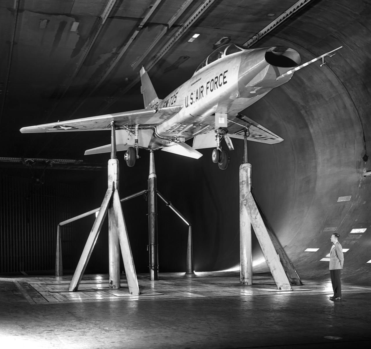
North American F-100-F airplane, equipped with thrust reversers, full scale wind tunnel test. 3/4 front view of F-100-F airplane with North American Aviation thrust reverser. On standard 40x80 struts landing gear down. Mark Kelly, branch chief in photo.

This official NASA commemorative logo marks the 25th anniversary of the first lunar landing. The design incorporates an eagle, from the original Apoll 11 crew insignia, descending toward the lunar surface with an olive branch, symbolizing America's peaceful mission in space. Alternative Headquarters number is 93-HC-312 or 93-H-336.
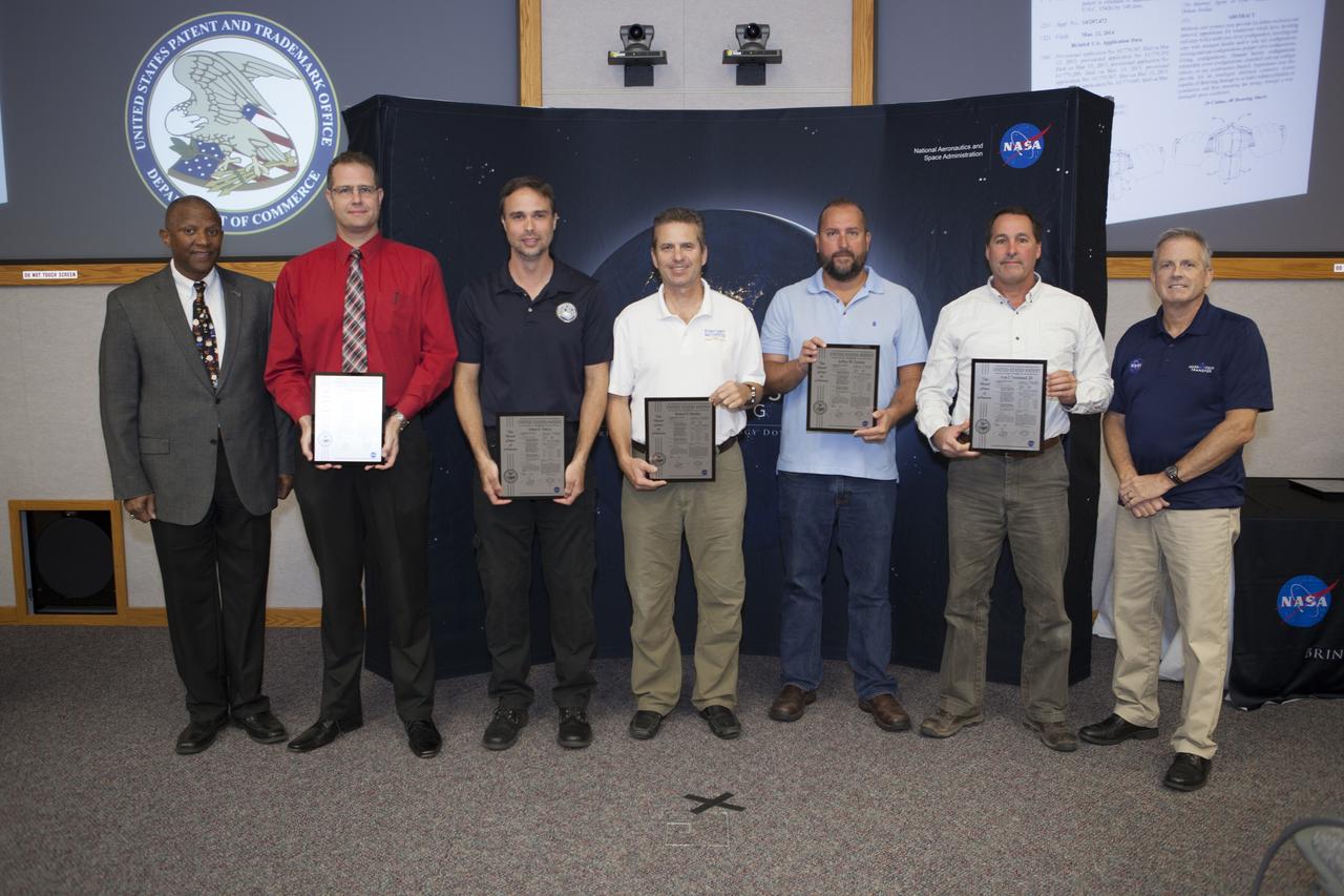
U.S. Patent plaques were awarded to, second from left, Mark Lewis, Adam Dokos, Robert Mueller, Jeffrey Carlson and Ivan Townsend III, for their invention, Dust Tolerant Connectors, during the 2017 Innovation Expo at NASA's Kennedy Space Center in Florida. Not pictured: Gary Basin, Matthew Branch, Kevin Murtland, Matthew Nugent and Gabor Tamasy. At left is Kelvin Manning, Kennedy's associate director. At far right is Dave Makufka, Kennedy's Technology Transfer Program manager. The purpose of the annual two-day expo is to help foster innovation and creativity among the Kennedy workforce. The event included several keynote speakers, training opportunities, an innovation showcase and the KSC Kickstart competition.
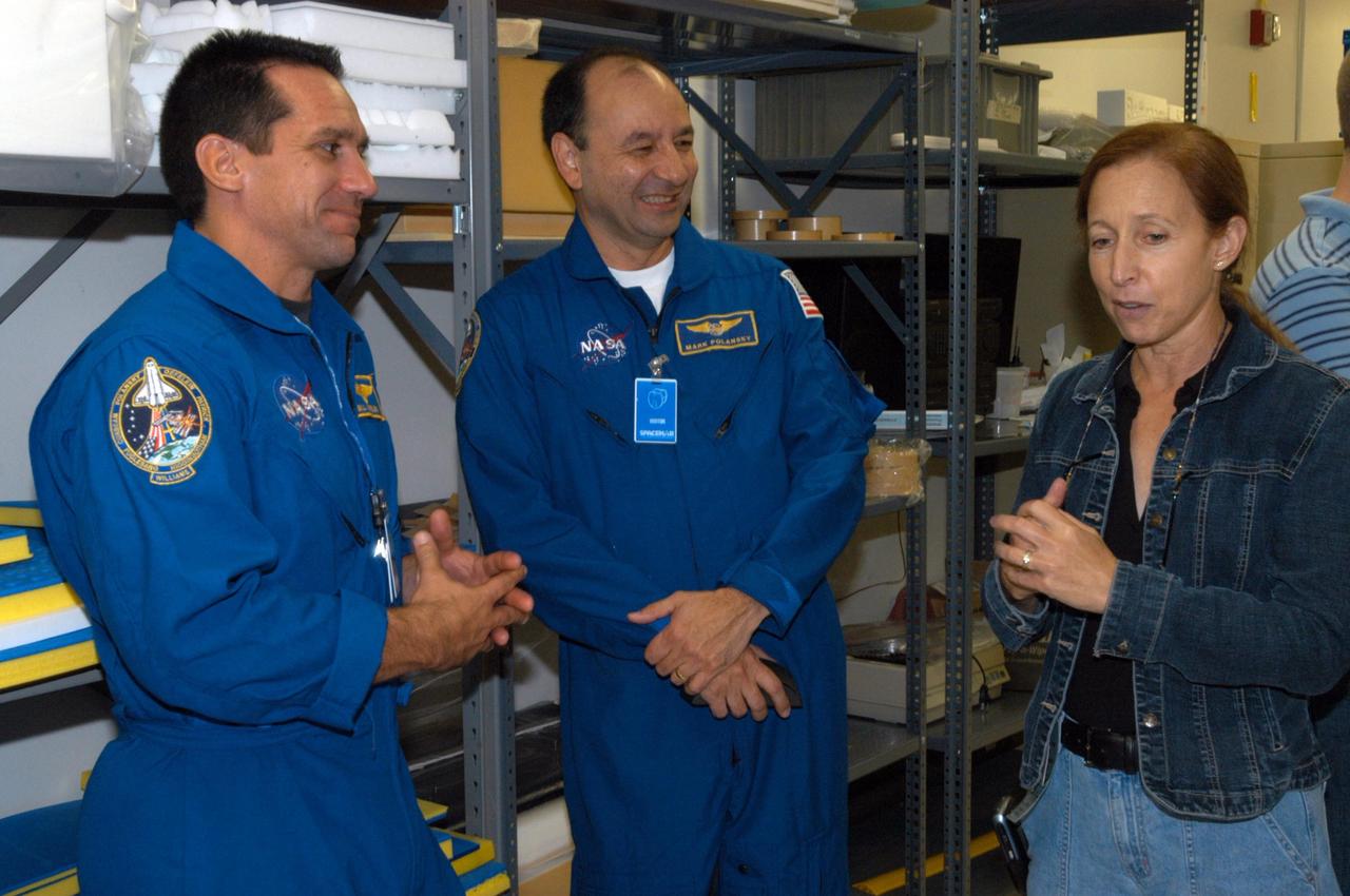
KENNEDY SPACE CENTER, FLA. - At SPACEHAB in Cape Canaveral, Fla., STS-116 Pilot William Oefelein and Commander Mark Polansky relax during equipment familiarization to talk to astronaut Marsha Ivins, who is currently assigned to the Astronaut Office, Space Station/Shuttle Branches for crew equipment, habitability and stowage. Mission crews make frequent trips to the Space Coast to become familiar with the equipment and payloads they will be using. STS-116 will be mission number 20 to the International Space Station and construction flight 12A.1. The mission payload is the SPACEHAB module, the P5 integrated truss structure and other key components. Launch is scheduled for no earlier than Dec. 7. Photo credit: NASA/George Shelton
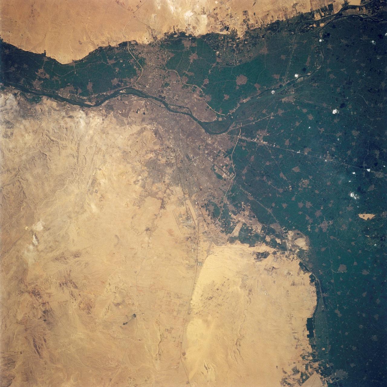
STS062-108-058 (4-18 March 1994) --- Cairo lies at the apex of the great delta of the Nile: the delta is marked by the strong greens of cultivated lands, Cairo by the gray sprawl along the river and the eastern delta apex as it develops in the direction of the airports and Suez. The city of El Giza lies on the west side of the Nile with the Giza pyramids in the desert just beyond the cultivated lands. Several major canals lead water to parts of the delta more distant from the Nile; generally these can be recognized as straighter, more engineered waterways. Towards the top left, the bifurcation of the Rosetta and Damietta branches of the Nile can be seen. These are the two major present-day veins of the Nile as it approaches the Mediterranean.
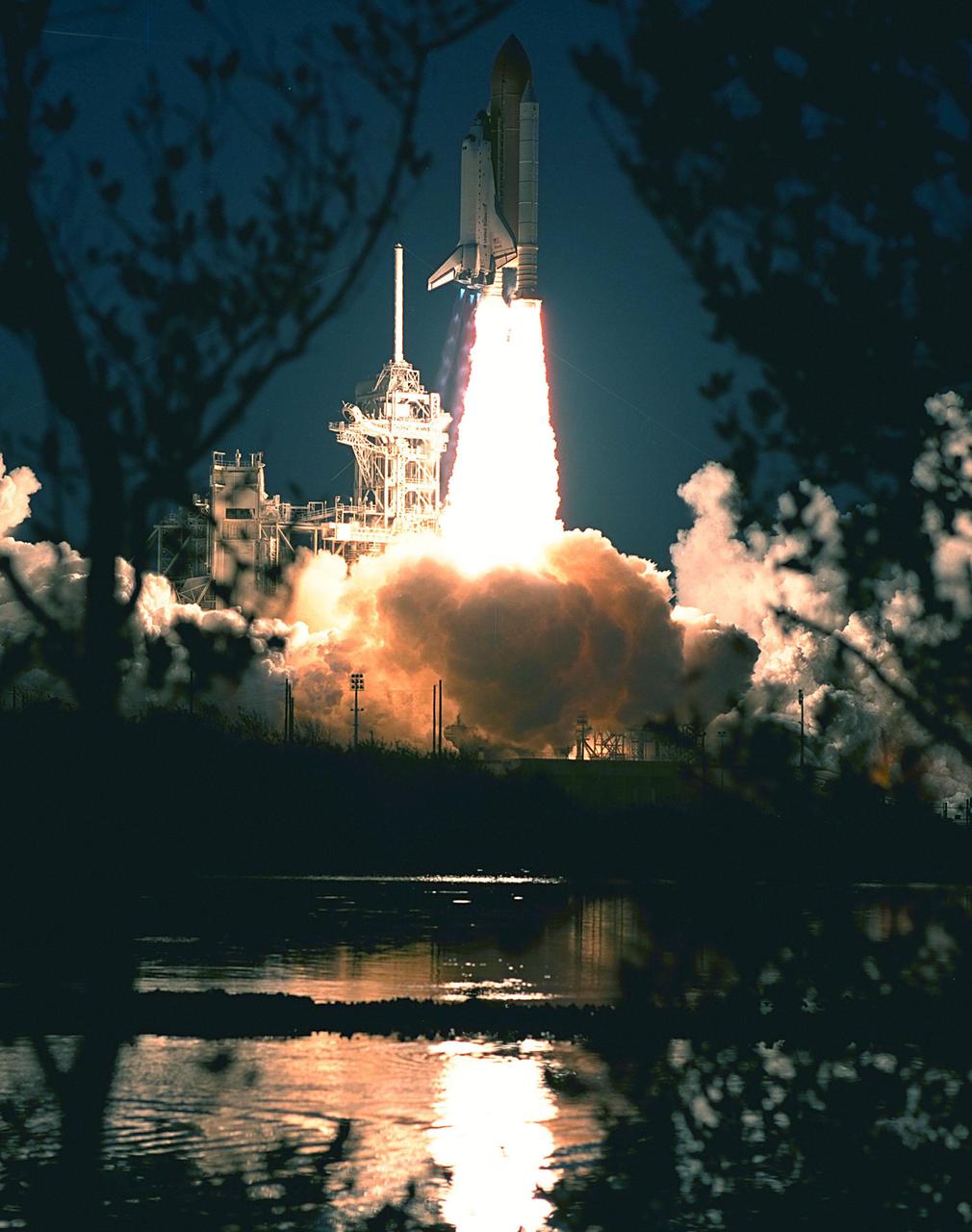
KENNEDY SPACE CENTER, FLA. -- Tree branches across the water from Launch Pad 39A provide a frame for the launch of Space Shuttle Atlantis on mission STS-98. Liftoff occurred at 6:13:02 p.m. EST. Along with a crew of five, Atlantis is carrying the U.S. Laboratory Destiny, a key module in the growth of the Space Station. Destiny will be attached to the Unity node on the Space Station using the Shuttle's robotic arm. Three spacewalks are required to complete the planned construction work during the 11-day mission. This mission marks the seventh Shuttle flight to the Space Station, the 23rd flight of Atlantis and the 102nd flight overall in NASA's Space Shuttle program. The planned landing is at KSC Feb. 18 about 1 p.m. EST

KENNEDY SPACE CENTER, FLA. -- Tree branches across the water from Launch Pad 39A provide a frame for the launch of Space Shuttle Atlantis on mission STS-98. Liftoff occurred at 6:13:02 p.m. EST. Along with a crew of five, Atlantis is carrying the U.S. Laboratory Destiny, a key module in the growth of the Space Station. Destiny will be attached to the Unity node on the Space Station using the Shuttle's robotic arm. Three spacewalks are required to complete the planned construction work during the 11-day mission. This mission marks the seventh Shuttle flight to the Space Station, the 23rd flight of Atlantis and the 102nd flight overall in NASA's Space Shuttle program. The planned landing is at KSC Feb. 18 about 1 p.m. EST
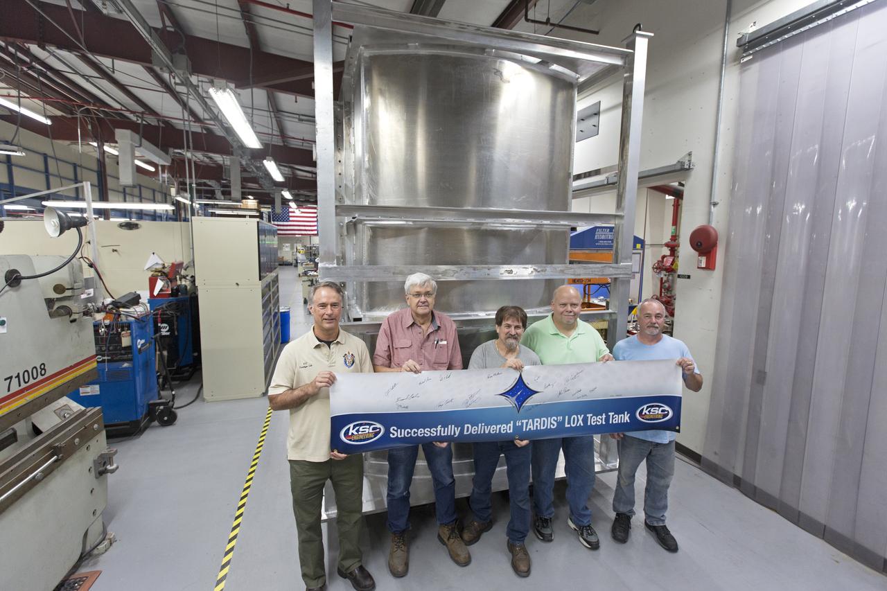
Inside the Prototype Development Laboratory at NASA's Kennedy Space Center in Florida, engineers and technicians hold a banner marking the successful delivery of a liquid oxygen test tank called Tardis. From left, are Todd Steinrock, chief, Fabrication and Development Branch, Prototype Development Lab; David McLaughlin, electrical engineering technician; Phil Stroda, mechanical engineering technician; Perry Dickey, lead electrical engineering technician; and Harold McAmis, lead mechanical engineering technician. Engineers and technicians worked together to develop the tank and build it at the lab to support cryogenic testing at Johnson Space Center's White Sands Test Facility in Las Cruces, New Mexico. The 12-foot-tall, 3,810-pound aluminum tank will be shipped to White Sands for testing.
ISS030-E-035487 (14 Jan. 2012) --- The East African Rift Valley in Kenya is featured in this image photographed by an Expedition 30 crew member on the International Space Station. This photograph highlights classical geological structures associated with a tectonic rift valley, in this case the Eastern Branch of the East African Rift near Kenya’s southern border with Tanzania and just south of the Equator. The East African Rift is one of the great tectonic features of Africa, caused by fracturing of Earth’s crust. The Nubian (or African) plate includes the older continental crust of Africa to the west, while the Somalian plate that is moving away includes the Horn of Africa to the northeast; the tectonic boundary stretches from the southern Red Sea to central Mozambique. Landscapes in the rift valley can appear confusing. The most striking features in this view are the numerous, nearly parallel, linear fault lines that occupy the floor of the valley (most of the image). Shadows cast by the late afternoon sun make the fault scarps (steps in the landscape caused by slip motion along individual faults) more prominent. The faults are aligned with the north-south axis of the valley (lower left to top right). A secondary trend of less linear faults cuts the main fault trend at an acute angle, the fault steps throwing large shadows. The Eastern Branch of the East African Rift is arid (compared with the Western Branch which lies on the border of the Congolese rainforest). Evidence of this can be seen in the red, salt-loving algae of the shallow and salty Lake Magadi (center). A neighboring small lake to the north has deeper water and appears dark in the image. The white salt deposits of the dry part of the Lake Magadi floor (center) host a few small commercial salt pans. The lakes appear to be located where the main and secondary fault trends intersect. The East African rift system is marked by substantial volcanic activity, including lavas erupted from fissures along the rift in the region. Much of the faulting observed in this image cuts through such lavas. Elsewhere along the rift system individual volcanoes form. Some of those volcanoes are very large, including Mt. Kilimanjaro and Mt. Kenya. In this image, rising 400 meters above the valley floor, a volcano appears to be superimposed on the faults—indicating that the volcano is younger than the faults it covers. Deeply eroded slopes also suggest that the volcano has not been active for a long time. The largest vegetated area (lower left)—in an desert zone with no vegetation visible to the naked eye from space—is the green floor of a valley which drains an area large enough for water to exist near the surface so that plants can thrive. For a sense of scale, the vegetated valley floor is 17 kilometers long (10.5 miles).

In the Kennedy Space Center’s Press Site auditorium, members of the news media are briefed on the upcoming Orion flight test. From left are: Rachel Kraft, NASA Public Affairs, Bill Hill, NASA deputy associate administrator for Exploration Systems Development, Mark Geyer, NASA Orion Program manager, Bryan Austin, Lockheed Martin mission manager, Jeremy Graeber, Operations Integration Branch of Ground Systems Development and Operations at Kennedy, and Ron Fortson, United Launch Alliance director of Mission Management. Mike Sarafin, NASA's lead flight director, participated by video from the Johnson Space Center. Orion is the exploration spacecraft designed to carry astronauts to destinations not yet explored by humans, including an asteroid and Mars. It will have emergency abort capability, sustain the crew during space travel and provide safe re-entry from deep space return velocities. The first unpiloted flight test of Orion is scheduled to launch Dec. 4, 2014 atop a United Launch Alliance Delta IV Heavy rocket, and in 2018 on NASA’s Space Launch System rocket.

In the Kennedy Space Center’s Press Site auditorium, members of the news media are briefed on the upcoming Orion flight test. From left are: Rachel Kraft, NASA Public Affairs, Bill Hill, NASA deputy associate administrator for Exploration Systems Development, Mark Geyer, NASA Orion Program manager, Bryan Austin, Lockheed Martin mission manager, Jeremy Graeber, Operations Integration Branch of Ground Systems Development and Operations at Kennedy, and Ron Fortson, United Launch Alliance director of Mission Management. Mike Sarafin, NASA's lead flight director, participated by video from the Johnson Space Center. Orion is the exploration spacecraft designed to carry astronauts to destinations not yet explored by humans, including an asteroid and Mars. It will have emergency abort capability, sustain the crew during space travel and provide safe re-entry from deep space return velocities. The first unpiloted flight test of Orion is scheduled to launch Dec. 4, 2014 atop a United Launch Alliance Delta IV Heavy rocket, and in 2018 on NASA’s Space Launch System rocket.
KENNEDY SPACE CENTER, FLA. - At SPACEHAB in Cape Canaveral, Fla., STS-116 crew members get a close look at he Treadmill Vibration Isolation System Gyroscop during equipment familiarization. Mission Specialist Nicholas Patrick (center) practices stowing the replacement gyro in the block of foam which is what the gyro will be stowed in inside the SPACEHAB module. The other crew members watching are, from left, Mission Specialists Christer Fuglesang, Pilot William Oefelein, Commander Mark Polansky, and at right, Mission Specialist Joan Higginbotham. Fuglesang, from Sweden, represents the European Space Agency. Between Patarick and Higginbotham is astronaut Marsha Ivins, who is currently assigned to the Astronaut Office, Space Station/Shuttle Branches for crew equipment, habitability and stowage. Mission crews make frequent trips to the Space Coast to become familiar with the equipment and payloads they will be using. STS-116 will be mission number 20 to the International Space Station and construction flight 12A.1. The mission payload is the SPACEHAB module, the P5 integrated truss structure and other key components. Launch is scheduled for no earlier than Dec. 7. Photo credit: NASA/George Shelton

CAPE CANAVERAL, Fla. – In the Kennedy Space Center’s Press Site auditorium, members of the news media are briefed on the upcoming Orion flight test. From left are: Rachel Kraft, NASA Public Affairs, Bill Hill, NASA deputy associate administrator for Exploration Systems Development, Mark Geyer, NASA Orion Program manager, Bryan Austin, Lockheed Martin mission manager, Jeremy Graeber, Operations Integration Branch of Ground Systems Development and Operations at Kennedy, and Ron Fortson, United Launch Alliance director of Mission Management. Mike Sarafin, NASA's lead flight director, participated by video from the Johnson Space Center. Orion is the exploration spacecraft designed to carry astronauts to destinations not yet explored by humans, including an asteroid and Mars. It will have emergency abort capability, sustain the crew during space travel and provide safe re-entry from deep space return velocities. The first unpiloted flight test of Orion is scheduled to launch Dec. 4, 2014 atop a United Launch Alliance Delta IV Heavy rocket, and in 2018 on NASA’s Space Launch System rocket. For more information, visit www.nasa.gov/orion Photo credit: NASA/Kim Shiflett
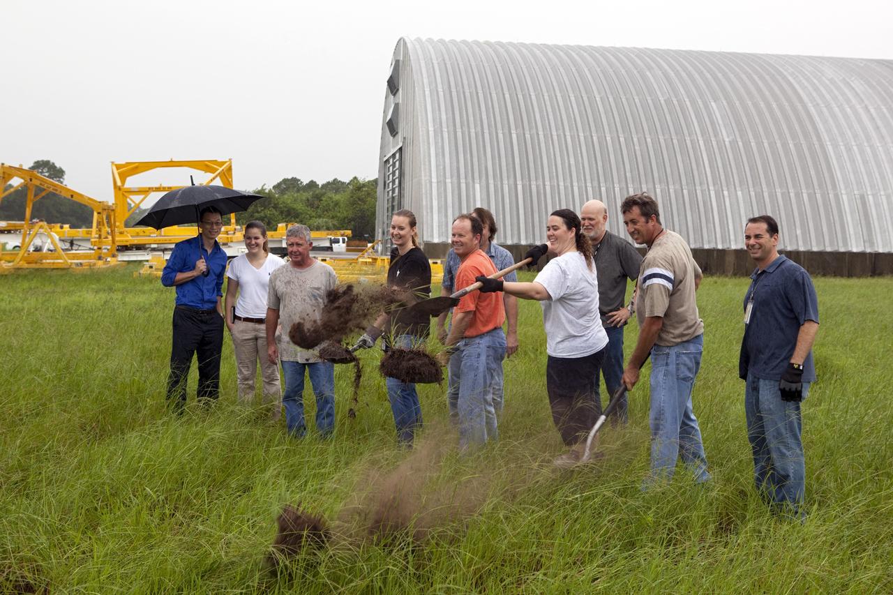
CAPE CANAVERAL, Fla. – Near the Hypergolic Maintenance Facility at NASA’s Kennedy Space Center in Florida, a groundbreaking ceremony was held to mark the location of the Ground Operations Demonstration Unit Liquid Hydrogen, or GODU LH2, test site. From left, are Johnny Nguyen, Fluids Test and Technology Development branch chief Emily Watkins, engineering intern Jeff Walls, Engineering Services Contract, or ESC, Cryogenics Test Lab engineer Kelly Currin, systems engineer Stephen Huff and Rudy Werlink partially hidden, cryogenics engineers Angela Krenn, systems engineer Doug Hammond, command and control engineer in the electrical division William Notardonato, GODU LH2 project manager and Kevin Jumper, ESC Cryogenics Test Lab manager. The GODU LH2 test site is one of the projects in NASA’s Advanced Exploration Systems Program. The site will be used to demonstrate advanced liquid hydrogen systems that are cost and energy efficient ways to store and transfer liquid hydrogen during process, loading, launch and spaceflight. The main components of the site will be a storage tank and a cryogenic refrigerator. Photo credit: NASA/Dimitri Gerondidakis
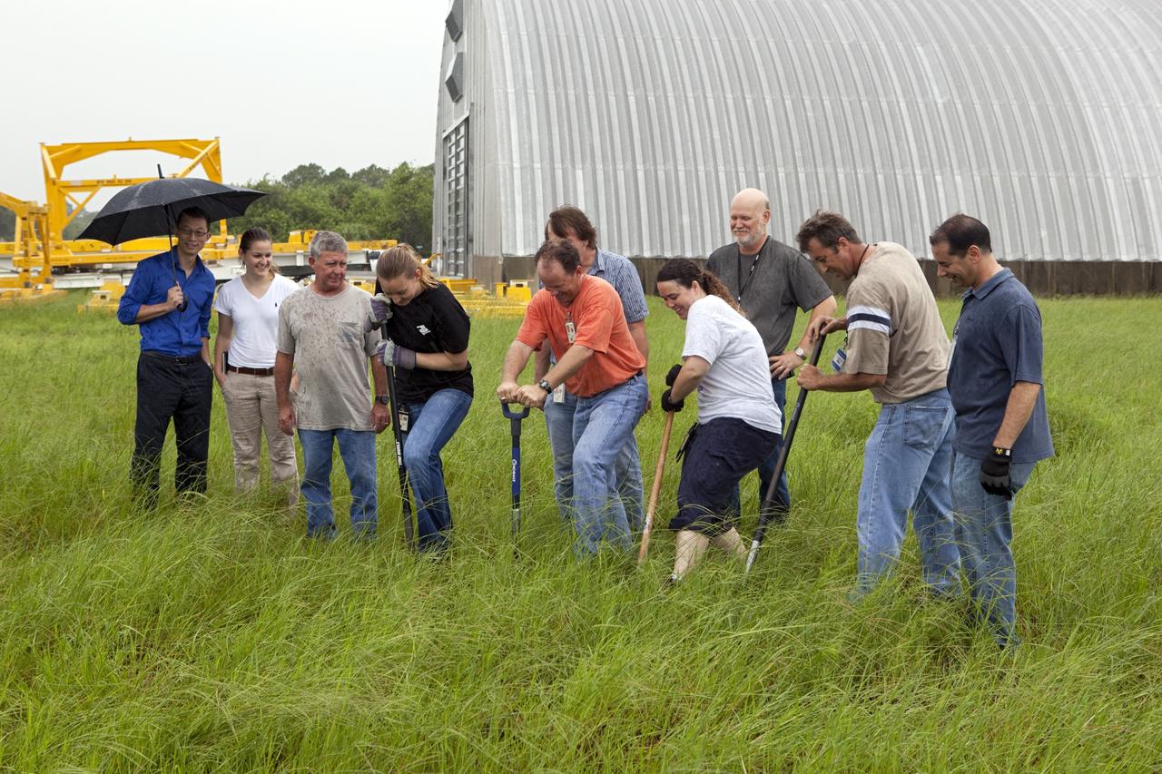
CAPE CANAVERAL, Fla. – Near the Hypergolic Maintenance Facility at NASA’s Kennedy Space Center in Florida, a groundbreaking ceremony was held to mark the location of the Ground Operations Demonstration Unit Liquid Hydrogen, or GODU LH2, test site. From left, are Johnny Nguyen, Fluids Test and Technology Development branch chief Emily Watkins, engineering intern Jeff Walls, Engineering Services Contract, or ESC, Cryogenics Test Lab engineer Kelly Currin, systems engineer Stephen Huff and Rudy Werlink partially hidden, cryogenics engineers Angela Krenn, systems engineer Doug Hammond, command and control engineer in the electrical division William Notardonato, GODU LH2 project manager and Kevin Jumper, ESC Cryogenics Test Lab manager. The GODU LH2 test site is one of the projects in NASA’s Advanced Exploration Systems Program. The site will be used to demonstrate advanced liquid hydrogen systems that are cost and energy efficient ways to store and transfer liquid hydrogen during process, loading, launch and spaceflight. The main components of the site will be a storage tank and a cryogenic refrigerator. Photo credit: NASA/Dimitri Gerondidakis

ISS033-E-020288 (13 Nov. 2012) --- A nighttime view of Riyadh, Saudi Arabia is featured in this image photographed by an Expedition 33 crew member on the International Space Station. The population of Riyadh, the capital city of Saudi Arabia, has risen dramatically in the last half century, from 150,000 in 1960 to an estimated 5.4 million in 2012. The city appears as a brightly colored patchwork in this nighttime photograph. The brightest lights, apart from those on the old Riyadh Airbase at center (the new international airport is far outside the city and not shown here), follow the commercial districts along King Abdullah Road and King Fahd Branch Road. Many of the darker patches within the built area are city parks. University sectors stand out with different street and light patterns, as seen in the King Saud University campus which houses the Arabic Language Institute, and the Princess Nora Bint Abdul Rahman University which is the largest all-female university in the world. Highways and various ring roads also stand out in night imagery due to bright regular lighting. Lighted developments beyond the ring roads mark the growth of the city. Newer neighborhoods, set further from the city center, are recognizable by blue-gray lightning.
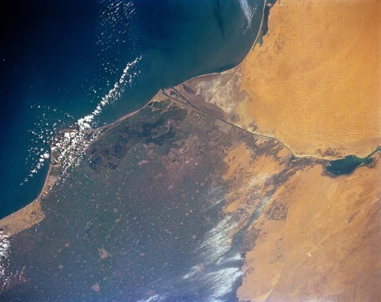
STS-56 Earth observation of the northeastern Nile Delta was photographed from the Earth-orbiting Discovery, Orbiter Vehicle (OV) 103. The branch of the Nile featured in the frame is Daimietta. The Suez Canal marks the boundary of the Nile Delta agriculture and the Sinai Desert to the right. Lake Masada, the dark waterlogged area to the west (left) of Port Said is becoming more saline as the Aswan Dam has reduced sediment downstream. This sediment reduction, according to NASA scientists studying the STS-56 photography, has resulted in increased coastal erosion and the intrusion of a salt-water lens to the ground water, particularly in the northeastern portions of the delta. Center pivot irrigation fields are located along either side of the Ramses Canal, which connects the Daimietta Nile with Great Bitter Lake. This canal has been re-dug three or four times in the past 3,000 years. Historians note that the canal's most famous use was as the departure point of the fleet of Pharaoh Necho. The fleet circumnavigated Africa clockwise from the head of the Red Sea to the Mediterranean coast of the Nile (probably the Rosetta Nile) in a three-year voyage circa 660 BC.

CAPE CANAVERAL, Fla. – In the Kennedy Space Center’s Press Site auditorium, members of the news media are briefed on the upcoming Orion flight test. From left are: Rachel Kraft, NASA Public Affairs, Bill Hill, NASA deputy associate administrator for Exploration Systems Development, Mark Geyer, NASA Orion Program manager, Bryan Austin, Lockheed Martin mission manager, Jeremy Graeber, Operations Integration Branch of Ground Systems Development and Operations at Kennedy, and Ron Fortson, United Launch Alliance director of Mission Management. Mike Sarafin, NASA's lead flight director, participated by video from the Johnson Space Center. Orion is the exploration spacecraft designed to carry astronauts to destinations not yet explored by humans, including an asteroid and Mars. It will have emergency abort capability, sustain the crew during space travel and provide safe re-entry from deep space return velocities. The first unpiloted flight test of Orion is scheduled to launch Dec. 4, 2014 atop a United Launch Alliance Delta IV Heavy rocket, and in 2018 on NASA’s Space Launch System rocket. For more information, visit www.nasa.gov/orion Photo credit: NASA/Kim Shiflett
ISS018-E-024949 (31 Jan. 2009) --- The All-American Canal, the largest irrigation canal in the world and a key landmark along the California-Mexico border, is featured in this image photographed by an Expedition 18 crewmember on the International Space Station. This image captures about 15 kilometers of the important infrastructure corridor just west of Yuma, AZ. The prominent dark line crossing the image is the Canal which is crossed, in this view, by Interstate Highway 8. The canal carries 740.6 cubic meters (26,155 cubic feet) of water per second from the Colorado River westward to support the intensive agriculture of California?s Imperial Valley to the northwest, and to nine cities including San Diego, CA. The canal system is the Imperial Valley?s only source of water, and allows irrigation of more than 2,000 square kilometers (500,000 acres) of agricultural fields. The Coachella Canal, one of four main branch canals, leads water north to Imperial Valley. This section of the canal requires constant maintenance. Approximately 68,000 acre-feet of water per year are lost by seepage from the All-American Canal - especially where the canal crosses the great Algodones Dune Field, a portion of which is visible extending from top to bottom in the center of the image. Additionally, dune sand is constantly blown to the southeast, and into the canal. As part of California?s Colorado River Water Use Plan, 37 kilometers (23 miles) of the canal is being lined to prevent water loss by seepage. A recently opened sector parallels the old canal (right) and new lined sectors are under construction (bright lines, center). Engineers have sited new sections of the canal to avoid the worst areas of dune-sand invasion, so that the new configuration will be significantly cheaper to maintain and operate. A new road crosses the dunes and marks the US?Mexico border as part of border fence construction efforts. The margin of the Colorado River floodplain in Mexico is just visible two kilometers south of the border (lower left corner). This floodplain is Mexico?s equivalent of the Imperial Valley in terms of its enormous irrigated agricultural production.
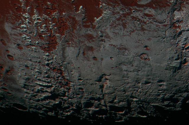
This area is south of Pluto's dark equatorial band informally named Cthulhu Regio, and southwest of the vast nitrogen ice plains informally named Sputnik Planitia. North is at the top; in the western portion of the image, a chain of bright mountains extends north into Cthulhu Regio. New Horizons compositional data indicate the bright snowcap material covering these mountains isn't water, but atmospheric methane that has condensed as frost onto these surfaces at high elevation. Between some mountains are sharply cut valleysindicated by the white arrows. These valleys are each a few miles across and tens of miles long. A similar valley system in the expansive plains to the east (blue arrows) appears to be branched, with smaller valleys leading into it. New Horizons scientists think flowing nitrogen ice that once covered this area -- perhaps when the ice in Sputnik was at a higher elevation -- may have formed these valleys. The area is also marked by irregularly shaped, flat-floored depressions (green arrows) that can reach more than 50 miles (80 kilometers) across and almost 2 miles (3 kilometers) deep. The great widths and depths of these depressions suggest that they may have formed when the surface collapsed, rather than through the sublimation of ice into the atmosphere. This enhanced color image was obtained by New Horizons' Multispectral Visible Imaging Camera (MVIC). The image resolution is approximately 2,230 feet (680 meters) per pixel. It was obtained at a range of approximately 21,100 miles (33,900 kilometers) from Pluto, about 45 minutes before New Horizons' closest approach to Pluto on July 14, 2015. http://photojournal.jpl.nasa.gov/catalog/PIA21026
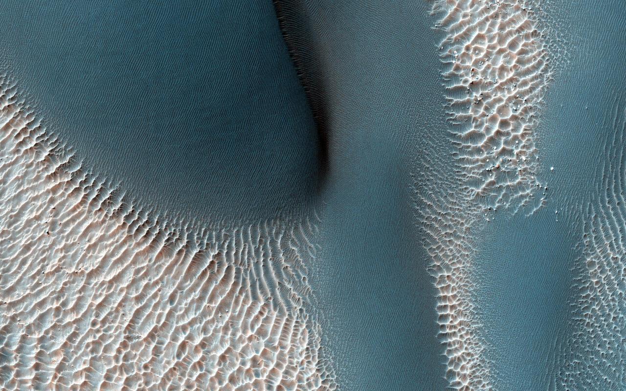
The workings of the Martian winds are visible in this image of sand dunes trapped inside an unnamed crater in southern Terra Cimmeria captured by NASA Mars Reconnaissance Orbiter spacecraft. Many of the craters in the Southern highlands of Mars contain sand dunes, and HiRISE is still in the process of mapping these dunes and determining how active they are today. So far, the dunes in these craters appear to be a mixed bunch, with some dunes actively advancing while others seem to be frozen in place. This image will be compared to a previous picture, to see how these dunes have changed since 2008. The sand dunes are the large, branched ridges and dark patches that are conspicuous against the bright background, particularly in the northwest corner of our picture. There are also signs of two other wind-related processes: smaller, brighter ridges line the floor of the crater in regularly spaced rows. These are also windblown deposits, mysterious "transverse aeolian ridges" or TARs that are more common in the Martian tropics. Faint, irregular dark lines cross the dunes and the TARs, marking the tracks of dust devils that vacuum the surface during southern summer. So, which came first? We can untangle the history of these processes by looking at the picture more closely. Over most of the image, it is obvious that the dark sand dunes bury the bright TARs, meaning that the sand dunes are younger than the TARs. But this relationship is not so clear for the southernmost dune we see in this picture. Here, the TARs look like they extend into the dune and merge with ripples on the dune's surface, suggesting that the TARs might be younger than the dunes. The question can be resolved by carefully examining an enhanced color cutout. The TARs are brighter and redder than the sand dunes and this color persists on the crests of the TARs as the sand encroaches, burying the valleys first and then the slopes and finally the TAR crests. This tells us that the unusual appearance of the dune margin is caused by burial and exposure of the older TARs by the younger sand. Finally, you can trace the tracks of dust devils crossing over the dunes, telling us that they are younger than the dunes. So, first came the TARs, next the dunes, and last the dust devils -- probably within the last few months! http://photojournal.jpl.nasa.gov/catalog/?IDNumber=pia19941
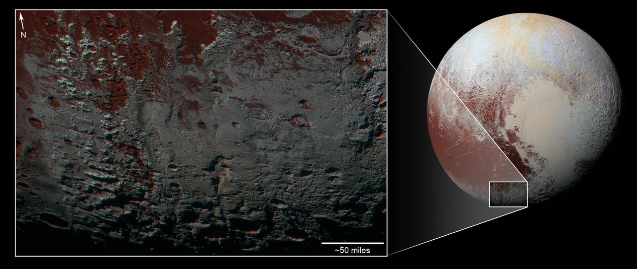
This area is south of Pluto's dark equatorial band informally named Cthulhu Regio, and southwest of the vast nitrogen ice plains informally named Sputnik Planitia. North is at the top; in the western portion of the image, a chain of bright mountains extends north into Cthulhu Regio. New Horizons compositional data indicate the bright snowcap material covering these mountains isn't water, but atmospheric methane that has condensed as frost onto these surfaces at high elevation. Between some mountains are sharply cut valleys -- indicated by the white arrows. These valleys are each a few miles across and tens of miles long. A similar valley system in the expansive plains to the east (blue arrows) appears to be branched, with smaller valleys leading into it. New Horizons scientists think flowing nitrogen ice that once covered this area -- perhaps when the ice in Sputnik was at a higher elevation -- may have formed these valleys. The area is also marked by irregularly shaped, flat-floored depressions (green arrows) that can reach more than 50 miles (80 kilometers) across and almost 2 miles (3 kilometers) deep. The great widths and depths of these depressions suggest that they may have formed when the surface collapsed, rather than through the sublimation of ice into the atmosphere. This enhanced color image was obtained by New Horizons' Multispectral Visible Imaging Camera (MVIC). The image resolution is approximately 2,230 feet (680 meters) per pixel. It was obtained at a range of approximately 21,100 miles (33,900 kilometers) from Pluto, about 45 minutes before New Horizons' closest approach to Pluto on July 14, 2015. http://photojournal.jpl.nasa.gov/catalog/PIA21025