
An artist concept of NASA Mars Global Surveyor MGS flying over Mars.
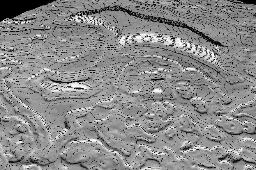
Derived Topographic Model from Mars Global Surveyor Instruments
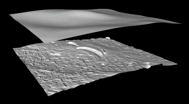
Derived Topographic Model from Mars Global Surveyor Instruments
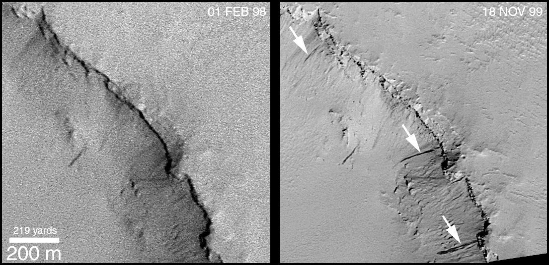
Mariner 4 Meets Mars Global Surveyor -- Mariner Crater 1965 and 1999
Mars Global Surveyor MOC Celebrates 2 Years in Orbit!

This picture of the European Space Agency Mars Express spacecraft by the Mars Orbiter Camera on NASA Mars Global Surveyor is from the first successful imaging of any spacecraft orbiting Mars taken by another spacecraft orbiting Mars.

Procedure for Finding New Impact Sites on Mars Using the Mars Global Surveyor Mars Orbiter Camera
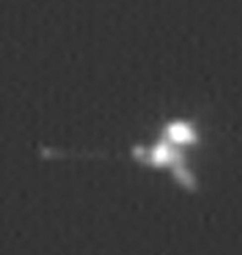
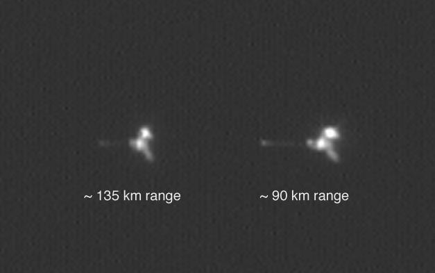
This view is an enlargement of an image of NASA Mars Odyssey spacecraft taken by the Mars Orbiter Camera aboard NASA Mars Global Surveyor while the two spacecraft were about 90 kilometers 56 miles apart.
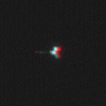
This stereoscopic picture of NASA Mars Odyssey spacecraft was created from two views of that spacecraft taken by the Mars Orbiter Camera on NASA Mars Global Surveyor. 3D glasses are necessary to view this image.
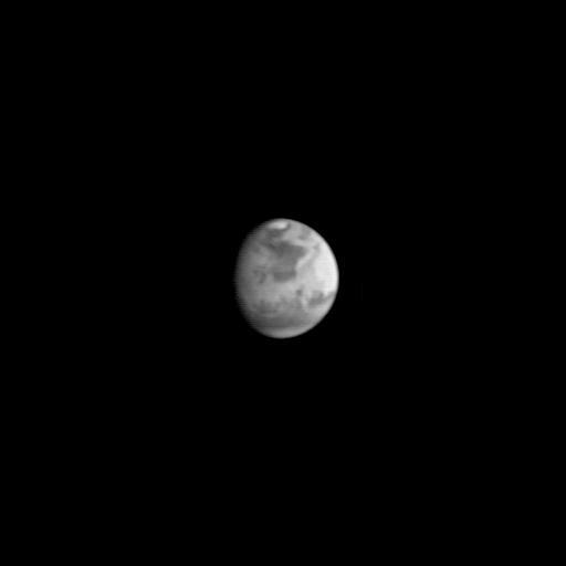
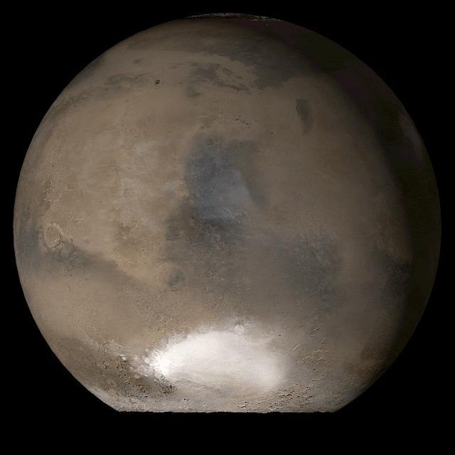
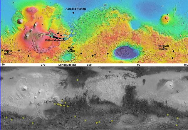
This image is the first view of Mars taken by the Mars Global Surveyor Orbiter Camera (MOC). It was acquired the afternoon of July 2, 1997 when the MGS spacecraft was 17.2 million kilometers (10.7 million miles) and 72 days from encounter. At this distance, the MOC's resolution is about 64 km per picture element, and the 6800 km (4200 mile) diameter planet is 105 pixels across. The observation was designed to show the Mars Pathfinder landing site at 19.4 N, 33.1 W approximately 48 hours prior to landing. The image shows the north polar cap of Mars at the top of the image, the dark feature Acidalia Planitia in the center with the brighter Chryse plain immediately beneath it, and the highland areas along the Martian equator including the canyons of the Valles Marineris (which are bright in this image owing to atmospheric dust). The dark features Terra Meridiani and Terra Sabaea can be seen at the 4 o`clock position, and the south polar hood (atmospheric fog and hazes) can be seen at the bottom of the image. Launched on November 7, 1996, Mars Global Surveyor will enter Mars orbit on Thursday, September 11 shortly after 6:00 PM PDT. After Mars Orbit Insertion, the spacecraft will use atmospheric drag to reduce the size of its orbit, achieving a circular orbit only 400 km (248 mi) above the surface in early March 1998, when mapping operations will begin. http://photojournal.jpl.nasa.gov/catalog/PIA00606

Mars Global Surveyor View of Gusev Crater During Spirit Entry, Descent, and Landing
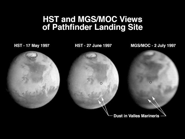
A comparison of images taken by the Hubble Space Telescope Wide Field/Planetary Camera (HST/WFPC) and the Mars Global Surveyor Orbiter Camera (MGS/MOC) shows the progress of a regional dust storm within the Valles Marineris canyons on Mars. The first HST image (left), taken in mid-May, shows no dust within the canyons. The most recent HST image (center), taken on 27 June in support of the Mars Pathfinder landing activities, shows a dust storm filling part of the canyon system and extending into the chaotic terrains at the eastern end of the canyons. The MGS/MOC image (right), acquired on July 2, shows that bright dust continues to fill the valleys. However, it does not appear to have moved significantly north of the previously observed position, suggesting that the storm remains confined to the canyon region, and does not appear to directly threaten the Pathfinder landing site (small black circle). The HST images shown here have been reduced in scale to match that of the MGS/MOC image. Although the HST is 10 times farther from Mars than MGS, its images are sharper because its resolving power is 15 times better than the MOC, and the light gathering area is almost 50 times greater. However, MGS is presently 45,000 times farther from Mars than it will be when the MOC begins its primary photography mission. At 400 km above the martian surface, the MOC wide angle camera will collect daily images at a resolution of 7.5 km/pixel, compared to HST's best of about 20 km/pixel. The narrow angle camera will observe portions of Mars at better than 1.5 m/pixel. http://photojournal.jpl.nasa.gov/catalog/PIA00607
This picture is a composite of Mars Global Surveyor MGS Mars Orbiter Camera MOC daily global images acquired at Ls 79° during a previous Mars year
This picture is a composite of Mars Global Surveyor MGS Mars Orbiter Camera MOC daily global images acquired at Ls 66° during a previous Mars year
This picture is a composite of Mars Global Surveyor MGS Mars Orbiter Camera MOC daily global images acquired at Ls 12° during a previous Mars year

Hubble Watches the Red Planet as Mars Global Surveyor Begins Aerobraking
This image was taken by NASA Mars Global Surveyor Cydonia region on Mars. 3D glasses are necessary to view this image.
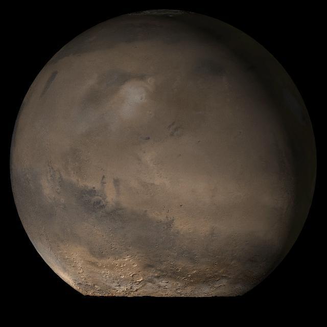
This picture is a composite of Mars Global Surveyor MGS Mars Orbiter Camera MOC daily global images acquired at Ls 79° during a previous Mars year of the Elysium/Mare Cimmerium face of Mars

This picture is a composite of Mars Global Surveyor MGS Mars Orbiter Camera MOC daily global images acquired at Ls 93° during a previous Mars year.of the Tharsis face of Mars

This picture is a composite of Mars Global Surveyor MGS Mars Orbiter Camera MOC daily global images acquired at Ls 93° during a previous Mars year.of the Acidalia/Mare Erythraeum face of Mars
This picture is a composite of Mars Global Surveyor MGS Mars Orbiter Camera MOC daily global images acquired at L<sub>s</sub> 107° of the Elysium/Mare Cimmerium face during a previous Mars year
This picture is a composite of Mars Global Surveyor MGS Mars Orbiter Camera MOC daily global images acquired at Ls 107° of the Acidalia/Mare Erythraeum face during a previous Mars year
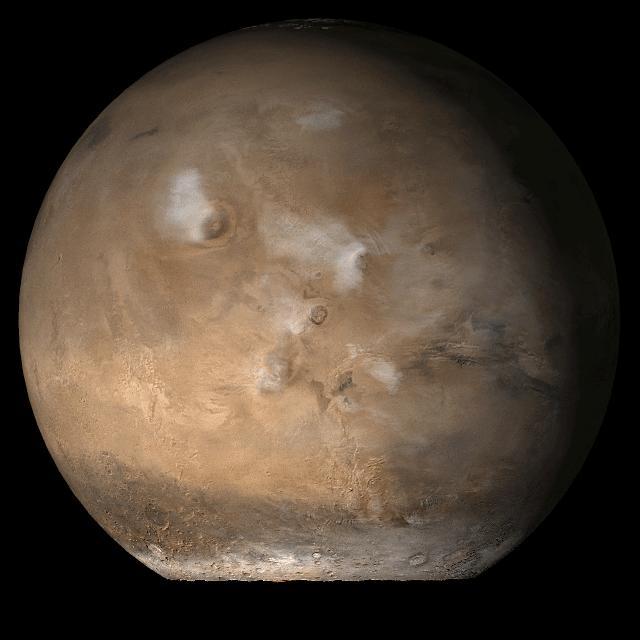
This picture is a composite of Mars Global Surveyor MGS Mars Orbiter Camera MOC daily global images acquired at Ls 93° of the Tharsis face during a previous Mars year
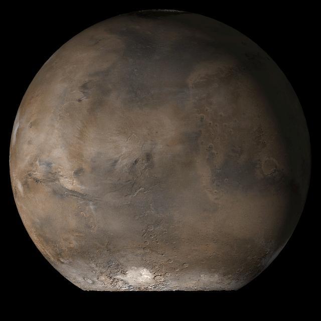
This picture is a composite of Mars Global Surveyor MGS Mars Orbiter Camera MOC daily global images acquired at Ls 107° of the Syrtis Major face during a previous Mars year

Color coding in this image of Mars represents differences in elevation, measured by NASA Mars Global Surveyor. While surface liquid water is rare and ephermal on modern Mars.
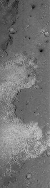
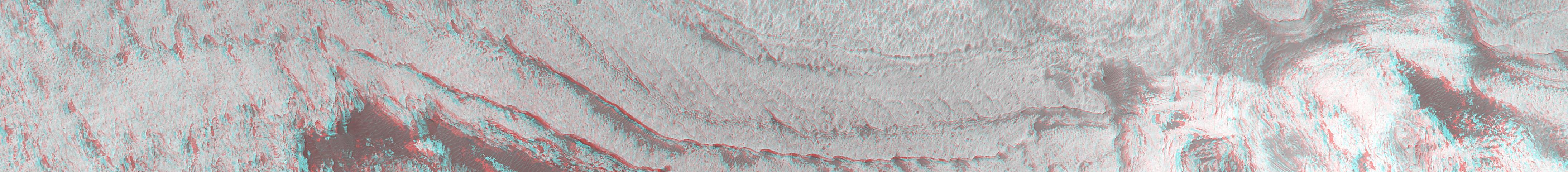
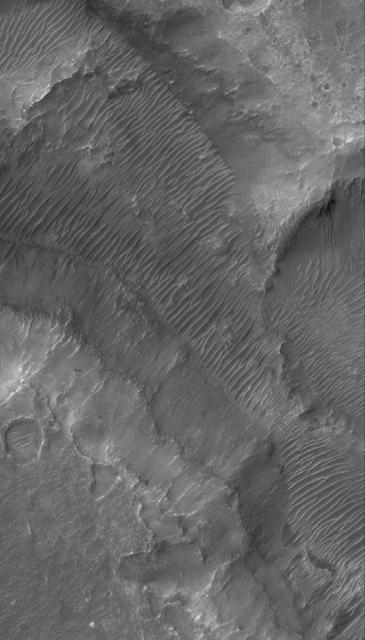
This Mars Global Surveyor MGS Mars Orbiter Camera MOC image shows layered buttes, knobs, and other landforms exposed by erosion in the Aeolis region of Mars
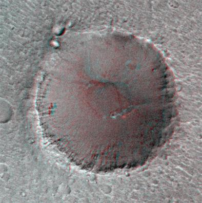
This anaglyph from Mars Global Surveyor MGS shows layers in Galle Crater. 3D glasses are necessary to view this image.
This Mars Global Surveyor MGS Mars Orbiter Camera MOC image shows an eroded stack of layered material in a crater of the south polar region of Mars
This Mars Global Surveyor MGS Mars Orbiter Camera MOC image shows dust plumes created by gusting winds on a plain southwest of Argyre Planitia
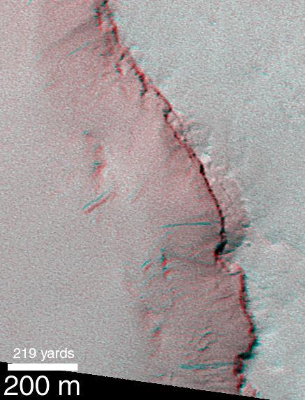
This Mars Global Surveyor MGS Mars Orbiter Camera MOC image shows a portion of the stair-stepped, north wall of a crater in Arabia Terra
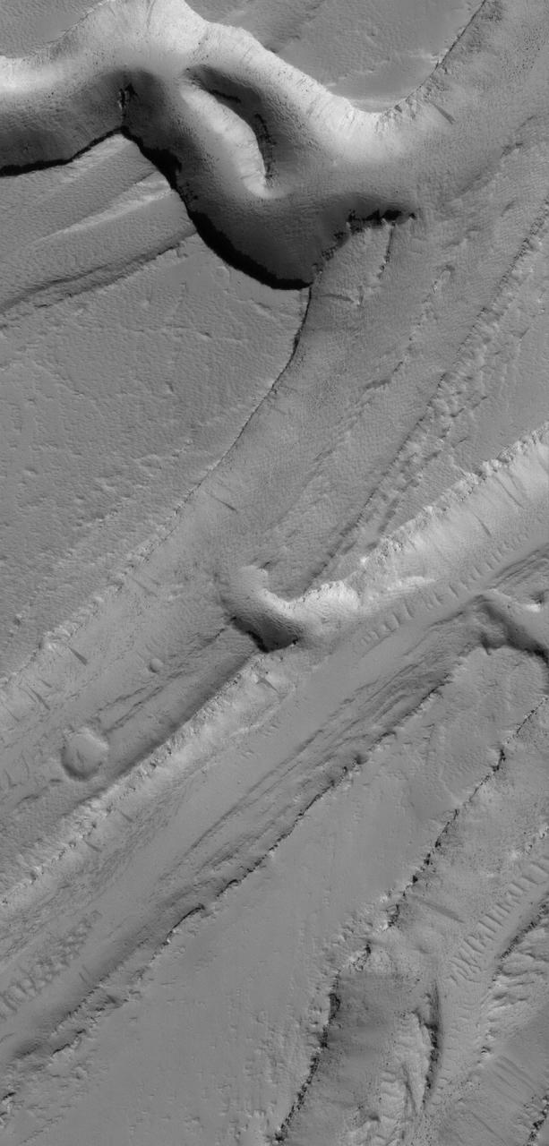
This Mars Global Surveyor MGS Mars Orbiter Camera MOC image shows a complex pattern of intersecting and overlapping troughs in the Olympica Fossae region of northern Tharsis
This anaglyph from NASA Mars Global Surveyor shows dark, blanketed or mantled surfaces in the Sinus Sabaeus region of Mars. 3D glasses are necessary to view this image.
This Mars Global Surveyor MGS Mars Orbiter Camera MOC image shows a spectacular summertime view of a portion of the south polar residual cap
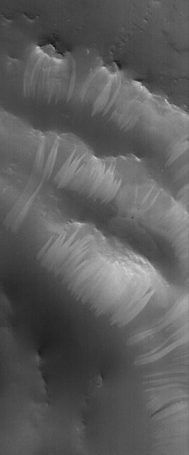
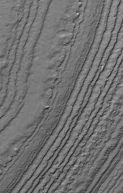
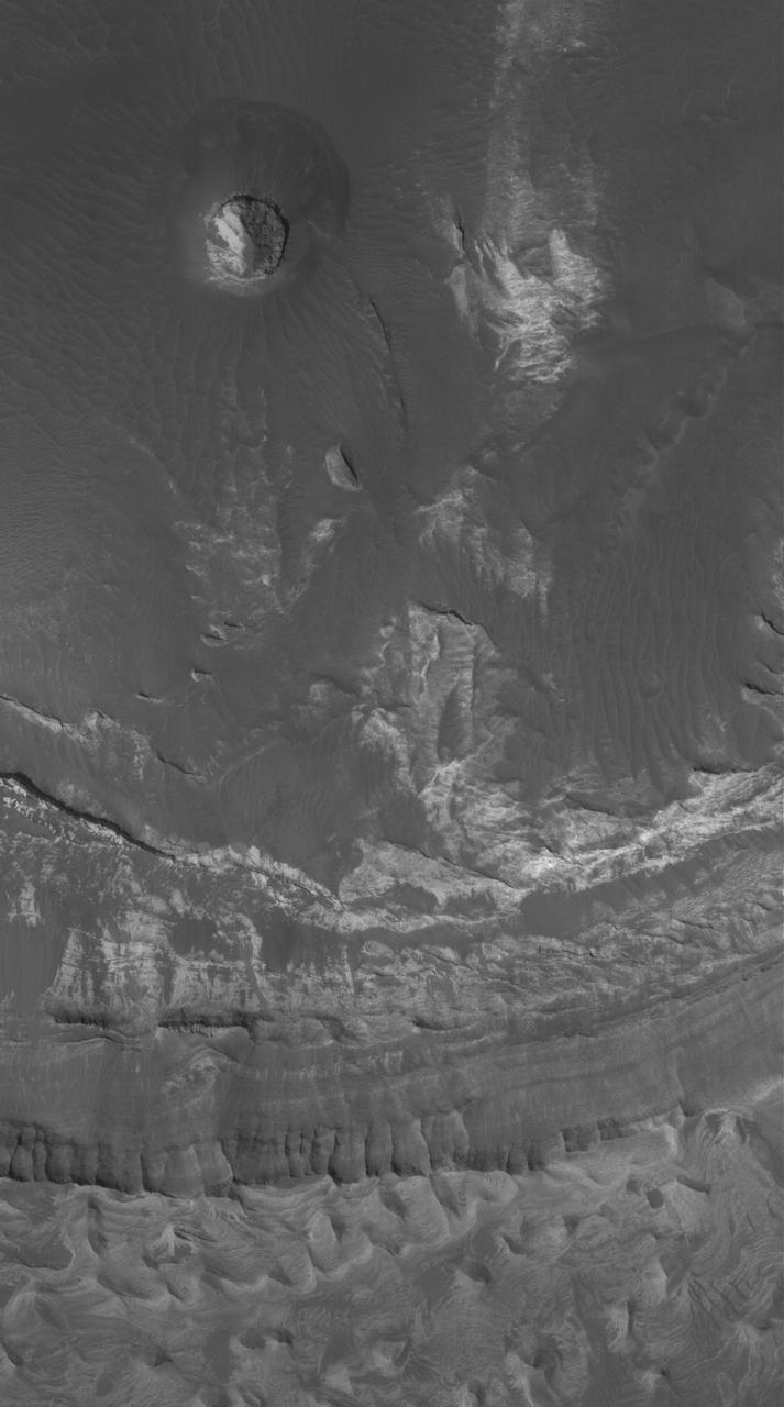
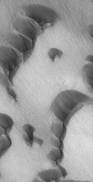
This Mars Global Surveyor MGS Mars Orbiter Camera MOC image shows layers and dunes in Chasma Boreale, a large depression in the north polar region.
This Mars Global Surveyor MGS Mars Orbiter Camera MOC image shows a channel extending northward from the Elysium Mons caldera at the volcano summit
This stereo image mosaic from NASA Mars Global Surveyor is of Mars south polar terrain. 3D glasses are necessary to view this image.
This Mars Global Surveyor MGS Mars Orbiter Camera MOC image shows dark streaks created by dust devils on a plain southwest of Hellas Planitia
NASA Mars Odyssey spacecraft appears twice in the same frame in this image from the Mars Orbiter Camera aboard NASA Mars Global Surveyor.
Twelve orbits a day provide NASA Mars Global Surveyor MOC wide angle cameras a global napshot of weather patterns across the planet. Here, bluish-white water ice clouds hang above the Tharsis volcanoes.
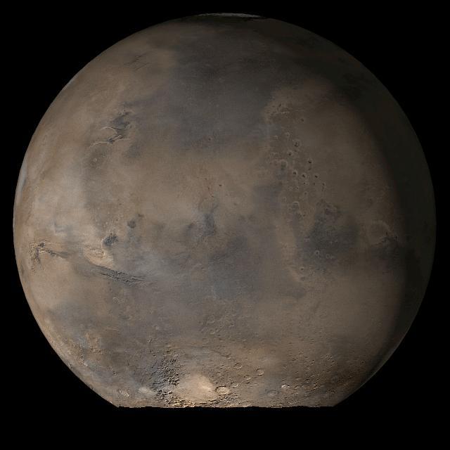
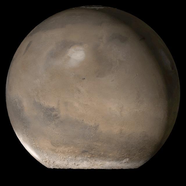
This picture is a composite of Mars Global Surveyor MGS Mars Orbiter Camera MOC daily global images acquired at Ls 79° during a previous Mars year. This month, Mars looks similar, as Ls 79° occurs in mid-July 2006
This is an orthographic projection with color-coded elevation contours and shaded relief based on data from the Mars Orbiter Laser Altimeter on NASA Mars Global Surveyor orbiter.
On its 256th orbit of Mars, the camera on-board NASA Mars Global Surveyor spacecraft successfully observed the vicinity of the Mars Pathfinder landing site. 3D glasses are necessary to identify surface detail.
This Mars Global Surveyor MGS Mars Orbiter Camera MOC image shows polygonally patterned ground on the floor of a trough in the southern hemisphere of Mars. The polygons could be an indicator that ground ice is or was present at this location
This Mars Global Surveyor MGS Mars Orbiter Camera MOC image shows layered material exposed on a slope in the south polar region of Mars. The composition of the layers, and whether they contain ice, is not known
This Mars Global Surveyor MGS Mars Orbiter Camera MOC image shows the margin of a lava flow on a cratered plain in the Athabasca Vallis region of Mars. Remarkably, the cratered plain in this scene is essentially free of bright, windblown ripples
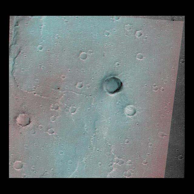
This anaglyph from NASA Mars Global Surveyor shows a circular feature in northern Terra Meridiani. 3D glasses are necessary to view this image.
This image of the vicinity of the Viking Lander 1 was captured by NASA Mars Global Surveyor MOC camera. site. 3D glasses are necessary to identify surface detail.
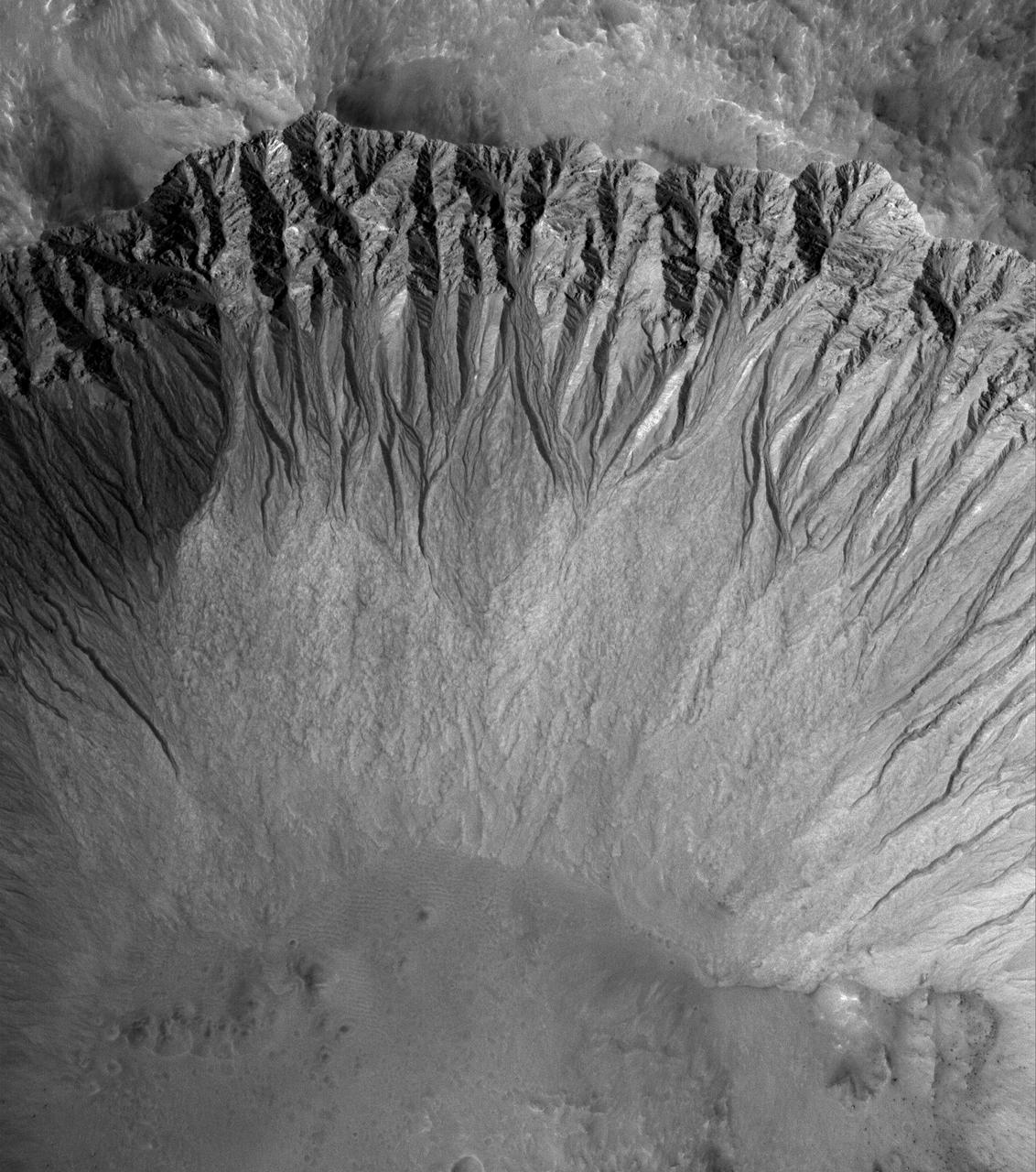
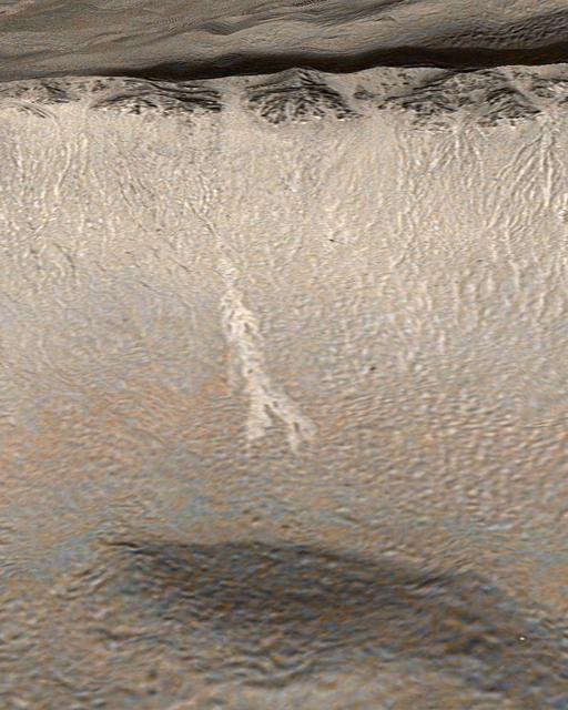
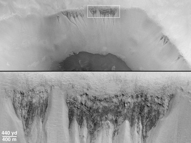
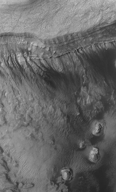
NASA Mars Global Surveyor image shows a suite of south mid-latitude gullies on a crater wall. Gullies such as these may have formed by runoff of liquid water.
This anaglyph from NASA Mars Global Surveyor shows eroded, pitted, light-toned layer outcrops in Iani Chaos. 3D glasses are necessary to view this image.
Two Martian southern mid-latitude craters have new light-toned deposit that formed in gully settings during the course of the Mars Global Surveyor mission.
This stereo image mosaic from NASA Mars Global Surveyor is of Columbia Hills. 3D glasses are necessary to view this image.

What does Earth look like when viewed from Mars? At 13:00 GMT on 8 May 2003, NASA Mars Global Surveyor MGS Mars Orbiter Camera MOC had an opportunity to find out.

This Mars Global Surveyor MGS Mars Orbiter Camera MOC image shows a pedestal crater in the Promethei Terra region. The ejecta from an impact crater is usually rocky
This Mars Global Surveyor MGS Mars Orbiter Camera MOC image shows light-toned, layered rock outcrops in Eos Chaos, located near the east end of the Valles Marineris trough system
This Mars Global Surveyor MGS Mars Orbiter Camera MOC image shows a portion of a field of dark sand dunes superposed on the light-toned floor of a crater in eastern Tyrrhena Terra
This Mars Global Surveyor MGS Mars Orbiter Camera MOC image shows a field of dark sand dunes on the northwestern floor of Brashear Crater. The dunes formed largely from winds that blew from the southeast lower right
Dark spots left and fans appear to scribble dusty hieroglyphics on top of the Martian south polar cap in two high-resolution Mars Global Surveyor, Mars Orbiter Camera images taken in southern spring
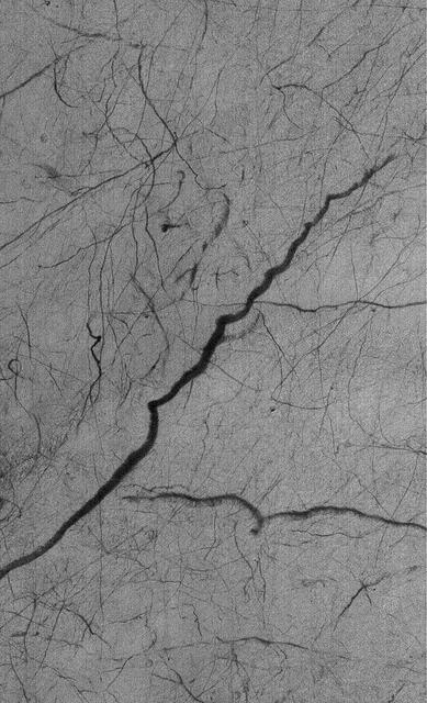
The first clue that there might be places on Mars where liquid groundwater seeps out onto the surface came from a picture taken by NASA Mars Global Surveyor. 3D glasses are necessary to identify surface detail.
This Mars Global Surveyor MGS Mars Orbiter Camera MOC image shows a dust-mantled plain streaked by spring and summertime dust devils in southern Noachis Terra
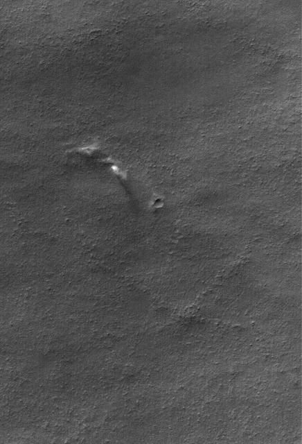
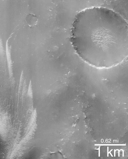
This Mars Global Surveyor MGS Mars Orbiter Camera MOC image shows a field of small craters formed by secondary debris thrown from a larger meteoritic impact on the plains south of the Cerberus region
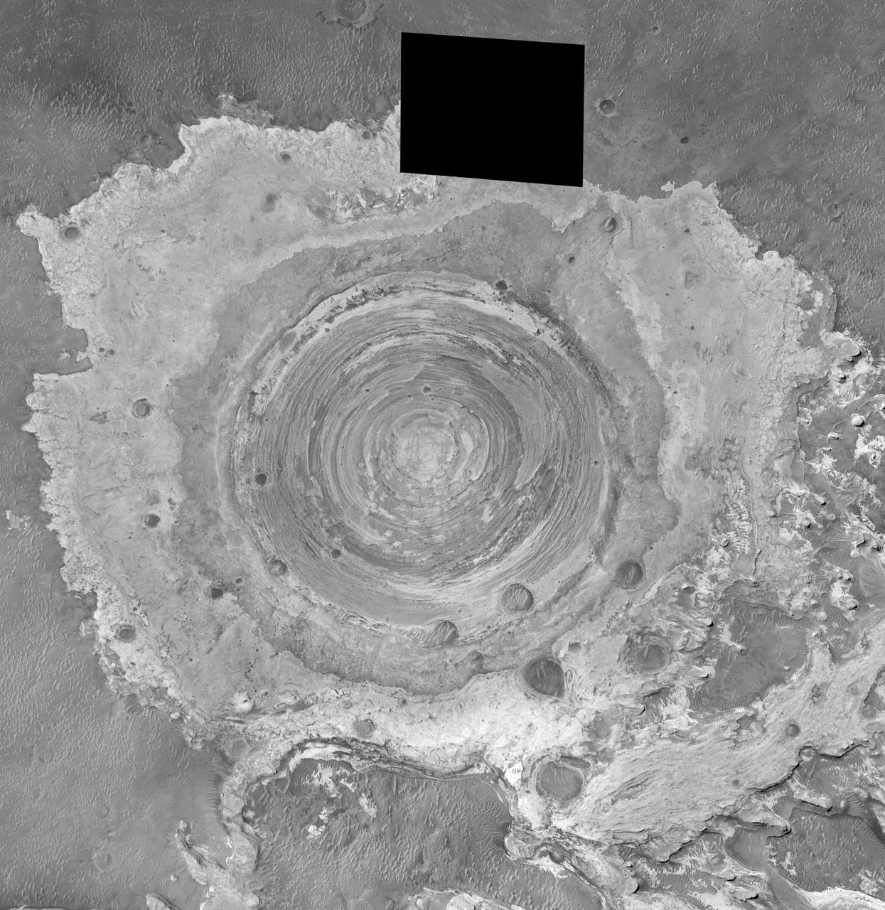
This Mars Global Surveyor MGS Mars Orbiter Camera MOC image shows a layered, light-toned mesa among other layered materials exposed in a mound that covers much of the floor of Spallanzani Crater
This Mars Global Surveyor MGS Mars Orbiter Camera MOC image shows two impact craters of nearly equal size, plus their associated wind streaks. These occur in far eastern Chryse Planitia
This Mars Global Surveyor MGS Mars Orbiter Camera MOC image shows the floor and walls of a small portion of Nirgal Vallis. The floor is covered by large windblown ripples
This pair of Mars Global Surveyor MGS Mars Orbiter Camera MOC color images shows early autumn clouds over the Arsia Mons volcano, plus the shadow of the innermost of the two martain moons, Phobos
Ganges Chasma is part of the Valles Marineris trough system that stretches nearly 5,000 kilometers 3,000 miles across the western equatorial region of Mars. This stereo anaglyph is from NASA Mars Global Surveyor. 3D glasses are necessary.
This Mars Global Surveyor MGS Mars Orbiter Camera MOC image shows gullies formed in the wall of a depression located on the floor of Rabe Crater west of the giant impact basin, Hellas Planitia
This anaglyph from NASA Mars Global Surveyor is of Meridiani Planum, the landing site of Mars Exploration Rover, Opportunity. 3D glasses are necessary to view this image.
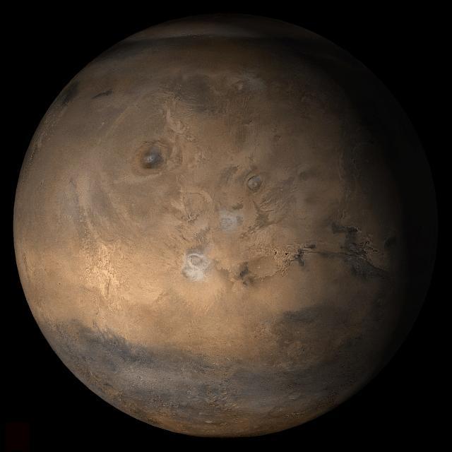
This picture, released 21 September 2005, is a composite of Mars Global Surveyor (MGS) Mars Orbiter Camera (MOC) daily global images acquired at Ls 288° during a previous Mars year. This month, Mars looks similar, as Ls 288° occurred in mid-September 2005. The picture shows the Syrtis Major face of Mars. Over the course of the month, additional faces of Mars as it appears at this time of year are being posted for MOC Picture of the Day. Ls, solar longitude, are a measure of the time of year on Mars. Mars travels 360° around the Sun in 1 Mars year. The year begins at Ls 0°, the start of northern spring and southern autumn.
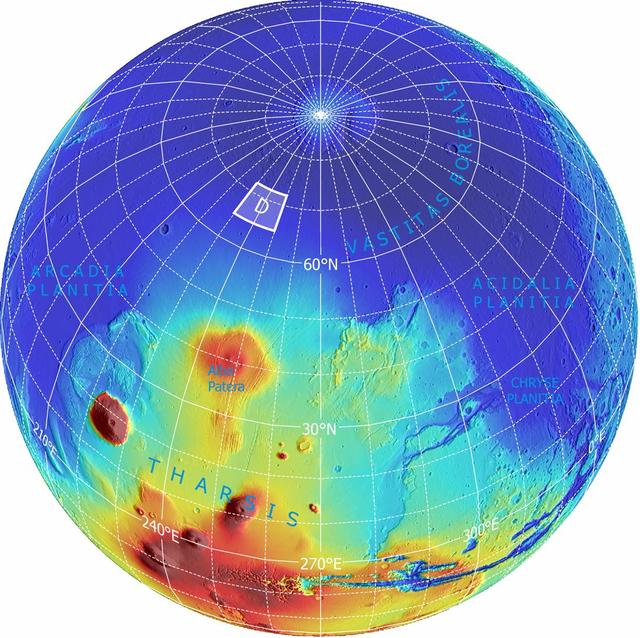
This area was designated Region D in the process of evaluating potential landing sites for NASA Phoenix Mars Lander. The topographical information is from the Mars Orbiter Laser Altimeter on NASA Mars Global Surveyor orbiter.
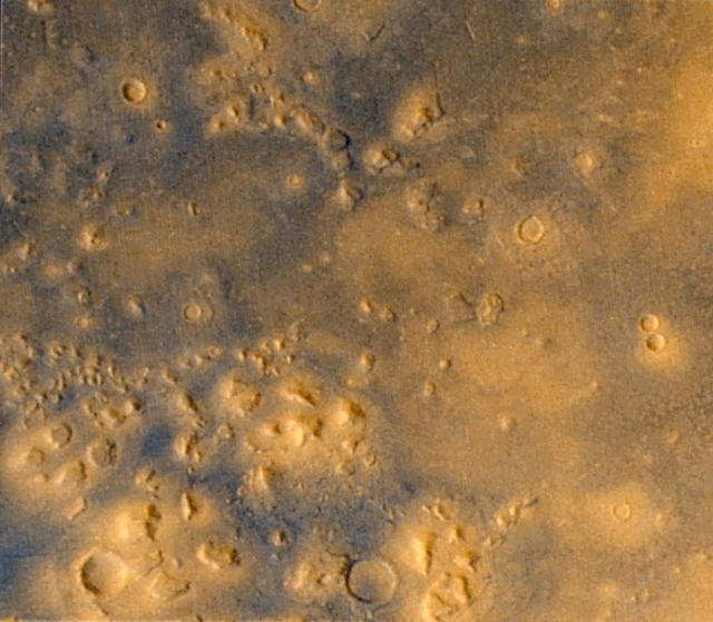
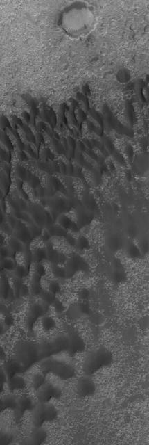
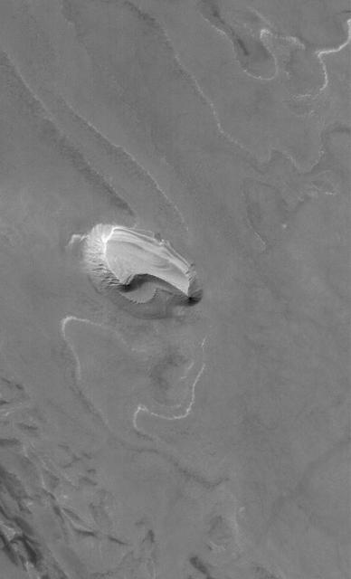
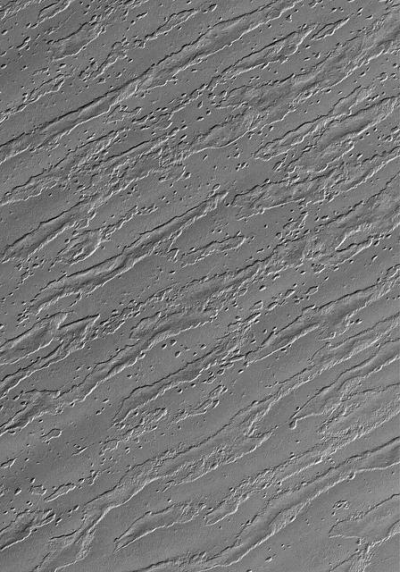
Extensive wind-swept plains of the Medusae Fossae formation on Mars. This northern subframe image, frame 3104, is of a 3.0 x 4.7 km area centered near 2.4 degrees north, 163.8 degrees west. Science Magazine, Volume 279, Number 5357, 13 March 1998, M. C. Malin, et. al., "Early Views of the Martian Surface from the Mars Orbiter Camera of Mars Global Surveyor", pp. 1681-1685 (Fig. 1A) http://photojournal.jpl.nasa.gov/catalog/PIA00800
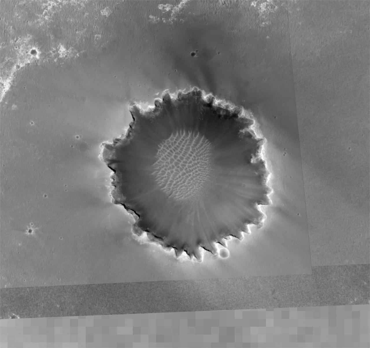
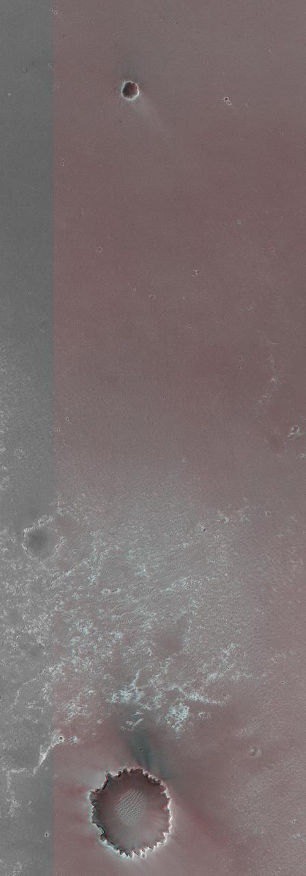
This image from the Mars Orbiter Camera aboard NASA's Mars Global Surveyor spacecraft shows an overview of "Victoria Crater" and a portion of the area NASA's Mars Exploration Rover Opportunity has covered to reach the enormous depression. Images such as this one from the Mars Orbiter Camera on NASA's Mars Global Surveyor are helping scientists and engineers decide the best path for NASA's Mars Exploration Rover Opportunity as it approaches "Victoria Crater." http://photojournal.jpl.nasa.gov/catalog/PIA08777
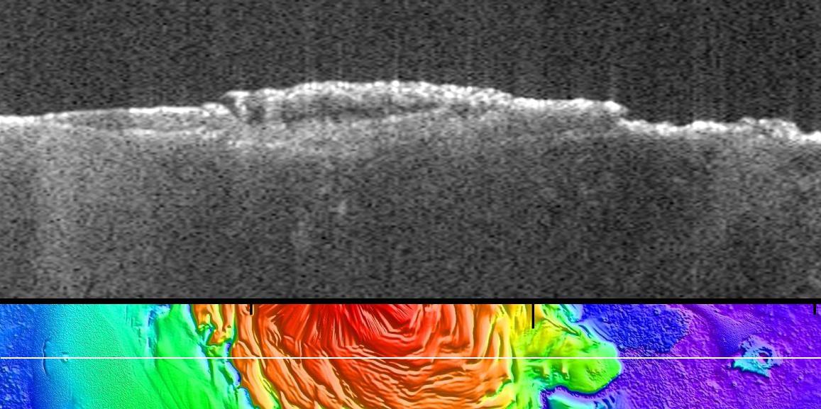
This radargram profile from ESA Mars Express and NASA Mars Global Surveyor orbiter shows data from the subsurface of Mars in the ice-rich north polar plateau of Mars.
Somewhere down there sits the Mars Pathfinder lander and Sojourner rover. This Mars Global Surveyor Mars Orbiter Camera view of the red planet shows the region that includes Ares Vallis and the Chryse Plains upon which both Mars Pathfinder and the Viking 1 landed in 1997 and 1976, respectively. Acidalia Planitia is the dark surface that dominates the center left. The Pathfinder site is immediately south of Acidalia, just left of center in this view. Also shown--the north polar cap is at the top, and Arabia Terra and Sinus Meridiani are to the right. The bluish-white features are clouds. This is a color composite of 9 red and 9 blue image strips taken by the Mars Global Surveyor Mars Orbiter Camera on 9 successive orbits from pole-to-pole during the calibration phase of the mission in March 1999. The color is computer-enhanced and is not shown as it would actually appear to the human eye. http://photojournal.jpl.nasa.gov/catalog/PIA02000

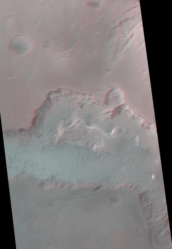
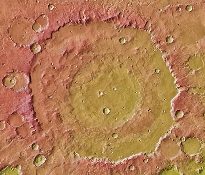
This view of Lyot Crater is a combined mapping by NASA Project Viking with elevation information from Mars Global Surveyor showing at least one of the nine craters in the northern lowlands of Mars with exposures of hydrated minerals detected from orbit.
This anaglyph from NASA Mars Global Surveyor shows a circular feature in northern Terra Meridiani. The circular feature was once an impact crater. 3D glasses are necessary to view this image.
The anaglyph is helpful to see that the dark streaks really do occur on a slope in this image taken by NASA Mars Global Surveyor 1999. 3D glasses are necessary to view this image.
This Mars Global Surveyor MOC image shows the remains of a once more laterally extensive layer overlying undulating terrain very near the south polar residual cap
The light-toned materials at the bottom end of this anaglyph fomr NASA Mars Global Surveyor are considered to be thick exposures of sedimentary rock. 3D glasses are necessary to view this image.
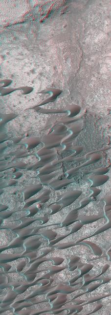
This stereo image mosaic from NASA Mars Global Surveyor is of a field of dunes located in Nili Patera, a volcanic depression in central Syrtis Major. 3D glasses are necessary to view this image.
The anaglyph is helpful to see that the dark streaks really do occur on a slope in this image taken by NASA Mars Global Surveyor 1999. 3D glasses are necessary to view this image.
This Mars Global Surveyor MOC image shows dark dunes superposed on the rippled floor of Proctor Crater in Noachis Terra. Winds blowing predominantly from east right to west left were responsible for the formation of these dunes
This picture is a composite of Mars Global Surveyor (MGS) Mars Orbiter Camera (MOC) daily global images acquired at Ls 211° during a previous Mars year. This month, Mars looks similar, as Ls 211° occurred in mid-May 2005. The picture shows the Elysium/Mare Cimmerium face of Mars. Over the course of the month, additional faces of Mars as it appears at this time of year are being posted for MOC Picture of the Day. Ls, solar longitude, is a measure of the time of year on Mars. Mars travels 360° around the Sun in 1 Mars year. The year begins at Ls 0°, the start of northern spring and southern autumn. http://photojournal.jpl.nasa.gov/catalog/PIA07988
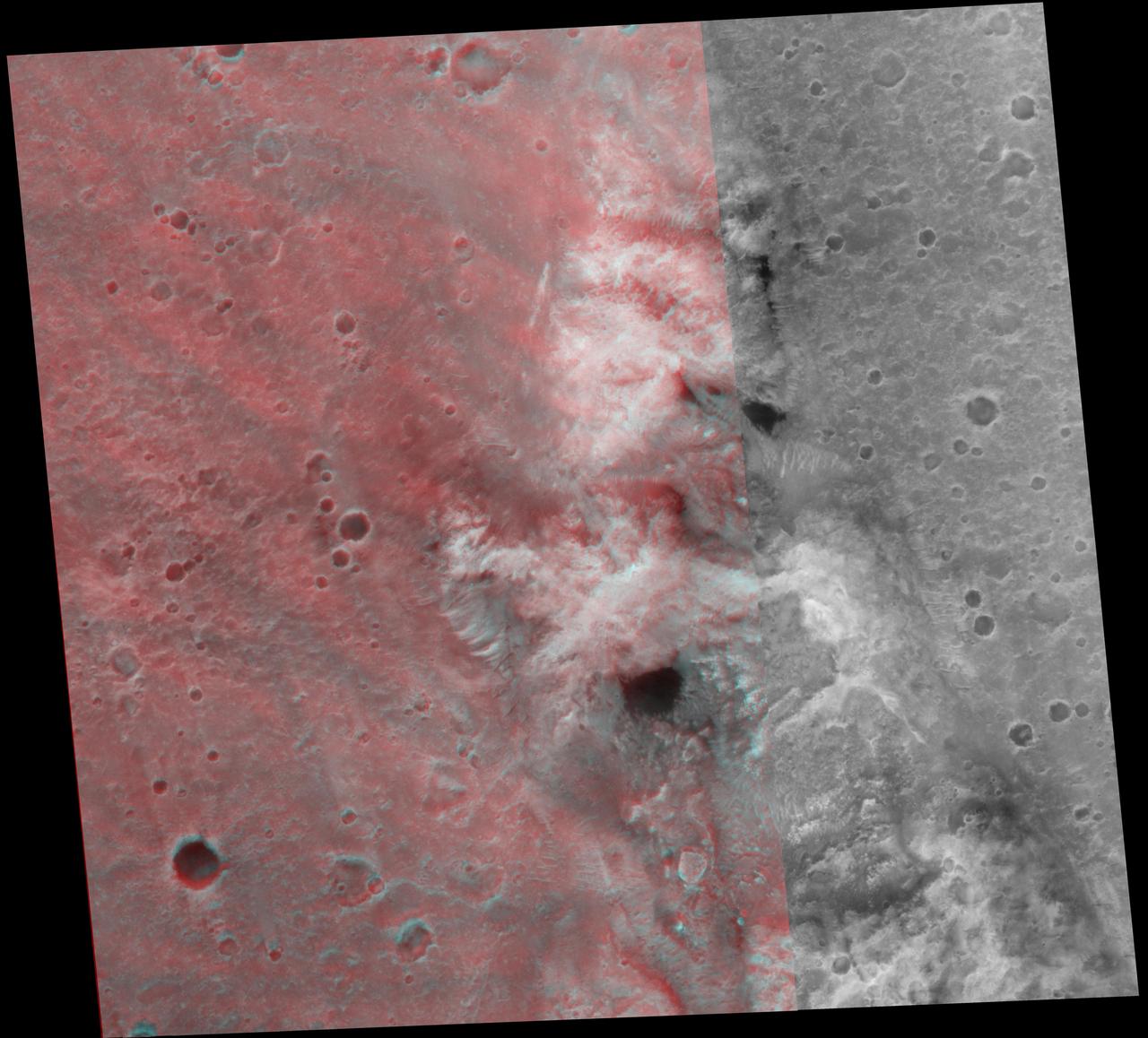
This image from NASA Mars Global Surveyor and Mars Odyssey spacecraft shows the context for orbital observations of exposed rocks that had been buried on Mars. The area is dominated by the Huygens crater, which is about the size of Wisconsin.
This pair of maps based on albedo information from NASA Mars Odyssey orbiter and topographical information from NASA Mars Global Surveyor orbiter indicates locations of confirmed sites of recurrent slope linea on Mars.
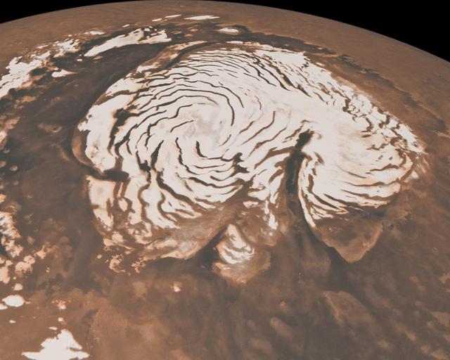
This image, combining data from two instruments aboard NASA Mars Global Surveyor, depicts an orbital view of the north polar region of Mars. To the right of center, a large canyon, Chasma Boreale, almost bisects the white ice cap.
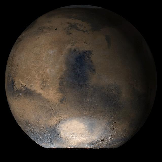
This picture is a composite of Mars Global Surveyor (MGS) Mars Orbiter Camera (MOC) daily global images acquired at Ls 193° during a previous Mars year. This month, Mars looks similar, as Ls 193° occurs in mid-April 2005. The picture shows the Acidalia/Mare Erythraeum face of Mars. Over the course of the month, additional faces of Mars as it appears at this time of year are being posted for MOC Picture of the Day. Ls, solar longitude, is a measure of the time of year on Mars. Mars travels 360° around the Sun in 1 Mars year. The year begins at Ls 0°, the start of northern spring and southern autumn. Location near: 47.3°N, 294.0°W Image width: ~3 km (~1.9 mi) Illumination from: lower left Season: Northern Summer. http://photojournal.jpl.nasa.gov/catalog/PIA07837
This picture is a composite of Mars Global Surveyor (MGS) Mars Orbiter Camera (MOC) daily global images acquired at Ls 176° during a previous Mars year. This month, Mars looks similar, as Ls 176° occurs in mid-March 2005. The picture shows the Acidalia/Mare Erythraeum face of Mars. Over the course of the month, additional faces of Mars as it appears at this time of year are being posted for MOC Picture of the Day. Ls, solar longitude, is a measure of the time of year on Mars. Mars travels 360° around the Sun in 1 Mars year. The year begins at Ls 0°, the start of northern spring and southern autumn. Season: Northern Summer/Southern Winter. http://photojournal.jpl.nasa.gov/catalog/PIA07443
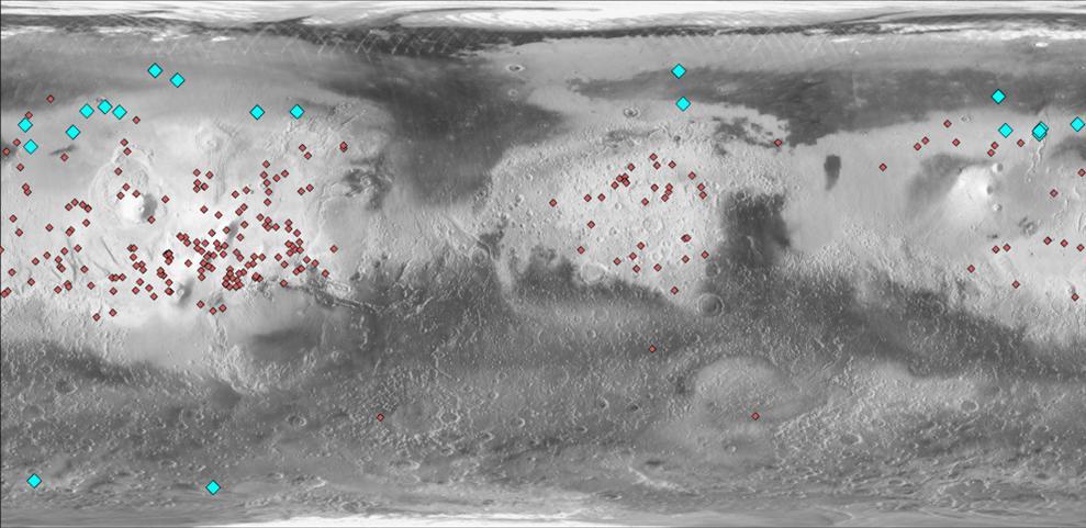
This map of Mars indicates locations of new craters that have excavated ice blue and those that have not red. Albedo information comes from NASA Mars Odyssey orbiter, and the map comes from NASA Mars Global Surveyor orbiter.
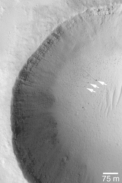
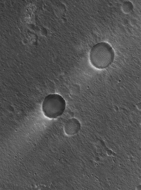
15 July 2004 The arrows in this Mars Global Surveyor (MGS) Mars Orbiter Camera (MOC) picture point to three boulders that left trails behind them as they rolled down the lower parts of a meteor crater's wall. In two cases, the tracks can be resolved into a series of small depressions, indicating the variable shape of the boulder as it unevenly proceeded down the slope. These features are located near 18.4°N, 120.1°W. The 75 meter scale bar is about 246 feet long. Sunlight illuminates the scene from the lower left. http://photojournal.jpl.nasa.gov/catalog/PIA06450
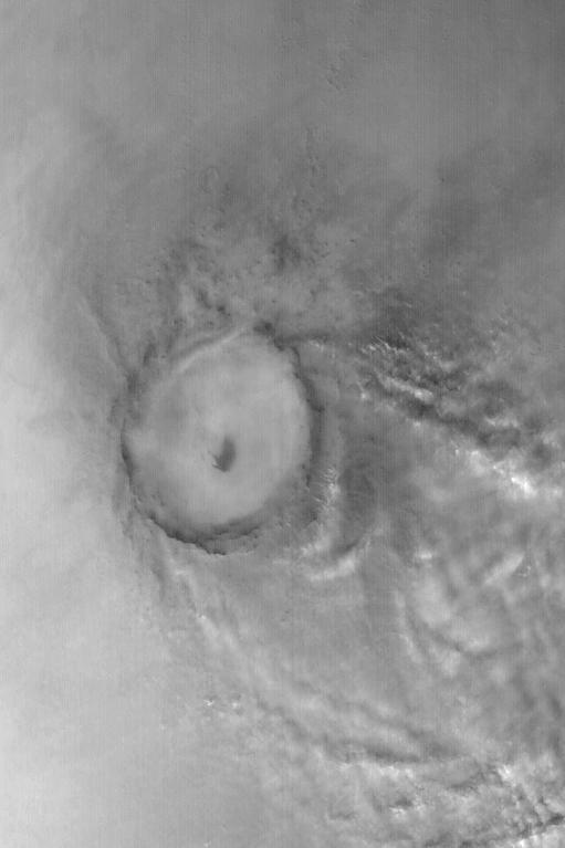
Mie Crater, a large basin formed by asteroid or comet impact in Utopia Planitia, lies at the center of this Mars Global Surveyor (MGS) Mars Orbiter Camera (MOC) red wide angle image. The crater is approximately 104 km (65 mi) across. To the east and southeast (toward the lower right) of Mie, in this 5 December 2003 view, are clouds of dust and water ice kicked up by local dust storm activity. It is mid-winter in the northern hemisphere of Mars, a time when passing storms are common on the northern plains of the red planet. Sunlight illuminates this image from the lower left; Mie Crater is located at 48.5°N, 220.3°W. Viking 2 landed west/southwest of Mie Crater, off the left edge of this image, in September 1976. http://photojournal.jpl.nasa.gov/catalog/PIA04930
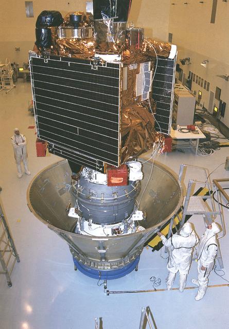
Workers at the Jet Propulsion Research Lab (JPL) in the Payload Hazardous Servicing Facility (PHSF) prepare the Mars Global Surveyor spacecraft for transfer to the launch pad by placing it in a protective canister. The Surveyor spacecraft (upper) is already mated to its solid propellant upper stage booster (lower), which is actually the third stage of the Delta II expendable launch vehicle that will propel the spacecraft on its interplanetary journey to Mars.
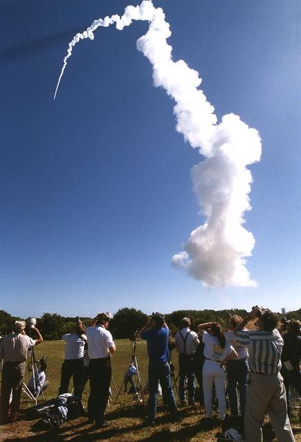
The journey back to Mars begins with a liftoff of the Mars Global Surveyor atop a Delta II 7925A expendable launch vehicle from the Cape Canaveral Air Station. After an approximate 10-month interplanetary odyssey, the spacecraft will arrive at Mars and begin a 4-month aerobreaking phase, an irnovative technique first demonstrated during the Magellan mission to Venus, to achieve a mapping orbit. It will take about 2 Earth years for Surveyor to circle above most of the planet, its suite of sophisticated remote-sensing instruments building a comprehensive global portrait of Mars by mapping its topography, magnetism, mineral composition and atmosphere. Among the locations the Surveyor will pass over are the landing sites where the two U.S. Viking landers have stood since 1975 as silent monuments to the most recent successful U.S. missions to Mars. The Global Surveyor is the first of a trio of spacecraft being launched to Mars; next is Russia's Mars `96 spacecraft, followed by the U.S.'s Mars Pathfinder.
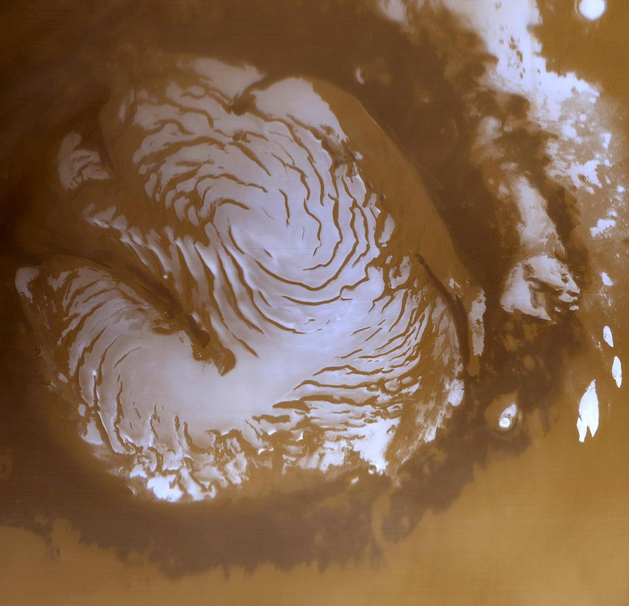
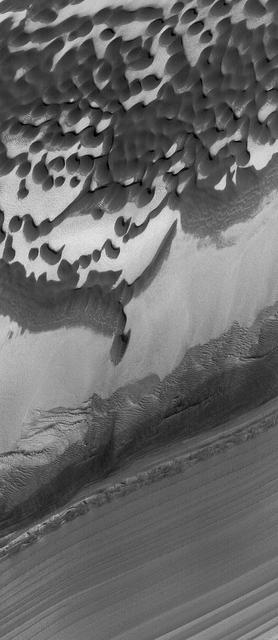
This is a wide angle view of the martian north polar cap as it appeared to the Mars Global Surveyor (MGS) Mars Orbiter Camera (MOC) in early northern summer. The picture was acquired on March 13, 1999, near the start of the Mapping Phase of the MGS mission. The light-toned surfaces are residual water ice that remains through the summer season. The nearly circular band of dark material surrounding the cap consists mainly of sand dunes formed and shaped by wind. The north polar cap is roughly 1100 kilometers (680 miles) across. http://photojournal.jpl.nasa.gov/catalog/PIA02800
The light-toned deposits that formed in two gully sites on Mars during the Mars Global Surveyor (MGS) Mars Orbiter Camera (MOC) mission in the 1999 to 2005 period are considered to be the result of sediment transport by a fluid with the physical properties of liquid water. The young, light-toned gully deposits were found in a crater in Terra Sirenum (see PIA09027 or MOC2-1618) and in a crater east of the Hellas basin in the Centauri Montes region (see PIA09028 or MOC2-1619). In their study of how the light-toned gully deposits may have formed, the MOC team considered their resemblance to light- and dark-toned slope streaks found elsewhere on Mars. Slope streaks are most commonly believed to have formed by downslope movement of extremely dry, very fine-grained dust, through processes thought by some to be analogous to terrestrial snow avalanche formation. http://photojournal.jpl.nasa.gov/catalog/PIA09030
This Mars Global Surveyor (MGS) Mars Orbiter Camera (MOC) image shows a high resolution view of a surface composed almost entirely of eroded, exposed sedimentary rock in the Sinus Meridiani region of Mars. If one could vacuum up all of the dark sand and dust that covers the rocks at the Mars Exploration Rover, Opportunity, site, one might find a surface similar to that shown here. Note, just right of center, the occurrence of a circular feature. This is the site of a filled and buried meteor impact crater. Filled and buried craters are common among the sedimentary rocks of the Meridiani region. Location near: 1.5°N, 359.4°W Image width: ~3 km (~1.9 mi) Illumination from: upper left Season: Northern Summer http://photojournal.jpl.nasa.gov/catalog/PIA07887
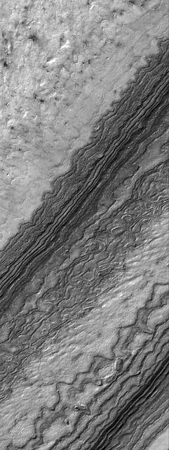
22 September 2005 This Mars Global Surveyor (MGS) Mars Orbiter Camera (MOC) image shows details among some of the eroded layer outcrops of the martian south polar region. Much of the south polar region of Mars is covered by a thick unit of layered material. For decades, the layers have been assumed to consist of a mixture of dust and ice, but it is equally possible that the materials are sedimentary rocks. This image was captured during southern spring, at a time when some of the surface was still covered by seasonal carbon dioxide (CO2) frost. Location near: 86.5°S, 116.6°W Image width: width: ~3 km (~1.9 mi) Illumination from: upper left Season: Southern Spring http://photojournal.jpl.nasa.gov/catalog/PIA06344
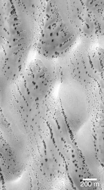
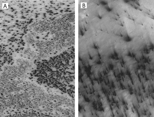
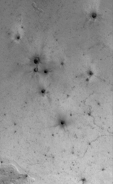
The patterns created by dark spots on defrosting south polar dunes are often strange and beautiful. This picture, which the Mars Orbiter Camera team has dubbed, "the snow leopard," shows a dune field located at 61.5°S, 18.9°W, as it appeared on July 1, 1999. The spots are areas where dark sand has been exposed from beneath bright frost as the south polar winter cap begins to retreat. Many of the spots have a diffuse, bright ring around them this is thought to be fresh frost that was re-precipitated after being removed from the dark spot. The spots seen on defrosting polar dunes are a new phenomenon that was not observed by previous spacecraft missions to Mars. Thus, there is much about these features that remains unknown. For example, no one yet knows why the dunes become defrosted by forming small spots that grow and grow over time. No one knows for sure if the bright rings around the dark spots are actually composed of re-precipitated frost. And no one knows for sure why some dune show spots that appear to be "lined-up" (as they do in the picture shown here). This Mars Global Surveyor Mars Orbiter Camera image is illuminated from the upper left. North is toward the upper right. The scale bar indicates a distance of 200 meters (656 feet). http://photojournal.jpl.nasa.gov/catalog/PIA02301
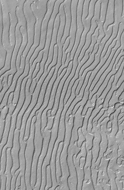
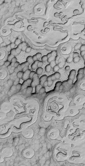
This picture is illuminated by sunlight from the upper left. Some portions of the martian south polar residual cap have long, somewhat curved troughs instead of circular pits. These appear to form in a layer of material that may be different than that in which "swiss cheese" circles and pits form, and none of these features has any analog in the north polar cap or elsewhere on Mars. This picture shows the "fingerprint" terrain as a series of long, narrow depressions considered to have formed by collapse and widening by sublimation of ice. Unlike the north polar cap, the south polar region stays cold enough in summer to retain frozen carbon dioxide. Viking Orbiter observations during the late 1970s showed that very little water vapor comes off the south polar cap during summer, indicating that any frozen water that might be there remains solid throughout the year. This Mars Global Surveyor (MGS) Mars Orbiter Camera (MOC) image was obtained in early southern spring on August 4, 1999. It shows an area 3 x 5 kilometers (1.9 x 3.1 miles) at a resolution of about 7.3 meters (24 ft) per pixel. Located near 86.0°S, 53.9°W. http://photojournal.jpl.nasa.gov/catalog/PIA02373
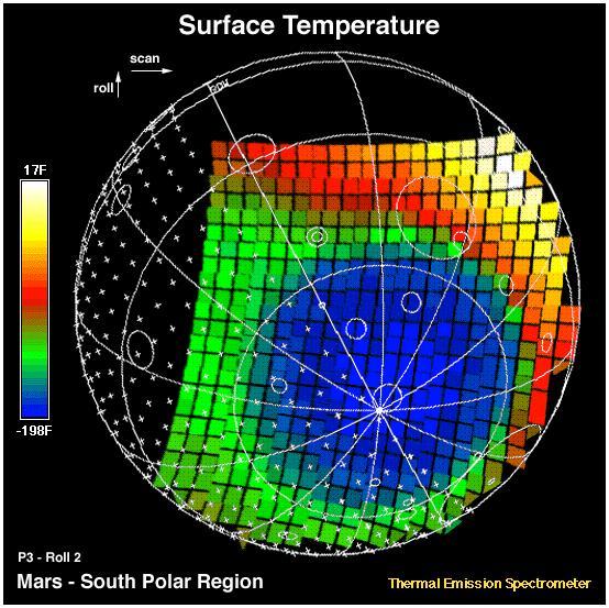
This image shows the temperature of the martian surface measured by the Mars Global Surveyor Thermal Emission Spectrometer (TES) instrument. On September 15, 3 hours and 48 minutes after the spacecrafts third close approach to the planet, the TES instrument was commanded to point at Mars and measure the temperature of the surface during a four minute scan. At this time MGS was approximately 15,000 miles (~24,000 km) from the planet, with a view looking up from beneath the planet at the south polar region. The circular blue region (- 198 F) is the south polar cap of Mars that is composed of CO2 ice. The night side of the planet, shown with crosses, is generally cool (green). The sunlit side of the planet reaches temperatures near 15 F (yellow). Each square represents an individual observation acquired in 2 seconds with a ground resolution of ~125 miles (~200 km). The TES instrument will remain on and collect similar images every 100 minutes to monitor the temperature of the surface and atmosphere throughout the aerobraking phase of the MGS mission. http://photojournal.jpl.nasa.gov/catalog/PIA00937
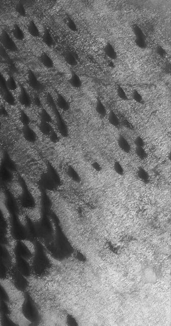
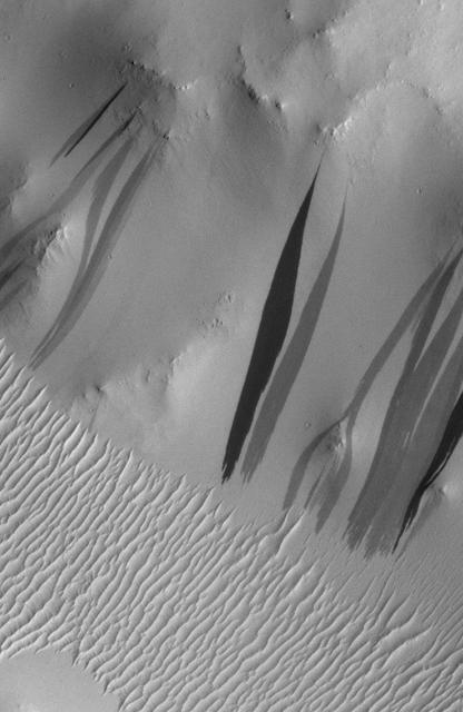
This Mars Global Surveyor (MGS) Mars Orbiter Camera (MOC) image of dunes in the martian north polar region is important because it shows one of the highest northern latitude views of streaks thought to be made by passing dust devils. The dark, thin, filamentary streaks on the dunes and on the adjacent plains were probably formed by dust devils. The dunes occur near 76.6°N, 62.7°W. Dust devil streaks are observed on Mars at very high latitudes, such as this, all the way down to the equator. They are also seen at all elevations, from the deepest parts of the Hellas Basin to the summit of Olympus Mons. This picture covers an area about 3 km (1.9 mi) wide. Sunlight illuminates the scene from the lower left. http://photojournal.jpl.nasa.gov/catalog/PIA06334