
An artist concept of NASA Mars Global Surveyor MGS flying over Mars.
This picture is a composite of Mars Global Surveyor MGS Mars Orbiter Camera MOC daily global images acquired at Ls 79° during a previous Mars year
This picture is a composite of Mars Global Surveyor MGS Mars Orbiter Camera MOC daily global images acquired at Ls 66° during a previous Mars year
This picture is a composite of Mars Global Surveyor MGS Mars Orbiter Camera MOC daily global images acquired at Ls 12° during a previous Mars year
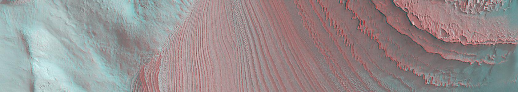
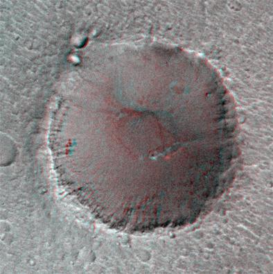
This anaglyph from Mars Global Surveyor MGS shows layers in Galle Crater. 3D glasses are necessary to view this image.
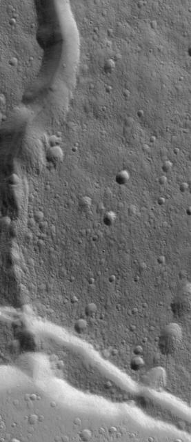
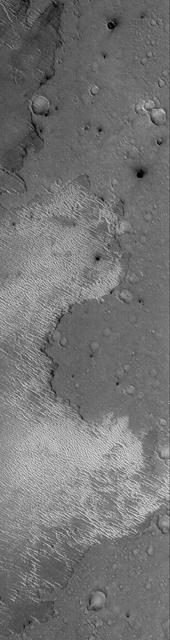
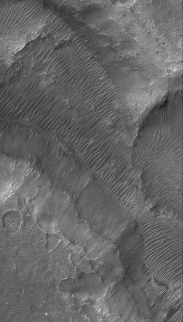
This Mars Global Surveyor MGS Mars Orbiter Camera MOC image shows layered buttes, knobs, and other landforms exposed by erosion in the Aeolis region of Mars
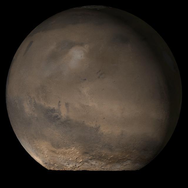
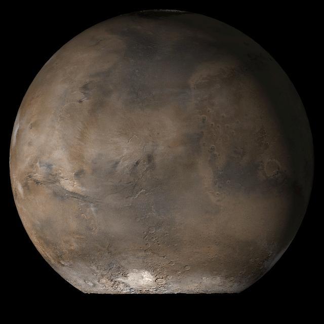
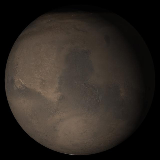
This picture is a composite of Mars Global Surveyor MGS Mars Orbiter Camera MOC daily global images acquired at Ls 79° during a previous Mars year of the Elysium/Mare Cimmerium face of Mars

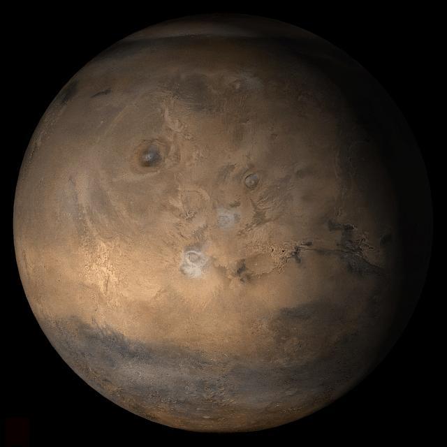
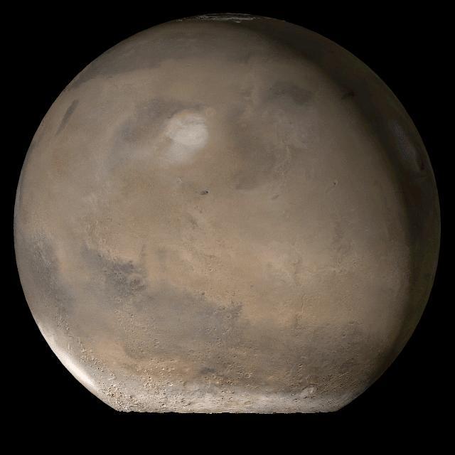
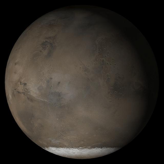
This picture is a composite of Mars Global Surveyor MGS Mars Orbiter Camera MOC daily global images acquired at Ls 93° during a previous Mars year.of the Tharsis face of Mars

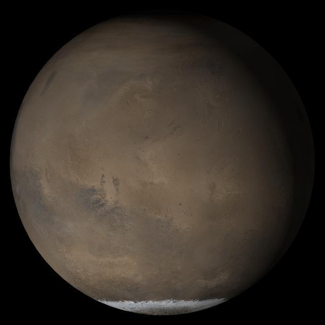
This picture is a composite of Mars Global Surveyor MGS Mars Orbiter Camera MOC daily global images acquired at Ls 93° during a previous Mars year.of the Acidalia/Mare Erythraeum face of Mars
This Mars Global Surveyor MGS Mars Orbiter Camera MOC image shows an eroded stack of layered material in a crater of the south polar region of Mars
This Mars Global Surveyor MGS Mars Orbiter Camera MOC image shows dust plumes created by gusting winds on a plain southwest of Argyre Planitia
This Mars Global Surveyor MGS Mars Orbiter Camera MOC image shows a portion of the stair-stepped, north wall of a crater in Arabia Terra
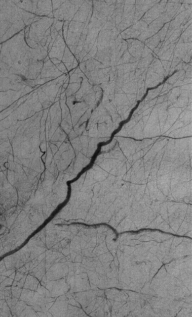
This Mars Global Surveyor MGS Mars Orbiter Camera MOC image shows a complex pattern of intersecting and overlapping troughs in the Olympica Fossae region of northern Tharsis
This Mars Global Surveyor MGS Mars Orbiter Camera MOC image shows a spectacular summertime view of a portion of the south polar residual cap
This Mars Global Surveyor MGS Mars Orbiter Camera MOC image shows layers and dunes in Chasma Boreale, a large depression in the north polar region.
This Mars Global Surveyor MGS Mars Orbiter Camera MOC image shows a channel extending northward from the Elysium Mons caldera at the volcano summit
This Mars Global Surveyor MGS Mars Orbiter Camera MOC image shows dark streaks created by dust devils on a plain southwest of Hellas Planitia
This picture is a composite of Mars Global Surveyor MGS Mars Orbiter Camera MOC daily global images acquired at L<sub>s</sub> 107° of the Elysium/Mare Cimmerium face during a previous Mars year
This picture is a composite of Mars Global Surveyor MGS Mars Orbiter Camera MOC daily global images acquired at Ls 107° of the Acidalia/Mare Erythraeum face during a previous Mars year
This picture is a composite of Mars Global Surveyor MGS Mars Orbiter Camera MOC daily global images acquired at Ls 93° of the Tharsis face during a previous Mars year
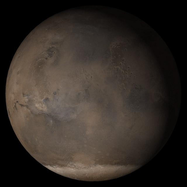
This picture is a composite of Mars Global Surveyor MGS Mars Orbiter Camera MOC daily global images acquired at Ls 107° of the Syrtis Major face during a previous Mars year
This Mars Global Surveyor MGS Mars Orbiter Camera MOC image shows polygonally patterned ground on the floor of a trough in the southern hemisphere of Mars. The polygons could be an indicator that ground ice is or was present at this location
This Mars Global Surveyor MGS Mars Orbiter Camera MOC image shows layered material exposed on a slope in the south polar region of Mars. The composition of the layers, and whether they contain ice, is not known
This Mars Global Surveyor MGS Mars Orbiter Camera MOC image shows the margin of a lava flow on a cratered plain in the Athabasca Vallis region of Mars. Remarkably, the cratered plain in this scene is essentially free of bright, windblown ripples

What does Earth look like when viewed from Mars? At 13:00 GMT on 8 May 2003, NASA Mars Global Surveyor MGS Mars Orbiter Camera MOC had an opportunity to find out.

This Mars Global Surveyor MGS Mars Orbiter Camera MOC image shows a pedestal crater in the Promethei Terra region. The ejecta from an impact crater is usually rocky
This Mars Global Surveyor MGS Mars Orbiter Camera MOC image shows light-toned, layered rock outcrops in Eos Chaos, located near the east end of the Valles Marineris trough system
This Mars Global Surveyor MGS Mars Orbiter Camera MOC image shows a portion of a field of dark sand dunes superposed on the light-toned floor of a crater in eastern Tyrrhena Terra
This Mars Global Surveyor MGS Mars Orbiter Camera MOC image shows a field of dark sand dunes on the northwestern floor of Brashear Crater. The dunes formed largely from winds that blew from the southeast lower right
This Mars Global Surveyor MGS Mars Orbiter Camera MOC image shows a dust-mantled plain streaked by spring and summertime dust devils in southern Noachis Terra
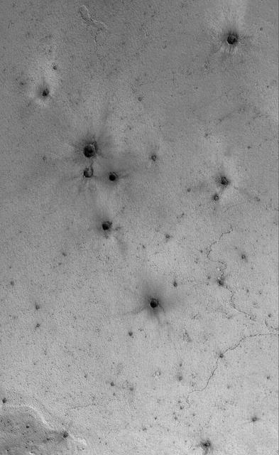
This Mars Global Surveyor MGS Mars Orbiter Camera MOC image shows a field of small craters formed by secondary debris thrown from a larger meteoritic impact on the plains south of the Cerberus region
This Mars Global Surveyor MGS Mars Orbiter Camera MOC image shows a layered, light-toned mesa among other layered materials exposed in a mound that covers much of the floor of Spallanzani Crater
This Mars Global Surveyor MGS Mars Orbiter Camera MOC image shows two impact craters of nearly equal size, plus their associated wind streaks. These occur in far eastern Chryse Planitia
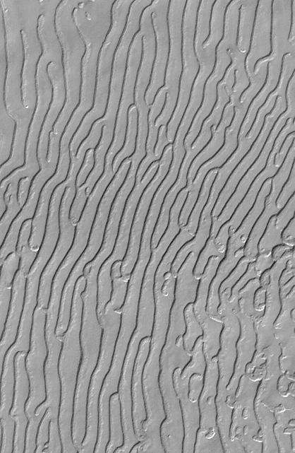
This Mars Global Surveyor MGS Mars Orbiter Camera MOC image shows the floor and walls of a small portion of Nirgal Vallis. The floor is covered by large windblown ripples
This pair of Mars Global Surveyor MGS Mars Orbiter Camera MOC color images shows early autumn clouds over the Arsia Mons volcano, plus the shadow of the innermost of the two martain moons, Phobos
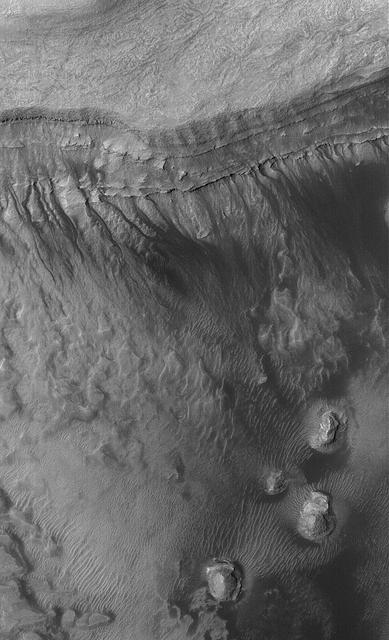
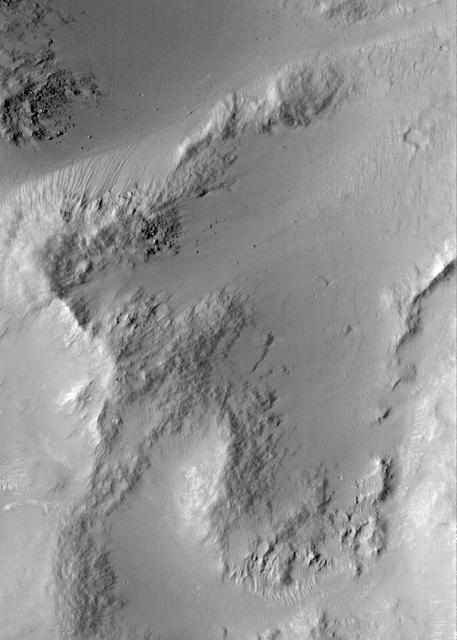
This Mars Global Surveyor MGS Mars Orbiter Camera MOC image shows gullies formed in the wall of a depression located on the floor of Rabe Crater west of the giant impact basin, Hellas Planitia
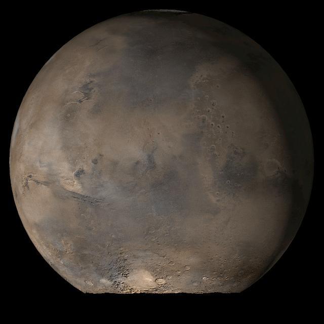
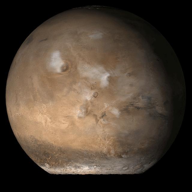
This picture is a composite of Mars Global Surveyor MGS Mars Orbiter Camera MOC daily global images acquired at Ls 79° during a previous Mars year. This month, Mars looks similar, as Ls 79° occurs in mid-July 2006
This picture, released 21 September 2005, is a composite of Mars Global Surveyor (MGS) Mars Orbiter Camera (MOC) daily global images acquired at Ls 288° during a previous Mars year. This month, Mars looks similar, as Ls 288° occurred in mid-September 2005. The picture shows the Syrtis Major face of Mars. Over the course of the month, additional faces of Mars as it appears at this time of year are being posted for MOC Picture of the Day. Ls, solar longitude, are a measure of the time of year on Mars. Mars travels 360° around the Sun in 1 Mars year. The year begins at Ls 0°, the start of northern spring and southern autumn.
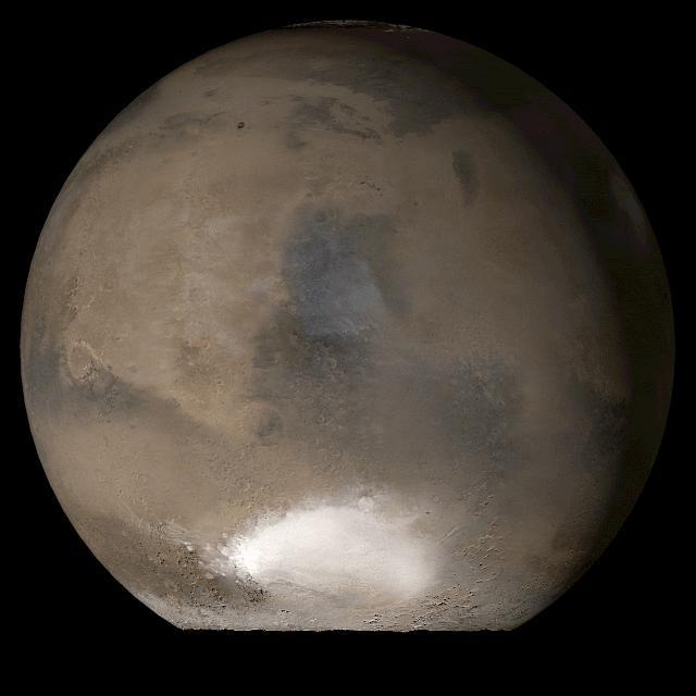
This picture is a composite of Mars Global Surveyor (MGS) Mars Orbiter Camera (MOC) daily global images acquired at Ls 211° during a previous Mars year. This month, Mars looks similar, as Ls 211° occurred in mid-May 2005. The picture shows the Elysium/Mare Cimmerium face of Mars. Over the course of the month, additional faces of Mars as it appears at this time of year are being posted for MOC Picture of the Day. Ls, solar longitude, is a measure of the time of year on Mars. Mars travels 360° around the Sun in 1 Mars year. The year begins at Ls 0°, the start of northern spring and southern autumn. http://photojournal.jpl.nasa.gov/catalog/PIA07988
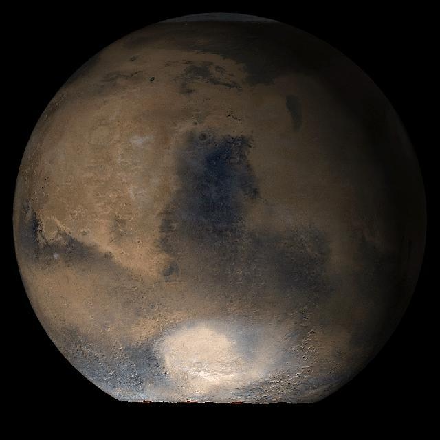
This picture is a composite of Mars Global Surveyor (MGS) Mars Orbiter Camera (MOC) daily global images acquired at Ls 193° during a previous Mars year. This month, Mars looks similar, as Ls 193° occurs in mid-April 2005. The picture shows the Acidalia/Mare Erythraeum face of Mars. Over the course of the month, additional faces of Mars as it appears at this time of year are being posted for MOC Picture of the Day. Ls, solar longitude, is a measure of the time of year on Mars. Mars travels 360° around the Sun in 1 Mars year. The year begins at Ls 0°, the start of northern spring and southern autumn. Location near: 47.3°N, 294.0°W Image width: ~3 km (~1.9 mi) Illumination from: lower left Season: Northern Summer. http://photojournal.jpl.nasa.gov/catalog/PIA07837
This picture is a composite of Mars Global Surveyor (MGS) Mars Orbiter Camera (MOC) daily global images acquired at Ls 176° during a previous Mars year. This month, Mars looks similar, as Ls 176° occurs in mid-March 2005. The picture shows the Acidalia/Mare Erythraeum face of Mars. Over the course of the month, additional faces of Mars as it appears at this time of year are being posted for MOC Picture of the Day. Ls, solar longitude, is a measure of the time of year on Mars. Mars travels 360° around the Sun in 1 Mars year. The year begins at Ls 0°, the start of northern spring and southern autumn. Season: Northern Summer/Southern Winter. http://photojournal.jpl.nasa.gov/catalog/PIA07443
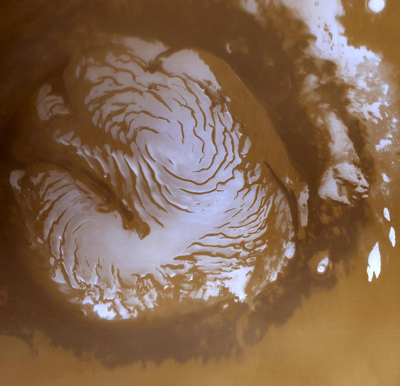
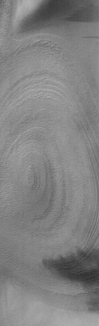
This is a wide angle view of the martian north polar cap as it appeared to the Mars Global Surveyor (MGS) Mars Orbiter Camera (MOC) in early northern summer. The picture was acquired on March 13, 1999, near the start of the Mapping Phase of the MGS mission. The light-toned surfaces are residual water ice that remains through the summer season. The nearly circular band of dark material surrounding the cap consists mainly of sand dunes formed and shaped by wind. The north polar cap is roughly 1100 kilometers (680 miles) across. http://photojournal.jpl.nasa.gov/catalog/PIA02800
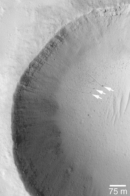
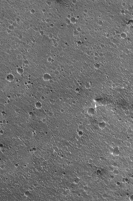
15 July 2004 The arrows in this Mars Global Surveyor (MGS) Mars Orbiter Camera (MOC) picture point to three boulders that left trails behind them as they rolled down the lower parts of a meteor crater's wall. In two cases, the tracks can be resolved into a series of small depressions, indicating the variable shape of the boulder as it unevenly proceeded down the slope. These features are located near 18.4°N, 120.1°W. The 75 meter scale bar is about 246 feet long. Sunlight illuminates the scene from the lower left. http://photojournal.jpl.nasa.gov/catalog/PIA06450
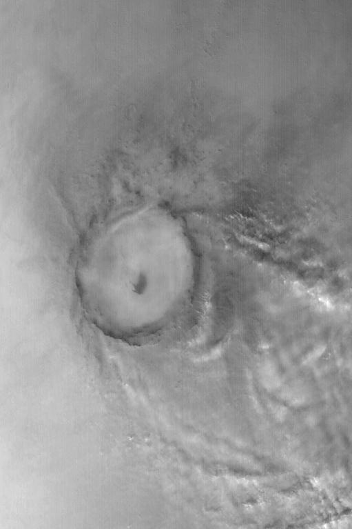
Mie Crater, a large basin formed by asteroid or comet impact in Utopia Planitia, lies at the center of this Mars Global Surveyor (MGS) Mars Orbiter Camera (MOC) red wide angle image. The crater is approximately 104 km (65 mi) across. To the east and southeast (toward the lower right) of Mie, in this 5 December 2003 view, are clouds of dust and water ice kicked up by local dust storm activity. It is mid-winter in the northern hemisphere of Mars, a time when passing storms are common on the northern plains of the red planet. Sunlight illuminates this image from the lower left; Mie Crater is located at 48.5°N, 220.3°W. Viking 2 landed west/southwest of Mie Crater, off the left edge of this image, in September 1976. http://photojournal.jpl.nasa.gov/catalog/PIA04930
The light-toned deposits that formed in two gully sites on Mars during the Mars Global Surveyor (MGS) Mars Orbiter Camera (MOC) mission in the 1999 to 2005 period are considered to be the result of sediment transport by a fluid with the physical properties of liquid water. The young, light-toned gully deposits were found in a crater in Terra Sirenum (see PIA09027 or MOC2-1618) and in a crater east of the Hellas basin in the Centauri Montes region (see PIA09028 or MOC2-1619). In their study of how the light-toned gully deposits may have formed, the MOC team considered their resemblance to light- and dark-toned slope streaks found elsewhere on Mars. Slope streaks are most commonly believed to have formed by downslope movement of extremely dry, very fine-grained dust, through processes thought by some to be analogous to terrestrial snow avalanche formation. http://photojournal.jpl.nasa.gov/catalog/PIA09030
This Mars Global Surveyor (MGS) Mars Orbiter Camera (MOC) image shows a high resolution view of a surface composed almost entirely of eroded, exposed sedimentary rock in the Sinus Meridiani region of Mars. If one could vacuum up all of the dark sand and dust that covers the rocks at the Mars Exploration Rover, Opportunity, site, one might find a surface similar to that shown here. Note, just right of center, the occurrence of a circular feature. This is the site of a filled and buried meteor impact crater. Filled and buried craters are common among the sedimentary rocks of the Meridiani region. Location near: 1.5°N, 359.4°W Image width: ~3 km (~1.9 mi) Illumination from: upper left Season: Northern Summer http://photojournal.jpl.nasa.gov/catalog/PIA07887
22 September 2005 This Mars Global Surveyor (MGS) Mars Orbiter Camera (MOC) image shows details among some of the eroded layer outcrops of the martian south polar region. Much of the south polar region of Mars is covered by a thick unit of layered material. For decades, the layers have been assumed to consist of a mixture of dust and ice, but it is equally possible that the materials are sedimentary rocks. This image was captured during southern spring, at a time when some of the surface was still covered by seasonal carbon dioxide (CO2) frost. Location near: 86.5°S, 116.6°W Image width: width: ~3 km (~1.9 mi) Illumination from: upper left Season: Southern Spring http://photojournal.jpl.nasa.gov/catalog/PIA06344
This picture is illuminated by sunlight from the upper left. Some portions of the martian south polar residual cap have long, somewhat curved troughs instead of circular pits. These appear to form in a layer of material that may be different than that in which "swiss cheese" circles and pits form, and none of these features has any analog in the north polar cap or elsewhere on Mars. This picture shows the "fingerprint" terrain as a series of long, narrow depressions considered to have formed by collapse and widening by sublimation of ice. Unlike the north polar cap, the south polar region stays cold enough in summer to retain frozen carbon dioxide. Viking Orbiter observations during the late 1970s showed that very little water vapor comes off the south polar cap during summer, indicating that any frozen water that might be there remains solid throughout the year. This Mars Global Surveyor (MGS) Mars Orbiter Camera (MOC) image was obtained in early southern spring on August 4, 1999. It shows an area 3 x 5 kilometers (1.9 x 3.1 miles) at a resolution of about 7.3 meters (24 ft) per pixel. Located near 86.0°S, 53.9°W. http://photojournal.jpl.nasa.gov/catalog/PIA02373
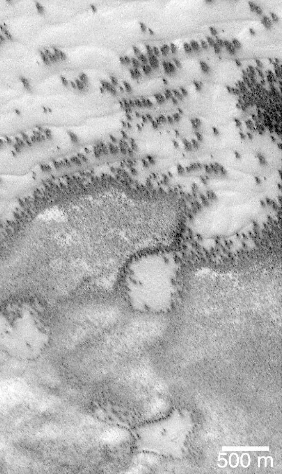
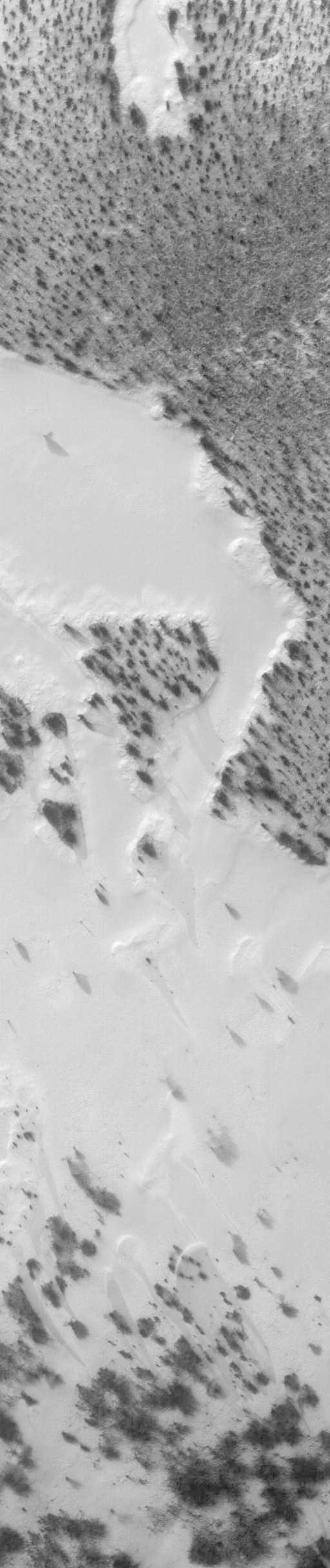
"They look like bushes!" That's what almost everyone says when they see the dark features found in pictures taken of sand dunes in the polar regions as they are beginning to defrost after a long, cold winter. It is hard to escape the fact that, at first glance, these images acquired by the Mars Global Surveyor (MGS) Mars Orbiter Camera (MOC) over both polar regions during the spring and summer seasons, do indeed resemble aerial photographs of sand dune fields on Earth -- complete with vegetation growing on and around them! Of course, this is not what the features are, as we describe below and in related picture captions. Still, don't they look like vegetation to you? Shown here are two views of the same MGS MOC image. On the left is the full scene, on the right is an expanded view of a portion of the scene on the left. The bright, smooth surfaces that are dotted with occasional, nearly triangular dark spots are sand dunes covered by winter frost. The MGS MOC has been used over the past several months (April-August 1999) to monitor dark spots as they form and evolve on polar dune surfaces. The dark spots typically appear first along the lower margins of a dune -- similar to the position of bushes and tufts of grass that occur in and among some sand dunes on Earth. Because the martian air pressure is very low -- 100 times lower than at Sea Level on Earth -- ice on Mars does not melt and become liquid when it warms up. Instead, ice sublimes -- that is, it changes directly from solid to gas, just as "dry ice" does on Earth. As polar dunes emerge from the months-long winter night, and first become exposed to sunlight, the bright winter frost and snow begins to sublime. This process is not uniform everywhere on a dune, but begins in small spots and then over several months it spreads until the entire dune is spotted like a leopard. The early stages of the defrosting process -- as in the picture shown here -- give the impression that something is "growing" on the dunes. The sand underneath the frost is dark, just like basalt beach sand in Hawaii. Once it is exposed to sunlight, the dark sand probably absorbs sunlight and helps speed the defrosting of each sand dune. This picture was taken by MGS MOC on July 21, 1999. The dunes are located in the south polar region and are expected to be completely defrosted by November or December 1999. North is approximately up, and sunlight illuminates the scene from the upper left. The 500 meter scale bar equals 547 yards; the 300 meter scale is also 328 yards. http://photojournal.jpl.nasa.gov/catalog/PIA02300
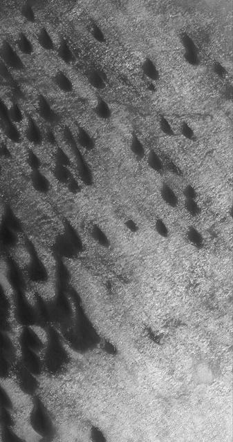
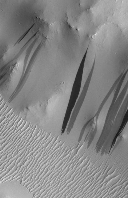
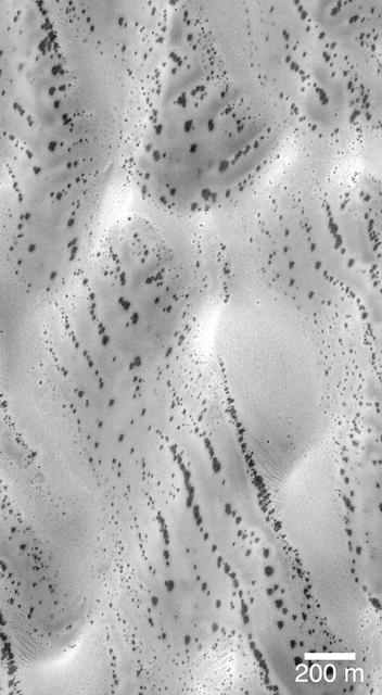
This Mars Global Surveyor (MGS) Mars Orbiter Camera (MOC) image of dunes in the martian north polar region is important because it shows one of the highest northern latitude views of streaks thought to be made by passing dust devils. The dark, thin, filamentary streaks on the dunes and on the adjacent plains were probably formed by dust devils. The dunes occur near 76.6°N, 62.7°W. Dust devil streaks are observed on Mars at very high latitudes, such as this, all the way down to the equator. They are also seen at all elevations, from the deepest parts of the Hellas Basin to the summit of Olympus Mons. This picture covers an area about 3 km (1.9 mi) wide. Sunlight illuminates the scene from the lower left. http://photojournal.jpl.nasa.gov/catalog/PIA06334
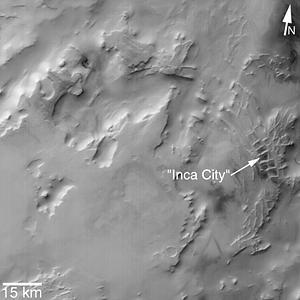
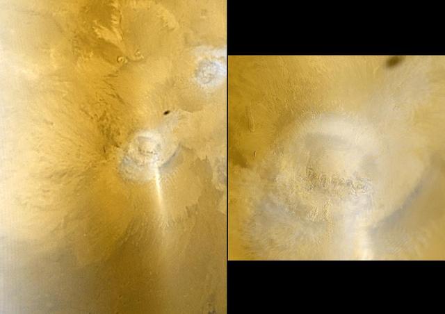
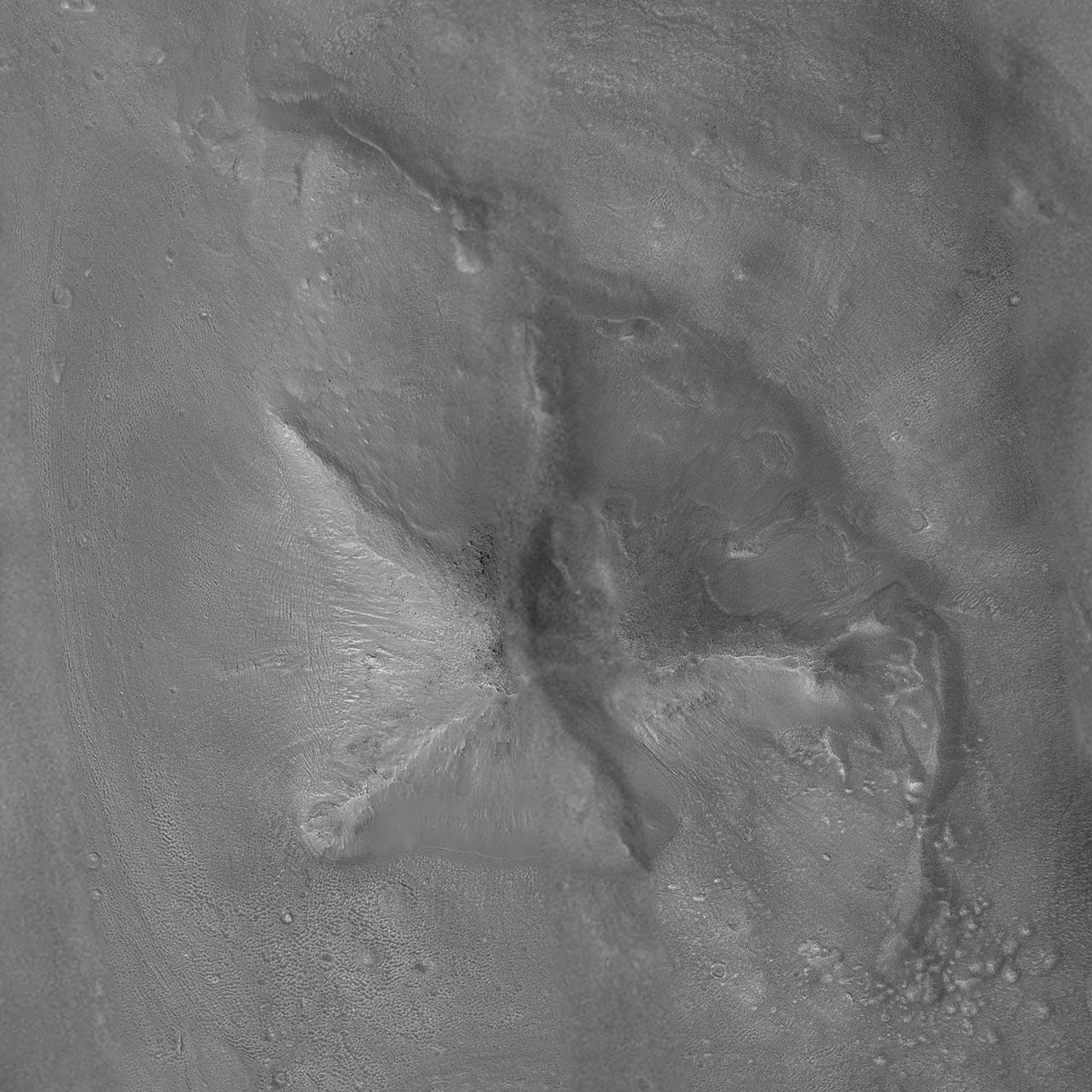
MGS MOC Release No. MOC2-319, 8 August 2002. "Inca City" is the informal name given by Mariner 9 scientists in 1972 to a set of intersecting, rectilinear ridges that are located among the layered materials of the south polar region of Mars. Their origin has never been understood; most investigators thought they might be sand dunes, either modern dunes or, more likely, dunes that were buried, hardened, then exhumed. Others considered them to be dikes formed by injection of molten rock (magma) or soft sediment into subsurface cracks that subsequently hardened and then were exposed at the surface by wind erosion. The Mars Global Surveyor (MGS) Mars Orbiter Camera (MOC) has provided new information about the "Inca City" ridges, though the camera's images still do not solve the mystery. The new information comes in the form of a MOC red wide angle context frame taken in mid-southern spring, shown above left and above right. The original Mariner 9 view of the ridges is seen at the center. The MOC image shows that the "Inca City" ridges, located at 82°S, 67°W, are part of a larger circular structure that is about 86 km (53 mi) across. It is possible that this pattern reflects an origin related to an ancient, eroded meteor impact crater that was filled-in, buried, then partially exhumed. In this case, the ridges might be the remains of filled-in fractures in the bedrock into which the crater formed, or filled-in cracks within the material that filled the crater. Or both explanations could be wrong. While the new MOC image shows that "Inca City" has a larger context as part of a circular form, it does not reveal the exact origin of these striking and unusual martian landforms. http://photojournal.jpl.nasa.gov/catalog/PIA03918
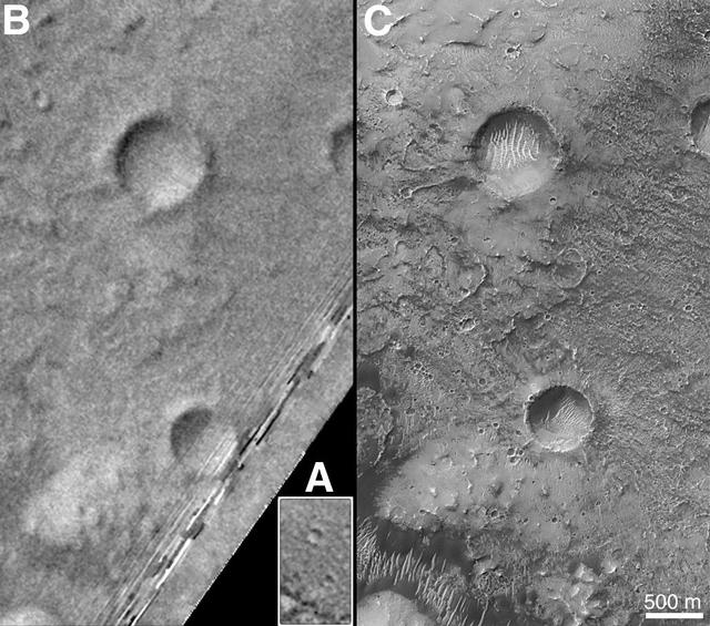
On Earth, the longitude of the Royal Observatory in Greenwich, England is defined as the "prime meridian," or the zero point of longitude. Locations on Earth are measured in degrees east or west from this position. The prime meridian was defined by international agreement in 1884 as the position of the large "transit circle," a telescope in the Observatory's Meridian Building. The transit circle was built by Sir George Biddell Airy, the 7th Astronomer Royal, in 1850. (While visual observations with transits were the basis of navigation until the space age, it is interesting to note that the current definition of the prime meridian is in reference to orbiting satellites and Very Long Baseline Interferometry (VLBI) measurements of distant radio sources such as quasars. This "International Reference Meridian" is now about 100 meters east of the Airy Transit at Greenwich.) For Mars, the prime meridian was first defined by the German astronomers W. Beer and J. H. Mädler in 1830-32. They used a small circular feature, which they designated "a," as a reference point to determine the rotation period of the planet. The Italian astronomer G. V. Schiaparelli, in his 1877 map of Mars, used this feature as the zero point of longitude. It was subsequently named Sinus Meridiani ("Middle Bay") by Camille Flammarion. When Mariner 9 mapped the planet at about 1 kilometer (0.62 mile) resolution in 1972, an extensive "control net" of locations was computed by Merton Davies of the RAND Corporation. Davies designated a 0.5-kilometer-wide crater (0.3 miles wide), subsequently named "Airy-0" (within the large crater Airy in Sinus Meridiani) as the longitude zero point. (Airy, of course, was named to commemorate the builder of the Greenwich transit.) This crater was imaged once by Mariner 9 (the 3rd picture taken on its 533rd orbit, 533B03) and once by the Viking 1 orbiter in 1978 (the 46th image on that spacecraft's 746th orbit, 746A46), and these two images were the basis of the martian longitude system for the rest of the 20th Century. The Mars Global Surveyor (MGS) Mars Orbiter Camera (MOC) has attempted to take a picture of Airy-0 on every close overflight since the beginning of the MGS mapping mission. It is a measure of the difficulty of hitting such a small target that nine attempts were required, since the spacecraft did not pass directly over Airy-0 until almost the end of the MGS primary mission, on orbit 8280 (January 13, 2001). In the left figure above, the outlines of the Mariner 9, Viking, and Mars Global Surveyor images are shown on a MOC wide angle context image, M23-00924. In the right figure, sections of each of the three images showing the crater Airy-0 are presented. A is a piece of the Mariner 9 image, B is from the Viking image, and C is from the MGS image. Airy-0 is the larger crater toward the top-center in each frame. The MOC observations of Airy-0 not only provide a detailed geological close-up of this historic reference feature, they will be used to improve our knowledge of the locations of all features on Mars, which will in turn enable more precise landings on the Red Planet by future spacecraft and explorers. http://photojournal.jpl.nasa.gov/catalog/PIA03207
This Mars Global Surveyor (MGS) Mars Orbiter Camera (MOC) image shows lava flows on the middle west flank of the large martian volcano, Ascraeus Mons. The flows ran downslope from the lower right (southeast) toward upper left (northwest). These flows are located near 11.9°N, 105.5°W. This December 2003 image covers an area about 3 km (1.9 mi) across; sunlight illuminates the scene from the lower left. http://photojournal.jpl.nasa.gov/catalog/PIA06288
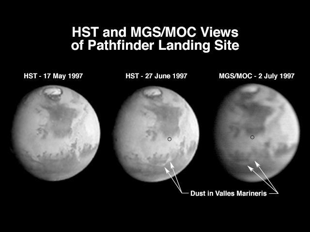
A comparison of images taken by the Hubble Space Telescope Wide Field/Planetary Camera (HST/WFPC) and the Mars Global Surveyor Orbiter Camera (MGS/MOC) shows the progress of a regional dust storm within the Valles Marineris canyons on Mars. The first HST image (left), taken in mid-May, shows no dust within the canyons. The most recent HST image (center), taken on 27 June in support of the Mars Pathfinder landing activities, shows a dust storm filling part of the canyon system and extending into the chaotic terrains at the eastern end of the canyons. The MGS/MOC image (right), acquired on July 2, shows that bright dust continues to fill the valleys. However, it does not appear to have moved significantly north of the previously observed position, suggesting that the storm remains confined to the canyon region, and does not appear to directly threaten the Pathfinder landing site (small black circle). The HST images shown here have been reduced in scale to match that of the MGS/MOC image. Although the HST is 10 times farther from Mars than MGS, its images are sharper because its resolving power is 15 times better than the MOC, and the light gathering area is almost 50 times greater. However, MGS is presently 45,000 times farther from Mars than it will be when the MOC begins its primary photography mission. At 400 km above the martian surface, the MOC wide angle camera will collect daily images at a resolution of 7.5 km/pixel, compared to HST's best of about 20 km/pixel. The narrow angle camera will observe portions of Mars at better than 1.5 m/pixel. http://photojournal.jpl.nasa.gov/catalog/PIA00607
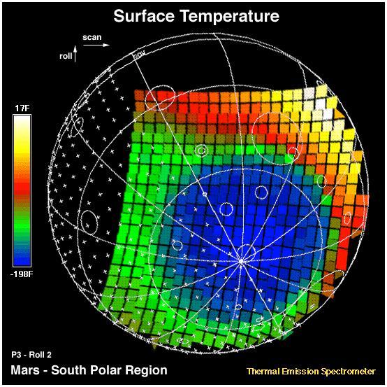
This image shows the temperature of the martian surface measured by the Mars Global Surveyor Thermal Emission Spectrometer (TES) instrument. On September 15, 3 hours and 48 minutes after the spacecrafts third close approach to the planet, the TES instrument was commanded to point at Mars and measure the temperature of the surface during a four minute scan. At this time MGS was approximately 15,000 miles (~24,000 km) from the planet, with a view looking up from beneath the planet at the south polar region. The circular blue region (- 198 F) is the south polar cap of Mars that is composed of CO2 ice. The night side of the planet, shown with crosses, is generally cool (green). The sunlit side of the planet reaches temperatures near 15 F (yellow). Each square represents an individual observation acquired in 2 seconds with a ground resolution of ~125 miles (~200 km). The TES instrument will remain on and collect similar images every 100 minutes to monitor the temperature of the surface and atmosphere throughout the aerobraking phase of the MGS mission. http://photojournal.jpl.nasa.gov/catalog/PIA00937
This image is illuminated by sunlight from the upper left. Martian Dairy Products? If parts of the south polar cap can look like swiss cheese (see "Martian "Swiss Cheese""), then parts of the north polar cap might as well look like some kind of cheese, too. This picture shows a cottage cheese-like texture on the surface of a part of the residual--summertime--north polar cap. The north polar cap surface is mostly covered by pits, cracks, small bumps and knobs. In this image, the cap surface appears bright and the floors of pits look dark. Based upon observations made by the Mariner 9 and Viking orbiters in the 1970s, the north polar residual cap is thought to contain mostly water ice because its summertime temperature is usually near the freezing point of water and water vapor was observed by the Vikings to be coming off the cap during summer. The south residual cap is different--its temperatures in summer remain cold enough to freeze carbon dioxide, and very little to no water vapor has been observed to come off the south cap in summer. The pits that have developed on the north polar cap surface are closely-spaced relative to the very different depressions in the south polar cap. The pits are estimated from the length of shadows cast in them to be less than about 2 meters (5.5 feet) deep. These pits probably develop slowly over thousands of years of successive spring and summer seasons. This picture was taken by the Mars Global Surveyor (MGS) Mars Orbiter Camera (MOC) during northern summer on April 5, 1999. The picture is located near 82.1°N, 329.6°W and covers an area 1.5 km wide by 3 km long (0.9 x 1.8 miles) at a resolution of 3 meters (10 ft) per pixel. http://photojournal.jpl.nasa.gov/catalog/PIA02369
9 March 2005 This Mars Global Surveyor (MGS) Mars Orbiter Camera (MOC) image shows a trough in the Labyrinthus Noctis region. Location near: 1.5°S, 92.5°W Image width: ~3 km (~1.9 mi) Illumination from: upper left Season: Southern Winter http://photojournal.jpl.nasa.gov/catalog/PIA07449
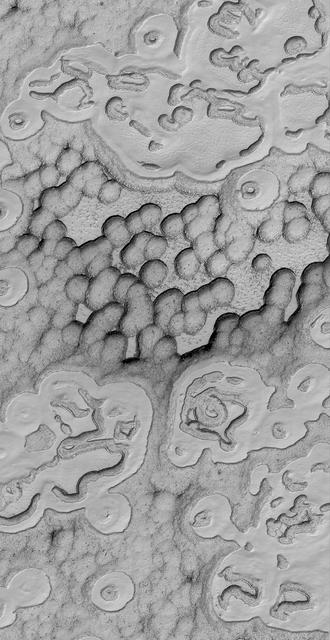
This image is illuminated by sunlight from the upper left. Looking like pieces of sliced and broken swiss cheese, the upper layer of the martian south polar residual cap has been eroded, leaving flat-topped mesas into which are set circular depressions such as those shown here. The circular features are depressions, not hills. The largest mesas here stand about 4 meters (13 feet) high and may be composed of frozen carbon dioxide and/or water. Nothing like this has ever been seen anywhere on Mars except within the south polar cap, leading to some speculation that these landforms may have something to do with the carbon dioxide thought to be frozen in the south polar region. On Earth, we know frozen carbon dioxide as "dry ice." On Mars, as this picture might be suggesting, there may be entire landforms larger than a small town and taller than 2 to 3 men and women that consist, in part, of dry ice. No one knows for certain whether frozen carbon dioxide has played a role in the creation of the "swiss cheese" and other bizarre landforms seen in this picture. The picture covers an area 3 x 9 kilometers (1.9 x 5.6 miles) near 85.6°S, 74.4°W at a resolution of 7.3 meters (24 feet) per pixel. This picture was taken by the Mars Global Surveyor (MGS) Mars Orbiter Camera (MOC) during early southern spring on August 3, 1999. http://photojournal.jpl.nasa.gov/catalog/PIA02367
This image is the first view of Mars taken by the Mars Global Surveyor Orbiter Camera (MOC). It was acquired the afternoon of July 2, 1997 when the MGS spacecraft was 17.2 million kilometers (10.7 million miles) and 72 days from encounter. At this distance, the MOC's resolution is about 64 km per picture element, and the 6800 km (4200 mile) diameter planet is 105 pixels across. The observation was designed to show the Mars Pathfinder landing site at 19.4 N, 33.1 W approximately 48 hours prior to landing. The image shows the north polar cap of Mars at the top of the image, the dark feature Acidalia Planitia in the center with the brighter Chryse plain immediately beneath it, and the highland areas along the Martian equator including the canyons of the Valles Marineris (which are bright in this image owing to atmospheric dust). The dark features Terra Meridiani and Terra Sabaea can be seen at the 4 o`clock position, and the south polar hood (atmospheric fog and hazes) can be seen at the bottom of the image. Launched on November 7, 1996, Mars Global Surveyor will enter Mars orbit on Thursday, September 11 shortly after 6:00 PM PDT. After Mars Orbit Insertion, the spacecraft will use atmospheric drag to reduce the size of its orbit, achieving a circular orbit only 400 km (248 mi) above the surface in early March 1998, when mapping operations will begin. http://photojournal.jpl.nasa.gov/catalog/PIA00606
The Mars Global Surveyor (MGS) Mars Orbiter Camera (MOC) was designed specifically to provide images of Mars that have a resolution comparable to the aerial photographs commonly used by Earth scientists to study geological processes and map landforms on our home planet. When MGS reaches its Mapping Orbit in March 1999, MOC will be able to obtain pictures with spatial resolutions of 1.5 meters (5 feet) per pixel--this good enough to easily see objects the size of an automobile. Boulders are one of the keys to determining which processes have eroded, transported, and deposited material on Mars (e.g.,landslides, mud flows, flood debris). During the first year in orbit,MGS MOC obtained pictures with resolutions between 2 and 30 meters (7to 98 feet) per pixel. It was found that boulders are difficult to identify on Mars in images with resolutions worse than about 2-3 meters per pixel. Although not known when the MOC was designed,"thresholds" like this are found on Earth, too. The MOC's 1.5 m/pixel resolution was a compromise between (1) the anticipation of such resolution-dependent sensitivity based on our experience with Earth and (2)the cost in terms of mass if we had built a larger telescope to get a higher resolution. Some rather larger boulders (i.e., larger than about 10 meters--or yards--in size) have already been seen on Mars by the orbiting camera. This is a feat similar to that which can be obtained by "spy" satellites on Earth. The MOC image 53104 subframe shown above features a low, rounded hill in southeastern Utopia Planitia. Each of the small, lumpy features on the top of this hill is a boulder. In this picture, boulders are not seen on the surrounding plain. These boulders are interpreted to be the remnants of a layer of harder rock that once covered the top of the hill, but was subsequently eroded and broken up by weathering and wind processes. MOC image 53104 was taken on September 2, 1998. The subframe shows an area 2.2 km by 3.3 km (1.4 miles by 2.7 miles). The image has a resolution of about 3.25 meters (10.7 feet) per pixel. The subframe is centered at 41.0°N latitude and 207.3°W longitude. North is approximately up, illumination is from the left. http://photojournal.jpl.nasa.gov/catalog/PIA01500
The patterns created by dark spots on defrosting south polar dunes are often strange and beautiful. This picture, which the Mars Orbiter Camera team has dubbed, "the snow leopard," shows a dune field located at 61.5°S, 18.9°W, as it appeared on July 1, 1999. The spots are areas where dark sand has been exposed from beneath bright frost as the south polar winter cap begins to retreat. Many of the spots have a diffuse, bright ring around them this is thought to be fresh frost that was re-precipitated after being removed from the dark spot. The spots seen on defrosting polar dunes are a new phenomenon that was not observed by previous spacecraft missions to Mars. Thus, there is much about these features that remains unknown. For example, no one yet knows why the dunes become defrosted by forming small spots that grow and grow over time. No one knows for sure if the bright rings around the dark spots are actually composed of re-precipitated frost. And no one knows for sure why some dune show spots that appear to be "lined-up" (as they do in the picture shown here). This Mars Global Surveyor Mars Orbiter Camera image is illuminated from the upper left. North is toward the upper right. The scale bar indicates a distance of 200 meters (656 feet). http://photojournal.jpl.nasa.gov/catalog/PIA02301
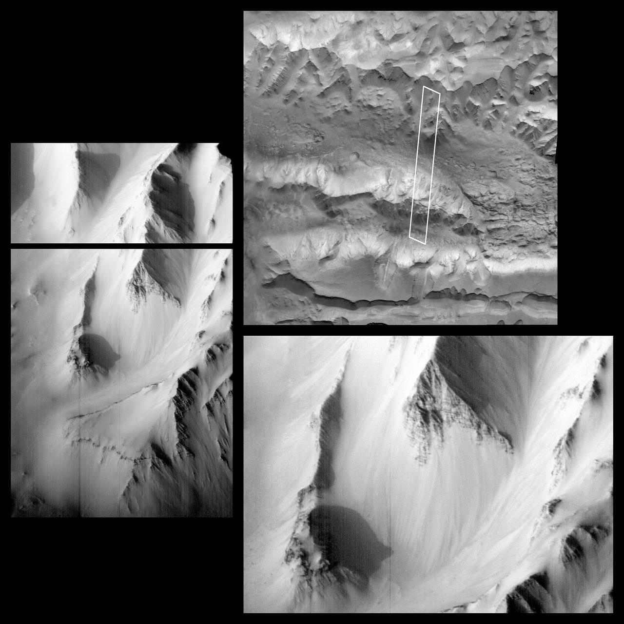
As we head into the 21st Century, it seems hard to believe that human beings have been sending spacecraft toward Mars for more than 3 decades already. The first spacecraft to reach Mars was Mariner 4 in 1965. This success was followed by two spacecraft in 1969, Mariners 6 and 7. Now the wonders and alien beauty of Mars continue to unfold with each day that the Mars Global Surveyor -- which arrived in September 1997 -- continues to radio its data to Earth. Mars exploration was always difficult and each bit of data returned from the planet is a marvel. On August 5, 1969, the Mariner 7 spacecraft flew past Mars at a minimum altitude of about 4200 km. It acquired 14 wide/narrow angle image pairs during the few minutes of the "near encounter" flyby. One of these image pairs, 7N19/7N20, shows the south polar region and contains a feature that at the time was nicknamed "the Giant's Footprint." Shown in the first two pictures, above, the feature consists of two adjoining craters, one about 80 km (50 mi) in diameter and the other about 50 km (31 mi) across near latitude 76°S, longitude 276°W. The oblique geometry of the Mariner 7 image enhances the impression of a footprint. The "Giant's Footprint" was almost missed when Mariner 7 suffered a near-catastrophic battery failure just a few days before the encounter -- on July 30 -- that put the spacecraft sporadically out of contact with Earth for two days. Ground controllers at the Jet Propulsion Laboratory (JPL)recovered the spacecraft, re-planned its imaging sequence based on results from the Mariner 6 flyby on July 31, and salvaged all of the mission's science goals in under a week! In the 1970's, the larger crater in "giant's footprint" was named "Vishniac" in honor of Wolf Vishniac, an American microbiologist of the University of Rochester who was instrumental in the development of methods to search for life on Mars. Vishniac was tragically killed in a fall in Antarctica in 1973 while retrieving a life detection experiment, and the crater was named in honor of this "giant" in the search for life on Mars. More than three decades after the Mariner 7 flyby, Mars Global Surveyor's Mars Orbiter Camera (MOC) acquired a commemorative view of the interior of Vishniac Crater on October 25, 1999. The context image and the 3-meters (9.8 feet)-per-pixel narrow angle view are shown above (in the lower image pair). Mariner 7's 7N20 has a nominal resolution of about 180 meters (591 feet) per pixel, while the MOC high resolution view is about 60 times higher (in actuality, the lower quality of the Mariner 7 images makes the resolution gain even more dramatic). The MOC high resolution view (lower right, above) shows a 1.5 kilometer-(0.9 mile)-wide portion of the floor of Vishniac in the process of defrosting during southern spring. The bright areas are still frost-covered, while the darker areas are either defrosted or composed of darkened or "dirty" frost. The dark patches in the image seem to serve as sources for dark streaks of material that has either been blown across the landscape by wind, or has somehow caused the erosion of frost to create the streaks. Dark streaks follow the local topography, as might the wind that blew across this landscape. This pattern of spots and streaks was quite common on the defrosting south polar cap during the spring that lasted from early August 1999 to late December 1999. All images shown here are illuminated by sunlight from the lower right. Image orientation with north toward the bottom was selected in order to show the "footprint" visible in Mariner 7 image 7N20. The Mariner 7 images were recovered at Malin Space Science Systems from the original 7-track magnetic tapes, archived on CD-ROM by the JPL Data Preservation activity. More images relating to the release can be viewed at http://photojournal.jpl.nasa.gov/catalog/PIA02365
Images of the Cydonia region of Mars continue to be popular among visitors to the Mars Global Surveyor (MGS) Mars Orbiter Camera (MOC)web site. The two pictures (one annotated, the other not) are mosaics of two images from MGS MOC and one from the Mars Odyssey Thermal Emission Imaging System visible camera (THEMIS VIS). The mosaics highlight a Cydonia landform popularly known as the "D&M Pyramid." It is located near 40.7°N, 9.6°W. Although it is not really shaped like a pyramid, the Cydonia landform is one of thousands of massifs, buttes, mesas, knobs, and blocks that mark the transition from the far northwestern Arabia Terra cratered highlands down to the northeastern Acidalia Planitia lowlands. Each block, whether shaped like a face, a pyramid, or simply a mesa, massif, or knob, is a remnant of the bedrock of northeastern Arabia that was left behind as erosion slowly degraded the terrain along this zone between the highlands and the lowlands. A few outcroppings of layers in this ancient bedrock can be seen in the mosaic of the pyramid-like landform shown here; much of the landform is covered with eroded mantling material that was deposited long after this highlands remnant became an isolated feature in Cydonia. The mosaic was created from two MOC images obtained in June (R06-00469) and July (R07-00422) of 2003 and one THEMIS VIS image acquired in 2002 (V01024003). The mosaic is 8 km by 8 km (5 mi by 5 mi) across and each of the three images is illuminated from the lower left. North is up. The picture on the right shows the location of the two MOC images as black outlines; the THEMIS image not only covers the gap between the two MOC images, it also fills out the lower left and upper right corners. http://photojournal.jpl.nasa.gov/catalog/PIA04745
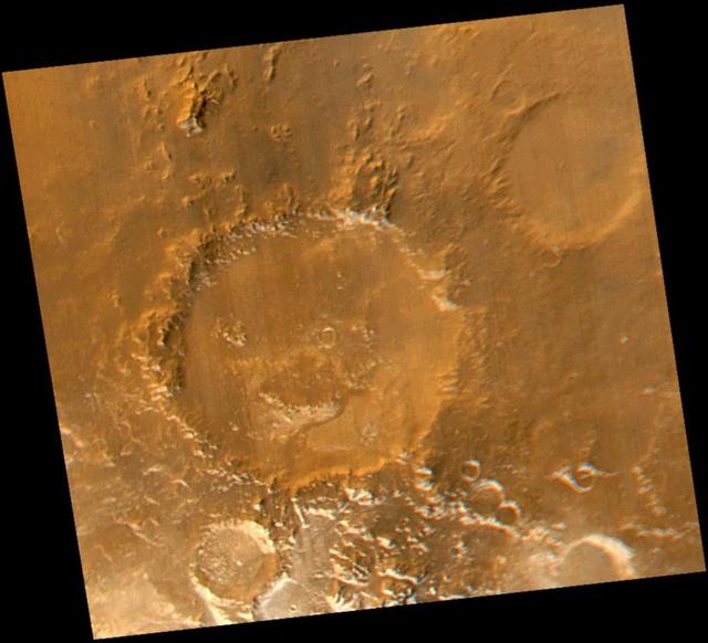
Smile! Spring has sprung in the martian southern hemisphere. With it comes the annual retreat of the winter polar frost cap. This view of "Happy Face Crater"--officially named "Galle Crater"--shows patches of white water ice frost in and around the crater's south-facing slopes. Slopes that face south will retain frost longer than north-facing slopes because they do not receive as much sunlight in early spring. This picture is a composite of images taken by the Mars Global Surveyor Mars Orbiter Camera (MOC) red and blue wide angle cameras. The wide angle cameras were designed to monitor the changing weather, frost, and wind patterns on Mars. Galle Crater is located on the east rim of the Argyre Basin and is about 215 kilometers (134 miles) across. In this picture, illumination is from the upper left and north is up. http://photojournal.jpl.nasa.gov/catalog/PIA02325
Martian Valley
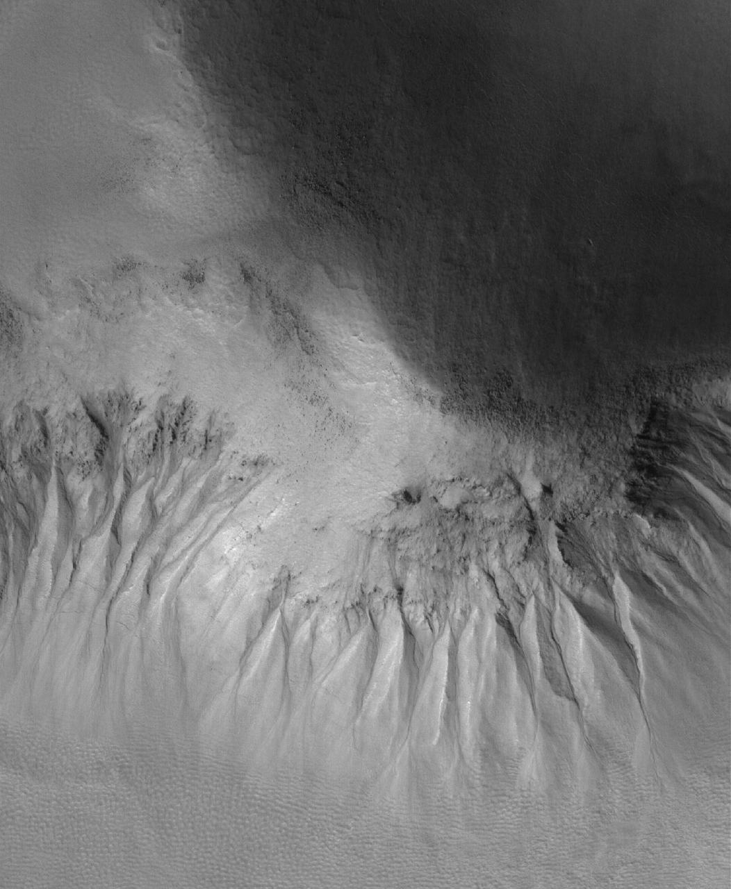
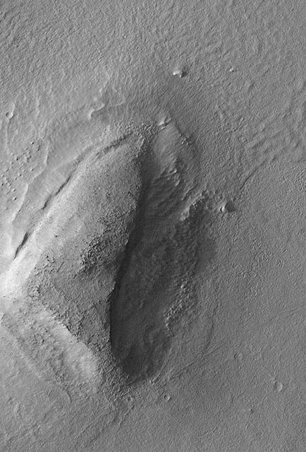
Gullied Slope
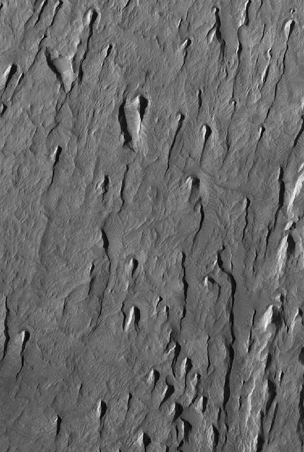
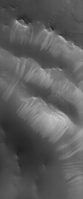
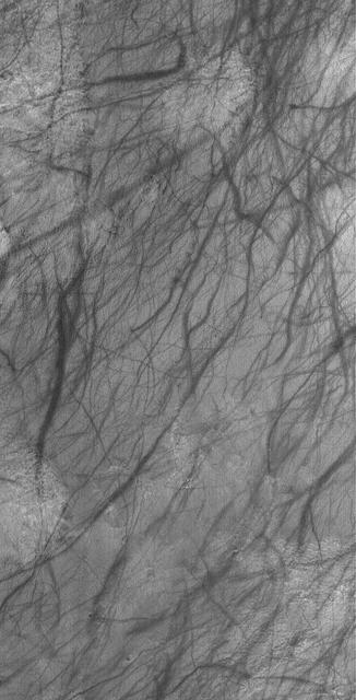
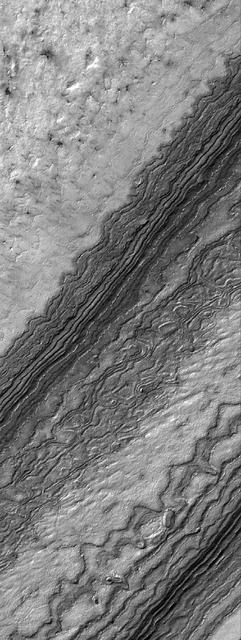
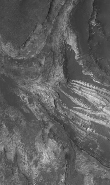
Tithonium Yardangs
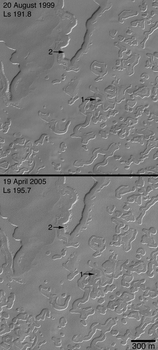
Four Mars Years of Change
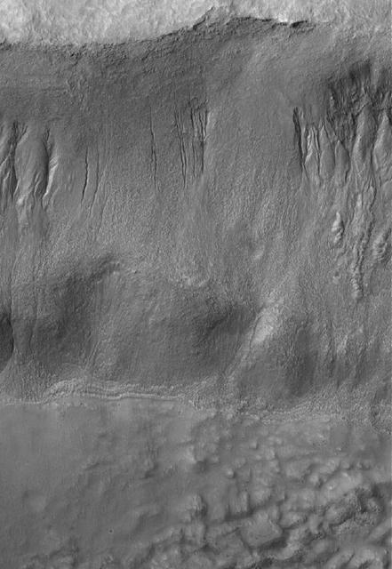
Gullied Wall
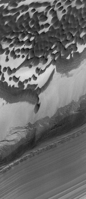
Defrosting Patterns

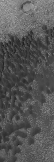
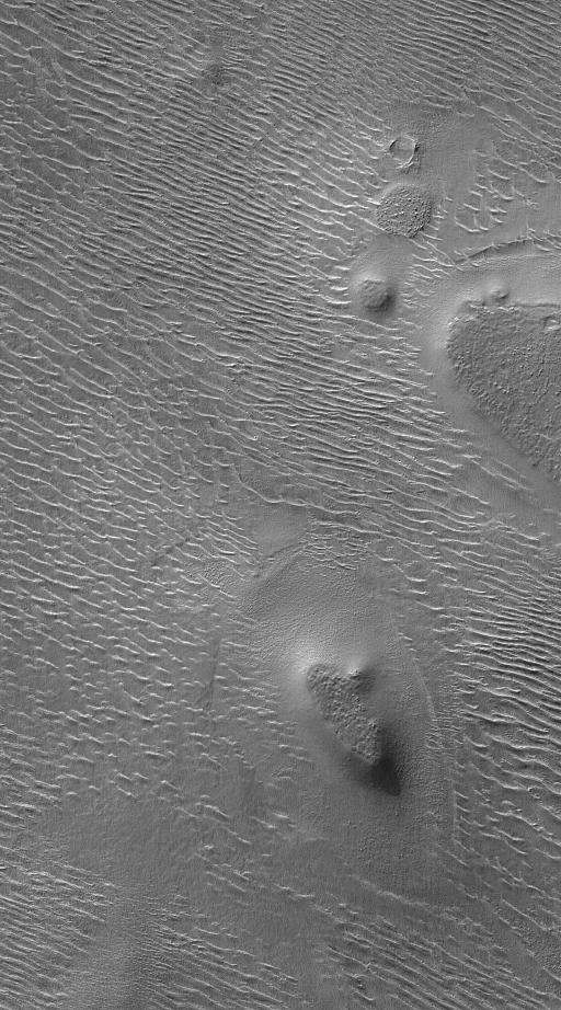
This MOC image shows dunes in the north polar region of Mars. In this scene, the dunes, and the plain on which the dunes reside, are at least in part covered by a bright carbon dioxide frost
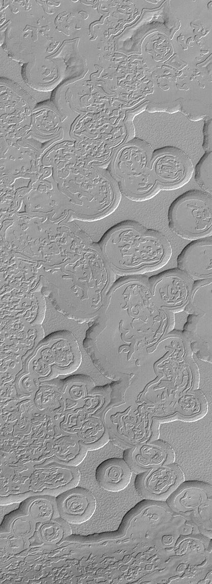
Utopia Cracks and Polygons
converted PNM file

Albedo Boundary
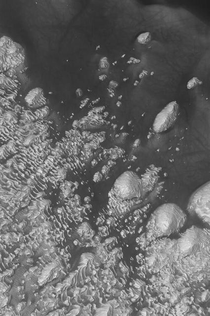
Russell Dune Gullies
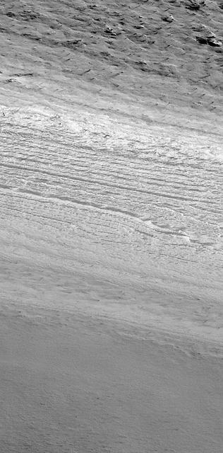
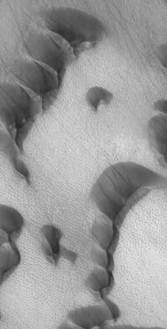
Layers of the South Polar Layered Deposits
Outcrops In Aram Chaos
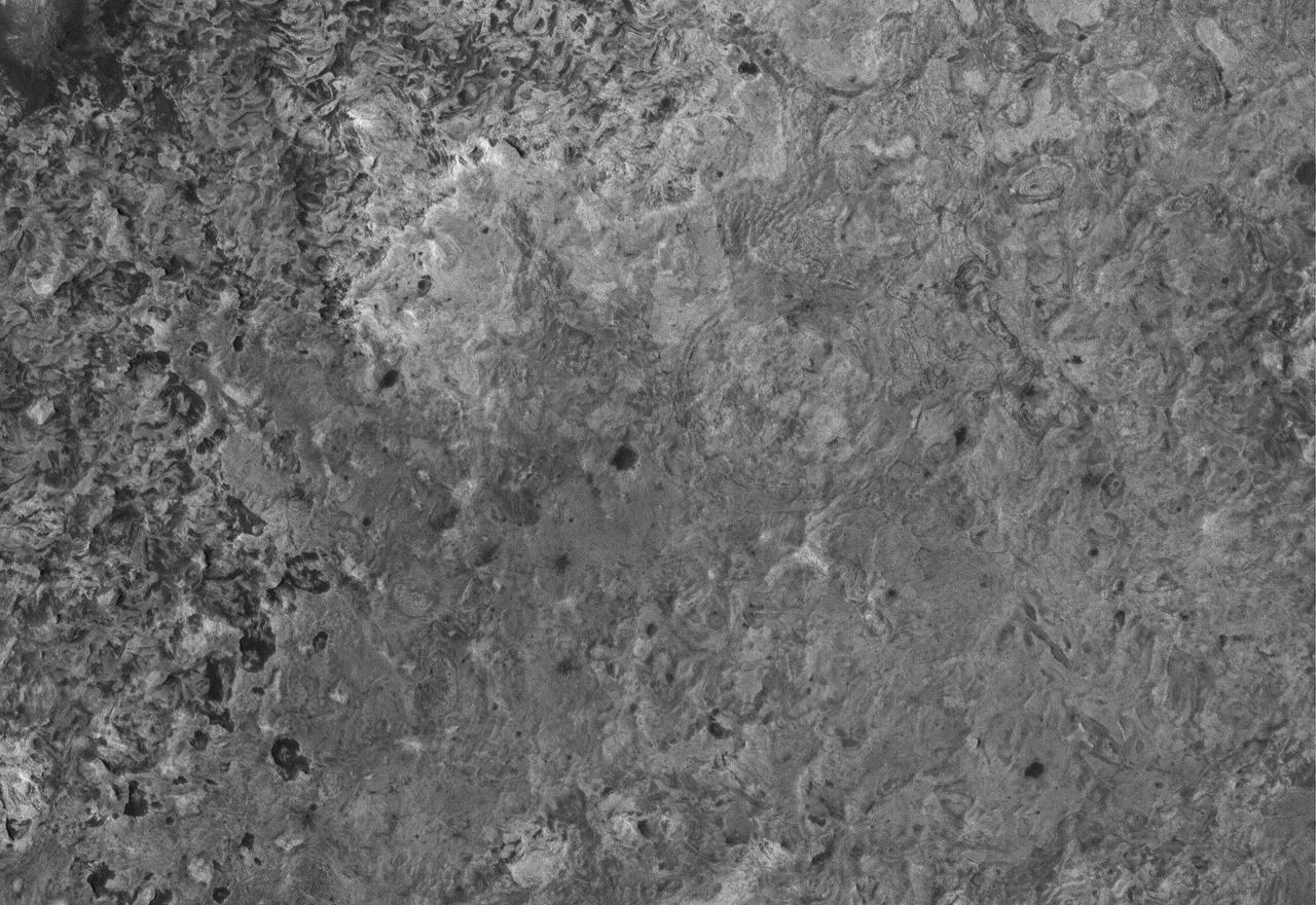
Sedimentary Rocks of 8°N, 7°W
Wind Streak in Acidalia
Sedimentary Rock in Candor
Winter Frosts of the Retreating South Polar Cap
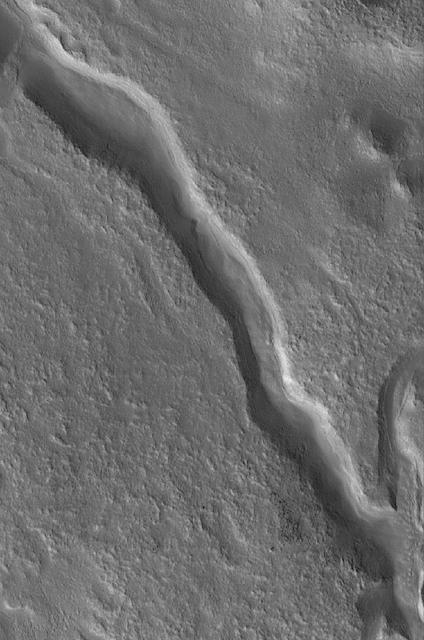
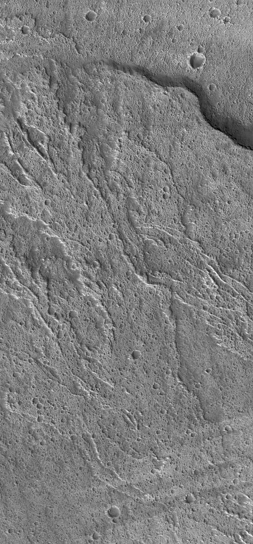
Valley Near Moreux
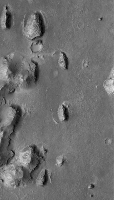
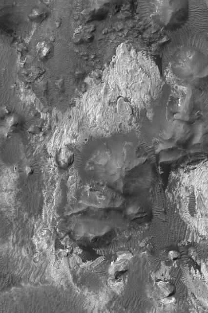
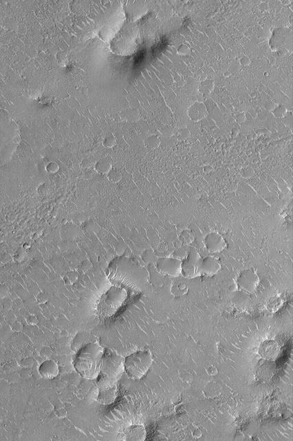
A Typical Martian Scene: Boulders and Slopes in a Crater in Aeolis
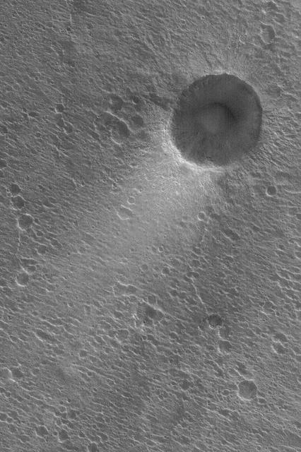
Oblique Impact
Marte Vallis Platy Flows
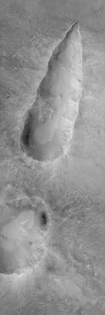
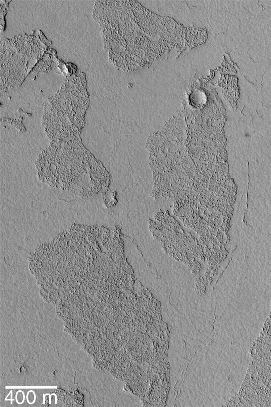
Eroded Layered Material in Southwest Utopia Planitia
Meridiani Outcrops
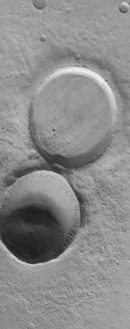
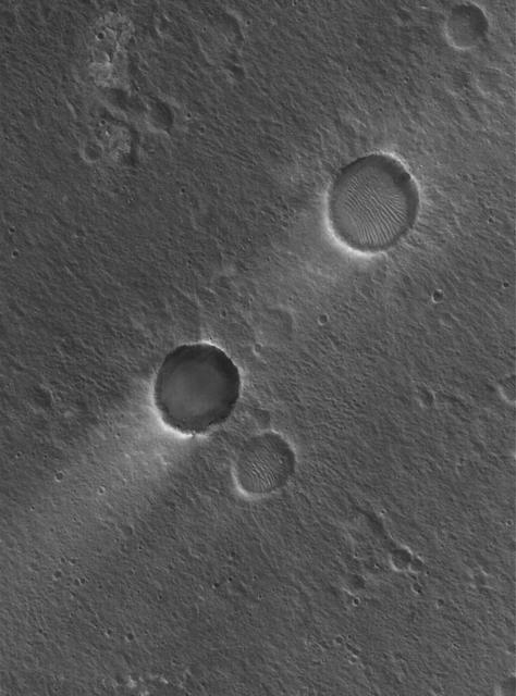
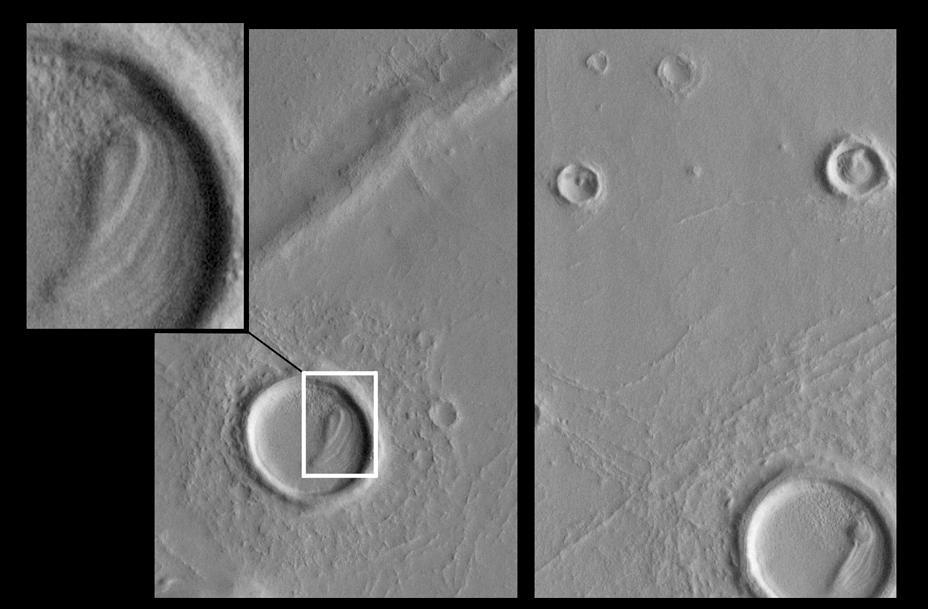
This MOC image shows adjacent impact craters located north-northwest of the Acheron Fossae region of Mars. The two craters are of similar size and formed by meteor impacts. However, one is much more filled than the other, indicating that it is older
Mars at Ls 288°: Elysium/Mare Cimmerium

MGS Approach Image - 217.4° W Longitude
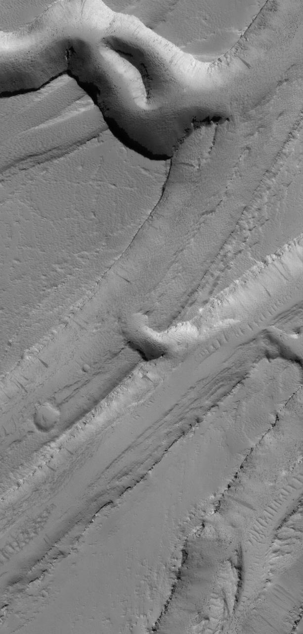
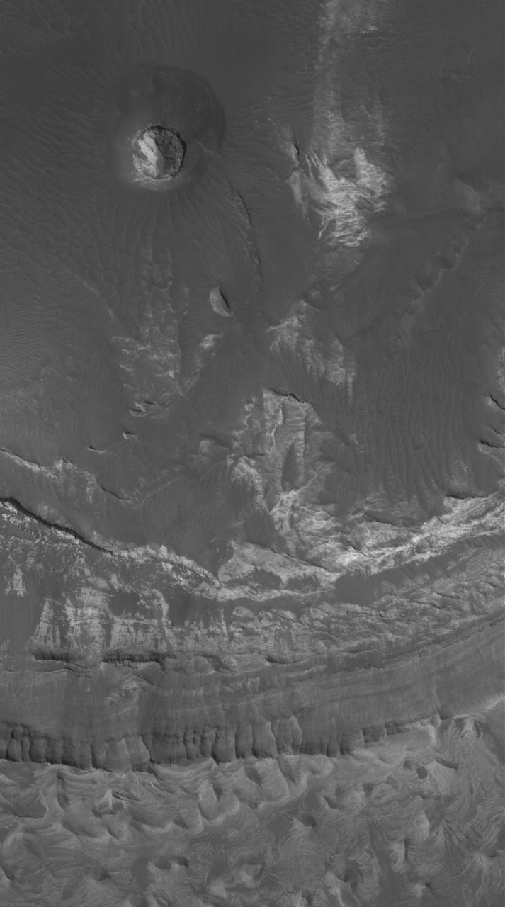
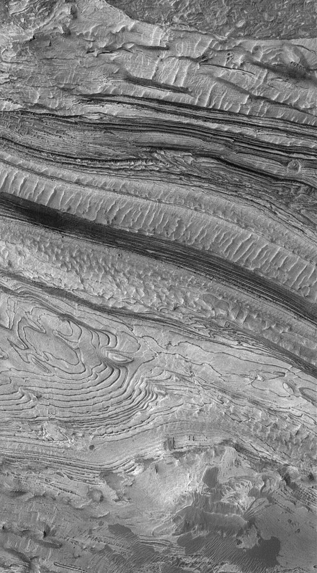
Western Tithonium Chasma/Ius Chasma, Valles Marineris
Lava Flows On Ascraeus Mons Volcano
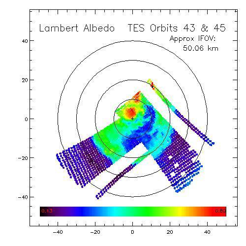
Dark Dry Ice on Southern Cap - Lambert Albedo Image
Terby Layers
Cydonia Region - Pass #2
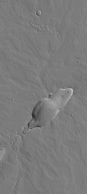
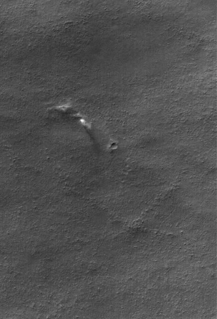
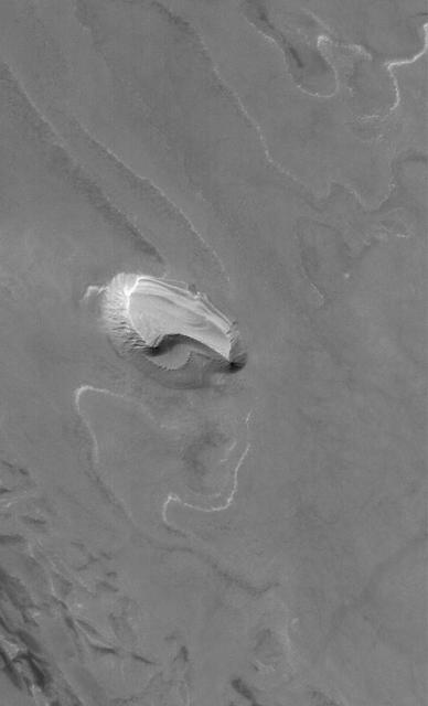
Small Dusty Volcano
Isidis Planitia
On its 256th orbit of Mars, the camera on-board NASA Mars Global Surveyor spacecraft successfully observed the vicinity of the Mars Pathfinder landing site. 3D glasses are necessary to identify surface detail.
Autumn in Argyre
September Dust Devil