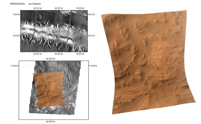
CRISM First Targeted Observation of Mars
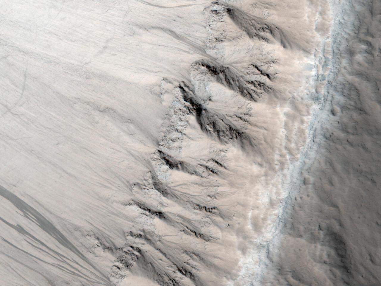
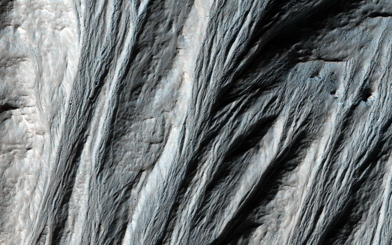
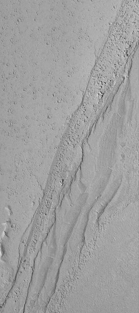
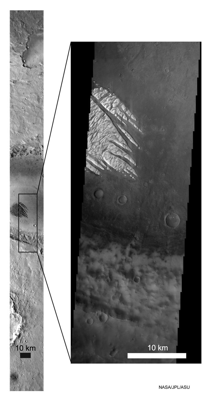
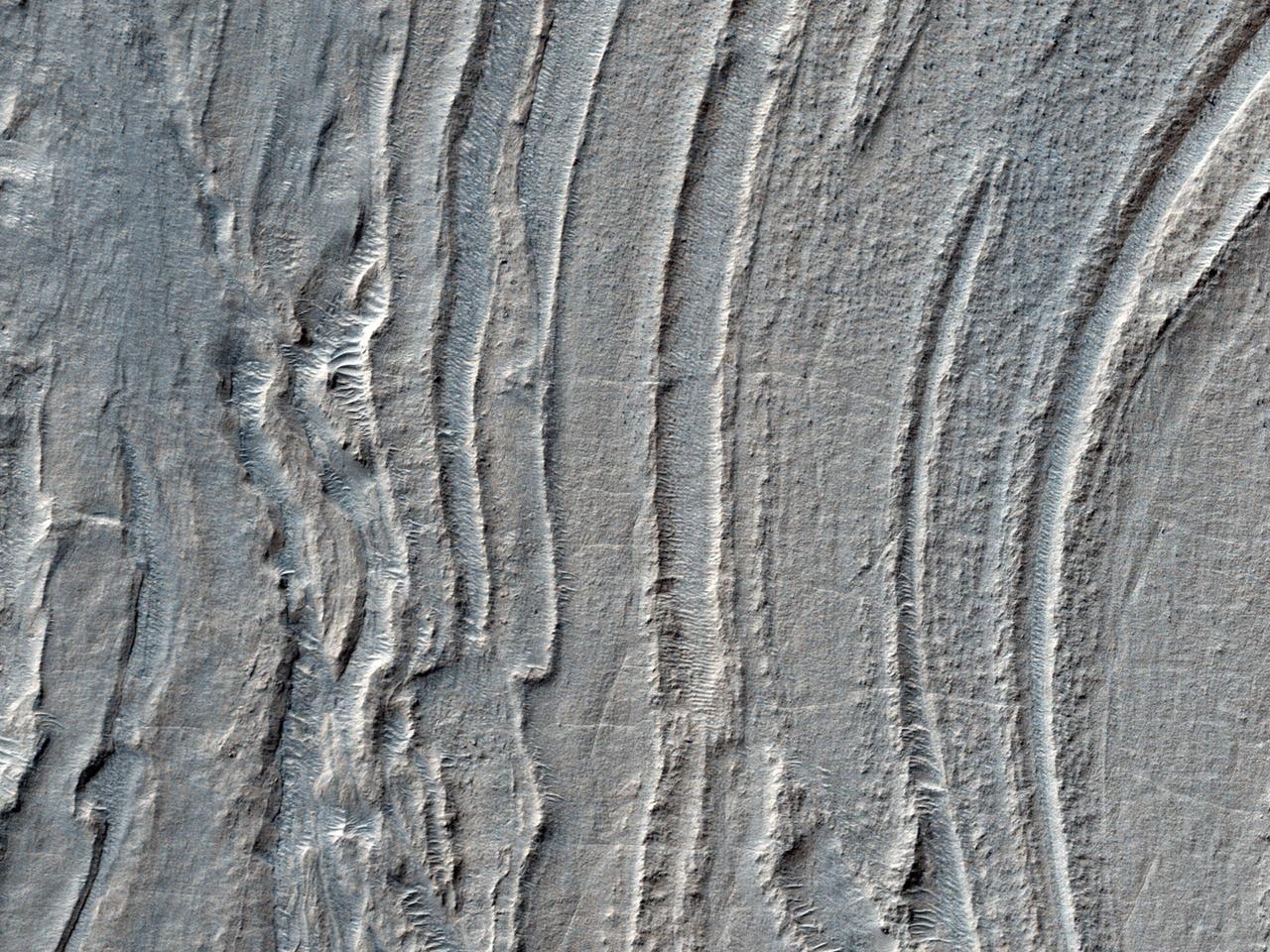
First Observation of Columnar Jointing on Mars
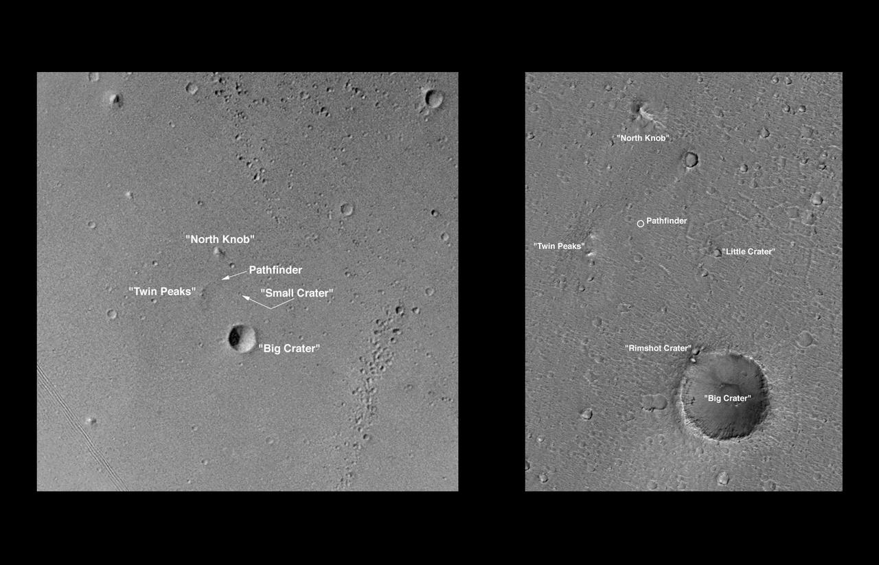
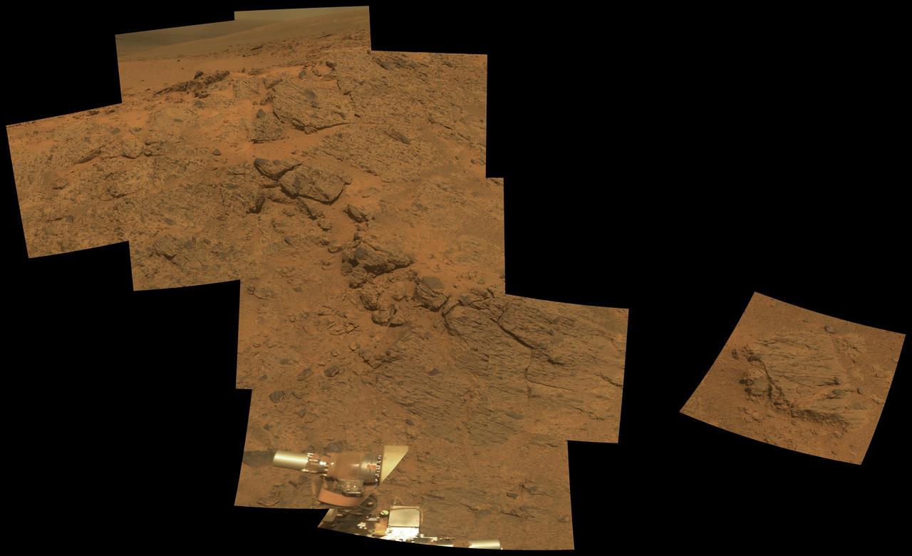
Pathfinder Landing Site Observed by Mars Orbiter Camera
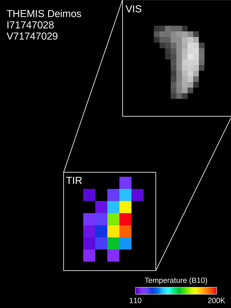
Colors in this image of the Martian moon Deimos indicate a range of surface temperatures detected by observing the moon on February 15, 2018, with the Thermal Emission Imaging System (THEMIS) camera on NASA's Mars Odyssey orbiter. The left edge of the small moon is in darkness, and the right edge in sunlight. Temperature information was derived from thermal-infrared imaging such as the grayscale image shown smaller at lower left with the moon in the same orientation. The color-coding merges information from THEMIS observations made in 10 thermal-infrared wavelength bands. This was the first observation of Deimos by Mars Odyssey; the spacecraft first imaged Mars' other moon, Phobos, on September 29, 2017. Researchers have been using THEMIS to examine Mars since early 2002, but the maneuver turning the orbiter around to point the camera at Phobos was developed only recently. https://photojournal.jpl.nasa.gov/catalog/PIA22250

Colors in this image of the Martian moon Phobos indicate a range of surface temperatures detected by observing the moon on February 15, 2018, with the Thermal Emission Imaging System (THEMIS) camera on NASA's Mars Odyssey orbiter. The left edge of the small moon is in darkness, and the right edge in sunlight. Phobos has an oblong shape with average diameter of about 14 miles (22 kilometers). Temperature information was derived from thermal-infrared imaging such as the grayscale image shown smaller at lower left with the moon in the same orientation. The color-coding merges information from THEMIS observations made in 10 thermal-infrared wavelength bands. This was the second observation of Phobos by Mars Odyssey; the first was on September 29, 2017. Researchers have been using THEMIS to examine Mars since early 2002, but the maneuver turning the orbiter around to point the camera at Phobos was developed only recently. https://photojournal.jpl.nasa.gov/catalog/PIA22249
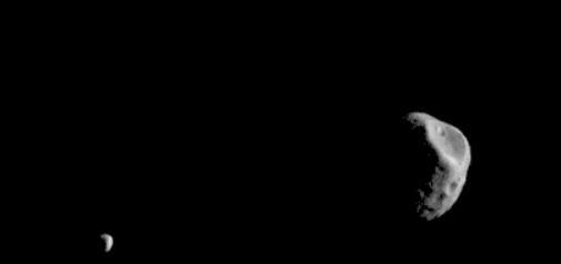
Phobos and Deimos, the moons of Mars, are seen by the Mars Odyssey orbiter's Thermal Emission Imaging System, or THEMIS, camera. The images were taken in visible-wavelength light. THEMIS also recorded thermal-infrared imagery in the same scan. The apparent motion is due to progression of the camera's pointing during the 17-second span of the February 15, 2018, observation, not from motion of the two moons. This was the second observation of Phobos by Mars Odyssey; the first was on September 29, 2017. Researchers have been using THEMIS to examine Mars since early 2002, but the maneuver turning the orbiter around to point the camera at Phobos was developed only recently. The distance to Phobos from Odyssey during the observation was about 3,489 miles (5,615 kilometers). The distance to Deimos from Odyssey during the observation was about 12,222 miles (19,670 kilometers). An animation is available at https://photojournal.jpl.nasa.gov/catalog/PIA22248
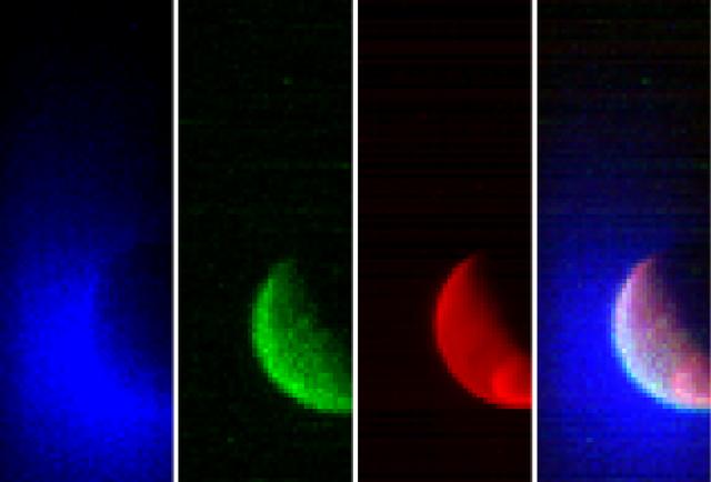
NASA’s Mars Atmosphere and Volatile Evolution (MAVEN) spacecraft has obtained its first observations of the extended upper atmosphere surrounding Mars. The Imaging Ultraviolet Spectrograph (IUVS) instrument obtained these false-color images eight hours after the successful completion of Mars orbit insertion by the spacecraft at 10:24 p.m. EDT Sunday, Sept. 21, after a 10-month journey. The image shows the planet from an altitude of 36,500 km in three ultraviolet wavelength bands. Blue shows the ultraviolet light from the sun scattered from atomic hydrogen gas in an extended cloud that goes to thousands of kilometers above the planet’s surface. Green shows a different wavelength of ultraviolet light that is primarily sunlight reflected off of atomic oxygen, showing the smaller oxygen cloud. Red shows ultraviolet sunlight reflected from the planet’s surface; the bright spot in the lower right is light reflected either from polar ice or clouds. The oxygen gas is held close to the planet by Mars’ gravity, while lighter hydrogen gas is present to higher altitudes and extends past the edges of the image. These gases derive from the breakdown of water and carbon dioxide in Mars’ atmosphere. Over the course of its one-Earth-year primary science mission, MAVEN observations like these will be used to determine the loss rate of hydrogen and oxygen from the Martian atmosphere. These observations will allow us to determine the amount of water that has escaped from the planet over time. MAVEN is the first spacecraft dedicated to exploring the tenuous upper atmosphere of Mars. Read more: <a href="http://1.usa.gov/1oj2Av3" rel="nofollow">1.usa.gov/1oj2Av3</a>
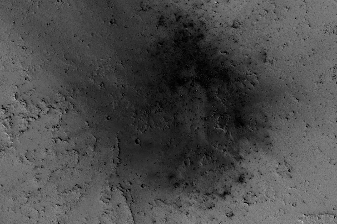
NASA's Mars Reconnaissance Orbiter has been observing Mars in sharp detail for more than a decade, enabling it to document many types of changes, such as the way winds alter the appearance of this recent impact site. The space-rock impact that created this blast zone occurred sometime between September 2005 and February 2006, as bracketed by observations made with the Mars Orbiter Camera on NASA's Mars Global Surveyor spacecraft. The location is between two large volcanos, named Ascraeus Mons and Pavonis Mons, in a dusty area of the Tharsis region of Mars. During the period from 2007 to 2012, winds blowing through the pass between the volcanoes darkened some regions and brightened others, probably by removing and depositing dust. The view covers an area about 1.0 mile (1.6 kilometers) across, at 7 degrees north latitude, 248 degrees east longitude. North is toward the top. An animation is availalble at http://photojournal.jpl.nasa.gov/catalog/PIA21267
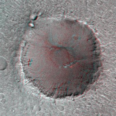
On its 256th orbit of Mars, the camera on-board NASA Mars Global Surveyor spacecraft successfully observed the vicinity of the Mars Pathfinder landing site. 3D glasses are necessary to identify surface detail.
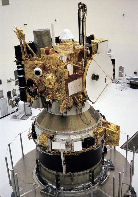
In the Payload Hazardous Servicing Facility, the integrated Mars Observer/Transfer Orbit Stage (TOS) payload is ready for encapsulation in the Titan III nose fairing. The TOS booster maiden flight was dedicated to Thomas O. Paine, a former NASA administrator who strongly supported interplanetary exploration and was an early backer of the TOS program. Launched September 25, 1992 from the Kennedy Space Flight Center aboard a Titan III rocket and the TOS, the Mars Observer spacecraft was to be the first U.S. spacecraft to study Mars since the Viking missions 18 years prior. Unfortunately, the Mars Observer spacecraft fell silent just 3 days prior to entering orbit around Mars.
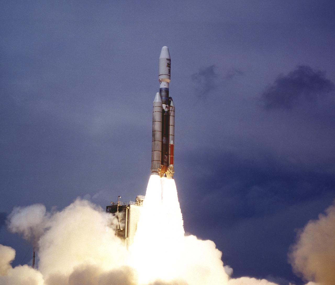
Titan III vehicle launched the Mars Observer spacecraft and the Transfer Orbit Stage (TOS) from the Cape Canaveral Air Force Station on September 25, 1992. Managed by the Marshall Space Flight Center (MSFC), TOS will fire to send the Observer on an 11-month interplanetary journey to the Mars. The Observer failed to reach the Mars orbit in August 1993.
MOC Observes Changes in the South Polar Cap: Evidence for Recent Climate Change on Mars
In this five-minute exposure taken from the surface of Mars by NASA Spirit rover, stars appear as streaks due to the rotation of the planet, and instantaneous cosmic-ray hits appear as points of light. Spirit took the image with its panoramic camera on March 11, 2004, after waking up during the martian night for a communication session with NASA's Mars Global Surveyor orbiter. Other exposures were also taken. The images tested the capabilities of the rover for night-sky observations. Scientists will use the results to aid planning for possible future astronomical observations from Mars. The difference in Mars' rotation, compared to Earth's, gives the star trails in this image a different orientation than they would have in a comparable exposure taken from Earth. http://photojournal.jpl.nasa.gov/catalog/PIA05551
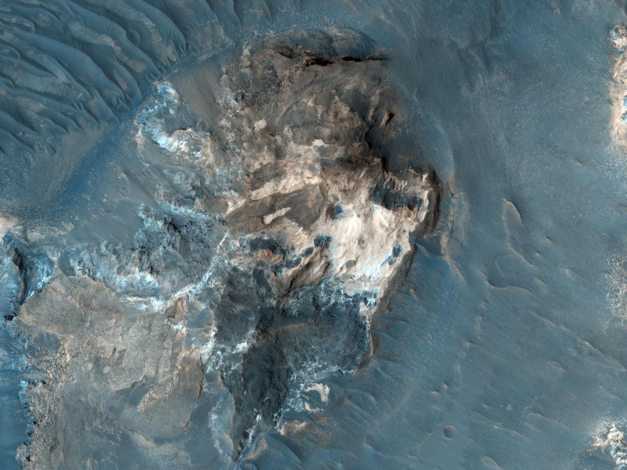
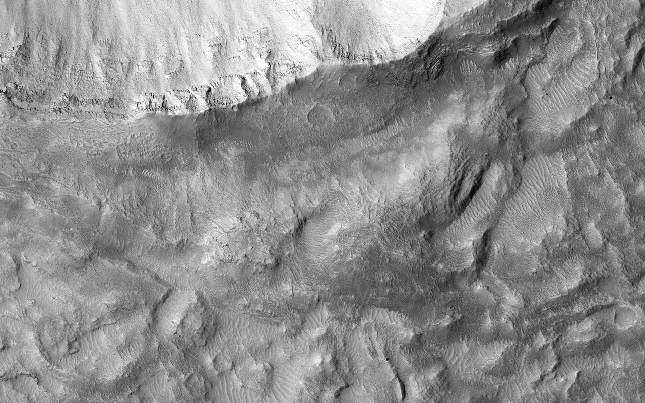
A surprise landslump in Melas Chasma was observed by NASA Mars Reconnaissance Orbiter.
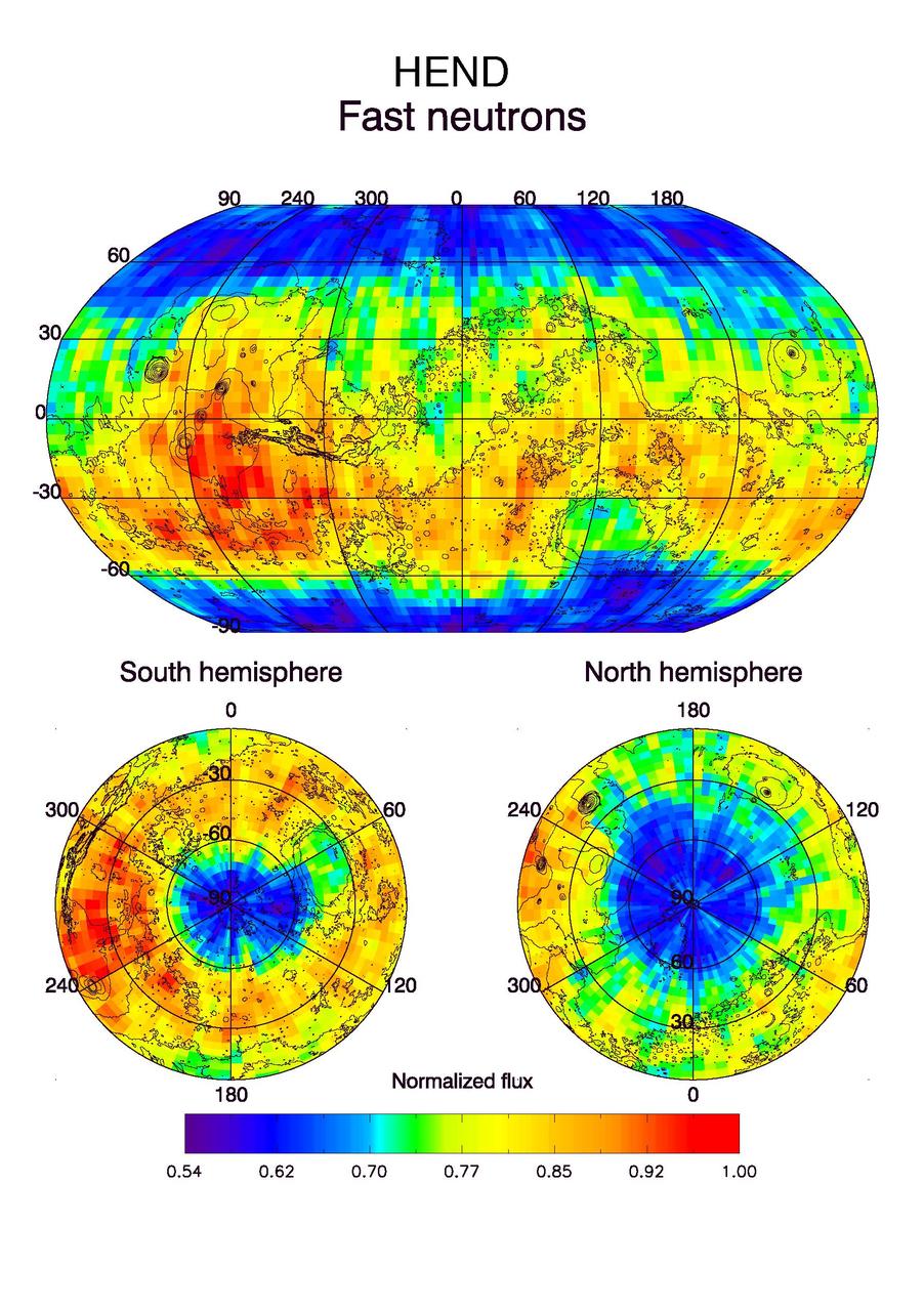
Observations by NASA Mars Odyssey spacecraft show a global view of Mars in high-energy, or fast, neutrons.
This observance from NASA Mars Reconnaissance Orbiter shows a formation of large outflow channels on Mars Aureum Chaos.

This global view of Mars in intermediate-energy, or epithermal, neutrons was created from observations by NASA Mars Odyssey spacecraft.

The CRISM, a mineral mapping instrument on NASA Mars Reconnaissance Orbiter, began observing Mars after its lens cover was opened on Sept. 27, 2006.
Observations by NASA Mars Reconnaissance Orbiter have detected carbon-dioxide snow clouds on Mars and evidence of carbon-dioxide snow falling to the surface.
NASA Mars Exploration Rover Opportunity observed this outcrop on the Murray Ridge portion of the rim of Endeavour Crater as the rover approached the 10th anniversary of its landing on Mars.
This observation from NASA Mars Reconnaissance Orbiter shows enigmatic, shallowly incised valleys, found in some mid- to low-latitude regions on Mars.

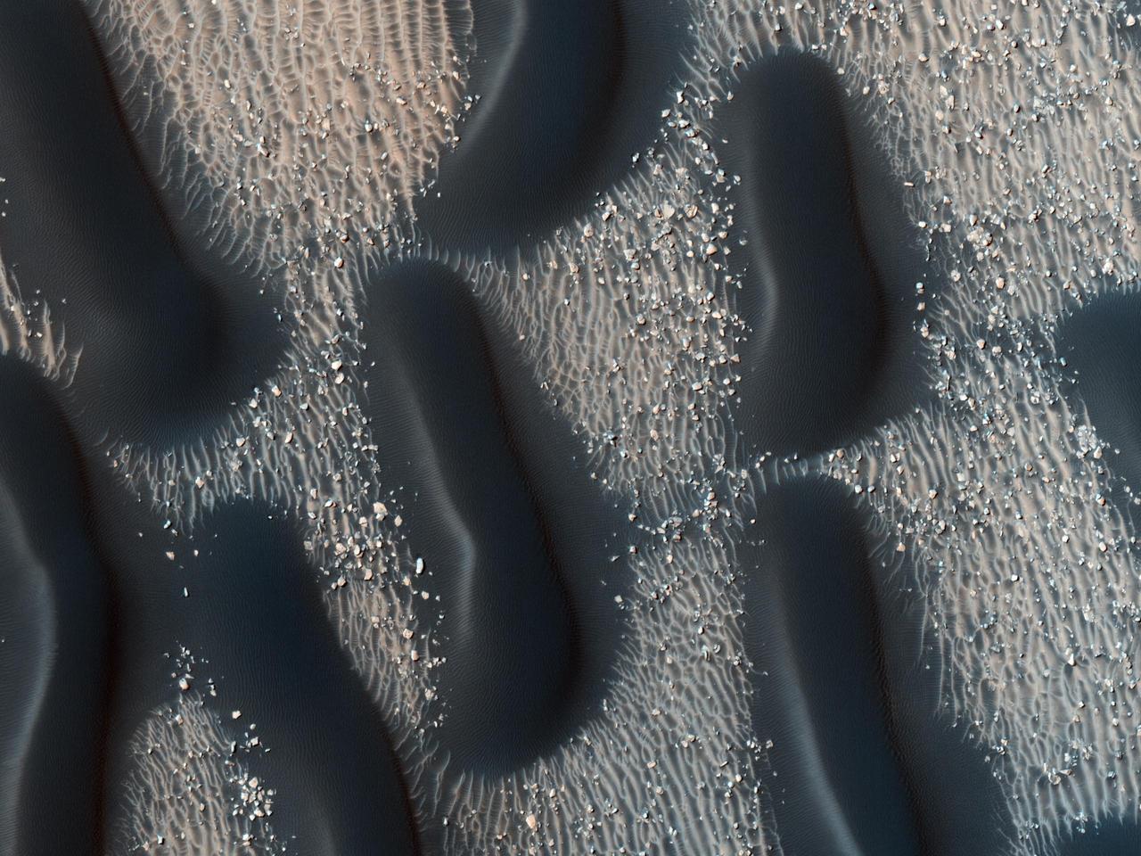
The upper portion of this map is from an observation by the Context Camera on NASA Mars Reconnaissance Orbiter of a field of dark sand dunes in the Nili Patera region of Mars.
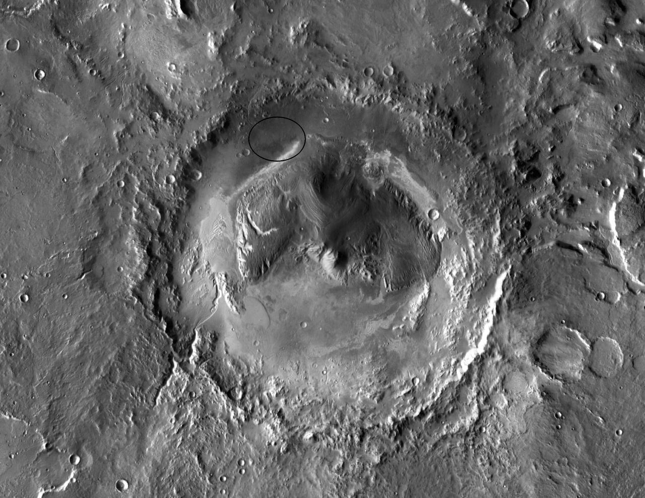
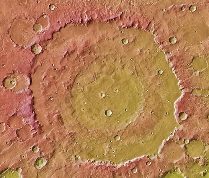
NASA has selected Gale crater as the landing site for the Mars Science Laboratory mission. This view of Gale is a mosaic of observations from NASA Mars Odyssey orbiter.

This observation from NASA Mars Reconnaissance Orbiter shows sand dunes in late Northern spring on Mars, mixed with rock outcrops on the floor of a large crater.
This image covers part of the Athabasca Valles flood lava plain, the youngest large lava flow on the surface of Mars as observed by NASA Mars Reconnaissance Orbiter.
This image shows numerous dark shapes and bright spots on a sand dune in the Northern polar regions of Mars. This observation is from NASA Mars Reconnaissance Orbiter.
This image shows numerous dark shapes and bright spots on a sand dune in the Northern polar regions of Mars. This observation is from NASA Mars Reconnaissance Orbiter.
This image from NASA Mars Global Surveyor and Mars Odyssey spacecraft shows the context for orbital observations of exposed rocks that had been buried on Mars. The area is dominated by the Huygens crater, which is about the size of Wisconsin.
This observation from NASA Mars Reconnaissance Orbiter shows what is called a calloped terrain, that appears here to merge in a linear depression.
This image covers a 26-kilometer-wide impact crater northeast of the Hellas impact basin as observed by NASA Mars Reconnaissance Orbiter.
This observation from NASA Mars Reconnaissance Orbiter shows bright and dark slope streaks in craters in the Arabia Terra region.

Ancient lava flow in Cerberus Planitia is observed here by NASA Mars Reconnaissance Orbiter.
NASA Mars 2020 rover would have capabilities for nested-scale observations and localized composition identification down to microscopic scale.
An impact crater in Isidis Planitia observed for a fifth time by NASA Mars Reconnaissance Orbiter.
This MOC image shows a variety of textures observed on a dust-covered plain in the Marte Valles region of Mars
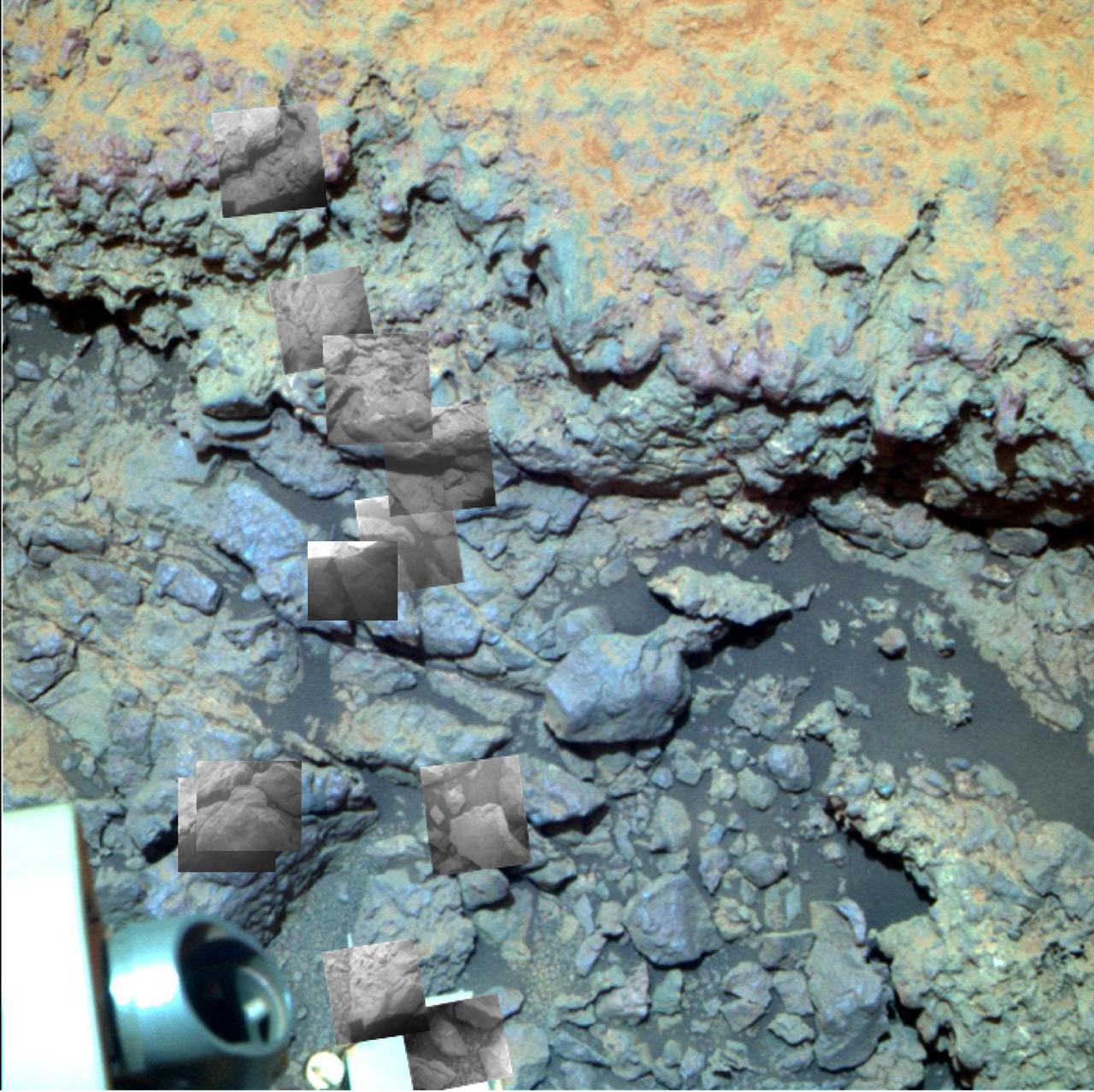
This image taken by the NASA Mars rover Opportunity shows locations of the microscopic imager observations on a rock informally named Tisdale 2.
An impact crater in Isidis Planitia observed for a fifth time by NASA Mars Reconnaissance Orbiter.
This image comes from observations of steep crater slopes on Terra Cimmeria by the HiRISE camera onboard NASA Mars Reconnaissance Orbiter.

This fascinating observation from NASA Mars Reconnaissance Orbiter shows us a dark-toned mound with pits inside an impact crater.
This observation from NASA Mars Reconnaissance Orbiter covers an outcrop of possible cyclic bedding within a crater in Arabia Terra.
This HiRISE image of the Opportunity rover was acquired as a coordinated ride-along observation with the CRISM instrument, also onboard the Mars Reconnaissance Orbiter.
This image comes from observations of a well-preserved crater on Terra Cimmeria by the HiRISE camera onboard NASA Mars Reconnaissance Orbiter.
This observation from NASA Mars Reconnaissance Orbiter is of an east-facing slope in Tithonium Chasma.

After investigating the upper atmosphere of the Red Planet for a full Martian year, NASA’s MAVEN mission has determined that the escaping water does not always go gently into space. Sophisticated measurements made by a suite of instruments on the Mars Atmosphere and Volatile Evolution, or MAVEN, spacecraft revealed the ups and downs of hydrogen escape – and therefore water loss. The escape rate peaked when Mars was at its closest point to the sun and dropped off when the planet was farthest from the sun. The rate of loss varied dramatically overall, with 10 times more hydrogen escaping at the maximum. “MAVEN is giving us unprecedented detail about hydrogen escape from the upper atmosphere of Mars, and this is crucial for helping us figure out the total amount of water lost over billions of years,” said Ali Rahmati, a MAVEN team member at the University of California at Berkeley who analyzed data from two of the spacecraft’s instruments. Hydrogen in Mars’ upper atmosphere comes from water vapor in the lower atmosphere. An atmospheric water molecule can be broken apart by sunlight, releasing the two hydrogen atoms from the oxygen atom that they had been bound to. Several processes at work in Mars’ upper atmosphere may then act on the hydrogen, leading to its escape. Read more: <a href="http://go.nasa.gov/2dAgAV4" rel="nofollow">go.nasa.gov/2dAgAV4</a> <b><a href="http://www.nasa.gov/audience/formedia/features/MP_Photo_Guidelines.html" rel="nofollow">NASA image use policy.</a></b> <b><a href="http://www.nasa.gov/centers/goddard/home/index.html" rel="nofollow">NASA Goddard Space Flight Center</a></b> enables NASA’s mission through four scientific endeavors: Earth Science, Heliophysics, Solar System Exploration, and Astrophysics. Goddard plays a leading role in NASA’s accomplishments by contributing compelling scientific knowledge to advance the Agency’s mission. <b>Follow us on <a href="http://twitter.com/NASAGoddardPix" rel="nofollow">Twitter</a></b> <b>Like us on <a href="http://www.facebook.com/pages/Greenbelt-MD/NASA-Goddard/395013845897?ref=tsd" rel="nofollow">Facebook</a></b> <b>Find us on <a href="http://instagrid.me/nasagoddard/?vm=grid" rel="nofollow">Instagram</a></b>
This observation image from NASA's Mars Reconnaisance Orbiter (MRO) captures details regarding the evolution of gully features observed in a crater in Acidalia Planitia. A Context Camera image provides context for these gullies showing an approximately 7-kilometer diameter crater in which we see that the gullies occur exclusively on the northern wall. This is unlike most of the observed gully sites in the northern Martian hemisphere, which typically have gullies on their pole-facing slopes. Another unique observation of this set of gullies is that they start mid-way down the crater's wall rather than cutting directly into the upper crater wall or rim. The younger, more recently active fans are generally rougher than the older, smoother fans that are located near the base of the slope. Consistent with this interpretation, are a number of observed superposition and cross-cutting relationships. The rougher fans are always superimposed over the older, smoother ones. Discontinuous fractures are observed to cross-cut only older features, while the most recently active portions of the gullies, in this case the channels or fans, are not cut by the fractures, but in some cases even superimpose them. This suggests that the fractures formed prior to the last phase of gully activity. https://photojournal.jpl.nasa.gov/catalog/PIA22054
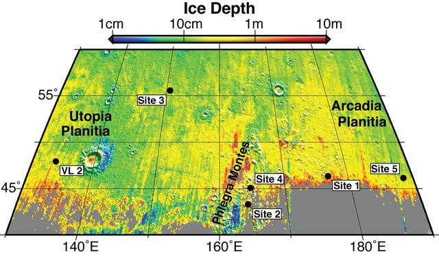
Using observations from NASA Mars Reconnaissance Orbiter, this map shows five locations where fresh impact cratering has excavated water ice from just beneath the surface of Mars.
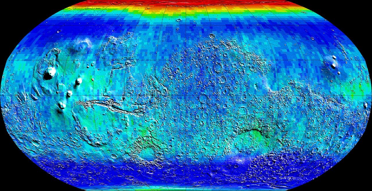
Observations by NASA Mars Odyssey spacecraft show a global view of Mars in low energy, or thermal, neutrons. Thermal neutrons are sensitive to the presence of hydrogen and the presence of carbon dioxide, in this case dry ice frost.
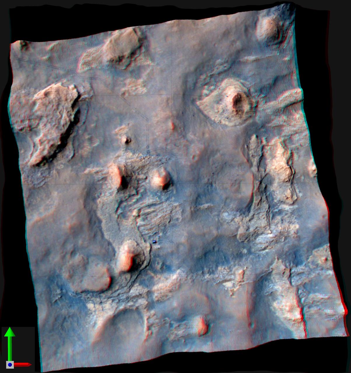
NASA Curiosity Mars rover and its tracks are visible in this view combining information from three observations by the HiRISE camera on NASA Mars Reconnaissance Orbiter. You need 3-D glasses to view this image.
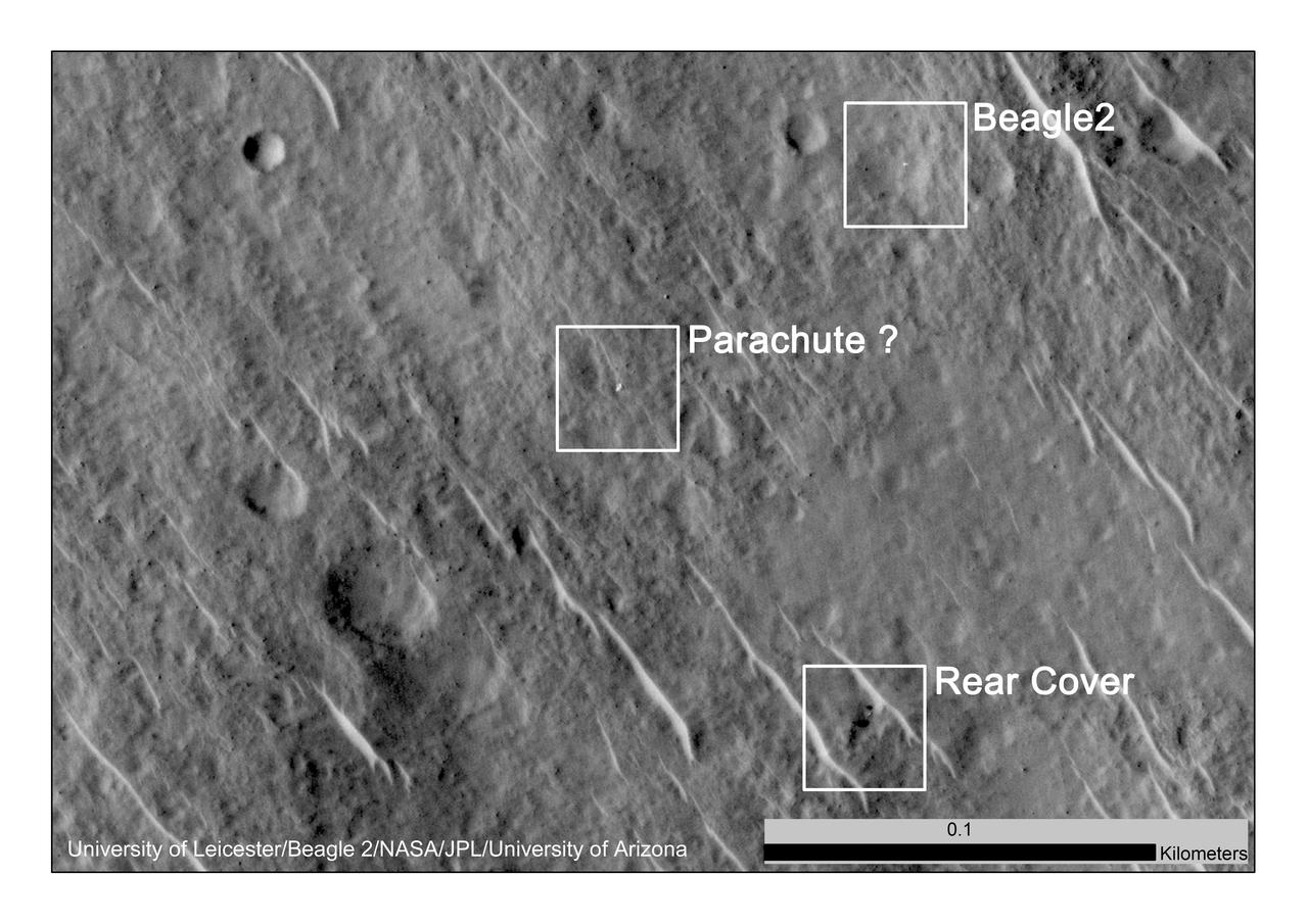
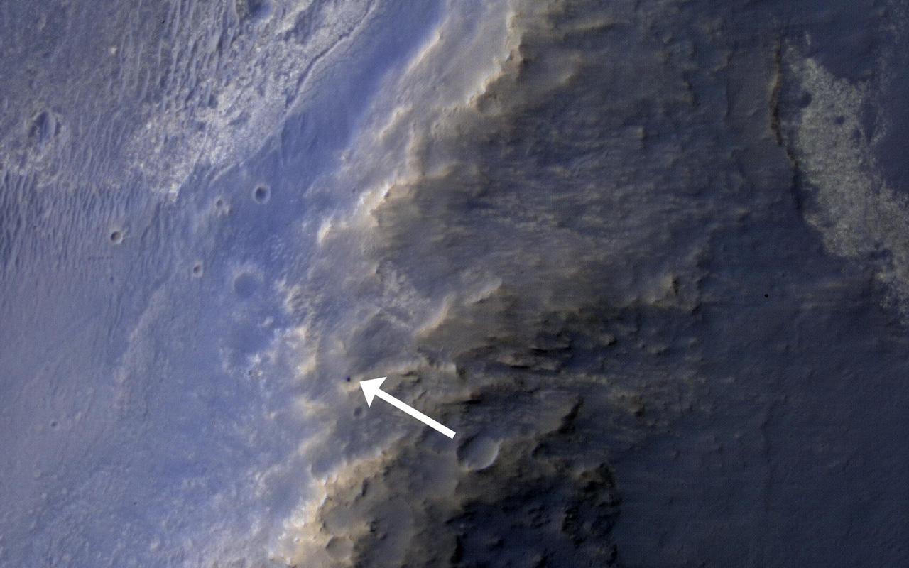
This annotated image, taken in 2014, shows where features seen in an observation by NASA Mars Reconnaissance Orbiter have been interpreted as hardware from the Dec. 25, 2003, arrival at Mars of the United Kingdom Beagle 2 Lander.
This frame from a movie clip shows the larger of Mars two moons, Phobos, passing in front of the smaller Martian moon, Deimos, as observed by NASA Mars rover Curiosity.
The Athabasca region contains some of the youngest lava flows on Mars. This looks like a circular island surrounded by a ea of smooth-looking lava flows. This image was observed by NASA Mars Reconnaissance Orbiter.
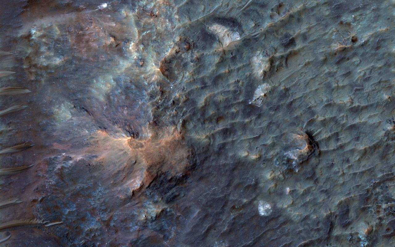
This image comes from observations of Newton crater by the HiRISE camera onboard NASA Mars Reconnaissance Orbiter; warm-season features might be evidence of salty liquid water active on Mars today.
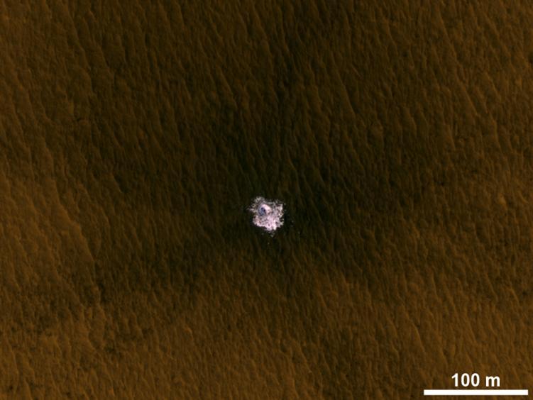
The image is an excerpt from an observation from NASA Mars Reconnaissance Orbiter showing a meteorite impact that excavated this crater on Mars exposed bright ice that had been hidden just beneath the surface at this location.
This observation from NASA Mars Reconnaissance Orbiter shows both dome and barchan dunes in a small sand dune field on the floor of Newton Crater, an approximately 300 kilometer 130 mile wide crater in the Southern hemisphere of Mars.
This impact crater in the region of Mars called Libya Montes, observed by NASA Mars Reconnaissance Orbiter, shows typical gullies with alcoves at the top, channels, and depositional fans at the bottom.
This image taken by NASA Mars Reconnaissance Orbite on May 19, 2010, shows an impact crater that had not existed when the same location on Mars was previously observed in March 2008.
These Mars Odyssey images show the White Rock feature on Mars in both infrared left and visible right wavelengths. White Rock is the unofficial name for this landform that was first observed during NASA Mariner 9 mission in the early 1970.
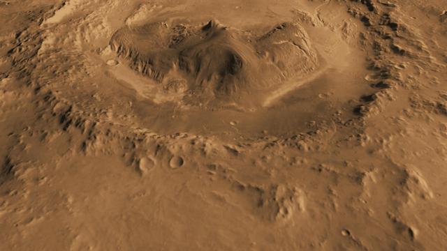
This computer-generated view based on multiple orbital observations shows Mars Gale crater. NASA is considering Gale as a possible landing site for the Mars Science Laboratory mission.
This observation from NASA Mars Reconnaissance Orbiter shows the very steep side of a plateau, part of the northern limit of the Kasei Valles system, which is one of the largest outflow channel systems on Mars.
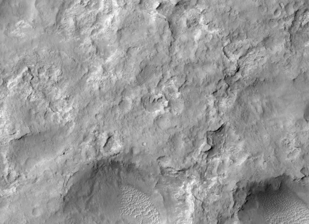
NASA Curiosity Mars rover and tracks left by its driving appear in this portion of a Dec. 11, 2013, observation by the HiRISE camera on NASA Mars Reconnaissance Orbiter. The rover is near the lower-left corner of this view.
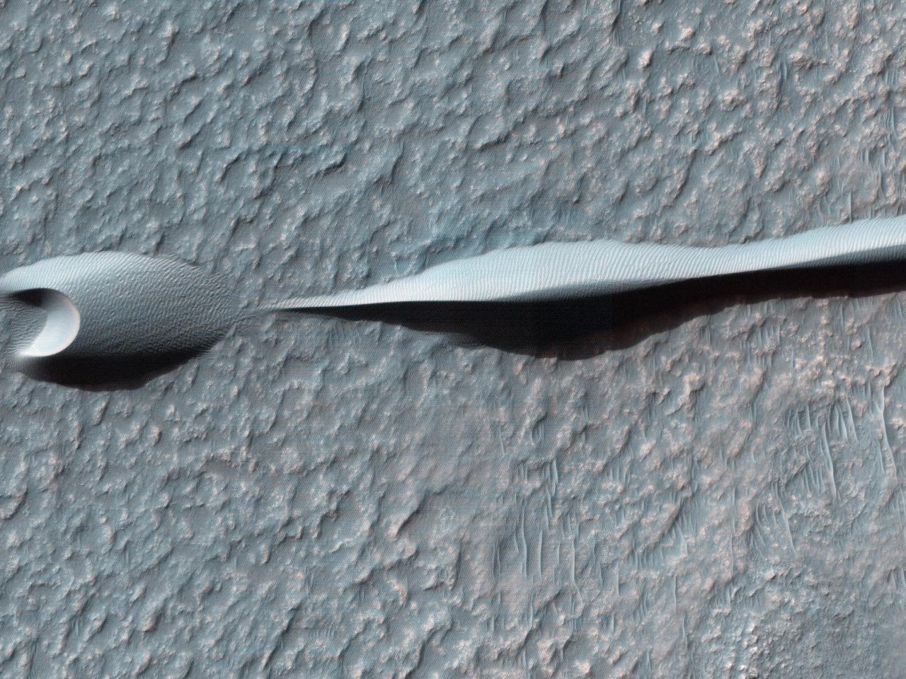
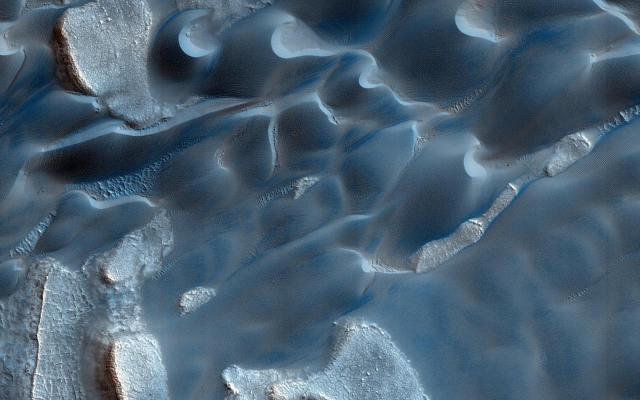
Sand dunes like those seen in this image from NASA Mars Reconnaissance Orbiter have been observed to creep slowly across the surface of Mars through the action of the wind.
Low lying areas in the Hellas region, which is the largest impact basin on Mars, often show complex groups of banded ridges, furrows, and pits as seen in this observation from NASA Mars Reconnaissance Orbiter.
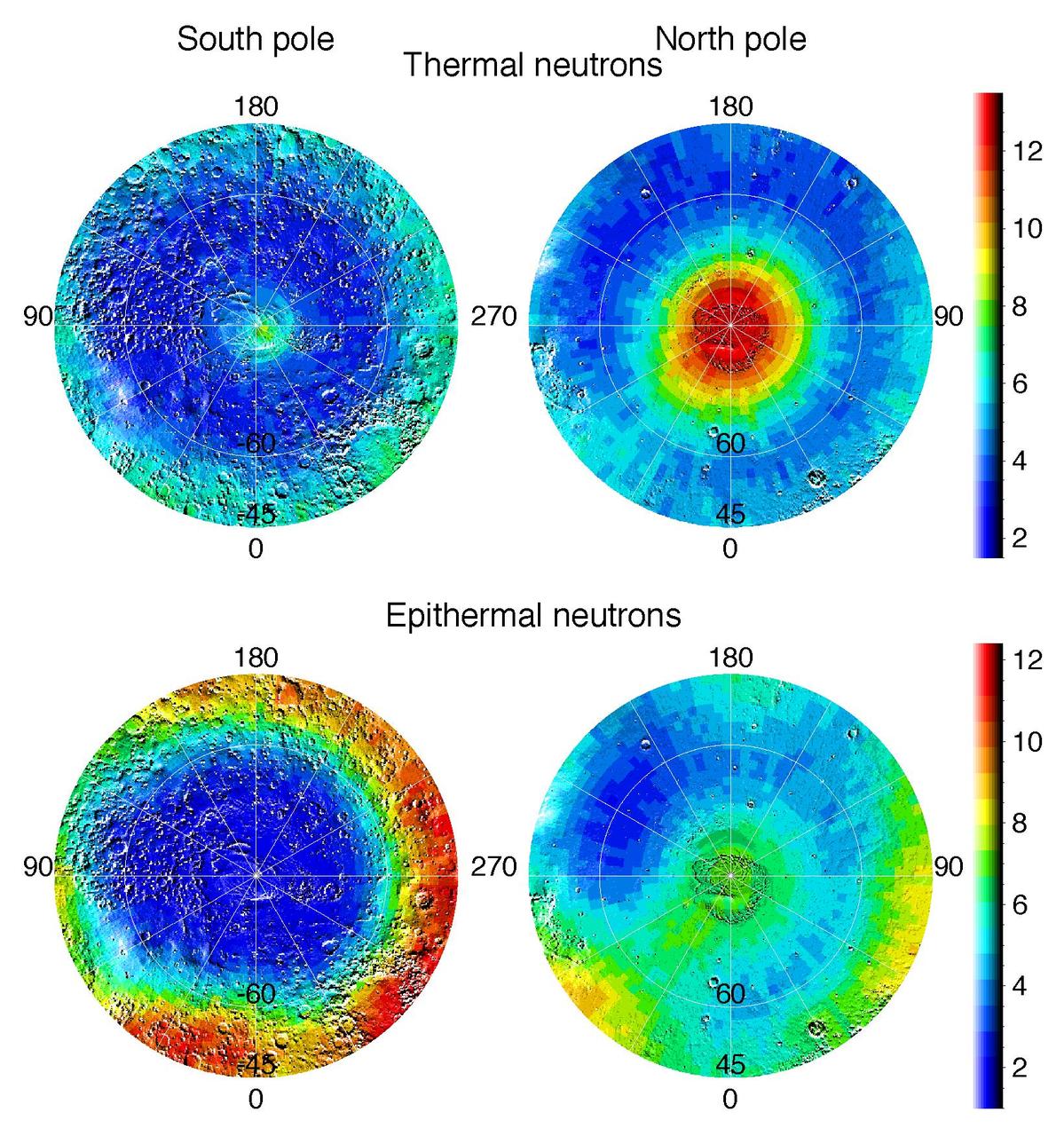
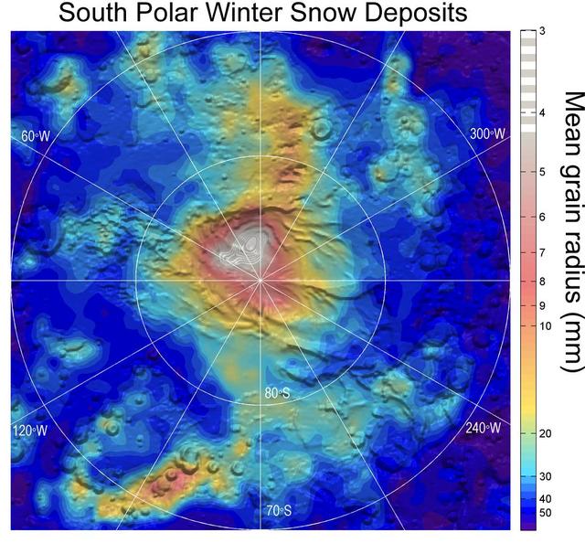
Observations by NASA Mars Odyssey spacecraft show views of the polar regions of Mars in thermal neutrons top and epithermal neutrons bottom. In these maps, deep blue indicates a low amount of neutrons and red indicates a high amount.
This observation from NASA Mars Reconnaissance Orbiter shows the edge of a dark dune field on the floor of Proctor Crater in the Southern highlands of Mars. The dark dunes are composed of basaltic sand that has collected on the bottom of the crater.
This observation from NASA Mars Reconnaissance Orbiter shows a sand dune field in the Nili Fossae region of Mars. The dark lines swirling over the surface of the dunes are the tracks of dust devils.

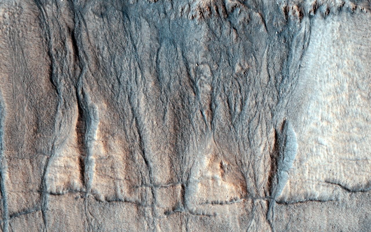
Several types of downhill flow features have been observed on Mars. Shown here is an example of a type called linear gullies as seen by NASA Mars Reconnaissance Orbiter.
This frame from an animation shows Phobos, the larger of the two moons of Mars, passing overhead, as observed by NASA Mars rover Curiosity, centered straight overhead starting shortly after sunset.
This observation from NASA Mars Reconnaissance Orbiter shows the end of a small channel near Athabasca Valles on Mars. Athabasca is an example of a Martian outflow channel, likely carved by a massive flood of groundwater.
Sand dunes such as those seen in this image from NASA Mars Reconnaissance Orbiter have been observed to creep slowly across the surface of Mars through the action of the wind.
This computer-generated view based on multiple orbital observations shows Mars Gale crater as if seen from an aircraft northwest of the crater. NASA has selected Gale as the landing site for the Mars Science Laboratory mission.
This observation from NASA Mars Reconnaissance Orbiter shows a beautiful example of gullies in a massif in Nereidum Montes, located in Argyre Planitia, one of the largest impact basins on Mars.
The impact crater in this NASA Mars Odyssey image is a model illustration of the effects of erosion on Mars. The degraded crater rim and several landslides observed in crater walls are evidence of the mass wasting of materials.
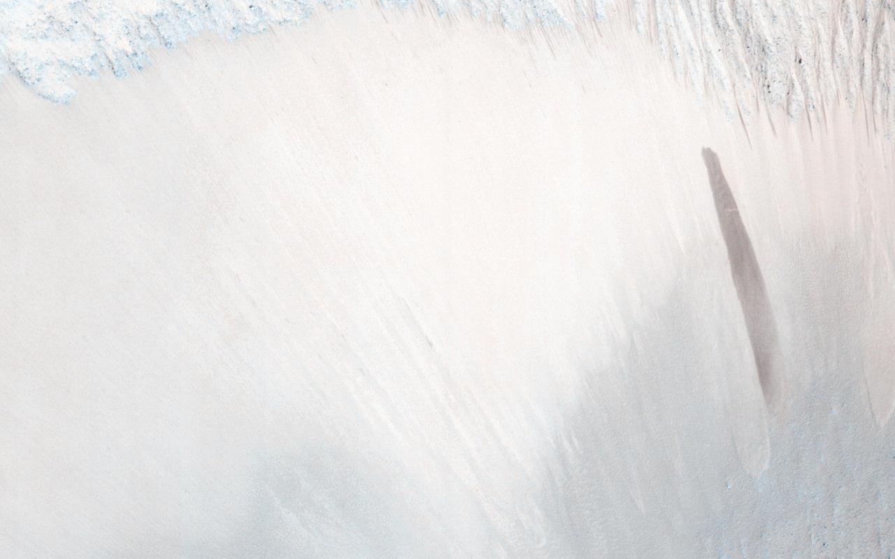
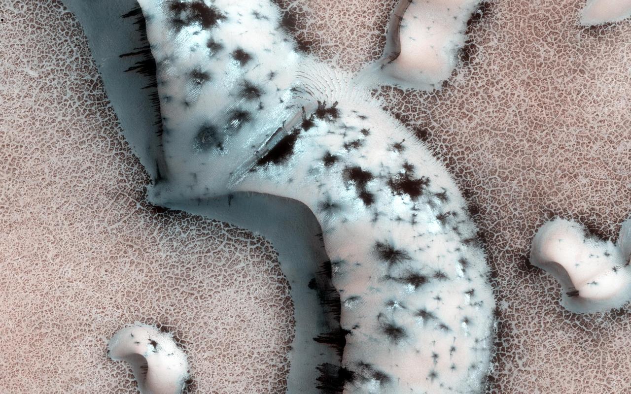
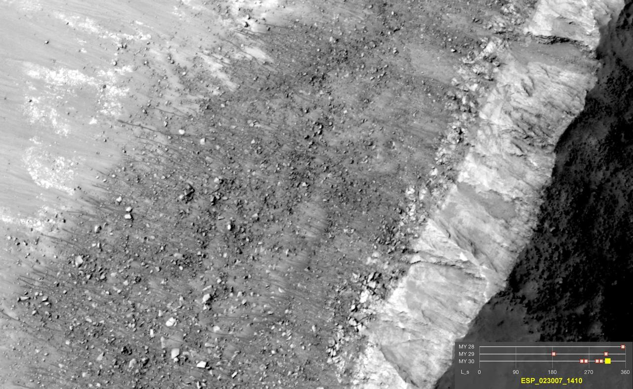
The deep chasm that formed on the polar cap edge is identified as an area of strong down-slope winds and has a clear connection to Mars largest dune field, Olympia Undae as observed by NASA Mars Reconnaissance Orbiter.

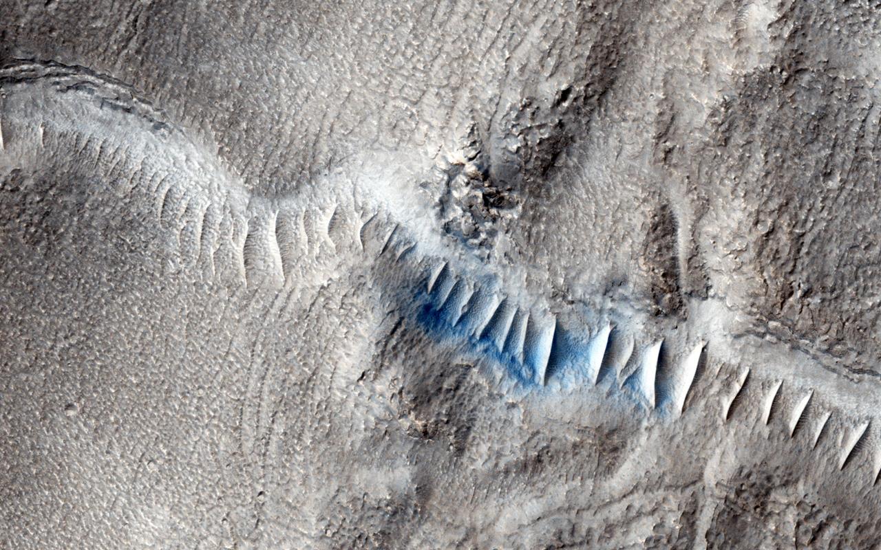
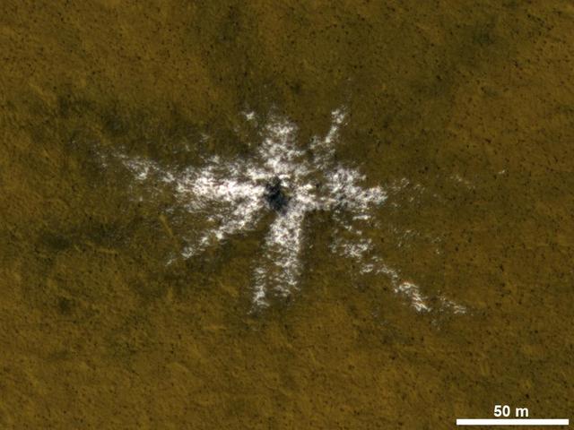
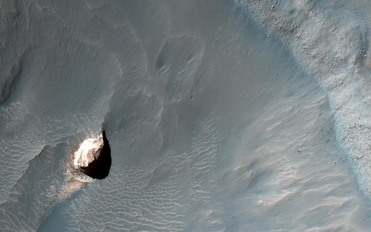
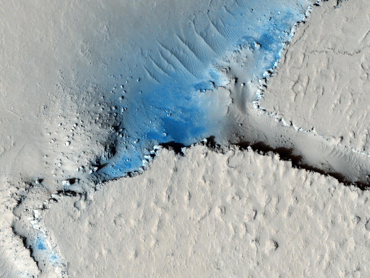
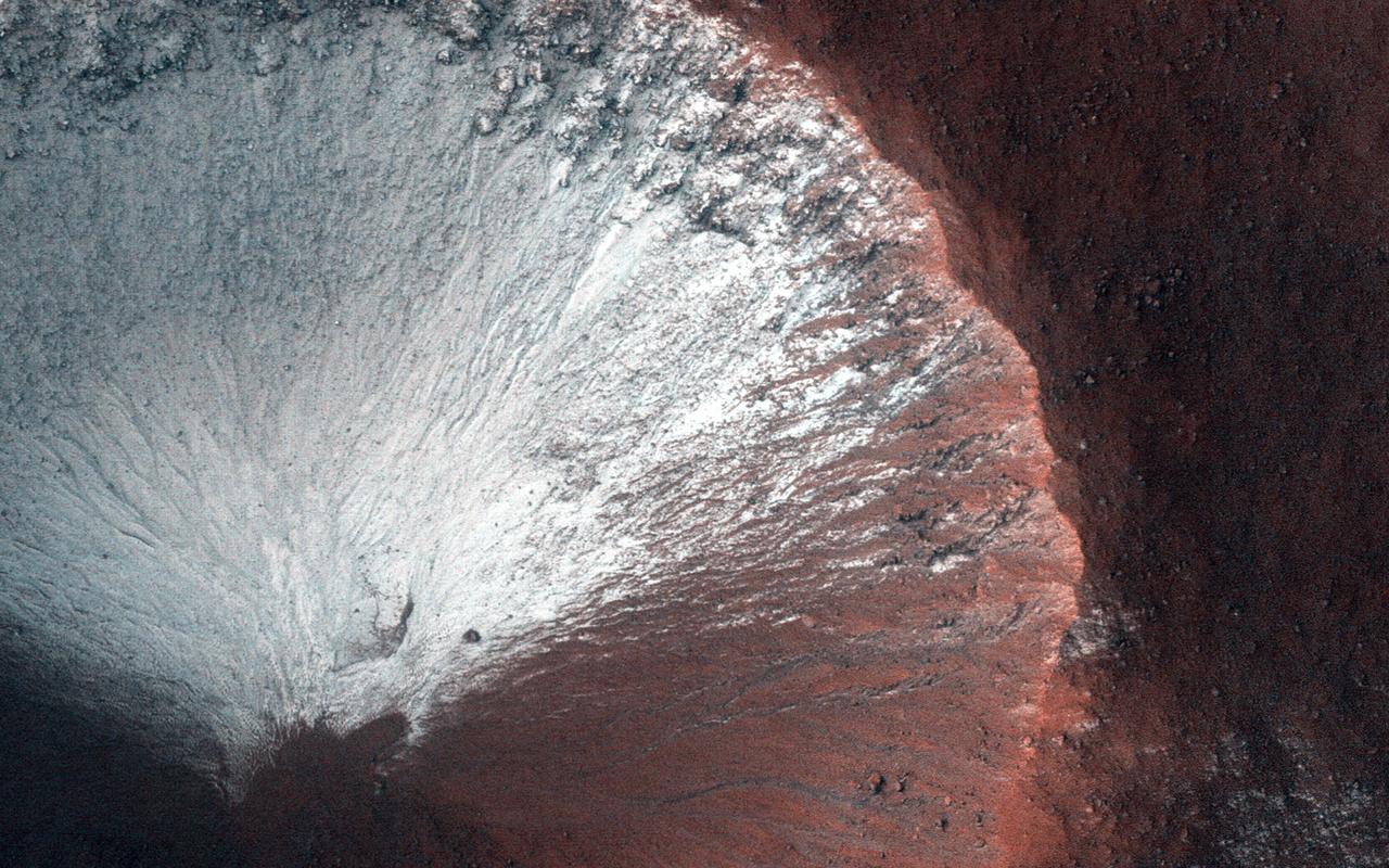
At the center of this view of an area of mid-latitude northern Mars, a fresh crater about 6 meters 20 feet in diameter holds an exposure of bright material, blue in this false-color image observed by NASA Mars Reconnaissance Orbiter.
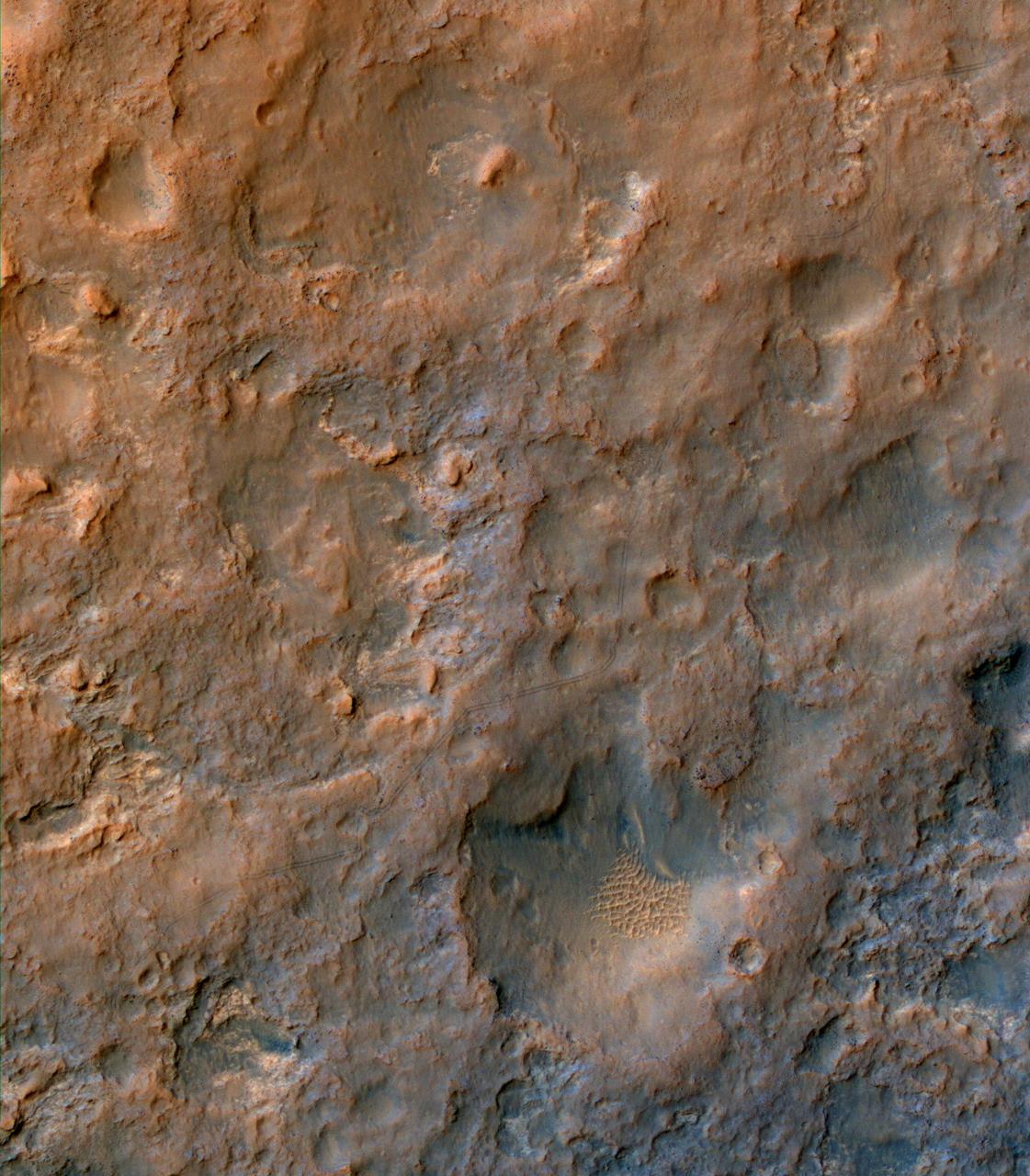
Two parallel tracks left by the wheels of NASA Curiosity Mars rover cross rugged ground in this portion of an observation by the HiRISE camera on NASA Mars Reconnaissance Orbiter on Dec. 11, 2013. The rover itself does not appear in this image.
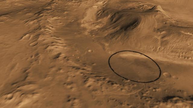
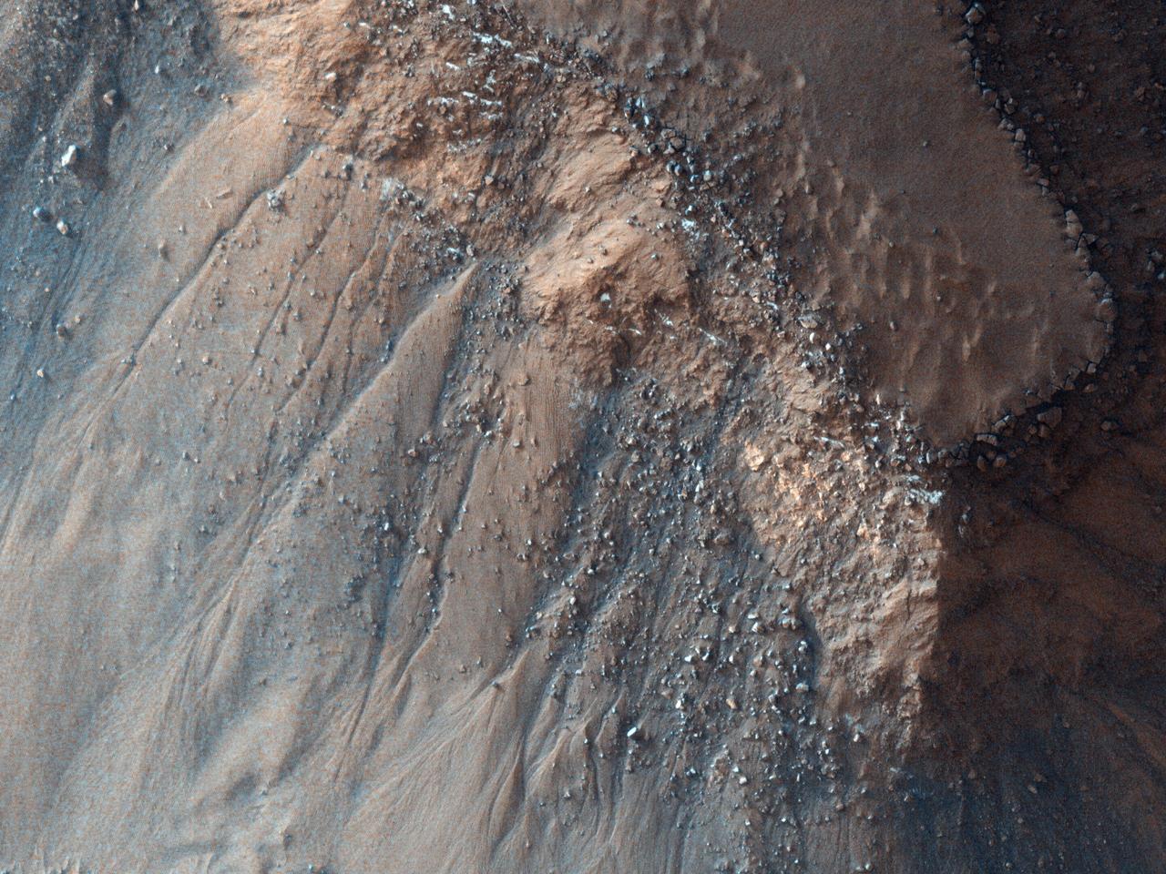
Seasonal flows on warm Martian slopes may be caused by the flow of salty water on Mars, active today when the surface is warm above the freezing point of the solution. This observation is from NASA Mars Reconnaissance Orbiter.
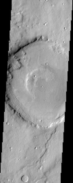
This crater on Mars, observed by NASA Mars Reconnaissance Orbiter, was named after Dr. Gerald A. Soffen February 7, 1926 - November 22, 2000, and this image covers a small portion of the crater floor. http://photojournal.jpl.nasa.gov/catalog/PIA14453
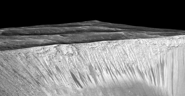
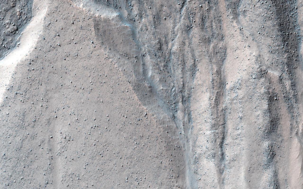
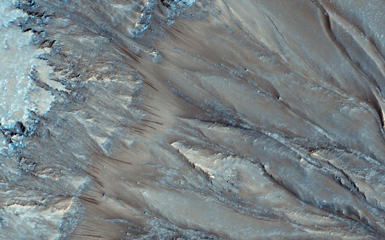
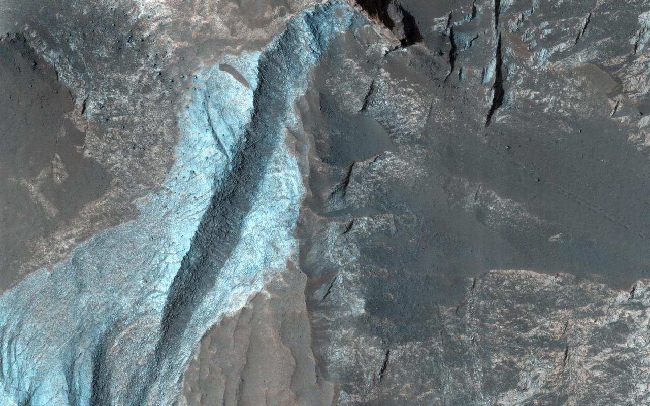
Dark narrow streaks, called "recurring slope lineae," emanate from the walls of Garni Crater on Mars, in this view constructed from observations by the High Resolution Imaging Science Experiment (HiRISE) camera on NASA's Mars Reconnaissance Orbiter. The dark streaks here are up to few hundred yards, or meters, long. They are hypothesized to be formed by flow of briny liquid water on Mars. The image was produced by first creating a 3-D computer model (a digital terrain map) of the area based on stereo information from two HiRISE observations, and then draping an image over the land-shape model. The vertical dimension is exaggerated by a factor of 1.5 compared to horizontal dimensions. The draped image is a red waveband (monochrome) product from HiRISE observation ESP_031059_1685, taken on March 12, 2013 at 11.5 degrees south latitude, 290.3 degrees east longitude. Other image products from this observation are at http://hirise.lpl.arizona.edu/ESP_031059_1685. http://photojournal.jpl.nasa.gov/catalog/PIA19917
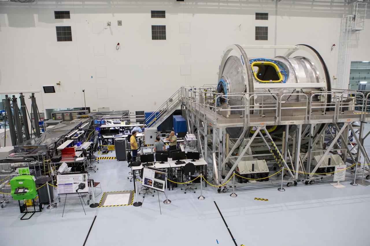
Instruments for NASA’s Mars Spectrometer observing lunar operations (MSolo) are in view at left in the high bay of the Space Station Processing Facility (SSPF) at NASA's Kennedy Space Center in Florida, on May 16, 2019. The center is celebrating the SSPF’s 25th anniversary. The facility was built to process elements for the International Space Station. Now it is providing support for current and future NASA and commercial provider programs, including Commercial Resupply Services, Artemis 1, sending the first woman and next man to the Moon, and deep space destinations including Mars.
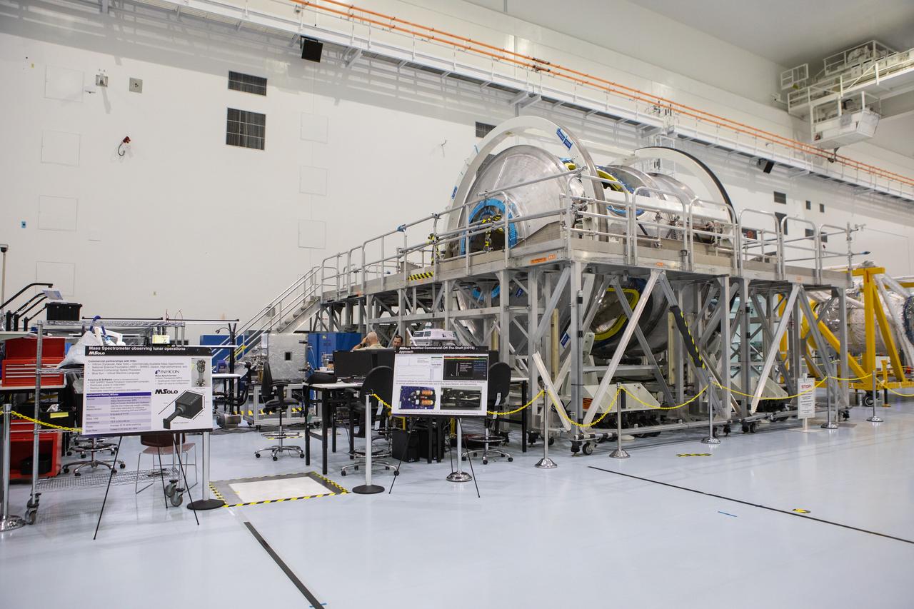
Instruments for NASA’s Mars Spectrometer observing lunar operations (MSolo) are in view at left in the high bay of the Space Station Processing Facility (SSPF) at NASA's Kennedy Space Center in Florida, on May 16, 2019. The center is celebrating the SSPF’s 25th anniversary. The facility was built to process elements for the International Space Station. Now it is providing support for current and future NASA and commercial provider programs, including Commercial Resupply Services, Artemis 1, sending the first woman and next man to the Moon, and deep space destinations including Mars.
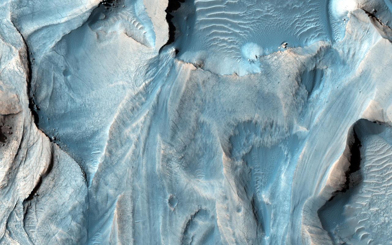
This observation from NASA Mars Reconnaissance Orbiter shows one of the first close HiRISE views of the enigmatic Valles Marineris interior layered deposits.
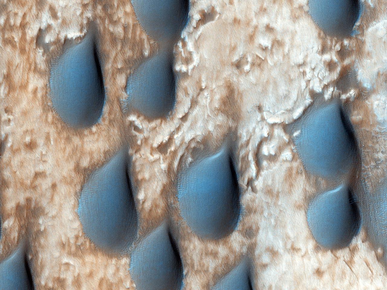
The dark features here look like raindrops, but are actually sand dunes in Copernicus Crater. This observation is from NASA Mars Reconnaissance Orbiter.

This observation from NASA Mars Reconnaissance Orbiter shows part of the floor of a large impact crater in the southern highlands, north of the giant Hellas impact basin.
This observation captured by NASA Mars Reconnaissance Orbiter shows a small crater in within the much larger Pollack Crater containing light-toned material.
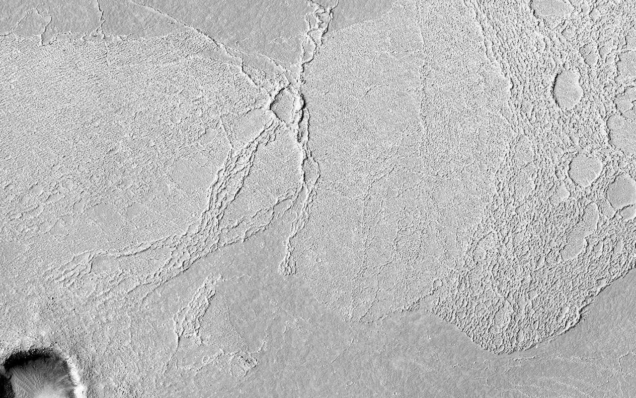
The crosscutting relationships observed in this image from NASA Mars Odyssey spacecraft can be used to determine the relative timing of graben and channel formations.
This observation from NASA Mars Reconnaissance Orbiter targets some unknown fill or mantling material within valleys on a crater floor and within a central pit.

Imaged by MRO NASA Mars Reconnaissance Orbiter Context Camera, this observation shows one of two odd, rounded mesas with a knobby, pitted texture.
The objective of this observation by NASA Mars Reconnaissance Orbiter was to examine the edge of impact ejecta from a crater to the north-west of this area north is up, west is to the left.
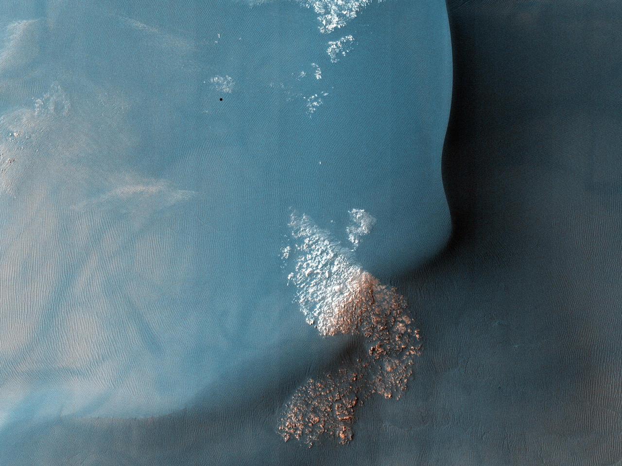
This observation from NASA Mars Reconnaissance Orbiter shows part of Gorgonum Chaos, a large cluster of chaotic terrain found in the southern hemisphere.

This image taken by NASA Mars Reconnaissance Orbiter shows gullies in a semi-circular trough in Noachis Terra. The gullies are observed to face all directions.
When impact craters are formed, the material that once resided in the subsurface is blown upward and outward, as seen in this observation from NASA Mars Reconnaissance Orbiter.
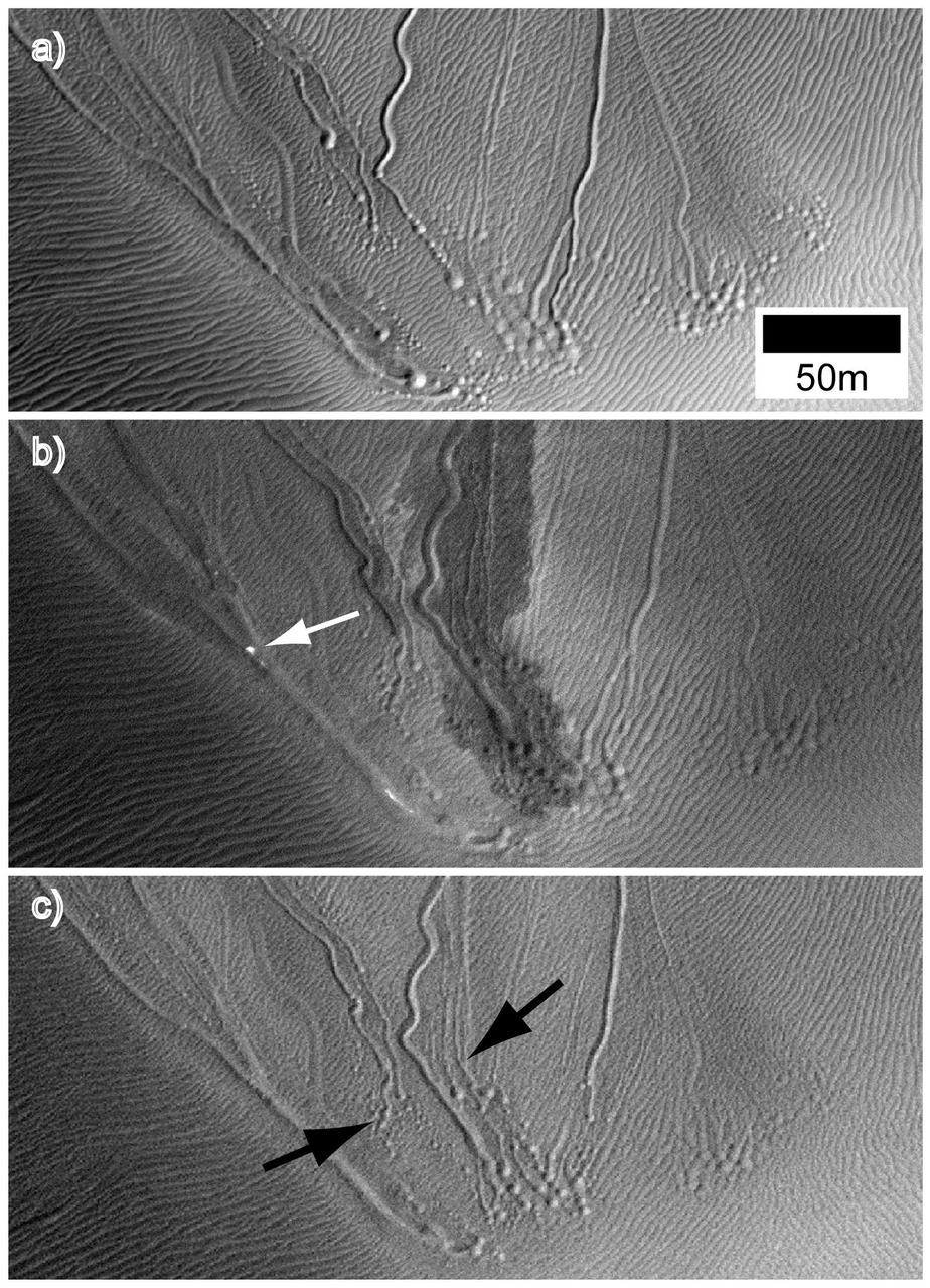
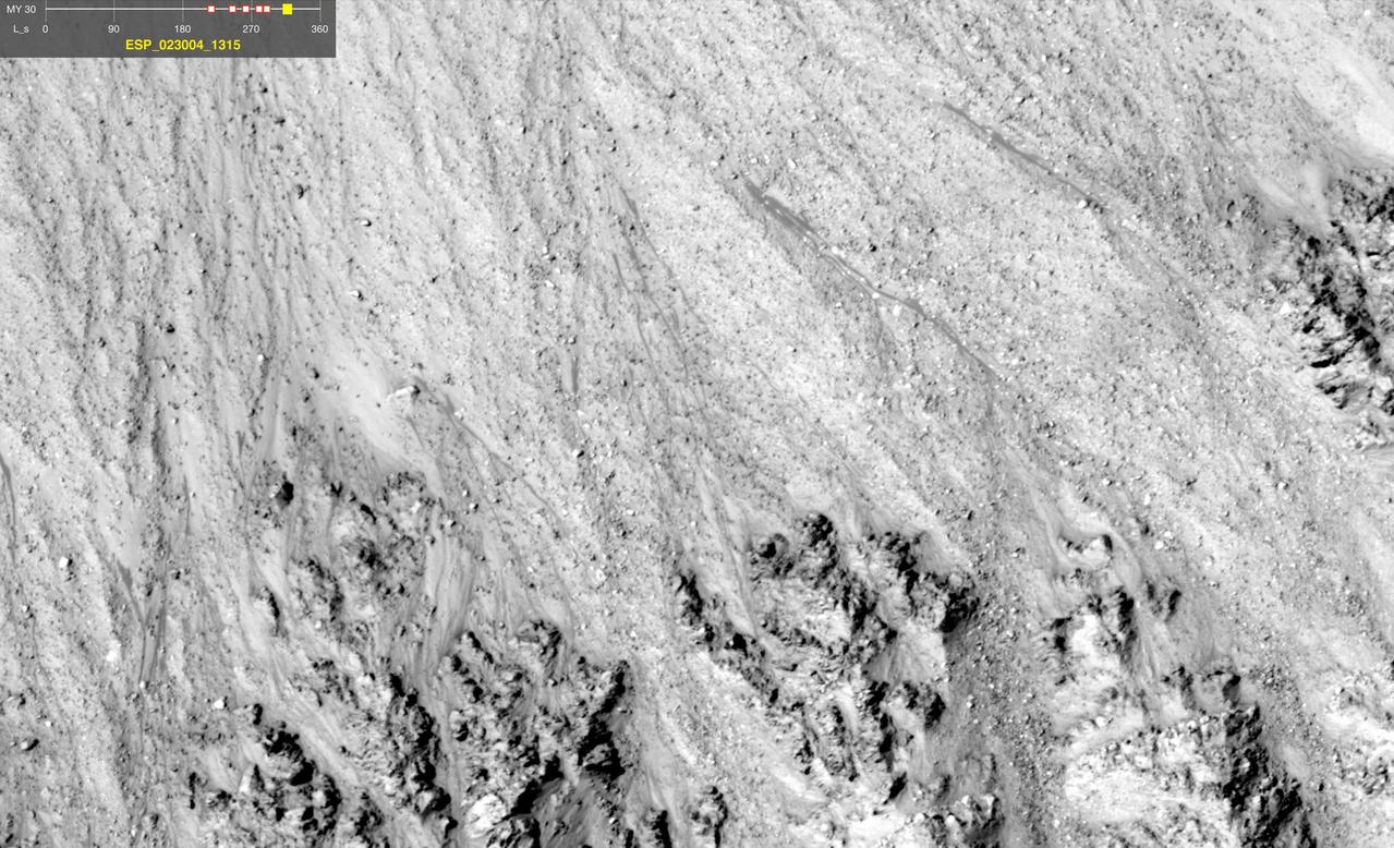
These three images taken by NASA Mars Reconnaissance Orbiter are called linear gullies and were taken at different times of the year to observe changes.
This observation from NASA Mars Reconnaissance Orbiter shows fractured mounds on the southern edge of Elysium Planitia. The fractures that crisscross their surfaces are probably composed of solidified lava.
The objective of this observation from NASA Mars Reconnaissance Orbiter is to determine the nature of a group of what appears to be channels that trend in a west-east direction.
This observation from NASA Mars Reconnaissance Orbiter shows an incredible diversity of ancient lava tubes and impact craters filled with sediment on the flank of Arsia Mons.
This observation from NASA Mars Reconnaissance Orbiter shows the central hills in Hale Crater with thousands of seasonal flows on steep slopes below bedrock outcrops.
Terby Crater, sitting on the northern rim of Hellas Basin, has been filled by sedimentary deposits, perhaps deposited by or in water, as observed by NASA Mars Reconnaissance Orbiter.
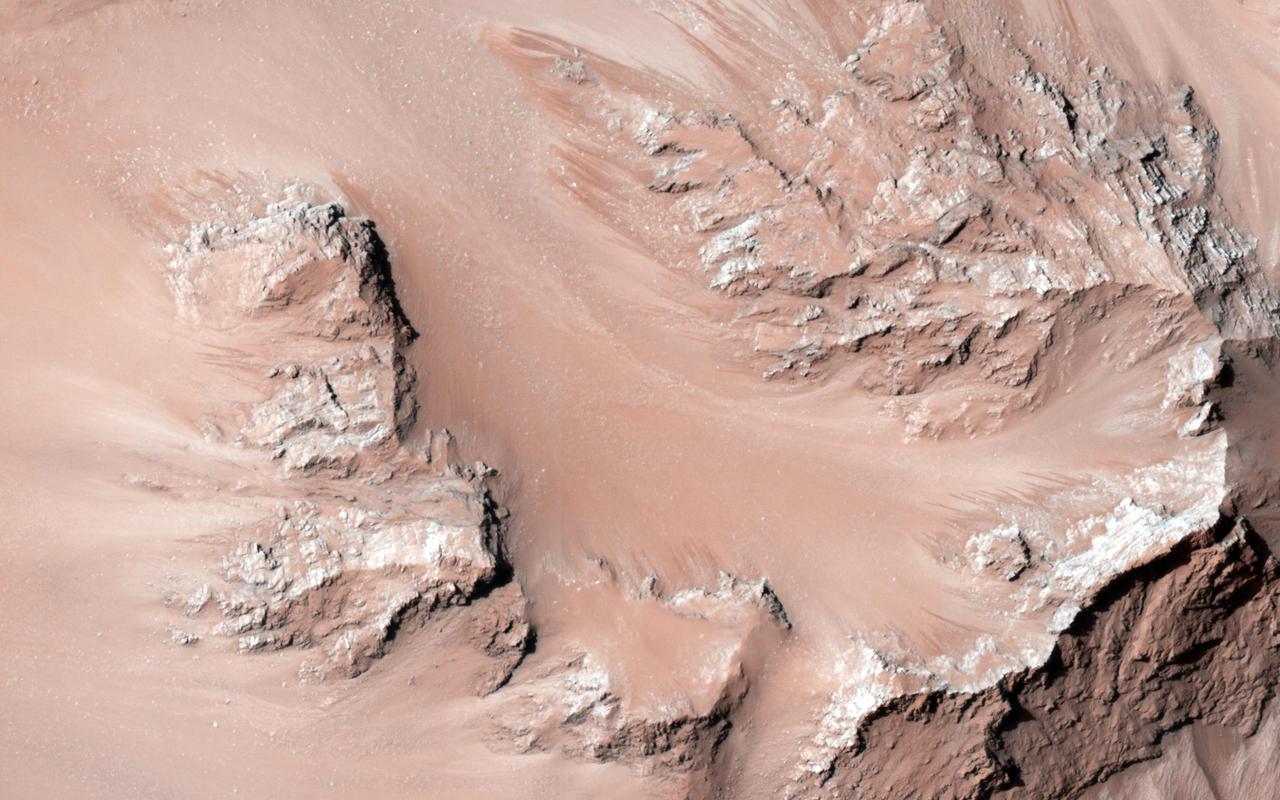
This observation from NASA Mars Reconnaissance Orbiter shows the central hills in Hale Crater with thousands of seasonal flows on steep slopes below bedrock outcrops.
This observation from NASA Mars Reconnaissance Orbiter shows a Southern hemisphere crater with gullies, dunes, periglacial modification, bright rock deposits, and dust devil tracks.
This observation, taken in June 2014, covers a small 1-kilometer sized simple crater located in the Southern hemisphere in late Martian winter as Mars is heading into spring.