
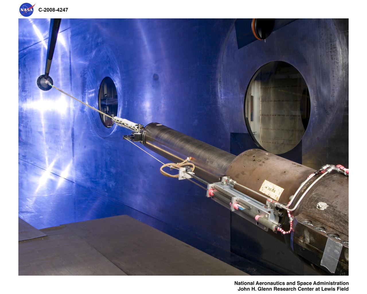
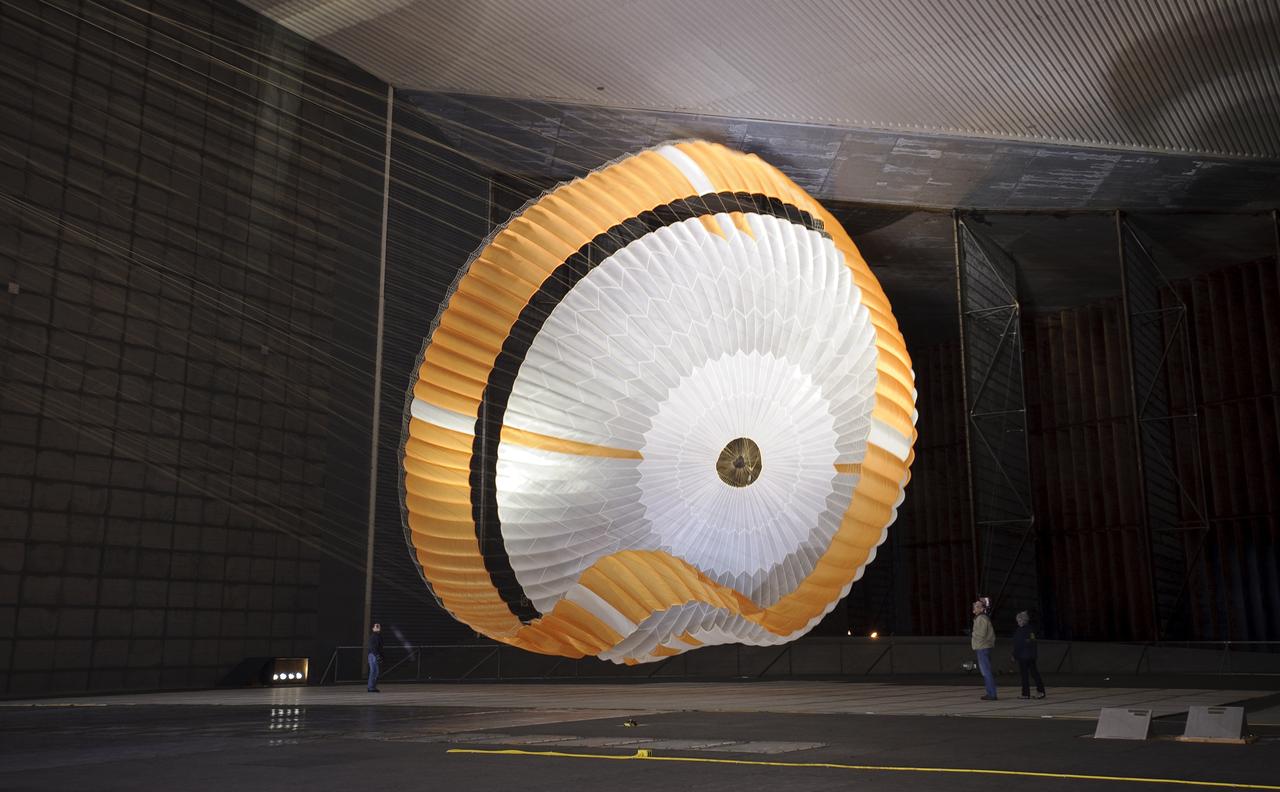
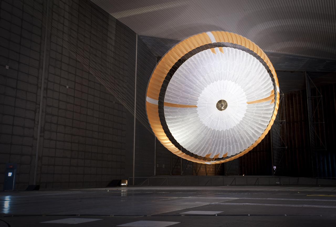
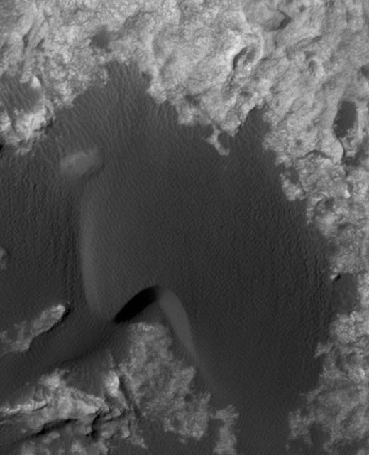
Mars Science Laboratory (MSL) Flexible Canopy Testing in the Glenn Research Center, 10x10 Supersonic Wind Tunnel
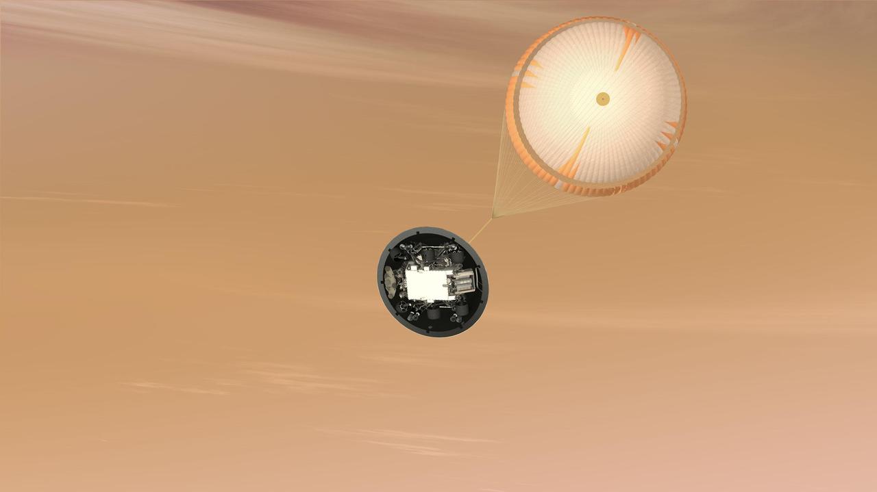
This artist concept is of NASA Mars Science Laboratory MSL Curiosity rover parachute system; the largest parachute ever built to fly on a planetary mission. The parachute is attached to the top of the backshell portion of the spacecraft aeroshell.
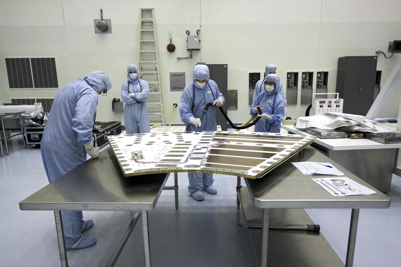
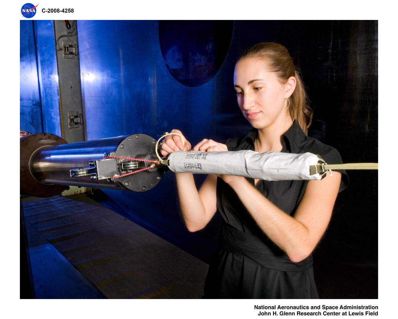
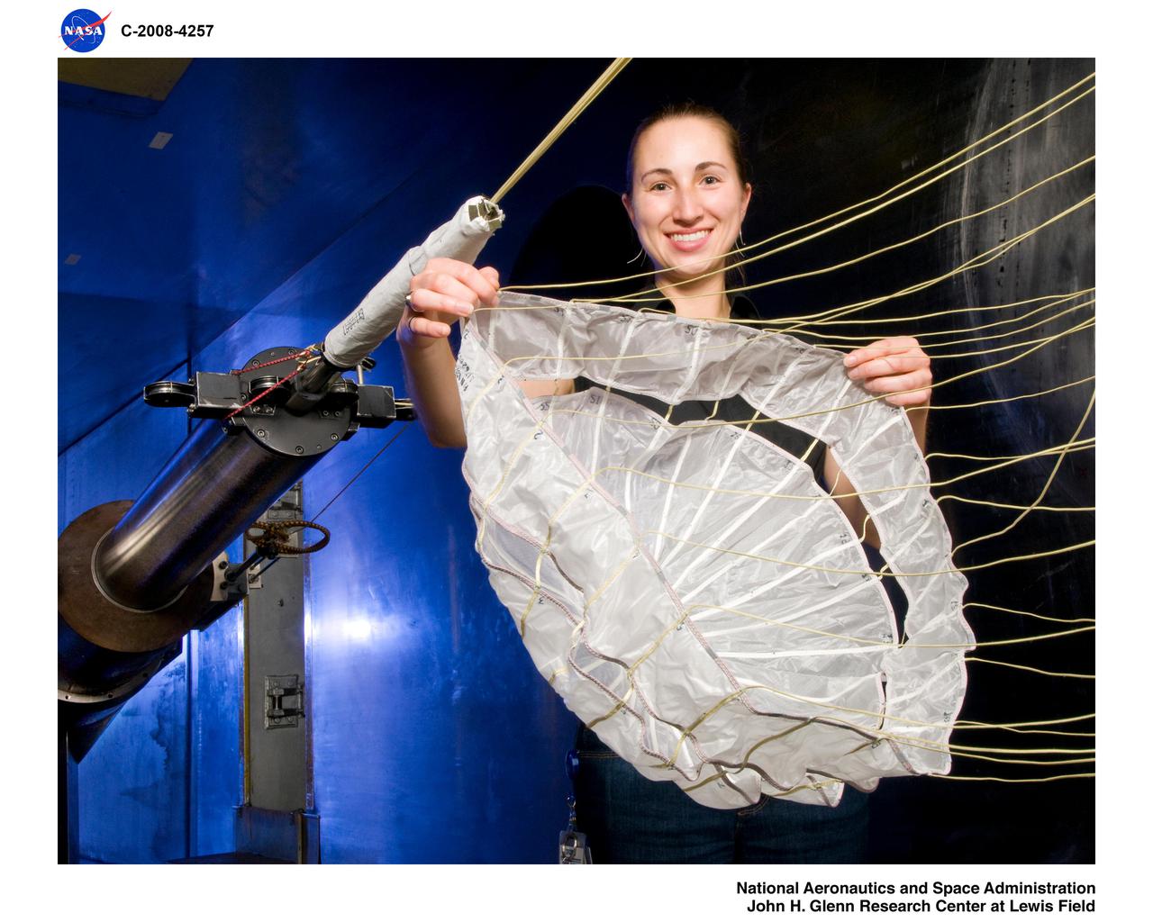
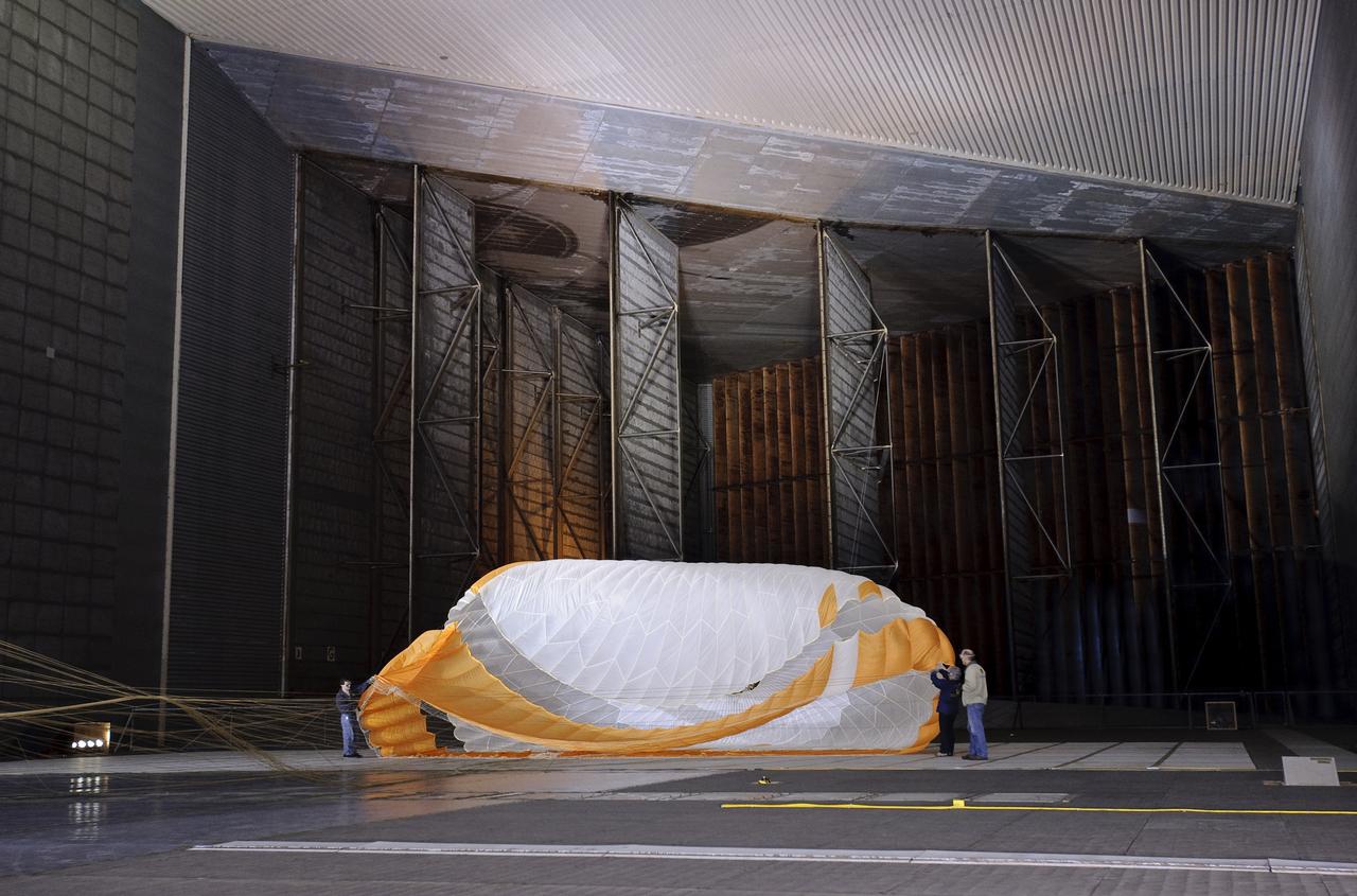
Mars Science Laboratory (MSL) Flexible Canopy Test
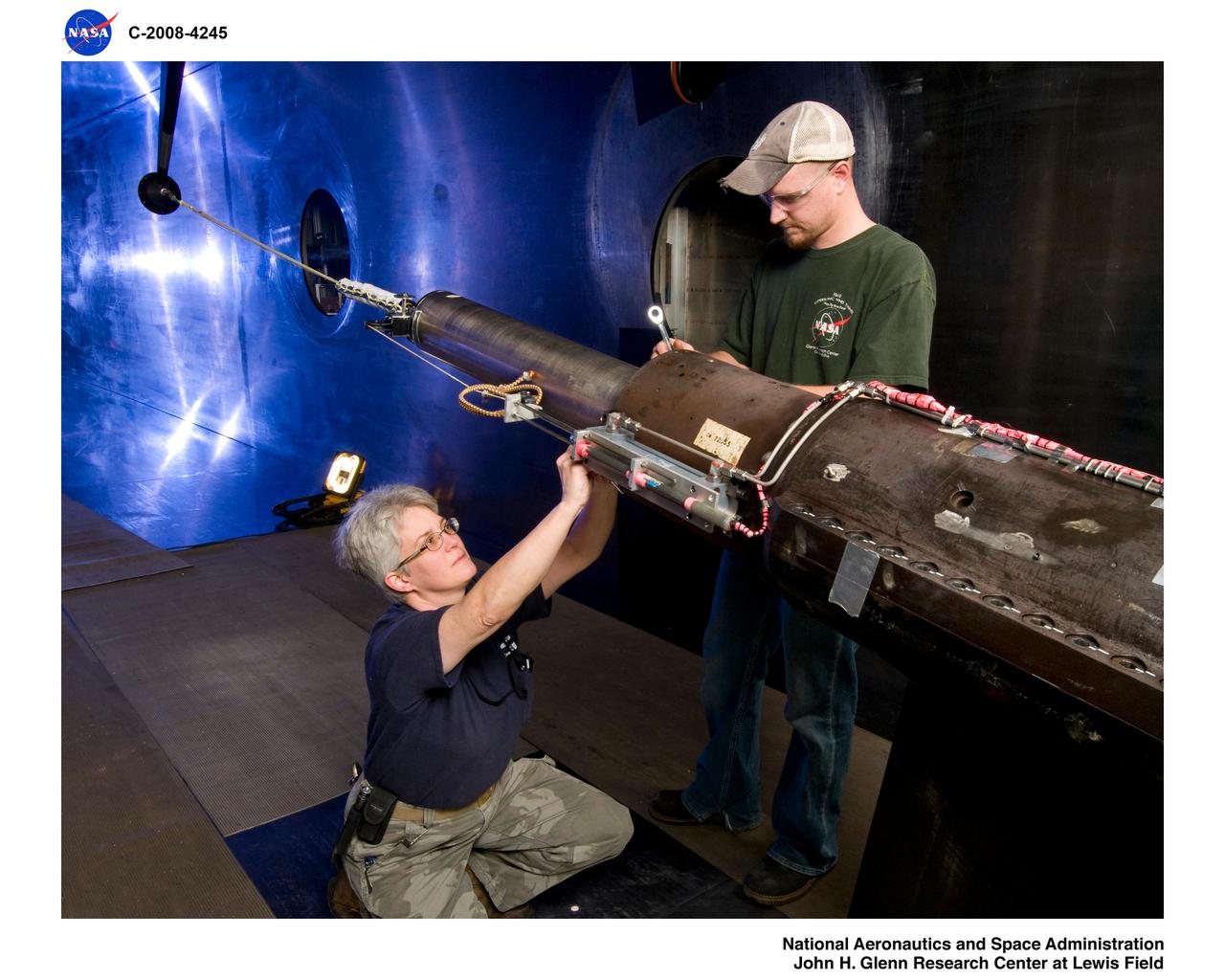
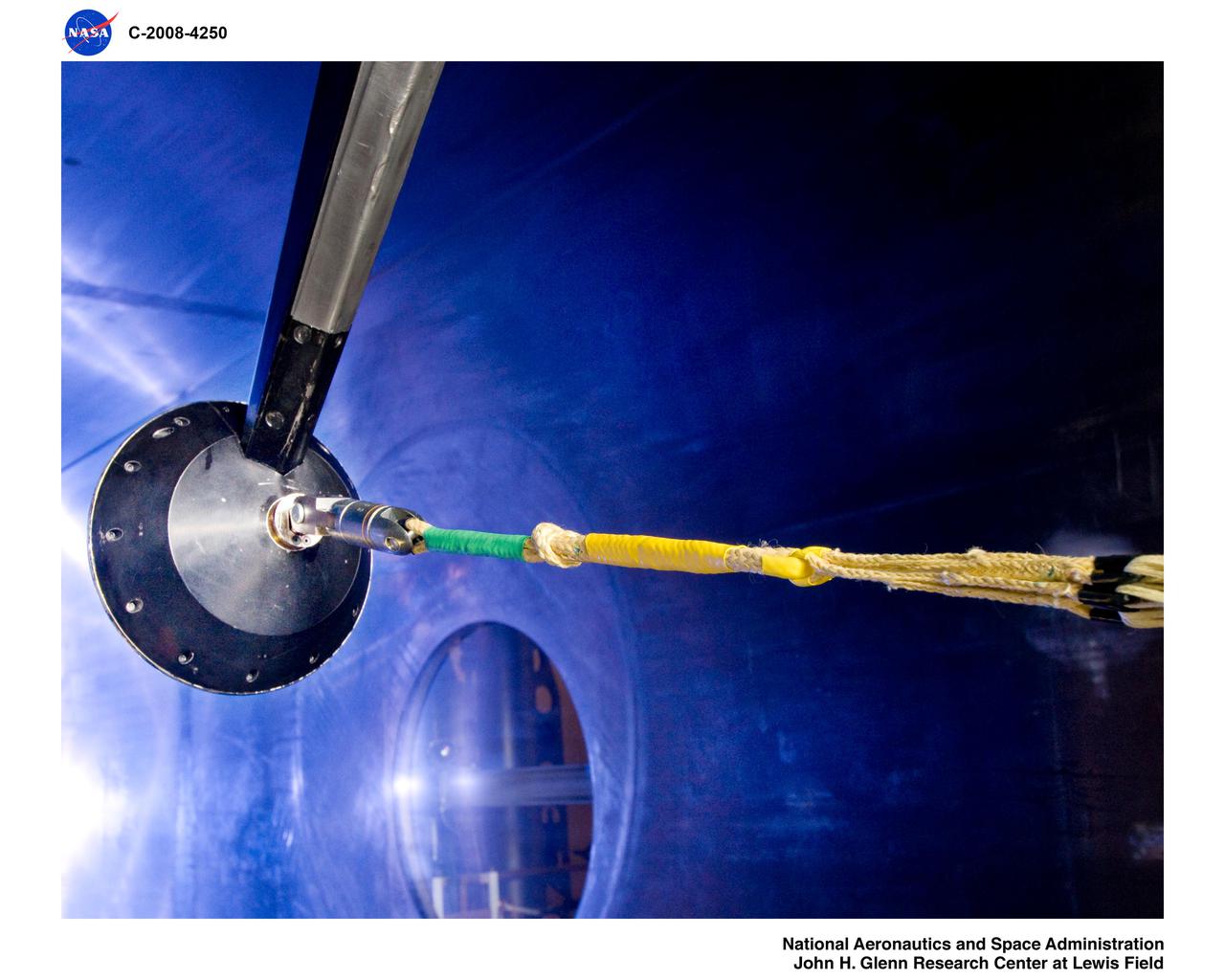
Mars Science Laboratory (MSL) Flexible Canopy Test
John Grant, geologist, Smithsonian National Air and Space Museum in Washington, speaks at a Mars Science Laboratory (MSL) press conference at the Smithsonian's National Air and Space Museum on Friday, July 22, 2011 in Washington. The Mars Science Laboratory (MSL), or Curiosity, is scheduled to launch late this year from NASA's Kennedy Space Center in Florida and land in August 2012. Curiosity is twice as long and more than five times as heavy as previous Mars rovers. The rover will study whether the landing region at Gale crater had favorable environmental conditions for supporting microbial life and for preserving clues about whether life ever existed. Photo Credit: (NASA/Carla Cioffi)

NASA chief scientist, Dr. Waleed Abdalati, speaks at a Mars Science Laboratory (MSL) press conference at the Smithsonian's National Air and Space Museum on Friday, July 22, 2011 in Washington. The Mars Science Laboratory (MSL), or Curiosity, is scheduled to launch late this year from NASA's Kennedy Space Center in Florida and land in August 2012. Curiosity is twice as long and more than five times as heavy as previous Mars rovers. The rover will study whether the landing region at Gale crater had favorable environmental conditions for supporting microbial life and for preserving clues about whether life ever existed. Photo Credit: (NASA/Carla Cioffi)
Dawn Sumner, geologist, University of California, Davis speaks at a Mars Science Laboratory (MSL) press conference at the Smithsonian's National Air and Space Museum on Friday, July 22, 2011 in Washington. The Mars Science Laboratory (MSL), or Curiosity, is scheduled to launch late this year from NASA's Kennedy Space Center in Florida and land in August 2012. Curiosity is twice as long and more than five times as heavy as previous Mars rovers. The rover will study whether the landing region at Gale crater had favorable environmental conditions for supporting microbial life and for preserving clues about whether life ever existed. Photo Credit: (NASA/Carla Cioffi)
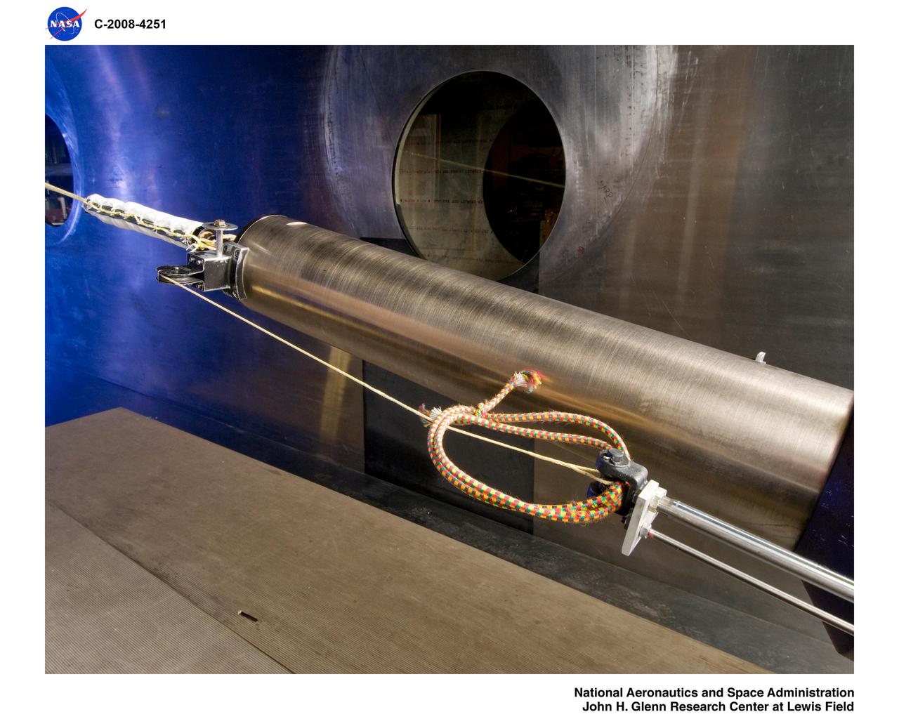
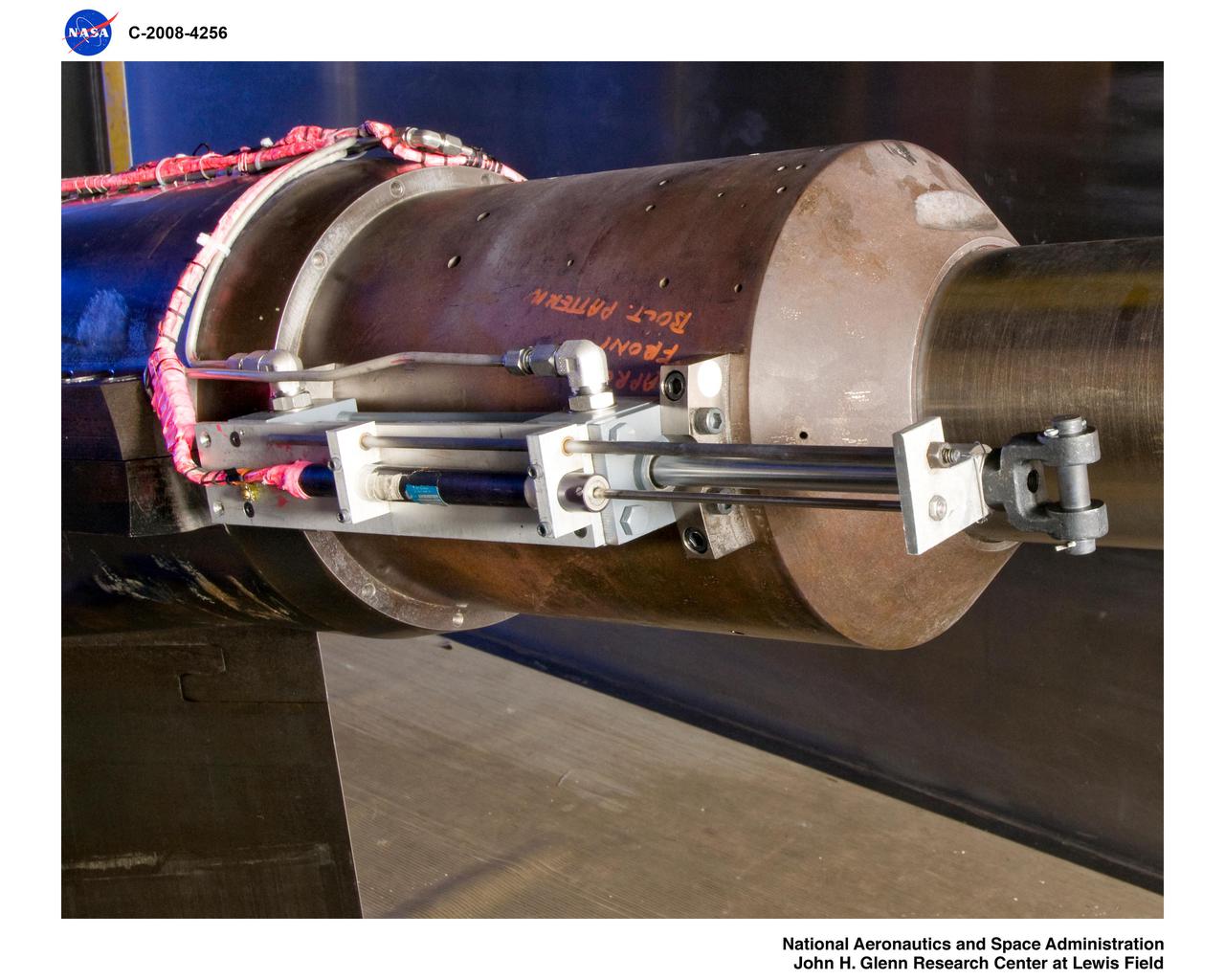
Mars Science Laboratory, MSL Flexible Canopy Test

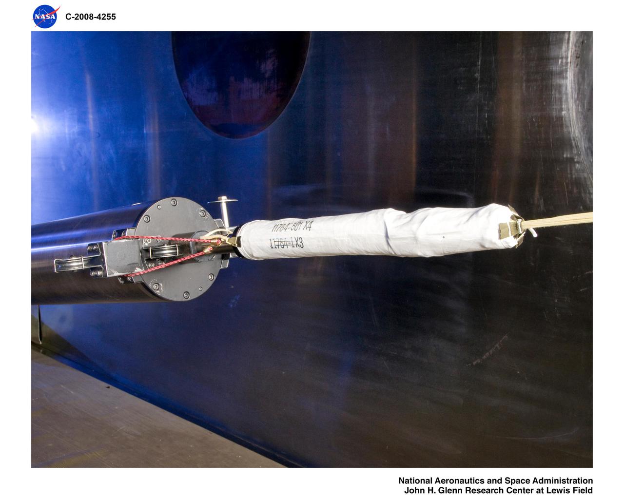
Mars Science Laboratory (MSL) Flexible Canopy Test
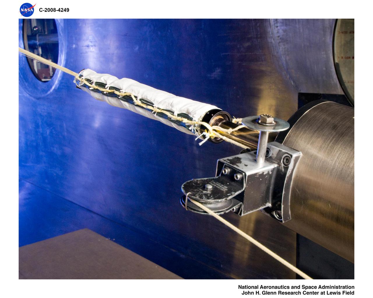
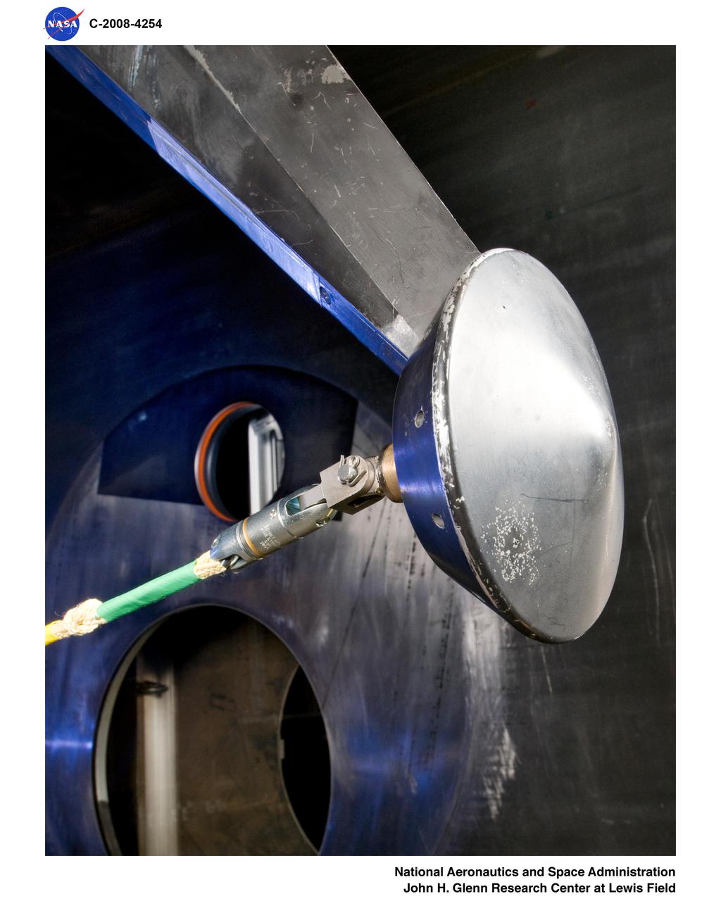
Mars Science Laboratory, MSL Flexible Canopy Test
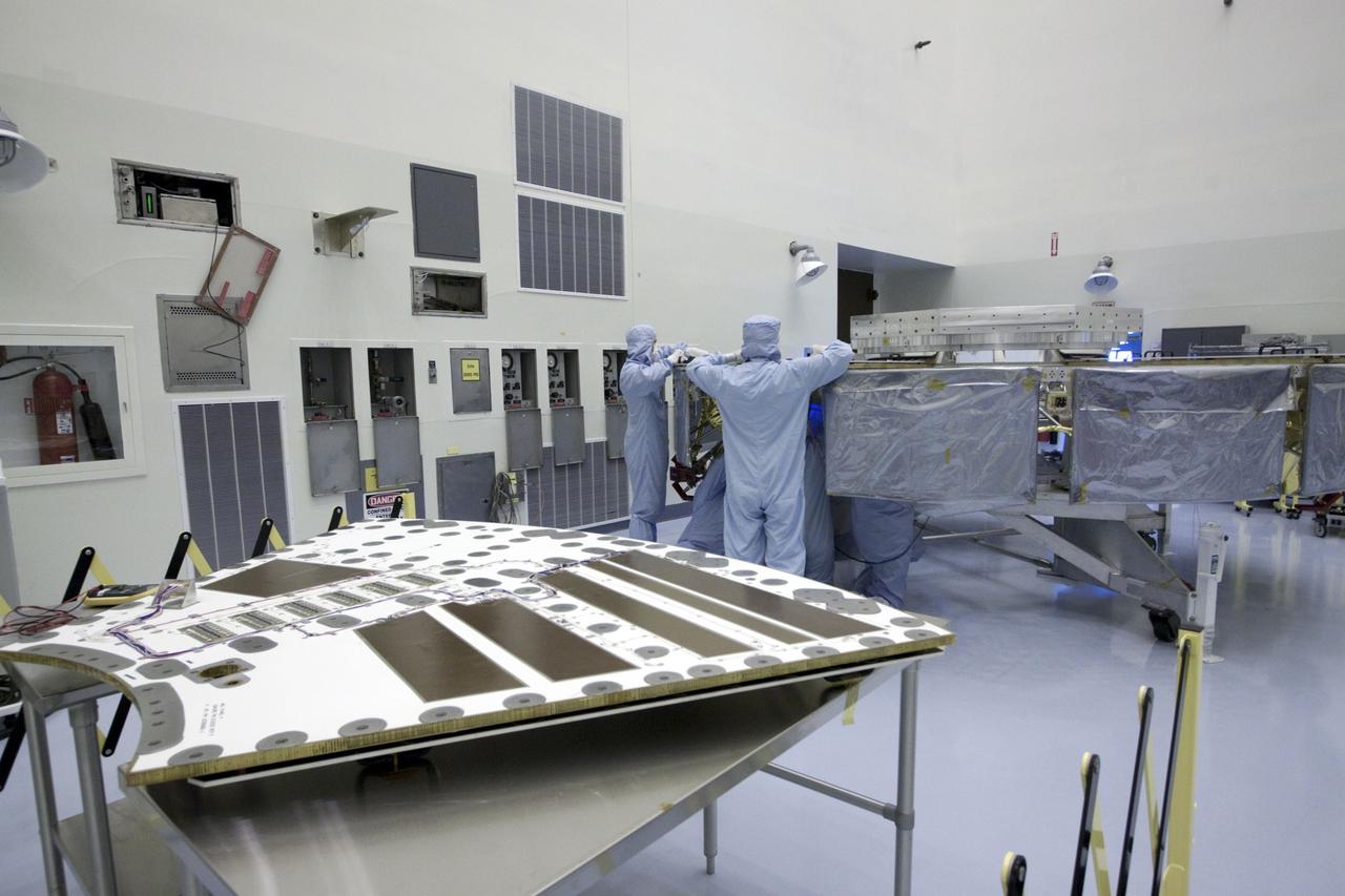
Cape Canaveral, Fla. -- At the Payload Hazardous Servicing Facility at NASA's Kennedy Space Center in Florida, technicians are installing a solar array panel to the cruise stage of NASA's Mars Science Laboratory (MSL). MSL's components include a compact car-sized rover, Curiosity, which has 10 science instruments designed to search for evidence on whether Mars has had environments favorable to microbial life, including chemical ingredients for life. The unique rover will use a laser to look inside rocks and release its gasses so that the rover’s spectrometer can analyze and send the data back to Earth. Launch of MSL aboard a United Launch Alliance Atlas V rocket is scheduled for Nov. 25 from Space Launch Complex 41 on Cape Canaveral Air Force Station in Florida. For more information, visit http://www.nasa.gov/msl. Photo credit: NASA/Jack Pfaller
Cape Canaveral, Fla. -- At the Payload Hazardous Servicing Facility at NASA's Kennedy Space Center in Florida, technicians are preparing a solar array panel for installation to the cruise stage of NASA's Mars Science Laboratory (MSL). MSL's components include a compact car-sized rover, Curiosity, which has 10 science instruments designed to search for evidence on whether Mars has had environments favorable to microbial life, including chemical ingredients for life. The unique rover will use a laser to look inside rocks and release its gasses so that the rover’s spectrometer can analyze and send the data back to Earth. Launch of MSL aboard a United Launch Alliance Atlas V rocket is scheduled for Nov. 25 from Space Launch Complex 41 on Cape Canaveral Air Force Station in Florida. For more information, visit http://www.nasa.gov/msl. Photo credit: NASA/Jack Pfaller
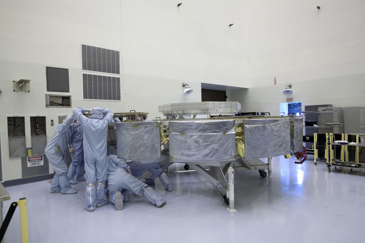
Cape Canaveral, Fla. -- At the Payload Hazardous Servicing Facility at NASA's Kennedy Space Center in Florida, technicians are installing a solar array panel to the cruise stage of NASA's Mars Science Laboratory (MSL). MSL's components include a compact car-sized rover, Curiosity, which has 10 science instruments designed to search for evidence on whether Mars has had environments favorable to microbial life, including chemical ingredients for life. The unique rover will use a laser to look inside rocks and release its gasses so that the rover’s spectrometer can analyze and send the data back to Earth. Launch of MSL aboard a United Launch Alliance Atlas V rocket is scheduled for Nov. 25 from Space Launch Complex 41 on Cape Canaveral Air Force Station in Florida. For more information, visit http://www.nasa.gov/msl. Photo credit: NASA/Jack Pfaller
Cape Canaveral, Fla. -- At the Payload Hazardous Servicing Facility at NASA's Kennedy Space Center in Florida, technicians are installing a solar array panel to the cruise stage of NASA's Mars Science Laboratory (MSL). MSL's components include a compact car-sized rover, Curiosity, which has 10 science instruments designed to search for evidence on whether Mars has had environments favorable to microbial life, including chemical ingredients for life. The unique rover will use a laser to look inside rocks and release its gasses so that the rover’s spectrometer can analyze and send the data back to Earth. Launch of MSL aboard a United Launch Alliance Atlas V rocket is scheduled for Nov. 25 from Space Launch Complex 41 on Cape Canaveral Air Force Station in Florida. For more information, visit http://www.nasa.gov/msl. Photo credit: NASA/Jack Pfaller
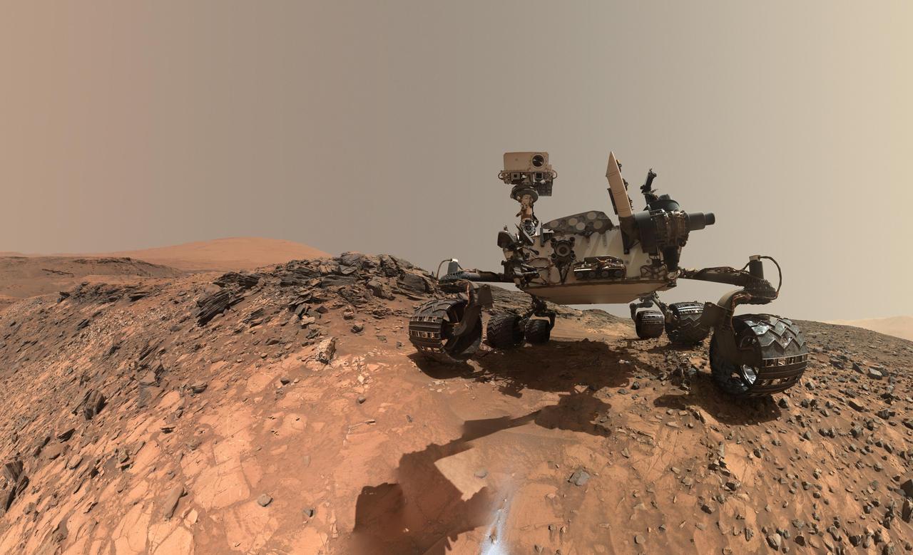
This low-angle self-portrait of NASA's Curiosity Mars rover shows the vehicle at the site from which it reached down to drill into a rock target called "Buckskin" on lower Mount Sharp. The selfie combines several component images taken by Curiosity's Mars Hand Lens Imager (MAHLI) on Aug. 5, 2015, during the 1,065th Martian day, or sol, of the rover's work on Mars. For scale, the rover's wheels are 20 inches (50 centimeters) in diameter and about 16 inches (40 centimeters) wide. This view is a portion of a larger panorama available at PIA19807. A close look reveals a small rock stuck onto Curiosity's left middle wheel (on the right in this head-on view). The rock had been seen previously during periodic monitoring of wheel condition about three weeks earlier, in the MAHLI raw image at http://mars.nasa.gov/msl/multimedia/raw/?rawid=1046MH0002640000400290E01_DXXX&s=1046. MAHLI is mounted at the end of the rover's robotic arm. For this self-portrait, the rover team positioned the camera lower in relation to the rover body than for any previous full self-portrait of Curiosity. This yielded a view that includes the rover's "belly," as in a partial self-portrait (/catalog/PIA16137) taken about five weeks after Curiosity's August 2012 landing inside Mars' Gale Crater. The selfie at Buckskin does not include the rover's robotic arm beyond a portion of the upper arm held nearly vertical from the shoulder joint. With the wrist motions and turret rotations used in pointing the camera for the component images, the arm was positioned out of the shot in the frames or portions of frames used in this mosaic. This process was used previously in acquiring and assembling Curiosity self-portraits taken at sample-collection sites "Rocknest" (PIA16468), "John Klein" (PIA16937), "Windjana" (PIA18390) and "Mojave" (PIA19142). MAHLI was built by Malin Space Science Systems, San Diego. NASA's Jet Propulsion Laboratory, a division of the California Institute of Technology in Pasadena, manages the Mars Science Laboratory Project for the NASA Science Mission Directorate, Washington. JPL designed and built the project's Curiosity rover. MAHLI was built by Malin Space Science Systems, San Diego. NASA's Jet Propulsion Laboratory, a division of the California Institute of Technology in Pasadena, manages the Mars Science Laboratory Project for the NASA Science Mission Directorate, Washington. JPL designed and built the project's Curiosity rover. http://photojournal.jpl.nasa.gov/catalog/PIA19808
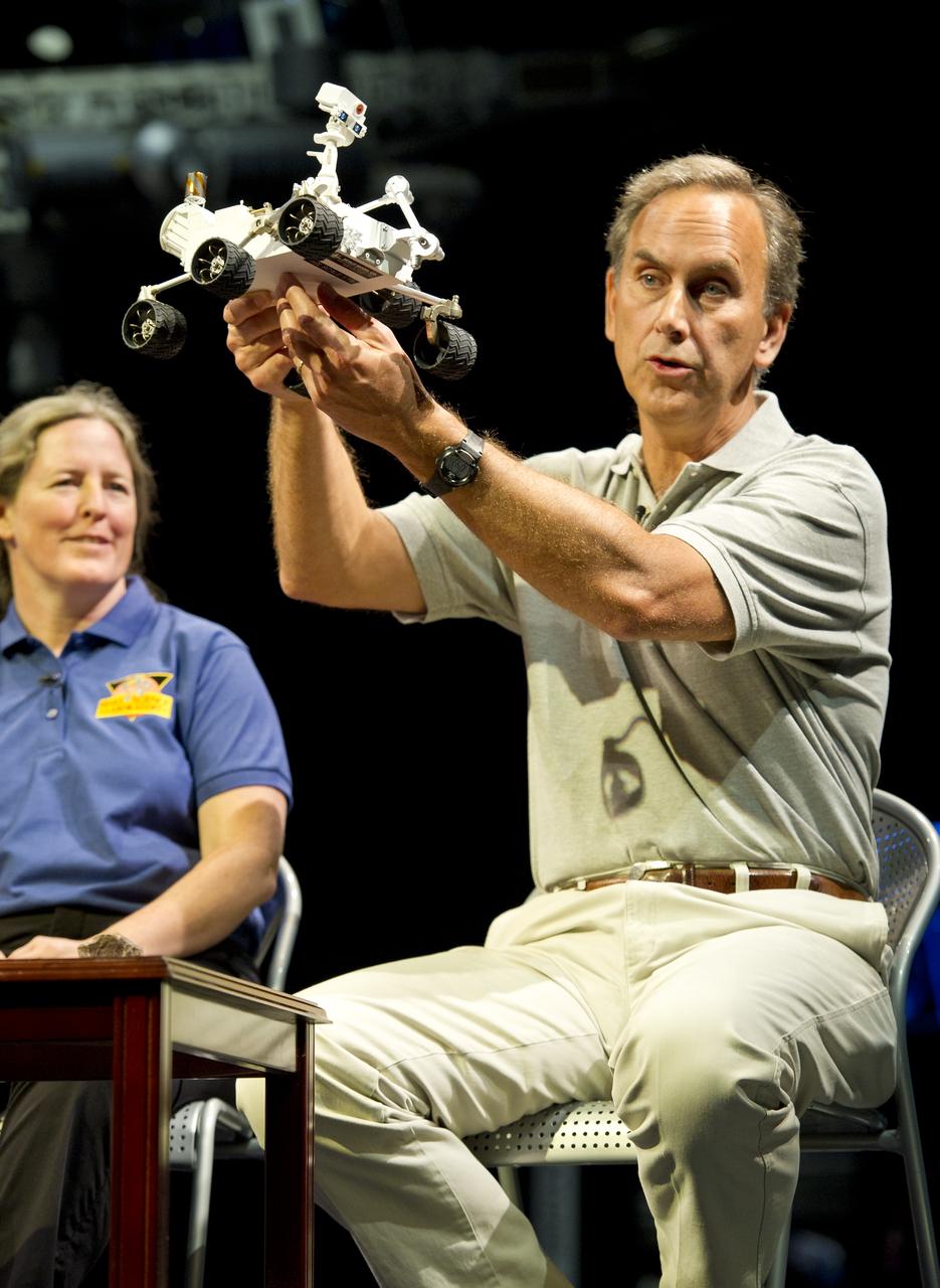
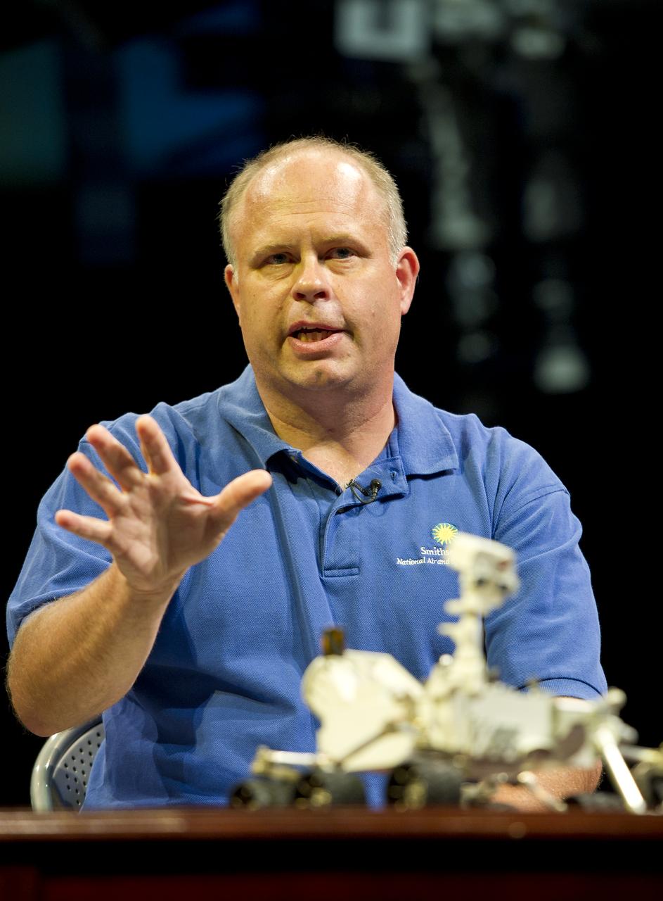
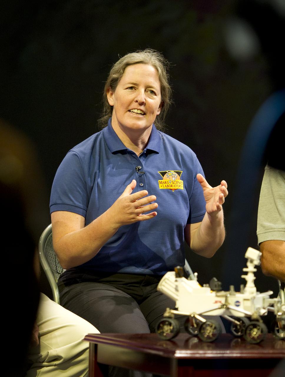
John Grotzinger, Mars Science Laboratory (MSL) project scientist, Jet Propulsion Lab (JPL), Pasadena, Calif., holds up a model of the MSL, or Curiosity, at a press conference at the Smithsonian's National Air and Space Museum on Friday, July 22, 2011 in Washington. The MSL is scheduled to launch late this year from NASA's Kennedy Space Center in Florida and land in August 2012. Curiosity is twice as long and more than five times as heavy as previous Mars rovers. The rover will study whether the landing region at Gale crater had favorable environmental conditions for supporting microbial life and for preserving clues about whether life ever existed. Photo Credit: (NASA/Carla Cioffi)
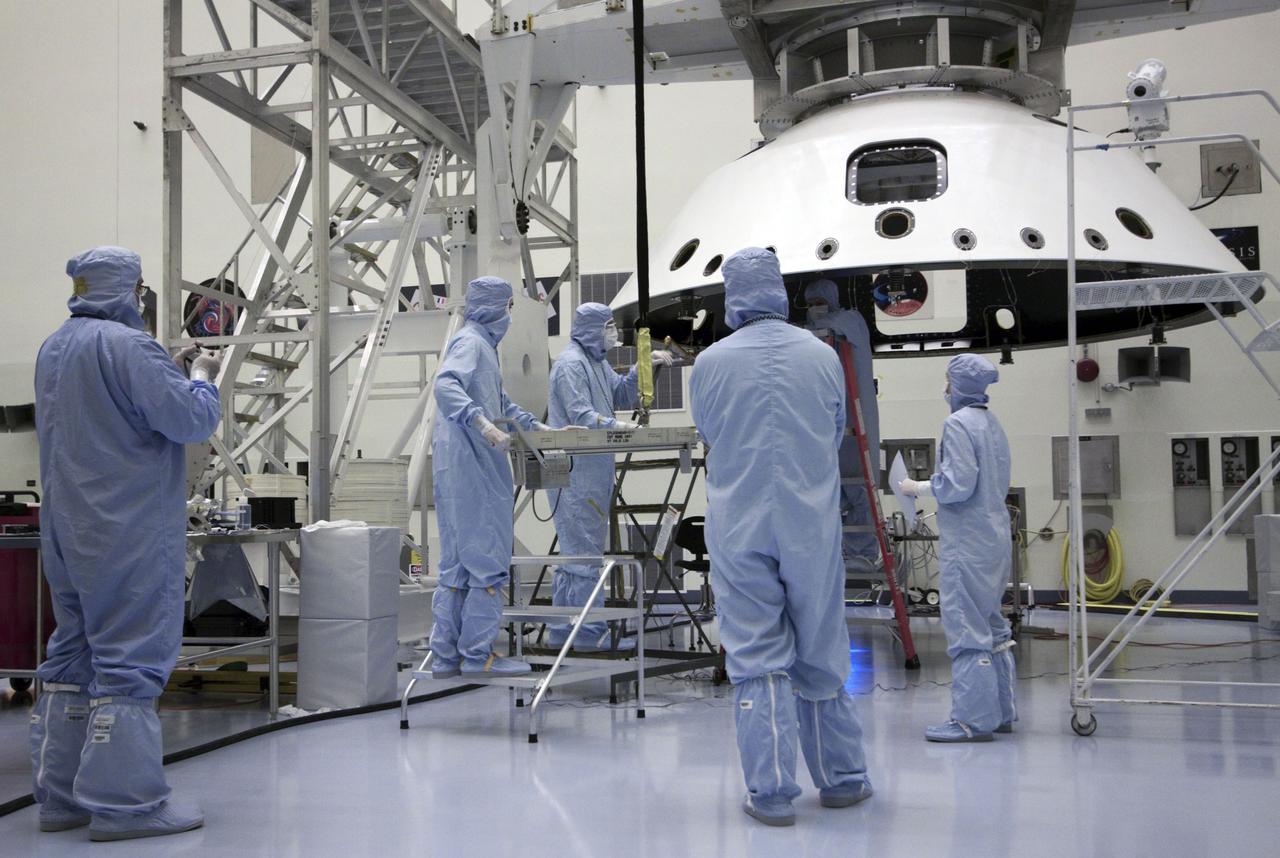
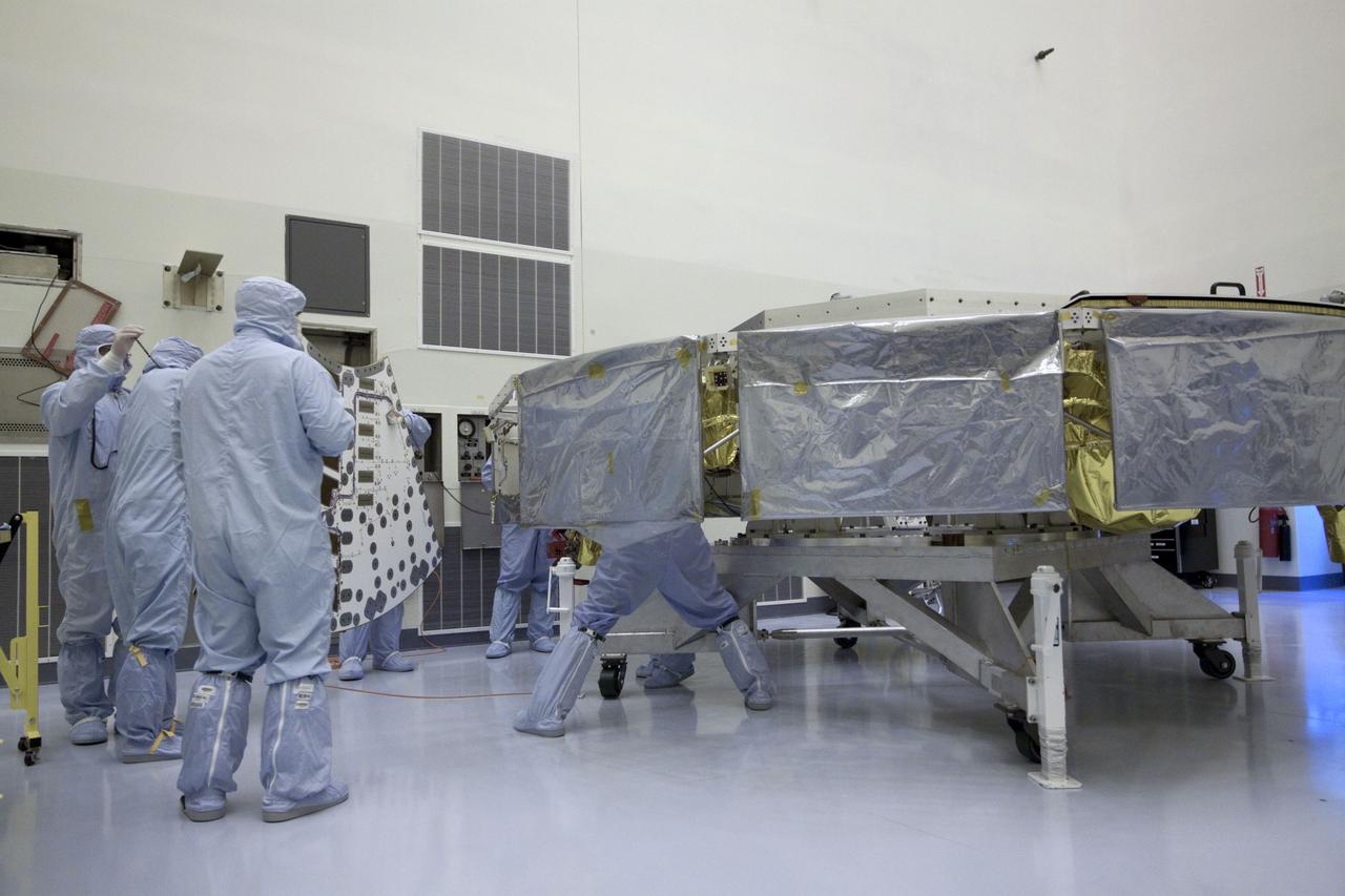
Cape Canaveral, Fla. -- At the Payload Hazardous Servicing Facility at NASA's Kennedy Space Center in Florida, technicians process the backshell for NASA's Mars Science Laboratory (MSL). The backshell carries the parachute and several components used during later stages of entry, descent and landing, and is one part of the spacecraft's heat shield which, when both are integrated is called an aeroshell. A United Launch Alliance Atlas V-541 configuration will be used to loft MSL into space. Curiosity’s 10 science instruments are designed to search for evidence on whether Mars has had environments favorable to microbial life, including chemical ingredients for life. The unique rover will use a laser to look inside rocks and release its gasses so that the rover’s spectrometer can analyze and send the data back to Earth. MSL is scheduled to launch from Cape Canaveral Air Force Station in Florida Nov. 25 with a window extending to Dec. 18 and arrival at Mars Aug. 2012. For more information, visit http://www.nasa.gov/msl. Photo credit: NASA/Jack Pfaller
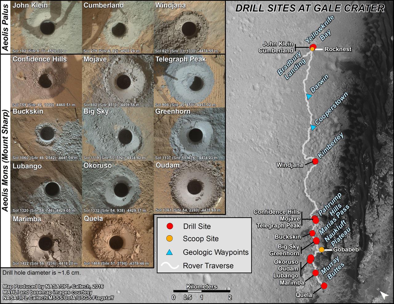
This graphic maps locations of the sites where NASA's Curiosity Mars rover collected its first 18 rock or soil samples for analysis by laboratory instruments inside the vehicle. It also presents images of the drilled holes where 14 rock-powder samples were acquired. Curiosity scooped two soil samples at each of the other two sites: Rocknest and Gobabeb. The diameter of each drill hole is about 0.6 inch (1.6 centimeters), slightly smaller than a U.S. dime. The images used here are raw color, as recorded by the rover's Mars Hand Lens Imager (MAHLI) camera. Notice the differences in color of the material at different drilling sites. For the map, north is toward upper left corner. The scale bar represents 2 kilometers (1.2 miles). The base map is from the High Resolution Imaging Science Experiment (HiRISE) camera on NASA's Mars Reconnaissance Orbiter. The latest sample site included is "Quela,"where Curiosity drilled into bedrock of the Murray formation on Sept. 18, 2016, during the 1,464th Martian day, or sol, of the mission. Curiosity landed in August 2012 on the plain (named Aeolis Palus) near Mount Sharp (or Aeolis Mons). More drilling samples collected by MSL are available at http://photojournal.jpl.nasa.gov/catalog/PIA20845
Mars Science Laboratory, MSL Flexible Canopy Test in the Glenn Research Center, 10x10 Supersonic Wind Tunnel
Mars Science Laboratory, MSL Flexible Canopy Test in the Glenn Research Center, 10x10 Supersonic Wind Tunnel
Mars Science Laboratory, MSL Flexible Canopy Test in the Glenn Research Center, 10x10 Supersonic Wind Tunnel
Mars Science Laboratory, MSL Flexible Canopy Test in the Glenn Research Center, 10x10 Supersonic Wind Tunnel
Mars Science Laboratory, MSL Flexible Canopy Test in the Glenn Research Center, 10x10 Supersonic Wind Tunnel
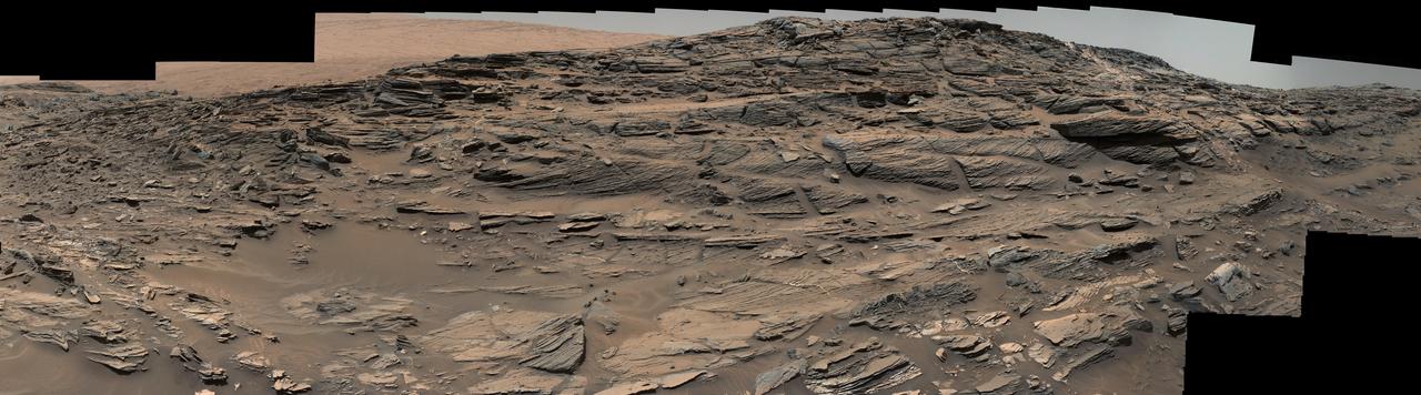
Large-scale crossbedding in the sandstone of this ridge on a lower slope of Mars' Mount Sharp is common in petrified sand dunes. The scene combines multiple images taken with both cameras of the Mast Camera (Mastcam) on Curiosity on Aug. 27, 2015, during the 1,087th Martian day, or sol of the rover's work on Mars. It spans from east, at left, to south-southwest. Figure 1 includes a scale bar of 200 centimeters (about 6.6 feet). Sets of bedding laminations lie at angles to each other. Such crossbedding is common in wind-deposited sandstone of the U.S. Southwest. An example from Utah is pictured at http://3dparks.wr.usgs.gov/zion/html2/3d153.html. The sandstone in the image from Mars is part of the Stimson unit on Mount Sharp. The color of the Mastcam mosaic has been approximately white-balanced to resemble how the scene would appear under daytime lighting conditions on Earth. The component images in the center and upper portion of the mosaic are from Mastcam's right-eye camera, which is equipped with a 100-millimeter-focal-length telephoto lens. Images used in the foreground and at far left and right were taken with Mastcam's left-eye camera, using a wider-angle, 34-millimeter lens. Malin Space Science Systems, San Diego, built and operates Curiosity's Mastcam. NASA's Jet Propulsion Laboratory, a division of the California Institute of Technology, Pasadena, built the rover and manages the project for NASA's Science Mission Directorate, Washington. For more information about Curiosity, visit http://www.nasa.gov/msl and http://mars.jpl.nasa.gov/msl . http://photojournal.jpl.nasa.gov/catalog/PIA19818

John Grotzinger, Mars Science Laboratory (MSL) project scientist, Jet Propulsion Lab (JPL), Pasadena, Calif., answers a reporter's question at a press conference at the Smithsonian's National Air and Space Museum on Friday, July 22, 2011 in Washington. The MSL is scheduled to launch late this year from NASA's Kennedy Space Center in Florida and land in August 2012. Curiosity is twice as long and more than five times as heavy as previous Mars rovers. The rover will study whether the landing region at Gale crater had favorable environmental conditions for supporting microbial life and for preserving clues about whether life ever existed. Photo Credit: (NASA/Carla Cioffi)
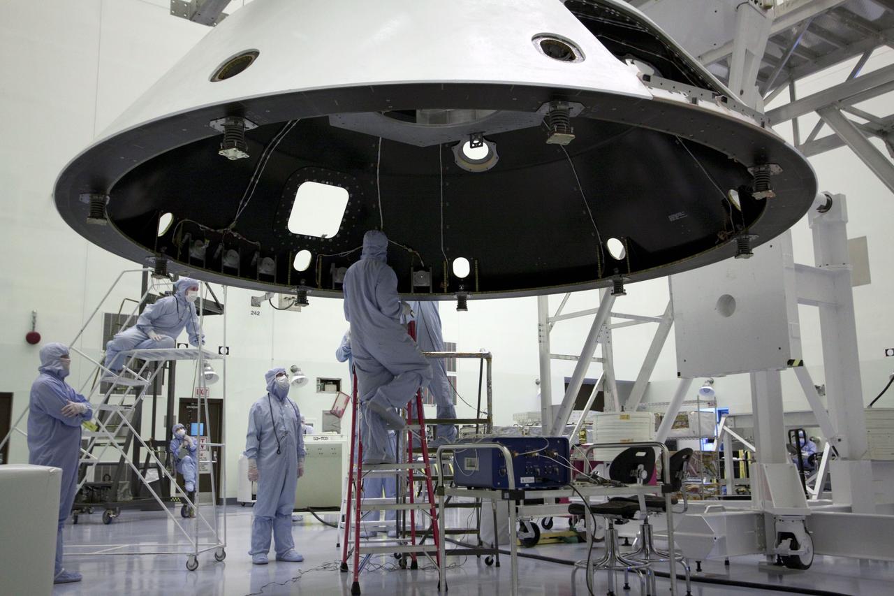
Cape Canaveral, Fla. -- At the Payload Hazardous Servicing Facility at NASA's Kennedy Space Center in Florida, technicians process the backshell for NASA's Mars Science Laboratory (MSL). The backshell carries the parachute and several components used during later stages of entry, descent and landing, and is one part of the spacecraft's heat shield which, when both are integrated is called an aeroshell. MSL's components include a compact car-sized rover, Curiosity, which has 10 science instruments designed to search for evidence on whether Mars has had environments favorable to microbial life, including chemical ingredients for life. The unique rover will use a laser to look inside rocks and release its gasses so that the rover’s spectrometer can analyze and send the data back to Earth. Launch of MSL aboard a United Launch Alliance Atlas V rocket is scheduled for Nov. 25 from Space Launch Complex 41 on Cape Canaveral Air Force Station in Florida. For more information, visit http://www.nasa.gov/msl. Photo credit: NASA/Jack Pfaller
Michael Watkins (right), mission manager and Mars Science Laboratory (MSL) engineer, Jet Propulsion Lab, Pasadena, Calif., speaks at a press conference, as Michael Meyer, Mars Exploration Program lead scientist looks on, at the Smithsonian's National Air and Space Museum on Friday, July 22, 2011 in Washington. The MSL, or Curiosity, is scheduled to launch late this year from NASA's Kennedy Space Center in Florida and land in August 2012. Curiosity is twice as long and more than five times as heavy as previous Mars rovers. The rover will study whether the landing region at Gale crater had favorable environmental conditions for supporting microbial life and for preserving clues about whether life ever existed. Photo Credit: (NASA/Carla Cioffi)
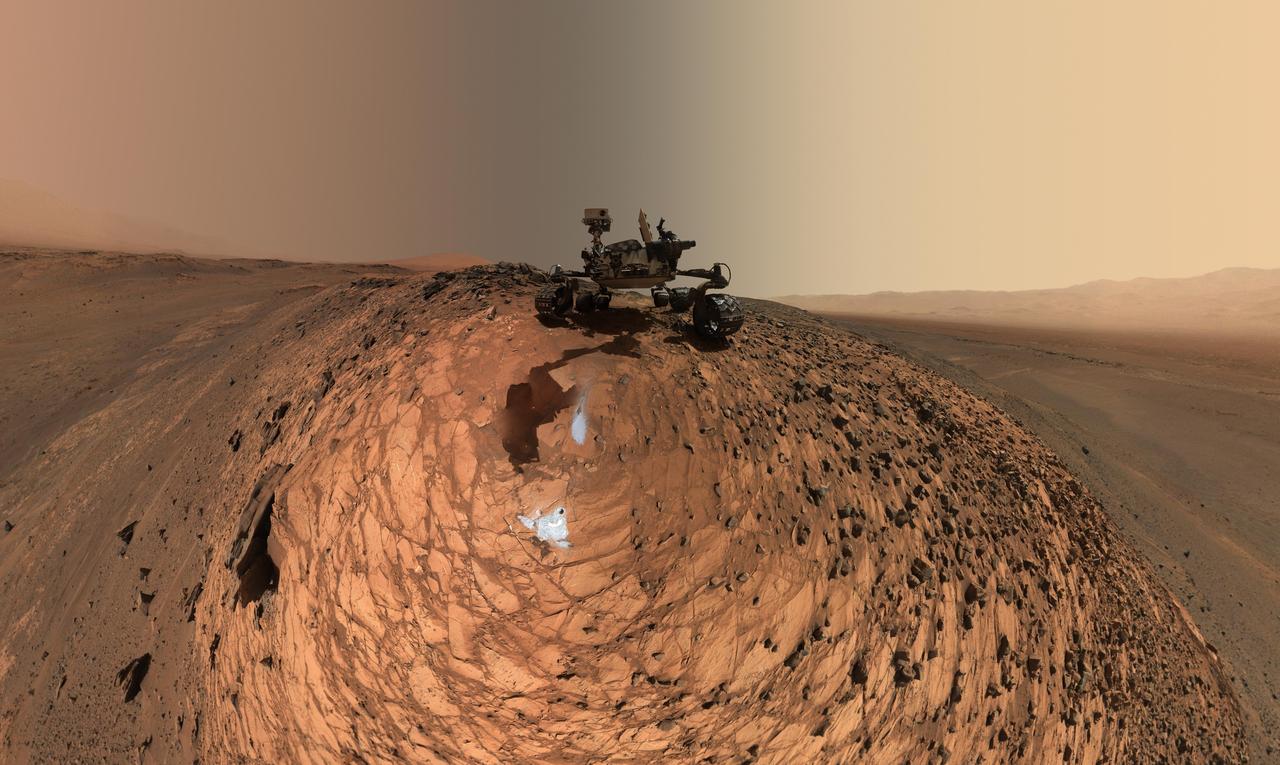
This low-angle self-portrait of NASA's Curiosity Mars rover shows the vehicle above the "Buckskin" rock target, where the mission collected its seventh drilled sample. The site is in the "Marias Pass" area of lower Mount Sharp. The scene combines dozens of images taken by Curiosity's Mars Hand Lens Imager (MAHLI) on Aug. 5, 2015, during the 1,065th Martian day, or sol, of the rover's work on Mars. The 92 component images are among MAHLI Sol 1065 raw images at http://mars.nasa.gov/msl/multimedia/raw/?s=1065&camera=MAHLI. For scale, the rover's wheels are 20 inches (50 centimeters) in diameter and about 16 inches (40 centimeters) wide. Curiosity drilled the hole at Buckskin during Sol 1060 (July 30, 2015). Two patches of pale, powdered rock material pulled from Buckskin are visible in this scene, in front of the rover. The patch closer to the rover is where the sample-handling mechanism on Curiosity's robotic arm dumped collected material that did not pass through a sieve in the mechanism. Sieved sample material was delivered to laboratory instruments inside the rover. The patch farther in front of the rover, roughly triangular in shape, shows where fresh tailings spread downhill from the drilling process. The drilled hole, 0.63 inch (1.6 centimeters) in diameter, is at the upper point of the tailings. The rover is facing northeast, looking out over the plains from the crest of a 20-foot (6-meter) hill that it climbed to reach the Marias Pass area. The upper levels of Mount Sharp are visible behind the rover, while Gale Crater's northern rim dominates the horizon on the left and right of the mosaic. A portion of this selfie cropped tighter around the rover is at PIA19808. Another version of the wide view, presented in a projection that shows the horizon as a circle, is at PIA19806. MAHLI is mounted at the end of the rover's robotic arm. For this self-portrait, the rover team positioned the camera lower in relation to the rover body than for any previous full self-portrait of Curiosity. This yielded a view that includes the rover's "belly," as in a partial self-portrait (PIA16137) taken about five weeks after Curiosity's August 2012 landing inside Mars' Gale Crater. Before sending Curiosity the arm-positioning commands for this Buckskin belly panorama, the team previewed the low-angle sequence of camera pointings on a test rover in California. A mosaic from that test is at PIA19810. This selfie at Buckskin does not include the rover's robotic arm beyond a portion of the upper arm held nearly vertical from the shoulder joint. Shadows from the rest of the arm and the turret of tools at the end of the arm are visible on the ground. With the wrist motions and turret rotations used in pointing the camera for the component images, the arm was positioned out of the shot in the frames or portions of frames used in this mosaic. This process was used previously in acquiring and assembling Curiosity self-portraits taken at sample-collection sites "Rocknest" (PIA16468), "John Klein" (PIA16937), "Windjana" (PIA18390) and "Mojave" (PIA19142). MAHLI was built by Malin Space Science Systems, San Diego. NASA's Jet Propulsion Laboratory, a division of the California Institute of Technology in Pasadena, manages the Mars Science Laboratory Project for the NASA Science Mission Directorate, Washington. JPL designed and built the project's Curiosity rover. http://photojournal.jpl.nasa.gov/catalog/PIA19807

A replica of NASA's Curiosity Rover and members of the Mars Science Laboratory (MSL) science team pass the Presidential viewing stand and President Barack Obama during the inaugural parade honoring Obama, Monday Jan. 21, 2013, in Washington. Obama was sworn-in as the nation's 44th President earlier in the day. Photo Credit: (NASA/Bill Ingalls)
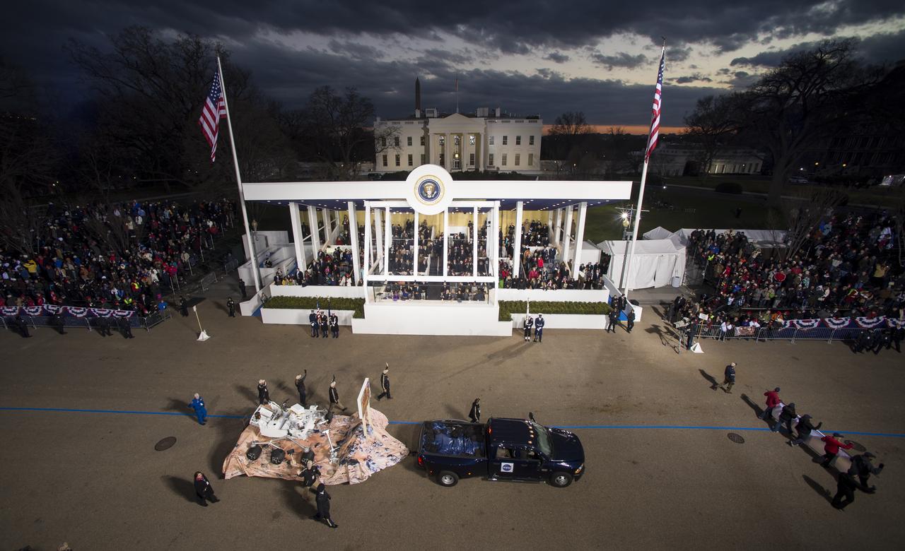
A replica of NASA's Curiosity Rover and members of the Mars Science Laboratory (MSL) science team pass the Presidential viewing stand and President Barack Obama during the inaugural parade honoring Obama, Monday Jan. 21, 2013, in Washington. Obama was sworn-in as the nation's 44th President earlier in the day. Photo Credit: (NASA/Bill Ingalls)
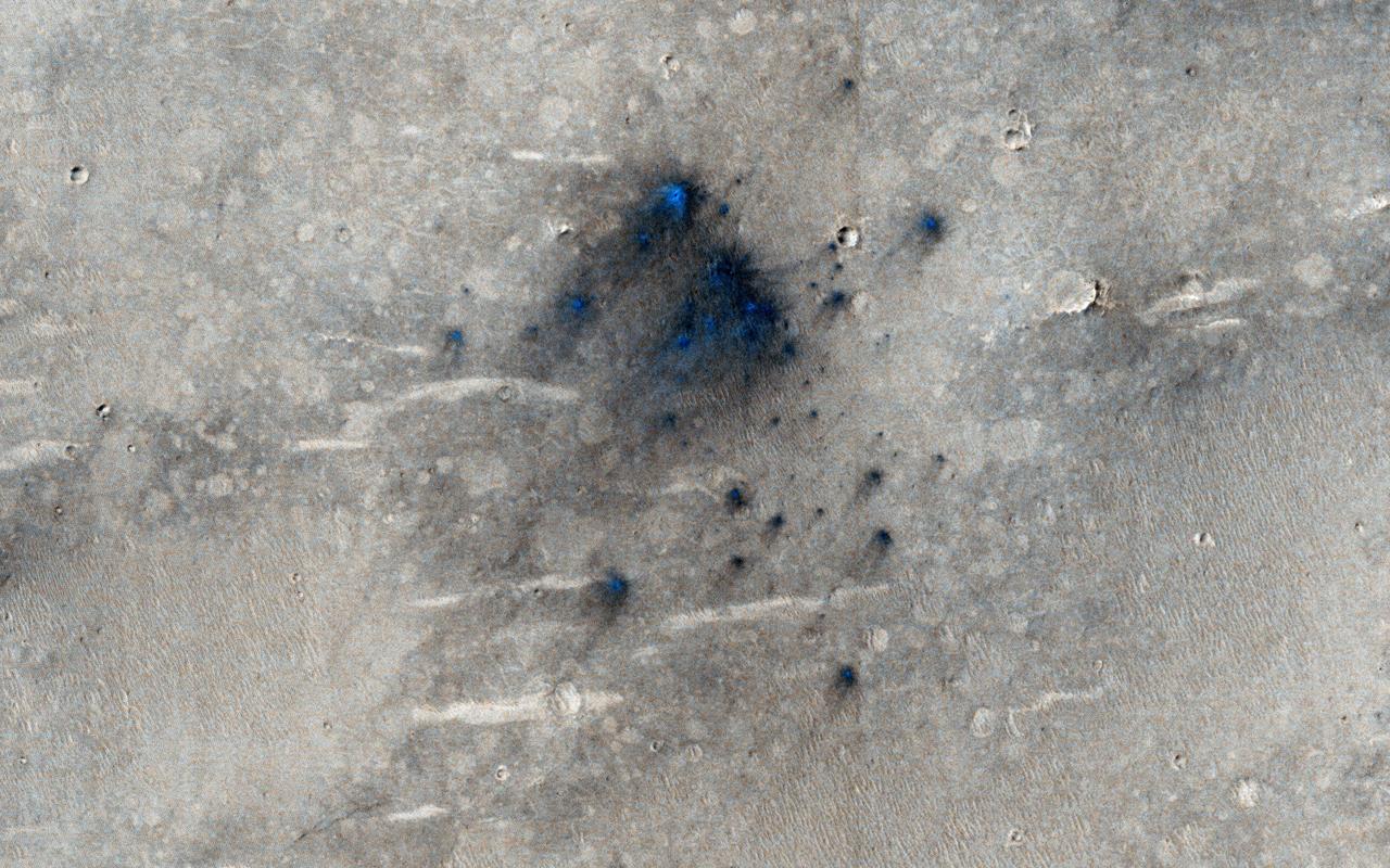
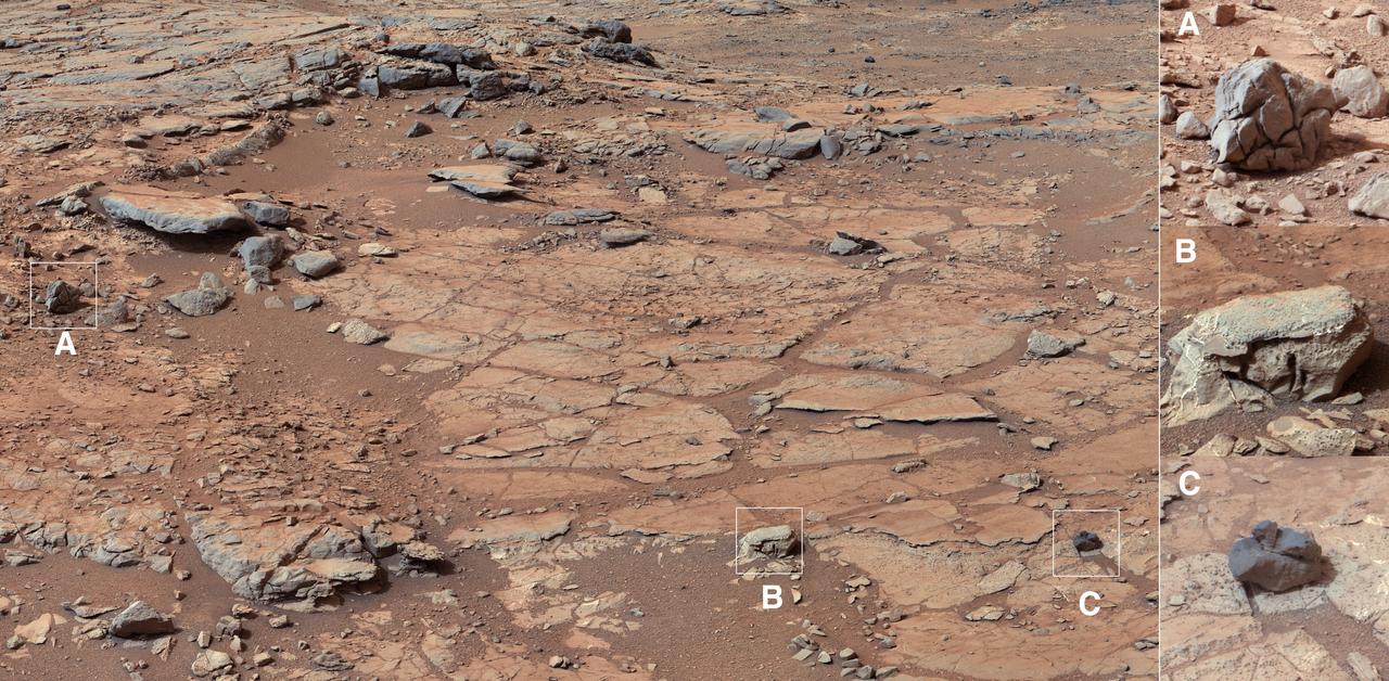
This cluster of small impact craters was spotted by the Context Camera on Mars Reconnaissance Orbiter in the region northwest of Gale Crater, the landing site of the Mars Science Laboratory MSL rover, Curiosity.
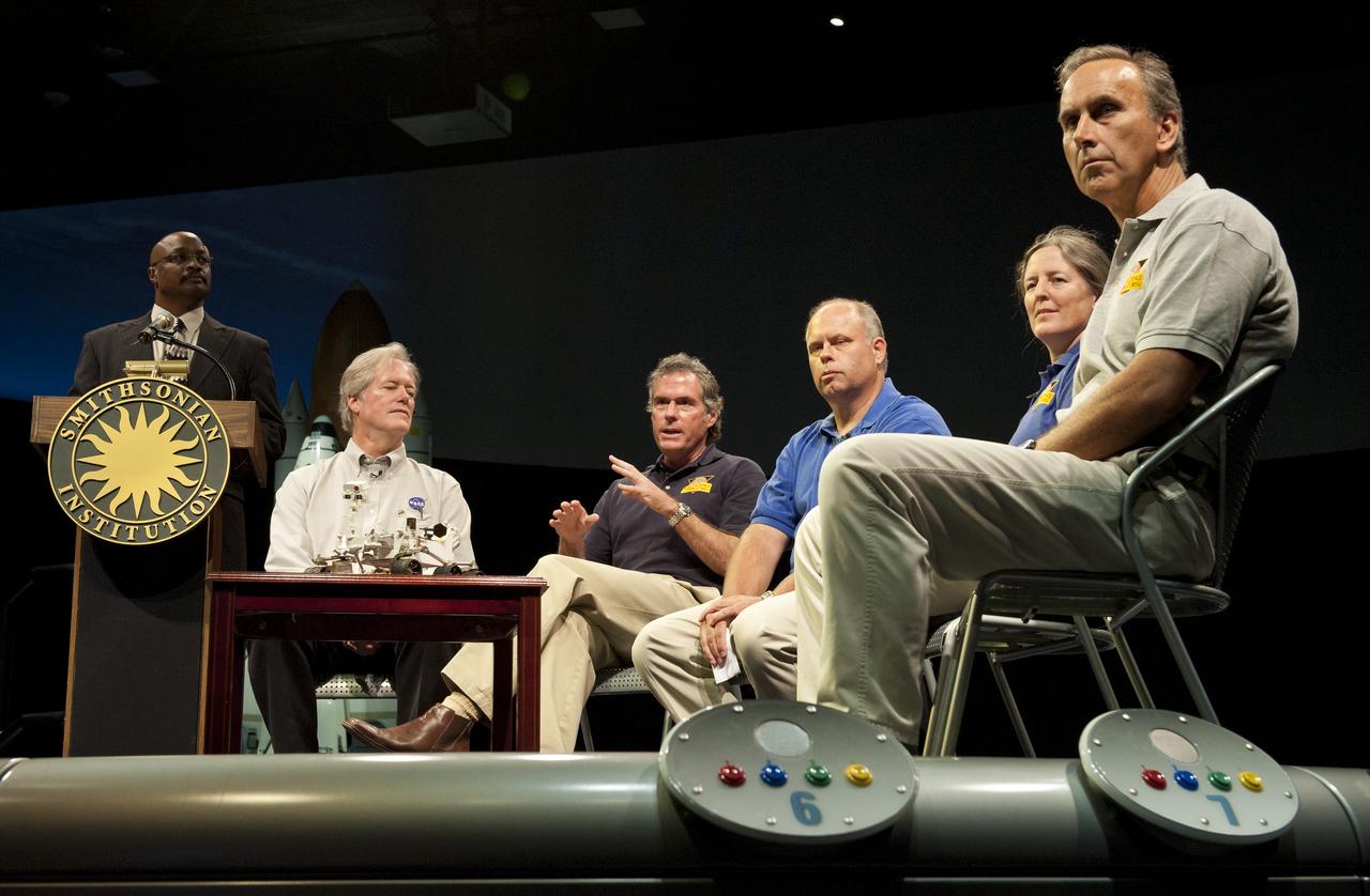
Michael Watkins (third from left), mission manager and project engineer, Mars Science Laboratory (MSL), Jet Propulsion Lab, Pasadena, Calif., speaks at a press conference at the Smithsonian's National Air and Space Museum on Friday, July 22, 2011 in Washington. From left to right, Watkins is joined by Dwayne Brown, NASA Headquarters public affairs officer; Michael Meyer, lead scientist Mars Exploration Program, NASA Headquarters; Watkins; John Grant, geologist, Smithsonian National Air and Space Museum in Washington; Dawn Sumner, geologist, University of California, Davis and John Grotzinger, MSL project scientist, JPL. Photo Credit: (NASA/Carla Cioffi)
Mars Science Laboratory, MSL Flexible Canopy Test
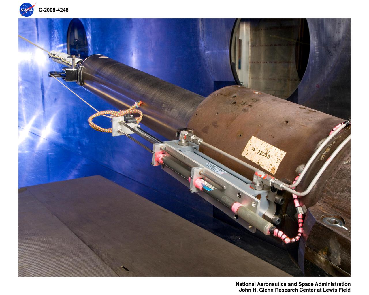
Mars Science Laboratory, MSL, Rotor Dynamics Model Analysis
Mars Science Laboratory, MSL Flexible Canopy Test in the Glenn Research Center, 10x10 Supersonic Wind Tunnel
Mars Science Laboratory (MSL) parachuste test in the Ames 80x120ft Subsonic Wind Tunnel (TR #22 - Phase 6)
Mars Science Laboratory, MSL Flexible Canopy Test in the Glenn Research Center, 10x10 Supersonic Wind Tunnel

Mars Science Laboratory (MSL) parachuste test in the Ames 80x120ft Subsonic Wind Tunnel (TR #22 - Phase 6)
Mars Science Laboratory (MSL) parachuste test in the Ames 80x120ft Subsonic Wind Tunnel (TR #22 - Phase 6)
Mars Science Laboratory (MSL) parachuste test in the Ames 80x120ft Subsonic Wind Tunnel (TR #22 - Phase 6)
The NASA Mars rover Curiosity used its Navigation Camera Navcam during the mission 120th Martian day, or sol Dec. 7, 2012, to record the seven images combined into this panoramic view.
Mars has two small, asteroid-sized moons named Phobos and Deimos. This frame from an animation shows the point of view of the rover, located near the equator of Mars, as these moons occasionally pass in front of, or transit, the disk of the sun.
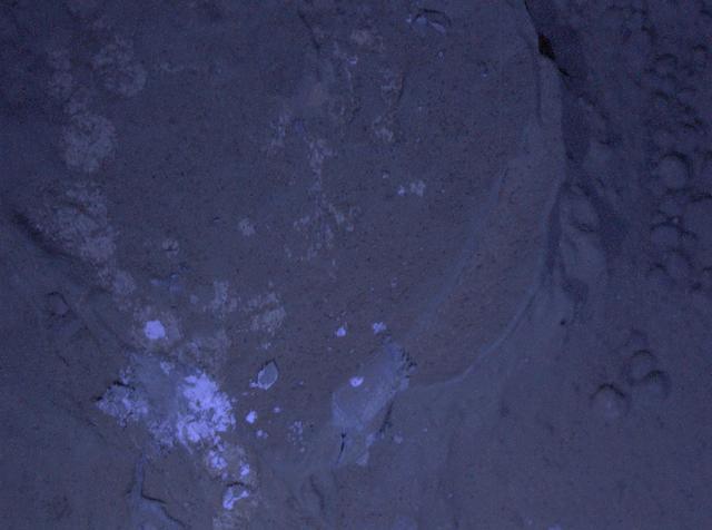
This image of a Martian rock dubbed Sayunei is illuminated by ultraviolet LEDs light emitting diodes is part of the first set of nighttime images taken by the Mars Hand Lens Imagery camera at the end of the robotic arm of NASA Mars rover Curiosity.
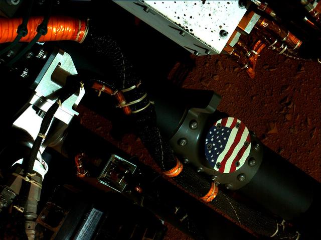
This view of the American flag medallion on NASA Mars rover Curiosity was taken by the rover MAHLI camera during the 44th Martian sol on Sept. 19, 2012. The flag is one of four mobility logos placed on the rover mobility rocker arms.
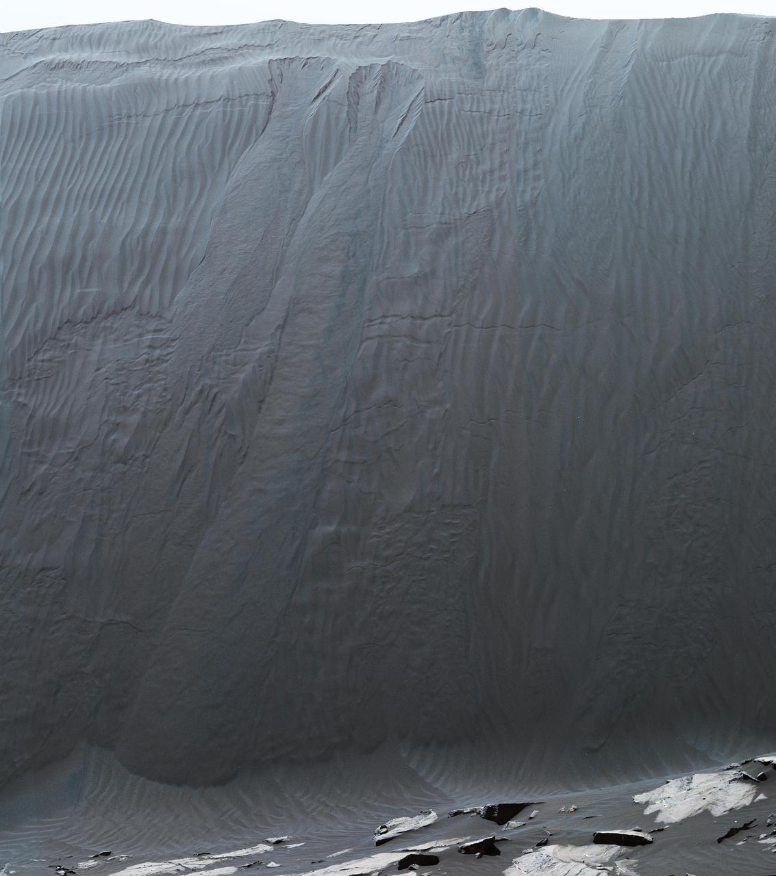
This view combines multiple images from the telephoto-lens camera of the Mast Camera (Mastcam) on NASA's Curiosity Mars rover to reveal fine details of the downwind face of "Namib Dune." The site is part of the dark-sand "Bagnold Dunes" field along the northwestern flank of Mount Sharp. Images taken from orbit have shown that dunes in the Bagnold field move as much as about 3 feet (1 meter) per Earth year. Sand on this face of Namib Dune has cascaded down a slope of about 26 to 28 degrees. The top of the face is about 13 to 17 feet (4 to 5 meters) above the rocky ground at its base. http://photojournal.jpl.nasa.gov/catalog/PIA20283

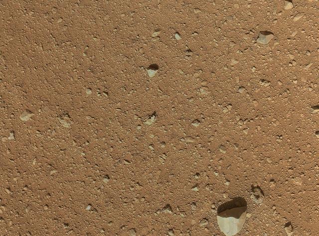
This set of images from NASA Curiosity rover shows a patch of rock before and after it was cleaned by Curiosity Dust Removal Tool DRT.

This graph compares a typical daily pattern of changing atmospheric pressure blue with the pattern during a regional dust storm hundreds of miles away red. The data are by the Rover Environmental Monitoring Station REMS on NASA Curiosity rover.
NASA's Curiosity Mars rover used its Mastcam instrument to take the 32 individual images that make up this panorama of the outcrop nicknamed "Mont Mercou." It took a second panorama, rolling sideways 13 feet (4 meters), to create a stereoscopic effect similar to a 3D viewfinder. The effect helps scientists get a better idea of the geometry of Mount Mercou's sedimentary layers, as if they're standing in front of the formation. Both panoramas were taken on March 4, 2021, the 3,049th Martian day, or sol, of the mission, from a distance of about 130 feet (40 meters) from the cliff face, which is about 20 feet (6 meters) tall. They have been white-balanced so that the colors of the rock materials resemble how they would appear under daytime lighting conditions on Earth. Animation available at https://photojournal.jpl.nasa.gov/catalog/PIA24266
The rock Ithaca is shown here with a rougher lower texture and smoother texture on top, and appears to be a piece of the local sedimentary bedrock protruding from the surrounding soil in Gale Crater as seen by NASA Curiosity Mars rover.
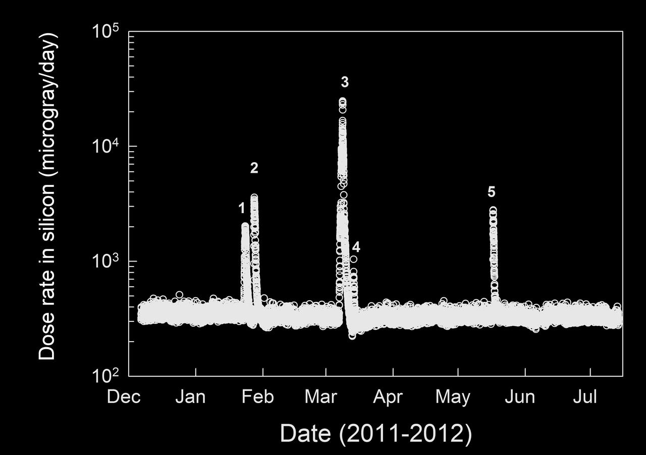
This graphic shows the level of natural radiation detected by the Radiation Assessment Detector shielded inside NASA Mars Science Laboratory on the trip from Earth to Mars from December 2011 to July 2012.
The right Mast Camera Mastcam of NASA Curiosity Mars rover provided this contextual view of the vicinity of the location called John Klein, selected as Curiosity first drilling site.
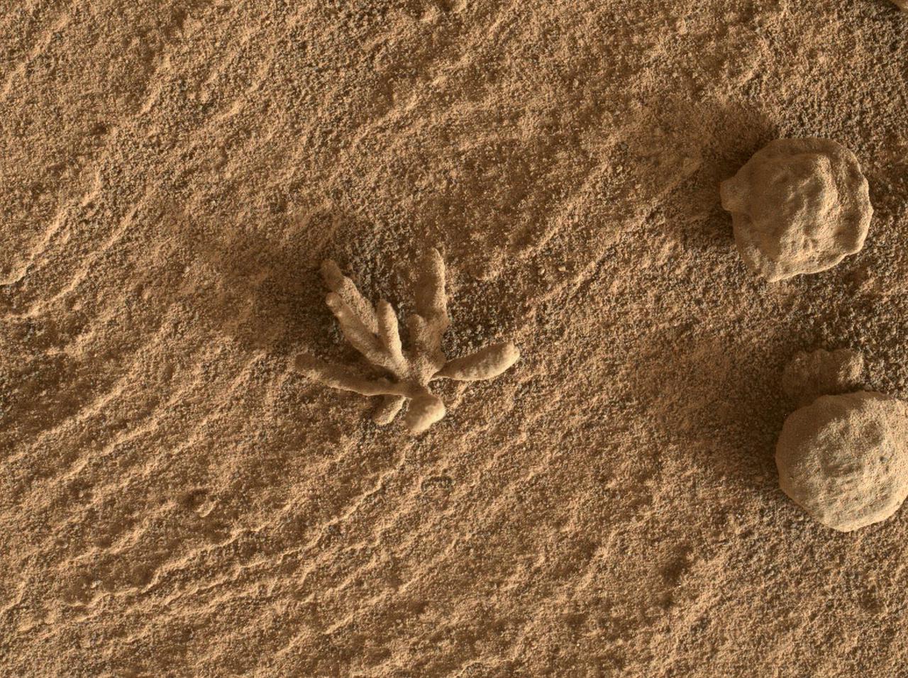
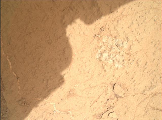
Smaller than a penny, the flower-like rock artifact on the left was imaged by NASA's Curiosity Mars rover using its Mars Hand Lens Imager (MAHLI) camera on the end of its robotic arm. The image was taken on Feb. 24, 2022, the 3,396th Martian day, or sol, of the mission. The "flower," along with the spherical rock artifacts seen to the right, were made in the ancient past when minerals carried by water cemented the rock. Figure 1 shows a tighter view of the flower-like feature. Curiosity has in the past discovered a diverse assortment of similar small features that formed when mineralizing fluids traveled through conduits in the rock. Images of such features are helping scientists understand more about the prolonged history of liquid water in Gale Crater. https://photojournal.jpl.nasa.gov/catalog/PIA25077
The sinuous rock feature in the lower center of this mosaic of images recorded by the NASA Mars rover Curiosity is called Snake River. Curiosity gets a closer look at Snake River for before proceeding to other nearby rocks.
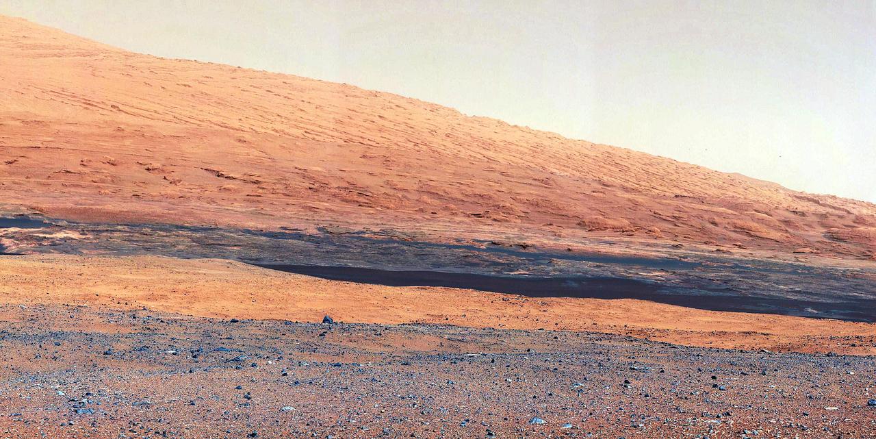
This image taken by NASA Curiosity shows what lies ahead for the rover -- its main science target, informally called Mount Sharp. The rover shadow can be seen in the foreground, and the dark bands beyond are dunes.
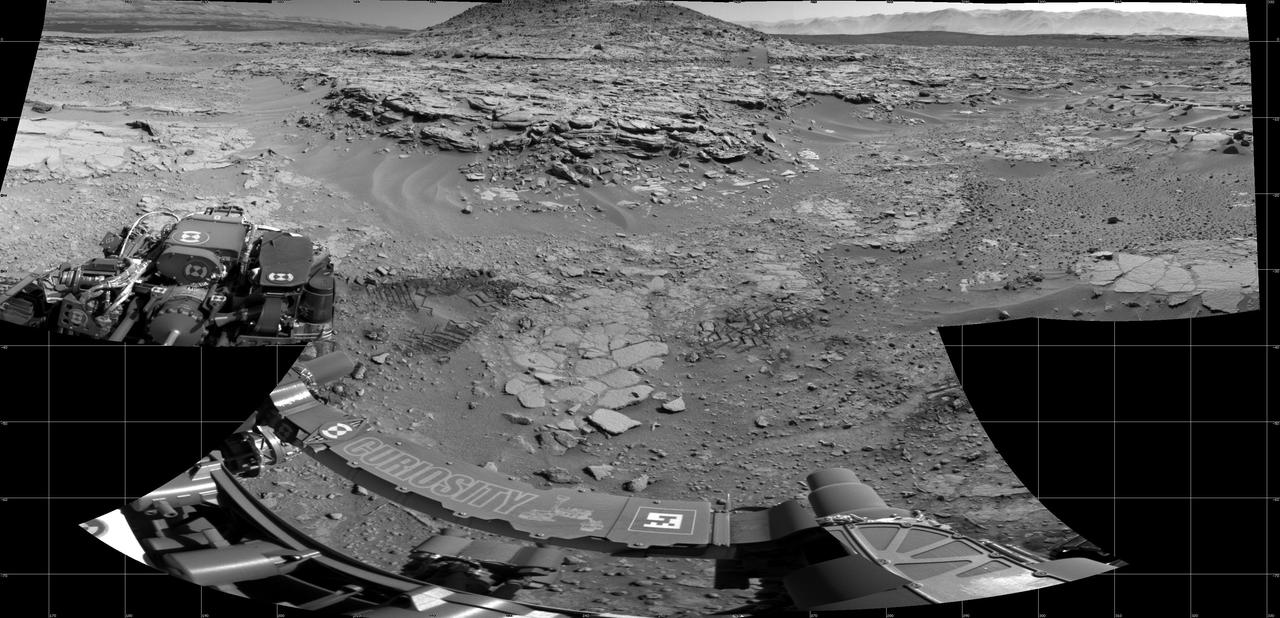
This oblique view of Gale crater shows the landing site and the mound of layered rocks that NASA Mars Science Laboratory will investigate. The landing site is in the smooth area in front of the mound.
The Shaler outcrop is dramatically layered, as seen in this mosaic of telephoto images from the right Mast Camera Mastcam on NASA Mars rover Curiosity.
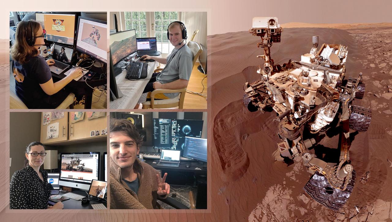
Members of NASA's Curiosity Mars rover mission team took pictures of themselves from their home offices on March 20, 2020, the first day the entire mission team worked remotely. Rover planning usually happens at NASA's Jet Propulsion Laboratory in Southern California. Clockwise from upper left: Rover planner Keri Bean, wearing red-blue 3D glasses; rover planner Camden Miller; tactical uplink lead Jack Quade; and Science Operations Team Chief Carrie Bridge. https://photojournal.jpl.nasa.gov/catalog/PIA23773
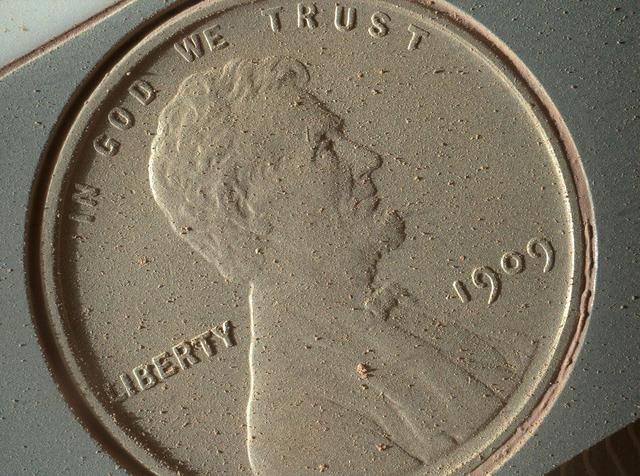
This image of a U.S. penny on a calibration target was taken by the Mars Hand Lens Imager MAHLI aboard NASA Curiosity rover in Gale Crater on Mars. At 14 micrometers per pixel, this is the highest-resolution image that MAHLI can acquire.
This frame from a set of three images from NASA Curiosity rover shows the rover drill in action on Feb. 8, 2013, or Sol 182, Curiosity 182nd Martian day of operations.
NASA Curiosity Mars rover caught its own shadow in this image taken just after completing a drive of 329 feet 100.3 meters on the 547th Martian day, or sol, of the rover work on Mars Feb. 18, 2014.

As the last step in a series of inspections of the Mars Hand Lens Imager MAHLI aboard NASA Mars rover Curiosity, this camera reclosable dust cover was opened for the first time on Sept. 8, 2012.
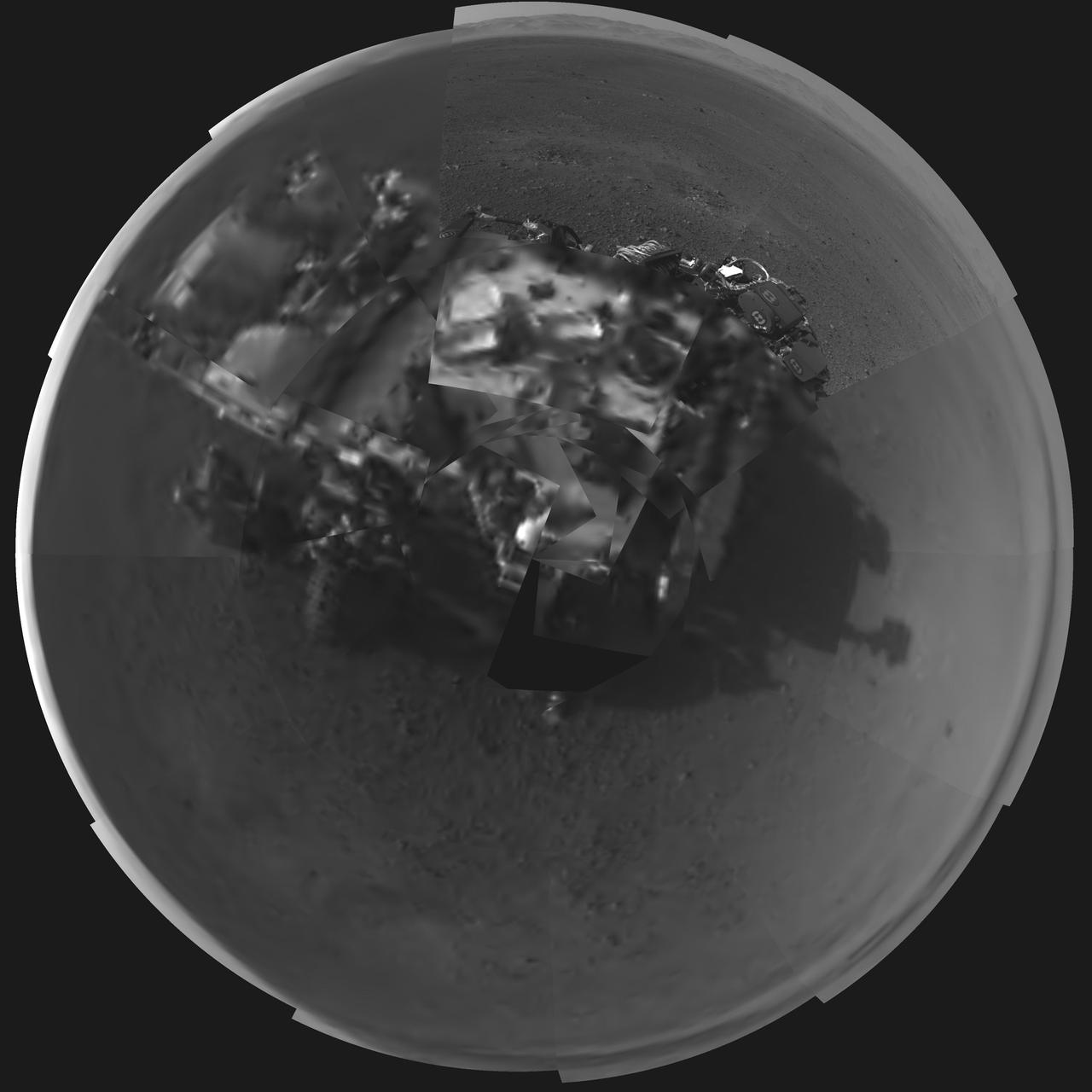
This Picasso-like self portrait of NASA Curiosity rover was taken by its Navigation cameras, located on the now-upright mast. The camera snapped pictures 360-degrees around the rover, while pointing down at the rover deck, up and straight ahead.
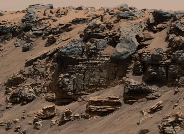
This 360-degree panorama of a location called "Teal Ridge" was captured on Mars by the Mast Camera, or Mastcam, on NASA's Curiosity rover on June 18, 2019, the 2,440th Martian day, or sol, of the mission. By driving up the side of Teal Ridge, the rover was able to reach rocks from the second of three subunits within the "clay-bearing unit" that are exposed in a valley-like region of Mount Sharp, which Curiosity is ascending. The scene is presented with a color adjustment that approximates white balancing to resemble how the rocks and sand would appear under daytime lighting conditions on Earth. https://photojournal.jpl.nasa.gov/catalog/PIA23346
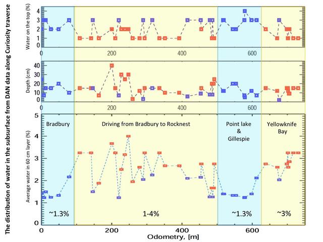
This set of graphs shows variation in the amount and the depth of water detected beneath NASA Mars rover Curiosity by use of the rover Dynamic Albedo of Neutrons DAN instrument at different points the rover has driven.
This image taken by the Mast Camera MastCam on NASA Curiosity rover highlights the interesting geology of Mount Sharp, a mountain inside Gale Crater, where the rover landed.
This evenly layered rock photographed by the Mast Camera Mastcam on NASA Curiosity Mars Rover on Aug. 7, 2014, shows a pattern typical of a lake-floor sedimentary deposit not far from where flowing water entered a lake.
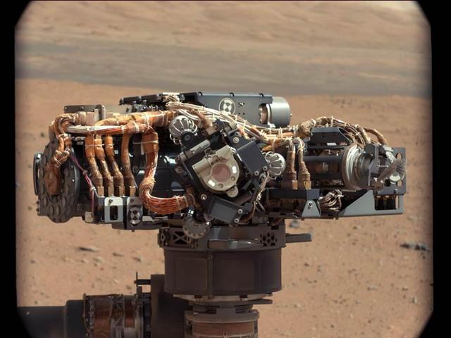
This image shows the Mars Hand Lens Imager MAHLI on NASA Curiosity rover, with the Martian landscape in the background. The image was taken by Curiosity Mast Camera on the 32nd Martian day, or sol, of operations on the surface.
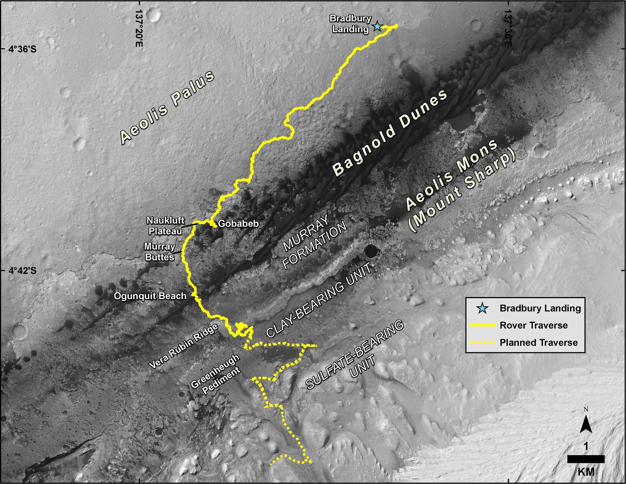
This map shows the route driven by NASA's Curiosity Mars rover, from the location where it landed in August 2012 to its location in August 2019, and its planned path to additional geological layers of lower "Mount Sharp." The blue star near top center marks "Bradbury Landing," the site where Curiosity arrived on Mars on Aug. 5, 2012, PDT (Aug. 6, EDT and Universal Time). Curiosity landed on Aeolis Palus, the plains surrounding Aeolis Mons (Mount Sharp) in Gale Crater. The base image for the map is from the High Resolution Imaging Science Experiment (HiRISE) camera on the Mars Reconnaissance Orbiter. North is up. "Bagnold Dunes" form a band of dark, wind-blown material at the foot of Mount Sharp. The scale bar at lower right represents one kilometer (0.62 mile). https://photojournal.jpl.nasa.gov/catalog/PIA23412
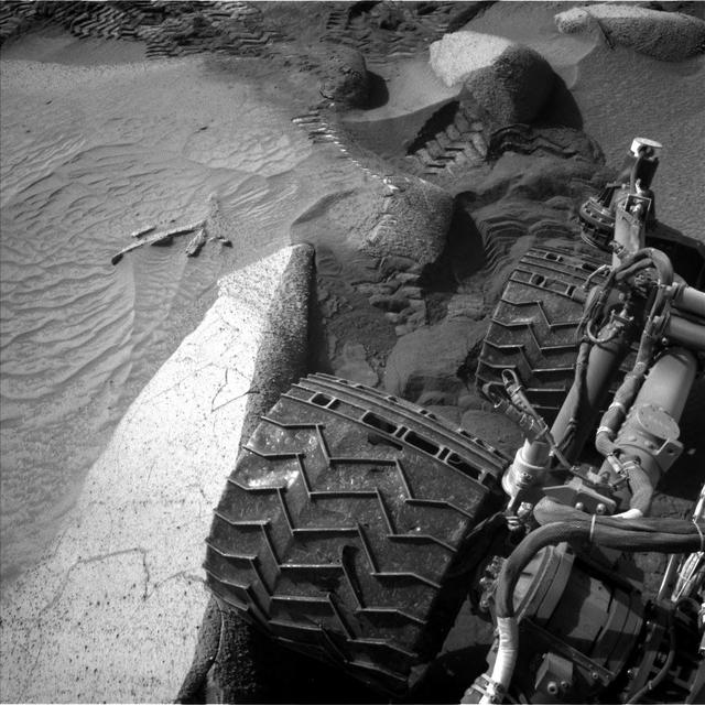
NASA's Curiosity Mars rover captured this image of its right rear wheels using its navigation cameras on June 1, the 3,846th Martian day, or sol, of the mission. The image was taken while the rover was attempting to climb a 23-degree slope covered with slippery sand and wheel-size boulders. Rover tracks from the approach to this location can be seen in the sand at the top of the image. The rover slipped in the sand, causing it to veer off its intended route and prompting its right middle wheel to drive up on to the bright, long rock seen at the left of the image. Driving over this rock was not intended, and the large movement of the suspension triggered a safety fault, stopping the drive. In response, rover planners chose to back away from this spot and try climbing the slope a few feet from here. Curiosity experienced several more faulted drives before a decision was made to pursue a detour on less difficult terrain about 492 feet (150 meters) away. https://photojournal.jpl.nasa.gov/catalog/PIA26016
This image is a 3-D view in front of NASA Curiosity rover. Mount Sharp is visible rising above the terrain, though in one eye a box on the rover holding the drill bits obscures the view.
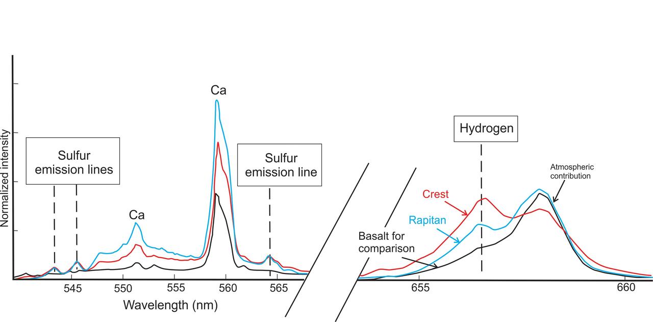
This graphic from NASA Curiosity mission shows an analysis of the composition of two rocks called Crest and Rapitan in the Yellowknife Bay area of Mars
These sulfur crystals were found inside a rock after NASA's Curiosity Mars rover happened to drive over it and crush it on May 30, 2024, the 4,200th Martian day, or sol, of the mission. This image was captured by Curiosity's Mars Hand Lens Imager (MAHLI), a camera on the end of its robotic arm, on June 4, 2024, the 4,205th Martian day, or sol, of the mission. This rock was nicknamed "Convict Lake" after a location in California's Sierra Nevada. Curiosity's Alpha Particle X-Ray Spectrometer (APXS) found that the crystalline material is elemental sulfur. https://photojournal.jpl.nasa.gov/catalog/PIA26307
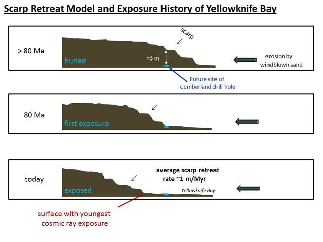
NASA Curiosity Mars rover has made measurements indicating that the Cumberland rock target the rover drilled in May 2013 has been exposed at the surface for about 80 million years.
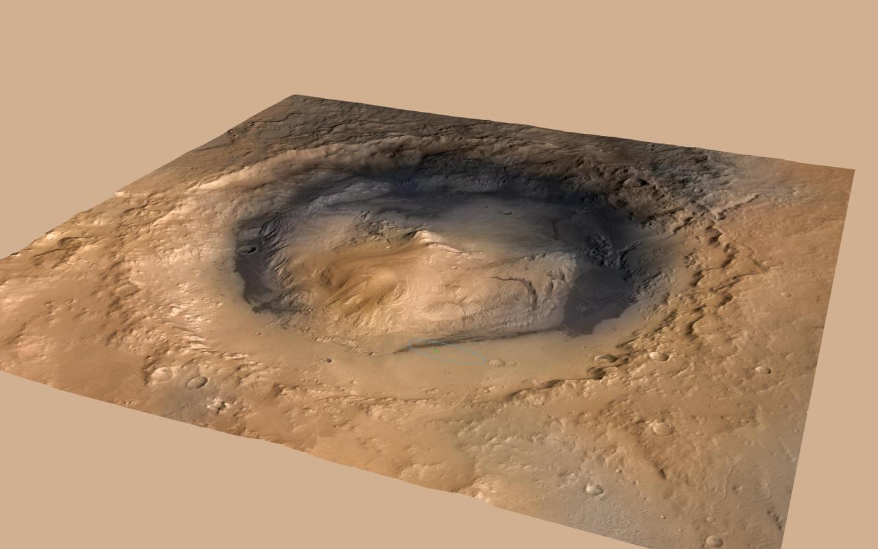
NASA Curiosity rover landed in the Martian crater known as Gale Crater, which is approximately the size of Connecticut and Rhode Island combined. A green dot shows where the rover landed, well within its targeted landing ellipse, outlined in blue.
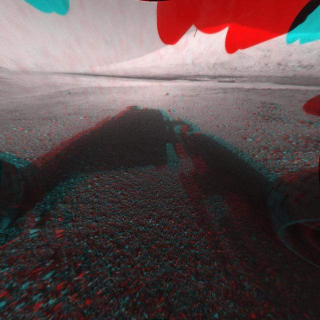
The NASA Mars rover Curiosity used its left Navigation Camera to record this view of the step down into a shallow depression called Yellowknife Bay. The descent into the basin crossed a step about 2 feet high, visible in the upper half of this image.
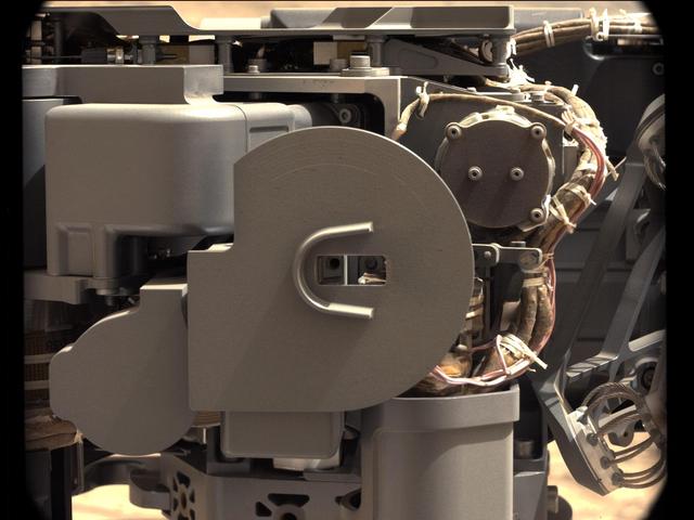
The drill bit of NASA's Curiosity Mars rover over one of the sample inlets on the rover's deck. The inlets lead to Curiosity's onboard laboratories. This image was taken on Sol 2068 by the rover's Mast Camera (Mastcam). https://photojournal.jpl.nasa.gov/catalog/PIA22327
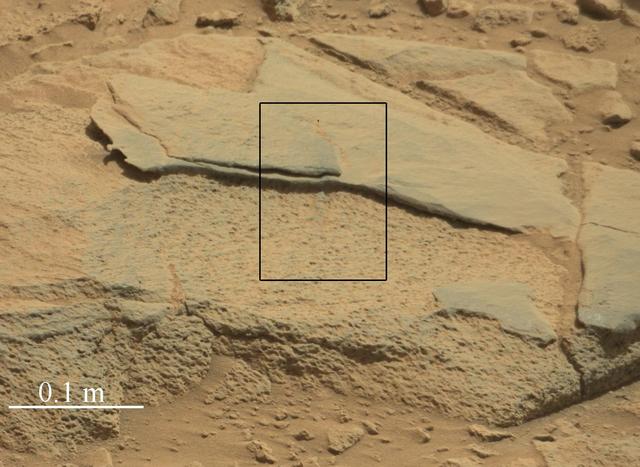
The Mast Camera Mastcam on NASA Mars rover Curiosity showed researchers interesting color and patterns in this unnamed rock.
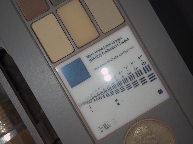
For scale, the Lincoln penny on the MAHLI calibration target is three-fourths inch 19 millimeters in diameter. The calibration target is mounted on NASA Mars rover Curiosity.
NASA Mars rover Curiosity used its Mast Camera Mastcam to take the images combined into this mosaic of the drill area, called John Klein, where the rover ultimately performed its first sample drilling.
This view from the NASA Curiosity Mars rover shows an example of cross-bedding that results from water passing over a loose bed of sediment. It was taken at a target called Whale Rock within the Pahrump Hills outcrop at the base of Mount Sharp.
NASA Curiosity rover found evidence for an ancient, flowing stream on Mars at a few sites, including a rock which the science team has named Hottah after Hottah Lake in Canada Northwest Territories. 3-D glasses are needed.
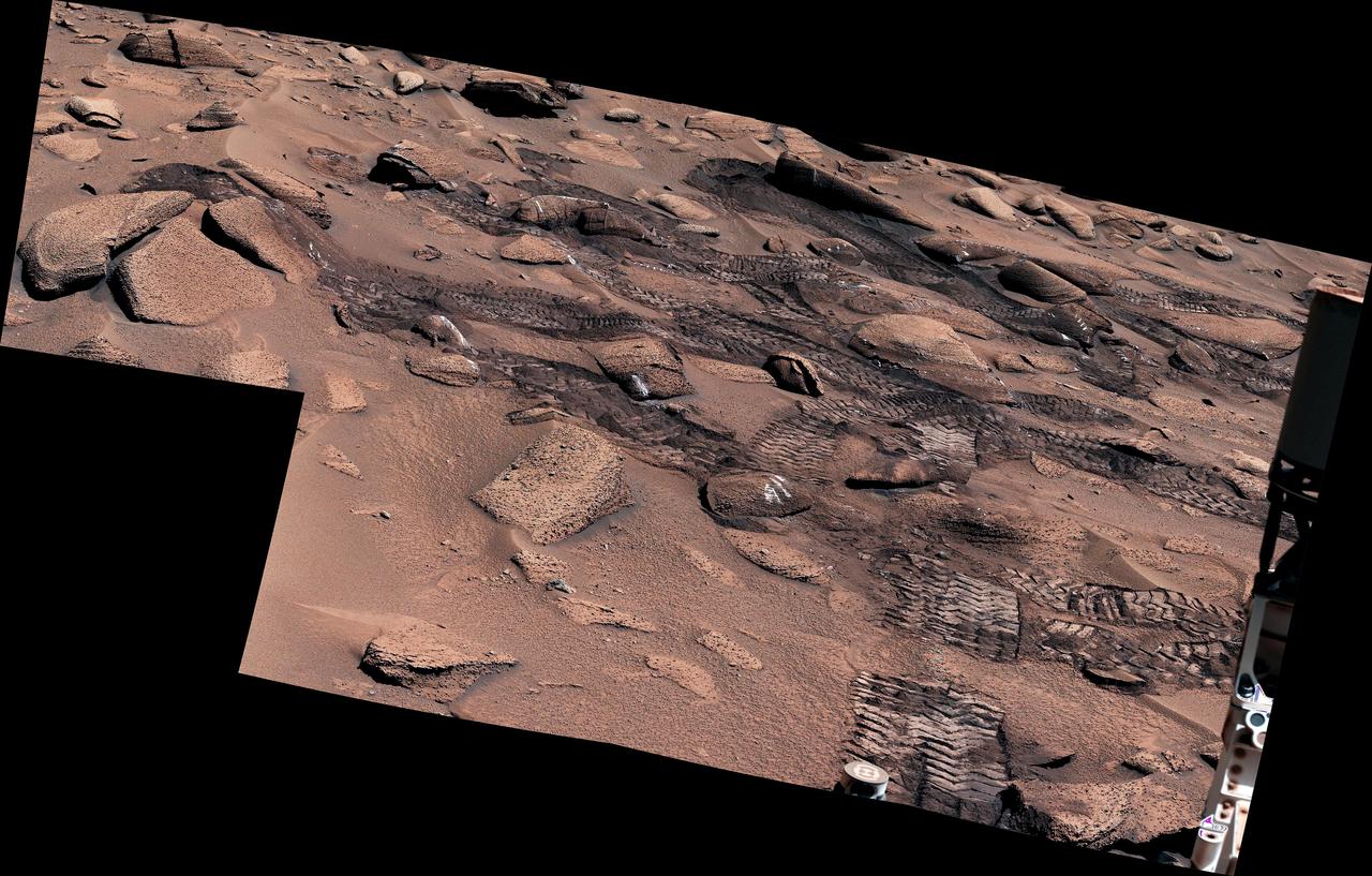
NASA's Curiosity Mars rover left these tracks after trying multiple times to crest a slippery slope. This mosaic, made up of seven images that were stitched together after being sent back to Earth, was captured by the rover's Mastcam on June 13, 2023, the 3,858th Martian day, or sol, of the mission. The color has been adjusted to match lighting conditions as the human eye would see them on Earth. Curiosity struggled to climb a 23-degree slope that had slippery sand and wheel-size boulders. These three factors – the incline, the sand, and the large boulders – combined to make this Curiosity's toughest climb yet. https://photojournal.jpl.nasa.gov/catalog/PIA25920
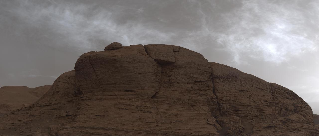
NASA's Curiosity Mars rover used its Mast Camera, or Mastcam, to take this 360-degree panorama on March 23, 2022, the 3,423th Martian day, or sol, of the mission. The team has informally described the wind-sharpened rocks seen here as "gator-back" rocks because of their scaly appearance. Wind-sharpened rocks like these are called ventifacts, and are responsible for chewing up Curiosity's wheels earlier in the mission. Since then, rover engineers have found ways to slow wheel wear, including a traction control algorithm. They also plan rover routes that avoid driving over such rocks, including these latest ventifacts, which are made of sandstone – the hardest type of rock Curiosity has encountered on Mars. These rocks form the surface of the "Greenheugh Pediment," a broad, sloping plain in the foothills of Mount Sharp. The floor of Gale Crater is visible along the edges of the mosaic. When Curiosity's team saw the gator-back rocks, they ultimately decided to turn the rover around and take an alternative path to continue climbing Mount Sharp, a 3.4-mile-tall (5.5-kilometer-tall) mountain that Curiosity has been ascending since 2014. As it climbs, Curiosity is able to study different sedimentary layers shaped by water billions of years ago. These layers help scientists understand whether microscopic life could have survived in the ancient Martian environment. https://photojournal.jpl.nasa.gov/catalog/PIA25176
NASA's Curiosity Mars rover captured this 360-degree panorama while parked below Gediz Vallis Ridge (the hill-like slope at right). After three attempts over the course of three years, the rover finally reached the ridge on its fourth try on Aug. 14, 2023, the 3,923rd Martian day, or sol, of the mission. On Aug. 19, Curiosity's Mastcam took the 136 individual images that were stitched together into this mosaic after being sent back to Earth. The color has been adjusted to match lighting conditions as the human eye would see them on Earth. Gediz Vallis Ridge was one of the last features to form on Mount Sharp, the 3-mile-tall (5-kilometer-tall) mountain that Curiosity has been ascending since 2014. The ridge preserves a record of one of the last wet periods seen on this part of Mars. Reaching the ridge was no easy feat: previous forays were stymied by knife-edged "gator-back" rocks and too-steep slopes. Arriving after one of the most difficult climbs the mission has ever faced, Curiosity spent 11 days at the ridge. It then departed to ascend higher up the mountain, where the rover will investigate Gediz Vallis Channel, through which water flowed some 3 billion years ago, carrying rocks and debris that piled up to form the ridge. https://photojournal.jpl.nasa.gov/catalog/PIA26019

The hole that NASA Curiosity Mars rover drilled into target rock John Klein provided a view into the interior of the rock, as well as obtaining a sample of powdered material from the rock.
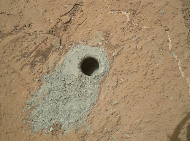
NASA Mars rover Curiosity drilled into this rock target, Cumberland, during the 279th Martian day, or sol, of the rover work on Mars May 19, 2013 and collected a powdered sample of material from the rock interior.
This image demonstrates how engineers place the drill carried by NASA Mars rover Curiosity onto rock targets. They first set down the drill two stabilizing prongs near the target, as shown by the dashed line.
This animation flips back and forth between views taken in 2010 and 2014 of a Martian sand dune at the edge of Mount Sharp, documenting dune activity. The images are from the High Resolution Imaging Science Experiment (HiRISE) camera on NASA's Mars Reconnaissance Orbiter. They cover an area about 740 feet (about 225 meters) wide, showing a site called "Dune 2" in the "Bagnold Dunes" dune field. NASA's Curiosity Mars rover will observe this dune up close on the rover's route up Mount Sharp. North is toward the top. The edge of the dune at the crescent-shaped slip face on the south edge advances slightly during the four-year period between the dates of the images. Figure A is an annotated version with an arrow indicating the location of this change. The lighting angle is different in the two images, resulting in numerous changes in shadows. http://photojournal.jpl.nasa.gov/catalog/PIA20161
NASA's Curiosity Mars rover captured these clouds just after sunset on March 19, 2021, the 3,063rd Martian day, or sol, of the rover's mission. The image is made up of 21 individual images stitched together and color corrected so that the scene appears as it would to the human eye. The clouds are drifting over "Mont Mercou," a cliff face that Curiosity has been studying. https://photojournal.jpl.nasa.gov/catalog/PIA24622
NASA Mars rover Curiosity has delivered sample portions of rock powder collected from the interior of a rock on Mars into laboratory instruments inside the rover.
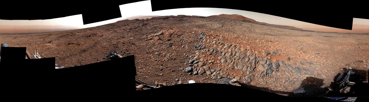
NASA Curiosity Mars rover used its Navigation Camera Navcam on April 11, 2014, to record this scene of a butte called Mount Remarkable and surrounding outcrops at a waypoint called the Kimberley inside Gale Crater.
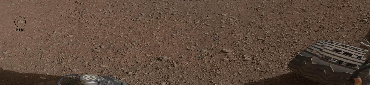
This mosaic image shows the first target NASA Curiosity rover aims to zap ChemCam instrument. ChemCam will be firing a laser at this rock, provisionally named N165, and analyzing the glowing, ionized gas, called plasma, that the laser excites.
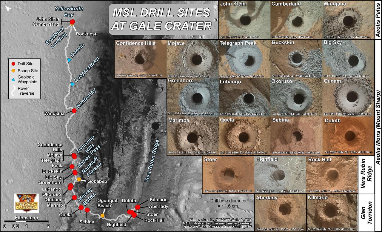
This graphic maps locations of the sites where NASA's Curiosity Mars rover collected its rock and soil samples for analysis by laboratory instruments inside the vehicle. It also presents images of the drilled holes where 21 rock-powder samples were acquired. The diameter of each drill hole is about 0.6 inch (1.6 centimeters), slightly smaller than a U.S. dime. The images used here are raw color, as recorded by the rover's Mars Hand Lens Imager (MAHLI) camera. Notice the differences in color of the material at different drilling sites. For the map, north is toward upper left corner. The scale bar represents 2 kilometers (1.2 miles). The base map is from the High Resolution Imaging Science Experiment (HiRISE) camera on NASA's Mars Reconnaissance Orbiter. https://photojournal.jpl.nasa.gov/catalog/PIA23413

This image graphs four gases released evolved when powdered rock from the target rock Cumberland was heated inside the Sample Analysis at Mars SAM instrument suite on NASA Curiosity Mars rover.
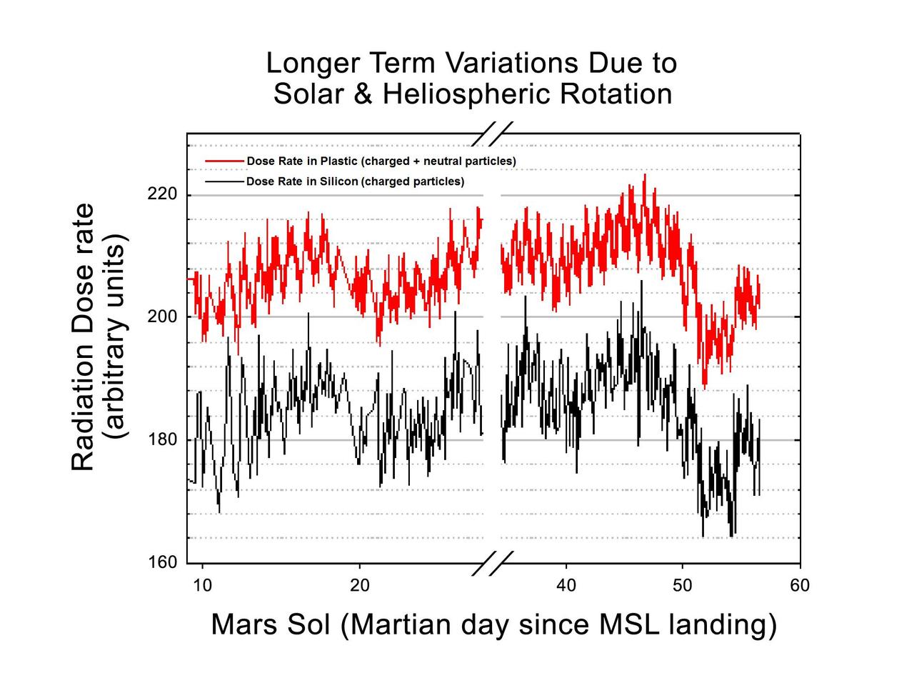
This graphic shows the variation of radiation dose measured by the Radiation Assessment Detector on NASA Curiosity rover over about 50 sols, or Martian days, on Mars.

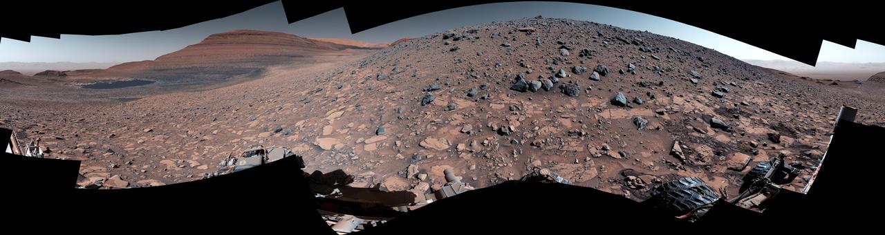
NASA's Curiosity Mars rover used its Mastcam to capture this mosaic of Gediz Vallis on Nov. 7, 2022, the 3,646th Martian day, or sol, of the mission. In the center of the valley in this image is a pile of boulders and debris that may have been swept there by flowing water billions of years ago. Wind is thought to have carved the larger valley, which starts much higher up on Mount Sharp, the 3-mile-tall (5-kilometer-tall) Martian mountain whose foothills Curiosity has been ascending since 2014. The mountain is made up of layers, with the oldest at the bottom and the youngest at the top. Approaching this debris in the valley's interior channel is thought to be the only way that Curiosity will be able to study younger material that originated higher on the mountain than the rover will ever go. The mosaic is made up of 18 individual images that were stitched together after being sent to Earth. The color has been adjusted to match lighting conditions as the human eye would see them on Earth. https://photojournal.jpl.nasa.gov/catalog/PIA25733
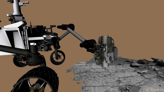
This frame from an animation of NASA Curiosity rover shows the complicated suite of operations involved in conducting the rover first rock sample drilling on Mars and transferring the sample to the rover scoop for inspection.

The Rover Environmental Monitoring Station REMS on NASA Curiosity Mars rover has detected dozens of whirlwinds, or vortex events, causing brief dips in atmospheric pressure, and sometimes other measurable effects.
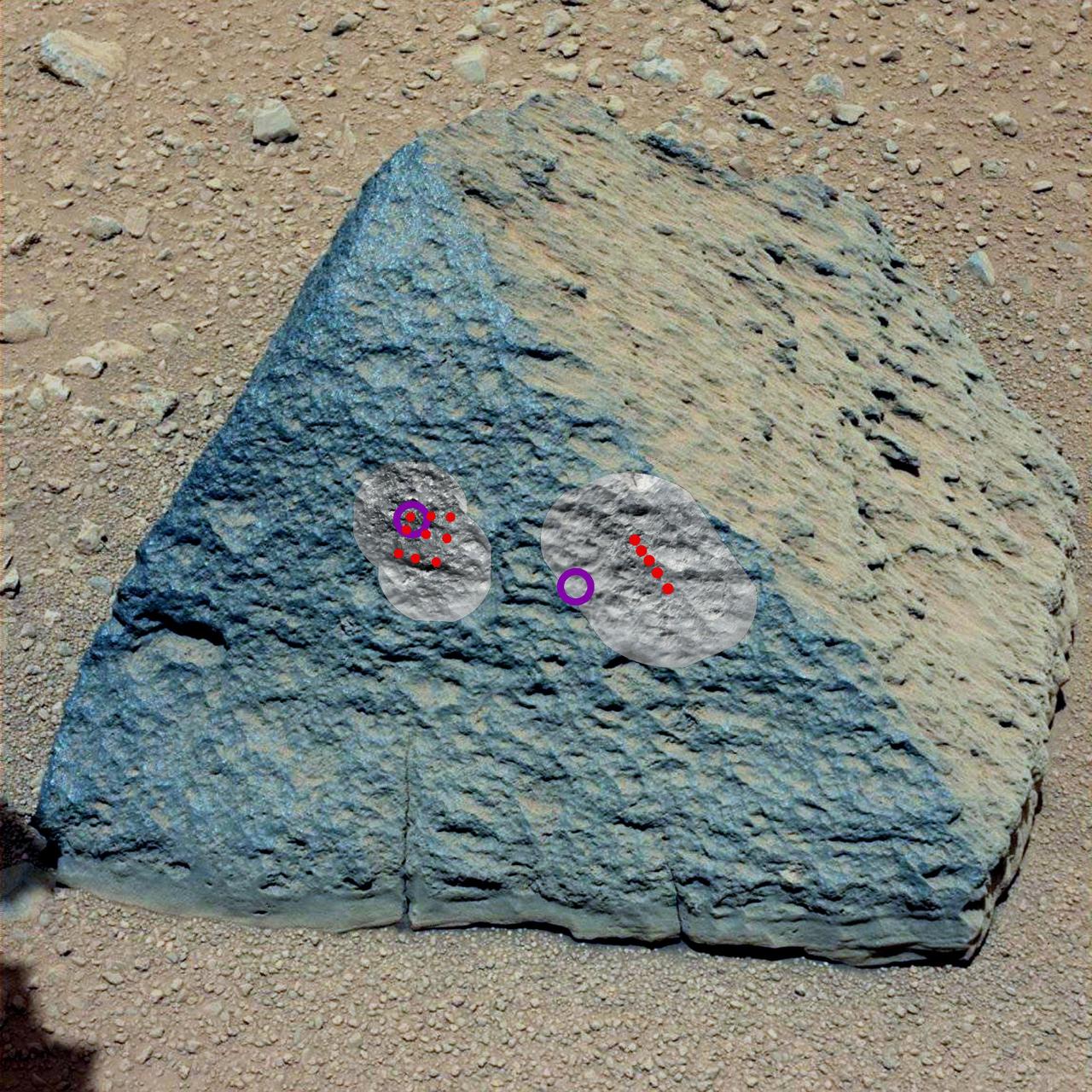
This image shows where NASA Curiosity rover aimed two different instruments to study a rock known as Jake Matijevic. The red dots are where ChemCam zapped the rock with its laser.
The level of detail apparent in this image from Curiosity Mars Hand Lens Imager MAHLI shows that haziness in earlier MAHLI images since landing was due to dust that had settled on the dust cover during the landing.