Rover Wheel Churns Up Bright Martian Soil
Rover Wheel Churns Up Bright Martian Soil Vertical
Rover Wheel Churns Up Bright Martian Soil False Color
With its heat shield facing the planet, NASA's Perseverance rover begins its descent through the Martian atmosphere in this illustration. Hundreds of critical events must execute perfectly and exactly on time for the rover to land on Mars safely on Feb. 18, 2021.  Entry, Descent, and Landing, or "EDL," begins when the spacecraft reaches the top of the Martian atmosphere, traveling nearly 12,500 mph (20,000 kph).  The aeroshell, which encloses the rover and descent stage, makes the trip to the surface on its own. The vehicle fires small thrusters on the backshell to reorient itself and make sure the heat shield is facing forward as it plunges into the atmosphere.  https://photojournal.jpl.nasa.gov/catalog/PIA24313
Entering the Martian Atmosphere with the Perseverance Rover (Illustration)
In this illustration of its descent to Mars, the spacecraft containing NASA's Perseverance rover slows down using the drag generated by its motion in the Martian atmosphere. Hundreds of critical events must execute perfectly and exactly on time for the rover to land on Mars safely on Feb. 18, 2021.  Entry, Descent, and Landing, or "EDL," begins when the spacecraft reaches the top of the Martian atmosphere, traveling nearly 12,500 mph (20,000 kph).  The cruise stage separates about 10 minutes before entering into the atmosphere, leaving the aeroshell, which encloses the rover and descent stage, to make the trip to the surface. The vehicle fires small thrusters on the backshell to reorient itself and make sure the heat shield is facing forward as it plunges into the atmosphere. As it descends through the atmosphere, the spacecraft fires these thrusters on its backshell to guide itself. The spacecraft uses the Martian atmosphere to brake, causing it to heat up dramatically. Peak heating occurs about 80 seconds after atmospheric entry, when the temperature at the external surface of the heat shield reaches about 2,370 degrees Fahrenheit (about 1,300 degrees Celsius). The rover is safe in the aeroshell, and reaches only about room temperature. Peak deceleration occurs about 10 seconds later (~90 seconds after atmospheric entry). The heat shield slows the spacecraft to under 1,000 mph (1,600 kph).  https://photojournal.jpl.nasa.gov/catalog/PIA24314
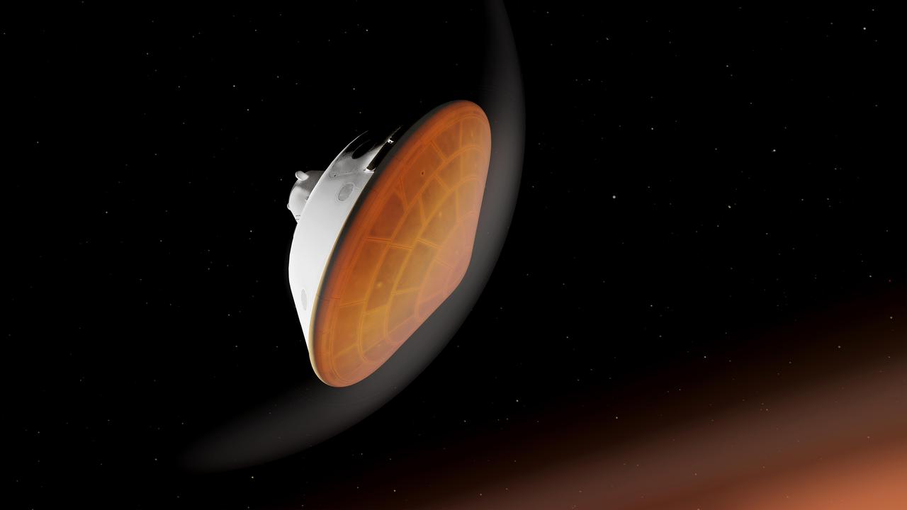
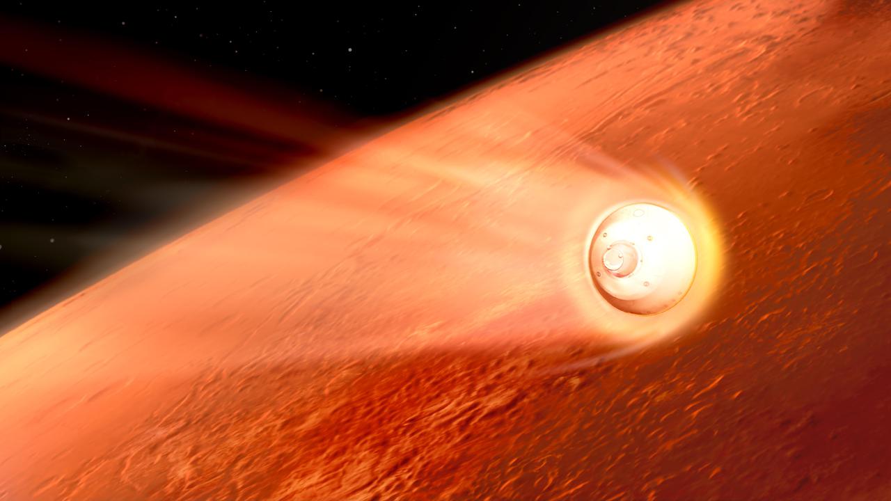
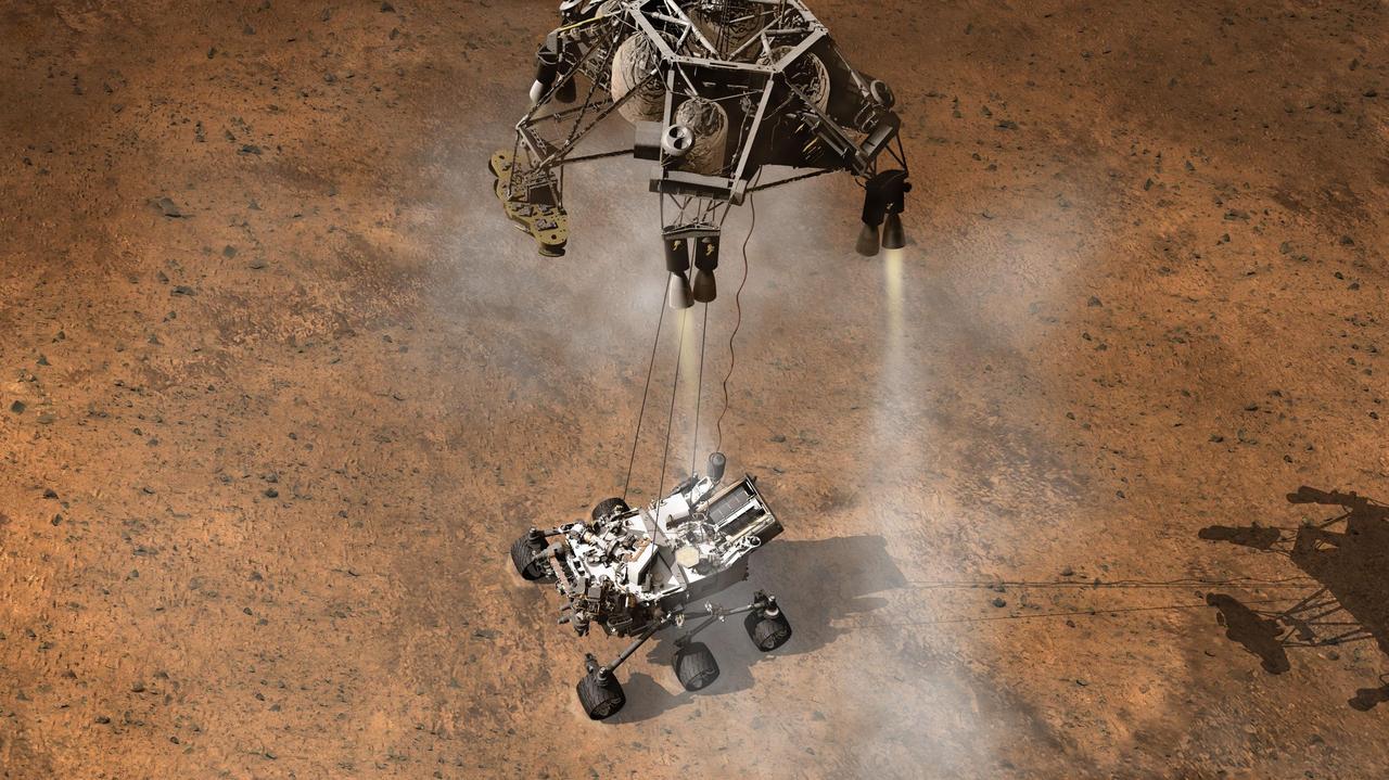
Perseverance Rover Decelerates in the Martian Atmosphere (Illustration)
This picture taken by the IMP (Imager for Mars Pathfinder) aboard the Mars Pathfinder spacecraft depicts the rover Sojourner's position after driving onto the Martian surface. Sojourner has become the first autonomous robot ever to traverse the surface of Mars. This image reflects the success of Pathfinder's principle objective -- to place a payload on Mars in a safe, operational configuration.  The primary mission of Sojourner, scheduled to last seven days, will be to use its Alpha Proton X-ray Spectrometer (APXS) instrument to determine the elements that make up the rocks and soil on Mars. A full study using the APXS takes approximately ten hours, and can measure all elements except hydrogen at any time of the Martian day or night. The APXS will conduct its studies by bombarding rocks and soil samples with alpha particle radiation -- charged particles equivalent to the nucleus of a helium atom, consisting of two protons and two neutrons.  http://photojournal.jpl.nasa.gov/catalog/PIA00623
Rover Touchdown on Martian Surface
This picture from Mars Pathfinder was taken at 9:30 AM in the martian morning (2:30 PM Pacific Daylight Time), after the spacecraft landed earlier today (July 4, 1997). The Sojourner rover is perched on one of three solar panels. The rover is 65 cm (26 inches) long by 18 cm (7 inches) tall; each of its wheels is about 13 cm (5 inches) high. The white material to the left of the front of the rover is part of the airbag system used to cushion the landing.  Many rocks of different of different sizes can be seen, set in a background of reddish soil. The landing site is in the mouth of an ancient channel carved by water. The rocks may be primarily flood debris. The horizon is seen towards the top of the picture. The light brown hue of the sky results from suspended dust.  Pathfinder, a low-cost Discovery mission, is the first of a new fleet of spacecraft that are planned to explore Mars over the next ten years. Mars Global Surveyor, already en route, arrives at Mars on September 11 to begin a two year orbital reconnaissance of the planet's composition, topography, and climate. Additional orbiters and landers will follow every 26 months.  http://photojournal.jpl.nasa.gov/catalog/PIA00608
Rover, Airbags & Martian Terrain
Four student teams: Blue, Gold, Green and Red built, designed and tested a LEGO robotic Martian rover prototype at NASA's Armstrong Flight Research Center. The teams competed against each other during a four-day workshop coordinated by the NASA Community College Aerospace Scholars. Each team prepared a marketing package to "sell" their design to NASA based on the performance of its Martian rover.
Students Test their LEGO Rover Prototype
This image from an animation shows how repeated laser shots from the ChemCam instrument on NASA Mars rover Curiosity cause a pit to form at the target point in Martian soil.
Pitting in Martian Soil During Repeated Laser Shots From Mars Rover
This is one of the first pictures taken by the camera on the Mars Pathfinder lander shortly after its touchdown at 10:07 AM Pacific Daylight Time on July 4, 1997. The small rover, named Sojourner, is seen in the foreground in its position on a solar panel of the lander. The white material on either side of the rover is part of the deflated airbag system used to absorb the shock of the landing. Between the rover and the horizon is the rock-strewn martian surface. Two hills are seen in the right distance, profiled against the light brown sky.  http://photojournal.jpl.nasa.gov/catalog/PIA00611
Pathfinder Rover, Airbags, & Martian Terrain
These two images, taken five Martian days sols apart by the front hazard-avoidance camera on NASA Mars Exploration Rover Opportunity, document the Martian sky above the rover Endeavour Crater location becoming dustier.
Sky Gets Dustier Between Opportunity Sols 3296 and 3301
The robotic arm on NASA Mars rover Curiosity delivered a sample of Martian soil to the rover observation tray for the first time during the mission 70th Martian day, or sol Oct. 16, 2012.
First Sample Placed on Curiosity Observation Tray
This view shows grains of sand where NASA's Curiosity Mars rover was driven into a shallow sand sheet near a large dune. The disturbance by the wheel exposed interior material of the sand body, including finer sand grains than on the undisturbed surface. Sunlight is coming from the left.  The scene covers an area 1.3 inches by 1.0 inch (3.3 by 2.5 centimeters). This is a focus-merge product from Curiosity's Mars Hand Lens Imager (MAHLI), combining multiple images taken at different focus settings to yield sharper focus at varying distances from the lens. The component images were taken on Dec. 3, 2015, during the 1,182nd Martian day, or sol, of Curiosity's work on Mars.  http://photojournal.jpl.nasa.gov/catalog/PIA20170
Martian Sand Disturbed by Rover Wheel
The first examinations of Martian soil by the Sample Analysis at Mars, or SAM, instrument on NASA Mars Curiosity rover show no definitive detection of Martian organic molecules at this point.
Chlorinated Compounds at Rocknest
Two images of the night sky were combined to show Earth and Venus as seen by the Mast Camera aboard NASA's Curiosity Mars rover on June 5, 2020, the 2,784th Martian day, or sol, of the mission. Both planets appear as mere pinpoints of light owing to a combination of distance and dust in the air; they would normally look like bright stars.  A feature called Tower Butte is just visible at the bottom of the image, part of the clay-bearing region that Curiosity has been exploring since early 2019.  https://photojournal.jpl.nasa.gov/catalog/PIA23899
Curiosity Rover Finds Earth and Venus in the Martian Sky
This image contributed to an interpretation by NASA Mars rover Curiosity science team that some of the bright particles on the ground near the rover are native Martian material.
Bright Particle of Martian Origin in Scoop Hole
This scene shows the surroundings of the location where NASA Mars rover Curiosity arrived on the 29th Martian day, or sol, of the rover mission on Mars Sept. 4, 2012.
Curiosity Location During Arm Checkouts
This anaglyph from NASA Mars Exploration Rover, Spirit, shows the rover lander and, in the background, the surrounding martian terrain. 3D glasses are necessary to view this image.
Martian Landscape in 3-D
In 2007, NASA Mars Exploration Rover Opportunity had endured a Martian dust storm and the rover team wanted to assess the dustiness of the solar panels.
Opportunity Rover Self-Portrait From 2007
A Martian mechanic checks beneath the completely deployed NASA Rover 1 lander. Atop the lander is Rover 1 with its wheels and solar arrays in the stowed position.
Rover 1 and Lander
This image was taken by the Hazard-Avoidance cameras on NASA Curiosity rover to show evidence for an impact plume created when the rover sky crane fell to the Martian surface.
Now You See an Impact Plume, Now You Dont
This map shows the route driven by NASA Mars rover Curiosity through the 29th Martian day, or sol, of the rover mission on Mars Sept. 4, 2012.
Curiosity Traverse Map Through Sol 29
This graph shows about one-fourth of a Martian year pattern atmospheric pressure at the surface of Mars, as measured by the Rover Environmental Monitoring Station on NASA Curiosity rover.
Seasonal Pressure Curve Peaks at Gale Crater
This map shows the route driven by NASA Mars rover Curiosity through the 56th Martian day, or sol, of the rover mission on Mars Oct. 2, 2012.
Curiosity Travels Through Sol 56
A southward-looking panorama combining images from both cameras of the Mast Camera Mastcam instrument on NASA Curiosity Mars Rover shows diverse geological textures on Mount Sharp.  A southward-looking panorama combining images from both cameras of the Mast Camera (Mastcam) instrument on NASA's Curiosity Mars Rover shows diverse geological textures on Mount Sharp.  Three years after landing on Mars, the mission is investigating this layered mountain for evidence about changes in Martian environmental conditions, from an ancient time when conditions were favorable for microbial life to the much-drier present.  Gravel and sand ripples fill the foreground, typical of terrains that Curiosity traversed to reach Mount Sharp from its landing site. Outcrops in the midfield are of two types: dust-covered, smooth bedrock that forms the base of the mountain, and sandstone ridges that shed boulders as they erode. Rounded buttes in the distance contain sulfate minerals, perhaps indicating a change in the availability of water when they formed. Some of the layering patterns on higher levels of Mount Sharp in the background are tilted at different angles than others, evidence of complicated relationships still to be deciphered.  The scene spans from southeastward at left to southwestward at right. The component images were taken on April 10 and 11, 2015, the 952nd and 953rd Martian days (or sols) since the rover's landing on Mars on Aug. 6, 2012, UTC (Aug. 5, PDT). Images in the central part of the panorama are from Mastcam's right-eye camera, which is equipped with a 100-millimeter-focal-length telephoto lens. Images used in outer portions, including the most distant portions of the mountain in the scene, were taken with Mastcam's left-eye camera, using a wider-angle, 34-millimeter lens.  http://photojournal.jpl.nasa.gov/catalog/PIA19803
Curiosity Rover View of Alluring Martian Geology Ahead
NASA Mars Exploration Rover Opportunity used its navigation camera during the rover 1,278th Martian day, or sol, Aug. 28, 2007 to take the images combined into this view. The rover was perched at the lip of Victoria Crater.
Forty Meters from Entry to Victoria Crater
The drive by NASA Mars rover Curiosity during the mission 43rd Martian day ended with this rock front of the rover. The rover team has assessed it as a suitable target for the first use of Curiosity contact instruments on a rock.
Jake Matijevic Contact Target for Curiosity
NASA Mars Exploration Rover Opportunity captured this low-light raw image during the late afternoon of the rover 2,847th Martian sol Jan. 27, 2012. The rover is positioned for the Mars winter at Greeley Haven.
Opportunity Late Afternoon View of Mars
This image from the navigation camera on NASA Mars Exploration Rover Opportunity shows the view ahead on the day before the rover reached the rim of Endeavour crater. It was taken during the 2,680th Martian day, or sol, of the rover work on Mars.
Approaching Endeavour Crater, Sol 2,680
This view from the Mast Camera (Mastcam) on NASA's Curiosity Mars rover shows two scales of ripples, plus other textures, in an area where the mission examined a linear-shaped dune in the Bagnold dune field on lower Mount Sharp.  The scene is an excerpt from a 360-degree panorama acquired on March 24 and March 25, 2017, (PST) during the 1,647th Martian day, or sol, of Curiosity's work on Mars, at a location called "Ogunquit Beach."  Crests of the longer ripples visible in the dark sand of the dune are several feet (a few meters) apart. This medium-scale feature in active sand dunes on Mars was one of Curiosity's findings at the crescent-shaped dunes that the rover examined in late 2015 and early 2016. Ripples that scale are not seen on Earth's sand dunes. Overlaid on those ripples are much smaller ripples, with crests about ten times closer together.  Textures of the local bedrock in the foreground -- part of the Murray formation that originated as lakebed sediments -- and of gravel-covered ground (at right) are also visible. The image has been white-balanced so that the colors of the colors of the rock and sand materials resemble how they would appear under daytime lighting conditions on Earth.   https://photojournal.jpl.nasa.gov/catalog/PIA11242
Textures Where Curiosity Rover Studied a Martian Dune
Sample material from the fourth scoop of Martian soil collected by NASA Mars rover Curiosity is on the rover observation tray in this image taken during the mission 78th Martian sol, Oct. 24, 2012 by Curiosity left Navigation Camera.
Scooped Material on Rover Observation Tray
The rippled surface of the first Martian sand dune ever studied up close fills this view of "High Dune" from the Mast Camera (Mastcam) on NASA's Curiosity rover. This site is part of the "Bagnold Dunes" field along the northwestern flank of Mount Sharp. The dunes are active, migrating up to about one yard or meter per year.  The component images of this mosaic view were taken on Nov. 27, 2015, during the 1,176th Martian day, or sol, of Curiosity's work on Mars.  The scene is presented with a color adjustment that approximates white balancing, to resemble how the sand would appear under daytime lighting conditions on Earth. The annotated version includes superimposed scale bars of 30 centimeters (1 foot) in the foreground and 100 centimeters (3.3 feet) in the middle distance.  Malin Space Science Systems, San Diego, built and operates Curiosity's Mastcam. NASA's Jet Propulsion Laboratory, a division of the California Institute of Technology, Pasadena, built the rover and manages the project for NASA's Science Mission Directorate, Washington.  http://photojournal.jpl.nasa.gov/catalog/PIA20169
Rover Track in Sand Sheet Near Martian Sand Dune
This image from NASA Curiosity rover shows the great diversity of grains found on the surface of a Martian rock.
Texture of Gillespie Lake Rock
This image taken by a front Hazard-Avoidance camera on NASA Curiosity shows track marks from the rover first Martian drives.
Big Wheels Keep on Rollin
This image shows the Mars Hand Lens Imager MAHLI on NASA Curiosity rover, with the Martian landscape in the background. The image was taken by Curiosity Mast Camera on the 32nd Martian day, or sol, of operations on the surface.
Hello, MAHLI
The mission science team assessed the bright particles in this scooped pit to be native Martian material rather than spacecraft debris as seen in this image from NASA Mars rover Curiosity as it collected its second scoop of Martian soil.
Bright Particle in Hole Dug by Scooping of Martian Soil
This graphic tracks the maximum relative humidity and the temperature at which that maximum occurred each Martian day, or sol, for about one-fourth of a Martian year, as measured by REMS on NASA Curiosity Mars rover.
Humidity in Gale Crater: Scant and Variable
The Chemistry and Camera ChemCam instrument on NASA Mars rover Curiosity used its laser and spectrometers to examine what chemical elements are in a drift of Martian sand during the mission 74th Martian day, or sol Oct. 20, 2012.
Laser Hit on Martian Sand Target, Before and After
This map shows the locations of NASA's Perseverance Mars rover and its Ingenuity Mars Helicopter in the sols (Martian days) leading up to the helicopter's 50th flight. The helicopter icon can be seen in the upper left. The rover is shown with a red dot in places where communications with the helicopter were impossible. The rover is shown with a yellow dot at its location when the Flight 50 prep sequence was transferred from rover to helicopter. The rover is shown with a green dot at its nearest point to the helicopter before Flight 50 was executed.  Ingenuity's 49th flight occurred on April 2, 2023, the 752nd Martian day, or sol, of the rover's mission. The 50th flight occurred April 13, 2023, the 763rd Martian sol of the mission.  https://photojournal.jpl.nasa.gov/catalog/PIA25961
Leading Up to Flight 50
This image from an animation shows effects of one Martian day of wind blowing sand underneath NASA's Curiosity Mars rover on a non-driving day for the rover. Each image was taken just after sundown by the rover's downward-looking Mars Descent Imager (MARDI). The area of ground shown in the images spans about 3 feet (about 1 meter) left-to-right.  The first image was taken on Jan. 23, 2017, during the 1,587th Martian day, or sol, of Curiosity's work on Mars. Figure 1 above is the image with a scale bar in centimeters. The second was taken on Jan. 24, 2017 (Sol 1588). The day-apart images by MARDI were taken as a part of investigation of wind's effects during Martian summer, the windiest time of year in Gale Crater.   An animation is available at http://photojournal.jpl.nasa.gov/catalog/PIA21143
Dust Devil Passes Near Martian Sand Dune
NASA rover Opportunity used its navigation camera to take the images combined into this full 360-degree view of the rover surroundings after a drive on the 2,220th Martian day, or sol, of Opportunity mission on Mars April 22, 2010.
Opportunity Surroundings After Sol 2220 Drive
This frame from a set of three images from NASA Curiosity rover shows the rover drill in action on Feb. 8, 2013, or Sol 182, Curiosity 182nd Martian day of operations.
Ready, Set, Drill
NASA Curiosity Mars rover caught its own shadow in this image taken just after completing a drive of 329 feet 100.3 meters on the 547th Martian day, or sol, of the rover work on Mars Feb. 18, 2014.
Curiosity Mars Rover Shadow After Long Backward Drive
This artist concept depicts the moment immediately after NASA Curiosity rover touches down onto the Martian surface. The spacecraft has detected touchdown, and pyrotechnic cutters have severed connections between rover and spacecraft descent stage.
A Moment After Curiosity Touchdown, Artist Concept
This 360-degree view combines frames taken by the navigation camera on NASA Mars Exploration Rover Spirit during the rover 271st martian day, or sol, on Oct. 7, 2004. 3D glasses are necessary to view this image.
Full-Circle View from Near Tetl 3-D
NASA Mars Exploration Rover Opportunity used its navigation camera to take the images combined into this stereo view of the rover surroundings on sol or Martian day 959 of its surface mission
Opportunity View, Sol 959 Cylindrical
This 360-degree polar projection was assembled from images taken by the navigation camera on NASA Mars Exporation Rover Opportunity shows terrain surrounding the position where the rover spent its 3,000th Martian day.
Opportunity Surroundings on 3,000th Sol, Polar Projection
The penny in this image is part of a camera calibration target on NASA Mars rover Curiosity. The MAHLI camera on the rover took this image of the MAHLI calibration target during the 34th Martian day of Curiosity work on Mars, Sept. 9, 2012.
Lincoln Penny on Mars in Camera Calibration Target
NASA Mars Exploration Rover Opportunity used its panoramic camera Pancam to capture this false-color view of the rim of Endeavour crater, the rover destination in a multi-year traverse along the sandy Martian landscape.
Endeavour on the Horizon False Color
NASA Mars Exploration Rover Opportunity used its navigation camera to take the images combined into this stereo view of the rover surroundings on the 958th sol, or Martian day, of its surface mission Oct. 4, 2006
Opportunity View, Sol 958 Polar
This graphic shows tenfold spiking in the abundance of methane in the Martian atmosphere surrounding NASA Curiosity Mars rover, as detected by a series of measurements made with the Tunable Laser Spectrometer instrument in the rover laboratory suite.
Methane Measurements by NASA Curiosity in Mars Gale Crater
NASA Mars Exploration Rover Opportunity used its navigation camera to take the images combined into this stereo view of the rover surroundings on sol or Martian day 959 of its surface mission
Opportunity View, Sol 959 Polar
NASA Mars Exploration Rover Opportunity used its navigation camera to take the images combined into this 360-degree polar view of the rover surroundings on the 1,950th Martian day, or sol, of its surface mission July 19, 2009.
Opportunity Surroundings on Sol 1950 Polar
NASA Mars Exploration Rover Opportunity used its navigation camera to take the images combined into this stereo view of the rover surroundings on the 958th sol, or Martian day, of its surface mission Oct. 4, 2006
Opportunity View, Sol 958
This frame from an animation from NASA Mars rover Curiosity shows the rover drilling into rock target Cumberland. The drilling was performed during the 279th Martian day, or sol, of the Curiosity work on Mars May 19, 2013.
Curiosity Mars Rover Drilling Into Its Second Rock
This view of the three left wheels of NASA Mars rover Curiosity combines two images that were taken by the rover Mars Hand Lens Imager MAHLI during the 34th Martian day, or sol, on Mars Sept. 9, 2012.
Wheels and a Destination
This image is one of two images which documents very slight forward movement of NASA Mars Exploration Rover Spirit during a drive on the rover 2,090th Martian day, or sol Nov. 19, 2009.
Movement from Spirit Second Extrication Drive
This stereo mosaic of images from NASA Mars rover Curiosity shows the terrain surrounding the rover position on the 524th Martian day. You need 3-D glasses to view this image.
Full-Circle Vista During Curiosity Approach to Dingo Gap Stereo
This sprawling look at the martian landscape surrounding the Mars Exploration Rover Spirit is the first 3-D stereo image from the rover navigation camera. Sleepy Hollow can be seen to center left of the image. 3D glasses are necessary.
First 3-D Panorama of Spirit Landing Site
NASA Mars Exploration Rover Opportunity used its navigation camera to capture this view of a northward-facing outcrop, Greeley Haven, where the rover will work during its fifth Martian winter.
Approaching Greeley Haven on Endeavour Rim
NASA Mars Exploration Rover Opportunity used its microscopic imager to get this view of the surface of a rock called Block Island during the 1,963rd Martian day, or sol, of the rover mission on Mars Aug. 1, 2009.
Magnified Look at a Meteorite on Mars
NASA Mars Exploration Rover Opportunity used its navigation camera to take the images combined into this 360-degree vertical view of the rover surroundings on the 1,950th Martian day, or sol, of its surface mission July 19, 2009.
Opportunity Surroundings on Sol 1950 Vertical
NASA Mars Exploration Rover Opportunity used its navigation camera to take the images combined into this stereo view of the rover surroundings on the 958th sol, or Martian day, of its surface mission Oct. 4, 2006
Opportunity View, Sol 958 Vertical
This image shows Phobos, the larger of Mars two moons, as it transits in front of the sun. This image was taken by NASA Mars Exploration Rover Opportunity during the afternoon of the rover 3,078th Martian day, or sol.
Phobos Transit Viewed by Opportunity on Sol 3078
NASA Mars Exploration Rover Opportunity used its navigation camera to take the images combined into this stereo view of the rover surroundings on sol or Martian day 959 of its surface mission
Opportunity View, Sol 959 Vertical
Researchers used the navigation camera on NASA Mars Exploration Rover Spirit to look for dust devils near the rover during the mission 1,919th Martian day, or sol May 27, 2009.
Huge Dust Devil Northwest of Spirit, Sol 1919
NASA Mars Exploration Rover Opportunity used its navigation camera to take the images combined into this 360-degree cylindrical view of the rover surroundings on the 1,950th Martian day, or sol, of its surface mission July 19, 2009.
Opportunity Surroundings on Sol 1950
This 360-degree vertical projection was assembled from images taken by the navigation camera on NASA Mars Exporation Rover Opportunity shows terrain surrounding the position where the rover spent its 3,000th Martian day.
Opportunity Surroundings on 3,000th Sol, Vertical Projection
NASA Mars Exploration Rover Opportunity used its panoramic camera Pancam to capture this view approximately true-color view of the rim of Endeavour crater, the rover destination in a multi-year traverse along the sandy Martian landscape.
Endeavour on the Horizon
This view of the lower front and underbelly areas of NASA Mars rover Curiosity combines nine images taken by the rover MAHLI camera during the 34th Martian day, or sol, of Curiosity work on Mars.
Panorama of Curiosity Belly Check
NASA Mars Exploration Rover Opportunity used its navigation camera to take the images combined into this stereo view of the rover surroundings on sol or Martian day 959 of its surface mission
Opportunity View, Sol 959, Stereo
On March 20, 2004, NASA Mars Exploration Rover Opportunity used a wheel to dig a trench revealing subsurface material beside the lander hardware that carried the rover to the surface of Mars 55 Martian days earlier.
Lander Trench Dug by Opportunity
This mosaic of images from the Navigation Camera Navcam on NASA Mars rover Curiosity shows the scene from the rover position on the 376th Martian day, or sol, of the mission Aug. 27, 2013.
View Ahead After Curiosity Sol 376 Drive Using Autonomous Navigation
NASA Mars Exploration Rover Opportunity reached the base of Burns Cliff, a portion of the inner wall of Endurance Crater in this anaglyph from the rover 285th martian day Nov. 11, 2004. 3D glasses are necessary to view this image.
Opportunity at the Wall 3-D
This pair of graphs shows about one-fourth of a Martian year record of temperatures in degrees Celsius measured by the Rover Environmental Monitoring Station REMS on NASA Curiosity rover.
Steady Temperatures at Mars Gale Crater
This frame taken from a three-frame animation aids evaluation of performance of the right-front wheel on NASA Mars Exploration Rover Spirit during a drive on the rover 2,117th Martian day, or sol Dec. 16, 2009.
Rotations by Spirit Right-Front Wheel, Sol 2117
These are the first two full-resolution images of the Martian surface from the Navigation cameras on NASA Curiosity rover, which are located on the rover head or mast. The rim of Gale Crater can be seen in the distance beyond the pebbly ground.
Curiosity New Home
This look back at a dune that NASA Curiosity Mars rover drove across was taken by the rover Mast Camera Mastcam during the 538th Martian day, or sol, of Curiosity work on Mars Feb. 9, 2014.
Curiosity Color View of Martian Dune After Crossing It
This is the first dust devil that NASA rover Opportunity has observed in the rover six and a half years on Mars. This image has been carefully calibrated and the contrast stretched to make the dust devil easier to see against the Martian sky.
First Dust Devil Seen by Opportunity
KENNEDY SPACE CENTER, FLA. - On Launch Complex 17-B, Cape Canaveral Air Force Station, the Delta II Heavy launch vehicle carrying the rover "Opportunity" for the second Mars Exploration Rover mission launches at 11:18:15 p.m. EDT.  Opportunity will reach Mars on Jan. 25, 2004. Together the two MER rovers, Spirit (launched June 10) and Opportunity, seek to determine the history of climate and water at two sites on Mars where conditions may once have been favorable to life. The rovers are identical. They will navigate themselves around obstacles as they drive across the Martian surface, traveling up to about 130 feet each Martian day.  Each rover carries five scientific instruments including a panoramic camera and microscope, plus a rock abrasion tool that will grind away the outer surfaces of rocks to expose their interiors for examination. Each rover’s prime mission is planned to last three months on Mars.
KENNEDY SPACE CENTER, FLA. - On Launch Complex 17-B, Cape Canaveral Air Force Station, the Delta II Heavy launch vehicle carrying the rover "Opportunity" for the second Mars Exploration Rover mission launches at 11:18:15 p.m. EDT. Opportunity will reach Mars on Jan. 25, 2004. Together the two MER rovers, Spirit (launched June 10) and Opportunity, seek to determine the history of climate and water at two sites on Mars where conditions may once have been favorable to life. The rovers are identical. They will navigate themselves around obstacles as they drive across the Martian surface, traveling up to about 130 feet each Martian day. Each rover carries five scientific instruments including a panoramic camera and microscope, plus a rock abrasion tool that will grind away the outer surfaces of rocks to expose their interiors for examination. Each rover’s prime mission is planned to last three months on Mars.
This image from one of the rear Hazard Cameras, or Hazcams, aboard NASA's Perseverance Mars rover, shows a smoke plume from the crashed descent stage that lowered the rover to the Martian surface. This image was taken within a minute or two after the rover landed on February 18, 2021.  https://photojournal.jpl.nasa.gov/catalog/PIA24425
Black and White: Smoke Plume from Perseverance's Descent Stage
This view of the American flag medallion on NASA Mars rover Curiosity was taken by the rover MAHLI camera during the 44th Martian sol on Sept. 19, 2012. The flag is one of four mobility logos placed on the rover mobility rocker arms.
Curiosity Stars and Stripes
This map shows the route driven by NASA Mars rover Curiosity through the 43rd Martian day, or sol, of the rover mission on Mars Sept. 19, 2012. The route starts where the rover touched down, a site subsequently named Bradbury Landing.
Curiosity Traverse Map Through Sol 43
The left eye of the Mast Camera Mastcam on NASA Mars rover Curiosity took this image of the camera on the rover arm, the Mars Hand Lens Imager MAHLI, during the 30th Martian day, or sol, of the rover mission on Mars Sept. 5, 2012.
Camera on Curiosity Arm as Seen by Camera on Mast
With a slope of about 10 degrees and a pointy rock under the test rover belly, this sandbox setup at NASA JPL, is ready for engineers to use the test rover to assess possible moves for getting Mars rover Spirit out of a patch of loose Martian soil.
Test Setup for Effort to Free Spirit
This graphic shows the variation of radiation dose measured by the Radiation Assessment Detector on NASA Curiosity rover over about 50 sols, or Martian days, on Mars.
Longer-Term Radiation Variations at Gale Crater
This graph shows a spectrum recorded by the Chemistry and Camera instrument ChemCam in NASA Curiosity Mars rover; it is is typical of Martian volcanic basalt material.
ChemCam Spectrum from Martian Rock Target Ithaca
As part of a multi-mission campaign, NASA Curiosity rover is observing Martian moon transits, the first of which involved the moon Phobos grazing the sun disk.
Comparing Phobos Views
From its perch high on a ridge, NASA Mars Exploration Rover Opportunity recorded this image of a Martian dust devil twisting through the valley below.
Opportunity Devilish View from on High
In this image from NASA Curiosity rover, a rock outcrop called Link pops out from a Martian surface that is elsewhere blanketed by reddish-brown dust.
Link to a Watery Past
This panel illustrates the transit of the martian moon Phobos across the Sun. It is made up of images taken by NASA Mars Exploration Rover Opportunity.
Martian Moon Eclipses Sun, in Stages
Martian terrain is seen in this 3-D image taken by the panoramic camera on NASA Mars Exploration Rover Spirit. 3D glasses are necessary to view this image.
Mars in Stereo
This pair of images shows a bite mark where NASA Curiosity rover scooped up some Martian soil left, and the scoop carrying soil.
Curiosity Digs In
Composition measurements by NASA Mars Exploration Rover Opportunity confirm that this rock on the Martian surface is an iron-nickel meteorite. 3D glasses are necessary to view this image.
Block Island Meteorite on Mars, Sol 1961 Stereo
This artist concept depicts the moment that NASA Curiosity rover touches down onto the Martian surface. The Mars Science Laboratory will use the sky crane touchdown system.
Curiosity Touching Down, Artist Concept
This graphic shows the daily variations in Martian radiation and atmospheric pressure as measured by NASA Curiosity rover. As pressure increases, the total radiation dose decreases.
Daily Cycles of Radiation and Pressure at Gale Crater
The sun descends to the Martian horizon and sets in this image from the panoramic camera Pancam on NASA Mars Exploration Rover Opportunity. A movie is available at the Photojournal.
Sunset Watched by Opportunity, November 2010
NASA Mars Exploration Rover Spirit obtained this stereo panorama of the surrounding Martian terrain in Gusev Crater . 3D glasses are necessary to view this image.
Sweeping View of the Columbia
Scientists used the ChemCam instrument on NASA Curiosity Mars rover to examine a Martian rock hell about one inch across, embedded in bedrock and with a hollow interior.
Martian Rock and Dust Filling Studied with Laser and Camera