
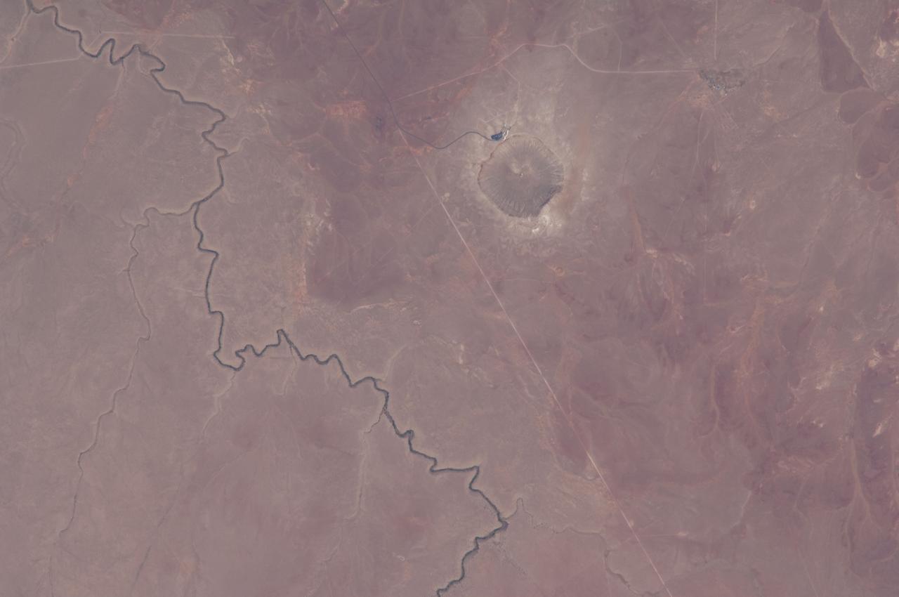
Martian Meteor Crater
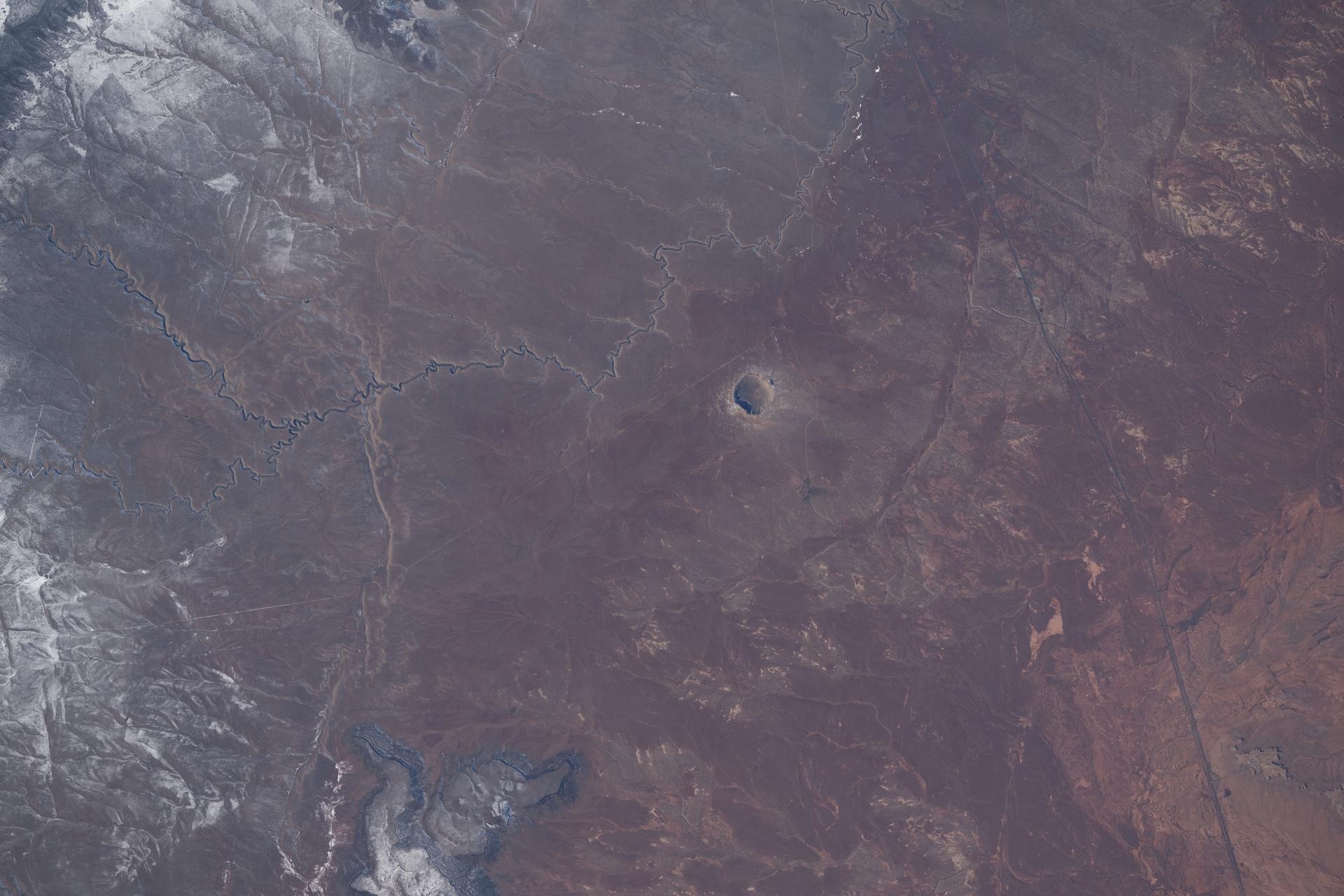
iss074e0208832 (Jan. 26, 2026) --- Meteor Crater in Arizona, a meteorite impact site approximately 4,000 feet in diameter and formed about 50,000 years ago in the high desert of the Colorado Plateau, is pictured from the International Space Station as it orbited 260 miles above the southwestern United States.

Barringer Crater, also known as Meteor Crater, is a 1,300-meter 0.8 mile diameter, 174-meter 570-feet deep hole in the flat-lying desert sandstones 30 kilometers 18.6 miles west of Winslow, Arizona.

The Barringer Meteorite Crater (also known as "Meteor Crater") is a gigantic hole in the middle of the arid sandstone of the Arizona desert. A rim of smashed and jumbled boulders, some of them the size of small houses, rises 50 m above the level of the surrounding plain. The crater itself is nearly a 1500 m wide, and 180 m deep. When Europeans first discovered the crater, the plain around it was covered with chunks of meteoritic iron - over 30 tons of it, scattered over an area 12 to 15 km in diameter. Scientists now believe that the crater was created approximately 50,000 years ago. The meteorite which made it was composed almost entirely of nickel-iron, suggesting that it may have originated in the interior of a small planet. It was 50 m across, weighed roughly 300,000 tons, and was traveling at a speed of 65,000 km per hour. This ASTER 3-D perspective view was created by draping an ASTER bands 3-2-1image over a digital elevation model from the US Geological Survey National Elevation Dataset. This image was acquired on May 17, 2001 by the Advanced Spaceborne Thermal Emission and Reflection Radiometer (ASTER) on NASA's Terra satellite. With its 14 spectral bands from the visible to the thermal infrared wavelength region, and its high spatial resolution of 15 to 90 meters (about 50 to 300 feet), ASTER will image Earth for the next 6 years to map and monitor the changing surface of our planet. http://photojournal.jpl.nasa.gov/catalog/PIA03490

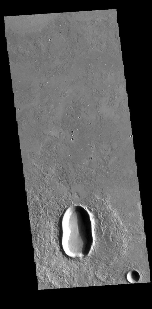
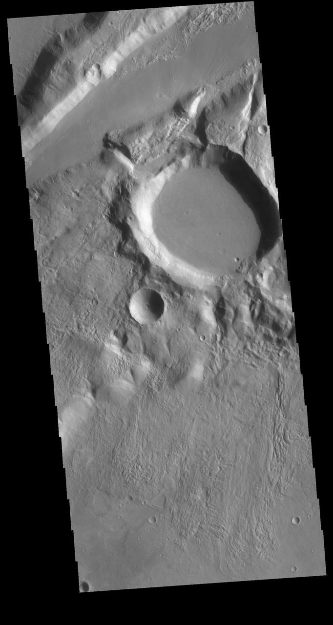
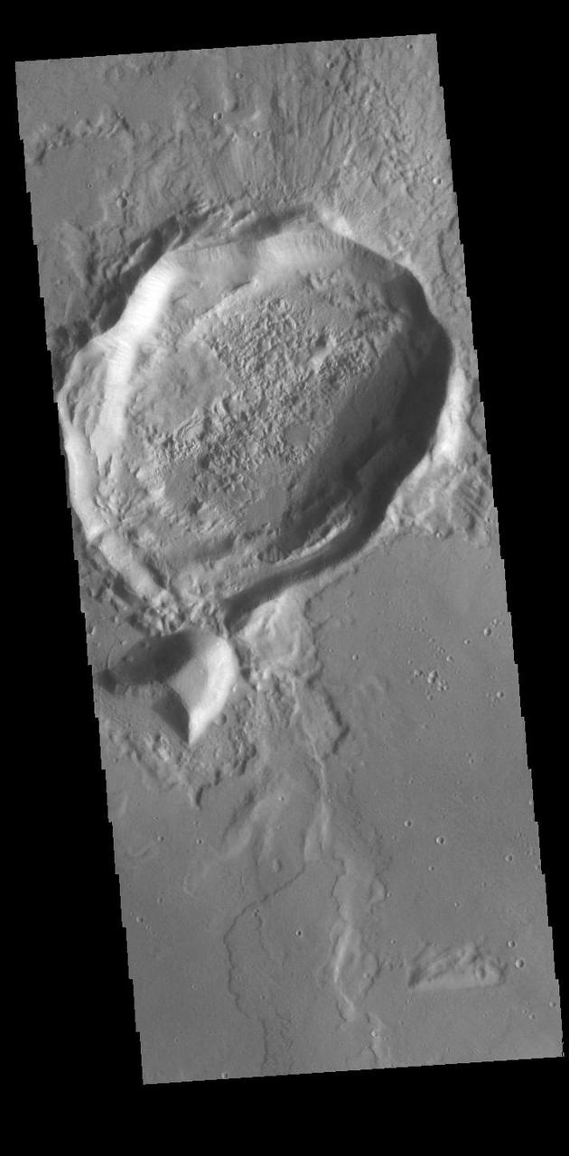
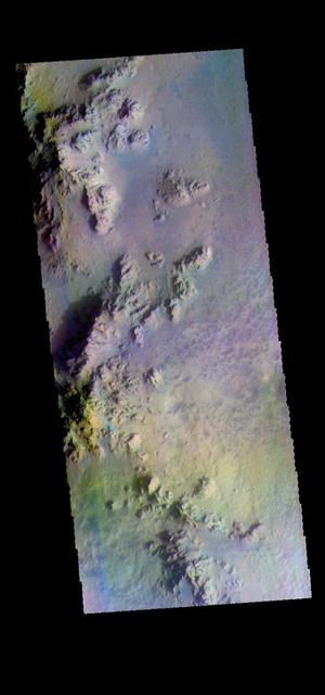
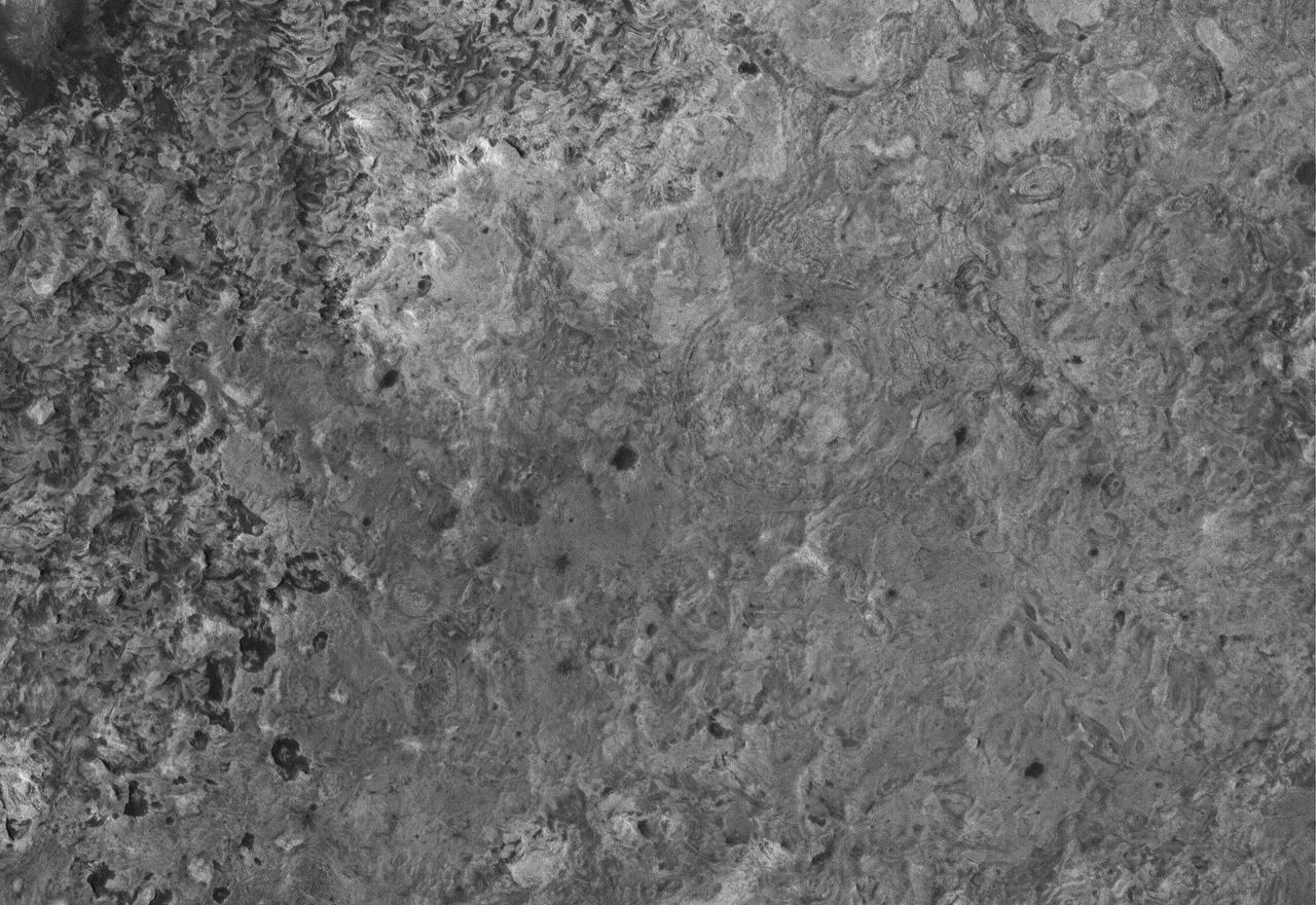
This MOC image shows an impact crater on the martian northern plains. This crater is roughly the size of the famous Meteor Crater in Arizona on the North American continent

This MOC image shows some a modest-sized meteor impact crater in the Elysium Planitia region of Mars. The dark spot inside the crater is, most likely, a patch of windblown sand and silt
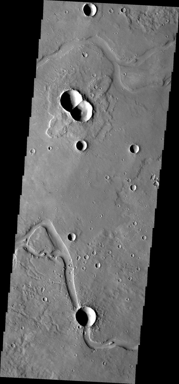
This image from NASA Mars Odyssey is of a doublet crater located in Utopia Planitia, near the Elysium Volcanic region. Doublet craters are formed by simultaneous impact of a meteor that broke into two pieces prior to hitting the surface.
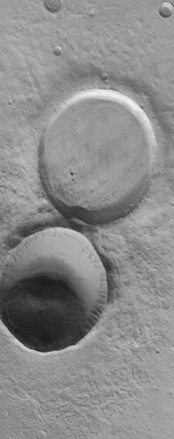
This MOC image shows adjacent impact craters located north-northwest of the Acheron Fossae region of Mars. The two craters are of similar size and formed by meteor impacts. However, one is much more filled than the other, indicating that it is older
The ejecta blanket of the crater in this image from NASA Mars Odyssey spacecraft does not resemble the blocky, discontinuous ejecta associated with most fresh craters on Mars. Rather, the continuous lobes of material seen around this crater are evidence that the crater ejecta were fluidized upon impact of the meteor that formed this crater. Impact ejecta become fluidized when a meteor strikes a surface that has a considerable volatile content. The volatiles mixed with the ejecta form a flow of material that moves outward from the crater and produces the morphology seen in this THEMIS visible image. http://photojournal.jpl.nasa.gov/catalog/PIA04025
Earth Observation taken during a day pass by the Expedition 40 crew aboard the International Space Station (ISS). Folder lists this as: EOS Barringer Meteor Crater.
This unnamed crater in Utopia Planitia is shaped like a peanut shell, with an indentation in the crater rim at the middle of the crater. It is likely that this crater was created by a dual impact. In a dual (or double) impact the incoming meteor is broken into two or more pieces which impact together into the surface. This type of impact often has a unique ejecta blanket shape, pinched at the center making a butterfly shape, and a pronounced inner rim jutting out at the center. The ejecta blanket in this case does not show the butterfly shape, and the middle rim is on slightly visible on the left side of the crater. These irregularities may indicate the the meteor pieces were still very close together when they hit the surface. Orbit Number: 95144 Latitude: 31.6611 Longitude: 128.303 Instrument: VIS Captured: 2023-05-27 11:12 https://photojournal.jpl.nasa.gov/catalog/PIA26261
NASA scientists will venture into an isolated part of the Bolivian Amazon to try and uncover the origin of a 5 mile (8 kilometer) diameter crater there known as the Iturralde Crater. Traveling to this inhospitable forest setting, the Iturralde Crater Expedition 2002 will seek to determine if the unusual circular crater was created by a meteor or comet. Organized by Dr. Peter Wasilewski of NASA's Goddard Space Flight Center, Greenbelt, Md., the Iturralde Crater Expedition 2002 will be led by Dr. Tim Killeen of Conservation International, which is based in Bolivia. Killeen will be assisted by Dr. Compton Tucker of Goddard. The team intends to collect and analyze rocks and soil, look for glass particles that develop from meteor impacts and study magnetic properties in the area to determine if the Iturralde site was indeed created by a meteor. This image was acquired on June 29, 2001 by the Advanced Spaceborne Thermal Emission and Reflection Radiometer (ASTER) on NASA's Terra satellite. With its 14 spectral bands from the visible to the thermal infrared wavelength region, and its high spatial resolution of 15 to 90 meters (about 50 to 300 feet), ASTER will image Earth for the next 6 years to map and monitor the changing surface of our planet. http://photojournal.jpl.nasa.gov/catalog/PIA03859
This image from NASA Mars Reconnaissance Orbiter spacecraft is of a morphologically fresh and simple impact crater in the Hellespontus region. At 1.3 kilometers in diameter, this unnamed crater is only slightly larger than Arizona's Barringer (aka Meteor) Crater, by about 200 meters. Note the simple bowl shape and the raised crater rim. Rock and soil excavated out of the crater by the impacting meteor -- called ejecta -- forms the ejecta deposit. It is continuous for about one crater radius away from the rim and is likely composed of about 90 percent ejecta and 10 percent in-place material that was re-worked by both the impact and the subsequently sliding ejecta. The discontinuous ejecta deposit extends from about one crater radius outward. Here, high velocity ejecta that was launched from close to the impact point -- and got the biggest kick -- flew a long way, landed, rolled, slid, and scoured the ground, forming long tendrils of ejecta and v-shaped ridges. http://photojournal.jpl.nasa.gov/catalog/PIA20340
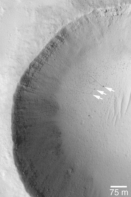
15 July 2004 The arrows in this Mars Global Surveyor (MGS) Mars Orbiter Camera (MOC) picture point to three boulders that left trails behind them as they rolled down the lower parts of a meteor crater's wall. In two cases, the tracks can be resolved into a series of small depressions, indicating the variable shape of the boulder as it unevenly proceeded down the slope. These features are located near 18.4°N, 120.1°W. The 75 meter scale bar is about 246 feet long. Sunlight illuminates the scene from the lower left. http://photojournal.jpl.nasa.gov/catalog/PIA06450
Today's VIS image shows an unnamed channel in Libya Montes. Libya Montes are south of Isidis Planitia, and are remnants of the crater rim created by the Isidis meteor impact. Orbit Number: 85899 Latitude: 2.26071 Longitude: 84.8385 Instrument: VIS Captured: 2021-04-26 05:34 https://photojournal.jpl.nasa.gov/catalog/PIA24886
Today's VIS image shows a section of unnamed channel in Libya Montes. Libya Montes are south of Isidis Planitia, and are remnants of the crater rim created by the Isidis meteor impact. Orbit Number: 80795 Latitude: 0.708331 Longitude: 89.3586 Instrument: VIS Captured: 2020-03-01 23:28 https://photojournal.jpl.nasa.gov/catalog/PIA23904

Today's VIS image shows part of the floor of Hale Crater and the elongate axis of the central peak mountains. Hale Crater is an example of an oblique impact crater. The mountain chain trends from the southeast towards the northwest, increasing in height towards the northwest. The incoming meteor struck the surface along this trend, forming an oval crater and displacing the impact energy forward to create the central mountain range. Hale Crater is located near the northern part of Argye Plainitia. Orbit Number: 74954 Latitude: -35.5134 Longitude: 323.598 Instrument: VIS Captured: 2018-11-06 22:53 https://photojournal.jpl.nasa.gov/catalog/PIA22994
Today's VIS image shows part of the floor of Hale Crater and the elongate axis of the central peak mountains. Hale Crater is an example of an oblique impact crater. The mountain chain trends from the southeast towards the northwest, increasing in height towards the northwest. The incoming meteor struck the surface along this trend, forming an oval crater and displacing the impact energy forward to create the central mountain range. Hale Crater is located near the northern part of Argye Plainitia. Orbit Number: 91600 Latitude: -35.5357 Longitude: 323.628 Instrument: VIS Captured: 2022-08-08 14:50 https://photojournal.jpl.nasa.gov/catalog/PIA25609
The large crater in this image is called Gandzani Crater. The crater is not circular, but appears to have "corners". This crater is located in Mareotis Fossae, a huge complex of graben that make up part of Tempe Terra. The tectonic activity would include subsurface fracturing, which would have deflected impact pressures along fault faces. Meteor Crater in Arizona has "corners" due to the same tectonic forcing of impact pressures. Orbit Number: 79104 Latitude: 34.6565 Longitude: 268.965 Instrument: VIS Captured: 2019-10-14 17:58 https://photojournal.jpl.nasa.gov/catalog/PIA23567
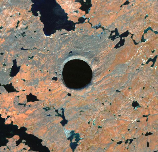
In Nunavik Province, far northern Canada, the Pingualuit Crater is known as the "Crystal Eye" to the Inuit. Once thought to be a possible diamond-bearing kimberlite pipe, the 3.5 km diameter circular structure is now known to be a meteor crater, formed about 1.4 million years ago. The image was acquired October 1, 2021, covers an area of 14.9 by 15.2 km, and is located at 61.3 degrees north, 73.7 degrees west. https://photojournal.jpl.nasa.gov/catalog/PIA25276
SL4-93-067 (16 Nov. 1973-8 Feb. 1974) --- A spectacular winter view of the Flagstaff, Arizona area is seen in this Skylab 4 Earth Resources Experiments package S190-B (five-inch earth terrain camera) infrared photograph taken from the Skylab space station in Earth orbit. Included in the scene are the San Francisco Mountains, Oak Creek Canyon, Painted Desert and Meteor Crater. The infrared picture depicts in red living vegetation, in white the snow, and in bright blue the water. Major features identified in this photograph are Humphrey's peak, top center, Flagstaff at foot of the peak, Sunset Crater volcanic field with numerous vents and craters right of Flagstaff and Meteor Crater (right center). Within the mountainous areas several clear areas generally rectangular are visible and represent the areas where lumbering has removed the forest. The thin white line extending from left corner to Sunset Crater fields is the power transmission line cleared area. Roads are subdued and are not easily visible. Photo credit: NASA
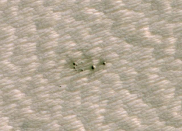
The High-Resolution Imaging Science Experiment (HiRISE) camera aboard NASA's Mars Reconnaissance Orbiter took this image of a crater cluster on Mars, the first ever to be discovered artificial intelligence (AI). The AI first spotted the craters in images taken the orbiter's Context Camera; scientists followed up with this HiRISE image to confirm the craters. The Context Camera's view of the craters can be found in PIA24091. These craters created by several pieces of a single meteor. The largest of the craters is about 13 feet (4 meters) wide. In total, the craters span about 100 feet (30 meters) of the Red Planet's surface. The craters were found in a region called Noctis Fossae, located at latitude -3.213, longitude 259.415. https://photojournal.jpl.nasa.gov/catalog/PIA24040
While the crater in this VIS image was crated by an impact event, the resultant form is not the normal circular shape. There are several factors that can create 'out of round' craters. The most common is subsurface faulting from tectonic activity. Pre-existing subsurface fractures can deflect impact pressures along the fault faces, rather than uniformly radially from the center of impact. Meteor Crater in Arizona has "corners" due to the same tectonic forcing of impact pressures. Orbit Number: 89615 Latitude: 31.7702 Longitude: 156.612 Instrument: VIS Captured: 2022-02-26 05:06 https://photojournal.jpl.nasa.gov/catalog/PIA25404
This full resolution mosaiced image covers an area of approximately 100 kilometers by 120 kilometers (62 by 74 miles) and is located in the Lakshmi region of Venus at 47 degrees north latitude and 334 east longitude. Due to the dense Venusian atmosphere, primary impact craters of less than a 3 kilometer (2 mile) diameter are nonexistent. The dark circular region and associated central bright feature in this image are thought to be the remnants of a meteoroid smaller than the size necessary to create an impact crater entering the atmosphere at a low velocity (approximately 350 meters/second.) The central bright feature appears to be a cluster of small secondary impacts, ejecta and debris from the original meteor that broke up in the atmosphere. Even though most of the meteorite did not hit the surface, the atmospheric shock wave could be great enough to modify the surrounding region. One explanation for this radar dark circular formation, called dark margins, could be that the shock wave was energetic enough to pulverize the surface (smooth surfaces generally appear radar dark.) Another explanation is that the surface could be blanketed by a fine material that was formed by the original meteor's breakup through the atmosphere. More than half of the impact craters on Venus have associated dark margins, and most of these are prominently located left of center of the crater. This is another effect which could be caused by the dense atmosphere of Venus. http://photojournal.jpl.nasa.gov/catalog/PIA00477

Looking east to west across the rim and down into Chaplygin crater reveals this beautiful example of a fresh young crater and its perfectly preserved ejecta blanket. The delicate patterns of flow across, over, and down local topography clearly show that ejecta traveled as a ground hugging flow for great distances, rather than simply being tossed out on a ballistic trajectory. Very near the rim lies a dark, lacy, discontinuous crust of now frozen impact melt. Clearly this dark material is on top of the bright material so it was the very last material ejected from the crater. The melt was formed as the tremendous energy of impact was converted to heat and the lunar crust was melted at the impact point. As the crater rebounded and material sloughed down the walls of the deforming crater the melt was splashed out over the rim and froze. Its low reflectance is mostly due to a high percentage of glass because the melt cooled so quickly that minerals did not have time to crystallize. The fact that the delicate splash patterns are so well preserved testifies to the very young age of this crater. But how young? For comparison "Chappy" (informal name) is 200 m larger than Meteor crater (1200 m diameter) in Arizona, which is about 50,000 years old. Craters of this size form every 100,000 years or so on the Moon and the Earth. Since there are very few superposed craters on Chappy, and its ejecta is so perfectly preserved it may be much younger than Meteor crater. However, we can't know the true true absolute age of "Chappy" until we can obtain a sample of its impact melt for radiometric age dating. Credit: NASA/Goddard/Arizona State University/LRO/LROC
Looking east to west across the rim and down into Chaplygin crater reveals this beautiful example of a fresh young crater and its perfectly preserved ejecta blanket. The delicate patterns of flow across, over, and down local topography clearly show that ejecta traveled as a ground hugging flow for great distances, rather than simply being tossed out on a ballistic trajectory. Very near the rim lies a dark, lacy, discontinuous crust of now frozen impact melt. Clearly this dark material is on top of the bright material so it was the very last material ejected from the crater. The melt was formed as the tremendous energy of impact was converted to heat and the lunar crust was melted at the impact point. As the crater rebounded and material sloughed down the walls of the deforming crater the melt was splashed out over the rim and froze. Its low reflectance is mostly due to a high percentage of glass because the melt cooled so quickly that minerals did not have time to crystallize. The fact that the delicate splash patterns are so well preserved testifies to the very young age of this crater. But how young? For comparison "Chappy" (informal name) is 200 m larger than Meteor crater (1200 m diameter) in Arizona, which is about 50,000 years old. Craters of this size form every 100,000 years or so on the Moon and the Earth. Since there are very few superposed craters on Chappy, and its ejecta is so perfectly preserved it may be much younger than Meteor crater. However, we can't know the true true absolute age of "Chappy" until we can obtain a sample of its impact melt for radiometric age dating. Investigate all of Chappy's ejecta, at full resolution: <a href="http://lroc.sese.asu.edu/posts/901" rel="nofollow">lroc.sese.asu.edu/posts/901</a> Credit: NASA/Goddard/Arizona State University/LRO/LROC
Looking east to west across the rim and down into Chaplygin crater reveals this beautiful example of a fresh young crater and its perfectly preserved ejecta blanket. The delicate patterns of flow across, over, and down local topography clearly show that ejecta traveled as a ground hugging flow for great distances, rather than simply being tossed out on a ballistic trajectory. Very near the rim lies a dark, lacy, discontinuous crust of now frozen impact melt. Clearly this dark material is on top of the bright material so it was the very last material ejected from the crater. The melt was formed as the tremendous energy of impact was converted to heat and the lunar crust was melted at the impact point. As the crater rebounded and material sloughed down the walls of the deforming crater the melt was splashed out over the rim and froze. Its low reflectance is mostly due to a high percentage of glass because the melt cooled so quickly that minerals did not have time to crystallize. The fact that the delicate splash patterns are so well preserved testifies to the very young age of this crater. But how young? For comparison "Chappy" (informal name) is 200 m larger than Meteor crater (1200 m diameter) in Arizona, which is about 50,000 years old. Craters of this size form every 100,000 years or so on the Moon and the Earth. Since there are very few superposed craters on Chappy, and its ejecta is so perfectly preserved it may be much younger than Meteor crater. However, we can't know the true true absolute age of "Chappy" until we can obtain a sample of its impact melt for radiometric age dating. Investigate all of Chappy's ejecta, at full resolution: <a href="http://lroc.sese.asu.edu/posts/901" rel="nofollow">lroc.sese.asu.edu/posts/901</a> Credit: NASA/Goddard/Arizona State University/LRO/LROC

Looking east to west across the rim and down into Chaplygin crater reveals this beautiful example of a fresh young crater and its perfectly preserved ejecta blanket. The delicate patterns of flow across, over, and down local topography clearly show that ejecta traveled as a ground hugging flow for great distances, rather than simply being tossed out on a ballistic trajectory. Very near the rim lies a dark, lacy, discontinuous crust of now frozen impact melt. Clearly this dark material is on top of the bright material so it was the very last material ejected from the crater. The melt was formed as the tremendous energy of impact was converted to heat and the lunar crust was melted at the impact point. As the crater rebounded and material sloughed down the walls of the deforming crater the melt was splashed out over the rim and froze. Its low reflectance is mostly due to a high percentage of glass because the melt cooled so quickly that minerals did not have time to crystallize. The fact that the delicate splash patterns are so well preserved testifies to the very young age of this crater. But how young? For comparison "Chappy" (informal name) is 200 m larger than Meteor crater (1200 m diameter) in Arizona, which is about 50,000 years old. Craters of this size form every 100,000 years or so on the Moon and the Earth. Since there are very few superposed craters on Chappy, and its ejecta is so perfectly preserved it may be much younger than Meteor crater. However, we can't know the true true absolute age of "Chappy" until we can obtain a sample of its impact melt for radiometric age dating. Credit: NASA/Goddard/Arizona State University/LRO/LROC
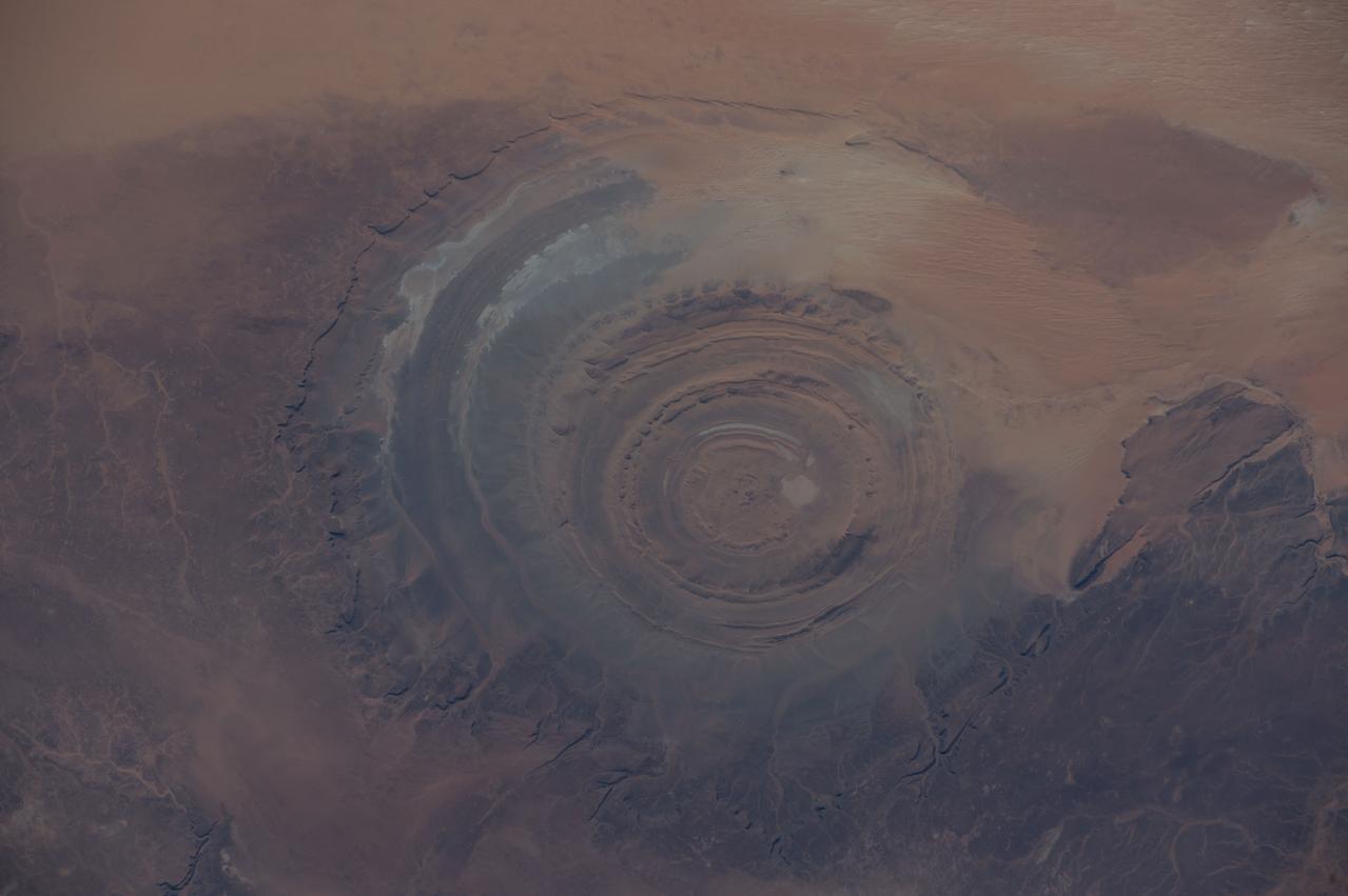
ISS042E007131 (11/22/2014) — Astronauts aboard the International Space Station captured this image of a huge crater in Africa on Nov. 22, 2014. This is the Richat Structure in northwestern Mauritania, otherwise known as the “Eye of the Sahara.” Scientists are still deciding whether this was formed by a subterranean volcano or impact from a large meteor. Deep in the Sahara Desert it is nearly a perfect circle, it is 1.2 miles (1.9 kilometers) wide, and sports a rim 330 feet (100 meters) tall. The crater sits in a vast plain of rocks so ancient they were deposited hundreds of millions of years before the first dinosaurs walked the Earth.

This VIS image shows a double impact - two meteors hitting simultaneously. The two meteors would have started as a single object, at some point prior to impact the object separated into parts. The two parts followed the same path to the surface, hitting at the same time in close proximity. The linear feature at the center is where the shock waves intersect, its straightness showing the impacts were simultaneous (and nearly equal in size). The ejecta created from the impact tends to be focused to the sides of the doublet, often forming a butterfly-like ejecta blanket. The butterfly pattern is most common at oblique angle impacts, but can also form by the interaction of the impact shock waves. These craters are located in Utopia Planitia. Orbit Number: 72448 Latitude: 27.1977 Longitude: 95.4916 Instrument: VIS Captured: 2018-04-14 13:36 https://photojournal.jpl.nasa.gov/catalog/PIA22606
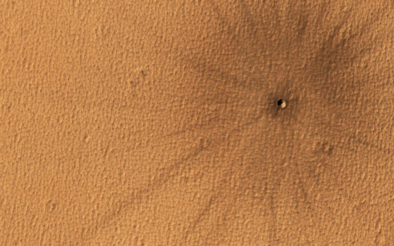
Mars and the Earth run into debris in space regularly, and on our planet, meteors usually vaporize in the atmosphere. On Mars however, with a surface pressure 1/100th that of the Earth, the impactors generally make it to the surface. This particular impact took place on Mars sometime in the last 5 years. Although the crater is small, the rays of ejecta thrown out by the impact are easy to spot, stretching out almost a kilometer. https://photojournal.jpl.nasa.gov/catalog/PIA24694
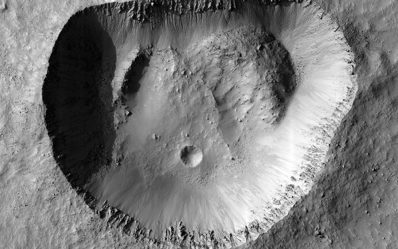
Most craters are round, because a high-velocity impact acts like a powerful explosion that expands in all directions. This crater is an exception because the northern rim is almost perfectly straight. One possibility is that there was a zone of joints or faults in the crust that existed before the impact. When the impact happened, the crater formed along the straight line of these faults. Something similar happened to Meteor Crater in Arizona. Our image doesn't show any faults, but they could be beneath the surface. Perhaps some sort of uneven collapse changed the shape of the crater. There are piles of material on the crater's floor, especially in the northwest and northeast corners. If those piles fell down from the rim, why did it happen there and not in other places? This crater is near the size where larger craters start to show wall slumping and terraces, so this type of collapse could be occurring unevenly. Our image reveals the crisp detail of the crater rim, with individual boulders around the outside and on the inner walls. That indicates that this crater probably isn't very old, so it hasn't been heavily modified. So somehow this odd shape probably happened when it first formed, although we still don't know exactly why. https://photojournal.jpl.nasa.gov/catalog/PIA23953
This image is located along the margin between Terra Cimmeria and Elysium Planitia. This boundary region is typified by tectonic fractures forming long, linear depressions. The crater in the lower half of the image has a hexagon shape rather than the normal circular outline. The regional surface/subsurface fracture system deflected the impact generated pressure waves along the tectonic network, causing the linear sides we see in the image. Meteor Crater in northern Arizona has a similar flat sided shape, in that case a square rather than a hexagon. The Arizona crater impacted into sandstone and limestone that had a right angle fracture system. Orbit Number: 78210 Latitude: -7.13006 Longitude: 147.811 Instrument: VIS Captured: 2019-08-02 02:56 https://photojournal.jpl.nasa.gov/catalog/PIA23448

ISS030-E-254011 (21 April 2012) --- The Ouarkziz Impact Crater is featured in this image photographed by an Expedition 30 crew member on the International Space Station. The Ouarkziz Impact Crater is located in northwestern Algeria close to the border with Morocco. According to scientists, the crater was formed by a meteor impact less than 70 million years ago during the late Cretaceous Period of the Mesozoic Era or “Age of Dinosaurs”. Originally called Tindouf, the 3.5-kilometer in diameter impact crater (center) has been heavily eroded since its formation; however its circular morphology is highlighted by exposures of older sedimentary rock layers that form roughly northwest-to-southeast-trending ridgelines to the north and south. From the vantage point of a crew member onboard the space station, the impact crater is clearly visible with a magnifying camera lens. A geologist interpreting this image to build a working geological history of the region would conclude that the Ouarkziz impact crater is younger than the sedimentary rocks, as the rock layers had to be already present for the meteor to hit them. Likewise, a stream channel is visible cutting across the center of the impact structure (center), indicating that the channel formed after the impact had occurred. This Principal of Cross-Cutting Relationships, usually attributed to the famous 19th century geologist Charles Lyell, is a basic logic tool used by geologists to build relative sequence and history of events when investigating a region.
This false color image shows part of the floor of Hale Crater and the elongate axis of the central peak mountains. Hale Crater is an example of an oblique impact crater. The mountain chain trends from the southeast towards the northwest, increasing in height towards the northwest. The incoming meteor struck the surface along this trend, forming an oval crater and displacing the impact energy forward to create the central mountain range. Hale Crater is 150 km x 125 km in diameter (93 miles x 77 miles) and is located near the northern part of Argye Plainitia. The THEMIS VIS camera contains 5 filters. The data from different filters can be combined in multiple ways to create a false color image. These false color images may reveal subtle variations of the surface not easily identified in a single band image. Orbit Number: 66105 Latitude: -35.5732 Longitude: 323.646 Instrument: VIS Captured: 2016-11-07 23:04 https://photojournal.jpl.nasa.gov/catalog/PIA23626
ISS030-E-005456 (26 Nov. 2011) --- Emi Koussi Volcano and Aorounga Impact Crater, Chad are featured in this image photographed by an Expedition 30 crew member on the International Space Station. This striking photograph features two examples of circular landscape features?labeled as craters?that were produced by very different geological processes. At left, the broad grey-green shield volcano of Emi Koussi is visible. The volcano is marked by three overlapping calderas formed by eruptions; these form a large oblong depression at the 3,415 meter ASL summit of the volcano. A smaller crater sits within the larger caldera depression. While volcanic activity has not been observed, nor is mentioned in the historical record, an active thermal area is located on the southern flank. The circular Aorounga Impact Crater is located approximately 110 kilometers to the southeast of Emi Koussi and has its origin in forces from above rather than eruptions from below. According to scientists, the Aorounga structure is thought to record a meteor impact approximately 345-370 million years ago. The circular feature visible at upper right may be only one of three impact craters formed by the same event ? the other two are buried by sand deposits. The linear features (lower right) that arc around Emi Koussi and overprint Aorounga and the surrounding bedrock are known as yardangs; these are rock ridges formed by wind erosion.
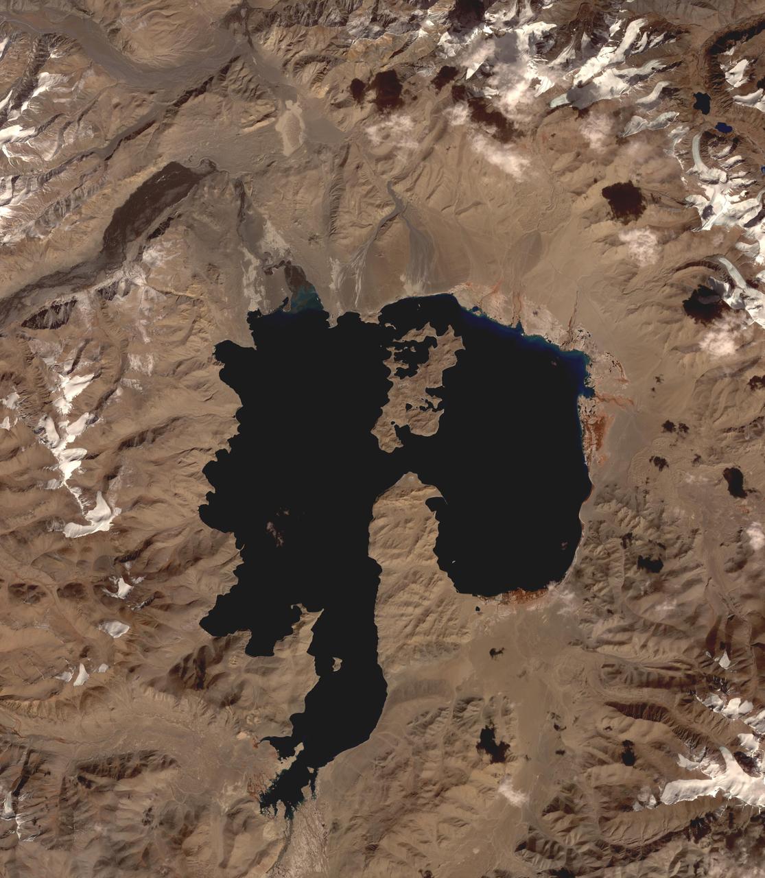
Lake Karakul in northeast Tajikistan is a hypersaline lake with no external drainage, receiving less than 3 cm precipitation per year. It is on the highest part of the fabled Pamir highway at 3900 m. In the local Kyrgyz language, the lake is called "The Black Lake". Recently, Russian scientists have suggested that the lake occupies a 200 million year old meteor impact crater. The image was acquired October 16, 2016, covers an area of 48 by 55 km, and is located at 39 degrees north, 73.4 degrees east. https://photojournal.jpl.nasa.gov/catalog/PIA23102
Today's VIS image is located on Lucus Planum. The surface in this image has been eroded by the wind to form features called yardangs. Yardangs form in a poorly cemented material where the wind cuts linear valleys, removing some of the material and leaving parallel ridges behind. The direction of the ridge/valley is aligned with the wind direction. The dominant wind direction in this region is along a northeast/southwest trend; however, other wind directions can occur within a localized region. There is a circular feature in the lower left side of the image. This is likely the remains of a crater. Meteor impacts melt the surface and subsurface, creating a harder material then the surrounding surfaces. The remnant of the crater are still visible due to being a more resistant material. Orbit Number: 81740 Latitude: -1.61604 Longitude: 187.227 Instrument: VIS Captured: 2020-05-18 18:55 https://photojournal.jpl.nasa.gov/catalog/PIA24008
This Mars Global Surveyor (MGS) Mars Orbiter Camera (MOC) image shows a high resolution view of a surface composed almost entirely of eroded, exposed sedimentary rock in the Sinus Meridiani region of Mars. If one could vacuum up all of the dark sand and dust that covers the rocks at the Mars Exploration Rover, Opportunity, site, one might find a surface similar to that shown here. Note, just right of center, the occurrence of a circular feature. This is the site of a filled and buried meteor impact crater. Filled and buried craters are common among the sedimentary rocks of the Meridiani region. Location near: 1.5°N, 359.4°W Image width: ~3 km (~1.9 mi) Illumination from: upper left Season: Northern Summer http://photojournal.jpl.nasa.gov/catalog/PIA07887
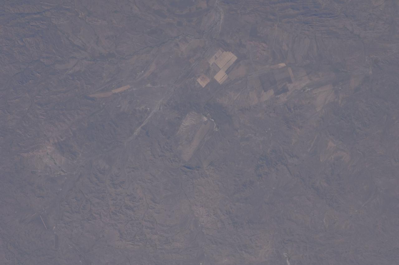
ISS028-E-044433 (8 Sept. 2011) --- Bigach Impact Crater in Kazakhstan is featured in this image photographed by an Expedition 28 crew member on the International Space Station. Some meteor impact craters, like Barringer Crater in Arizona, are easily recognizable on the landscape due to well-preserved form and features. Other impact structures, such as Bigach Impact Crater in northeastern Kazakhstan are harder to recognize due to their age, modification by subsequent geologic processes, or even human alteration of the landscape. According to scientists, at approximately 5 million years old, Bigach is a relatively young geologic feature; however active tectonic processes in the region have caused movement of parts of the structure along faults, leading to a somewhat angular appearance (center). The roughly circular rim of the eight kilometers in diameter structure is still discernable around the relatively flat interior in this photograph. In addition to modification by faulting and erosion, the interior of the impact structure has also been used for agricultural activities, as indicated by the presence of tan regular graded fields. Other rectangular agricultural fields are visible to the northeast and east. The closest settlement, Novopavlovka, is barely visible near the top of the image.
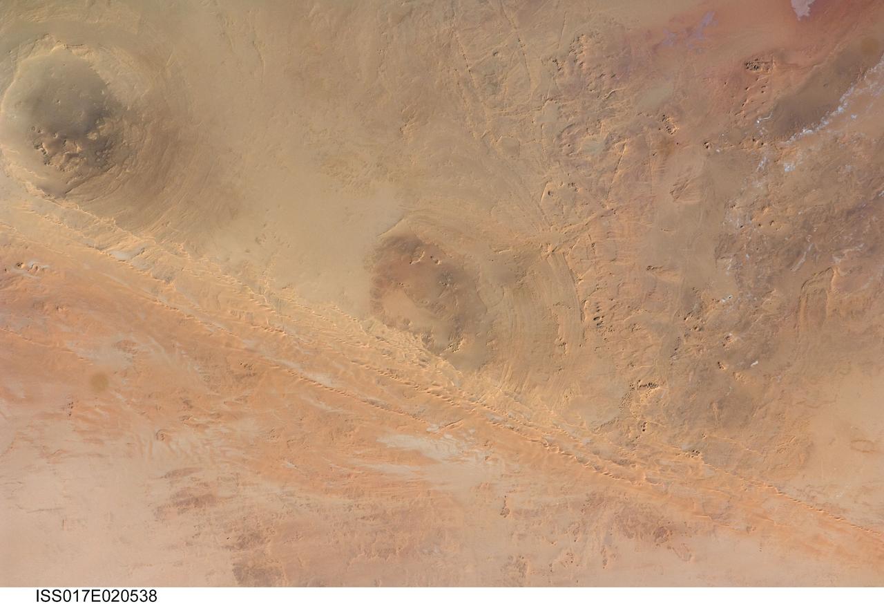
ISS017-E-020538 (21 Oct. 2008) --- Arkenu Craters 1 and 2 in Libya are featured in this image photographed by an Expedition 17 crewmember on the International Space Station. Geologists often study features on Earth, such as impact craters, to gain insight into processes that occur on other planets. On Earth, more than 150 impact craters have been identified on the continents, but only a few of these are classified as double impact craters. One such example, the Arkenu Craters in northern Africa, is shown in this image. Arkenu 1 and 2 are double impact structures located in eastern Libya (22.04 degrees north latitude and 23.45 degrees east longitude) in the Sahara desert, with diameters of approximately 6.8 kilometers and 10.3 kilometers, respectively. The craters are unusual in that they both exhibit concentric annular ridge structures (gray circles in the image indicate the position of the outermost visible ridges). In many terrestrial complex craters these features are highly eroded and no longer visible. While the circular structure of these features had been noted, the impact origin hypothesis was strengthened in December 2003 when a field team observed shatter cones -- conical-shaped features in rocks created by the high shock pressures generated during impact. Large outcrops of impact breccias -- a jumble of rock fragments generated at the impact site that are now cemented together into an identifiable rock layer -- were also observed by the field team. Two impactors, each approximately 500 meters in diameter, are thought to have created the craters. According to scientists, the age of the impact event has been dated as occurring less than 140 million years ago. While the presence of shatter cones and impact breccias is generally considered to be strong evidence for meteor impact, some scientists now question the interpretation of these features observed at the Arkenu structures and suggest that they were caused by erosive and volcanic processes. At present, both craters are being crossed by linear dunes extending northeast-southwest -- the superposition of the dunes across the annular ridges indicates that they are much younger than the craters.
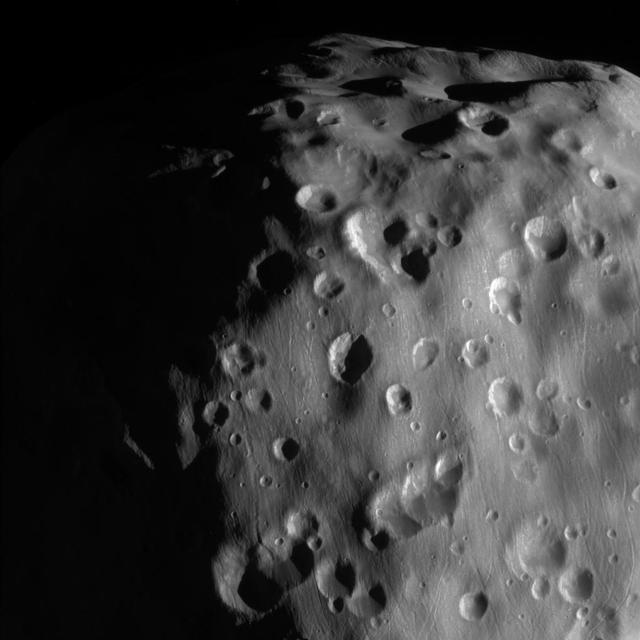
This zoomed-in view of Epimetheus, one of the highest resolution ever taken, shows a surface covered in craters, vivid reminders of the hazards of space. Epimetheus (70 miles or 113 kilometers across) is too small for its gravity to hold onto an atmosphere. It is also too small to be geologically active. There is therefore no way to erase the scars from meteor impacts, except for the generation of new impact craters on top of old ones. This view looks toward anti-Saturn side of Epimetheus. North on Epimetheus is up and rotated 32 degrees to the right. The image was taken with the Cassini spacecraft narrow-angle camera on Feb. 21, 2017 using a spectral filter which preferentially admits wavelengths of near-infrared light centered at 939 nanometers. The view was acquired at a distance of approximately 9,300 miles (15,000 kilometers) from Epimetheus and at a Sun-Epimetheus-spacecraft, or phase, angle of 71 degrees. Image scale is 290 feet (89 meters) per pixel. https://photojournal.jpl.nasa.gov/catalog/PIA21335
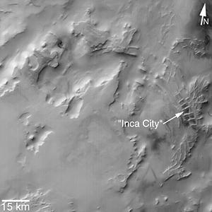
MGS MOC Release No. MOC2-319, 8 August 2002. "Inca City" is the informal name given by Mariner 9 scientists in 1972 to a set of intersecting, rectilinear ridges that are located among the layered materials of the south polar region of Mars. Their origin has never been understood; most investigators thought they might be sand dunes, either modern dunes or, more likely, dunes that were buried, hardened, then exhumed. Others considered them to be dikes formed by injection of molten rock (magma) or soft sediment into subsurface cracks that subsequently hardened and then were exposed at the surface by wind erosion. The Mars Global Surveyor (MGS) Mars Orbiter Camera (MOC) has provided new information about the "Inca City" ridges, though the camera's images still do not solve the mystery. The new information comes in the form of a MOC red wide angle context frame taken in mid-southern spring, shown above left and above right. The original Mariner 9 view of the ridges is seen at the center. The MOC image shows that the "Inca City" ridges, located at 82°S, 67°W, are part of a larger circular structure that is about 86 km (53 mi) across. It is possible that this pattern reflects an origin related to an ancient, eroded meteor impact crater that was filled-in, buried, then partially exhumed. In this case, the ridges might be the remains of filled-in fractures in the bedrock into which the crater formed, or filled-in cracks within the material that filled the crater. Or both explanations could be wrong. While the new MOC image shows that "Inca City" has a larger context as part of a circular form, it does not reveal the exact origin of these striking and unusual martian landforms. http://photojournal.jpl.nasa.gov/catalog/PIA03918
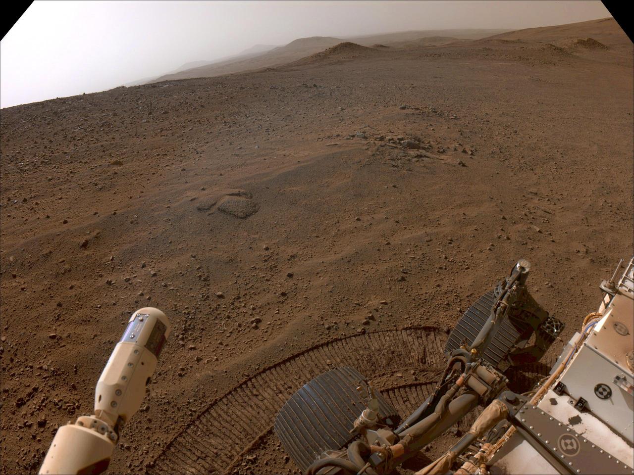
NASA's Perseverance Mars rover used its right-front navigation camera to capture this first view over the rim of Jezero Crater on Dec. 10, 2024, the 1,354th Martian day, or sol, of the mission, when it reached the end of its long climb from the crater floor. The rover is looking west in this image from a location nicknamed "Lookout Hill." Not visible is "Witch Hazel Hill," a scientifically significant rocky outcrop that Perseverance is headed toward. Once there, the rover will spend about six months exploring the area. Scientists are excited to explore the region outside of Jezero because the rover will encounter rocks excavated by a monster meteor impact that formed the crater an estimated 3.9 billion years ago. These rocks could not only be early Martian crust, but among the oldest rocks found anywhere in the solar system. A key objective for Perseverance's mission on Mars is astrobiology, including the search for signs of ancient microbial life. The rover will characterize the planet's geology and past climate, pave the way for human exploration of the Red Planet, and be the first mission to collect and cache Martian rock and regolith (broken rock and dust). Subsequent NASA missions, in cooperation with ESA (European Space Agency), would send spacecraft to Mars to collect these sealed samples from the surface and return them to Earth for in-depth analysis. The Mars 2020 Perseverance mission is part of NASA's Moon to Mars exploration approach, which includes Artemis missions to the Moon that will help prepare for human exploration of the Red Planet. https://photojournal.jpl.nasa.gov/catalog/PIA26511