Mike Miller, senior vice president, Science and Environmental Satellite Programs, Orbital Sciences Space Systems Group, discusses the successful launch of the Orbiting Carbon Observatory-2 (OCO-2), NASA’s first spacecraft dedicated to studying carbon dioxide, during a press briefing, Wednesday, July 2, 2014, at the Vandenberg Air Force Base, Calif. OCO-2 will measure the global distribution of carbon dioxide, the leading human-produced greenhouse gas driving changes in Earth’s climate. Photo Credit: (NASA/Bill Ingalls)

Mike Miller, senior vice president, Science and Environmental Satellite Programs, Orbital Sciences Space Systems Group, discusses the successful launch of the Orbiting Carbon Observatory-2 (OCO-2), NASA’s first spacecraft dedicated to studying carbon dioxide, during a press briefing, Wednesday, July 2, 2014, at the Vandenberg Air Force Base, Calif. OCO-2 will measure the global distribution of carbon dioxide, the leading human-produced greenhouse gas driving changes in Earth’s climate. Photo Credit: (NASA/Bill Ingalls)
Ralph Basilio, OCO-2 project manager, Jet Propulsion Laboratory, left, Mike Miller, senior vice president, Science and Environmental Satellite Programs, Orbital Sciences Space Systems Group,and Geoff Yoder, deputy associate administrator for programs, Science Mission Directorate, NASA Headquarters, right, discuss the successful launch of the Orbiting Carbon Observatory-2 (OCO-2), NASA’s first spacecraft dedicated to studying carbon dioxide, during a press briefing, Wednesday, July 2, 2014, at the Vandenberg Air Force Base, Calif. OCO-2 will measure the global distribution of carbon dioxide, the leading human-produced greenhouse gas driving changes in Earth’s climate. Photo Credit: (NASA/Bill Ingalls)

Mike Miller demonstrates one of the backpacks his team designed and built for the Desert Research and Technology Studies project's upcoming field test in Arizona. Miller led the team that developed the backpacks. The backpacks are equipped with GPS antennas, communications components and cameras. They are meant to show researchers what an astronaut might need to explore an alien world and give designers a look at the hardships the equipment could encounter. Photo credit: NASA/Frank Michaux

Engineers Juan Busto (left) and Mike Miller (right) work to install the communications network for the base camp during the Joint Extravehicular Activity and Human Surface Mobility Test Team Field Test 5 (JETT5) in the San Francisco Volcanic Field in Northern Arizona on May 11, 2024. Credit: NASA/Josh Valcarcel
KENNEDY SPACE CENTER, FLA. -- In the Vehicle Assembly Building, the repair work of hail damage on Atlantis' external tank is inspected. At left is Brian Miller, with NASA Quality Assurance; at right is Mike Ravenscroft, with United Space Alliance. In the front is Sabrena Yedo, with NASA Safety. In late February, Atlantis' external tank received hail damage during a severe thunderstorm that passed through the Kennedy Space Center Launch Complex 39 area. The hail caused visible divots in the giant tank's foam insulation as well as minor surface damage to about 26 heat shield tiles on the shuttle's left wing. The launch now is targeted for June 8. Photo credit: NASA/George Shelton
KENNEDY SPACE CENTER, FLA. - Project managers Mike Miller and Rex Eberhardt stand in front of the Swift spacecraft in Hangar AE at Cape Canaveral Air Force Station. Swift has been wrapped with blankets to provide thermal stability during the mission. Swift is a first-of-its-kind multi-wavelength observatory dedicated to the study of gamma-ray burst (GRB) science. Its three instruments will work together to observe GRBs and afterglows in the gamma-ray, X-ray, ultraviolet and optical wavebands. The most comprehensive study of GRB afterglows to date, Swift is expected to observe more than 200 gamma-ray bursts during its 2-year mission.
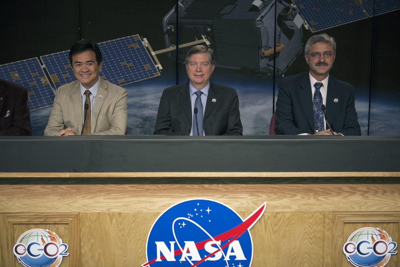
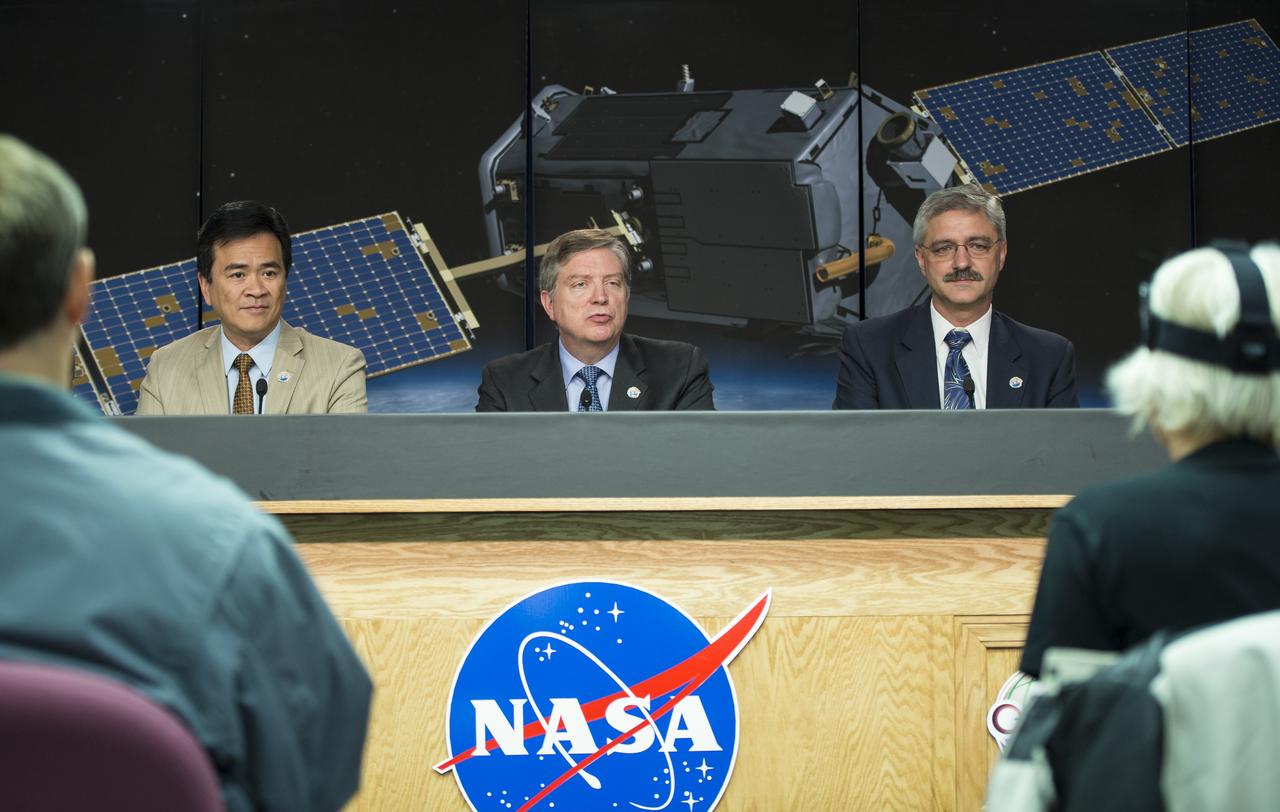
VANDENBERG AIR FORCE BASE, Calif. – A post-launch news conference is held at Vandenberg Air Force Base in California following the successful launch of NASA's Orbiting Carbon Observatory-2, or OCO-2. From left are Ralph Basilio, OCO-2 project manager at NASA's Jet Propulsion Laboratory Mike Miller, senior vice president, Science and Environmental Satellite Programs, Orbital Sciences Space Systems Group and Geoff Yoder, deputy associate administrator for Programs, Science Mission Directorate, NASA Headquarters. Liftoff of OCO-2 from Space Launch Complex 2 aboard a United Launch Alliance Delta II rocket was on schedule at 5:56 a.m. EDT on July 2 following the repair of the pad's water suppression system, which failed on the first launch attempt July 1. OCO-2 is NASA’s first mission dedicated to studying atmospheric carbon dioxide, the leading human-produced greenhouse gas driving changes in Earth’s climate. OCO-2 will provide a new tool for understanding the human and natural sources of carbon dioxide emissions and the natural "sinks" that absorb carbon dioxide and help control its buildup. The observatory will measure the global geographic distribution of these sources and sinks and study their changes over time. To learn more about OCO-2, visit http://www.nasa.gov/oco2. Photo credit: NASA/Kim Shiflett

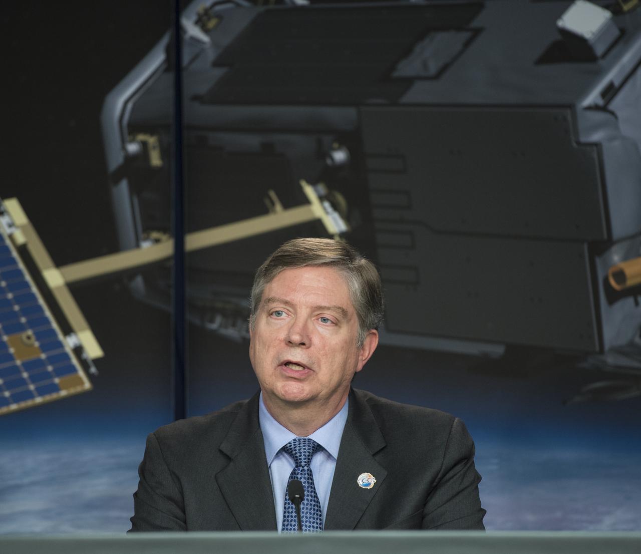
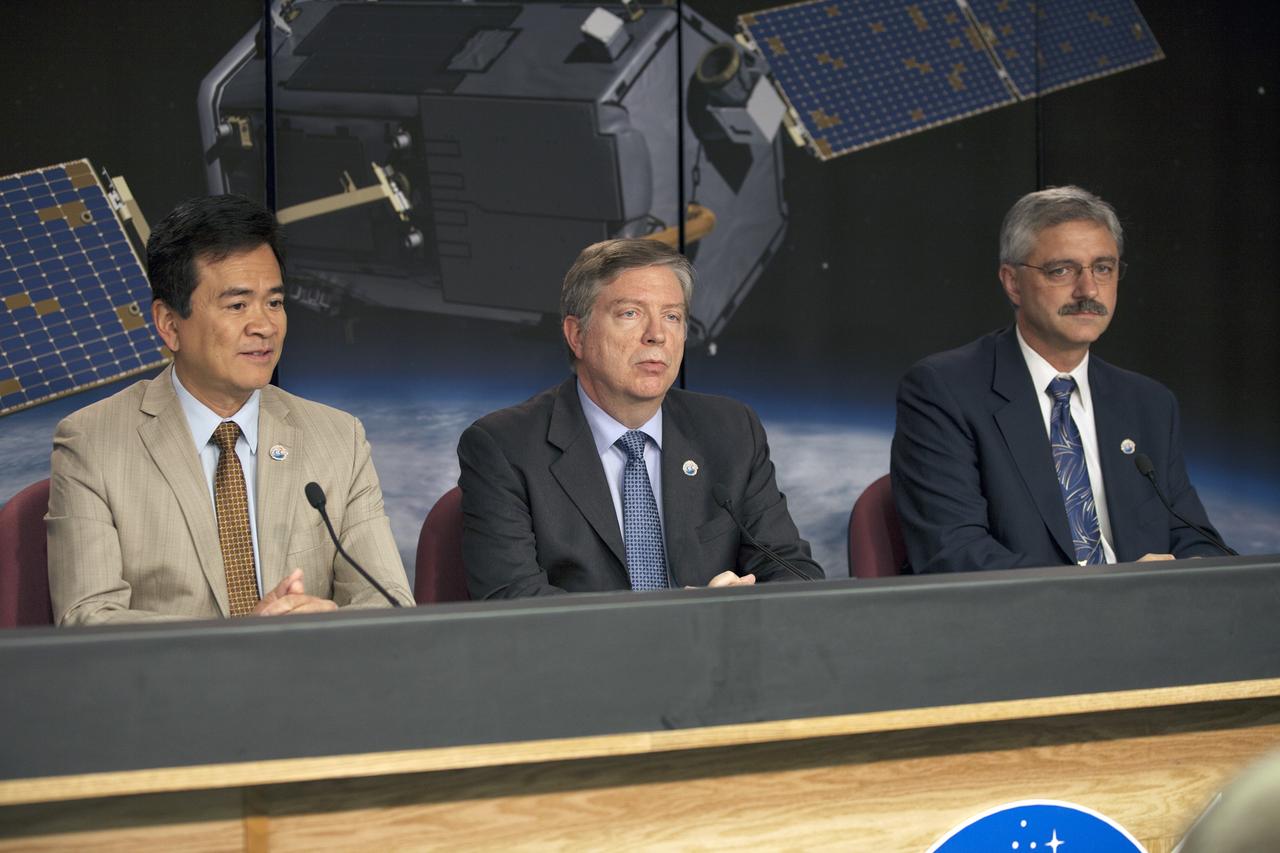
VANDENBERG AIR FORCE BASE, Calif. – Mike Miller, senior vice president, Science and Environmental Satellite Programs, Orbital Sciences Space Systems Group, participates in a post-launch news conference at Vandenberg Air Force Base in California following the successful launch of NASA's Orbiting Carbon Observatory-2, or OCO-2. Orbital Sciences built the satellite for NASA. Liftoff of OCO-2 from Space Launch Complex 2 aboard a United Launch Alliance Delta II rocket was on schedule at 5:56 a.m. EDT on July 2 following the repair of the pad's water suppression system, which failed on the first launch attempt July 1. OCO-2 is NASA’s first mission dedicated to studying atmospheric carbon dioxide, the leading human-produced greenhouse gas driving changes in Earth’s climate. OCO-2 will provide a new tool for understanding the human and natural sources of carbon dioxide emissions and the natural "sinks" that absorb carbon dioxide and help control its buildup. The observatory will measure the global geographic distribution of these sources and sinks and study their changes over time. To learn more about OCO-2, visit http://www.nasa.gov/oco2. Photo credit: NASA/Kim Shiflett
VANDENBERG AIR FORCE BASE, Calif. – A post-launch news conference is held at Vandenberg Air Force Base in California following the successful launch of NASA's Orbiting Carbon Observatory-2, or OCO-2. From left are Ralph Basilio, OCO-2 project manager at NASA's Jet Propulsion Laboratory Mike Miller, senior vice president, Science and Environmental Satellite Programs, Orbital Sciences Space Systems Group and Geoff Yoder, deputy associate administrator for Programs, Science Mission Directorate, NASA Headquarters. Liftoff of OCO-2 from Space Launch Complex 2 aboard a United Launch Alliance Delta II rocket was on schedule at 5:56 a.m. EDT on July 2 following the repair of the pad's water suppression system, which failed on the first launch attempt July 1. OCO-2 is NASA’s first mission dedicated to studying atmospheric carbon dioxide, the leading human-produced greenhouse gas driving changes in Earth’s climate. OCO-2 will provide a new tool for understanding the human and natural sources of carbon dioxide emissions and the natural "sinks" that absorb carbon dioxide and help control its buildup. The observatory will measure the global geographic distribution of these sources and sinks and study their changes over time. To learn more about OCO-2, visit http://www.nasa.gov/oco2. Photo credit: NASA/Kim Shiflett
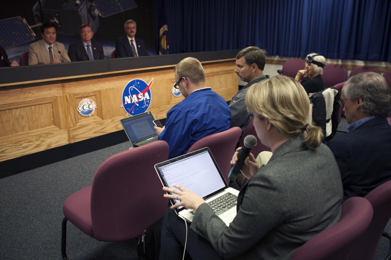
VANDENBERG AIR FORCE BASE, Calif. – Representatives of news and social media outlets participate in a post-launch news conference at Vandenberg Air Force Base in California following the successful launch of NASA's Orbiting Carbon Observatory-2, or OCO-2. On the dais, from left, are Ralph Basilio, OCO-2 project manager at NASA's Jet Propulsion Laboratory Mike Miller, senior vice president, Science and Environmental Satellite Programs, Orbital Sciences Space Systems Group and Geoff Yoder, deputy associate administrator for Programs, Science Mission Directorate, NASA Headquarters. Liftoff of OCO-2 from Space Launch Complex 2 aboard a United Launch Alliance Delta II rocket was on schedule at 5:56 a.m. EDT on July 2 following the repair of the pad's water suppression system, which failed on the first launch attempt July 1. OCO-2 is NASA’s first mission dedicated to studying atmospheric carbon dioxide, the leading human-produced greenhouse gas driving changes in Earth’s climate. OCO-2 will provide a new tool for understanding the human and natural sources of carbon dioxide emissions and the natural "sinks" that absorb carbon dioxide and help control its buildup. The observatory will measure the global geographic distribution of these sources and sinks and study their changes over time. To learn more about OCO-2, visit http://www.nasa.gov/oco2. Photo credit: NASA/Kim Shiflett
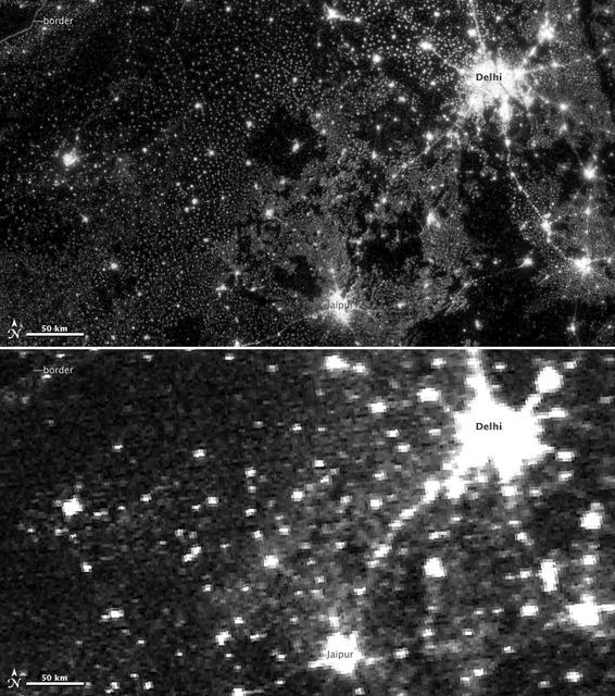
NASA image acquired November 11-12, 2012. On November 12, 2012, the Visible Infrared Imaging Radiometer Suite (VIIRS) on the Suomi NPP satellite captured the top nighttime image of city, village, and highway lights near Delhi, India. For comparison, the lower image shows the same area one night earlier, as observed by the Operational Line Scan (OLS) system on a Defense Meteorological Satellite Program (DMSP) spacecraft. Since the 1960s, the U.S. Air Force has operated DMSP in order to observe clouds and other weather variables in key wavelengths of infrared and visible light. Since 1972, the DMSP satellites have included the Operational Linescan System (OLS), which gives weather forecasters some ability to see in the dark. It has been a highly successful sensor, but it is dependent on older technology with lower resolution than most scientists would like. And for many years, DMSP data were classified. Through improved optics and “smart” sensing technology, the VIIRS “day-night band,” is ten to fifteen times better than the OLS system at resolving the relatively dim lights of human settlements and reflected moonlight. Each VIIRS pixel shows roughly 740 meters (0.46 miles) across, compared to the 3-kilometer footprint (1.86 miles) of DMSP. Beyond the resolution, the new sensor can detect dimmer light sources. And since the VIIRS measurements are fully calibrated (unlike DMSP), scientists now have the precision required to make quantitative measurements of clouds and other features. “In contrast to the Operational Line Scan system, the imagery from the new day-night band is almost like a nearsighted person putting on glasses for the first time and looking at the Earth anew,” says Steve Miller, an atmospheric scientist at Colorado State University. “VIIRS has allowed us to bring this coarse, blurry view of night lights into clearer focus. Now we can see things in such great detail and at such high precision that we’re really talking about a new kind of measurement.” Unlike a film camera that captures a photograph in one exposure, VIIRS produces an image by repeatedly scanning a scene and resolving it as millions of individual picture elements, or pixels. The day-night band goes a step further, determining on-the-fly whether to use its low, medium, or high-gain mode. If a pixel is very bright, a low-gain mode on the sensor prevents the pixel from over-saturating. If the pixel is dark, the signal will be amplified. “On a hand-held camera, there’s a nighttime setting where the shutter will stay open much longer than it would under daylight imaging conditions,” says Chris Elvidge, who leads the Earth Observation Group at NOAA’s National Geophysical Data Center. “The day-night band is similar. It increases the exposure time—the amount of time that it’s collecting photons for pixels.” NASA Earth Observatory image by Jesse Allen and Robert Simmon, using Suomi NPP VIIRS and DMSP OLS data provided courtesy of Chris Elvidge (NOAA National Geophysical Data Center). Suomi NPP is the result of a partnership between NASA, NOAA, and the Department of Defense. Caption by Mike Carlowicz. Instrument: Suomi NPP - VIIRS Credit: <b><a href="http://www.earthobservatory.nasa.gov/" rel="nofollow"> NASA Earth Observatory</a></b> <b>Click here to view all of the <a href="http://earthobservatory.nasa.gov/Features/NightLights/" rel="nofollow"> Earth at Night 2012 images </a></b> <b>Click here to <a href="http://earthobservatory.nasa.gov/NaturalHazards/view.php?id=79846" rel="nofollow"> read more </a> about this image </b> <b><a href="http://www.nasa.gov/audience/formedia/features/MP_Photo_Guidelines.html" rel="nofollow">NASA image use policy.</a></b> <b><a href="http://www.nasa.gov/centers/goddard/home/index.html" rel="nofollow">NASA Goddard Space Flight Center</a></b> enables NASA’s mission through four scientific endeavors: Earth Science, Heliophysics, Solar System Exploration, and Astrophysics. Goddard plays a leading role in NASA’s accomplishments by contributing compelling scientific