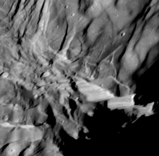
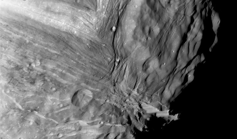
View of Miranda showing light and dark banded scarps near the boundary of the banded ovoid and a deep graben that bounds the ovoid in this region.
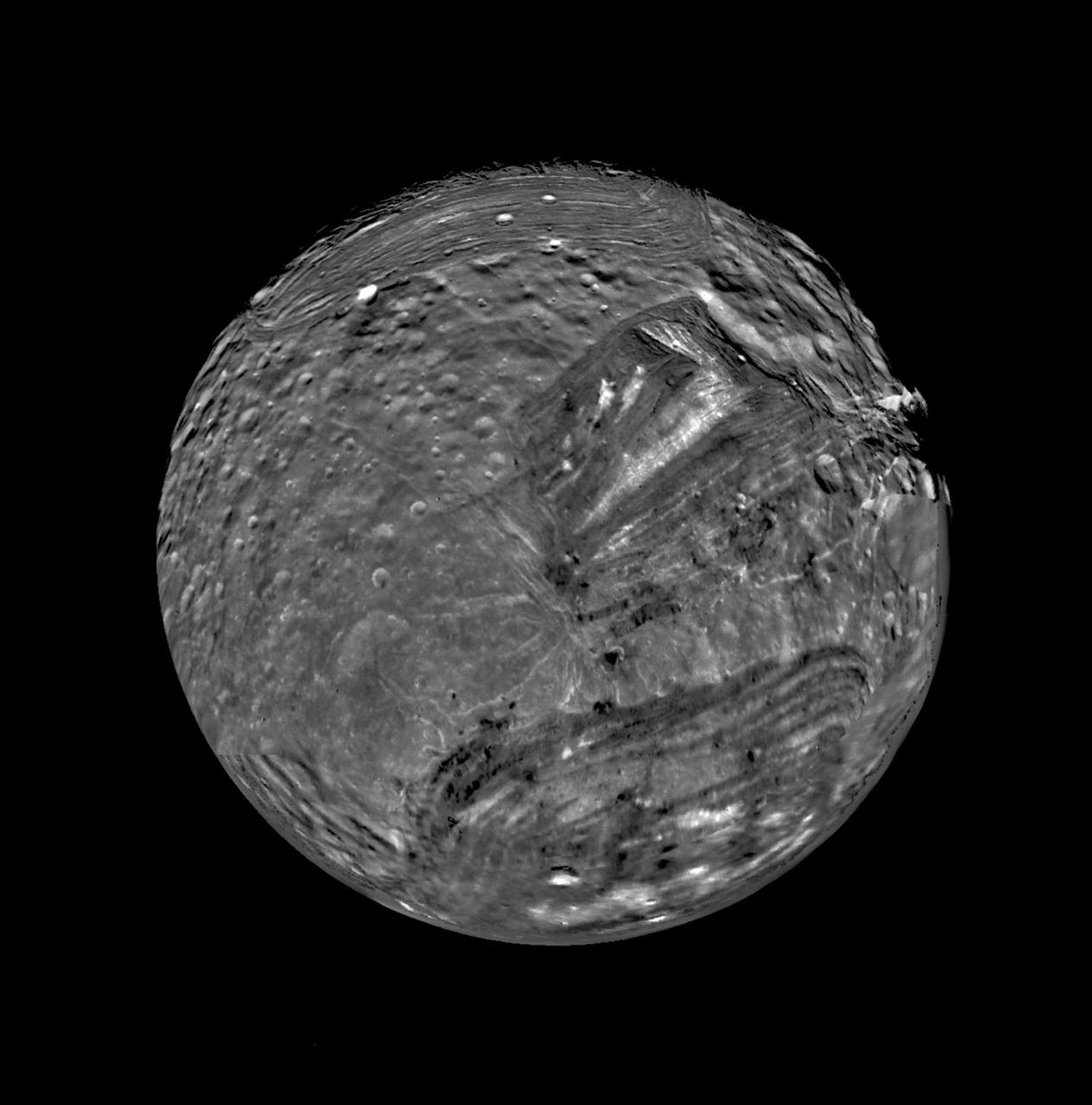
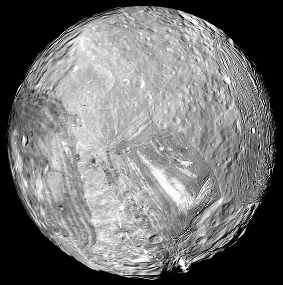
Uranus moon Miranda is shown in a computer-assembled mosaic of images obtained Jan. 24, 1986, by NASA Voyager 2 spacecraft. Miranda is the innermost and smallest of the five major Uranian satellites,

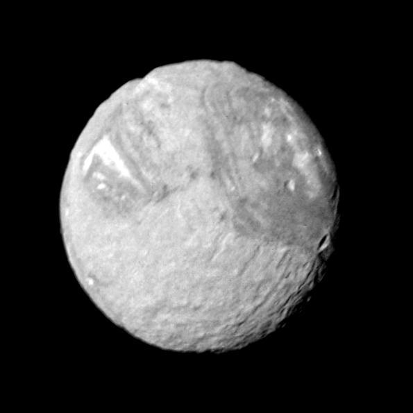
This Voyager 2 image of Miranda was taken Jan. 23, 1986, as the spacecraft neared Uranus. Miranda is the innermost of the five Uranian satellites known from Earth-based observations.
This mosaic of Miranda was obtained by NASA Voyager 2 during its close flyby of the Uranian moon. Miranda exhibits varied geologic provinces where ridges and valleys of one province are cut off against the boundary of the next province. http://photojournal.jpl.nasa.gov/catalog/PIA00043
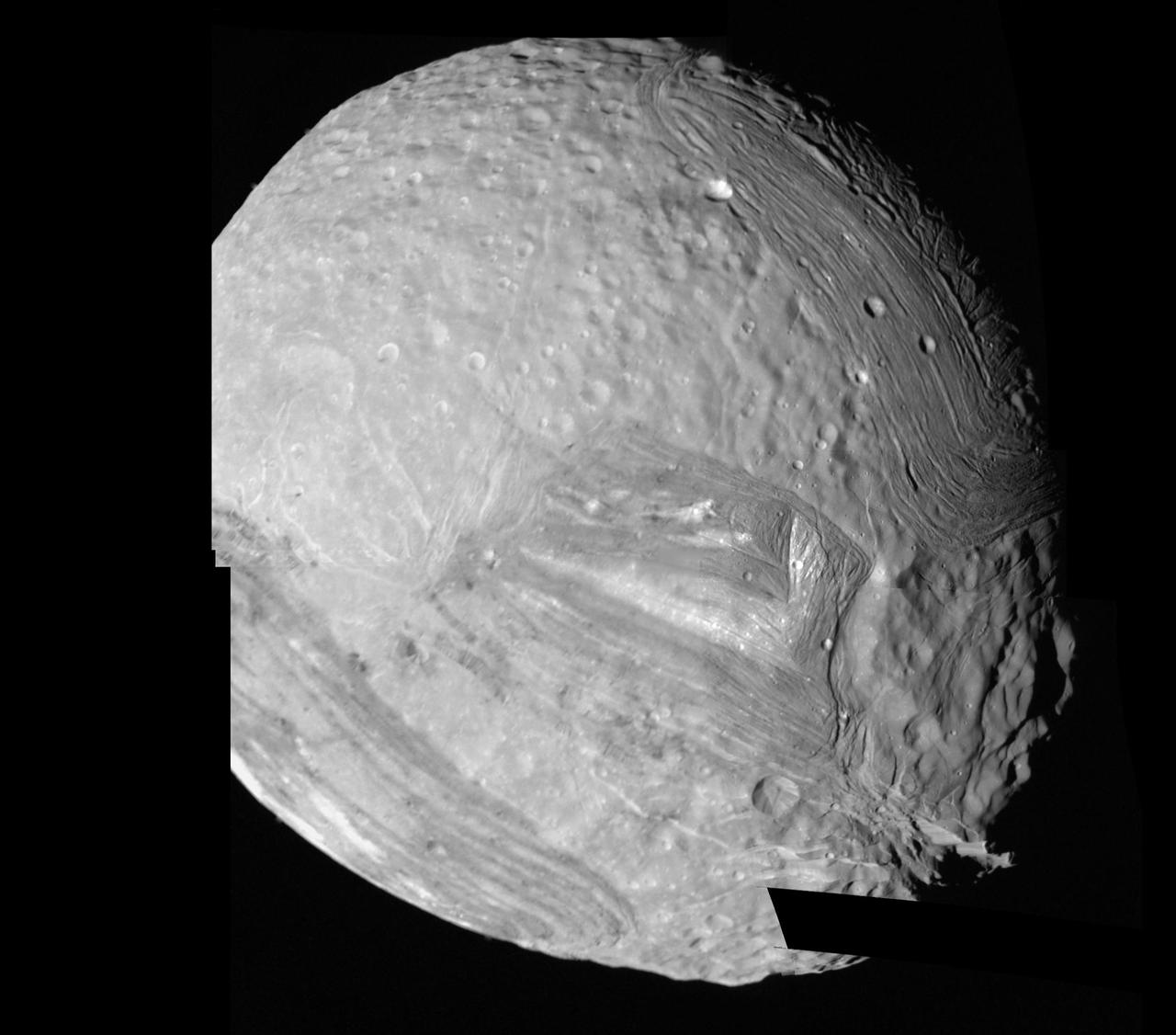
One wide-angle and eight narrow-angle camera images of Miranda, taken by NASA Voyager 2, were combined in this view. The controlled mosaic was transformed to an orthographic view centered on the south pole.
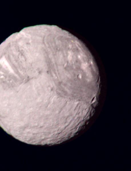
This color composite of the Uranian satellite Miranda was taken by NASA Voyager 2 on January 24, 1986. Miranda, just 480 km 300 mi across, is the smallest of Uranus five major satellites. http://photojournal.jpl.nasa.gov/catalog/PIA00042
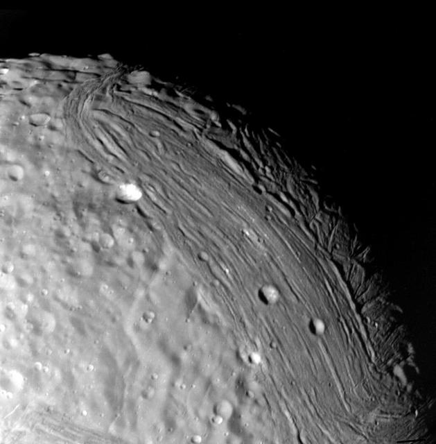
This image of Miranda, Uranus moon, was acquired by NASA Voyager 2 on Jan. 24, 1986. Miranda displays a dramatically varied surface. Well shown are numerous ridges and valleys -- a topography that was probably produced by compressional tectonics. http://photojournal.jpl.nasa.gov/catalog/PIA00044
Uranus icy moon Miranda is seen in this image from Voyager 2 on January 24, 1986. https://photojournal.jpl.nasa.gov/catalog/PIA18185
Miranda, innermost of Uranus large satellites, is seen at close range in this Voyager 2 image, taken Jan. 24, 1986, as part of a high-resolution mosaicing sequence.
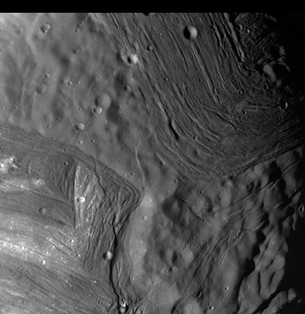
This image of Miranda, obtained by NASA Voyager 2 on approach in 1986, shows an unusual chevron figure and regions of distinctly differing terrain on the Uranian moon. http://photojournal.jpl.nasa.gov/catalog/PIA00038
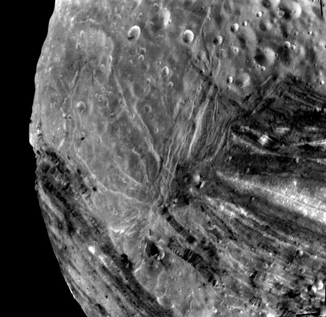
This image of the Uranian moon, Miranda, was taken Jan 24, 1986 by NASA's Voyager 2. This image reveals a bewildering variety of fractures, grooves and craters, as well as features of different albedos reflectancea. http://photojournal.jpl.nasa.gov/catalog/PIA00140
Miranda reveals a complex geologic history in this view, acquired by NASA's Voyager 2 on Jan. 24, 1986, around its close approach to the Uranian moon. At least three terrain types of different age and geologic style are evident. http://photojournal.jpl.nasa.gov/catalog/PIA00141
MIRANDA HOLTON GIVES OVERVIEW OF THRUST VECTOR CONTROL LAB
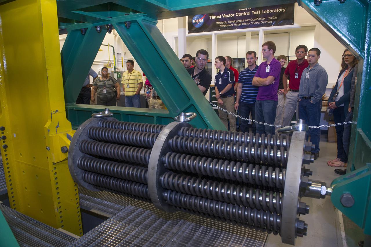
MIRANDA HOLTON GIVES OVERVIEW OF THRUST VECTOR CONTROL LAB
![“Discipline is one of the things that they instill with you [in the military.] All the way starting in boot camp, [the goal] is doing the right thing when nobody's looking. Integrity. Whenever you're in boot camp, they always say, ‘it's too easy.’ It's just too easy to follow the rules, read the book, read the regulations, and that's probably why I enjoy contracting. I like reading the regulations and following the regulations. …[Now that I work for Safety and Mission Assurance,] it's really cool to read everything about the different types of the scenarios. I always get to see the task orders and the type of work that is going on to keep people safe on the ground and in the air.” NASA Contract Specialist at NASA’s Goddard Space Flight Center (GSFC), Miranda Meyer, poses for a portrait, Wednesday, Feb. 7, 2024 at GSFC in Greenbelt, Maryland. Photo Credit: (NASA/Thalia Patrinos)](https://images-assets.nasa.gov/image/NHQ202402070015/NHQ202402070015~medium.jpg)
“Discipline is one of the things that they instill with you [in the military.] All the way starting in boot camp, [the goal] is doing the right thing when nobody's looking. Integrity. Whenever you're in boot camp, they always say, ‘it's too easy.’ It's just too easy to follow the rules, read the book, read the regulations, and that's probably why I enjoy contracting. I like reading the regulations and following the regulations. …[Now that I work for Safety and Mission Assurance,] it's really cool to read everything about the different types of the scenarios. I always get to see the task orders and the type of work that is going on to keep people safe on the ground and in the air.” NASA Contract Specialist at NASA’s Goddard Space Flight Center (GSFC), Miranda Meyer, poses for a portrait, Wednesday, Feb. 7, 2024 at GSFC in Greenbelt, Maryland. Photo Credit: (NASA/Thalia Patrinos)
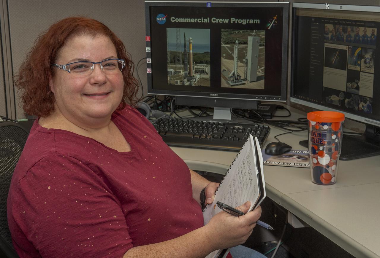
Miranda Holton is the Main Propulsion Systems (MPS) Subsystem Manager for NASA’s Commercial Crew Program. The goal of the Commercial Crew Program is to have safe, reliable and cost-effective access to and from the International Space Station and foster commercial access to other potential low-Earth orbit destinations.
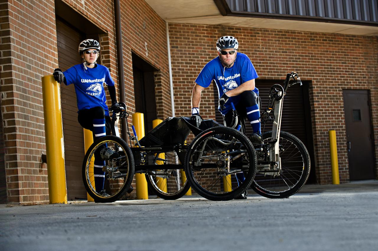
UA HUNTSVILLE’S MIRANDA NELSON AND MICHAEL PATTERSON POSE WITH THE MOONBUGGY THEY WILL DRIVE IN THE 2011 GREAT MOONBUGGY RACE AT THE US SPACE AND ROCKET CENTER.
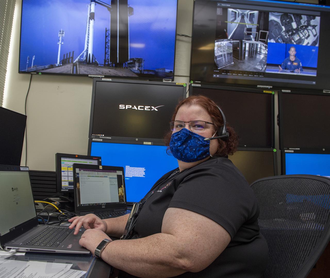
Miranda Holton and teams at NASA’s Marshall Space Flight Center help monitor launch conditions for the Demo-2 mission from the Huntsville Operations Support Center, HOSC.
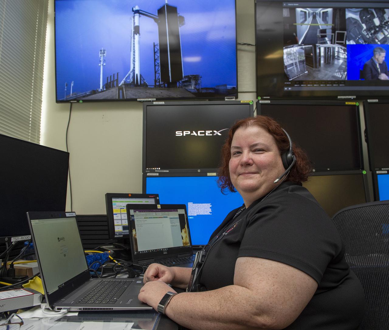
Miranda Holton and teams at NASA’s Marshall Space Flight Center help monitor launch conditions for the Demo-2 mission from the Huntsville Operations Support Center, HOSC.
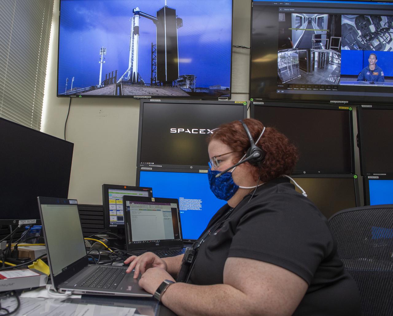
Miranda Holton and teams at NASA’s Marshall Space Flight Center help monitor launch conditions for the Demo-2 mission from the Huntsville Operations Support Center, HOSC.
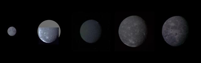
Montage of Uranus five largest satellites taken by NASA Voyager 2. From to right to left in order of decreasing distance from Uranus are Oberon, Titania, Umbriel, Ariel, and Miranda.

This family portrait of Uranus five largest moons was compiled from images sent back Jan. 20, 1986, by NASA Voyager 2 spacecraft. Even in these distant views, the satellites exhibit distinct differences in appearance.

Monty Miranda in the telescope reticle during the demolition of the modified C-141 Kuiper Airborne Observatory, (KAO) (NASA-714), on the N211 apron at Moffett Field, California.
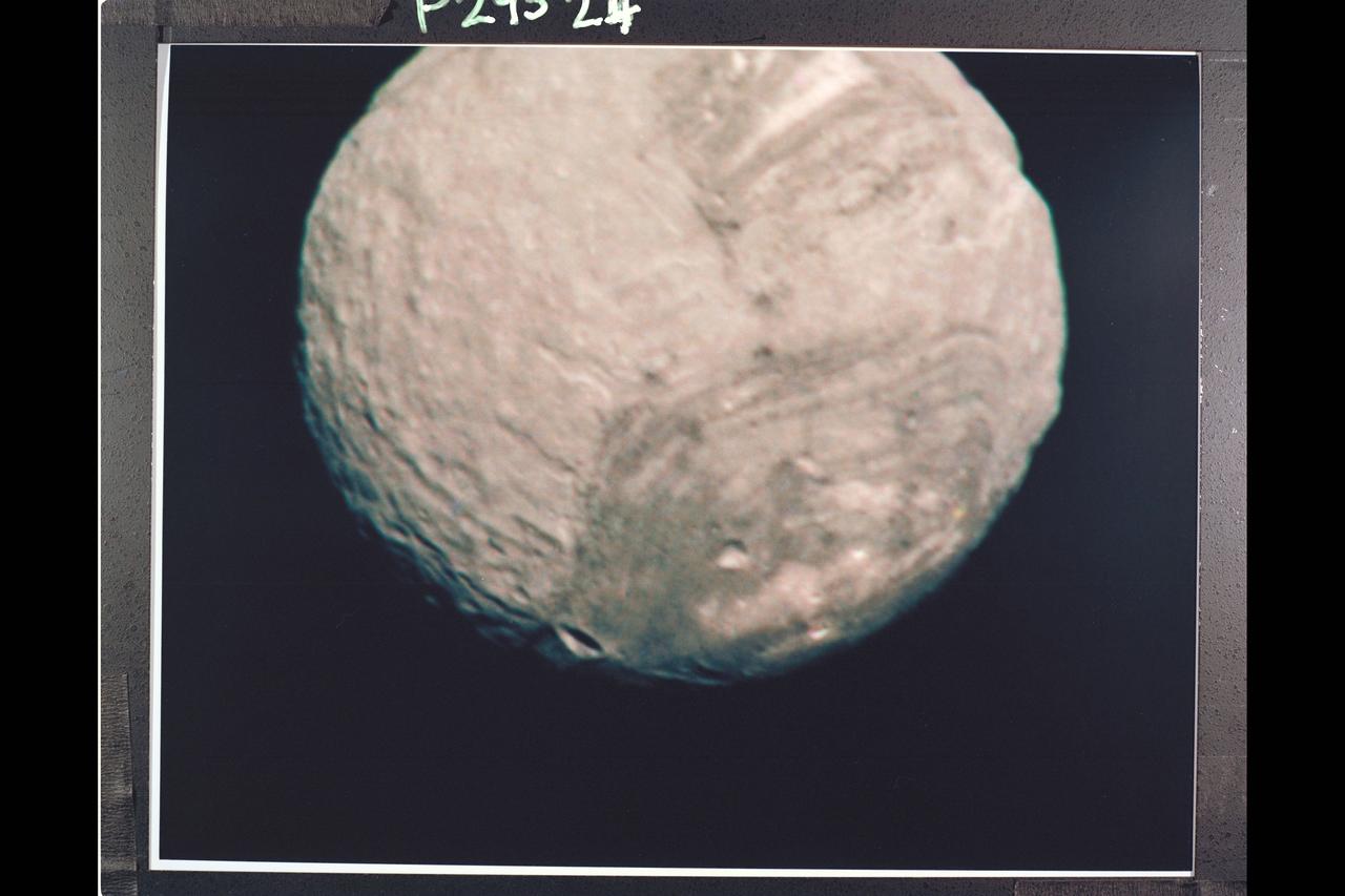
Range : 147,000 km. ( 91,000 mi. ) Resolution : 2.7 km. ( 1.7 mi. ) P-29524C this Voyager 2 color image of the Uranian satellite, Miranda is a composite of three shots taken through green, violet, and ultraviolet filters from the narrow angle camera. It is the best color image of Miranda returned to date. Miranda, just 480 km. (300 mi.) across, is the smallest of Uranus' five major satellites. Miranda's regional geologic provinces show very well in this view of the southern hemisphere. The dark and bright banded region, with its curvilinear traces, covers about half of the image. Higher resolution pictures taken later show many fault lines valleys and ridges parallel to these bands. Near the terminator (at right), another system of ridges and valleys abuts the banded terrain, while many impact craters pockmark the surface in this region. The largest of these are about 30 km. (20 mi.) in diameter. Many more lie in the range of 5 to 10 km. (3 to 6 mi.) in diameter
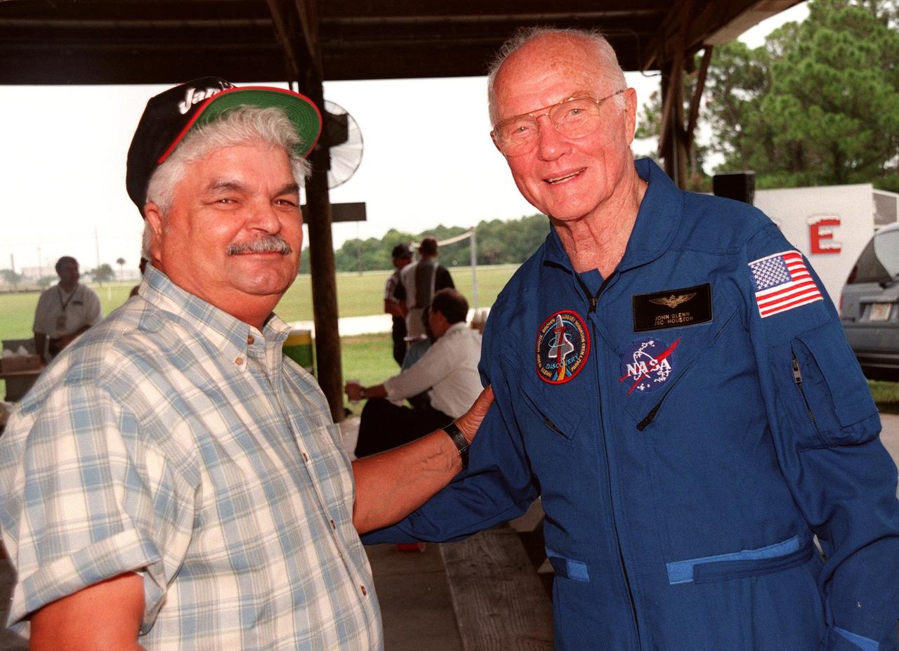
During a break in the Crew Equipment Interface Test (CEIT), Payload Specialist John H. Glenn Jr., a senator from Ohio, greets Bobby Miranda. Miranda was a NASA photographer for Glenn's first flight on Friendship 7, February 1962. The CEIT gives astronauts an opportunity for a hands-on look at the payloads and equipment with which they will be working on orbit. The launch of the STS-95 mission is scheduled for Oct. 29, 1998, on the Space Shuttle Discovery. The mission includes research payloads such as the Spartan solar-observing deployable spacecraft, the Hubble Space Telescope Orbital Systems Test Platform, the International Extreme Ultraviolet Hitchhiker, as well as the SPACEHAB single module with experiments on space flight and the aging process
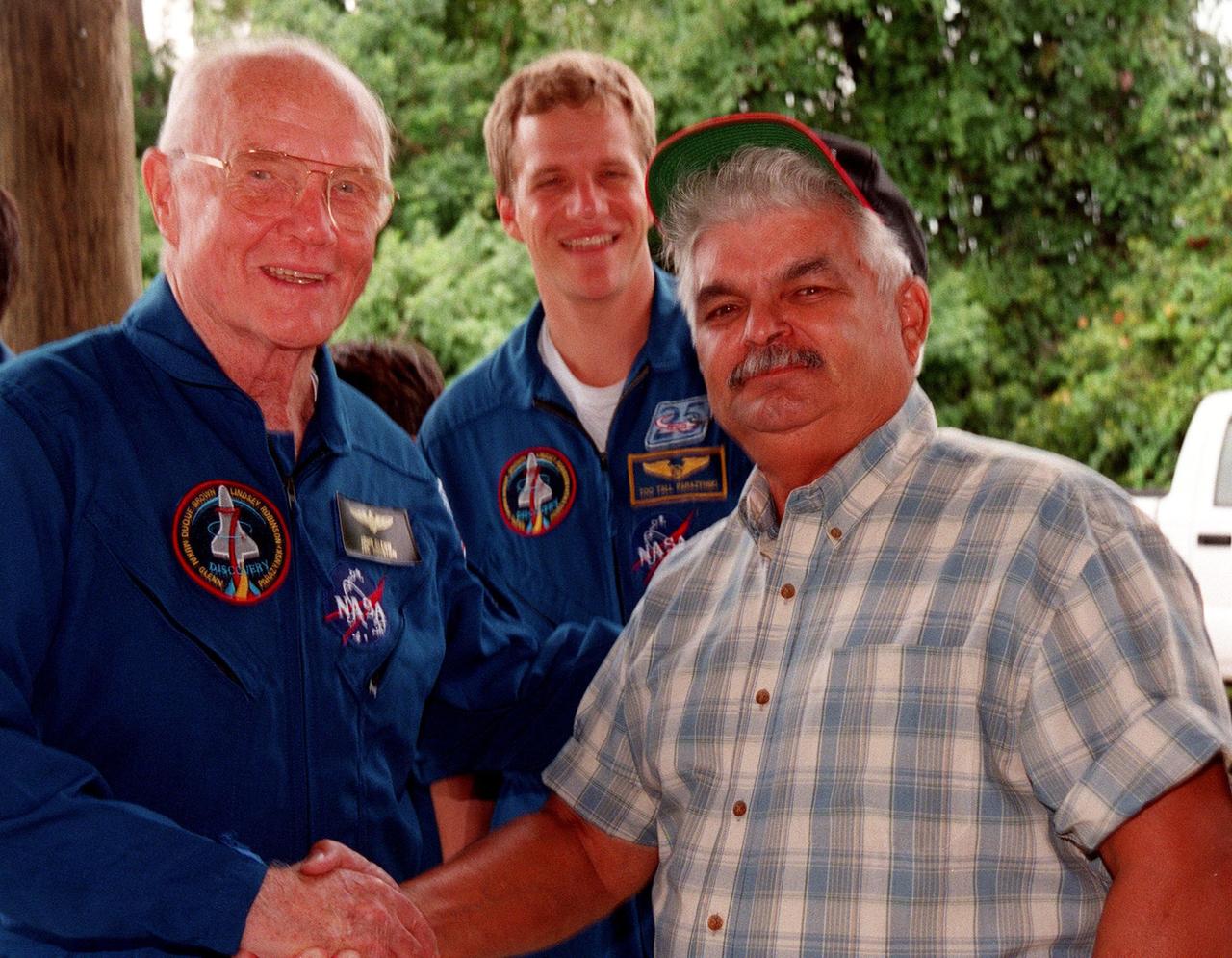
During a break in the Crew Equipment Interface Test (CEIT), Payload Specialist John H. Glenn Jr.(left), a senator from Ohio, greets Bobby Miranda. Miranda was a NASA photographer for Glenn's first flight on Friendship 7, February 1962. In the background is Mission Specialist Scott E. Parazynski. The CEIT gives astronauts an opportunity for a hands-on look at the payloads and equipment with which they will be working on orbit. The launch of the STS-95 mission is scheduled for Oct. 29, 1998, on the Space Shuttle Discovery. The mission includes research payloads such as the Spartan solar-observing deployable spacecraft, the Hubble Space Telescope Orbital Systems Test Platform, the International Extreme Ultraviolet Hitchhiker, as well as the SPACEHAB single module with experiments on space flight and the aging process
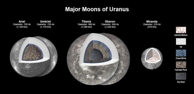
New modeling shows that there likely is an ocean layer in four of Uranus' major moons: Ariel, Umbriel, Titania, and Oberon. Salty – or briny – oceans lie under the ice and atop layers of water-rich rock and dry rock. Miranda is too small to retain enough heat for an ocean layer. The modeling, detailed in a paper published in the Journal of Geophysical Research, was informed by a re-analysis of data from NASA's Voyager spacecraft. Scientists have long thought that Titania, given its size, would be most likely to retain internal heat, caused by radioactive decay. The other moons had been widely considered too small to retain the heat necessary to keep an internal ocean from freezing, especially as heating created by the gravitational pull of Uranus is only a minor source of heat. https://photojournal.jpl.nasa.gov/catalog/PIA25500
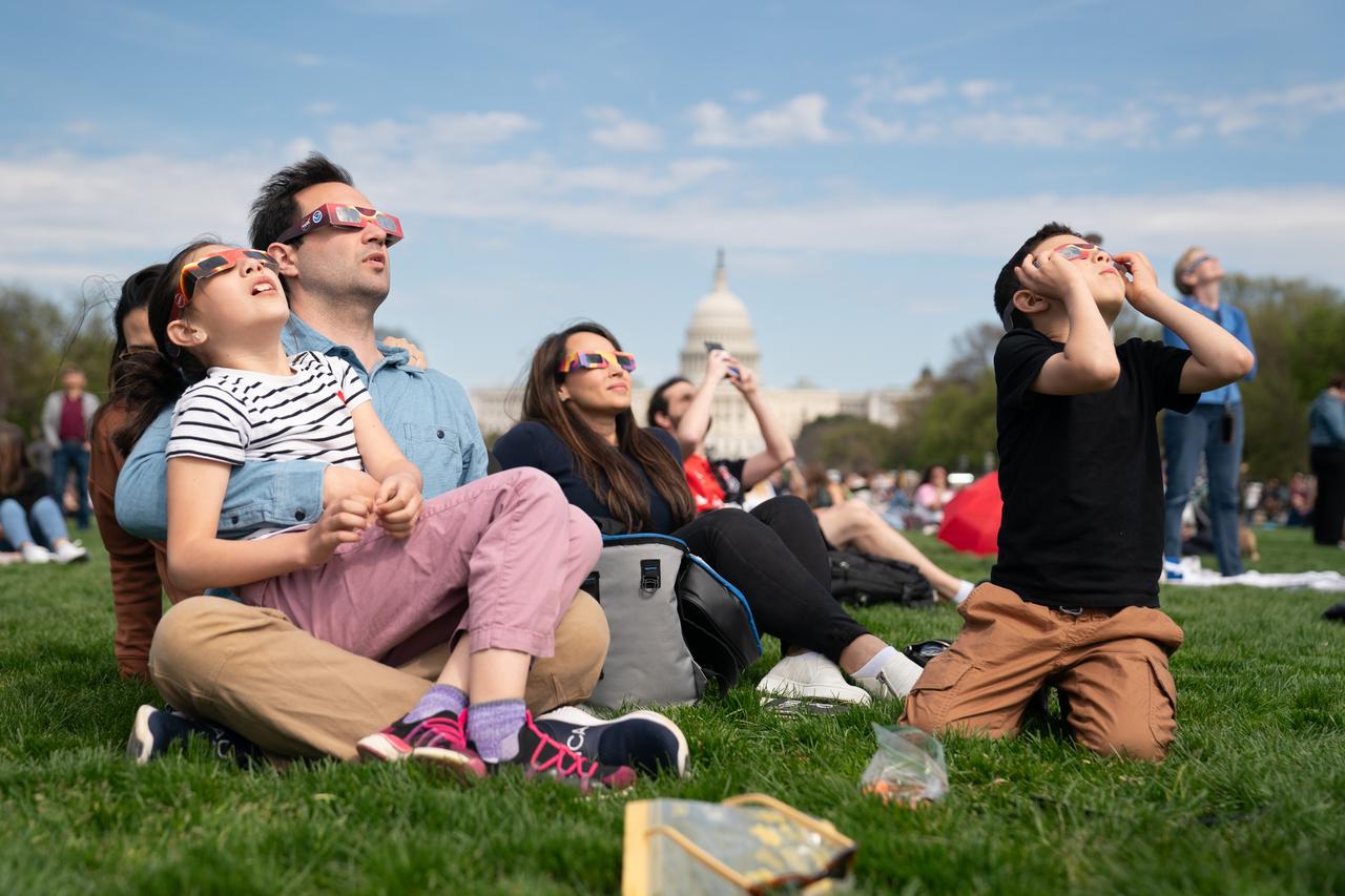
(L-R) Miranda (9) and Cameron Dyal, Yudi Lewis, and Cameron Dyal (7) view a partial solar eclipse in Washington, DC, Monday, April 8, 2024. A total solar eclipse swept across a narrow portion of the North American continent from Mexico’s Pacific coast to the Atlantic coast of Newfoundland, Canada. A partial solar eclipse was visible across the entire North American continent along with parts of Central America and Europe. Photo Credit: (NASA/Denny Henry)W
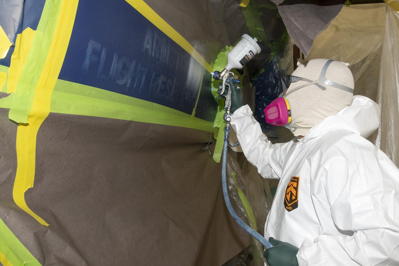
Eric Miranda, who works at the U.S. Air Force Corrosion Control Facility, paints areas in a stencil for adding some finishing touches to NASA 862, which is an F/A-18D based at NASA’s Armstrong Flight Research Center in Edwards, California. The corrosion control facility is located on Edwards Air Force Base and is also known as the Paint Barn.

Ecuador Minister of Foreign Affairs and Human Mobility Gustavo Manrique Miranda signs the Artemis Accords, Wednesday, June 21, 2023, at the Embassy of Ecuador in Washington. Ecuador is the twenty sixth country to sign the Artemis Accords, which establish a practical set of principles to guide space exploration cooperation among nations participating in NASA’s Artemis program. Photo Credit: (NASA/Keegan Barber)

Ecuador Minister of Foreign Affairs and Human Mobility Gustavo Manrique Miranda signs the Artemis Accords, Wednesday, June 21, 2023, at the Embassy of Ecuador in Washington. Ecuador is the twenty sixth country to sign the Artemis Accords, which establish a practical set of principles to guide space exploration cooperation among nations participating in NASA’s Artemis program. Photo Credit: (NASA/Keegan Barber)

Ecuador Minister of Foreign Affairs and Human Mobility Gustavo Manrique Miranda, center, delivers remarks during an Artemis Accords signing ceremony Wednesday, June 21, 2023, at the Embassy of Ecuador in Washington. Ecuador is the twenty sixth country to sign the Artemis Accords, which establish a practical set of principles to guide space exploration cooperation among nations participating in NASA’s Artemis program. Photo Credit: (NASA/Keegan Barber)

Ecuador Minister of Foreign Affairs and Human Mobility Gustavo Manrique Miranda delivers remarks during an Artemis Accords signing ceremony Wednesday, June 21, 2023, at the Embassy of Ecuador in Washington. Ecuador is the twenty sixth country to sign the Artemis Accords, which establish a practical set of principles to guide space exploration cooperation among nations participating in NASA’s Artemis program. Photo Credit: (NASA/Keegan Barber)

Miranda (9) and Cameron Dyal view a partial solar eclipse in Washington, DC, Monday, April 8, 2024. A total solar eclipse swept across a narrow portion of the North American continent from Mexico’s Pacific coast to the Atlantic coast of Newfoundland, Canada. A partial solar eclipse was visible across the entire North American continent along with parts of Central America and Europe. Photo Credit: (NASA/Denny Henry)
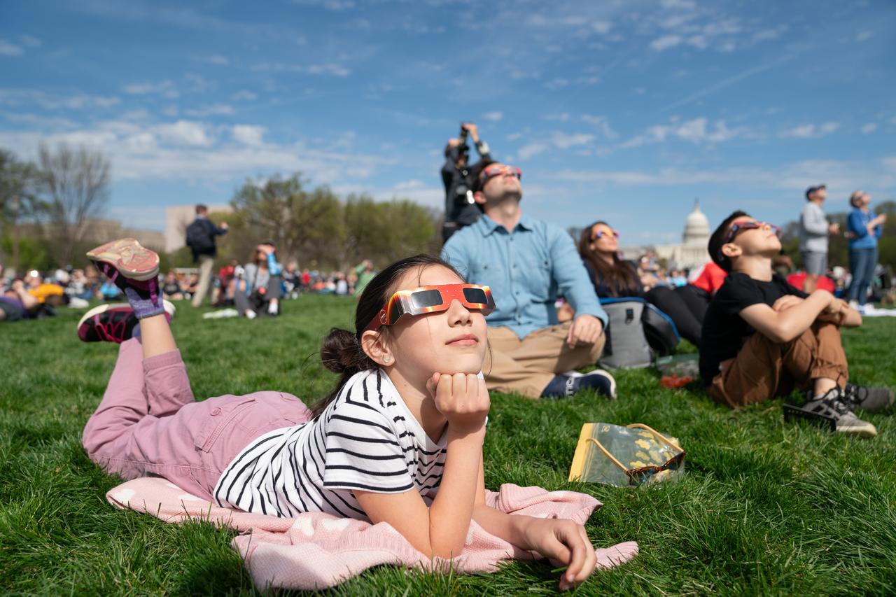
Miranda Dyal (9) views a partial solar eclipse in Washington, DC, Monday, April 8, 2024. A total solar eclipse swept across a narrow portion of the North American continent from Mexico’s Pacific coast to the Atlantic coast of Newfoundland, Canada. A partial solar eclipse was visible across the entire North American continent along with parts of Central America and Europe. Photo Credit: (NASA/Denny Henry)
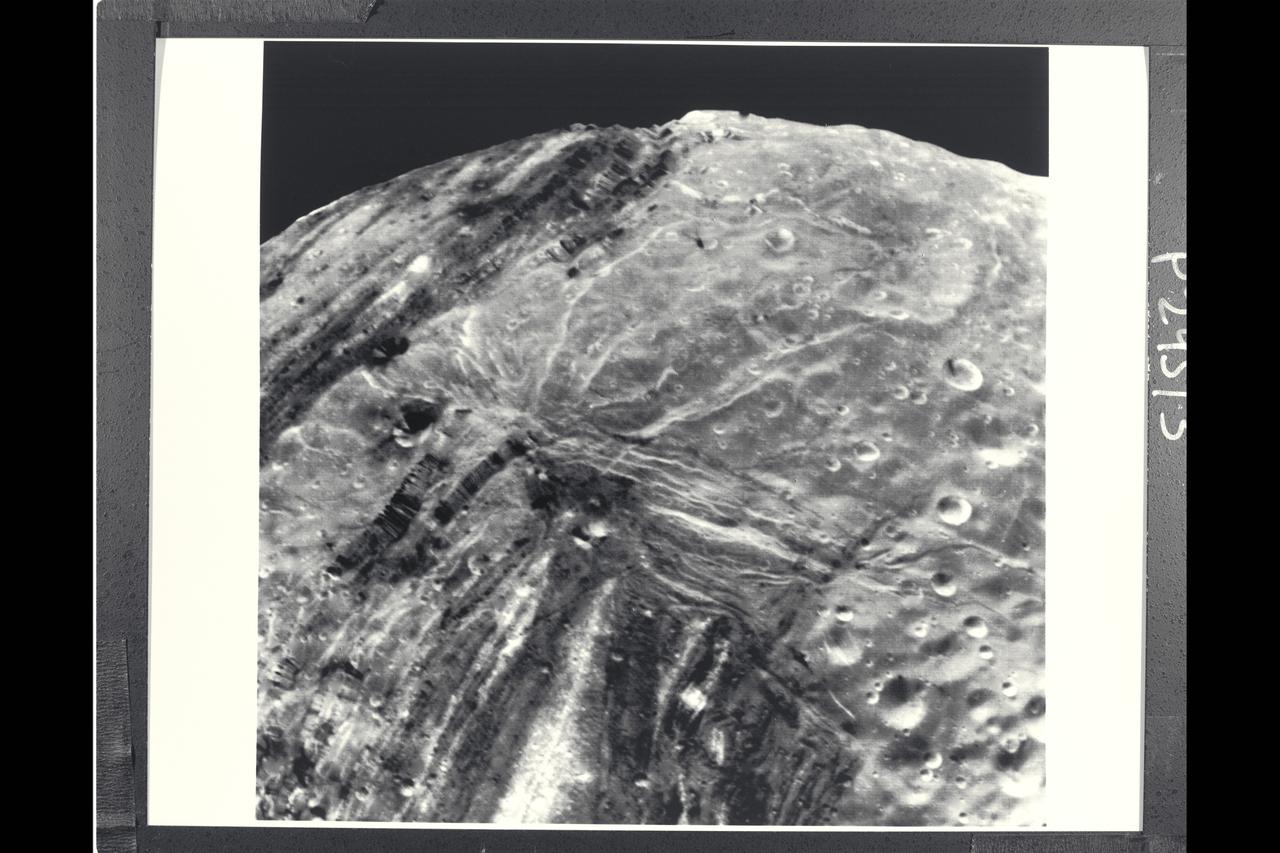
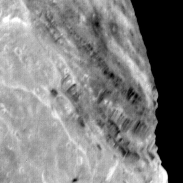
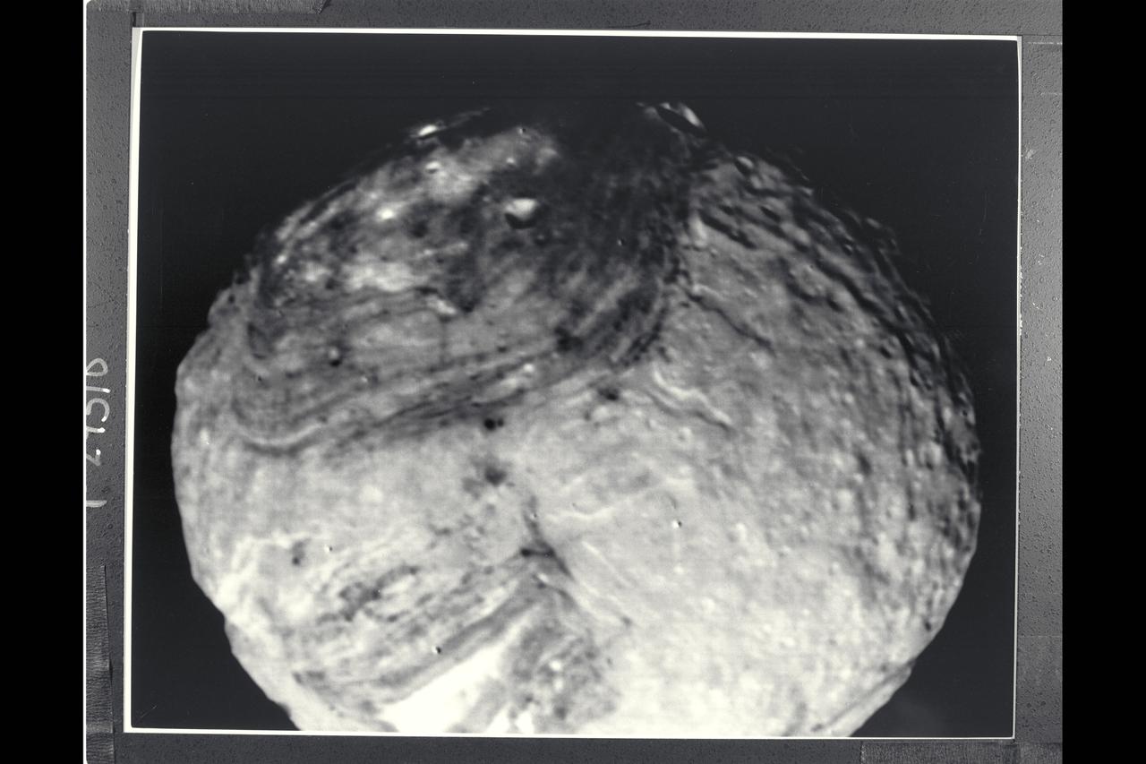
P-29513 BW Range: 31,000 kilometers (19,000 miles) This Voyager 2 image of Miranda was taken shortly before the spacecraft's closet approach to the Uranian moon.The high resolution of 600 meters (2,000 feet) reveals a bewildering variety of fractures, grooves and craters, as well as features of different albedos (reflectances). This clear-filter, narrow-angle view encompasses areas of older, heavily cratered terrain with a wide variety of forms. The grooves and troughs reach depths of a few kilometers and expose materials of different albedos. The great variety of directions of fracture and troughs, and the different densities of impact craters on them, signify a long, complex geologic evolution of this satellite.
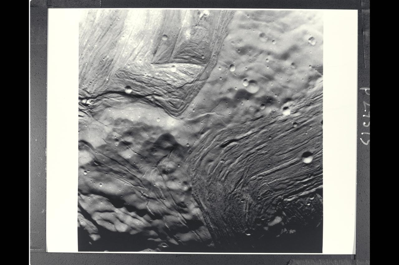
P-29514 BW Miranda reveals a complex geologic history in this view acquired by Voyager 2 around its closest approach to the Uranian moon. At least three terrain types of different age and geologic style are evident at this resolution of about 700 meters (2,300 feet). Visible in this clear-filter, narrow-angle image are from left: 1) an apparently ancient, cratered terrain consisting of rolling, subdued hills and degraded medium-sized craters; 2) a grooved terrain with linear valleys and ridges developed at the expense of, or replacing, the first terrain type; and 3) a complex terrain seen along the terminator, in which intersecting curvillinear ridges and troughs are abrubtly truncated by the linear, grooved terrain. Voyager scientists believe this third terrain type is intermediate in age between the first two.
P-29510BW Range: 150,000 kilometers (90,000 miles) Nearly the full disk of Miranda can be seen in this clear-filter image taken by Voyager's narrow-angle camera. At this resolution, about 2.7 km (1.7 mi), only two distinct terrain types are visible. One is a bright, rugged, heavily-cratered region seen along the bottom of the disk and extending to the top in a narrow band. The second terrain type is a topographically lower, darker, grooved terrain along the two upper sides in this image. The dark areas had been visible for several days before closest approach in lower-resolution views of the satellite. Scarps, or cliffs, visible along the limbs have a rugged relief of several kilometers in height.
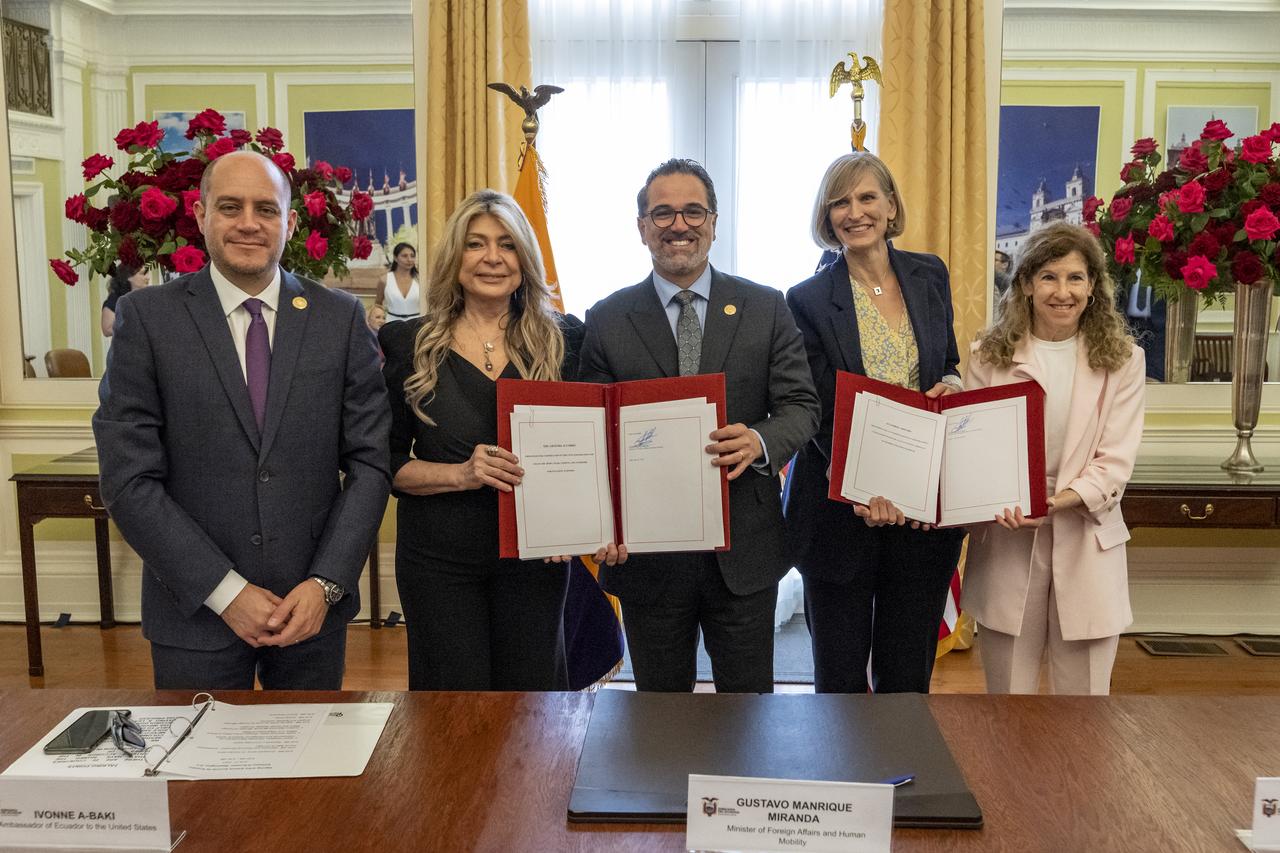
From left to right, Ecuador Minster of Production, Foreign Trade, Investments and Fisheries Julio José Prado, Ambassador of Ecuador to the United States Ivonne A-Baki, Ecuador Minister of Foreign Affairs and Human Mobility Gustavo Manrique Miranda, U.S. Department of State Director of the Office of Space Affairs Valda Vikmanis Keller, and NASA Associate Administrator for International and Interagency Relations Karen Feldstein, pose for a photo during an Artemis Accords signing ceremony, Wednesday, June 21, 2023, at the Embassy of Ecuador in Washington. Ecuador is the twenty sixth country to sign the Artemis Accords, which establish a practical set of principles to guide space exploration cooperation among nations participating in NASA’s Artemis program. Photo Credit: (NASA/Keegan Barber)
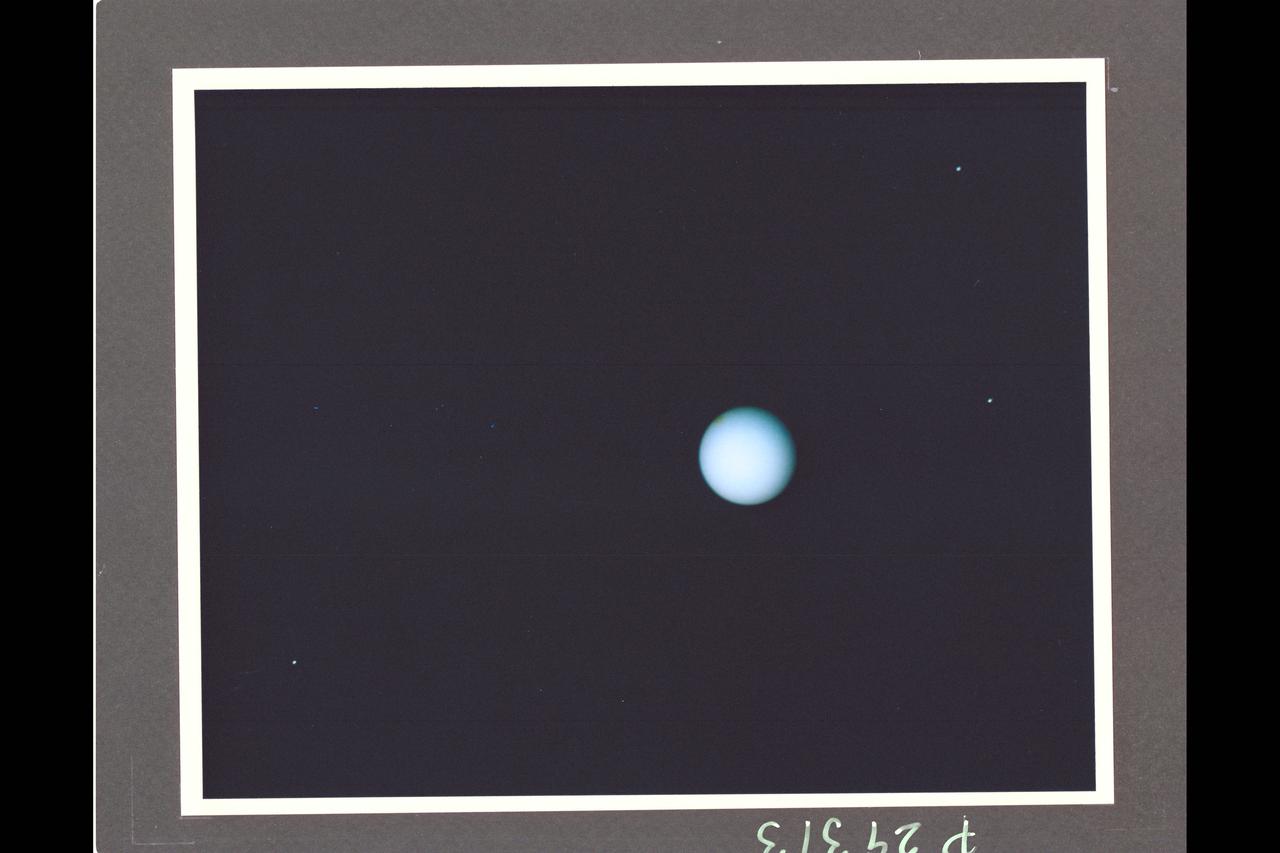
Range : 74 million km. ( 46 million miles ) P-29313CThis Voyager photograph of Uranus is a composite of for images taken by the narrow angle camera. At this range, clouds and other features in the atmosphere as small as 1,370 km. could be detected by Voyager 2. Yet, no such features are visible. This view is toward the illuminated south pole of Uranus. The predominant blue color is the result of atmospheric methane, which absorbs the red wavelengths from incoming sunlight. The spot at the upper left edge of the planet's disk reulted from the removal of a reseau mark used in making measurments on the photograph. Three of Uranus' five known satellites are visible; Miranda ( at far right, closest to the planet ), Ariel ( next out , at top), and Umbriel ( lower left ). Titania and Oberon are now outside the narrow angle camera's field of view when it centered on the planet. This color composite was made from images taken through blue, green, orange, and clear filters.
P-29515 BW Range: 42,000 kilometers (26,000 miles) This image of Miranda, obtained by Voyager 2 on approach, shows an unusual 'chevron' figure and regions of distinctly differing terrain on the Uranian moon. Grooved areas baring light and dark bands, distinct from other areas of mottled terrain, are visible at this resolution of about 600 meters (2,000 feet). The bright V-shaped feature in the grooved areas is the 'cheron' observed in earlier, lower-resolution images. Cutting across the bands are sinuous scarps, probably faults. Superimposed on both types of terrain are many bowl-shaped impact craters less than 5 km (3 mi) wide. The entire picture spans an area about 220 km (140 mi) across.
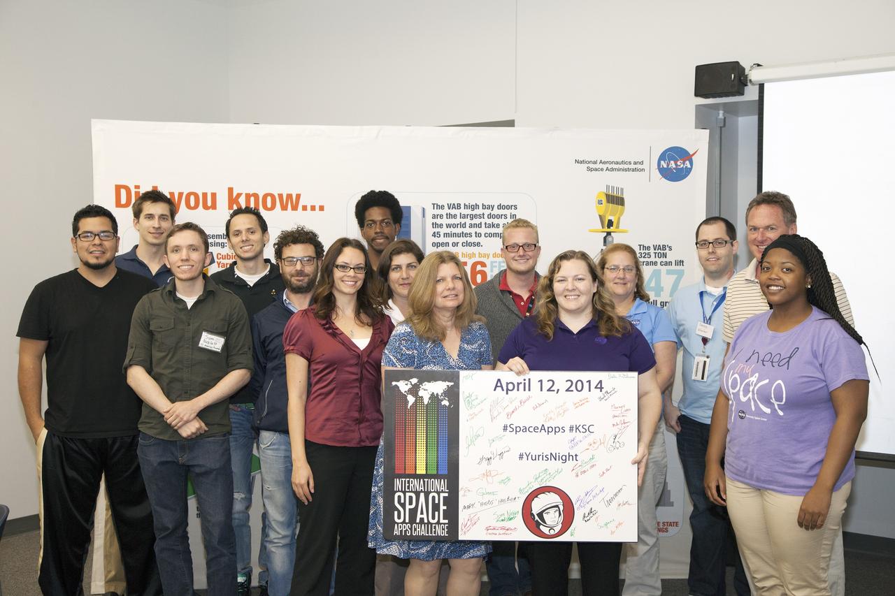
CAPE CANAVERAL, Fla. - Members of the winning Astronaut Resource Managing System and SpaceWear teams in the International Space Apps Challenge pose for a group portrait with the NASA volunteers, judges and event organizers. From left are Alejandro Velasco, NASA's Justin Treptow, Sam Neblett, Roberto Ricci, James Brucato, NASA's Suzanne Plantec, Keith Hargett, NASA's Cynthia Duffaut, NASA's Launa Maier, event organizer James Wood, event organizer lead Caley Burke, NASA's Lisa Singleton, event organizer David Miranda, NASA Ground Systems Development and Operation Program Manager Michael Bolger and NASA intern Brandi Burse. Kennedy Space Center hosted one of the over 90 locations around the world where participants congregated for the attempt to design innovative solutions for global challenges over a 48-hour period. This year's development marathon focused on five NASA mission areas: Asteroids, Earth Watch, Human Spaceflight, Robotics, and Technology in Space. Three of this year’s challenges were developed by KSC employees: Space Wearables: Fashion Designer to Astronauts, Growing Food for a Martian Table, and Asteroid Prospector. The winners selected in 2014 at Kennedy were Astronaut Resource Managing System, or ARMS, for Best Use of Data and SpaceWear for Best Use of Hardware. ARMS also took the People's Choice Award. For more information, visit https://2014.spaceappschallenge.org. Photo credit: NASA/Daniel Casper

NASA Glenn Research Center Director and Senior Management at the Aerospace Communications Facility, ACF Groundbreaking Ceremony