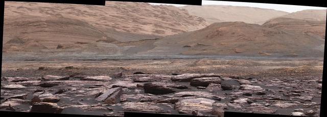
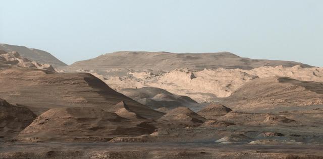
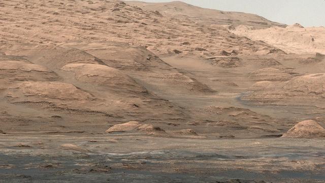
The foreground of this scene from the Mast Camera (Mastcam) on NASA's Curiosity Mars rover shows purple-hued rocks near the rover's late-2016 location on lower Mount Sharp. The scene's middle distance includes higher layers that are future destinations for the mission. Variations in color of the rocks hint at the diversity of their composition on lower Mount Sharp. The purple tone of the foreground rocks has been seen in other rocks where Curiosity's Chemical and Mineralogy (CheMin) instrument has detected hematite. Winds and windblown sand in this part of Curiosity's traverse and in this season tend to keep rocks relatively free of dust, which otherwise can cloak rocks' color. The three frames combined into this mosaic were acquired by the Mastcam's right-eye camera on Nov. 10, 2016, during the 1,516th Martian day, or sol, of Curiosity's work on Mars. The scene is presented with a color adjustment that approximates white balancing, to resemble how the rocks and sand would appear under daytime lighting conditions on Earth. Sunlight on Mars is tinged by the dusty atmosphere and this adjustment helps geologists recognize color patterns they are familiar with on Earth. The view spans about 15 compass degrees, with the left edge toward southeast. The rover's planned direction of travel from its location when this scene was recorded is generally southeastward. The orange-looking rocks just above the purplish foreground ones are in the upper portion of the Murray formation, which is the basal section of Mount Sharp, extending up to a ridge-forming layer called the Hematite Unit. Beyond that is the Clay Unit, which is relatively flat and hard to see from this viewpoint. The next rounded hills are the Sulfate Unit, Curiosity's highest planned destination. The most distant slopes in the scene are higher levels of Mount Sharp, beyond where Curiosity will drive. Figure 1 is a version of the same scene with annotations added as reference points for distance, size and relative elevation. The annotations are triangles with text telling the distance (in kilometers) to the point in the image marked by the triangle, the point's elevation (in meters) relative to the rover's location, and the size (in meters) of an object as big as the triangle at that distance. An annotated figure is available at http://photojournal.jpl.nasa.gov/catalog/PIA21256
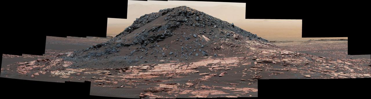
This dark mound, called "Ireson Hill," rises about 16 feet (5 meters) above redder layered outcrop material of the Murray formation on lower Mount Sharp, Mars, near a location where NASA's Curiosity rover examined a linear sand dune in February 2017. Researchers used the rover's Mast Camera (Mastcam) on Feb. 2, 2017, during the 1,598th Martian day, or sol, of Curiosity's work on Mars, to take the 41 images combined into this scene. The mosaic has been white-balanced so that the colors of the rock and sand materials resemble how they would appear under daytime lighting conditions on Earth. The view extends from west-southwest on the left to north-northwest on the right. The faint horizon in the distance beyond Ireson Hill is part of the rim of Gale Crater. An annotated figure is available at https://photojournal.jpl.nasa.gov/catalog/PIA21718
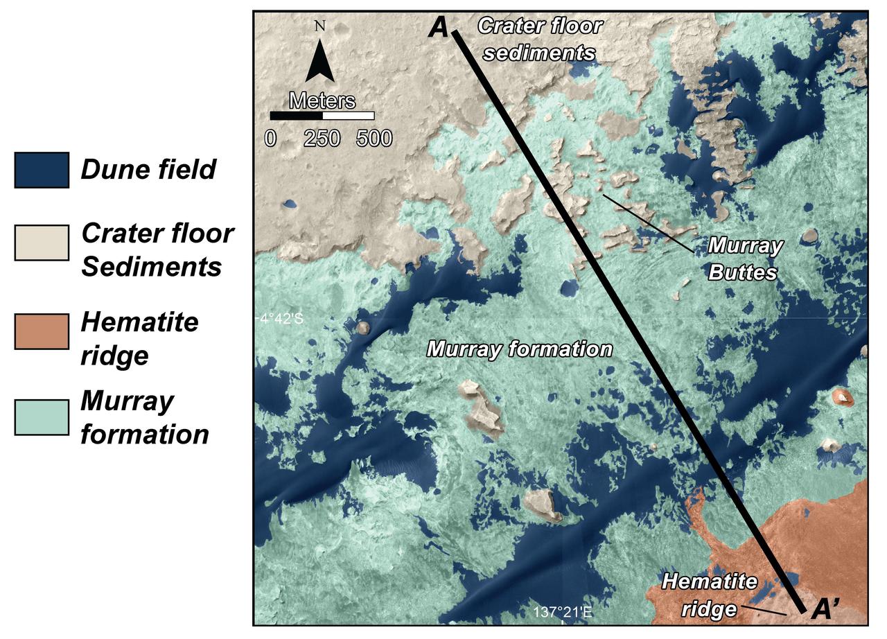
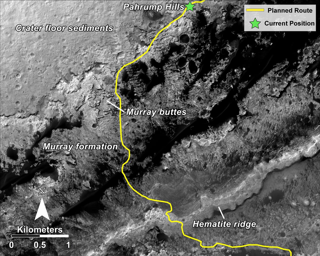
This is a map of lower Mount Sharp on Mars, showing the major geologic units identified from orbit. The rocks of the Murray Formation, mapped in green, likely represent the oldest layers of Mount Sharp that NASA Curiosity rover will explore.
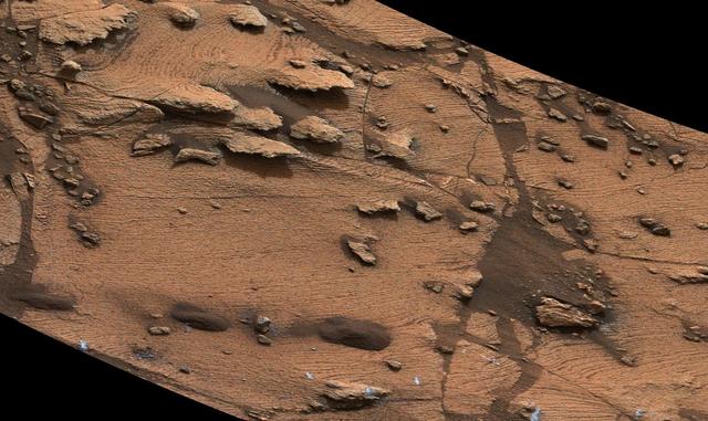
The mesa in the center of this scene from the "Murray Buttes" area on Mars' lower Mount Sharp is longer than a football field. It extends more than 361 feet (110 meters) from the left-most outcrop low on the slope to the right side where rock debris is behind a light-toned, dust-covered dune. The panorama combines sets of images taken by the left-eye camera of the Mast Camera (Mastcam) on NASA's Curiosity Mars rover, for the left half of the scene, and by Mastcam's right-eye camera for the right half of the scene. The component images from the left-eye camera were taken on Aug. 22, 2016, during the 1,438th Martian day, or sol, of the rover's work on Mars. The ones from the right-eye camera, which has a telephoto lens, were taken the following day, on Sol 1439. From the rover's position when the component images were taken, the top of the central mesa is about 310 feet (about 95 meters) away and about 52 feet (about 16 meters) above the rover. The relatively flat foreground is part of a geological layer called the Murray formation, which includes lakebed mud deposits. The buttes and mesas rising above this surface are eroded remnants of ancient sandstone that originated when winds deposited sand after lower Mount Sharp had formed. They are capped by material that is relatively resistant to erosion, just as is the case with many similarly shaped buttes and mesas on Earth. The scene is presented with a color adjustment that approximates white balancing, to resemble how the rocks and sand would appear under daytime lighting conditions on Earth. http://photojournal.jpl.nasa.gov/catalog/PIA20842
This composite image looking toward the higher regions of Mount Sharp was taken in mid-September, 2015, by NASA Curiosity rover.
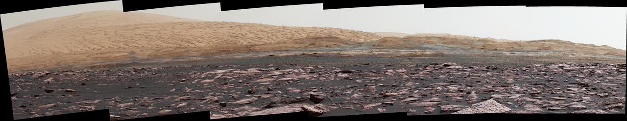
This look ahead from NASA's Curiosity Mars rover includes four geological layers to be examined by the mission, and higher reaches of Mount Sharp beyond the planned study area. The redder rocks of the foreground are part of the Murray formation. Pale gray rocks in the middle distance of the right half of the image are in the Clay Unit. A band between those terrains is "Vera Rubin Ridge." Rounded brown knobs beyond the Clay Unit are in the Sulfate Unit, beyond which lie higher portions of the mountain. The view combines six images taken with the rover's Mast Camera (Mastcam) on Jan. 24, 2017, during the 1,589th Martian day, or sol, of Curiosity's work on Mars, when the rover was still more than half a mile (about a kilometer) north of Vera Rubin Ridge. The panorama has been white-balanced so that the colors of the rock and sand materials resemble how they would appear under daytime lighting conditions on Earth. It spans from east-southeast on the left to south on the right. The Sol 1589 location was just north of the waypoint labeled "Ogunquit Beach" on a map of the area that also shows locations of the Murray formation, Vera Rubin Ridge, Clay Unit and Sulfate Unit. The ridge was informally named in early 2017 in memory of Vera Cooper Rubin (1928-2016), whose astronomical observations provided evidence for the existence of the universe's dark matter. Annotated and full resolution TIFF files are available at https://photojournal.jpl.nasa.gov/catalog/PIA21716
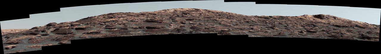
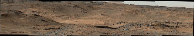
This image taken by the Mast Camera MastCam on NASA Curiosity rover highlights the interesting geology of Mount Sharp, a mountain inside Gale Crater, where the rover landed.
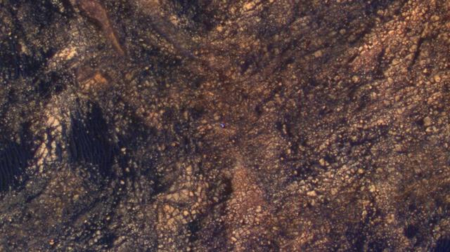
The feature that appears bright blue at the center of this scene is NASA's Curiosity Mars rover on the northwestern flank of Mount Sharp, viewed by NASA's Mars Reconnaissance Orbiter. Curiosity is approximately 10 feet long and 9 feet wide (3.0 meters by 2.8 meters). The view is a cutout from observation ESP_050897_1750 taken by the High Resolution Imaging Science Experiment (HiRISE) camera on the orbiter on June 5, 2017. HiRISE has been imaging Curiosity about every three months, to monitor the surrounding features for changes such as dune migration or erosion. When the image was taken, Curiosity was partway between its investigation of active sand dunes lower on Mount Sharp, and "Vera Rubin Ridge," a destination uphill where the rover team intends to examine outcrops where hematite has been identified from Mars orbit. The rover's surroundings include tan rocks and patches of dark sand. As in previous HiRISE color images of Curiosity since the rover was at its landing site, the rover appears bluer than it really is. HiRISE color observations are recorded in a red band, a blue-green band and an infrared band, and displayed in red, green and blue. This helps make differences in Mars surface materials apparent, but does not show natural color as seen by the human eye. Lower Mount Sharp was chosen as a destination for the Curiosity mission because the layers of the mountain offer exposures of rocks that record environmental conditions from different times in the early history of the Red Planet. Curiosity has found evidence for ancient wet environments that offered conditions favorable for microbial life, if Mars has ever hosted life. https://photojournal.jpl.nasa.gov/catalog/PIA21710
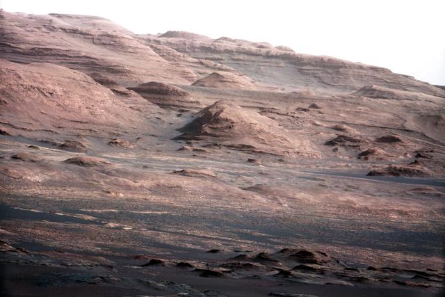
A chapter of the layered geological history of Mars is laid bare in this postcard from NASA Curiosity rover. The image shows the base of Mount Sharp, the rover eventual science destination.
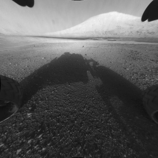
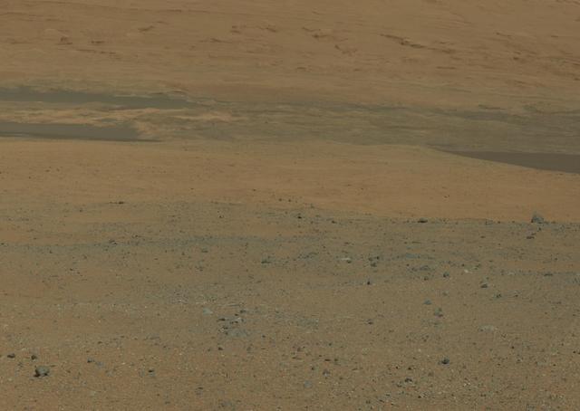
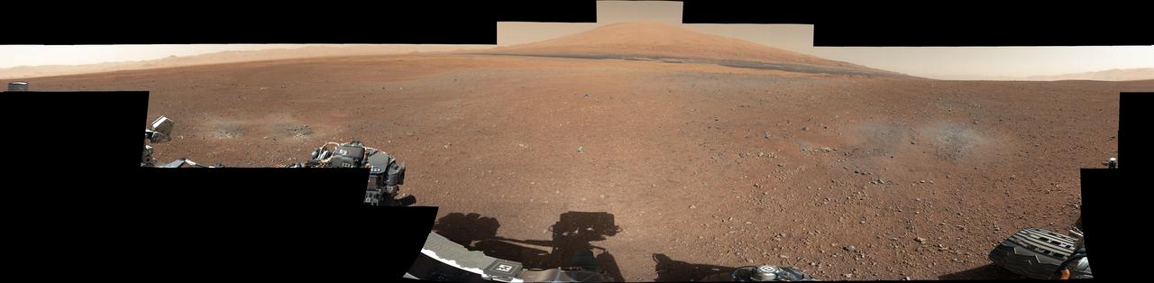
This image taken by NASA Curiosity shows what lies ahead for the rover -- its main science target, informally called Mount Sharp. The rover shadow can be seen in the foreground, and the dark bands beyond are dunes.
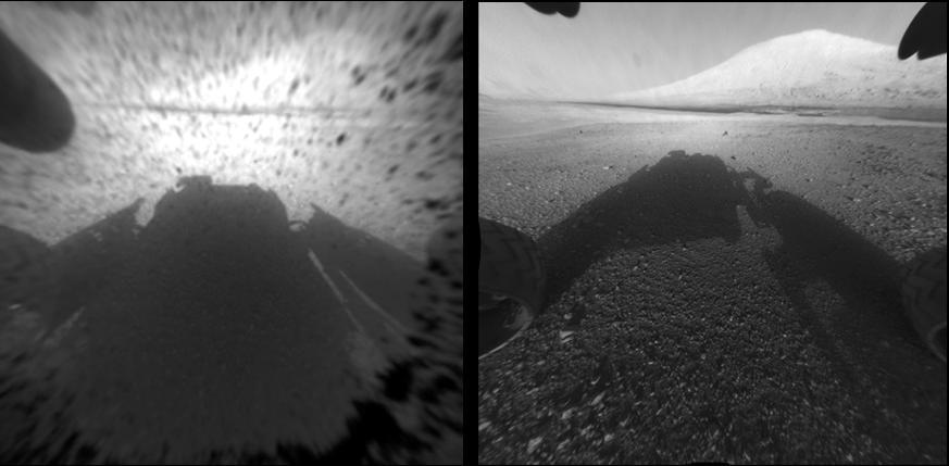
With the addition of four high-resolution Navigation Camera, or Navcam, images, taken on Aug. 18 Sol 12, Curiosity 360-degree landing-site panorama now includes the highest point on Mount Sharp visible from the rover.
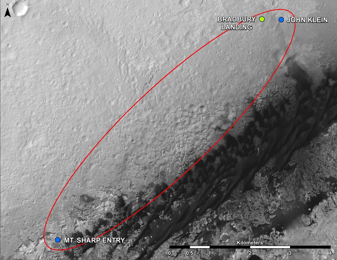
This map shows where NASA Mars rover Curiosity landed in August 2012 at Bradbury Landing. All of these features are inside Gale Crater. Curiosity next major destination, the entry point to the base of Mount Sharp.
This color image from NASA Curiosity rover looks south of the rover landing site on Mars towards Mount Sharp. This is part of a larger, high-resolution color mosaic made from images obtained by Curiosity Mast Camera.
This is a portion of the first color 360-degree panorama from NASA Curiosity showing the rover a mountain at the center of Gale Crater called Mount Sharp, can be seen in the distance, to the left, beginning to rise up.
This image from Curiosity Mastcam looks to the west of a waypoint on the rover route to Mount Sharp. The mountain lies to the left of the scene.
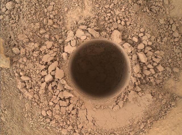
This image from the Mars Hand Lens Imager MAHLI camera on NASA Curiosity Mars rover shows the first sample-collection hole drilled in Mount Sharp, the layered mountain that is the science destination of the rover extended mission.
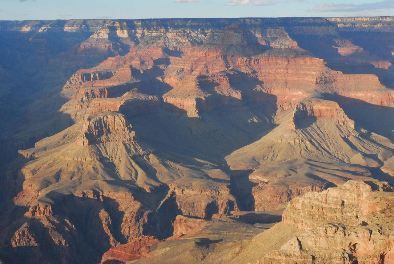
Before NASA Curiosity rover landed on Mars, the strata exposed in Mount Sharp were compared to those in the Grand Canyon of the western United States, shown here. Scientists are surprised by just how close the similarities are.
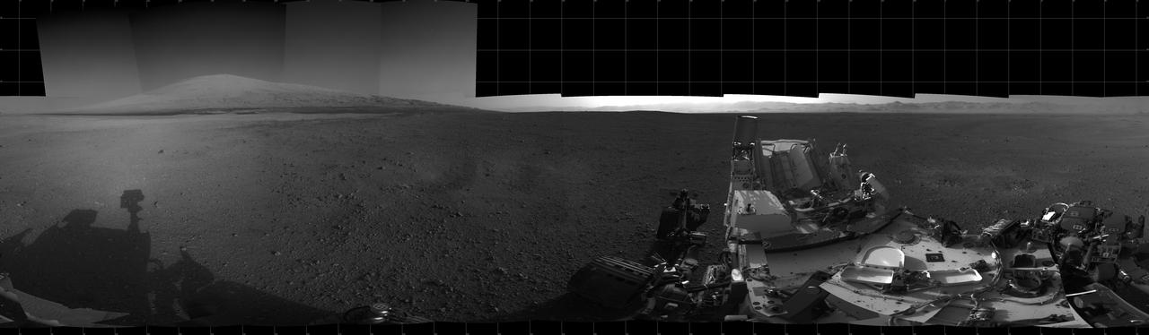
This color panorama shows a 360-degree view of the landing site of NASA Curiosity rover, including the highest part of Mount Sharp visible to the rover.
A landscape scene from NASA Curiosity Mars rover shows rock rows at Junda forming striations in the foreground, with Mount Sharp on the horizon.
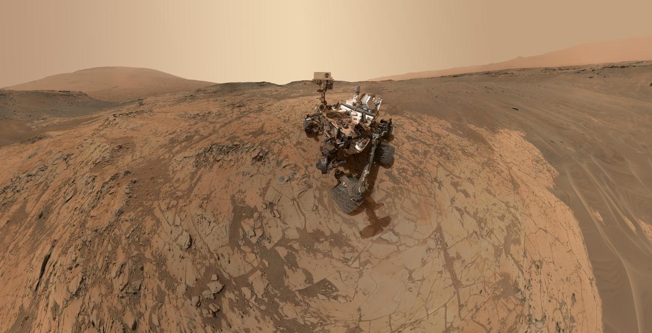
This self-portrait of NASA Curiosity Mars rover shows the vehicle at the Mojave site, where its drill collected the mission second taste of Mount Sharp.
The Mast Camera (Mastcam) on NASA's Curiosity Mars rover captured this view of "Vera Rubin Ridge" about two weeks before the rover started ascending this steep ridge on lower Mount Sharp. The view combines 13 images taken with the Mastcam's right-eye, telephoto-lens camera, on Aug. 19, 2017, during the 1,790th Martian day, or sol, of Curiosity's work on Mars. This and other Mastcam panoramas show details of the sedimentary rocks that make up the "Vera Rubin Ridge." This distinct topographic feature located on the lower slopes of Mount Sharp (Aeolis Mons) is characterized by the presence of hematite, an iron-oxide mineral, which has been detected from orbit. The Mastcam images show that the rocks making up the lower part of the ridge are characterized by distinct horizontal stratification with individual rock layers of the order of several inches (tens of centimeters) thick. Scientists on the mission are using such images to determine the ancient environment these rocks were deposited in. The repeated beds indicate progressive accumulation of sediments that now make up the lower part of Mount Sharp, although from this distance it is not possible to know if they were formed by aqueous or wind-blown processes. Close-up images collected as the rover climbs the ridge will help answer this question. The stratified rocks are cross cut by veins filled with a white mineral, likely calcium sulfate, that provide evidence of later episodes of fluid flow through the rocks. The panorama has been white-balanced so that the colors of the rock materials resemble how they would appear under daytime lighting conditions on Earth. It spans about 55 compass degrees centered to the south-southeast. The Sol 1790 location just north of the ridge is shown in a Sol 1789 traverse map. The ridge was informally named in early 2017 in memory of Vera Cooper Rubin (1928-2016), whose astronomical observations provided evidence for the existence of the universe's dark matter. An annotated figure is shown at https://photojournal.jpl.nasa.gov/catalog/PIA21851

This panorama from the Mast Camera (Mastcam) of NASA's Curiosity Mars rover shows details of "Vera Rubin Ridge," which stretches about 4 miles (6.5 kilometers), end-to-end, on the northwestern flank of lower Mount Sharp. The view combines 112 images taken with the Mastcam's right-eye camera, which has a telephoto lens, on April 4, 2017, during the 1,657th Martian day, or sol, of Curiosity's work on Mars. It has been white-balanced so that colors of the rock and sand materials resemble how they would appear under daytime lighting conditions on Earth. It spans from east-southeast on the left to south-southwest on the right, from a rover location about half a mile (0.8 kilometer) from the closest part of the ridge. Hematite, an iron-oxide mineral, has been detected in this ridge by the Compact Reconnaissance Imaging Spectrometer for Mars (CRISM) on NASA's Mars Reconnaissance Orbiter. The ridge has been an identified destination for Curiosity since before the rover's August 2012 landing near the base of Mount Sharp, inside Gale Crater. The ridge was informally named in early 2017 in memory of Vera Cooper Rubin (1928-2016), whose astronomical observations provided evidence for the existence of the universe's dark matter. An annotated version and full resolution TIFF files are available at https://photojournal.jpl.nasa.gov/catalog/PIA21717
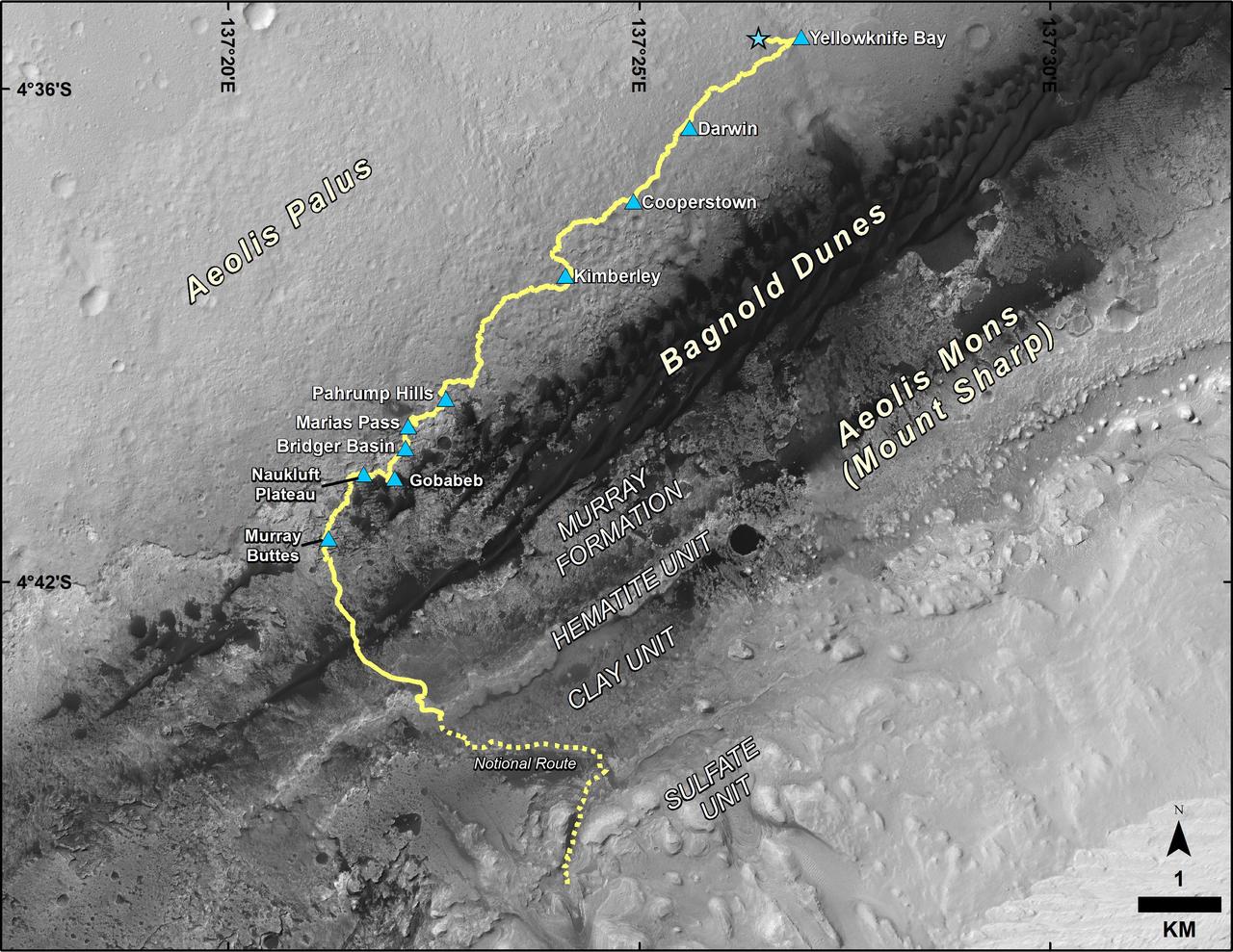
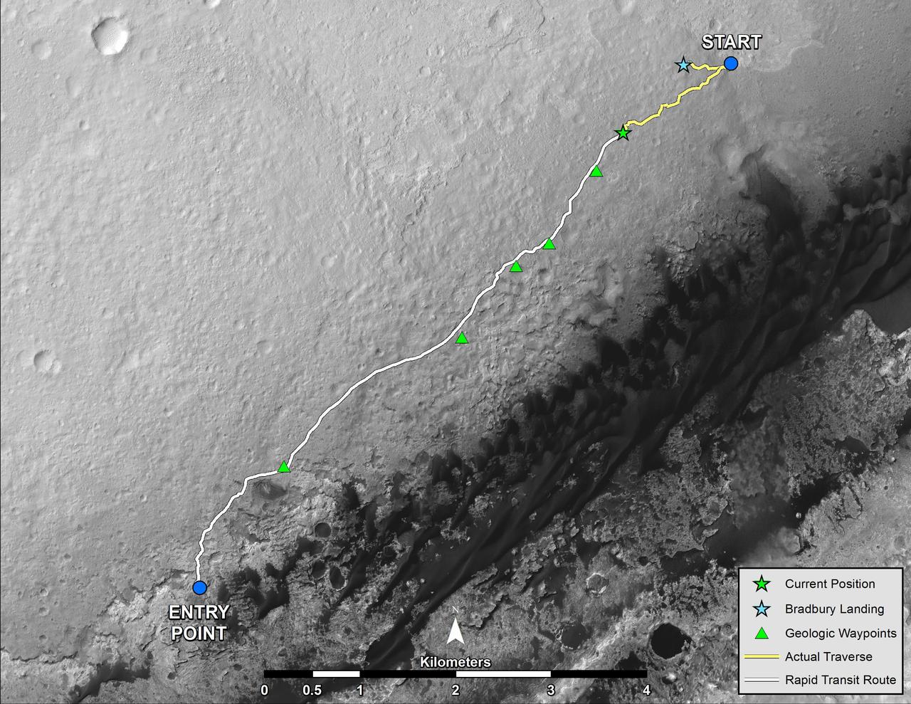
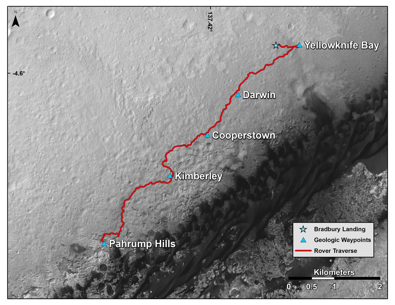
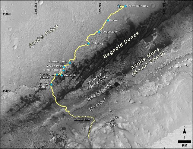
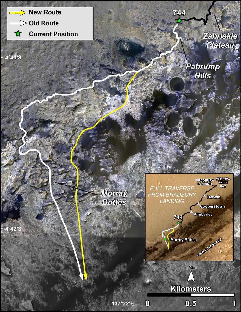
This map shows the route driven by NASA's Curiosity Mars rover from the location where it landed in August 2012 to its location in September 2016 at "Murray Buttes," and the path planned for reaching destinations at "Hematite Unit" and "Clay Unit" on lower Mount Sharp. Blue triangles mark waypoints investigated by Curiosity during the rover's two-year prime mission and first two-year extended mission. The Hematite Unit and Clay Unit are key destinations for the second two-year extension, through September 2018. The base image for the map is from the High Resolution Imaging Science Experiment (HiRISE) camera on NASA's Mars Reconnaissance Orbiter. North is up. Bagnold Dunes form a band of dark, wind-blown material at the foot of Mount Sharp. http://photojournal.jpl.nasa.gov/catalog/PIA20846
A stereo landscape scene from NASA Curiosity Mars rover shows rock rows at Junda forming striations in the foreground, with Mount Sharp on the horizon. You need 3D glasses to view this image.
Curiosity, the big rover of NASA Mars Science Laboratory mission, will land in August 2012 near the foot of a mountain inside Gale Crater. The mission project science group is calling the mountain Mount Sharp.
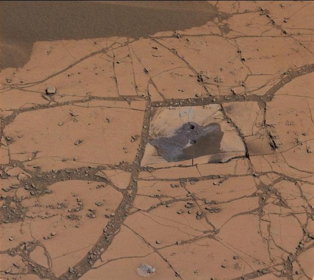
This image shows the first holes drilled by NASA Mars rover Curiosity at Mount Sharp. The loose material near the drill holes is drill tailings and an accumulation of dust that slid down the rock during drilling.
This March 18, 2015, view from the Mast Camera on NASA Curiosity Mars rover shows a network of two-tone mineral veins at an area called Garden City on lower Mount Sharp.
This mosaic of images from the Mast Camera Mastcam on NASA Mars rover Curiosity shows Mount Sharp in a white-balanced color adjustment that makes the sky look overly blue but shows the terrain as if under Earth-like lighting.
NASA Mars rover Curiosity left the Glenelg area on July 4, 2013, on a rapid transit route to the entry point for the mission next major destination, the lower layers of Mount Sharp.
This mosaic of images from the Mastcam onboard NASA Mars rover Curiosity shows Mount Sharp in raw color. Raw color shows the scene colors as they would look in a typical smart-phone camera photo, before any adjustment.
Lower slopes of Mount Sharp appear at the top of this image taken by the right Navigation Camera Navcam of NASA Mars rover Curiosity at the end of a drive of about 135 feet during the 329th Martian day, or sol, of the rover work on Mars.
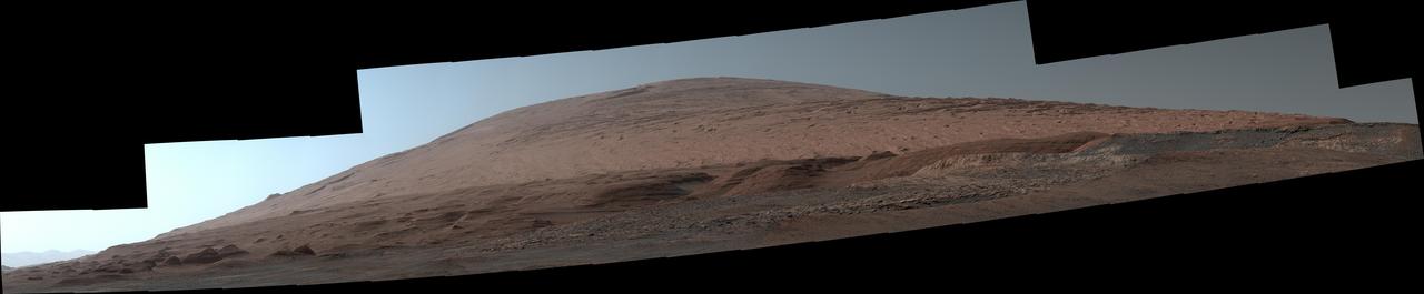
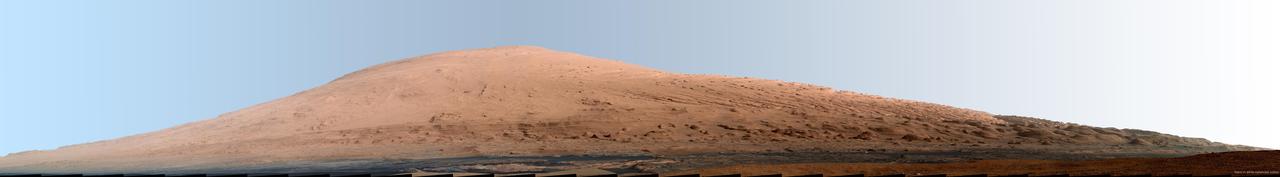
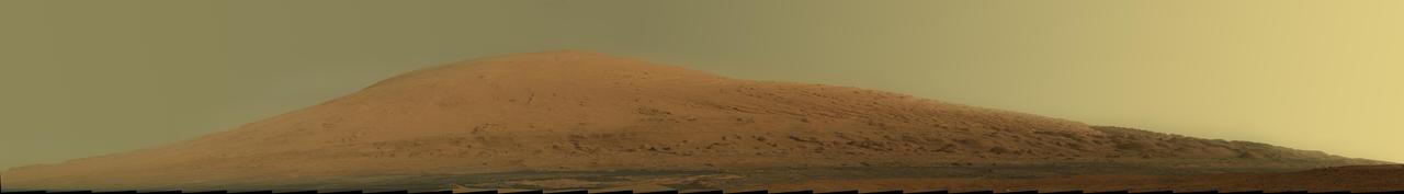
The Mast Camera, or Mastcam, on NASA's Curiosity Mars rover used its telephoto lens to capture Mount Sharp in the morning illumination on Oct. 13, 2019, the 2,555th Martian day, or sol, of the mission. The panorama is composed of 44 individual images stitched together. The panorama has been white-balanced and additionally brightened so that the colors of the rock materials resemble how they would appear under daytime lighting conditions on Earth. https://photojournal.jpl.nasa.gov/catalog/PIA23898
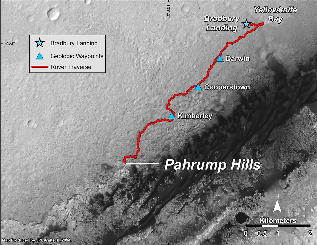
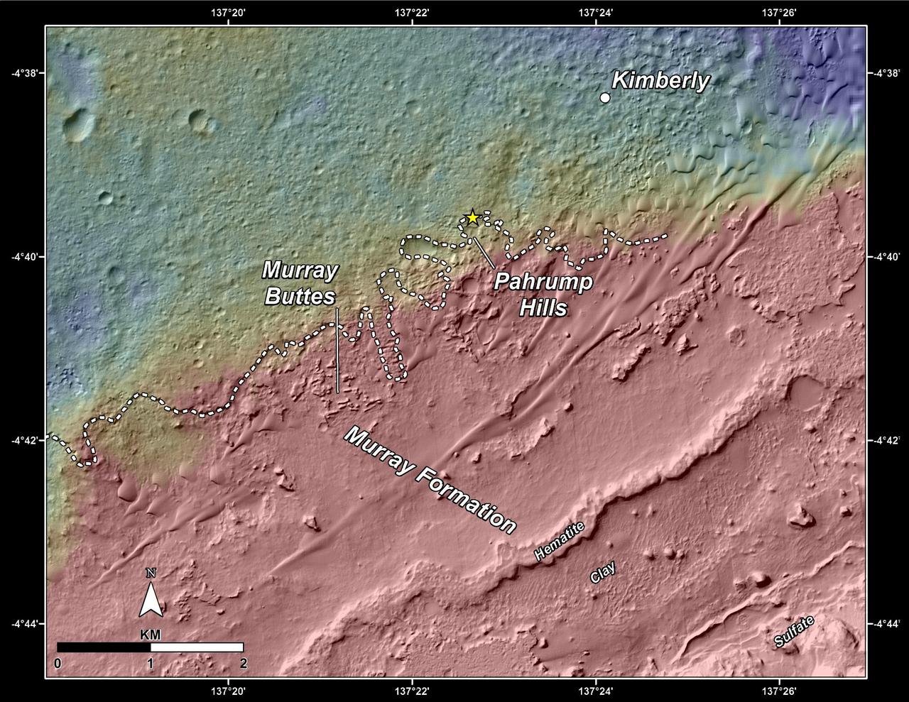
This map shows the route driven by NASA Curiosity Mars rover from the location where it landed in August 2012 to the Pahrump Hills outcrop at the base of Mount Sharp.
This 360-degree panorama was acquired by the Mast Camera (Mastcam) on NASA's Curiosity Mars rover as the rover neared features called "Murray Buttes" on lower Mount Sharp. The view combines more than 130 images taken on Aug. 5, 2016, during the afternoon of the mission's 1,421st sol, or Martian day, by Mastcam's left-eye camera. This date also was the fourth anniversary of Curiosity's landing. The dark, flat-topped mesa seen to the left of Curiosity's robotic arm is about 300 feet (about 90 meters) from the rover's position. It stands about 50 feet (about 15 meters) high. The horizontal ledge near the top of the mesa is about 200 feet (about 60 meters) across. An upper portion of Mount Sharp appears on the distant horizon to the left of this mesa. The relatively flat foreground is part of a geological layer called the Murray formation, which formed from lakebed mud deposits. The buttes and mesas rising above this surface are eroded remnants of ancient sandstone that originated when winds deposited sand after lower Mount Sharp had formed. Curiosity closely examined that layer -- the Stimson formation -- during the first half of 2016 while crossing a feature called "Naukluft Plateau" between two exposures of the Murray formation. The buttes and mesas of Murray Buttes are capped by material that is relatively resistant to erosion, just as is the case with many similarly shaped buttes and mesas on Earth. The informal naming honors Bruce Murray (1931-2013), a Caltech planetary scientist and director of NASA's Jet Propulsion Laboratory, Pasadena, California. The scene is presented with a color adjustment that approximates white balancing, to resemble how the rocks and sand would appear under daytime lighting conditions on Earth. http://photojournal.jpl.nasa.gov/catalog/PIA20765
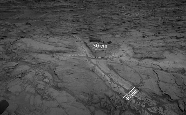
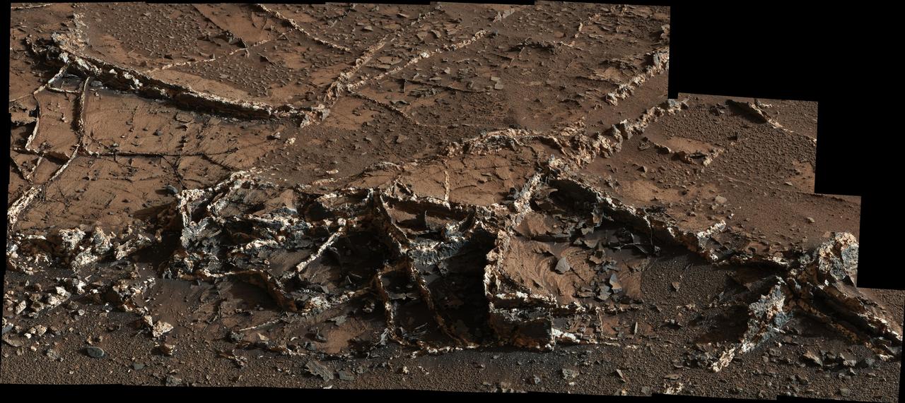
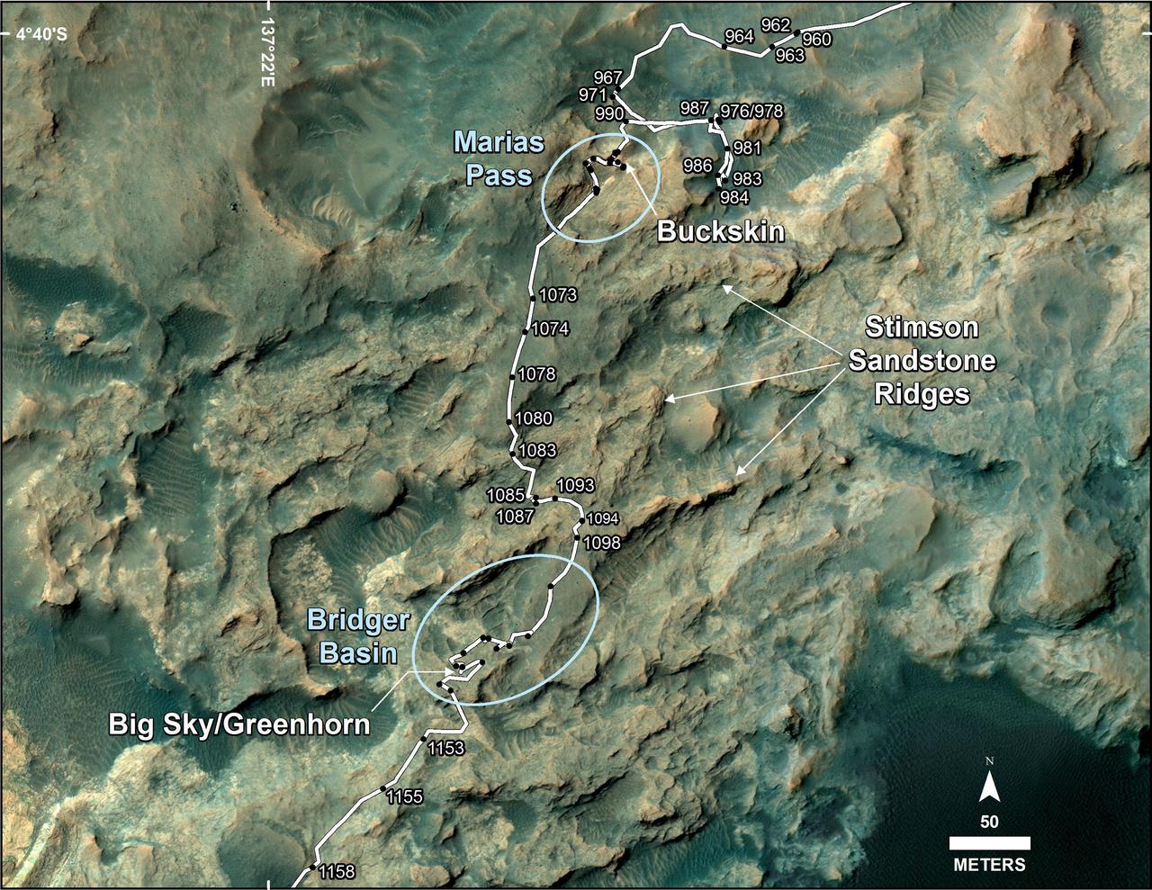
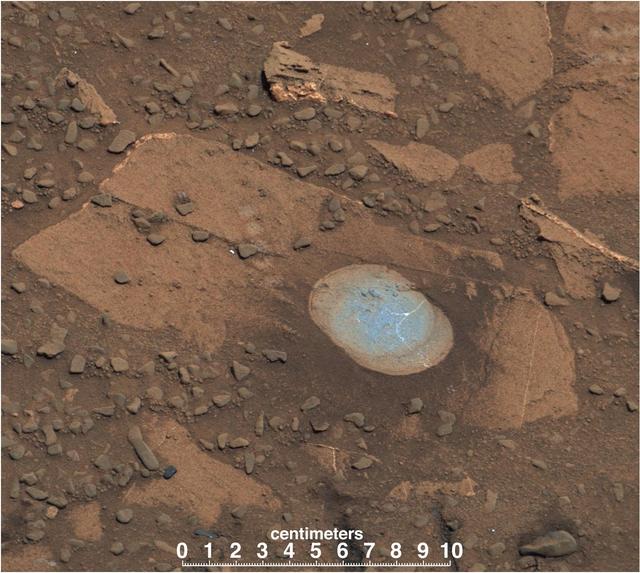
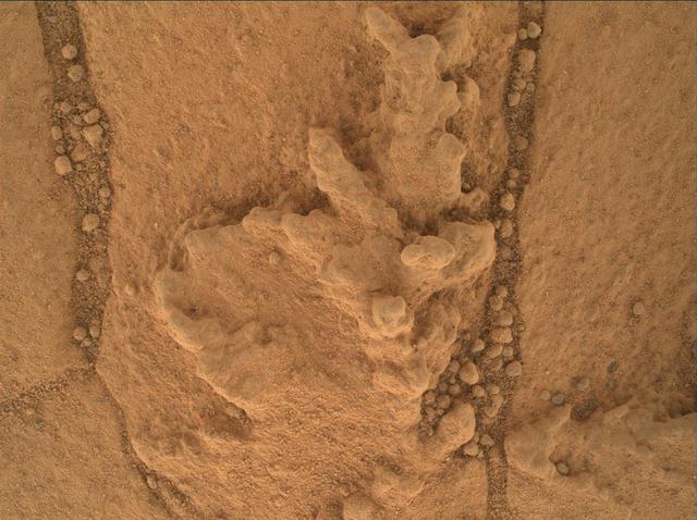
Pale zones called "halos" border bedrock fractures visible in this 2015 image from NASA's Curiosity Mars rover which has been darkened (a previously released image can be seen at PIA20268). Measurements overlaid on the image offer a sense of scale for the size of these fractures. The rover team determined that the halos are rich in silica, a clue to the duration of wet environmental conditions long ago. The location is on the lower slope of Mars' Mount Sharp. Curiosity's Navigation Camera (Navcam) acquired the component images of this mosaic on Aug. 23, 2015, during the 1.083rd Martian day, or sol, of the mission. The location is along the rover's path between "Marias Pass" and "Bridger Basin." In this region, the rover has found fracture zones to be associated with rock compositions enriched in silica, relative to surrounding bedrock. https://photojournal.jpl.nasa.gov/catalog/PIA21649
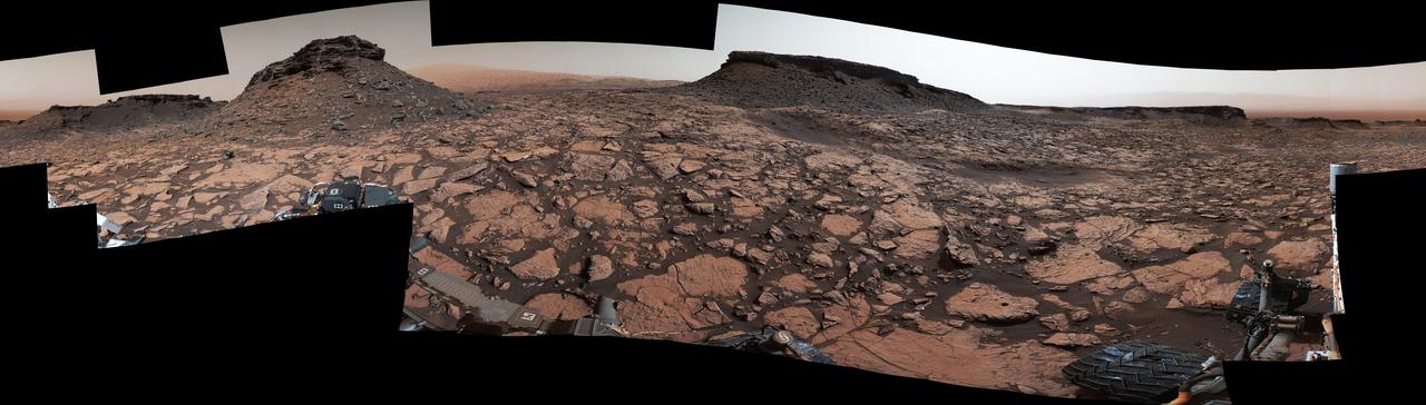
Original Caption Released with Image: This 360-degree panorama was acquired by the Mast Camera (Mastcam) on NASA's Curiosity Mars rover while the rover was in an area called "Murray Buttes" on lower Mount Sharp, one of the most scenic landscapes yet visited by any Mars rover. The view stitches together many individual images taken by Mastcam's left-eye camera on Sept. 4, 2016, during the 1,451st Martian day, or sol, of the mission. North is at both ends and south is in the center. The rover's location when it recorded this scene was the site it reached in its Sol 1448 drive. (See map at http://mars.nasa.gov/msl/multimedia/images/?ImageID=8015.) The dark, flat-topped mesa near the center of the scene rises to about 39 feet (about 12 meters) above the surrounding plain. From the rover's position, the top of this mesa is about 131 feet (about 40 meters) away, and the beginning of the debris apron at the base of the mesa is about 98 feet (about 30 meters) away. In the left half of the image, the dark butte that appears largest sits eastward from the rover and about 33 feet (about 10 meters) high. From the rover's position, the top of this butte is about 85 feet (about 26 meters) away, and the beginning of the debris apron at its base is about 33 feet (about 10 meters) away. An upper portion of Mount Sharp appears on the horizon to the right of it. The relatively flat foreground is part of a geological layer called the Murray formation, which includes lakebed mud deposits. The buttes and mesas rising above this surface are eroded remnants of ancient sandstone that originated when winds deposited sand after lower Mount Sharp had formed. They are capped by material that is relatively resistant to erosion, just as is the case with many similarly shaped buttes and mesas on Earth. The area's informal naming honors Bruce Murray (1931-2013), a Caltech planetary scientist and director of NASA's Jet Propulsion Laboratory, Pasadena, California. The scene is presented with a color adjustment that approximates white balancing, to resemble how the rocks and sand would appear under daytime lighting conditions on Earth. http://photojournal.jpl.nasa.gov/catalog/PIA20840
A view from the Kimberly formation on Mars taken by NASA Curiosity rover. The strata in the foreground dip towards the base of Mount Sharp, indicating the ancient depression that existed before the larger bulk of the mountain formed. The colors are adjusted so that rocks look approximately as they would if they were on Earth, to help geologists interpret the rocks. This "white balancing" to adjust for the lighting on Mars overly compensates for the absence of blue on Mars, making the sky appear light blue and sometimes giving dark, black rocks a blue cast. This image was taken by the Mast Camera (Mastcam) on Curiosity on the 580th Martian day, or sol, of the mission. Malin Space Science Systems, San Diego, built and operates Curiosity's Mastcam. NASA's Jet Propulsion Laboratory, a division of the California Institute of Technology, Pasadena, built the rover and manages the project for NASA's Science Mission Directorate, Washington. http://photojournal.jpl.nasa.gov/catalog/PIA19839
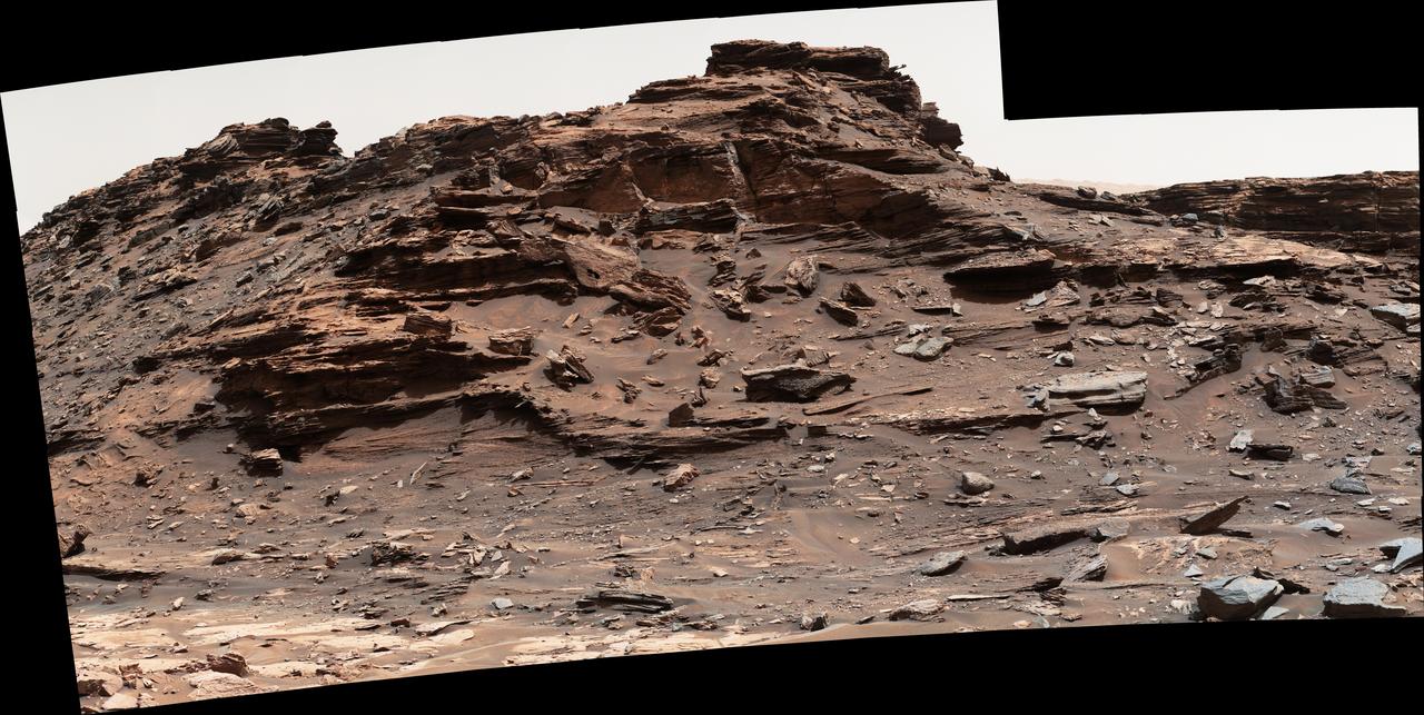
This view from the Mastcam on NASA Curiosity Mars rover shows dramatic buttes and layers on the lower flank of Mount Sharp. It was taken on Sept. 7, 2013, from near the waypoint called Darwin on the route toward an entry point to the mountain.

This northeast-facing view from the lower edge of the pale Pahrump Hills outcrop at the base of Mount Sharp includes wind-sculpted ripples of sand and dust in the middle ground. It was taken by Curiosity Navcam on Nov. 13, 2014.
This animation shows a proposed route for NASA's Curiosity rover, which is climbing lower Mount Sharp on Mars. The annotated version of the map labels different regions that scientists working with the rover would like to explore in coming years. A flyover video explains them in more detail. Data used in creating this map came from several instruments on NASA's Mars Reconnaissance Orbiter (MRO), including the High Resolution Imaging Science Experiment (HiRISE), Compact Reconnaissance Imaging Spectrometer for Mars (CRISM) and the Context Camera (CTX). The High Resolution Stereo Camera (HRSC) instrument on the European Space Agency's Mars Express also contributed data. Animation available at https://photojournal.jpl.nasa.gov/catalog/PIA23179
This frame from a sequence of images shows a dust-carrying whirlwind, called a dust devil, on lower Mount Sharp inside Gale Crater, as viewed by NASA's Curiosity Mars Rover during the summer afternoon of the rover's 1,613rd Martian day, or sol (Feb. 18, 2017). Set within a broader southward view from the rover's Navigation Camera, the rectangular area outlined in black was imaged multiple times over a span of several minutes to check for dust devils. Images from the period with most activity are shown in the inset area. The images are in pairs that were taken about 12 seconds apart, with an interval of about 90 seconds between pairs. Timing is accelerated and not fully proportional in this animation. Contrast has been modified to make frame-to-frame changes easier to see. A black frame provides a marker between repeats of the sequence. On Mars as on Earth, dust devils result from sunshine warming the ground, prompting convective rising of air that has gained heat from the ground. Observations of dust devils provide information about wind directions and interaction between the surface and the atmosphere. An animation is available at http://photojournal.jpl.nasa.gov/catalog/PIA21483
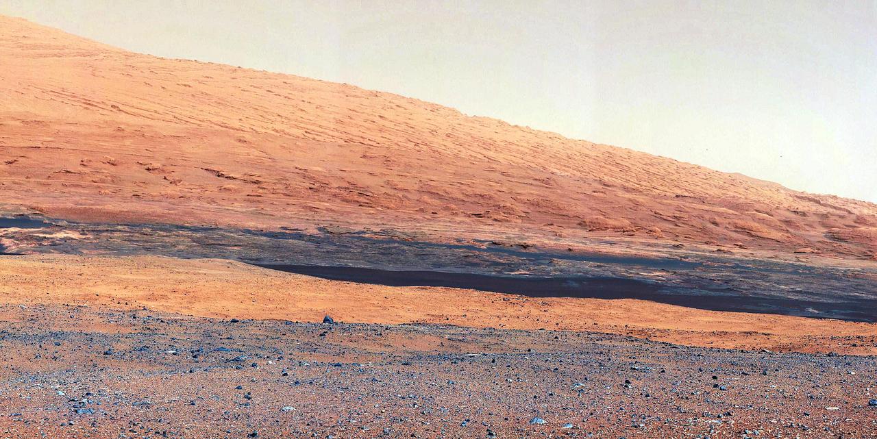
The dark band in the lower portion of this Martian scene is part of the "Bagnold Dunes" dune field lining the northwestern edge of Mount Sharp, inside Gale Crater. The view combines multiple images taken with the Mast Camera (Mastcam) on NASA's Curiosity Mars rover on Sept. 25, 2015, during the 1,115th Martian day, or sol, of Curiosity's work on Mars. The images are from Mastcam's right-eye camera, which has a telephoto lens. The view is toward south-southeast. Curiosity will visit examples of the Bagnold Dunes on the rover's route to higher layers of Mount Sharp. The informal name for the dune field is a tribute to British military engineer Ralph Bagnold (1896-1990), a pioneer in the study of how winds move sand particles of dunes on Earth. The dune field is evident as a dark band in orbital images of the area inside Gale Crater where Curiosity has been active since landing in 2012, such as a traverse map at PIA20162. Dunes are larger than wind-blown ripples of sand or dust that Curiosity and other rovers have visited previously. The scene is presented with a color adjustment that approximates white balancing, to resemble how the rocks and sand would appear under daytime lighting conditions on Earth. http://photojournal.jpl.nasa.gov/catalog/PIA19929
This self-portrait of NASA's Curiosity Mars rover shows the vehicle at the "Quela" drilling location in the "Murray Buttes" area on lower Mount Sharp. Key features on the skyline of this panorama are the dark mesa called "M12" to the left of the rover's mast and pale, upper Mount Sharp to the right of the mast. The top of M12 stands about 23 feet (7 meters) above the base of the sloping piles of rocks just behind Curiosity. The scene combines approximately 60 images taken by the Mars Hand Lens Imager (MAHLI) camera at the end of the rover's robotic arm. Most of the component images were taken on Sept. 17, 2016, during the 1,463rd Martian day, or sol, of Curiosity's work on Mars. Two component images of the drill-hole area in front of the rover were taken on Sol 1466 (Sept. 20) to show the hole created by collecting a drilled sample at Quela on Sol 1464 (Sept. 18). The skyline sweeps from west on the left to south-southwest on the right, with the rover's mast at northeast. The rover's location when it recorded this scene was where it ended a drive on Sol 1455, mapped at http://mars.nasa.gov/msl/multimedia/images/?ImageID=8029. The view does not include the rover's arm nor the MAHLI camera itself, except in the miniature scene reflected upside down in the parabolic mirror at the top of the mast. That mirror is part of Curiosity's Chemistry and Camera (ChemCam) instrument. MAHLI appears in the center of the mirror. Wrist motions and turret rotations on the arm allowed MAHLI to acquire the mosaic's component images. The arm was positioned out of the shot in the images, or portions of images, that were used in this mosaic. This process was used previously in acquiring and assembling Curiosity self-portraits taken at other sample-collection sites, including "Rocknest" (PIA16468), "Windjana" (PIA18390"), "Buckskin" (PIA19808) and "Gobabeb" (PIA20316). For scale, the rover's wheels are 20 inches (50 centimeters) in diameter and about 16 inches (40 centimeters) wide. http://photojournal.jpl.nasa.gov/catalog/PIA20844
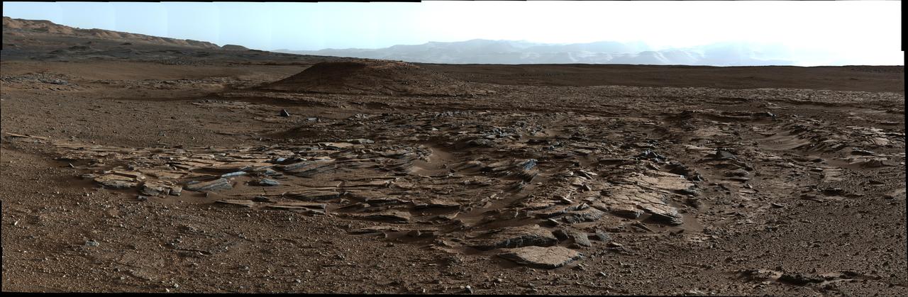
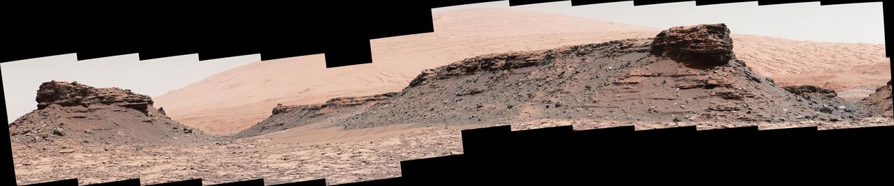
A sweeping panorama combining 33 telephoto images into one Martian vista presents details of several types of terrain visible on Mount Sharp from a location along the route of NASA's Curiosity Mars rover. The rover's Mast Camera (Mastcam) recorded the component images with its right-eye camera on April 10, 2015, during the 952nd Martian day, or sol, of Curiosity's work on Mars, before that sol's drive. The panorama spans from south-southeast, at left, to west-southwest. The color has been approximately white-balanced to resemble how the scene would appear under daytime lighting conditions on Earth. Higher elevations on Mount Sharp are visible at left, including the jagged skyline to the right of a 100-meter scale bar overlaid on the image. (One hundred meters is about 328 feet.) The 2-meter (7-foot) scale bar near the center of the scene is on an exposure of pale mudstone within Mount Sharp's basal geological unit, the Murray formation, and nearby darker rocks. The 3-meter (10-foot) scale bar farther to the right is at the base of a rise called "Gray Wolf Peak." "Logan Pass," a science destination for the rover, is at a dip on the horizon near the right edge of the panorama. Malin Space Science Systems, San Diego, built and operates the rover's Mastcam. NASA's Jet Propulsion Laboratory, a division of the California Institute of Technology, Pasadena, manages the Mars Science Laboratory Project for NASA's Science Mission Directorate, Washington. JPL designed and built the project's Curiosity rover. http://photojournal.jpl.nasa.gov/catalog/PIA19397
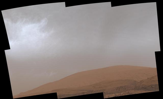
This GIF shows clouds drifting over Mount Sharp on Mars, as viewed by NASA's Curiosity rover on March 19, 2021, the 3,063rd Martian day, or sol, of the mission. Each frame of the scene was stitched together from six individual images. Movie available at https://photojournal.jpl.nasa.gov/catalog/PIA24661
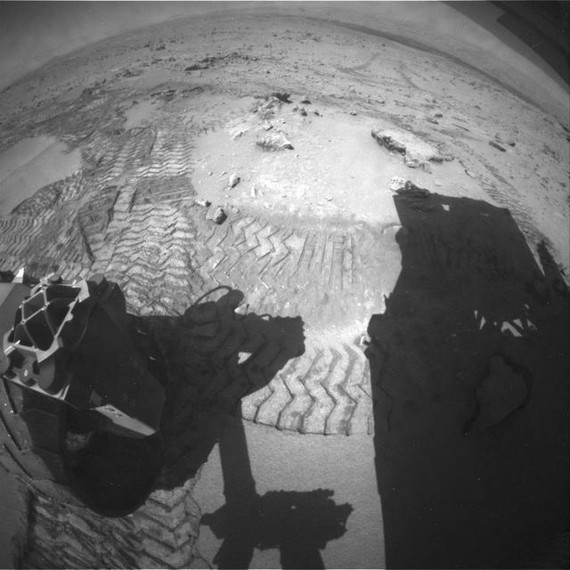
This view from the Navigation Camera (Navcam) on the mast of NASA's Curiosity Mars rover shows rocky ground within view while the rover was working at an intended drilling site called "Precipice" on lower Mount Sharp. The right-eye camera of the stereo Navcam took this image on Dec. 2, 2016, during the 1,537th Martian day, or sol, of Curiosity's work on Mars. On the previous sol, an attempt to collect a rock-powder sample with the rover's drill ended before drilling began. This led to several days of diagnostic work while the rover remained in place, during which it continued to use cameras and a spectrometer on its mast, plus environmental monitoring instruments. In this view, hardware visible at lower right includes the sundial-theme calibration target for Curiosity's Mast Camera. http://photojournal.jpl.nasa.gov/catalog/PIA21140
This map shows the route driven by NASA's Curiosity Mars rover from the location where it landed in August 2012 to its location in December 2016, which is in the upper half of a geological unit called the Murray formation, on lower Mount Sharp. Blue triangles mark waypoints investigated by Curiosity during the rover's two-year prime mission and first two-year extended mission. The "Hematite Unit" and "Clay Unit" are key destinations for the second two-year extension, through September 2018. An approximate possible route is indicated for studying those layers of the mountain. The base image for the map is from the High Resolution Imaging Science Experiment (HiRISE) camera on NASA's Mars Reconnaissance Orbiter. North is up. Bagnold Dunes form a band of dark, wind-blown material at the foot of Mount Sharp. The scale bar at lower right represents one kilometer (0.62 mile). http://photojournal.jpl.nasa.gov/catalog/PIA21144
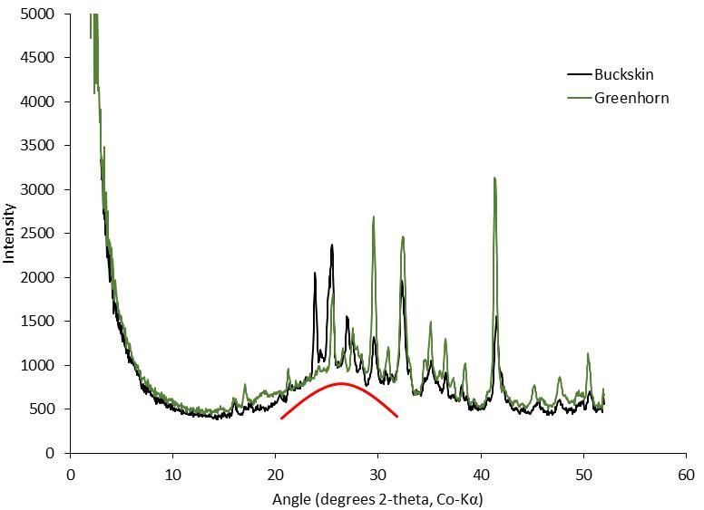
This graph presents information from the NASA Curiosity Mars rover's onboard analysis of rock powder drilled from the "Buckskin" and "Greenhorn" target locations on lower Mount Sharp. Buckskin, in the "Marias Pass" area, and Greenhorn, in the "Bridger Basin" area, both contain high concentrations of silica. X-ray diffraction analysis of powered samples inside Curiosity's Chemistry and Mineralogy (CheMin) instrument revealed that each of them contains silica in the form of noncrystalline opal. The broad hump in the two X-ray diffraction patterns is diagnostic of opaline silica. Some of the silica in Buckskin is in the form of tridymite. http://photojournal.jpl.nasa.gov/catalog/PIA20273
This patch of Martian bedrock, about 2 feet 70 centimeters across, is finely layered rock with some pea-size inclusions. It lies near the lowest point of the Pahrump Hills outcrop, which forms part of the basal layer of Mount Sharp.
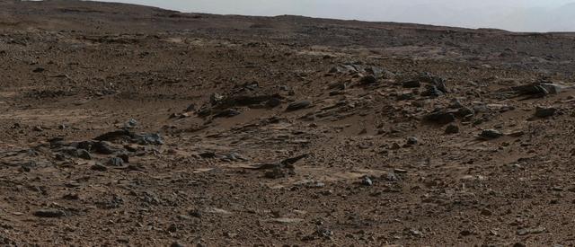
This small ridge, about 3 feet long, appears to resist wind erosion more than the flatter plates around it. Such differences are among the traits NASA Curiosity Mars rover is examining at selected rock targets at the base of Mount Sharp.

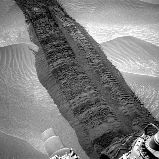
This view from the Mast Camera (Mastcam) on NASA's Curiosity Mars rover shows two scales of ripples, plus other textures, in an area where the mission examined a linear-shaped dune in the Bagnold dune field on lower Mount Sharp. The scene is an excerpt from a 360-degree panorama acquired on March 24 and March 25, 2017, (PST) during the 1,647th Martian day, or sol, of Curiosity's work on Mars, at a location called "Ogunquit Beach." Crests of the longer ripples visible in the dark sand of the dune are several feet (a few meters) apart. This medium-scale feature in active sand dunes on Mars was one of Curiosity's findings at the crescent-shaped dunes that the rover examined in late 2015 and early 2016. Ripples that scale are not seen on Earth's sand dunes. Overlaid on those ripples are much smaller ripples, with crests about ten times closer together. Textures of the local bedrock in the foreground -- part of the Murray formation that originated as lakebed sediments -- and of gravel-covered ground (at right) are also visible. The image has been white-balanced so that the colors of the colors of the rock and sand materials resemble how they would appear under daytime lighting conditions on Earth. https://photojournal.jpl.nasa.gov/catalog/PIA11242
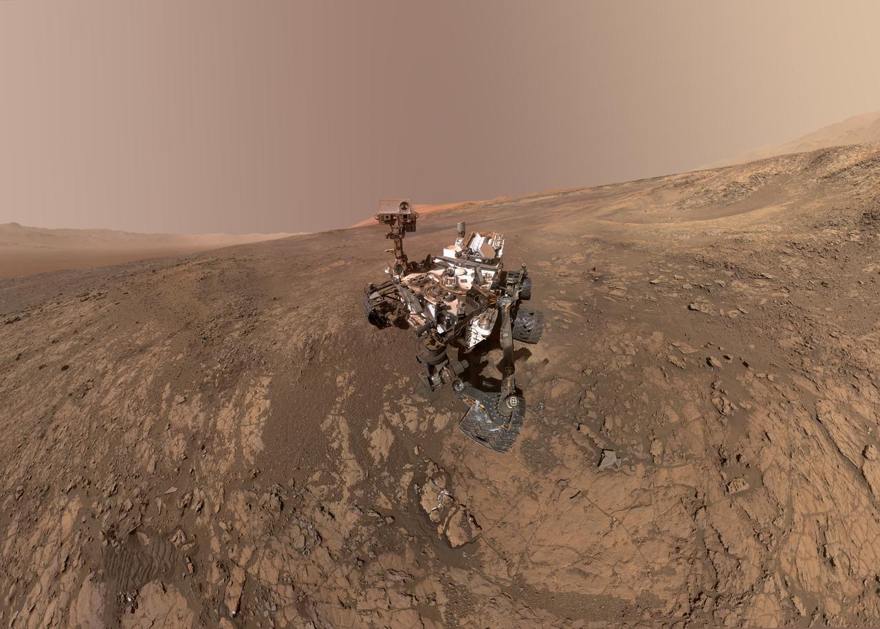
This self-portrait of NASA's Curiosity Mars rover shows the vehicle on Vera Rubin Ridge, which it's been investigating for the past several months. Directly behind the rover is the start of a clay-rich slope scientists are eager to begin exploring. In the coming week, Curiosity will begin to climb this slope. North is on the left and west is on the right, with Gale Crater's rim on the horizon of both edges. Poking up just behind Curiosity's mast is Mount Sharp, photobombing the robot's selfie. Curiosity landed on Mars five years ago with the intention of studying lower Mount Sharp, where it will remain for all of its time on Mars. The mountain's base provides access to layers formed over millions of years. These layers formed in the presence of water -- likely due to a lake or lakes that sat at the bottom of the mountain, which sits inside of Gale Crater. This mosaic was assembled from dozens of images taken by Curiosity's Mars Hands Lens Imager (MAHLI). They were all taken on Jan. 23, 2018, during Sol 1943. The view does not include the rover's arm nor the MAHLI camera itself, except in the miniature scene reflected upside down in the parabolic mirror at the top of the mast. That mirror is part of Curiosity's Chemistry and Camera (ChemCam) instrument. MAHLI appears in the center of the mirror. Wrist motions and turret rotations on the arm allowed MAHLI to acquire the mosaic's component images. The arm was positioned out of the shot in the images, or portions of images, that were used in this mosaic. A full-resolution image is available at https://photojournal.jpl.nasa.gov/catalog/PIA22207
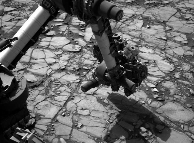
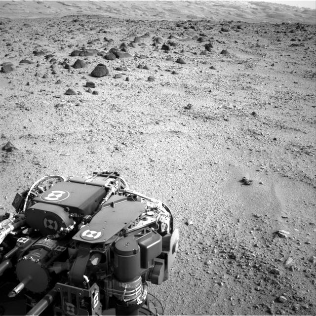
NASA's Curiosity Mars rover began close-up investigation of a target called "Marimba," on lower Mount Sharp, during the week preceding the fourth anniversary of the mission's dramatic sky-crane landing. The Navigation Camera (Navcam) on Curiosity's mast took this image on Aug. 2, 2016, during the 1,418th Martian day, or sol, since Curiosity landed inside Gale Crater on Aug. 6, 2012, Universal Time (Aug. 5, PDT). In this scene, the rover has extended its arm over a patch of bedrock selected as the target for rover's next drilling operation. The drilling collects rock powder for onboard laboratory analysis. The arm is positioned with the rover's wire-bristle Dust Removal Tool above the target. http://photojournal.jpl.nasa.gov/catalog/PIA20764
The two prominent mesas in this view of Mars' "Murray Buttes" region from NASA's Curiosity Mars rover are about 260 feet (about 80 meters) apart. The top of the one on the left is about 26 feet (about 8 meters) above the surrounding plain and about 330 feet (about 100 meters) from Curiosity's position when the rover acquired this view on Aug. 18, 2016, during the 1,434th Martian day, or sol, of its work Mars. The component images of this mosaic were taken by the right-eye camera of the rover's Mast Camera (Mastcam), which has a telephoto lens. The mesa on the right is about 33 feet (about 10 meters) high. The top of it is about 270 feet (about 82 meters) from the rover. Upper Mount Sharp is the salmon-hued mound dominating the horizon between the scene's two prominent mesas. The left edge of this view is east-northeast from the rover; the right edge is southeast. The rover's location when it recorded this scene was the site it reached in its Sol 1433 drive. (See map at http://mars.nasa.gov/msl/multimedia/images/?ImageID=7999.) The scene is presented with a color adjustment that approximates white balancing, to resemble how the rocks and sand would appear under daytime lighting conditions on Earth. http://photojournal.jpl.nasa.gov/catalog/PIA20841
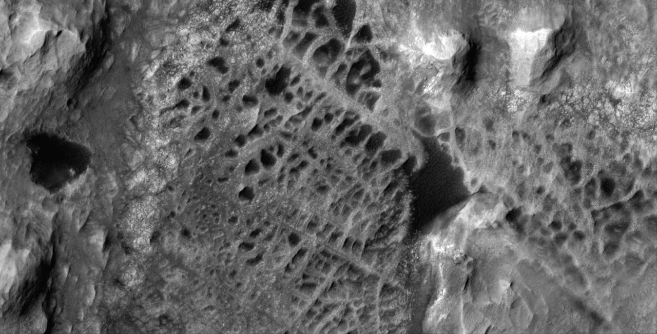
Scientists think that ancient groundwater formed this weblike pattern of ridges, called boxwork, that were captured by NASA's Mars Reconnaissance Orbiter on Dec. 10, 2006. The agency's Curiosity rover will study ridges similar to these up close in 2025. Boxwork can form on Earth when groundwater flows through a web of rock fractures underground. Minerals carried by the water can coat the cracks and be deposited within the rock nearby. Eons later, if the rock erodes away, the minerals filling the cracks or the hardened rock leave a weblike pattern of ridges exposed. In the area captured by HiRISE, dark sand filled the spaces between these ridges, making them stand out more dramatically in the black-and-white image. The Martian boxwork Curiosity is headed toward formed in the foothills of lower Mount Sharp, a 3-mile-tall (5-kilometer-tall) mountain the rover has been ascending since 2014. Mount Sharp's boxwork structures stand apart from those on Earth, both because they formed as water was disappearing from Mars and because they're so extensive, running as long as 6 to 12 miles (10 to 20 kilometers). Scientists are eager to study them up close because minerals in the Martian boxwork crystallized underground, where it would have been warmer, with liquid flowing through. The rover's science team will study whether microbes could have survived in that ancient environment. https://photojournal.jpl.nasa.gov/catalog/PIA26306
This map shows the route on lower Mount Sharp that NASA Curiosity followed between April 19, 2015, and Nov. 5, 2015.
This low-angle self-portrait of NASA's Curiosity Mars rover shows the vehicle above the "Buckskin" rock target, where the mission collected its seventh drilled sample. The site is in the "Marias Pass" area of lower Mount Sharp. The scene combines dozens of images taken by Curiosity's Mars Hand Lens Imager (MAHLI) on Aug. 5, 2015, during the 1,065th Martian day, or sol, of the rover's work on Mars. The 92 component images are among MAHLI Sol 1065 raw images at http://mars.nasa.gov/msl/multimedia/raw/?s=1065&camera=MAHLI. For scale, the rover's wheels are 20 inches (50 centimeters) in diameter and about 16 inches (40 centimeters) wide. Curiosity drilled the hole at Buckskin during Sol 1060 (July 30, 2015). Two patches of pale, powdered rock material pulled from Buckskin are visible in this scene, in front of the rover. The patch closer to the rover is where the sample-handling mechanism on Curiosity's robotic arm dumped collected material that did not pass through a sieve in the mechanism. Sieved sample material was delivered to laboratory instruments inside the rover. The patch farther in front of the rover, roughly triangular in shape, shows where fresh tailings spread downhill from the drilling process. The drilled hole, 0.63 inch (1.6 centimeters) in diameter, is at the upper point of the tailings. The rover is facing northeast, looking out over the plains from the crest of a 20-foot (6-meter) hill that it climbed to reach the Marias Pass area. The upper levels of Mount Sharp are visible behind the rover, while Gale Crater's northern rim dominates the horizon on the left and right of the mosaic. A portion of this selfie cropped tighter around the rover is at PIA19808. Another version of the wide view, presented in a projection that shows the horizon as a circle, is at PIA19806. MAHLI is mounted at the end of the rover's robotic arm. For this self-portrait, the rover team positioned the camera lower in relation to the rover body than for any previous full self-portrait of Curiosity. This yielded a view that includes the rover's "belly," as in a partial self-portrait (PIA16137) taken about five weeks after Curiosity's August 2012 landing inside Mars' Gale Crater. Before sending Curiosity the arm-positioning commands for this Buckskin belly panorama, the team previewed the low-angle sequence of camera pointings on a test rover in California. A mosaic from that test is at PIA19810. This selfie at Buckskin does not include the rover's robotic arm beyond a portion of the upper arm held nearly vertical from the shoulder joint. Shadows from the rest of the arm and the turret of tools at the end of the arm are visible on the ground. With the wrist motions and turret rotations used in pointing the camera for the component images, the arm was positioned out of the shot in the frames or portions of frames used in this mosaic. This process was used previously in acquiring and assembling Curiosity self-portraits taken at sample-collection sites "Rocknest" (PIA16468), "John Klein" (PIA16937), "Windjana" (PIA18390) and "Mojave" (PIA19142). MAHLI was built by Malin Space Science Systems, San Diego. NASA's Jet Propulsion Laboratory, a division of the California Institute of Technology in Pasadena, manages the Mars Science Laboratory Project for the NASA Science Mission Directorate, Washington. JPL designed and built the project's Curiosity rover. http://photojournal.jpl.nasa.gov/catalog/PIA19807

This self-portrait of NASA Curiosity Mars rover shows the vehicle at a drilled sample site called Okoruso, on the Naukluft Plateau of lower Mount Sharp.
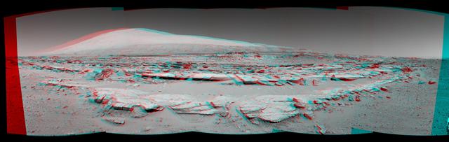
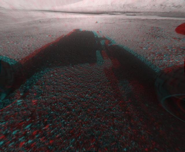
The site for NASA Curiosity rover is near the northern flank of Mount Sharp, inside Gale Crater on Mars. You need 3D glasses to view this image.
As NASA Mars rover Curiosity is progressing toward Mount Sharp, researchers are using the rover RIM and ChemCam instruments to examine soils and rocks in Gale Crater.
This view from the Mast Camera (Mastcam) on NASA's Curiosity Mars rover shows a site with a network of prominent mineral veins below a cap rock ridge on lower Mount Sharp. Researchers used the rover in March 2015 to examine the structure and composition of the crisscrossing veins at the "Garden City" site in the center of this scene. For geologists, the vein complex offers a three-dimensional exposure of mineralized fractures in a geological setting called the Pahrump section of the Lower Murray Formation. Curiosity spent several months examining sites in the Pahrump section below this site, before arriving at Garden City. Mineral veins such as these form where fluids move through fractured rocks, depositing minerals in the fractures and affecting chemistry of the surrounding rock. In this case, the veins have been more resistant to erosion than the surrounding host rock. The component images of this mosaic view were taken by the left-eye camera of Mastcam on March 27, 2015, during the 938th Martian day, or sol, of Curiosity's work on Mars. The scene is presented with a color adjustment that approximates white balancing, to resemble how the rocks would appear under daytime lighting conditions on Earth. For scale, the cap rock scarp is about 3 feet (1 meter) tall. Figure 1 includes scale bars of 1 meter (3.3 feet) vertically and 2 meters (6.7 feet) horizontally. Malin Space Science Systems, San Diego, built and operates Curiosity's Mastcam. NASA's Jet Propulsion Laboratory, a division of the California Institute of Technology, Pasadena, built the rover and manages the project for NASA's Science Mission Directorate, Washington. http://photojournal.jpl.nasa.gov/catalog/PIA19921
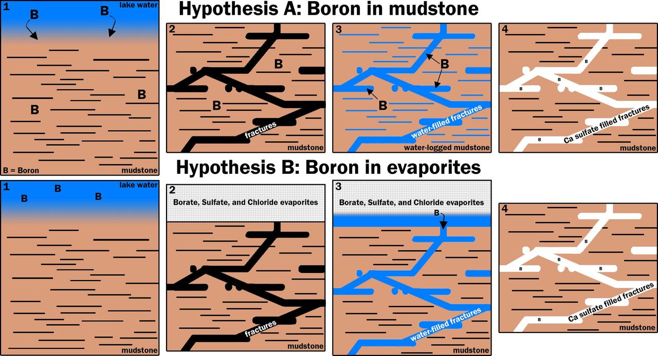
This graphic portrays two hypotheses about how the element boron ended up in calcium sulfate veins found within mudstone layers of the Murray formation on Mars' lower Mount Sharp. Hypothesis A is presented left-to-right in the upper four panels; hypothesis B in the lower four. Note that the two final panels are identical, depicting conditions found by NASA's Curiosity Mars rover. Calcium sulfate is the veins' main ingredient. The mudstone matrix around the veins resulted from deposition of sediments in a lake environment in Mars' Gale Crater billions of years ago. In hypothesis A: (1) Boron dissolved in the lake and was incorporated into the lake bottom clays that became the Murray formation. (2) The lake then dried and the bedrock fractured. (3) Later groundwater interacted with the clays under conditions that released the boron into the groundwater. (4) Then, the boron was deposited along with the calcium sulfate that makes up the bulk of these veins. In hypothesis B: (1) Boron was not incorporated into the clays as the lake was active. (2) Instead, when the lake dried out, it left a layer of boron-containing salts, and likely other types of salts, such as sodium chloride (table salt) and calcium sulfates, in an overlying layer that Curiosity has not yet visited. The bedrock fractured. (3) Groundwater later dissolved this layer of evaporite salts and moved the salts down into the older layers the rover has investigated. (4) The groundwater deposited the evaporite salts with the calcium sulfate that makes up the bulk of these veins. http://photojournal.jpl.nasa.gov/catalog/PIA21253

This mosaic taken by NASA's Mars Curiosity rover looks uphill at Mount Sharp, which Curiosity has been climbing. Highlighted in white is an area with clay-bearing rocks that scientists are eager to explore; it could shed additional light on the role of water in creating Mount Sharp. The mosaic was assembled from dozens of images taken by Curiosity's Mast Camera (Mastcam). It was taken on Sol 1931 back in January. Mount Sharp stands in the middle of Gale Crater, which is 96 miles (154 kilometers) in diameter. This mound, which Curiosity has been climbing since 2014, likely formed in the presence of water at various points of time in Mars ancient history. That makes it an ideal place to study how water influenced the habitability of Mars billions of years ago. The scene has been white-balanced so the colors of the rock materials resemble how they would appear under daytime lighting conditions on Earth. https://photojournal.jpl.nasa.gov/catalog/PIA22312
This view of the downwind face of "Namib Dune" on Mars covers 360 degrees, including a portion of Mount Sharp on the horizon. The site is part of the dark-sand "Bagnold Dunes" field along the northwestern flank of Mount Sharp. Images taken from orbit indicate that dunes in the Bagnold field move as much as about 3 feet (1 meter) per Earth year. The component images of this scene were taken on Dec. 18, 2015, by the Mast Camera (Mastcam) on NASA's Curiosity Mars rover during the 1,197th Martian day, or sol, of the rover's work on Mars. http://photojournal.jpl.nasa.gov/catalog/PIA20284
This mosaic taken by NASA's Mars Curiosity rover looks uphill at Mount Sharp, which Curiosity has been climbing. Spanning the center of the image is an area with clay-bearing rocks that scientists are eager to explore; it could shed additional light on the role of water in creating Mount Sharp. The mosaic was assembled from dozens of images taken by Curiosity's Mast Camera (Mastcam). It was taken on Sol 1931 back in January. Mount Sharp stands in the middle of Gale Crater, which is 96 miles (154 kilometers) in diameter. This mound, which Curiosity has been climbing since 2014, likely formed in the presence of water at various points of time in Mars ancient history. That makes it an ideal place to study how water influenced the habitability of Mars billions of years ago. The scene has been white-balanced so the colors of the rock materials resemble how they would appear under daytime lighting conditions on Earth. https://photojournal.jpl.nasa.gov/catalog/PIA22313
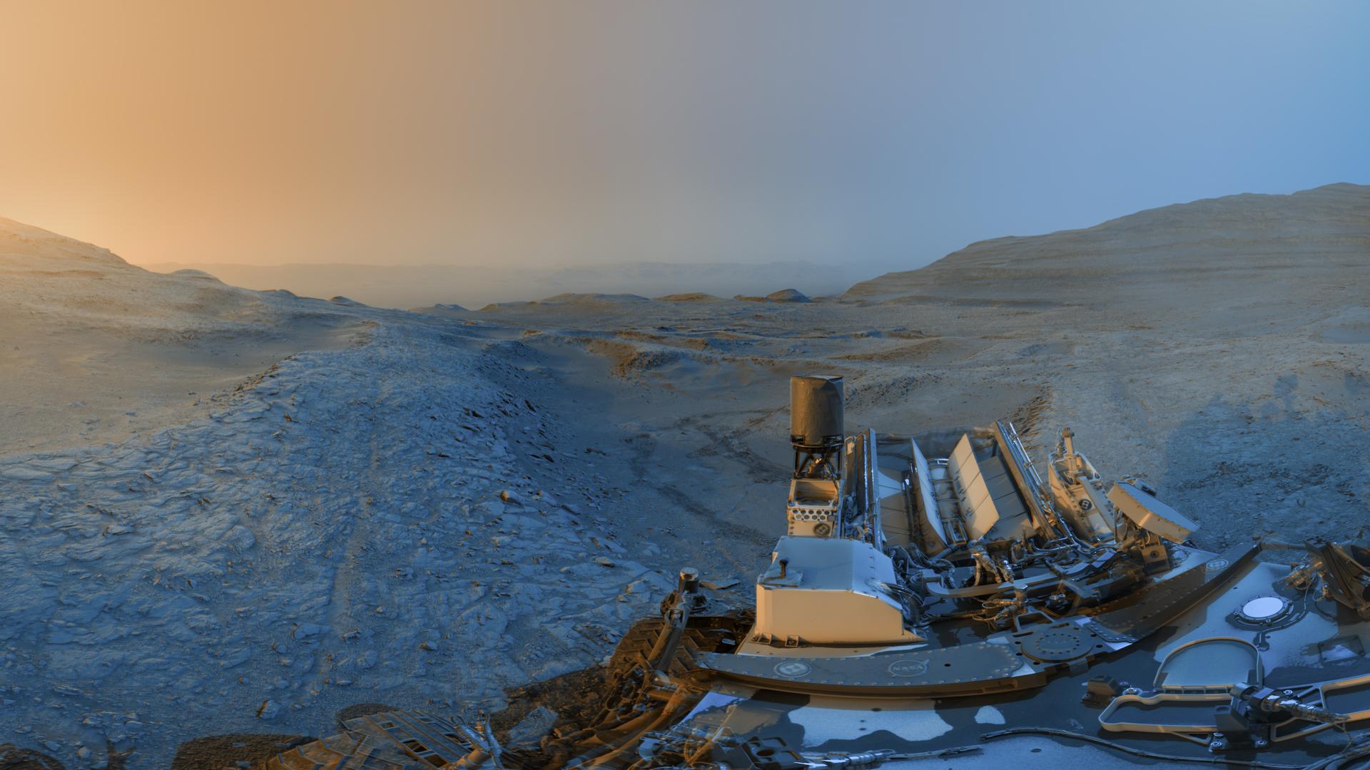
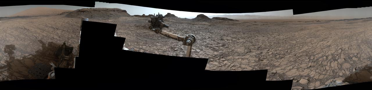
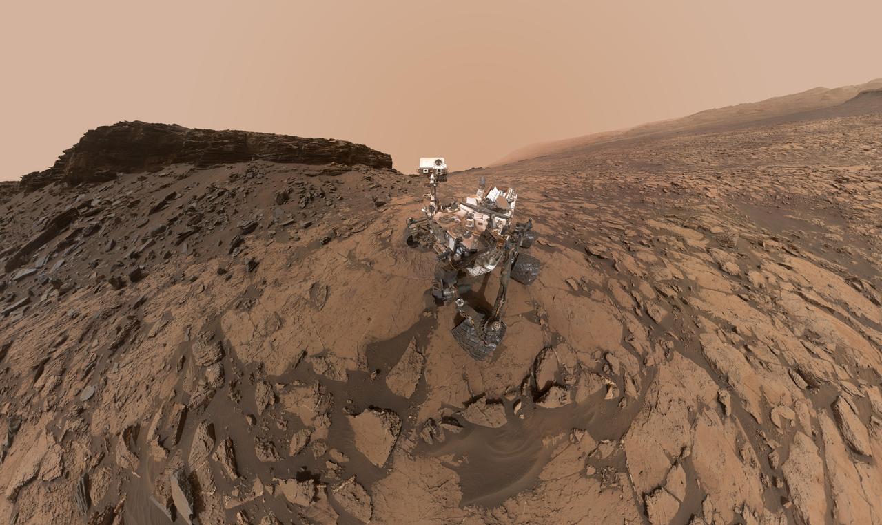
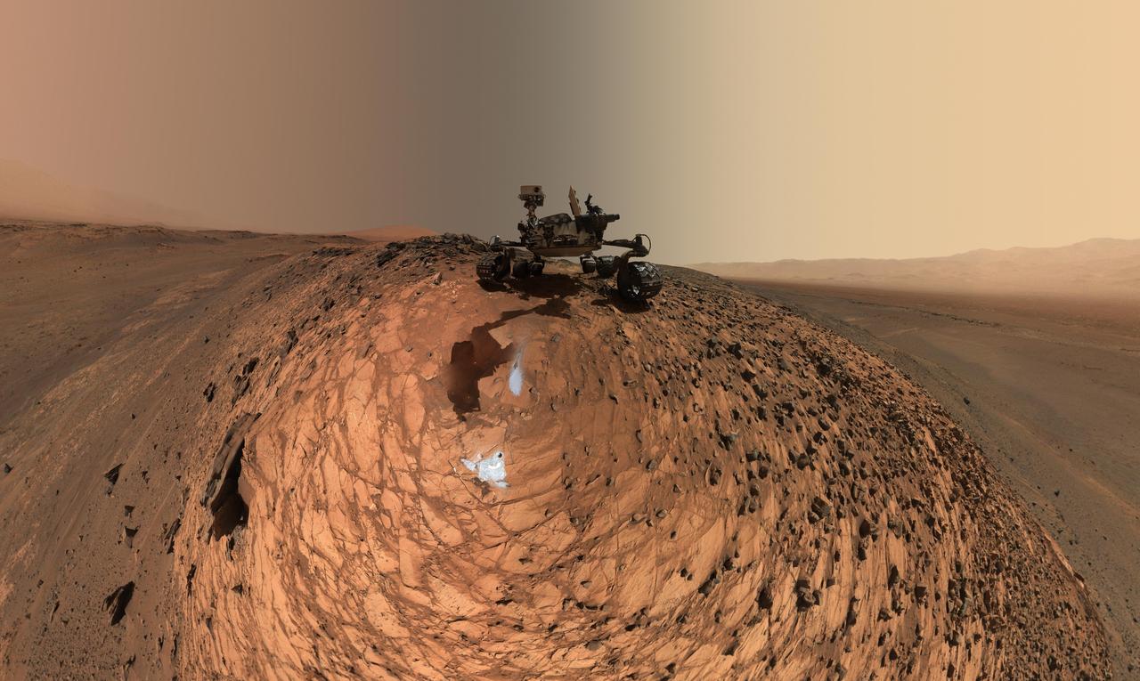
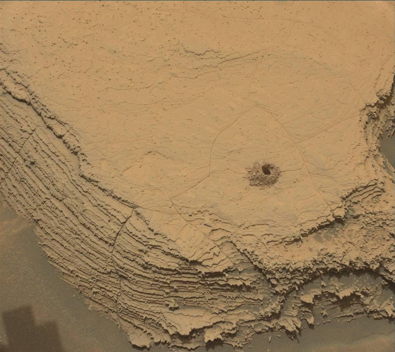
NASA’s Curiosity Mars rover used its black-and-white navigation cameras to capture panoramas at two times of day on Nov. 18, 2025, spanning periods that occurred on both the 4,722nd and 4,723rd Martian days, or sols, of the mission. The panoramas were captured at 4:15 p.m. on Sol 4,722 and 8:20 a.m. on Sol 4,723 (both at local Mars time), then merged together. Color was later added for an artistic interpretation of the scene with blue representing the morning panorama and yellow representing the afternoon one. The resulting “postcard” is similar to ones the rover took in June 2023 and November 2021. Adding color to these kinds of merged images helps different details stand out in the landscape. The scene captured in this postcard shows Curiosity at the top of a ridge referred to as a boxwork formation. These formations crisscross a region in the lower foothills of Mount Sharp, a 3-mile-tall (5-kilometer-tall) mountain which Curiosity has been climbing since 2014. Curiosity used the drill on the end of its robotic arm to collect a rock sample from the top of this ridge at a spot nicknamed “Nevado Sajama.” This view looks north across the boxwork formations and downslope of Mount Sharp toward the floor of Gale Crater, a vast impact crater the mountain is located within. The crater’s rim can be seen far in the distant horizon, approximately 25 miles (40 kilometers) away. Wheel tracks are visible in the hollow behind Curiosity, where a sample was also drilled at a spot nicknamed “Valle de la Luna.” The boxwork formations are believed to have been created billions of years ago when water on ancient Mars dripped through rock cracks, carrying minerals with them. The minerals hardened after the water dried up; eons later, wind sandblasted the softer rock around these hardened minerals, exposing the ridges Curiosity is exploring today. These ridges may reveal more about the planet’s watery past. Curiosity was built by NASA’s Jet Propulsion Laboratory, which is managed by Caltech in Pasadena, California. JPL leads the mission on behalf of NASA’s Science Mission Directorate in Washington as part of NASA’s Mars Exploration Program portfolio. For more about Curiosity, visit: science.nasa.gov/mission/msl-curiosity
This image from NASA Mars Curiosity rover shows the Amargosa Valley, on the slopes leading up to Mount Sharp on Mars. The rover is headed toward the Pahrump Hills outcrop.
This is the first 360-degree panoramic view from NASA Curiosity rover, taken with the Navigation cameras. Mount Sharp is to the right, and the north Gale Crater rim can be seen at center. The rover body is in the foreground.
This image shows inclined beds characteristic of delta deposits where a stream entered a lake, but at a higher elevation and farther south than other delta deposits north of Mount Sharp.
A swept Martian rock called Bonanza King can be seen in this image take by NASA Mars Curiosity rover. This rock is located across the boundary that defines the base of Mount Sharp.
This image comparison shows a view through a Hazard-Avoidance camera on NASA Curiosity rover before and after the clear dust cover was removed. Both images were taken by a camera at the front of the rover. Mount Sharp, looms ahead.
NASA Curiosity Mars rover used its Navigation Camera Navcam to capture this view partway back down a slope it climbed toward Marias Pass on lower Mount Sharp. The image was taken May 22, 2015.
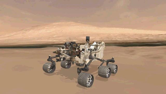
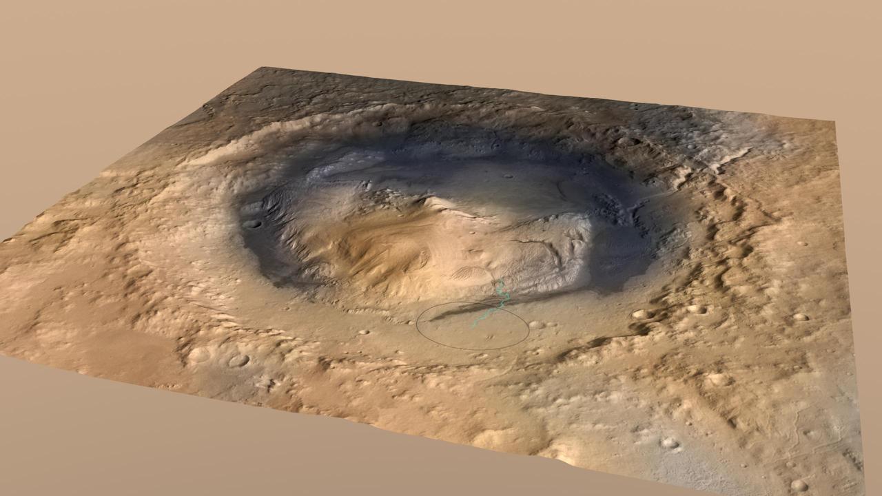
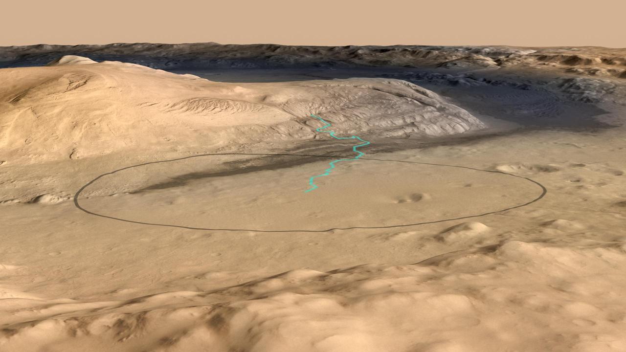
This image shows the approximate true position of NASA Curiosity rover on Mars. A 3-D virtual model of Curiosity is shown inside Gale Crater, near Mount Sharp, Curiosity ultimate destination.
This image from Curiosity Mastcam shows inclined beds of sandstone interpreted as the deposits of small deltas fed by rivers flowing down from the Gale Crater rim and building out into a lake where Mount Sharp is now.
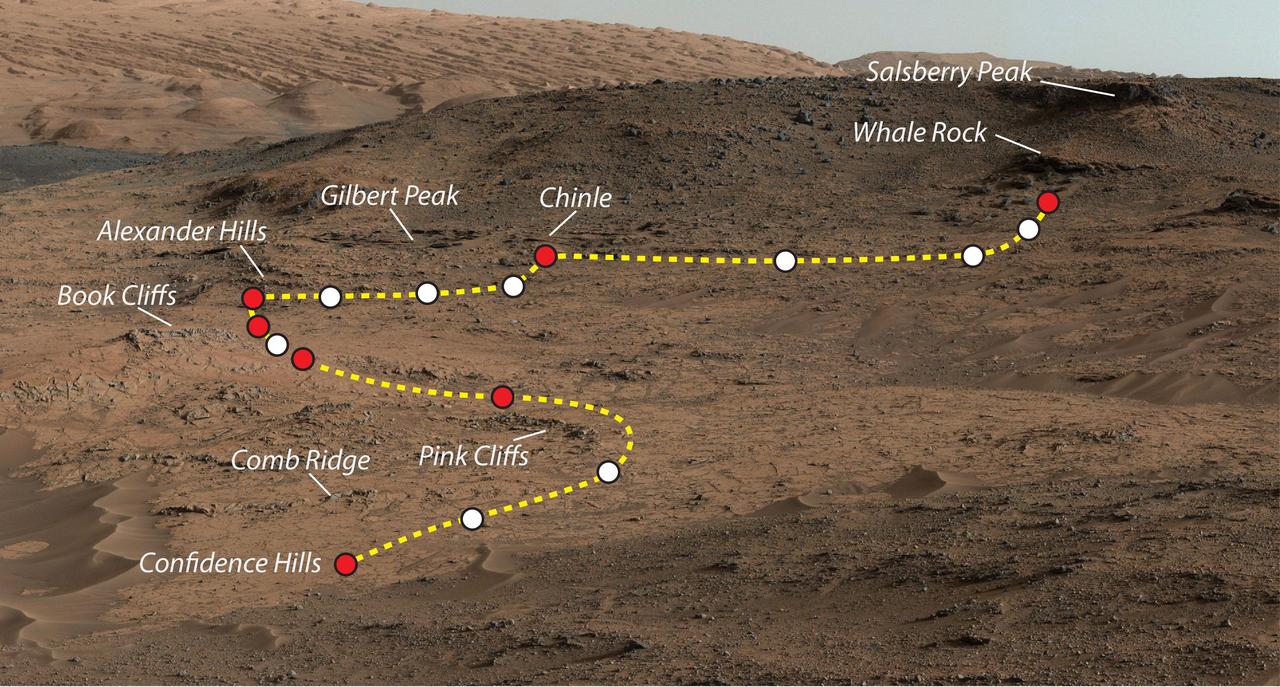
This view shows the path and some key places in a survey of the Pahrump Hills outcrop by NASA Curiosity Mars rover in autumn of 2014. The outcrop is at the base of Mount Sharp within Gale Crater.
This image shows the target landing area for Curiosity, the rover of NASA Mars Science Laboratory mission. The target, called Mount Sharp, is near the foot of a mountain inside Gale Crater.
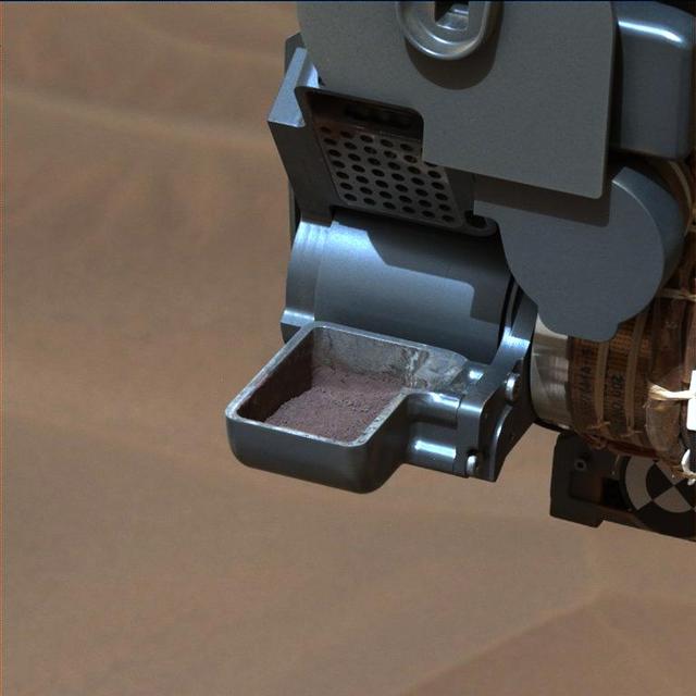
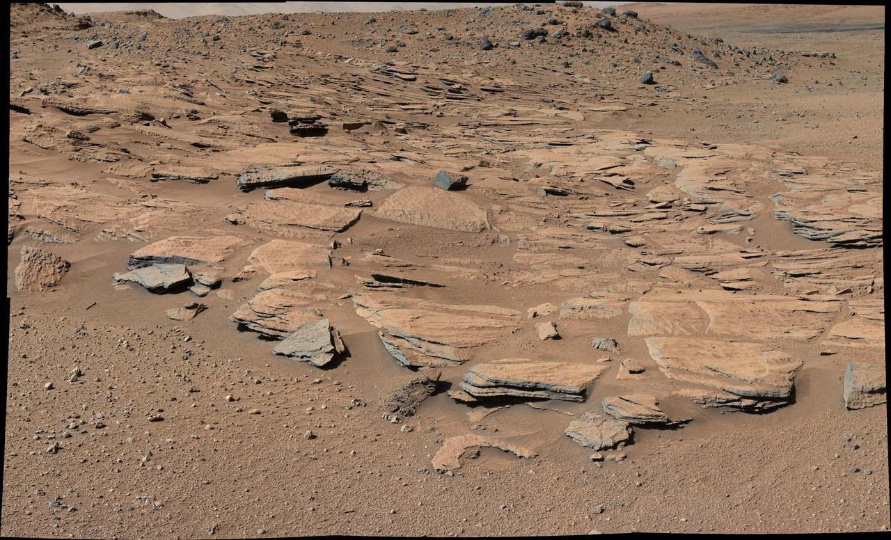
This image from NASA Curiosity rover shows a sample of powdered rock extracted by the rover drill from the Confidence Hills target -- the first rock drilled after Curiosity reached the base of Mount Sharp in September 2014.
This image from the Mars Hand Lens Imager MAHLI camera on NASA Curiosity Mars rover shows an example of a type of geometrically distinctive feature that researchers are using Curiosity to examine at a mudstone outcrop at the base of Mount Sharp.

This view from NASA Curiosity shows nodules exposed in sandstone that is part of the Stimson geological unit on Mount Sharp, Mars. The nodules can be seen to consist of grains of sand cemented together.
This image is a 3-D view in front of NASA Curiosity rover captured by the rover front left Hazard-Avoidance camera. The image is cropped but part of Mount Sharp is still visible rising above the terrain.
This 3D image from NASA Curiosity was taken from the rover Bradbury Landing site inside Gale Crater, Mars. Between the rover on the right, and its shadow on the left, looms the rover eventual target: Mount Sharp.
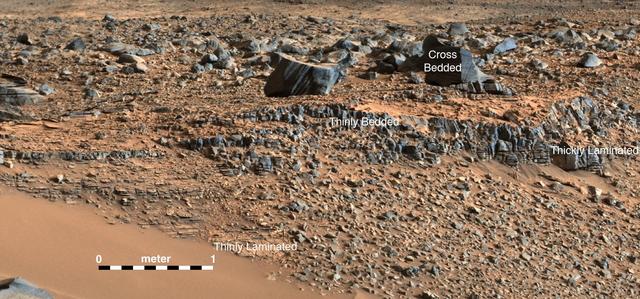
This image from NASA Curiosity Mars rover shows an example of a thin-laminated, evenly stratified rock type that occurs in the Pahrump Hills outcrop at the base of Mount Sharp on Mars. This type of rock can form under a lake.
The route of NASA Mars Curiosity rover up the slopes of Mount Sharp on Mars is indicated in yellow in this image. The rover current position is marked with a star. This new route provides excellent access to many features in the Murray Formation.
This image from NASA Curiosity Mars rover looks down the ramp at the northeastern end of Hidden Valley and across the sandy-floored valley to lower slopes of Mount Sharp on the horizon.
This mosaic, taken by NASA Mars Reconnaissance Orbiter, shows the planned route in yellow of NASA Curiosity rover from Pahrump Hills at the base of Mount Sharp, through the Murray Formation.
This map shows the route driven by NASA Curiosity Mars rover from the Bradbury Landing location where it landed in August 2012 to the Pahrump Hills outcrop where it drilled into the lowest part of Mount Sharp.
This image, taken on Aug. 4, 2014, from the Navigation Camera on NASA Curiosity Mars rover shows wheel tracks printed by the rover as it drove on the sandy floor of a lowland called Hidden Valley on the route toward Mount Sharp.
This series of images reconstructs the geology of the region around Mars Mount Sharp, where NASA Curiosity Mars rover landed and is now driving. The images were taken on Earth and have been altered for the illustration.
NASA Curiosity Mars rover as the rover drove over a dune spanning Dingo Gap on Mars. The light-toned dome on the right side of the horizon is part of Mount Sharp.
The landing target area for Curiosity, the big rover of NASA Mars Science Laboratory mission, has been revised, reducing the area size. It also puts the center of the landing area closer to Mount Sharp.
This topography map shows a portion of the Gale Crater region on Mars, where NASA Mars Curiosity rover landed on August 6, 2014. The rover marked with a star is currently headed toward Pahrump Hills.
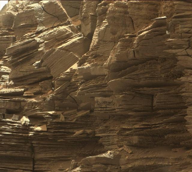
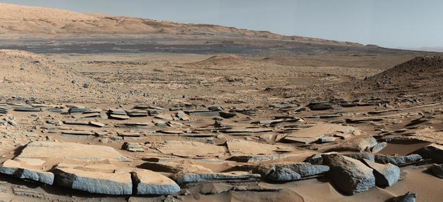
This view from the Mast Camera (Mastcam) in NASA's Curiosity Mars rover shows finely layered rocks within the "Murray Buttes" region on lower Mount Sharp. The buttes and mesas rising above the surface in this area are eroded remnants of ancient sandstone that originated when winds deposited sand after lower Mount Sharp had formed. Curiosity closely examined that layer -- called the "Stimson formation" -- during the first half of 2016, while crossing a feature called "Naukluft Plateau" between two exposures of the Murray formation. The layering within the sandstone is called "cross-bedding" and indicates that the sandstone was deposited by wind as migrating sand dunes. The image was taken on Sept. 8, 2016, during the 1454th Martian day, or sol, of Curiosity's work on Mars. http://photojournal.jpl.nasa.gov/catalog/PIA21043
This animation flips back and forth between views taken in 2010 and 2014 of a Martian sand dune at the edge of Mount Sharp, documenting dune activity. The images are from the High Resolution Imaging Science Experiment (HiRISE) camera on NASA's Mars Reconnaissance Orbiter. They cover an area about 740 feet (about 225 meters) wide, showing a site called "Dune 2" in the "Bagnold Dunes" dune field. NASA's Curiosity Mars rover will observe this dune up close on the rover's route up Mount Sharp. North is toward the top. The edge of the dune at the crescent-shaped slip face on the south edge advances slightly during the four-year period between the dates of the images. Figure A is an annotated version with an arrow indicating the location of this change. The lighting angle is different in the two images, resulting in numerous changes in shadows. http://photojournal.jpl.nasa.gov/catalog/PIA20161
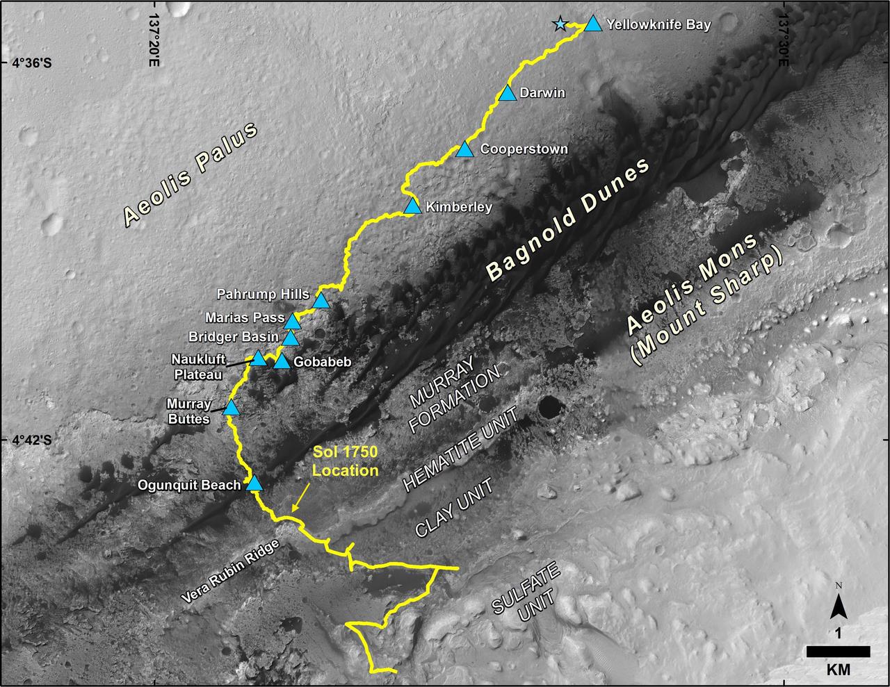
This map shows the route driven by NASA's Curiosity Mars rover, from the location where it landed in August 2012 to its location in July 2017, and its planned path to additional geological layers of lower Mount Sharp. The blue star near top center marks "Bradbury Landing," the site where Curiosity arrived on Mars on Aug. 5, 2012, PDT (Aug. 6, EDT and Universal Time). Blue triangles mark waypoints investigated by Curiosity on the floor of Gale Crater and, starting with "Pahrump Hills," on Mount Sharp. The Sol 1750 label identifies the rover's location on July 9, 2017, the 1,750th Martian day, or sol, since the landing. In July 2017, the mission is examining "Vera Rubin Ridge" from the downhill side of the ridge. Spectrometry observations from NASA's Mars Reconnaissance Orbiter have detected hematite, an iron-oxide mineral, in the ridge. Curiosity's planned route continues to the top of the ridge and then to geological units where clay minerals and sulfate minerals have been detected from orbit. The base image for the map is from the High Resolution Imaging Science Experiment (HiRISE) camera on the Mars Reconnaissance Orbiter. North is up. "Bagnold Dunes" form a band of dark, wind-blown material at the foot of Mount Sharp. https://photojournal.jpl.nasa.gov/catalog/PIA21720

This view from the Mast Camera (Mastcam) in NASA's Curiosity Mars rover shows a sloping hillside within the "Murray Buttes" region on lower Mount Sharp. The rim of Gale Crater, where the rover has been active since landing in 2012, is visible in the distance, through the dusty haze. The image was taken on Sept. 8, 2016, during the 1454th Martian day, or sol, of Curiosity's work on Mars. http://photojournal.jpl.nasa.gov/catalog/PIA21041
NASA's Curiosity Mars rover took this image with its Mast Camera (Mastcam) on Feb. 10, 2019 (Sol 2316). The rover is currently exploring a region of Mount Sharp nicknamed "Glen Torridon" that has lots of clay minerals. https://photojournal.jpl.nasa.gov/catalog/PIA23047
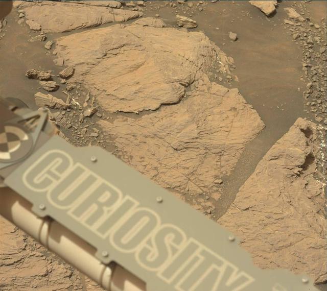
NASA's Curiosity Mars rover used its Mast Camera, or Mastcam, to capture this image of its 36th successful drill hole on Mount Sharp, at a rock called "Canaima." The pulverized sample of this rock was drilled on Oct. 3, 2022, the 3,612th Martian day, or sol, of the mission. https://photojournal.jpl.nasa.gov/catalog/PIA25418
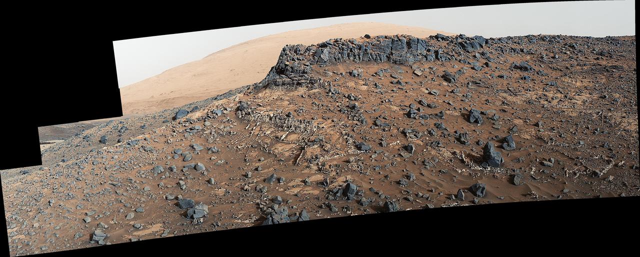
The top of the butte in this scene from the Mast Camera (Mastcam) on NASA's Curiosity Mars rover stands about 16 feet (about 5 meters) above the rover and about 82 feet (about 25 meters) east-southeast of the rover. Mastcam's right-eye (telephoto-lens) camera took the component images of this mosaic on Sept. 1, 2016, during the 1,448th Martian day, or sol, of Curiosity's work on Mars. The site is in the scenic "Murray Buttes" area, where individual buttes and mesas were assigned numbers. This one is "M9a." The average slope on the prominent ridge on the left side is more than 40 degrees, while the average slope on the right side of the highest point is about 30 degrees. The rover's location when it recorded this scene was the site it reached in its Sol 1446 drive. (See map at http://mars.nasa.gov/msl/multimedia/images/?ImageID=8009.) The scene is presented with a color adjustment that approximates white balancing, to resemble how the rocks and sand would appear under daytime lighting conditions on Earth. http://photojournal.jpl.nasa.gov/catalog/PIA20843
This view from the Mast Camera (Mastcam) in NASA's Curiosity Mars rover shows sloping buttes and layered outcrops within the "Murray Buttes" region on lower Mount Sharp. The buttes and mesas rising above the surface are eroded remnants of ancient sandstone that originated when winds deposited sand after lower Mount Sharp had formed. Curiosity closely examined that layer -- called the "Stimson formation" -- during the first half of 2016, while crossing a feature called "Naukluft Plateau" between two exposures of the Murray formation. The layering within the sandstone is called "cross-bedding" and indicates that the sandstone was deposited by wind as migrating sand dunes. The image was taken on Sept. 8, 2016, during the 1454th Martian day, or sol, of Curiosity's work on Mars. http://photojournal.jpl.nasa.gov/catalog/PIA21042
An image taken at the Hidden Valley site, en-route to Mount Sharp, by NASA Curiosity rover. A variety of mudstone strata in the area indicate a lakebed deposit, with river- and stream-related deposits nearby. Decoding the history of how these sedimentary rocks were formed, and during what period of time, was a key component in the confirming of the role of water and sedimentation in the formation of the floor of Gale Crater and Mount Sharp. This image was taken by the Mast Camera (Mastcam) on Curiosity on the 703rd Martian day, or sol, of the mission. Malin Space Science Systems, San Diego, built and operates Curiosity's Mastcam. NASA's Jet Propulsion Laboratory, a division of the California Institute of Technology, Pasadena, built the rover and manages the project for NASA's Science Mission Directorate, Washington. http://photojournal.jpl.nasa.gov/catalog/PIA19840