Making Mountains Out of Central Peaks

Mountain peaks through the ice cover on Thurston Island off of western Antarctica as seen on the IceBridge flight on Nov. 5, 2014. Image Credit: NASA/Jim Yungel NASA’s Operation IceBridge collected some rare images on a flight out of Punta Arenas, Chile on Nov. 5, 2014, on a science flight over western Antarctica dubbed Ferrigno-Alison-Abbott 01. The crew snapped a few shots of a calving front of the Antarctic ice sheet. This particular flight plan was designed to collect data on changes in ice elevation along the coast near the Ferrigno and Alison ice streams, on the Abbot Ice Shelf, and grounded ice along the Eights Coast.
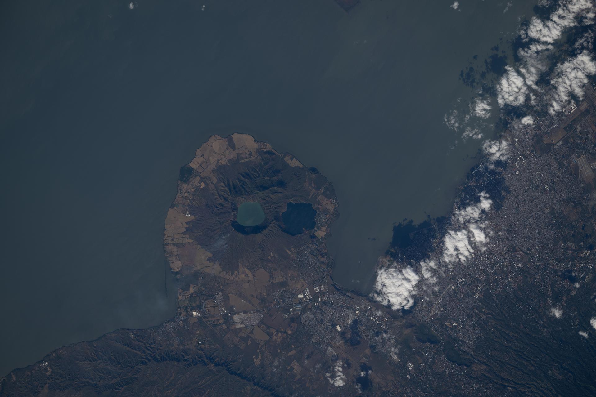
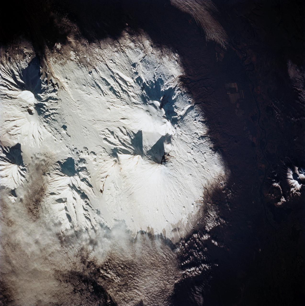
iss074e0312836 (Feb. 10, 2026) --- The Apoyeque mountain peak—a dormant stratovolcano with a crater lake—located in the Chiltepe Peninsula Nature Reserve near Managua, Nicaragua, is shown from the International Space Station as it orbited 261 miles above Central America. Credit: NASA/Chris Williams
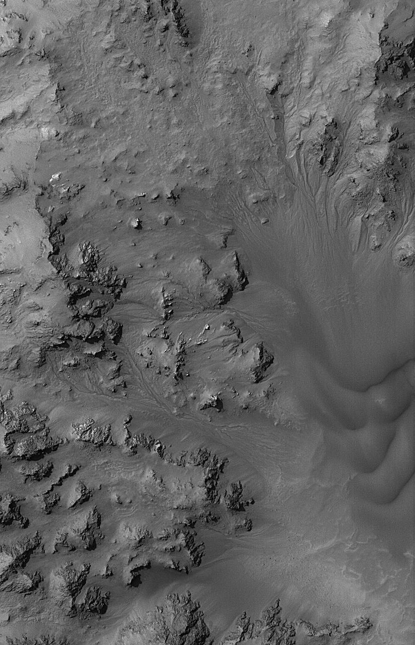
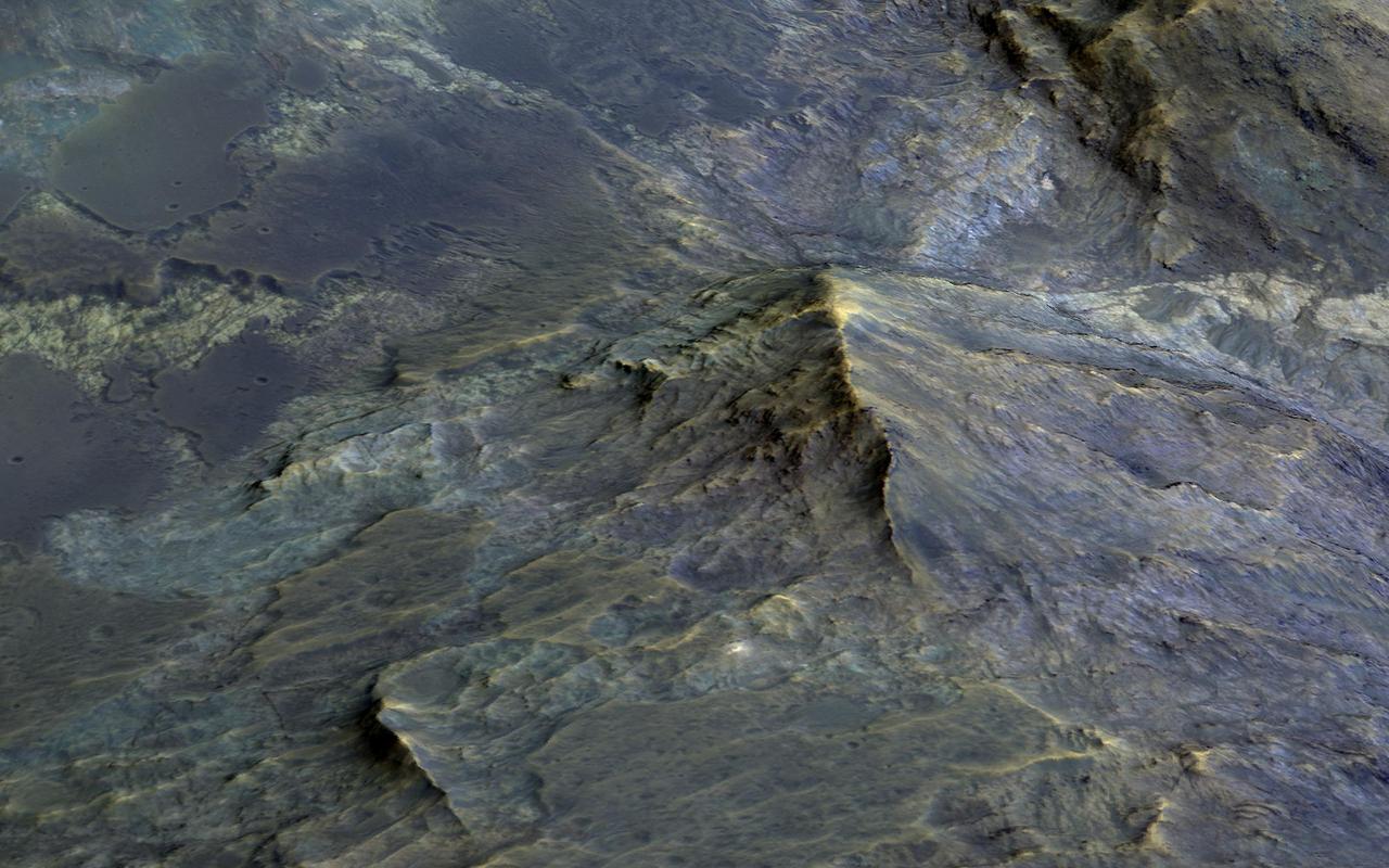
This MOC image shows dried streambeds -- martian gullies -- in the mountainous central peak region of Hale Crater
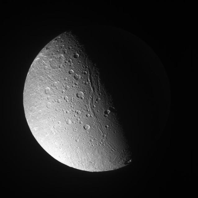
Canyons and mountain peaks snake along the terminator on the crater-covered, icy moon Dione. With the Sun at a low angle on their local horizon, the line of mountain ridges above center casts shadows toward the east

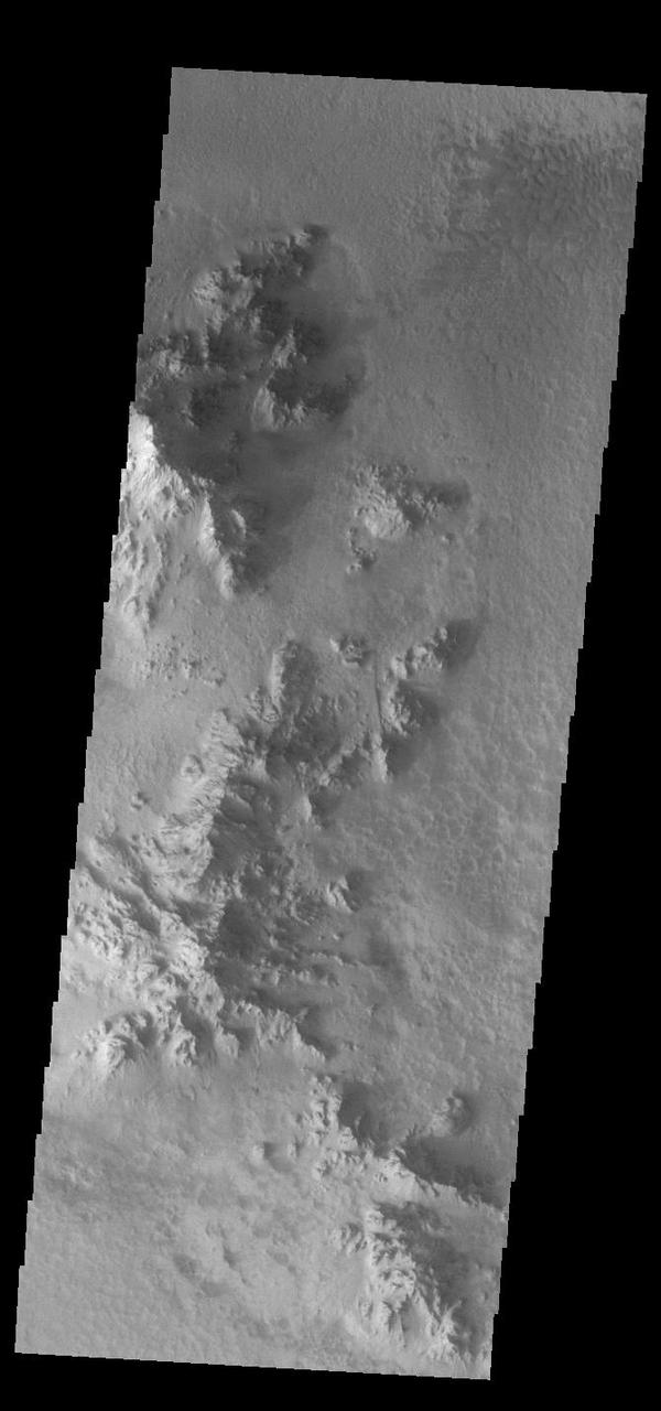
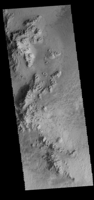
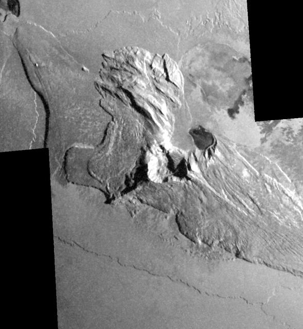
Today's VIS image shows part of the floor of Hale Crater and the elongate axis of the central peak mountains. Hale Crater is an example of an oblique impact crater. The mountain chain trends from the southeast towards the northwest, increasing in height towards the northwest. The incoming meteor struck the surface along this trend, forming an oval crater and displacing the impact energy forward to create the central mountain range. Hale Crater is located near the northern part of Argye Plainitia. Orbit Number: 74954 Latitude: -35.5134 Longitude: 323.598 Instrument: VIS Captured: 2018-11-06 22:53 https://photojournal.jpl.nasa.gov/catalog/PIA22994
Today's VIS image shows part of the floor of Hale Crater and the elongate axis of the central peak mountains. Hale Crater is an example of an oblique impact crater. The mountain chain trends from the southeast towards the northwest, increasing in height towards the northwest. The incoming meteor struck the surface along this trend, forming an oval crater and displacing the impact energy forward to create the central mountain range. Hale Crater is located near the northern part of Argye Plainitia. Orbit Number: 91600 Latitude: -35.5357 Longitude: 323.628 Instrument: VIS Captured: 2022-08-08 14:50 https://photojournal.jpl.nasa.gov/catalog/PIA25609
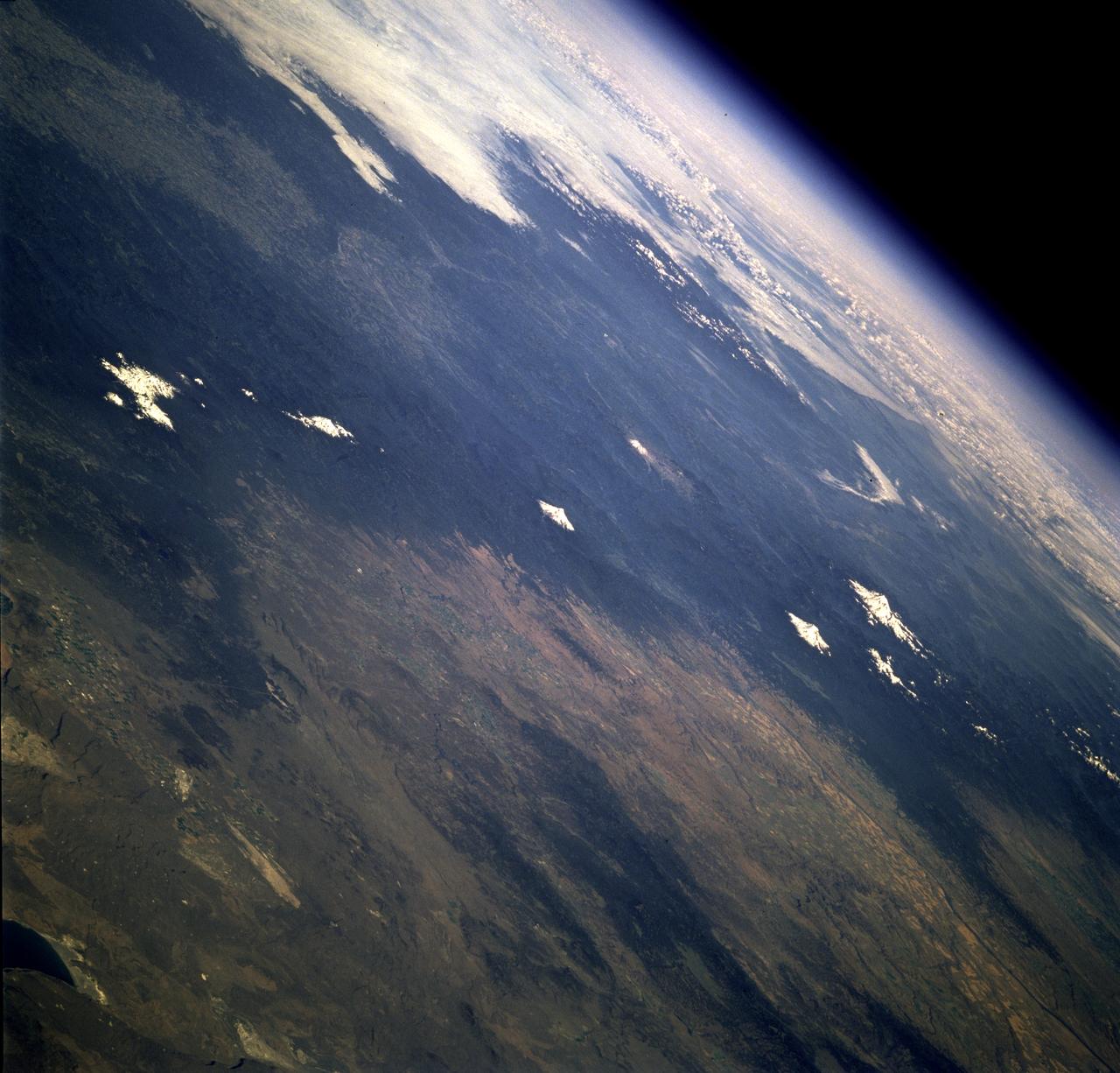
This dramatic view looks west along the Cucharas River Canyon in Colorado toward the 4,152 meter 13,623 ft high Spanish Peaks, in the foothills of the Sangre De Cristo Mountains.
The trio of ridges on Titan known as Mithrim Montes is home to the hazy Saturnian moon tallest peak. The mountain is located midway along the lower of the three ridges shown in this radar image from NASA Cassini spacecraft.
This image captured by NASA 2001 Mars Odyssey spacecraft shows part of the floor of Hale Crater. The mountains in the image are part of the elongated central peak of the crater.It is believed that Hale Crater was formed by an oblique impact, which caused it's more oval form and central peak elongation. Orbit Number: 66105 Latitude: -35.5732 Longitude: 323.646 Instrument: VIS Captured: 2016-11-07 23:04 http://photojournal.jpl.nasa.gov/catalog/PIA21192
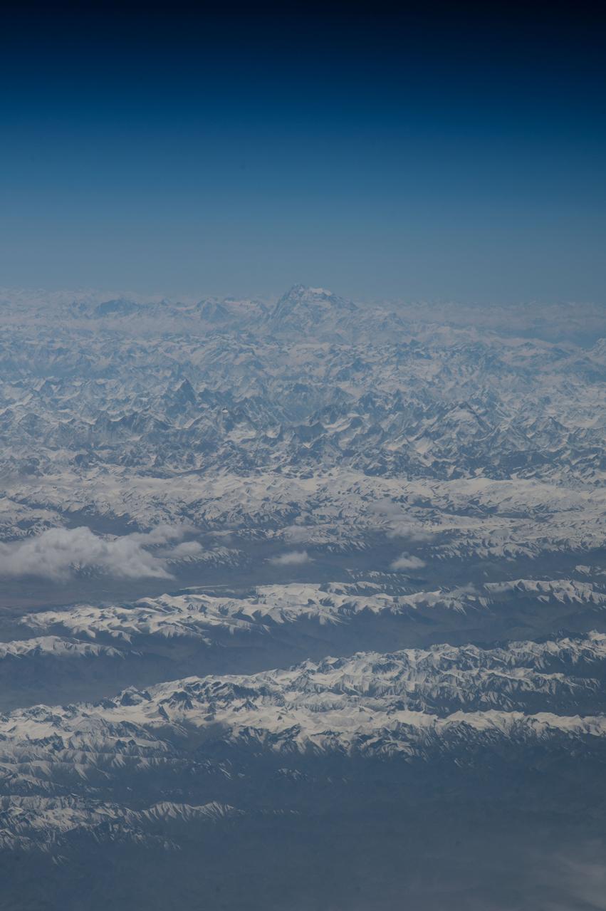
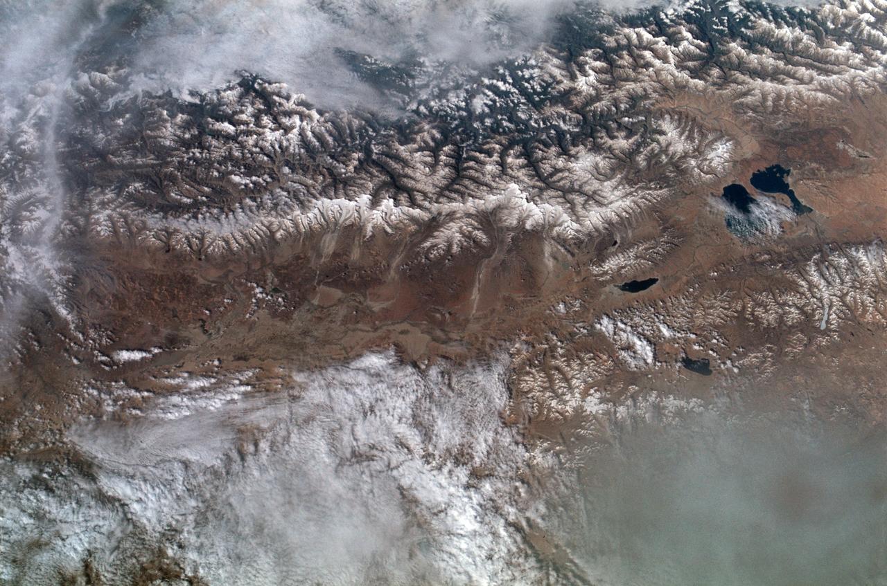
ISS047e087333 (04/30/2016) ---NASA Astronaut Jeff Williams captured this soaring mountain visa image and twitted "up to the amazing array of white peaks on the Himalaya Mountains".

iss064e002041 (Oct. 27, 2020) --- The International Space Station was orbiting above southern Colorado when an external high-definition camera photographed several snow-capped peaks along a portion of the Rocky Mountain range including Cottonwood Peak near the top left, to Blanca Peak and Mount Lindsey near the bottom right.
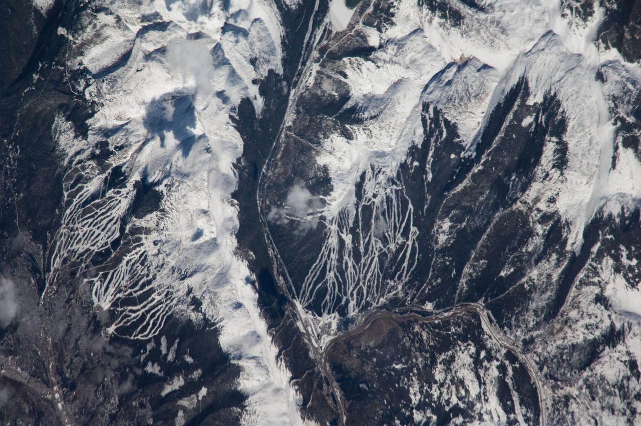
ISS018-E-005353 (24 Oct. 2008) --- Breckenridge and Copper Mountain ski slopes, Colorado are featured in this image photographed by an Expedition 18 crewmember on the International Space Station. Located in a section of the Rocky Mountains which extend through central Colorado, Tenmile Range and Copper Mountain provide the ideal location and landscape for popular winter sports. In this view, the Breckenridge and Copper Mountain ski areas are clearly visible as the snow covered ski runs stand out among the surrounding darker forest. Tenmile Range has mountain peaks that are named Peaks 1 through Peaks 10. The Breckenridge ski area use Peaks 7 through Peaks 10 which range from 12,631 feet (3,850 meters) to 13,615 feet (4,150 meters) high. Tenmile Canyon is a north northeast-trending fault-controlled valley running nearly 3,000 feet (914.4 meters) deep that serves as the boundaries for Tenmile Creek running through the center of the photo. The snow-covered peaks clearly delineate the tree line at an elevation of around 11,000 feet (3,350 meters). In the winter, this area's annual average snowfall ranges between 284 inches (7.21 meters) at Copper Mountain to 300 inches (7.62 meters) a year at Breckenridge. Before recreation became the main industry, miners were attracted to the area in the mid-1800's following discoveries of gold, silver, lead, and zinc. The towns of Breckenridge and Wheeler Junction (at the base of Copper Mountain ski area) were born out of the surge to settle the West during the Pike's Peak Gold Rush. While this image records snow on the peaks of Tenmile Range, the months of October and November 2008 saw little accumulation of snow pack in the area of Breckenridge. The situation changed in early December 2008 however, when more snow fell in eight days than in the preceding two months. The late, but significant, snowfall boosted the snow pack back to expected levels for this time of year.
Dramatic shadows across a mountainous landscape on Jupiter's moon Io reveal details of the topography around a peak named Tohil Mons in this mosaic created from images taken by NASA's Galileo spacecraft in October 2001. Tohil Mons rises 5.4 kilometers (18,000 feet) above Io's surface, according to analysis of stereo imaging from earlier Galileo flybys of Io. The new images, with a resolution of 327 meters (1,070 feet) per picture element, were taken when the Sun was low in the sky, producing informative shadows. North is to the top and the Sun illuminates the surface from the upper right. The topographic features revealed include a very straight ridge extending southwest from the peak, 500- to 850-meter-high (1,640- to 2,790-foot-high) cliffs to the northwest and a curious pit immediately east of the peak. Major questions remain about how Io's mountains form and how they are related to Io's ubiquitous volcanoes. Although Io is extremely active volcanically, few of its mountains appear to be volcanoes. However, two volcanic craters do lie directly to the northeast of Tohil's peak, a smaller dark-floored one and a larger one at the very edge of the mosaic. Furthermore, the shape of the pit directly east of the peak suggests a volcanic origin. Galileo scientists will use these images to investigate the geologic history of Tohil Mons and its relationship to the neighboring volcanic features. The image is centered at 28 degrees south latitude and 161 degrees west longitude. http://photojournal.jpl.nasa.gov/catalog/PIA03600
This false color image shows part of the floor of Hale Crater and the elongate axis of the central peak mountains. Hale Crater is an example of an oblique impact crater. The mountain chain trends from the southeast towards the northwest, increasing in height towards the northwest. The incoming meteor struck the surface along this trend, forming an oval crater and displacing the impact energy forward to create the central mountain range. Hale Crater is 150 km x 125 km in diameter (93 miles x 77 miles) and is located near the northern part of Argye Plainitia. The THEMIS VIS camera contains 5 filters. The data from different filters can be combined in multiple ways to create a false color image. These false color images may reveal subtle variations of the surface not easily identified in a single band image. Orbit Number: 66105 Latitude: -35.5732 Longitude: 323.646 Instrument: VIS Captured: 2016-11-07 23:04 https://photojournal.jpl.nasa.gov/catalog/PIA23626
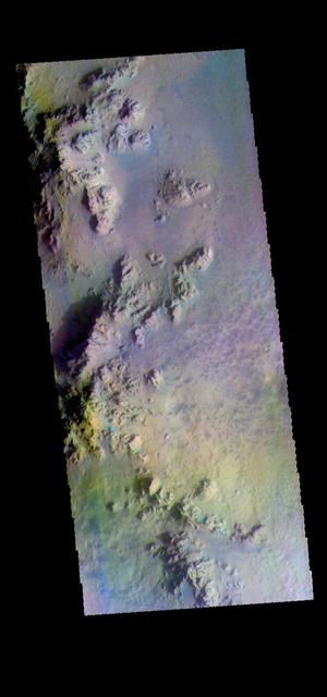
Large craters, like this 50-kilometer diameter one, can uplift material from below and form a mountain-like central peak. Craters of this size on Mars become unstable as they form and collapse due to gravity. Craters with central peaks and terraced rims are referred to as "complex" craters. Geologists study these central peaks because the uplifted bedrock was once deep within the Martian crust. A 3D perspective shows heavily-fractured bedrock exposed within the peak, and also dark-toned and fragmental rocks that formed during the impact process. Sometimes, we observe similar rocks in the crater wall terraces. Some areas of the terrace show dark-toned materials coating and surrounding the white- and green-colored bedrock. This dark-toned rock was the once-molten material that was produced by the tremendous energy generated during the formation of the crater. Similarly, the impact melt material coats and surrounds the higher-standing bedrock of the peak. There are additional exposures of bedrock in the northern wall-terraces of the crater. Previous HiRISE images have focused largely on central structures, but clearly the wall-terraces of these craters may also be informative in our exploration of the Martian subsurface. More information is available at https://photojournal.jpl.nasa.gov/catalog/PIA22784

STS090-774-028 (29 April 1998) --- This view features a 13,980-foot mountain peak in Colorado’s Sangre de Cristo Mountains in Saguache County, photographed by crewmembers of the STS-90 Space Shuttle Columbia mission in April 1998. EDITOR’S NOTE: In June 2003, the summit was named “Columbia Point” by the U.S. Department of Interior in memory of the STS-107 Space Shuttle Columbia crew, lost in an accident on February 1, 2003, and for the scientific exploration, technical excellence, and the dream of spaceflight for which the mission stood. Columbia Point is located on the east side of Kit Carson Mountain. On the northwest shoulder of the same mountain is Challenger Point, a peak previously named in memory of the Space Shuttle Challenger, which exploded soon after liftoff on January 28, 1986.
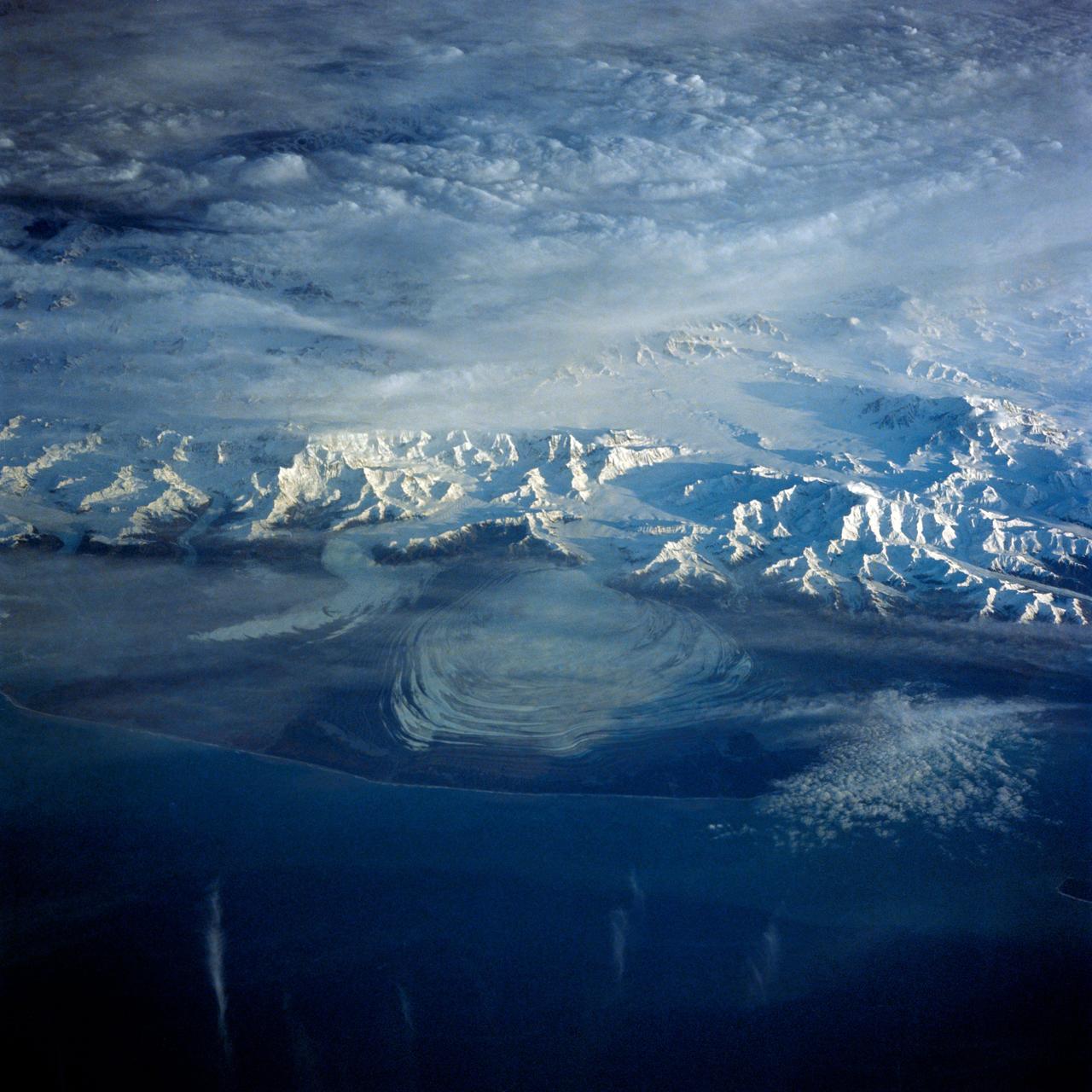
41G-43-016 (5-13 Oct 1984) --- The Gulf of Alaska, with the great peaks of the Saint Elias Range of Alaska, Yukon, and British Columbia. Mount Logan, Canada's highest mountain peak at 19,850 feet, is to the left of the center of the photograph. Between Saint Elias Peak and Mount Vancouver, right of center, flows the great Malaspina Glacier in a great lobe of ice shaped like a human ear.
ISS008-E-08767 (12 December 2003) --- This view featuring K-2 Mountain in Pakistan, the world’s second highest peak, was photographed by an Expedition 8 crewmember on the International Space Station (ISS).

iss063e032032 (June 22, 2020) --- The International Space Station orbits above Tajikistan near the western border of China with the K2 mountain, the world's second-highest peak, below in the Karakoram range.
iss064e003738 (Nov. 8, 2020) --- The snow-capped peaks of the Andes Mountains in southern Chile, with General Carrera Lake at bottom left, are pictured from the International Space Station as it orbited above South America.
iss067e147538 (June 22, 2022) --- Old Baldy Mountain peak (bottom right) and Dead Man's Basin Reservoir (top) in Montana are pictured from the International Space Station as it orbited 264 miles above North America.
iss068e022209 (Nov. 13, 2022) --- Clouds gather near the peaks of the Andes Mountain range in Peru in this photograph from the International Space Station as it orbited 262 miles above the South American nation's Pacific coast.
iss068e029498 (Dec. 13, 2022) --- Emi Koussi, a volcano and the highest peak in the Tibesti Mountains of Chad, was photographed from the International Space Station as it orbited 257 miles above Africa.
The northwest-southeast trending, snow-covered, linear mountain range is the King Ata Tag Mountain, located in extreme western most China. Highest peaks are just over 20,100 feet above sea level. The town or village of Muji is located in the largest river valley that is south of this range of mountains. This area includes part of the country of Tajikistan. The center point of the photo is approximately 39.30 degrees north and 74.30 degrees easth.
SL2-102-900 (22 June 1973) --- The Great Himalayan Mountain Range, India/Tibet (30.5N, 81.5E) is literally the top of the world where mountains soar to over 20,000 ft. effectively isolating Tibet from the rest of the world. The two lakes seen in the center of the image are the Laga Co and the Kunggyu Co located just inside the Tibet border. Although clouds and rainfall are rare in this region, snow is always present on the mountain peaks. Photo credit: NASA
ISS010-E-08224 (22 November 2004) --- Mount Olympus, Greece is featured in this image photographed by an Expedition 10 crewmember on the International Space Station (ISS). Mount Olympus is the highest peak (2917 meters) in Greece, as well as the mountain chain that runs north into Bulgaria and south, via the Cyclades Islands, into Turkey. In this winter view, Olympus is the only peak with a dusting of snow—perhaps for this reason its name in classical Greek means “the luminous one.” In Greek mythology the peak was inhabited by the Twelve Olympians, the most famous gods of the ancient Greeks. North of Mount Olympus lies Macedonia, the homeland of Alexander the Great. Climbing the mountain is a favorite tourist activity today. The slopes of the peaks of Olympus and its neighboring peaks drop sheer into the Thermaikos Gulf, a northern arm of the Aegean Sea. White cirrus clouds obscure the shoreline near the city of Thessaloniki. This major port is spread along the shores of a small and well protected bay at the north end of the gulf. On the plains inland of the Olympus chain lie a lake, on the Aliakmon River, and the town of Larisa, at the focus point of a series of transport routes.
STS066-124-059 (3-14 Nov. 1994) --- Mount Everest region, Nepal and China. Low morning Sun highlights Mount Everest (the highest mountain in the world at 8,848 meters), Cho Oyu (8,153 meters) to the northwest, and other peaks of "The Roof of the World". New snow seems to be confined to the highest peaks. Abundant details of glacier surfaces, including moraines, crevasse fields, and ice falls are displayed for study.
In this southeast looking view, Mont Blanc, on the French/Italian border, (48.0N, 4.5E) the highest mountain peak in all of Europe, is just below and right of center (below the end of the prominent valley of the Aosta River, in the center of the photo. The rivers flow out of the Alps into Italy toward Turin. Chamonix, the famous resort town and center of Alpine mountain climbing, lies in the valley just below Mont Blanc.
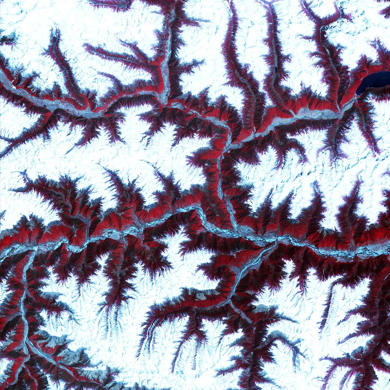
April 12th, 2001: Description: Soaring, snow-capped peaks and ridges of the eastern Himalaya Mountains create an irregular white-on-red patchwork between major rivers in southwestern China. The Himalayas are made up of three parallel mountain ranges that together extend more than 2,900 kilometers. Source: ASTER To learn more about the Landsat satellite go to: <a href="http://landsat.gsfc.nasa.gov/" rel="nofollow">landsat.gsfc.nasa.gov/</a>

This view from NASA's Dawn spacecraft captures the central complex of mountain peaks within Dantu Crater on Ceres. A patch of bright material is visible near lower right. The image is centered at approximately 23 degrees north latitude, 139 degrees east longitude. Dawn captured the scene on Dec. 21, 2015 from its low-altitude mapping orbit (LAMO), at an approximate altitude of 240 miles (385 kilometers) above Ceres. The image resolution is 120 feet (35 meters) per pixel. http://photojournal.jpl.nasa.gov/catalog/PIA20303
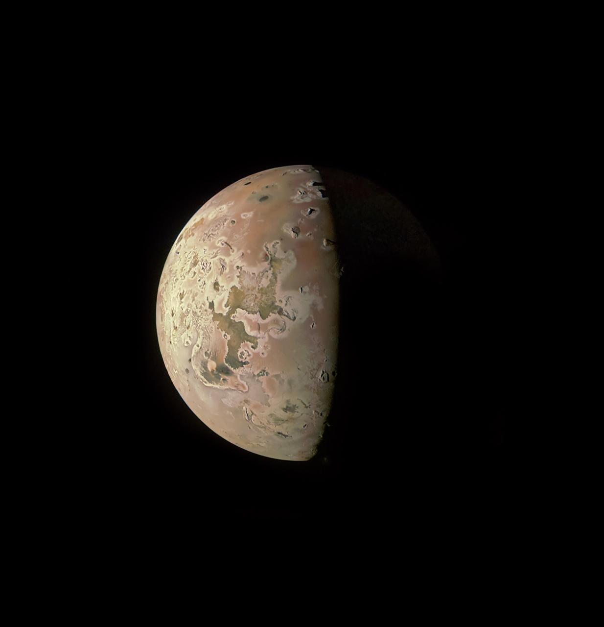
This image revealing the north polar region of the Jovian moon Io was taken on October 15, 2023, by the JunoCam imager aboard NASA's Juno spacecraft. Since the high latitudes were not well covered in imagery gathered by NASA's Voyager and Galileo missions, three of the peaks captured here were observed for the first time. Those mountains are seen at the upper part of the image, near the terminator (the line dividing day and night). At the time the image was taken, the Juno spacecraft was about 7,270 miles (11,700 kilometers) above Io's surface. Citizen scientist Ted Stryk made this image using raw data from the JunoCam instrument, processing the data to enhance details. https://photojournal.jpl.nasa.gov/catalog/PIA26234
iss071e522460 (Aug. 20, 2024) --- The dome-shaped Brandburg Massif, near the Atlantic coast of central Namibia, containing Brandberg Mountain, the African nation's highest peak and ancient rock paintings going back at least 2,000 years, is pictured from the International Space Station as it orbited 261 miles above.

STS-28 Columbia, Orbiter Vehicle (OV) 102, approaches Runway 17 dry lake bed at Edwards Air Force Base (EAFB) California and is photographed just moments before main landing gear (MLG) touchdown. In the distance, are peaks of Southern California mountain range.

iss073e0458478 (July 4, 2025) --- The International Space Station soared 267 miles above New Zealand's snow-capped Southern Alps mountain range that includes Mount Cook, the nation's highest peak at over 12,200 feet. At lower left, is a set of the orbital outpost's main solar arrays and a rollout solar array.
ISS038-E-021397 (24 Dec. 2013) --- The Caribbean country of Cuba is pictured in this nadir image, photographed by one of the Expedition 38 crew members aboard the International Space Station. (Note: North is at the top of the picture.) Cuba is an archipelago of islands in the northern Caribbean Sea at the confluence with the Gulf of Mexico and the Atlantic Ocean. In the southeast, the dark coastal area is home to the Sierra Maestra mountains. It is the highest mountain range on the island, with Pico Turquino reaching nearly 2000 meters. On the central southern coast of the island is the Sierra Del Escambray mountain range, including the 1160 meter-high Pico San Juan, Cuba's second highest peak.

This anaglyph from the MISR instrument aboard NASA Terra spacecraft shows the peaks of the Wasatch and Uinta Ranges in Utah. 3D glasses are necessary to view this image.
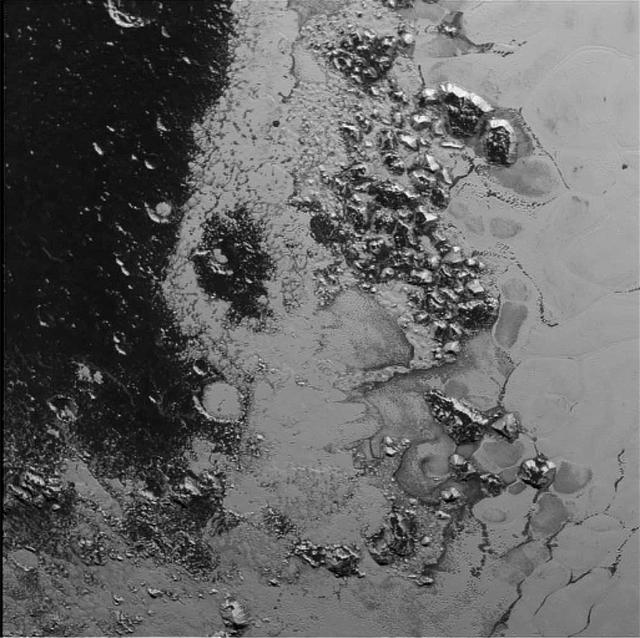
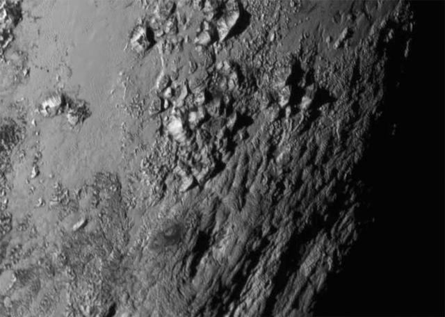
A newly discovered mountain range lies near the southwestern margin of Pluto heart-shaped Tombaugh Regio Tombaugh Region, situated between bright, icy plains and dark, heavily-cratered terrain. This image was acquired by NASA's New Horizons' Long Range Reconnaissance Imager (LORRI) on July 14, 2015, from a distance of 48,000 miles (77,000 kilometers) and sent back to Earth on July 20. Features as small as a half-mile (1 kilometer) across are visible. These frozen peaks are estimated to be one-half mile to one mile (1-1.5 kilometers) high, about the same height as the United States' Appalachian Mountains. The Norgay Montes (Norgay Mountains) discovered by New Horizons on July 15 more closely approximate the height of the taller Rocky Mountains The names of features on Pluto have all been given on an informal basis by the New Horizons team. http://photojournal.jpl.nasa.gov/catalog/PIA19842
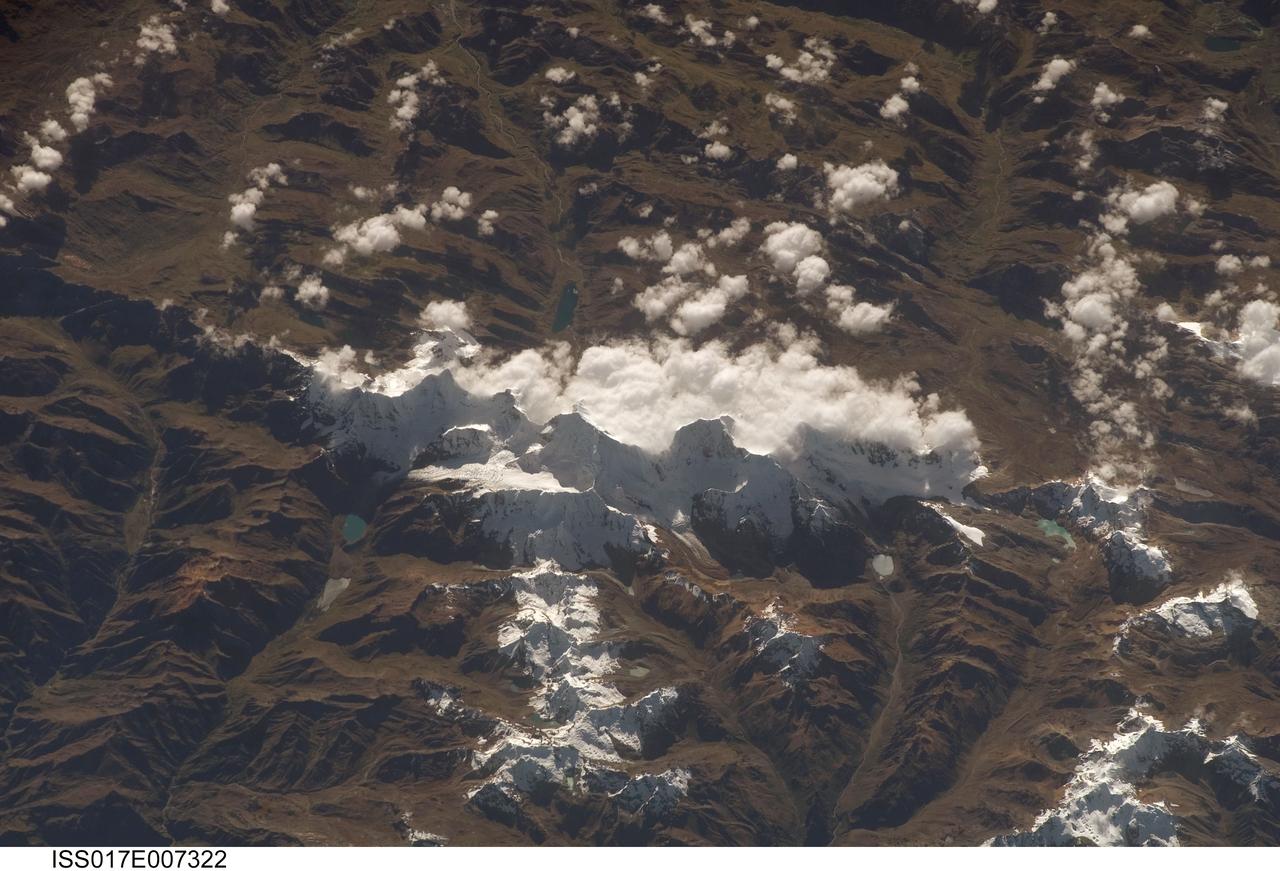
ISS017-E-007322 (17 May 2008) --- Cordillera Huayhuash in the Peruvian Andes is featured in this image photographed by an Expedition 17 crewmember on the International Space Station. This view was taken looking east as the station was flying approximately 100 kilometers off the Peruvian coast and shows Cordillera Huayhuash (pronounced Why-wash). Here clouds are banked up on the east side, snow covers all higher slopes and mountain peaks, and glaciers occupy lower slopes. This prominent but short mountain range (25 kilometers in length) boasts twenty peaks of remarkable steepness and ridge sharpness. Although only 100 kilometers from the coastline, six of the peaks reach above 6,000 meters (more than 19,500 feet), the highest of which is Nevado Yerupaja, Peru's second highest peak, variously estimated as 6,617 and 6,635 meters high. Generally considered the most spectacular peak in South America, Yerupaja is so steep that it has seldom been climbed. The best climbing approach is from the southwest, the face seen in this view. Yerupaja is locally known as El Carnicero (The Butcher) because of its blade-like ridges, features typical of mountains that have been heavily eroded by glacial ice. Other features created by the erosive effect of flowing ice are small glacial lakes, which often vary in color due to different amounts of fine mud being fed into them by meltwater from under the glaciers. According to scientists, during the ice ages the glaciers advanced many kilometers outward from the cordillera, occupying all the surrounding valley floors (all of which lie above 3,000 meters) producing the characteristic U-shaped valleys.

STS071-705-055 (27 June-7 July 1995) --- This vertical view over the central Andes Mountains was photographed from the Earth-orbiting space shuttle Atlantis during the ten-day STS-71 mission. It is one of many still visuals shown by the returning crew during its post-flight press briefing on July 18, 1995. Views of Earth from orbit often make landscapes seem flat, but this view taken with the Sun near the horizon and with a 250mm lens able to pick up detail reveals the conical peaks of numerous volcanoes. The dusting of snow makes the view more vivid as the peaks cast black shadows. The snow is a few days old in this view since several roads can be seen crossing dry lake beds (smooth white areas between mountains, top right), indicating that vehicles have crushed and melted the thin snow. According to NASA scientists observing the STS-71 photography, some volcanoes are not yet mapped. They believe that most of the snow-covered peaks reach more than 16,000 feet in altitude.
SL4-138-3875 (February 1974) --- A color oblique photograph looking east over the Rocky Mountains and Great Plains. This view covers a portion of the States of Colorado, Wyoming, and Nebraska. A Skylab 4 crewmen took this picture with a hand-held 70mm Hasselblad camera. This entire region, covered with a blanket of snow, depicts much of the structural and topographic features of the Rocky Mountain chain. Man's only apparent change to the snow pattern seen here is the (right center) metropolitan areas of Denver and Colorado Springs, Colorado, which can be observed along the eastern edge of the mountain front. Grand Junction, Colorado on the western slope of the Rocky Mountains is just off the photograph at left center bottom. The major inter-montane valleys of South Park (right center), Middle Park (center), and North Park (left center) are clearly visible and separate the Colorado Rockies Front Range from the high rugged mountains can be discovered such as Pikes Peak near right border (center), Mt. Cunnison region, circular feature accentuated by the Cunnison River (dark) in the right center (bottom) of the photograph. The snow covered peaks of Mts. Harvard, Princeton and Yale form the high region of the Collegiate Range which is the pronounced mountain area in the right center. Snow cover not only enhances mountain features but also the drainage patterns. East of Denver (right corner) the sinuous trace of the South Platte River (center) and its junction with the North Platte River near North Platte, Nebraska. Lake McConaughy in Nebraska is the body of water (black) near the river intersection. The trace of the Republic River in southern Nebraska is visible near the right corner of the photography. Geologic and hydro logic studies using this photograph will be conducted by Dr. Roger Morrison, U.S. Geological Survey. Photo credit: NASA
The north polar region of Jupiter's volcanic moon Io was captured by the JunoCam imager aboard NASA's Juno during the spacecraft's 57th close pass of the gas giant on Dec. 30, 2023. The region was imaged at a scale of 1.1 miles (1.8 kilometers) per pixel. The low illumination angle along the terminator (the line dividing day and night) shows several previously unrecognized mountain blocks rising abruptly above the surrounding plains. These are each characterized by a central, sharp peak and adjacent flanks that appear to be collapsing toward the plains. The higher of these peaks range from 2.3 to 6.1 miles (3.7 to 9.8 kilometers) in elevation. The shadows indicate that some of the mountain flanks grade into plateaus under 0.6 miles (1 kilometer). All mountains here are partly or completely covered by bright white diffuse deposits, which may be sulfur dioxide frosts derived from gases escaping the interior and transported up. Extremely large flow fields are evident here. The most active flow regions in Lei-Kung Fluctus (upper left in this image) are evidenced by their darker color and surrounded by white deposits, perhaps liberated from the surface by thermal action. https://photojournal.jpl.nasa.gov/catalog/PIA26484
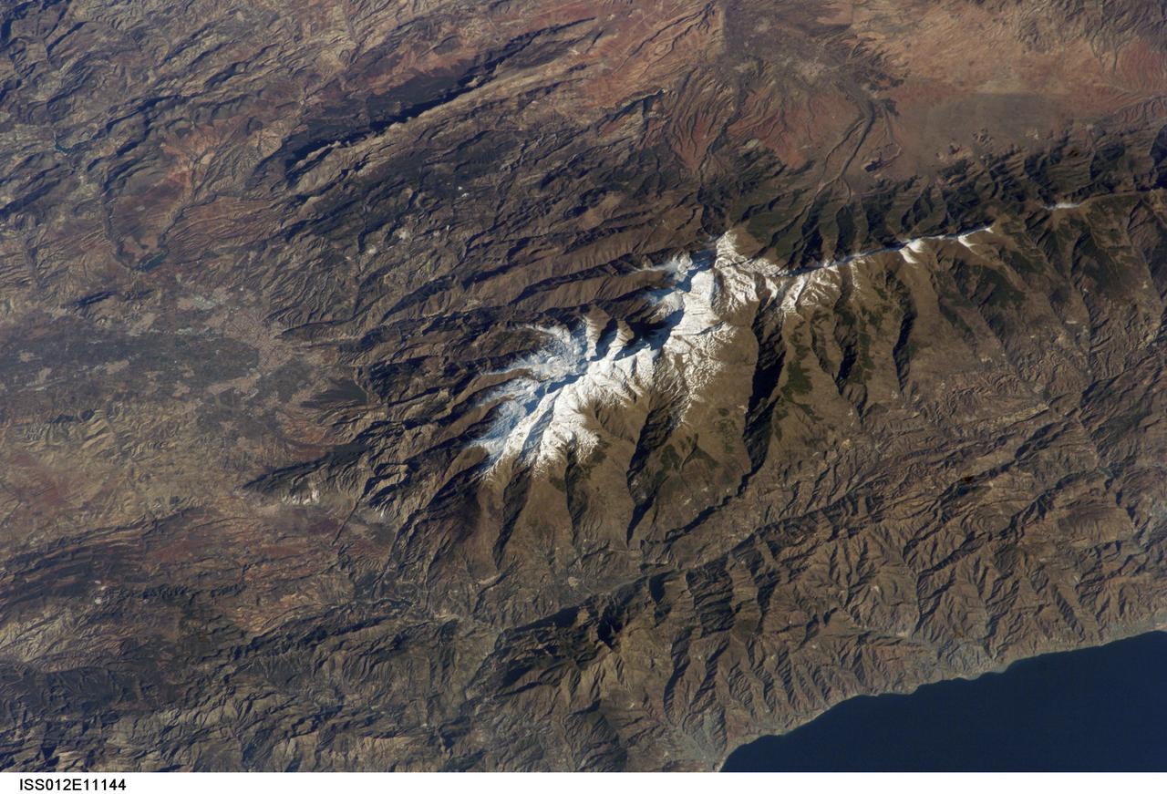
ISS012-E-11144 (11 Dec. 2005) --- Sierra Nevada, Spain is featured in this image photographed by an Expedition 12 crew member on the International Space Station. According to scientists, the Sierra Nevada, part of the Betic Cordillera of southern Spain, was formed during the Alpine Orogeny (or mountain-building event) that also formed the European Alps to the east and the Atlas Mountains of northern Africa across the Mediterranean Sea to the south. The Sierra as observed today formed during the Tertiary Period (65 to 1.8 million years ago) during collision of the African and Eurasian continental plates. The former Tethys Sea also closed during this time period, the scientists say, and the Mediterranean Sea is the largest surviving remnant basin of the ancient Tethys. The Sierra Nevada in the Granada province of Spain is perhaps the southernmost skiing location in all of Europe. Veleta Peak, at an elevation of 3,398 meters above sea level, is a popular destination for skiers and snowboarders. The rapid transition from lofty ski runs to Mediterranean beaches within a few hours’ drive has made the Sierra Nevada region popular for both outdoor and urban tourism. This photograph depicts the Veleta Peak region of the range and illustrates the sharp contrast between the snow capped mountains, adjacent dry lowlands to the west and north, and the Mediterranean Sea to the south.

ISS032-E-024687 (3 Sept. 2012) --- Idaho fires are featured in this image photographed by an Expedition 32 crew member on the International Space Station. Taken with a short lens (45 mm), this west-looking photograph has a field of view covering much of the forested region of central Idaho. The dark areas are all wooded mountains—the Salmon River Mountains (left), Bitterroot Mountains (lower right) and Clearwater Mountains (right). All three areas experienced wildfires in September 2012—this image illustrates the situation early in the month. Smaller fire ‘complexes” appear as tendrils of smoke near the sources (e.g. Halstead complex at left), and as major white smoke plumes from the Mustang fire complex in the densest forests (darkest green, center) of the Clearwater Mountains. This was the largest plume noted in the region with thick smoke blowing eastward over the Beaverhead Mountains at bottom. The linear shape of the smoke plumes gives a sense of the generally eastward smoke transport on this day in early September. The smoke distribution shows another kind of transport: at night, when winds are weak, cooling of the atmosphere near the ground causes drainage of cooled (denser) air down into the major valleys. Here the smoke can be seen flowing west down into the narrow Salmon and Lochsa River valleys (at a local time of 12:18:50 p.m.) – in the opposite direction to the higher winds and the thick smoke masses. The bright yellow-tan areas at top left and top right contrasting with the mountains are grasslands of the Snake River in southern Idaho around Boise, and the Palouse region in western Idaho–SE Washington state. This latter area is known to ecologists as the Palouse Grasslands Ecoregion. Light green areas visible in the center of many of the valleys are agricultural crops including barley, alfalfa, and wheat. The image also shows several firsts of which Idaho can boast. The Snake River between Boise and the Palouse region has cut Hells Canyon (top), the deepest gorge in the U.S. at almost 2,436 meters (8,000 feet). The largest single wilderness area in the contiguous U.S., the Frank Church-River of No Return Wilderness occupies the wooded zones of the Salmon River Mountains and the Clearwater Mountains, i.e. most of the area shown in the middle of the image. Idaho’s highest peak is Borah Peak (lower left) at 3,860 meters above sea level (12,662 feet ASL). The Continental Divide cuts through the bottom of the image—rivers on the eastern slopes of the Beaverhead Mountains drain to the Atlantic Ocean, whereas rivers in the rest of the area drain to the Pacific Ocean.
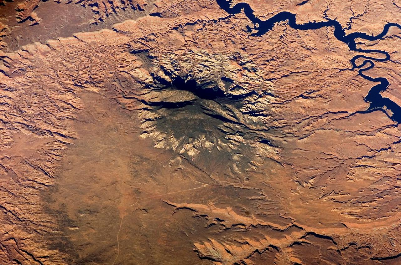
ISS012-E-05172 (14 October 2005) --- Navajo Mountain, Utah is featured in this image photographed by an Expedition 12 crewmember on the international space station. According to scientists, the Colorado Plateau of Arizona, Colorado, New Mexico, and Utah is characterized by mostly flat-lying sedimentary layers that record paleoclimate extremes ranging from oceans to widespread deserts over the last 1.8 billion years. Navajo Mountain is formed by a dome-shaped body of igneous rock (called a laccolith by geologists), one of several in southeast Utah that intrude and uplift the surrounding sedimentary layers of the Plateau. This oblique image highlights Navajo Mountain in the center of the image, surrounded by light red-brown Navajo Sandstone (also visible in canyons at bottom of image). Scientists believe the peak of Navajo Mountain, at approximately 3148 meters (10,388 feet) elevation, is comprised of uplifted Dakota Sandstone deposited during the Cretaceous Period. The establishment of Rainbow Bridge National Monument (1910), and the filling of Glen Canyon by Lake Powell in 1963 (upper right), have facilitated tourism and aesthetic appreciation of this previously remote region. Access to Navajo Mountain is still regulated by the sovereign Navajo Nation, and the process of permitting is required to hike in the region.

Grinding glaciers and granite peaks mingle in Chile’s Torres del Paine National Park. The Advanced Land Imager (ALI) on NASA’s Earth Observing-1 (EO-1) satellite captured this summertime image of the park on January 21, 2013. This image shows just a portion of the park, including Grey Glacier and the mountain range of Cordillera del Paine. The rivers of glacial ice in Torres del Paine National Park grind over bedrock, turning some of that rock to dust. Many of the glaciers terminate in freshwater lakes, which are rich with glacial flour that colors them brown to turquoise. Skinny rivers connect some of the lakes to each other (image upper and lower right). Cordillera del Paine rises between some of the wide glacial valleys. The compact mountain range is a combination of soaring peaks and small glaciers, most notably the Torres del Paine (Towers of Paine), three closely spaced peaks emblematic of the mountain range and the larger park. By human standards, the mountains of Cordillera del Paine are quite old. But compared to the Rocky Mountains (70 million years old), and the Appalachians (about 480 million years), the Cordillera del Paine are very young—only about 12 million years old. A study published in 2008 described how scientists used zircon crystals to estimate the age of Cordillera del Paine. The authors concluded that the mountain range was built in three pulses, creating a granite laccolith, or dome-shaped feature, more than 2,000 meters (7,000 feet) thick. NASA Earth Observatory image created by Jesse Allen and Robert Simmon, using Advanced Land Imager data from the NASA EO-1 team. Caption by Michon Scott. Instrument: EO-1 - ALI View more info: <a href="http://earthobservatory.nasa.gov/IOTD/view.php?id=80266" rel="nofollow">earthobservatory.nasa.gov/IOTD/view.php?id=80266</a> Credit: <b><a href="http://www.earthobservatory.nasa.gov/" rel="nofollow"> NASA Earth Observatory</a></b> <b><a href="http://www.nasa.gov/audience/formedia/features/MP_Photo_Guidelines.html" rel="nofollow">NASA image use policy.</a></b> <b><a href="http://www.nasa.gov/centers/goddard/home/index.html" rel="nofollow">NASA Goddard Space Flight Center</a></b> enables NASA’s mission through four scientific endeavors: Earth Science, Heliophysics, Solar System Exploration, and Astrophysics. Goddard plays a leading role in NASA’s accomplishments by contributing compelling scientific knowledge to advance the Agency’s mission. <b>Follow us on <a href="http://twitter.com/NASA_GoddardPix" rel="nofollow">Twitter</a></b> <b>Like us on <a href="http://www.facebook.com/pages/Greenbelt-MD/NASA-Goddard/395013845897?ref=tsd" rel="nofollow">Facebook</a></b> <b>Find us on <a href="http://instagrid.me/nasagoddard/?vm=grid" rel="nofollow">Instagram</a></b>
51F-37-097 (29 July-6 Aug 1985) --- The snow capped peaks of the Oregon Cascades are clearly seen. From bottom to top we see Mount Hood, Mount Jefferson, and the Three Sisters volcanos. The Columbia River is at the bottom. The Deschutes River system and canyon, the scene of railroad wars nearly a century ago, is at the left side. The Cascades make a very distinct rain shadow between the moist forests to the right and the semiario lands to the east (left) of these great mountains.
STS058-89-013 (18 Oct-1 Nov 1993) --- An oblique westward view, across the wheat fields and cattle pastures, of eastern Colorado to the Front Range of the Rocky Mountains. Denver is bisected at the center of the right edge of the frame. Pikes Peak and Colorado Springs are left of center, and the Arkansas River Valley with Canyon City and the Royal Gorge are along the left edge of the frame. This view shows the startling contrast between the nearly-flat High Plains and the ancient geological uplift of the Rockies.
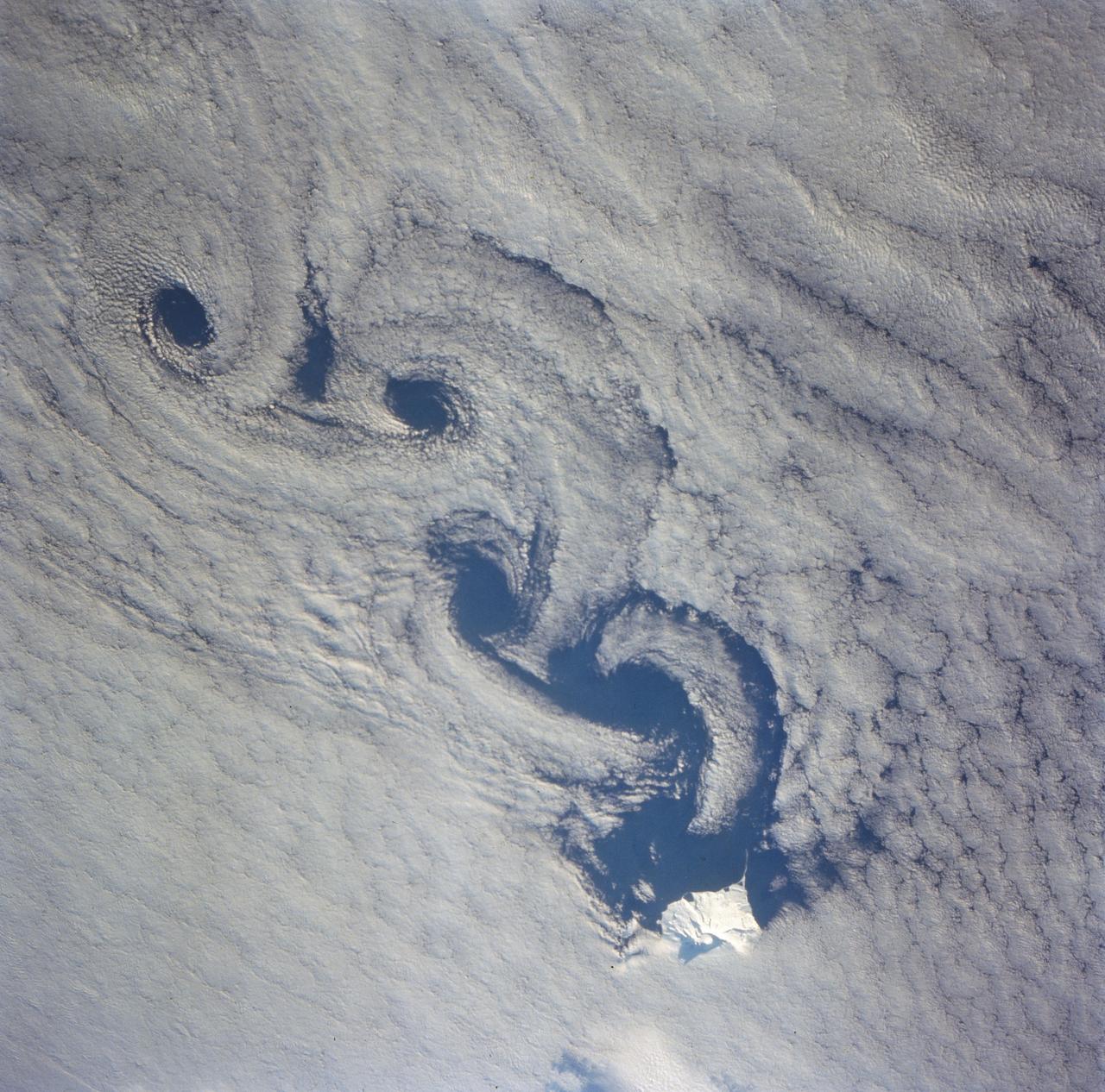
As the air blows over the tops of the mountain peaks, seen here in the clear region, the direction of the air flow is disturbed. These disturbances in the flow pattern are generally small circular eddies with one circulating in a clockwise direction and the next in the reverse direction. The wind here has caused the shallow cloud cover to change accordingly. These eddies are commonly called von Karmen Vortices.
STS058-101-014 (18 Oct-1 Nov 1993) --- The best, most-nearly cloud-free, shuttle view yet of Mount Everest, the highest mountain in the world at 29,028 feet. The peak, on the border between Nepal and China, is almost exactly in the center of the photograph. The challenging North Face is in shadow; valley glaciers radiate in all directions from the central massif.
AS09-20-3137 (3-13 March 1969) --- The Grand Canyon is sharply etched on the snow-covered Colorado Plateau in Arizona in this photograph from the Apollo 9 spacecraft during its Earth-orbital mission. Lake Powell behind Glen Canyon Dam is in the upper right corner. Humphreys Peak and the many volcanic craters around the San Francisco Mountains near Flagstaff, Arizona, are right of center. Prescott is under clouds at lower center.
STS121-331-019 (4-17 July 2006) --- (North is toward the lower right corner of the image). This vertical view over glaciers in the Karakoram Mountain range of Northern India was photographed from the Space Shuttle Discovery during the STS-121 mission. The glaciers are centered at 34.8 degrees north latitude and 77.8 degrees east longitude. The small peak in the center of the photo stands 25,170 feet high.
S66-38298 (5 June 1966) --- The central coastal area of Peru as seen from the Gemini-9A spacecraft during its 35th revolution of Earth. The body of water is the Pacific Ocean. The mountains are in the Cordillera Blanca range of the Andes. The 22,205-feet Huascaran is the highest peak in the area. The image was taken with a modified 70mm Hasselblad camera, using Eastman Kodak, Ektachrome MS (S.O. 217) color film Photo credit: NASA
art002e012093 (April 6, 2026) - Hertzsprung Basin comes into view with its distinctive two concentric rings of mountains, revealing the scale of this ancient impact structure. Near the lower left, Vavilov crater—identified by its central peak—stands out, a feature often described by the Artemis II crew during their lunar flyby. Credit: NASA
ISS016-E-006986 (26 Oct. 2007) --- Great Sand Dunes National Park and Preserve, Colorado is featured in this image photographed by an Expedition 16 crewmember on the International Space Station. The Sangre de Cristo Mountains of south-central Colorado stretch dramatically from top left to lower right of this image, generally outlined by the dark green of forests with white snow-capped peaks on the highest elevations. Dun-colored dunes, covering an area of 80 square kilometers, are banked up on the west side of the mountains and comprise the Great Sand Dunes National Park and Preserve. Originally established in 1932 as a National Monument, it was reauthorized as a National Park in 2004. The park contains dunes over 750 feet (227 meters) high -- among the highest in North America. Sand grains that make up the dunes are small enough to be moved along by the wind (a process known as saltation), although much of the dunefield is now anchored by vegetation. Predominant winds blow broadly to the east, so that sand in the San Luis valley (part of which appears at lower left) is driven towards and piled against the Sangre de Cristo Mts. The sand of the dunes is mostly derived from ancient exposed lakebed sediments - now the floor of the San Luis valley - formed by erosion of rocks in the Sangre de Cristo and San Juan Mountains (located to the west). The action of streams and occasional storms today returns some of the impounded sand back to the valley, where the prevailing winds begin the sand's migration to the dunefield anew. Interestingly, the specific location of the sand field appears to be related to a locally lower altitude sector of the Sangre de Cristo Mts. Altitudes can be inferred from the distribution of snow cover on the day this image was taken. Areas to the north (Cleveland Peak and northward) of the dunefield, and to the south around Blanca Peak, are higher than the ridgeline next to the dune field where almost no snow is visible. Since winds are preferentially channeled over the lower parts of any range (hundreds of meters lower here than ridgelines to north and south), sand grains are carried up to (but not over) the low point of the range.
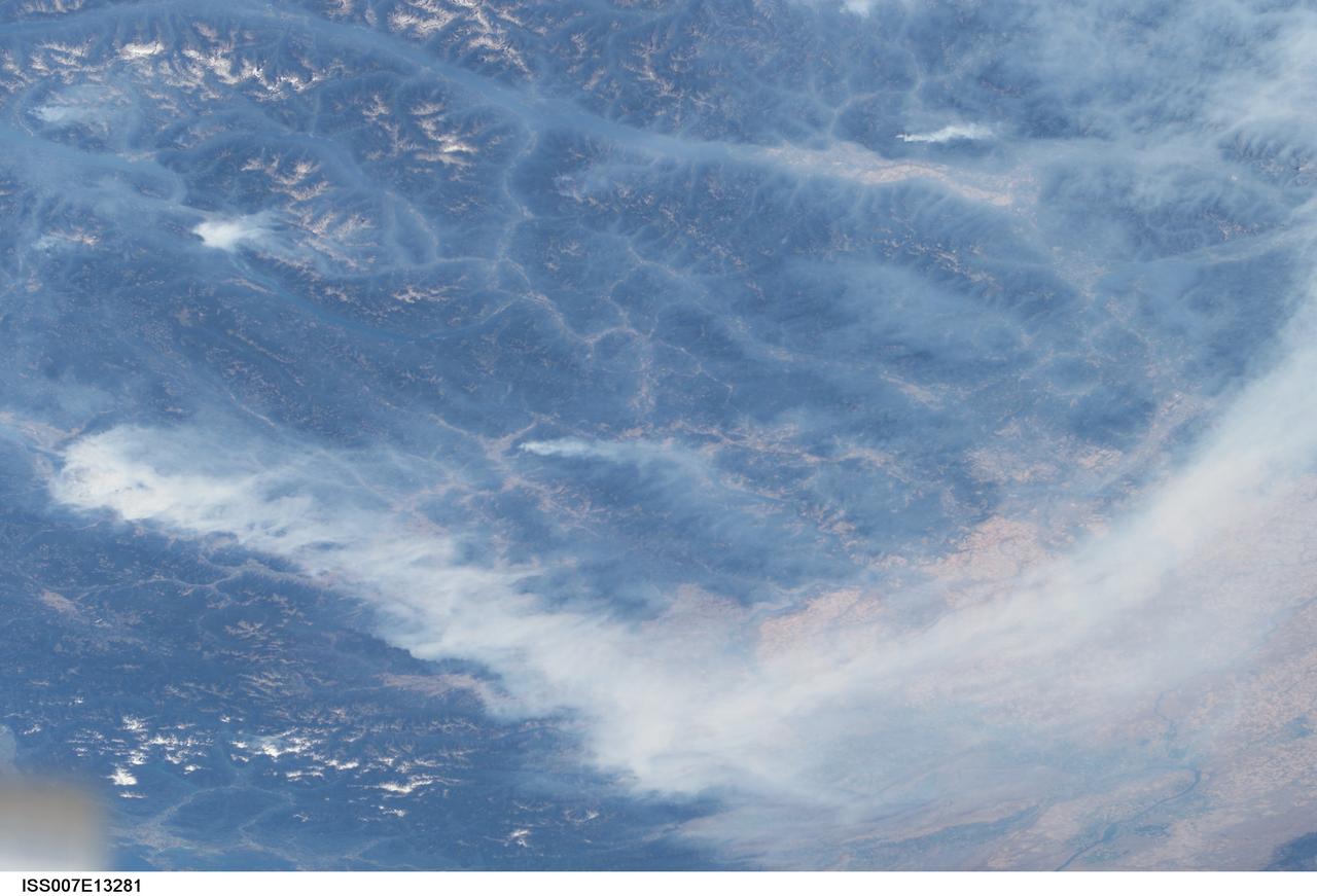
ISS007-E-13281 (20 August 2003) --- This view features forest fires in the Canadian province of British Columbia where some 620,000 acres of forest were consumed in almost 2,500 fires. Here the Rocky Mountains have both lofty, snow-capped peaks and long, narrow valleys that create special conditions and problems with air quality from these smoky fires. This image taken by one of the Expedition 7 crewmembers onboard the International Space Station (ISS) illustrates how smoke has become trapped in valleys where light winds and cold air drainage from the higher elevations have created temperature inversions. Note how the snowy peaks of the mountains are relatively smoke-free while the long, north-south valleys of Kootenay Lake and Columbia River are filled with trapped aerosols from the plumes of the large fires situated in the southwest. Meanwhile shifting winds have now swept the bulk of the plumes southeastward over the Columbia River Basin of Washington.
STS078-742-004 (20 June - 7 July 1996) --- This is a north-looking perspective of the major volcanoes of the Cascade Mountains of southern Washington and northern Oregon. With the Earth limb in the upper left corner of the photo, the large mountain at the top right, or northern part of the photo, is Mt. Rainier. The next snow covered area to the south east of Mt. Rainier is Gilbert Point. Mt. Adams is the larger peak, south-southeast of Mt. Rainier, Mt. St. Helens is the gray patch in the center of the photo, west of Mt. Adams. Mt. St. Helens erupted on May 18, 1980, removing 1,300 feet of the 9,677-ft. volcano. The eruption toppled trees with a searing, stone-filled 275-mile-per-hour wind over an area of more than 150 square miles. This area, now referred to as the "blast zone", can be easily spotted in this view. NASA scientists say that natural regrowth of vegetation within the blast zone is progressing at a rapid rate, especially on the outer fringes and in the protected valleys. Many fir trees have grown to heights exceeding 20 feet in a little over 12 years. A large lava dome within the crater of the volcano has grown to a height of over 1,000 feet since the 1980 eruption. The next three snow covered peaks are Mt. Hood, Mt. Jefferson and the Three Sisters all located in Oregon.
SL4-93-067 (16 Nov. 1973-8 Feb. 1974) --- A spectacular winter view of the Flagstaff, Arizona area is seen in this Skylab 4 Earth Resources Experiments package S190-B (five-inch earth terrain camera) infrared photograph taken from the Skylab space station in Earth orbit. Included in the scene are the San Francisco Mountains, Oak Creek Canyon, Painted Desert and Meteor Crater. The infrared picture depicts in red living vegetation, in white the snow, and in bright blue the water. Major features identified in this photograph are Humphrey's peak, top center, Flagstaff at foot of the peak, Sunset Crater volcanic field with numerous vents and craters right of Flagstaff and Meteor Crater (right center). Within the mountainous areas several clear areas generally rectangular are visible and represent the areas where lumbering has removed the forest. The thin white line extending from left corner to Sunset Crater fields is the power transmission line cleared area. Roads are subdued and are not easily visible. Photo credit: NASA
Acquisition Date: February 2004 The high reflectance of clouds compared to the surrounding land, coupled with the low sun elevation when this image was acquired, causes low clouds to appear red as they fill a portion of the Rocky Mountain Trench. Running parallel with the peaks of the Canadian Rockies and ranging from 2 to 10 miles (3 to 16 kilometers) wide and about 900 miles (1,448 kilometers) long, the Trench aligns with the Fraser River and makes its way past Mount Robson, the highest peak in the Canadian Rockies at 12,972 feet (3,954 meters). Mount Robson is near the center of this image. Credit: NASA/GSFC/Landsat/USGS To learn more about Landsat and to see the orginal high res file go to: <a href="http://landsat.usgs.gov/gallery_view.php?category=greenflag&thesort=mainTitle" rel="nofollow">landsat.usgs.gov/gallery_view.php?category=greenflag&...</a>
STS070-717-011 (13-22 JULY 1995) --- Volcanic landscapes with a thin dusting of snow appear in this near-vertical view of the dry, high spine of the Andes Mountains at around 28 degrees south latitude. Strong westerly winds (from left) have blown the snow off the highest volcanic peaks (center and bottom): many of these peaks rise higher than 20,000 feet. A small, dry lake appears top right, the white color derived from salts. The border between Argentina and Chile winds from volcano to volcano and passes just left of the small blue lake (left center). Black lava flows can be detected bottom right. The larger area of brown-pink rocks (bottom rock) is also an area of volcanic rocks, of a type known as ash flow tuffs which are violently extruded, often in volumes measured in cubic kilometers.
STS-56 Earth observation shows of some of the highest mountain peaks in the world taken from Discovery, Orbiter Vehicle (OV) 103, as it passed over India and China. The top of the view shows one of the snow and ice-covered massifs in the great Karakorum Range of north India. A star-shaped peak at top left reaches 23,850 feet. Glaciers can be seen in valleys at these high elevations. The international border between India to the south (top) and China (bottom) snakes left to right along a river near the top of the scene, then veers into the muntains at top left. Larger valleys, despite their elevation (all in excess of 14,000 feet), are occupied by transport routes joining points in India, China and the southern republics of the CIS. The ancient Silk Route between China and the Middle East lies not far to the north (outside the bottom of the frame).
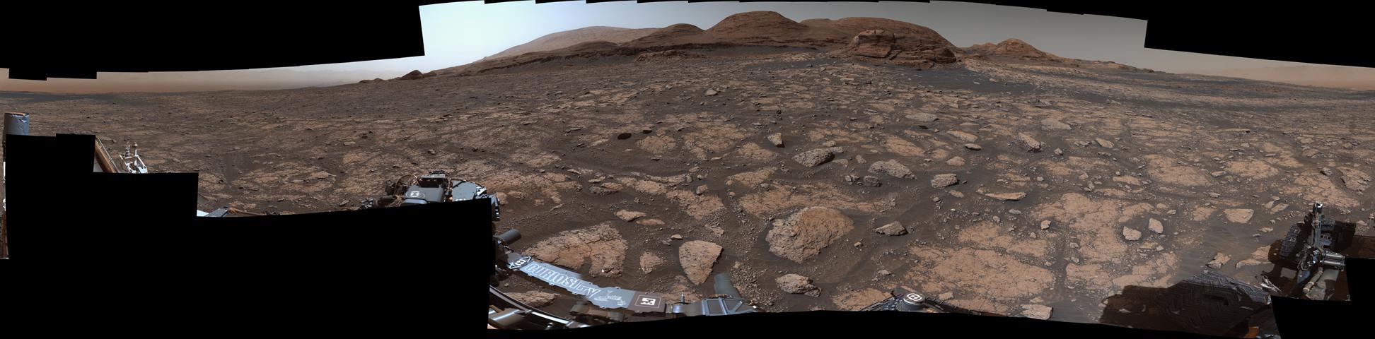
NASA's Curiosity Mars rover used its Mastcam instrument to take the 126 individual images that make up this 360-degree panorama on March 3, 2021, the 3,048th Martian day, or sol, of the mission. Right of center in the upper part of the image is "Mont Mercou," a ˜20-foot-tall (6-meter-tall) outcrop nicknamed after a mountain in France. Beyond the outcrop are peaks higher up Mount Sharp, the mountain Curiosity has been rolling up since 2014. Mount Sharp's summit can be seen at the top of the image, just left of center. The panorama has been white-balanced so that the colors of the rock materials resemble how they would appear under daytime lighting conditions on Earth. https://photojournal.jpl.nasa.gov/catalog/PIA24269
STS040-151-126 (5-14 June 1991) --- Croplands of the San Luis Valley stand out exceptionally clearly from low Earth orbit. The Rio Grande flows through the valley. Circular center pivot irrigation patterns have almost completely replaced the earlier rectangular grid pattern. Pinto beans are the specialty of the area. The Great Sand Dunes National Monument appears in fine detail near the center of the picture. The sands of these dunes have been blown from the valley floor by westerly winds in the course of the last few tens of thousands of years, now banked up against the foot of the Sangre de Christo Mountains (snowcapped peaks reach over 14000 feet). The town of Alamosa lies on the Rio Grande. The San Juan Mountains appear at the bottom left.
STS085-716-081 (7-19 August 1997) --- This photograph provides a southerly view from Vancouver, B. C. in the foreground, to Portland, Oregon near the top. Coastal stratus, a common occurrence, hugs the Pacific coastline and laps into Puget sound. The silty Fraser River cuts through Vancouver and empties into Puget Sound with a large, milky plume of sediment (bottom). Near the top of the image, the Columbia River runs across the Cascades (between Mt. Adams and Mt. Hood) and the Coast Ranges to the Pacific Ocean. Snow caps the highest peaks of the Olympic Mountains (near center), and the Cascade volcanoes of Rainier (closest to Seattle), Adams and Hood (top). The smaller, gray mountain just south (above and right) of Rainier is Mt. St. Helens.

ISS011-E-13889 (30 September 2005) --- Wasatch Range, Utah is featured in this image photographed by an Expedition 11 crewmember on the international space station. The Wasatch Range forms an impressive backdrop to the Salt Lake City metropolitan area, and is a frequent destination for hikers, backpackers, and skiers. The range is considered to be the westernmost part of the Rocky Mountains, and rises to elevations of approximately 3600 meters (12,000 feet) above sea level. This photograph, taken at the end of September, captures red- (maple trees) and gold-mantled (aspen trees) hill slopes along the western mountain front to the south of Salt Lake City. Other common tree species at these elevations include pine, fir, spruce, willow, birch, and oak. A portion of Draper City is visible in the left half of the image. The elevation of Lone Peak, visible at upper right, is approximately 3410 meters (11,253 feet).
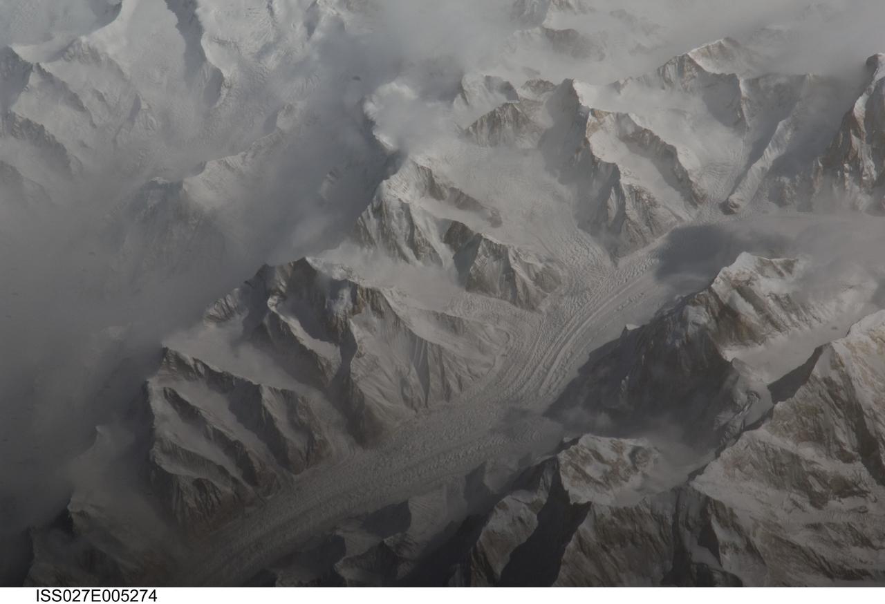
ISS027-E-005274 (16 March 2011) --- Central Tien Shan in the People?s Republic of China is featured in this image photographed by an Expedition 27 crew member on the International Space Station (ISS). The Tien Shan (or ?celestial mountains? in Chinese) is one of the largest continuous mountain ranges in the world, extending approximately 2,500 kilometers roughly east-west across Central Asia. This photograph provides a detailed view of part of the central Tien Shan, located approximately 64 kilometers east of a point where the borders of China, Kyrgyzstan, and Kazakhstan meet. While the image looks like it might have been taken from an airplane, it was taken from the space station at an altitude of 341 kilometers. The distance between the ISS ground track position (approximately 304 kilometers to the southwest) and the imaged area produces an oblique ? looking outwards an angle, rather than straight down ? view that, together with shadowing of valleys, accentuates the mountainous topography. Like the Himalayas to the south, the uplift of the Tien Shan results from the ongoing collision between the Eurasian and Indian continental tectonic plates. The rugged topography of the range is the result of subsequent erosion by water, wind, and in the highest parts of the range, active glaciers. Two types of glaciers are visible in the image; cirque glaciers occupy amphitheater-like depressions on the upper slopes of the mountains, and feed ice downslope to aggregate into large valley glaciers such as the one visible at center. Low clouds obscure an adjacent valley and glaciers to the north (upper left). Two high peaks of the central Tien Shan are identifiable in the image. Xuelian Feng has a high summit of 6,527 meters above sea level. To the east, the aptly-named Peak 6231 has summit of 6,231 meters above sea level.

ISS038-E-003612 (15 Nov. 2013) --- Islands of the Four Mountains are featured in this image photographed by an Expedition 38 crew member on the International Space Station. Morning sunlight illuminates the southeast-facing slopes of the islands in the photograph. The islands, part of the Aleutian Island chain, are actually the upper slopes of volcanoes rising from the sea floor; Carlisle, Cleveland, Herbert, and Tana. Carlisle and Herbert volcanoes are distinct cones and form separate islands. Cleveland volcano and the Tana volcanic complex form the eastern and western ends respectively of Chuginadak Island; a cloud bank obscures the connecting land mass in this image. Cleveland volcano (peak elevation 1,730 meters above sea level) is one of the most active in the Aleutian chain, with its most recent activity--eruptions and lava flow emplacement--taking place in May of 2013. The northernmost of the islands, Carlisle volcano's (peak elevation 1,620 meters above sea level) last confirmed eruption occurred in 1828, with unconfirmed reports of activity in 1987. Herbert volcano (peak elevation 1,280 meters above sea level) to the southwest displays a classic cone structure breached by a two-kilometer wide summit caldera (upper right), but there are no historical records of volcanic activity. The easternmost peak, Tana (1,170 meters above sea level) is a volcanic complex comprised of two east-west trending volcanoes and associated younger cinder cones; like Herbert volcano, there is no historical record of activity at Tana. A layer of low clouds and/or fog obscures much of the lower elevations of the islands and the sea surface, but the clouds also indicate the general airflow pattern around and through the islands. Directly to the south-southeast of Cleveland volcano a Von Karman vortex "street" is visible. Shadows cast by the morning sun extend from the peaks towards the northwest. The peaks of all of the Four Islands have snow cover; this is distinct from the clouds due to both higher brightness (white versus gray) and specific location on the landscape.
STS072-709-063 (11-20 Jan. 1996) --- The astronauts aboard the Space Shuttle Endeavour exposed this 70mm frame of the Air Mountains, located in the country of Niger. These Sahara Desert structures are granitic intrusions. They are resistant to erosion and are very prominent in the lighter colored sands of the area. According to NASA geologists studying the photo collection, the ring-like structure on the lower left-hand edge of the photograph is probably a Quaternary volcanic feature. The highest peaks in the range approach 1,800 meters (6,000 feet). Deep valleys in the range are used by the Tuaregs for pasturage. Uranium and other minerals are being mined in the massif.

STS058-95-028 (18 Oct-1Nov 1993) --- Lake Urmia (Orumiyeh) in the high desert plateau of northwest Iran dominates the center of this northeast-looking view. The left edge of the view cuts Lake Van in eastern Turkey. The Caucasus Mountains in war-torn Georgia appear just beyond. Mount Ararat, of biblical fame, is a major peak north of Lake Van. The Caspian Sea, an international body of water, stretches across the top right of the view. Countries bordering the Caspian are Iran in the south, Kazakhstan in the west, and Russia and Azerbaijan in the west.
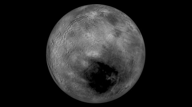
Images from NASA New Horizons spacecraft were used to create a flyover video (PIA19965) of Pluto largest moon, Charon. The flight starts with the informally named Mordor dark region near Charon north pole. In the video, the camera then moves south to a vast chasm, descending from 1,100 miles (1,800 kilometers) to just 40 miles (60 kilometers) above the surface to fly through the canyon system. From there it's a turn to the south to view the plains and "moat mountain," informally named Kubrick Mons, a prominent peak surrounded by a topographic depression. http://photojournal.jpl.nasa.gov/catalog/PIA19965
S71-44672 (30 July 1971) --- A near vertical view of the crater Paracelsus (formerly called I.A.U. Crater 365) on the lunar farside, as photographed by the Fairchild metric camera in the Scientific Instrumentation Module (SIM) bay of the Apollo 15 Command and Service Modules (CSM) in lunar orbit. Note mountain peak in center of Paracelsus. The coordinates of the center of Paracelsus are 163 degrees east longitude and 23 degrees south latitude. The second largest crater in the picture is identified as number 364 by the I.A.U. North will be at the top of the picture if held with Paracelsus at top center. The three-inch mapping camera was one of eight lunar orbital science experiments mounted in the SIM bay.
STS068-258-028 (9 October 1994) --- Astronauts aboard the Space Shuttle Endeavour recorded this final 70mm frame of the Kliuchevskoi volcano on the Kamchatka Peninsula in Russia. The volcano was near its peak on launch day, 10 days earlier, but a snowstorm left very little indication of the major event that had occurred here, except for the ash-covered summit and the large black flow down the northern flank of the mountain. As various members of the six-person crew were using handheld cameras to record the various stages of the volcano, hardware in Endeavour's cargo bay was taking radar data of the event in support of the Space Radar Laboratory (SRL-2) mission.
Roadside bedrock outcrops are all too familiar for many who have taken a long road trip through mountainous areas on Earth. Martian craters provide what tectonic mountain building and man's TNT cannot: crater-exposed bedrock outcrops. Although crater and valley walls offer us roadside-like outcrops from just below the Martian surface, their geometry is not always conducive to orbital views. On the other hand, a crater central peak -- a collection of mountainous rocks that have been brought up from depth, but also rotated and jumbled during the cratering process -- produce some of the most spectacular views of bedrock from orbit. This color composite cutout shows an example of such bedrock that may originate from as deep as 2 miles beneath the surface. The bedrock at this scale is does not appear to be layered or made up of grains, but has a massive appearance riddled with cross-cutting fractures, some of which have been filled by dark materials and rock fragments (impact melt and breccias) generated by the impact event. A close inspection of the image shows that these light-toned bedrock blocks are partially to fully covered by sand dunes and coated with impact melt bearing breccia flows. http://photojournal.jpl.nasa.gov/catalog/PIA12291
Naked peaks, sheltered valleys, snowfields, towering trees, and alpine meadows make up the varied landscape of Sequoia National Park in California. Established as a National Park by Congress on September 25, 1890, Sequoia National Park is the second-oldest U.S. National Park, after Yellowstone. This national park borders Kings Canyon National Park. The Thematic Mapper sensor on NASA’s Landsat 5 satellite captured this true-color image of Sequoia National Park, outlined in white, on October 22, 2008. Sunlight illuminates southern slopes, leaving northern faces in shadow in this autumn image. In the west, deep green conifers carpet most of the land. These forested mountains are home to the park’s most famous giant sequoia trees. Sequoia National Park sits at the southern end of the Sierra Nevada mountains. Terrain alternates between extremes, from peaks such as Mt. Whitney—the highest peak in the contiguous United States—to deep caverns. The rivers and lakes in this region are part of a watershed valuable not only to the plants and animals of the park, but also to farms and cities in California’s Central Valley. Read more: <a href="http://go.nasa.gov/2bzGOXr" rel="nofollow">go.nasa.gov/2bzGOXr</a> Credit: NASA/Landsat5 <b><a href="http://www.nasa.gov/audience/formedia/features/MP_Photo_Guidelines.html" rel="nofollow">NASA image use policy.</a></b> <b><a href="http://www.nasa.gov/centers/goddard/home/index.html" rel="nofollow">NASA Goddard Space Flight Center</a></b> enables NASA’s mission through four scientific endeavors: Earth Science, Heliophysics, Solar System Exploration, and Astrophysics. Goddard plays a leading role in NASA’s accomplishments by contributing compelling scientific knowledge to advance the Agency’s mission. <b>Follow us on <a href="http://twitter.com/NASAGoddardPix" rel="nofollow">Twitter</a></b> <b>Like us on <a href="http://www.facebook.com/pages/Greenbelt-MD/NASA-Goddard/395013845897?ref=tsd" rel="nofollow">Facebook</a></b> <b>Find us on <a href="http://instagrid.me/nasagoddard/?vm=grid" rel="nofollow">Instagram</a></b>
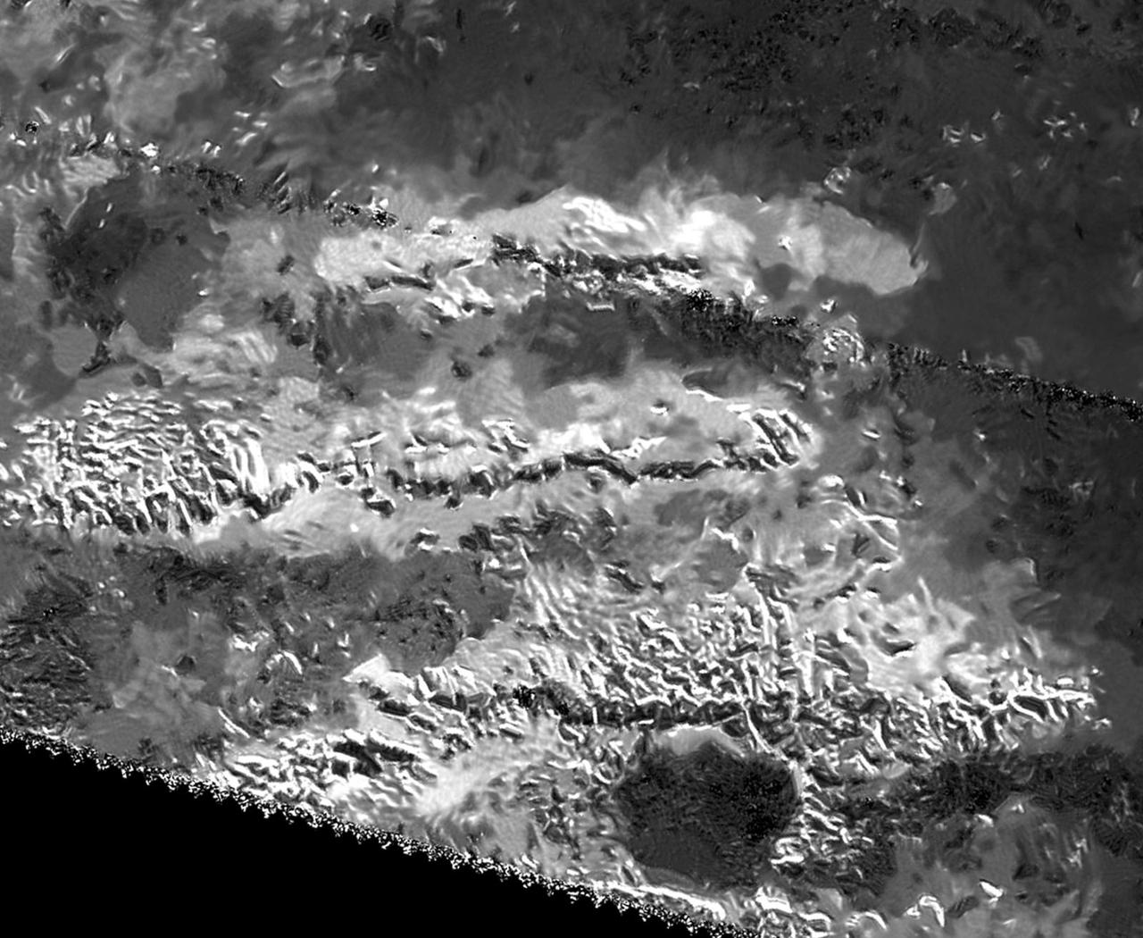
This synthetic-aperture radar image was obtained by NASA's Cassini spacecraft during its T-120 pass over Titan's southern latitudes on June 7, 2016. The area shown here measures about 40 by 60 miles (70 by 100 kilometers) and is centered at about 60 degrees south latitude, 130 degrees west longitude. Radar illuminates the scene from the left at a 28-degree incidence angle. At the center of the image is a bright feature oriented from upper left to lower right. This is interpreted to be a long ridge with jagged peaks, likely created by methane rainfall erosion. Some of the individual peaks rise about 2,400 feet (800 meters) above the valley floor. The ridge has a considerably gentler slope on its left side (which appears brighter here) than on its right. Frequently, mountains shaped like this on Earth are fractured blocks of the planet's crust, thrusted upward and then tilted, creating a shallow slope on one side and a steeper slope on the fractured, faulted edge. Also presented here is an annotated version of the image, along with a radar image of the Dragoon Mountains in Arizona just east of Tucson. The Dragoon feature represents a tilted fault block, formed by spreading that has occurred across the western U.S., and has a similar shape to that of the Titan ridge. The Dragoon radar image was produced using data from NASA's Shuttle Radar Topography Mission (credit: NASA/JPL-Caltech/NGA). Radar illuminates the scene from the left in that image as well. Titan has displayed many features that are strikingly similar to Earth: lakes, seas, rivers, dunes and mountains. Scientists think it possible that, like Earth, the giant moon's crust has experienced familiar processes of uplift and spreading, followed by erosion. http://photojournal.jpl.nasa.gov/catalog/PIA20709
STS061-101-023 (8 Dec 1993) --- This color photograph is a spectacular, panoramic (southeastern view) shot that features the northern half of the country of Chile and the Andes Mountains of South America. The Atacama Desert, one of the driest regions on earth, is clearly visible along the northern Chilean coast. This desert extends from roughly Arica in the north to the city of Caldera in the south, a distance of six hundred miles. Some parts of this very arid region go for more than twenty years without measurable precipitation. It is an area of dramatic and abrupt elevation changes. For example, from the waters edge there is an escarpment of the coastal plateau that rises like an unbroken wall two or three thousand feet above the Pacific Ocean. From the coastal plateau, there is an even more dramatic increase in elevation -- from two thousand feet above sea level to an average elevation of thirteen thousand feet above sea level in the Bolivian Altiplano. This elevation change occurs within a one hundred to two hundred mile distance from the Pacific Ocean. The north-south trending spine of the Andes Mountains can be seen on this photograph. Several of the volcanic peaks in this mountain chain exceed 20,000 feet above sea level. Interspersed with these volcanic peaks, numerous dry lake beds (salars) can be seen as highly reflective surfaces. The largest of these salars (Salar de Uyuni) is visible at the edge of the Hubble Space Telescope (HST). Offshore, the cold Peruvian current produces low stratus clouds that can be found along this coastline at certain times of the year. This is the same type of meteorological phenomena that is found along the southern California coast and the Skeleton coast of southwestern Africa.
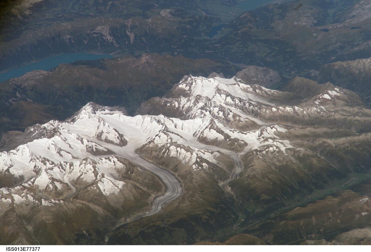
ISS013-E-77377 (5 Sept. 2006) --- Bernese Alps, Switzerland is featured in this image photographed by an Expedition 13 crewmember onboard the International Space Station. The formidable mountain system of the Alps stretches across much of central Europe, with seven countries claiming portions of the mountains within their borders (Germany, France, Switzerland, Italy, Liechtenstein, Austria, and Slovenia). The glacial landscape of the Bernese Alps, located in southwestern Switzerland, is well illustrated by this view. The image was taken by a crewmember looking north-northwest while the station was located over the Mediterranean Sea between Corsica and Italy -- this oblique viewing angle imparts a sense of perspective to the image. This type of viewing angle complements more nadir (downward)--viewing imagery of the region. Three of the higher peaks of the central Alps are visible--Jungfrau (4,158 meters), Moench (4,089 meters), and Eiger (3,970 meters). To the east and south of the Jungfrau is the Aletsch Glacier, clearly marked by dark medial moraines extending along the glacier's length parallel to the valley axis. The moraines are formed from rock and soil debris collected along the sides of three mountain glaciers located near the Jungfrau and Moench peaks -- as these flowing ice masses merge to form the Aletsch Glacier, the debris accumulates in the middle of the glacier and is carried along the flow direction. According to geologists, Lake Brienz to the northwest was formed by the actions of both glacial ice and the flowing waters of the Aare and Lutschine rivers, and has a maximum depth of 261 meters. The lake has a particularly fragile ecosystem, as demonstrated by the almost total collapse of the whitefish population in 1999. Possible causes for the collapse, according to the scientists, include increased water turbidity associated with upstream hydropower plant operations, and reduction of phosphorus (a key nutrient for lake algae, a basic element of the local food web) due to water quality concerns.
STS097-715-061 (10 December 2000) This view over the Central Andes Mountains in Argentina and Chile was taken on December 10, 2000 by one of the astronauts aboard the Earth-orbiting Space Shuttle Endeavour. Extending 5500 miles (8850 kilometers) along the western coast of South America from northern Colombia to Cape Horn in southern Chile, the Andes are the longest mountain range, above sea level, and the second highest range in the world. According to NASA scientists studying the STS-97 photo collection, this immense system came into existence nearly 70 million years ago. With numerous active volcanoes and a slow uplift, the building of the Andes Mountains continues today rising four inches (10 centimeters) per century, the scientists say. In this north-looking view, snow covers the higher peaks of the range, some of which rise to over 20000 feet (6100 meters) above sea level. Along the left or western portion of the view, clouds can be seen along coastal areas of Chile. In the bottom left quadrant of the scene, the blue waters of the Paloma Reservoir, a recreational lake, are visible. The folded Tontal Range (bottom center) and the Valle Fertil Range (upper right quadrant and partially cloud covered) of western Argentina can be seen. The rocks of these ranges, the scientists point out, are ancient compared to the younger volcanic peaks and ranges of the Andes. The city of San Juan, Argentina is visible on the eastern (right) base of the Tontal Range in the lower right quadrant of the view.
New close-up images of a region near Pluto's equator reveal a giant surprise: a range of youthful mountains rising as high as 11,000 feet (3,500 meters) above the surface of the icy body. The mountains likely formed no more than 100 million years ago -- mere youngsters relative to the 4.56-billion-year age of the solar system -- and may still be in the process of building. That suggests the close-up region, which covers less than one percent of Pluto's surface, may still be geologically active today. The youthful age estimate is based on the lack of craters in this scene. Like the rest of Pluto, this region would presumably have been pummeled by space debris for billions of years and would have once been heavily cratered -- unless recent activity had given the region a facelift, erasing those pockmarks. Unlike the icy moons of giant planets, Pluto cannot be heated by gravitational interactions with a much larger planetary body. Some other process must be generating the mountainous landscape. The mountains are probably composed of Pluto's water-ice "bedrock." Although methane and nitrogen ice covers much of the surface of Pluto, these materials are not strong enough to build the mountains. Instead, a stiffer material, most likely water-ice, created the peaks. The close-up image was taken about 1.5 hours before New Horizons closest approach to Pluto, when the craft was 47,800 miles (770,000 kilometers) from the surface of the planet. The image easily resolves structures smaller than a mile across. http://photojournal.jpl.nasa.gov/catalog/PIA19710
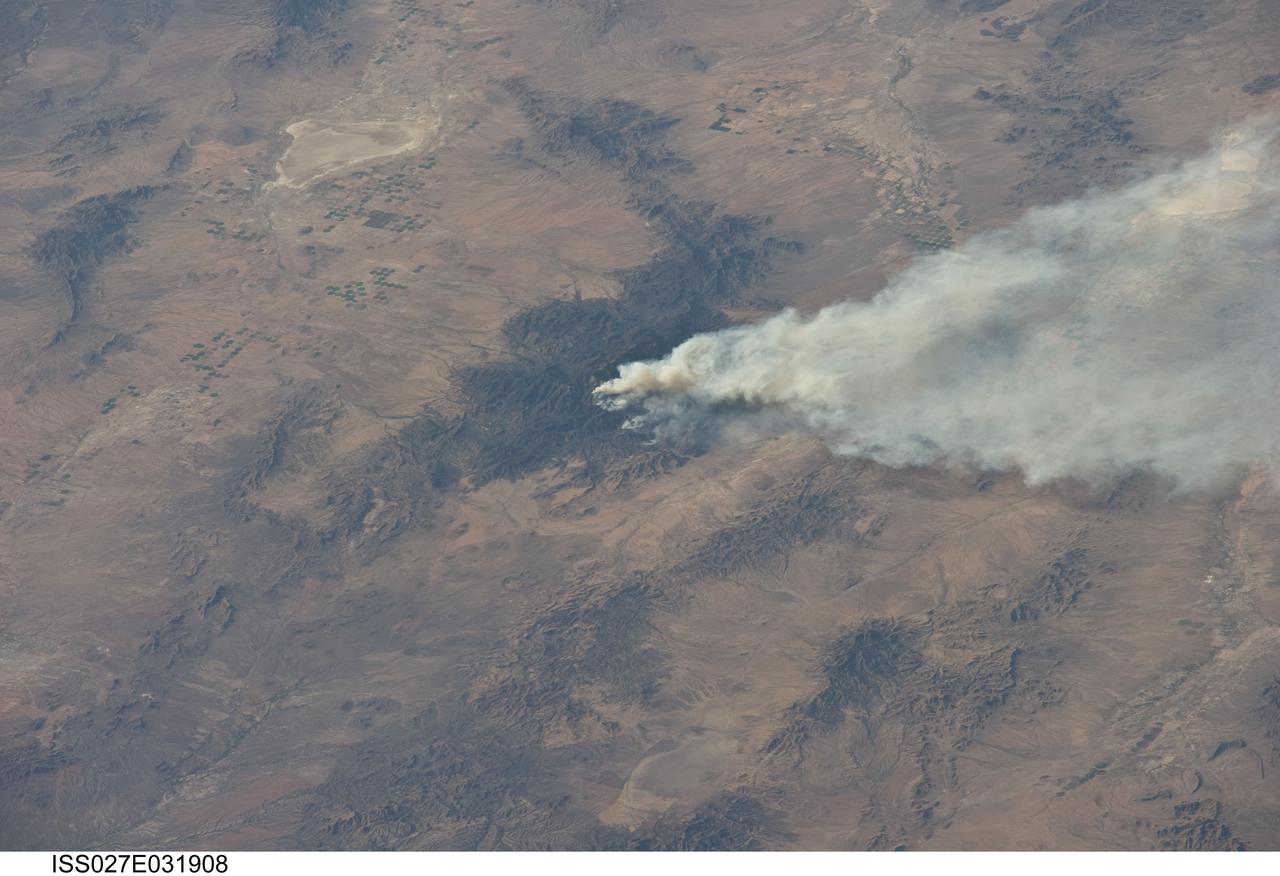
ISS027-E-031908 (15 May 2011) --- The Horseshoe 2 fire is featured in this image photographed by an Expedition 27 crew member on the International Space Station. The Horseshoe 2 fire, located along the southeastern flank of the Chiricahua Mountains in southeastern Arizona, began on May 8, 2011 at approximately 11:00 a.m. The fire is thought to have been started by human activities. This photograph illustrates the area (approximately 8,900 hectares, or 22,110 acres) and position of the fire within the mountains on May 15, 2011, as well as an extensive smoke plume extending to the east-northeast over a distance of at least 60 kilometers (approximately 40 miles). As of May 19, 2011, the fire had burned an area of nearly 14,000 hectares (approximately 34,400 acres) of grasses, shrubs, and trees along the mountain slopes. The Chiricahua Mountains are included within the Chiricahua National Monument located near the borders of Arizona, USA; New Mexico, USA; and Chihuahua, United Mexican States. Elevations in the mountains range from approximately 914 – 3,267 meters (300 – 10,720 feet) above sea level. The higher elevations—known regionally as “sky islands”—allow for biologically diverse plant and animal communities, adapted to cooler and wetter conditions, to survive while surrounded by semi-arid to arid desert conditions at lower elevations. The image highlights this contrast in environments; pine and oak forest contributes to the dark coloration of the upper slopes and peaks of the Chiricahuas at center, while the flat, gray to tan surface of Willcox Playa (an interior-draining basin or dry lake) to the northwest is indicative of the adjacent desert environment.
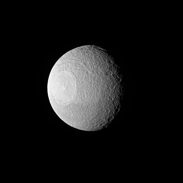
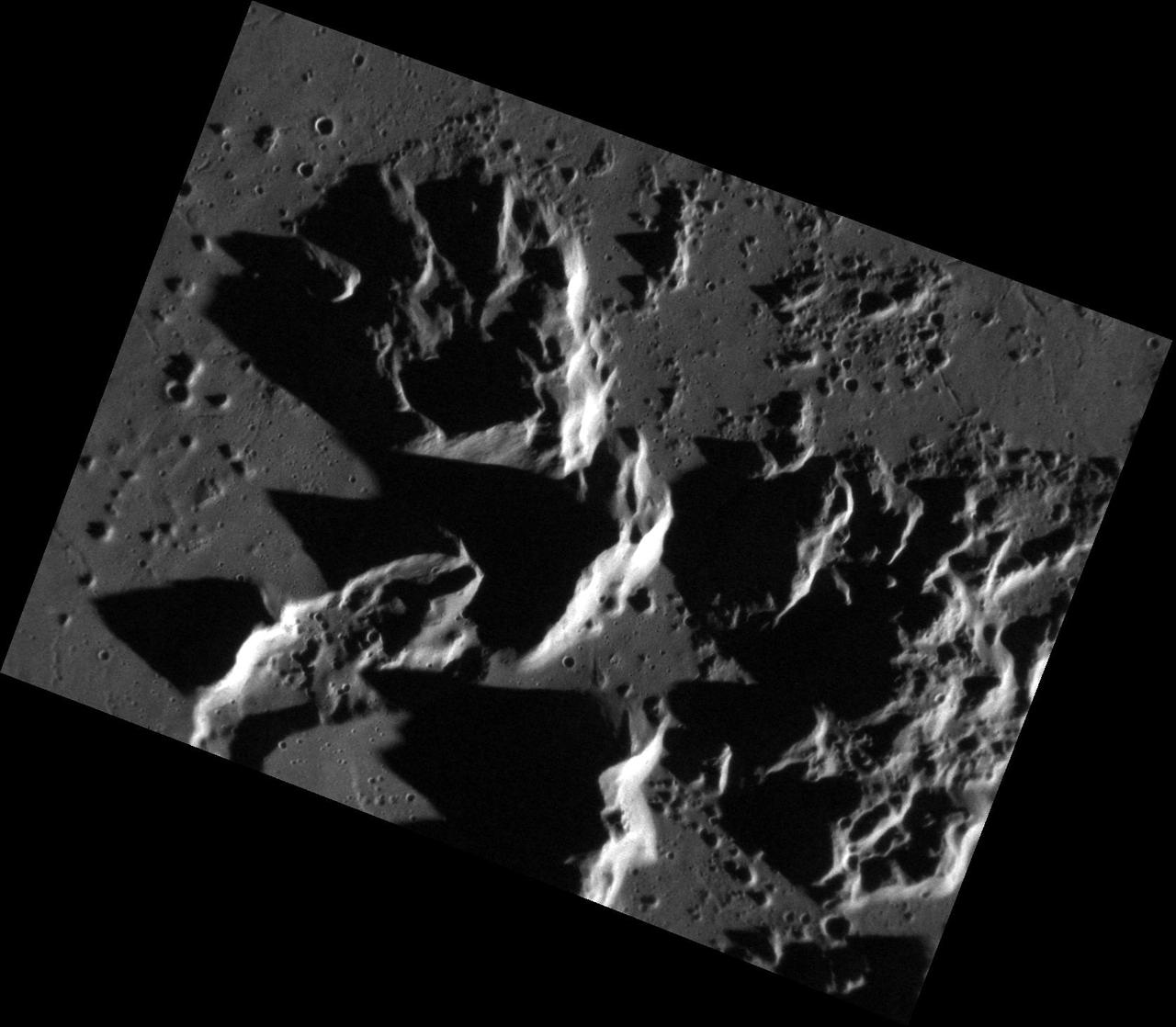
Tethys, one of Saturn's larger icy moons, vaguely resembles an eyeball staring off into space in this view from NASA's Cassini spacecraft. The resemblance is due to the enormous crater, Odysseus, and its complex of central peaks. Like any solar system moon, Tethys (660 miles or 1,062 kilometers across) has suffered many impacts. These impacts are a prime shaper of the appearance of a moon's surface , especially when the moon has no active geological processes. In this case, a large impact not only created a crater known as Odysseus, but the rebound of the impact caused the mountainous peaks, named Scheria Montes, to form in the center of the crater. This view looks toward the leading side of Tethys. North on Tethys is up and rotated 1 degree to the left. The image was taken in green light with the Cassini spacecraft narrow-angle camera on Nov. 10, 2016. The view was acquired at a distance of approximately 228,000 miles (367,000 kilometers) from Tethys. Image scale is 1.2 miles (2 kilometers) per pixel. http://photojournal.jpl.nasa.gov/catalog/PIA20518
STS060-85-000AH (3-11 Feb 1994) --- This view is centered at about 44 degrees south along the Chilean continental margin of South America. The dark-colored coastal region is heavily forested by dense old-growth forests that are now being cut, but east of the mountains in Argentina the dry climate supports very little vegetation. This desert region known as Patagonia appears as light brown colors. The coastline is especially dramatic because it is shaped by the tortuous channels carved by glaciers which have left fjords. These fjords have effectively cut across the continental divide, and are bordered by active volcanoes which reach elevations between 2, 000 - 3,000 meters. The prominent volcanic peak in the center of the frame is Mt. Melimoya. To the north is a long, snow-covered volcanic ridge called Cerro Yantales. Cerro Yantales recently reported greatly increased fumarolic activity, including the emission of yellow gases near the summit. Russian and American scientists will use this photography to look for further evidence of increased activity like snow melt around the peak. Other Russian and American scientists are particularly interested in mapping the summertime snowline and firm (permanent snow field) elevations as early indications of any potential climatic variation in the making.
This three-dimensional perspective of the remote Karakax Valley in the northern Tibetan Plateau of western China was created by combining two spaceborne radar images using a technique known as interferometry. Visualizations like this are helpful to scientists because they reveal where the slopes of the valley are cut by erosion, as well as the accumulations of gravel deposits at the base of the mountains. These gravel deposits, called alluvial fans, are a common landform in desert regions that scientists are mapping in order to learn more about Earth's past climate changes. Higher up the valley side is a clear break in the slope, running straight, just below the ridge line. This is the trace of the Altyn Tagh fault, which is much longer than California's San Andreas fault. Geophysicists are studying this fault for clues it may be able to give them about large faults. Elevations range from 4000 m (13,100 ft) in the valley to over 6000 m (19,700 ft) at the peaks of the glaciated Kun Lun mountains running from the front right towards the back. Scale varies in this perspective view, but the area is about 20 km (12 miles) wide in the middle of the image, and there is no vertical exaggeration. http://photojournal.jpl.nasa.gov/catalog/PIA01800
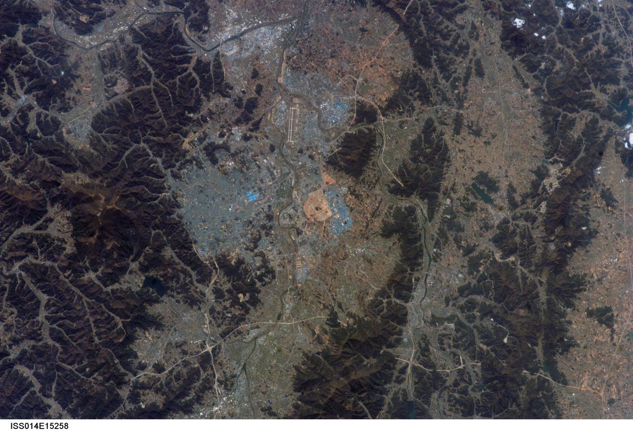
ISS014-E-15258 (26 Feb. 2007) --- Kwangju, South Korea is featured in this image photographed by an Expedition 14 crewmember on the International Space Station. The Metropolitan City of Kwangju (or Gwangju) is the fifth largest urban area in South Korea with a population of 1.4 million people. It is a major economic and cultural center for the southern portion of the country, located in a geographic basin with high mountains to the east (the mountain of Mudeungsan to the east has a peak elevation of 1,140 meters) and more open plains to the west. The city is perhaps best known to the West as the location of the Gwangju Massacre in May 1980, during which civilian demonstrators were killed by government forces. This event has led to identification of the city within South Korea as "the shrine of Korean democracy." The most notable feature in this view is an interesting blue cast to the urbanized regions. Digital photographs capture the same red, green, and blue wavelengths of reflected light that human eyes are sensitive to (known as a "true-color" image), and urban areas typically appear in tones of grey. The distinctive blue-grey color of the Kwangju metropolitan area is the result of numerous blue building rooftops, present on both small residential buildings and large industrial buildings such as those located at center and right.
STS068-247-061 (30 September-11 October 1994) --- Photographed through the Space Shuttle Endeavour's flight windows, this 70mm frame centers on Yellowstone Lake in the Yellowstone National Park. North will be at the top if picture is oriented with series of sun glinted creeks and river branches at top center. The lake, at 2,320 meters (7,732 feet) above sea level, is the largest high altitude lake in North America. East of the park part of the Absaroka Range can be traced by following its north to south line of snow capped peaks. Jackson Lake is southeast of Yellowstone Park, and the connected Snake River can be seen in the lower left corner. Yellowstone, established in 1872 is the world's oldest national park. It covers an area of 9,000 kilometers (3,500 square miles), lying mainly on a broad plateau of the Rocky Mountains on the Continental Divide. It's average altitude is 2,440 meters (8,000 feet) above sea level. The plateau is surrounded by mountains exceeding 3,600 meters (12,000 feet) in height. Most of the plateau was formed from once-molten lava flows, the last of which is said to have occurred 100,000 years ago. Early volcanic activity is still evident in the region by nearly 10,000 hot springs, 200 geysers and numerous vents found throughout the park.
In February 2015, New England was not alone in dealing with the wrath of Old Man Winter. Thick snow blanketed mountain ranges in southwestern Europe after a winter storm pushed through the region in early February. The Moderate Resolution Imaging Spectroradiometer (MODIS) on NASA’s Terra satellite captured this true-color image of the snow-covered peaks of the Cantabrian Mountains, the Pyrenees, the Alps, and Massif Central on February 9, 2015. Credit: NASA/GSFC/Jeff Schmaltz/MODIS Land Rapid Response Team <b><a href="http://www.nasa.gov/audience/formedia/features/MP_Photo_Guidelines.html" rel="nofollow">NASA image use policy.</a></b> <b><a href="http://www.nasa.gov/centers/goddard/home/index.html" rel="nofollow">NASA Goddard Space Flight Center</a></b> enables NASA’s mission through four scientific endeavors: Earth Science, Heliophysics, Solar System Exploration, and Astrophysics. Goddard plays a leading role in NASA’s accomplishments by contributing compelling scientific knowledge to advance the Agency’s mission. <b>Follow us on <a href="http://twitter.com/NASAGoddardPix" rel="nofollow">Twitter</a></b> <b>Like us on <a href="http://www.facebook.com/pages/Greenbelt-MD/NASA-Goddard/395013845897?ref=tsd" rel="nofollow">Facebook</a></b> <b>Find us on <a href="http://instagram.com/nasagoddard?vm=grid" rel="nofollow">Instagram</a></b>

STS113-708-014 (23 November - 7 December 2002) --- The STS-113 crewmembers used a handheld 70mm still camera to record this image of Patagonia lakes in southern Argentina. The lowest of the three lakes in this view is Lake Argentino. The next one north (middle lake) is Lake Viedma, and the lake on the top margin is Lake San Martín. According to NASA scientists studying the STS-113 Earth imagery, all three of these large lakes have been carved out by glaciers in the "recent" ice age, descending from the Andes Mountains (under cloud along the right side of the view). Three glacier tongues can be discerned as small white features leading into the western (left) ends of each lake. The rounded ends of the lakes, according to the Johnson Space Center scientists, are produced by the slow "flowing" action of glacial ice on the plains next to the mountain chain. Snow cap on lower peaks next to the cloud make a jagged pattern.
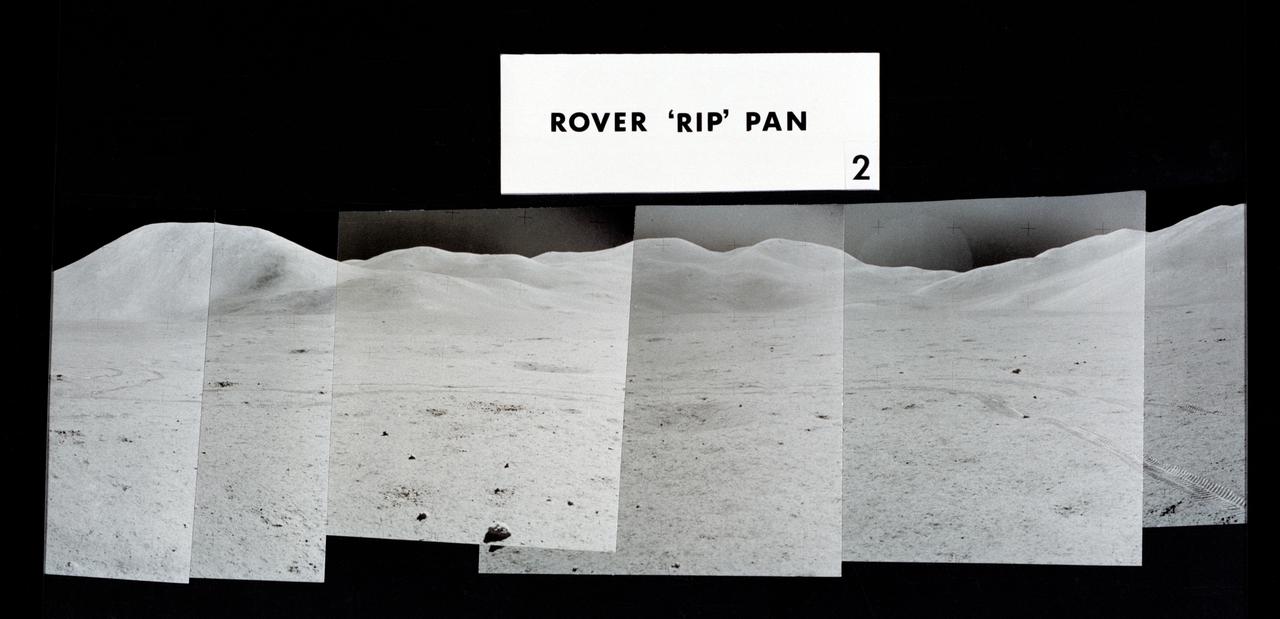
S71-43943 (2 Aug. 1971) --- Mosaic photographs which compose a 360-degree panoramic view of the Apollo 15 Hadley-Apennine landing site, taken near the close of the third lunar surface extravehicular activity (EVA) by astronauts David Scott and James Irwin. This group of photographs was designated the Rover "RIP" Pan because the Lunar Roving Vehicle was parked in its final position prior to the two crewmen returning to the Lunar Module. The astronaut taking the pan was standing 325 feet east of the Lunar Module (LM). The Rover was parked about 300 feet east of the LM. This mosaic covers a field of view from about north-northeast to about south. Visible on the horizon from left to right are: Mount Hadley; high peaks of the Apennine Mountains which are farther in the distance than either Mount Hadley or Hadley Delta Mountain; Silver Spur on the Apennine Front; and the eastern portion of Hadley Delta. Note Rover tracks in the foreground. The numbers of the other two views composing the 360-degree pan are S71-43940 and S71-43942.
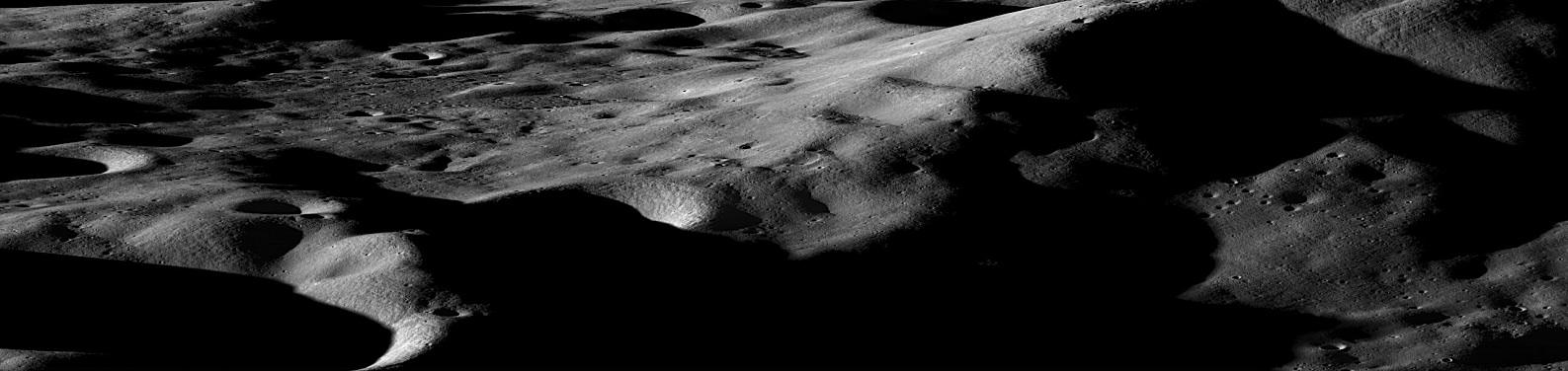
Mountains on the Moon On the Earth, we are taught that mountains form over millions of years, the result of gradual shifting and colliding plates. On the moon however, the situation is quite different. Even the largest lunar mountains were formed in minutes or less as asteroids and comets slammed into the surface at tremendous velocities, displacing and uplifting enough crust to create peaks that easily rival those found on Earth. On a few occasions in the past year, NASA has tilted the angle of LRO to do calibrations and other tests. In such cases the camera has the opportunity to gather oblique images of the lunar surface like the one featured here of Cabeus Crater providing a dramatic view of the moon's mountainous terrain. Cabeus Crater is located near the lunar south pole and contains the site of the LCROSS mission's impact. Early measurements by several instruments on LRO were used to guide the decision to send LCROSS to Cabeus. During the LCROSS impact LRO was carefully positioned to observe both the gas cloud generated in the impact, as well as the heating at the impact site. Credit: NASA/Goddard/Arizona State University To see the other nine images go to: <a href="http://www.nasa.gov/mission_pages/LRO/news/first-year.html" rel="nofollow">www.nasa.gov/mission_pages/LRO/news/first-year.html</a> <b><a href="http://www.nasa.gov/centers/goddard/home/index.html" rel="nofollow">NASA Goddard Space Flight Center</a></b> is home to the nation's largest organization of combined scientists, engineers and technologists that build spacecraft, instruments and new technology to study the Earth, the sun, our solar system, and the universe.
The nearly perfectly conical profile of Fuji soars 3,776 meters (12,388 feet) above sea level on southern Honshu, near Tokyo. The highest mountain in Japan, Fuji is the country's most familiar symbol. The summit of this graceful, dormant volcano is broken by a crater 610 meters (2,000 feet) in diameter. The crater is ringed by eight jagged peaks. The five Fuji Lakes lie on the northern slopes of the mountain, all formed in the wake of lava flows. Mirrored in the still waters of Kawaguchi-ko, the most beautiful of the five lakes, is a reflection of Fuji. Part of Fuji-Hakone-Izu National Park, Fuji last erupted for a two-month period starting in November 1707, covering Tokyo, some 100 kilometers (60 miles) away, with a layer of ash. According to legend, Fuji arose from the plain during a single night in 286 BC. Geologically, the mountain is much older than this. Considered sacred by many, Fuji is surrounded by temples and shrines. Thousands of pilgrims climb the mountain each year as part of their religious practice, hoping to reach the summit by dawn to watch the sunrise. This animated fly-by was created by draping visible and near infrared image data over a digital topography model, created from ASTER's stereo bands. The spatial resolution of both the image and topography is 15 m. The image is centered at 35.3 degrees north latitude, 138.7 degrees east longitude. http://photojournal.jpl.nasa.gov/catalog/PIA11166
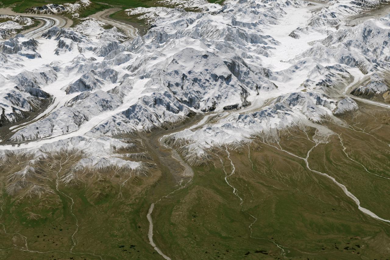
Physically, not too much has changed on Denali, North America’s highest peak. What did change in 2015 is how people describe and measure Alaska’s majestic mountain. On August 30, 2015, U.S. Secretary of the Interior Sally Jewell announced that the mountain’s official name would be Denali, not Mount McKinley. Restoration of the traditional Koyukon Athabascan name of Denali, which means “the tall one,” resolved a request by former Alaska Gov. Jay Hammond that dates back to 1975. But the mountain’s name was not the only change. On September 2, its elevation was also revised. The U.S. Geological Survey announced that Denali’s summit had a new, official elevation of 20,310 feet (6,190 meters)—10 feet shorter than surveyors had determined in the 1950s. The mountain has not shrunk. Instead, technology has improved. The images on this page offer two views of Denali as observed on June 15, 2015, by the Operational Land Imager (OLI) on Landsat 8. The natural-color Landsat 8 images were draped over an ASTER-derived Global Digital Elevation Model, which helps show the topography of the area. Read more: <a href="http://1.usa.gov/1QbmOFP" rel="nofollow">1.usa.gov/1QbmOFP</a> <b><a href="http://www.nasa.gov/audience/formedia/features/MP_Photo_Guidelines.html" rel="nofollow">NASA image use policy.</a></b> <b><a href="http://www.nasa.gov/centers/goddard/home/index.html" rel="nofollow">NASA Goddard Space Flight Center</a></b> enables NASA’s mission through four scientific endeavors: Earth Science, Heliophysics, Solar System Exploration, and Astrophysics. Goddard plays a leading role in NASA’s accomplishments by contributing compelling scientific knowledge to advance the Agency’s mission. <b>Follow us on <a href="http://twitter.com/NASAGoddardPix" rel="nofollow">Twitter</a></b> <b>Like us on <a href="http://www.facebook.com/pages/Greenbelt-MD/NASA-Goddard/395013845897?ref=tsd" rel="nofollow">Facebook</a></b> <b>Find us on <a href="http://instagrid.me/nasagoddard/?vm=grid" rel="nofollow">Instagram</a></b>
Physically, not too much has changed on Denali, North America’s highest peak. What did change in 2015 is how people describe and measure Alaska’s majestic mountain. On August 30, 2015, U.S. Secretary of the Interior Sally Jewell announced that the mountain’s official name would be Denali, not Mount McKinley. Restoration of the traditional Koyukon Athabascan name of Denali, which means “the tall one,” resolved a request by former Alaska Gov. Jay Hammond that dates back to 1975. But the mountain’s name was not the only change. On September 2, its elevation was also revised. The U.S. Geological Survey announced that Denali’s summit had a new, official elevation of 20,310 feet (6,190 meters)—10 feet shorter than surveyors had determined in the 1950s. The mountain has not shrunk. Instead, technology has improved. The images on this page offer two views of Denali as observed on June 15, 2015, by the Operational Land Imager (OLI) on Landsat 8. The natural-color Landsat 8 images were draped over an ASTER-derived Global Digital Elevation Model, which helps show the topography of the area. Read more: <a href="http://1.usa.gov/1QbmOFP" rel="nofollow">1.usa.gov/1QbmOFP</a> <b><a href="http://www.nasa.gov/audience/formedia/features/MP_Photo_Guidelines.html" rel="nofollow">NASA image use policy.</a></b> <b><a href="http://www.nasa.gov/centers/goddard/home/index.html" rel="nofollow">NASA Goddard Space Flight Center</a></b> enables NASA’s mission through four scientific endeavors: Earth Science, Heliophysics, Solar System Exploration, and Astrophysics. Goddard plays a leading role in NASA’s accomplishments by contributing compelling scientific knowledge to advance the Agency’s mission. <b>Follow us on <a href="http://twitter.com/NASAGoddardPix" rel="nofollow">Twitter</a></b> <b>Like us on <a href="http://www.facebook.com/pages/Greenbelt-MD/NASA-Goddard/395013845897?ref=tsd" rel="nofollow">Facebook</a></b> <b>Find us on <a href="http://instagrid.me/nasagoddard/?vm=grid" rel="nofollow">Instagram</a></b>
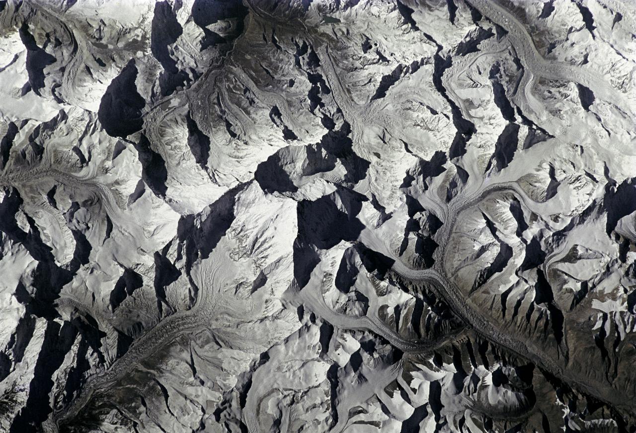
STS066-208-025 (3-14 Nov. 1994) --- Mount Everest, the highest mountain in the world at 8,848 meters, was photographed by the crew members aboard the Space Shuttle Atlantis from 165 nautical miles above Earth. Also seen are Cho Oyu (8,153 meters) northwest of Everest, and other peaks in what has been called the "Roof of the World". Abundant details of glacier surfaces, including moraines, crevasse fields and ice falls are displayed for study. Crew members onboard Atlantis were astronauts Donald R. McMonagle, Curtis L. Brown, Jr., Ellen Ochoa, Scott E. Parazynski and Joseph R. Tanner, along with Jean-François Clervoy of the European Space Agency (ESA). The six astronauts spent 11-days in Earth-orbit in support of the Atmospheric Laboratory for Applications and Science (ATLAS-3) mission.

Dantu Crater on Ceres, at top center, is featured in this image from NASA's Dawn spacecraft. Dantu, whose diameter is 77 miles (124 kilometers), has a central complex of mountain peaks. Small patches of bright material can be seen in some places along the crater walls and floor. A small crater (4-miles, 6-kilometers wide) located around the 5 o'clock position within Dantu is called Centeotl. This crater is named for the Mexican deity of maize and agriculture. Dawn took this image on Oct. 21, 2016, from its second extended-mission science orbit (XMO2), at a distance of about 920 miles (1,480 kilometers) above the surface. The image resolution is about 460 feet (140 meters) per pixel. http://photojournal.jpl.nasa.gov/catalog/PIA21242
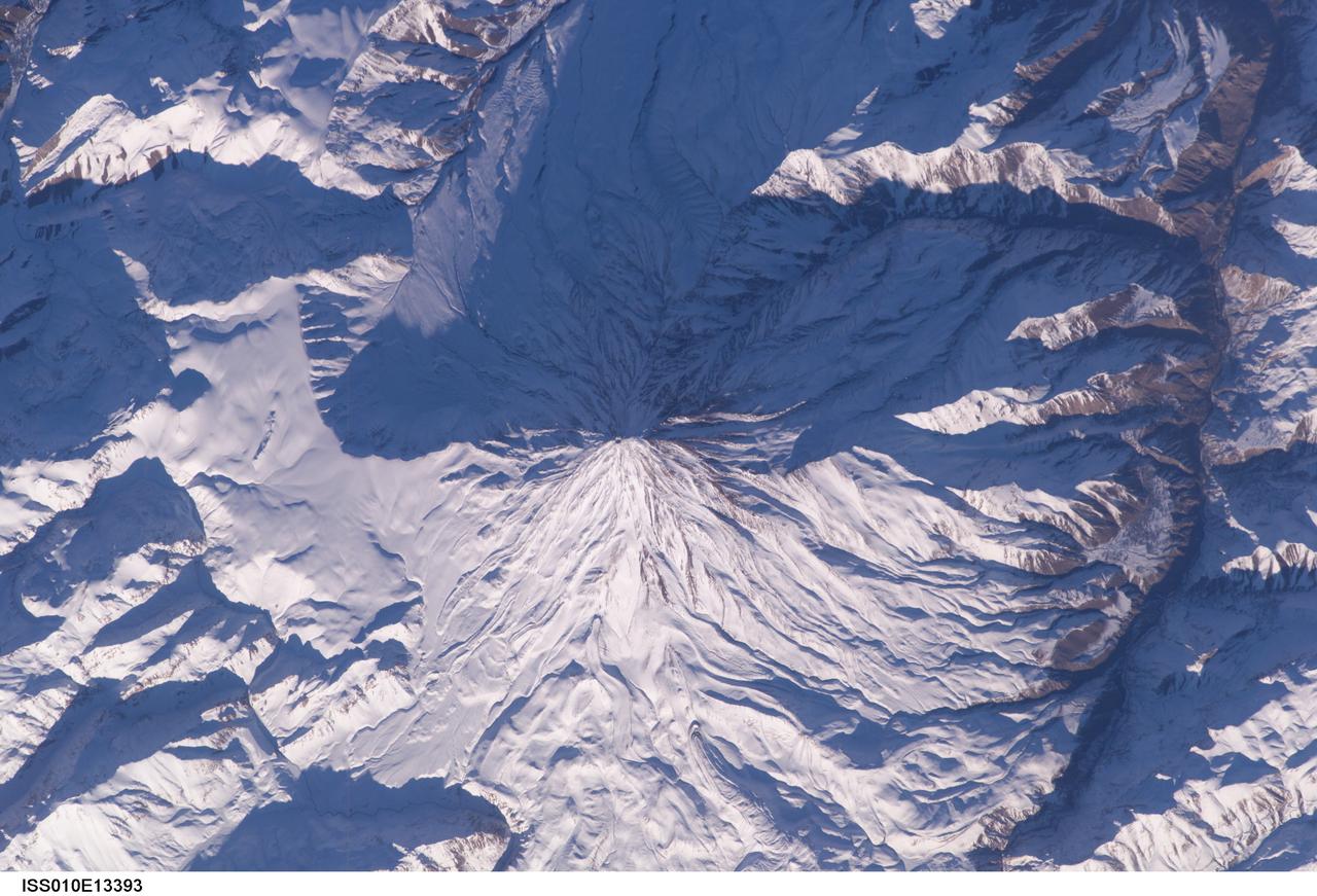
ISS010-E-13393 (15 January 2005) --- Mt. Damavand, Iran is featured in this image photographed by an Expedition 10 crewmember on the International Space Station (ISS). Located approximately 50 kilometers to the northeast of Tehran, Mt. Damavand is an impressive stratovolcano that reaches 5,670 meters (18,598 feet) in elevation. Damavand, which is part of the Alborz mountain range that borders the Caspian Sea to the north, is believed by scientists to be a young volcano that has mostly formed during the Holocene Epoch (over approximately the last 10,000 years). The western flank of the volcano includes solidified lava flows with flow levees – “walls” formed as the side edges of flowing lava cooled rapidly, forming a chute that channeled the hotter interior lava. Two such flows with well-defined levees are highlighted by snow on the mountainside (center). Damavand is the highest peak in Iran and the highest volcano in the Middle East.
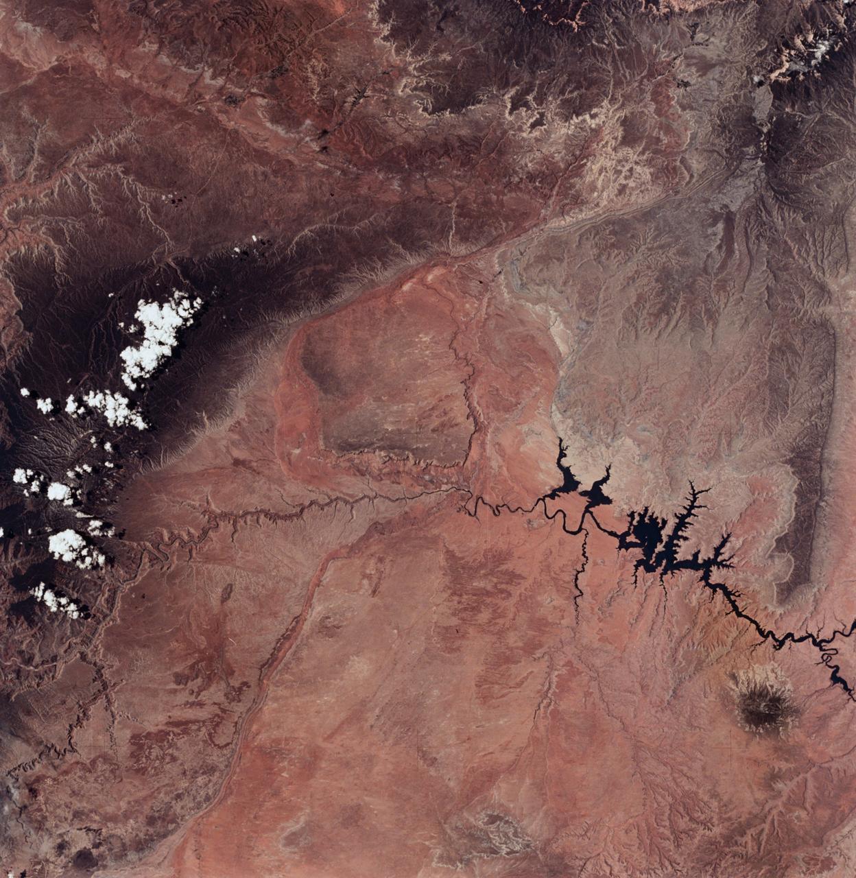
SL2-04-018 (June 1973) --- A vertical view of the Arizona-Utah border area showing the Colorado River and Grand Canyon photographed from the Skylab 1/2 space station in Earth orbit. This picture was taken by one of the six lenses of the Itek-furnished S190-A Multispectral Photographic Facility Experiment in the Multiple Docking Adapter of the space station. Type S0-356 film was used. The row of white clouds extend north-south over the dark colored Kaibab Plateau. The junction of the Colorado and Little Colorado rivers is in the southwest corner of the picture. The body of water is Lake Powell on the Colorado River upstream from the Grand Canyon. The lone peak at the eastern edge of the photograph south of Colorado River is the 10,416-foot Navajo Mountain. The S190-A experiment is part of the Skylab Earth Resources Experiments Package(EREP). Photo credit: NASA
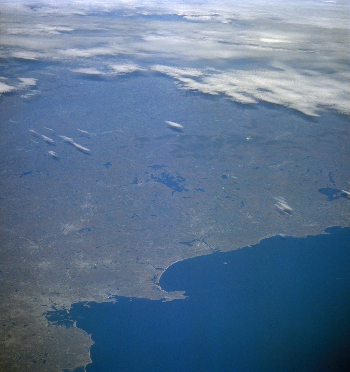
STS058-105-016 (18 Oct-1 Nov 1993) --- This photograph includes much of the heart of New England, stretching from Boston and Boston Harbor (lower left) across New Hampshire and Vermont to Lake Champlain (upper left), and up to southern Maine (Portland is just off the photo at right center). The colors in this photograph are less vivid than those in STS-58-81-038, because the color changes on the deciduous trees in central and northern New England were past their peak when this photograph was taken. North of Boston flows the Merrimack River (which forms part of the state boundary between Massachusetts and New Hampshire). It is delineated by the small industrial towns (Concord, Manchester, Nashua, Lowell) which grew up on its banks. The White Mountains of New Hampshire are seen near the center, and Mt. Washington (6,288 feet) is capped with snow.
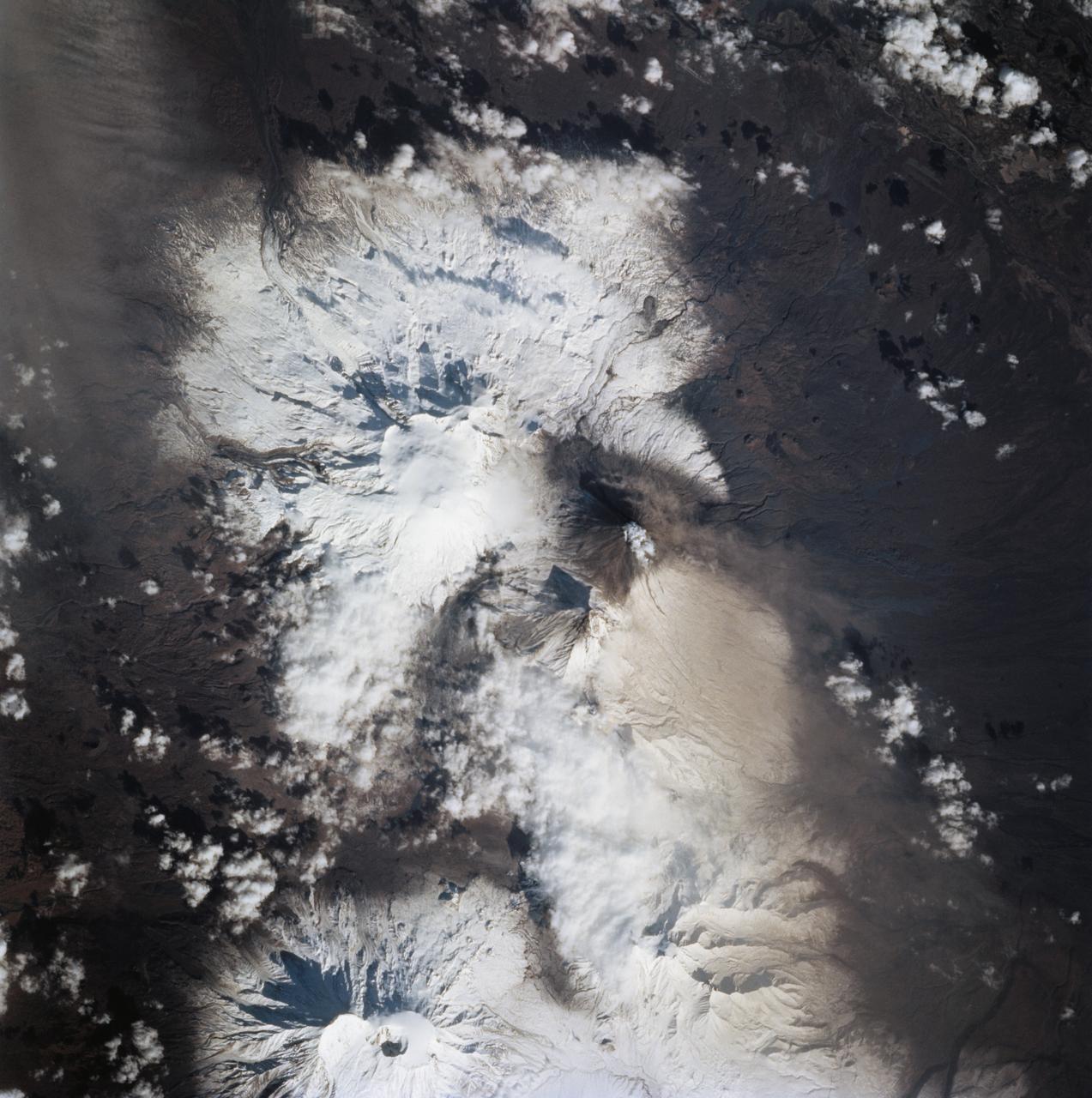
STS068-273-060 (4 October 1994) --- Astronauts aboard the Space Shuttle Endeavour recorded this follow-up 70mm frame of the Kliuchevskoi volcano on the Kamchatka Peninsula in Russia. The volcano was near its peak on launch day, five days earlier, but only a small steam plume was rising from the summit in this Day 5 photo. Tendrils of ash are airborne on the northern flank of the volcano. Scientists feel that the source of these plumes is from a flow down the mountain's northern flank. The entire summit region is covered in ash. As various members of the six-person crew were using handheld cameras to record the various stages of the volcano, hardware in Endeavour's cargo bay was taking radar data of the event in support of the Space Radar Laboratory (SRL-2) mission.
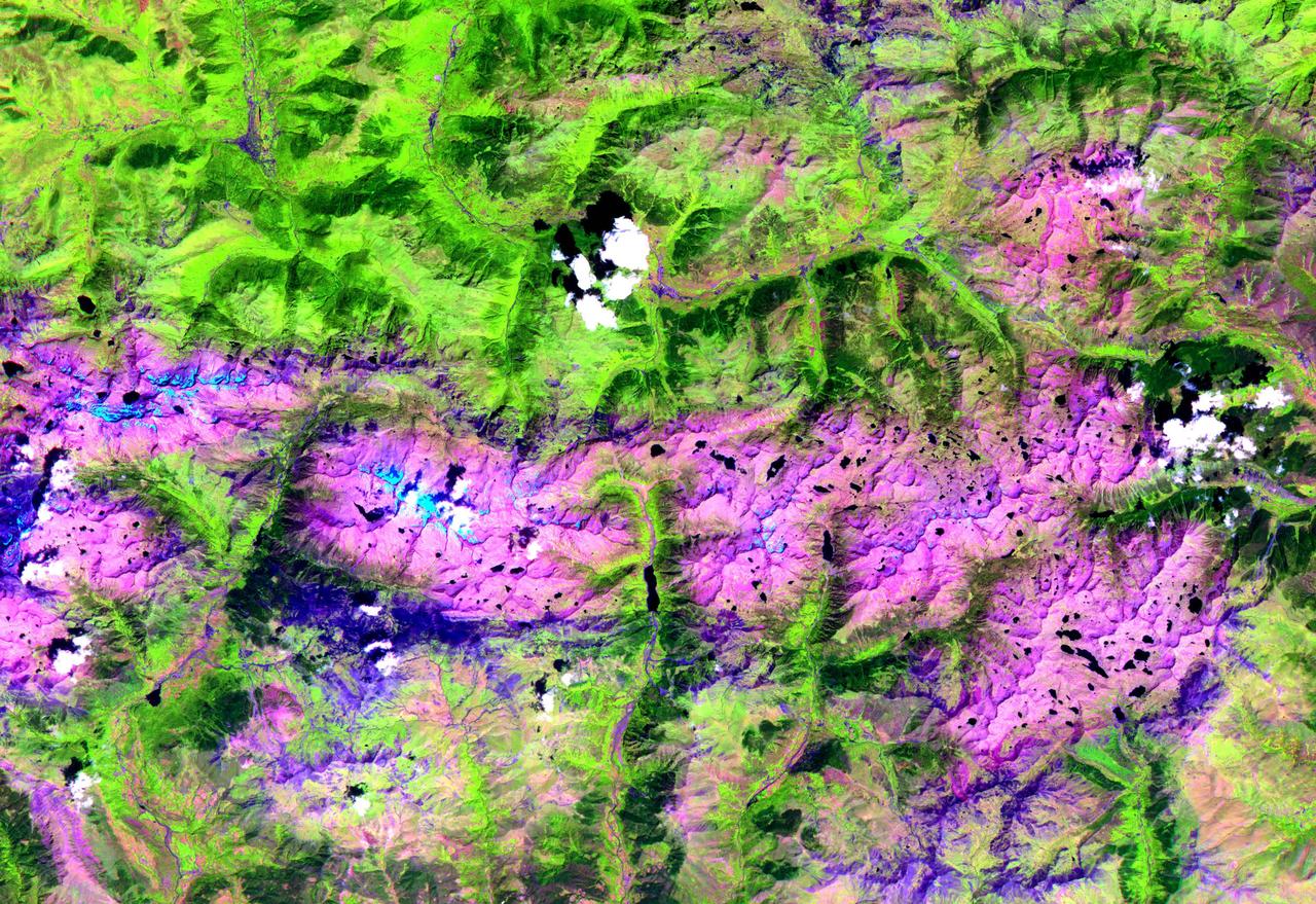
This ASTER image, acquired on August 1, 2000, covers an area of 57 by 29 km and covers part of the central Pyrenees in Spain. The Pyrenees in southwestern Europe extend for about 435 kilometers (about 270 miles) from the Bay of Biscay to the Mediterranean Sea, separating the Iberian Peninsula from the rest of Europe. The Pyrenees form most of the boundary between France and Spain, and encompass the tiny principality of Andorra. Approximately two-thirds of the mountains lie in Spain. The central Pyrenees extend to the Collines du Perche and contain the highest peaks of the system, including Pico de Aneto, the highest at 3,404 meters (11,168 feet). ASTER bands 4, 3 and 2 were displayed in red, green and blue. In this combination, snow is blue, vegetation is green, bare rocks are pink and dark blue, and clouds are white. The image is located at 42.6 degrees north latitude and 0.6 degrees east longitude. http://photojournal.jpl.nasa.gov/catalog/PIA11162
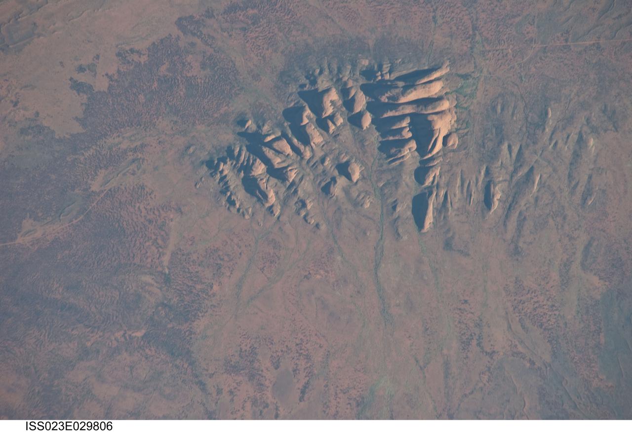
ISS023-E-029806 (30 April 2010) --- Kata Tjuta, Australia is featured in this image photographed by an Expedition 23 crew member on the International Space Station. Located in the Northern Territory of Australia, Uluru – Kata Tjuta National Park hosts some of the world’s most spectacular examples of inselbergs, or isolated mountains. The most famous of these inselbergs is Uluru (also known as Ayers Rock). An equally massive inselberg located approximately 30 kilometers to the northwest is known as Kata Tjuta– like Uluru, this is a sacred site to the native Anangu or Aboriginal people. Explorers named the highest peak Mount Olga, with the entire grouping of rocks informally known as “the Olgas”. Mount Olga has a peak elevation of 1,069 meters above sea level, making it 206 meters higher than Uluru. Kata Tjuta is comprised of gently dipping Mount Currie Conglomerate, a sedimentary rock that includes abundant rounded fragments of other rock types (here, primarily granite with less abundant basalt and rhyolite) in a coarse sandy matrix. Geologists interpret the Mount Currie Conglomerate as a remnant of a large fan of material rapidly eroded from mountains uplifted approximately 550 million years ago. Subsequent burial under younger sediments consolidated the eroded materials to form the conglomerate exposed at the surface today. In this photograph, afternoon sunlight highlights the rounded summits of Kata Tjuta against the surrounding sandy plains. Sand dunes are visible at upper right; while in other areas (image top and image left) sediments washed from the rocks have been anchored by a variety of grasses and bushes adapted to the arid climate. Green vegetation in the ephemeral stream channels that drain Kata Tjuta (bottom center) provides colorful contrast with the red rocks and surrounding soils. Large gaps in the rocks (highlighted by shadows) are thought to be fractures that have been enlarged due to erosion.