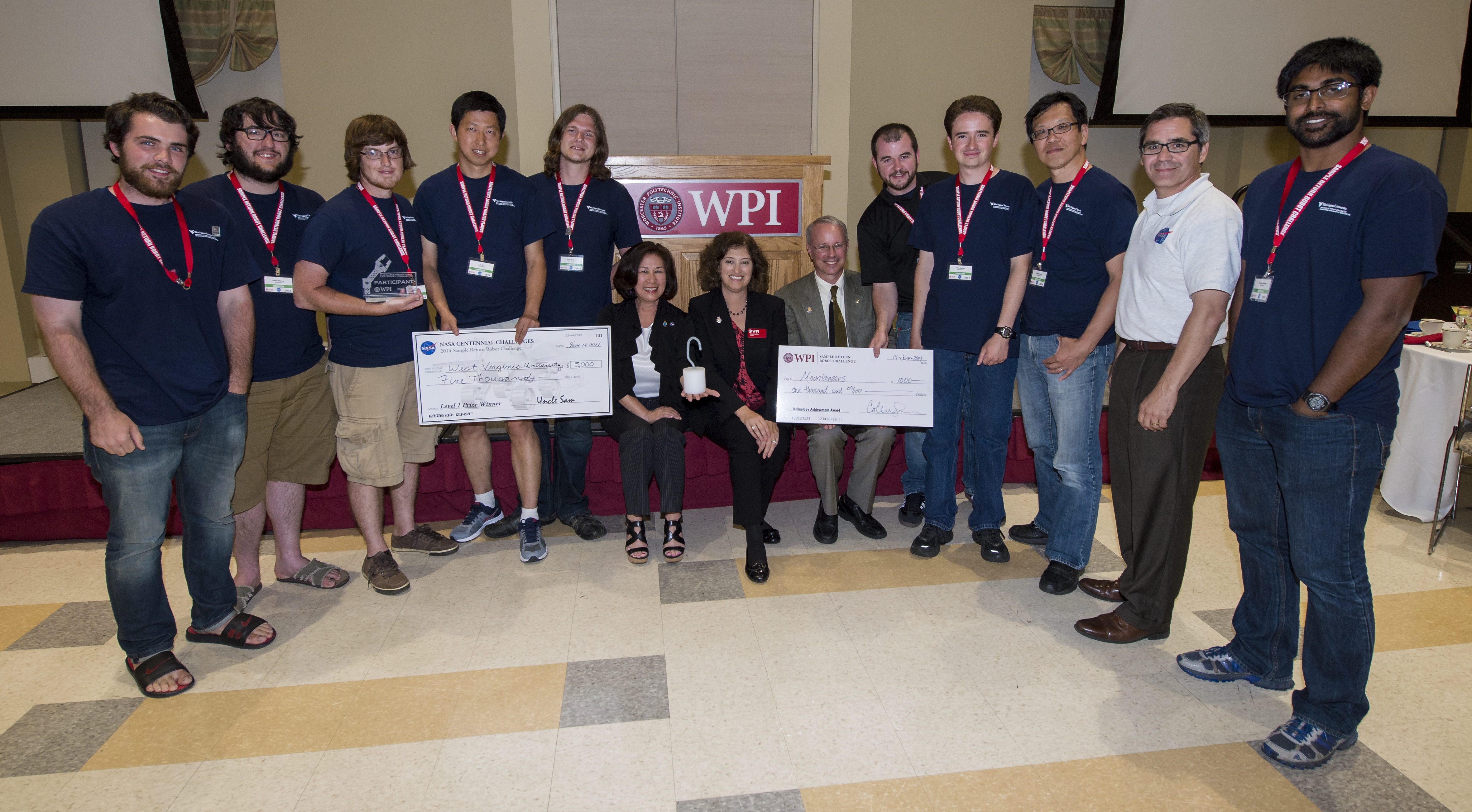
The NASA Centennial Challenges prize, level one, is presented to team Mountaineers for successfully completing level one of the NASA 2014 Sample Return Robot Challenge, from left, Ryan Watson, Team Mountaineers; Lucas Behrens, Team Mountaineers; Jarred Strader, Team Mountaineers; Yu Gu, Team Mountaineers; Scott Harper, Team Mountaineers; Dorothy Rasco, NASA Deputy Associate Administrator for the Space Technology Mission Directorate; Laurie Leshin, Worcester Polytechnic Institute (WPI) President; David Miller, NASA Chief Technologist; Alexander Hypes, Team Mountaineers; Nick Ohi,Team Mountaineers; Marvin Cheng, Team Mountaineers; Sam Ortega, NASA Program Manager for Centennial Challenges; and Tanmay Mandal, Team Mountaineers;, Saturday, June 14, 2014, at Worcester Polytechnic Institute (WPI) in Worcester, Mass. Team Mountaineers was the only team to complete the level one challenge. During the competition, teams were required to demonstrate autonomous robots that can locate and collect samples from a wide and varied terrain, operating without human control. The objective of this NASA-WPI Centennial Challenge was to encourage innovations in autonomous navigation and robotics technologies. Innovations stemming from the challenge may improve NASA's capability to explore a variety of destinations in space, as well as enhance the nation's robotic technology for use in industries and applications on Earth. Photo Credit: (NASA/Joel Kowsky)
The NASA Centennial Challenges prize, level one, is presented to team Mountaineers for successfully completing level one of the NASA 2014 Sample Return Robot Challenge, from left, Ken Stafford, WPI Challenge technical advisor; Colleen Shaver, WPI Challenge Manager; Ryan Watson, Team Mountaineers; Marvin Cheng, Team Mountaineers; Alexander Hypes, Team Mountaineers; Jarred Strader, Team Mountaineers; Lucas Behrens, Team Mountaineers; Yu Gu, Team Mountaineers; Nick Ohi, Team Mountaineers; Dorothy Rasco, NASA Deputy Associate Administrator for the Space Technology Mission Directorate; Scott Harper, Team Mountaineers; Tanmay Mandal, Team Mountaineers; David Miller, NASA Chief Technologist; Sam Ortega, NASA Program Manager for Centennial Challenges, Saturday, June 14, 2014, at Worcester Polytechnic Institute (WPI) in Worcester, Mass. Team Mountaineers was the only team to complete the level one challenge. During the competition, teams were required to demonstrate autonomous robots that can locate and collect samples from a wide and varied terrain, operating without human control. The objective of this NASA-WPI Centennial Challenge was to encourage innovations in autonomous navigation and robotics technologies. Innovations stemming from the challenge may improve NASA's capability to explore a variety of destinations in space, as well as enhance the nation's robotic technology for use in industries and applications on Earth. Photo Credit: (NASA/Joel Kowsky)
Created using data collected by the JunoCam imager aboard NASA's Juno spacecraft, this animation is an artist's concept that shows a view of a mountain on the Jovian moon Io. The data was recorded during close flybys of the moon in December 2023 and February 2024. The mountain, which the Juno science team has nicknamed "Steeple Mountain," is between 3 and 4.3 miles (5 and 7 kilometers) in height. One side of Steeple Mountain is in shade in the animation because only one side of the mountain was illuminated when imaged by JunoCam. Animation available at https://photojournal.jpl.nasa.gov/catalog/PIA26294
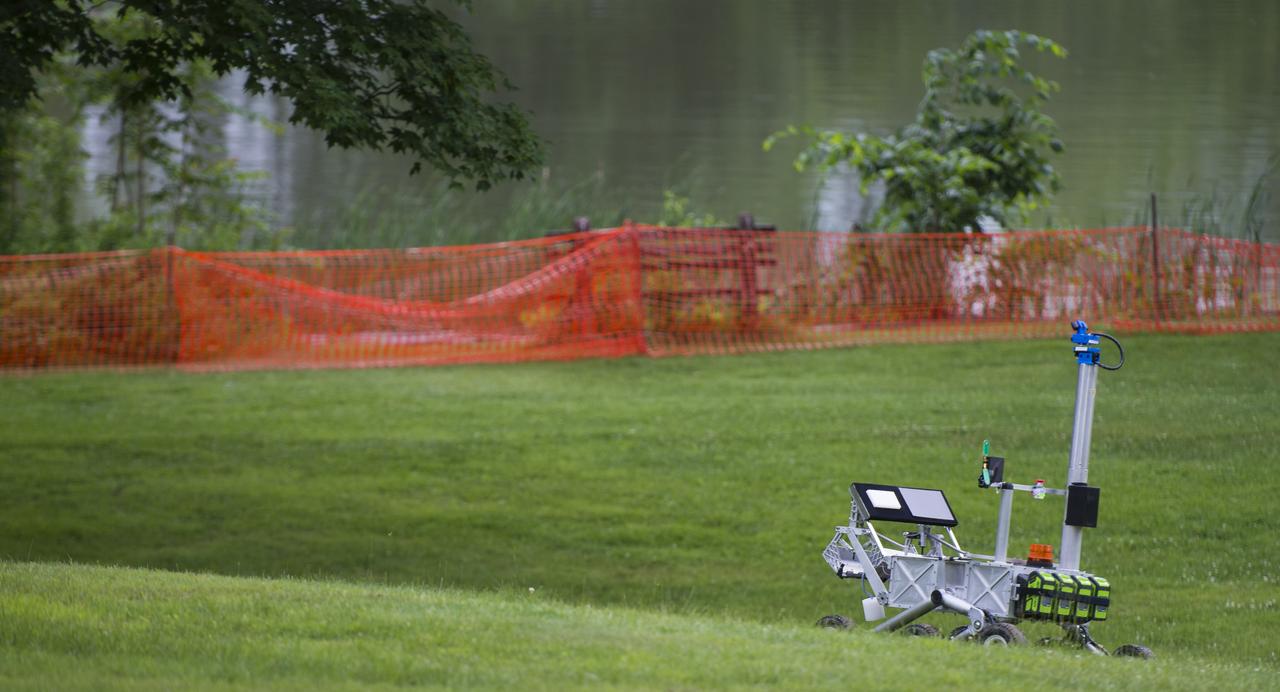
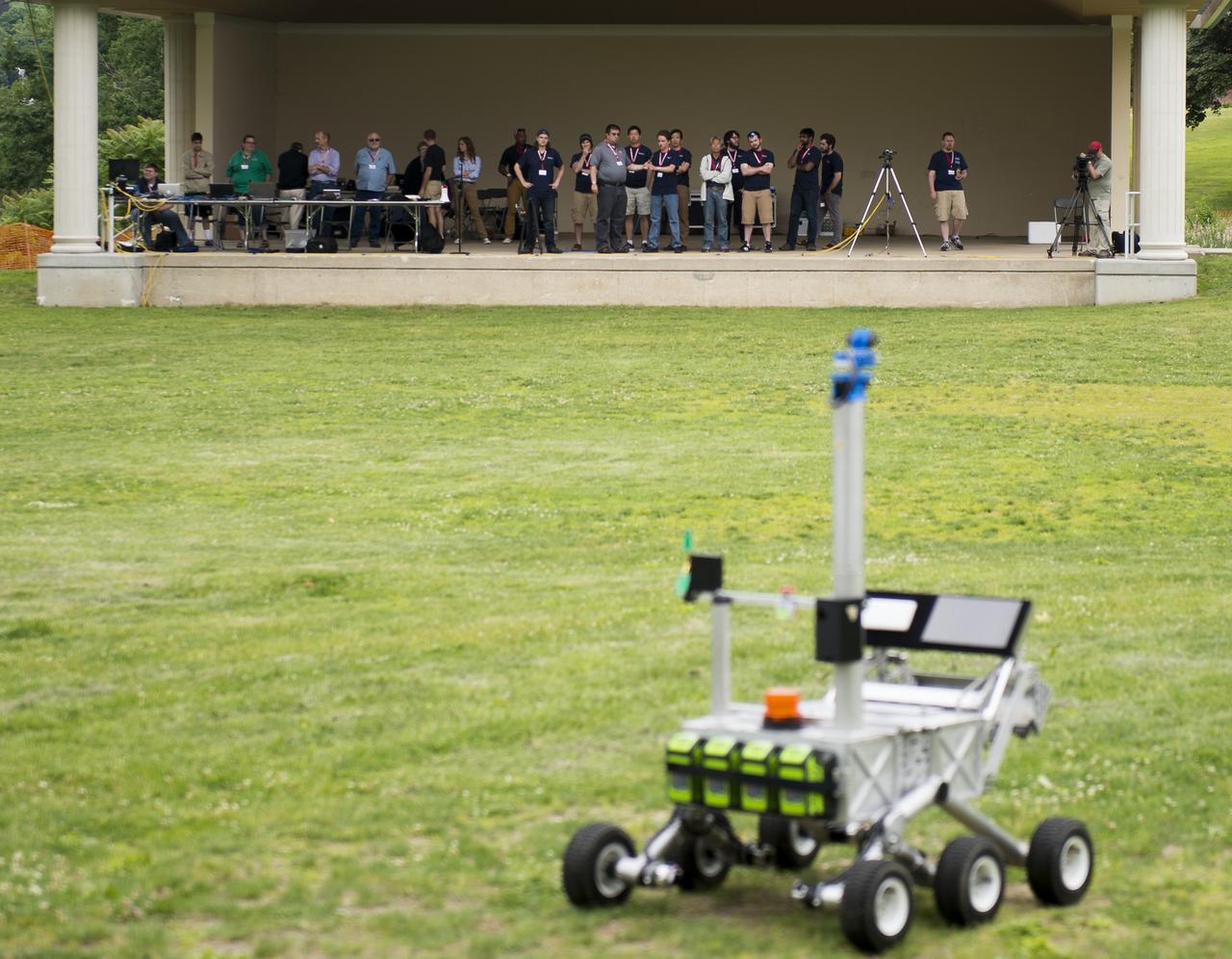
The team Mountaineers robot is seen after picking up the sample during a rerun of the level one challenge at the 2014 NASA Centennial Challenges Sample Return Robot Challenge, Saturday, June 14, 2014, at the Worcester Polytechnic Institute (WPI) in Worcester, Mass. Eighteen teams are competing for a $1.5 million NASA prize purse. Teams will be required to demonstrate autonomous robots that can locate and collect samples from a wide and varied terrain, operating without human control. The objective of this NASA-WPI Centennial Challenge is to encourage innovations in autonomous navigation and robotics technologies. Innovations stemming from the challenge may improve NASA's capability to explore a variety of destinations in space, as well as enhance the nation's robotic technology for use in industries and applications on Earth. Photo Credit: (NASA/Joel Kowsky)

Members of the Mountaineers team from West Virginia University celebrate after their robot returned to the starting platform after picking up the sample during a rerun of the level one challenge during the 2014 NASA Centennial Challenges Sample Return Robot Challenge, Saturday, June 14, 2014, at the Worcester Polytechnic Institute (WPI) in Worcester, Mass. Eighteen teams are competing for a $1.5 million NASA prize purse. Teams will be required to demonstrate autonomous robots that can locate and collect samples from a wide and varied terrain, operating without human control. The objective of this NASA-WPI Centennial Challenge is to encourage innovations in autonomous navigation and robotics technologies. Innovations stemming from the challenge may improve NASA's capability to explore a variety of destinations in space, as well as enhance the nation's robotic technology for use in industries and applications on Earth. Photo Credit: (NASA/Joel Kowsky)
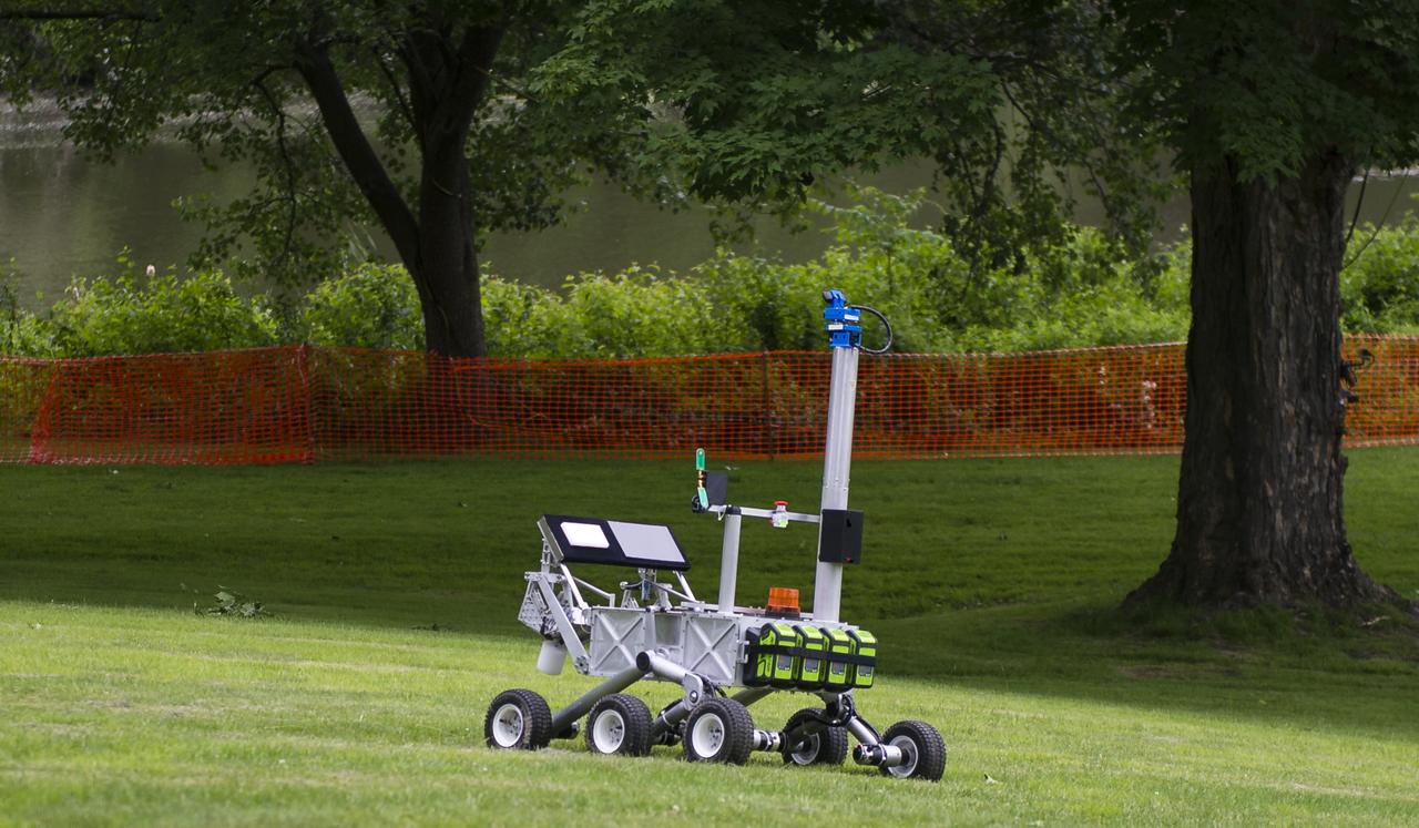
The team Mountaineers robot is seen as it attempts the level one challenge during the 2014 NASA Centennial Challenges Sample Return Robot Challenge, Wednesday, June 11, 2014, at the Worcester Polytechnic Institute (WPI) in Worcester, Mass. Eighteen teams are competing for a $1.5 million NASA prize purse. Teams will be required to demonstrate autonomous robots that can locate and collect samples from a wide and varied terrain, operating without human control. The objective of this NASA-WPI Centennial Challenge is to encourage innovations in autonomous navigation and robotics technologies. Innovations stemming from the challenge may improve NASA's capability to explore a variety of destinations in space, as well as enhance the nation's robotic technology for use in industries and applications on Earth. Photo Credit: (NASA/Joel Kowsky)
The team Mountaineers robot is seen as it attempts the level one challenge during the 2014 NASA Centennial Challenges Sample Return Robot Challenge, Wednesday, June 11, 2014, at the Worcester Polytechnic Institute (WPI) in Worcester, Mass. Eighteen teams are competing for a $1.5 million NASA prize purse. Teams will be required to demonstrate autonomous robots that can locate and collect samples from a wide and varied terrain, operating without human control. The objective of this NASA-WPI Centennial Challenge is to encourage innovations in autonomous navigation and robotics technologies. Innovations stemming from the challenge may improve NASA's capability to explore a variety of destinations in space, as well as enhance the nation's robotic technology for use in industries and applications on Earth. Photo Credit: (NASA/Joel Kowsky)
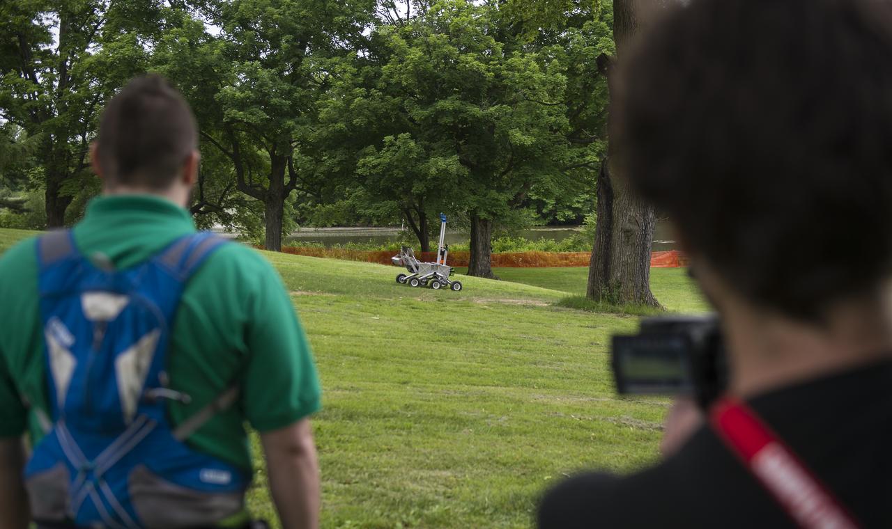
The Mountaineers team from West Virginia University, watches as their robot attempts the level one challenge during the 2014 NASA Centennial Challenges Sample Return Robot Challenge, Wednesday, June 11, 2014, at the Worcester Polytechnic Institute (WPI) in Worcester, Mass. Eighteen teams are competing for a $1.5 million NASA prize purse. Teams will be required to demonstrate autonomous robots that can locate and collect samples from a wide and varied terrain, operating without human control. The objective of this NASA-WPI Centennial Challenge is to encourage innovations in autonomous navigation and robotics technologies. Innovations stemming from the challenge may improve NASA's capability to explore a variety of destinations in space, as well as enhance the nation's robotic technology for use in industries and applications on Earth. Photo Credit: (NASA/Joel Kowsky)
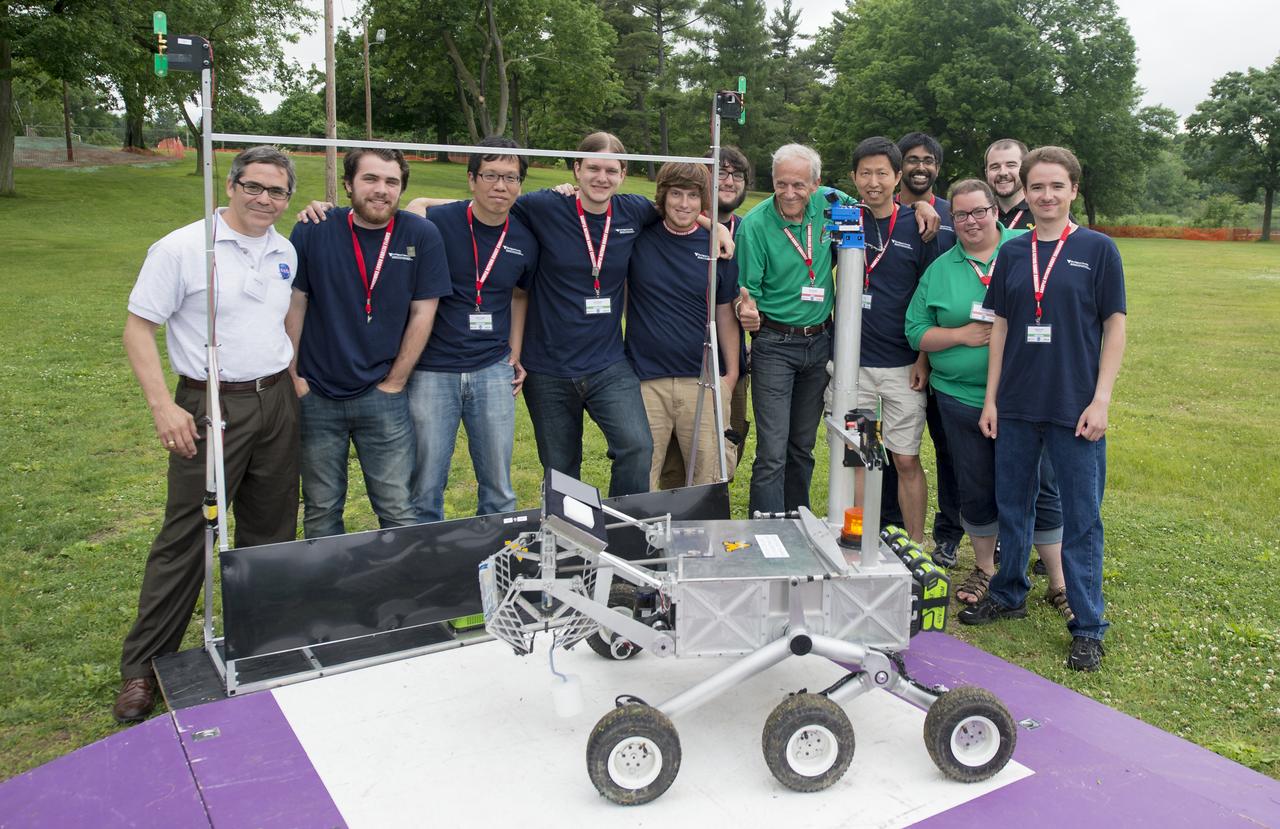
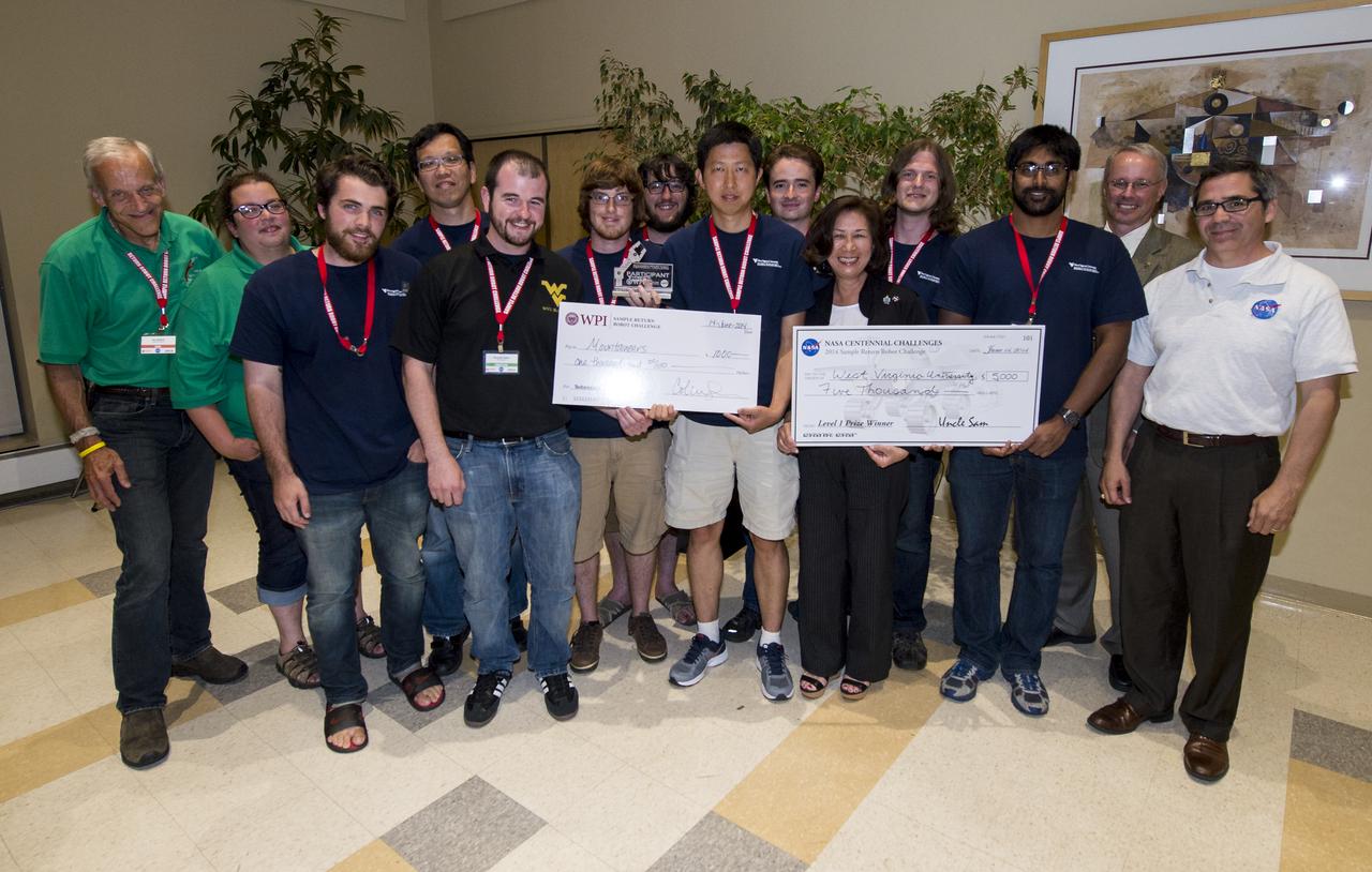
Members of team Mountaineers pose with officials from the 2014 NASA Centennial Challenges Sample Return Robot Challenge on Saturday, June 14, 2014 at Worcester Polytechnic Institute (WPI) in Worcester, Mass. Team Mountaineer was the only team to complete the level one challenge this year. Team Mountaineer members, from left (in blue shirts) are: Ryan Watson, Marvin Cheng, Scott Harper, Jarred Strader, Lucas Behrens, Yu Gu, Tanmay Mandal, Alexander Hypes, and Nick Ohi Challenge judges and competition staff (in white and green polo shirts) from left are: Sam Ortega, NASA Centennial Challenge program manager; Ken Stafford, challenge technical advisor, WPI; Colleen Shaver, challenge event manager, WPI. During the competition, teams were required to demonstrate autonomous robots that can locate and collect samples from a wide and varied terrain, operating without human control. The objective of this NASA-WPI Centennial Challenge was to encourage innovations in autonomous navigation and robotics technologies. Innovations stemming from the challenge may improve NASA's capability to explore a variety of destinations in space, as well as enhance the nation's robotic technology for use in industries and applications on Earth. Photo Credit: (NASA/Joel Kowsky)

Astronaut David Brown talks with FIRST team members, Baxter Bomb Squad, from Mountain Home High School, Mountain Home, Ariz., during the FIRST competition. Students from all over the country are at the KSC Visitor Complex for the FIRST (For Inspiration and Recognition of Science and Technology) Southeast Regional competition March 9-11 in the Rocket Garden. Teams of high school students are testing the limits of their imagination using robots they have designed, with the support of business and engineering professionals and corporate sponsors, to compete in a technological battle against other schools' robots. Of the 30 high school teams competing, 16 are Florida teams co-sponsored by NASA and KSC contractors. Local high schools participating are Astronaut, Bayside, Cocoa Beach, Eau Gallie, Melbourne, Melbourne Central Catholic, Palm Bay, Rockledge, Satellite, and Titusville
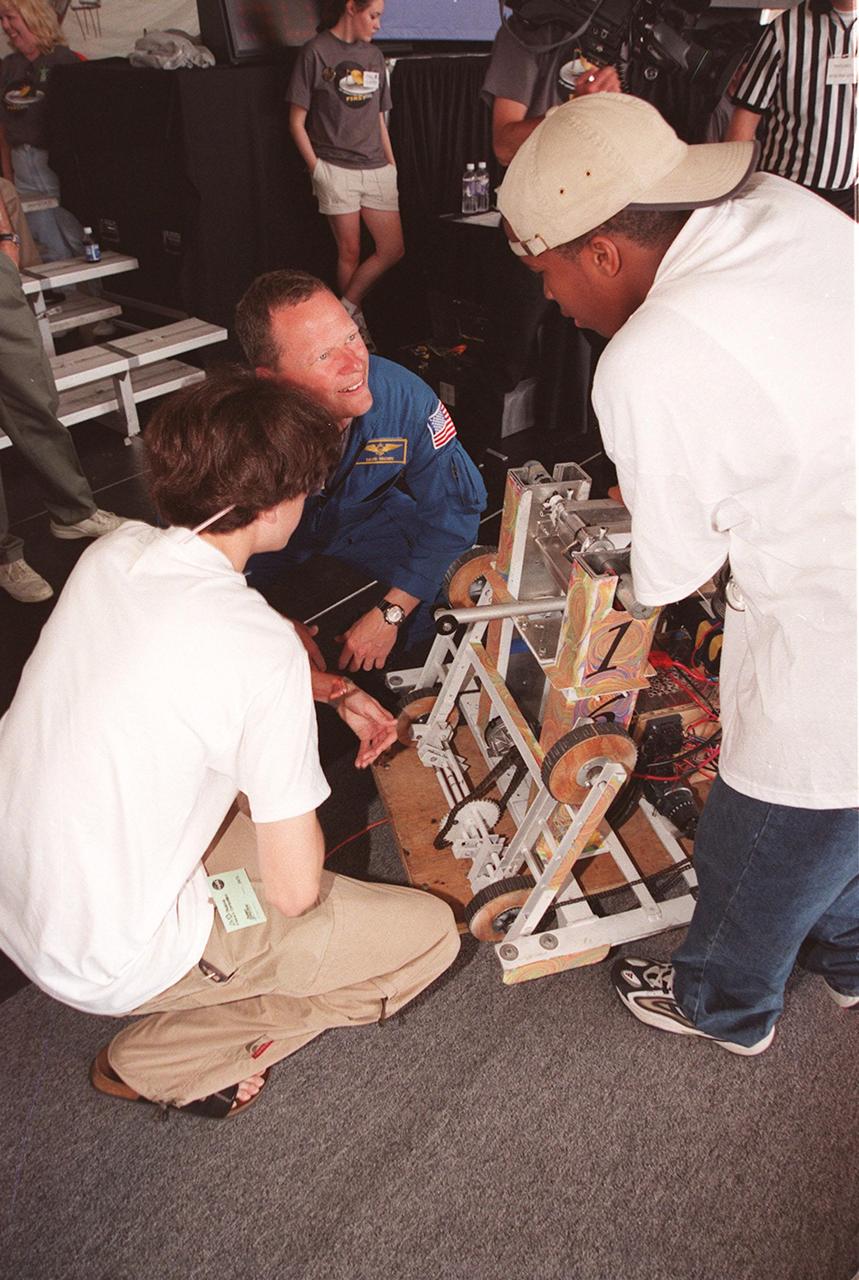
Astronaut David Brown talks with FIRST team members, Baxter Bomb Squad, from Mountain Home High School, Mountain Home, Ariz., during the FIRST competition. Students from all over the country are at the KSC Visitor Complex for the FIRST (For Inspiration and Recognition of Science and Technology) Southeast Regional competition March 9-11 in the Rocket Garden. Teams of high school students are testing the limits of their imagination using robots they have designed, with the support of business and engineering professionals and corporate sponsors, to compete in a technological battle against other schools' robots. Of the 30 high school teams competing, 16 are Florida teams co-sponsored by NASA and KSC contractors. Local high schools participating are Astronaut, Bayside, Cocoa Beach, Eau Gallie, Melbourne, Melbourne Central Catholic, Palm Bay, Rockledge, Satellite, and Titusville

For Inspiration and Recognition of Science and Technology; FIRST Robotics Competition 2010 Silicon Valley Regional held at San Jose State University, San Jose, California (NASA Ames/Mike Dininny sponsored) Cheesy Poofs, Bellarmine College Preparatory, CA Robot name Gizmo Team 254, Spartan Robotics Mountain View H.S. Team 971 and MSET, Saratoga H.S. Team 649. Three teams placed first in the Silicon Valley regional.
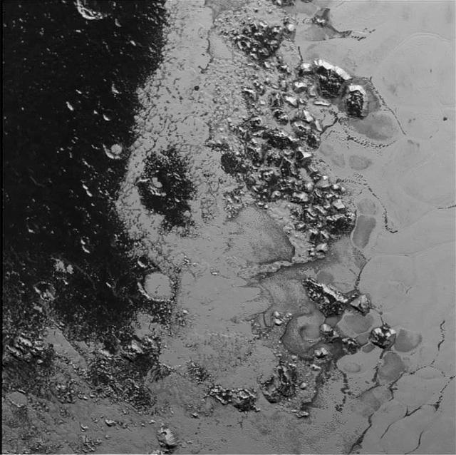
A newly discovered mountain range lies near the southwestern margin of Pluto heart-shaped Tombaugh Regio Tombaugh Region, situated between bright, icy plains and dark, heavily-cratered terrain. This image was acquired by NASA's New Horizons' Long Range Reconnaissance Imager (LORRI) on July 14, 2015, from a distance of 48,000 miles (77,000 kilometers) and sent back to Earth on July 20. Features as small as a half-mile (1 kilometer) across are visible. These frozen peaks are estimated to be one-half mile to one mile (1-1.5 kilometers) high, about the same height as the United States' Appalachian Mountains. The Norgay Montes (Norgay Mountains) discovered by New Horizons on July 15 more closely approximate the height of the taller Rocky Mountains The names of features on Pluto have all been given on an informal basis by the New Horizons team. http://photojournal.jpl.nasa.gov/catalog/PIA19842
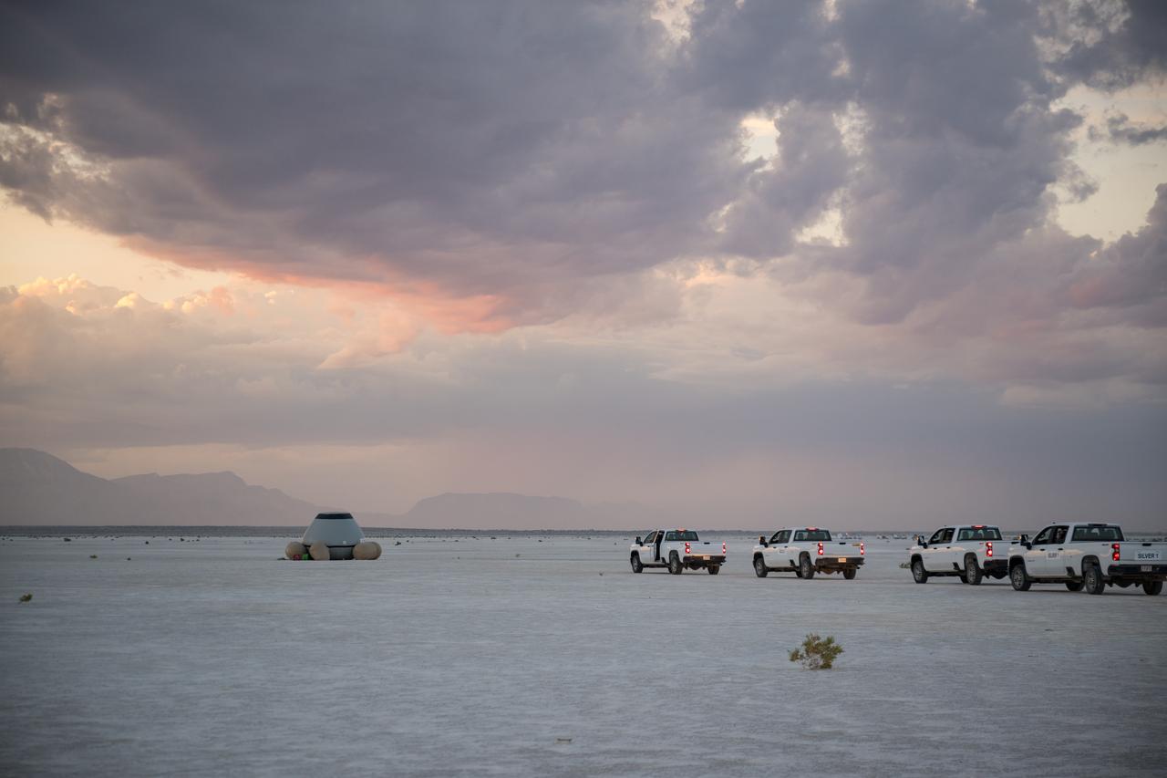
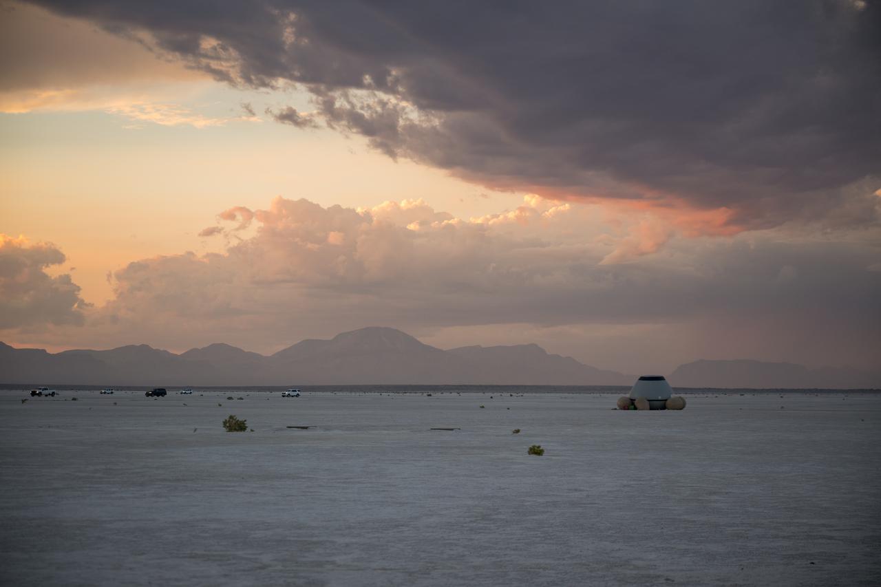
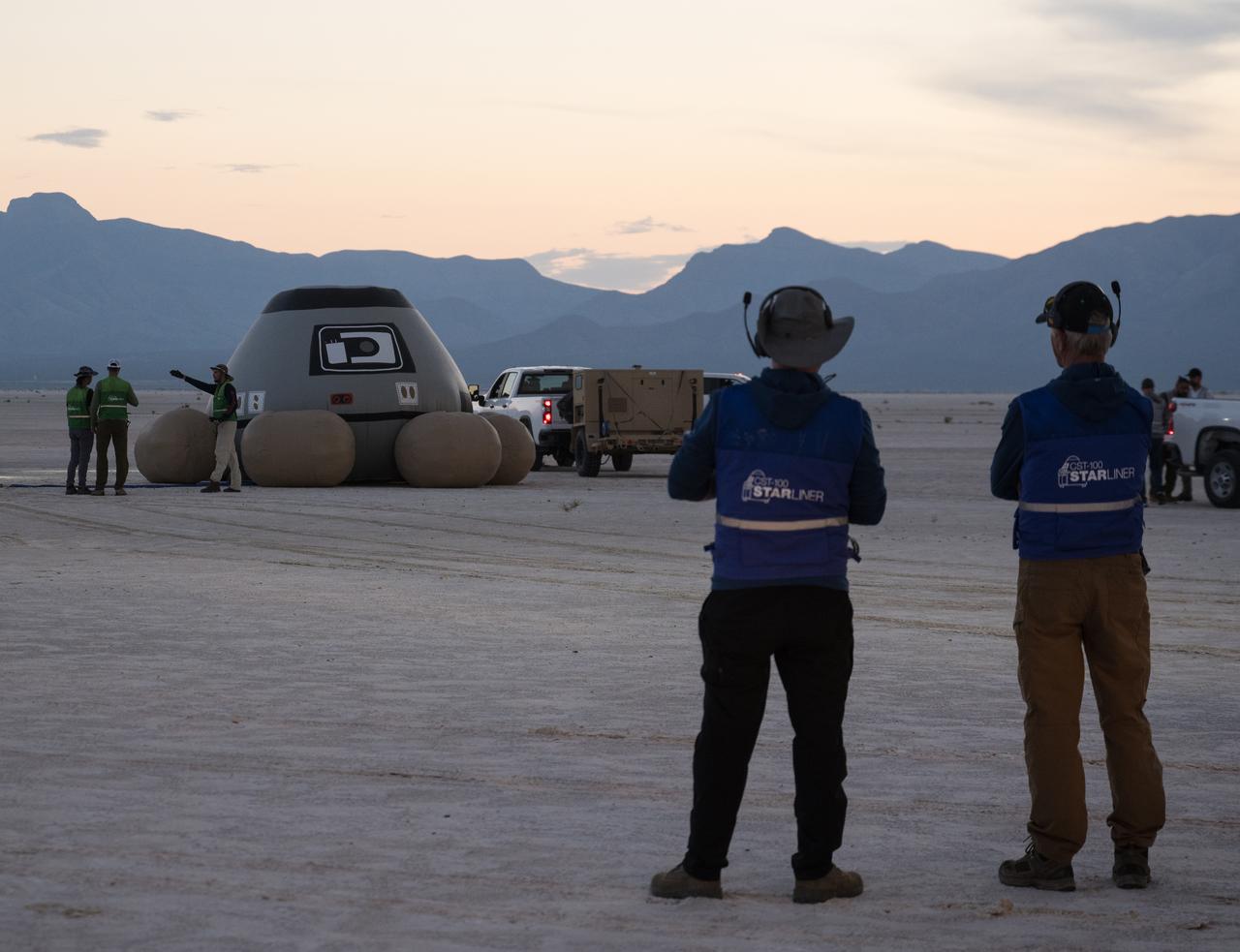
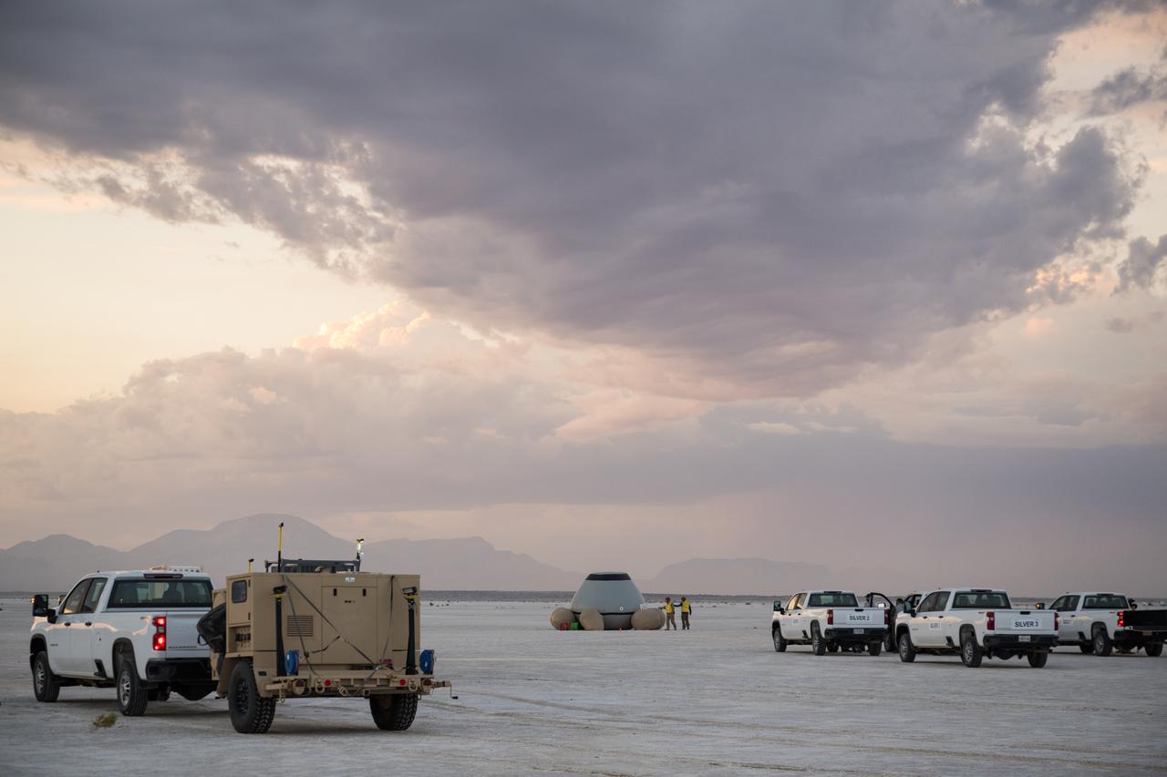
Boeing and NASA teams meet before NASA's Boeing Crew Flight Test Starliner spacecraft lands uncrewed, Friday, Sept. 6, 2024 Mountain Time at White Sands, New Mexico. This approach allows NASA and Boeing to continue gathering testing data on the spacecraft. Photo Credit: (NASA/Aubrey Gemignani)
Boeing and NASA teams are seen before NASA's Boeing Crew Flight Test Starliner spacecraft lands uncrewed, Friday, Sept. 6, 2024 Mountain Time at White Sands, New Mexico. This approach allows NASA and Boeing to continue gathering testing data on the spacecraft. Photo Credit: (NASA/Aubrey Gemignani)

Boeing and NASA recovery teams wait for hazmat teams to confirm it is safe to work around NASA's Boeing Crew Flight Test Starliner spacecraft after it landed uncrewed at White Sands Missile Range’s Space Harbor, Friday, Sept. 6, 2024 Mountain Time (Sept. 7 Eastern Time), in New Mexico. This approach allows NASA and Boeing to continue gathering testing data on the spacecraft. Photo Credit: (NASA/Aubrey Gemignani)

Pipistrel-USA Team Lead Jack Langelaan talks after his team won the 2011 Green Flight Challenge, sponsored by Google, on Monday, Oct. 3, 2011 at the NASA Ames Research Center, Mountain View, Calif. The all electric Taurus G4 aircraft achieved the equivalency of more than 400 miles per gallon. NASA and CAFE Foundation held the challenge to advance technologies in fuel efficiency and reduced emissions with cleaner renewable fuels and electric aircraft. Photo Credit: (NASA/Bill Ingalls)
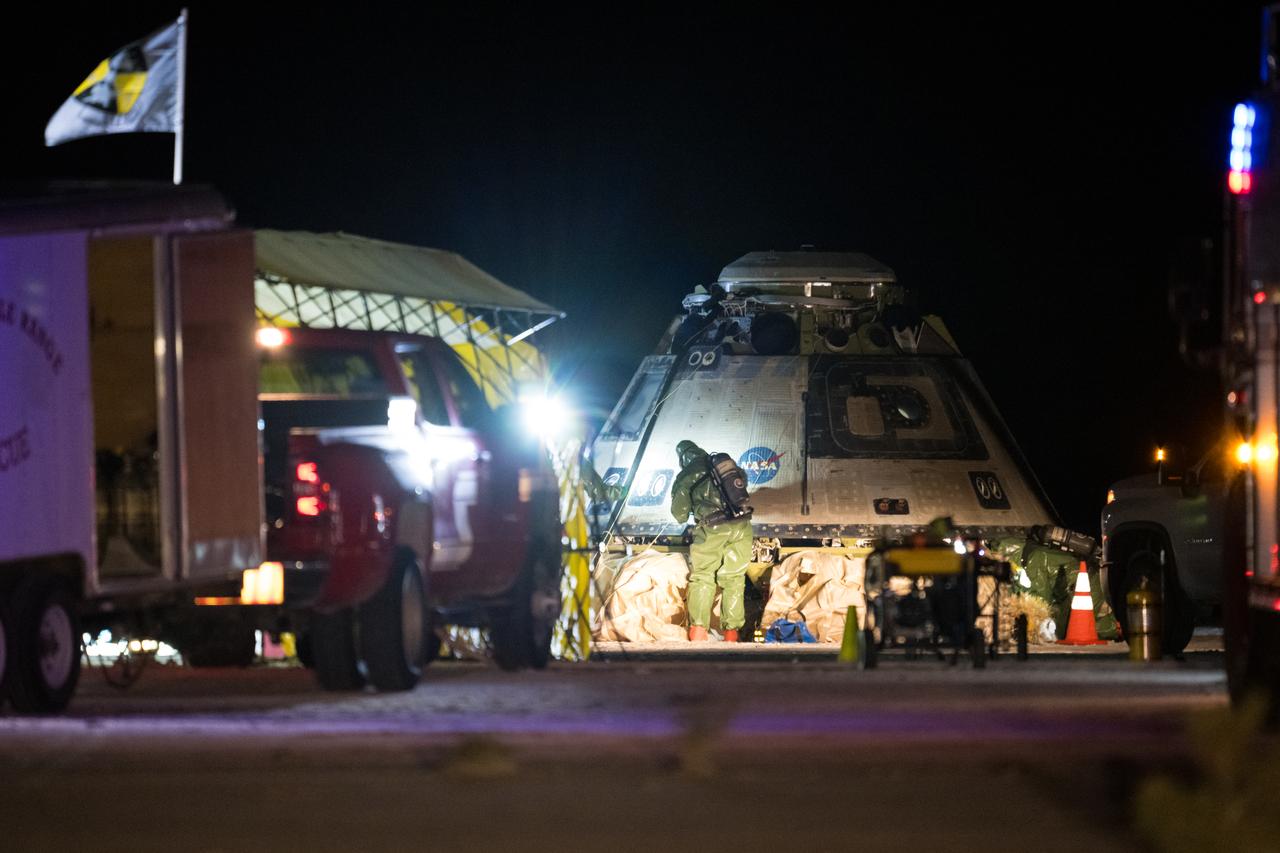
Boeing and NASA recovery teams wait for hazmat teams to confirm it is safe to work around NASA's Boeing Crew Flight Test Starliner spacecraft after it landed uncrewed at White Sands Missile Range’s Space Harbor, Friday, Sept. 6, 2024 Mountain Time (Sept. 7 Eastern Time), in New Mexico. This approach allows NASA and Boeing to continue gathering testing data on the spacecraft. Photo Credit: (NASA/Aubrey Gemignani)
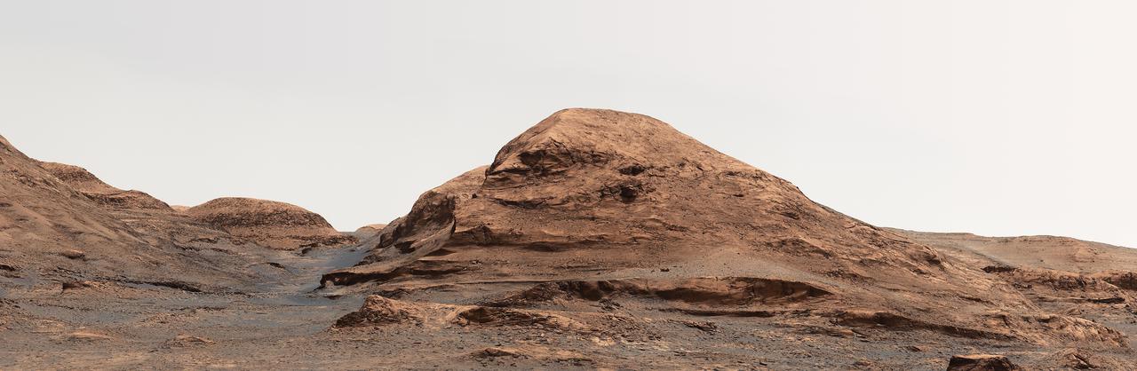
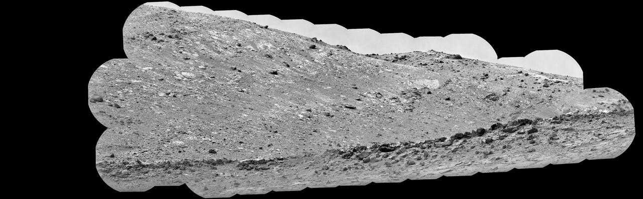
NASA's Curiosity Mars rover captured this view looking back down at the floor of Gale Crater from its location on Mount Sharp on Feb. 7, 2025, the 4,447th Martian day, or sol, of the mission. Curiosity was continuing its climb through a region of the mountain called the sulfate-bearing unit. Mount Sharp is a 3-mile-tall (5-kilometer-tall) mountain made up of a number of layers, all of which formed in different eras of Martian history. By studying each layer, the rover's team can learn more about how the Martian environment changed over time from a warmer, wetter, and more Earthlike world to the freezing desert it is today. The mountain is inside of Gale Crater, formed by an ancient asteroid impact. What appears to be a mountain range in the distance of this scene is in fact the crater's rim. The color in these images has been adjusted to match the lighting conditions as the human eye would see them on Earth. https://photojournal.jpl.nasa.gov/catalog/PIA26551
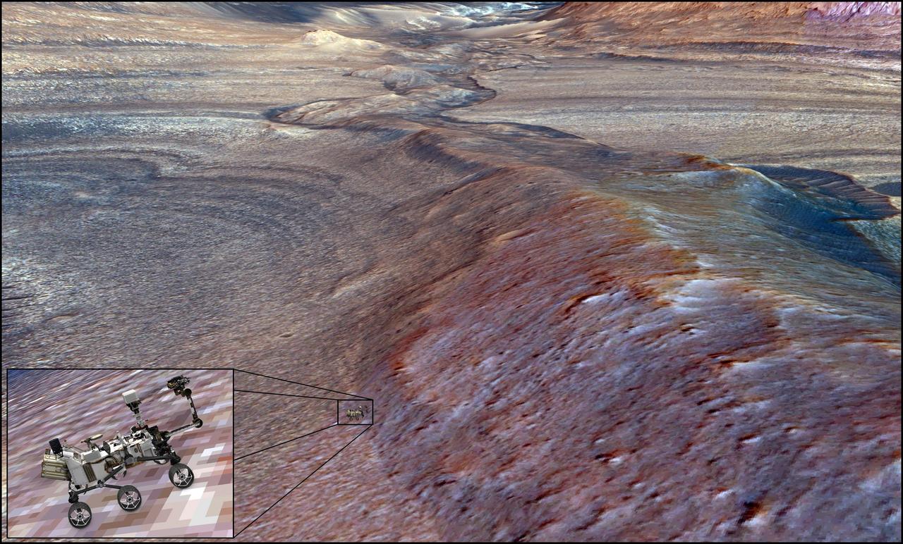
NASA's Curiosity Mars rover can be seen in this 3D rendering of Gediz Vallis Ridge, a formation the mission's science team has long sought to explore. It took the mission four attempts over three years to finally reach the ridge in mid-August 2023. This rendering was created using science data and imagery captured from space by NASA's Mars Reconnaissance Orbiter. Curiosity team member Alex Bryk made the rendering using the same software the team uses to chart Curiosity's route up Mount Sharp, which the rover has been ascending since 2014. Where Curiosity appears in this image, the ridge is estimated to be nearly 70 feet (21 meters) tall. After spending Aug. 14-25 at the ridge, Curiosity departed to drive farther up the mountain; the rover's team will be searching for a path to the left side of the channel that's seen at the top of this image. https://photojournal.jpl.nasa.gov/catalog/PIA26020
Boeing and NASA teams participate in a mission dress rehearsal to prepare for the landing of NASA’s Boeing Crew Flight Test Starliner spacecraft, Thursday, Sept. 5, 2024, at White Sands, New Mexico. The uncrewed spacecraft is scheduled to land at White Sands Missile Range’s Space Harbor, Friday, Sept. 6, 2024 Mountain Time. This approach allows NASA and Boeing to continue gathering testing data. Photo Credit: (NASA/Aubrey Gemignani)
Boeing and NASA teams participate in a mission dress rehearsal to prepare for the landing of NASA’s Boeing Crew Flight Test Starliner spacecraft, Thursday, Sept. 5, 2024, at White Sands, New Mexico. The uncrewed spacecraft is scheduled to land at White Sands Missile Range’s Space Harbor, Friday, Sept. 6, 2024 Mountain Time. This approach allows NASA and Boeing to continue gathering testing data. Photo Credit: (NASA/Aubrey Gemignani)

Boeing and NASA teams work around NASA's Boeing Crew Flight Test Starliner spacecraft after it landed uncrewed, Friday, Sept. 6, 2024 Mountain Time (Sept. 7 Eastern Time), at White Sands, New Mexico. This approach allows NASA and Boeing to continue gathering testing data on the spacecraft. Photo Credit: (NASA/Aubrey Gemignani)

Boeing and NASA teams work around NASA's Boeing Crew Flight Test Starliner spacecraft after it landed uncrewed, Friday, Sept. 6, 2024 Mountain Time (Sept. 7 Eastern Time), at White Sands, New Mexico. This approach allows NASA and Boeing to continue gathering testing data on the spacecraft. Photo Credit: (NASA/Aubrey Gemignani)

NASA Astronauts Scott Tingle, left, and Mike Fincke, speak with Boeing and NASA landing teams before the landing of NASA’s Boeing Crew Flight Test Starliner spacecraft, Friday, Sept. 6, 2024, in Las Cruces, New Mexico. The uncrewed spacecraft is scheduled to land at White Sands Missile Range’s Space Harbor later today, Mountain Time (Sept. 7 Eastern Time). This approach allows NASA and Boeing to continue gathering testing data. Photo Credit: (NASA/Aubrey Gemignani)
NASA's Curiosity Mars rover used its Mastcam to take an image of this hill, nicknamed "Rafael Navarro Mountain" after Rafael Navarro-González, an astrobiologist who worked on the mission until he passed away January 26, 2021. He was a member of the team working with Curiosity's Sample Analysis at Mars, or SAM, instrument. https://photojournal.jpl.nasa.gov/catalog/PIA24544

Boeing and NASA teams work around NASA's Boeing Crew Flight Test Starliner spacecraft after it landed uncrewed, Friday, Sept. 6, 2024 Mountain Time (Sept. 7 Eastern Time), at White Sands, New Mexico. This approach allows NASA and Boeing to continue gathering testing data on the spacecraft. Photo Credit: (NASA/Aubrey Gemignani)

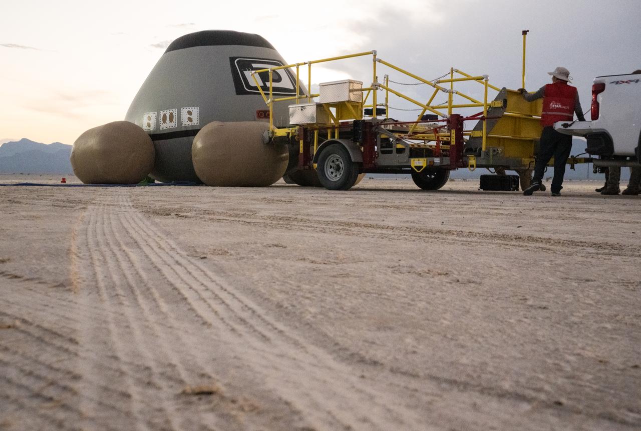
Boeing and NASA teams unload cargo from NASA's Boeing Crew Flight Test Starliner spacecraft after it landed uncrewed at White Sands Missile Range’s Space Harbor, Friday, Sept. 6, 2024 Mountain Time (Sept. 7 Eastern Time), in New Mexico. This approach allows NASA and Boeing to continue gathering testing data on the spacecraft. Photo Credit: (NASA/Aubrey Gemignani)
Boeing and NASA teams participate in a mission dress rehearsal to prepare for the landing of NASA’s Boeing Crew Flight Test Starliner spacecraft, Thursday, Sept. 5, 2024, at White Sands, New Mexico. The uncrewed spacecraft is scheduled to land at White Sands Missile Range’s Space Harbor, Friday, Sept. 6, 2024 Mountain Time. This approach allows NASA and Boeing to continue gathering testing data. Photo Credit: (NASA/Aubrey Gemignani)

Boeing and NASA teams unload cargo from NASA's Boeing Crew Flight Test Starliner spacecraft after it landed uncrewed at White Sands Missile Range’s Space Harbor, Friday, Sept. 6, 2024 Mountain Time (Sept. 7 Eastern Time), in New Mexico. This approach allows NASA and Boeing to continue gathering testing data on the spacecraft. Photo Credit: (NASA/Aubrey Gemignani)

Team Lead Jack Langelaan poses for a photograph next to the Pipistrel-USA, Taurus G4, aircraft prior to winning the 2011 Green Flight Challenge, sponsored by Google, on Monday, Oct. 3, 2011 at the NASA Ames Research Center, Mountain View, Calif. The all electric Taurus G4 aircraft achieved the equivalency of more than 400 miles per gallon. NASA and CAFE held the challenge to advance technologies in fuel efficiency and reduced emissions with cleaner renewable fuels and electric aircraft. Photo Credit: (NASA/Bill Ingalls)
Boeing and NASA teams participate in a mission dress rehearsal to prepare for the landing of NASA’s Boeing Crew Flight Test Starliner spacecraft, Thursday, Sept. 5, 2024, at White Sands, New Mexico. The uncrewed spacecraft is scheduled to land at White Sands Missile Range’s Space Harbor, Friday, Sept. 6, 2024 Mountain Time. This approach allows NASA and Boeing to continue gathering testing data. Photo Credit: (NASA/Aubrey Gemignani)

Boeing and NASA teams work around NASA's Boeing Crew Flight Test Starliner spacecraft after it landed uncrewed, Friday, Sept. 6, 2024 Mountain Time (Sept. 7 Eastern Time), at White Sands, New Mexico. This approach allows NASA and Boeing to continue gathering testing data on the spacecraft. Photo Credit: (NASA/Aubrey Gemignani)

Boeing and NASA teams work around NASA's Boeing Crew Flight Test Starliner spacecraft after it landed uncrewed, Friday, Sept. 6, 2024 Mountain Time (Sept. 7 Eastern Time), at White Sands, New Mexico. This approach allows NASA and Boeing to continue gathering testing data on the spacecraft. Photo Credit: (NASA/Aubrey Gemignani)

Boeing and NASA teams work around NASA's Boeing Crew Flight Test Starliner spacecraft after it landed uncrewed, Friday, Sept. 6, 2024 Mountain Time (Sept. 7 Eastern Time), at White Sands, New Mexico. This approach allows NASA and Boeing to continue gathering testing data on the spacecraft. Photo Credit: (NASA/Aubrey Gemignani)
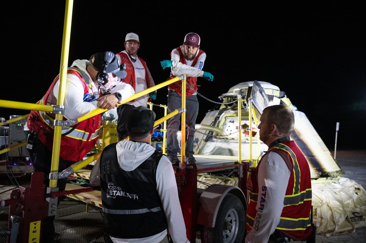
Boeing and NASA teams work around NASA's Boeing Crew Flight Test Starliner spacecraft after it landed uncrewed, Friday, Sept. 6, 2024 Mountain Time (Sept. 7 Eastern Time), at White Sands, New Mexico. This approach allows NASA and Boeing to continue gathering testing data on the spacecraft. Photo Credit: (NASA/Aubrey Gemignani)
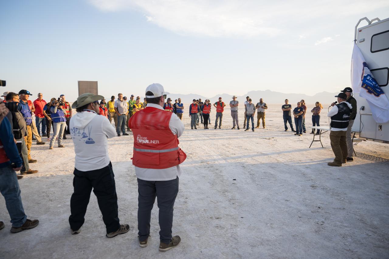
Boeing and NASA teams participate in a mission dress rehearsal to prepare for the landing of NASA’s Boeing Crew Flight Test Starliner spacecraft, Thursday, Sept. 5, 2024, at White Sands, New Mexico. The uncrewed spacecraft is scheduled to land at White Sands Missile Range’s Space Harbor, Friday, Sept. 6, 2024 Mountain Time. This approach allows NASA and Boeing to continue gathering testing data. Photo Credit: (NASA/Aubrey Gemignani)

NASA Astronauts Scott Tingle, left, and Mike Fincke, speak with Boeing and NASA landing teams before the landing of NASA’s Boeing Crew Flight Test Starliner spacecraft, Friday, Sept. 6, 2024, in Las Cruces, New Mexico. The uncrewed spacecraft is scheduled to land at White Sands Missile Range’s Space Harbor later today, Mountain Time (Sept. 7 Eastern Time). This approach allows NASA and Boeing to continue gathering testing data. Photo Credit: (NASA/Aubrey Gemignani)

Boeing and NASA teams work around NASA's Boeing Crew Flight Test Starliner spacecraft after it landed uncrewed, Friday, Sept. 6, 2024 Mountain Time (Sept. 7 Eastern Time), at White Sands, New Mexico. This approach allows NASA and Boeing to continue gathering testing data on the spacecraft. Photo Credit: (NASA/Aubrey Gemignani)
Boeing and NASA teams participate in a mission dress rehearsal to prepare for the landing of NASA’s Boeing Crew Flight Test Starliner spacecraft, Thursday, Sept. 5, 2024, at White Sands, New Mexico. The uncrewed spacecraft is scheduled to land at White Sands Missile Range’s Space Harbor, Friday, Sept. 6, 2024 Mountain Time. This approach allows NASA and Boeing to continue gathering testing data. Photo Credit: (NASA/Aubrey Gemignani)

Grinding glaciers and granite peaks mingle in Chile’s Torres del Paine National Park. The Advanced Land Imager (ALI) on NASA’s Earth Observing-1 (EO-1) satellite captured this summertime image of the park on January 21, 2013. This image shows just a portion of the park, including Grey Glacier and the mountain range of Cordillera del Paine. The rivers of glacial ice in Torres del Paine National Park grind over bedrock, turning some of that rock to dust. Many of the glaciers terminate in freshwater lakes, which are rich with glacial flour that colors them brown to turquoise. Skinny rivers connect some of the lakes to each other (image upper and lower right). Cordillera del Paine rises between some of the wide glacial valleys. The compact mountain range is a combination of soaring peaks and small glaciers, most notably the Torres del Paine (Towers of Paine), three closely spaced peaks emblematic of the mountain range and the larger park. By human standards, the mountains of Cordillera del Paine are quite old. But compared to the Rocky Mountains (70 million years old), and the Appalachians (about 480 million years), the Cordillera del Paine are very young—only about 12 million years old. A study published in 2008 described how scientists used zircon crystals to estimate the age of Cordillera del Paine. The authors concluded that the mountain range was built in three pulses, creating a granite laccolith, or dome-shaped feature, more than 2,000 meters (7,000 feet) thick. NASA Earth Observatory image created by Jesse Allen and Robert Simmon, using Advanced Land Imager data from the NASA EO-1 team. Caption by Michon Scott. Instrument: EO-1 - ALI View more info: <a href="http://earthobservatory.nasa.gov/IOTD/view.php?id=80266" rel="nofollow">earthobservatory.nasa.gov/IOTD/view.php?id=80266</a> Credit: <b><a href="http://www.earthobservatory.nasa.gov/" rel="nofollow"> NASA Earth Observatory</a></b> <b><a href="http://www.nasa.gov/audience/formedia/features/MP_Photo_Guidelines.html" rel="nofollow">NASA image use policy.</a></b> <b><a href="http://www.nasa.gov/centers/goddard/home/index.html" rel="nofollow">NASA Goddard Space Flight Center</a></b> enables NASA’s mission through four scientific endeavors: Earth Science, Heliophysics, Solar System Exploration, and Astrophysics. Goddard plays a leading role in NASA’s accomplishments by contributing compelling scientific knowledge to advance the Agency’s mission. <b>Follow us on <a href="http://twitter.com/NASA_GoddardPix" rel="nofollow">Twitter</a></b> <b>Like us on <a href="http://www.facebook.com/pages/Greenbelt-MD/NASA-Goddard/395013845897?ref=tsd" rel="nofollow">Facebook</a></b> <b>Find us on <a href="http://instagrid.me/nasagoddard/?vm=grid" rel="nofollow">Instagram</a></b>
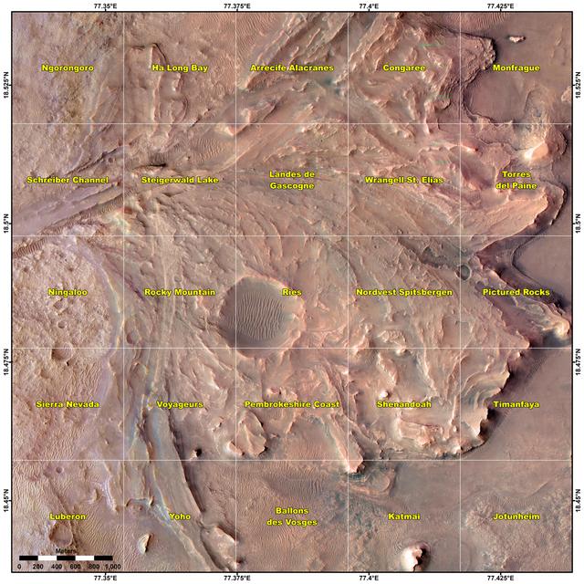
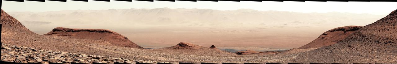
This map shows various quadrant themes in the vicinity of NASA's Perseverance Mars rover, which is currently in the Rocky Mountain quadrant within the much broader Jezero Crater. Each quadrant is 0.7 miles (1.2 kilometers) on each side. The Perseverance team chose quadrant themes related to various national parks across Earth, from Shenandoah National Park in Virginia to Jotunheimen National Park in Norway. The themes help organize the unofficial nicknames that are given by rover team members to different surface features they want to study, such as hills, craters, boulders, and even specific rock surfaces. The first sedimentary rock core sample the rover took was from a rock nicknamed "Skinner Ridge" for a ridge in Shenandoah National Park when Perseverance was in that quadrant. Many hundreds of names are compiled into a list based on each theme and are applied as the rover explores that quadrant. Rovers can sometimes end up exploring a quadrant for months, exhausting the list of names and prompting a new list to be drawn up. A key objective for Perseverance's mission on Mars is astrobiology, including the search for signs of ancient microbial life. The rover will characterize the planet's geology and past climate, pave the way for human exploration of the Red Planet, and be the first mission to collect and cache Martian rock and regolith (broken rock and dust). Subsequent NASA missions, in cooperation with ESA (European Space Agency), would send spacecraft to Mars to collect these sealed samples from the surface and return them to Earth for in-depth analysis. The Mars 2020 Perseverance mission is part of NASA's Moon to Mars exploration approach, which includes Artemis missions to the Moon that will help prepare for human exploration of the Red Planet. https://photojournal.jpl.nasa.gov/catalog/PIA25913

NASA Astronauts Butch Wilmore, left, and Suni Williams, speak with Boeing and NASA landing teams by phone from the International Space Station, before the landing of NASA’s Boeing Crew Flight Test Starliner spacecraft, Friday, Sept. 6, 2024, in Las Cruces, New Mexico. The uncrewed spacecraft is scheduled to land at White Sands Missile Range’s Space Harbor later today, Mountain Time (Sept. 7 Eastern Time). This approach allows NASA and Boeing to continue gathering testing data. Photo Credit: (NASA/Aubrey Gemignani)

NASA Astronauts Butch Wilmore, left, and Suni Williams, speak with Boeing and NASA landing teams by phone from the International Space Station, before the landing of NASA’s Boeing Crew Flight Test Starliner spacecraft, Friday, Sept. 6, 2024, in Las Cruces, New Mexico. The uncrewed spacecraft is scheduled to land at White Sands Missile Range’s Space Harbor later today, Mountain Time (Sept. 7 Eastern Time). This approach allows NASA and Boeing to continue gathering testing data. Photo Credit: (NASA/Aubrey Gemignani)

NASA Astronauts Butch Wilmore, left, and Suni Williams, speak with Boeing and NASA landing teams by phone from the International Space Station, before the landing of NASA’s Boeing Crew Flight Test Starliner spacecraft, Friday, Sept. 6, 2024, in Las Cruces, New Mexico. The uncrewed spacecraft is scheduled to land at White Sands Missile Range’s Space Harbor later today, Mountain Time (Sept. 7 Eastern Time). This approach allows NASA and Boeing to continue gathering testing data. Photo Credit: (NASA/Aubrey Gemignani)
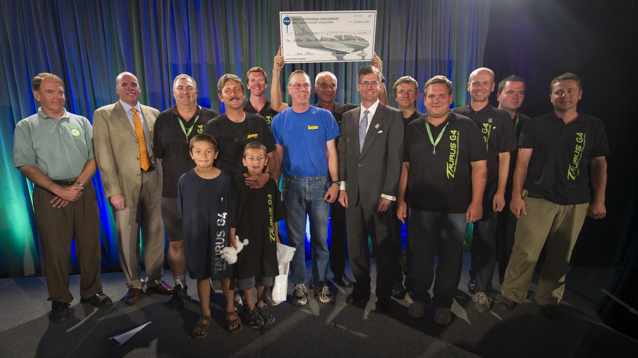
Comparative Aircraft Flight Efficiency (CAFE) Foundation President Brien A. Seeley M.D., left, NASA Acting Chief Technologist Joe Parrish, 2nd from left, and Pipistrel-USA Team Lead Jack Langelaan, center with suit, and the entire Pipistrel-USA, Taurus G4 aircraft team pose for a photograph shortly after winning the 2011 Green Flight Challenge, sponsored by Google, on Monday, Oct. 3, 2011 at the NASA Ames Research Center, Mountain View, Calif. The all electric Taurus G4 aircraft achieved the equivalency of more than 400 miles per gallon. NASA and CAFE held the challenge to advance technologies in fuel efficiency and reduced emissions with cleaner renewable fuels and electric aircraft. Photo Credit: (NASA/Bill Ingalls)
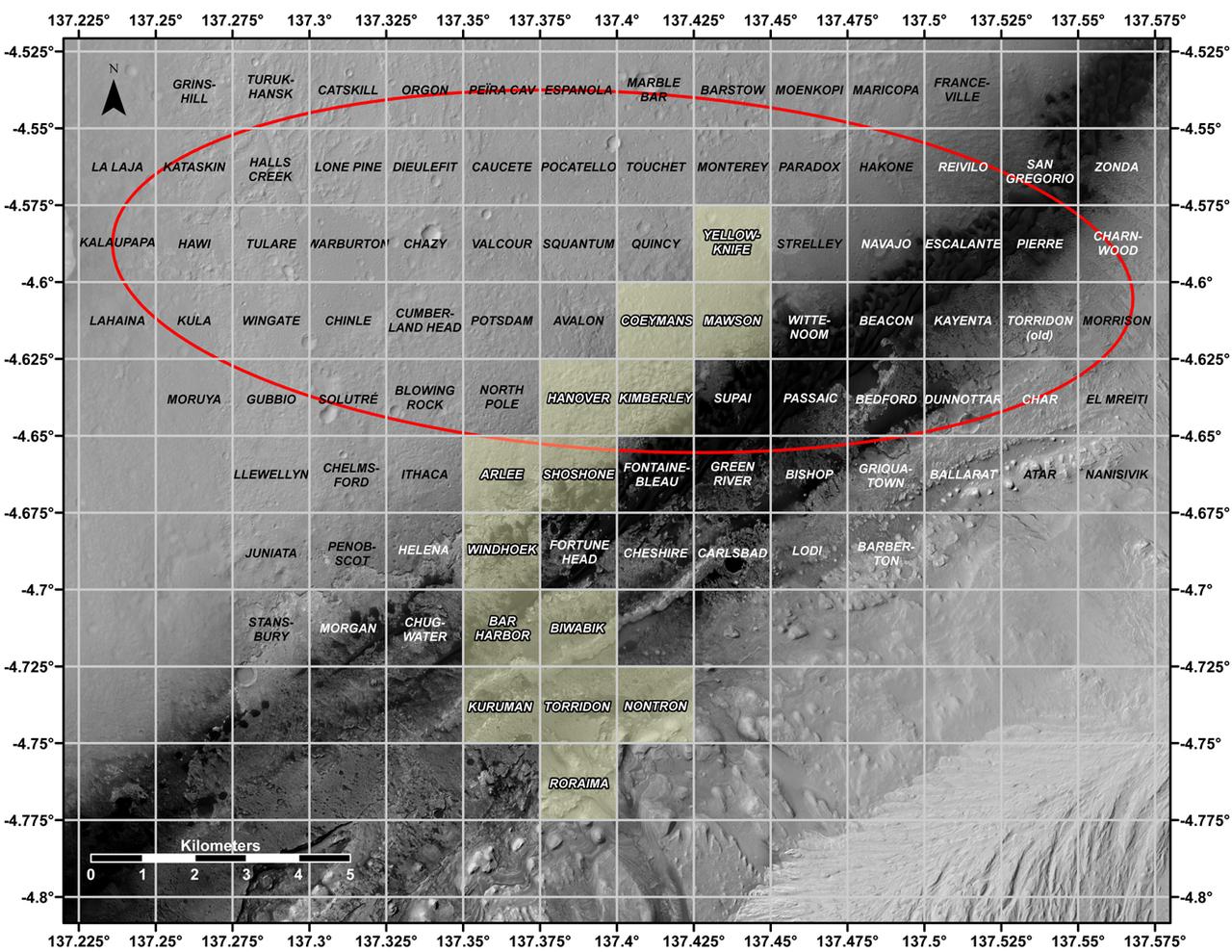
This map shows all the quadrant themes for NASA's Curiosity Mars rover, which is currently in the Roraima quadrant seen at the bottom. The red oval indicates the landing ellipse where the rover was targeted to touch down in 2012. The yellow-tinted quadrants are areas the rover has driven through since then. Themes are chosen in advance of the rover's arrival in a new quadrant; the rover's path couldn't be planned until after the team knew where it landed. Martian latitude and longitude is provided around the outside of the map. With the Curiosity mission, scientists began using quadrant themes to organize the long lists of unofficial nicknames needed to catalog its observations, whether hills, craters, boulders, rocks, and even tiny features on rock surfaces. Scientist deplete these lists of names quickly – especially with Curiosity, which has used more than 10,000 names over nearly 11 years of exploring Mars. Different science "targets" all require names – including targets for the rover's cameras, the rocks on which it places its arm instruments and drill, and the surfaces it zaps with its laser instrument. Curiosity's team chooses quadrant themes based on sites of geological interest on Earth. Its current quadrant, Roraima, is named for the northernmost state of Brazil, and for Mount Roraima, the highest peak in the Pacaraima mountains, located near the border of Venezuela, Brazil, and Guyana. The sulfate-enriched region Curiosity is currently exploring, with its flat-topped hills and steep slopes, reminded the rover team of the "table-top" mountains in the Pacaraima range. This is the first quadrant theme the team has chosen related to South America. Previously explored quadrants include Torridon, based on sites in Scotland, and Nontron, based on the French region where the town of Nontron can be found. While in the Nontron quadrant, which was located in a clay-enriched region, Curiosity drilled a rock sample that included a notable amount of nontronite – a clay mineral that was first discovered on Earth near Nontron. Each quadrant is 0.025 degrees of latitude and longitude, or approximately 0.7 miles (1.2 kilometers) on each side. https://photojournal.jpl.nasa.gov/catalog/PIA25914
In February 2015, New England was not alone in dealing with the wrath of Old Man Winter. Thick snow blanketed mountain ranges in southwestern Europe after a winter storm pushed through the region in early February. The Moderate Resolution Imaging Spectroradiometer (MODIS) on NASA’s Terra satellite captured this true-color image of the snow-covered peaks of the Cantabrian Mountains, the Pyrenees, the Alps, and Massif Central on February 9, 2015. Credit: NASA/GSFC/Jeff Schmaltz/MODIS Land Rapid Response Team <b><a href="http://www.nasa.gov/audience/formedia/features/MP_Photo_Guidelines.html" rel="nofollow">NASA image use policy.</a></b> <b><a href="http://www.nasa.gov/centers/goddard/home/index.html" rel="nofollow">NASA Goddard Space Flight Center</a></b> enables NASA’s mission through four scientific endeavors: Earth Science, Heliophysics, Solar System Exploration, and Astrophysics. Goddard plays a leading role in NASA’s accomplishments by contributing compelling scientific knowledge to advance the Agency’s mission. <b>Follow us on <a href="http://twitter.com/NASAGoddardPix" rel="nofollow">Twitter</a></b> <b>Like us on <a href="http://www.facebook.com/pages/Greenbelt-MD/NASA-Goddard/395013845897?ref=tsd" rel="nofollow">Facebook</a></b> <b>Find us on <a href="http://instagram.com/nasagoddard?vm=grid" rel="nofollow">Instagram</a></b>
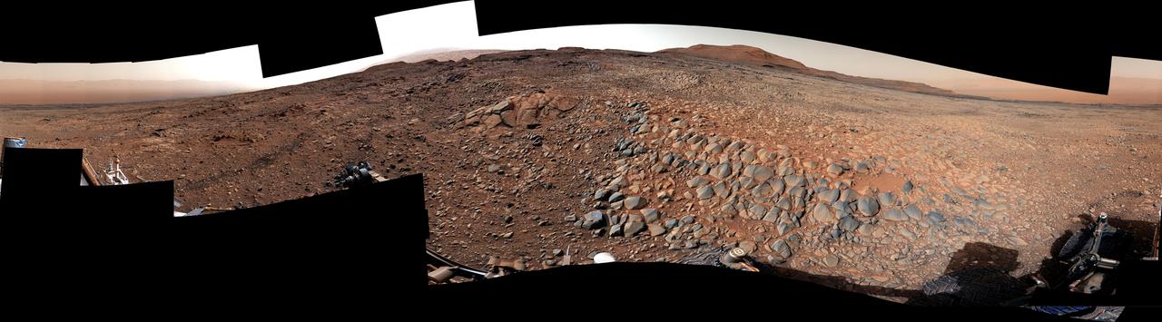
NASA's Curiosity Mars rover used its Mast Camera, or Mastcam, to capture this panorama in morning light on March 9, 2025, the 4,476th Martian day, or sol, of the mission. Steep hills on the left side of the panorama enclose wind-carved valleys on Mount Sharp, the mountain that Curiosity has been climbing for over a decade. Broken-up, rounded rocks throughout the foreground are part of the mountain's sulfate-bearing unit. The butte in the distance at right is nicknamed "Gould Mesa." A band of cliffs and dark ridges near the top of the butte may be the first glimpses of boxwork formations, a kind of feature created by groundwater flowing through large bedrock fractures in the ancient past. Assuming that is how they formed, these could represent the last gasps of water found on this region of Mars before the planet dried out completely. Before now, these features had only been viewed from orbiting spacecraft, to which they appeared as spiderweb-like fractures. This pattern of fractures stretches as long as 6 to 12 miles (10 to 20 kilometers) across the side of Mount Sharp. The rover's team expects to study these formations up close throughout the rest of 2025. The color in this image has been adjusted to match lighting conditions as the human eye would see them on Earth. https://photojournal.jpl.nasa.gov/catalog/PIA26552

New close-up images of a region near Pluto’s equator reveal a giant surprise: a range of youthful mountains rising as high as 11,000 feet (3,500 meters) above the surface of the icy body. The mountains likely formed no more than 100 million years ago -- mere youngsters relative to the 4.56-billion-year age of the solar system -- and may still be in the process of building, says Jeff Moore of New Horizons’ Geology, Geophysics and Imaging Team (GGI). That suggests the close-up region, which covers less than one percent of Pluto’s surface, may still be geologically active today. Moore and his colleagues base the youthful age estimate on the lack of craters in this scene. Like the rest of Pluto, this region would presumably have been pummeled by space debris for billions of years and would have once been heavily cratered -- unless recent activity had given the region a facelift, erasing those pockmarks. “This is one of the youngest surfaces we’ve ever seen in the solar system,” says Moore. Unlike the icy moons of giant planets, Pluto cannot be heated by gravitational interactions with a much larger planetary body. Some other process must be generating the mountainous landscape. “This may cause us to rethink what powers geological activity on many other icy worlds,” says GGI deputy team leader John Spencer of the Southwest Research Institute in Boulder, Colo. The mountains are probably composed of Pluto’s water-ice “bedrock.” Although methane and nitrogen ice covers much of the surface of Pluto, these materials are not strong enough to build the mountains. Instead, a stiffer material, most likely water-ice, created the peaks. “At Pluto’s temperatures, water-ice behaves more like rock,” said deputy GGI lead Bill McKinnon of Washington University, St. Louis. The close-up image was taken about 1.5 hours before New Horizons closest approach to Pluto, when the craft was 478,000 miles (770,000 kilometers) from the surface of the planet. The image easily resolves structures smaller than a mile across. Image Credit: NASA-JHUAPL-SwRI <b><a href="http://www.nasa.gov/audience/formedia/features/MP_Photo_Guidelines.html" rel="nofollow">NASA image use policy.</a></b> <b><a href="http://www.nasa.gov/centers/goddard/home/index.html" rel="nofollow">NASA Goddard Space Flight Center</a></b> enables NASA’s mission through four scientific endeavors: Earth Science, Heliophysics, Solar System Exploration, and Astrophysics. Goddard plays a leading role in NASA’s accomplishments by contributing compelling scientific knowledge to advance the Agency’s mission. <b>Follow us on <a href="http://twitter.com/NASAGoddardPix" rel="nofollow">Twitter</a></b> <b>Like us on <a href="http://www.facebook.com/pages/Greenbelt-MD/NASA-Goddard/395013845897?ref=tsd" rel="nofollow">Facebook</a></b> <b>Find us on <a href="http://instagrid.me/nasagoddard/?vm=grid" rel="nofollow">Instagram</a></b>
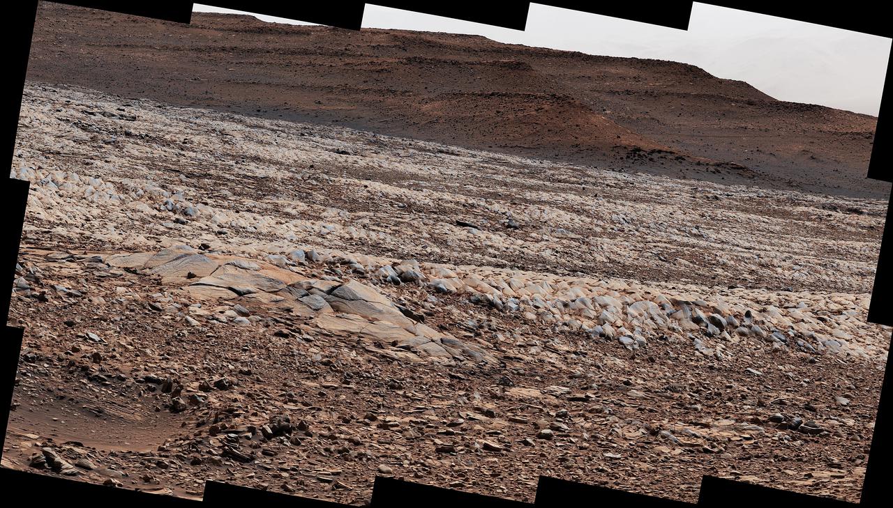
NASA's Curiosity Mars rover used its ChemCam instrument to view boulders on Gediz Vallis Ridge Nov. 15 to 17, 2022, the 3,653rd to 3,655th Martian days, or sols, of the mission. These boulders are thought to have been washed down in a debris flows in the ancient past and are probably some of the youngest evidence of liquid water Curiosity will see on Mount Sharp. Curiosity has been ascending the foothills of the 3-mile-tall (5-kilometer-tall) mountain since 2014. Water ebbed and flowed on Mount Sharp billions of years ago, at times forming lakes and rivers that would dry up and flood repeatedly. Gediz Vallis is a part of the mountain where water once flowed down; Curiosity's scientists are interested in the ridge in part because it includes boulders like these that were washed down from much higher up the mountain, where Curiosity won't be able to reach. From left to right, the boulders depicted in the circles are approximately 984 feet (300 meters), 1,312 feet (400 meters), and 656 feet (200 meters) away. Based on these distances, the width of the boulders are estimated to be (again, from left to right) 4 feet (120 centimeters), 3.3 feet (100 centimeters), and 2 feet (60 centimeters). This scene is made up of 52 individual images captured by ChemCam's Remote Micro-Imager; the images were stitched together after being sent back to Earth. Early in the mission, the team discovered that the imager, originally designed to view targets shot by ChemCam's laser, can also be used like a telescope, looking at distant horizons rather than nearby rock textures. https://photojournal.jpl.nasa.gov/catalog/PIA25731
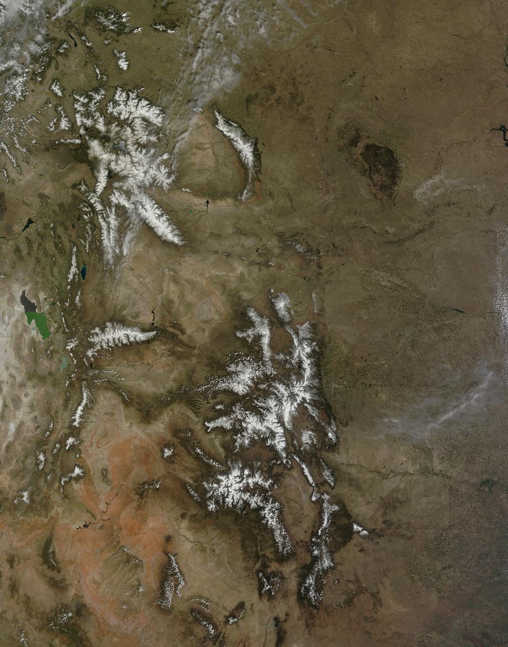
On April 29, 2015 the Moderate Resolution Imaging Spectroradiometer (MODIS) aboard NASA’s Terra satellite captured a true-color image of a typical spring scene in the western United State: snow-crowned Rocky Mountains rising above the faintly greening plains. The Rocky Mountains stretch from British Columbia, Canada to the Rio Grande in New Mexico, a span of roughly 3,000 miles, and contains many of the highest peaks in the continental United States. The tallest, Mount Elbert, rises 14,400 ft. (4,401 m) above sea level, and is located in the San Isabel National Forest, near Leadville, Colorado. This image covers seven Rocky Mountain states. From north to south they are: Montana and Idaho, Wyoming; Utah (with the Great Salt Lake visible) and Colorado; Arizona and New Mexico. To the east, the Great Plain states captured are, from north to south: North Dakota, South Dakota, Nebraska, Kansas, Oklahoma and northwestern Texas. Credit: NASA/GSFC/Jeff Schmaltz/MODIS Land Rapid Response Team <b><a href="http://www.nasa.gov/audience/formedia/features/MP_Photo_Guidelines.html" rel="nofollow">NASA image use policy.</a></b> <b><a href="http://www.nasa.gov/centers/goddard/home/index.html" rel="nofollow">NASA Goddard Space Flight Center</a></b> enables NASA’s mission through four scientific endeavors: Earth Science, Heliophysics, Solar System Exploration, and Astrophysics. Goddard plays a leading role in NASA’s accomplishments by contributing compelling scientific knowledge to advance the Agency’s mission. <b>Follow us on <a href="http://twitter.com/NASAGoddardPix" rel="nofollow">Twitter</a></b> <b>Like us on <a href="http://www.facebook.com/pages/Greenbelt-MD/NASA-Goddard/395013845897?ref=tsd" rel="nofollow">Facebook</a></b> <b>Find us on <a href="http://instagrid.me/nasagoddard/?vm=grid" rel="nofollow">Instagram</a></b>
NASA's Curiosity Mars rover used its Mast Camera, or Mastcam, to take this 360-degree panorama on March 23, 2022, the 3,423th Martian day, or sol, of the mission. The team has informally described the wind-sharpened rocks seen here as "gator-back" rocks because of their scaly appearance. Wind-sharpened rocks like these are called ventifacts, and are responsible for chewing up Curiosity's wheels earlier in the mission. Since then, rover engineers have found ways to slow wheel wear, including a traction control algorithm. They also plan rover routes that avoid driving over such rocks, including these latest ventifacts, which are made of sandstone – the hardest type of rock Curiosity has encountered on Mars. These rocks form the surface of the "Greenheugh Pediment," a broad, sloping plain in the foothills of Mount Sharp. The floor of Gale Crater is visible along the edges of the mosaic. When Curiosity's team saw the gator-back rocks, they ultimately decided to turn the rover around and take an alternative path to continue climbing Mount Sharp, a 3.4-mile-tall (5.5-kilometer-tall) mountain that Curiosity has been ascending since 2014. As it climbs, Curiosity is able to study different sedimentary layers shaped by water billions of years ago. These layers help scientists understand whether microscopic life could have survived in the ancient Martian environment. https://photojournal.jpl.nasa.gov/catalog/PIA25176
NASA's Curiosity Mars rover used its Mast Camera, or Mastcam, to survey these wind-sharpened rocks, called ventifacts, on March 15, 2022, the 3,415th Martian day, or sol, of the mission. The team has informally described these patches of ventifacts as "gator-back" rocks because of their scaly appearance. Ventifacts chewed up Curiosity's wheels earlier in the mission. Since then, rover engineers have found ways to slow wheel wear, including a traction control algorithm. They also plan rover routes that avoid driving over such rocks, including these latest ventifacts, which are made of sandstone &ndsh; the hardest type of rock Curiosity has encountered on Mars. These rocks form the surface of the "Greenheugh Pediment," a broad, sloping plain in the foothills of Mount Sharp. The floor of Gale Crater is visible along the edges of the mosaic. When Curiosity's team saw the gator-back rocks, they ultimately decided to turn the rover around and take an alternative path to continue climbing Mount Sharp, a 3.4-mile-tall (5.5-kilometer-tall) mountain that Curiosity has been ascending since 2014. As it climbs, Curiosity is able to study different sedimentary layers shaped by water billions of years ago. These layers help scientists understand whether microscopic life could have survived in the ancient Martian environment. https://photojournal.jpl.nasa.gov/catalog/PIA25175

On most days, relentless rivers of clouds wash over Alaska, obscuring most of the state’s 6,640 miles (10,690 kilometers) of coastline and 586,000 square miles (1,518,000 square kilometers) of land. The south coast of Alaska even has the dubious distinction of being the cloudiest region of the United States, with some locations averaging more than 340 cloudy days per year. That was certainly not the case on June 17, 2013, the date that the Moderate Resolution Imaging Spectroradiometer (MODIS) on NASA’s Terra satellite acquired this rare, nearly cloud-free view of the state. The absence of clouds exposed a striking tapestry of water, ice, land, forests, and even wildfires. Snow-covered mountains such as the Alaska Range and Chugach Mountains were visible in southern Alaska, while the arc of mountains that make up the Brooks Range dominated the northern part of the state. The Yukon River—the longest in Alaska and the third longest in the United States—wound its way through the green boreal forests that inhabit the interior of the state. Plumes of sediment and glacial dust poured into the Gulf of Alaska from the Copper River. And Iliamna Lake, the largest in Alaska, was ice free. The same ridge of high pressure that cleared Alaska’s skies also brought stifling temperatures to many areas accustomed to chilly June days. Talkeetna, a town about 100 miles north of Anchorage, saw temperatures reach 96°F (36°C) on June 17. Other towns in southern Alaska set all-time record highs, including Cordova, Valez, and Seward. The high temperatures also helped fuel wildfires and hastened the breakup of sea ice in the Chukchi Sea. NASA image courtesy Jeff Schmaltz, LANCE MODIS Rapid Response Team at NASA GSFC. Caption by Adam Voiland. Instrument: Terra - MODIS More info: <a href="http://1.usa.gov/102MAEj" rel="nofollow">1.usa.gov/102MAEj</a> Credit: <b><a href="http://www.earthobservatory.nasa.gov/" rel="nofollow"> NASA Earth Observatory</a></b> <b><a href="http://www.nasa.gov/audience/formedia/features/MP_Photo_Guidelines.html" rel="nofollow">NASA image use policy.</a></b> <b><a href="http://www.nasa.gov/centers/goddard/home/index.html" rel="nofollow">NASA Goddard Space Flight Center</a></b> enables NASA’s mission through four scientific endeavors: Earth Science, Heliophysics, Solar System Exploration, and Astrophysics. Goddard plays a leading role in NASA’s accomplishments by contributing compelling scientific knowledge to advance the Agency’s mission. <b>Follow us on <a href="http://twitter.com/NASA_GoddardPix" rel="nofollow">Twitter</a></b> <b>Like us on <a href="http://www.facebook.com/pages/Greenbelt-MD/NASA-Goddard/395013845897?ref=tsd" rel="nofollow">Facebook</a></b> <b>Find us on <a href="http://instagram.com/nasagoddard?vm=grid" rel="nofollow">Instagram</a></b>
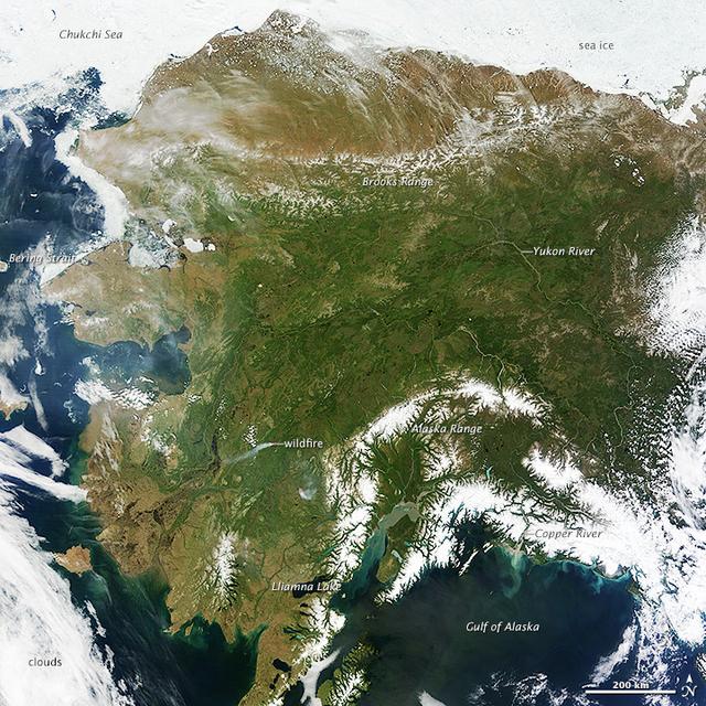
On most days, relentless rivers of clouds wash over Alaska, obscuring most of the state’s 6,640 miles (10,690 kilometers) of coastline and 586,000 square miles (1,518,000 square kilometers) of land. The south coast of Alaska even has the dubious distinction of being the cloudiest region of the United States, with some locations averaging more than 340 cloudy days per year. That was certainly not the case on June 17, 2013, the date that the Moderate Resolution Imaging Spectroradiometer (MODIS) on NASA’s Terra satellite acquired this rare, nearly cloud-free view of the state. The absence of clouds exposed a striking tapestry of water, ice, land, forests, and even wildfires. Snow-covered mountains such as the Alaska Range and Chugach Mountains were visible in southern Alaska, while the arc of mountains that make up the Brooks Range dominated the northern part of the state. The Yukon River—the longest in Alaska and the third longest in the United States—wound its way through the green boreal forests that inhabit the interior of the state. Plumes of sediment and glacial dust poured into the Gulf of Alaska from the Copper River. And Iliamna Lake, the largest in Alaska, was ice free. The same ridge of high pressure that cleared Alaska’s skies also brought stifling temperatures to many areas accustomed to chilly June days. Talkeetna, a town about 100 miles north of Anchorage, saw temperatures reach 96°F (36°C) on June 17. Other towns in southern Alaska set all-time record highs, including Cordova, Valez, and Seward. The high temperatures also helped fuel wildfires and hastened the breakup of sea ice in the Chukchi Sea. NASA image courtesy Jeff Schmaltz, LANCE MODIS Rapid Response Team at NASA GSFC. Caption by Adam Voiland. Instrument: Terra - MODIS More info: <a href="http://1.usa.gov/102MAEj" rel="nofollow">1.usa.gov/102MAEj</a> Credit: <b><a href="http://www.earthobservatory.nasa.gov/" rel="nofollow"> NASA Earth Observatory</a></b> <b><a href="http://www.nasa.gov/audience/formedia/features/MP_Photo_Guidelines.html" rel="nofollow">NASA image use policy.</a></b> <b><a href="http://www.nasa.gov/centers/goddard/home/index.html" rel="nofollow">NASA Goddard Space Flight Center</a></b> enables NASA’s mission through four scientific endeavors: Earth Science, Heliophysics, Solar System Exploration, and Astrophysics. Goddard plays a leading role in NASA’s accomplishments by contributing compelling scientific knowledge to advance the Agency’s mission. <b>Follow us on <a href="http://twitter.com/NASA_GoddardPix" rel="nofollow">Twitter</a></b> <b>Like us on <a href="http://www.facebook.com/pages/Greenbelt-MD/NASA-Goddard/395013845897?ref=tsd" rel="nofollow">Facebook</a></b> <b>Find us on <a href="http://instagram.com/nasagoddard?vm=grid" rel="nofollow">Instagram</a></b>
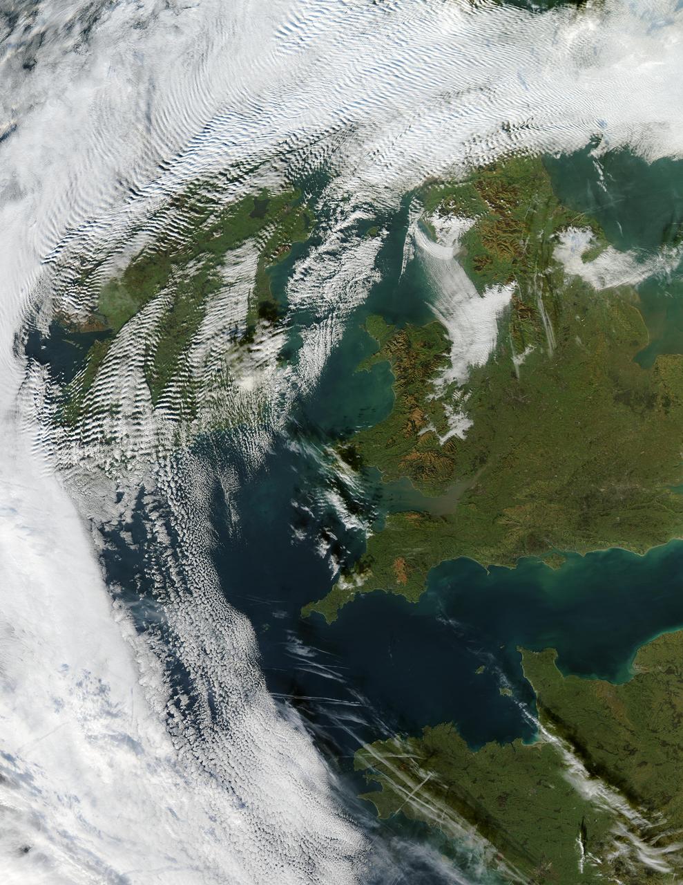
Visualization Date 2003-12-18 Clouds ripple over Ireland and Scotland in a wave pattern, similar to the pattern of waves along a seashore. The similarity is not coincidental — the atmosphere behaves like a fluid, so when it encounters an obstacle, it must move around it. This movement forms a wave, and the wave movement can continue for long distances. In this case, the waves were caused by the air moving over and around the mountains of Scotland and Ireland. As the air crested a wave, it cooled, and clouds formed. Then, as the air sank into the trough, the air warmed, and clouds did not form. This pattern repeated itself, with clouds appearing at the peak of every wave. Other types of clouds are also visible in the scene. Along the northwestern and southwestern edges of this true-color image from December 17, 2003, are normal mid-altitude clouds with fairly uniform appearances. High altitude cirrus-clouds float over these, casting their shadows on the lower clouds. Open- and closed-cell clouds formed off the coast of northwestern France, and thin contrail clouds are visible just east of these. Contrail clouds form around the particles carried in airplane exhaust. Fog is also visible in the valleys east of the Cambrian Mountains, along the border between northern/central Wales and England. This is an Aqua MODIS image. Sensor Aqua/MODIS Credit Jacques Descloitres, MODIS Rapid Response Team, NASA/GSFC For more information go to: <a href="http://visibleearth.nasa.gov/view_rec.php?id=6146" rel="nofollow">visibleearth.nasa.gov/view_rec.php?id=6146</a>

The Anti-Atlas Mountains of Morocco formed as a result of the collision of the African and Eurasian tectonic plates about 80 million years ago. This collision destroyed the Tethys Ocean; the limestone, sandstone, claystone, and gypsum layers that formed the ocean bed were folded and crumpled to create the Anti-Atlas Mountains. In this ASTER image of southwest Morocco, visible, near infrared, and short wavelength infrared bands are combined to dramatically highlight the different rock types, and illustrate the complex folding. The ability to map geology using ASTER data is enhanced by bands that are sensitive to differences in rock mineralogy. The image was acquired on November 5, 2007, covers an area of 51.9 by 60.8 km, and is located at 28.1 degrees north and 10.7 degrees west. With its 14 spectral bands from the visible to the thermal infrared wavelength region and its high spatial resolution of about 50 to 300 feet (15 to 90 meters), ASTER images Earth to map and monitor the changing surface of our planet. ASTER is one of five Earth-observing instruments launched Dec. 18, 1999, on Terra. The instrument was built by Japan's Ministry of Economy, Trade and Industry. A joint U.S./Japan science team is responsible for validation and calibration of the instrument and data products. The broad spectral coverage and high spectral resolution of ASTER provides scientists in numerous disciplines with critical information for surface mapping and monitoring of dynamic conditions and temporal change. Example applications are monitoring glacial advances and retreats; monitoring potentially active volcanoes; identifying crop stress; determining cloud morphology and physical properties; wetlands evaluation; thermal pollution monitoring; coral reef degradation; surface temperature mapping of soils and geology; and measuring surface heat balance. https://photojournal.jpl.nasa.gov/catalog/PIA23533
NASA's Curiosity Mars rover used its black-and-white navigation cameras to capture panoramas of this scene at two times of day. Blue, orange, and green color was added to a combination of both panoramas for an artistic interpretation of the scene. On Nov. 16, 2021 (the 3,299th Martian day, or sol, of the mission), engineers commanded Curiosity to take two sets of mosaics, or composite images, capturing the scene at 8:30 a.m. and again at 4:10 p.m. local Mars time. The two times of day provided contrasting lighting conditions that brought out a variety of unique landscape details. They combined the two scenes in an artistic re-creation that includes images from the morning scene in blue, the afternoon scene in orange, and a combination of both in green. The main image is an artistic interpretation of the scene. Figure 1 is the mosaic taken in the afternoon. Figure 2 is the mosaic taken in the morning. At the center of the image is the view back down Mount Sharp, the 3-mile-tall (5-kilometer-tall) mountain that Curiosity has been driving up since 2014. Rounded hills can be seen in the distance at center-right; Curiosity got a closer view of these back in July, when the rover started to see intriguing changes in the landscape. A field of sand ripples known as the "Sands of Forvie" stretches a quarter- to a half-mile (400 to 800 meters) away. At the far right of the panorama is the craggy "Rafael Navarro Mountain," named after a Curiosity team scientist who passed away earlier this year. Poking up behind it is the upper part of Mount Sharp, far above the area Curiosity is exploring. Mount Sharp lies inside Gale Crater, a 96-mile-wide (154-kilometer-wide) basin formed by an ancient impact; Gale Crater's distant rim stands 7,500 feet tall (2.3 kilometers), and is visible on the horizon about 18 to 25 miles away (30 to 40 kilometers). https://photojournal.jpl.nasa.gov/catalog/PIA24937

NASA image acquired July 27, 2001 In southwestern Jordan lies an unusual landscape. Mountains of granite and sandstone rise next to valleys filled with red sand. Some of the mountains reach a height of about 1,700 meters (5,600 feet) above sea level, and many have near-vertical slopes. So alien is this landscape, it’s nicknamed “Valley of the Moon,” and it has served as the film set for a movie about Mars. Yet nomadic people have lived here for thousands of years. Declared a protected area in 1998, this unearthly landscape is Wadi Rum. The Advanced Land Imager (ALI) on NASA’s Earth Observing-1 (EO-1) satellite captured this natural-color image on July 27, 2001. The scene includes part of Wadi Rum and an adjacent area to the east. East of the protected area, fields with center-pivot irrigation make circles of green and brown (image upper right). As the earth tones throughout the image attest, the area is naturally arid, receiving little annual precipitation and supporting only sparse vegetation. Between rocky peaks, the sandy valleys range in color from beige to brick. Ancient granite rocks dating from the Precambrian underlie younger rocks, and some of these basement rocks have eroded into rugged, steep-sloped mountains. The granite mountains have risen thanks partly to crisscrossing fault lines under the park. Overlying the granite are sandstones from the Cambrian and Ordovician Periods, as well as loose sands. Lawrence of Arabia, who fought in the Arab Revolt of 1917–1918, made frequent references to Wadi Rum in his book The Seven Pillars of Wisdom. Likewise, a prominent feature of the protected area is named after the book. Several popular sites in Wadi Rum bear Lawrence of Arabia’s name, but whether he actually visited those sites is uncertain. To download the full high res go to: <a href="http://earthobservatory.nasa.gov/IOTD/view.php?id=49945" rel="nofollow">earthobservatory.nasa.gov/IOTD/view.php?id=49945</a> NASA Earth Observatory image created by Jesse Allen and Robert Simmon, using EO-1 ALI data provided courtesy of the NASA EO-1 team and the United States Geological Survey. Caption by Michon Scott. Instrument: EO-1 - ALI Credit: <b><a href="http://www.earthobservatory.nasa.gov/" rel="nofollow"> NASA Earth Observatory</a></b> <b><a href="http://www.nasa.gov/centers/goddard/home/index.html" rel="nofollow">NASA Goddard Space Flight Center</a></b> enables NASA’s mission through four scientific endeavors: Earth Science, Heliophysics, Solar System Exploration, and Astrophysics. Goddard plays a leading role in NASA’s accomplishments by contributing compelling scientific knowledge to advance the Agency’s mission. <b>Follow us on <a href="http://twitter.com/NASA_GoddardPix" rel="nofollow">Twitter</a></b> <b>Join us on <a href="http://www.facebook.com/pages/Greenbelt-MD/NASA-Goddard/395013845897?ref=tsd" rel="nofollow">Facebook</a></b>
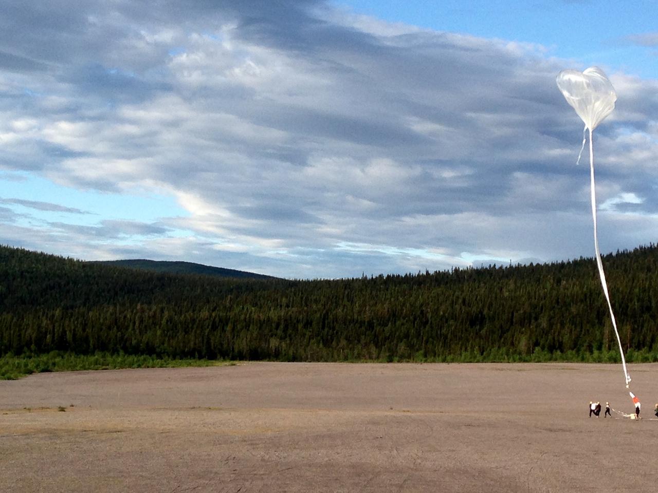
The BARREL team prepares to release the second scientific balloon in its Sweden campaign on Aug. 13, 2015. In addition to the instruments used in previous BARREL campaigns, this second balloon launched from the Esrange Space Center in Kiruna is carrying one of two instruments designed by a team from the University of Houston. With funding from the Undergraduate Student Instrument Program, or USIP, at NASA Goddard Space Flight Center’s Wallops Flight Facility, the team of 12 students, under the direction of Edgar Bering at the University of Houston, developed a magnetometer -- which measures magnetic fields -- and an instrument to measure electrons, which flew on this launch. To collect their data, the University of Houston team needs to recover their instrument after the balloon comes down. After this launch, the balloon began to drift toward the mountains, which would have impeded recovery. So the team terminated the flight at 1:18 pm EDT to bring the payload slowly and safely to the ground. The NASA-funded BARREL – which stands for Balloon Array for Radiation-belt Relativistic Electron Losses – measures electrons in the atmosphere near the poles. Such electrons rain down into the atmosphere from two giant radiation belts surrounding Earth, called the Van Allen belts. For its third campaign, BARREL is launching six balloons from the Esrange Space Center in Kiruna, Sweden. BARREL is led by Dartmouth College in Hanover, New Hampshire. Credit: NASA/University of Houston/Edgar Bering <b><a href="http://www.nasa.gov/audience/formedia/features/MP_Photo_Guidelines.html" rel="nofollow">NASA image use policy.</a></b> <b><a href="http://www.nasa.gov/centers/goddard/home/index.html" rel="nofollow">NASA Goddard Space Flight Center</a></b> enables NASA’s mission through four scientific endeavors: Earth Science, Heliophysics, Solar System Exploration, and Astrophysics. Goddard plays a leading role in NASA’s accomplishments by contributing compelling scientific knowledge to advance the Agency’s mission. <b>Follow us on <a href="http://twitter.com/NASAGoddardPix" rel="nofollow">Twitter</a></b> <b>Like us on <a href="http://www.facebook.com/pages/Greenbelt-MD/NASA-Goddard/395013845897?ref=tsd" rel="nofollow">Facebook</a></b> <b>Find us on <a href="http://instagrid.me/nasagoddard/?vm=grid" rel="nofollow">Instagram</a></b>
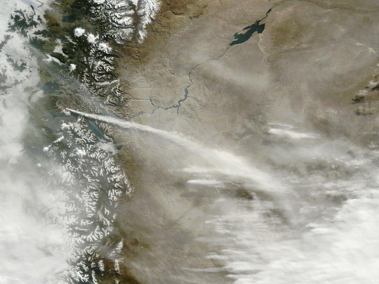
When NASA's Terra satellite flew over the Puyehue-Cordon Caulle volcano on July 8, 2011 at 14:25 UTC (10:25 a.m. EDT) it captured this visible image of a steady stream of ash (light brown) blowing southeast into Argentina. The Puyehue-Cordón Caulle Volcano is located in the Andes Mountains of central Chile, near the Argentina border. Image: NASA Goddard/MODIS Rapid Response Team, Jeff Schmaltz Text: NASA Goddard/Rob Gutro <b><a href="http://www.nasa.gov/centers/goddard/home/index.html" rel="nofollow">NASA Goddard Space Flight Center</a></b> enables NASA’s mission through four scientific endeavors: Earth Science, Heliophysics, Solar System Exploration, and Astrophysics. Goddard plays a leading role in NASA’s accomplishments by contributing compelling scientific knowledge to advance the Agency’s mission. <b>Follow us on <a href="http://twitter.com/NASA_GoddardPix" rel="nofollow">Twitter</a></b> <b>Like us on <a href="http://www.facebook.com/pages/Greenbelt-MD/NASA-Goddard/395013845897?ref=tsd" rel="nofollow">Facebook</a></b> <b>Find us on <a href="http://web.stagram.com/n/nasagoddard/?vm=grid" rel="nofollow">Instagram</a></b>
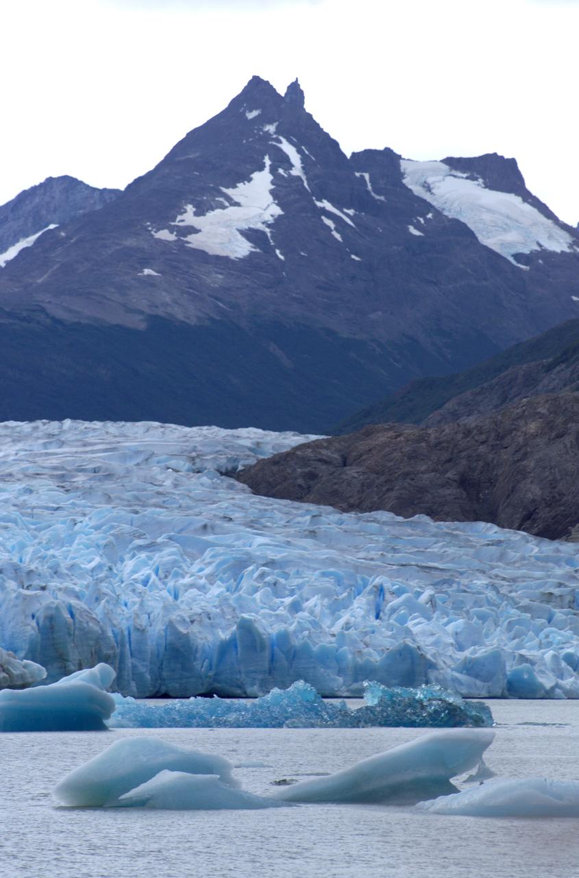
Glacier Grey in front of the Cuernos del Paine mountains, photographed from Lago Grey (Grey Lake) during NASA's AirSAR 2004 campaign in Chile. AirSAR 2004 is a three-week expedition in Central and South America by an international team of scientists that is using an all-weather imaging tool, called the Airborne Synthetic Aperture Radar (AirSAR), located onboard NASA's DC-8 airborne laboratory. Scientists from many parts of the world are combining ground research with NASA's AirSAR technology to improve and expand on the quality of research they are able to conduct. Founded in 1959, Torres del Paine National Park encompasses 450,000 acres in the Patagonia region of Chile. This region is being studied by NASA using a DC-8 equipped with an Airborne Synthetic Aperture Radar (AirSAR) developed by scientists from NASA’s Jet Propulsion Laboratory. This is a very sensitive region that is important to scientists because the temperature has been consistently rising causing a subsequent melting of the region’s glaciers. AirSAR will provide a baseline model and unprecedented mapping of the region. This data will make it possible to determine whether the warming trend is slowing, continuing or accelerating. AirSAR will also provide reliable information on ice shelf thickness to measure the contribution of the glaciers to sea level.
Aletsch Glacier, the largest glacier of Europe, covers more than 120 square kilometers (more than 45 square miles) in southern Switzerland. At its eastern extremity lies a glacierlake, Mdrjelensee (2,350 meters/7,711 feet above sea level). To the west rises Aletschhorn (4,195 meters/13,763 feet), which was first climbed in 1859. The Rhone River flows along the southern flank of the mountains. This image was acquired on July 23, 2001 by the Advanced Spaceborne Thermal Emission and Reflection Radiometer (ASTER) on NASA's Terra satellite. With its 14 spectral bands from the visible to the thermal infrared wavelength region, and its high spatial resolution of 15 to 90 meters (about 50 to 300 feet), ASTER will image Earth for the next 6 years to map and monitor the changing surface of our planet. ASTER is one of five Earth-observing instruments launched December 18, 1999, on NASA's Terra satellite. The instrument was built by Japan's Ministry of Economy, Trade and Industry. A joint U.S./Japan science team is responsible for validation and calibration of the instrument and the data products. http://photojournal.jpl.nasa.gov/catalog/PIA03857
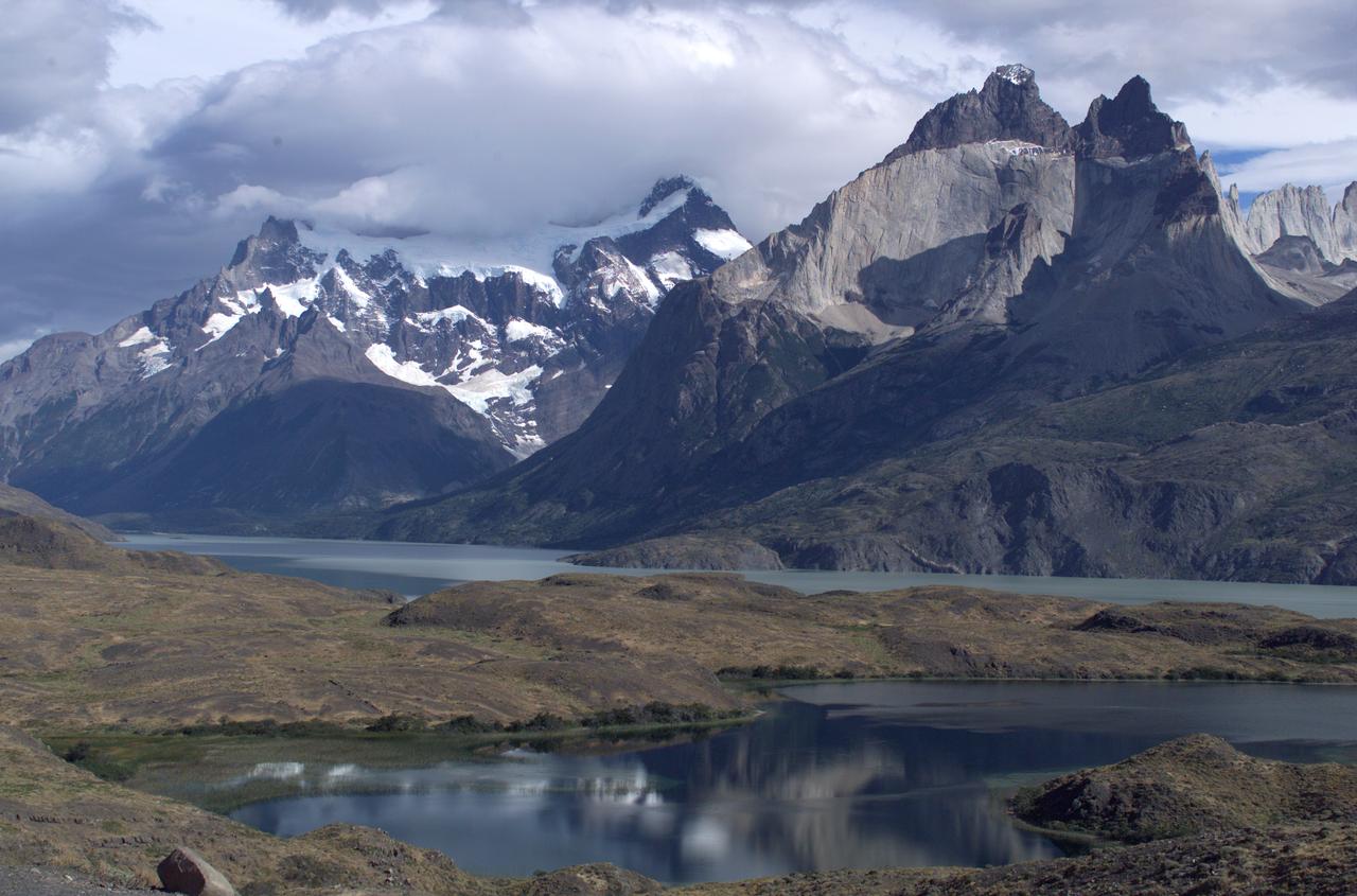
The Cuernos del Paine mountains in Torres del Paine National Park, Chile, during NASA's AirSAR 2004 campaign. AirSAR 2004 is a three-week expedition in Central and South America by an international team of scientists that is using an all-weather imaging tool, called the Airborne Synthetic Aperture Radar (AirSAR), located onboard NASA's DC-8 airborne laboratory. Scientists from many parts of the world are combining ground research with NASA's AirSAR technology to improve and expand on the quality of research they are able to conduct. Founded in 1959, Torres del Paine National Park encompasses 450,000 acres in the Patagonia region of Chile. This region is being studied by NASA using a DC-8 equipped with an Airborne Synthetic Aperture Radar (AirSAR) developed by scientists from NASA’s Jet Propulsion Laboratory. This is a very sensitive region that is important to scientists because the temperature has been consistently rising causing a subsequent melting of the region’s glaciers. AirSAR will provide a baseline model and unprecedented mapping of the region. This data will make it possible to determine whether the warming trend is slowing, continuing or accelerating. AirSAR will also provide reliable information on ice shelf thickness to measure the contribution of the glaciers to sea level.
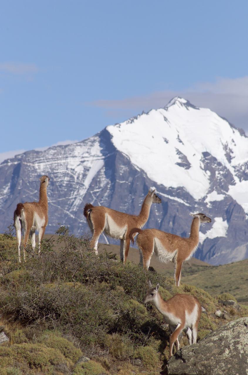
The Cuernos del Paine mountains in Torres del Paine National Park in Chile provide a backdrop to a herd of guanacos during NASA's AirSAR 2004 campaign. AirSAR 2004 is a three-week expedition in Central and South America by an international team of scientists that is using an all-weather imaging tool, called the Airborne Synthetic Aperture Radar (AirSAR), located onboard NASA's DC-8 airborne laboratory. Scientists from many parts of the world are combining ground research with NASA's AirSAR technology to improve and expand on the quality of research they are able to conduct. Founded in 1959, Torres del Paine National Park encompasses 450,000 acres in the Patagonia region of Chile. This region is being studied by NASA using a DC-8 equipped with an Airborne Synthetic Aperture Radar (AirSAR) developed by scientists from NASA’s Jet Propulsion Laboratory. This is a very sensitive region that is important to scientists because the temperature has been consistently rising causing a subsequent melting of the region’s glaciers. AirSAR will provide a baseline model and unprecedented mapping of the region. This data will make it possible to determine whether the warming trend is slowing, continuing or accelerating. AirSAR will also provide reliable information on ice shelf thickness to measure the contribution of the glaciers to sea level.

This image of the greater Los Angeles area was taken on March 29, 2019 by ASTERIA, the Arcsecond Space Telescope Enabling Research in Astrophysics satellite. It shows a region of about 43.5 square miles (70 square kilometers) with a resolution of about 100 feet (30 meters) per pixel. A bright spot near the center of the image marks the location of Dodger Stadium. (The Dodgers played the Arizona Diamondbacks at home that night.) To the northeast, near the darkness of the San Gabriel Mountains, is NASA's Jet Propulsion Laboratory in Pasadena, California, which built and operates ASTERIA, and the nearby Rose Bowl Stadium. The close-cropped image shows a region of about 43.5 square miles (70 square kilometers) with a resolution of about 100 feet (30 meters) per pixel. ASTERIA is a CubeSat, or a small satellite composed of cube units that measure 10 centimeters (4.5 inches) on each side. ASTERIA was designed to demonstrate precision pointing technology in a CubeSat, which could be used to observe planets around other stars. A slight decrease in a star's brightness as detected by ASTERIA could indicate that a planet is orbiting the star and passed in front of the star. This is called a planet transit. After completing its primary mission objectives in January 2018, ASTERIA has continued to operate on an extended mission. The mission team took this image to further test the capabilities of the satellite. https://photojournal.jpl.nasa.gov/catalog/PIA23125
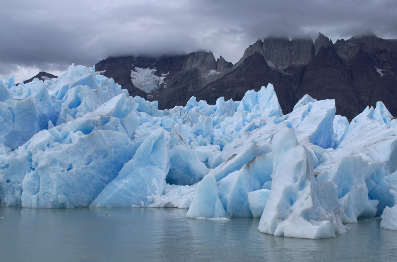
View of Glacier Grey from Lago Grey (Grey Lake), with the Cuernos del Paine mountains in the background, seen during NASA's AirSAR 2004 campaign in Chile. AirSAR 2004 is a three-week expedition in Central and South America by an international team of scientists that is using an all-weather imaging tool, called the Airborne Synthetic Aperture Radar (AirSAR), located onboard NASA's DC-8 airborne laboratory. Scientists from many parts of the world are combining ground research with NASA's AirSAR technology to improve and expand on the quality of research they are able to conduct. Founded in 1959, Torres del Paine National Park encompasses 450,000 acres in the Patagonia region of Chile. This region is being studied by NASA using a DC-8 equipped with an Airborne Synthetic Aperture Radar (AirSAR) developed by scientists from NASA’s Jet Propulsion Laboratory. This is a very sensitive region that is important to scientists because the temperature has been consistently rising causing a subsequent melting of the region’s glaciers. AirSAR will provide a baseline model and unprecedented mapping of the region. This data will make it possible to determine whether the warming trend is slowing, continuing or accelerating. AirSAR will also provide reliable information on ice shelf thickness to measure the contribution of the glaciers to sea level.
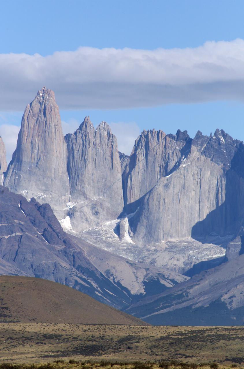
The Cuernos del Paine mountains in Torres del Paine National Park in Chile, photographed during NASA's AirSAR 2004 campaign. AirSAR 2004 is a three-week expedition in Central and South America by an international team of scientists that is using an all-weather imaging tool, called the Airborne Synthetic Aperture Radar (AirSAR), located onboard NASA's DC-8 airborne laboratory. Scientists from many parts of the world are combining ground research with NASA's AirSAR technology to improve and expand on the quality of research they are able to conduct. Founded in 1959, Torres del Paine National Park encompasses 450,000 acres in the Patagonia region of Chile. This region is being studied by NASA using a DC-8 equipped with an Airborne Synthetic Aperture Radar (AirSAR) developed by scientists from NASA’s Jet Propulsion Laboratory. This is a very sensitive region that is important to scientists because the temperature has been consistently rising causing a subsequent melting of the region’s glaciers. AirSAR will provide a baseline model and unprecedented mapping of the region. This data will make it possible to determine whether the warming trend is slowing, continuing or accelerating. AirSAR will also provide reliable information on ice shelf thickness to measure the contribution of the glaciers to sea level.
The ground near one of the long-dormant Three Sisters volcanoes in the Cascade Mountains of west-central Oregon has risen approximately 10centimeters in a 10-by-20-km parcel since 1996, meaning that magma or underground lava is slowly flowing into the area, according to a research team from the U.S. Geological Survey. The Three Sisters area -- which contains five volcanoes -- is only about 170 miles from Mount St. Helens, which erupted in 1980. Both are part of the Cascades Range, a line of 27volcanoes stretching from British Columbia in Canada to northern California. This perspective view was created by draping a simulated natural color ASTER image over digital topography from the U.S. Geological Survey National Elevation Dataset. This image was acquired on May 28, 2000 by the Advanced Spaceborne Thermal Emission and Reflection Radiometer (ASTER) on NASA's Terra satellite. With its 14 spectral bands from the visible to the thermal infrared wavelength region, and its high spatial resolution of 15 to 90 meters (about 50 to 300 feet), ASTER will image Earth for the next 6 years to map and monitor the changing surface of our planet. http://photojournal.jpl.nasa.gov/catalog/PIA03492
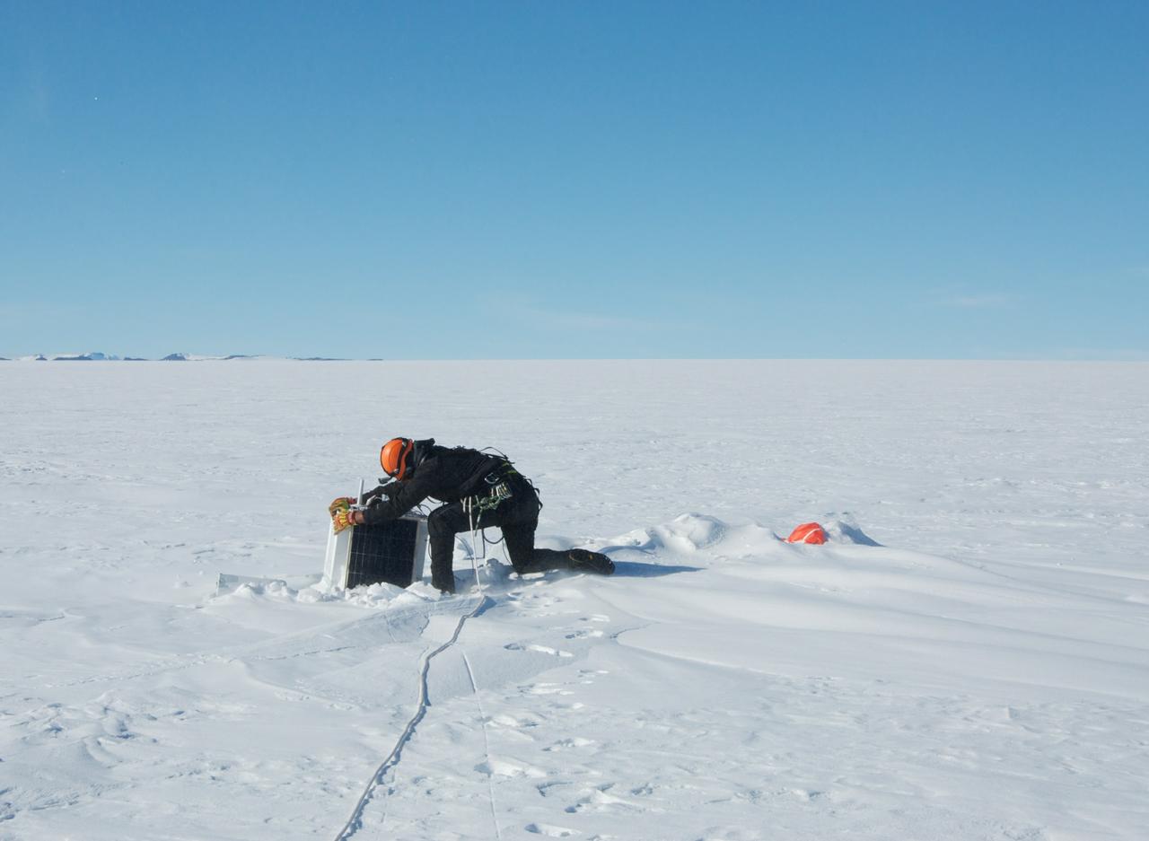
Recovery of a BARREL balloon payload after its flight. The recovery was carried out by helicopter. This area is known to be heavily crevassed so the base mountaineer is seen here with a safety rope. Credit: NASA/Goddard/BARREL/Brett Anderson Read more: <a href="http://www.nasa.gov/content/goddard/nasas-barrel-returns-successful-from-antarctica" rel="nofollow">www.nasa.gov/content/goddard/nasas-barrel-returns-success...</a> -- Three months, 20 balloons, and one very successful campaign. The team for NASA's BARREL – short for Balloon Array for Radiation belt Relativistic Electron Losses -- mission returned from Antarctica in March 2014. BARREL's job is to help unravel the mysterious Van Allen belts, two gigantic donuts of radiation that surround Earth, which can shrink and swell in response to incoming energy and particles from the sun and sometimes expose satellites to harsh radiation. While in Antarctica, the team launched 20 balloons carrying instruments that sense charged particles that are scattered into the atmosphere from the belts, spiraling down the magnetic fields near the South Pole. Each balloon traveled around the pole for up to three weeks. The team will coordinate the BARREL data with observations from NASA's two Van Allen Probes to better understand how occurrences in the belts relate to bursts of particles funneling down toward Earth. BARREL team members will be on hand at the USA Science and Engineering Festival in DC on April 26 and 27, 2014 for the exhibit Space Balloons: Exploring the Extremes of Space Weather. <b><a href="http://www.nasa.gov/audience/formedia/features/MP_Photo_Guidelines.html" rel="nofollow">NASA image use policy.</a></b> <b><a href="http://www.nasa.gov/centers/goddard/home/index.html" rel="nofollow">NASA Goddard Space Flight Center</a></b> enables NASA’s mission through four scientific endeavors: Earth Science, Heliophysics, Solar System Exploration, and Astrophysics. Goddard plays a leading role in NASA’s accomplishments by contributing compelling scientific knowledge to advance the Agency’s mission. <b>Follow us on <a href="http://twitter.com/NASAGoddardPix" rel="nofollow">Twitter</a></b> <b>Like us on <a href="http://www.facebook.com/pages/Greenbelt-MD/NASA-Goddard/395013845897?ref=tsd" rel="nofollow">Facebook</a></b> <b>Find us on <a href="http://instagram.com/nasagoddard?vm=grid" rel="nofollow">Instagram</a></b>
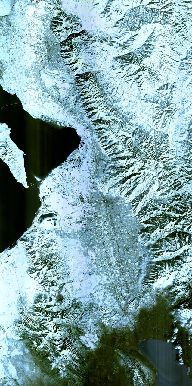
Salt Lake City, Utah, Winter 2001 The 2002 Winter Olympics are hosted by Salt Lake City at several venues within the city, in nearby cities, and within the adjacent Wasatch Mountains. This simulated natural color image presents a snowy, winter view of north central Utah that includes all of the Olympic sites. The image extends from Ogden in the north, to Provo in the south; and includes the snow-capped Wasatch Mountains and the eastern part of the Great Salt Lake. This image was acquired on February 8, 2001 by the Advanced Spaceborne Thermal Emission and Reflection Radiometer (ASTER) on NASA's Terra satellite. With its 14 spectral bands from the visible to the thermal infrared wavelength region, and its high spatial resolution of 15 to 90 meters (about 50 to 300 feet), ASTER will image Earth for the next 6 years to map and monitor the changing surface of our planet. ASTER is one of five Earth-observing instruments launched December 18,1999, on NASA's Terra satellite. The instrument was built by Japan's Ministry of Economy, Trade and Industry. A joint U.S./Japan science team is responsible for validation and calibration of the instrument and the data products. Dr. Anne Kahle at NASA's Jet Propulsion Laboratory, Pasadena, California, is the U.S. Science team leader; Bjorn Eng of JPL is the project manager. ASTER is the only high resolution imaging sensor on Terra. The Terra mission is part of NASA's Earth Science Enterprise, along-term research and technology program designed to examine Earth's land, oceans, atmosphere, ice and life as a total integrated system. The broad spectral coverage and high spectral resolution of ASTER will provide scientists in numerous disciplines with critical information for surface mapping, and monitoring dynamic conditions and temporal change. Example applications are: monitoring glacial advances and retreats; monitoring potentially active volcanoes; identifying crop stress; determining cloud morphology and physical properties; wetlands evaluation; thermal pollution monitoring; coral reef degradation; surface temperature mapping of soils and geology; and measuring surface heat balance. Image credit: NASA/GSFC/METI/ERSDAC/JAROS, and U.S./Japan ASTER Science Team Credit: <b><a href="http://www.earthobservatory.nasa.gov/" rel="nofollow"> NASA Earth Observatory</a></b> <b><a href="http://www.nasa.gov/audience/formedia/features/MP_Photo_Guidelines.html" rel="nofollow">NASA image use policy.</a></b> <b><a href="http://www.nasa.gov/centers/goddard/home/index.html" rel="nofollow">NASA Goddard Space Flight Center</a></b> enables NASA’s mission through four scientific endeavors: Earth Science, Heliophysics, Solar System Exploration, and Astrophysics. Goddard plays a leading role in NASA’s accomplishments by contributing compelling scientific knowledge to advance the Agency’s mission. <b>Follow us on <a href="http://twitter.com/NASAGoddardPix" rel="nofollow">Twitter</a></b> <b>Like us on <a href="http://www.facebook.com/pages/Greenbelt-MD/NASA-Goddard/395013845897?ref=tsd" rel="nofollow">Facebook</a></b> <b>Find us on <a href="http://instagram.com/nasagoddard?vm=grid" rel="nofollow">Instagram</a></b>

This synthetic-aperture radar (SAR) image was obtained by NASA's Cassini spacecraft on July 25, 2016, during its "T-121" pass over Titan's southern latitudes. The image shows an area nicknamed the "Xanadu annex" by members of the Cassini radar team, earlier in the mission. This area had not been imaged by until now, but measurements of its brightness temperature from Cassini's microwave radiometer were quite similar to that of the large region on Titan named Xanadu (see PIA20713), which lies just to the north. Cassini's radiometer is essentially a very sensitive thermometer, and brightness temperature is a measure of the intensity of microwave radiation received from a feature by the instrument. Radar team members predicted at the time that, if this area were ever imaged, it would be similar in appearance to Xanadu. That earlier hunch appears to have been borne out, as features in this scene bear a strong similarity to the mountainous terrains Cassini's radar has imaged in Xanadu. Xanadu -- and now perhaps its annex -- remains something of a mystery. First imaged in 1994 by the Hubble Space Telescope (just three years before Cassini's launch from Earth), Xanadu was the first surface feature to be recognized on Titan. Once thought to be a raised plateau, the region is now understood to be slightly tilted, but not higher than, the darker surrounding regions. It blocks the formation of sand dunes, which otherwise extend all the way around Titan at its equator. The area shown here is illuminated by the radar from the bottom at a 30-degree incidence angle. It measures about 155 by 310 miles (250 by 500 kilometers) and is centered at about 30 degrees south latitude, 60 degrees west longitude. http://photojournal.jpl.nasa.gov/catalog/PIA20712

In September, NASA's New Horizons team released a stunning but incomplete image of Pluto's crescent. Thanks to new processing work by the science team, New Horizons is releasing the entire, breathtaking image of Pluto. This image was made just 15 minutes after New Horizons' closest approach to Pluto on July 14, 2015, as the spacecraft looked back at Pluto toward the sun. The wide-angle perspective of this view shows the deep haze layers of Pluto's atmosphere extending all the way around Pluto, revealing the silhouetted profiles of rugged plateaus on the night (left) side. The shadow of Pluto cast on its atmospheric hazes can also be seen at the uppermost part of the disk. On the sunlit side of Pluto (right), the smooth expanse of the informally named icy plain Sputnik Planum is flanked to the west (above, in this orientation) by rugged mountains up to 11,000 feet (3,500 meters) high, including the informally named Norgay Montes in the foreground and Hillary Montes on the skyline. Below (east) of Sputnik, rougher terrain is cut by apparent glaciers. The backlighting highlights more than a dozen high-altitude layers of haze in Pluto's tenuous atmosphere. The horizontal streaks in the sky beyond Pluto are stars, smeared out by the motion of the camera as it tracked Pluto. The image was taken with New Horizons' Multi-spectral Visible Imaging Camera (MVIC) from a distance of 11,000 miles (18,000 kilometers) to Pluto. The resolution is 700 meters (0.4 miles).
This synthetic-aperture radar (SAR) image was obtained by NASA's Cassini spacecraft on July 25, 2016, during its 'T-121' pass over Titan's southern latitudes. The improved contrast provided by the denoising algorithm helps river channels (at bottom and upper left) stand out, as well as the crater-like feature at left. The image shows an area nicknamed the "Xanadu annex" by members of the Cassini radar team, earlier in the mission. This area had not been imaged by Cassini's radar until now, but measurements of its brightness temperature from Cassini's microwave radiometer were quite similar to that of the large region on Titan named Xanadu. Cassini's radiometer is essentially a very sensitive thermometer, and brightness temperature is a measure of the intensity of microwave radiation received from a feature by the instrument. Radar team members predicted at the time that, if this area were ever imaged, it would be similar in appearance to Xanadu, which lies just to the north. That earlier hunch appears to have been borne out, as features in this scene bear a strong similarity to the mountainous terrains Cassini's radar has imaged in Xanadu. Xanadu -- and now perhaps its annex -- remains something of a mystery. First imaged in 1994 by the Hubble Space Telescope (just three years before Cassini's launch from Earth), Xanadu was the first surface feature to be recognized on Titan. Once thought to be a raised plateau, the region is now understood to be slightly tilted, but not higher than, the darker surrounding regions. It blocks the formation of sand dunes, which otherwise extend all the way around Titan at its equator. The image was taken by the Cassini Synthetic Aperture radar (SAR) on July 25, 2016 during the mission's 122nd targeted Titan encounter. The image has been modified by the denoising method described in A. Lucas, JGR:Planets (2014). http://photojournal.jpl.nasa.gov/catalog/PIA20714

NASA image acquired February 24, 2012 By late February, 2012, the great European cold wave had begun to loosen its frigid grip, but significant snow still remained in the region. The Moderate Resolution Imaging Spectroradiometer (MODIS) aboard the Aqua satellite captured this true-color image of snow in Italy on February 24 at 12:35 UTC (1:30 p.m. local time). In the north of the image, bright white clouds blanket the region in a broad arc. Snow, which tends to be generally less bright that clouds, covers the Alps in the north of Italy. The Apennine Mountains, which form the backbone of the Italian peninsula, also carry a blanket of snow. Although clouds and snow can, at times, be distinguished visually in a true-color image, sometimes they can appear very similar. When it is important to clearly define snow from cloud, false color images are often helpful. Rome, which can be seen as a gray smudge on the southwestern coast of the peninsula, recorded highs of a spring-like 50°F the day this image was captured, but earlier in the month the temperatures dove as low as 26°F on February 5. During that cold snap a rare intense snowfall blanketed Rome, causing the closure of the Colosseum, the Roman Forum and the Palatine Hill due to concerns of the risk of icy footing for tourists, and roads became impassible. Further north, temperatures plummeted to −21 °C (−6 °F) on 7 February. On February 11, news media reported over 2 meters (6.5 feet) of snow had fallen in Urbino, a walled town situated on a high sloping hillside on the eastern side of the Apennine Mountains. That same snowfall cut access to many remote towns in the Apennines, blocking roads and trapping some people in the homes. Credit: NASA/GSFC/Jeff Schmaltz/MODIS Land Rapid Response Team <b><a href="http://www.nasa.gov/centers/goddard/home/index.html" rel="nofollow">NASA Goddard Space Flight Center</a></b> enables NASA’s mission through four scientific endeavors: Earth Science, Heliophysics, Solar System Exploration, and Astrophysics. Goddard plays a leading role in NASA’s accomplishments by contributing compelling scientific knowledge to advance the Agency’s mission. <b>Follow us on <a href="http://twitter.com/NASA_GoddardPix" rel="nofollow">Twitter</a></b> <b>Like us on <a href="http://www.facebook.com/pages/Greenbelt-MD/NASA-Goddard/395013845897?ref=tsd" rel="nofollow">Facebook</a></b> <b>Find us on <a href="http://instagrid.me/nasagoddard/?vm=grid" rel="nofollow">Instagram</a></b>
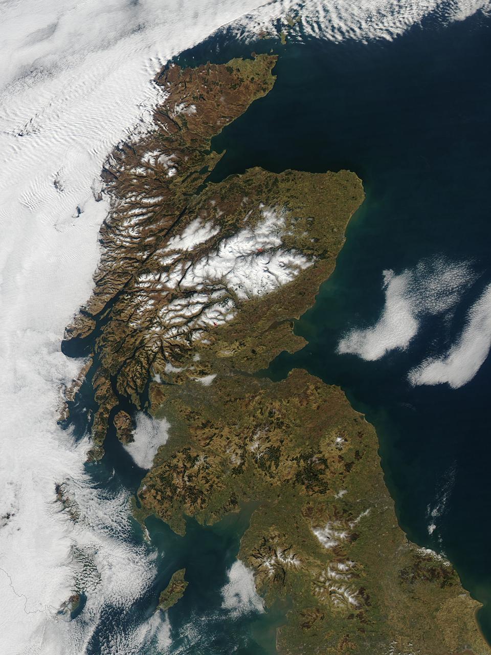
In late February, 2013 the Aqua satellite passed over Scotland as the clouds parted, allowing the Moderate Resolution Imaging Spectroradiometer (MODIS) flying aboard to capture a clear image of the late winter landscape. This image was captured at 1320 UTC (1:20 in the afternoon local time) on February 27. England makes up about the southern third of the image. The border between England and Scotland runs from the River Tweed on the east coast and the Solway Firth along the Cheviot Hills of the west coast. The Solway Firth is an estuary of the Irish Sea, and was filled with tan-colored sediment at the time of this image. Further north on the west coast of Scotland, the Firth of Clyde is hidden under a bank of low clouds (fog). Scotland’s Southern Uplands lie just north of the border and the Central Lowlands just north of that. The Grampian Mountains are found in the center of the country, and the high peaks wear a covering of snow and ice year-round. Finally the Northern Highlands can be seen peeking out from under a large bank of clouds. The Northern Highlands and the Grampian Mountains are separated by a striking feature - the Great Glen Fault. This is a 100 km-long strike-slip fault which runs from Moray Firth in the east to Fort William at the head of Loch Linnhe in the west. The Great Glen contains the United Kingdom’s deepest freshwater loch, the famous Loch Ness. Credit: NASA/GSFC/Jeff Schmaltz/MODIS Land Rapid Response Team <b><a href="http://www.nasa.gov/audience/formedia/features/MP_Photo_Guidelines.html" rel="nofollow">NASA image use policy.</a></b> <b><a href="http://www.nasa.gov/centers/goddard/home/index.html" rel="nofollow">NASA Goddard Space Flight Center</a></b> enables NASA’s mission through four scientific endeavors: Earth Science, Heliophysics, Solar System Exploration, and Astrophysics. Goddard plays a leading role in NASA’s accomplishments by contributing compelling scientific knowledge to advance the Agency’s mission. <b>Follow us on <a href="http://twitter.com/NASA_GoddardPix" rel="nofollow">Twitter</a></b> <b>Like us on <a href="http://www.facebook.com/pages/Greenbelt-MD/NASA-Goddard/395013845897?ref=tsd" rel="nofollow">Facebook</a></b> <b>Find us on <a href="http://instagram.com/nasagoddard?vm=grid" rel="nofollow">Instagram</a></b>

What looks much like craggy mountains on a moonlit evening is actually the edge of a nearby, young, star-forming region NGC 3324 in the Carina Nebula. Captured in infrared light by the Near-Infrared Camera (NIRCam) on NASA’s James Webb Space Telescope, this image reveals previously obscured areas of star birth. Called the Cosmic Cliffs, the region is actually the edge of a gigantic, gaseous cavity within NGC 3324, roughly 7,600 light-years away. The cavernous area has been carved from the nebula by the intense ultraviolet radiation and stellar winds from extremely massive, hot, young stars located in the center of the bubble, above the area shown in this image. The high-energy radiation from these stars is sculpting the nebula’s wall by slowly eroding it away. NIRCam – with its crisp resolution and unparalleled sensitivity – unveils hundreds of previously hidden stars, and even numerous background galaxies. Several prominent features in this image are described below. • The “steam” that appears to rise from the celestial “mountains” is actually hot, ionized gas and hot dust streaming away from the nebula due to intense, ultraviolet radiation. • Dramatic pillars rise above the glowing wall of gas, resisting the blistering ultraviolet radiation from the young stars. • Bubbles and cavities are being blown by the intense radiation and stellar winds of newborn stars. • Protostellar jets and outflows, which appear in gold, shoot from dust-enshrouded, nascent stars. • A “blow-out” erupts at the top-center of the ridge, spewing gas and dust into the interstellar medium. • An unusual “arch” appears, looking like a bent-over cylinder. This period of very early star formation is difficult to capture because, for an individual star, it lasts only about 50,000 to 100,000 years – but Webb’s extreme sensitivity and exquisite spatial resolution have chronicled this rare event. Located roughly 7,600 light-years away, NGC 3324 was first catalogued by James Dunlop in 1826. Visible from the Southern Hemisphere, it is located at the northwest corner of the Carina Nebula (NGC 3372), which resides in the constellation Carina. The Carina Nebula is home to the Keyhole Nebula and the active, unstable supergiant star called Eta Carinae. NIRCam was built by a team at the University of Arizona and Lockheed Martin’s Advanced Technology Center.
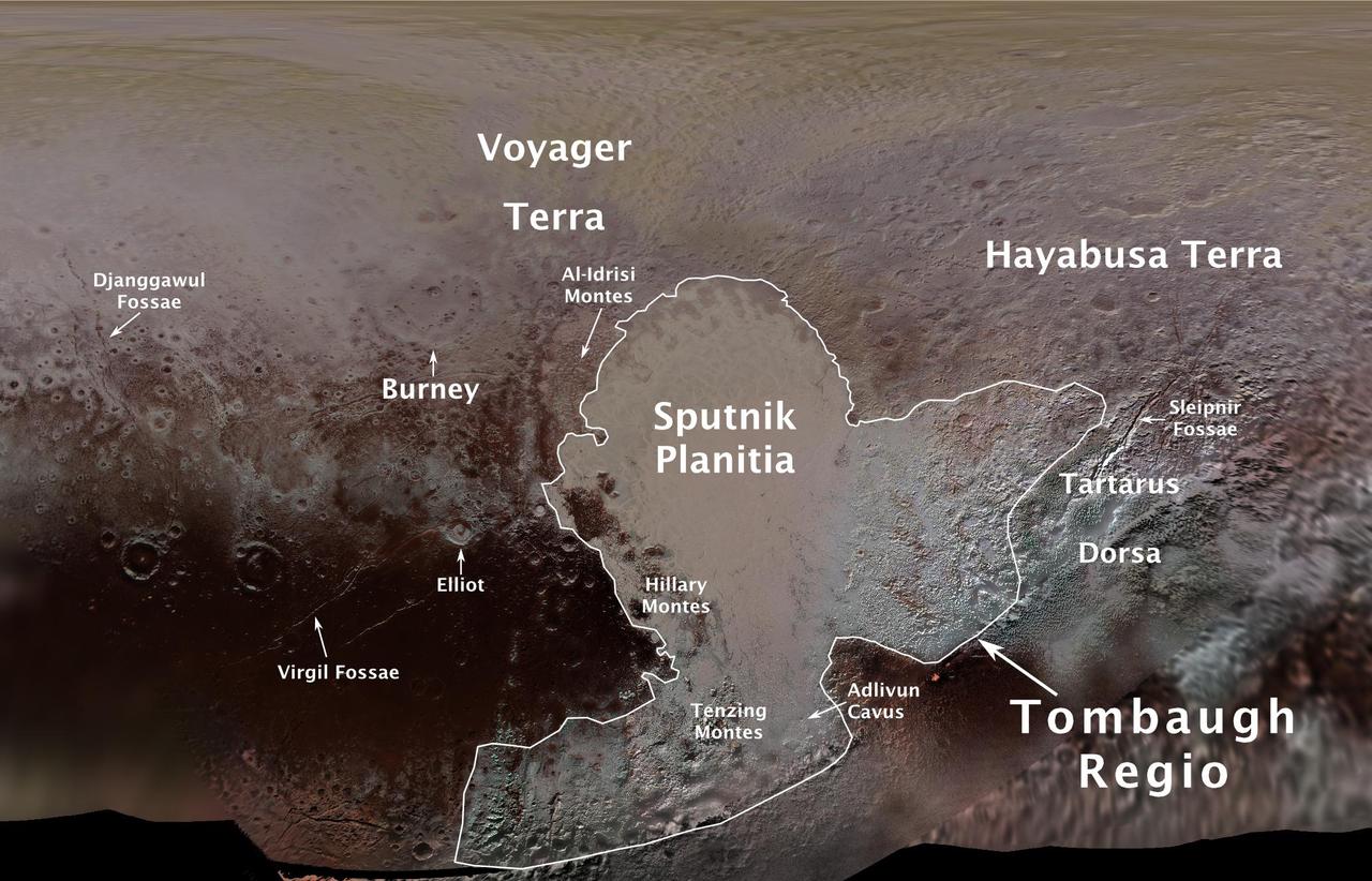
The International Astronomical Union (IAU), the internationally recognized authority for naming celestial bodies and their surface features, approved names of 14 surface features on Pluto in August 2017. The names were proposed by NASA's New Horizons team following the first reconnaissance of Pluto and its moons by the New Horizons spacecraft in 2015. The names, listed below, pay homage to the underworld mythology, pioneering space missions, historic pioneers who crossed new horizons in exploration, and scientists and engineers associated with Pluto and the Kuiper Belt. Tombaugh Regio honors Clyde Tombaugh (1906-1997), the U.S. astronomer who discovered Pluto in 1930 from Lowell Observatory in Arizona. Burney crater honors Venetia Burney (1918-2009), who as an 11-year-old schoolgirl suggested the name "Pluto" for Clyde Tombaugh's newly discovered planet. Later in life she taught mathematics and economics. Sputnik Planitia is a large plain named for Sputnik 1, the first space satellite, launched by the Soviet Union in 1957. Tenzing Montes and Hillary Montes are mountain ranges honoring Tenzing Norgay (1914-1986) and Sir Edmund Hillary (1919-2008), the Indian/Nepali Sherpa and New Zealand mountaineer were the first to reach the summit of Mount Everest and return safely. Al-Idrisi Montes honors Ash-Sharif al-Idrisi (1100-1165/66), a noted Arab mapmaker and geographer whose landmark work of medieval geography is sometimes translated as "The Pleasure of Him Who Longs to Cross the Horizons.†Djanggawul Fossae defines a network of long, narrow depressions named for the Djanggawuls, three ancestral beings in indigenous Australian mythology who traveled between the island of the dead and Australia, creating the landscape and filling it with vegetation. Sleipnir Fossa is named for the powerful, eight-legged horse of Norse mythology that carried the god Odin into the underworld. Virgil Fossae honors Virgil, one of the greatest Roman poets and Dante's fictional guide through hell and purgatory in the Divine Comedy. Adlivun Cavus is a deep depression named for Adlivun, the underworld in Inuit mythology. Hayabusa Terra is a large land mass saluting the Japanese spacecraft and mission (2003-2010) that performed the first asteroid sample return. Voyager Terra honors the pair of NASA spacecraft, launched in 1977, that performed the first "grand tour" of all four giant planets. The Voyager spacecraft are now probing the boundary between the Sun and interstellar space. Tartarus Dorsa is a ridge named for Tartarus, the deepest, darkest pit of the underworld in Greek mythology. Elliot crater recognizes James Elliot (1943-2011), an MIT researcher who pioneered the use of stellar occultations to study the solar system -- leading to discoveries such as the rings of Uranus and the first detection of Pluto's thin atmosphere. https://photojournal.jpl.nasa.gov/catalog/PIA21944
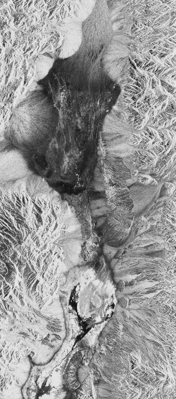
STS059-S-026 (11 April 1994) --- This is an image of Death Valley, California, centered at 36.629 degrees north latitude, 117.069 degrees west longitude. The image shows Furnace Creek alluvial fan and Furnace Creek Ranch at the far right, and the sand dunes near Stove Pipe Wells at the center. The dark fork-shaped feature between Furnace Creek fan and the dunes is a smooth flood-plain which encloses Cottonball Basin. The SIR-C/X-SAR supersite is an area of extensive field investigations and has been visited by both Space Radar Lab astronaut crews. Elevations in the Valley range from 70 meters below sea level, the lowest in the United States, to more than 3300 meters above sea level. Scientists are using SIR-C/X-SAR data from Death Valley to help answer a number of different questions about the Earth's geology. One question concerns how alluvial fans are formed and change through time under the influence of climatic changes and earthquakes. Alluvial fans are gravel deposits that wash down from the mountains over time. They are visible in the image as circular, fan-shaped bright areas extending into the darker valley floor from the mountains. Information about the alluvial fans help scientists study Earth's ancient climate. Scientists know the fans are bulit up through climatic and tectonic processes and they will use the SIR-C/X-SAR data to understand the nature and rates of weathering processes on the fans, soil formation, and the transport of sand and dust by the wind. SIR-C/X-SAR's sensitivity to centimeter-scale (or inch-scale) roughness provides detailed maps of surface texture. Such information can be used to study the occurrence and movement of dust storms and sand dunes. the goal of these studies is to gain a better understanding of the record of past climatic changes and the effects of those changes on a sensitive environment. This may lead to a better ability to predict future response of the land to different potential global cimate-change scenarios. Death Valley is also one of the primary calibration sites for SIR-C/X-SAR. The bright dots near the center of the image are corner reflectors that have been set-up to calibrate the radar as the Shuttle passes overhead. Thirty triangular-shaped reflectors (they look like aluminum pyramids) have been deployed by the calibration team from JPL over a 40 kilometer by 40 kilometer area in and around Death Valley. The calibration team will also deploy transponders (electronic reflectors) and recievers to measure the radar signals from SIR-C/X-SAR on the ground. Spaceborne Imaging Radar-C and X-Synthetic Aperture Radar (SIR-C/X-SAR) is part of NASA's Mission to Planet Earth (MTPE). The radars illuminate Earth with microwaves allowing detailed observations at any time, regardless of weather or sunlight conditions. SIR-C/X-SAR uses three microwave wavelengths: L-Band (24 cm), C-Band (6 cm), and X-Band (3 cm). The multi-frequency data will be used by the international scientific community to better understand the global environment and how it is changing. The SIR-C/X-SAR data, complemented by aircraft and ground studies, will give scientists clearer insights into those environmental changes which are caused by nature and those changes which are induced by human activity. SIR-C was develpoed by NASA's Jet Propulsion Laboratory (JPL). X-SAR was developed by the Dornire and Alenia Spazio Companies for the German Space Agency, Deutsche Agentur fuer Raumfahrtangelegenheiten (DARA), and the Italian Space Agency, Agenzia Spaziale Italiana (ASI). JPL Photo ID: P-43883

The skies over northern China were shrouded with a thick haze in late December, 2013. The Moderate Resolution Imaging Spectroradiometer (MODIS) aboard the Terra satellite captured this true-color image on December 23. The dense, gray haze obscures almost all the land and much of the coastal waters from view south and east of the Taihang Mountains. Clearer air covers the region north of the mountains, although fingers of haze roll through most river valleys. The cities of Beijing and Hebei, both west of the Bohai Sea are complete enshrouded. By December 24 the smog levels in some area exceeded World Health Organization-recommended levels by 30 times, according to Bloomberg News. The concentration of PM2.5, which are fine air particulates, were reported at 421 micrograms per cubic meter at 2 p.m. near Tiananmen Square in Beijing, while levels were 795 in Xi’an and 740 in Zhengzhou. The World Health Organization (WHO) recommends 24-hour exposure to PM2.5 concentrations no higher than 25 micrograms per cubic meter. While not the sole cause of haze and pollution, the use of coal as a very cheap energy source adds to the problem, particularly north of the Huai River. Prior to 1980, the government policy provided free coal for fuel boilers for all people living north of the Huai River. The widespread use of coal allows people in the north to stay warm in winter, but they have paid a price in air quality. According to Michael Greenstone, a Professor of Environmental Economics at Massachusetts Institute of Technology (MIT), whose research team published a paper on sustained exposure to air pollution on life expectancy in the region, air pollution, as measured by total suspended particulates, was about 55% higher north of the Huai River than south of it, for a difference of around 184 micrograms of particulate matter per cubic meter. The research, published in Proceedings of the National Academy of Sciences in July, 2013, also noted life expectancies were about 5.5 years lower in the north, owing to an increased incidence of cardiorespiratory mortality. Air pollution is an on-going issue for the government of China, and Beijing’s Five-Year Clean Air Action Plan aims to reduce overall particle density by over 25 percent on the PM2.5 scale by 2017, and also takes aim at shutting down all coal-burning plants. Credit: NASA/GSFC/Jeff Schmaltz/MODIS Land Rapid Response Team <b><a href="http://www.nasa.gov/audience/formedia/features/MP_Photo_Guidelines.html" rel="nofollow">NASA image use policy.</a></b> <b><a href="http://www.nasa.gov/centers/goddard/home/index.html" rel="nofollow">NASA Goddard Space Flight Center</a></b> enables NASA’s mission through four scientific endeavors: Earth Science, Heliophysics, Solar System Exploration, and Astrophysics. Goddard plays a leading role in NASA’s accomplishments by contributing compelling scientific knowledge to advance the Agency’s mission. <b>Follow us on <a href="http://twitter.com/NASA_GoddardPix" rel="nofollow">Twitter</a></b> <b>Like us on <a href="http://www.facebook.com/pages/Greenbelt-MD/NASA-Goddard/395013845897?ref=tsd" rel="nofollow">Facebook</a></b> <b>Find us on <a href="http://instagram.com/nasagoddard?vm=grid" rel="nofollow">Instagram</a></b>
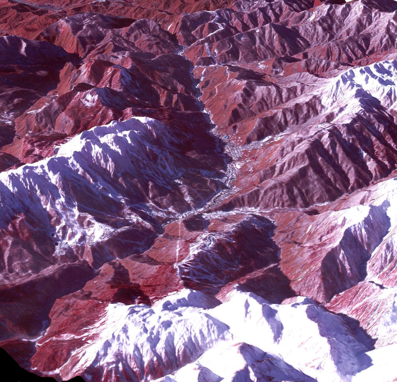
Sochi, Russia Winter Olympic Sites (Mountain Cluster) The 2014 Winter Olympic ski runs may be rated double black diamond, but they're not quite as steep as they appear in this image of the skiing and snowboarding sites for the Sochi Winter Olympic Games, acquired on Jan. 4, 2014, by the Advanced Spaceborne Thermal Emission and Reflection Radiometer (ASTER) instrument on NASA's Terra spacecraft. Rosa Khutar ski resort near Sochi, Russia, is in the valley at center, and the runs are visible on the shadowed slopes on the left-hand side of the valley. Height has been exaggerated 1.5 times to bring out topographic details. The games, which begin on Feb. 7 and continue for 17 days, feature six new skiing and boarding events plus the return of the legendary Jamaican bobsled team to the winter games for the first time since 2002. In this southwest-looking image, red indicates vegetation, white is snow, and the resort site appears in gray. The area imaged is about 11 miles (18 kilometers) across in the foreground and 20 miles (32 kilometers) from front to back. The image was created from the ASTER visible and near-infrared bands, draped over ASTER-derived digital elevation data. With its 14 spectral bands from the visible to the thermal infrared wavelength region and its high spatial resolution of 15 to 90 meters (about 50 to 300 feet), ASTER images Earth to map and monitor the changing surface of our planet. ASTER is one of five Earth-observing instruments launched Dec. 18, 1999, on Terra. The instrument was built by Japan's Ministry of Economy, Trade and Industry. A joint U.S./Japan science team is responsible for validation and calibration of the instrument and data products. The broad spectral coverage and high spectral resolution of ASTER provides scientists in numerous disciplines with critical information for surface mapping and monitoring of dynamic conditions and temporal change. Example applications are: monitoring glacial advances and retreats; monitoring potentially active volcanoes; identifying crop stress; determining cloud morphology and physical properties; wetlands evaluation; thermal pollution monitoring; coral reef degradation; surface temperature mapping of soils and geology; and measuring surface heat balance. The U.S. science team is located at NASA's Jet Propulsion Laboratory, Pasadena, Calif. The Terra mission is part of NASA's Science Mission Directorate, Washington, D.C. More information about ASTER is available at <a href="http://asterweb.jpl.nasa.gov/" rel="nofollow">asterweb.jpl.nasa.gov/</a>. credit:NASA/GSFC/METI/ERSDAC/JAROS, and U.S./Japan ASTER Science Team <b><a href="http://www.nasa.gov/audience/formedia/features/MP_Photo_Guidelines.html" rel="nofollow">NASA image use policy.</a></b> <b><a href="http://www.nasa.gov/centers/goddard/home/index.html" rel="nofollow">NASA Goddard Space Flight Center</a></b> enables NASA’s mission through four scientific endeavors: Earth Science, Heliophysics, Solar System Exploration, and Astrophysics. Goddard plays a leading role in NASA’s accomplishments by contributing compelling scientific knowledge to advance the Agency’s mission. <b>Follow us on <a href="http://twitter.com/NASAGoddardPix" rel="nofollow">Twitter</a></b> <b>Like us on <a href="http://www.facebook.com/pages/Greenbelt-MD/NASA-Goddard/395013845897?ref=tsd" rel="nofollow">Facebook</a></b> <b>Find us on <a href="http://instagram.com/nasagoddard?vm=grid" rel="nofollow">Instagram</a></b>
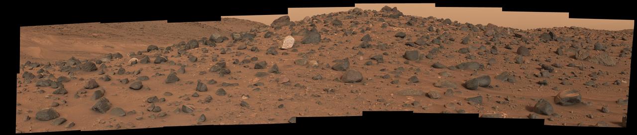
Composed of 18 images, this natural-color mosaic shows a boulder field on "Mount Washburn" (named after a mountain in Wyoming) in Mars' Jezero Crater. The Perseverance science team nicknamed the light-toned boulder with dark speckles near the center of the mosaic "Atoko Point" (after a feature in the eastern Grand Canyon). The images were acquired by NASA's Perseverance Mars rover on May 27, 2024, the 1,162nd Martian day, or sol, of the mission. Analysis by the rover's SuperCam and Mastcam-Z instruments indicate Atoko Point is composed of the mineral pyroxene, similar to some boulders the rover has encountered elsewhere in Jezero Crater. In terms of the size, shape, and arrangement of its mineral grains and crystals – and potentially its chemical composition – Atoko Point is different from any of the rocks the rover has encountered before. Some Perseverance scientists speculate the minerals that make up Atoko Point were produced in a subsurface body of magma that is possibly exposed now on the crater rim. Others on the team wonder if the boulder, which stands about 18 inches (45 centimeters) wide and 14 inches (35 centimeters) tall, had been created far beyond the walls of Jezero and transported there by swift Martian waters eons ago. Arizona State University leads the operations of the Mastcam-Z instrument, working in collaboration with Malin Space Science Systems in San Diego, on the design, fabrication, testing, and operation of the cameras, and in collaboration with the Niels Bohr Institute of the University of Copenhagen on the design, fabrication, and testing of the calibration targets. A key objective for Perseverance's mission on Mars is astrobiology, including the search for signs of ancient microbial life. The rover will characterize the planet's geology and past climate, pave the way for human exploration of the Red Planet, and be the first mission to collect and cache Martian rock and regolith (broken rock and dust). Subsequent NASA missions, in cooperation with ESA (European Space Agency), would send spacecraft to Mars to collect these sealed samples from the surface and return them to Earth for in-depth analysis. The Mars 2020 Perseverance mission is part of NASA's Moon to Mars exploration approach, which includes Artemis missions to the Moon that will help prepare for human exploration of the Red Planet. https://photojournal.jpl.nasa.gov/catalog/PIA26333
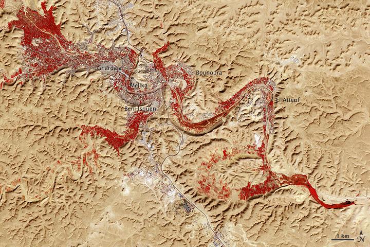
NASA image acquired Feb. 9, 2011 Less than 5 percent of Algeria’s land surface is suitable for growing crops, and most precipitation falls on the Atlas Mountains along the coast. Inland, dust-laden winds blow over rocky plains and sand seas. However, in north central Algeria—off the tip of Grand Erg Occidental and about 450 kilometers (280 miles) south of Algiers—lies a serpentine stretch of vegetation. It is the M’zab Valley, filled with palm groves and dotted with centuries-old settlements. The Advanced Spaceborne Thermal Emission and Reflection Radiometer (ASTER) on NASA’s Terra satellite captured this image of M’zab Valley on February 9, 2011. ASTER combines infrared, red, and green wavelengths of light. Bare rock ranges in color from beige to peach. Buildings and paved surfaces appear gray. Vegetation is red, and brighter shades of red indicate more robust vegetation. This oasis results from water that is otherwise in short supply in the Sahara Desert, thanks to the valley’s approximately 3,000 wells. Chemical analysis of Algerian aquifers, as well studies of topography in Algeria and Tunisia, suggest this region experienced a cooler climate in the late Pleistocene, and potentially heavy monsoon rains earlier in the Holocene. The M’zab region shows evidence of meandering rivers and pinnate drainage patterns. The vegetation lining M’zab Valley highlights this old river valley’s contours. Cool summer temperatures and monsoon rains had long since retreated from the region by eleventh century, but this valley nevertheless supported the establishment of multiple fortified settlements, or ksours. Between 1012 A.D. and 1350 A.D., locals established the ksours of El-Atteuf, Bounoura, Melika, Ghardaïa, and Beni-Isguen. Collectively these cities are now a United Nations Educational, Scientific, and Cultural Organization (UNESCO) World Heritage site. NASA Earth Observatory image by Robert Simmon and Jesse Allen, using data from the GSFC/METI/ERSDAC/JAROS, and U.S./Japan ASTER Science Team. Caption by Michon Scott. Instrument: Terra - ASTER <b>To download the full high res file go <a href="http://earthobservatory.nasa.gov/IOTD/view.php?id=51296" rel="nofollow"> here</a></b>
Scientists think that ancient groundwater formed this weblike pattern of ridges, called boxwork, that were captured by NASA's Mars Reconnaissance Orbiter on Dec. 10, 2006. The agency's Curiosity rover will study ridges similar to these up close in 2025. Boxwork can form on Earth when groundwater flows through a web of rock fractures underground. Minerals carried by the water can coat the cracks and be deposited within the rock nearby. Eons later, if the rock erodes away, the minerals filling the cracks or the hardened rock leave a weblike pattern of ridges exposed. In the area captured by HiRISE, dark sand filled the spaces between these ridges, making them stand out more dramatically in the black-and-white image. The Martian boxwork Curiosity is headed toward formed in the foothills of lower Mount Sharp, a 3-mile-tall (5-kilometer-tall) mountain the rover has been ascending since 2014. Mount Sharp's boxwork structures stand apart from those on Earth, both because they formed as water was disappearing from Mars and because they're so extensive, running as long as 6 to 12 miles (10 to 20 kilometers). Scientists are eager to study them up close because minerals in the Martian boxwork crystallized underground, where it would have been warmer, with liquid flowing through. The rover's science team will study whether microbes could have survived in that ancient environment. https://photojournal.jpl.nasa.gov/catalog/PIA26306
The Moderate Resolution Imaging Spectroradiometer (MODIS) on the Aqua satellite captured this stunning view of Japan’ four largest islands on February 20, 2004. The snow-covered southern arm of Hokkaido extends into the upper left corner. Honshu, Japan’s largest island, curves across the center of the image. Shikoku, right, and Kyushu, left, form the southern tip of the group. Japan is mostly mountainous, and, as the dusting of snow in this image shows, is cold in the north and more tropical in the south. A single red dot marks the location of an active fire. Credit: Jeff Schmaltz, MODIS Rapid Response Team, NASA/GSFC <b><a href="http://www.nasa.gov/audience/formedia/features/MP_Photo_Guidelines.html" rel="nofollow">NASA image use policy.</a></b> <b><a href="http://www.nasa.gov/centers/goddard/home/index.html" rel="nofollow">NASA Goddard Space Flight Center</a></b> enables NASA’s mission through four scientific endeavors: Earth Science, Heliophysics, Solar System Exploration, and Astrophysics. Goddard plays a leading role in NASA’s accomplishments by contributing compelling scientific knowledge to advance the Agency’s mission. <b>Follow us on <a href="http://twitter.com/NASAGoddardPix" rel="nofollow">Twitter</a></b> <b>Like us on <a href="http://www.facebook.com/pages/Greenbelt-MD/NASA-Goddard/395013845897?ref=tsd" rel="nofollow">Facebook</a></b> <b>Find us on <a href="http://instagram.com/nasagoddard?vm=grid" rel="nofollow">Instagram</a></b>
The Ralph instrument on NASA's New Horizons spacecraft detected water ice on Pluto's surface, picking up on the ice's near-infrared spectral characteristics. (See featured image from Oct. 8, 2015.) The middle panel shows a region west of Pluto's "heart" feature -- which the mission team calls Tombaugh Regio -- about 280 miles (450 kilometers) across. It combines visible imagery from Ralph's Multispectral Visible Imaging Camera (MVIC) with infrared spectroscopy from the Linear Etalon Imaging Spectral Array (LEISA). Areas with the strongest water ice spectral signature are highlighted in blue. Major outcrops of water ice occur in regions informally called Viking Terra, along Virgil Fossa west of Elliot crater, and in Baré Montes. Numerous smaller outcrops are associated with impact craters and valleys between mountains. In the lower left panel, LEISA spectra are shown for two regions indicated by cyan and magenta boxes. The white curve is a water ice model spectrum, showing similar features to the cyan spectrum. The magenta spectrum is dominated by methane ice absorptions. The lower right panel shows an MVIC enhanced color view of the region in the white box, with MVIC's blue, red and near-infrared filters displayed in blue, green and red channels, respectively. The regions showing the strongest water ice signature are associated with terrains that are actually a lighter shade of red. http://photojournal.jpl.nasa.gov/catalog/PIA20030
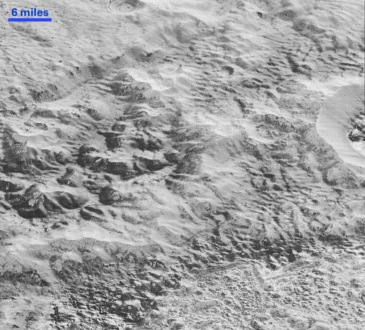
This highest-resolution image from NASA's New Horizons spacecraft shows how erosion and faulting has sculpted this portion of Pluto's icy crust into rugged badlands. The prominent 1.2-mile-high cliff at the top, running from left to upper right, is part of a great canyon system that stretches for hundreds of miles across Pluto's northern hemisphere. New Horizons team members think that the mountains in the middle are made of water ice, but have been modified by the movement of nitrogen or other exotic ice glaciers over long periods of time, resulting in a muted landscape of rounded peaks and intervening sets of short ridges. At the bottom of this 50-mile-wide image, the terrain transforms dramatically into a fractured and finely broken up floor at the northwest margin of the giant ice plain informally called Sputnik Planum. The top of the image is to Pluto's northwest. These images were made with the telescopic Long Range Reconnaissance Imager (LORRI) aboard New Horizons, in a timespan of about a minute centered on 11:36 UT on July 14 -- just about 15 minutes before New Horizons' closest approach to Pluto -- from a range of just 10,000 miles (17,000 kilometers). They were obtained with an unusual observing mode; instead of working in the usual "point and shoot," LORRI snapped pictures every three seconds while the Ralph/Multispectral Visual Imaging Camera (MVIC) aboard New Horizons was scanning the surface. This mode requires unusually short exposures to avoid blurring the images. http://photojournal.jpl.nasa.gov/catalog/PIA20199
Since NASA's Earth Surface Mineral Dust Source Investigation (EMIT) imaging spectrometer was installed on the International Space Station in late July 2022, the EMIT science team has been validating its data against data gathered in 2018 by NASA's Airborne Visible/Infrared Imaging Spectrometer (AVIRIS). EMIT recently collected data from a mountainous area of Nevada about 130 miles (209 kilometers) northeast of Lake Tahoe. The instrument measures reflected solar energy from Earth across hundreds of wavelengths from the visible to the infrared range of the spectrum. The intensity of the reflected light varies by wavelength based on the material. Scientists use these patterns, called spectral fingerprints, to pinpoint the locations of surface minerals on a map. The top left map shows the region both the EMIT and AVIRIS data sets cover. The center image is a mineral map featuring AVIRIS data. At right is a map generated with EMIT data. The center and right images reveal portions of the landscape dominated by kaolinite, a light-colored clay mineral that scatters sunlight. This comparison, which shows a close match of the data, was one of many that confirmed the accuracy of EMIT's data. The bottom row features an AVIRIS spectral fingerprint, left, beside EMIT data for the same location. The graphs show agreement in the kaolinite fingerprint region, which is marked in blue. Over the course of its 12-month mission, EMIT will collect measurements of 10 important surface minerals – kaolinite, hematite, goethite, illite, vermiculite, calcite, dolomite, montmorillonite, chlorite, and gypsum – in arid regions between 50-degree south and north latitudes in Africa, Asia, North and South America, and Australia. The data EMIT collects will help scientists better understand the role of airborne dust particles in heating and cooling Earth's atmosphere on global and regional scales. https://photojournal.jpl.nasa.gov/catalog/PIA25428
Topography of Earth's moon generated from data collected by the Lunar Orbiter Laser Altimeter, aboard NASA's Lunar Reconnaissance Orbiter, with the gravity anomalies bordering the Procellarum region superimposed in blue. The border structures are shown using gravity gradients calculated with data from NASA's Gravity Recovery and Interior Laboratory (GRAIL) mission. These gravity anomalies are interpreted as ancient lava-flooded rift zones buried beneath the volcanic plains (or maria) on the nearside of the Moon. Launched as GRAIL A and GRAIL B in September 2011, the probes, renamed Ebb and Flow, operated in a nearly circular orbit near the poles of the moon at an altitude of about 34 miles (55 kilometers) until their mission ended in December 2012. The distance between the twin probes changed slightly as they flew over areas of greater and lesser gravity caused by visible features, such as mountains and craters, and by masses hidden beneath the lunar surface. The twin spacecraft flew in a nearly circular orbit until the end of the mission on Dec. 17, 2012, when the probes intentionally were sent into the moon's surface. NASA later named the impact site in honor of late astronaut Sally K. Ride, who was America's first woman in space and a member of the GRAIL mission team. GRAIL's prime and extended science missions generated the highest-resolution gravity field map of any celestial body. The map will provide a better understanding of how Earth and other rocky planets in the solar system formed and evolved. The GRAIL mission was managed by NASA's Jet Propulsion Laboratory (JPL) in Pasadena, California, for NASA's Science Mission Directorate in Washington. The mission was part of the Discovery Program managed at NASA's Marshall Space Flight Center in Huntsville, Alabama. GRAIL was built by Lockheed Martin Space Systems in Denver. For more information about GRAIL, please visit <a href="http://grail.nasa.gov" rel="nofollow">grail.nasa.gov</a>. Credit: NASA/Colorado School of Mines/MIT/GSFC/Scientific Visualization Studio
The Advanced Rapid Imaging and Analysis (ARIA) team at NASA's Jet Propulsion Laboratory in Pasadena, California, and Caltech, also in Pasadena, created a Damage Proxy Map (DPM) depicting areas in Southern California that are likely damaged (shown by red and yellow pixels) as a result of recent wildfires, including the Thomas Fire in Ventura and Santa Barbara Counties, highlighted in the attached image taken from the DPM. The map is derived from synthetic aperture radar (SAR) images from the Copernicus Sentinel-1 satellites, operated by the European Space Agency (ESA). The images were taken before (Nov. 28, 2017, 6 a.m. PST) and after (Dec. 10, 2017, 6 a.m. PST) the onset of the fires. The map covers an area of 107 by 107 miles (172 by 172 kilometers), shown by the large red polygon. Each pixel measures about 33 yards (30 meters) across. The color variation from yellow to red indicates increasingly more significant ground surface change. Preliminary validation was done by comparing the map to optical satellite imagery from DigitalGlobe. This damage proxy map should be used as guidance to identify damaged areas, and may be less reliable over vegetated areas. For example, the colored pixels seen over mountainous areas may seem a little scattered even though the reality could be that the contiguous areas were burned. Patches of farmland can also appear as signals due to plowing or irrigation. The full map is available to download from https://aria-share.jpl.nasa.gov/events/20171210-SoCal_Fire/. https://photojournal.jpl.nasa.gov/catalog/PIA22191
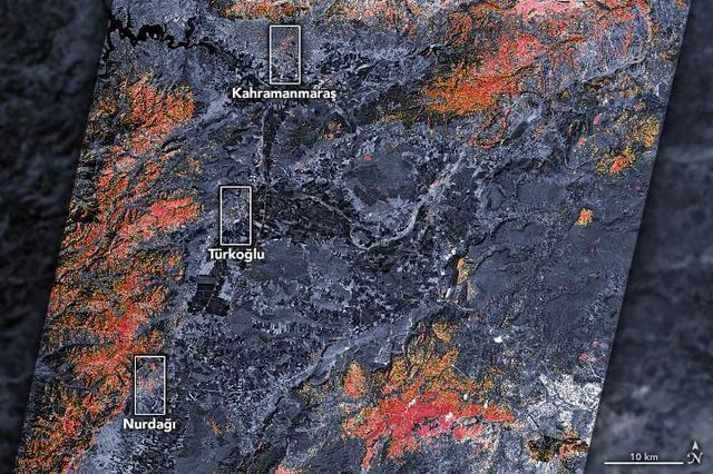
The magnitude 7.8 and 7.5 earthquakes that struck southern Turkey and western Syria on February 6, 2023, caused widespread destruction in both countries. The initial, stronger earthquake emanated from a fault 11 miles (18 kilometers) below the surface. The shallow depth meant the earthquake produced violent shaking that affected areas hundreds of miles from the epicenter, 16 miles (26 kilometers) east of the city of Nurdağı, Turkey. The second quake followed nine hours later, striking 6 miles (10 kilometers) deep, roughly 2.5 miles (4 kilometers) south-southeast of the Turkish town of Ekinözü. Hundreds of smaller aftershocks occurred in subsequent days. The preliminary damage proxy map above shows parts of the Turkish cities of Islahiye, Kahramanmaras, and Nurdağı. Dark red pixels represent areas likely to have severe damage to buildings, homes, and infrastructure or changes to landscape, while orange and yellow areas are moderately or partially damaged. Each pixel measures about 100 feet (30 meters) across (about the size of a baseball infield). The damage estimates are most accurate for urban areas and may be less accurate in the mountain and vegetated areas. The Earth Observatory of Singapore – Remote Sensing Lab and the Advanced Rapid Imaging and Analysis (ARIA) team at NASA's Jet Propulsion Laboratory and Caltech collaborated to derive the map from data collected by Japan's Advanced Land Observing Satellite-2 satellite (ALOS-2) on February 8, 2023. The satellite carries a synthetic aperture radar, a sensor that sends pulses of microwaves toward Earth's surface and records for the reflections of those waves to map the landscape, including buildings. By comparing the February 8 data to observations made by the same satellite before the earthquake (on April 7, 2021 and April 6, 2022), scientists tracked the changes and began to identify areas that were likely damaged. https://photojournal.jpl.nasa.gov/catalog/PIA25564
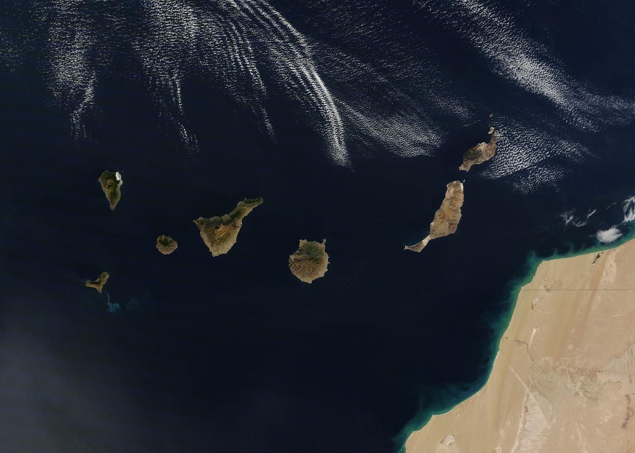
NASA image acquired December 21, 2011 The rugged landscape of the Canary Islands stood out in sharp contrast to the smooth blue waters of the Atlantic Ocean and the flat tan land of northwestern Africa on December 21, 2011, when the Moderate Resolution Imaging Spectroradiometer (MODIS) aboard the Terra satellite captured this true-color image. The Canary Islands are a group of seven large islands and several smaller islets, all volcanic in origin. The eastern edge of the chain lies only 100 kilometers from the coasts of Morocco and Western Sahara, and the chain stretches for about 500 kilometers across the Atlantic. All the islands are mountainous, and Tenerife, the central island in this image is home to Pico de Teinde, the highest peak, which rises 12,198 feet (3,718 meters) above sea level. From east to west, the islands are named Lanzarote, Fuerteventura, Gran Canaria, Tenerife, La Gomera, La Palmera and El Hierro. A bright swirl of peacock blue marks the ocean south of El Hierro, a stain on the sea from an ongoing eruption of a volcano under the waters. Credit: NASA/GSFC/Jeff Schmaltz/MODIS Land Rapid Response Team <b><a href="http://www.nasa.gov/audience/formedia/features/MP_Photo_Guidelines.html" rel="nofollow">NASA image use policy.</a></b> <b><a href="http://www.nasa.gov/centers/goddard/home/index.html" rel="nofollow">NASA Goddard Space Flight Center</a></b> enables NASA’s mission through four scientific endeavors: Earth Science, Heliophysics, Solar System Exploration, and Astrophysics. Goddard plays a leading role in NASA’s accomplishments by contributing compelling scientific knowledge to advance the Agency’s mission. <b>Follow us on <a href="http://twitter.com/NASA_GoddardPix" rel="nofollow">Twitter</a></b> <b>Like us on <a href="http://www.facebook.com/pages/Greenbelt-MD/NASA-Goddard/395013845897?ref=tsd" rel="nofollow">Facebook</a></b> <b>Find us on <a href="http://instagrid.me/nasagoddard/?vm=grid" rel="nofollow">Instagram</a></b>
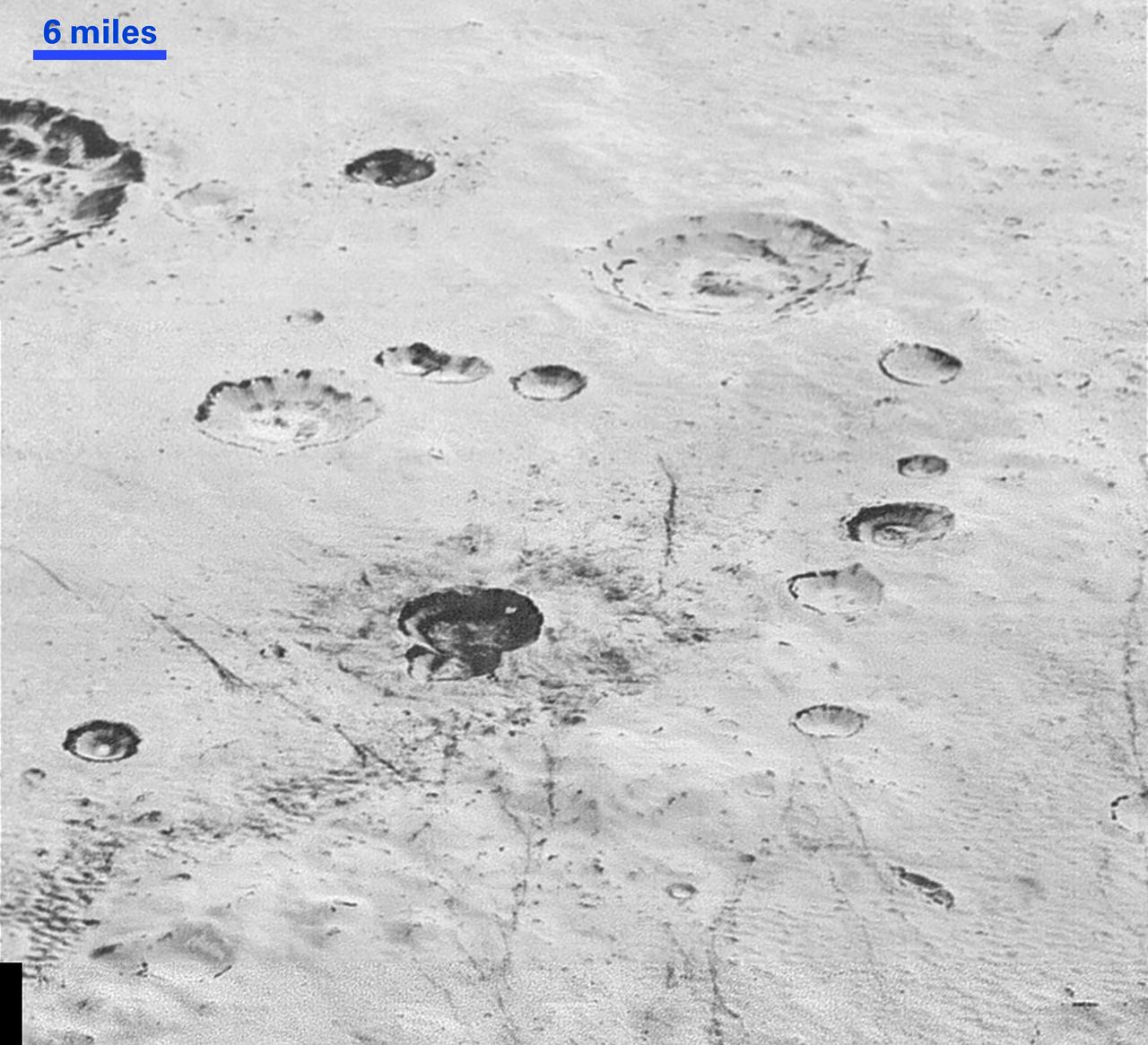
This highest-resolution image from NASA's New Horizons spacecraft reveals new details of Pluto's rugged, icy cratered plains. Notice the layering in the interior walls of many craters (the large crater at upper right is a good example) -- layers in geology usually mean an important change in composition or event but at the moment New Horizons team members do not know if they are seeing local, regional or global layering. The darker crater in the lower center is apparently younger than the others, because dark material ejected from within -- its "ejecta blanket" -- have not been erased and can still be made out. The origin of the many dark linear features trending roughly vertically in the bottom half of the image is under debate, but may be tectonic. Most of the craters seen here lie within the 155-mile (250-kilometer)-wide Burney Basin, whose outer rim or ring forms the line of hills or low mountains at bottom. The basin is informally named after Venetia Burney, the English schoolgirl who first proposed the name "Pluto" for the newly discovered planet in 1930. The top of the image is to Pluto's northwest. These images were made with the telescopic Long Range Reconnaissance Imager (LORRI) aboard New Horizons, in a timespan of about a minute centered on 11:36 UT on July 14 -- just about 15 minutes before New Horizons' closest approach to Pluto-- from a range of just 10,000 miles (17,000 kilometers). They were obtained with an unusual observing mode; instead of working in the usual "point and shoot," LORRI snapped pictures every three seconds while the Ralph/Multispectral Visual Imaging Camera (MVIC) aboard New Horizons was scanning the surface. This mode requires unusually short exposures to avoid blurring the images. http://photojournal.jpl.nasa.gov/catalog/PIA20200
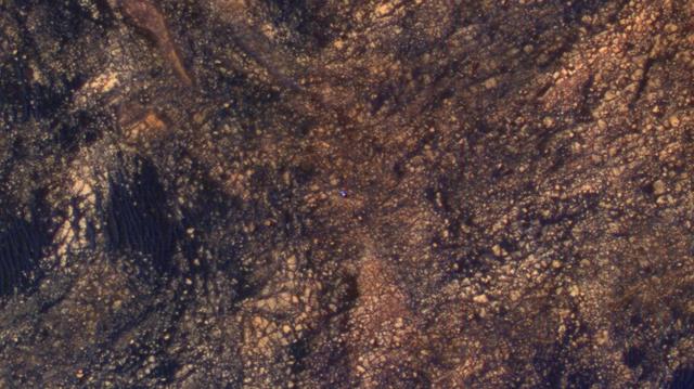
The feature that appears bright blue at the center of this scene is NASA's Curiosity Mars rover on the northwestern flank of Mount Sharp, viewed by NASA's Mars Reconnaissance Orbiter. Curiosity is approximately 10 feet long and 9 feet wide (3.0 meters by 2.8 meters). The view is a cutout from observation ESP_050897_1750 taken by the High Resolution Imaging Science Experiment (HiRISE) camera on the orbiter on June 5, 2017. HiRISE has been imaging Curiosity about every three months, to monitor the surrounding features for changes such as dune migration or erosion. When the image was taken, Curiosity was partway between its investigation of active sand dunes lower on Mount Sharp, and "Vera Rubin Ridge," a destination uphill where the rover team intends to examine outcrops where hematite has been identified from Mars orbit. The rover's surroundings include tan rocks and patches of dark sand. As in previous HiRISE color images of Curiosity since the rover was at its landing site, the rover appears bluer than it really is. HiRISE color observations are recorded in a red band, a blue-green band and an infrared band, and displayed in red, green and blue. This helps make differences in Mars surface materials apparent, but does not show natural color as seen by the human eye. Lower Mount Sharp was chosen as a destination for the Curiosity mission because the layers of the mountain offer exposures of rocks that record environmental conditions from different times in the early history of the Red Planet. Curiosity has found evidence for ancient wet environments that offered conditions favorable for microbial life, if Mars has ever hosted life. https://photojournal.jpl.nasa.gov/catalog/PIA21710
![More than 70% of the world's hazelnuts come from Turkey, and about 60% come from the Eastern Black Sea region on the slopes of the Pontic mountain range, around the ancient coastal city of Giresun. The tradition of hazelnut farming goes back thousands of years. Presently, most of the hazelnut products are processed by women [BBC Travel]. The image was acquired August 15, 2024, covers an area of 35.7 by 36.2 km, and is located at 40.9 degrees north, 38.4 degrees east. With its 14 spectral bands from the visible to the thermal infrared wavelength region and its high spatial resolution of about 50 to 300 feet (15 to 90 meters), ASTER images Earth to map and monitor the changing surface of our planet. ASTER is one of five Earth-observing instruments launched Dec. 18, 1999, on Terra. The instrument was built by Japan's Ministry of Economy, Trade and Industry. A joint U.S./Japan science team is responsible for validation and calibration of the instrument and data products. The broad spectral coverage and high spectral resolution of ASTER provides scientists in numerous disciplines with critical information for surface mapping and monitoring of dynamic conditions and temporal change. Example applications are monitoring glacial advances and retreats; monitoring potentially active volcanoes; identifying crop stress; determining cloud morphology and physical properties; wetlands evaluation; thermal pollution monitoring; coral reef degradation; surface temperature mapping of soils and geology; and measuring surface heat balance. https://photojournal.jpl.nasa.gov/catalog/PIA26450](https://images-assets.nasa.gov/image/PIA26450/PIA26450~medium.jpg)
More than 70% of the world's hazelnuts come from Turkey, and about 60% come from the Eastern Black Sea region on the slopes of the Pontic mountain range, around the ancient coastal city of Giresun. The tradition of hazelnut farming goes back thousands of years. Presently, most of the hazelnut products are processed by women [BBC Travel]. The image was acquired August 15, 2024, covers an area of 35.7 by 36.2 km, and is located at 40.9 degrees north, 38.4 degrees east. With its 14 spectral bands from the visible to the thermal infrared wavelength region and its high spatial resolution of about 50 to 300 feet (15 to 90 meters), ASTER images Earth to map and monitor the changing surface of our planet. ASTER is one of five Earth-observing instruments launched Dec. 18, 1999, on Terra. The instrument was built by Japan's Ministry of Economy, Trade and Industry. A joint U.S./Japan science team is responsible for validation and calibration of the instrument and data products. The broad spectral coverage and high spectral resolution of ASTER provides scientists in numerous disciplines with critical information for surface mapping and monitoring of dynamic conditions and temporal change. Example applications are monitoring glacial advances and retreats; monitoring potentially active volcanoes; identifying crop stress; determining cloud morphology and physical properties; wetlands evaluation; thermal pollution monitoring; coral reef degradation; surface temperature mapping of soils and geology; and measuring surface heat balance. https://photojournal.jpl.nasa.gov/catalog/PIA26450
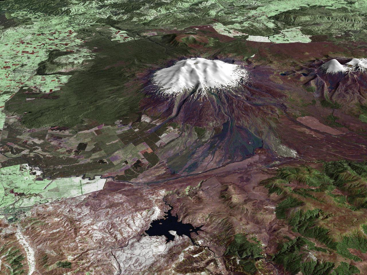
All around the world, people live in places where the threat of natural disaster is high. On the North Island of New Zealand, the Mount Ruapehu volcano is just such a threat. A towering, active stratovolcano (the classic cone-shaped volcano), snow-capped Ruapehu Volcano is pictured in this enhanced-color image. The image is made from topography data collected by the Shuttle Radar Topography Mission aboard the Space Shuttle Endeavour, launched on February 11, 2000, and imagery collected by the Landsat satellite on October 23, 2002. Ruapehu is one of New Zealand’s most active volcanoes, with ten eruptions since 1861. The eruptions aren’t the only threat from the volcano, however. Among the most serious threats is a volcanic mudflow called a lahar. In between eruptions, a lake forms in the volcano’s caldera from melting snow. If a previous eruption has deposited a dam of ash, rocks and mud in the lake’s natural overflow point, then the lake becomes dangerously full, held back only by the temporary dam. In this scene, the lake is nestled among the ridges at the top of the volcano. Eventually, the dam gives way and a massive flow of mud and debris churns down the mountain toward farmland and towns below. Scientists estimate that Ruapehu has experienced 60 lahars in the last 150 years. A devastating lahar in 1953 killed more than 150 people, who died when a passenger train plunged into a ravine when a railroad bridge was taken out by the lahar. The flank of the volcano below the lake is deeply carved by the path of previous lahars; the gouge can be seen just left of image center. Currently scientists in the region are predicting that the lake will overflow in a lahar sometime in the next year. There is great controversy about how to deal with the threat. News reports from the region indicate that the government is planning to invest in a high-tech warning system that will alert those who might be affected well in advance of any catastrophic release. Others feel that the government should combat the threat through engineering at the top of the mountain, for example, by undertaking a controlled release of the lake. Credit Landsat data provided courtesy of the University of Maryland Global Land Cover Facility Landsat processing by Laura Rocchio, Landsat Project Science Office SRTM 3-arcsecond elevation data courtesy of SRTM Team NASA/JPL/NIMA Visualization created by Earth Observatory staff. <b><a href="http://www.nasa.gov/centers/goddard/home/index.html" rel="nofollow">NASA Goddard Space Flight Center</a></b> enables NASA’s mission through four scientific endeavors: Earth Science, Heliophysics, Solar System Exploration, and Astrophysics. Goddard plays a leading role in NASA’s accomplishments by contributing compelling scientific knowledge to advance the Agency’s mission. <b>Follow us on <a href="http://twitter.com/NASA_GoddardPix" rel="nofollow">Twitter</a></b> <b>Join us on <a href="http://www.facebook.com/pages/Greenbelt-MD/NASA-Goddard/395013845897?ref=tsd" rel="nofollow">Facebook</a></b>
An Earth-monitoring instrument aboard NASA's Terra satellite is keeping a close eye on a potential glacial disaster in the making in Peru's spectacular, snow-capped Cordillera Blanca (White Mountains), the highest range of the Peruvian Andes. Data from NASA's Advanced Spaceborne Thermal Emission and Reflection Radiometer (Aster) is assisting Peruvian government officials and geologists in monitoring a glacier that feeds Lake Palcacocha, located high above the city of Huaraz, 270 kilometers (168 miles) north of Lima. An ominous crack has developed in the glacier. Should the large glacier chunk break off and fall into the lake, the ensuing flood could hurtle down the Cojup Valley into the Rio Santa Valley below, reaching Huaraz, population 60,000, in less than 15 minutes. "Glacial natural hazards like the one in Huaraz are an increasing threat to people in many parts of the world," said Dr. Michael Abrams, associate Aster team leader at NASA's Jet Propulsion Laboratory, Pasadena, Calif. "Remote sensing instruments like Aster can serve a vital role in mountain hazard management and disaster mapping by providing rapid access to data, even in regions not easily accessible by humans. Aster's unique vantage point from space gives scientists another tool with which to see early signs of potential glacial flood-burst events and to monitor changes in glacial behavior over time. In Huaraz, Peruvian authorities and scientists will incorporate Aster data along with data from ground-based monitoring techniques to better assess current conditions and take steps necessary to reduce risks to human lives and property." Comparison images of the area are available at: http://asterweb.jpl.nasa.gov . Huaraz can be seen in the images' left-center, with Lake Palcacocha in the images' upper right corners at the head of a valley, below the snow and glacier cap. The left image was acquired on November 5, 2001; the right on April 8, 2003. Glacial flood-bursts, known by Peruvians as "aluviones," occur periodically when water is released abruptly from a previously ice-dammed lake alongside, within, or above a glacier. The release can be caused by various triggering events. These flood-bursts typically arrive with little or no warning, carrying liquid mud, large rock boulders and blocks of ice. The Rio Santa Valley is no stranger to such disasters. Since 1702, floods caused by glaciological conditions have repeatedly caused death and destruction in the region. One particularly devastating event in 1941 destroyed approximately one-third of Huaraz, killing an estimated 5,000 to 7,000 people. Since then, the Peruvian government has emphasized control of the water level in Lake Palcacocha and other lakes in the region that pose similar threats. The efforts appear to have worked; since 1972, no destructive floods resulting from the breakout of glacial lakes have occurred. Nevertheless, officials are still monitoring the current situation closely. http://photojournal.jpl.nasa.gov/catalog/PIA03899
Sochi, Russia Winter Olympic Sites (Coastal Cluster) The Black Sea resort of Sochi, Russia, is the warmest city ever to host the Winter Olympic Games, which open on Feb. 7, 2014, and run through Feb. 23. This north-looking image, acquired on Jan. 4, 2014, by the Advanced Spaceborne Thermal Emission and Reflection Radiometer (ASTER) instrument on NASA's Terra spacecraft, shows the Sochi Olympic Park Coastal Cluster -- the circular area on the shoreline in the bottom center of the image -- which was built for Olympic indoor sports. Even curling has its own arena alongside multiple arenas for hockey and skating. The Olympic alpine events will take place at the Mountain Cluster, located in a snow-capped valley at the top right of the image. Sochi itself, a city of about 400,000, is not visible in the picture. It's farther west (left) along the coast, past the airport at bottom left. In the image, red indicates vegetation, white is snow, buildings are gray and the ocean is dark blue. The area imaged is about 15 miles (24 kilometers) from west to east (left to right) at the coastline and 25 miles (41 kilometers) from front to back. Height is exaggerated 1.5 times. The image was created from the ASTER visible and near-infrared bands, draped over ASTER-derived digital elevation data. With its 14 spectral bands from the visible to the thermal infrared wavelength region and its high spatial resolution of 15 to 90 meters (about 50 to 300 feet), ASTER images Earth to map and monitor the changing surface of our planet. ASTER is one of five Earth-observing instruments launched Dec. 18, 1999, on Terra. The instrument was built by Japan's Ministry of Economy, Trade and Industry. A joint U.S./Japan science team is responsible for validation and calibration of the instrument and data products. The broad spectral coverage and high spectral resolution of ASTER provides scientists in numerous disciplines with critical information for surface mapping and monitoring of dynamic conditions and temporal change. Example applications are: monitoring glacial advances and retreats; monitoring potentially active volcanoes; identifying crop stress; determining cloud morphology and physical properties; wetlands evaluation; thermal pollution monitoring; coral reef degradation; surface temperature mapping of soils and geology; and measuring surface heat balance. The U.S. science team is located at NASA's Jet Propulsion Laboratory, Pasadena, Calif. The Terra mission is part of NASA's Science Mission Directorate, Washington, D.C. More information about ASTER is available at <a href="http://asterweb.jpl.nasa.gov/" rel="nofollow">asterweb.jpl.nasa.gov/</a>. Image credit: NASA/GSFC/METI/ERSDAC/JAROS, and U.S./Japan ASTER Science Team <b><a href="http://www.nasa.gov/audience/formedia/features/MP_Photo_Guidelines.html" rel="nofollow">NASA image use policy.</a></b> <b><a href="http://www.nasa.gov/centers/goddard/home/index.html" rel="nofollow">NASA Goddard Space Flight Center</a></b> enables NASA’s mission through four scientific endeavors: Earth Science, Heliophysics, Solar System Exploration, and Astrophysics. Goddard plays a leading role in NASA’s accomplishments by contributing compelling scientific knowledge to advance the Agency’s mission. <b>Follow us on <a href="http://twitter.com/NASAGoddardPix" rel="nofollow">Twitter</a></b> <b>Like us on <a href="http://www.facebook.com/pages/Greenbelt-MD/NASA-Goddard/395013845897?ref=tsd" rel="nofollow">Facebook</a></b> <b>Find us on <a href="http://instagram.com/nasagoddard?vm=grid" rel="nofollow">Instagram</a></b>

As temperatures dropped and daylight began to shorten, autumn colors began to wash over the deciduous forests of North America. The Moderate Resolution Imaging Spectroradiometer (MODIS) aboard NASA’s Terra satellite captured this true-color image of the northeastern United States and Canada on September 27, 2014. Washes of orange, brown and yellow are brightest in the Upper Peninsula of Michigan, upstate New York, New Hampshire, Vermont, Maine, and southern Quebec and Ontario. Also, faint traces of phytoplankton blooms can be seen in the offshore waters of the Atlantic Ocean. The transition of autumn leaves from green, to glowing with colors, to browning and dropping to the ground, involve several complex interactions and reactions. However, length of sunlight and the temperature changes are dominant factors. Topography also plays a role, as does latitude. Temperature tends to drop faster at higher elevations and at higher latitudes, and day length shortens more quickly at higher latitudes. Color change tends to begin in the north and sweep southward, and change begins at mountain tops then moves into valleys. As explained by the U.S. Forest Service, certain species of trees produce certain colors. Oaks generally turn red, brown, or russet; hickories become golden bronze; aspen and yellow-poplar turn golden. Maples differ by species. Red maple turns brilliant scarlet; sugar maple, orange-red; and black maple, yellow. Leaves of some trees, such as elms, simply become brown. Credit: NASA/GSFC/Jeff Schmaltz/MODIS Land Rapid Response Team <b><a href="http://www.nasa.gov/audience/formedia/features/MP_Photo_Guidelines.html" rel="nofollow">NASA image use policy.</a></b> <b><a href="http://www.nasa.gov/centers/goddard/home/index.html" rel="nofollow">NASA Goddard Space Flight Center</a></b> enables NASA’s mission through four scientific endeavors: Earth Science, Heliophysics, Solar System Exploration, and Astrophysics. Goddard plays a leading role in NASA’s accomplishments by contributing compelling scientific knowledge to advance the Agency’s mission. <b>Follow us on <a href="http://twitter.com/NASAGoddardPix" rel="nofollow">Twitter</a></b> <b>Like us on <a href="http://www.facebook.com/pages/Greenbelt-MD/NASA-Goddard/395013845897?ref=tsd" rel="nofollow">Facebook</a></b> <b>Find us on <a href="http://instagram.com/nasagoddard?vm=grid" rel="nofollow">Instagram</a></b>