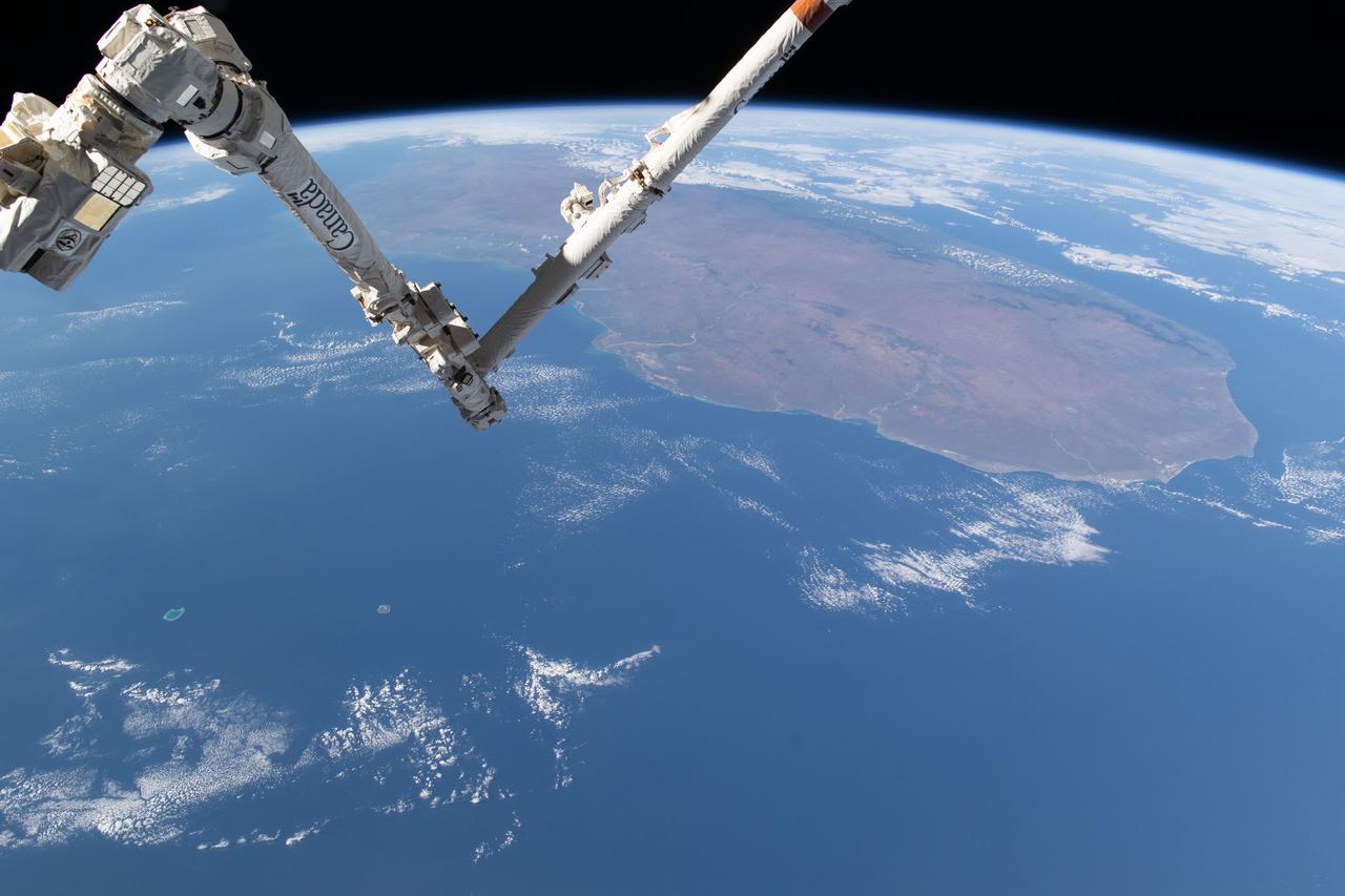
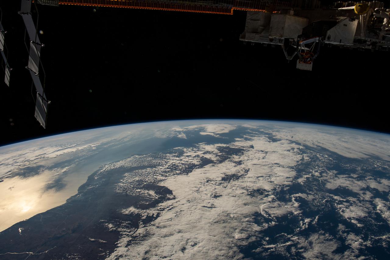
iss071e361950 (July 15, 2024) --- The International Space Station's 57.7-foot-long Canadarm2 robotic arm crosses the foreground as the orbital outpost soared 265 miles above the Mozambique Channel south of the African island nation of Madagascar.
iss071e345427 (July 15, 2024) --- The Mayotte archipelago, a French overseas department and region, in the Mozambique Channel and in between Madagascar and Mozambique is pictured from the International Space Station as it orbited 263 miles above.
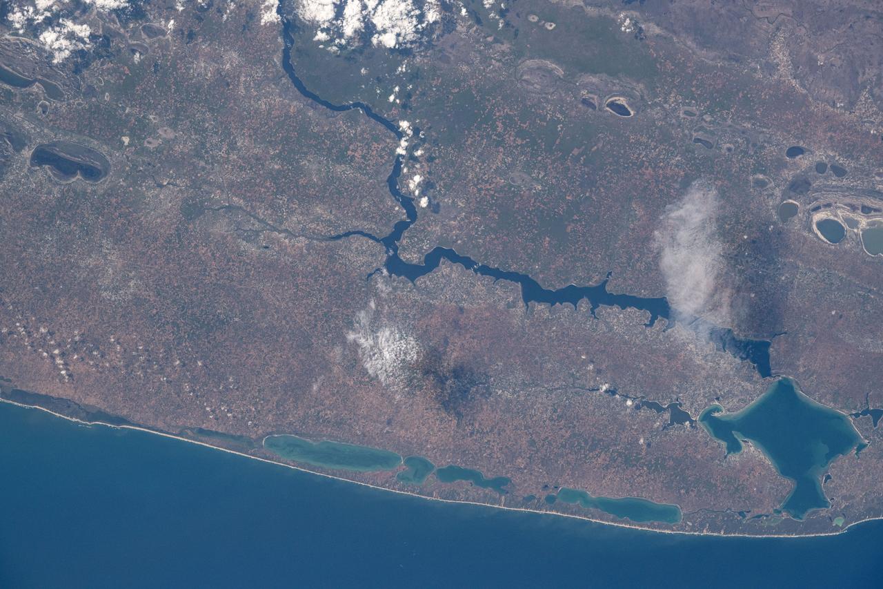
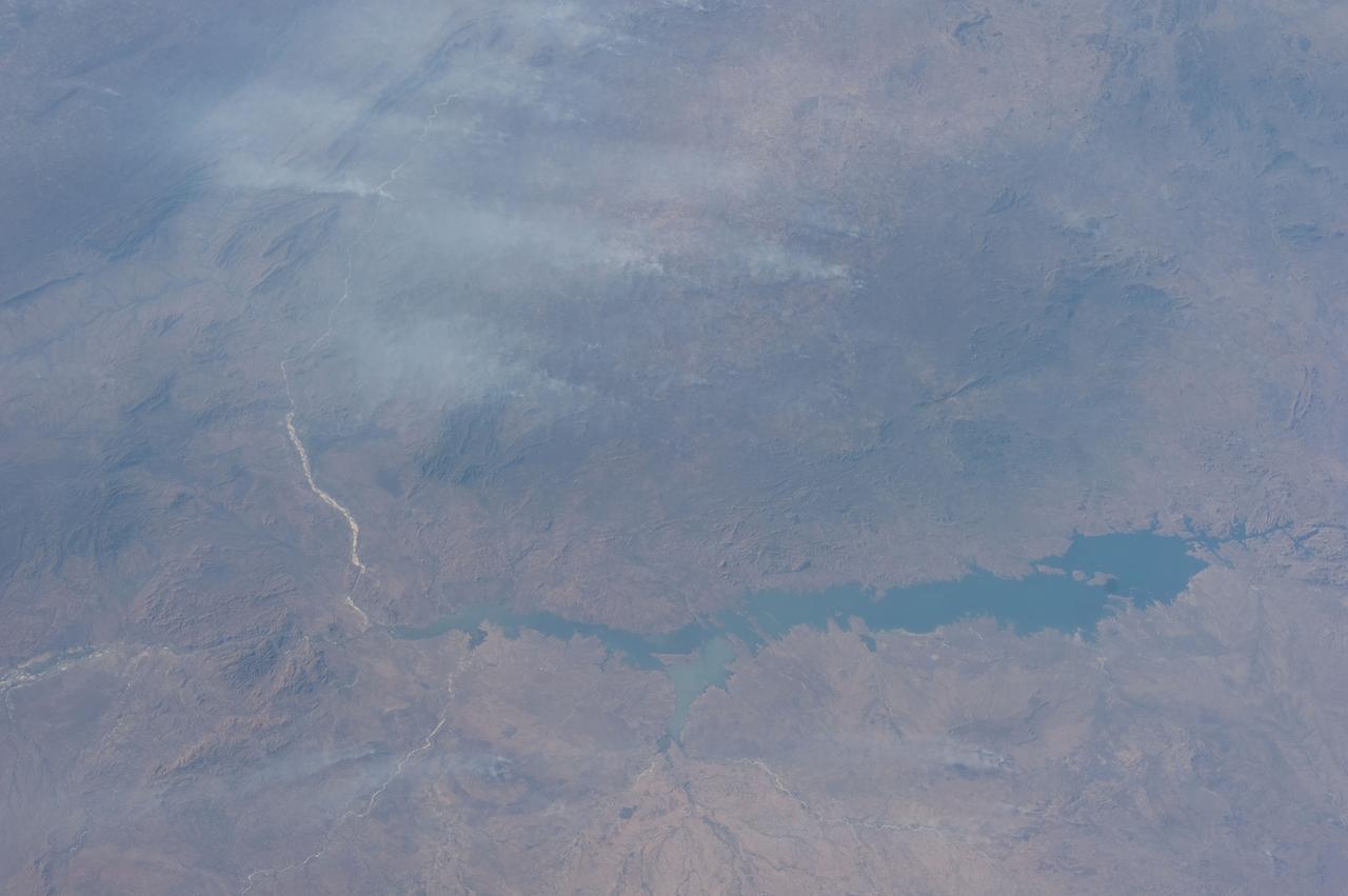
iss072e095378 (Oct. 20, 2024) --- Lake Poelela (lower right) in Mozambique's tropical climate on the coast of the Mozambique Channel is pictured from the International Space Station as it orbited 265 miles above the African nation.
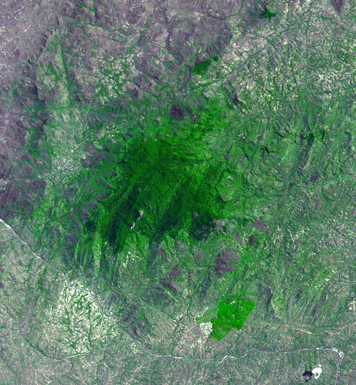
Mount Mabu in northern Mozambique is famous for its old-growth rain forest. The 75 square kilometers forest and its extremely diverse wildlife were unknown to scientists until 2005. One scientist believes he has discovered 15 new species of dung beetles. At least 25 additional new species of animals have also been found. The image was acquired October 4, 2023, covers an area of 26.7 by 28.8 km, and is located at 16.3 degrees south, 36.4 degrees east. https://photojournal.jpl.nasa.gov/catalog/PIA26392
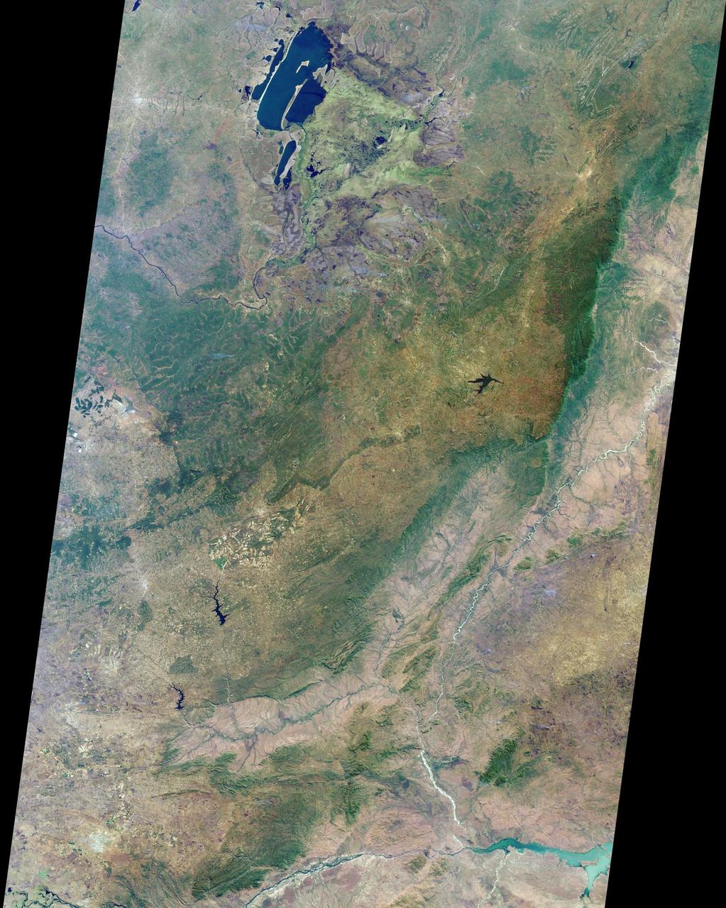
Zambia, the Democratic Republic of the Congo, Mozambique, and Zimbabwe are shown in this MISR Mystery Quiz #20 captured by NASA Terra spacecraft.
iss072e094988 (Oct. 21, 2024) --- The French atoll of Bassas da India in the Mozambique Channel, halfway beween the African nations of Mozambiue and Madagascar, is pictured from the International Space Station as it orbited 264 miles above.
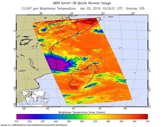
This infrared image from NASA's Atmospheric Infrared Sounder (AIRS) shows the temperature of clouds or the surface in and around Tropical Cyclone Kenneth as it was about to make landfall in northern Mozambique on Thursday, April 25. The large purple area indicates very cold clouds carried high into the atmosphere by deep thunderstorms. These storm clouds are associated with heavy rainfall. The orange areas are mostly cloud-free areas, with the clear air caused by air motion outward from the cold clouds near the storm center then downward into the surrounding areas. The images were taken at 1:30 p.m. local time. Shortly after that, Kenneth made landfall with maximum sustained winds of 140 mph (225 kph). It was the first known hurricane-strength landfall in the province and comes just weeks after Tropical Cyclone Idai hit farther south in central Mozambique with catastrophic consequences. Heavy rainfall and life-threatening flooding are expected over the next several days. https://photojournal.jpl.nasa.gov/catalog/PIA23144

The Advanced Rapid Imaging and Analysis (ARIA) team at NASA's Jet Propulsion Laboratory in Pasadena, California, created these flood proxy maps depicting areas of Mozambique that are likely flooded as a result of Cyclone Idai. The likely flooding zones are indicated by light blue pixels. The maps were derived from synthetic aperture radar (SAR) images from the ICEYE-X2 (March 18), Sentinel-1 (March 19, 20), and ALOS-2 (March 23) satellites operated by ICEYE (Finnish satellite manufacturer Every Square Meter, Every Hour), European Space Agency (ESA), and Japan Aerospace Exploration Agency (JAXA), respectively. The processed images were compared to each other for cross-validation. These flood proxy maps should be used as guidance to identify areas that are likely flooded, and may be less reliable over urban and vegetated areas. https://photojournal.jpl.nasa.gov/catalog/PIA23142
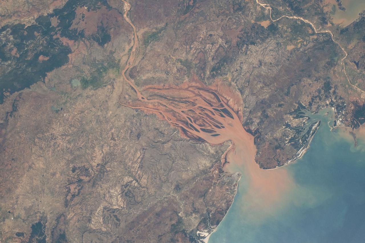
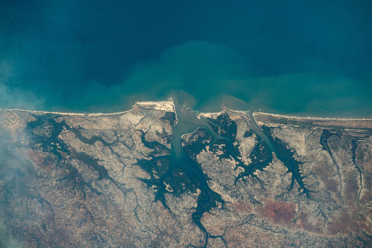
iss071e218069 (June 26, 2024) -- On Madagascar's northwestern coast, the Mozambique Channel flows inland to the Betsiboka River, forming Bombetoka Bay. The reddish-brown color is the result of iron-rich sediment transporting through, creating a striking visual marker for astronauts aboard the International Space Station. This photograph was taken as the orbiting laboratory soared 266 miles above Earth.
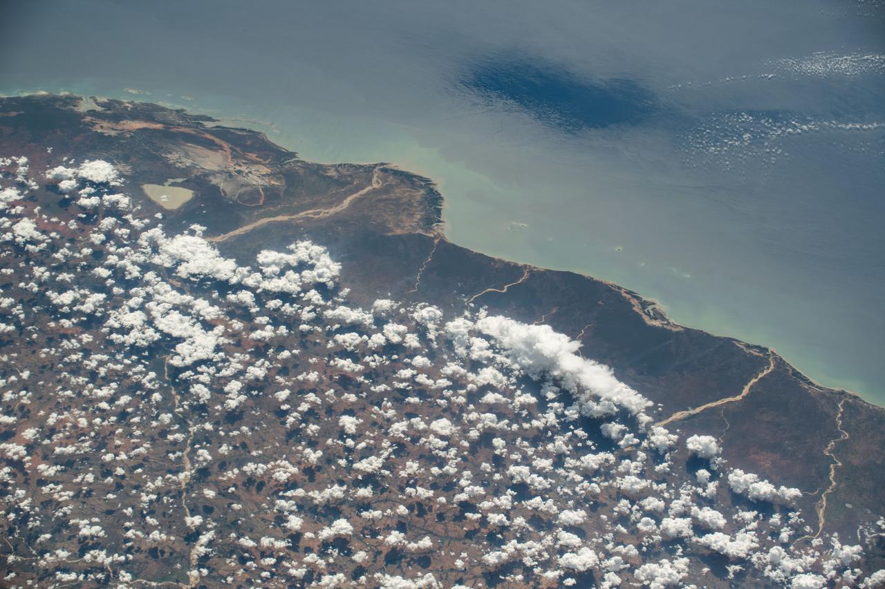
iss070e013997 (Oct. 25, 2023) --- The coast of Mozambique on the Mozambique Channel is pictured from the International Space Station as it orbited 263 miles above the African nation.
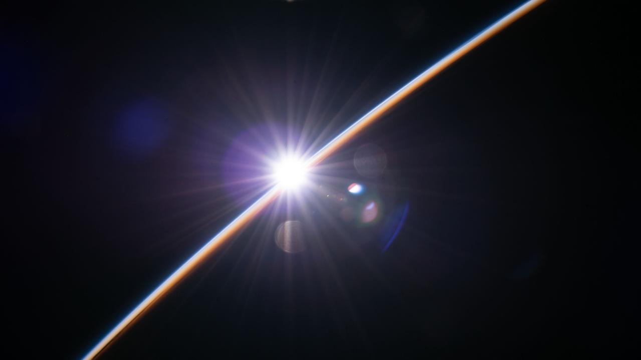
iss067e124188 (June 15, 2022) --- The first rays of an orbital sunrise illuminate the Earth's atmosphere as the International Space Station orbited 263 miles above southern Mozambique near the coast of the Mozambique channel.
This nadir camera view was captured by NASA Terra spacecraft around Kruger National Park in NE South Africa. The bright white feature is the Palabora Copper Mine, and the water body near upper right is Lake Massingir in Mozambique.
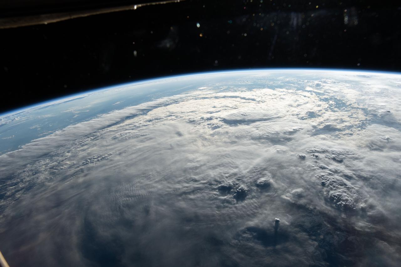
iss059e000515 (March 16, 2019) --- Tropical Cyclone Idai is pictured from the International Space Station as the orbital complex flew 261 miles above the southeast coast of Africa. Idai's track took it over the Mozambique Channel and portions of the nations of Madagascar, Mozambique, Malawi and Zimbabwe creating devastation and casualties in the southeast portion of the African continent.

iss056e084625 (July 7, 2018) --- The island nation of Madagascar was photographed by an Expedition 56 crew member as the International Space Station orbited about 255 miles above the Mozambique Channel which separates Madagascar from the African nation of Mozambique.

iss059e000502 (March 16, 2019) --- Tropical Cyclone Idai is pictured from the International Space Station as the orbital complex flew 261 miles above the southeast coast of Africa. Idai's track took it over the Mozambique Channel and portions of the nations of Madagascar, Mozambique, Malawi and Zimbabwe creating devastation and casualties in the southeast portion of the African continent.
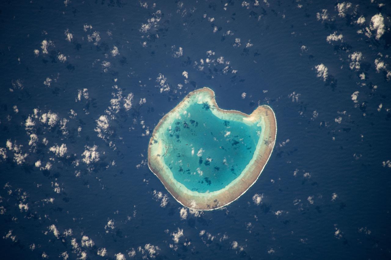
iss071e111610 (May 23, 2024) -- Nearly halfway between Madagascar and Mozambique lies the Bassas da India atoll in the Mozambique Channel. The uninhabited ring-shaped island spans roughly 330 feet (~100 meters) around a shallow lagoon. The International Space Station was soaring 260 miles above as this photo was taken.
Earth observation taken during a day pass by the Expedition 37 crew. Per Twitter message: Ruvuma River, Tanzania and Mozambique.
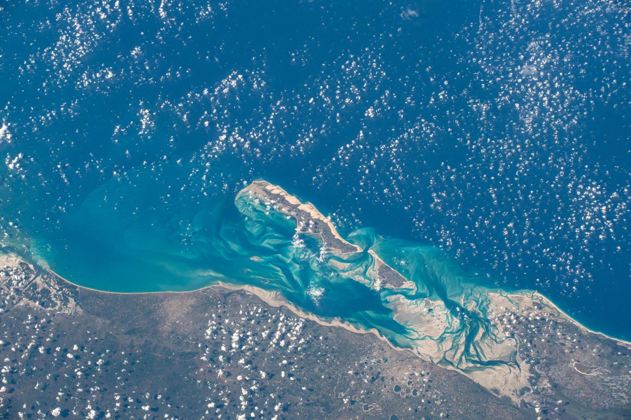
iss065e009427 (April 29, 2021) --- The Bazaruto Archipelago off the coast of Mozambique is pictured from the International Space Station as it orbited 265 miles above the African nation.
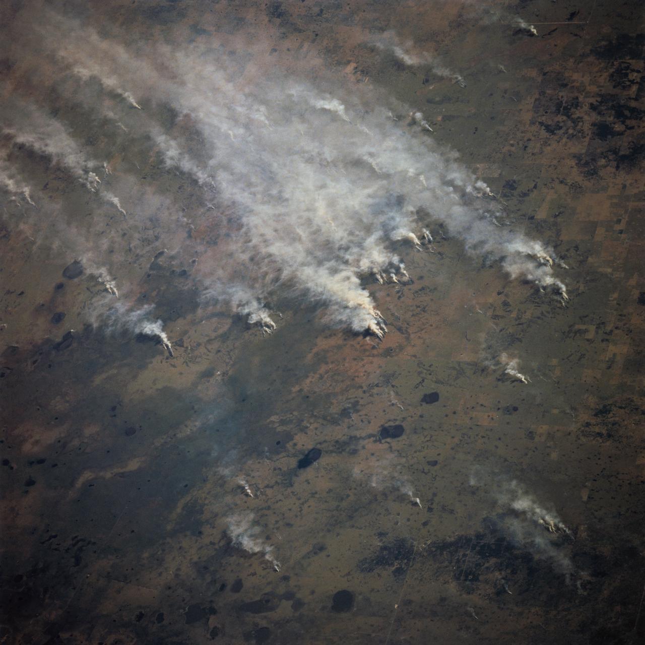
STS070-717-027 (13-22 JULY 1995) --- Easterly winds from the Mozambique Channel blow the smoke from many large fires in southern Mozambique inland. Neighboring views showed the smoke moving over and around the Chimanimani Mountains, into Zimbabwe on the African plateau. Winter is the dry season in southern Africa and fires are set to hasten the greening of the grass shoots for cattle grazing.
ISS028-E-018657 (23 July 2011) --? One of the Expedition 28 crew members aboard the International Space Station photographed this northward looking view featuring the reservoir of Cahora Bassa in extreme western Mozambique, formed by damming the Zambezi River. Also visible are numerous plumes from fires in the wooded plateau region north of the lake on the Mozambique-Zambia frontier.

iss070e064005 (Jan. 10, 2024) --- A portion of Mozambique's Bazaruto Archipelago, a national park ceated to protect marine wildlife, on the southern coast of the African nation is pictured from the International Space Station as it orbited 261 miles above.
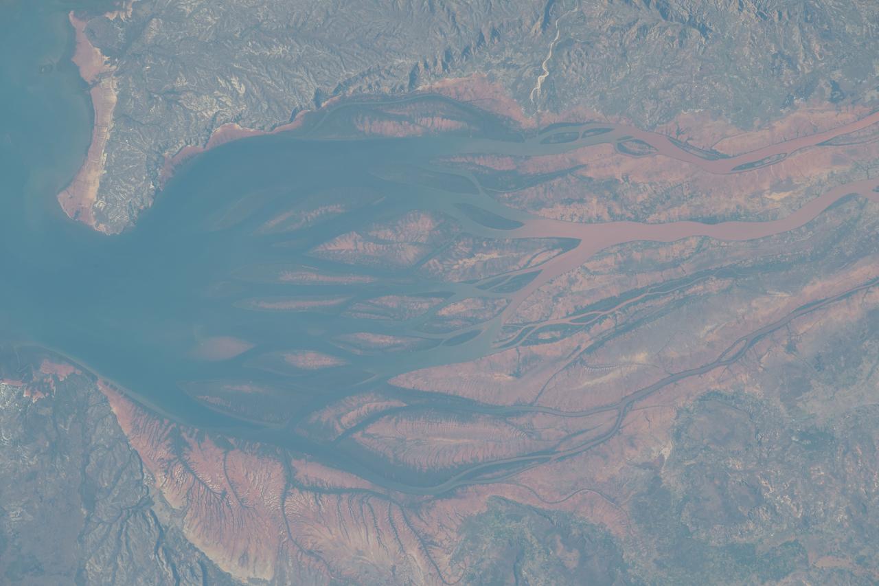
iss069e032071 (July 15, 2023) --- The Bombetoka Bay leads into the Mozambique Channel from the island nation of Madagascar in this photograph from the International Space Station as it orbited 262 miles above.
iss071e218076 (June 26, 2024) --- The northwest coast of Madagascar on the Mozambique Channel is pictured from the International Space Station as it orbited 267 miles above the East African island nation.
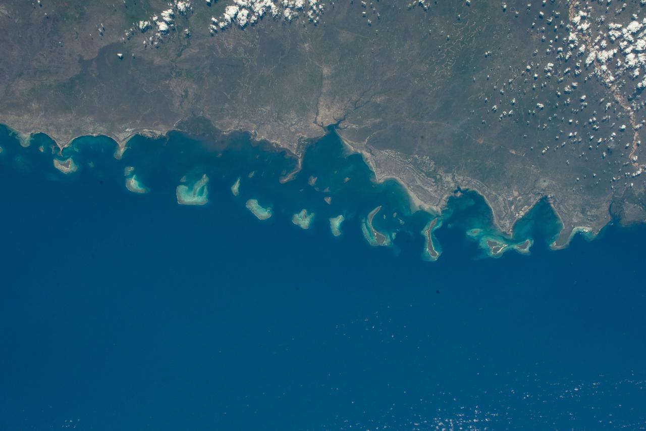
iss070e026322 (Nov. 17, 2023) --- The Quirimbas Islands off the northeastern coast of Mozambique in the Indian Ocean are pictured from the International Space Station as it orbited 262 miles above the African nation.
iss067e189040 (July 16, 2022) --- The sun's glint beams off the Mozambique Channel in this photograph of Madagascar's coast as the International Space Station orbited 262 miles above the Indian Ocean.
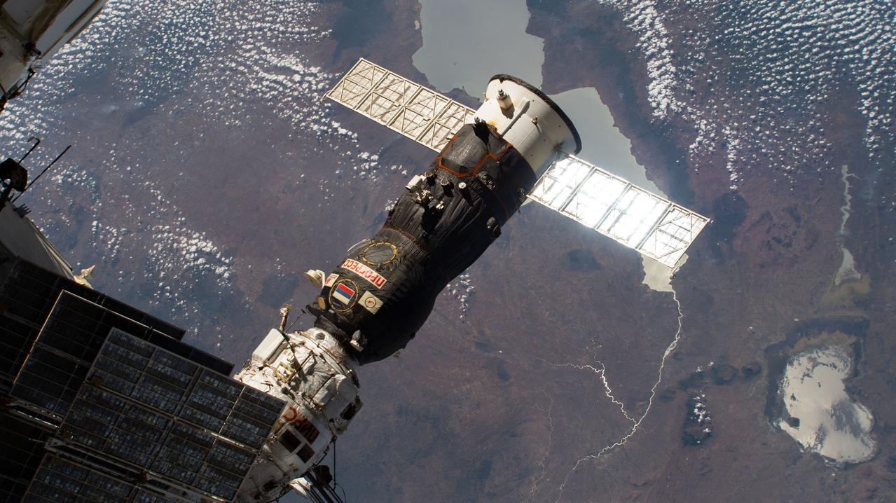
iss060e014984 (July 29, 2019) --- Russia's Progress 72 cargo craft is pictured shortly before undocking from the Pirs docking compartment. The International Space Station was orbiting 262 miles above Mozambique when this photograph was taken.
iss070e025919 (Nov. 16, 2023) --- The partly cloudy coast of southwestern Madagascar on the Mozambique Channel is pictured from the International Space Station as it orbited 264 miles above the island nation.

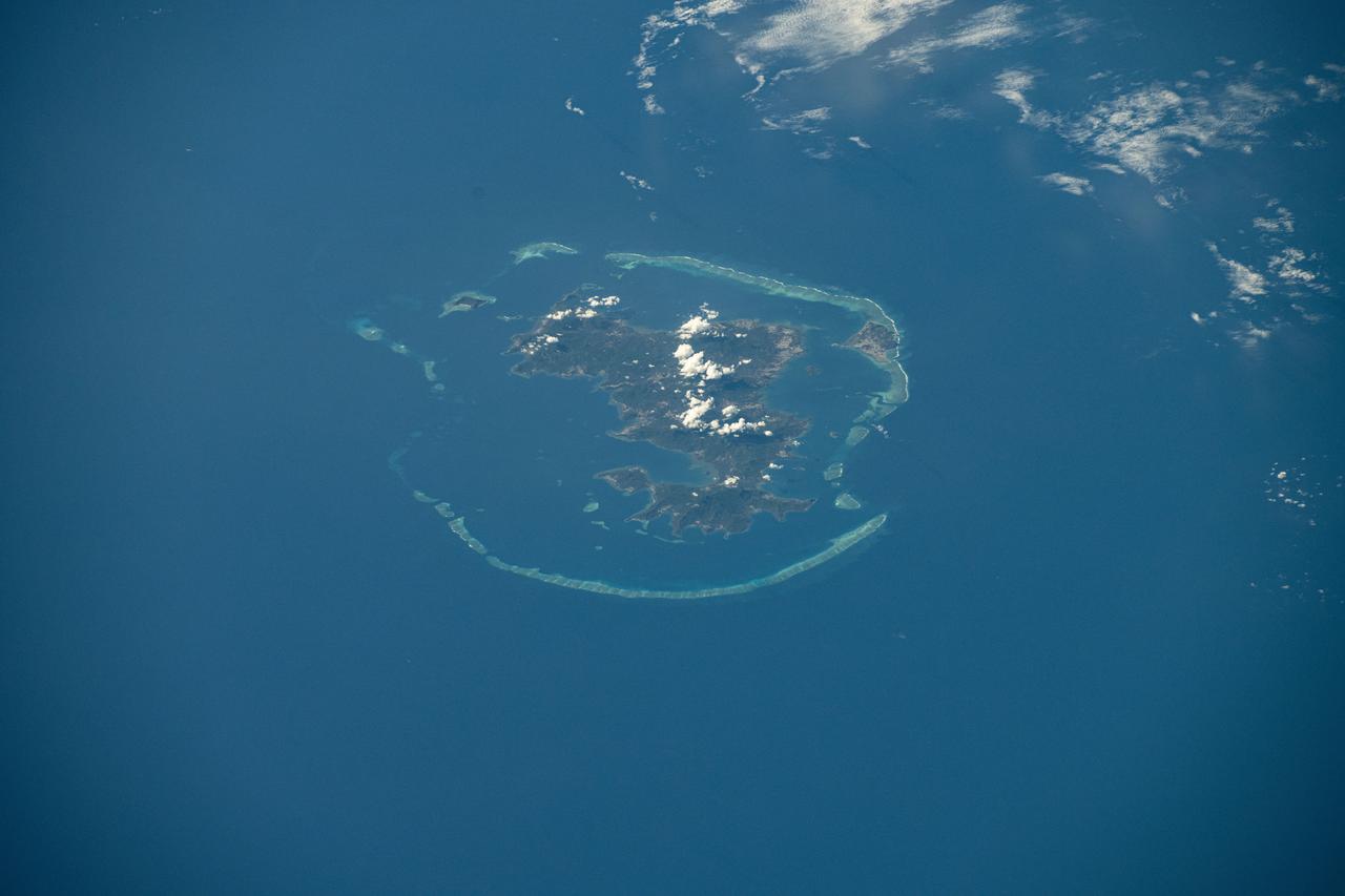
ISS047e141619 (06/06/2016) --- This Earth observation image captured by Expedition 47 members aboard the International Space Station is of Juan de Nova Island, also known as Saint-Christophe. The small French tropical island is in the narrowest part of the Mozambique Channel, about one-third of the way between Madagascar and Mozambique. The Island is 3.7 miles long and 1 mile at its widest. It is a nature reserve surrounded by reefs. Forests cover about half the island and sea turtles nest on the beaches. It is largely uninhabited but the French maintain a weather station on the Island.

iss071e378497 (July 21, 2024) -- The Quirimbas Islands lie in the western Indian Ocean off the coast of Mozambique. The archipelago consists of 32 islands, partially linked to the coastline by coral reefs, mangroves, and sand bars. As the International Space Station orbited 262 miles above, NASA astronaut Matthew Dominick captured this photo.
iss071e673801 (Sept. 15, 2024) --- Ankarana Special Reserve, formed about 150 million years ago during the Jurassic period, on the northwest coast of Madagascar near the Mozambique Channel is pictured from the International Space Station as it orbited 260 miles above.
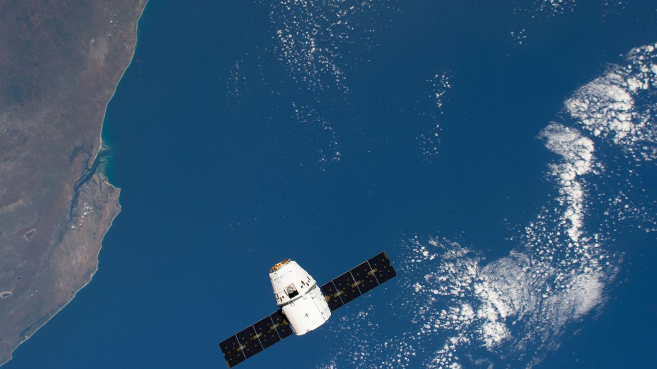
iss059e043268 (May 6, 2019) --- The SpaceX Dragon cargo craft approaches the International Space Station 259 miles above the coast of Mozambique. Astronaut David Saint-Jacques would command the Canadarm2 robotic arm to capture Dragon as astronaut Nick Hague backed him up and monitored systems.
NASA Terra spacecraft flew over South Africa and Zimbabwe where week-long torrential rains swelled the Limpopo River in Jan. 2013.
41G-120-079 (5-13 Oct 1984) --- This oblique view, photographed from the Space Shuttle Challenger, shows the south tip of the island of Madagascar. Sunglint reflects on the surface of the Mozambique Channel. The crew consisted of astronauts Robert L. Crippen, commander; Jon A. McBride, pilot; mission specialist's Kathryn D. Sullivan, Sally K. Ride, and David D. Leestma; Canadian astronaut Marc Garneau; and Paul D. Scully-Power, payload specialist. EDITOR'S NOTE: The STS-41G mission had the first American female EVA (Sullivan); first seven-person crew; first orbital fuel transfer; and the first Canadian (Garneau).
Grande Comore is the largest island of the Union of the Comoros, an island nation located in the Mozambique Channel northwest of Madagascar. The nation was granted independence from France in 1975, and became the Federated Islamic Republic of the Comoro Islands. In 2001, the government reformed as the Union of the Comoros. The three islands making up the country are all of volcanic origin, and Grande Comore is still volcanically active. The image was acquired June 22, 2022, covers an area of 25.7 by 67.4 km, and is located at 11.7 degrees south, 43.3 degrees east. With its 14 spectral bands from the visible to the thermal infrared wavelength region and its high spatial resolution of about 50 to 300 feet (15 to 90 meters), ASTER images Earth to map and monitor the changing surface of our planet. ASTER is one of five Earth-observing instruments launched Dec. 18, 1999, on Terra. The instrument was built by Japan's Ministry of Economy, Trade and Industry. A joint U.S./Japan science team is responsible for validation and calibration of the instrument and data products. The broad spectral coverage and high spectral resolution of ASTER provides scientists in numerous disciplines with critical information for surface mapping and monitoring of dynamic conditions and temporal change. Example applications are monitoring glacial advances and retreats; monitoring potentially active volcanoes; identifying crop stress; determining cloud morphology and physical properties; wetlands evaluation; thermal pollution monitoring; coral reef degradation; surface temperature mapping of soils and geology; and measuring surface heat balance. https://photojournal.jpl.nasa.gov/catalog/PIA25444
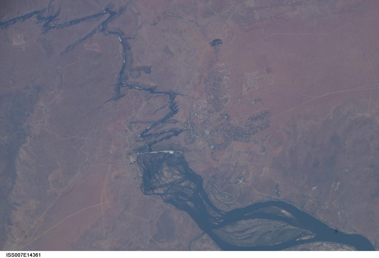
ISS007-E-14361 (4 September 2003) --- This view featuring Victoria Falls and the Zambezi River was photographed by one of the Expedition 7 crewmembers onboard the International Space Station (ISS). Victoria Falls is one of the most famous tourist sites in sub-Saharan Africa. The falls and their famous spray clouds are 1700 meters long, the longest sheet of falling water in the world. The falls appear as a ragged white line in this image. The small town of Victoria Falls in Zimbabwe appears just west of the falls, with smaller tourist facilities on the east bank in Zambia. A major river in south-central Africa, the Zambezi River flows from western Zambia to the Indian Ocean in Mozambique. It flows southeast in a wide bed before plunging suddenly 130 meters over the Victoria Falls into a narrow gorge.

STS065-42-017 (8-23 July 1994) --- This 35mm panorama shows the science module, for the second International Microgravity Laboratory (IML-2) and the Space Shuttle Columbia's cargo bay, backdropped against the darkness of space over part of Africa, on Earth's horizon. Lake Nyasa in Malawi can easily be delineated. Also visible are part of the country of Mozambique and the Indian Ocean. Six NASA astronauts and a Japanese payload specialist spent more than two weeks of experimenting in Earth-orbit. Onboard were NASA astronauts Robert D. Cabana, James D. Halsell, Jr., Richard J. Hieb, Carl E. Walz, Donald A. Thomas and Leroy Chiao along with payload specialist Dr. Chiaki Mukai, representing the National Space Development Agency (NASDA) of Japan.
STS093-716-065 (23-27 July 1999) --- The STS-93 astronauts aboard the Space Shuttle Columbia took this picture of a sunrise on the Mozambique Channel along the coast of Madagascar. The nearest point of land is Cape Saint Andre, which forms the northwest corner of the island. Sunglint highlights the land-water boundary along a series of dynamic estuaries. The fifth inlet from the bottom just above the small lake is the Betsiboka Estuary. When the photo was taken, the shuttle was flying over a point located at 18.7 degrees south latitude and 36.1 degrees east longitude. Data back information on the 70mm film listed the time and date as 03:40:43 GMT, July 26, 1999 (orbit 48).
ISS028-E-018675 (23 July 2011) --- Biomass burning in southern Africa is featured in this image photographed by an Expedition 28 crew member on the International Space Station. A smoke pall of subcontinental proportions dominates this view of tropical southern Africa. In what has been described as the most fire-prone part of the world, numerous fires give rise to regional smoke palls every dry season. Fires are both natural and set by local people to clear woodland for agricultural fields. This recent, oblique, northwest-looking view taken in July 2011 at the end of the dry season shows the extent of the smoke on the African plateau?from central Zimbabwe (lower left) to northern Malawi more than 1,000 kilometers away (top right)?and in the wide coastal plains of the lower Zambezi River valley of Mozambique (lower right). Here smoke can be seen blowing inland (left to right), channeled up the Zambezi River valley and contributing to the pall on the plateau. The light gray smoke plumes contrast with higher altitude, brighter patchy cloud cover at lower right. The smoke palls obscure much surface detail, so that Lake Malawi, one of Africa?s Great Lakes, is barely visible, as is Lake Cahora Bassa, Africa?s fourth largest reservoir, in the Zambezi valley. The sun?s reflection off its surface (sunglint) makes Lake Kariba most prominent in the view at left. Kariba is the world?s largest artificial reservoir by volume, and is 220 kilometers long, giving a sense of the scale of the view. The steep, shadowed, mid-afternoon faces of the Inyanga Mountains on the Mozambique-Zimbabwe border protrude above the smoke layer at lower left. Solar panels extending from Russian spacecraft docked at the International Space Station are visible in the foreground at left.
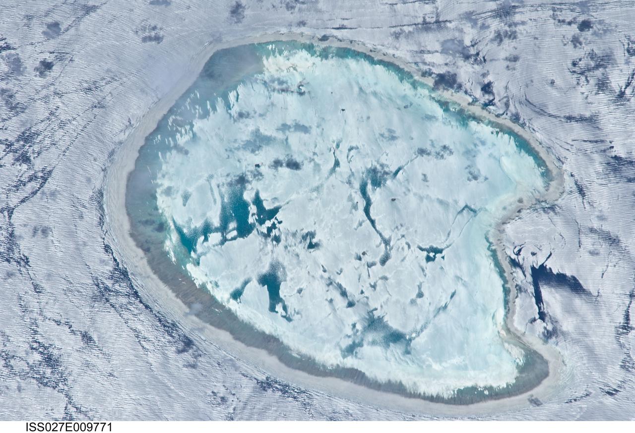
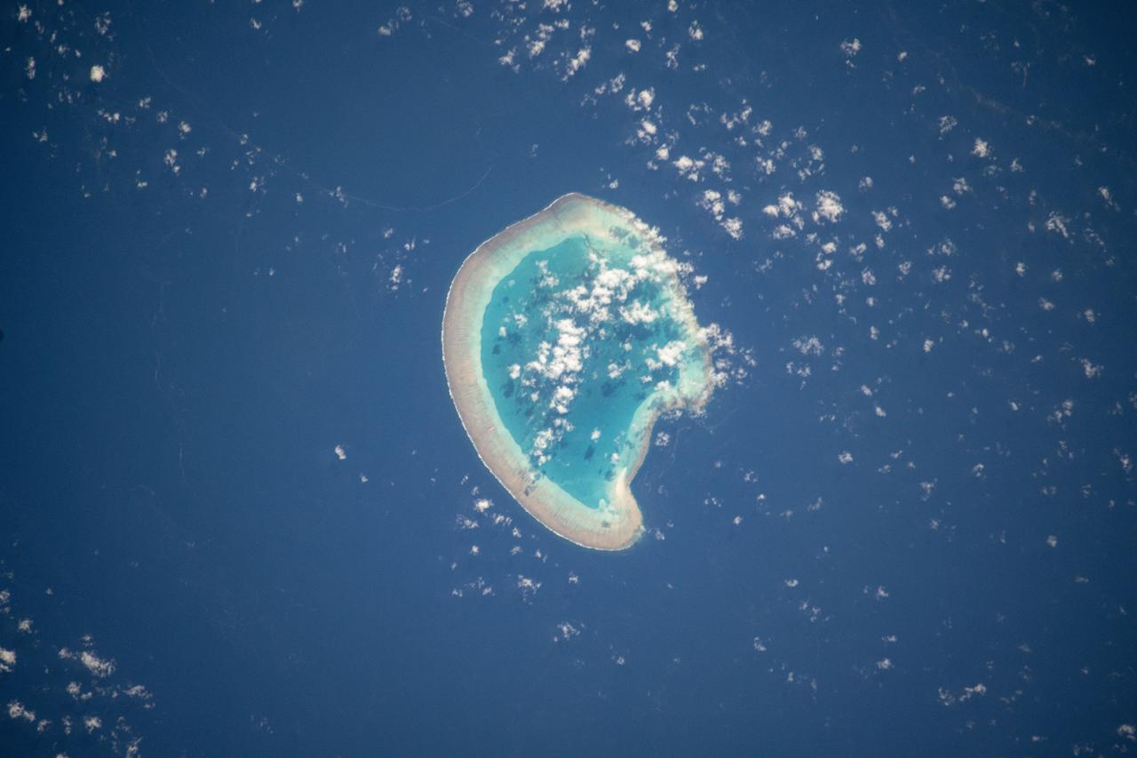
ISS027-E-009771 (2 April 2011) --- Bassas da India is featured in this image photographed by an Expedition 27 crew member on the International Space Station. The vantage point of crew members onboard the space station provides many dramatic views of Earth?s surface. This detailed photograph of the Bassas da India, an uninhabited atoll in the Indian Ocean (between the Mozambique coast of Africa and the island of Madagascar) has an almost surreal quality due to varying degrees of sunglint. Sunglint is an optical phenomena caused by light reflecting off of a water surface directly back towards the observer. Variations in the roughness of the water surface?presence or absence of waves due to wind and water currents?will cause differences in the intensity of the sunglint. The presence of other materials, such as oils or surfactants, can also change the properties of the water surface. Here the presence of currents is highlighted as darker patches or streaks (left and upper right). In contrast, shallow water in the lagoon (center) presents a more uniform, mirror-like appearance in sunglint suggesting that there are no subsurface currents present. Wave crests visible around the atoll are likely the result of both surface winds and subsurface currents. The Bassas da India atoll is part of the French Southern and Antarctic Lands. It is uninhabited due to its complete submergence during high tide ? there is no vegetation established on the atoll for the same reason. The atoll is approximately 10 kilometers in diameter, and covers an area (including the lagoon) of approximately 80 square kilometers.
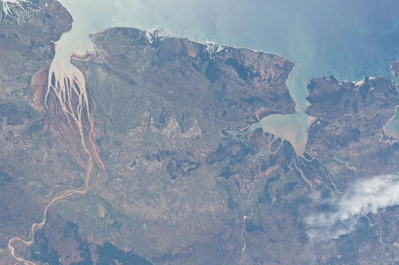
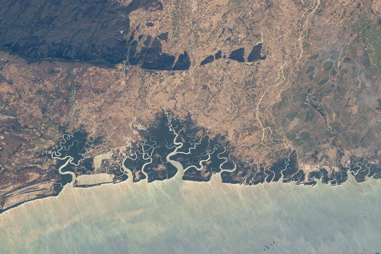
ISS028-E-006687 (2 June 2011) --- Estuaries on the northwestern coast of Madagascar are featured in this image photographed by an Expedition 28 crew member on the International Space Station. Regions where fresh water flowing in rivers and salt water from the seas and oceans mix are called estuaries, and they are among the most biologically productive ecosystems on Earth. This photograph highlights two estuaries located along the northwestern coastline of the island of Madagascar. The Mozambique Channel (top) separates Madagascar from the southeastern coast of Africa. Bombetoka Bay (upper left) is fed by the Betsiboka River and is a frequent subject of astronaut photography due to its striking red floodplain sediments. Mahajamba Bay (right) is fed by several rivers including the Mahajamba and Sofia Rivers; like the Betsiboka, the floodplains of these rivers also contain reddish sediments eroded from their basins upstream. The brackish (mix of fresh and salty water) conditions found in most estuaries host unique plant and animal species adapted to live in such environments. Mangroves in particular are a common plant species found in and around Madagascar estuaries, and Bombetoka Bay contains some of the largest remaining stands. Estuaries also host abundant fish and shellfish species ? many of which need access to freshwater for a portion of their life cycles ? and these in turn support local and migratory bird species that prey on them. However, human activities such as urban development, overfishing, and increased sediment loading from erosion of upriver highlands threaten the ecosystem health of the estuaries. In particular, the silt deposits in Bombetoka Bay at the mouth of the Betsiboka River have been filling in the bay.
ISS030-E-035487 (14 Jan. 2012) --- The East African Rift Valley in Kenya is featured in this image photographed by an Expedition 30 crew member on the International Space Station. This photograph highlights classical geological structures associated with a tectonic rift valley, in this case the Eastern Branch of the East African Rift near Kenya’s southern border with Tanzania and just south of the Equator. The East African Rift is one of the great tectonic features of Africa, caused by fracturing of Earth’s crust. The Nubian (or African) plate includes the older continental crust of Africa to the west, while the Somalian plate that is moving away includes the Horn of Africa to the northeast; the tectonic boundary stretches from the southern Red Sea to central Mozambique. Landscapes in the rift valley can appear confusing. The most striking features in this view are the numerous, nearly parallel, linear fault lines that occupy the floor of the valley (most of the image). Shadows cast by the late afternoon sun make the fault scarps (steps in the landscape caused by slip motion along individual faults) more prominent. The faults are aligned with the north-south axis of the valley (lower left to top right). A secondary trend of less linear faults cuts the main fault trend at an acute angle, the fault steps throwing large shadows. The Eastern Branch of the East African Rift is arid (compared with the Western Branch which lies on the border of the Congolese rainforest). Evidence of this can be seen in the red, salt-loving algae of the shallow and salty Lake Magadi (center). A neighboring small lake to the north has deeper water and appears dark in the image. The white salt deposits of the dry part of the Lake Magadi floor (center) host a few small commercial salt pans. The lakes appear to be located where the main and secondary fault trends intersect. The East African rift system is marked by substantial volcanic activity, including lavas erupted from fissures along the rift in the region. Much of the faulting observed in this image cuts through such lavas. Elsewhere along the rift system individual volcanoes form. Some of those volcanoes are very large, including Mt. Kilimanjaro and Mt. Kenya. In this image, rising 400 meters above the valley floor, a volcano appears to be superimposed on the faults—indicating that the volcano is younger than the faults it covers. Deeply eroded slopes also suggest that the volcano has not been active for a long time. The largest vegetated area (lower left)—in an desert zone with no vegetation visible to the naked eye from space—is the green floor of a valley which drains an area large enough for water to exist near the surface so that plants can thrive. For a sense of scale, the vegetated valley floor is 17 kilometers long (10.5 miles).