Mt. Etna, a volcano on the island of Sicily, erupted on October 26, 2002, as seen by the Atmospheric Infrared Sounding System AIRS on NASA Aqua. http://photojournal.jpl.nasa.gov/catalog/PIA00355

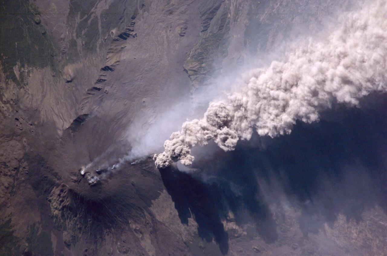
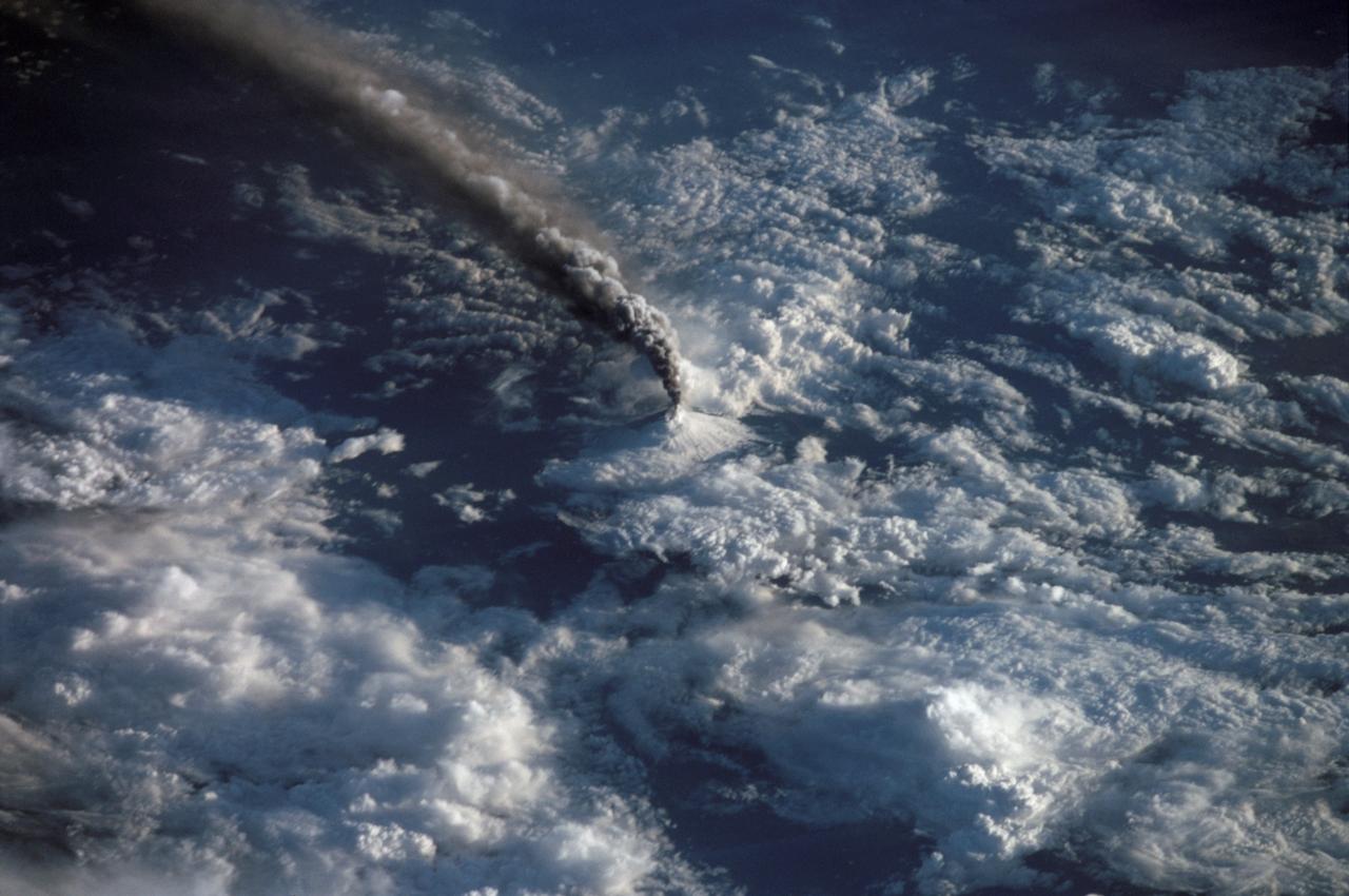
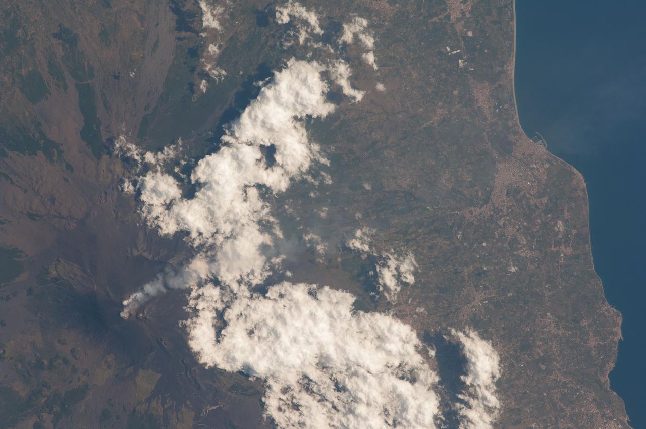
Expedition Five crew members aboard the International Space Station (ISS) captured this overhead look at the smoke and ash regurgitated from the erupting volcano Mt. Etna on the island of Sicily, Italy in October 2002. Triggered by a series of earthquakes on October 27, 2002, this eruption was one of Etna's most vigorous in years. This image shows the ash plume curving out toward the horizon. The lighter-colored plumes down slope and north of the summit seen in this frame are produced by forest fires set by flowing lava. At an elevation of 10,990 feet (3,350 m), the summit of the Mt. Etna volcano, one of the most active and most studied volcanoes in the world, has been active for a half-million years and has erupted hundreds of times in recorded history.
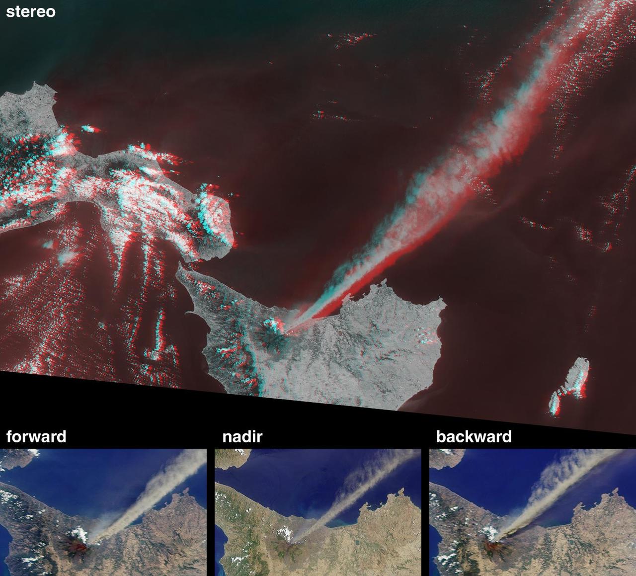
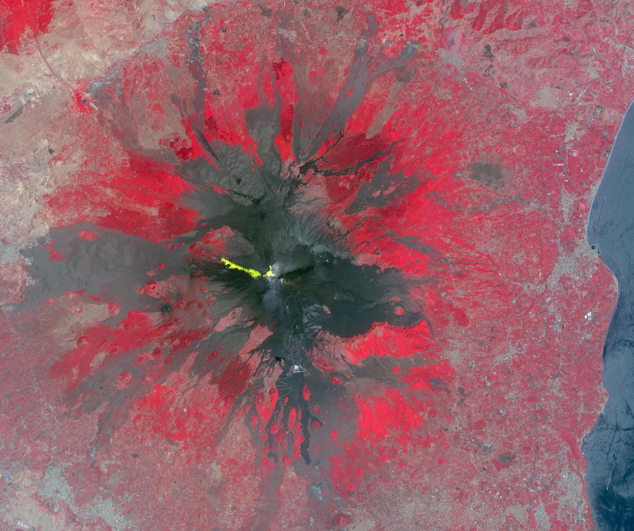
This anaglyph from the MISR instrument aboard NASA Terra spacecraft shows the eruption of Mt. Etna volcano located near the eastern coast of Sicily on July 22, 2001. 3D glasses are necessary to view this image.
An Expedition Two crewmember aboard the International Space Station (ISS) captured this overhead look at the smoke and ash regurgitated from the erupting volcano Mt. Etna on the island of Sicily, Italy. At an elevation of 10,990 feet (3,350 m), the summit of the Mt. Etna volcano, one of the most active and most studied volcanoes in the world, has been active for a half-million years and has erupted hundreds of times in recorded history.
On Sunday, November 3, 2002, Mt. Etna's ash-laden plume was imaged by the Advanced Spaceborne Thermal Emission and Reflection Radiometer (ASTER) on NASA's Terra satellite. The plume is seen blowing toward the south-southeast, over the city and airport of Catania, Sicily. The previous day, the plume was blowing toward the northwest, and posed no hazard to Catania. The current eruption of Mt. Etna, Europe's most active volcano, began on October 27. These sorts of observations from space may help civil defense authorities mitigate hazards from active eruptions. Space data may also help scientists evaluate the behavior and effects volcanic eruptions have on our global climate system. http://photojournal.jpl.nasa.gov/catalog/PIA03881
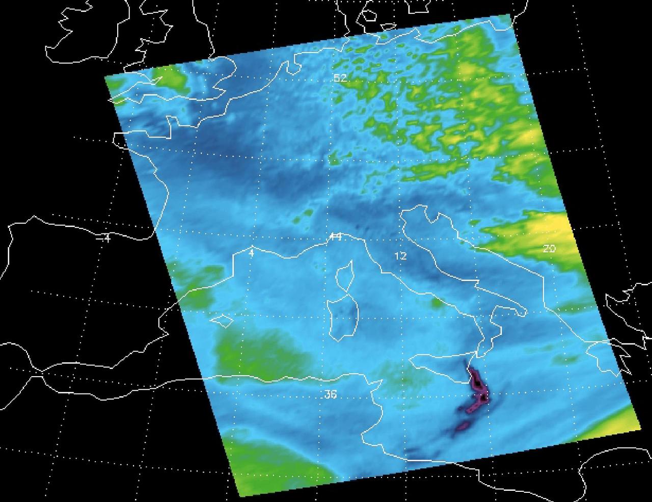
Sulfur dioxide plume from the Mt. Etna Eruption 2002 as seen by the Atmospheric Infrared Sounder AIRS on NASA Aqua satellite.
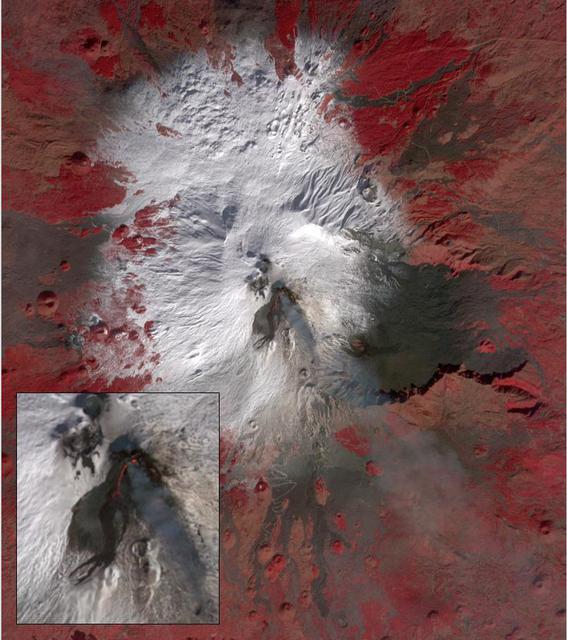
Starting December 13, 2020, a strong eruptive episode began at Mt. Etna's New SE summit crater. Lava fountains produced a new lava flow, traveling to the SW. The fresh lava is hot enough to be incandescent, and appears as a red "snake" issuing from the crater's flank. The lava fountain appears as a separate red area at the crater's summit. A faint gray plume streams southeastward from the crater. Analysis of the thermal infrared data reveals that the plume's composition is dominated by SO2. The image was acquired December 15, 2020, covers an area of 12 by 13.5 km, and is located at 37.7 degrees north, 15 degrees east. https://photojournal.jpl.nasa.gov/catalog/PIA24283
The current eruption of Mt. Etna started on July 17, and has continued to the present. This ASTER image was acquired on Sunday, July 29 and shows advancing lava flows on the southern flank of Mt. Etna above the town of Nicolosi, which is potentially threatened if the eruption increases in magnitude. Also visible are glowing summit craters above the main lava flows, and a small fissure eruption. The bright puffy clouds were formed from water vapor released during the eruption. The image covers an area of 24 x 30 km. The image is centered at 37.7 degrees north latitude, 15 degrees east longitude. http://photojournal.jpl.nasa.gov/catalog/PIA02677
Mt. Etna, Italy erupted Tuesday, February 16, 2021, sending rivers of lava down the southeast flank of the volcano, and spewing ashes and volcanic stones over nearby villages. Sicily's Catania Airport was temporarily closed due to an ash plume that rose to 3700 m altitude. The ASTER nighttime thermal infrared data shows the extent of the active lava flows, draped over an older Google Earth image. The image was acquired February 17, 2021, covers an area of 38 by 39 km, and is located at 37.8 degrees north, 15 degrees east. https://photojournal.jpl.nasa.gov/catalog/PIA24417
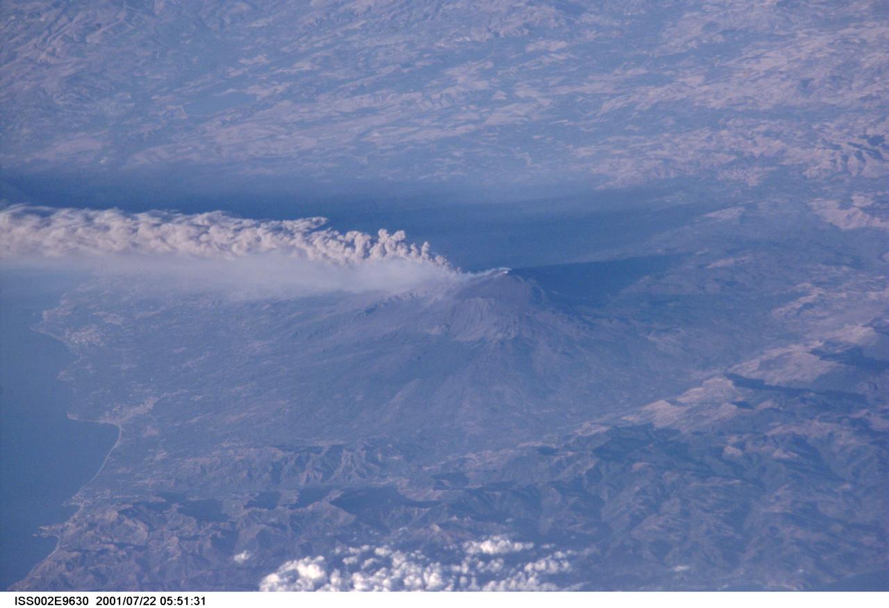
ISS002-E-9630 (22 July 2001) --- The active volcano Mt. Etna on the island of Sicily was recorded by an Expedition Two crew member with a digital still camera.
STS062-85-195 (4-18 March 1994) --- A thin plume of steam blows southward from the summit of Mt. Etna, the active volcano on the island of Sicily. The summit is capped with snow but the dark lava flow along the eastern flank (the 1991-93 flow) is clearly visible. The coastal city south of Etna is Catania.
STS064-71-037 (9-20 Sept. 1994) --- Mt. Etna on Sicily displays a steam plume from its summit. Geologists attribute the volcano's existence to the collision of tectonic plates. Unlike the sudden, explosive eruption at Rabaul, Mt. Etna's activity is ongoing and is generally not explosive - Etna's slopes have been settled with villages and cultivated land for centuries. Other Mediterranean volcanoes (like Santorini) have experienced large catastrophic eruptions. Etna recently finished a two-year eruption (ending in 1993), marked by relatively gentle lava flows down the eastern flank. It has been continually degassing since then, according to the geologists, producing an omnipresent steam plume, as seen here. The 1993 flow is difficult to identify in this image because it lies within shadows on the eastern flank, but small cinder cones on the western flank mark earlier episodes of volcanic activity. Photo credit: NASA or National Aeronautics and Space Administration
Mt. Etna, Italy erupted February 17, 2021, sending rivers of lave down the southeast flank of the volcano, and spewing ashes and volcanic stones over nearby villages. Sicily's Catania Airport was temporarily closed due to an ash plume that rose to 3700 m altitude. By the following week, the eruption had waned. The ASTER visible image shows the extent of the active lava flows (derived from the thermal infrared data). The image was acquired February 26, 2021, covers an area of 25.5 by 27.0 km, and is located at 37.8 degrees north, 15 degrees east. https://photojournal.jpl.nasa.gov/catalog/PIA24418
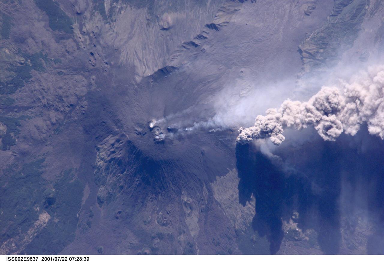
ISS002-E-9637 (22 July 2001) --- An overhead look at the smoke and ash being expelled from the erupting volcano Mt. Etna on the island of Sicily. This image was recorded by an Expedition Two crew member with a digital still camera.
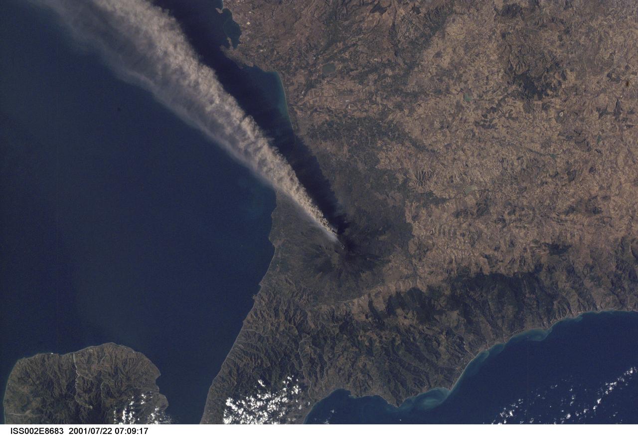
ISS002-E-8683 (22 July 2001) --- Smoke and ash combine to create a plume extending from the erupting volcano on Mt. Etna in Sicily. The digital still image was recorded by one of the Expedition Two crew members.
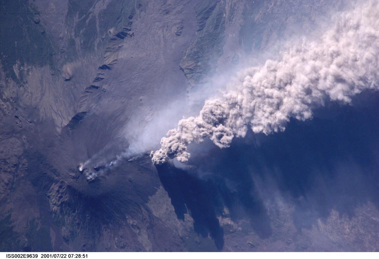
ISS002-E-9639 (22 July 2001) --- An overhead look at the smoke and ash being expelled from the erupting volcano Mt. Etna on the island of Sicily. This image was recorded by an Expedition Two crew member with a digital still camera.

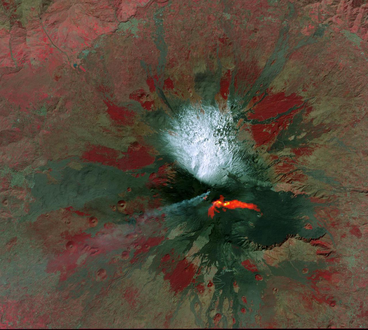
The most recent eruption of Mt. Etna, Italy, began May 30, 2019. New fissure vents opened on the New Southeast Crater, feeding two lava flows that moved down into the Valle del Bove, accompanied by loud explosions. By June 4, when this nighttime ASTER thermal image was acquired, eruption activity had ended. https://photojournal.jpl.nasa.gov/catalog/PIA23235
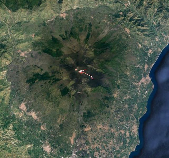
Mt. Etna, Sicily, Italy, is Europe most active volcano. In mid-May 2016, Mt. Etna put on a display of lava fountaining, ash clouds and lava flows. Three of the four summit craters were active. NASA Terra spacecraft acquired this image on May 26, 2016.
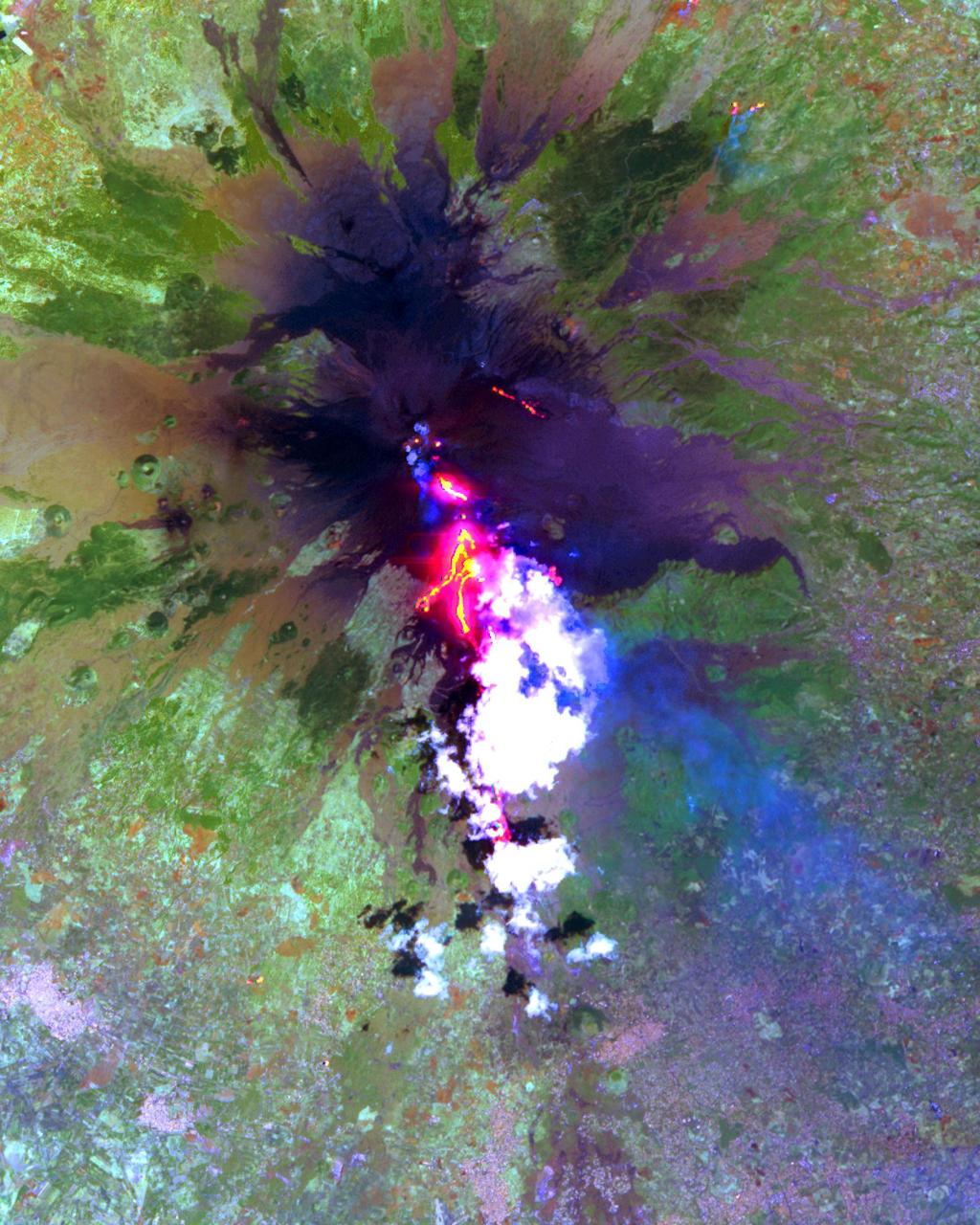
The current eruption of Mt. Etna started on July 17, and has continued to the present. This ASTER image was acquired on Sunday, July 29 and shows the sulfur dioxide plume (in purple) originating form the summit, drifting over the city of Catania, and continuing over the Ionian Sea. ASTER's unique combination of multiple thermal infrared channels and high spatial resolution allows the determination of the thickness and position of the SO2 plume. The image covers an area of 24 x 30 km. The image is centered at 37.7 degrees north latitude, 15 degrees east longitude. http://photojournal.jpl.nasa.gov/catalog/PIA02678
This image acquired by NASA Terra spacecraft is of Mt. Etna, Europe most active volcano, as it continued its latest eruptive activity with a new lava flow from the recently formed southeast crater.
STS113-332-030 (14 December 2002) --- The STS-113 crewmembers used a 35mm still camera to record this image of Mt. Etna Volcano erupting on the island of Sicily. The south-looking oblique sunset view shows snowy, winter-time Mt. Etna with a brown smutty ash plume.
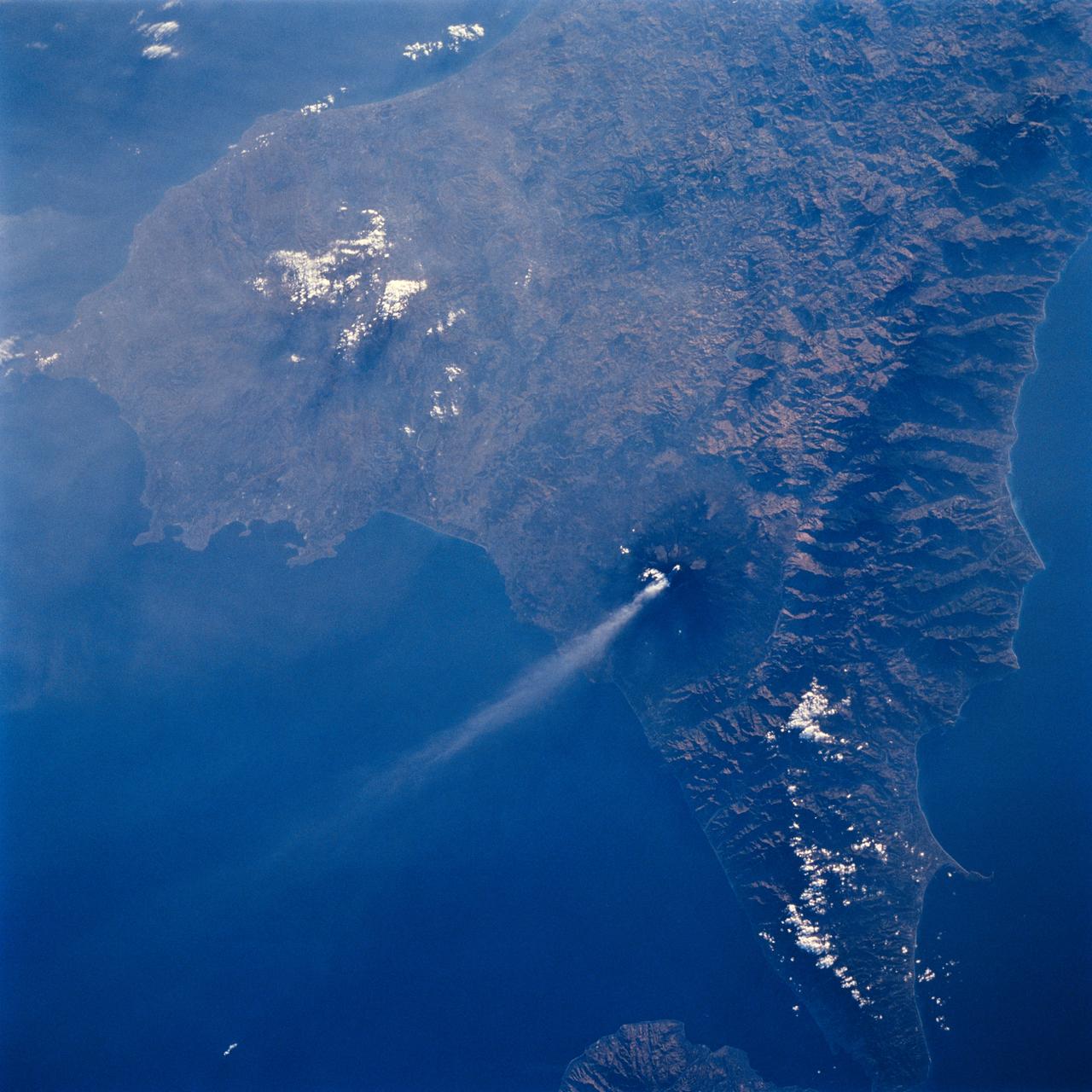
STS106-706-055 (8-20 September 2000) --- One of the STS-106 crew members on board the Space Shuttle Atlantis used a handheld 70mm camera to photograph this image of the Etna Volcano on Sicily. Mt. Etna is known as the volcano with the longest record of volcanic activity with the first being in 1500 BC. It has erupted many times since then and is almost continuously venting gas and steam, as shown in this view. Astronauts can almost be assured of seeing some venting whenever they fly in orbit. Mt. Etna appears as a cone with an almost circular base in this near-vertical view. The Salso River winds around the western and southern flanks of the volcano. The city of Catania appears as a diffuse gray patch at the foot of the volcano where the river meets the Mediterranean Sea. Mt. Etna has a complex of cones at its summit, which is nearly 3300 meters above sea level. Its slopes are a patchwork of colors, the darker colors being lava flows of different ages. Greens are patches of forest on slopes which have not been disrupted by lava and ash in the last few decades. Mt. Etna is a constructional landform which has been built upwards for millennia; it contrasts subtly but distinctly in this view with the surrounding lower hills which are water-eroded landforms everywhere sculpted into V-shaped valleys by the erosive power of flowing water of streams.

Earth Observation taken during a day pass by the Expedition 40 crew aboard the International Space Station (ISS). Folder lists this as: Italy, Mt. Etna.
Earth Observation taken during a day pass by the Expedition 40 crew aboard the International Space Station (ISS). Folder lists this as: Italy, Mt. Etna.

STS113-332-035 (14 December 2002) --- The STS-113 crewmembers used a 35mm still camera to record this image of Mt. Etna Volcano erupting on the island of Sicily. The oblique, south-looking view shows Mt. Etna's dark ash plume rising above the general altitude of storm clouds over the Mediterranean Sea at sunset on Dec. 14, 2002.
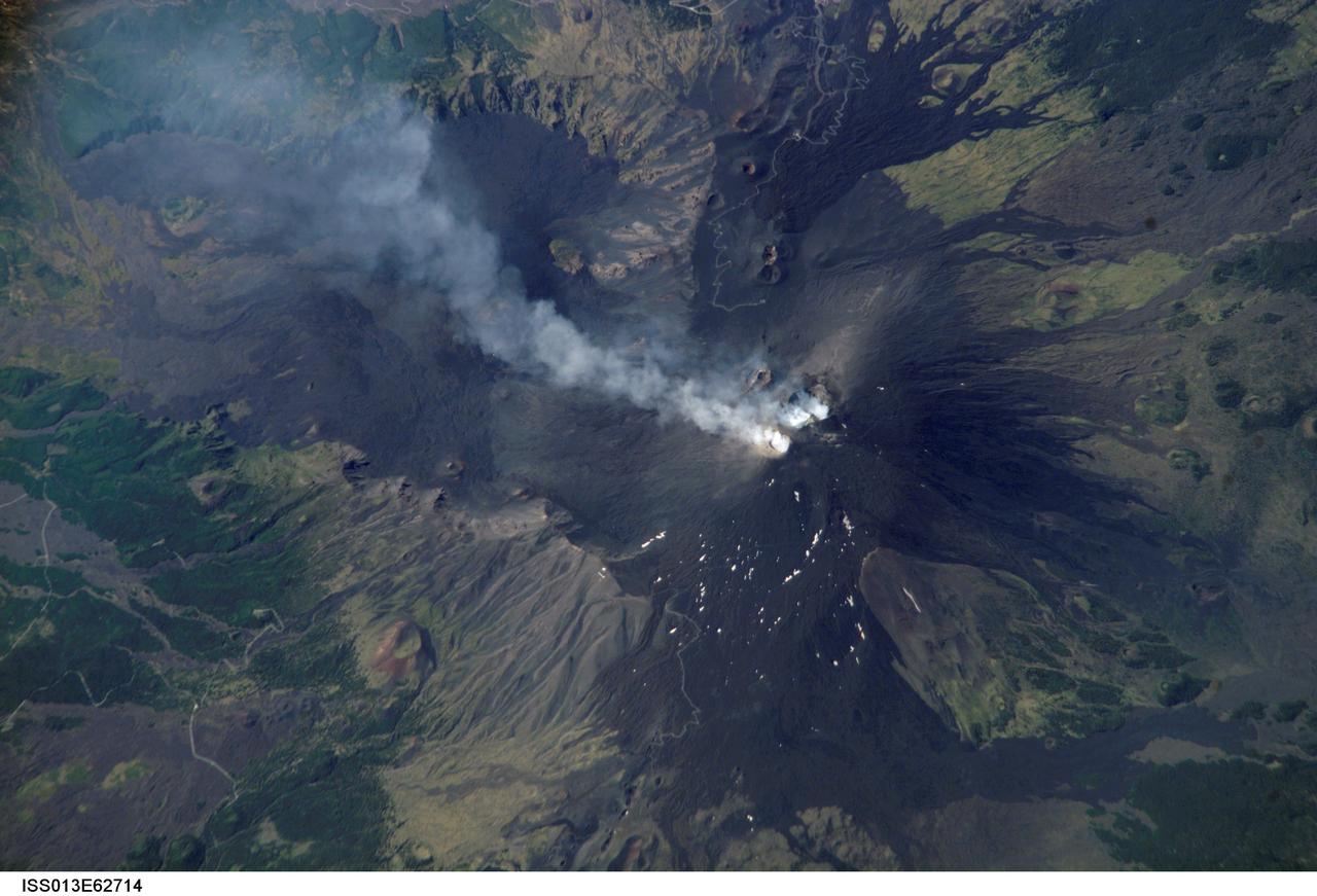
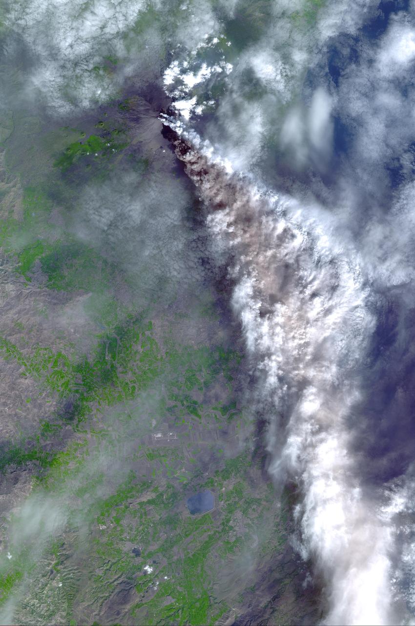
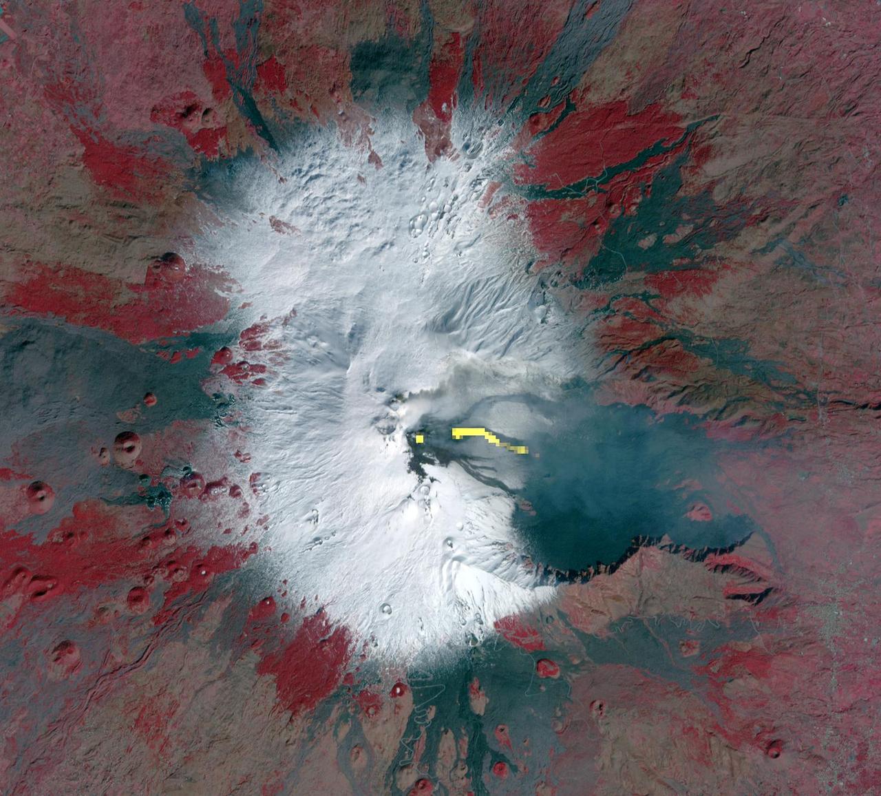
ISS013-E-62714 (2 Aug. 2006) --- Mt. Etna Summit Plumes, Sicily is featured in this image photographed by an Expedition 13 crewmember on the International Space Station. One of the most consistently active volcanoes in the world is Sicily's Mt. Etna, which has a historical record of eruptions dating back to 1500 B.C. This image captures plumes of steam and possible minor ash originating from summit craters on the mountain -- the Northeast Crater and Central Crater, which includes two secondary craters (Voragine and Bocca Nuova). Explosions were heard from the rim of the Northeast Crater on July 26, and scientists suspect that these plumes are a continuation of that activity. The massive 3350 meter high volcano is located approximately 24 kilometers to the north of Catania, the second largest city in Sicily, and dominates the northern skyline. Much of Etna's surface is comprised of numerous generations of dark basaltic lava flows, as can be seen extended outwards from the summit craters. Fertile soils developed on older flows are marked by green vegetation. While the current explosive eruptions of Etna tend to occur at the summit, lava flows generally erupt through fissures lower down on the flanks of the volcano. Many of the lava flow vents are marked by cinder cones on the flanks of Mt. Etna. Scientists have noted evidence of larger eruptive events as well. The Valle Del Bove to the south-southeast of the summit is a caldera formed by the emptying of a subsurface magma chamber during a large eruptive event -- once the magma chamber was emptied, the overlaying roof material collapsed downwards.
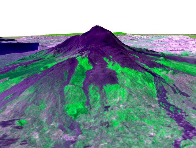
Italy's Mount Etna is the focus of this perspective view made from an Advanced Spaceborne Thermal and Emission Radiometer (ASTER) image from NASA's Terra spacecraft overlaid on Shuttle Radar Topography Mission (SRTM) topography. The image is looking south with dark lava flows from the 1600's (center) to 1981 (long flow at lower right) visible in the foreground and the summit of Etna above. The city of Catania is barely visible behind Etna on the bay at the upper left. In late October 2002, Etna erupted again, sending lava flows down the north and south sides of the volcano. The north flows are near the center of this view, but the ASTER image is from before the eruption. In addition to the terrestrial applications of these data for understanding active volcanoes and hazards associated with them such as lava flows and explosive eruptions, geologists studying Mars find these data useful as an analog to martian landforms and geologic processes. In late September 2002, a field conference with the theme of Terrestrial Analogs to Mars focused on Mount Etna, allowing Mars geologists to see in person the types of features they can only sample remotely. http://photojournal.jpl.nasa.gov/catalog/PIA03371
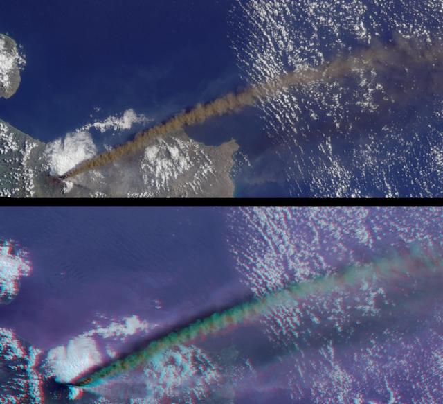
This anaglyph from the MISR instrument aboard NASA Terra spacecraft captured the energetic eruption of Sicily Mount Etna volcano on October 29, 2002. 3D glasses are necessary to view this image.
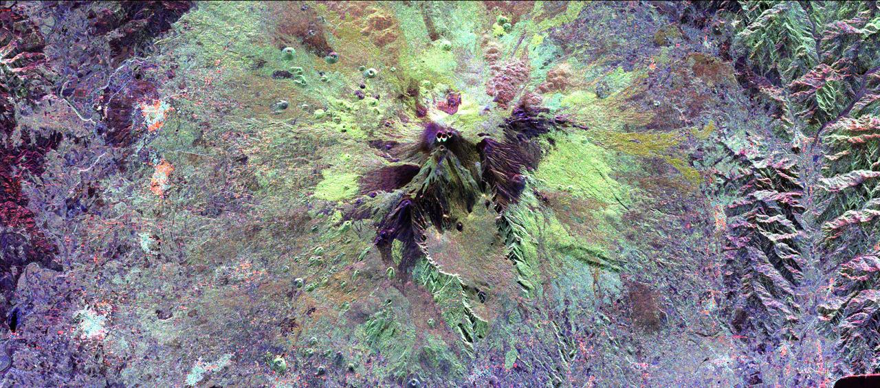
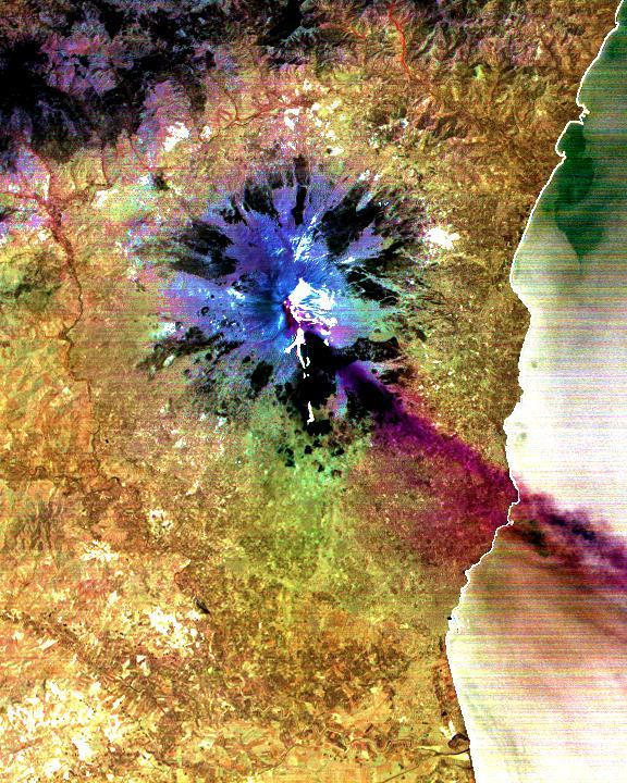
The summit of the Mount Etna volcano on the island of Sicily, Italy, one of the most active volcanoes in the world, is shown near the center of this radar image. Lava flows of different ages and surface roughness appear in shades of purple, green, yellow and pink surrounding the four small craters at the summit. Etna is one of the best-studied volcanoes in the world and scientists are using this radar image to identify and distinguish a variety of volcanic features. Etna has erupted hundreds of times in recorded history, with the most recent significant eruption in 1991-1993. Scientists are studying Etna as part of the international "Decade Volcanoes" project, because of its high level of activity and potential threat to local populations. This image was acquired on October 11, 1994 by the Spaceborne Imaging Radar-C/X-Band Synthetic Aperture Radar (SIR-C/X-SAR) aboard the space shuttle Endeavour. SIR-C/X-SAR, a joint mission of the German, Italian and the United States space agencies, is part of NASA's Mission to Planet Earth. The image is centered at 37.8 degrees North latitude and 15.1 degrees East longitude and covers an area of 51.2 kilometers by 22.6 kilometers (31.7 miles by 14.0 miles). http://photojournal.jpl.nasa.gov/catalog/PIA01776
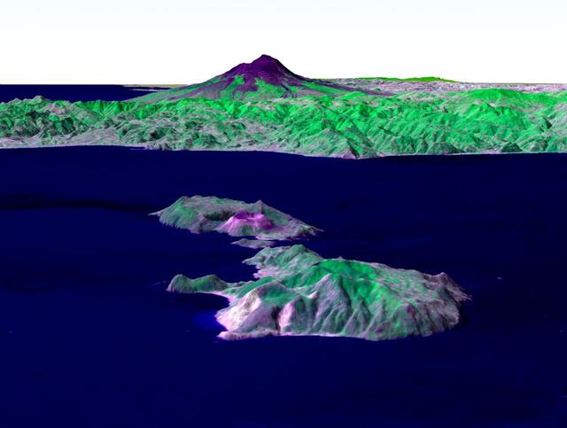
Italy's Mount Etna and the Aeolian Islands are the focus of this perspective view made from an Advanced Spaceborne Thermal and Emission Radiometer (ASTER) image from NASA's Terra spacecraft overlaid on Shuttle Radar Topography Mission (SRTM) topography. The image is looking south with the islands of Lipari and Vulcano in the foreground and Etna with its dark lava flows on the skyline. Vulcano also hosts an active volcano, the cone of which is prominent. In late October 2002, Etna erupted again, sending lava flows down the north and south sides of the volcano. The north flows are near the center of this view, but the ASTER image is from before the eruption. In addition to the terrestrial applications of these data for understanding active volcanoes and hazards associated with them such as lava flows and explosive eruptions, geologists studying Mars find these data useful as an analog to martian landforms and geologic processes. In late September 2002, a field conference with the theme of Terrestrial Analogs to Mars focused on Mount Etna allowing Mars geologists to see in person the types of features they can only sample remotely. http://photojournal.jpl.nasa.gov/catalog/PIA03370

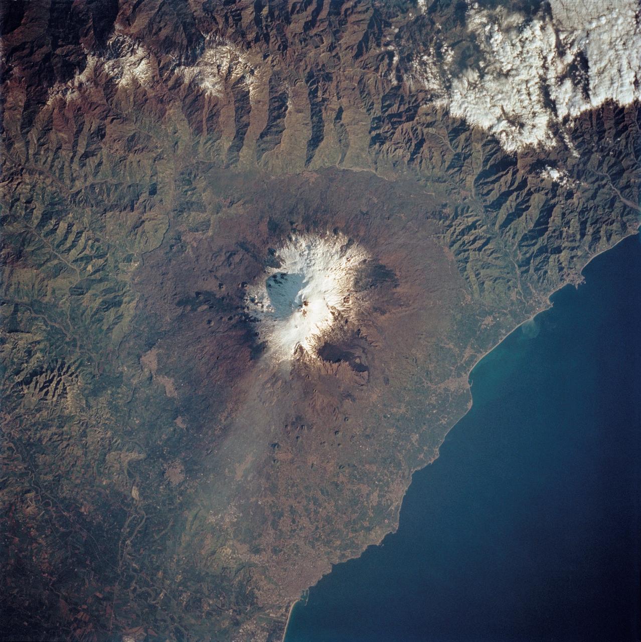
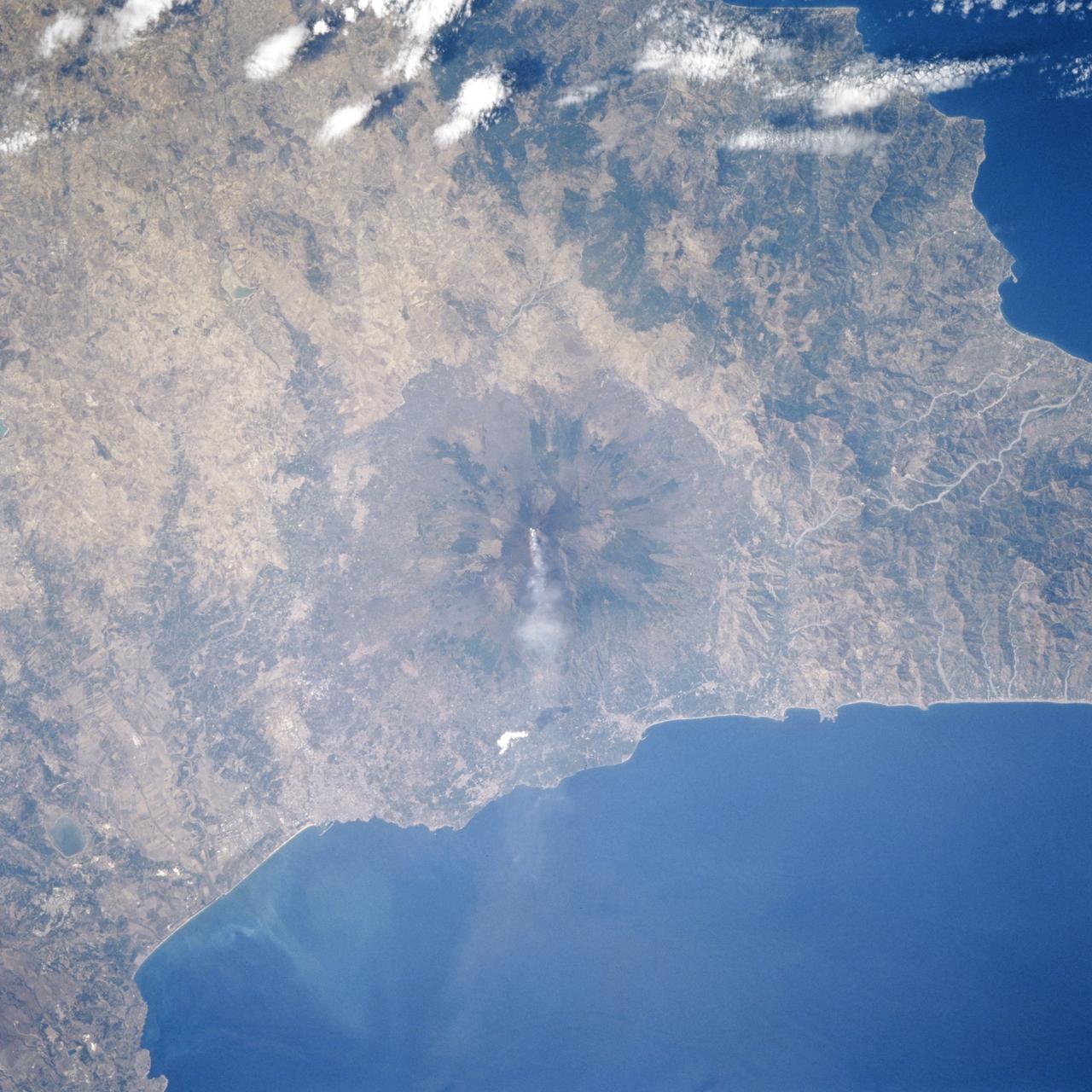
STS100-713-064 (19 April-1 May 2001) --- This southerly-looking view, captured with a 70mm camera onboard the Space Shuttle Endeavour, shows the triangular-shaped island of Sicily. With only very limited coastal plains the island's topography consists of rugged hills and low mountains. Snow-capped Mt. Etna, one of the world's most instrumented volcanoes, is visible near the northeast point of the island. Two other distinctive features in this image are the lighter-colored zone of suspended sediment in the water along the southern coast and, in the distance, the smaller islands of Malta.
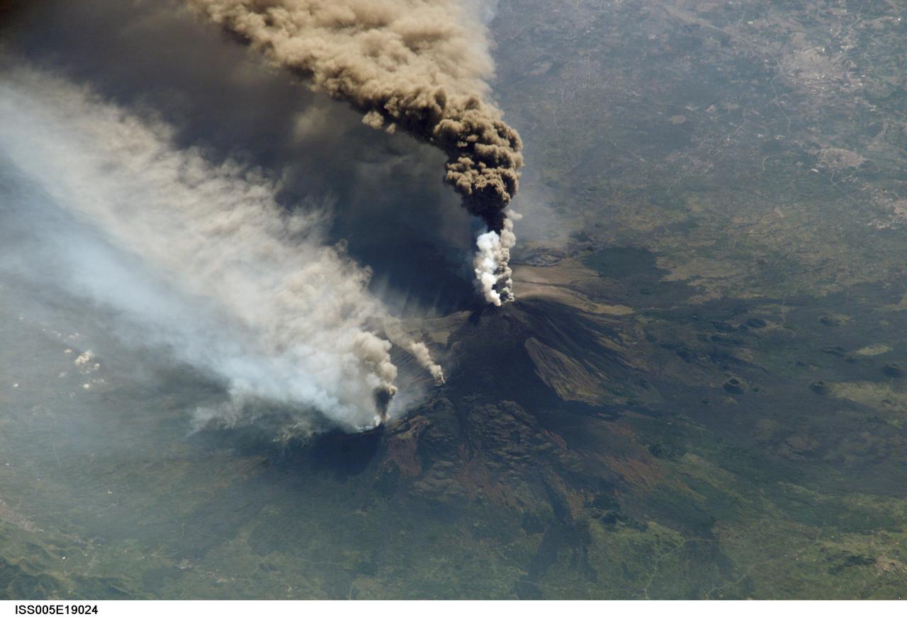
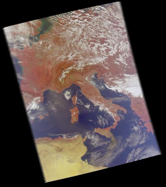
ISS005-E-19024 (30 October 2002) --- The three-member crew of the Expedition Five mission onboard the International Space Station was able to observe Mt. Etna’s spectacular eruption, and photograph the details of the eruption plume and smoke from fires triggered by the lava as it flowed down the 11,000 ft mountain. This image and a second image (ISS005-E-19016) are looking obliquely to the southeast over the island of Sicily. The wider view (ISS005-E-19024) shows the ash plume curving out toward the horizon, caught first by low-level winds blowing to the southeast, and to the south toward Africa at higher altitudes. Ashfall was reported in Libya, more than 350 miles away. The lighter-colored plumes downslope and north of the summit seen in this frame are produced by forest fires set by lava flowing into the pine forests on the slope of the mountain. This image provides a more three-dimensional profile of the eruption plume. This eruption was one of Etna’s most vigorous in years, volcanologists reported this week. The eruption was triggered by a series of earthquakes on October 27, 2002, they said. These images were taken on October 30. Although schools were closed and air traffic was diverted because of the ash, no towns or villages were reported to have been threatened by the lava flow.
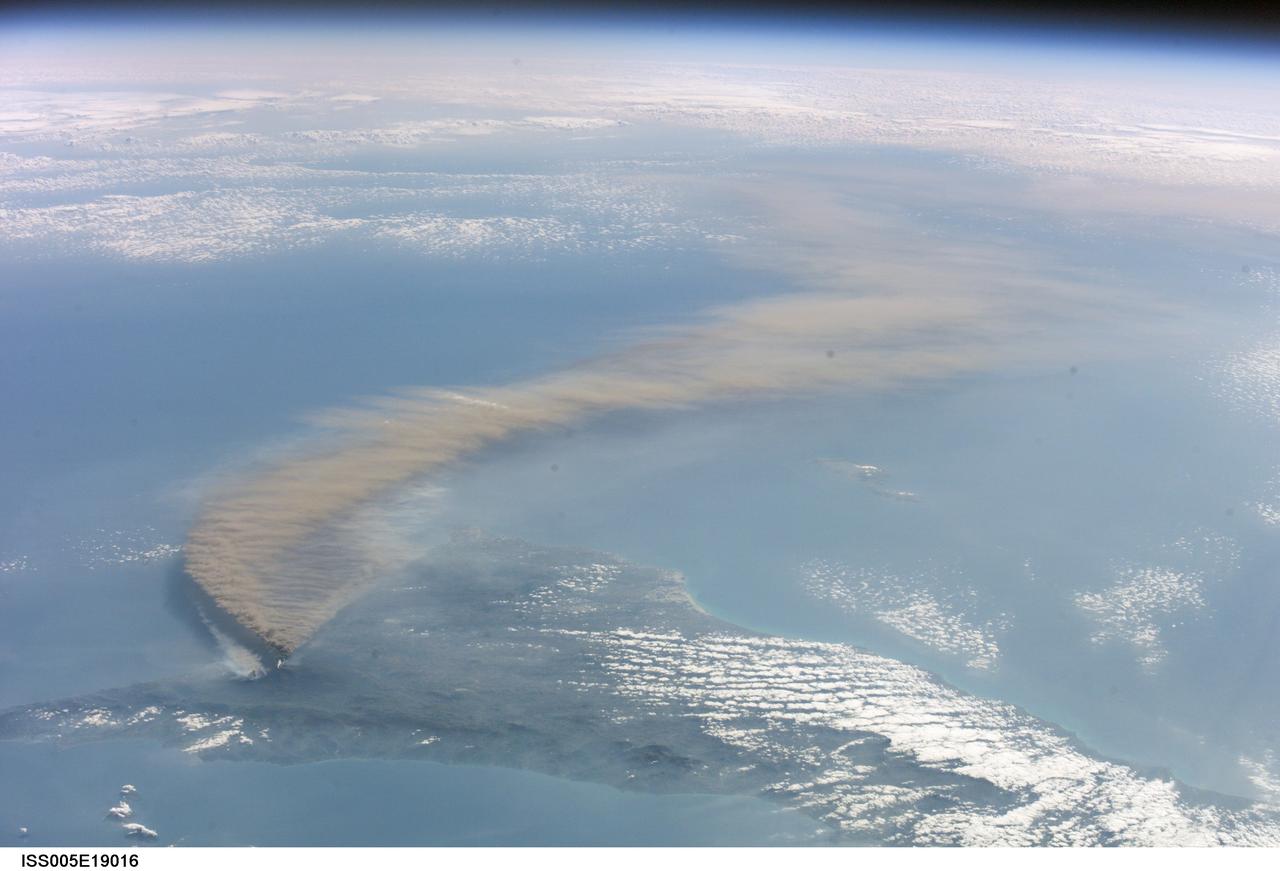
ISS005-E-19016 (30 October 2002) --- The three-member crew of the Expedition Five mission onboard the International Space Station was able to observe Mt. Etna’s spectacular eruption, and photograph the details of the eruption plume and smoke from fires triggered by the lava as it flowed down the 11,000 ft mountain. This image and a second image (ISS005-E-19024) are looking obliquely to the southeast over the island of Sicily. This wide view shows the ash plume curving out toward the horizon, caught first by low-level winds blowing to the southeast, and to the south toward Africa at higher altitudes. Ashfall was reported in Libya, more than 350 miles away. The lighter-colored plumes downslope and north of the summit (see detailed view taken the same day, ISS005-E-19024) are produced by forest fires set by lava flowing into the pine forests on the slope of the mountain. The detailed image provides a more three-dimensional profile of the eruption plume. This eruption was one of Etna’s most vigorous in years, volcanologists reported this week. The eruption was triggered by a series of earthquakes on October 27, 2002, they said. These images were taken on October 30. Although schools were closed and air traffic was diverted because of the ash, no towns or villages were reported to have been threatened by the lava flow.