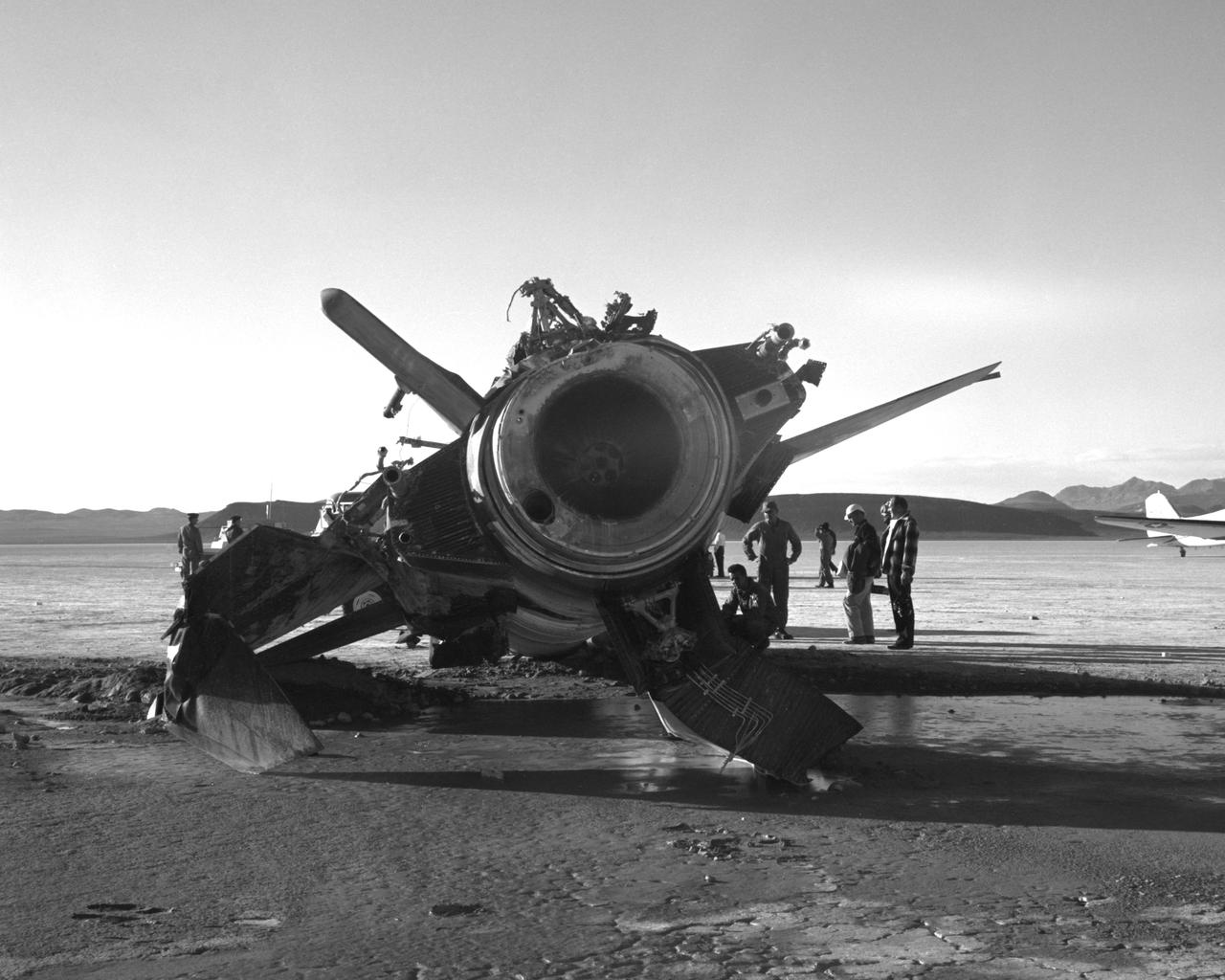
NASA research pilot Jack McKay was injured in a crash landing of the X-15 #2 on November 9, 1962. Following the launch from the B-52 to begin flight 2-31-52, he started the X-15's rocket engine, only to discover that it produced just 30 percent of its maximum thrust. He had to make a high-speed emergency landing on Mud Lake, NV, without flaps but with a significant amount of fuel still in the aircraft. As the X-15 slid across the lakebed, the left skid collapsed; the aircraft turned sideways and flipped onto its back. McKay suffered back injuries but was eventually able to resume X-15 pilot duties, making 22 more flights. The X-15 was sent back to North American Aviation and rebuilt into the X-15A-2.

iss071e133389 (May 29, 2024) --- Mud Lake in Harney County, Oregon, one of at least sixteen similarly named lakes throughout the Beaver State, is pictured from the International Space Station as it orbited 263 miles above.
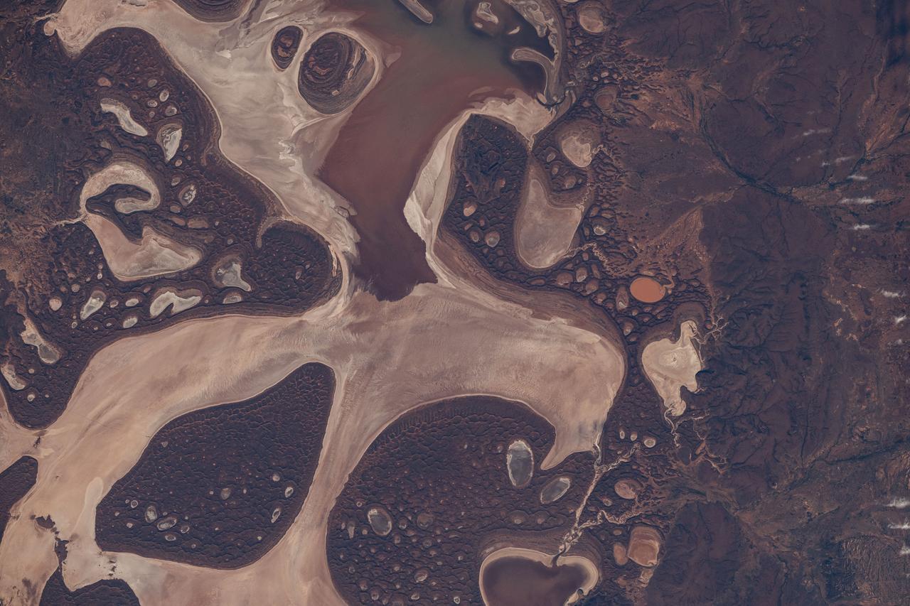
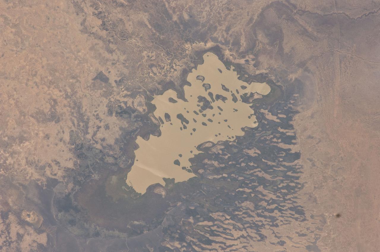
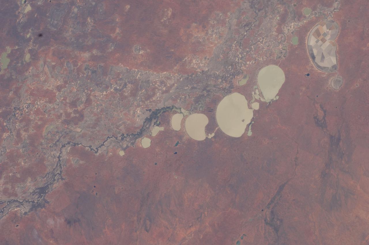
iss071e615200 (Sept. 9, 2024) -- The ephemeral Lake Carnegie, one of Western Australia's largest lakes, displays its mixture of water and mud as the International Space Station orbited 263 miles above. The lake fills with water only during periods of heavy rainfall, while in dry years, the lake is mostly a muddy marsh.
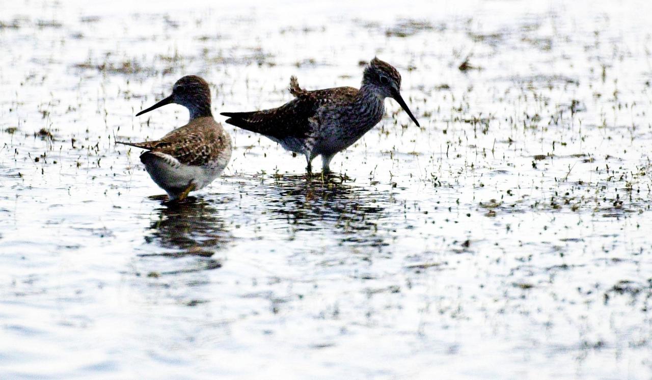
KENNEDY SPACE CENTER, FLA. -- A pair of Lesser Yellowlegs search a lake near Kennedy Space Center for food. The species inhabits marshy ponds, lake and river shores, and mud flats. They range from Alaska and Canada, wintering in the southern United States and South America.
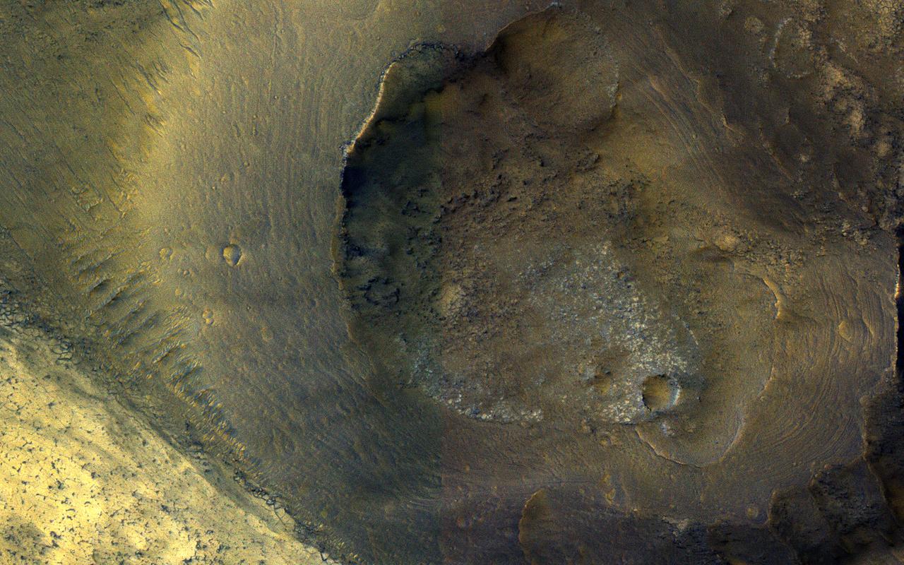
This image from NASA's Mars Reconnaissance Orbiter (MRO) shows a hill with a central crater. Such features have been interpreted as both mud volcanoes (really a sedimentary structure) and as actual volcanoes (the erupting lava kind). They occur on the floor of Valles Marineris below a closed topographic contour that could have held a lake, and the compaction of wet sediments may have created mud volcanoes. The fracture pattern of the bright flow unit surrounding the hill resembles mud cracks. However, there have also been observations from the CRISM instrument interpreted as high-temperature minerals, suggesting actual volcanism, although not necessarily at this location. Fine layers in the hill are consistent with either volcanism or mud flows. Either way, this activity is relatively recent in geologic time and may mark habitable subsurface environments. https://photojournal.jpl.nasa.gov/catalog/PIA22514
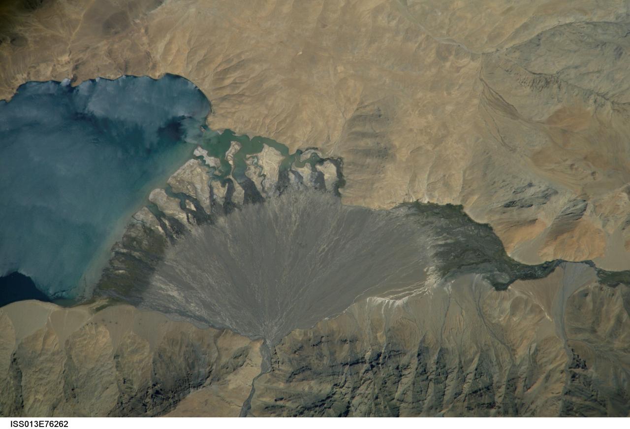
ISS013-E-76262 (4 Sept. 2006) --- Lake Morari, Tibet is featured in this image photographed by an Expedition 13 crewmember onboard the International Space Station. Melt-water from glaciers to the east and west drains into Lake Morari, a large lake on the Tibetan Plateau which lies at an altitude of 4,521 meters (14,830 feet). The main inflow to the lake is via a west-side stream. Mud from this river gives the light blue hues to the lake water. The well-formed alluvial fan (center), built by sediment from the main inflow river, is the reason the lake has formed at this point in the valley. The fan has dammed up the depression now occupied by Lake Morari (approximately 7 kilometers wide in this view) and forms the curved southern shore of the lake. The apex of the fan lies fully 40 meters above the level of the lake. The change of color and texture on the fan seems to result from a new influx of gray sediment on top of an older fan which had several channels cut into it. Interestingly, the alluvial fan also acts as the only outlet of the lake, although no obvious outlet channel can be seen in this detailed view. South of the fan an outlet river appears as a green surface, possibly due to aquatic vegetation or algae. Altitude measurements show that the outlet river lies many meters below the lake surface.
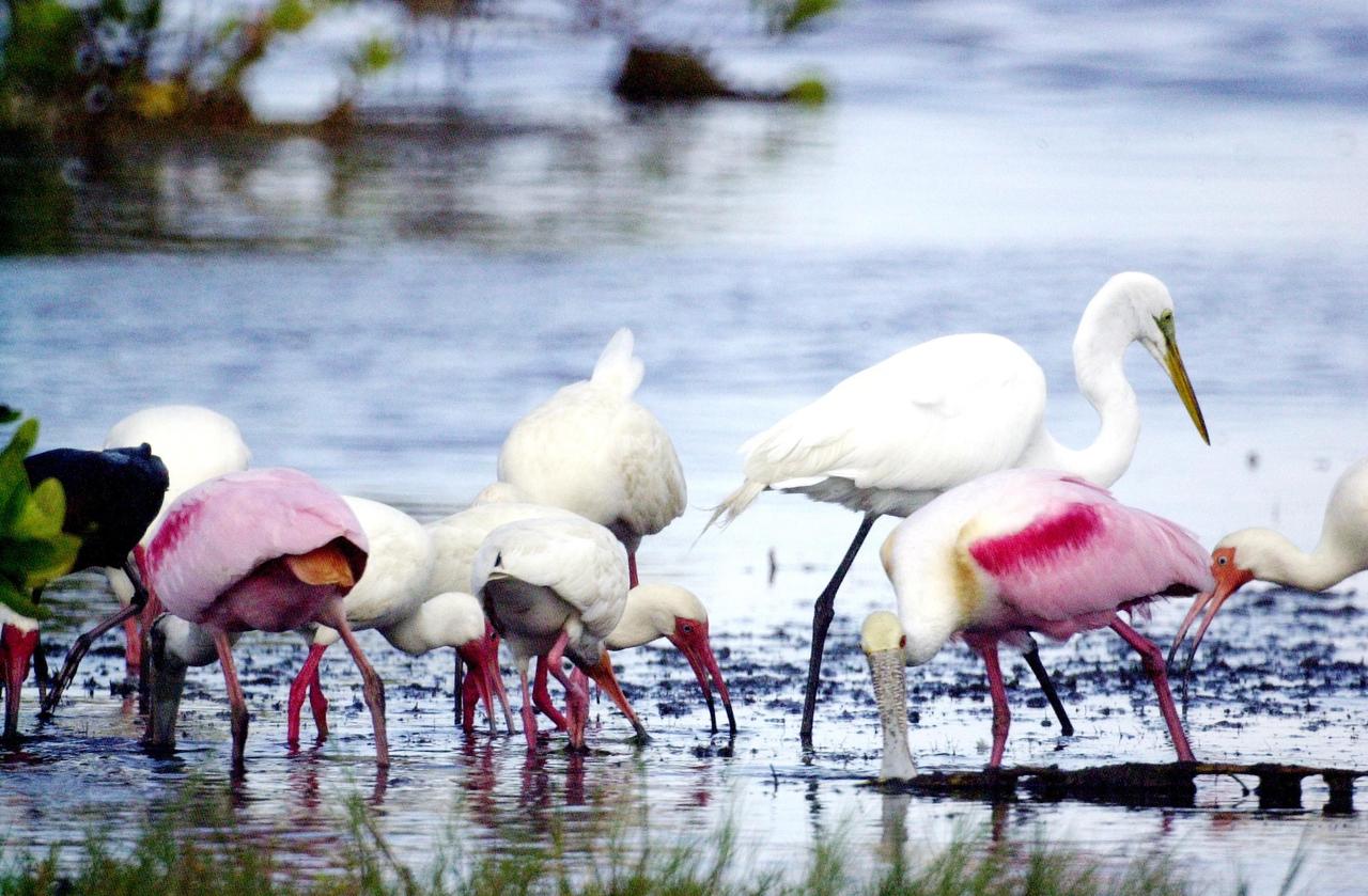
KENNEDY SPACE CENTER, FLA. -- A mixed group of water birds searches for food in a lake near Kennedy Space Center. Identified are a Great Egret (background, with yellow beak), White Ibis (far right and center, orange beak), and Roseate Spoonbills. All prefer marshes, mud flats, ponds, lagoons and tidal flats as habitat. They are frequently found in the warm, coastal areas of Florida
STS068-260-078 (30 September-11 October 1994) --- The ice visible along the bottom of this view is the north end of the larger (southern) of two great remaining ice field of the Andes Mountains in Chile. The longest glacier visible here flows down into the Calen Fjord (an arm of the Pacific Ocean known as Canal Baker) where numerous calved icebergs can be seen floating. The other three glaciers end in glacier-cut valleys with small lakes - the bigger lake has numerous icebergs as well. the river snaking through the mountains to the fjord drains water from the great Lake O'Higgins, which lies out of the picture to the right. Glacial mud can be seen emptying into the fjord and discoloring the water with its milky color.
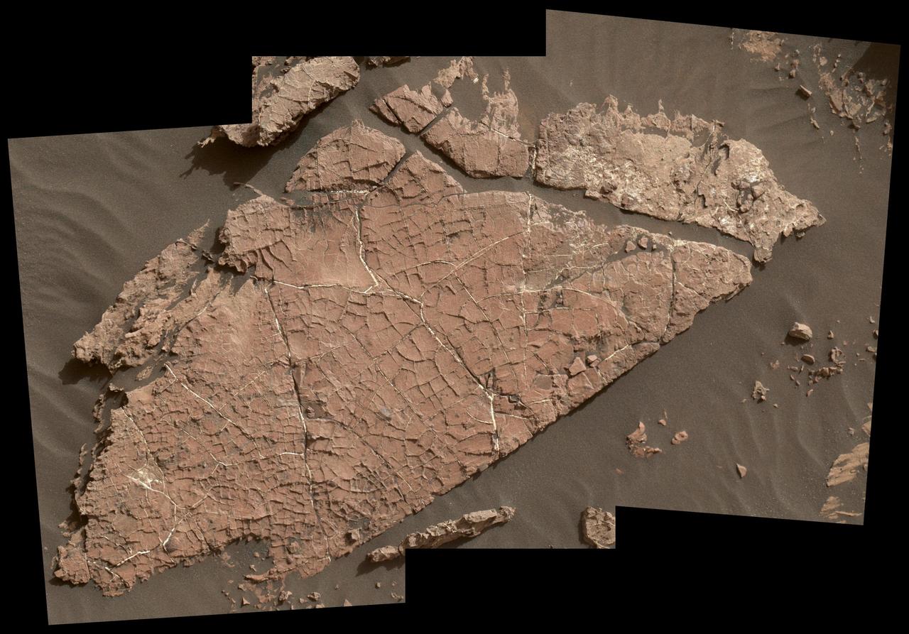
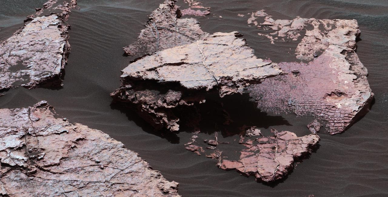
The network of cracks in this Martian rock slab called "Old Soaker" may have formed from the drying of a mud layer more than 3 billion years ago. The view spans about 4 feet (1.2 meters) left-to-right and combines three images taken by the Mars Hand Lens Imager (MAHLI) camera on the arm of NASA's Curiosity Mars rover. Mud cracks would be evidence of a time when dry intervals interrupted wetter periods that supported lakes in the area. Curiosity has found evidence of ancient lakes in older, lower-lying rock layers and also in younger mudstone that is above Old Soaker. MAHLI was positioned about 3 feet (90 centimeters) above the surface when it took the component images on Dec. 31, 2016, during the 1,566th Martian day, or sol, of Curiosity's work on Mars. This observation was planned as part of assessing a hypothesis that the target preserves evidence of drying mud. The location is within an exposure of Murray formation mudstone on lower Mount Sharp inside Gale Crater. The slab bears a network of four- and five-sided polygons about half an inch to 1 inch (1 to 2 centimeters) across, which matches the pattern commonly formed when a thin layer of mud dries. Some edges of the polygons are ridges of material the same color as the surrounding rock. This could result from a three-step process after cracks form due to drying: Wind-blown sediments accumulate in the open cracks. Later, these sediments and the dried mud become rock under the pressure of multiple younger layers that accumulate on top of them. Most recently, after the overlying layers were eroded away by wind, the vein-filling material resists erosion better than the once-muddy material, so the pattern that began as cracks appears as ridges. Note that some of the cracks contain material much brighter than the surrounding rock. These are mineral veins. Curiosity has found such bright veins of calcium sulfate in many rock layers the rover has investigated. These veins form from circulation of mineral-laden groundwater through underground cracks. Rover-team scientists suggest that a likely scenario for the history of Old Soaker is more than one generation of fracturing: mud cracks first, with sediment accumulating in them, then a later episode of underground fracturing and vein forming. The target rock's name comes from the name of an island off the coast of Maine. The names informally assigned by the rover team to features in the area of lower Mount Sharp that includes this slab are from a list of islands, hills and other sites in or near Maine's Bar Harbor. http://photojournal.jpl.nasa.gov/catalog/PIA21261
A grid of small polygons on the Martian rock surface near the right edge of this view may have originated as cracks in drying mud more than 3 billion years ago. Multiple images from the Mast Camera (Mastcam) on NASA's Curiosity Mars rover were combined for this mosaic of a block called "Squid Cove" and its immediate surroundings. The location is within an exposure of Murray formation mudstone on lower Mount Sharp inside Gale Crater. Mastcam's right-eye camera, which has a telephoto lens, took the component images of this view on Dec. 20, 2016, during the 1,555th Martian day, or sol, of Curiosity's work on Mars. The rover drove farther uphill on Gale Crater before the possible mud cracks were detected in the Mastcam images. This possible evidence about the area's ancient environment prompted the rover mission to backtrack for closer inspection of Squid Cove and nearby target rocks. This scene is presented with a color adjustment that approximates white balancing, to resemble how the rocks and sand would appear under daytime lighting conditions on Earth. The polygons are about half an inch to 1 inch (about 1 to 2 centimeters) across. Figure 1 includes a scale bar of 30 centimeters (12 inches). The polygons are outlined by ridges. This could result from a three-step process after cracks form due to drying: Wind-blown sediments accumulate in the open cracks. Later, these sediments and the dried mud become rock under the pressure of multiple younger layers that accumulate on top of them. Most recently, after the overlying layers were eroded away by wind, the vein-filling material resists erosion better than the once-muddy material, so the pattern that began as cracks appears as ridges. Mud cracks would be evidence of a drying interval between wetter periods that supported lakes in the area. Curiosity has found evidence of ancient lakes in older, lower-lying rock layers and also in younger mudstone that is above Squid Cove. http://photojournal.jpl.nasa.gov/catalog/PIA21263
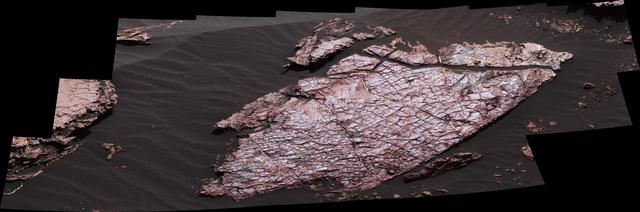
This view of a Martian rock slab called "Old Soaker," which has a network of cracks that may have originated in drying mud, comes from the Mast Camera (Mastcam) on NASA's Curiosity Mars rover. The location is within an exposure of Murray formation mudstone on lower Mount Sharp inside Gale Crater. Mud cracks would be evidence of a time more than 3 billion years ago when dry intervals interrupted wetter periods that supported lakes in the area. Curiosity has found evidence of ancient lakes in older, lower-lying rock layers and also in younger mudstone that is above Old Soaker. Several images from Mastcam's left-eye camera are combined into this mosaic view. They were taken on Dec. 20, 2016, during the 1,555th Martian day, or sol, of Curiosity's work on Mars. The Old Soaker slab is about 4 feet (1.2 meters) long. Figure 1 includes a scale bar of 30 centimeters (12 inches). The scene is presented with a color adjustment that approximates white balancing, to resemble how the rocks and sand would appear under daytime lighting conditions on Earth. http://photojournal.jpl.nasa.gov/catalog/PIA21262
ISS030-E-059398 (19 Jan. 2012) --- Lake Fitri, Chad is featured in this image photographed by an Expedition 30 crew member on the International Space Station. Lake Fitri is an endorheic, or terminal lake in a desert basin in the southern Sahara Desert. Muddy yellow-brown water marks the center of the depression (center), with a ring of dark brown muds and burnt vegetation on the exposed lake floor to the north. The lake shoreline supports a thin line of reed and floating grass vegetation which appears as dark green in the image. Deserts have so little rainfall that many rivers cannot reach the sea, but end at local low points where they form lakes. Here the usually dry Wadi Batha empties into Lake Fitri. Over time, water flow in Wadi Batha has created a large delta, which occupies the entire top left third of the image—a sense of scale is given by the 23–kilometer length of the lake. The lake has been designated under the Ramsar Convention as a wetland of international importance. Other features visible in the image reveal evidence of significant climate change. The dry part of the present lake shows that the lake has been larger in the last several decades. But, as NASA scientists point out, the lake was once many times larger than its present surface area, as shown by numerous sweeping curves of ancient beaches which are now situated many kilometers from the present shoreline, at higher altitudes (upper right). Inland lakes are highly sensitive to the exact equilibrium between the amount of inflow from contributing rivers like Wadi Batha and evaporation. Each beach ridge therefore shows a different lake level and thus a different balance in the lake-river-climate system. A smaller river enters from the south (top right) and cuts through the beach reaches on its way to the lake. The irregular, elongated, tan patches to the west of the lake are linear dunes aligned parallel to the dominant winds which blow from the northeast. The dunes have all formed on the downwind side (southwest) side of the lake since the lake bed and delta provide the sands which have built the dunes. The dunes indicate that during past climatic phases the lake has been almost or completely dry on repeated occasions—often enough for these great dunes, many kilometers long and several meters high, to form even in the lowest parts of the lake. The islands visible in the center of the lake are likewise remnants of dunes. These dunes are smaller than those on the lake margin, presumably because waves from the lake have eroded them. Villages occupy the points of some major dunes, and some islands, where fishermen can gain easy access to the lake.
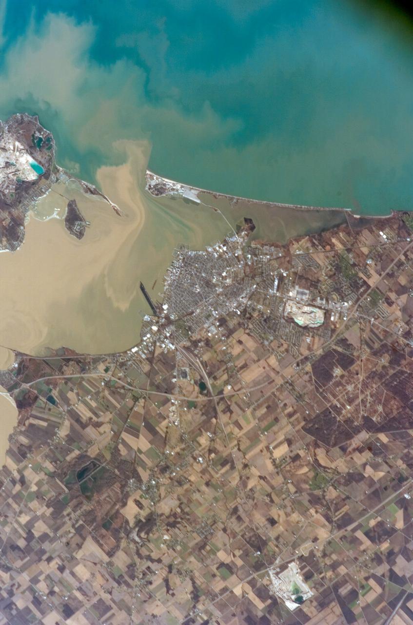
ISS012-E-15050 (12 Jan. 2006) --- Sandusky Bay is featured in this image photographed by an Expedition 12 crew member on the International Space Station. Sandusky Bay appears with brown muddy water (left) in this view. The bay leads out into southern Lake Erie (top). The small city of Sandusky occupies the northeastern shore of the bay (center of the image). Highway 6 can be seen arcing around the south side of the city. Ferries connect Sandusky to Pelee Island (not visible) in the middle of the lake. In earlier days, Sandusky Bay was known as one of the best protected port sites in the Great Lakes. The most striking aspect of this image is the flow lines of the brown water in and out of the mouth of the bay. Slight movement of lake surface water, driven mainly by wind, causes a small ebb and flow of bay water. Sediment-charged water is derived from agricultural fields along the Sandusky River upstream. Mud plumes in Lake Erie originate from prior pulses of muddy water from the bay. According to scientists studying the station photos, it appears that water was flowing into the bay when this image was taken. Sandusky lies midway between Toledo and Cleveland, both about an hour’s drive away.
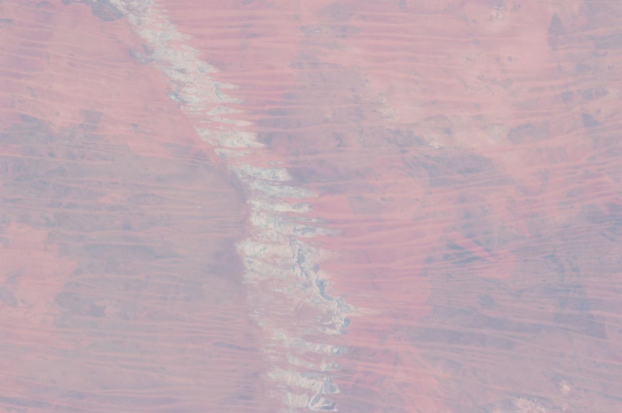
ISS030-E-009186 (3 Dec. 2011) --- The Menindee Lakes, New South Wales, Australia are featured in this image photographed by an Expedition 30 crew member on the International Space Station. The Menindee Lakes comprise a system of ephemeral, freshwater lakes fed by the Darling River when it floods. The lakes lie in the far west of New South Wales, Australia, near the town of Menindee. The longest is Lake Tandou (18.6 kilometers north?south dimension), visible at the upper right of this photograph. The lakes appear to have a small amount of water flooding them. The Darling River itself was flowing, as indicated by the dark water and blackened mud along its course (left). The Darling River flows southwest in tortuous fashion (bottom left to upper right). In the flat landscapes of this part of Australia, the river has created several inland deltas in its course to the sea, with characteristic diverging channel patterns, marked by younger sediments, which appear grayer than the surrounding ancient red soils and rocks. One such inland delta appears at right where minor channels wind across the countryside. The apex of another inland delta appears at upper right. Some of the Menindee Lakes have been incorporated in an artificially regulated overflow system providing for flood control, water storage for domestic use and livestock, as well as downstream irrigation. The lakes are also important as wetlands supporting a rich diversity of birds. The floor of one lake, Lake Tandou, is also used as prime agricultural land, as can be seen by its patchwork of irrigated fields, and is protected from flooding.
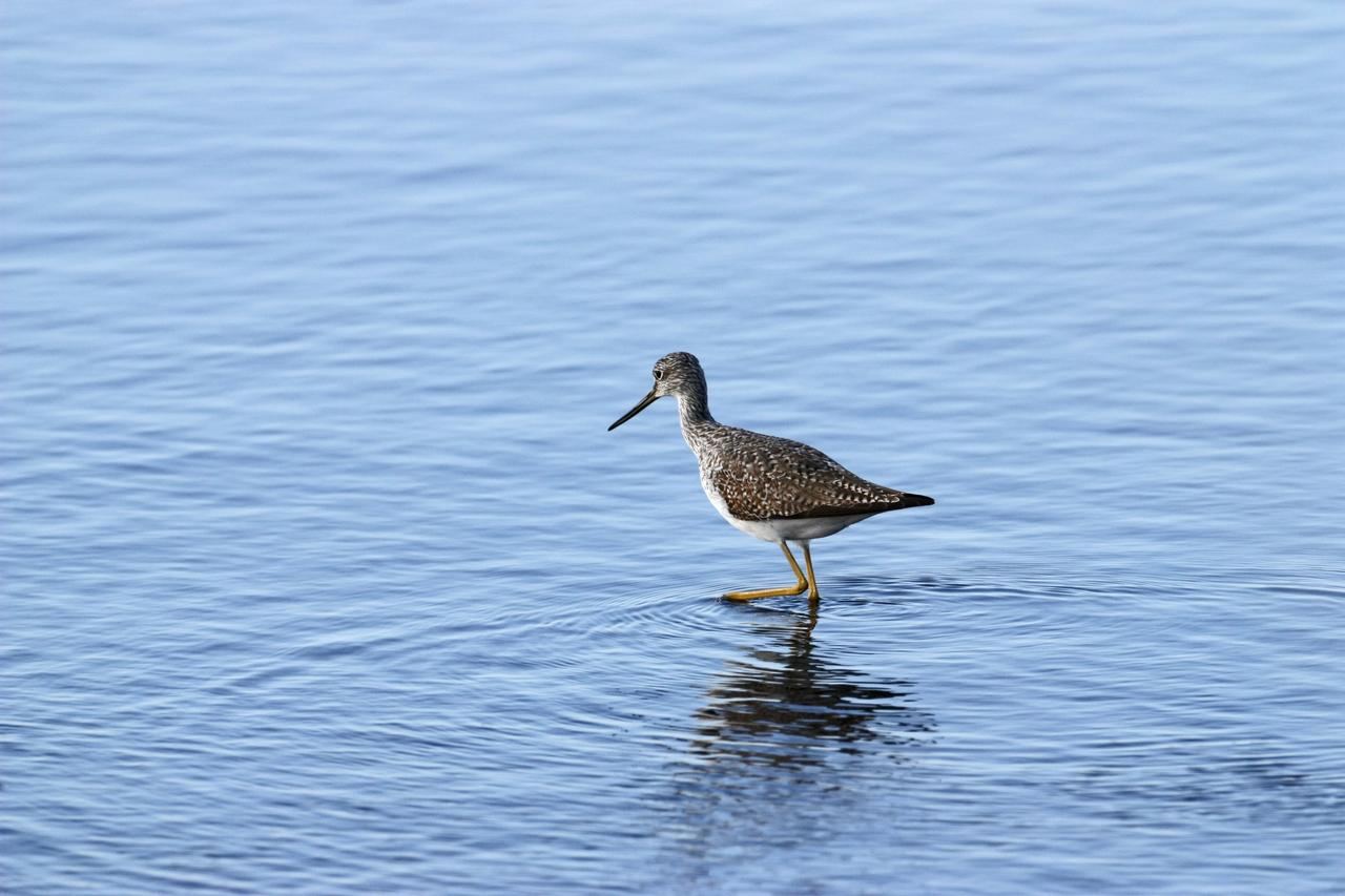
CAPE CANAVERAL, Fla. – A yellowleg sandpiper wades in the shallow water of a pond in the Merritt island National Wildlife Refuge, which borders NASA's Kennedy Space Center in Florida. They range through Alaska and Canada, wintering from the southern U.S. to southern South America. They inhabit marshy ponds, lake and river shores and mud flats. The center shares a boundary with the refuge that includes salt-water estuaries, brackish marshes, hardwood hammocks and pine flatwoods. The diverse landscape provides habitat for more than 310 species of birds, 25 mammals, 117 fishes and 65 amphibians and reptiles. Photo credit: NASA/Jim Grossmann
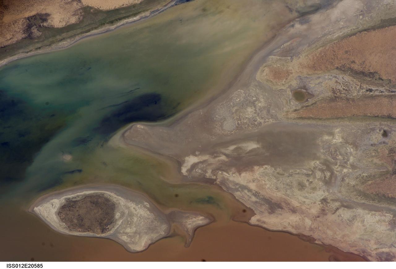
ISS012-E-20586 (9 March 2006) --- A portion of Lake Poopo is featured in this image photographed by an Expedition 12 crewmember on the International Space Station. Lake Poopo sits high in the Bolivian Andes, catching runoff from its larger neighbor to the north - Lake Titicaca (not shown) - by way of the Desaguadero River (muddy area at the north end of the lake). Because Lake Poopo is very high in elevation (roughly 3400 meters or 11,000 feet above sea level), very shallow (generally less than 3 meters or 9 feet), and the regional climate is very dry, small changes in precipitation in the surrounding basin have large impacts on the water levels and areal extent of Lake Poopo. When the lake fills during wet periods, Poopo drains from the south end into Salar de Coipasa (not shown). Water levels in Poopo are important because it is one of South America’s largest saline lakes, and a prime stop for migratory birds, including flamingoes. Last November, water levels had dropped, exposing large tracts of salt and mud flats. A wet and cool period between December and the end of February resulted in flooding of Poopo with muddy waters from the Desaguadero River. NASA managers have tasked the station crew to track such changes, which are related to regional weather patterns. Lake Poopo’s sensitivity to precipitation in the high Andes (possibly reflecting larger climate cycles) provides an excellent visual indicator of these trends.
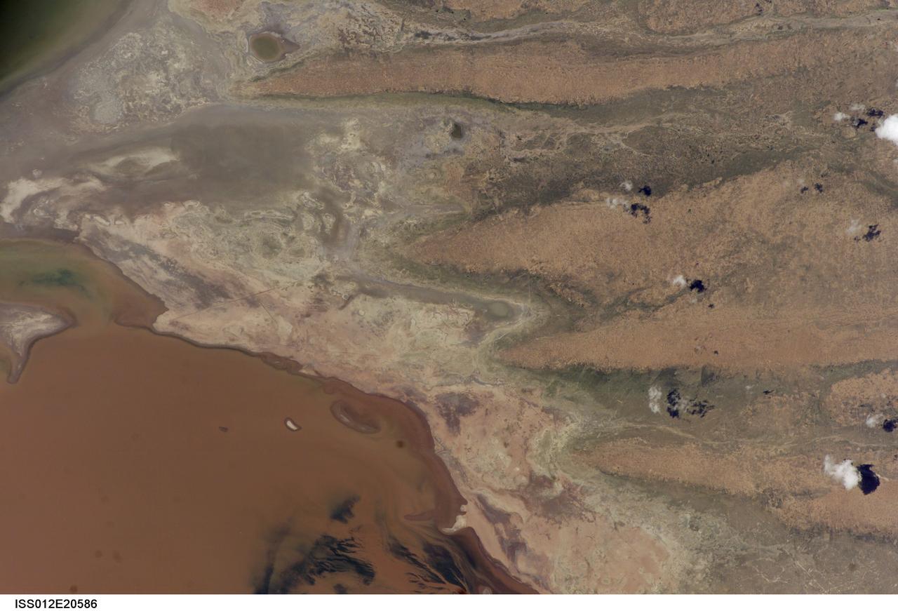
ISS012-E-20585 (9 March 2006) --- A portion of Lake Poopo is featured in this image photographed by an Expedition 12 crewmember on the International Space Station. Lake Poopo sits high in the Bolivian Andes, catching runoff from its larger neighbor to the north - Lake Titicaca (not shown) - by way of the Desaguadero River (muddy area at the north end of the lake). Because Lake Poopo is very high in elevation (roughly 3400 meters or 11,000 feet above sea level), very shallow (generally less than 3 meters or 9 feet), and the regional climate is very dry, small changes in precipitation in the surrounding basin have large impacts on the water levels and areal extent of Lake Poopo. When the lake fills during wet periods, Poopo drains from the south end into Salar de Coipasa (not shown). Water levels in Poopo are important because it is one of South America’s largest saline lakes, and a prime stop for migratory birds, including flamingoes. Last November, water levels had dropped, exposing large tracts of salt and mud flats. A wet and cool period between December and the end of February resulted in flooding of Poopo with muddy waters from the Desaguadero River. NASA managers have tasked the station crew to track such changes, which are related to regional weather patterns. Lake Poopo’s sensitivity to precipitation in the high Andes (possibly reflecting larger climate cycles) provides an excellent visual indicator of these trends.
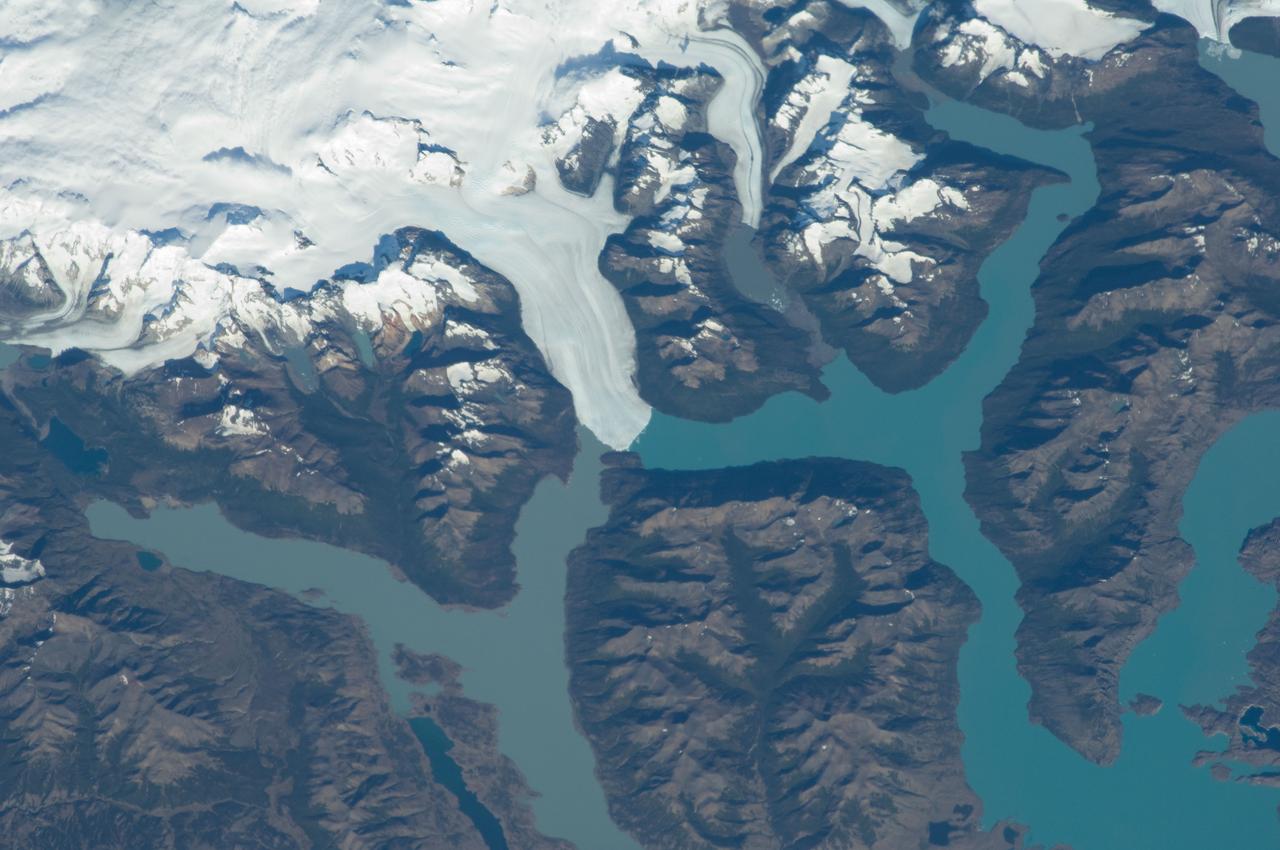
ISS030-E-091253 (21 Feb. 2012) --- Perito Moreno Glacier near Lake Argentino, Argentina is featured in this image photographed by an Expedition 30 crew member on the International Space Station. The largest glacier tongue in this image is known as the Perito Moreno Glacier (center). It descends from the Southern Patagonian Icefield (top) at great altitudes (greater than 2,100 meters, 6,825 feet) in the southern Andes Mountains, down into the water and warmer altitudes of Lake Argentino at approximately 180 meters above sea level. The glacier is 30 kilometers long (image width represents approximately 60 kilometers on the ground). Perito Moreno is one of the largest glaciers in Patagonia, and is perhaps the most famous for the fact that it periodically cuts off the major southern arm (known as Brazo Rico) of Lake Argentino completely from the rest of the lake. This is because the glacier advances right across the lake until it meets the opposite shoreline. The ice tongue is “grounded” (meaning that it is not floating, as occurs at the termini of glaciers and ice shelves where they enter the sea), thus forming a natural dam which prevents the lake water on either side from circulating, which in turn causes muddier, “milkier” water to concentrate in Brazo Rico. Sub-ice water, flows under the ice, not only carrying the mud into the lake but also helping lubricate the glacier’s downhill movement. Because of its effect as a dam, meltwater from the south raises water levels in Brazo Rico by as much as 30 meters above the level of the water in Lago Argentino. The great pressure of this higher water ultimately causes the ice tongue to rupture catastrophically, in a great natural spectacle. The last rupture took place in March 2012. The process then repeats, on average every four to five years, as the glacier starts to grow back towards the opposite shoreline. The repeatability of the rupture has contributed to the event becoming a major tourist attraction in the region.
ISS035-E-009454 (25 March 2013 ) --- One of the Expedition 35 crew members aboard the Earth-orbiting International Space Station used a 400 millimeter lens to photograph this view of the Great Sandy Desert, northwestern Australia on March 25. It bears evidence that much of Australia is arid. In northwest Australia the Great Sandy Desert holds great geological interest as a zone of active sand dune movement; strings of narrow lakes that represent very ancient rivers are also present. While a variety of dune forms can be seen in the region, this photograph features numerous linear dunes (approximately 25 meters high) separated in a roughly regular fashion (0.5?1.5 kilometers), and aligned closely to the winds that generated them?that is, winds blowing from east to west. Where linear dunes converge, dune confluences point downwind. One of the main visual impressions flying over such tropical dune fields ? both from an airplane or from the orbital station outpost?apart from the dune patterns are fire scars where thin vegetation has been burned off the dunes. The result is dunes that appear red from the underlying sand (image top left and top right), and darker areas where the vegetation remains (image lower left and lower right). The white feature visible down the center of the image is Lake Auld, the white color being the result of a cemented combination of fine clayey sediment and salts from evaporation of flood waters that occasionally fill the lake. Wider views of the area show that this lake is part of what is now known to have been a major, ancient river system in northwest Australia, draining northwest to the Indian Ocean. Such sinuous lakes are also known in Australia as ?river lakes.? Scientists point out that the river system is remarkably well preserved considering that the rivers were probably active in the Paleocene Epoch more than 55 million years ago. Australia then lay much further south in a wetter climatic zone. Today?s desert climate results in almost all rivers in the Great Sandy Desert being dry. Linear dunes can be seen entering Lake Auld on the east side. During flooding events, the sand of the dune noses is dispersed, becoming incorporated into the lake floor sediments together with muds and salts. During the long intervening dry periods, sand can blow across the lake floor to build thinner, smaller dunes visible as linear accumulations on the west side of the lake.
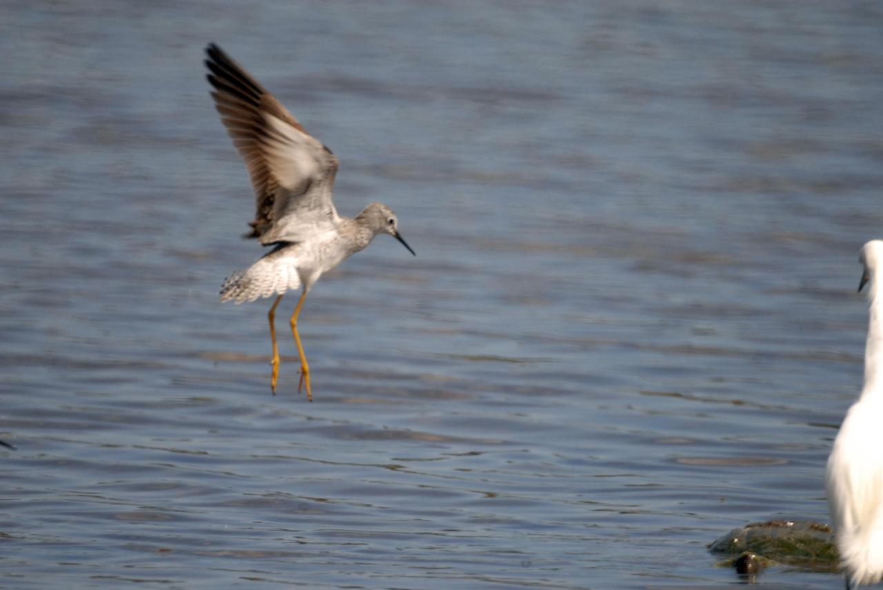
KENNEDY SPACE CENTER, FLA. -- A lesser yellowleg slows for landing in a pond near Kennedy Space Center. The yellowleg is a smaller edition of the greater yellowleg, with a shorter bill. The species inhabits marshy ponds, lake and river shores, mud flats and, in the breeding season, boreal bogs. They range throughout Alaska and Canada, wintering from the southern United States throughout South America. KSC shares a boundary with the Merritt Island National Wildlife Refuge, which surrounds it. The refuge is a habitat for more than 310 species of birds, 25 mammals, 117 fishes and 65 amphibians and reptiles. In addition, the refuge supports 19 endangered or threatened wildlife species on Federal or State lists, more than any other single refuge in the U.S. Photo credit: NASA/Ken Thornsley
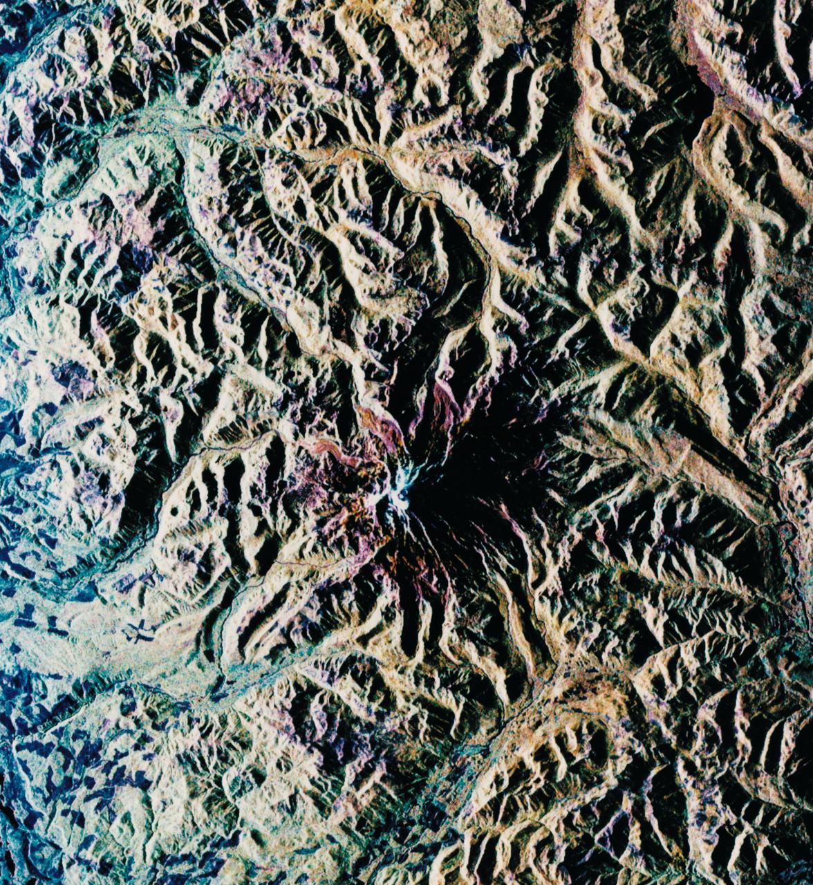
STS059-L14-170 (9-20 April 1994) --- Orient with the sea at the left. Then Subic Bay is at the lower left corner, and Clark Air Force Base (abandoned after the eruption) is to the lower right of the volcano. A turquoise lake occupies the caldera just below the center of the photograph. Mount Pinatubo erupted in June, 1991 after several hundred years of quiescence. Eruptive activity has nearly ceased, but every torrential rain in this monsoonal climate causes renewed mud flows of a viscous slurry composed of volcanic ash and pumice. Shuttle crews have been photographing the mountain at every opportunity, to add documentation to unmanned-satellite, aerial, and ground-based observations of changes. SRL scientists will use the excellent radar imagery obtained during STS-59 to help discriminate among different kinds of volcanic material, and to extend their observations to other volcanoes around the world using future, perhaps unmanned, radar satellites. Linhof photograph.
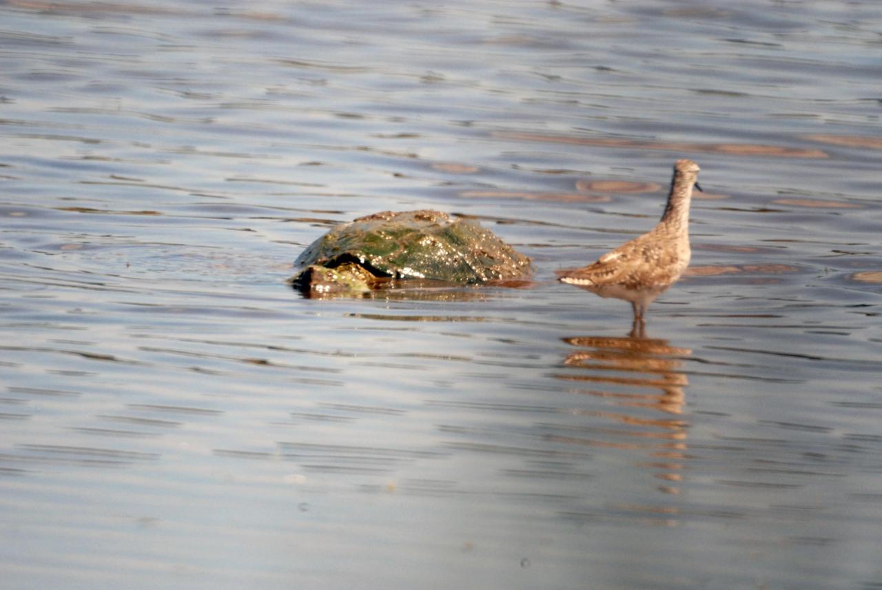
KENNEDY SPACE CENTER, FLA. -- A turtle cruises past a lesser yellowleg in a pond near Kennedy Space Center. The yellowleg is a smaller edition of the greater yellowleg, with a shorter bill. The species inhabits marshy ponds, lake and river shores, mud flats and, in the breeding season, boreal bogs. They range throughout Alaska and Canada, wintering from the southern United States throughout South America. KSC shares a boundary with the Merritt Island National Wildlife Refuge, which surrounds it. The refuge is a habitat for more than 310 species of birds, 25 mammals, 117 fishes and 65 amphibians and reptiles. In addition, the refuge supports 19 endangered or threatened wildlife species on Federal or State lists, more than any other single refuge in the U.S. Photo credit: NASA/Ken Thornsley

KENNEDY SPACE CENTER, FLA. -- Lesser yellowlegs wade through a pond near Kennedy Space Center. The yellowleg is a smaller edition of the greater yellowleg, with a shorter bill. The species inhabits marshy ponds, lake and river shores, mud flats and, in the breeding season, boreal bogs. They range throughout Alaska and Canada, wintering from the southern United States throughout South America. KSC shares a boundary with the Merritt Island National Wildlife Refuge, which surrounds it. The refuge is a habitat for more than 310 species of birds, 25 mammals, 117 fishes and 65 amphibians and reptiles. In addition, the refuge supports 19 endangered or threatened wildlife species on Federal or State lists, more than any other single refuge in the U.S. Photo credit: NASA/Ken Thornsley

KENNEDY SPACE CENTER, FLA. -- A sandpiper-like Lesser Yellowlegs eyes the water for food in the Merritt Island National Wildlife Refuge, which shares a boundary with Kennedy Space Center. The gray-streaked wader is found in marshy ponds, lake and river shores, and mud flats in Alaska and Canada; it winters in the southern United States to southern South America. The 92,000-acre refuge is a habitat for more than 310 species of birds, 25 mammals, 117 fishes and 65 amphibians and reptiles. The marshes and open water of the refuge also provide wintering areas for 23 species of migratory waterfowl, as well as a year-round home for great blue herons, great egrets, wood storks, cormorants, brown pelicans and other species of marsh and shore birds
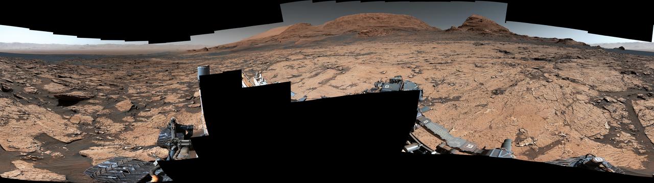
NASA's Curiosity Mars rover found preserved, ancient mud cracks that scientists believe were formed after long cycles of wet and dry conditions over many years. The discovery marks the first evidence of these wet-dry cycles on Mars. The cracks were found while the rover explored a transitional region between an area enriched with clay minerals and one enriched with sulfate minerals. The mud cracks were captured in this mosaic by Curiosity's Mastcam on June 20, 2021, the 3,154th Martian day, or sol, of the mission. The mosaic is made up of 143 images that were stitched together after being sent back to Earth. The hexagonal shapes are similar to those found at locations on Earth such as Death Valley National Park's Racetrack playa. They form only after many years of alternating wet and dry conditions. When the mud cracks initially form, they have sharp, T-shaped angles within their "pits." After being gently rehydrated many times, those sharp angles soften into Y-shapes that become ridges as the rock is eroded. Evidence pointing to wet-dry cycles is exciting to Curiosity's scientists because while no one is exactly sure how life first forms, one prevailing theory suggests that these wet-dry cycles are supportive, perhaps even required. The conditions that sustain microbial life – a long-lasting lake, for example – differ from those that scientists think kickstart the chemical reactions that might lead to life. Driving those chemical reactions are long chains of carbon-based molecules called polymers, which require just the right conditions. Water is needed to mix chemicals into a soup, where they can react with one another. Too much water will dilute the soup, making it difficult for polymer-forming chemical reactions to occur; too little water, and the chemicals can't adequately mix and react. Wet-dry cycling can strike a balance between the two. https://photojournal.jpl.nasa.gov/catalog/PIA25915
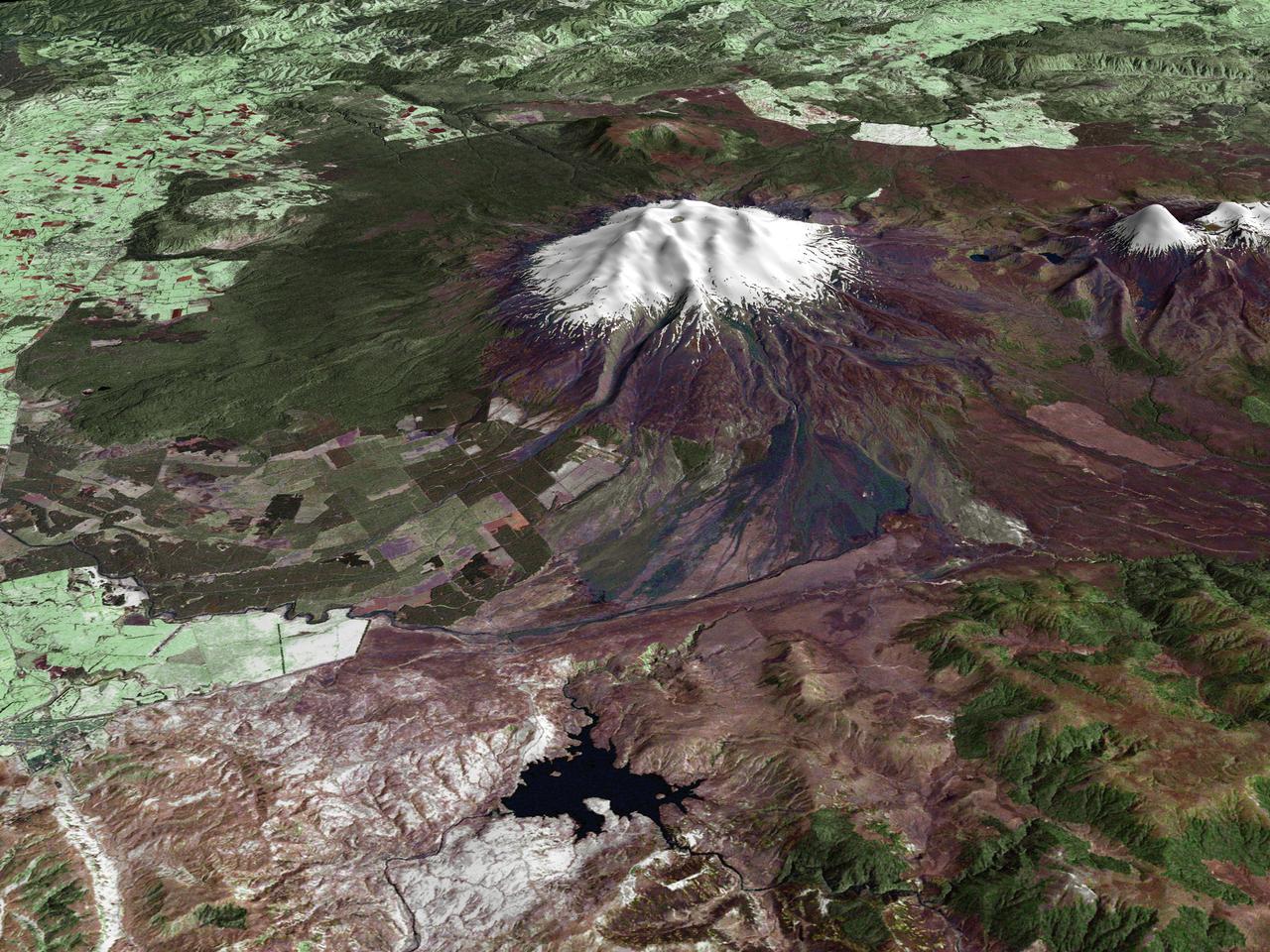
All around the world, people live in places where the threat of natural disaster is high. On the North Island of New Zealand, the Mount Ruapehu volcano is just such a threat. A towering, active stratovolcano (the classic cone-shaped volcano), snow-capped Ruapehu Volcano is pictured in this enhanced-color image. The image is made from topography data collected by the Shuttle Radar Topography Mission aboard the Space Shuttle Endeavour, launched on February 11, 2000, and imagery collected by the Landsat satellite on October 23, 2002. Ruapehu is one of New Zealand’s most active volcanoes, with ten eruptions since 1861. The eruptions aren’t the only threat from the volcano, however. Among the most serious threats is a volcanic mudflow called a lahar. In between eruptions, a lake forms in the volcano’s caldera from melting snow. If a previous eruption has deposited a dam of ash, rocks and mud in the lake’s natural overflow point, then the lake becomes dangerously full, held back only by the temporary dam. In this scene, the lake is nestled among the ridges at the top of the volcano. Eventually, the dam gives way and a massive flow of mud and debris churns down the mountain toward farmland and towns below. Scientists estimate that Ruapehu has experienced 60 lahars in the last 150 years. A devastating lahar in 1953 killed more than 150 people, who died when a passenger train plunged into a ravine when a railroad bridge was taken out by the lahar. The flank of the volcano below the lake is deeply carved by the path of previous lahars; the gouge can be seen just left of image center. Currently scientists in the region are predicting that the lake will overflow in a lahar sometime in the next year. There is great controversy about how to deal with the threat. News reports from the region indicate that the government is planning to invest in a high-tech warning system that will alert those who might be affected well in advance of any catastrophic release. Others feel that the government should combat the threat through engineering at the top of the mountain, for example, by undertaking a controlled release of the lake. Credit Landsat data provided courtesy of the University of Maryland Global Land Cover Facility Landsat processing by Laura Rocchio, Landsat Project Science Office SRTM 3-arcsecond elevation data courtesy of SRTM Team NASA/JPL/NIMA Visualization created by Earth Observatory staff. <b><a href="http://www.nasa.gov/centers/goddard/home/index.html" rel="nofollow">NASA Goddard Space Flight Center</a></b> enables NASA’s mission through four scientific endeavors: Earth Science, Heliophysics, Solar System Exploration, and Astrophysics. Goddard plays a leading role in NASA’s accomplishments by contributing compelling scientific knowledge to advance the Agency’s mission. <b>Follow us on <a href="http://twitter.com/NASA_GoddardPix" rel="nofollow">Twitter</a></b> <b>Join us on <a href="http://www.facebook.com/pages/Greenbelt-MD/NASA-Goddard/395013845897?ref=tsd" rel="nofollow">Facebook</a></b>
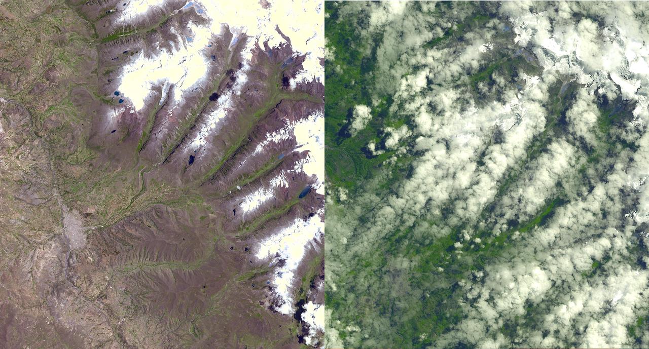
An Earth-monitoring instrument aboard NASA's Terra satellite is keeping a close eye on a potential glacial disaster in the making in Peru's spectacular, snow-capped Cordillera Blanca (White Mountains), the highest range of the Peruvian Andes. Data from NASA's Advanced Spaceborne Thermal Emission and Reflection Radiometer (Aster) is assisting Peruvian government officials and geologists in monitoring a glacier that feeds Lake Palcacocha, located high above the city of Huaraz, 270 kilometers (168 miles) north of Lima. An ominous crack has developed in the glacier. Should the large glacier chunk break off and fall into the lake, the ensuing flood could hurtle down the Cojup Valley into the Rio Santa Valley below, reaching Huaraz, population 60,000, in less than 15 minutes. "Glacial natural hazards like the one in Huaraz are an increasing threat to people in many parts of the world," said Dr. Michael Abrams, associate Aster team leader at NASA's Jet Propulsion Laboratory, Pasadena, Calif. "Remote sensing instruments like Aster can serve a vital role in mountain hazard management and disaster mapping by providing rapid access to data, even in regions not easily accessible by humans. Aster's unique vantage point from space gives scientists another tool with which to see early signs of potential glacial flood-burst events and to monitor changes in glacial behavior over time. In Huaraz, Peruvian authorities and scientists will incorporate Aster data along with data from ground-based monitoring techniques to better assess current conditions and take steps necessary to reduce risks to human lives and property." Comparison images of the area are available at: http://asterweb.jpl.nasa.gov . Huaraz can be seen in the images' left-center, with Lake Palcacocha in the images' upper right corners at the head of a valley, below the snow and glacier cap. The left image was acquired on November 5, 2001; the right on April 8, 2003. Glacial flood-bursts, known by Peruvians as "aluviones," occur periodically when water is released abruptly from a previously ice-dammed lake alongside, within, or above a glacier. The release can be caused by various triggering events. These flood-bursts typically arrive with little or no warning, carrying liquid mud, large rock boulders and blocks of ice. The Rio Santa Valley is no stranger to such disasters. Since 1702, floods caused by glaciological conditions have repeatedly caused death and destruction in the region. One particularly devastating event in 1941 destroyed approximately one-third of Huaraz, killing an estimated 5,000 to 7,000 people. Since then, the Peruvian government has emphasized control of the water level in Lake Palcacocha and other lakes in the region that pose similar threats. The efforts appear to have worked; since 1972, no destructive floods resulting from the breakout of glacial lakes have occurred. Nevertheless, officials are still monitoring the current situation closely. http://photojournal.jpl.nasa.gov/catalog/PIA03899
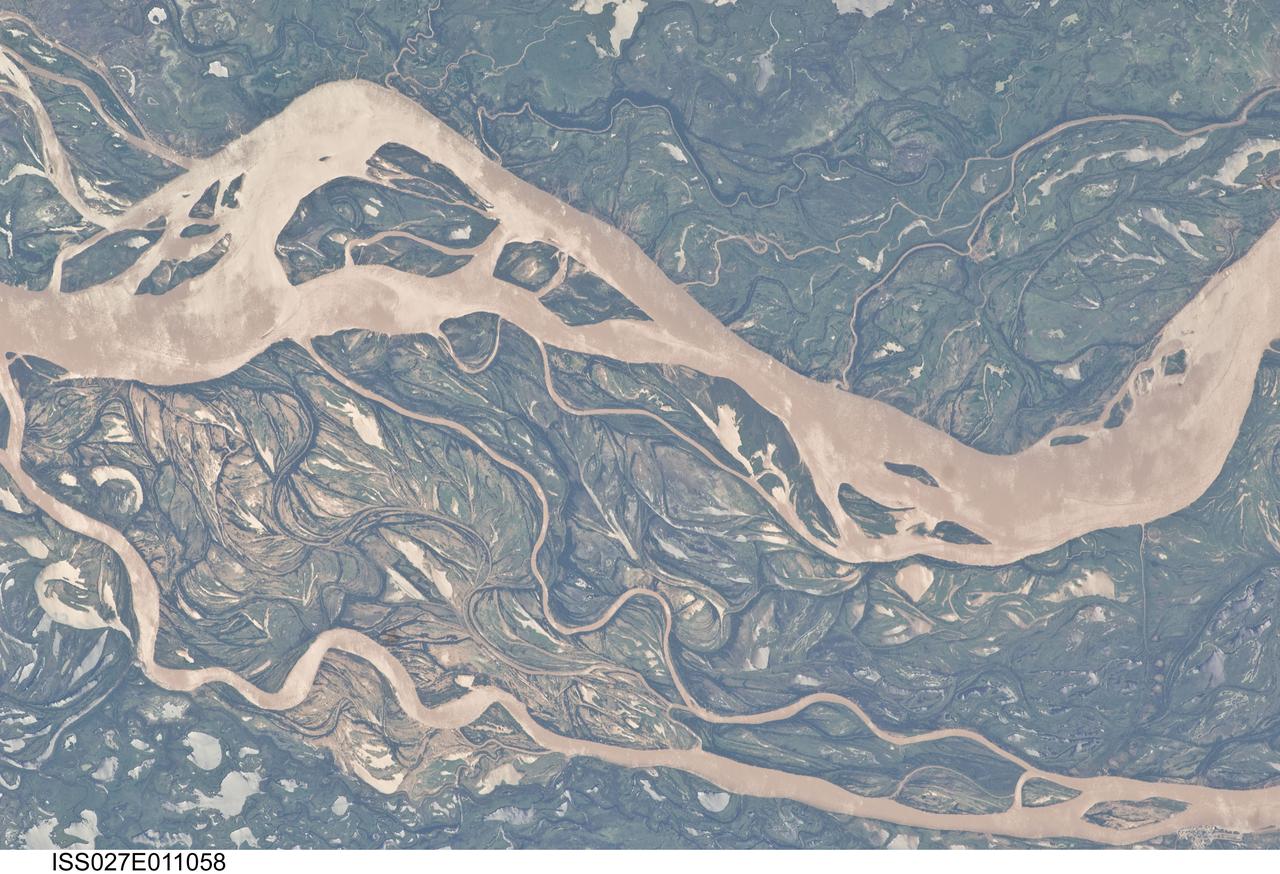
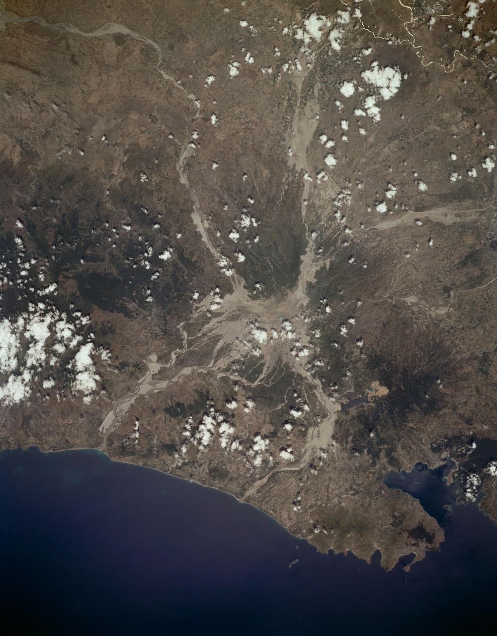
ISS027-E-011058 (9 April 2011) --- The Parana River floodplain in northern Argentina is featured in this image photographed by an Expedition 27 crew member on the International Space Station. This image shows a 29-kilometer stretch of the Parana River, South America?s second largest river, downstream of the small city of Goya (barely distinguishable as grayer surfaces in the extreme top left corner of the image). The Parana River ranges up to three kilometers wide along the reach illustrated in the image. Its strong brown color indicates that it is carrying a heavy load of muddy sediment. Smaller active side channels also carry this muddy water. Numerous lakes are typical on active floodplains, and appear here as irregular bodies of water. Some appear brown, indicating that they have been refilled during recent higher flood levels of the active channels. The main channel Parana River (top) is deep enough to allow smaller ocean-going ships to pass north of the illustrated region to the capital city of Asuncion in landlocked Paraguay, fully 1,200 kilometers inland (well out of the image). The Parana River is thus an important transportation route for landlocked cities such as Asuncion and inland cities of eastern landlocked Bolivia and inland Brazil. The Parana floodplain occupies the entire image; it is so wide?18 kilometers?that its banks are not visible. Numerous curved, or meandering past channels are the most prominent characteristic of the floodplain. These indicate prior positions of rivers. As river beds move laterally by natural processes, they leave remnants of their channels, which appear as lakes, and finally fill with mud. This is an excellent image for illustrating these meander forms. From a geological standpoint it is interesting that almost all the past channels are similar in curvature to the smaller active side rivers; almost no forms show, in any obvious way, prior positions of the main, very wide Parana channel. The reverse might be expected since the main channel is so dominant in the modern landscape.
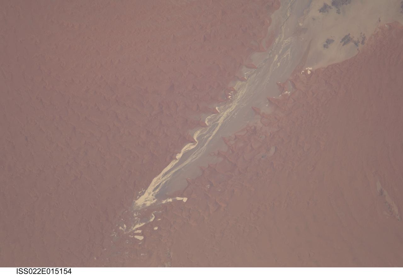
ISS022-E-015154 (24 Dec. 2009) --- Tsauchab River and Sossus Vlei Lakebed, Namibia are featured in this image photographed by an Expedition 22 crew member on the International Space Station. Taken on Christmas Eve of 2009, this image shows the lower 45 kilometers of the Tsauchab River, a famous landmark for Namibians, tourists, and for orbiting astronauts. The Tsauchab River bed is seen jutting into the sea of red dunes near Namibia?s hyper arid coast, where it ends in a series of light-toned silty muds of the dry lake floor, known locally as Sossus Vlei (small lake). Because of the present arid climate, few people have ever seen the Tsauchab River with flowing water or a lake in Sossus Vlei. In times past, however, the Tsauchab appears to have reached the Atlantic coast, another 55 kilometers further west. Like several other rivers of the coastal Namib Desert, the Tsauchab brings sediment down from the hinterland to the coastal lowland. According the scientists, this sediment is then blown from the river beds, and over probably tens of millions of years, has accumulated as the red dunes of the impressive Namib Sand Sea. In this view the sand is heaped up in the form of numerous ?star dunes,? each characterized by long arms extending in several directions. These compare with the better-known barchan dunes (not present in image) that display two horns pointing downwind, which form in areas where winds generally blow from one direction only. By contrast, star dunes are apparently generated in a variable wind regime. In this part of the Sand Sea, winds are mainly from the south, but easterly winds, channeled along the Tsauchab valley, provide another component. And warm dry winter winds?similar to the Santa Ana winds of California, which can cause the hottest annual temperatures to occur briefly on winter days?blow from the northeast. These northeasterly winds are likely responsible for the regular dune arms that point into the valley from both sides. These large dunes facing the river valley are promoted as the highest dunes in the world. Although continuous dune slopes allow hikers to gain more than 300 meters of altitude from the river bottom, this could be misleading since the main base of the dunes lies on a terrace 180 meters above the river.
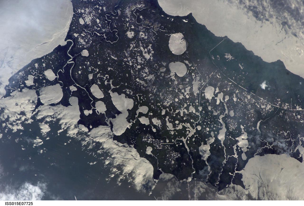
ISS015-E-07725 (11 May 2007) --- Marsh Island, Louisiana is featured in this image photographed by an Expedition 15 crewmember on the International Space Station. Marsh Island, located along the southwestern coastline of Louisiana, is a remnant of an abandoned lobe of the Mississippi River Delta formed approximately 5000-7500 years before the present day, according to scientists. It is composed primarily of organic-rich muds and brackish marsh vegetation (some peat -- semiconsolidated plant and organic matter -- is also present). The intricate lake, pond and stream network of the island is highlighted in this image by silver-gray sunglint -- light reflected off of water surfaces directly back to the crewmember on the space station. Sunglint also illuminates water surfaces in the adjacent Gulf of Mexico and West Cote Blanche Bay -- variations in intensity of reflectance in these water bodies is due to surface roughness (often related to wind-driven waves or currents) and the presence of surfactants that can change the surface properties of the water. Marsh Island is a popular fishing, shrimping and birding location. The island has experienced significant loss of vegetation and land area -- nearly 3,000 hectares (7,000 acres) - due to erosion, with a corresponding loss of habitat for local and migratory birds, shrimp, alligators and deer. While Marsh Island is uninhabited, it has been the focus of intensive development for management of erosion, such as revegetation of deteriorated marsh areas. Leveed canals (straight silver-gray water features) help drain areas for above-surface revegetation, while sill dams help stabilize water levels and foster regrowth of important subsurface vegetation such as widgeongrass.
The ancient highland channels in this image empty into the Eridania Basin (not visible), a large topographically low enclosure with smooth-appearing terrains that may have once contained a large paleolake or ancient sea. Water in these channels flowed to the east into Ariadnes Basin, a smaller basin located within the confines of Eridiana. Light-toned knobs are exposed in the northern channel, while the other channels are partially filled with smooth appearing lobe-shaped surface flows that are extensively fractured when viewed at high-resolution. Although the origin of these knobs is not known, interpretations include fumarolic mounds, erosional remnants, pingos, mud volcanoes and spring mounds. The movement of the once ice-rich, channel-filling flows over the knobby terrains likely created radial tension stresses producing the cracks that we see on the surface of these deposits. As the material slowly thinned, it eventually led to the formation of an elephant skin-like texture. This texture is different from the surrounding eroding mantling deposit that has become pitted as the ice sublimated causing the overlying surface to collapse. The combination of such knobby terrain and smooth, channel-filling deposits are seen only in a few places on Mars. One such example is the Navua Valles channels northeast of the Hellas Basin that may have also hosted a large, ice-covered lake in the past. Their morphological similarities, particularly in their surface materials, suggest that they formed under similar paleoclimatic conditions. http://photojournal.jpl.nasa.gov/catalog/PIA12968
This animated artist's concept depicts a scene of water breaking through the rim of Mars' Jezero Crater, which NASA's Perseverance rover is now exploring. Water entered the crater billions of years ago, depositing sediments that built up into a delta. Since the spacecraft's landing in February 2021, Perseverance's exploration of the crater floor and the delta have led to scientists developing a detailed timeline for the crater's formation. They now know there were three major periods after water began flooding through the crater rim. First, those waters brought fine-grained sand and mud (seen by Perseverance at "Hogwallow Flats") that is known for preserving fossilized life in comparable environments on Earth. Second, the crater's lake grew as wide as 22 miles (35 kilometers) in diameter and as deep as 100 feet (30 meters) – deep enough to lay down several sedimentary layers (like those seen at "Pinestand"). Finally, high-energy rivers brought in boulders that were rounded as they tumbled through water, as seen at "Castell Henllys." A key objective for Perseverance's mission on Mars is astrobiology, including the search for signs of ancient microbial life. The rover will characterize the planet's geology and past climate, pave the way for human exploration of the Red Planet, and be the first mission to collect and cache Martian rock and regolith (broken rock and dust). Subsequent NASA missions, in cooperation with ESA (European Space Agency), would send spacecraft to Mars to collect these sealed samples from the surface and return them to Earth for in-depth analysis. The Mars 2020 Perseverance mission is part of NASA's Moon to Mars exploration approach, which includes Artemis missions to the Moon that will help prepare for human exploration of the Red Planet. Animation available at https://photojournal.jpl.nasa.gov/catalog/PIA26207
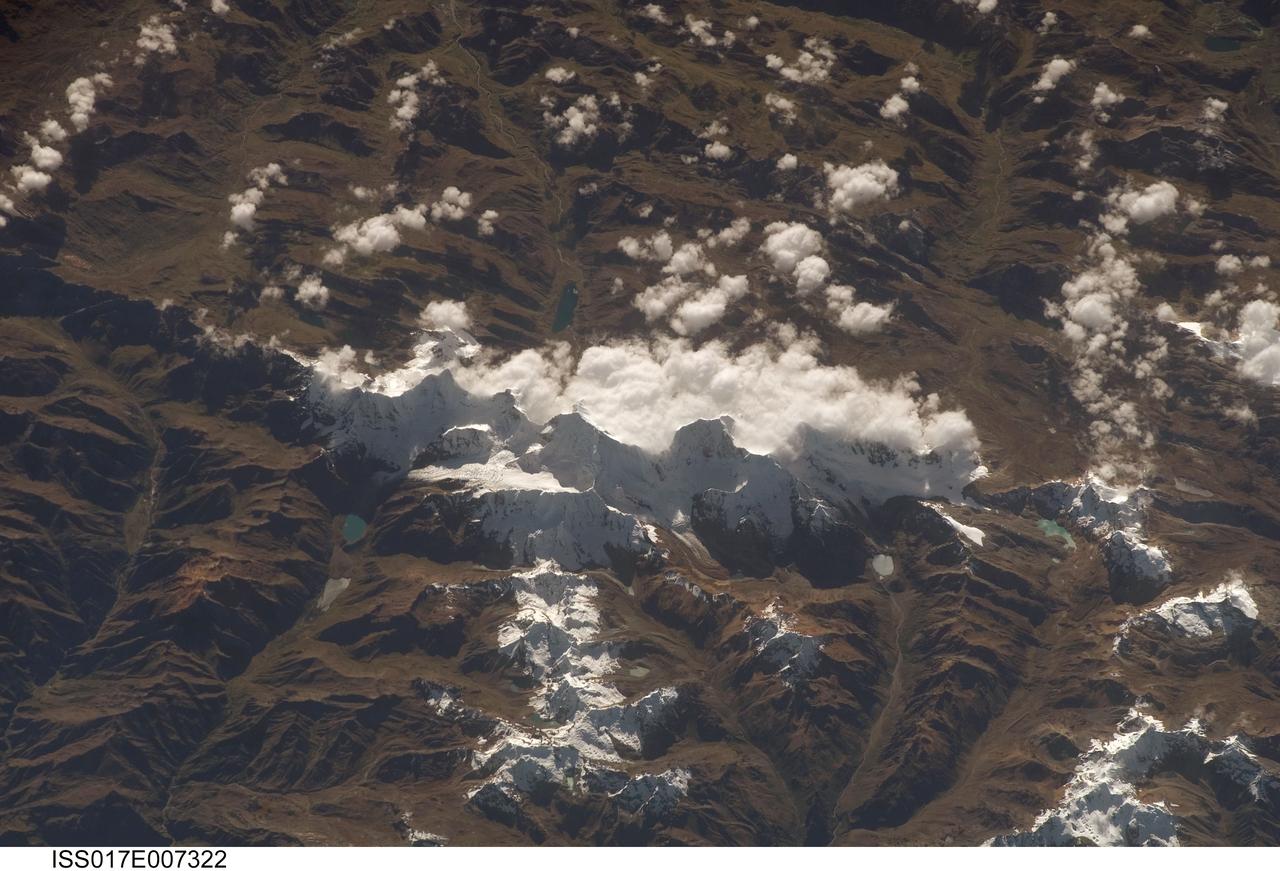
ISS017-E-007322 (17 May 2008) --- Cordillera Huayhuash in the Peruvian Andes is featured in this image photographed by an Expedition 17 crewmember on the International Space Station. This view was taken looking east as the station was flying approximately 100 kilometers off the Peruvian coast and shows Cordillera Huayhuash (pronounced Why-wash). Here clouds are banked up on the east side, snow covers all higher slopes and mountain peaks, and glaciers occupy lower slopes. This prominent but short mountain range (25 kilometers in length) boasts twenty peaks of remarkable steepness and ridge sharpness. Although only 100 kilometers from the coastline, six of the peaks reach above 6,000 meters (more than 19,500 feet), the highest of which is Nevado Yerupaja, Peru's second highest peak, variously estimated as 6,617 and 6,635 meters high. Generally considered the most spectacular peak in South America, Yerupaja is so steep that it has seldom been climbed. The best climbing approach is from the southwest, the face seen in this view. Yerupaja is locally known as El Carnicero (The Butcher) because of its blade-like ridges, features typical of mountains that have been heavily eroded by glacial ice. Other features created by the erosive effect of flowing ice are small glacial lakes, which often vary in color due to different amounts of fine mud being fed into them by meltwater from under the glaciers. According to scientists, during the ice ages the glaciers advanced many kilometers outward from the cordillera, occupying all the surrounding valley floors (all of which lie above 3,000 meters) producing the characteristic U-shaped valleys.
STS068-S-052 (3 October 1994) --- This is a radar image of Mount Rainier in Washington state. The volcano last erupted about 150 years ago and numerous large floods and debris flows have originated on its slopes during the last century. Today the volcano is heavily mantled with glaciers and snow fields. More than 100,000 people live on young volcanic mud flows less than 10,000 years old and, are within the range of future, devastating mud slides. This image was acquired by the Spaceborne Imaging Radar-C/X-Band Synthetic Aperture Radar (SIR-C/X-SAR) aboard the Space Shuttle Endeavour on its 20th orbit on October 1, 1994. The area shown in the image is approximately 59 by 60 kilometers (36.5 by 37 miles). North is toward the top left of the image, which was composed by assigning red and green colors to the L-Band, horizontally transmitted and vertically, and the L-Band, horizontally transmitted and vertically received. Blue indicates the C-Band, horizontally transmitted and vertically received. In addition to highlighting topographic slopes facing the Space Shuttle, SIR-C records rugged areas as brighter and smooth areas as darker. The scene was illuminated by the Shuttle's radar from the northwest so that northwest-facing slopes are brighter and southeast-facing slopes are dark. Forested regions are pale green in color, clear cuts and bare ground are bluish or purple; ice is dark green and white. The round cone at the center of the image is the 14,435 feet (4,399 meters) active volcano, Mount Rainier. On the lower slopes is a zone of rock ridges and rubble (purple to reddish) above coniferous forests (in yellow/green). The western boundary of Mount Rainier National Park is seen as a transition from protected, old-growth forest to heavily logged private land, a mosaic of recent clear cuts (bright purple/blue) and partially re-grown timber plantations (pale blue). The prominent river seen curving away from the mountain at the top of the image (to the northwest) is the White River, and the river leaving the mountain at the bottom right of the image (south) is the Nisqually River, which flows out of the Nisqually glacier on the mountain. The river leaving to the left of the mountain is the Carbon River, leading west and north toward heavily populated regions near Tacoma. The dark patch at the top right of the image is Bumping Lake. Other dark areas seen to the right of ridges throughout the image are radar shadow zones. Radar images can be used to study the volcanic structure and the surrounding regions with linear rock boundaries and faults. In addition, the recovery of forested lands from natural disasters and the success of re-forestation programs can also be monitored. Ultimately this data may be used to study the advance and retreat of glaciers and other forces of global change. Spaceborne Imaging Radar-C/X-Band Synthetic Aperture Radar (SIR-C/X-SAR) is part of NASA's Mission to Planet Earth. (P-44703)
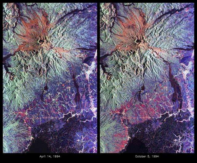
These are color composite radar images showing the area around Mount Pinatubo in the Philippines. The images were acquired by the Spaceborne Imaging Radar-C and X-band Synthetic Aperture Radar (SIR-C/X-SAR) aboard the space shuttle Endeavour on April 14, 1994 (left image) and October 5,1994 (right image). The images are centered at about 15 degrees north latitude and 120.5 degrees east longitude. Both images were obtained with the same viewing geometry. The color composites were made by displaying the L-band (horizontally transmitted and received) in red; the L-band (horizontally transmitted and vertically received) in green; and the C-band (horizontally transmitted and vertically received) in blue. The area shown is approximately 40 kilometers by 65 kilometers (25 miles by 40 miles). The main volcanic crater on Mount Pinatubo produced by the June 1991 eruptions and the steep slopes on the upper flanks of the volcano are easily seen in these images. Red on the high slopes shows the distribution of the ash deposited during the 1991 eruption, which appears red because of the low cross-polarized radar returns at C and L bands. The dark drainages radiating away from the summit are the smooth mudflows, which even three years after the eruptions continue to flood the river valleys after heavy rain. Comparing the two images shows that significant changes have occurred in the intervening five months along the Pasig-Potrero rivers (the dark area in the lower right of the images). Mudflows, called "lahars," that occurred during the 1994 monsoon season filled the river valleys, allowing the lahars to spread over the surrounding countryside. Three weeks before the second image was obtained, devastating lahars more than doubled the area affected in the Pasig-Potrero rivers, which is clearly visible as the increase in dark area on the lower right of the images. Migration of deposition to the east (right) has affected many communities. Newly affected areas included the community of Bacolor, Pampanga, where thousands of homes were buried in meters of hot mud and rock as 80,000 people fled the lahar-stricken area. Scientists are closely monitoring the westward migration ( toward the left in this image) of the lahars as the Pasig-Potrero rivers seek to join with the Porac River, an area that has not seen laharic activity since the eruption. This could be devastating because the Pasig-Potrero rivers might be permanently redirected to lower elevations along the Porac River where communities are located. Ground saturation with water during the rainy season reveals inactive channels that were dry in the April image. A small lake has turned into a pond in the lower reaches of the Potrero River because the channels are full of lahar deposits and the surface runoff has no where to flow. Changes in the degree of erosion in ash and pumice deposits from the 1991 eruption can also be seen in the channels that deliver the mudflow material to the Pasig-Potrero rivers. The 1991 Mount Pinatubo eruption is well known for its near-global effects on the atmosphere and short-term climate due to the large amount of sulfur dioxide that was injected into the upper atmosphere. Locally, however, the effects will most likely continue to impact surrounding areas for as long as the next 10 to 15 years. Mudflows, quite certainly, will continue to pose severe hazards to adjacent areas. Radar observations like those obtained by SIR-C/X-SAR will play a key role in monitoring these changes because of the radar's ability to see in daylight or darkness and even in the worst weather conditions. Radar imaging will be particularly useful, for example, during the monsoon season, when the lahars form. Frequent imaging of these lahar fields will allow scientists to better predict when they are likely to begin flowing again and which communities might be at risk. http://photojournal.jpl.nasa.gov/catalog/PIA01743