One View, Multiple Worlds
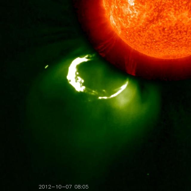
This CME image from Oct. 7, 2012, captured by two instruments on STEREO, shows the eruption from its base out into space. The base of the CME near the sun is seen in extreme ultraviolet light emitted directly from the solar material; the growing loop is seen in visible light. Credit: NASA/STEREO CME WEEK: What To See in CME Images Two main types of explosions occur on the sun: solar flares and coronal mass ejections. Unlike the energy and x-rays produced in a solar flare – which can reach Earth at the speed of light in eight minutes – coronal mass ejections are giant, expanding clouds of solar material that take one to three days to reach Earth. Once at Earth, these ejections, also called CMEs, can impact satellites in space or interfere with radio communications. During CME WEEK from Sept. 22 to 26, 2014, we explore different aspects of these giant eruptions that surge out from the star we live with. When a coronal mass ejection blasts off the sun, scientists rely on instruments called coronagraphs to track their progress. Coronagraphs block out the bright light of the sun, so that the much fainter material in the solar atmosphere -- including CMEs -- can be seen in the surrounding space. CMEs appear in these images as expanding shells of material from the sun's atmosphere -- sometimes a core of colder, solar material (called a filament) from near the sun's surface moves in the center. But mapping out such three-dimensional components from a two-dimensional image isn't easy. Watch the slideshow to find out how scientists interpret what they see in CME pictures. The images in the slideshow are from the three sets of coronagraphs NASA currently has in space. One is on the joint European Space Agency and NASA Solar and Heliospheric Observatory, or SOHO. SOHO launched in 1995, and sits between Earth and the sun about a million miles away from Earth. The other two coronagraphs are on the two spacecraft of the NASA Solar Terrestrial Relations Observatory, or STEREO, mission, which launched in 2006. The two STEREO spacecraft are both currently viewing the far side of the sun. Together these instruments help scientists create a three-dimensional model of any CME as its journey unfolds through interplanetary space. Such information can show why a given characteristic of a CME close to the sun might lead to a given effect near Earth, or any other planet in the solar system...<b><a href="http://www.nasa.gov/audience/formedia/features/MP_Photo_Guidelines.html" rel="nofollow">NASA image use policy.</a></b> <b><a href="http://www.nasa.gov/centers/goddard/home/index.html" rel="nofollow">NASA Goddard Space Flight Center</a></b> enables NASA’s mission through four scientific endeavors: Earth Science, Heliophysics, Solar System Exploration, and Astrophysics. Goddard plays a leading role in NASA’s accomplishments by contributing compelling scientific knowledge to advance the Agency’s mission. <b>Follow us on <a href="http://twitter.com/NASAGoddardPix" rel="nofollow">Twitter</a></b> <b>Like us on <a href="http://www.facebook.com/pages/Greenbelt-MD/NASA-Goddard/395013845897?ref=tsd" rel="nofollow">Facebook</a></b> <b>Find us on <a href="http://instagram.com/nasagoddard?vm=grid" rel="nofollow">Instagram</a></b>
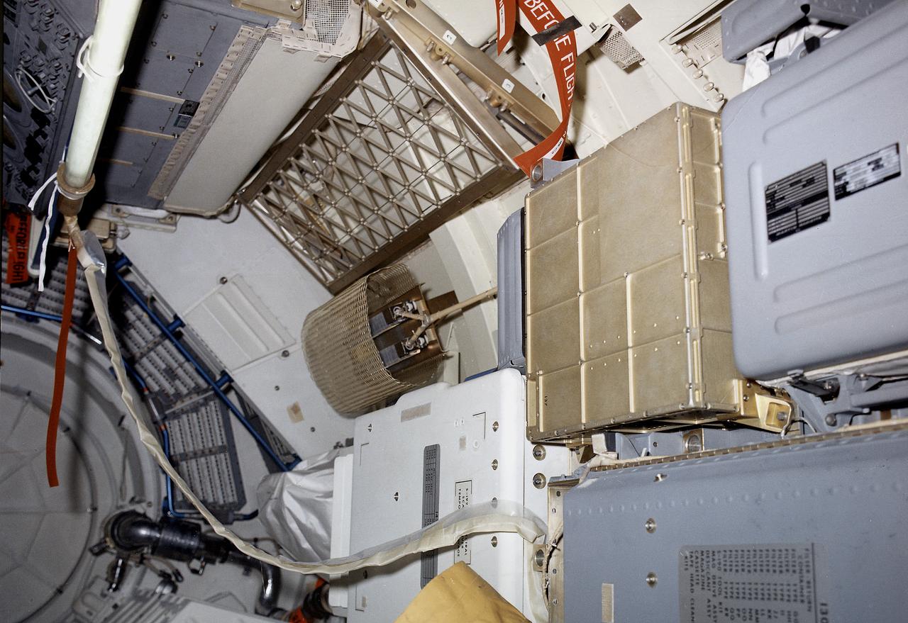
The Multiple Docking Adapter (MDA), designed and constructed under the direction of the Marshall Space Flight Center, was one of four principal sections comprising Skylab. The MDA provided the means by which the Command and Service Modules attached to the Skylab, enabling the crews to enter and work in it. Also included in the MDA was a control and display console for the Apollo Telescope Mount. This image shows an interior view of the MDA.
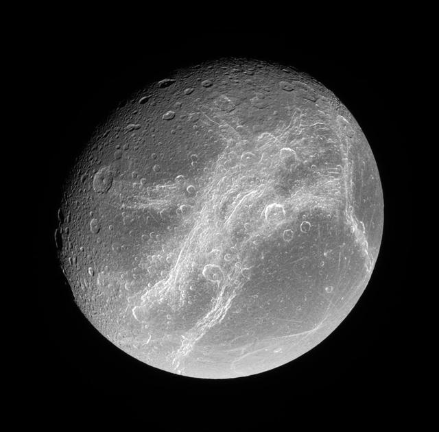
This splendid view showcases Dione tortured complex of bright cliffs. At lower right is the feature called Cassandra, exhibiting linear rays extending in multiple directions
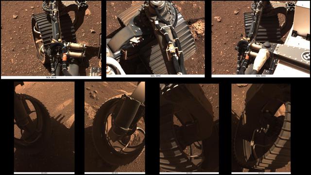
These sets of animated GIFs show seven views of NASA's Perseverance Mars rover wiggling its wheels on March 4, 2021, the day Perseverance completed its first drive on Mars. The first three sets of GIFs come from the Navigation Cameras (Navcams). The first view shows the front left wheel; the second the front right wheel; the third the rear right wheel. The next four sets come from the Hazard Avoidance Cameras (Hazcams). The fourth GIF shows the front left wheel again; the fifth the front right wheel again; the sixth the rear left wheel; and the seventh the rear right wheel again. A key objective for Perseverance's mission on Mars is astrobiology, including the search for signs of ancient microbial life. The rover will characterize the planet's geology and past climate, pave the way for human exploration of the Red Planet, and be the first mission to collect and cache Martian rock and regolith (broken rock and dust). Subsequent NASA missions, in cooperation with ESA (European Space Agency), would send spacecraft to Mars to collect these sealed samples from the surface and return them to Earth for in-depth analysis. The Mars 2020 Perseverance mission is part of NASA's Moon to Mars exploration approach, which includes Artemis missions to the Moon that will help prepare for human exploration of the Red Planet. Animations available at https://photojournal.jpl.nasa.gov/catalog/PIA24489
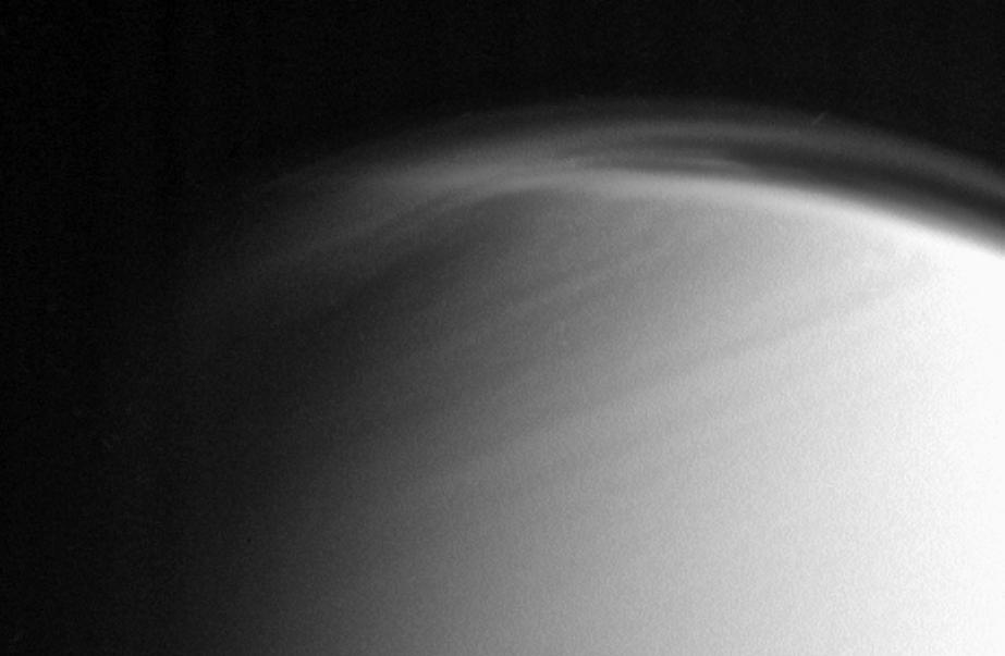
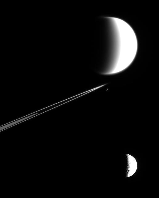
The complex and dynamic atmosphere of Titan displays multiple haze layers near the north pole in this view, which also provides an excellent look at the detached stratospheric haze layer that surrounds the moon at lower latitudes
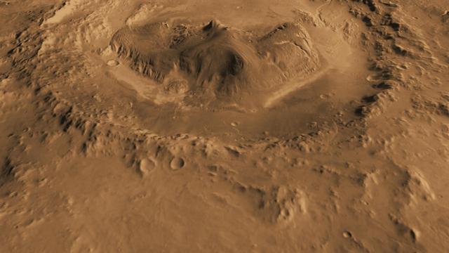
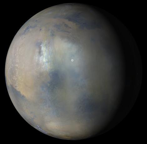
This computer-generated view based on multiple orbital observations shows Mars Gale crater. NASA is considering Gale as a possible landing site for the Mars Science Laboratory mission.

This is the most detailed view to date of the entire surface of the dwarf planet Pluto, as constructed from multiple NASA Hubble Space Telescope photographs taken from 2002 to 2003.
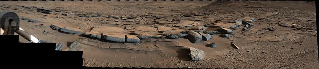
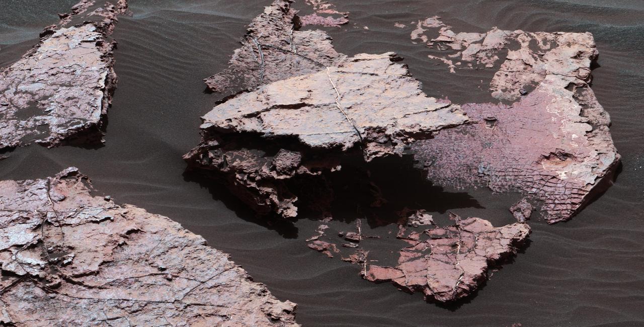
On March 25, 2014, view from the Mastcam on NASA Curiosity Mars rover looks southward at the Kimberley waypoint. Multiple sandstone beds show systematic inclination to the south suggesting progressive build-out of delta sediments.

This anaglyph, from NASA Shuttle Radar Topography Mission, shows Meseta de Somuncura, a broad plateau capped by basalt. Near its western edge is evidence of multiple volcanic events. 3D glasses are necessary to view this image.
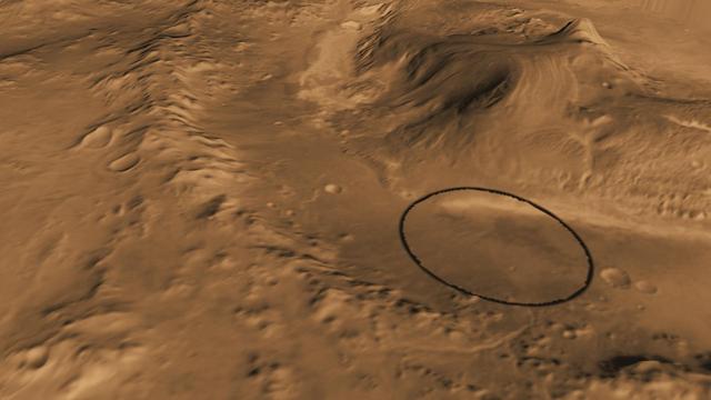
This computer-generated view based on multiple orbital observations shows Mars Gale crater as if seen from an aircraft northwest of the crater. NASA has selected Gale as the landing site for the Mars Science Laboratory mission.
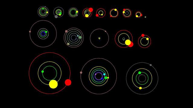
This artist concept shows an overhead view of the orbital position of the planets in systems with multiple transiting planets discovered by NASA Kepler mission. All the colored planets have been verified.
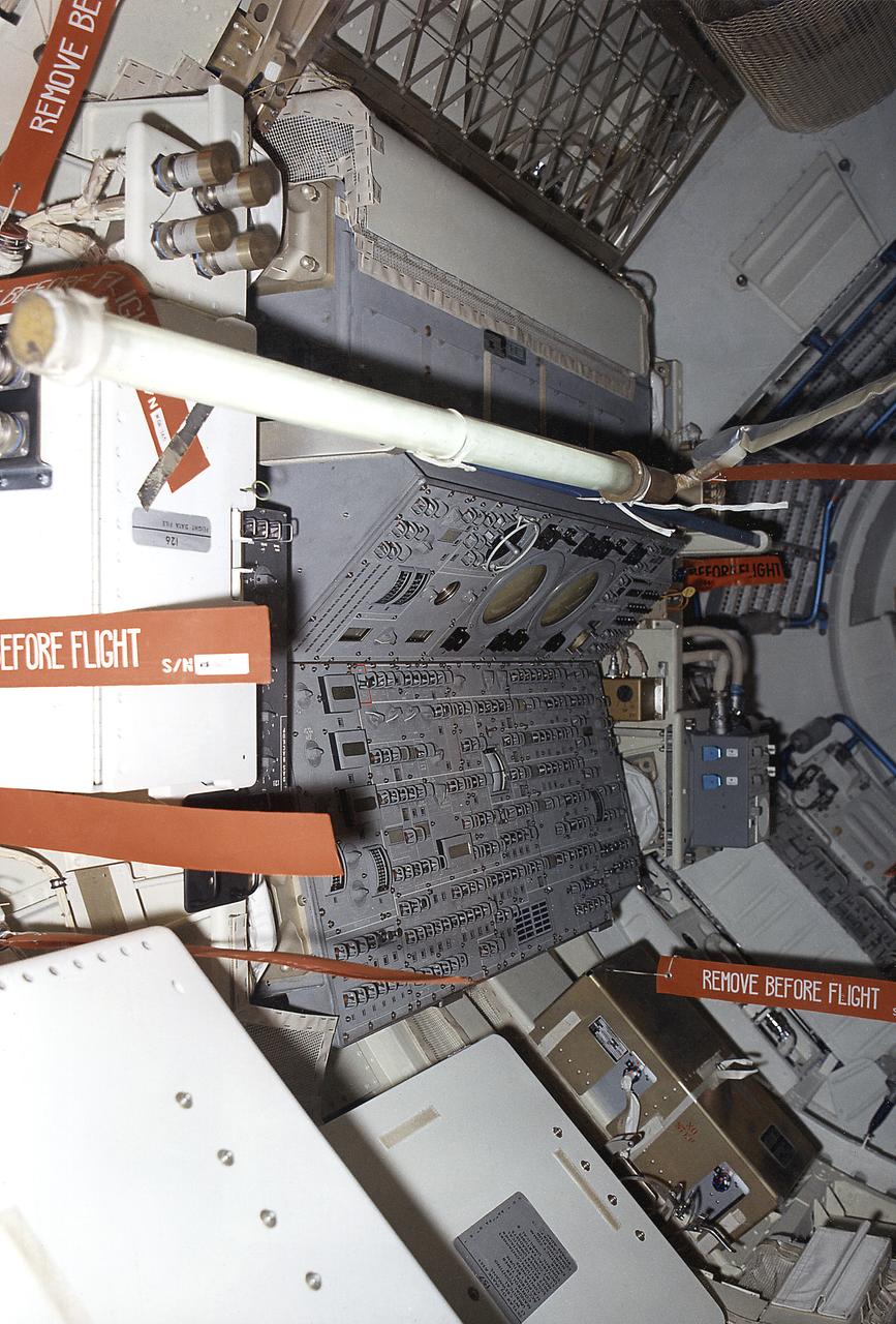
This September 1972 photograph shows the internal configuration of Skylab's Multiple Docking Adapter (MDA) flight article as it appeared during the Crew Compartment and Function Review at the Martin-Marietta Corporation's Space Center facility in Denver, Colorado. Designed and manufactured by the Marshall Space Flight Center, the MDA housed a number of experiment control and stowage units and provided a docking port for the Apollo Command Module.
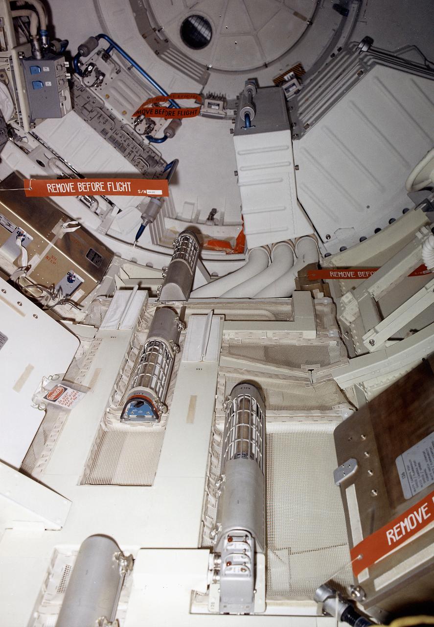
This September 1972 photograph shows the internal configuration of Skylab's Multiple Docking Adapter (MDA) flight article as it appeared during the Crew Compartment and Function Review at the Martin-Marietta Corporation's Space Center facility in Denver, Colorado. Designed and manufactured by the Marshall Space Flight Center, the MDA housed a number of experiment control and stowage units and provided a docking port for the Apollo Command Module.
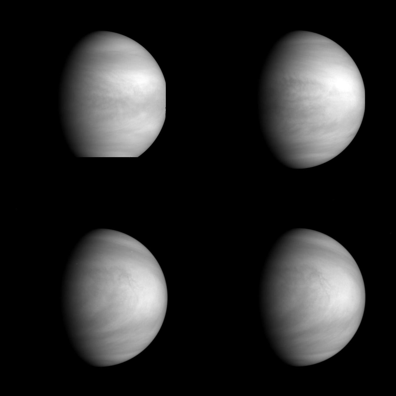
This series of pictures shows four views of the planet Venus obtained by NASA Galileo Solid State Imaging System at ranges of 1.4 to 2 million miles as the spacecraft receded from Venus. http://photojournal.jpl.nasa.gov/catalog/PIA00223
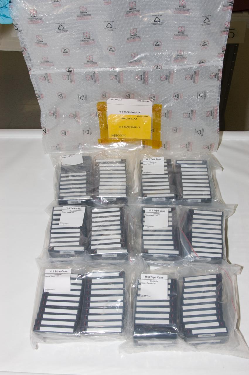
View of a Hi 8 Video Storage Bag and multiple Hi 8 Video Tape cases.
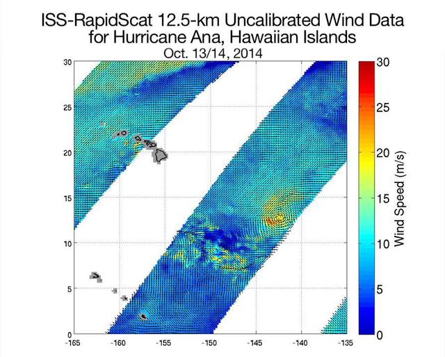
NASA ISS-RapidScat ocean wind scatterometer viewed Hurricane Ana as it approached Hawaii. From Oct. 13 to Oct. 19, 2014, RapidScat observed Ana seven times. This frame is from a movie containing multiple days of observation.
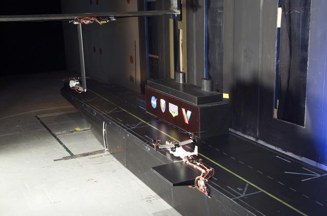
VSHAIP test in 7x10ft#1 W.T. (multiple model configruations) V-22 helicopter shipboard aerodynamic interaction program: rear view of model on deck
VSHAIP test in 7x10ft#1 W.T. (multiple model configruations) V-22 helicopter shipboard aerodynamic interaction program: rear view Osprey on deck
iss063e026157 (June 11, 2020) --- NASA astronaut and Expedition 63 Commander Chris Cassidy configures the new Spectrum imager that will view the cellular growth of plants in multiple wavelengths.
NASA's Mars Exploration Rover Opportunity captured this view from the base of "Burns Cliff" during the rover's 280th martian day (Nov. 6, 2004). This cliff in the inner wall of "Endurance Crater" displays multiple layers of bedrock for the rover to examine with its panoramic camera and miniature thermal emission spectrometer. The rover team has decided that the farthest Opportunity can safely advance along the base of the cliff is close to the squarish white rock near the center of this image. After examining the site for a few days from that position, the the rover will turn around and head out of the crater. The view is a mosaic of frames taken by Opportunity's navigation camera. The rover was on ground with a slope of about 30 degrees when the pictures were taken, and the view is presented here in a way that corrects for that tilt of the camera. http://photojournal.jpl.nasa.gov/catalog/PIA07039
When seen up close, the F ring of Saturn resolves into multiple dusty strands. This Cassini view shows three bright strands and a very faint fourth strand off to the right. The central strand is the core of the F ring. The other strands are not independent at all, but are actually sections of long spirals of material that wrap around Saturn. The material in the spirals was likely knocked out from the F ring's core during interactions with a small moon. This view looks toward the unilluminated side of the rings from about 38 degrees above the ring plane. The image was taken in visible light with the Cassini spacecraft narrow-angle camera on Dec. 18, 2016. The view was acquired at a distance of approximately 122,000 miles (197,000 kilometers) from Saturn and at a Sun-Ring-spacecraft, or phase, angle of 47 degrees. Image scale is 0.7 miles (1.2 kilometers) per pixel. http://photojournal.jpl.nasa.gov/catalog/PIA20519
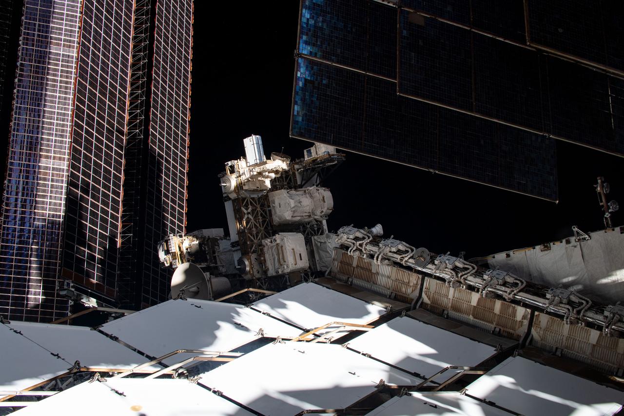
iss067e055839 (5/16/2022) --- Multiple User System for Earth Sensing (MUSES) is the first multi-user facility on an ISS ExPRESS Logistics Carrier (ELC). The facility primarily serves as a platform for earth-viewing sensors and other technologies requiring long-term access to the space environment.
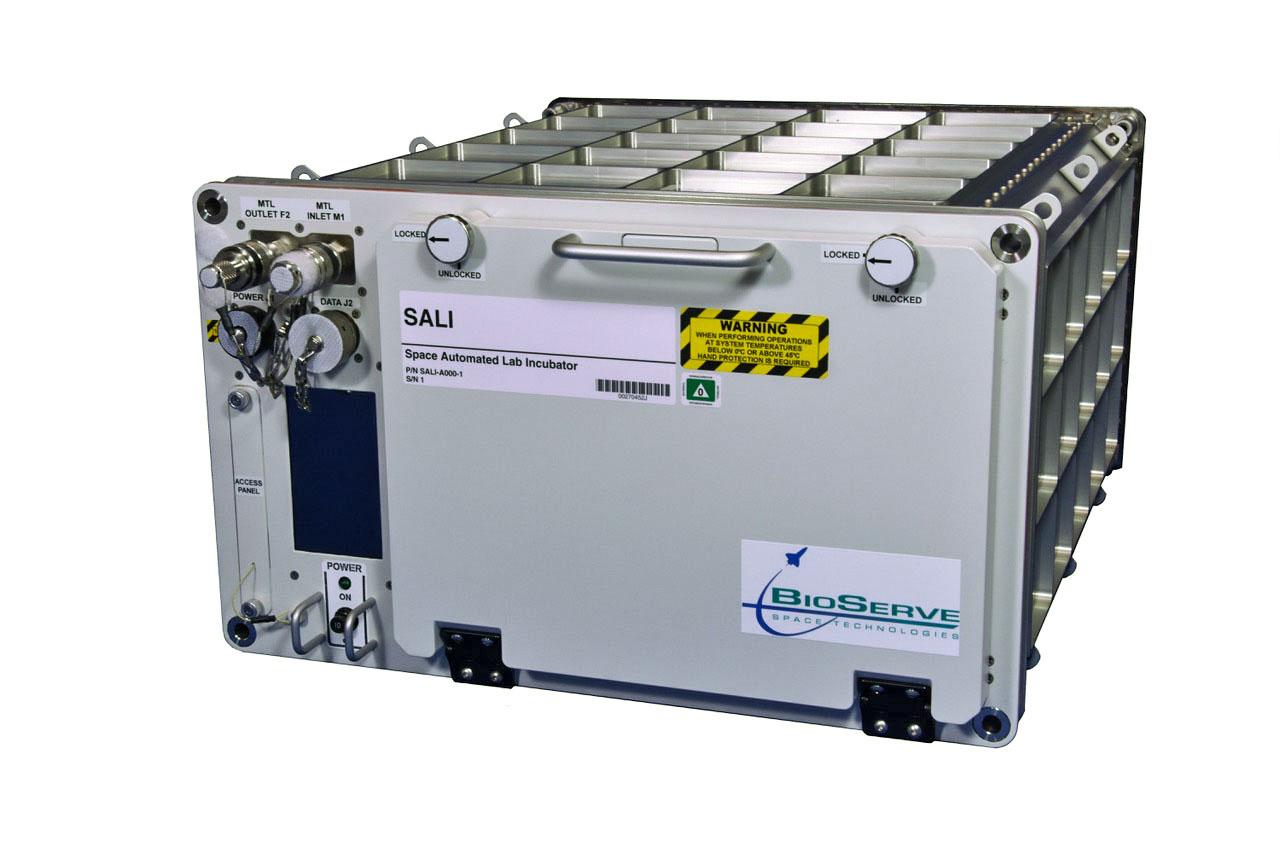
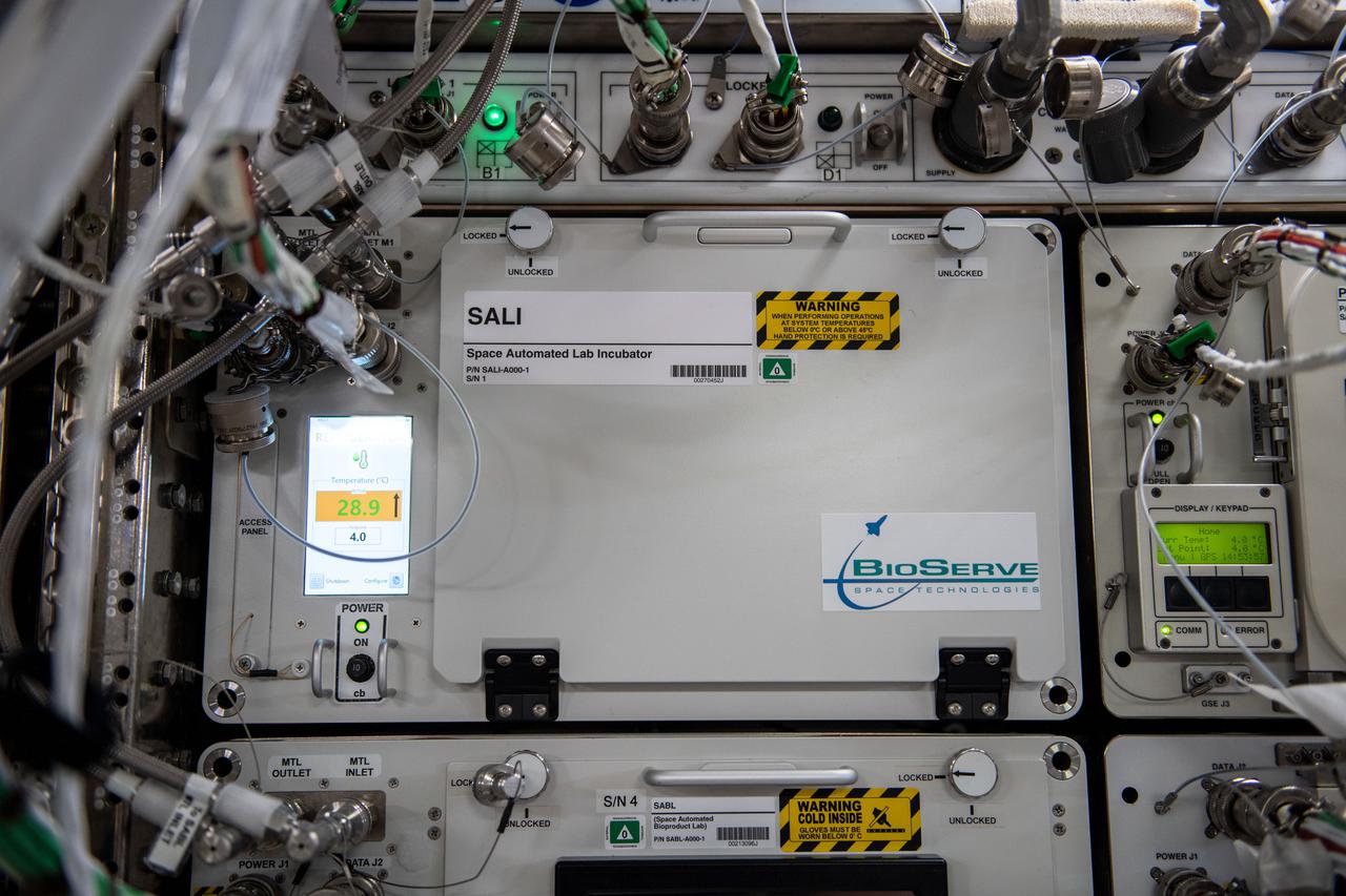
jsc2021e037287 (5/21/2021) --- A preflight view of the SALI incubator. The Space Automated Lab Incubator (SALI) supports a wide variety of investigations in the life, physical, and material sciences, focusing on research on biological systems and processes. SALI accommodates multiple sample packs or habitats and also serves as back-up cold stowage.e.
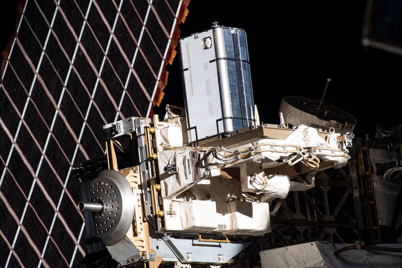
iss067e055847 (5/16/2022) --- Multiple User System for Earth Sensing (MUSES) is the first multi-user facility on an ISS ExPRESS Logistics Carrier (ELC). The facility primarily serves as a platform for earth-viewing sensors and other technologies requiring long-term access to the space environment.
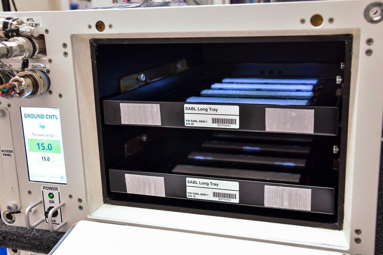
jsc2021e037286 (5/21/2021) --- A preflight view of the SALI incubator. The Space Automated Lab Incubator (SALI) supports a wide variety of investigations in the life, physical, and material sciences, focusing on research on biological systems and processes. SALI accommodates multiple sample packs or habitats and also serves as back-up cold stowage.
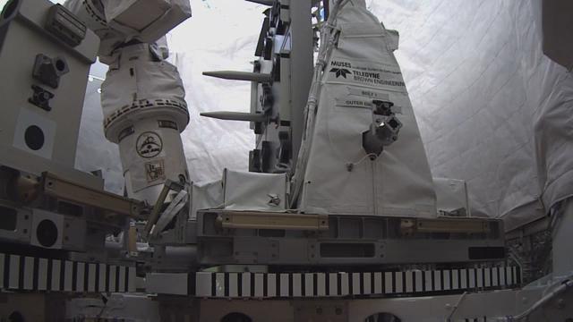
jsc2017e088397 (7/3/2017) --- Multiple User System for Earth Sensing (MUSES) is the first multi-user facility on an ISS ExPRESS Logistics Carrier (ELC). The facility primarily serves as a platform for earth-viewing sensors and other technologies requiring long-term access to the space environment.
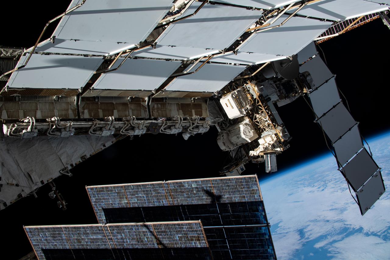
iss067e055504 (5/16/2022) --- Multiple User System for Earth Sensing (MUSES) is the first multi-user facility on an ISS ExPRESS Logistics Carrier (ELC). The facility primarily serves as a platform for earth-viewing sensors and other technologies requiring long-term access to the space environment.
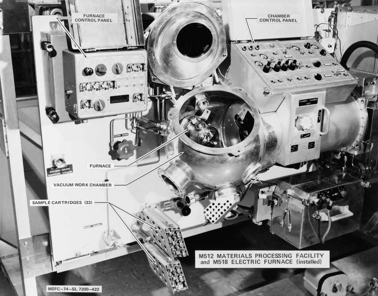
S74-19675 (1974) --- Medium close-up view of the M512 materials processing equipment storage assembly and the M518 electric furnace in the Multiple Docking Adapter (MDA), one of the primary elements of the Skylab space station. The assembly holds equipment designed to explore space manufacturing capability in a weightless state. Photo credit: NASA
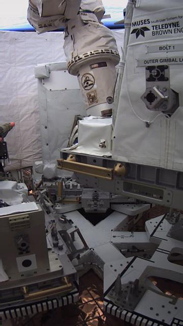
jsc2017e088400 (7/3/2017) --- Multiple User System for Earth Sensing (MUSES) is the first multi-user facility on an ISS ExPRESS Logistics Carrier (ELC). The facility primarily serves as a platform for earth-viewing sensors and other technologies requiring long-term access to the space environment.
A grid of small polygons on the Martian rock surface near the right edge of this view may have originated as cracks in drying mud more than 3 billion years ago. Multiple images from the Mast Camera (Mastcam) on NASA's Curiosity Mars rover were combined for this mosaic of a block called "Squid Cove" and its immediate surroundings. The location is within an exposure of Murray formation mudstone on lower Mount Sharp inside Gale Crater. Mastcam's right-eye camera, which has a telephoto lens, took the component images of this view on Dec. 20, 2016, during the 1,555th Martian day, or sol, of Curiosity's work on Mars. The rover drove farther uphill on Gale Crater before the possible mud cracks were detected in the Mastcam images. This possible evidence about the area's ancient environment prompted the rover mission to backtrack for closer inspection of Squid Cove and nearby target rocks. This scene is presented with a color adjustment that approximates white balancing, to resemble how the rocks and sand would appear under daytime lighting conditions on Earth. The polygons are about half an inch to 1 inch (about 1 to 2 centimeters) across. Figure 1 includes a scale bar of 30 centimeters (12 inches). The polygons are outlined by ridges. This could result from a three-step process after cracks form due to drying: Wind-blown sediments accumulate in the open cracks. Later, these sediments and the dried mud become rock under the pressure of multiple younger layers that accumulate on top of them. Most recently, after the overlying layers were eroded away by wind, the vein-filling material resists erosion better than the once-muddy material, so the pattern that began as cracks appears as ridges. Mud cracks would be evidence of a drying interval between wetter periods that supported lakes in the area. Curiosity has found evidence of ancient lakes in older, lower-lying rock layers and also in younger mudstone that is above Squid Cove. http://photojournal.jpl.nasa.gov/catalog/PIA21263
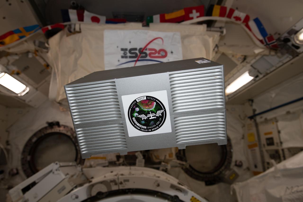
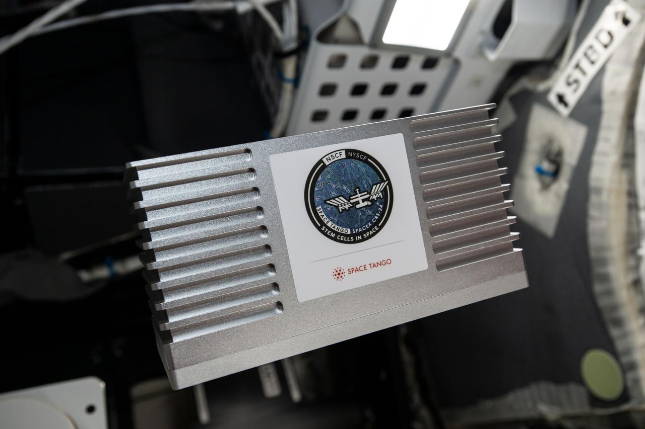
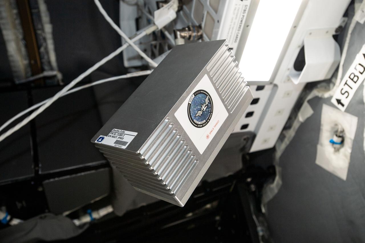
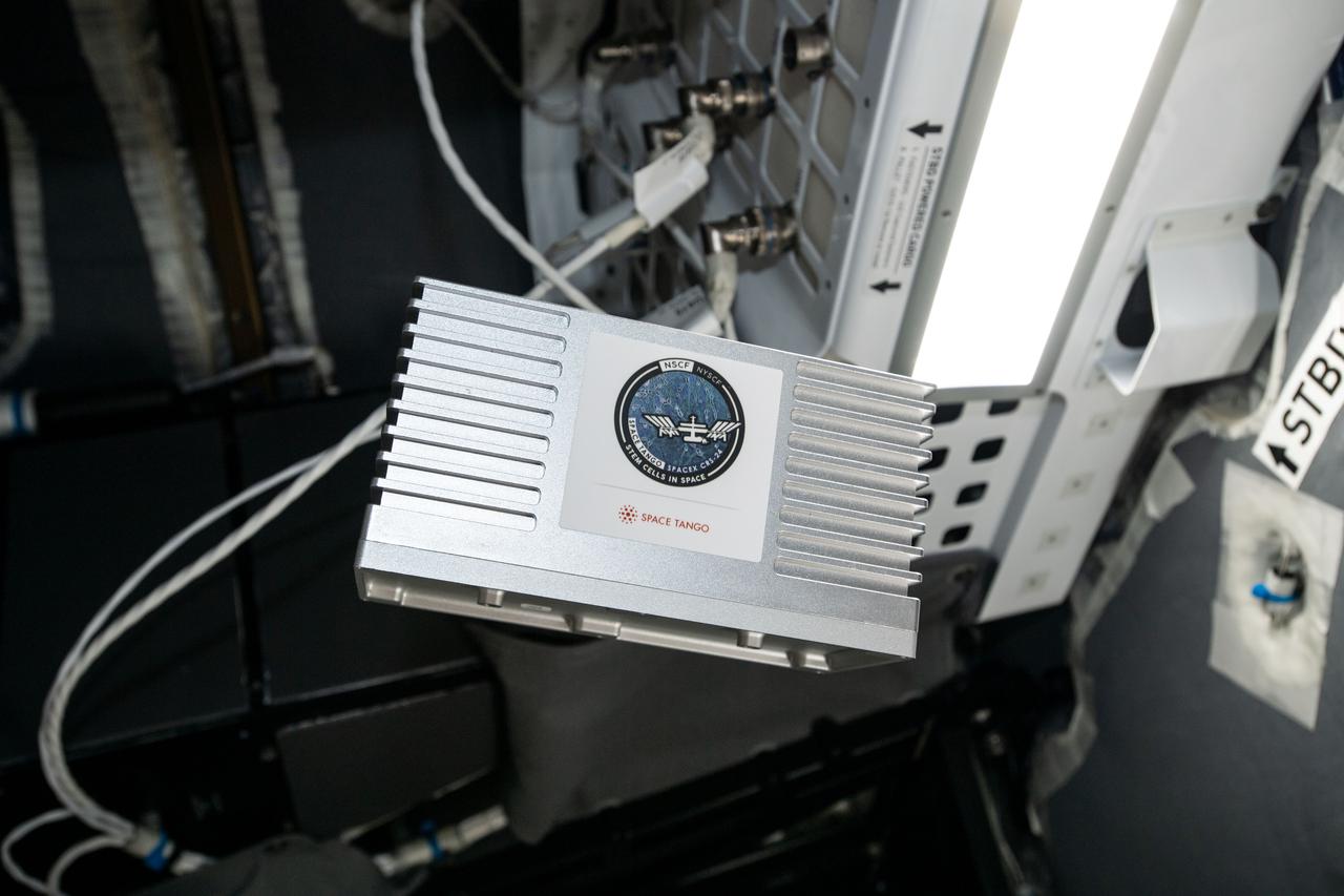
iss061e117838 (1/5/2020) --- A view aboard the International Space Station (ISS) of the TangoLab Space Tango-Induced Pluripotent Stem Cells. The Effects of Microgravity on Microglia 3-Dimensional Models of Parkinson’s Disease and Multiple Sclerosis (Space Tango-Induced Pluripotent Stem Cells) examines how microglial cells grow and move in three-dimensional (3D) cultures as well as any changes in gene expression that occur as a result of microgravity exposure. Microglia are a type of immune defense cell found in the central nervous system. Results may help provide novel approaches to characterizing, understanding, and developing therapies for Parkinson’s disease and multiple sclerosis.
CAPE CANAVERAL, Fla. – At NASA’s Kennedy Space Center in Florida, work continues in Firing Room 2 in the Launch Control Center, or LCC. The legacy flooring is being removed and wiring and conduits below the floor will be upgraded. The mission director’s room to the left and another viewing room to the right also will be upgraded. Firing Rooms inside the LCC are being upgraded by the Ground System Development and Operations Program at Kennedy to support the processing and launch of multiple types of rockets and spacecraft, whether they are government or commercial models. Kennedy’s Launch Complex 39 is transitioning to support multiple users with the Firing Rooms being modified to be more generic in nature for upcoming programs. Photo credit: NASA_Gary Thompson
CAPE CANAVERAL, Fla. – At NASA’s Kennedy Space Center in Florida, modifications continue to Firing Room 3 in the Launch Control Center, or LCC. Wiring and conduits below the floor have been upgraded. The legacy flooring leading to and inside a viewing room has been removed and the area is being prepared for new flooring to be installed. Firing Rooms inside the LCC are being upgraded by the Ground System Development and Operations Program at Kennedy to support the processing and launch of multiple types of rockets and spacecraft, whether they are government or commercial models. Kennedy’s Launch Complex 39 is transitioning to support multiple users with the Firing Rooms being modified to be more generic in nature for upcoming programs. Photo credit: NASA_Gary Thompson
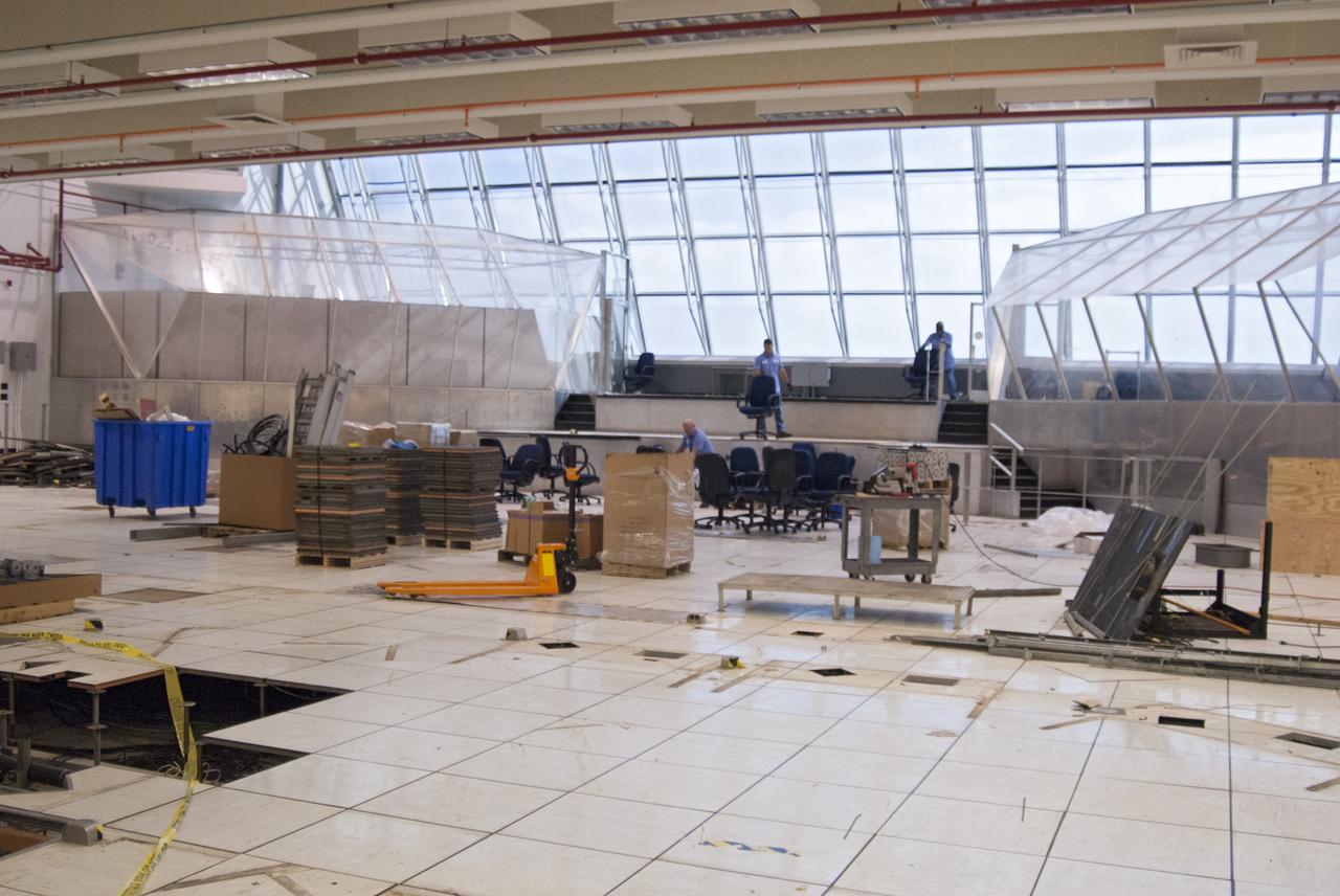
CAPE CANAVERAL, Fla. – At NASA’s Kennedy Space Center in Florida, work continues in Firing Room 2 in the Launch Control Center, or LCC. The legacy flooring is being removed and wiring and conduits below the floor will be upgraded. The mission director’s room to the left and another viewing room to the right also will be upgraded. Firing Rooms inside the LCC are being upgraded by the Ground System Development and Operations Program at Kennedy to support the processing and launch of multiple types of rockets and spacecraft, whether they are government or commercial models. Kennedy’s Launch Complex 39 is transitioning to support multiple users with the Firing Rooms being modified to be more generic in nature for upcoming programs. Photo credit: NASA_Gary Thompson
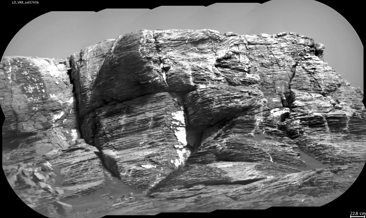
This view of "Vera Rubin Ridge" from the Chemistry and Camera (ChemCam) instrument on NASA's Curiosity Mars rover shows multiple sedimentary layers and fracture-filling deposits of minerals. Buried layers of what is now a ridge became fractured, and the fractures were filled with mineral deposits precipitated from underground fluids that moved through the fractures. ChemCam's telescopic Remote Micro-Imager took the 10 component images of this mosaic on July 3, 2017, during the 1,745th Martian day, or sol, of Curiosity's work on Mars. The camera was about 377 feet (115 meters) away from the pictured portion of the ridge. The rover's location at the time, shown in a Sol 1741 traverse map, was west of the place where it began its ascent up the ridge about two months later. The scale bar at lower right indicates how wide a feature 9 inches (22.8 centimeters) in width would look in the middle portion of the scene. https://photojournal.jpl.nasa.gov/catalog/PIA21852
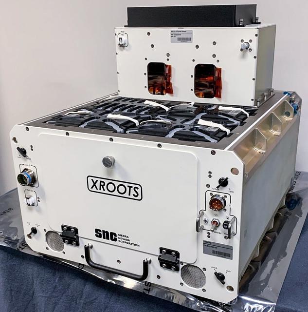
jsc2021e037285 (2/12/2021) --- A preflight view of the XROOTS hardware. The eXposed Root On-Orbit Test System (XROOTS) investigation uses hydroponic and aeroponic techniques to grow plants without soil or other growth media. Video and still images enable evaluation of multiple independent growth chambers for the entire plant life cycle from seed germination through maturity. Results could identify suitable methods to produce crops on a larger scale for future space missions.
iss066e110840 (1/11/2022) --- A view of the Cosmic Brain Organoids CubeLab aboard the International Space Station (ISS). The Effects of Microgravity on Microglia 3-Dimensional Models of Parkinson’s Disease and Multiple Sclerosis – Mission 2 (Cosmic Brain Organoids) examines growth and movement of microglial cells in 3D organoids and potential changes in gene expression and protein secretion caused by microgravity.

S73-25140 (16 April 1973) --- A ground-level view of Pad A, Launch Complex 39, Kennedy Space Center, Florida, showing the 341-feet tall Skylab 1/Saturn V space vehicle on the pad soon after being rolled out from the Vehicle Assembly Building (VAB). The vehicle is composed of the Saturn V first (S-1C) stage, the Apollo Telescope Mount (ATM), the Multiple Docking Adapter (MDA), the Airlock Module (AM), and the Orbital Workshop (OWS). Photo credit: NASA
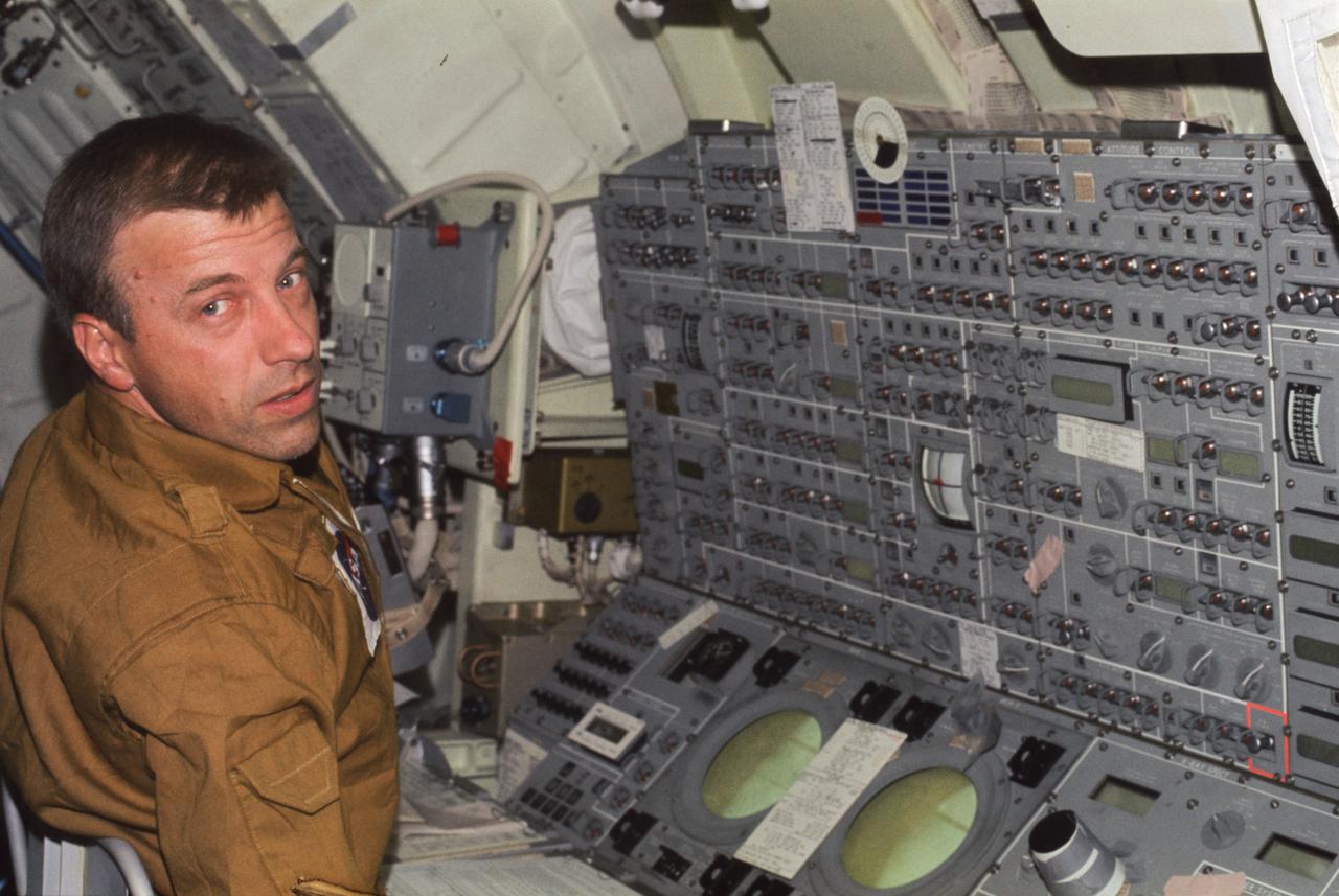
SL2-X9-747 (June 1973) --- Astronaut Paul J. Weitz, Skylab 2 pilot, mans the control and display console of the Apollo Telescope Mount (ATM) in this onboard view photographed in Earth orbit. The ATM C&D console is located in the Multiple Docking Adapter (MDA) of the Skylab 1/2 space station. Weitz, along with astronaut Charles Conrad Jr., commander, and scientist-astronaut Joseph P. Kerwin, science pilot, went on to successfully complete a 28-day mission in Earth orbit. Photo credit: NASA

Volunteers from the Merritt Island National Wildlife Refuge are photographed with their display during a sustainability expo held at the Kennedy Space Center Visitor Complex in Florida on April 11, 2019. Guests had the opportunity to view their display and receive information on Florida plants and wildlife. The expo kicked off Kennedy’s annual Earth Day celebrations, where approximately 40 exhibitors attended to provide information ranging from energy-saving solutions to wildlife and natural conservation. In addition, there were multiple butterfly releases throughout the day.
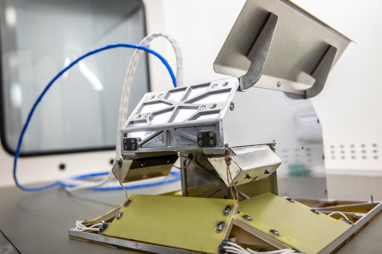
jsc2024e016243 (2/14/2024) --- Close-up view of the final Multi-Resolution Scanning payload with its stereo vision cameras at left and right. The Multi-Resolution Scanning payload uses multiple different sensor types to generate high-resolution 3D data and more accurate trajectory data to understand how the Astrobee robot moves around in 3D space.
The final version of the Marshall Space Flight Center managed Skylab consisted of four primary parts. One component was the Apollo Telescope Mount (ATM) that housed the first marned scientific telescopes in space. This picture is a view of the ATM spar, which contained the scientific instruments, as the multiple docking adapter (MDA) canister end is lowered over it. The MDA served to link the major parts of Skylab together.
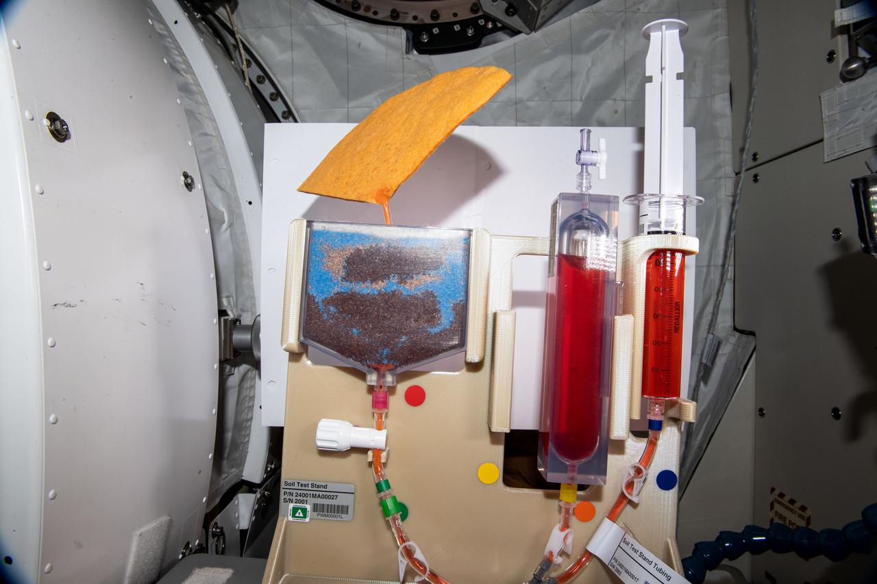
iss064e030235 (2/8/2021) --- A view of the Plant Water Management (PWM) investigation aboard the International space Station (ISS). Plant Water Management demonstrates a hydroponic method for ensuring adequate hydration and aeration to the root zone in order to sustain plants from germination through harvest. Low-gravity capillary fluidics deliver water in single and multiple plant production chambers, and researchers compare growth of individual plants in microgravity and normal gravity.
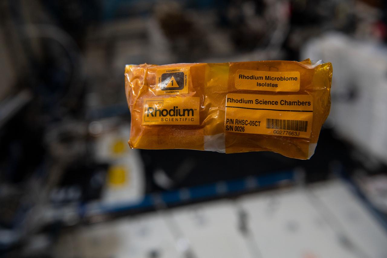
iss068e012558 (10/7/2022) --- A view of the Rhodium Space Microbiome Isolates sample aboard the International space Station (ISS). Characterization of Targeted Space Gut Microbiome Isolates to Advance Astronaut Gut-On-A-Chip Platform Development (Rhodium Space Microbiome Isolates) characterizes individual bacterial species from the human gut microbiome that change during spaceflight. Research shows a connection between alterations in the gut microbiome and multiple chronic and acute diseases.
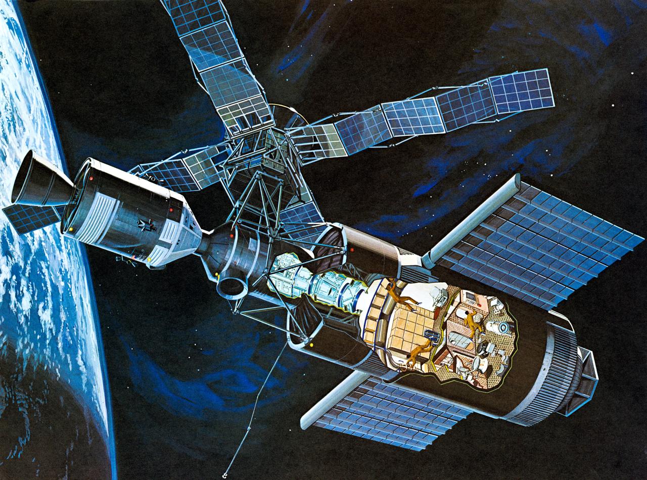
S71-52192 (1971) --- An artist's concept of the Skylab space station cluster in Earth's orbit. The cutaway view shows astronaut activity in the Orbital Workshop (OWS). The Skylab cluster is composed of the OWS, Airlock Module (AM), Multiple Docking Adapter (MDA), Apollo Telescope Mount (ATM), and the Command and Service Module (CSM). Photo credit: NASA
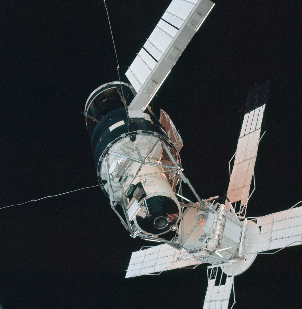
A close-up view of the Skylab space station cluster photographed against a black sky background from the Skylab 3 command module during the "fly around" inspection prior to docking. Note the one solar array system wing on the Orbital Workshop (OWS) which was successfully deployed during EVA on the first manned Skylab mission. The primary docking part at the forward end of the Multiple Docking Adapter (MDA) is visible below the Apollo Telescope Mount (ATM).
iss066e110844 (1/11/2022) --- A view of the Cosmic Brain Organoids CubeLab aboard the International Space Station (ISS). The Effects of Microgravity on Microglia 3-Dimensional Models of Parkinson’s Disease and Multiple Sclerosis – Mission 2 (Cosmic Brain Organoids) examines growth and movement of microglial cells in 3D organoids and potential changes in gene expression and protein secretion caused by microgravity.
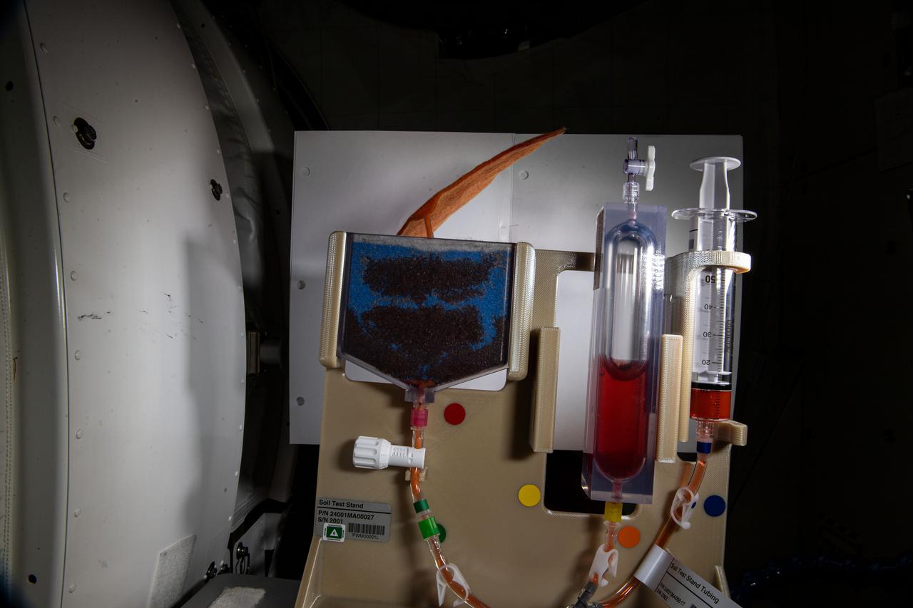
iss064e030517 (2/9/2021) --- A view of the Plant Water Management (PWM) investigation aboard the International space Station (ISS). Plant Water Management demonstrates a hydroponic method for ensuring adequate hydration and aeration to the root zone in order to sustain plants from germination through harvest. Low-gravity capillary fluidics deliver water in single and multiple plant production chambers, and researchers compare growth of individual plants in microgravity and normal gravity.
iss066e110849 (1/11/2022) --- A view of the Cosmic Brain Organoids CubeLab aboard the International Space Station (ISS). The Effects of Microgravity on Microglia 3-Dimensional Models of Parkinson’s Disease and Multiple Sclerosis – Mission 2 (Cosmic Brain Organoids) examines growth and movement of microglial cells in 3D organoids and potential changes in gene expression and protein secretion caused by microgravity.

This animation shows the overlap of the field of view of Juno's Stellar Reference Unit (SRU) star camera (in yellow) and Juno's Microwave Radiometer (MWR) Antenna-1 beam (in red). The animation depicts Juno flying over Jupiter's North pole where the planet's massive northern aurora is located. Juno observes Jupiter's lightning using multiple instruments which detect lightning at different parts of its spectrum. Animation avaiable at https://photojournal.jpl.nasa.gov/catalog/PIA22967

iss064e030275 (2/8/2021) --- A view of the Plant Water Management (PWM) investigation aboard the International space Station (ISS). Plant Water Management demonstrates a hydroponic method for ensuring adequate hydration and aeration to the root zone in order to sustain plants from germination through harvest. Low-gravity capillary fluidics deliver water in single and multiple plant production chambers, and researchers compare growth of individual plants in microgravity and normal gravity.
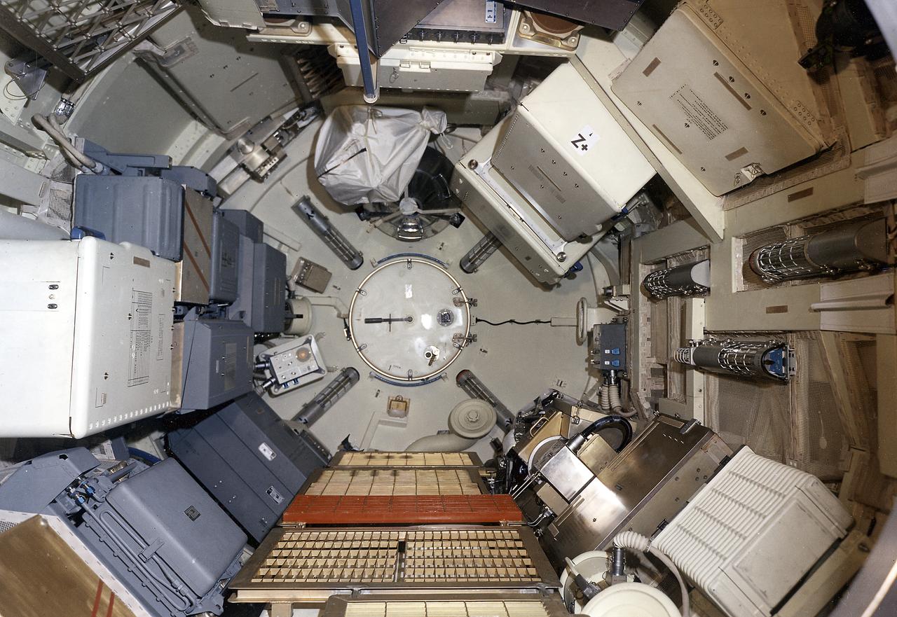
This December 1971 photograph shows the internal configuration of Skylab's Multiple Docking Adapter (MDA) flight article (forward view) as it appeared during the crew compartment and function review at the Martin-Marietta Corporation's Space Center Facility in Denver, Colorado. Designed and manufactured by the Marshall Space Flight Center, the MDA housed a number of experiment control and stowage units as well as providing a docking port for the Apollo Command module.

iss068e013749 (10/8/2022) --- A view of the Rhodium Space Microbiome Isolates sample aboard the International space Station (ISS). Characterization of Targeted Space Gut Microbiome Isolates to Advance Astronaut Gut-On-A-Chip Platform Development (Rhodium Space Microbiome Isolates) characterizes individual bacterial species from the human gut microbiome that change during spaceflight. Research shows a connection between alterations in the gut microbiome and multiple chronic and acute diseases.

Guests view a display set up by Hubbs-Seaworld Research Institute during a sustainability expo held at the Kennedy Space Center Visitor Complex in Florida on April 11, 2019. The expo kicked off Kennedy’s annual Earth Day celebrations, where approximately 40 exhibitors from across the nation assembled to provide information ranging from energy-saving solutions to wildlife and natural conservation. In addition, there were multiple butterfly releases throughout the day.
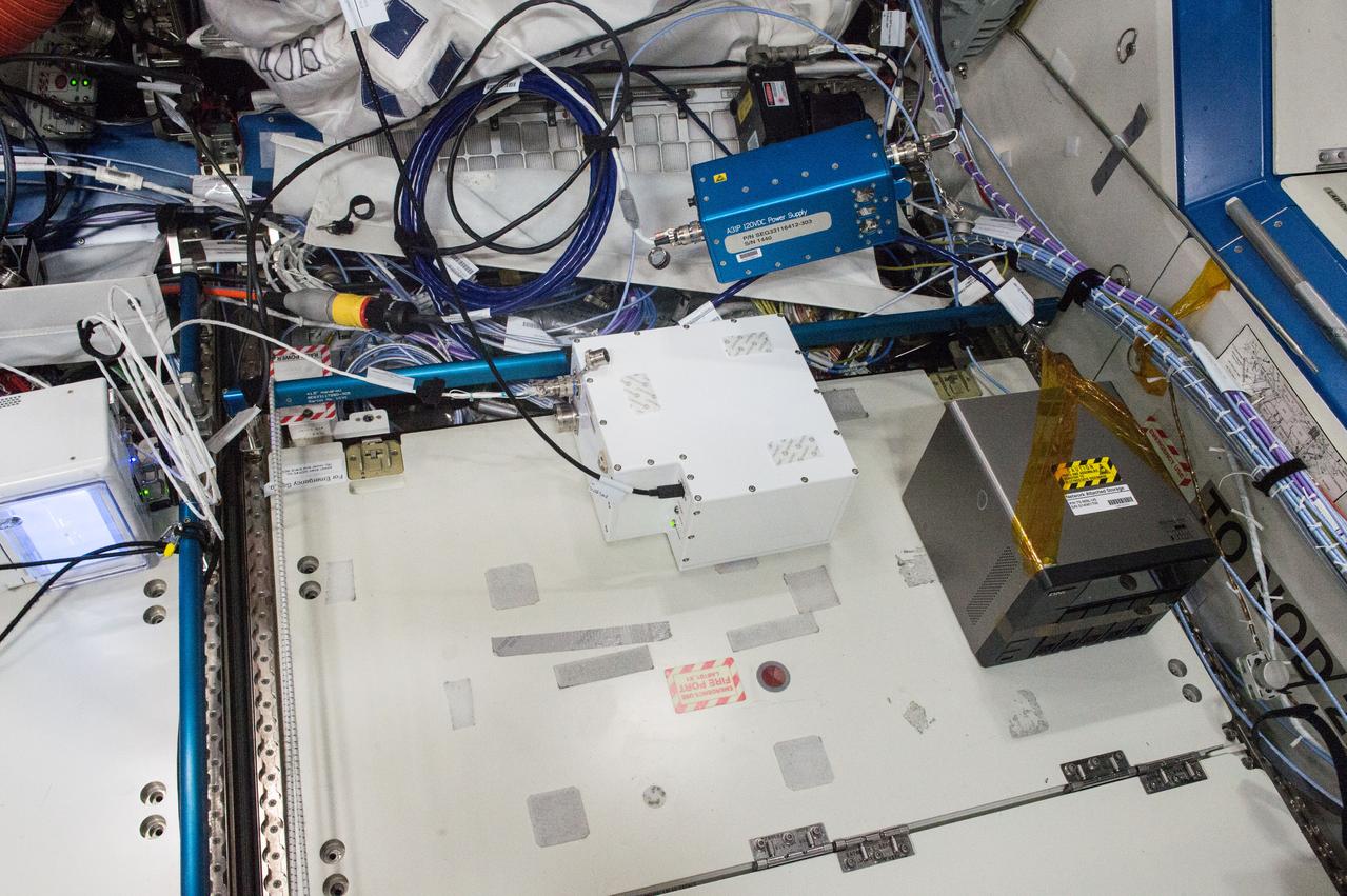
iss050e013233 (12/2/2016) --- A view during the Fast Neutron Spectrometer (FNS) Hardware Setup, in the U.S. Laboratory. The Fast Neutron Spectrometer (FNS) investigation studies a new neutron measurement technique that is better suited for the mixed radiation fields found in deep space. Future manned and exploration missions benefit from clearer, more error-free measurement of the neutron flux present in an environment with multiple types of radiation.
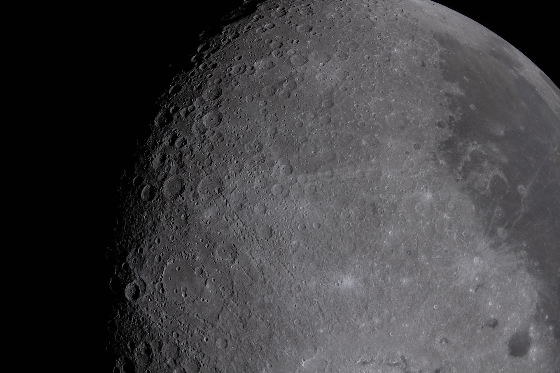
art002e012261 (April 6, 2026) - Multiple lunar landmarks come into view in this image, many of which were highlighted during the Artemis II crew’s observation call. Visible features include Ohm crater, Oceanus Procellarum, Grimaldi crater, Pierazzo crater, the newly proposed Carroll crater, and the expansive Hertzsprung Basin—together illustrating a range of geologic terrains, from dark volcanic plains to heavily cratered highlands and the remnants of ancient impact basins.
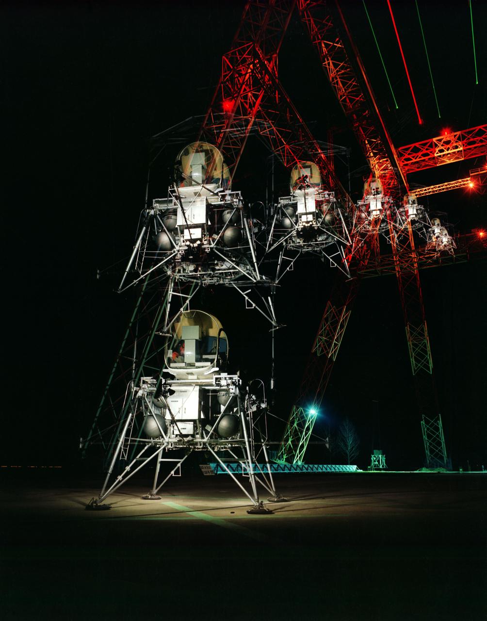
During a nighttime training session, a multiple exposure captures the movement of the Lunar Excursion Module Simulator (LEMS). The LEMS was a manned vehicle used to familiarize the Apollo astronauts with the handling characteristics of lunar-landing type vehicle. The Apollo Program is best known for the astronaut Neal Armstrong s first step on the Moon July 20, 1969. In its earliest test period, the LEMS featured a helicopter crew cabin atop the lunar landing module. Later, the helicopter crew cabin was replaced with a stand-up rectangular cabin which was more efficient for controlling maneuvers and for better viewing by the pilot. The vehicle was designed at Langley Research Center in Hampton, VA. This multiple exposure shows a simulated Moon landing of the (LEMS) trainer at Langley s Lunar Landing Research Facility. -- Photograph published in Winds of Change, 75th Anniversary NASA publication (page 70), by James Shultz. Also published in " A Century at Langley" by Joseph Chambers, pg. 93.
jsc2019e040133 (7/18/2019) --- A preflight view of Dopaminergic neurons growing in a culture dish (20x magnification) . A skin biopsy from a patient with Parkinson’s disease was reprogrammed into induced pluripotent stem cells. The stem cells were then differentiated into dopaminergic neurons (green), the same cells that are lost in Parkinson’s disease patients. Work is underway to use these cells as a replacement for lost neurons as a treatment for the disease. The Effects of Microgravity on Microglia 3-Dimensional Models of Parkinson’s Disease and Multiple Sclerosis (Space Tango-Induced Pluripotent Stem Cells) examines how microglial cells grow and move in three-dimensional (3D) cultures as well as any changes in gene expression that occur as a result of microgravity exposure. Microglia are a type of immune defense cell found in the central nervous system. Results may help provide novel approaches to characterizing, understanding, and developing therapies for Parkinson’s disease and multiple sclerosis. (Image courtesy of: Andres Bratt-Leal, PhD| Aspen Neuroscience)
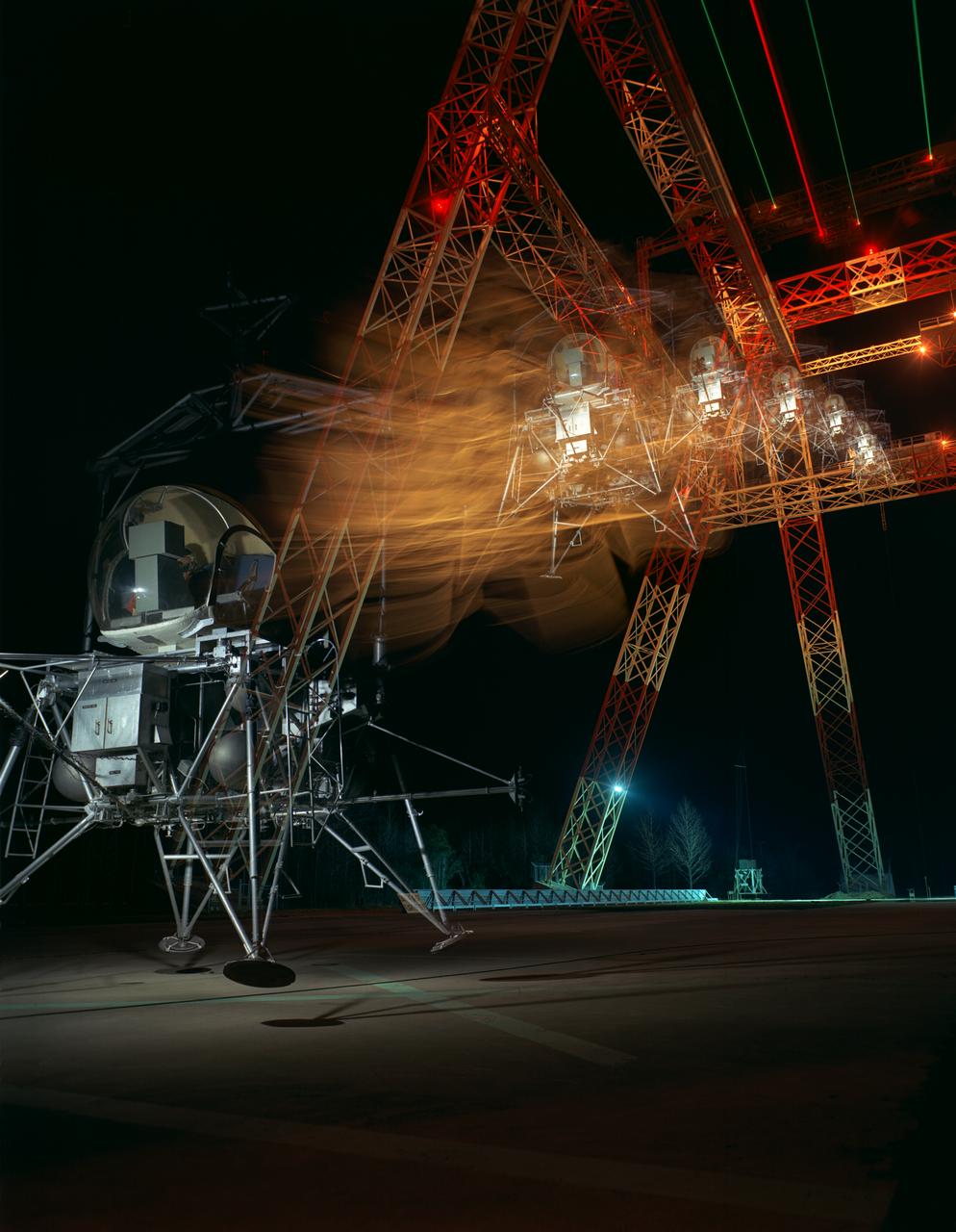
During a nighttime training session, a multiple exposure captures the movement of the Lunar Excursion Module Simulator (LEMS). The LEMS was a manned vehicle used to familiarize the Apollo astronauts with the handling characteristics of lunar-landing type vehicle. The Apollo Program is best known for the astronaut Neal Armstrong s first step on the Moon July 20, 1969. In its earliest test period, the LEMS featured a helicopter crew cabin atop the lunar landing module. Later, the helicopter crew cabin was replaced with a stand-up rectangular cabin which was more efficient for controlling maneuvers and for better viewing by the pilot. The vehicle was designed at Langley Research Center in Hampton, VA. This multiple exposure shows a simulated Moon landing of the (LEMS) trainer at Langley s Lunar Landing Research Facility. -- Photograph published in Winds of Change, 75th Anniversary NASA publication (page 70), by James Shultz. Also published in " A Century at Langley" by Joseph Chambers, pg. 93.
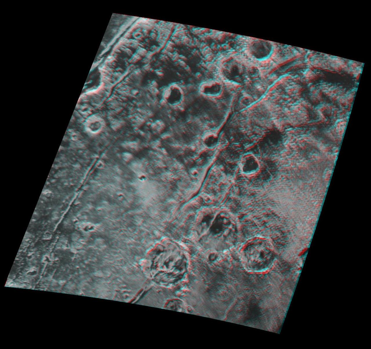
Global stereo mapping of Pluto surface is now possible, as images taken from multiple directions are downlinked from NASA New Horizons spacecraft. Stereo images will eventually provide an accurate topographic map of most of the hemisphere of Pluto seen by New Horizons during the July 14 flyby, which will be key to understanding Pluto's geological history. This example, which requires red/blue stereo glasses for viewing, shows a region 180 miles (300 kilometers) across, centered near longitude 130 E, latitude 20 N (the red square in the global context image). North is to the upper left. The image shows an ancient, heavily cratered region of Pluto, dotted with low hills and cut by deep fractures, which indicate extension of Pluto's crust. Analysis of these stereo images shows that the steep fracture in the upper left of the image is about 1 mile (1.6 kilometers) deep, and the craters in the lower right part of the image are up to 1.3 miles (2.1 km) deep. Smallest visible details are about 0.4 miles (0.6 kilometers) across. You will need 3D glasses to view this image showing an ancient, heavily cratered region of Pluto. http://photojournal.jpl.nasa.gov/catalog/PIA20032
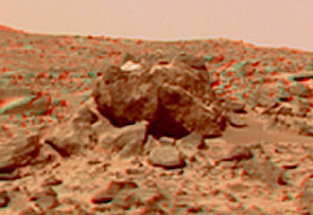
This view of the "Hippo," 25 meters to the west of the lander, was produced by combining the "Super Panorama" frames from the IMP camera. Super resolution was applied to help to address questions about the texture of this rock and what it might tell us about its mode of origin. The composite color frames that make up this anaglyph were produced for both the right and left eye of the IMP. These composites consist of more than 15 frames per eye (because multiple sequences covered the same area), taken with different color filters that were enlarged by 500% and then co-added using Adobe Photoshop to produce, in effect, a super-resolution panchromatic frame that is sharper than an individual frame would be. These panchromatic frames were then colorized with the red, green, and blue filtered images from the same sequence. The color balance was adjusted to approximate the true color of Mars. The anaglyph view was produced by combining the left with the right eye color composite frames by assigning the left eye composite view to the red color plane and the right eye composite view to the green and blue color planes (cyan), to produce a stereo anaglyph mosaic. This mosaic can be viewed in 3-D on your computer monitor or in color print form by wearing red-blue 3-D glasses. http://photojournal.jpl.nasa.gov/catalog/PIA01421
![ISS005-E-5416 (18 June 2002) --- This photograph, taken by the International Space Station’s Expedition Five crew on June 18, 2002, shows the Hayman Fire burning in the foothills southwest of Denver. Astronauts use a variety of lenses and look angles as their orbits pass over wildfires to document the long-distance movements of smoke from the fires as well as details of the burning areas. In this detail view, you can see multiple smoke source points as the fire moves across the rough terrain. The link [<http://eol.jsc.nasa.gov/scripts/sseop/photo.pl?mission=ISS005&roll=E&frame=5416> ] was provided by the Earth Sciences and Image Analysis Laboratory at Johnson Space Center. Additional images taken by astronauts and cosmonauts can be viewed at the NASA-JSC Gateway to Astronaut Photography of Earth [link to <http://eol.jsc.nasa.gov/> ].](https://images-assets.nasa.gov/image/iss005e05416/iss005e05416~medium.jpg)
ISS005-E-5416 (18 June 2002) --- This photograph, taken by the International Space Station’s Expedition Five crew on June 18, 2002, shows the Hayman Fire burning in the foothills southwest of Denver. Astronauts use a variety of lenses and look angles as their orbits pass over wildfires to document the long-distance movements of smoke from the fires as well as details of the burning areas. In this detail view, you can see multiple smoke source points as the fire moves across the rough terrain. The link [<http://eol.jsc.nasa.gov/scripts/sseop/photo.pl?mission=ISS005&roll=E&frame=5416> ] was provided by the Earth Sciences and Image Analysis Laboratory at Johnson Space Center. Additional images taken by astronauts and cosmonauts can be viewed at the NASA-JSC Gateway to Astronaut Photography of Earth [link to <http://eol.jsc.nasa.gov/> ].
This self-portrait of NASA's Opportunity Mars rover shows the vehicle at a site called "Perseverance Valley" on the slopes of Endeavour Crater. It was taken with the rover's Microscopic Imager to celebrate the 5000th Martian Day, or sol, of the rover's mission. The Microscopic Imager is a fixed-focus camera mounted at the end of the rover's robotic arm. Because it was designed for close inspection of rocks, soils and other targets at a distance of around 2.7 inches (7 cm), the rover is out of focus. The rover's self-portrait view is made by stitching together multiple images take on Sol 5,000 and 5,006 of the mission. Wrist motions and turret rotations on the arm allowed the Microscopic Imager to acquire the mosaic's component images. The resulting mosaic does not include the rover's arm. This simulation from planning software used to write commands for the rover shows the motion of the robotic arm, and an inset view of the Microscopic Imager. https://photojournal.jpl.nasa.gov/catalog/PIA22222
Inside the Space Station Processing Facility high bay at NASA's Kennedy Space Center in Florida, the Multiple User System for Earth Sensing, or MUSES, payload is being prepared for transfer out of the high bay. MUSES will be delivered to the International Space Station aboard the SpaceX Dragon cargo carrier on the company’s 11th commercial resupply services mission to the space station. MUSES, developed by Teledyne Brown, is part of the company's new commercial space-based digital imaging business. MUSES hosts earth-viewing instruments, such as high-resolution digital cameras, hyperspectral imagers, and provides precision pointing and other accommodations.
Multiple images from the Mars Color Imager (MARCI) aboard NASA's Mars Reconnaissance Orbiter (MRO) were used to generate this view of a regional dust storm obscuring Syrtis Major and Jezero Crater (white circle). The images were acquired on Jan. 9, 2022. MRO creates global maps of Mars but roll maneuvers for targeted observations produce gaps in the coverage, which appear as black gores in the maps. On some days there are data drops where partial or full orbits of coverage are missing. Green and purple observed in the south polar region indicate saturated pixels. https://photojournal.jpl.nasa.gov/catalog/PIA25068
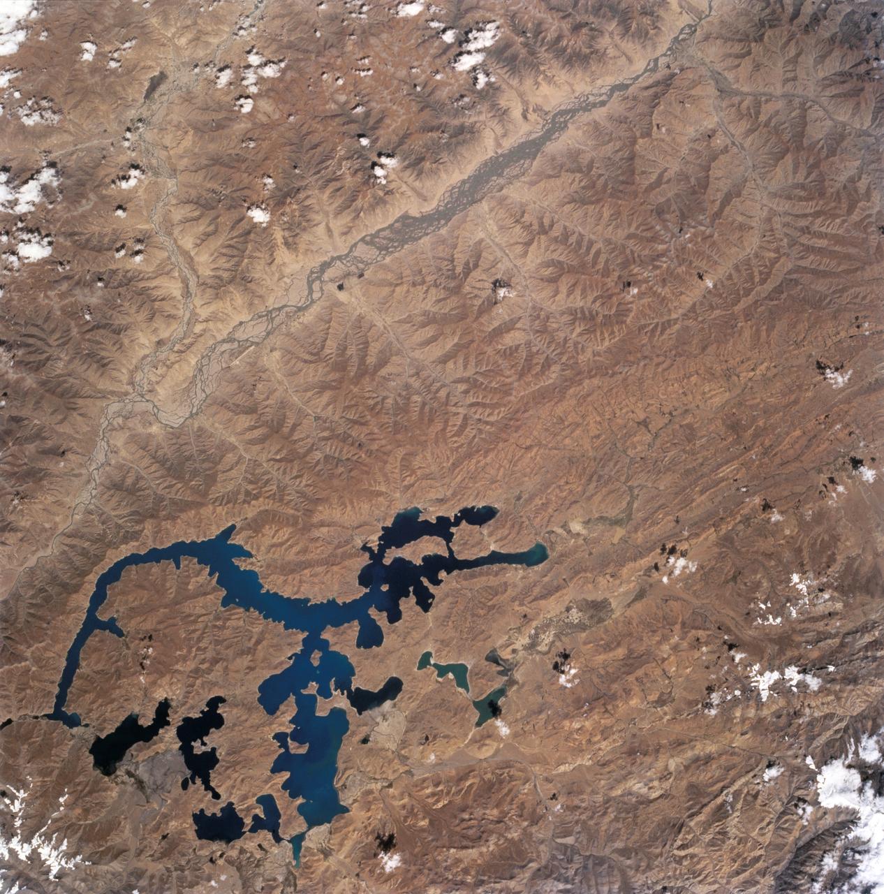
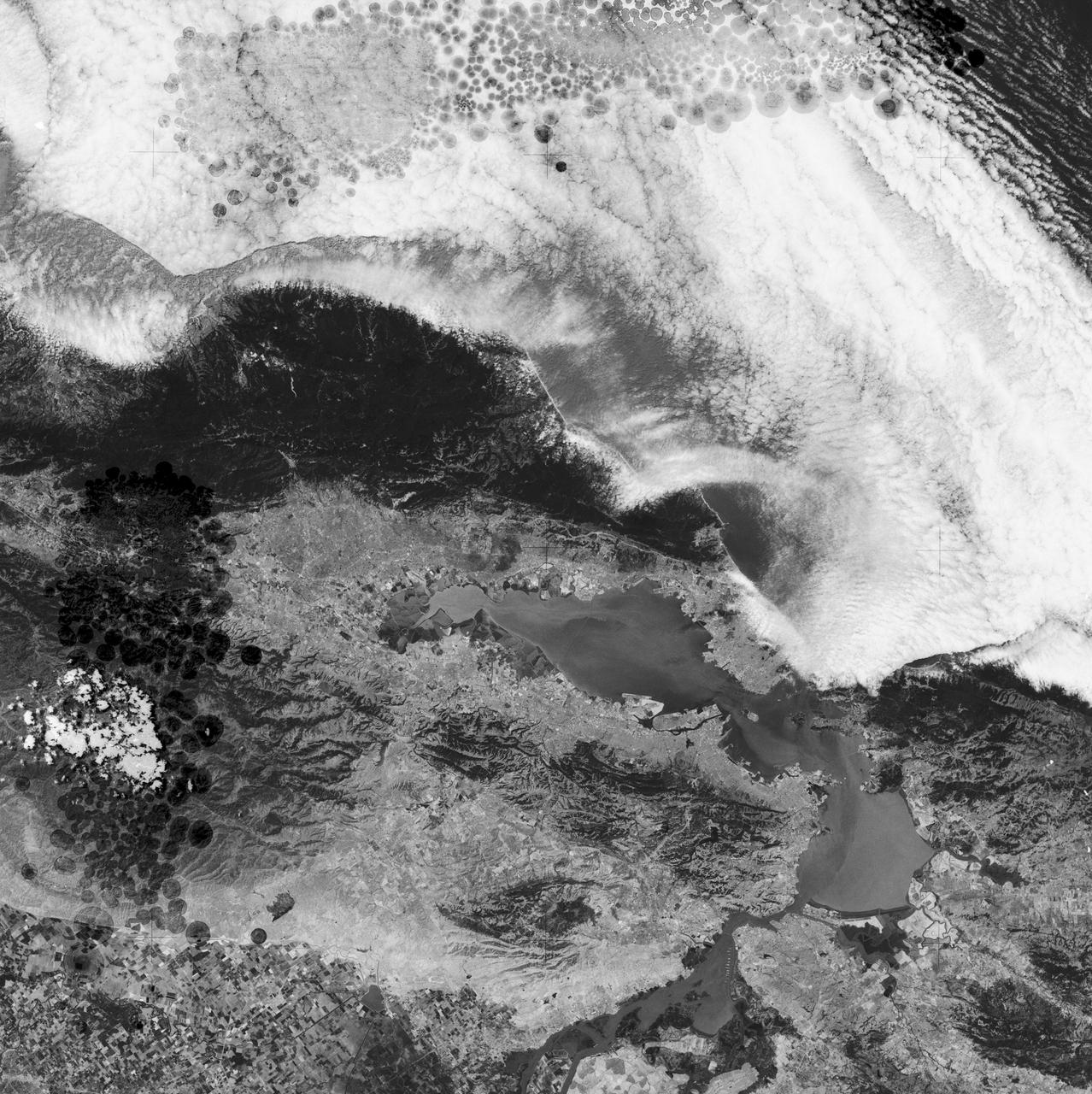
STS068-243-012 (30 September-11 October 1994) --- This nadir view of the southern Tibetan Plateau shows the plateau in late summer without snow. It also shows large, irregular Lake Yamzho Yumco, which has the unusual feature of different water color in different places, the darkest water apparently related to the remotest bays, and the lighter color resulting from sediment flowing into the lake from a stream bottom left. The multiple-channeled upper Brahmaputra River cuts the top left corner of the frame, flowing east (to the top right). The tributary entering the frame near the top left corner is the Lhasa River: Lhasa lies on this river just outside the frame.

STS054-86-001 (13-19 Jan. 1993) --- This 70mm view shows a spectacular multiple spit on the coast of Brazil, about halfway between Rio de Janeiro and the mouth of the Amazon River. Over a few thousand years, according to NASA scientists, shifting regimes of wave and current patterns piled up sand onto a series of beach ridges and tidal lagoons. The present swirls of sediment along the coast evidently were derived from beach erosion, because streams flowing into the Atlantic contain dark, clear water. Offshore, reefs and sandbanks parallel the coast. The largest is the Recife da Pedra Grande (Big Rocks Reef).
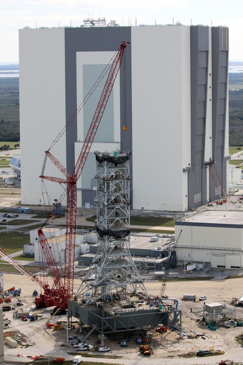
CAPE CANAVERAL, Fla. – At NASA's Kennedy Space Center in Florida, this aerial view of the mobile launcher park site area north of the 525-foot-tall Vehicle Assembly Building, in the background, shows a new mobile launcher, or ML, under construction to support the Constellation Program. When completed, the tower will be approximately 345 feet tall and have multiple platforms for personnel access. Its base is being made lighter than space shuttle mobile launcher platforms so the crawler-transporter can pick up the heavier load of the tower and a taller rocket. For information on the Constellation Program, visit http://www.nasa.gov/constellation. Photo credit: NASA/Cory Huston
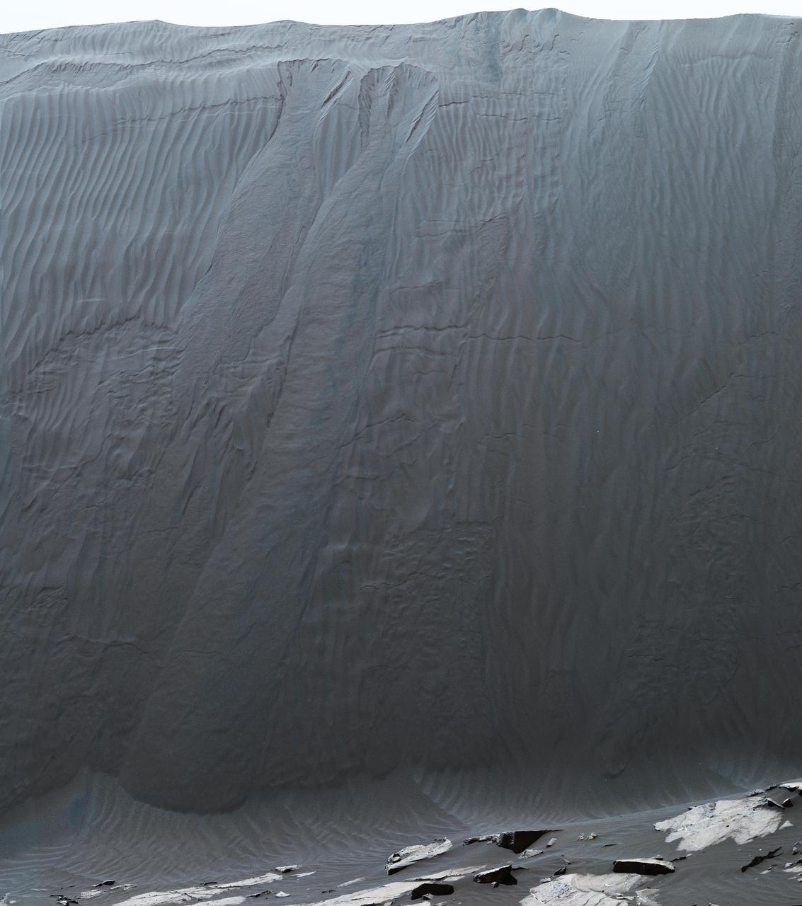
This view combines multiple images from the telephoto-lens camera of the Mast Camera (Mastcam) on NASA's Curiosity Mars rover to reveal fine details of the downwind face of "Namib Dune." The site is part of the dark-sand "Bagnold Dunes" field along the northwestern flank of Mount Sharp. Images taken from orbit have shown that dunes in the Bagnold field move as much as about 3 feet (1 meter) per Earth year. Sand on this face of Namib Dune has cascaded down a slope of about 26 to 28 degrees. The top of the face is about 13 to 17 feet (4 to 5 meters) above the rocky ground at its base. http://photojournal.jpl.nasa.gov/catalog/PIA20283
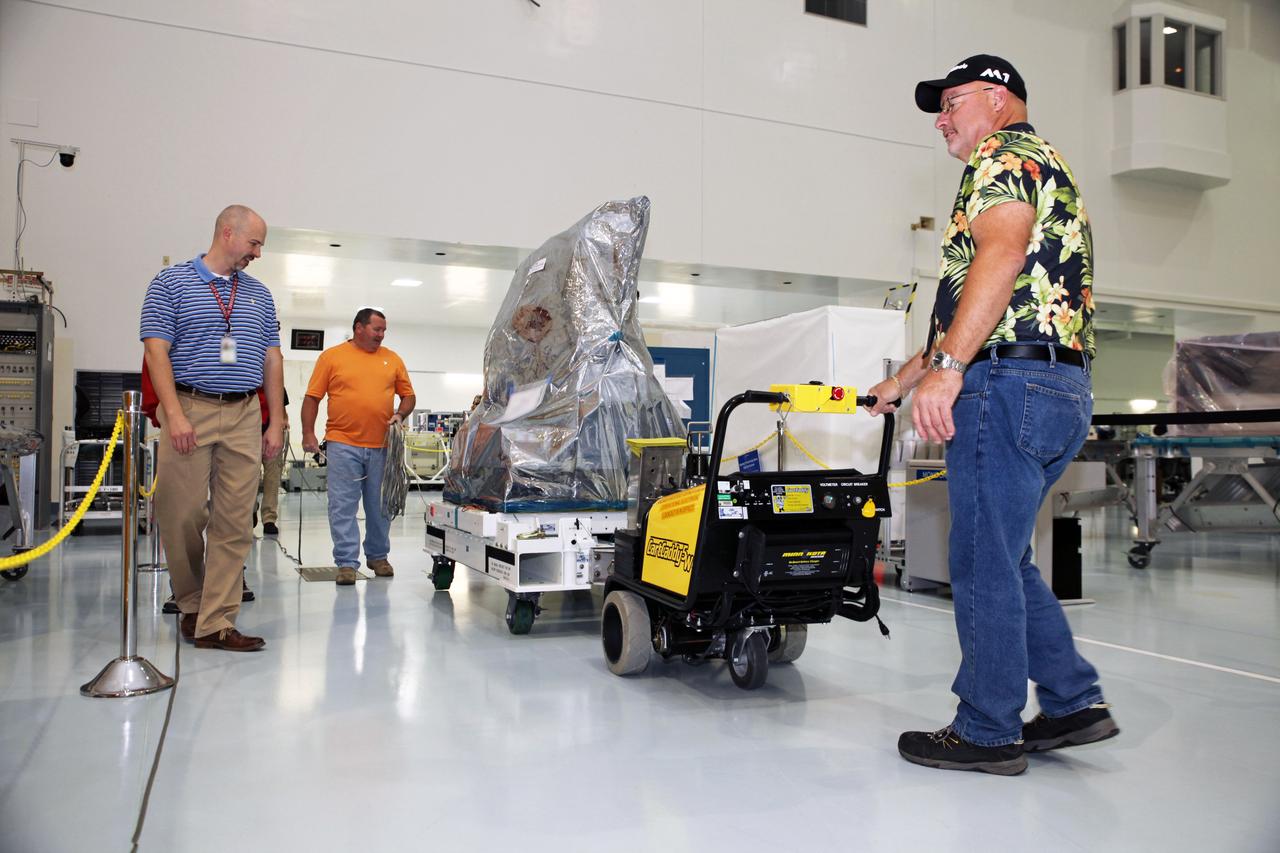
Inside the Space Station Processing Facility high bay at NASA's Kennedy Space Center in Florida, the Multiple User System for Earth Sensing, or MUSES, payload is being prepared for transfer out of the high bay. MUSES will be delivered to the International Space Station aboard the SpaceX Dragon cargo carrier on the company’s 11th commercial resupply services mission to the space station. MUSES, developed by Teledyne Brown, is part of the company's new commercial space-based digital imaging business. MUSES hosts earth-viewing instruments, such as high-resolution digital cameras, hyperspectral imagers, and provides precision pointing and other accommodations.
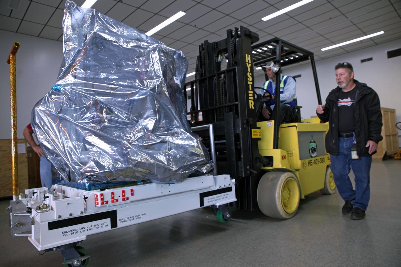
Technicians use a Hyster forklift to move the Multiple User System for Earth Sensing, or MUSES, payload out of the Space Station Processing Facility high bay at NASA's Kennedy Space Center in Florida. MUSES will be delivered to the International Space Station aboard the SpaceX Dragon cargo carrier on the company’s 11th commercial resupply services mission to the space station. MUSES, developed by Teledyne Brown, is part of the company's new commercial space-based digital imaging business. MUSES hosts earth-viewing instruments, such as high-resolution digital cameras, hyperspectral imagers, and provides precision pointing and other accommodations.
Arctic Ozone Expedition Stavanger Norway These clouds in the polar regions north of Stravanger, Norway are representative of what are called 'Type 1' and Type 2' polar stratospheric clouds. Type 1 are seen in the lower portion and consist of cloud particles comprised of nitrogen trihydrates. Seen edge-on as in this view, they appear as a thin dark orange or brown layer. Multiple layering can be seen. The Type 2 clouds are above and consist mostly of water molecules frozen as ice. The size of the particles in Type 2 clouds, the water-ice clouds, are much larger than the particle size of the Type 1 clouds - which are on the order of the wavelength of light.
iss065e364696 (9/8/2021) --- A view of the of the SALI 1 unit in the Japanese Experiment Module (JEM) aboard the International Space Station (ISS). The Space Automated Lab Incubator (SALI) supports a wide variety of investigations in the life, physical, and material sciences, focusing on research on biological systems and processes. It provides a 24-liter temperature-controlled chamber ranging from -20.0°C to +48.0°C, continuous maintenance-free operation, and LED lighting. SALI accommodates multiple sample packs or habitats and serves as back-up cold stowage space aboard station.
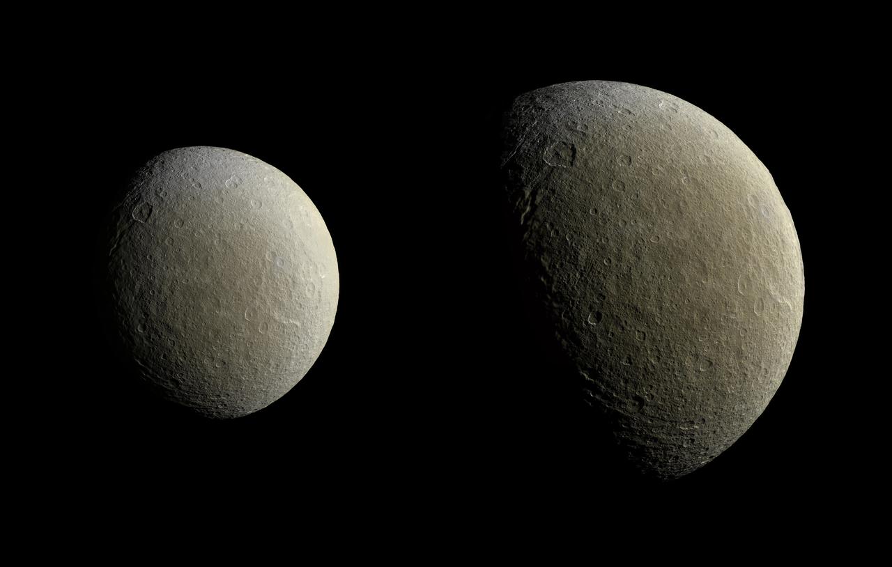
After a couple of years in high-inclination orbits that limited its ability to encounter Saturn's moons, NASA's Cassini spacecraft returned to Saturn's equatorial plane in March 2015. As a prelude to its return to the realm of the icy satellites, the spacecraft had its first relatively close flyby of an icy moon (apart from Titan) in almost two years on Feb. 9. During this encounter Cassini's cameras captured images of the icy moon Rhea, as shown in these in two image mosaics. The views were taken about an hour and a half apart as Cassini drew closer to Rhea. Images taken using clear, green, infrared and ultraviolet spectral filters were combined to create these enhanced color views, which offer an expanded range of the colors visible to human eyes in order to highlight subtle color differences across Rhea's surface. The moon's surface is fairly uniform in natural color. The image at right represents one of the highest resolution color views of Rhea released to date. A larger, monochrome mosaic is available in PIA07763. Both views are orthographic projections facing toward terrain on the trailing hemisphere of Rhea. An orthographic view is most like the view seen by a distant observer looking through a telescope. The views have been rotated so that north on Rhea is up. The smaller view at left is centered at 21 degrees north latitude, 229 degrees west longitude. Resolution in this mosaic is 450 meters (1,476 feet) per pixel. The images were acquired at a distance that ranged from about 51,200 to 46,600 miles (82,100 to 74,600 kilometers) from Rhea. The larger view at right is centered at 9 degrees north latitude, 254 degrees west longitude. Resolution in this mosaic is 300 meters (984 feet) per pixel. The images were acquired at a distance that ranged from about 36,000 to 32,100 miles (57,900 to 51,700 kilometers) from Rhea. The mosaics each consist of multiple narrow-angle camera (NAC) images with data from the wide-angle camera used to fill in areas where NAC data was not available. The image was produced by Heike Rosenberg and Tilmann Denk at Freie Universität in Berlin, Germany. http://photojournal.jpl.nasa.gov/catalog/PIA19057
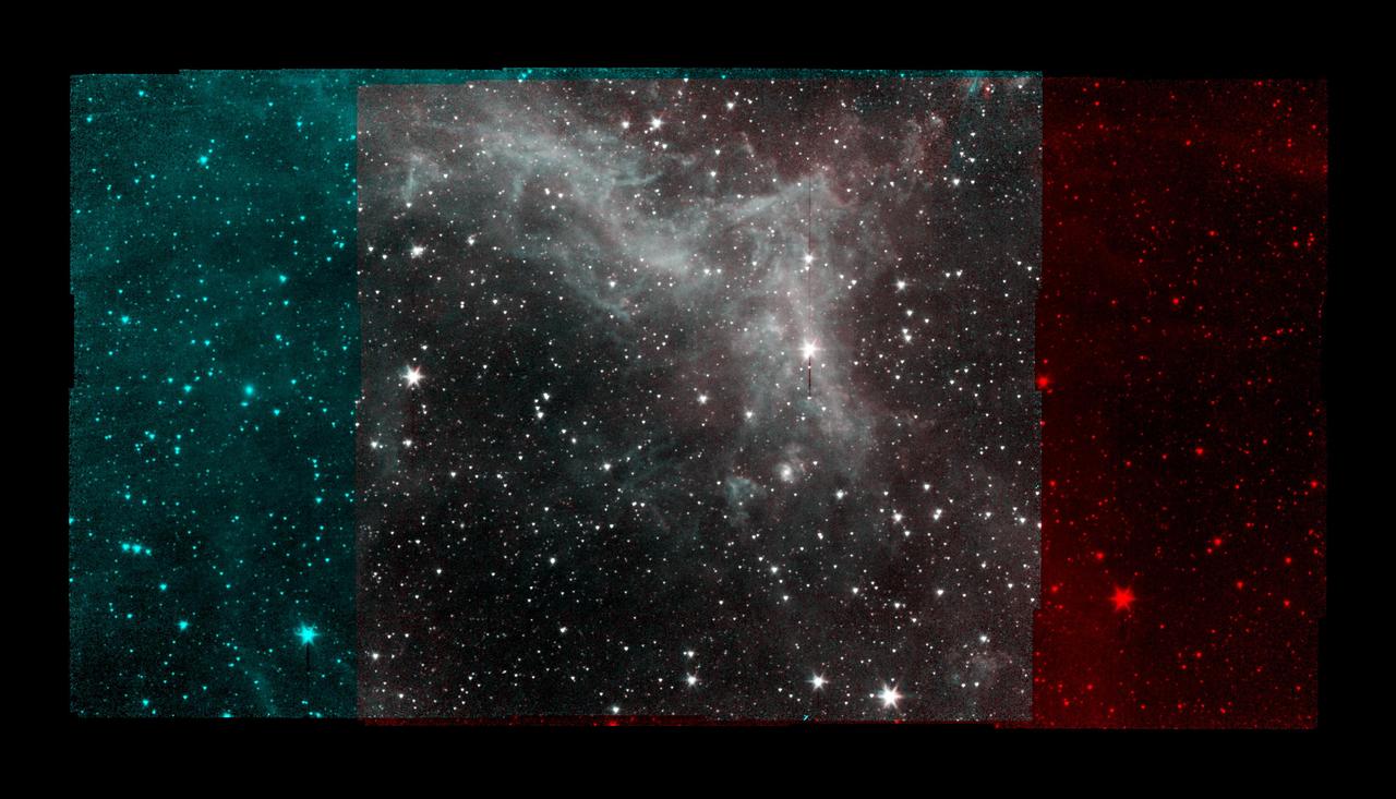
This series of image taken by NASA's Spitzer Space Telescope on Jan. 25, 2020, shows part of the California Nebula, which is located about 1,000 light-years from Earth. This is the final mosaic taken by the mission before it was decommissioned on Jan. 30, 2020. Spitzer's infrared detectors reveal the presence of warm dust, similar to soot, mixed in with the gas. The dust absorbs visible and ultraviolet light from nearby stars and then re-emits the absorbed energy as infrared light. The image displays Spitzer's observations much the way that research astronomers would view them: From 2009 to 2020, Spitzer operated two detectors simultaneously that imaged adjacent areas of the sky. The detectors captured different wavelengths of infrared light (referred to by their physical wavelength): 3.6 micrometers (shown in cyan) and 4.5 micrometers (shown in red). Different wavelengths of light can reveal different objects or features. Spitzer would scan the sky, taking multiple pictures in a grid pattern, so that both detectors would image the region at the center of the grid. By combining those images into a mosaic, it was possible to see what a given region looked like in multiple wavelengths, such as in the gray-hued part of the image above. https://photojournal.jpl.nasa.gov/catalog/PIA23650
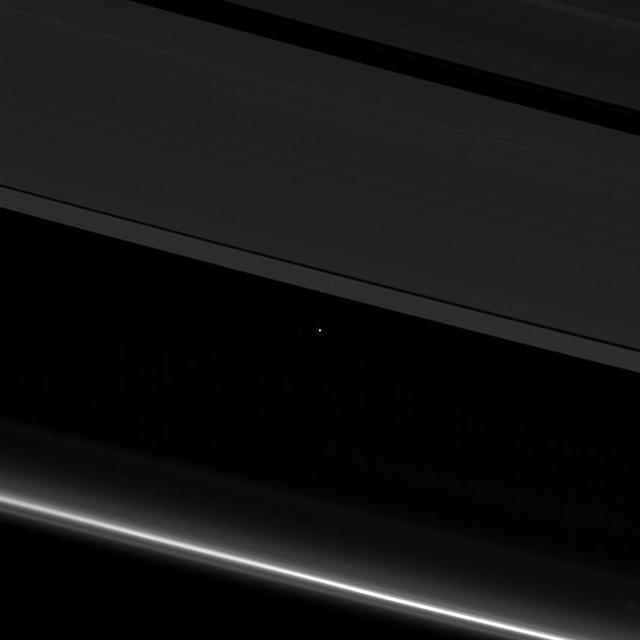
This view from NASA's Cassini spacecraft shows planet Earth as a point of light between the icy rings of Saturn. The spacecraft captured the view on April 12, 2017 at 10:41 p.m. PDT (1:41 a.m. EDT). Cassini was 870 million miles (1.4 billion kilometers) away from Earth when the image was taken. Although far too small to be visible in the image, the part of Earth facing toward Cassini at the time was the southern Atlantic Ocean. Earth's moon is also visible to the left of our planet in a cropped, zoomed-in version of the image (Figure 1). The rings visible here are the A ring (at top) with the Keeler and Encke gaps visible, and the F ring (at bottom). During this observation Cassini was looking toward the backlit rings, making a mosaic of multiple images, with the sun blocked by the disk of Saturn. Seen from Saturn, Earth and the other inner solar system planets are all close to the sun, and are easily captured in such images, although these opportunities have been somewhat rare during the mission. The F ring appears especially bright in this viewing geometry. https://photojournal.jpl.nasa.gov/catalog/PIA21445
SL2-05-102 (June 1973) --- A black and white photograph of the San Francisco Bay California area, taken from the Skylab 1-2 space station cluster in Earth orbit. THE PICTURE SHOULD BE HELD WITH THE CLOUDS AND PACIFIC OCEAN ON THE LEFT. This photograph was taken by one of six lenses of the Itek-furnished S190-A Multispectral Photographic Facility Experiment in the Multiple Docking Adapter of the space station. Note the thickly populated and highly developed area around the Bay. Among the cities visible in this photograph are San Francisco, Oakland, Berkeley and San Jose. This view extends eastward to show a portion of the San Joaquin Valley. The S190-A experiment is part of the Skylab Earth Resources Experiments Package (EREP). Type SO-022 film was used. This station covered the spectral region from 0.6 to .07 micrometers. Photo credit: NASA

SL2-04-118 (June 1973) --- A color photograph of the San Francisco Bay, California area, taken from the Skylab space station in Earth orbit. (The picture should be held with the clouds and Pacific Ocean on the left.) Note the thickly populated and highly developed area around the bay. Among the cities visible are San Francisco, Oakland, Berkeley and San Jose. This view extends eastward to show a portion of the San Joaquin Valley. This photograph was taken by one of the six lenses of the Itek-furnished S190-A Multispectral Photographic Facility Experiment in the Multiple Docking Adapter of the space station. Type SO-356 film was used. The S190-A experiment is part of the Skylab Earth Resources Experiments Package (EREP). Photo credit: NASA
Inside of the Electrostatics and Surface Physics Laboratory at NASA’s Kennedy Space Center in Florida, an electrodynamic dust shield (EDS) is in view on Jan. 18, 2023. The dust shield is one of the payloads that will fly aboard Firefly Aerospace’s Blue Ghost lunar lander as part of NASA’s Commercial Lunar Payload Services (CLPS) initiative. During the mission, EDS will generate a non-uniform electric field using varying high voltage on multiple electrodes. This traveling field, in turn, carries away the particles and has potential applications in thermal radiators, spacesuit fabrics, visors, camera lenses, solar panels, and many other technologies. The CLPS initiative is a key part of NASA’s Artemis lunar exploration efforts. The science and technology payloads sent to the Moon’s surface as part of the initiative will help lay the foundation for human missions and a sustainable human presence on the lunar surface.
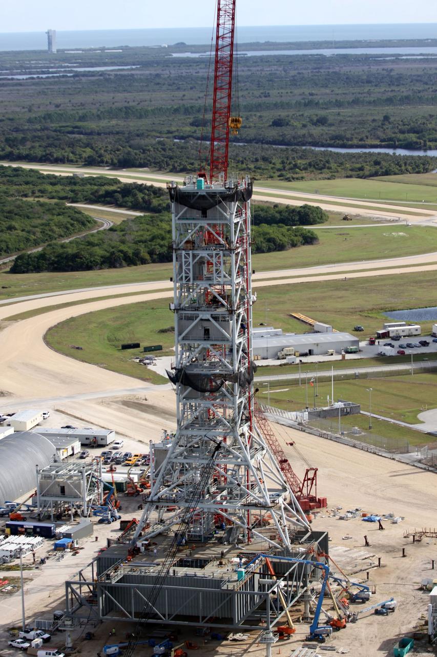
CAPE CANAVERAL, Fla. – At NASA's Kennedy Space Center in Florida, this aerial view of the mobile launcher park site area north of the 525-foot-tall Vehicle Assembly Building shows a new mobile launcher, or ML, for the Constellation Program under construction. In the background are the Atlantic Ocean and Launch Complex 41 on Cape Canaveral Air Force Station, at upper left, from which Atlas V rockets are launched. When completed, the tower will be approximately 345 feet tall and have multiple platforms for personnel access. Its base is being made lighter than space shuttle mobile launcher platforms so the crawler-transporter can pick up the heavier load of the tower and a taller rocket. For information on the Constellation Program, visit http://www.nasa.gov/constellation. Photo credit: NASA/Cory Huston
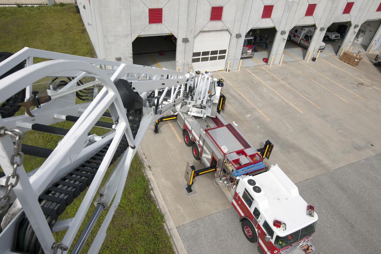
CAPE CANAVERAL, Fla. – At Fire Station No. 2 near the Shuttle Landing Facility at NASA’s Kennedy Space Center in Florida, a bird’s eye view reveals the ladder has been extended on the aerial fire truck during a training exercise. The center’s Fire Rescue Services recently achieved Pro Board Certification in aerial fire truck operations. Pro Board Certification is a globally recognized certification that puts on multiple courses that all fire departments throughout the world recognize and use to train their personnel. The unique aerial truck contains a 100-foot extendable ladder with a bucket at the end of it that can be used for rescues from taller buildings or aircraft rescue firefighting. Photo credit: NASA/Kim Shiflett

The high-tech art of digital signal processing (DSP) was pioneered at NASA's Jet Propulsion Laboratory (JPL) in the mid-1960s for use in the Apollo Lunar Landing Program. Designed to computer enhance pictures of the Moon, this technology became the basis for the Landsat Earth resources satellites and subsequently has been incorporated into a broad range of Earthbound medical and diagnostic tools. DSP is employed in advanced body imaging techniques including Computer-Aided Tomography, also known as CT and CATScan, and Magnetic Resonance Imaging (MRI). CT images are collected by irradiating a thin slice of the body with a fan-shaped x-ray beam from a number of directions around the body's perimeter. A tomographic (slice-like) picture is reconstructed from these multiple views by a computer. MRI employs a magnetic field and radio waves, rather than x-rays, to create images.
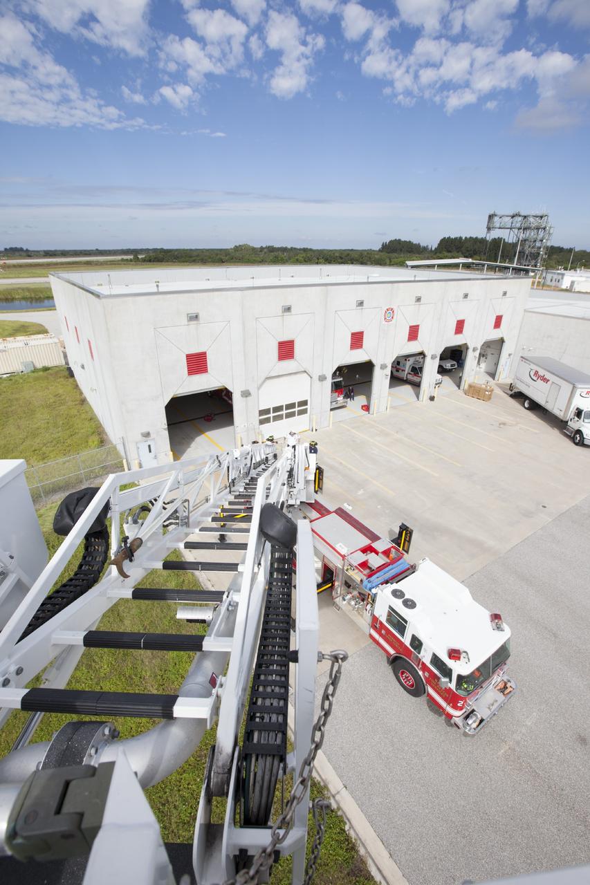
CAPE CANAVERAL, Fla. – At Fire Station No. 2 near the Shuttle Landing Facility at NASA’s Kennedy Space Center in Florida, a bird’s eye view reveals the ladder has been extended on the aerial fire truck during a training exercise. The center’s Fire Rescue Services recently achieved Pro Board Certification in aerial fire truck operations. Pro Board Certification is a globally recognized certification that puts on multiple courses that all fire departments throughout the world recognize and use to train their personnel. The unique aerial truck contains a 100-foot extendable ladder with a bucket at the end of it that can be used for rescues from taller buildings or aircraft rescue firefighting. Photo credit: NASA/Kim Shiflett
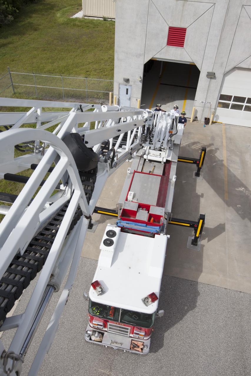
CAPE CANAVERAL, Fla. – At Fire Station No. 2 near the Shuttle Landing Facility at NASA’s Kennedy Space Center in Florida, a bird’s eye view reveals the ladder has been extended on the aerial fire truck during a training exercise. The stabilizers have been deployed on either side of the fire truck. The center’s Fire Rescue Services recently achieved Pro Board Certification in aerial fire truck operations. Pro Board Certification is a globally recognized certification that puts on multiple courses that all fire departments throughout the world recognize and use to train their personnel. The unique aerial truck contains a 100-foot extendable ladder with a bucket at the end of it that can be used for rescues from taller buildings or aircraft rescue firefighting. Photo credit: NASA/Kim Shiflett

SL2-03-118 (June 1973) --- An infrared photograph of the San Francisco Bay, California area, taken from the Skylab 1/2 space station in Earth orbit. THE PICTURE SHOULD BE HELD WITH THE CLOUDS AND PACIFIC OCEAN ON THE LEFT. This photograph was taken by one of the six lenses of the Itek-furnished S190-A Multispectral Photographic Facility Experiment in the Multiple Docking Adapter of the space station. Type 2443 film was used. Note the thickly populated and highly developed area around the bay. Among the cities visible in this photograph are San Francisco, Oakland, Berkeley and San Jose. This view extends eastward to show a portion of the San Joaquin Valley. The S190-A experiment is part of the Skylab Earth Resources Experiment Package (EREP). Photo credit: NASA
ISS034-E-056100 (21 Feb. 2013) --- One of the most recognizable natural features on Earth, when viewing from space, is the Manicouagan Crater, one of the oldest known impact craters on Earth. Photographed by one of the Expedition 34 crew members onboard the International Space Station, the crater is located primarily in Manicouagan Regional County Municipality in the Côte-Nord region of Québec, Canada, about 300 kilometers (190 miles) north of the city of Baie-Comeau. Manicouagan is one of the oldest large astroblemes still visible on the surface. The crater is a multiple-ring structure about 100 kilometers (60 miles) across, with its 70 kilometer (40 mile) diameter inner ring its most prominent feature; it contains a 70 kilometer (40 mile) diameter annular lake, the Manicouagan Reservoir, surrounding an inner island plateau.

The high-tech art of digital signal processing (DSP) was pioneered at NASA's Jet Propulsion Laboratory (JPL) in the mid-1960s for use in the Apollo Lunar Landing Program. Designed to computer enhance pictures of the Moon, this technology became the basis for the Landsat Earth resources satellites and subsequently has been incorporated into a broad range of Earthbound medical and diagnostic tools. DSP is employed in advanced body imaging techniques including Computer-Aided Tomography, also known as CT and CATScan, and Magnetic Resonance Imaging (MRI). CT images are collected by irradiating a thin slice of the body with a fan-shaped x-ray beam from a number of directions around the body's perimeter. A tomographic (slice-like) picture is reconstructed from these multiple views by a computer. MRI employs a magnetic field and radio waves, rather than x-rays, to create images. In this photograph, a patient undergoes an open MRI.
CAPE CANAVERAL, Fla. – At NASA's Kennedy Space Center in Florida, this aerial view of Launch Complex 39 shows a new mobile launcher, or ML, for the Constellation Program, at far right, being constructed in the mobile launcher park site area north of the 525-foot-tall Vehicle Assembly Building. In the background is the Indian River. When completed, the tower will be approximately 345 feet tall and have multiple platforms for personnel access. Its base is being made lighter than space shuttle mobile launcher platforms so the crawler-transporter can pick up the heavier load of the tower and a taller rocket. For information on the Constellation Program, visit http://www.nasa.gov/constellation. Photo credit: NASA/Cory Huston
This false color image shows part of the south polar cap. The cap was created over millions of years with deposition of ice and dust during different seasons. This image was collected during spring time. In addition to the layers of ice/dust (bottom of image) the surface of the ice contains dark spots, may of which are elongated. The process forming these spots is still not understood, but likely occurs by geysers of ice and dust that erupt in regions of thin CO2 ice (dry ice). These spots will fade from view as spring changes into summer. The THEMIS VIS camera contains 5 filters. The data from different filters can be combined in multiple ways to create a false color image. These false color images may reveal subtle variations of the surface not easily identified in a single band image. Orbit Number: 65107 Latitude: -86.2797 Longitude: 98.6099 Instrument: VIS Captured: 2016-08-17 17:37 https://photojournal.jpl.nasa.gov/catalog/PIA23614
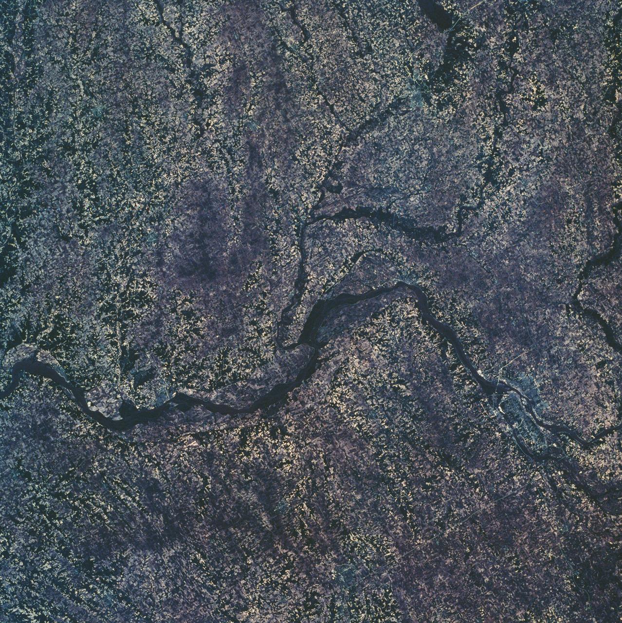
SL2-10-250 (May-June 1973) --- A vertical view of eastern Iowa and northwestern Illinois, as photographed from Skylab space station in Earth orbit. Davenport, Burlington and Muscatine, Iowa; and Rock Island and Moline, Illinois can be delineated on opposite sides of the Mississippi River. The Iowa River and tributaries of it can also be delineated. This photograph was taken with one of six lenses of the Itek-furnished Multispectral Photographic Facility Experiment S190-A mounted in the Multiple Docking Adapter (MDA) of the space station. A six-inch lens, using 70mm medium speed Ektachrome (SO-356) film, was used. Agencies participating with NASA on the EREP project are the Departments of Agriculture, Commerce and Interior; the Environmental Protection Agency and the Corps of Engineers. All EREP photography is available to the public through the Department of Interior's Earth Resources Observations Systems Data Center, Sioux Falls, South Dakota, 57198. Photo credit: NASA

The high-tech art of digital signal processing (DSP) was pioneered at NASA's Jet Propulsion Laboratory (JPL) in the mid-1960s for use in the Apollo Lunar Landing Program. Designed to computer enhance pictures of the Moon, this technology became the basis for the Landsat Earth resources satellites and subsequently has been incorporated into a broad range of Earthbound medical and diagnostic tools. DSP is employed in advanced body imaging techniques including Computer-Aided Tomography, also known as CT and CATScan, and Magnetic Resonance Imaging (MRI). CT images are collected by irradiating a thin slice of the body with a fan-shaped x-ray beam from a number of directions around the body's perimeter. A tomographic (slice-like) picture is reconstructed from these multiple views by a computer. MRI employs a magnetic field and radio waves, rather than x-rays, to create images.
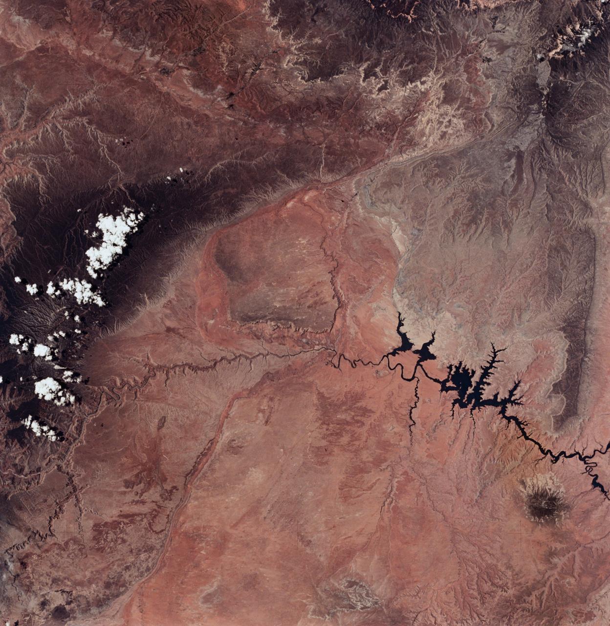
SL2-04-018 (June 1973) --- A vertical view of the Arizona-Utah border area showing the Colorado River and Grand Canyon photographed from the Skylab 1/2 space station in Earth orbit. This picture was taken by one of the six lenses of the Itek-furnished S190-A Multispectral Photographic Facility Experiment in the Multiple Docking Adapter of the space station. Type S0-356 film was used. The row of white clouds extend north-south over the dark colored Kaibab Plateau. The junction of the Colorado and Little Colorado rivers is in the southwest corner of the picture. The body of water is Lake Powell on the Colorado River upstream from the Grand Canyon. The lone peak at the eastern edge of the photograph south of Colorado River is the 10,416-foot Navajo Mountain. The S190-A experiment is part of the Skylab Earth Resources Experiments Package(EREP). Photo credit: NASA
CAPE CANAVERAL, Fla. – At NASA's Kennedy Space Center in Florida, this aerial view of the mobile launcher park site area shows a new mobile launcher, or ML, for the Constellation Program under construction. In the background at left is Launch Complex 41 on Cape Canaveral Air Force Station from which Atlas V rockets are launched. When completed, the tower will be approximately 345 feet tall and have multiple platforms for personnel access. Its base is being made lighter than space shuttle mobile launcher platforms so the crawler-transporter can pick up the heavier load of the tower and a taller rocket. For information on the Constellation Program, visit http://www.nasa.gov/constellation. Photo credit: NASA/Cory Huston
This view shows grains of sand where NASA's Curiosity Mars rover was driven into a shallow sand sheet near a large dune. The disturbance by the wheel exposed interior material of the sand body, including finer sand grains than on the undisturbed surface. Sunlight is coming from the left. The scene covers an area 1.3 inches by 1.0 inch (3.3 by 2.5 centimeters). This is a focus-merge product from Curiosity's Mars Hand Lens Imager (MAHLI), combining multiple images taken at different focus settings to yield sharper focus at varying distances from the lens. The component images were taken on Dec. 3, 2015, during the 1,182nd Martian day, or sol, of Curiosity's work on Mars. http://photojournal.jpl.nasa.gov/catalog/PIA20170
SL2-06-102 (June 1973) --- A black and white photograph of the San Francisco Bay California area, taken from the Skylab 1-2 space station cluster in Earth orbit. THE PICTURE SHOULD BE HELD WITH THE CLOUDS AND PACIFIC OCEAN ON THE LEFT. This photograph was taken by one of six lenses of the Itek-furnished S190-A Multispectral Photographic Facility Experiment in the Multiple Docking Adapter of the space station. Note the thickly populated and highly developed area around the Bay. Among the cities visible in this photograph are San Francisco, Oakland, Berkeley and San Jose. This view extends eastward to show a portion of the San Joaquin Valley. The S190-A experiment is part of the Skylab Earth Resources Experiments Package (EREP). Type SO-022 film was used. This station covered the spectral region from 0.5 to 0.6 micrometers. Photo credit: NASA
STS068-267-097 (30 September-11 October 1994) --- An extensive view eastward from the irrigated San Joaquin Valley in the foreground, across the Sierra Nevada (living up to its name in early October), into the desert of eastern California and Nevada (which has no snow, despite the name). Mono Lake is just visible at the left edge of the frame; Owens Valley extends southward to Owens Lake, the next valley is Panamint Valley, and then Death Valley. Las Vegas and Lake Mead are visible at the upper right of the frame. The Space Radar Laboratory 2 (SRL-2) obtained extensive, multiple-pass data from many test sites within the region displayed, including Mammoth Mountain ski area south of Mono Lake, and in Death Valley.
SL2-16-281 (June 1973) --- A vertical view of the Orlando and central Florida area photographed from the Skylab space station in Earth orbit. (The picture should be held with the heaviest cloud cover at the bottom.) The extensive road and highway network in the area is clearly visible. The Lakeland and Winter Haven area is near the center of the picture. Interstate 4 extends southwesterly out of Orlando through the center of the picture. The urban growth caused by the opening of the Disney World amusement complex is clearly evident. The giant recreational facility is just southwest of Orlando. This picture was taken by one of the six lenses of the Itek-furnished S190-A Multispectral Photographic Facility Experiment in the Multiple Docking Adapter of the space station. Type SO-356 film was used. Photo credit: NASA
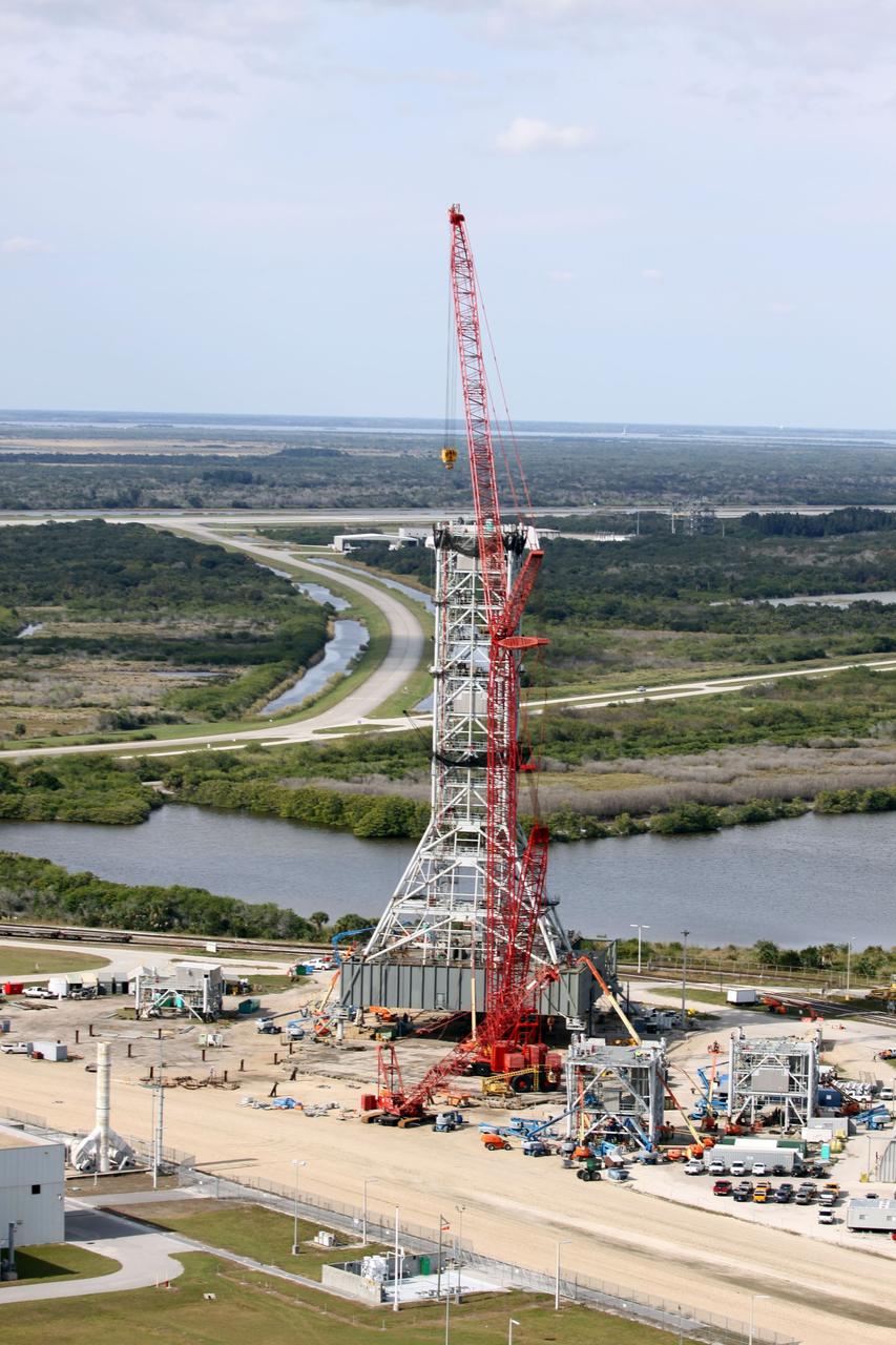
CAPE CANAVERAL, Fla. - At NASA's Kennedy Space Center in Florida, this aerial view of the mobile launcher park site area north of the 525-foot-tall Vehicle Assembly Building shows a new mobile launcher, or ML, for the Constellation Program under construction. In the background are the Shuttle Landing Facility runway, the towway and the mate-demate device. When completed, the tower will be approximately 345 feet tall and have multiple platforms for personnel access. Its base is being made lighter than space shuttle mobile launcher platforms so the crawler-transporter can pick up the heavier load of the tower and a taller rocket. For information on the Constellation Program, visit http://www.nasa.gov/constellation. Photo credit: NASA/Cory Huston
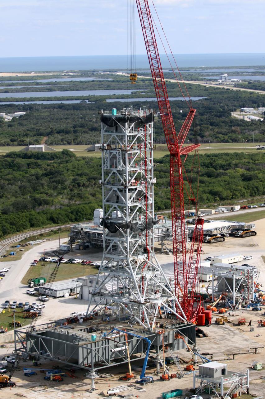
CAPE CANAVERAL, Fla. – At NASA's Kennedy Space Center in Florida, this aerial view of the mobile launcher park site area north of the 525-foot-tall Vehicle Assembly Building shows a new mobile launcher, or ML, for the Constellation Program under construction. In the background are the Atlantic Ocean and the Launch Complex 39 Observation Gantry, at upper right. When completed, the tower will be approximately 345 feet tall and have multiple platforms for personnel access. Its base is being made lighter than space shuttle mobile launcher platforms so the crawler-transporter can pick up the heavier load of the tower and a taller rocket. For information on the Constellation Program, visit http://www.nasa.gov/constellation. Photo credit: NASA/Cory Huston