
UH-60 (USA 78-23012 NASA 750) Sikorsky Airloads Research Team, Front Row: Frank Pichay, Jim Phillips, Karen Studebaker, Stan Uyeda, Munro Dearing, Rick Simmons, Mario Garcia, Anna Almaraz, Allen Au, Frank Presbury, Bob Kufeld, Marianne Kidder, Nancy Bashford, Jack Brilla, Dwight Balough, Chico Rijfkogel, Paul Aristo. Back Row; Tom English, Dick Denman, Patrich Brunn, Tom Reynolds, Bud Billings, Paul Espinosa, Bill Bjorkman, Chee Tung, Leonard Hee, Bill Bousman, Tom Maier, Ron Fong, Steve Timmons, Jeff Cross, Colin Coleman, Paul Loschke, John Lewis, Jim Lasko, Alex Macalma. NASA SP Flight Research at Ames: 57 Years of Development and Validation of Aeronautical Technology Fig. 136 NASA SP-1998-3300
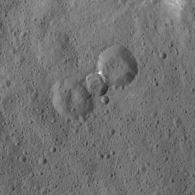
This image was obtained by NASA's Dawn spacecraft on May 30, 2018 from an altitude of about 465 miles (750 kilometers). The center of this picture is located at about 3 degrees south in latitude and 11 degrees east in longitude. https://photojournal.jpl.nasa.gov/catalog/PIA22517

UH-60 NASA-750 in front of Ames hangar

UH-60 RASCAL (NASA-750) on flight line

UH-60 (NASA-750) on Ames ramp - side view in front of hangar
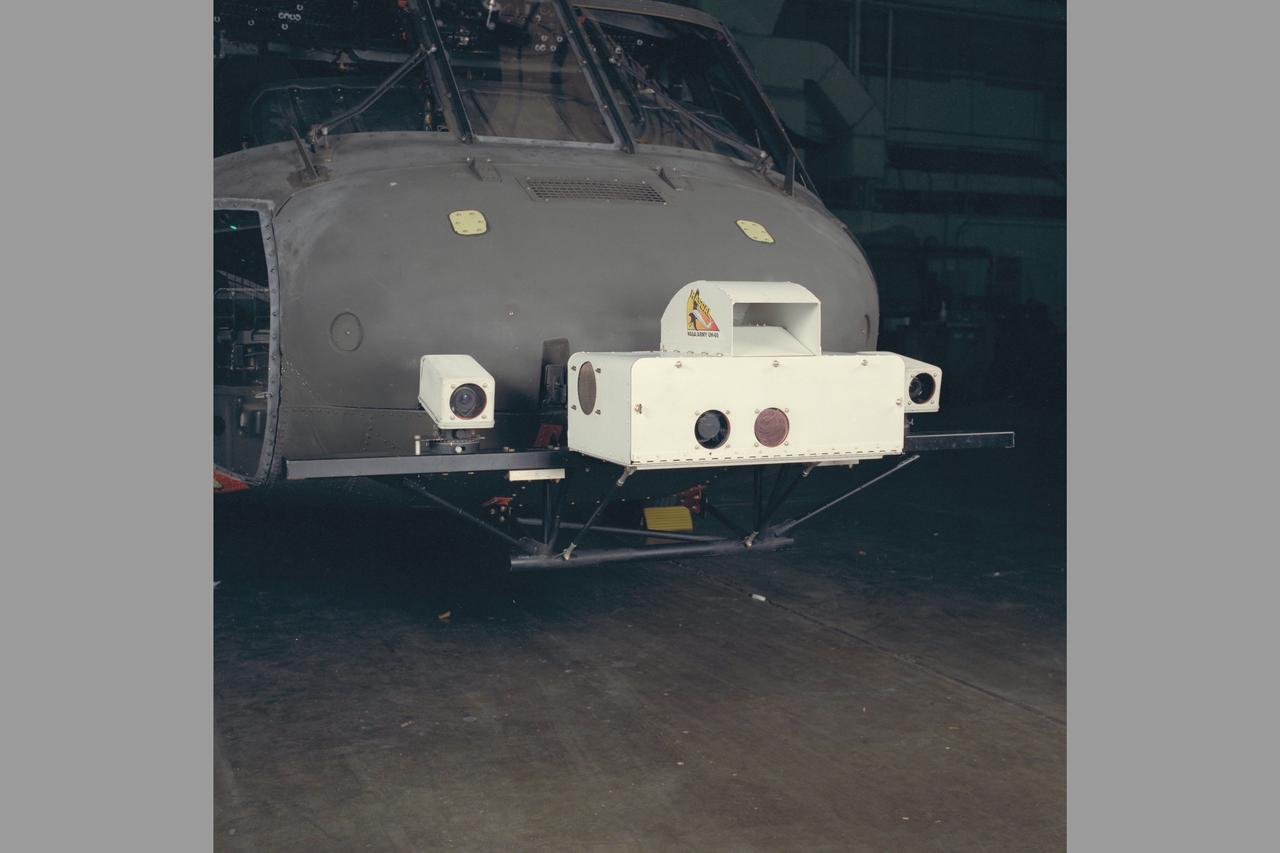
IR CAMERA & ASSOCIATED ELECTRONICS. UH-60 (NASA-750) Blackhawk Rascal helicopter

IR CAMERA & ASSOCIATED ELECTRONICS. UH-60 (NASA-750) Blackhawk Rascal helicopter with investigator Shirley Worden

This image from NASA Hubble telescope shows one of the most distant galaxies known, called GN-108036, dating back to 750 million years after the Big Bang that created our universe. The galaxy light took 12.9 billion years to reach us.

S66-54455 (13 Sept. 1966) --- Astronaut Richard F. Gordon Jr., Gemini-11 pilot, attaches a tether line from his spacecraft to the Agena Target Docking Vehicle (ATDV) during a spacewalk. This view was taken over the Atlantic Ocean at approximately 160 miles above Earth on Sept. 13, 1966. With the aid of the ATDV, Gordon and astronaut Charles (Pete) Conrad Jr., command pilot, set a new altitude record of 750 miles during the GT-11 mission. Photo credit: NASA
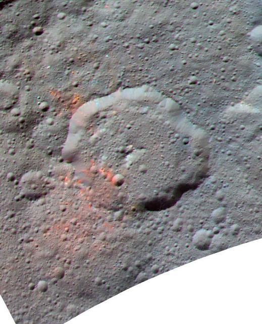
This enhanced color composite image, made with data from the framing camera aboard NASA's Dawn spacecraft, shows the area around Ernutet crater. The bright red portions appear redder with respect to the rest of Ceres. In a 2017 study in the journal Science, researchers from the Dawn science team found that these red areas around Ernutet are associated with evidence of organic material. Images taken using blue (440 nanometers), green (750 nanometers) and infrared (960 nanometers) spectral filters were combined to create the view. Ernutet Crater measures about 32 miles (52 kilometers) in diameter and is located in the northern hemisphere. http://photojournal.jpl.nasa.gov/catalog/PIA21419
NASA's Mars Exploration Rover Spirit acquired the images that went into this color composite with its panoramic camera around 1:00 p.m. martian time on its 270th martian day, or sol (Oct. 5, 2004). The view represents the panoramic-camera team's best current attempt at generating a "true color" view of what this scene would look like if viewed by a human on Mars. It was generated from a mathematical combination of six calibrated images acquired through filters for wavelengths between 430 nanometers and 750 nanometers. http://photojournal.jpl.nasa.gov/catalog/PIA06938

Ceres' lonely mountain, Ahuna Mons, is seen in this simulated perspective view. The elevation has been exaggerated by a factor of two. The view was made using enhanced-color images from NASA's Dawn mission. Images taken using blue (440 nanometers), green (750 nanometers) and infrared (960 nanometers) spectral filters were combined to create the view. The spacecraft's framing camera took the images from Dawn's low-altitude mapping orbit, from an altitude of 240 miles (385 kilometers) in August 2016. The resolution of the component images is 120 feet (35 meters) per pixel. http://photojournal.jpl.nasa.gov/catalog/PIA20915
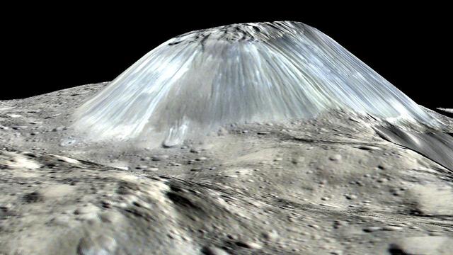
Ceres' lonely mountain, Ahuna Mons, is seen in this simulated perspective view. The elevation has been exaggerated by a factor of two. The view was made using enhanced-color images from NASA's Dawn mission. Images taken using blue (440 nanometers), green (750 nanometers) and infrared (960 nanometers) spectral filters were combined to create the view. The spacecraft's framing camera took the images from Dawn's low-altitude mapping orbit, from an altitude of 240 miles (385 kilometers) in August 2016. The resolution of the component images is 120 feet (35 meters) per pixel. http://photojournal.jpl.nasa.gov/catalog/PIA20915

NASA Administrator Charles Bolden poses with an all-girl engineering team that participated in the White House Science Fair. "Team Rocket Power" was one of 100 teams that qualified for last year’s Team America Rocketry Challenge (TARC). Nia'mani Robinson, 15, Jasmyn Logan, 15, and Rebecca Chapin-Ridgely, 17, gave up their weekends and free time after school to build and test their bright purple rocket, which is designed to launch to an altitude of about 750 ft, and then return a “payload” (an egg) to the ground safely. The fourth White House Science Fair was held at the White House on May 27, 2014 and included 100 students from more than 30 different states who competed in science, technology, engineering, and math (STEM) competitions. (Photo Credit: NASA/Aubrey Gemignani)
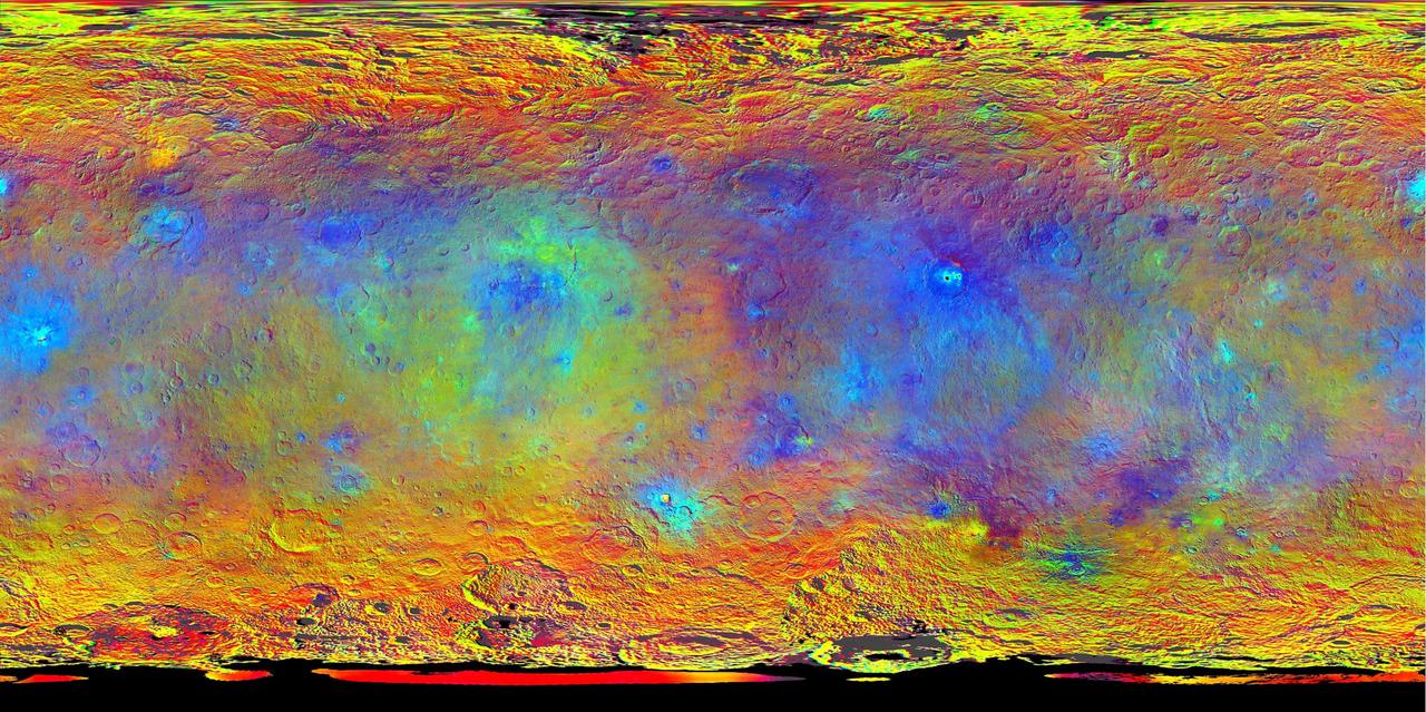
This map-projected view of Ceres was created from images taken by NASA's Dawn spacecraft during its high-altitude mapping orbit, in August and September, 2015. Images taken using infrared (920 nanometers), red (750 nanometers) and blue (440 nanometers) spectral filters were combined to create this false-color view. Redder colors indicate places on Ceres' surface that reflect light strongly in the infrared, while bluish colors indicate enhanced reflectivity at short (bluer) wavelengths; green indicates places where albedo, or overall brightness, is strongly enhanced. Scientists use this technique in order to highlight subtle color differences across Ceres, which would appear fairly uniform in natural color. This can provide valuable insights into the mineral composition of the surface, as well as the relative ages of surface features. http://photojournal.jpl.nasa.gov/catalog/PIA19977
This is a mosaic assembled from some of the images taken by the panoramic camera on NASA's Mars Exploration Rover Opportunity during the rover's 590th sol (Sept. 21, 2005). The view is toward the south and includes rock exposures north of "Erebus Crater," with the crater in the background. The rover will investigate the exposed rocks in the foreground and will take additional panoramic-camera images of Erebus Crater, which is about 300 meters (about 984 feet) across. Erebus Crater dwarfs the landing-site crater, "Eagle Crater," which measures about 22 meters (72 feet) in diameter. And, it is nearly twice the diameter of "Endurance Crater," which, at 130 meters (430 feet) wide, has been compared to a stadium. The camera's red filter was used for taking the images in this mosaic. It admits light with a wavelength of 750 nanometers http://photojournal.jpl.nasa.gov/catalog/PIA06341
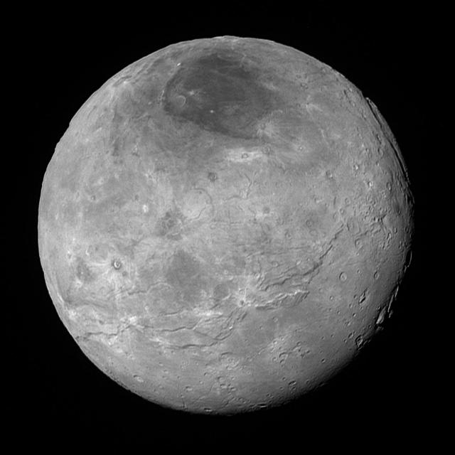
This image of Pluto's largest moon Charon, taken by NASA's New Horizons spacecraft 10 hours before its closest approach to Pluto on July 14, 2015 from a distance of 290,000 miles (470,000 kilometers), is a recently downlinked, much higher quality version of a Charon image released on July 15. Charon, which is 750 miles (1,200 kilometers) in diameter, displays a surprisingly complex geological history, including tectonic fracturing; relatively smooth, fractured plains in the lower right; several enigmatic mountains surrounded by sunken terrain features on the right side; and heavily cratered regions in the center and upper left portion of the disk. There are also complex reflectivity patterns on Charon's surface, including bright and dark crater rays, and the conspicuous dark north polar region at the top of the image. The smallest visible features are 2.9 miles 4.6 kilometers) in size. http://photojournal.jpl.nasa.gov/catalog/PIA19932
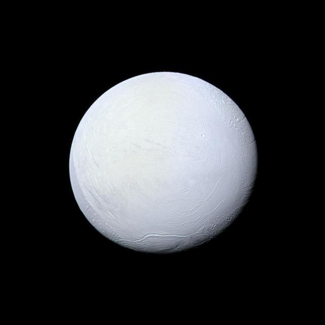
Saturn's moon Enceladus, covered in snow and ice, resembles a perfectly packed snowball in this image from NASA's Cassini mission. Cassini has imaged Enceladus many times throughout its mission, discovering a fractured surface and the now-famous geysers that erupt icy particles and water vapor from fractures crossing the moons' 200-mile-wide (300-kilometer-wide) south polar terrain. The mountain ridge seen in the south in this image is part of the undulating mountain belt that circumscribes this region. This view looks toward the leading side of Enceladus (313 miles, 504 kilometers across). North on Enceladus is up and rotated 6 degrees to the left. The image was taken with the Cassini spacecraft narrow-angle camera on March 10, 2012, using filters sensitive to ultraviolet, visible and infrared light (spanning wavelengths from 338 to 750 nanometers). The view was acquired at a distance of approximately 106,000 miles (170,000 kilometers) from Enceladus. Image scale is 3,336 feet (1 kilometer) per pixel. http://photojournal.jpl.nasa.gov/catalog/PIA17182
NASA's Mars Exploration Rover Spirit drove 6.98 meters (22.9 feet) southeastward on the 1,871st Martian day, or sol, of the rover's mission on Mars (April 8, 2009). As usual since losing the use of its right-front wheel in 2006, Spirit drove backward, dragging the immobile wheel. The rover used its front hazard-avoidance camera after the drive to capture this view looking back at the ground covered. For scale, the distance between the parallel wheel tracks is about 1 meter (40 inches). The drive added to progress in trekking counterclockwise around a low plateau called "Home Plate." Spirit is driving through a valley on the west side of the plateau. Home Plate is not within this image. The hill on the horizon in the upper right is Husband Hill, the summit of which is about 750 meters (nearly half a mile) to the north of Spirit's position. Following this drive, Spirit experienced difficulties that prevented driving during the subsequent week. http://photojournal.jpl.nasa.gov/catalog/PIA11990
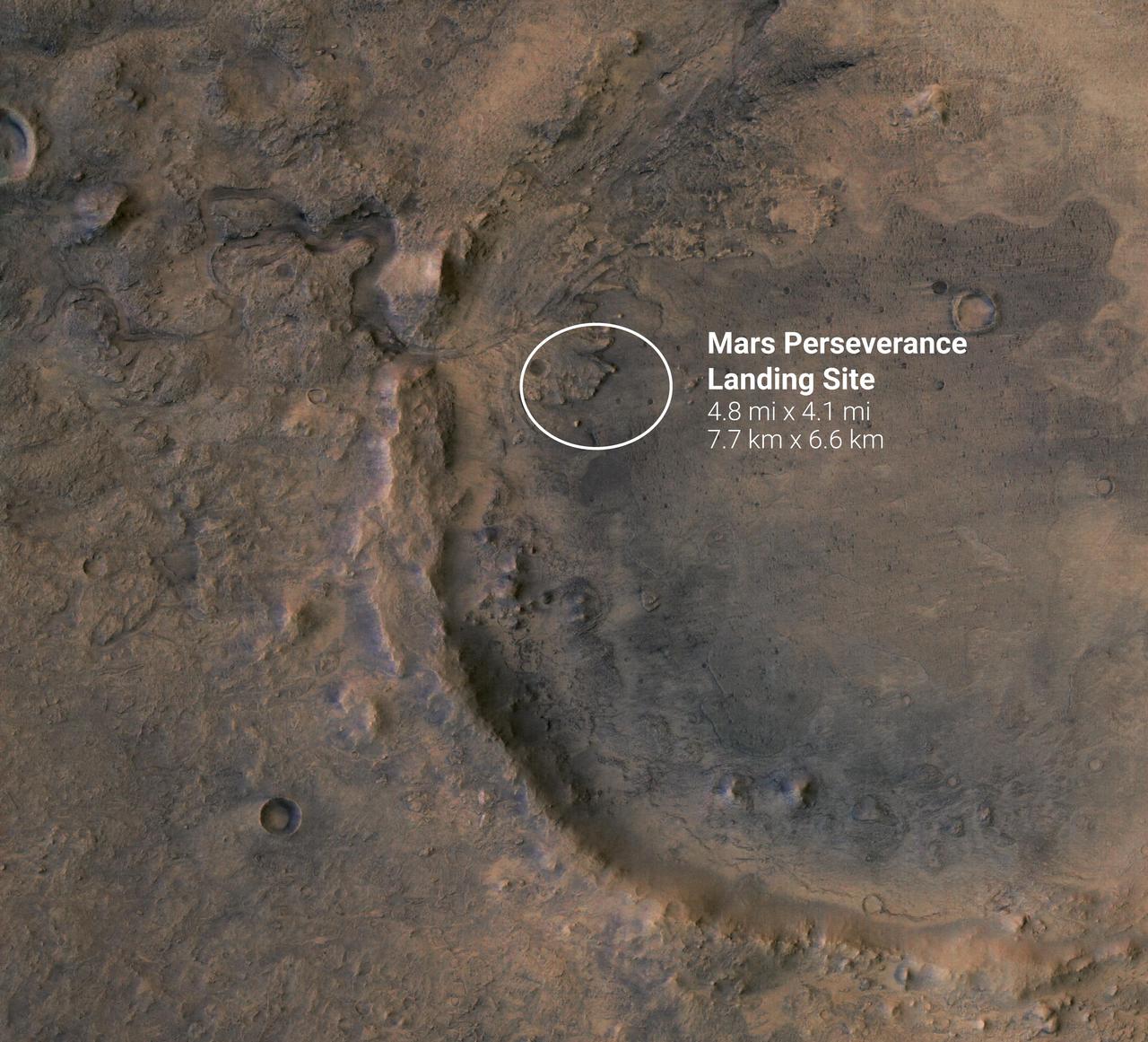
The white circle near the center of this image of Mars represents the location where NASA's Perseverance rover is expected to land on Feb. 18, 2021. The landing ellipse, measuring 4.8 miles by 4.1 miles (7.7 kilometers by 6.6 kilometers), places the rover at the site of an ancient river delta which could harbor signs of fossilized microbial life. The fan-like shape of the delta is visible in this image, as is the crater rim. The crater was once filled with a lake several hundred feet deep. Jezero Crater sits within the Isidis Planitia region of Mars, where an ancient asteroid or comet impact left behind a large basin some 750 miles (1200 kilometers) across. This event forever changed the rocks in and around the basin. A later, smaller impact created Jezero Crater within the Isidis impact basin. There is evidence of ancient river flow into Jezero, forming a lake that has long since been dry. Scientists believe that these events likely created environments friendly to life. https://photojournal.jpl.nasa.gov/catalog/PIA24350
The 16-mile-wide (26-kilometer-wide) crater Insitor is located almost exactly in the center of Kerwan crater on Ceres. Scientists can compute the chances that a cosmic dart would hit exactly at the bullseye of the largest crater on Ceres by using models of impact frequency as a function of time, combined with the period of time since Kerwan's formation. By counting the number of craters within Kerwan and comparing that number to the distribution of craters on Earth's moon and other bodies, it is possible to derive an approximate time for Kerwan's formation of between 550 and 750 million years ago. The chance that a crater the size of Insitor would be formed at the center of Kerwan over that period is only one in one hundred. This image of Ceres was obtained by NASA's Dawn spacecraft on September 23, 2015, from an altitude of about 915 miles (1,470 kilometers). Insitor crater is located at 10.7 degrees south latitude, 124.9 degrees east longitude. The crater gets its name from the Roman agricultural deity in charge of the sowing of crops. https://photojournal.jpl.nasa.gov/catalog/PIA21614
All this week, the THEMIS Image of the Day is following on the real Mars the path taken by fictional astronaut Mark Watney, stranded on the Red Planet in the book and movie, The Martian. Today's image shows part of Mawrth Valles, a channel carved by giant floods billions of years ago. The highlands lying to the south and west of the channel are under consideration as a potential landing site for NASA's Mars 2020 rover. Remote-sensing observations from orbit show widespread exposures of clay minerals, indicating alteration by water early in Martian history. These might preserve traces of ancient life, if there was any. For astronaut Mark Watney, driving in a pressurized and solar-powered rover vehicle, Mawrth Valles offers a gentle slope and an easy-to-follow route up from Acidalia's low-lying plains into the Arabia Terra highlands. At this point in his journey, he has driven about 750 kilometers (470 miles). Orbit Number: 38563 Latitude: 24.4297 Longitude: 341.726 Instrument: VIS Captured: 2010-08-24 14:56 http://photojournal.jpl.nasa.gov/catalog/PIA19797
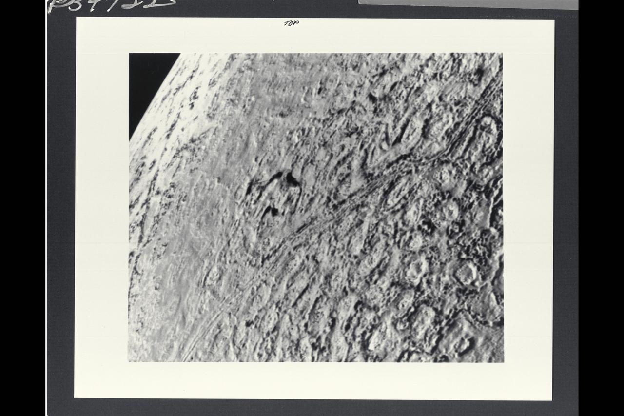
Voyager II Imagery, Neptune: This is one of the most detailed views of the surface of Triton taken by Voyager 2 on its flyby of the large satellite of Neptune early in the morning of August 25, 1989. The picture was stored on the tape recorder and relayed to Earth later. Taken from a distanT ce of only 40,000 km (25, 000 miles), the frame is about 220 kilometers (140 miles) across and shows details as small as 750 meters (0.5 miles). Most of the area is covered by a peculiar landscape of roughly circular depressions separated by rugged ridges. This type of terrain, which covers large tracts of Triton's northern hemisphere, is unlike anything seen elsewhere in the solar system. The depressions are probably not impact craters: They are too similar in size and too regularly spaced. Their origin is still unknown, but may involve local melting and collapse of the icy surface. A conspicuous set of grooves and ridges cuts across the landscape, indicating fracturing and deformation of Triton's surface. The rarity of impact craters suggests a young surface by solar-system standards, probably less than a few billion years old. The Voyager Mission is conducted by JPL for NASA's Office of Space Science and Applications. (JPL ref: P-34722 Voyager N-60 )
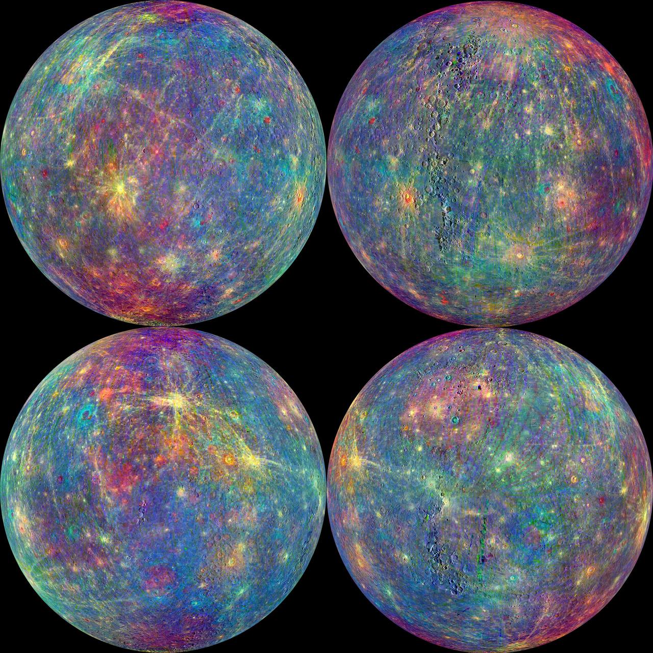
The MASCS instrument onboard NASA MESSENGER spacecraft was designed to study both the exosphere and surface of Mercury. To learn more about the minerals and surface processes on Mercury, the Visual and Infrared Spectrometer (VIRS) portion of MASCS has been diligently collecting single tracks of spectral surface measurements since MESSENGER entered orbit. The track coverage is now extensive enough that the spectral properties of both broad terrains and small, distinct features such as pyroclastic vents and fresh craters can be studied. To accentuate the geological context of the spectral measurements, the MASCS data have been overlain on the MDIS monochrome mosaic. Click on the image to explore the colorful diversity of surface materials in more detail! Instrument: Mercury Atmosphere and Surface Composition Spectrometer (MASCS) Map Projection: Orthographic VIRS Color Composite Wavelengths: 575 nm as red, 415 nm/750 nm as green, 310 nm/390 nm as blue Center Latitude (All Globes): 0° Center Longitude (Top Left Globe): 270° E Center Longitude (Top Right Globe): 0° E Center Longitude (Bottom Left Globe): 90° E Center Longitude (Bottom Right Globe): 180° E http://photojournal.jpl.nasa.gov/catalog/PIA19419

This collage shows some of the most interesting geological sites that NASA's Dawn spacecraft has revealed at dwarf planet Ceres. Images were acquired with the spacecraft's framing camera during various phases of the mission: Survey orbit at a distance of about 2,700 miles (4,400 kilometers); high-altitude mapping orbit (HAMO) at a distance of 915 miles (1,470 kilometers) from Ceres; and low-altitude mapping orbit (LAMO) at an altitude of 240 miles (385 kilometers). In the first row, from left to right: Ceres in shown in false color, roughly centered on Occator Crater, home of the brightest area on Ceres. This picture combines color images obtained by Dawn in its survey orbit. Red corresponds to a wavelength range around 980 nanometers (near infrared), green to a wavelength range around 750 nanometers (red, visible light) and blue to a wavelength range of around 430 nanometers (blue, visible light). This picture illustrates the diversity of terrains on Ceres where the bluish material points to recently emplaced material and the brownish background material is associated with older terrains. Juling Crater (12 miles, 20 kilometers in diameter) as seen in LAMO. Central coordinates are 36 degrees south latitude, 168 degrees east longitude. It is named after the Sakai/Orang Asli (Malaysia) spirit of the crops. This crater displays evidence for the presence of ice -- for example, in the form of a large flow feature seen at the top of the image. Oxo Crater (6 miles, 10 kilometers in diameter) as seen in LAMO. Center coordinates are 42 degrees north latitude, 0 degrees east longitude. It is named after the god of agriculture in Afro-Brazilian beliefs of Yoruba derivation. Oxo hosts the first site at which Dawn detected ice on Ceres, exposed by a landslide. Ahuna Mons is not only a volcano, but also the tallest mountain on Ceres. It is about 2.5 miles (4 kilometers) high and 11 miles (17 kilometers) wide. Center coordinates are 10 degrees south latitude, 316 degrees east longitude. This view combines images obtained in LAMO in blue (430 nanometers), green (750 nanometers) and infrared (980 nanometers) color filters. Ahuna is named after the Sumi tribe (Nagaland, northeastern India) traditional post-harvest thanksgiving festival. Second Row Occator Crater (57 miles, 92 kilometers across) is seen in LAMO images. Center coordinates are 20 degrees north latitude, 239 degrees east longitude. Named after the Roman agricultural deity of the harrowing. This image shows a "Type I" flow feature with a thick "toe" typical of rock glaciers and icy landslides on Earth as viewed in LAMO. The flow feature, found in Ghanan Crater (77 degrees north latitude, 31 degrees east longitude), is one of the most voluminous on Ceres. Enhanced color view of Haulani Crater (21 miles, 34 kilometers in diameter) in color observed in HAMO. Central coordinates: 6 degrees north latitude, 11 degrees east longitude. Named after the Hawaiian plant goddess. Kokopelli Crater (21 miles, 34 kilometers in diameter) seen in LAMO. Central coordinates: 18 degrees north latitude, 125 degrees east longitude. Named after the Pueblo (SW USA) fertility deity, who presides over agriculture. This crater displays a nice arrangement of scarps that likely formed when the crater partly collapsed during its formation. Third Row Central region of Occator Crater, called Cerealia Facula, seen in color. The facula -- or "bright spot" -- is about 9 miles (14 kilometers) in diameter. Center coordinates: 20 N, 240 E. Cerealia refers to the major festival in Ancient Rome that celebrates the grain goddess Ceres (8 days in mid- to late April). The view was produced by combining the highest resolution images of Occator obtained in LAMO (at image scales of 35 meters, or 115 feet, per pixel) with color images obtained in HAMO (at image scales of 135 meters, or about 440 feet, per pixel). The three images used to produce the color were taken using filters centered at 430, 750 and 980 nanometers (the last being slightly beyond the range of human vision, in the near-infrared). North part of Nar Sulcus seen in LAMO. The full feature is about 39 miles (63 km) in length and is located around 42 degrees south latitude, 280 degrees east longitude. Nar is a Azerbaijani festival of pomegranate harvest held in October-November in Goychay city, center of pomegranate cultivation in Azerbaijan. A sulcus is a set of parallel furrows or ridges. Ikapati Crater (31 miles, 50 kilometers in diameter) seen in LAMO. Central coordinates: 34 degrees north latitude, 46 degrees east longitude. Ikapati is named after the Philippine goddess of the cultivated lands. The crater has a smooth floor, probably because heat from the impact that formed Ikapati caused ice in the ground to melt, and then refreeze. This view of Ceres, taken in LAMO, shows an area located at approximately 86 degrees south longitude, 177 degrees east longitude. This part of Ceres, near the south pole, has such long shadows because, from the perspective of this location, the sun is near the horizon. At the time this image was taken, the sun was 4 degrees north of the equator. If you were standing this close to Ceres' south pole, the sun would never get high in the sky during the course of a nine-hour Cerean day. https://photojournal.jpl.nasa.gov/catalog/PIA22090

NASA image acquired: March 29, 2011 The first image acquired by MESSENGER from orbit around Mercury was actually part of an eight-image sequence, for which images were acquired through eight of the WAC’s eleven filters. Here we see a color version of that first imaged terrain; in this view the images obtained through the filters with central wavelengths of 1000 nm, 750 nm, and 430 nm are displayed in red, green, and blue, respectively. One of MESSENGER’s measurement objectives is to create an eight-color global base map at a resolution of 1 km/pixel (0.6 miles/pixel) to help understand the variations of composition across Mercury’s surface. On March 17, 2011 (March 18, 2011, UTC), MESSENGER became the first spacecraft ever to orbit the planet Mercury. The mission is currently in its commissioning phase, during which spacecraft and instrument performance are verified through a series of specially designed checkout activities. In the course of the one-year primary mission, the spacecraft's seven scientific instruments and radio science investigation will unravel the history and evolution of the Solar System's innermost planet. Visit the Why Mercury? section of this website to learn more about the science questions that the MESSENGER mission has set out to answer. Credit: NASA/Johns Hopkins University Applied Physics Laboratory/Carnegie Institution of Washington <b><a href="http://www.nasa.gov/centers/goddard/home/index.html" rel="nofollow">NASA Goddard Space Flight Center</a></b> enables NASA’s mission through four scientific endeavors: Earth Science, Heliophysics, Solar System Exploration, and Astrophysics. Goddard plays a leading role in NASA’s accomplishments by contributing compelling scientific knowledge to advance the Agency’s mission. <b>Follow us on <a href="http://twitter.com/NASA_GoddardPix" rel="nofollow">Twitter</a></b> <b>Join us on <a href="http://www.facebook.com/pages/Greenbelt-MD/NASA-Goddard/395013845897?ref=tsd" rel="nofollow">Facebook</a></b>
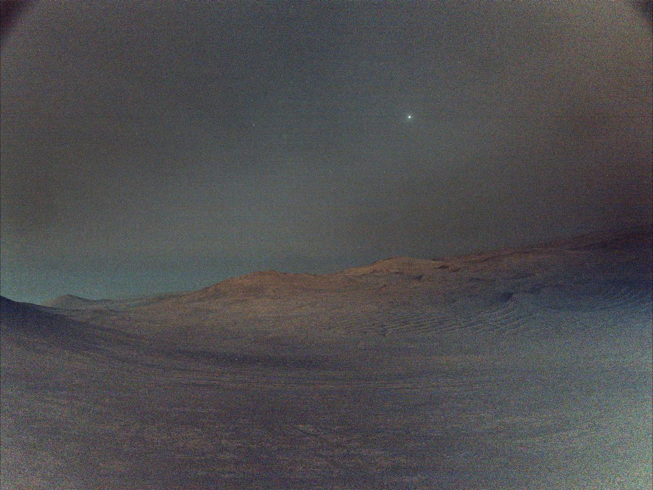
NASA's Perseverance rover captured this view of Deimos, the smaller of Mars' two moons, shining in the sky at 4:27 a.m. local time on March 1, 2025, the 1,433rd Martian day, or sol, of the mission. In the dark before dawn, the rover's left navigation camera used its maximum long-exposure time of 3.28 seconds for each of 16 individual shots, all of which were combined onboard the camera into a single image that was later sent to Earth. In total, the image represents an exposure time of about 52 seconds. The low light and long exposures add digital noise, making the image hazy. Many of the white specks seen in the sky are likely noise; some may be cosmic rays. Two of the brighter white specks are Regulus and Algieba, stars that are part of the constellation Leo. "Woodstock Crater," at center right, is roughly a half-mile (750 meters) away from the rover. At the time, Perseverance was making its way to a location called "Witch Hazel Hill." A key objective for Perseverance's mission on Mars is astrobiology, including the search for signs of ancient microbial life. The rover is characterizing the planet's geology and past climate, to help pave the way for human exploration of the Red Planet, and is the first mission to collect and cache Martian rock and regolith. NASA's Mars Sample Return Program, in cooperation with ESA (European Space Agency), is designed to send spacecraft to Mars to collect these sealed samples from the surface and return them to Earth for in-depth analysis. The Mars 2020 Perseverance mission is part of NASA's Mars Exploration Program portfolio and the agency's Moon to Mars exploration approach, which includes Artemis missions to the Moon that will help prepare for human exploration of the Red Planet. https://photojournal.jpl.nasa.gov/catalog/PIA26556
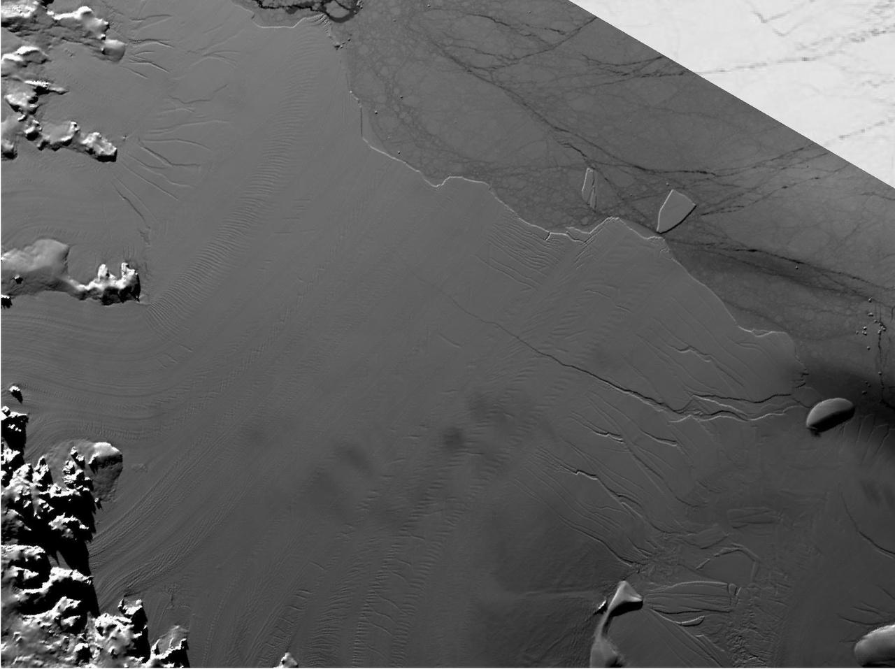
Between July 10 and 12, 2017, the Larsen C Ice Shelf in West Antarctica calved one of the largest icebergs in history (named "A-68"), weighing approximately one trillion tons. The rift in the ice shelf that spawned the iceberg has been present on the shelf since at least the beginning of the Landsat era (approximately the 1970s), but remained relatively dormant until around 2012, when it was observed actively moving through a suture zone in the ice shelf (Jansen et al., 2015). Suture zones are wide bands of ice that extend from glacier grounding lines (the boundary between a floating ice shelf and ice resting on bedrock) to the sea comprised of a frozen mixture of glacial ice and sea water, traditionally considered to be stabilizing features in ice shelves. When the Antarctic entered its annual dark period in late April, scientists knew the rift only had a few more miles to go before it completely calved the large iceberg. However, due to the lack of sunlight during the Antarctic winter, visible imagery is generally not available each year between May and August. This frame is from an animation that shows the ice shelf as imaged by the NASA/NOAA satellite Suomi NPP, which features the VIIRS (Visible Infrared Imaging Radiometer Suite) instrument. VIIRS has a day/night panchromatic band capable of collecting nighttime imagery of Earth with a spatial resolution of 2,460 feet (750 meters). An image from the Moderate Resolution Imaging Spectroradiometer (MODIS) instrument on NASA's Terra satellite shows the last cloud-free, daytime image of the ice shelf on April 6; the MODIS thermal imagery band is shown on April 29. The images from May 9 to July 14 show available cloud-free imagery from Suomi NPP. Luckily, despite several cloudy days leading up to the break, the weather mostly cleared on July 11, allowing scientists to see the newly formed iceberg on July 12. The animation is available at https://photojournal.jpl.nasa.gov/catalog/PIA21785
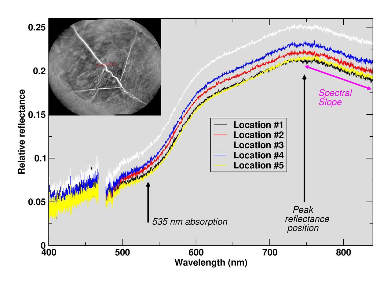
The Chemistry and Camera (ChemCam) instrument on NASA's Curiosity Mars rover examined a freshly brushed area on target rock "Christmas Cove" and found spectral evidence of hematite, an iron-oxide mineral. ChemCam sometimes zaps rocks with a laser, but can also be used, as in this case, in a "passive" mode. In this type of investigation, the instrument's telescope delivers to spectrometers the sunlight reflected from a small target point. The upper-left inset of this graphic is an image from ChemCam's Remote Micro-Imager with five labeled points that the instrument analyzed. The image covers an area about 2 inches (5 centimeters) wide, and the bright lines are fractures in the rock filled with calcium sulfate minerals. The five charted lines of the graphic correspond to those five points and show the spectrometer measurements of brightness at thousands of different wavelengths, from 400 nanometers (at the violet end of the visible-light spectrum) to 840 nanometers (in near-infrared). Sections of the spectrum measurements that are helpful for identifying hematite are annotated. These include a dip around 535 nanometers, the green-light portion of the spectrum at which fine-grained hematite tends to absorb more light and reflect less compared to other parts of the spectrum. That same green-absorbing characteristic of the hematite makes it appear purplish when imaged through special filters of Curiosity's Mast Camera and even in usual color images. The spectra also show maximum reflectance values near 750 nanometers, followed by a steep decrease in the spectral slope toward 840 nanometers, both of which are consistent with hematite. This ChemCam examination of Christmas Cove was part of an experiment to determine whether the rock had evidence of hematite under a tan coating of dust. The target area was brushed with Curiosity's Dust Removal Tool prior to these ChemCam passive observations on Sept. 17, 2017, during the 1,819th Martian day, or sol, of Curiosity's work on Mars. https://photojournal.jpl.nasa.gov/catalog/PIA22068

These two thumbnail images, with the ghostly dot of a faint Sun near the middle of each, are the last images NASA's Opportunity rover took on Mars as a dust storm darkened the sky. These images from the left and right eyes of the Panoramic Camera (Pancam) were used to estimate how opaque the atmosphere was (a measurement known as "tau") on Opportunity's final day of operation. With a tau of about 10.8 on that day, scientists knew that only a tiny amount of sunlight was getting through the dust. The left and right Pancam eyes had camera filters that typically help with geological investigations: 440-nanometer (deep blue) and 750-nanometer (red to infrared) filters, respectively. These filters would normally result in overexposed images, but with such weak sunlight, scientists were able to point the Pancams at the Sun and determine the tau. The left Pancam image (Figure 1) has more wavy gradations. In the right Pancam image (Figure 2), the Sun appears as the larger whitish feature in the middle of the frame. These images were taken in Perseverance Valley around 9:33 a.m. PDT (12:33 a.m. EDT) on June 10, 2018 (the 5,111st Martian day, or sol, of Opportunity's mission). These thumbnails were not the last images transmitted by the rover: The last image sent (PIA22929) is a partial full-frame image of a dark sky. While full-frame image versions are typically sent after thumbnails, the full-frame versions of these images with faint spots of sun were never transmitted. https://photojournal.jpl.nasa.gov/catalog/PIA22930
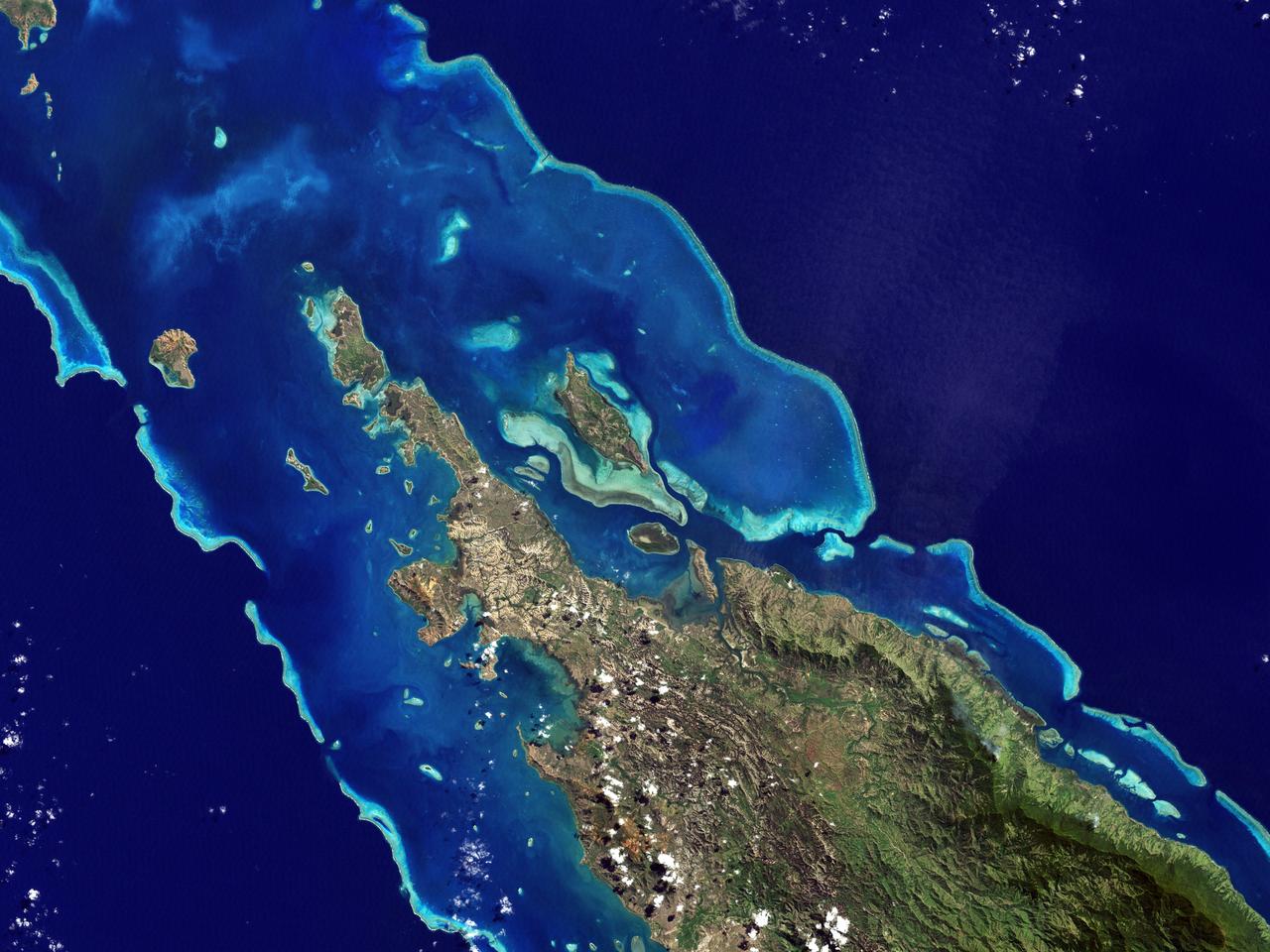
NASA image acquired May 10, 2001 In July 2008, the United Nations Educational, Scientific, and Cultural Organization (UNESCO) added 27 new areas to its list of World Heritage sites. One of those areas included the lagoons of New Caledonia. Some 1,200 kilometers (750 miles) east of Australia, this French-governed archipelago contains the world’s third-largest coral reef structure. The coral reefs enclose the waters near the islands in shallow lagoons of impressive biodiversity. On May 10, 2001, the Enhanced Thematic Mapper Plus on NASA’s Landsat 7 satellite captured this image of Île Balabio, off the northern tip of Grande Terra, New Caledonia’s main island. In this natural-color image, the islands appear in shades of green and brown—mixtures of vegetation and bare ground. The surrounding waters range in color from pale aquamarine to deep blue, and the color differences result from varying depths. Over coral reef ridges and sand bars, the water is shallowest and palest in color. Darker shades of blue characterize deeper waters. Reef-enclosed, shallow waters surround Île Balabio, and a larger, semi-enclosed lagoon appears immediately east of that island. Immediately north of Grande Terra, unenclosed, deeper waters predominate. The coral reefs around New Caledonia support an unusual diversity of species, including large numbers of predators and big fish, turtles, and the world’s third-largest dugong population. NASA image created by Jesse Allen, using Landsat data provided by the United States Geological Survey. Caption by Michon Scott. Instrument: Landsat 7 - ETM+ Credit: NASA/GSFC/Landsat <b><a href="http://www.nasa.gov/centers/goddard/home/index.html" rel="nofollow">NASA Goddard Space Flight Center</a></b> enables NASA’s mission through four scientific endeavors: Earth Science, Heliophysics, Solar System Exploration, and Astrophysics. Goddard plays a leading role in NASA’s accomplishments by contributing compelling scientific knowledge to advance the Agency’s mission. <b>Follow us on <a href="http://twitter.com/NASA_GoddardPix" rel="nofollow">Twitter</a></b> <b>Join us on <a href="http://www.facebook.com/pages/Greenbelt-MD/NASA-Goddard/395013845897?ref=tsd" rel="nofollow">Facebook</a></b>

NASA image acquired September 3, 2011 Dominici crater, the very bright crater to the top of this image, exhibits bright rays and contains hollows. This crater lies upon the peak ring of Homer Basin, a very degraded peak ring basin that has been filled by volcanism. This image contains several examples of craters that have excavated materials from depth that are spectrally distinct from the surface volcanic layers, providing windows into the subsurface. MESSENGER scientists are estimating the approximate depths of these spectrally distinct materials by applying knowledge of how impacts excavate material during the cratering process. The 1000, 750, and 430 nm bands of the Wide Angle Camera are displayed in red, green, and blue, respectively. This image was acquired as a high-resolution targeted observation. Targeted observations are images of a small area on Mercury's surface at resolutions much higher than the 250-meter/pixel (820 feet/pixel) morphology base map or the 1-kilometer/pixel (0.6 miles/pixel) color base map. It is not possible to cover all of Mercury's surface at this high resolution during MESSENGER's one-year mission, but several areas of high scientific interest are generally imaged in this mode each week. The MESSENGER spacecraft is the first ever to orbit the planet Mercury, and the spacecraft's seven scientific instruments and radio science investigation are unraveling the history and evolution of the Solar System's innermost planet. Visit the Why Mercury? section of this website to learn more about the key science questions that the MESSENGER mission is addressing. During the one-year primary mission, MDIS is scheduled to acquire more than 75,000 images in support of MESSENGER's science goals. Credit: NASA/Johns Hopkins University Applied Physics Laboratory/Carnegie Institution of Washington <b><a href="http://www.nasa.gov/audience/formedia/features/MP_Photo_Guidelines.html" rel="nofollow">NASA image use policy.</a></b> <b><a href="http://www.nasa.gov/centers/goddard/home/index.html" rel="nofollow">NASA Goddard Space Flight Center</a></b> enables NASA’s mission through four scientific endeavors: Earth Science, Heliophysics, Solar System Exploration, and Astrophysics. Goddard plays a leading role in NASA’s accomplishments by contributing compelling scientific knowledge to advance the Agency’s mission. <b>Follow us on <a href="http://twitter.com/NASA_GoddardPix" rel="nofollow">Twitter</a></b> <b>Like us on <a href="http://www.facebook.com/pages/Greenbelt-MD/NASA-Goddard/395013845897?ref=tsd" rel="nofollow">Facebook</a></b> <b>Find us on <a href="http://instagrid.me/nasagoddard/?vm=grid" rel="nofollow">Instagram</a></b>

This composite image shows an infrared view of Saturn's moon Titan from NASA's Cassini spacecraft, acquired during the mission's "T-114" flyby on Nov. 13, 2015. The spacecraft's visual and infrared mapping spectrometer (VIMS) instrument made these observations, in which blue represents wavelengths centered at 1.3 microns, green represents 2.0 microns, and red represents 5.0 microns. A view at visible wavelengths (centered around 0.5 microns) would show only Titan's hazy atmosphere (as in PIA14909). The near-infrared wavelengths in this image allow Cassini's vision to penetrate the haze and reveal the moon's surface. During this Titan flyby, the spacecraft's closest-approach altitude was 6,200 miles (10,000 kilometers), which is considerably higher than those of typical flybys, which are around 750 miles (1,200 kilometers). The high flyby allowed VIMS to gather moderate-resolution views over wide areas (typically at a few kilometers per pixel). The view looks toward terrain that is mostly on the Saturn-facing hemisphere of Titan. The scene features the parallel, dark, dune-filled regions named Fensal (to the north) and Aztlan (to the south), which form the shape of a sideways letter "H." Several places on the image show the surface at higher resolution than elsewhere. These areas, called subframes, show more detail because they were acquired near closest approach. They have finer resolution, but cover smaller areas than data obtained when Cassini was farther away from Titan. Near the limb at left, above center, is the best VIMS view so far of Titan's largest confirmed impact crater, Menrva (first seen by the RADAR instrument in PIA07365). Similarly detailed subframes show eastern Xanadu, the basin Hotei Regio, and channels within bright terrains east of Xanadu. (For Titan maps with named features see http://planetarynames.wr.usgs.gov/Page/TITAN/target.) Due to the changing Saturnian seasons, in this late northern spring view, the illumination is significantly changed from that seen by VIMS during the "T-9" flyby on December 26, 2005 (PIA02145). The sun has moved higher in the sky in Titan's northern hemisphere, and lower in the sky in the south, as northern summer approaches. This change in the sun's angle with respect to Titan's surface has made high southern latitudes appear darker, while northern latitudes appear brighter. http://photojournal.jpl.nasa.gov/catalog/PIA20016

NASA's New Horizons spacecraft took this stunning image of Pluto only a few minutes after closest approach on July 14, 2015. The image was obtained at a high phase angle -- that is, with the sun on the other side of Pluto, as viewed by New Horizons. Seen here, sunlight filters through and illuminates Pluto's complex atmospheric haze layers. The southern portions of the nitrogen ice plains informally named Sputnik Planum, as well as mountains of the informally named Norgay Montes, can also be seen across Pluto's crescent at the top of the image. Looking back at Pluto with images like this gives New Horizons scientists information about Pluto's hazes and surface properties that they can't get from images taken on approach. The image was obtained by New Horizons' Ralph/Multispectral Visual Imaging Camera (MVIC) approximately 13,400 miles (21,550 kilometers) from Pluto, about 19 minutes after New Horizons' closest approach. The image has a resolution of 1,400 feet (430 meters) per pixel. Pluto's diameter is 1,475 miles (2,374 kilometers). The inset at top right in the annotated version shows a detail of Pluto's crescent, including an intriguing bright wisp (near the center) measuring tens of miles across that may be a discreet, low-lying cloud in Pluto's atmosphere; if so, it would be the only one yet identified in New Horizons imagery. This cloud -- if that's what it is -- is visible for the same reason the haze layers are so bright: illumination from the sunlight grazing Pluto's surface at a low angle. Atmospheric models suggest that methane clouds can occasionally form in Pluto's atmosphere. The scene in this inset is 140 miles (230 kilometers) across. The inset at bottom right shows more detail on the night side of Pluto. This terrain can be seen because it is illuminated from behind by hazes that silhouette the of the annotated version limb. The topography here appears quite rugged, and broad valleys and sharp peaks with relief totaling 3 miles (5 kilometers) are apparent. This image, made from closer range, is much better than the lower-resolution images of this same terrain taken several days before closest approach. These silhouetted terrains therefore act as a useful "anchor point," giving New Horizons scientists a rare, detailed glimpse at the lay of the land in this mysterious part of Pluto seen at high resolution only in twilight. The scene in this inset is 460 miles (750 kilometers) wide. http://photojournal.jpl.nasa.gov/catalog/PIA20727
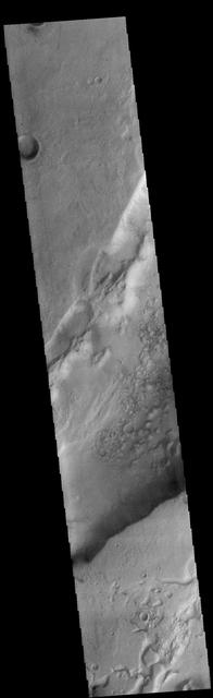
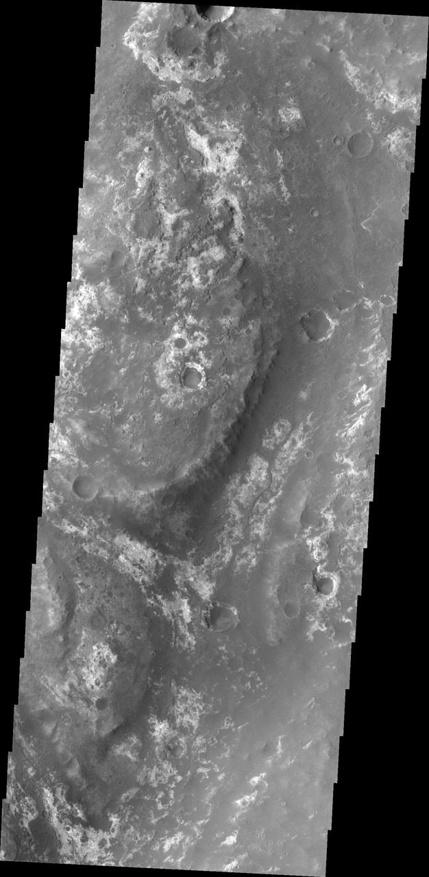
Today's VIS image shows a small portion of Dao Vallis. Located south of Hadriacus Mons (a volcano), this channel is approximately 1200km (750 miles) long. It has been proposed that heating of the region due to volcanic activity melted subsurface ice which was released to the surface to carve the channel. Dao Vallis empties into the Hellas Planitia basin. Orbit Number: 83191 Latitude: -34.7957 Longitude: 91.6287 Instrument: VIS Captured: 2020-09-15 06:07 https://photojournal.jpl.nasa.gov/catalog/PIA24241