
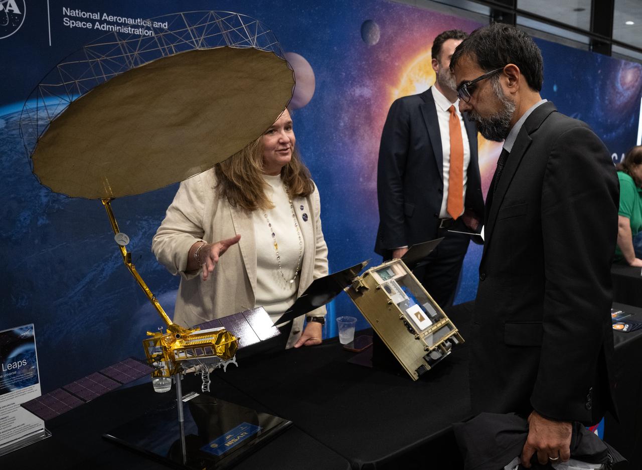
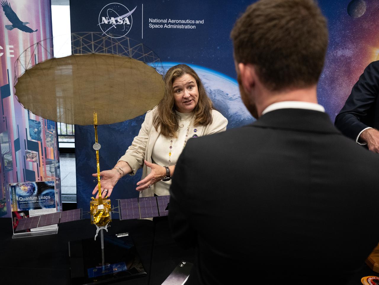
Attendees view exhibits during NASA’s Day on the Hill, Tuesday, Sept. 16, 2025, at the Hart Senate Office Building in Washington. Photo Credit: (NASA/Joel Kowsky)

Attendees view exhibits during NASA’s Day on the Hill, Tuesday, Sept. 16, 2025, at the Hart Senate Office Building in Washington. Photo Credit: (NASA/Joel Kowsky)

Attendees view exhibits during NASA’s Day on the Hill, Tuesday, Sept. 16, 2025, at the Hart Senate Office Building in Washington. Photo Credit: (NASA/Joel Kowsky)
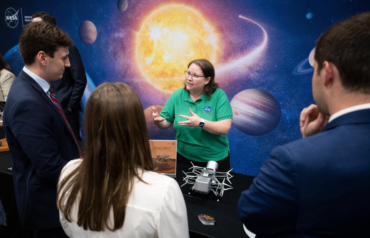
Attendees view exhibits during NASA’s Day on the Hill, Tuesday, Sept. 16, 2025, at the Hart Senate Office Building in Washington. Photo Credit: (NASA/Joel Kowsky)

Attendees view exhibits during NASA’s Day on the Hill, Tuesday, Sept. 16, 2025, at the Hart Senate Office Building in Washington. Photo Credit: (NASA/Joel Kowsky)

Attendees view exhibits during NASA’s Day on the Hill, Tuesday, Sept. 16, 2025, at the Hart Senate Office Building in Washington. Photo Credit: (NASA/Joel Kowsky)

Attendees view exhibits during NASA’s Day on the Hill, Tuesday, Sept. 16, 2025, at the Hart Senate Office Building in Washington. Photo Credit: (NASA/Joel Kowsky)

Attendees view exhibits during NASA’s Day on the Hill, Tuesday, Sept. 16, 2025, at the Hart Senate Office Building in Washington. Photo Credit: (NASA/Joel Kowsky)

Attendees view exhibits and listen to speakers during NASA’s Science Day on the Hill event, Wednesday, June 7, 2023, at the Rayburn House Office Building in Washington. Photo Credit: (NASA/Joel Kowsky)

Attendees view exhibits during NASA’s Science Day on the Hill event, Wednesday, June 7, 2023, at the Rayburn House Office Building in Washington. Photo Credit: (NASA/Joel Kowsky)

Acting NASA Administrator Sean Duffy delivers remarks during NASA’s Day on the Hill, Tuesday, Sept. 16, 2025, at the Hart Senate Office Building in Washington. Photo Credit: (NASA/Joel Kowsky)

Acting NASA Administrator Sean Duffy delivers remarks during NASA’s Day on the Hill, Tuesday, Sept. 16, 2025, at the Hart Senate Office Building in Washington. Photo Credit: (NASA/Joel Kowsky)

Acting NASA Administrator Sean Duffy delivers remarks during NASA’s Day on the Hill, Tuesday, Sept. 16, 2025, at the Hart Senate Office Building in Washington. Photo Credit: (NASA/Joel Kowsky)

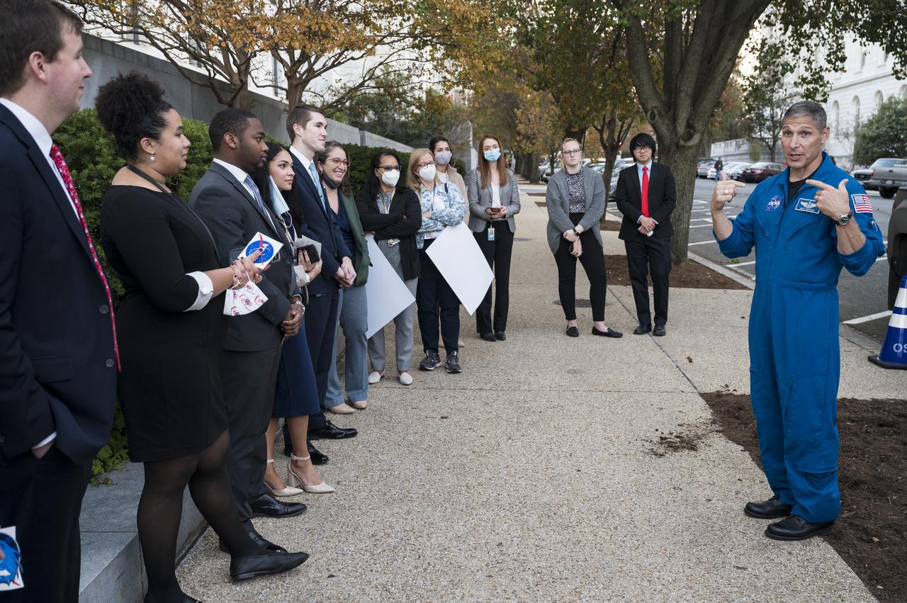
NASA astronaut Nick Hague speaks with attendees of NASA’s Day on the Hill, Tuesday, Sept. 16, 2025, at the Hart Senate Office Building in Washington. Photo Credit: (NASA/Joel Kowsky)

NASA astronaut Butch Wilmore speaks with attendees of NASA’s Day on the Hill, Tuesday, Sept. 16, 2025, at the Hart Senate Office Building in Washington. Photo Credit: (NASA/Joel Kowsky)

NASA astronaut Suni Williams speaks with attendees of NASA’s Day on the Hill, Tuesday, Sept. 16, 2025, at the Hart Senate Office Building in Washington. Photo Credit: (NASA/Joel Kowsky)

U.S. Senator Jerry Moran, R-Kan., gives remarks during NASA’s Day on the Hill, Tuesday, Sept. 16, 2025, at the Hart Senate Office Building in Washington. Photo Credit: (NASA/Joel Kowsky)

Heather Pringle, CEO of Space Foundation, gives remarks during NASA’s Day on the Hill, Tuesday, Sept. 16, 2025, at the Hart Senate Office Building in Washington. Photo Credit: (NASA/Joel Kowsky)

U.S. Senator Jerry Moran, R-Kan., gives remarks during NASA’s Day on the Hill, Tuesday, Sept. 16, 2025, at the Hart Senate Office Building in Washington. Photo Credit: (NASA/Joel Kowsky)

U.S. Senator Jerry Moran, R-Kan., gives remarks during NASA’s Day on the Hill, Tuesday, Sept. 16, 2025, at the Hart Senate Office Building in Washington. Photo Credit: (NASA/Joel Kowsky)
Karen St. Germain, director of the Earth Science Division of NASA’s Science Mission Directorate, left, speaks with NASA Associate Administrator Amit Kshatriya during NASA’s Day on the Hill, Tuesday, Sept. 16, 2025, at the Hart Senate Office Building in Washington. Photo Credit: (NASA/Joel Kowsky)
Karen St. Germain, director of the Earth Science Division of NASA’s Science Mission Directorate speaks with an attendee as he views exhibits during NASA’s Day on the Hill, Tuesday, Sept. 16, 2025, at the Hart Senate Office Building in Washington. Photo Credit: (NASA/Joel Kowsky)

NASA Associate administrator Bob Cabana speaks during NASA’s Science Day on the Hill event, Wednesday, June 7, 2023, at the Rayburn House Office Building in Washington. Photo Credit: (NASA/Joel Kowsky)

Rep. Frank Lucas, R-Okla., speaks during NASA’s Science Day on the Hill event, Wednesday, June 7, 2023, at the Rayburn House Office Building in Washington. Photo Credit: (NASA/Joel Kowsky)

Karen St. Germain, director of the Earth Science Division of NASA’s Science Mission Directorate, center, speaks with Nicola Fox, associate administrator of NASA’s Science Mission Directorate, left, and NASA Associate Administrator Amit Kshatriya during NASA’s Day on the Hill, Tuesday, Sept. 16, 2025, at the Hart Senate Office Building in Washington. Photo Credit: (NASA/Joel Kowsky)

NASA’s SpaceX Crew-5 astronaut Nicole Mann of NASA speaks to attendees of NASA’s Science Day on the Hill event, Wednesday, June 7, 2023, at the Rayburn House Office Building in Washington. Mann and fellow crewmates Josh Cassada of NASA and Koichi Wakata of the Japan Aerospace Exploration Agency (JAXA) spent 157 days in space as part of Expedition 68 aboard the International Space Station. Photo Credit: (NASA/Joel Kowsky)
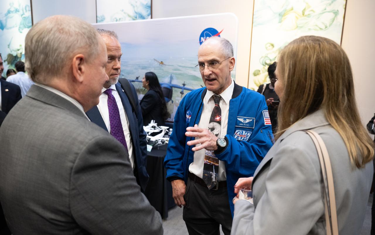
NASA astronaut Don Pettit speaks with Trey Carlson, chief of staff for NASA’s Kennedy Space Center, left, John McCullough, deputy associate administrator for integration in NASA’s Exploration Systems Development Mission Directorate, and Janet Petro, director of NASA’s Kennedy Space Center during NASA’s Day on the Hill, Tuesday, Sept. 16, 2025, at the Hart Senate Office Building in Washington. Photo Credit: (NASA/Joel Kowsky)

Expedition 72 NASA astronauts Suni Williams, left, Don Pettit, Butch Wilmore, and Nick Hague, are seen as acting NASA Administrator Sean Duffy delivers remarks during NASA’s Day on the Hill, Tuesday, Sept. 16, 2025, at the Hart Senate Office Building in Washington. Photo Credit: (NASA/Joel Kowsky)

NASA’s SpaceX Crew-5 astronaut Koichi Wakata of the Japan Aerospace Exploration Agency (JAXA) takes a picture with an attendee during NASA’s Science Day on the Hill event, Wednesday, June 7, 2023, at the Rayburn House Office Building in Washington. Photo Credit: (NASA/Joel Kowsky)

NASA’s SpaceX Crew-5 astronauts Koichi Wakata of the Japan Aerospace Exploration Agency (JAXA), left, and Josh Cassada and Nicole Mann of NASA, speak during NASA’s Science Day on the Hill event, Wednesday, June 7, 2023, at the Rayburn House Office Building in Washington. Mann, Cassada, and Wakata spent 157 days in space as part of Expedition 68 aboard the International Space Station. Photo Credit: (NASA/Joel Kowsky)

NASA’s SpaceX Crew-5 astronauts Koichi Wakata of the Japan Aerospace Exploration Agency (JAXA), left, and Josh Cassada and Nicole Mann of NASA, speak during NASA’s Science Day on the Hill event, Wednesday, June 7, 2023, at the Rayburn House Office Building in Washington. Mann, Cassada, and Wakata spent 157 days in space as part of Expedition 68 aboard the International Space Station. Photo Credit: (NASA/Joel Kowsky)

NASA’s SpaceX Crew-5 astronauts Koichi Wakata of the Japan Aerospace Exploration Agency (JAXA), left, and Josh Cassada and Nicole Mann of NASA, speak during NASA’s Science Day on the Hill event, Wednesday, June 7, 2023, at the Rayburn House Office Building in Washington. Mann, Cassada, and Wakata spent 157 days in space as part of Expedition 68 aboard the International Space Station. Photo Credit: (NASA/Joel Kowsky)
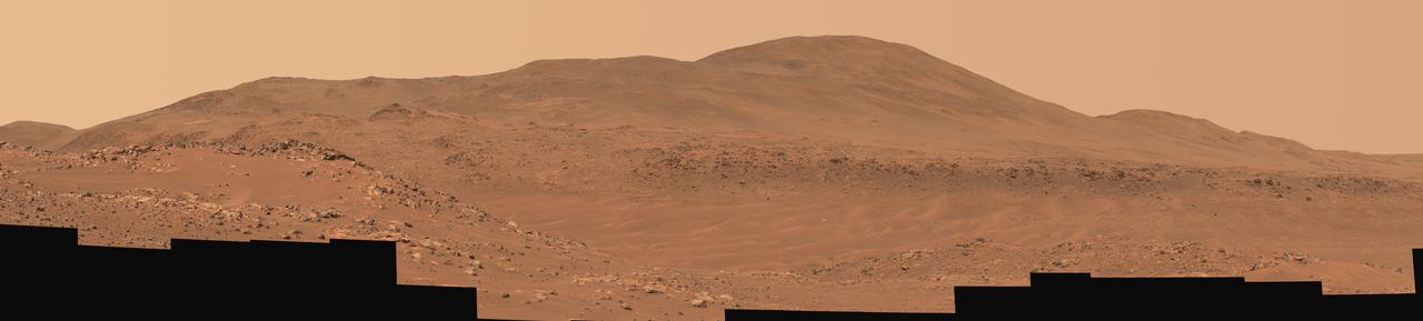
NASA Mars Exploration Rover Spirit looked up at the Columbia Hills from its location on the 265th martian day, or sol, of its mission Sept. 30, 2004 and captured this 3-D view. 3D glasses are necessary to view this image.
NASA Mars Exploration Rover Spirit has been making tracks on Mars for seven months now, well beyond its original 90-day mission, when it reached Columbia Hills. 3D glasses are necessary to view this image.
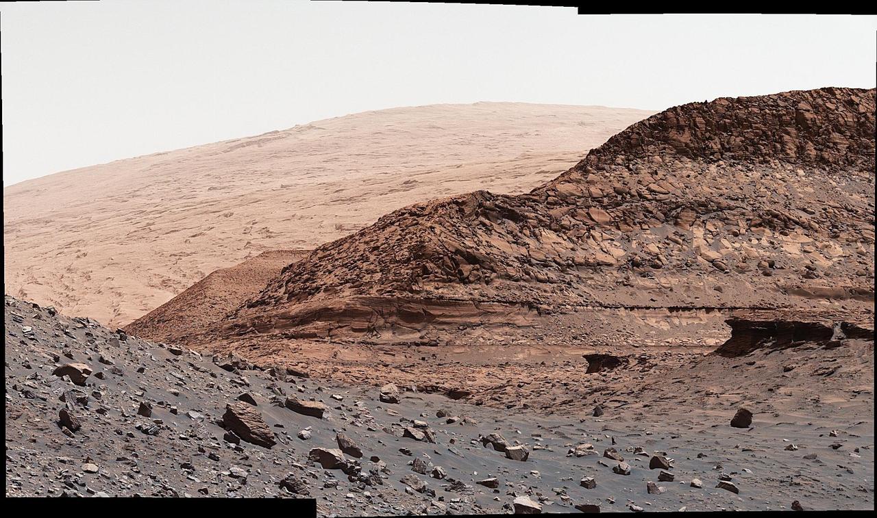
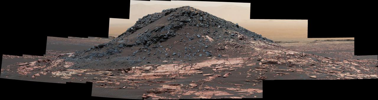
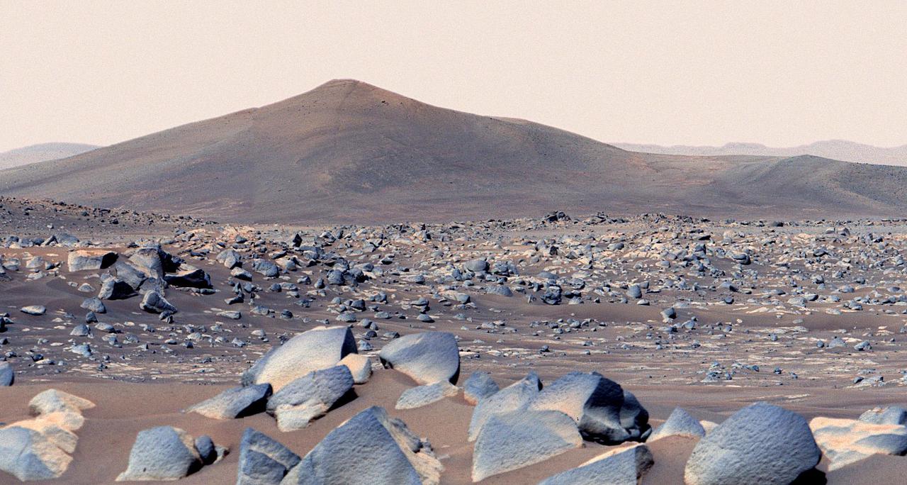
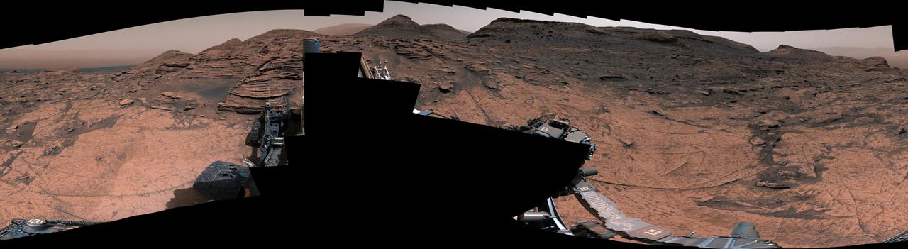
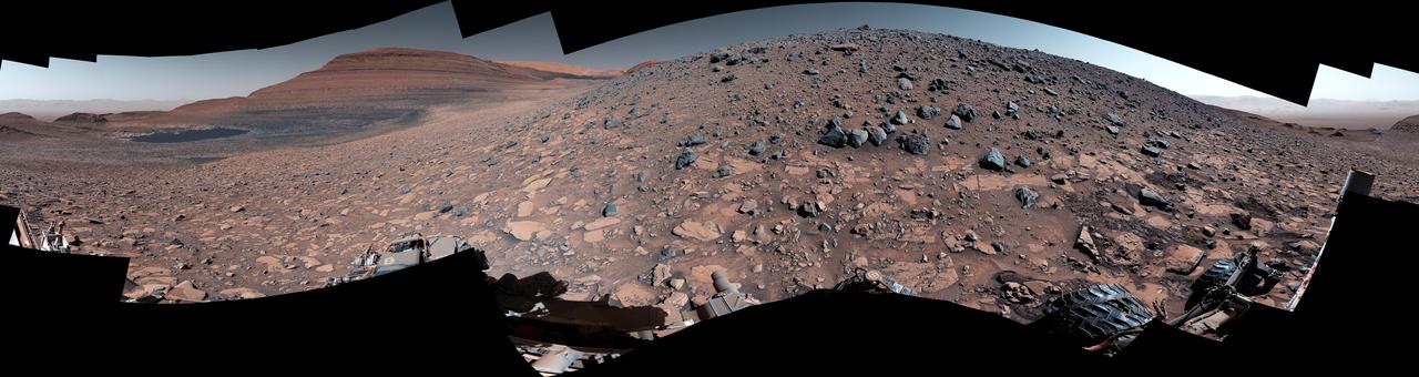
NASA's Curiosity Mars rover used its Mast Camera, or Mastcam, to capture this panorama of a hill nicknamed "Bolívar" and adjacent sand ridges on Aug. 23, 2022, the 3,572nd Martian day, or sol, of the mission. This panorama was stitched together from 23 images once they were sent back to Earth. The color has been adjusted to match the lighting conditions as the human eye would perceive them on Earth. https://photojournal.jpl.nasa.gov/catalog/PIA25414
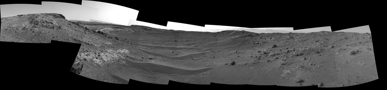
NASA's Curiosity Mars rover used its navigation cameras, or Navcams, to capture this panorama of the narrow "Paraitepuy Pass" on Aug. 11, 2022, the 3,560th Martian day, or sol, of the mission. The pass, with hills in the distance, can be seen on the left side of the scene. The hill in the center of this scene is "Bolívar"; "Deepdale" is on the far left of the scene. The crater floor is visible in the background of the right side of the panorama. https://photojournal.jpl.nasa.gov/catalog/PIA25417
NASA's Curiosity Mars rover used its Mast Camera, or Mastcam, to capture geologic details within "Paraitepuy Pass," a sandy, hill-lined area the rover traversed to reach the "sulfate-bearing unit" in August 2022. In the this scene is a hill nicknamed "Orinoco" within the sulfate region, and upper Mount Sharp in the distance. This image was taken on Aug. 15, 2022, the 3,564rd Martian day, or sol, of the mission. This scene is made up of three individual images that were stitched together once they were sent back to Earth. The color has been adjusted to match the lighting conditions as the human eye would perceive them on Earth. https://photojournal.jpl.nasa.gov/catalog/PIA25415

Japan Aerospace Exploration Agency (JAXA) astronaut Soichi Noguchi speaks with visitors at the Destination Station mobile exhibition on Capitol Hill, Wednesday, Nov. 17, 2021, in Washington. Noguchi and crew mates NASA astronauts Mike Hopkins, Victor Glover, and Shannon Walker, launched on the first crew rotation mission to the International Space Station for SpaceX’s Falcon 9 and Crew Dragon spacecraft as part of the agency’s Commercial Crew Program and spent 168 days in space across Expeditions 64 and 65. Photo Credit: (NASA/Aubrey Gemignani)
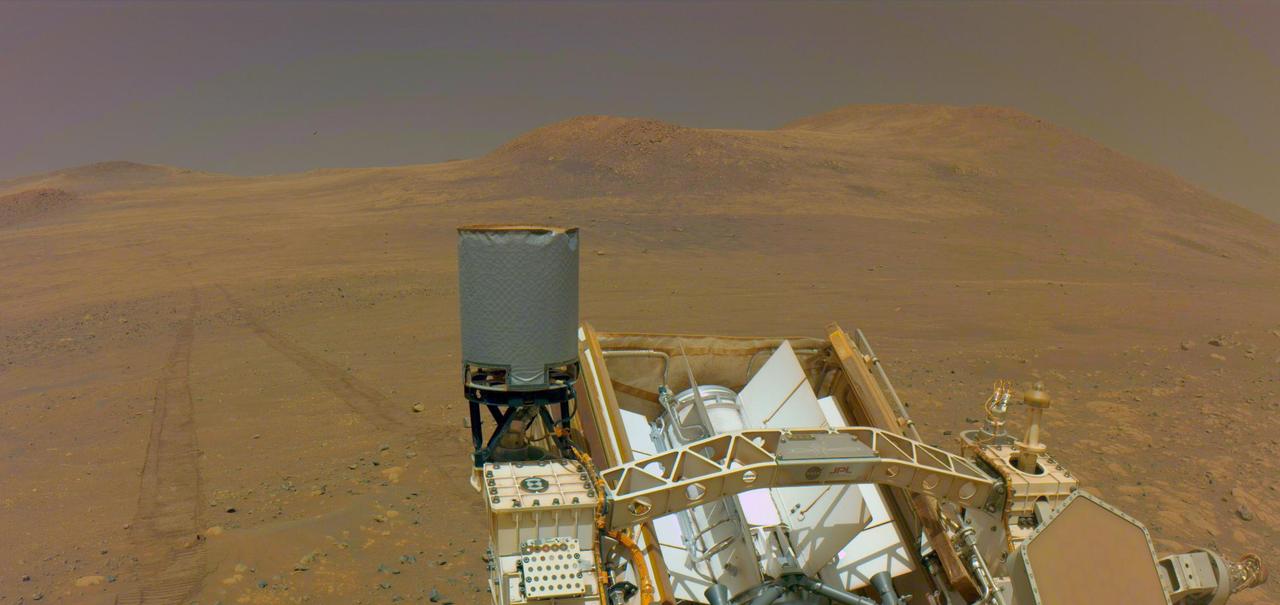
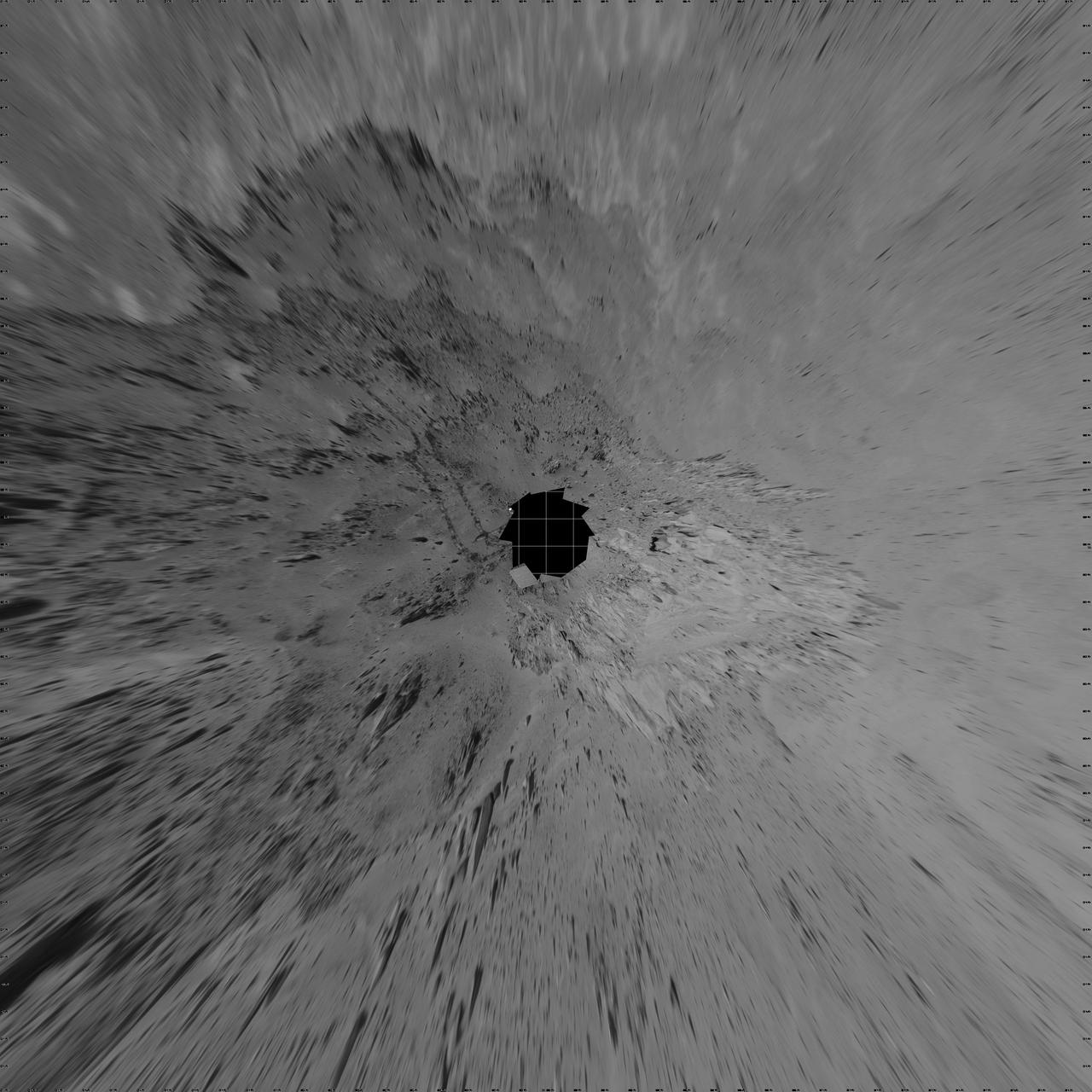
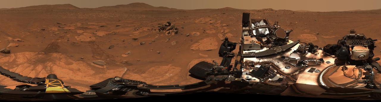
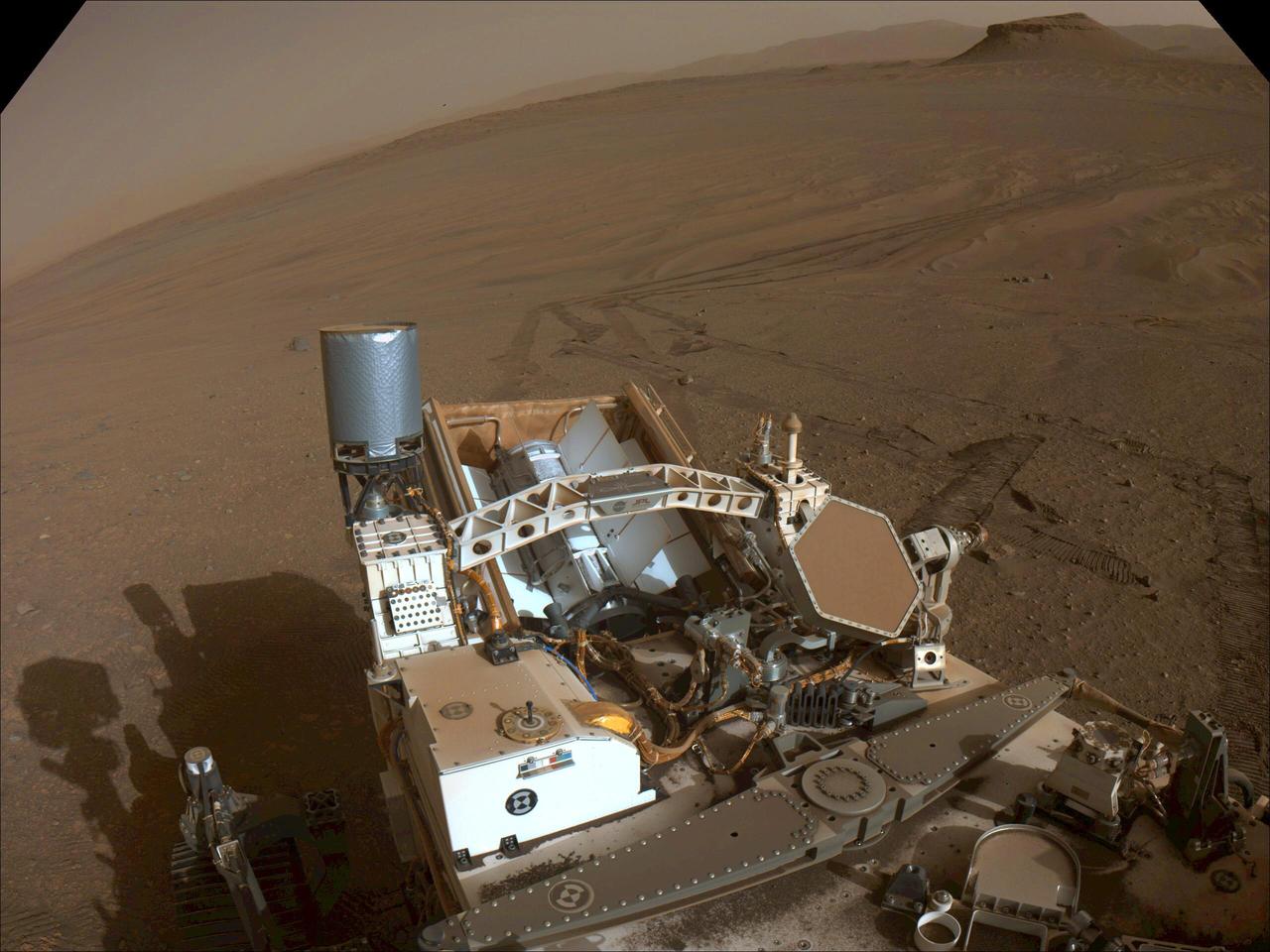
One of the navigation cameras on NASA's Perseverance captured the rover's tracks coming from an area called "Witch Hazel Hill," on May 13, 2025, the 1,503rd Martian day, or sol, of the mission. The Mars 2020 Perseverance mission is part of NASA's Moon to Mars exploration approach, which includes Artemis missions to the Moon that will help prepare for human exploration of the Red Planet. https://photojournal.jpl.nasa.gov/catalog/PIA26573

Japan Aerospace Exploration Agency (JAXA) astronaut Soichi Noguchi speaks with visitors at the Destination Station mobile exhibition on Capitol Hill, Wednesday, Nov. 17, 2021, in Washington. Noguchi and crew mates NASA astronauts Mike Hopkins, Victor Glover, and Shannon Walker, launched on the first crew rotation mission to the International Space Station for SpaceX’s Falcon 9 and Crew Dragon spacecraft as part of the agency’s Commercial Crew Program and spent 168 days in space across Expeditions 64 and 65. Photo Credit: (NASA/Aubrey Gemignani)
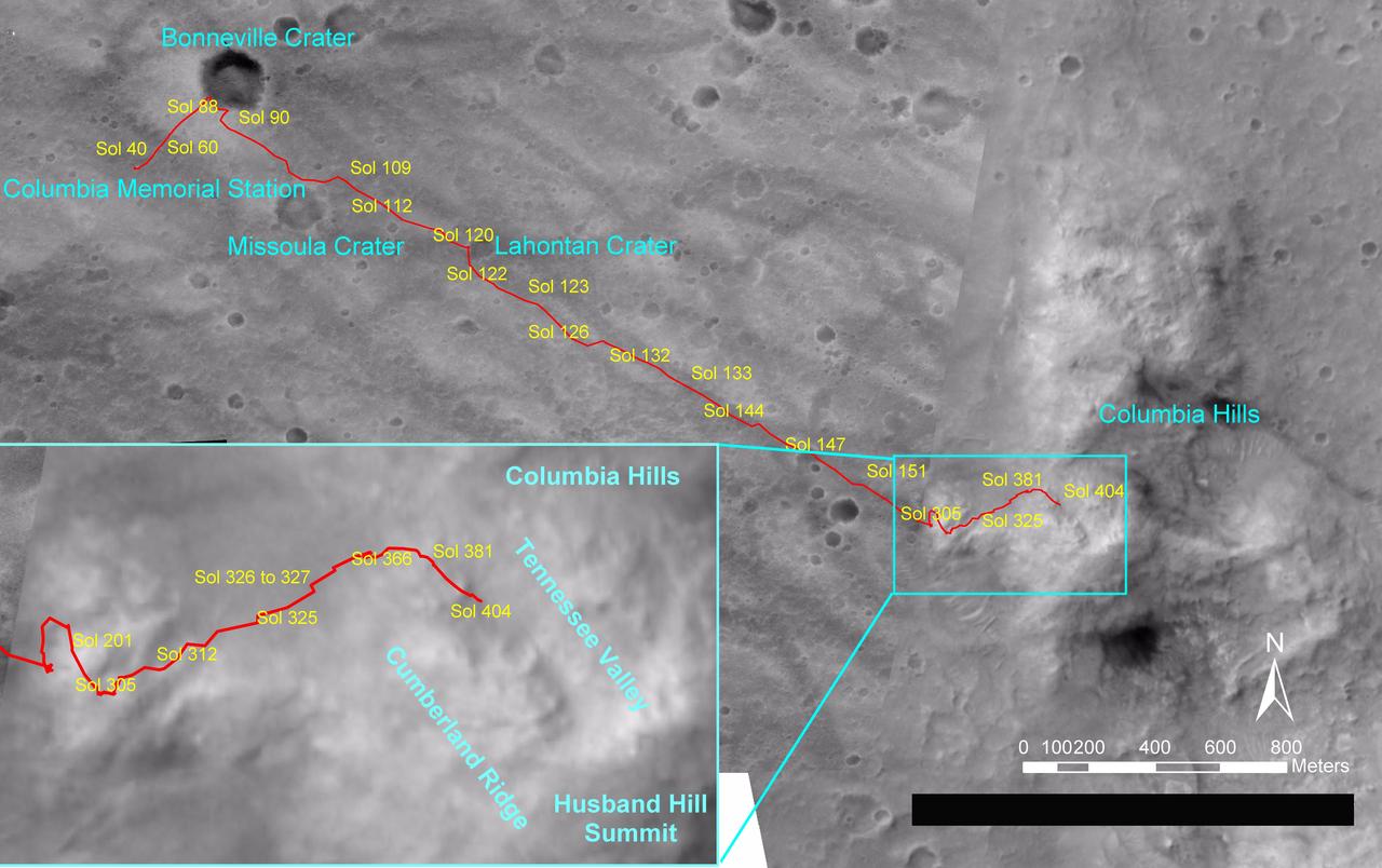
NASA's Mars Exploration Rover Spirit drove a total of 4,143 meters (2.57 miles) between its landing in January 2004 and its 404th martian day, or sol (Feb. 20, 2005). This map on an image taken by the Mars Orbiter Camera on NASA's Mars Global Surveyor shows the course the rover drove during that time. The rover has recently been approaching a ridge overlooking "Tennessee Valley" on the north flank of "Husband Hill." http://photojournal.jpl.nasa.gov/catalog/PIA07393
This image of NASA's Perseverance Mars rover at the rim of Belva Crater was taken by the agency's Ingenuity Mars Helicopter during the rotorcraft's 51st flight on April 22, 2023, the 772nd Martian day, or sol, of the rover's mission. At the time the image was taken, the helicopter was at an altitude of about 40 feet (12 meters). The rover is in the upper left of the image, parked at a light-toned rocky outcrop the science team is calling "Echo Creek." Perseverance's tracks can be seen extending from its location to the upper-right side of image. The helicopter's shadow can be seen on the rocky hill in the foreground, just to the right and below the image's center. The hill, designated "Mount Julian" by the science team, is a planned future stop for the rover. A small triangular piece of debris from the rover's entry, descent, and landing system can be seen at the lower center of image. https://photojournal.jpl.nasa.gov/catalog/PIA25884
This dark mound, called "Ireson Hill," rises about 16 feet (5 meters) above redder layered outcrop material of the Murray formation on lower Mount Sharp, Mars, near a location where NASA's Curiosity rover examined a linear sand dune in February 2017. Researchers used the rover's Mast Camera (Mastcam) on Feb. 2, 2017, during the 1,598th Martian day, or sol, of Curiosity's work on Mars, to take the 41 images combined into this scene. The mosaic has been white-balanced so that the colors of the rock and sand materials resemble how they would appear under daytime lighting conditions on Earth. The view extends from west-southwest on the left to north-northwest on the right. The faint horizon in the distance beyond Ireson Hill is part of the rim of Gale Crater. An annotated figure is available at https://photojournal.jpl.nasa.gov/catalog/PIA21718

JSC2009-E-119383 (12 May 2009) --- Flight directors Rick LaBrode (left) and Chris Edelen; along with Paul Hill (standing at right), Space Shuttle Mission Operations manager, are pictured in the space shuttle flight control room in the Mission Control Center at NASA's Johnson Space Center during STS-125 flight day two activities.
This view from the Navigation Camera (Navcam) on NASA's Curiosity Mars rover shows the terrain ahead of the rover as it makes its way westward through a valley called "Artist's Drive." The Navcam recorded the component images of this mosaic on April 10, 2015, during the 951st Martian Day, or sol, of Curiosity's work on Mars. The valley is on the rover's route toward a higher site on Mount Sharp than the "Pahrump Hills" area the mission investigated at the base of the layered mountain. http://photojournal.jpl.nasa.gov/catalog/PIA19163
The left side of this 360-degree panorama from NASA's Curiosity Mars rover shows the long rows of ripples on a linear shaped dune in the Bagnold Dune Field on the northwestern flank of Mount Sharp. The view is a mosaic of images taken with Curiosity's Navigation Camera (Navcam) on Feb. 5, 2017, during the 1,601st Martian day, or sol, of the rover's work on Mars. The view is centered toward west-southwest, with east-southeast on either end. A capped mound called "Ireson Hill" is on the right. http://photojournal.jpl.nasa.gov/catalog/PIA21268

SpaceX Crew-1 NASA astronaut Victor Glover, left, speaks with Rep. Chrissy Houlahan, D-Pa., center, and NASA Deputy Administrator Pam Melroy, at the Destination Station mobile exhibition on Capitol Hill, Wednesday, Nov. 17, 2021, in Washington. Glover, and NASA astronauts Mike Hopkins, and Shannon Walker, and Japan Aerospace Exploration Agency (JAXA) astronaut Soichi Noguchi launched on the first crew rotation mission to the International Space Station for SpaceX’s Falcon 9 and Crew Dragon spacecraft as part of the agency’s Commercial Crew Program and spent 168 days in space across Expeditions 64 and 65. Photo Credit: (NASA/Aubrey Gemignani)

SpaceX Crew-1 NASA astronauts Victor Glover, left, and Shannon Walker, second from right, and Japan Aerospace Exploration Agency (JAXA) astronaut Soichi Noguchi, right, speak with Senator John Hickenlooper, D-Colo, at the Destination Station mobile exhibition on Capitol Hill, Wednesday, Nov. 17, 2021, in Washington. Walker, Glover, Noguchi, and NASA astronaut Mike Hopkins, launched on the first crew rotation mission to the International Space Station for SpaceX’s Falcon 9 and Crew Dragon spacecraft as part of the agency’s Commercial Crew Program and spent 168 days in space across Expeditions 64 and 65. Photo Credit: (NASA/Aubrey Gemignani)
SpaceX Crew-1 NASA astronaut Shannon Walker speaks with visitors at the Destination Station mobile exhibition on Capitol Hill, Wednesday, Nov. 17, 2021, in Washington. Walker, and NASA astronauts Mike Hopkins, and Victor Glover, and Japan Aerospace Exploration Agency (JAXA) astronaut Soichi Noguchi launched on the first crew rotation mission to the International Space Station for SpaceX’s Falcon 9 and Crew Dragon spacecraft as part of the agency’s Commercial Crew Program and spent 168 days in space across Expeditions 64 and 65. Photo Credit: (NASA/Aubrey Gemignani)

SpaceX Crew-1 NASA astronaut Victor Glover, center, and Japan Aerospace Exploration Agency (JAXA) astronaut Soichi Noguchi, right, speak with visitors at the Destination Station mobile exhibition on Capitol Hill, Wednesday, Nov. 17, 2021, in Washington.Glover, Noguchi, and NASA astronauts Mike Hopkins and Shannon Walker, launched on the first crew rotation mission to the International Space Station for SpaceX’s Falcon 9 and Crew Dragon spacecraft as part of the agency’s Commercial Crew Program and spent 168 days in space across Expeditions 64 and 65. Photo Credit: (NASA/Aubrey Gemignani)

SpaceX Crew-1 NASA astronaut Mike Hopkins speaks with visitors at the Destination Station mobile exhibition on Capitol Hill, Wednesday, Nov. 17, 2021, in Washington. Hopkins and NASA astronauts Shannon Walker and Victor Glover, and Japan Aerospace Exploration Agency (JAXA) astronaut Soichi Noguchi launched on the first crew rotation mission to the International Space Station for SpaceX’s Falcon 9 and Crew Dragon spacecraft as part of the agency’s Commercial Crew Program and spent 168 days in space across Expeditions 64 and 65. Photo Credit: (NASA/Aubrey Gemignani)

SpaceX Crew-1 NASA astronaut Victor Glover speaks with visitors at the Destination Station mobile exhibition on Capitol Hill, Wednesday, Nov. 17, 2021, in Washington. Glover, and NASA astronauts Mike Hopkins, and Shannon Walker, and Japan Aerospace Exploration Agency (JAXA) astronaut Soichi Noguchi launched on the first crew rotation mission to the International Space Station for SpaceX’s Falcon 9 and Crew Dragon spacecraft as part of the agency’s Commercial Crew Program and spent 168 days in space across Expeditions 64 and 65. Photo Credit: (NASA/Aubrey Gemignani)

SpaceX Crew-1 Japan Aerospace Exploration Agency (JAXA) astronaut Soichi Noguchi, left, and NASA astronaut Shannon Walker, right, pose for a photo with Senator John Hickenlooper, D-Colo, at the Destination Station mobile exhibition on Capitol Hill, Wednesday, Nov. 17, 2021, in Washington. Walker, Noguchi, and NASA astronauts Mike Hopkins and Victor Glover launched on the first crew rotation mission to the International Space Station for SpaceX’s Falcon 9 and Crew Dragon spacecraft as part of the agency’s Commercial Crew Program and spent 168 days in space across Expeditions 64 and 65. Photo Credit: (NASA/Aubrey Gemignani)
SpaceX Crew-1 NASA astronaut Mike Hopkins speaks with visitors at the Destination Station mobile exhibition on Capitol Hill, Wednesday, Nov. 17, 2021, in Washington. Hopkins, and NASA astronauts Shannon Walker and Victor Glover, and Japan Aerospace Exploration Agency (JAXA) astronaut Soichi Noguchi launched on the first crew rotation mission to the International Space Station for SpaceX’s Falcon 9 and Crew Dragon spacecraft as part of the agency’s Commercial Crew Program and spent 168 days in space across Expeditions 64 and 65. Photo Credit: (NASA/Aubrey Gemignani)

SpaceX Crew-1 NASA astronaut Shannon Walker speaks with visitors at the Destination Station mobile exhibition on Capitol Hill, Wednesday, Nov. 17, 2021, in Washington. Walker, and NASA astronauts Mike Hopkins, and Victor Glover, and Japan Aerospace Exploration Agency (JAXA) astronaut Soichi Noguchi launched on the first crew rotation mission to the International Space Station for SpaceX’s Falcon 9 and Crew Dragon spacecraft as part of the agency’s Commercial Crew Program and spent 168 days in space across Expeditions 64 and 65. Photo Credit: (NASA/Aubrey Gemignani)

SpaceX Crew-1 NASA astronauts Shannon Walker, center, and Victor Glover, right, speak with Senator John Hickenlooper, D-Colo, at the Destination Station mobile exhibition on Capitol Hill, Wednesday, Nov. 17, 2021, in Washington. Walker, Glover, NASA astronaut Mike Hopkins, and Japan Aerospace Exploration Agency (JAXA) astronaut Soichi Noguchi launched on the first crew rotation mission to the International Space Station for SpaceX’s Falcon 9 and Crew Dragon spacecraft as part of the agency’s Commercial Crew Program and spent 168 days in space across Expeditions 64 and 65. Photo Credit: (NASA/Aubrey Gemignani)
SpaceX Crew-1 NASA astronaut Shannon Walker speaks with visitors at the Destination Station mobile exhibition on Capitol Hill, Wednesday, Nov. 17, 2021, in Washington. Walker, and NASA astronauts Mike Hopkins, and Victor Glover, and Japan Aerospace Exploration Agency (JAXA) astronaut Soichi Noguchi launched on the first crew rotation mission to the International Space Station for SpaceX’s Falcon 9 and Crew Dragon spacecraft as part of the agency’s Commercial Crew Program and spent 168 days in space across Expeditions 64 and 65. Photo Credit: (NASA/Aubrey Gemignani)

SpaceX Crew-1 NASA astronaut Shannon Walker speaks with visitors at the Destination Station mobile exhibition on Capitol Hill, Wednesday, Nov. 17, 2021, in Washington. Walker, and NASA astronauts Mike Hopkins, and Victor Glover, and Japan Aerospace Exploration Agency (JAXA) astronaut Soichi Noguchi launched on the first crew rotation mission to the International Space Station for SpaceX’s Falcon 9 and Crew Dragon spacecraft as part of the agency’s Commercial Crew Program and spent 168 days in space across Expeditions 64 and 65. Photo Credit: (NASA/Aubrey Gemignani)

SpaceX Crew-1 NASA astronaut Victor Glover speaks with visitors at the Destination Station mobile exhibition on Capitol Hill, Wednesday, Nov. 17, 2021, in Washington. Glover, and NASA astronauts Mike Hopkins, and Shannon Walker, and Japan Aerospace Exploration Agency (JAXA) astronaut Soichi Noguchi launched on the first crew rotation mission to the International Space Station for SpaceX’s Falcon 9 and Crew Dragon spacecraft as part of the agency’s Commercial Crew Program and spent 168 days in space across Expeditions 64 and 65. Photo Credit: (NASA/Aubrey Gemignani)

Japan Aerospace Exploration Agency (JAXA) astronaut Soichi Noguchi poses for a photo with visitors at the Destination Station mobile exhibition on Capitol Hill, Wednesday, Nov. 17, 2021, in Washington. Noguchi and crew mates NASA astronauts Mike Hopkins, Victor Glover, and Shannon Walker, launched on the first crew rotation mission to the International Space Station for SpaceX’s Falcon 9 and Crew Dragon spacecraft as part of the agency’s Commercial Crew Program and spent 168 days in space across Expeditions 64 and 65. Photo Credit: (NASA/Aubrey Gemignani)

SpaceX Crew-1 NASA astronauts, from left to right, Shannon Walker, Victor Glover, Mike Hopkins, and Japan Aerospace Exploration Agency (JAXA) astronaut Soichi Noguchi, right, presents a montage from their mission to Capitol Police officer Jason Conlon at the Destination Station mobile exhibition on Capitol Hill, Wednesday, Nov. 17, 2021, in Washington. Walker, Glover, Hopkins, and Noguchi launched on the first crew rotation mission to the International Space Station for SpaceX’s Falcon 9 and Crew Dragon spacecraft as part of the agency’s Commercial Crew Program and spent 168 days in space across Expeditions 64 and 65. Photo Credit: (NASA/Aubrey Gemignani)
NASA's Curiosity Mars rover used its Mast Camera, or Mastcam, to capture this panorama while driving toward the center of this scene, an area that forms the narrow "Paraitepuy Pass," on Aug. 14, the 3,563rd Martian day, or sol, of the mission. The hill on the right is "Bolívar"; on the left of is "Deepdale." The floor of the vast Gale Crater is visible in the background in the upper right. This panorama was stitched together from 146 images after they were sent back to Earth. The color has been adjusted to match the lighting conditions as the human eye would perceive them on Earth. https://photojournal.jpl.nasa.gov/catalog/PIA25413
This stereo view from the Navigation Camera (Navcam) on NASA's Curiosity Mars rover shows the terrain ahead of the rover as it makes its way westward through a valley called "Artist's Drive." The image appears three-dimensional when viewed through red-blue glasses with the red lens on the left. The Navcam recorded the component images of this mosaic on April 10, 2015, during the 951st Martian Day, or sol, of Curiosity's work on Mars. The valley is on the rover's route toward a higher site on Mount Sharp than the "Pahrump Hills" area the mission investigated at the base of the layered mountain. http://photojournal.jpl.nasa.gov/catalog/PIA19165
NASA's Mars Exploration Rover Spirit used its navigation camera to take the images combined into this 360-degree view of the rover's surroundings on Spirit's 409th martian day, or sol (Feb. 26, 2005). Spirit had driven 2 meters (7 feet) on this sol to get in position on "Cumberland Ridge" for looking into "Tennessee Valley" to the east. This location is catalogued as Spirit's Site 108. Rover-wheel tracks from climbing the ridge are visible on the right. The summit of "Husband Hill" is at the center, to the south. This view is presented in a vertical projection with geometric and brightness seam correction. http://photojournal.jpl.nasa.gov/catalog/PIA07410
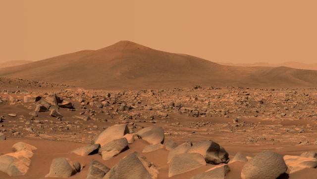
NASA's Perseverance Mars rover used its dual-camera Mastcam-Z imager to capture this image of "Santa Cruz," a hill about 1.5 miles (2.5 kilometers) away from the rover, on April 29, 2021, the 68th Martian day, or sol, of the mission. The entire scene is inside of Mars' Jezero Crater; the crater's rim can be seen on the horizon line beyond the hill. This scene is not white balanced; instead, it is displayed in a preliminary calibrated version of a natural-color composite, approximately simulating the colors of the scene as it would appear to a person on Mars. Arizona State University in Tempe leads the operations of the Mastcam-Z instrument, working in collaboration with Malin Space Science Systems in San Diego. A key objective for Perseverance's mission on Mars is astrobiology, including the search for signs of ancient microbial life. The rover will characterize the planet's geology and past climate, pave the way for human exploration of the Red Planet, and be the first mission to collect and cache Martian rock and regolith (broken rock and dust). Subsequent NASA missions, in cooperation with ESA (European Space Agency), would send spacecraft to Mars to collect these sealed samples from the surface and return them to Earth for in-depth analysis. The Mars 2020 Perseverance mission is part of NASA's Moon to Mars exploration approach, which includes Artemis missions to the Moon that will help prepare for human exploration of the Red Planet. https://photojournal.jpl.nasa.gov/catalog/PIA24546
This digital elevation map, produced from satellite data overlain on an image taken by the Mars Orbital Camera on NASA's Mars Global Surveyor spacecraft, shows changes in elevation along the trek of NASA's Mars Exploration Rover Spirit as of the rover's 328th martian day, or sol (Dec. 4, 2004). To that point, Spirit had driven a total of 3.89 kilometers (2.42 miles). The blue area represents the basaltic plains on the floor of Gusev Crater, about 20 meters (66 feet) below the rover's present location. Spirit crossed those plains for several months after landing to the west, off the left edge of this image. The greenish-blue area is the "West Spur" of the "Columbia Hills," which Spirit reached on sol 156 (June 11, 2004). Since then, Spirit has been gradually ascending the slopes of the "West Spur" in an east-northeasterly direction. Southeast of the rover's current position is a brighter green area that represents an abrupt increase in slope where the "West Spur" meets the steeper flanks of the "Columbia Hills." The yellow and red areas represent the highest slopes and peaks. A steep valley east of the rover's location appears, from orbiter images, to have layered outcrops. Scientists are directing the rover to a ridge overlooking the valley to get a better look at what lies ahead. http://photojournal.jpl.nasa.gov/catalog/PIA07089
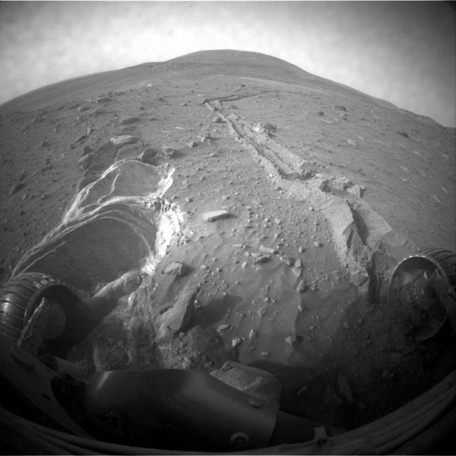
NASA's Mars Exploration Rover Spirit drove 6.98 meters (22.9 feet) southeastward on the 1,871st Martian day, or sol, of the rover's mission on Mars (April 8, 2009). As usual since losing the use of its right-front wheel in 2006, Spirit drove backward, dragging the immobile wheel. The rover used its front hazard-avoidance camera after the drive to capture this view looking back at the ground covered. For scale, the distance between the parallel wheel tracks is about 1 meter (40 inches). The drive added to progress in trekking counterclockwise around a low plateau called "Home Plate." Spirit is driving through a valley on the west side of the plateau. Home Plate is not within this image. The hill on the horizon in the upper right is Husband Hill, the summit of which is about 750 meters (nearly half a mile) to the north of Spirit's position. Following this drive, Spirit experienced difficulties that prevented driving during the subsequent week. http://photojournal.jpl.nasa.gov/catalog/PIA11990
This natural-color mosaic showing NASA's Ingenuity Mars Helicopter at "Valinor Hills" was acquired by the agency's Perseverance Mars rover on Feb. 21, 2024, the 1,068th Martian day, or sol, of the mission. The helicopter – the first aircraft to achieve powered, controlled flight on another world – sits just left of center, a speck-like figure amid a field of sand ripples. Ingenuity damaged its rotor blades during landing on its 72nd and final flight on Jan. 18, 2024. The helicopter team nicknamed the spot where the last flight concluded Valinor Hills after the fictional location in J.R.R. Tolkien's fantasy novels, which include "The Lord of the Rings" trilogy. The 67 images that were stitched together to make this mosaic were captured from about 1,365 feet (415 meters) away by the rover's Mastcam-Z camera. This is a wider and more detailed view of Valinor Hills than was shown in a previously released six-image Mastcam-Z mosaic that was taken from farther away. Arizona State University leads the operations of the Mastcam-Z instrument, working in collaboration with Malin Space Science Systems in San Diego, on the design, fabrication, testing, and operation of the cameras, and in collaboration with the Niels Bohr Institute of the University of Copenhagen on the design, fabrication, and testing of the calibration targets. A key objective for Perseverance's mission on Mars is astrobiology, including the search for signs of ancient microbial life. The rover will characterize the planet's geology and past climate, pave the way for human exploration of the Red Planet, and be the first mission to collect and cache Martian rock and regolith (broken rock and dust). Subsequent NASA missions, in cooperation with ESA (European Space Agency), would send spacecraft to Mars to collect these sealed samples from the surface and return them to Earth for in-depth analysis. The Mars 2020 Perseverance mission is part of NASA's Moon to Mars exploration approach, which includes Artemis missions to the Moon that will help prepare for human exploration of the Red Planet. https://photojournal.jpl.nasa.gov/catalog/PIA26237
NASA's Perseverance Mars rover snapped this view of a hill in Mars' Jezero Crater called "Santa Cruz" on April 29, 2021, the 68th Martian day, or sol, of the mission. About 20 inches (50 centimeters) across on average, the boulders in the foreground are among the type of rocks the rover team has named "Ch'al" (the Navajo term for "frog" and pronounced "chesh"). Perseverance will return to the area in the next week or so. Composed of multiple images, this enhanced-color mosaic was created using the left- and right-eye views of Perseverance's Mastcam-Z camera system, merging the scene into a single, wider view. Santa Cruz hill is a possible eroded remnant of Jezero Crater's western delta. The hill is about 164 feet (50 meters) tall and was roughly 1.6 miles (2.5 kilometers) east of the rover when the photo was taken, viewed from "Van Zyl Overlook." A key objective for Perseverance's mission on Mars is astrobiology, including the search for signs of ancient microbial life. The rover will characterize the planet's geology and past climate, pave the way for human exploration of the Red Planet, and be the first mission to collect and cache Martian rock and regolith (broken rock and dust). Subsequent NASA missions, in cooperation with ESA (European Space Agency), would send spacecraft to Mars to collect these sealed samples from the surface and return them to Earth for in-depth analysis. The Mars 2020 Perseverance mission is part of NASA's Moon to Mars exploration approach, which includes Artemis missions to the Moon that will help prepare for human exploration of the Red Planet. https://photojournal.jpl.nasa.gov/catalog/PIA25075
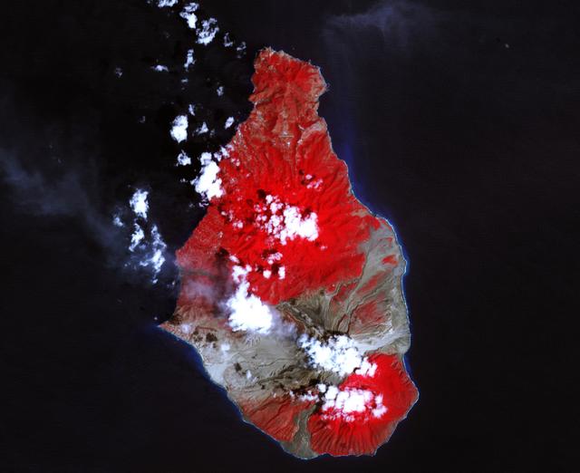
A massive eruption of Montserrat’s Soufrière Hills Volcano covered large portions of the island in debris. The eruption was triggered by a collapse of Soufrière Hills’ summit lava dome on February 11, 2010. Pyroclastic flows raced down the northern flank of the volcano, leveling trees and destroying buildings in the village of Harris, which was abandoned after Soufrière Hills became active in 1995. The Montserrat Volcano Observatory reported that some flows, about 15 meters (49 feet) thick, reached the sea at Trant’s Bay. These flows extended the island’s coastline up to 650 meters (2,100 feet). These false-color satellite images show the southern half of Montserrat before and after the dome collapse. The top image shows Montserrat on February 21, 2010, just 10 days after the event. For comparison, the bottom image shows the same area on March 17, 2007. Red areas are vegetated, clouds are white, blue/black areas are ocean water, and gray areas are covered by flow deposits. Fresh deposits tend to be lighter than older deposits. On February 21, the drainages leading down from Soufrière Hills, including the White River Valley, the Tar River Valley, and the Belham River Valley, were filled with fresh debris. According to the Montserrat Volcano Observatory, pyroclastic flows reached the sea through Aymers Ghaut on January 18, 2010, and flows entered the sea near Plymouth on February 5, 2010. NASA Earth Observatory image by Robert Simmon, using data from the NASA/GSFC/METI/ERSDAC/JAROS, and U.S./Japan ASTER Science Team. Caption by Robert Simmon. To read more go to: <a href="http://earthobservatory.nasa.gov/IOTD/view.php?id=42792" rel="nofollow">earthobservatory.nasa.gov/IOTD/view.php?id=42792</a> <b><a href="http://www.nasa.gov/centers/goddard/home/index.html" rel="nofollow">NASA Goddard Space Flight Center</a></b> is home to the nation's largest organization of combined scientists, engineers and technologists that build spacecraft, instruments and new technology to study the Earth, the sun, our solar system, and the universe. <b>Follow us on <a href="http://twitter.com/NASA_GoddardPix" rel="nofollow">Twitter</a></b> <b>Join us on <a href="http://www.facebook.com/pages/Greenbelt-MD/NASA-Goddard/395013845897?ref=tsd" rel="nofollow">Facebook</a><b> </b></b>

CAPE CANAVERAL, Fla. – At NASA's Kennedy Space Center in Florida, Aly Mendoza-Hill, NASA Launch Services Program mission manager, talks to agency social media followers during the second day of NASA Social activities revolving around NASA's Radiation Belt Storm Probes, or RBSP, mission. The probes are set to launch aboard a United Launch Alliance, or ULA, Atlas V rocket from nearby Cape Canaveral Air Force Station. About 40 followers were selected to participate in RBSP's prelaunch and launch activities. The RBSP mission will help us understand the sun’s influence on Earth and near-Earth space by studying the Earth’s radiation belts on various scales of space and time. RBSP will begin its mission of exploration of Earth’s Van Allen radiation belts and the extremes of space weather. For more information, visit http://www.nasa.gov/rbsp. Photo credit: NASA/Frankie Martin

From left to right, SpaceX Crew-1 NASA astronaut Shannon Walker, Japan Aerospace Exploration Agency (JAXA) astronaut Soichi Noguchi, Senator John Hickenlooper, D-Colo, NASA Deputy Administrator Pam Melroy, Senator Mark Kelly, D-Ariz., and NASA astronaut Victor Glover, pose for a photo at the Destination Station mobile exhibition on Capitol Hill, Wednesday, Nov. 17, 2021, in Washington. Walker, Glover, Noguchi, and NASA astronaut Mike Hopkins, launched on the first crew rotation mission to the International Space Station for SpaceX’s Falcon 9 and Crew Dragon spacecraft as part of the agency’s Commercial Crew Program and spent 168 days in space across Expeditions 64 and 65. Photo Credit: (NASA/Aubrey Gemignani)

NASA Deputy Administrator Pam Melroy, right, SpaceX Crew-1 NASA astronauts Victor Glover, left, and Shannon Walker, third from right, and Japan Aerospace Exploration Agency (JAXA) astronaut Soichi Noguchi, second from right, speak with Senator John Hickenlooper, D-Colo, at the Destination Station mobile exhibition on Capitol Hill, Wednesday, Nov. 17, 2021, in Washington. Walker, Glover, Noguchi, and NASA astronaut Mike Hopkins, launched on the first crew rotation mission to the International Space Station for SpaceX’s Falcon 9 and Crew Dragon spacecraft as part of the agency’s Commercial Crew Program and spent 168 days in space across Expeditions 64 and 65. Photo Credit: (NASA/Aubrey Gemignani)
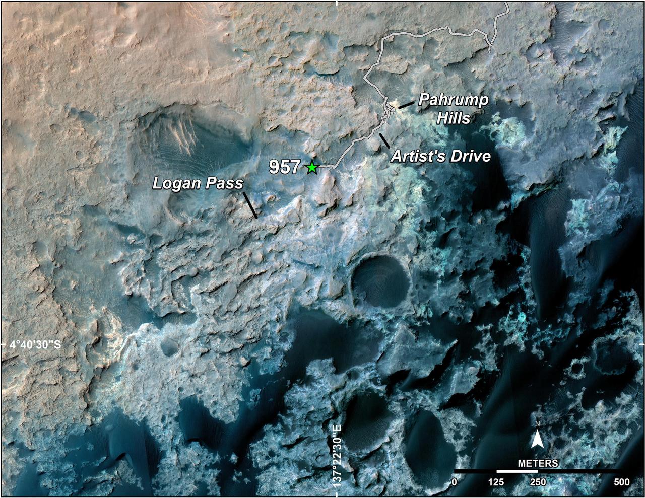
A green star marks the location of NASA's Curiosity Mars rover after a drive on the mission's 957th Martian day, or sol, (April 16, 2015). The map covers an area about 1.25 miles (2 kilometers) wide. Curiosity landed on Mars in August 2012. The drive on Sol 957 brought the mission's total driving distance past the 10-kilometer mark (6.214 miles). The rover is passing through a series of shallow valleys on a path from the "Pahrump Hills" outcrop, which it investigated for six months, toward its next science destination, called "Logan Pass." The rover's traverse line enters this map at the location Curiosity reached in mid-July 2014. The base map uses imagery from the High Resolution Imaging Science Experiment (HiRISE) camera on NASA's Mars Reconnaissance Orbiter. http://photojournal.jpl.nasa.gov/catalog/PIA19390
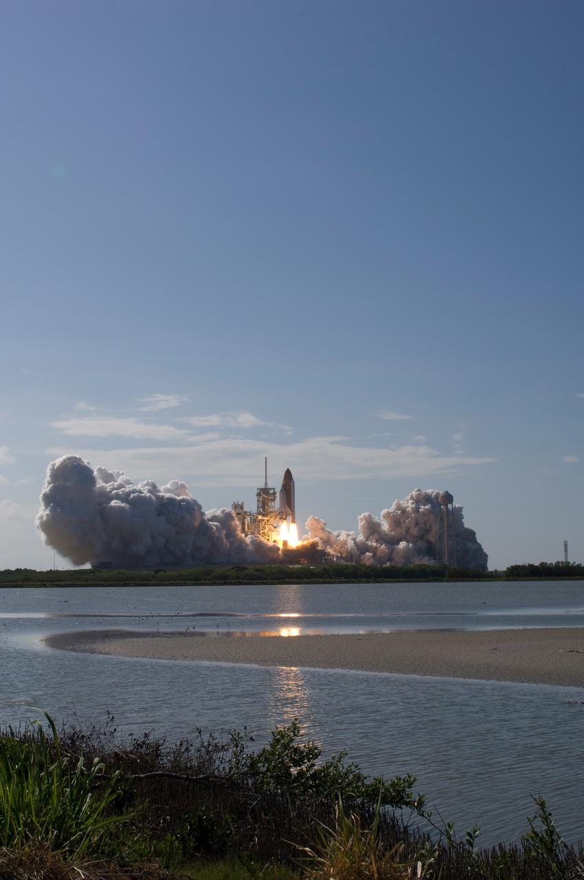
CAPE CANAVERAL, Fla. -- Hills of smoke and steam rise from Launch Pad 39A at NASA's Kennedy Space Center as space shuttle Discovery lifts off on its STS-124 mission to the International Space Station. Launch was on time at 5:02 p.m. EDT. Discovery is making its 35th flight. The STS-124 mission is the 26th in the assembly of the space station. It is the second of three flights launching components to complete the Japan Aerospace Exploration Agency's Kibo laboratory. The shuttle crew will install Kibo's large Japanese Pressurized Module and its remote manipulator system, or RMS. The 14-day flight includes three spacewalks. Photo credit: NASA/Sandra Joseph, Tony Gray, Robert Murray, Mike Kerley
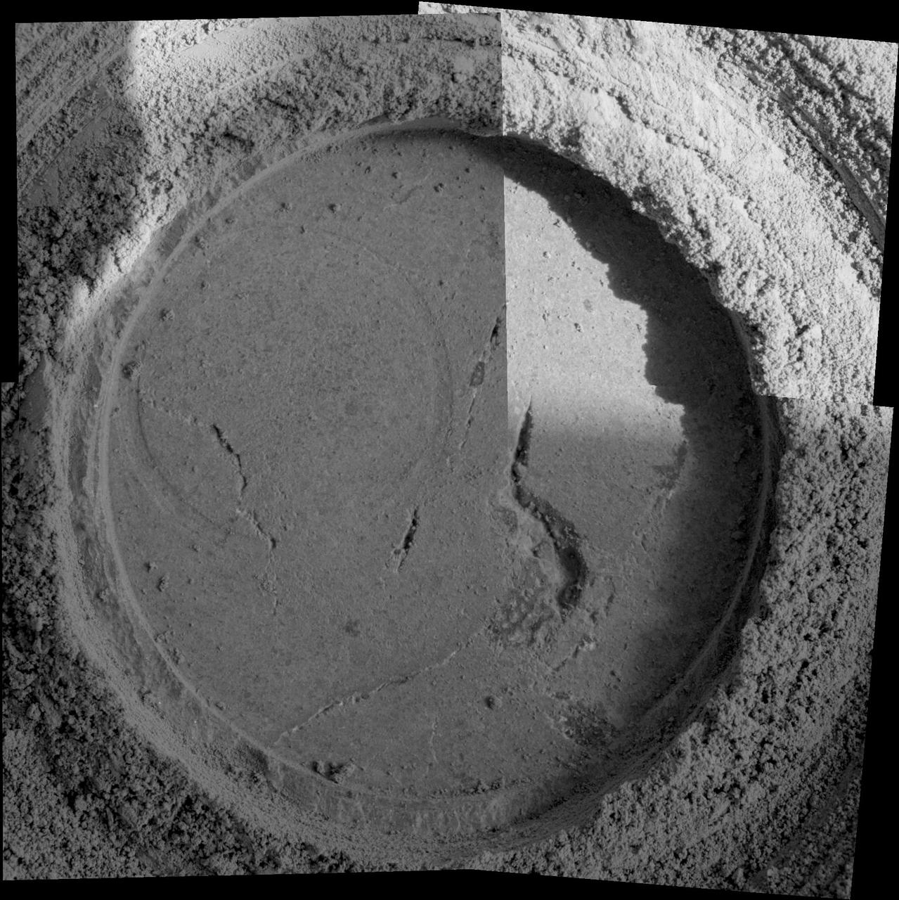
Close-up examination of a freshly exposed area of a rock called "Uchben" in the "Columbia Hills" of Mars reveals an assortment of particle shapes and sizes in the rock's makeup. NASA's Mars Exploration Rover Spirit used its microscopic imager during the rover's 286th martian day (Oct. 22, 2004) to take the frames assembled into this view. The view covers a circular hole ground into a target spot called "Koolik" on Uchben by the rover's rock abrasion tool. The circle is 4.5 centimeters (1.8 inches) in diameter. Particles in the rock vary in shape from angular to round, and range in size from about 0.5 millimeter (0.2 inch) to too small to be seen. This assortment suggests that the rock originated from particles that had not been transported much by wind or water, because such a transport process would likely have resulted in more sorting of the particles by size and shape. http://photojournal.jpl.nasa.gov/catalog/PIA07023
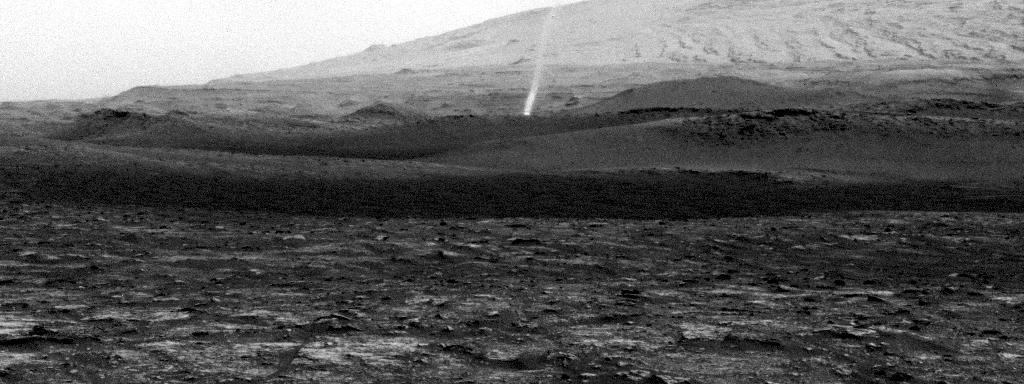
NASA's Curiosity Mars rover spotted this dust devil with one of its Navigation Cameras around 11:35 a.m. local Mars time on Aug. 9, 2020 (the 2,847th Martian day, or sol, of the mission). The frames in this GIF were shot over 4 minutes and 15 seconds. Taken from the "Mary Anning" drill site, this dust devil appears to be passing through small hills just above Curiosity's present location on Mount Sharp. The dust devil is approximately one-third to a half-mile (half-a-kilometer to a kilometer) away and estimated to be about 16 feet (5 meters) wide. The dust plume disappears past the top of the frame, so an exact height can't be known, but it's estimated to be at least 164 feet (50 meters) tall. Contrast has been modified to make frame-to-frame changes easier to see. Movie available at https://photojournal.jpl.nasa.gov/catalog/PIA24039
NASA's Mars Exploration Rover Spirit slipped in soft ground during short backward drives on the 1,886th and 1,889th Martian days, or sols, of the rover's mission on Mars (April 23 and 26, 2009). Spirit used its front hazard-avoidance camera after driving on Sol 1889 to get this wide-angle view, which shows the soil disturbed by the drives. Spirit drove 1.11 meters (3.6 feet) on Sol 1889 and 1.68 meters (5.5 feet) on Sol 1886. The rover drags its right front wheel, which no longer rotates. For scale, the distance between the wheel tracks is about 1 meter (40 inches). This view is looking northward, with Husband Hill on the horizon. http://photojournal.jpl.nasa.gov/catalog/PIA12002

Orville Wright makes the first powered, controlled flight on Earth as his brother Wilbur looks on in this image taken at Kitty Hawk, North Carolina, on Dec. 17, 1903. Orville Wright covered 120 feet in 12 seconds during the first flight. The Wright brothers made four flights that day, each longer than the last. A small amount of the material that covered the wing of the aircraft, Flyer 1, during the first flight was flown to Mars aboard NASA's Ingenuity Mars Helicopter. An insulative tape was used to wrap the small swatch of fabric around a cable located underneath the helicopter's solar panel. Ingenuity is scheduled to attempt the first powered, controlled flight on another planet in April 2021. The Wrights had been using the same type of material – an unbleached muslin called "Pride of the West" – to cover their glider and aircraft wings since 1901. A different piece of the material, along with a small splinter of wood, from the Flyer 1 was flown to the Moon and back aboard Apollo 11. The image was taken by John Daniels, a member of the U.S. Life-Saving Station in Kill Devil Hills, North Carolina. Until the day of the flight, Daniels had never seen a camera. https://photojournal.jpl.nasa.gov/catalog/PIA24434
Composed of 993 individual images and 2.38 billion pixels, this 360-degree mosaic taken by NASA's Perseverance looks in all directions from a location the rover science team calls "Airey Hill." The rover remained parked at Airey Hill during the entirety of solar conjunction. Captured by the rover's Mastcam-Z, the images used to create the mosaic were acquired on Nov. 3, Nov. 4, and Nov. 6, 2023, the 962nd, 963rd, and 965th Martian day, or sol, of the rover's mission. The main image is a natural color version at half-resolution. Arizona State University leads the operations of the Mastcam-Z instrument, working in collaboration with Malin Space Science Systems in San Diego, on the design, fabrication, testing, and operation of the cameras, and in collaboration with the Niels Bohr Institute of the University of Copenhagen on the design, fabrication, and testing of the calibration targets. A key objective for Perseverance's mission on Mars is astrobiology, including the search for signs of ancient microbial life. The rover will characterize the planet's geology and past climate, pave the way for human exploration of the Red Planet, and be the first mission to collect and cache Martian rock and regolith (broken rock and dust). Subsequent NASA missions, in cooperation with ESA (European Space Agency), would send spacecraft to Mars to collect these sealed samples from the surface and return them to Earth for in-depth analysis. The Mars 2020 Perseverance mission is part of NASA's Moon to Mars exploration approach, which includes Artemis missions to the Moon that will help prepare for human exploration of the Red Planet. https://photojournal.jpl.nasa.gov/catalog/PIA26080
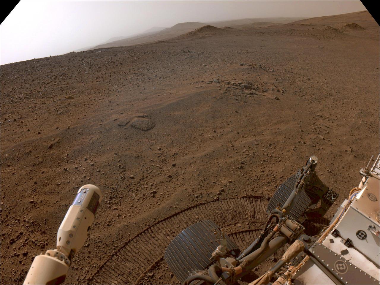
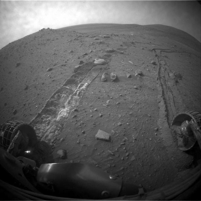
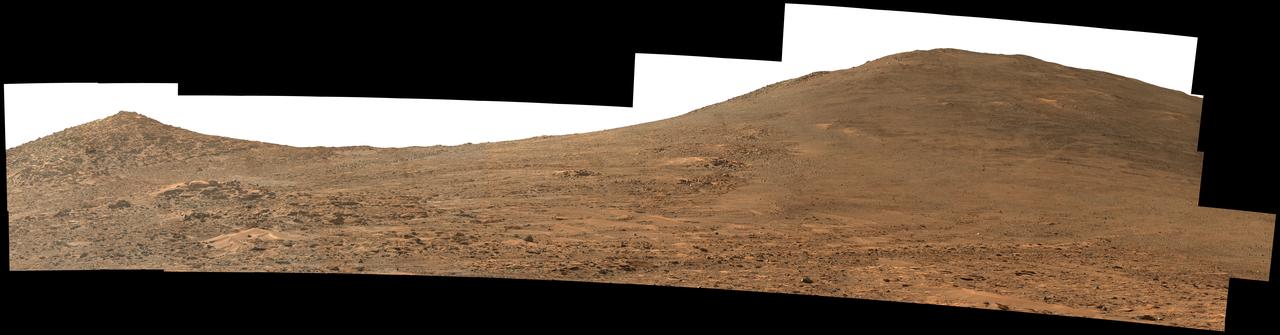
NASA's Perseverance Mars rover used its right-front navigation camera to capture this first view over the rim of Jezero Crater on Dec. 10, 2024, the 1,354th Martian day, or sol, of the mission, when it reached the end of its long climb from the crater floor. The rover is looking west in this image from a location nicknamed "Lookout Hill." Not visible is "Witch Hazel Hill," a scientifically significant rocky outcrop that Perseverance is headed toward. Once there, the rover will spend about six months exploring the area. Scientists are excited to explore the region outside of Jezero because the rover will encounter rocks excavated by a monster meteor impact that formed the crater an estimated 3.9 billion years ago. These rocks could not only be early Martian crust, but among the oldest rocks found anywhere in the solar system. A key objective for Perseverance's mission on Mars is astrobiology, including the search for signs of ancient microbial life. The rover will characterize the planet's geology and past climate, pave the way for human exploration of the Red Planet, and be the first mission to collect and cache Martian rock and regolith (broken rock and dust). Subsequent NASA missions, in cooperation with ESA (European Space Agency), would send spacecraft to Mars to collect these sealed samples from the surface and return them to Earth for in-depth analysis. The Mars 2020 Perseverance mission is part of NASA's Moon to Mars exploration approach, which includes Artemis missions to the Moon that will help prepare for human exploration of the Red Planet. https://photojournal.jpl.nasa.gov/catalog/PIA26511
NASA's Perseverance Mars rover looks out at the expanse of Jezero Crater's river delta on April 11, 2022, the 406th Martian day, or sol, of the mission. This panorama is made up of 64 individual images from the rover's Mastcam-Z camera system and stitched together after the files were sent back from Mars. The color bands of the image have been processed to improve visual contrast and accentuate color differences. The sky would not actually look blue to a human explorer on the Red Planet. The delta formed billions of years ago from sediment that an ancient river carried to the mouth of the lake that once existed in the crater. Aeolian bedforms (sand dunes) can be seen running along the base of the delta. The hills visible on the distant horizon to the far left of the image – about 3.8 miles (6.2 kilometers) away from the rover – are actually part of the rim of Jezero Crater. The peak of the delta remnant to the right center of the image is about 920 feet (260 meters) away and the peak of the hill camera right is about 950 feet (280 meters) away. The portion of the delta farthest left in this image (visible directly below the crater wall) is the area where "Cape Nukshak" and "Hawksbill Gap" channels can be found. The rover is expected to ascend to the top of the delta via one of these two channels. A key objective for Perseverance's mission on Mars is astrobiology, including the search for signs of ancient microbial life. The rover will characterize the planet's geology and past climate, pave the way for human exploration of the Red Planet, and be the first mission to collect and cache Martian rock and regolith (broken rock and dust). Subsequent NASA missions, in cooperation with ESA (European Space Agency), would send spacecraft to Mars to collect these sealed samples from the surface and return them to Earth for in-depth analysis. The Mars 2020 Perseverance mission is part of NASA's Moon to Mars exploration approach, which includes Artemis missions to the Moon that will help prepare for human exploration of the Red Planet. https://photojournal.jpl.nasa.gov/catalog/PIA25212
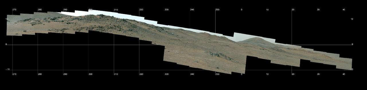
NASA's Perseverance Mars Rover used its Mastcam-Z camera system to capture this panorama of a location nicknamed "Pico Turquino Hills" on Oct. 22, 2024, the 1,306th Martian day, or sol, of the mission. This area is located on the rim of Jezero Crater. Perseverance landed on the crater's floor on Feb. 18, 2021, and has been steadily working its way up and out of the crater since August 2024. The rocks in Pico Turquino Hills are among the oldest yet found by Perseverance, forming in a different geologic era than almost everything the rover has seen before. They're likely part of the original surface that existed before Jezero Crater's formation by a massive asteroid about 3.9 billion years ago. The rocks here are mostly made up of volcanic minerals like olivine, plagioclase, and pyroxene. In the far-right corner of the panorama is a field of white cobbles. This represents the first time Perseverance has encountered pure quartz rock, which may have been created by a hydrothermal system like hot springs – an environment life could have survived in, if any existed on the Red Planet billions of years ago. Arizona State University leads the operations of the Mastcam-Z instrument, working in collaboration with Malin Space Science Systems in San Diego, on the design, fabrication, testing, and operation of the cameras, and in collaboration with the Niels Bohr Institute of the University of Copenhagen on the design, fabrication, and testing of the calibration targets. A key objective for Perseverance's mission on Mars is astrobiology, including the search for signs of ancient microbial life. The rover will characterize the planet's geology and past climate, pave the way for human exploration of the Red Planet, and be the first mission to collect and cache Martian rock and regolith (broken rock and dust). Subsequent NASA missions, in cooperation with ESA (European Space Agency), would send spacecraft to Mars to collect these sealed samples from the surface and return them to Earth for in-depth analysis. The Mars 2020 Perseverance mission is part of NASA's Moon to Mars exploration approach, which includes Artemis missions to the Moon that will help prepare for human exploration of the Red Planet. https://photojournal.jpl.nasa.gov/catalog/PIA26473
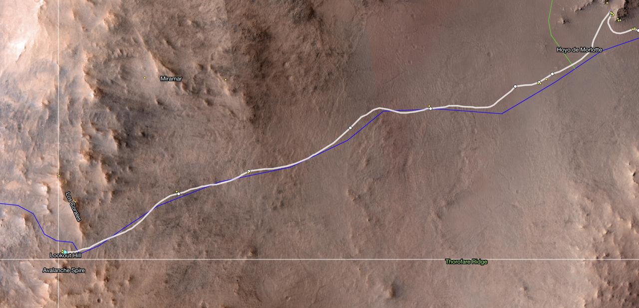
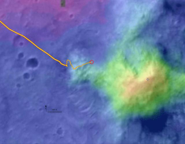
This map shows the location of NASA's Perseverance Mars rover as of Dec. 10, 2024, the 1,354th Martian day, or sol, of the mission, which it reached "Lookout Hill" at the top of Jezero Crater's rim after a monthslong climb. This map was made using data from NASA's Mars Reconnaissance Orbiter's High-Resolution Imaging Science Experiment (HiRISE) camera as well as the European Space Agency's (ESA) High Resolution Stereo Camera (HRSC). The University of Arizona, in Tucson, operates HiRISE, which was built by Ball Aerospace & Technologies Corp., in Boulder, Colorado, NASA's Jet Propulsion Laboratory manages the Mars Reconnaissance Orbiter Project for NASA's Science Mission Directorate, Washington. A key objective for Perseverance's mission on Mars is astrobiology, including the search for signs of ancient microbial life. The rover will characterize the planet's geology and past climate, pave the way for human exploration of the Red Planet, and be the first mission to collect and cache Martian rock and regolith (broken rock and dust). Subsequent NASA missions, in cooperation with ESA (European Space Agency), would send spacecraft to Mars to collect these sealed samples from the surface and return them to Earth for in-depth analysis. The Mars 2020 Perseverance mission is part of NASA's Moon to Mars exploration approach, which includes Artemis missions to the Moon that will help prepare for human exploration of the Red Planet. https://photojournal.jpl.nasa.gov/catalog/PIA26512
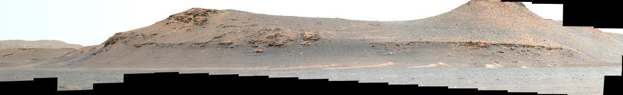
NASA's Perseverance Mars rover used its Mastcam-Z instrument to capture this view looking south toward the rim of Jezero Crater. The panorama, which encompasses 80 degrees, is made up of 59 individual images. They were captured on Aug. 4, 2024, the 1,229th Martian day, or sol, of the mission, and stitched together after being sent back to Earth. The color has been enhanced to bring out subtle details. "Dox Castle," a region the Perseverance science team wants to visit during the rover's climb up the crater rim, is about a half-mile (740 meters) away, on the left side of the hill at right. After the exploration of Dox Castle is complete, the rover will continue its climb up the crater rim, taking a route somewhere in between the two hills. Arizona State University leads the operations of the Mastcam-Z instrument, working in collaboration with Malin Space Science Systems in San Diego, on the design, fabrication, testing, and operation of the cameras, and in collaboration with the Niels Bohr Institute of the University of Copenhagen on the design, fabrication, and testing of the calibration targets. A key objective for Perseverance's mission on Mars is astrobiology, including the search for signs of ancient microbial life. The rover will characterize the planet's geology and past climate, pave the way for human exploration of the Red Planet, and be the first mission to collect and cache Martian rock and regolith (broken rock and dust). https://photojournal.jpl.nasa.gov/catalog/PIA26373
The robotic arm on NASA's Perseverance Mars rover used its percussive drill to core and collect the "Main River" rock sample on March 10, 2025, the 1,441st Martian day, or sol, of the mission. The time-lapse movie, taken by one of the rover's hazard cameras, is made up of 35 images taken over the course of 34 minutes. The sample was taken from a rock the rover science team named "Broom Point" at a location near the rim of Jezero Crater called "Witch Hazel Hill." A key objective for Perseverance's mission on Mars is astrobiology, including the search for signs of ancient microbial life. The rover will characterize the planet's geology and past climate, pave the way for human exploration of the Red Planet, and be the first mission to collect and cache Martian rock and regolith (broken rock and dust). Subsequent NASA missions, in cooperation with ESA (European Space Agency), would send spacecraft to Mars to collect these sealed samples from the surface and return them to Earth for in-depth analysis. The Mars 2020 Perseverance mission is part of NASA's Mars Exploration Program (MEP) portfolio and the agency's Moon to Mars exploration approach, which includes Artemis missions to the Moon that will help prepare for human exploration of the Red Planet. Animation available at https://photojournal.jpl.nasa.gov/catalog/PIA26571
This view from the Mast Camera (Mastcam) on NASA's Curiosity Mars rover shows a site where two different types of bedrock meet on lower Mount Sharp. The scene combines multiple images taken by the left-eye camera of Mastcam on May 25, 2015, during the 995th Martian day, or sol, of Curiosity's work on Mars, in a valley just below "Marias Pass." The color has been approximately white-balanced to resemble how the scene would appear under daytime lighting conditions on Earth. The paler part of the outcrop, in the foreground, is mudstone similar to what Curiosity examined in 2014, and in early 2015, at "Pahrump Hills." The darker, finely bedded bedrock higher in the image and overlying the mudstone stratigraphically is sandstone that the rover team calls the "Stimson" unit. The scene covers an area about 10 feet (3 meters) wide in the foreground. Malin Space Science Systems, San Diego, built and operates the rover's Mastcam. NASA's Jet Propulsion Laboratory, a division of the California Institute of Technology, Pasadena, manages the Mars Science Laboratory Project for NASA's Science Mission Directorate, Washington. http://photojournal.jpl.nasa.gov/catalog/PIA19676
This image of the floor of Jezero Crater was taken by one of the Navcam imagers aboard NASA's Perseverance Mars rover on Feb. 5, 2023, the 698th Martian day, or sol, of the mission. The rover's tracks can be seen disappearing into the distance. The flat-topped hill that the science team refers to as "Kodiak," a remnant of Jezero Crater's river delta, is in the upper right of image, about 0.6 miles (1 kilometer) away. A key objective for Perseverance's mission on Mars is astrobiology, including the search for signs of ancient microbial life. The rover will characterize the planet's geology and past climate, pave the way for human exploration of the Red Planet, and be the first mission to collect and cache Martian rock and regolith (broken rock and dust). Subsequent NASA missions, in cooperation with ESA (European Space Agency), would send spacecraft to Mars to collect these sealed samples from the surface and return them to Earth for in-depth analysis. The Mars 2020 Perseverance mission is part of NASA's Moon to Mars exploration approach, which includes Artemis missions to the Moon that will help prepare for human exploration of the Red Planet. https://photojournal.jpl.nasa.gov/catalog/PIA25684
Wheel slippage during attempts to extricate NASA's Mars Rover Spirit from a patch of soft ground during the preceding two weeks had partially buried the wheels by the 1,899th Martian day, or sol, of the Spirit's mission on Mars (May 6, 2009). Spirit took this image with its front hazard-avoidance camera on Sol 1899. With Spirit in the position shown here, the rover team temporarily suspended driving attempts while studying the ground around Spirit and planning simulation tests of driving options with a test rover at NASA's Jet Propulsion Laboratory in Pasadena, Calif. Driving attempts between the time Spirit took a similar image (PIA12002) 10 sols earlier and when this image was taken moved the rover a total of about 36 centimeters (14 inches). While driving backwards, the rover drags its right front wheel, which no longer rotates. For scale, the distance between the wheel tracks is about 1 meter (40 inches). This view is looking northward, with Husband Hill on the horizon. http://photojournal.jpl.nasa.gov/catalog/PIA12007
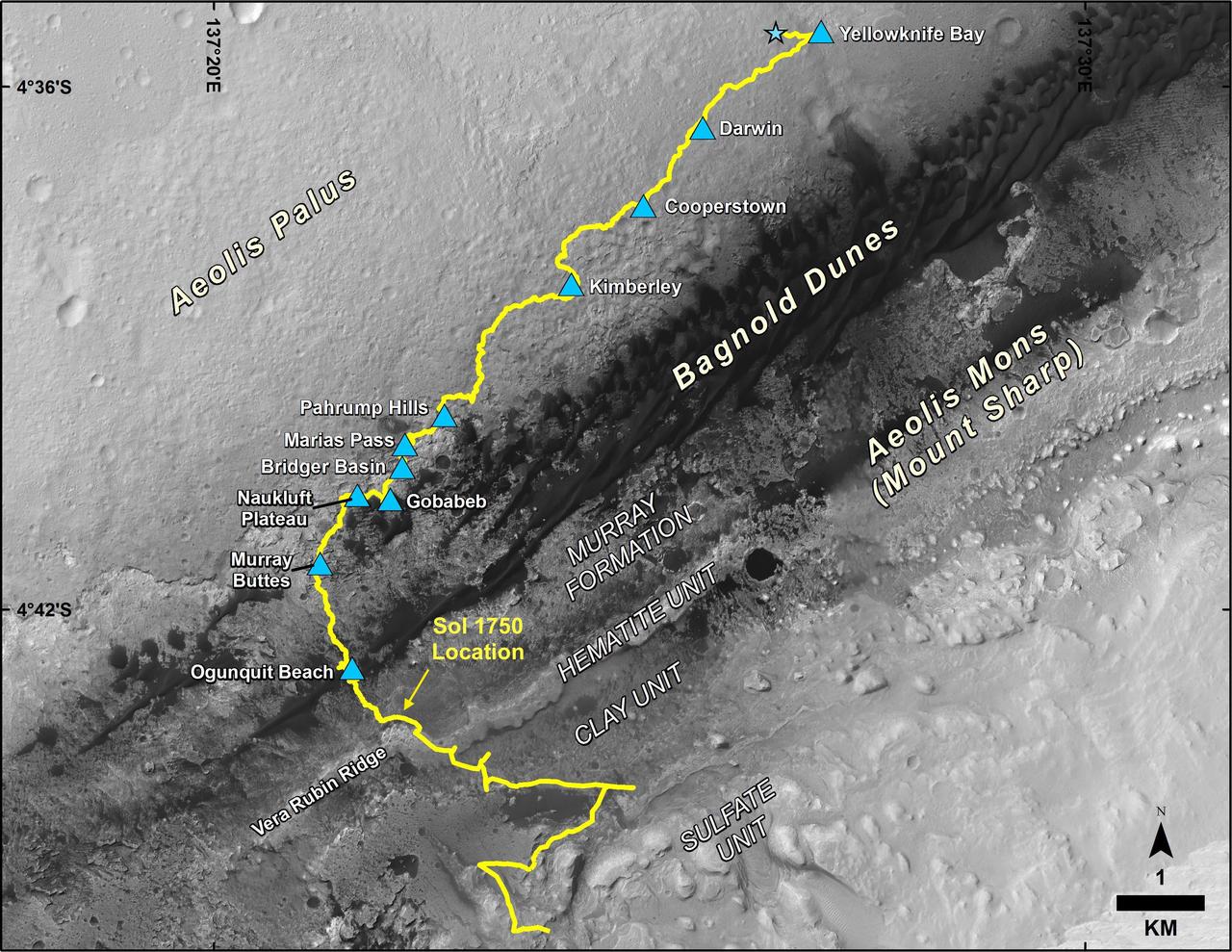
This map shows the route driven by NASA's Curiosity Mars rover, from the location where it landed in August 2012 to its location in July 2017, and its planned path to additional geological layers of lower Mount Sharp. The blue star near top center marks "Bradbury Landing," the site where Curiosity arrived on Mars on Aug. 5, 2012, PDT (Aug. 6, EDT and Universal Time). Blue triangles mark waypoints investigated by Curiosity on the floor of Gale Crater and, starting with "Pahrump Hills," on Mount Sharp. The Sol 1750 label identifies the rover's location on July 9, 2017, the 1,750th Martian day, or sol, since the landing. In July 2017, the mission is examining "Vera Rubin Ridge" from the downhill side of the ridge. Spectrometry observations from NASA's Mars Reconnaissance Orbiter have detected hematite, an iron-oxide mineral, in the ridge. Curiosity's planned route continues to the top of the ridge and then to geological units where clay minerals and sulfate minerals have been detected from orbit. The base image for the map is from the High Resolution Imaging Science Experiment (HiRISE) camera on the Mars Reconnaissance Orbiter. North is up. "Bagnold Dunes" form a band of dark, wind-blown material at the foot of Mount Sharp. https://photojournal.jpl.nasa.gov/catalog/PIA21720

"On my first day, I felt like I did not belong. I felt like I was unqualified. That’s the thing: the people around here, I don’t know if it’s just the culture or the area where we are, but these people around here, they just encourage you: 'You can do it!' and 'Let me show you this, there’s nothing to it!' I mean, really, they forced me out of my element, even into where I am right now. I belong now. I definitely belong now. I don’t feel out of place. I feel like I have a better handle on things compared to when I was younger and easily intimidated. I feel like I belong now. "My goal right now is to find a need and fill it. That’s my thing. And that’s all through life. Any job, any position. That’s the goal. Find the need. Find what you’re good at. And you fill that need." Candis Hills, Facilities and Asset Management, Boeing, Friday, June 28, 2019 at Michoud Assembly Facility, New Orleans, LA. Photo Credit: (NASA/Aubrey Gemignani)

A rippled linear dune of dark Martian sand, "Nathan Bridges Dune," dominates this full-circle panorama from the Mast Camera (Mastcam) of NASA's Curiosity Mars rover. This dune was one research stop of the rover mission's campaign to investigate active Martian dunes. The feature was informally named in 2017 in memory of Nathan Bridges (1966-2017), a planetary scientist who was a leader of the Curiosity team's dune campaign. The scene combines 112 images taken with Mastcam's left-eye camera on Feb. 5, 2017, during the 1,601st Martian day, or sol, of Curiosity's work on Mars. The panorama has been white-balanced so that colors of the rock and sand materials resemble how they would appear under daytime lighting conditions on Earth. The center is toward east-southeast and both ends are toward west-northwest. The dark butte on the horizon in the left half is "Ireson Hill." Upper Mount Sharp is on the horizon in the center. An annotated figure and full resolution TIFF file is available at https://photojournal.jpl.nasa.gov/catalog/PIA21719
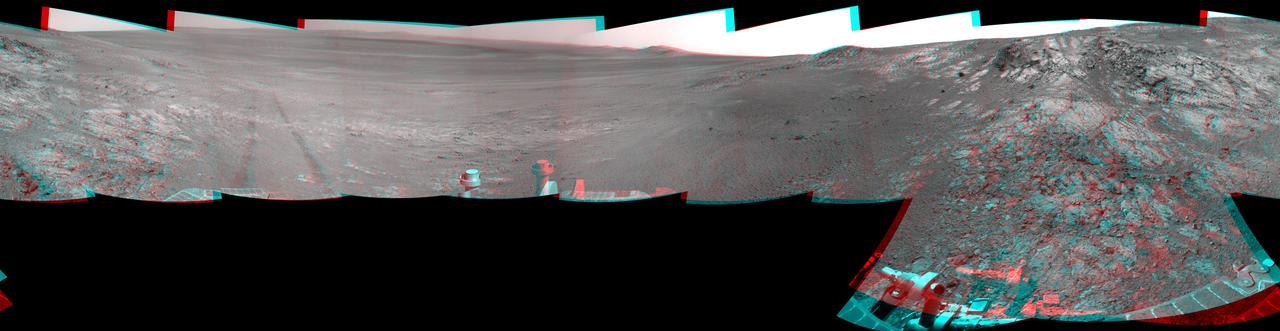
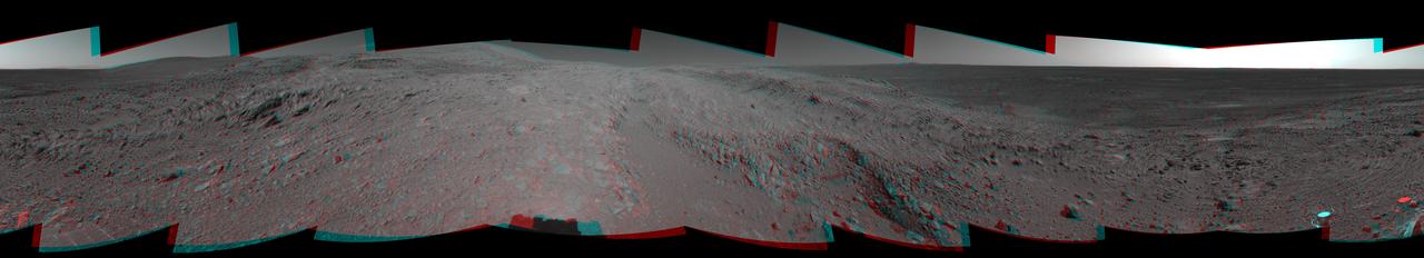
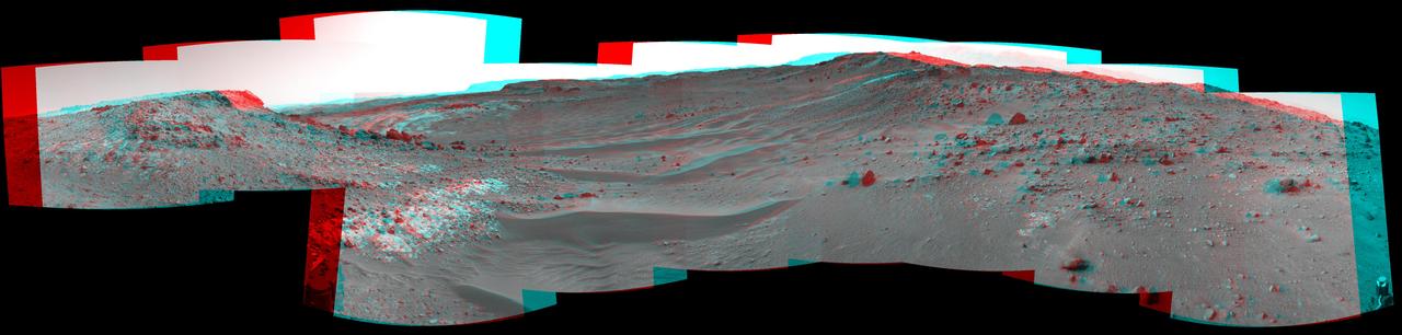
This full-circle, stereo panorama shows the terrain around the NASA Mars Exploration Rover Opportunity during the 3,105th Martian day, or sol, of the rover's work on Mars (Oct. 18, 2012). It was assembled from images taken by the rover's navigation camera. The view appears in three dimensions when viewed through red-blue glasses with the red lens on the left. South is at the center. North is on both ends. Opportunity had driven about 61 feet (18.5 meters) westward earlier on Sol 3105 to reach this location, which is on the northern portion of "Matijevic Hill" on the "Cape York" segment of the western rim of Endeavour Crater. The wheel tracks created by the drive are visible. For scale, the distance between the two parallel tracks is about 3.3 feet (1 meter). The basin of Endeavour Crater is in the left half of the image. Opportunity has been working on the western rim of Endeavour since mid-2011. The stereo panorama is presented as a cylindrical-perspective projection. http://photojournal.jpl.nasa.gov/catalog/PIA16559
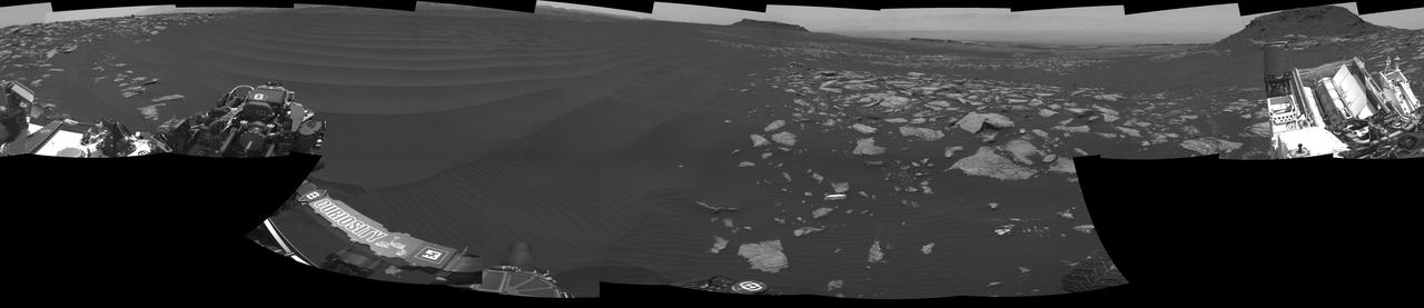
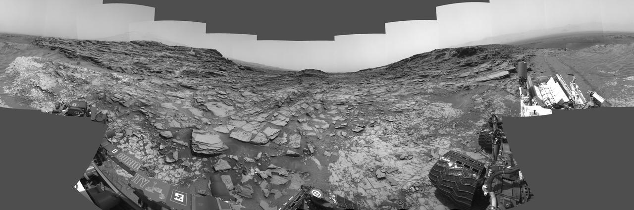
NASA's Curiosity Mars rover used its Mast Camera, or Mastcam, to take this 360-degree panorama of at the "Avanavero" drill site. The panorama is made up of 127 individual images taken on June 20, 2022, the 3,509th Martian day, or sol, of the mission, and stitched together back on Earth. The color has been adjusted to match the lighting conditions as the human eye would perceive them on Earth. At this location, Curiosity used the drill on its robotic arm to collect a rock sample for analysis by laboratory instruments inside the vehicle. It has collected more than three dozen such samples in its decade on the Red Planet. In the center of the panorama is a gap between two hills – nicknamed "Paraitepuy Pass" – that Curiosity is currently driving through; beyond it is a layered sulfate-bearing region, which represents a drier, saltier era in the history of Mount Sharp, the 3-mile-tall (5-kilometer-tall) mountain the rover has been ascending since 2014. https://photojournal.jpl.nasa.gov/catalog/PIA25407
This 360-degree panorama from the Navigation Camera (Navcam) on NASA's Curiosity Mars rover shows the surroundings of a site on lower Mount Sharp where the rover spent its 1,000th Martian day, or sol, on Mars. Sol 1,000 of Curiosity's Mars-surface mission corresponded to May 30, 2015. The component images for this scene were taken on Sol 997 (May 27, 2015). The site is a valley just below "Marias Pass" on lower Mount Sharp. A map of the area is at http://mars.nasa.gov/msl/images/Curiosity_Location_Sol997-full.jpg. Tracks from the rover's drive to this site are visible at right. The rover team chose this location near Marias Pass because images from orbit showed what appeared to be a contact between two types of bedrock. The two types are evident in this panorama. The bedrock close to the rover is pale mudstone similar to what Curiosity examined in 2014 and early 2015 at "Pahrump Hills." The darker, finely bedded bedrock above it is sandstone that the rover team calls the "Stimson" unit. The largest-looking slab of Stimson sandstone in the image, in the lower left quadrant, is a target called "Ronan," selected for close-up inspection. http://photojournal.jpl.nasa.gov/catalog/PIA19679
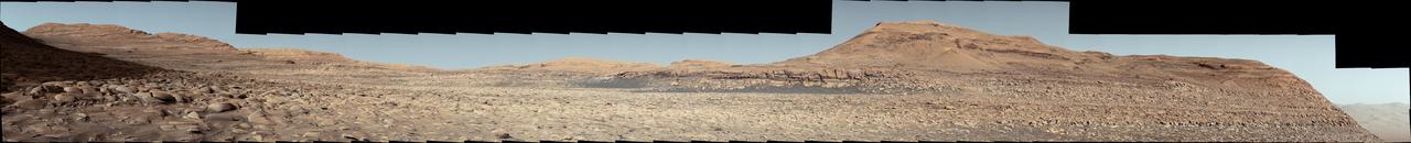
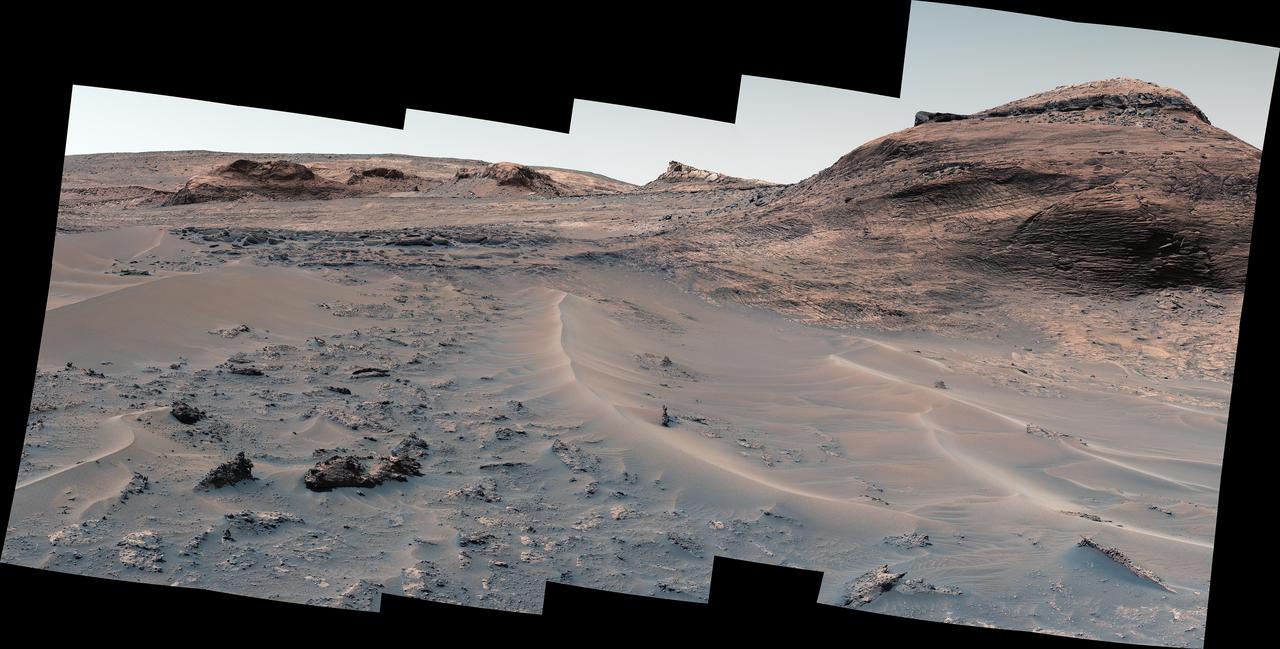
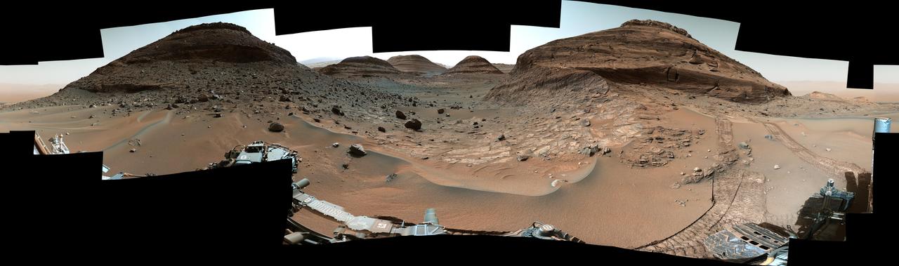
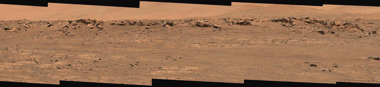
NASA's Curiosity Mars rover used its Mast Camera, or Mastcam, to capture this panorama in morning light on March 9, 2025, the 4,476th Martian day, or sol, of the mission. Steep hills on the left side of the panorama enclose wind-carved valleys on Mount Sharp, the mountain that Curiosity has been climbing for over a decade. Broken-up, rounded rocks throughout the foreground are part of the mountain's sulfate-bearing unit. The butte in the distance at right is nicknamed "Gould Mesa." A band of cliffs and dark ridges near the top of the butte may be the first glimpses of boxwork formations, a kind of feature created by groundwater flowing through large bedrock fractures in the ancient past. Assuming that is how they formed, these could represent the last gasps of water found on this region of Mars before the planet dried out completely. Before now, these features had only been viewed from orbiting spacecraft, to which they appeared as spiderweb-like fractures. This pattern of fractures stretches as long as 6 to 12 miles (10 to 20 kilometers) across the side of Mount Sharp. The rover's team expects to study these formations up close throughout the rest of 2025. The color in this image has been adjusted to match lighting conditions as the human eye would see them on Earth. https://photojournal.jpl.nasa.gov/catalog/PIA26552
NASA's Curiosity Mars rover used its black-and-white navigation cameras to capture panoramas of this scene at two times of day. Blue, orange, and green color was added to a combination of both panoramas for an artistic interpretation of the scene. On Nov. 16, 2021 (the 3,299th Martian day, or sol, of the mission), engineers commanded Curiosity to take two sets of mosaics, or composite images, capturing the scene at 8:30 a.m. and again at 4:10 p.m. local Mars time. The two times of day provided contrasting lighting conditions that brought out a variety of unique landscape details. They combined the two scenes in an artistic re-creation that includes images from the morning scene in blue, the afternoon scene in orange, and a combination of both in green. The main image is an artistic interpretation of the scene. Figure 1 is the mosaic taken in the afternoon. Figure 2 is the mosaic taken in the morning. At the center of the image is the view back down Mount Sharp, the 3-mile-tall (5-kilometer-tall) mountain that Curiosity has been driving up since 2014. Rounded hills can be seen in the distance at center-right; Curiosity got a closer view of these back in July, when the rover started to see intriguing changes in the landscape. A field of sand ripples known as the "Sands of Forvie" stretches a quarter- to a half-mile (400 to 800 meters) away. At the far right of the panorama is the craggy "Rafael Navarro Mountain," named after a Curiosity team scientist who passed away earlier this year. Poking up behind it is the upper part of Mount Sharp, far above the area Curiosity is exploring. Mount Sharp lies inside Gale Crater, a 96-mile-wide (154-kilometer-wide) basin formed by an ancient impact; Gale Crater's distant rim stands 7,500 feet tall (2.3 kilometers), and is visible on the horizon about 18 to 25 miles away (30 to 40 kilometers). https://photojournal.jpl.nasa.gov/catalog/PIA24937
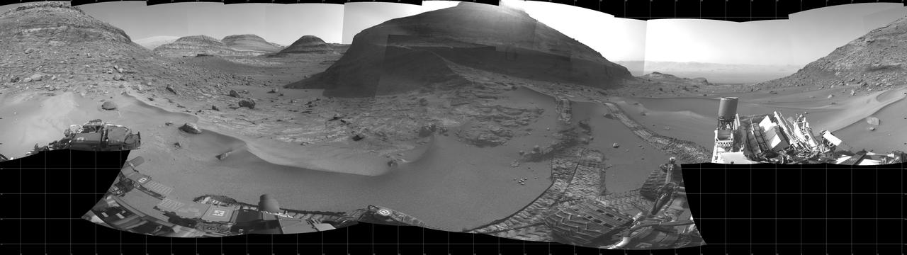
NASA's Curiosity Mars rover captured this 360-degree panorama while parked below Gediz Vallis Ridge (the hill-like slope at right). After three attempts over the course of three years, the rover finally reached the ridge on its fourth try on Aug. 14, 2023, the 3,923rd Martian day, or sol, of the mission. On Aug. 19, Curiosity's Mastcam took the 136 individual images that were stitched together into this mosaic after being sent back to Earth. The color has been adjusted to match lighting conditions as the human eye would see them on Earth. Gediz Vallis Ridge was one of the last features to form on Mount Sharp, the 3-mile-tall (5-kilometer-tall) mountain that Curiosity has been ascending since 2014. The ridge preserves a record of one of the last wet periods seen on this part of Mars. Reaching the ridge was no easy feat: previous forays were stymied by knife-edged "gator-back" rocks and too-steep slopes. Arriving after one of the most difficult climbs the mission has ever faced, Curiosity spent 11 days at the ridge. It then departed to ascend higher up the mountain, where the rover will investigate Gediz Vallis Channel, through which water flowed some 3 billion years ago, carrying rocks and debris that piled up to form the ridge. https://photojournal.jpl.nasa.gov/catalog/PIA26019

CAPE CANAVERAL, Fla. - NASA's Shuttle Launch Director Mike Leinbach, left, Kennedy Space Center Director Bob Cabana and NASA Administrator Charles Bolden wait to welcome the STS-130 crew back to Earth following space shuttle Endeavour's successful landing on Runway 15 at the Shuttle Landing Facility at NASA's Kennedy Space Center in Florida. At right, Bill Hill, NASA's assistant associate administrator for Space Shuttle Program, looks on. After 14 days in space, Endeavour's 5.7-million-mile STS-130 mission was completed on orbit 217. Main gear touchdown was at 10:20:31 p.m. EST followed by nose gear touchdown at 10:20:39 p.m. and wheels stop at 10:22:10 p.m. It was the 23rd night landing in shuttle history and the 17th at Kennedy. During Endeavour's STS-130 mission, astronauts installed the Tranquility node, a module that provides additional room for crew members and many of the station's life support and environmental control systems. Attached to Tranquility is a cupola with seven windows that provide a panoramic view of Earth, celestial objects and visiting spacecraft. The module was built in Turin, Italy, by Thales Alenia Space for the European Space Agency. The orbiting laboratory is approximately 90 percent complete now in terms of mass. STS-130 was the 24th flight for Endeavour, the 32nd shuttle mission devoted to ISS assembly and maintenance, and the 130th shuttle mission to date. For information on the STS-130 mission and crew, visit http:__www.nasa.gov_mission_pages_shuttle_shuttlemissions_sts130_index.html. Photo credit: NASA_Kim Shiflett
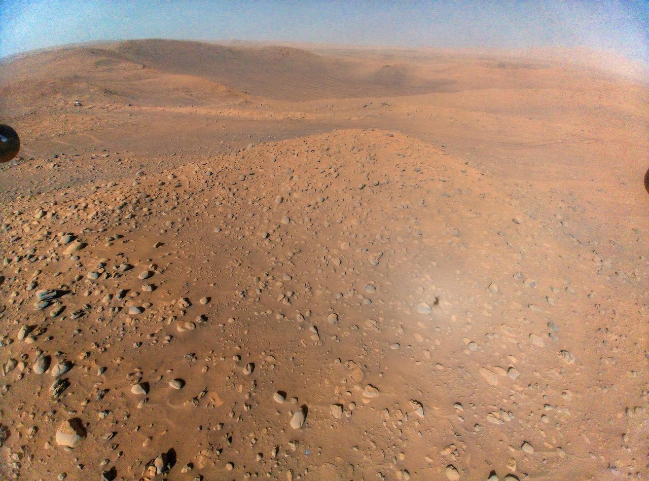
This wide view of Mars' Jezero Crater was taken by NASA's Perseverance rover on July 15, 2021 (the 143rd sol, or Martian day, of its mission). The rover has driven nearly a mile (1.5 kilometers) south of its landing site, "Octavia E. Butler Landing," into a region the team has nicknamed the "Crater Floor Fractured Rough" unit. The stones that appear light-colored and flat in this image are informally referred to as the "paver rocks" and will be the first type from which Perseverance will collect a sample for planned return to Earth by subsequent missions. Small hills to the south of the rover and the sloping inner walls of the Jezero Crater rim fill the distant background of this view. Five images from the rover's Mastcam-Z instrument were calibrated and combined to make this mosaic. Perseverance has been exploring the floor of Jezero since landing on Feb. 18, 2021. The Mastcam-Z investigation is led and operated by Arizona State University in Tempe, working in collaboration with Malin Space Science Systems in San Diego, California, on the design, fabrication, testing, and operation of the cameras, and in collaboration with the Neils Bohr Institute of the University of Copenhagen on the design, fabrication, and testing of the calibration targets. A key objective for Perseverance's mission on Mars is astrobiology, including the search for signs of ancient microbial life. The rover will characterize the planet's geology and past climate, pave the way for human exploration of the Red Planet, and be the first mission to collect and cache Martian rock and regolith. The Mars 2020 Perseverance mission is part of NASA's Moon to Mars exploration approach, which includes Artemis missions to the Moon that will help prepare for human exploration of the Red Planet. Subsequent NASA missions, in cooperation with ESA (European Space Agency), would send spacecraft to Mars to collect these sealed samples from the surface and return them to Earth for in-depth analysis. https://photojournal.jpl.nasa.gov/catalog/PIA24745