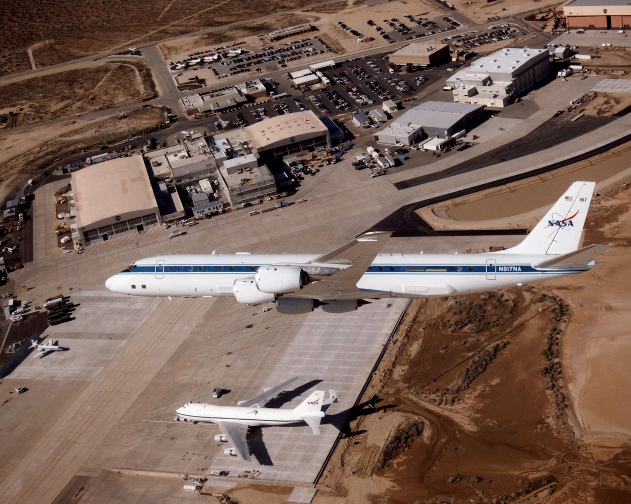
The DC-8 aircraft is seen making a banking turn high above the NASA Dryden ramp. This view of the DC-8's left side reveals some of the modifications necessary for particular on-board experiments. To the right of the DC-8 is the edge of Rogers Dry Lake. Above the aircraft's forward fuselage is the Dryden Flight Research Center headquarters building, while other NASA facilities extend down the flightline to the right. Below the DC-8 is the Shuttle Carrier Aircraft (SCA), on which are visible attachment points for the Shuttle Orbiter.

NASA Monsoon Multidisciplinary analysis (NAMMA) deployment, Sal Island, Cape Verde Africia DC-8 NAMMA MISSION TO CAPE VERDE, AFRICA: NASA Ames photographer Eric James videotapes the formaton flight with the U.K.'s FAAM aircrft BAE-146 off the coast of Senegal, Africa.
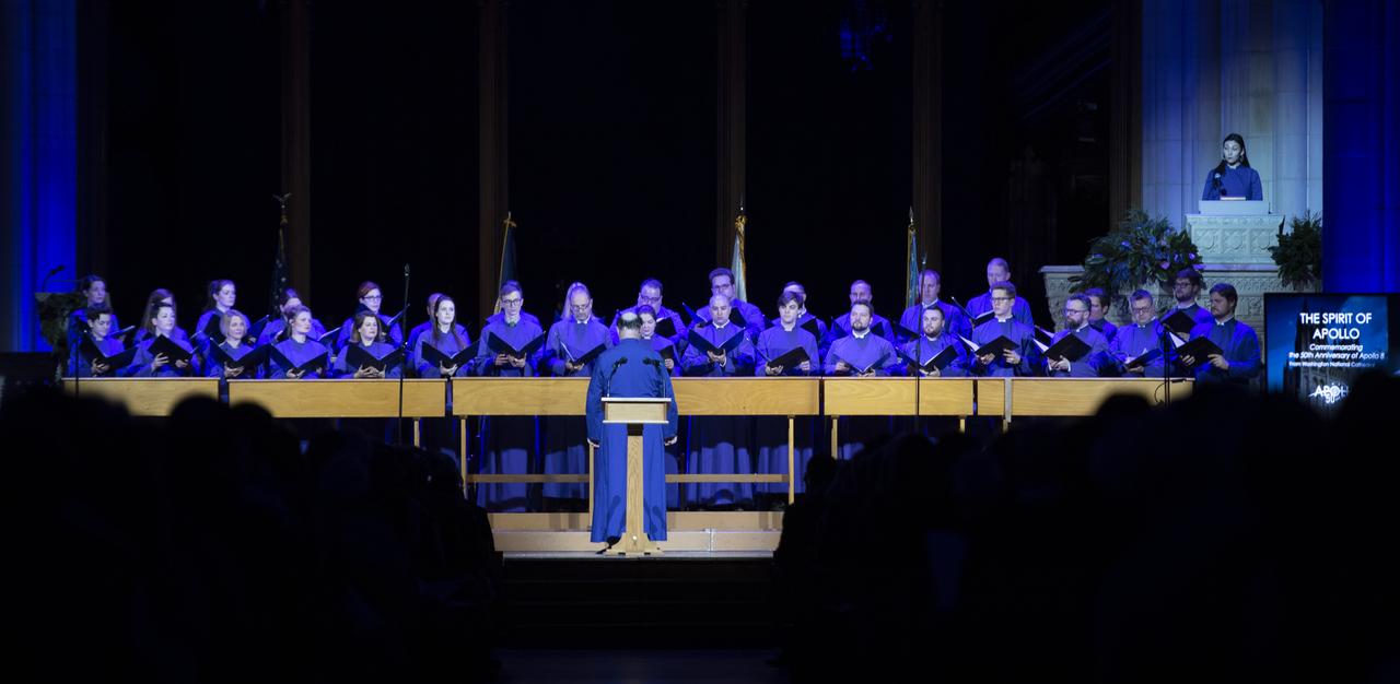
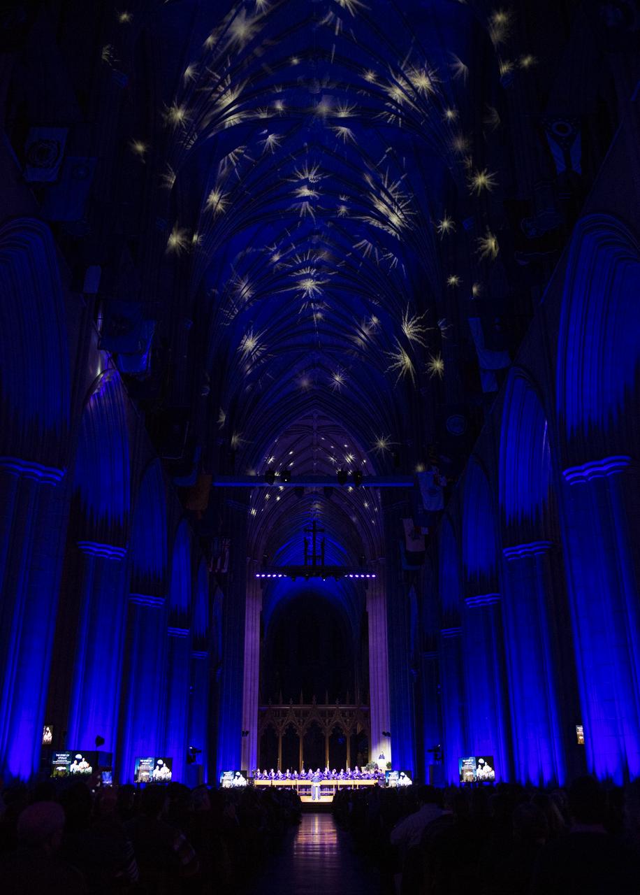
The Washington National Cathedral Choir performs a choral performance of Apollo 8's Christmas Eve broadcast during the Smithsonian National Air and Space Museum's Spirit of Apollo event commemorating the 50th anniversary of Apollo 8, Tuesday, Dec. 11, 2018 at the Washington National Cathedral in Washington, DC. Apollo 8 was humanity's first journey to another world, taking astronauts Frank Borman, Jim Lovell, and William Anders to the Moon and back in December of 1968. Photo Credit: (NASA/Joel Kowsky)
The Washington National Cathedral Choir performs a choral performance of Apollo 8's Christmas Eve broadcast during the Smithsonian National Air and Space Museum's Spirit of Apollo event commemorating the 50th anniversary of Apollo 8, Tuesday, Dec. 11, 2018 at the Washington National Cathedral in Washington, DC. Apollo 8 was humanity's first journey to another world, taking astronauts Frank Borman, Jim Lovell, and William Anders to the Moon and back in December of 1968. Photo Credit: (NASA/Joel Kowsky)
There’s more than one way to study the impact of biofuels. For NASA scientists, it means trailing an aircraft from as little as 300 feet behind while flying 34,000 feet in the air. Earlier this year, a NASA-led team conducted a series of carefully choreographed flights over California in order to sniff out how aircraft emissions differ when using petroleum fuels or biofuels. Early results from the Alternative Fuel Effects on Contrails and Cruise Emissions (ACCESS II) experiment confirm that blended biofuel is the cleaner-burning fuel. "Our findings show we definitely see a 50 percent reduction in soot emissions from the DC-8 when it burns the blended fuel as opposed to jet fuel alone," said Bruce Anderson, ACCESS principal investigator from NASA's Langley Research Center. The DC-8 is a NASA science workhorse: a flying laboratory equipped to collect—or, in this case, produce—data for basic Earth science research. During the ACESS experiment, scientists took advantage of the aircraft's segregated fuel tank. On the fly, the pilot switched the fuel type sent to each of the four engines. The engines burned either jet fuel, or a 50-50 blend of jet fuel and a renewable alternative produced from camelina plant oil. With each change of fuel, three other instrumented aircraft took turns lining up in the DC-8's wake and flying anywhere from 90 meters (300 feet) to more than 30 kilometers (20 miles) behind to catch a sniff. Richard Moore, a post-doctoral fellow at NASA Langley, took this photograph with a DSLR camera on May 7, 2014, during an ACCESS II test flight over Edwards Air Force Base in California. The photo was taken from Langley's HU-25C Guardian jet as it descended toward NASA's Armstrong Flight Research Center after a successful three-hour sampling flight behind the DC-8. The aircraft trailing the DC-8 in the photo was a Falcon 20-E5 jet owned by the German Aerospace Center. The flight on May 7 was just the first in a series of flights that lasted throughout the month. After the campaign, researchers continued to examine the data to determine whether a reduction in soot emissions translates to a reduction in contrail formation, and how that might affect climate. Read more: <a href="http://1.usa.gov/1wBfaKq" rel="nofollow">1.usa.gov/1wBfaKq</a> <b><a href="http://www.nasa.gov/audience/formedia/features/MP_Photo_Guidelines.html" rel="nofollow">NASA image use policy.</a></b> <b><a href="http://www.nasa.gov/centers/goddard/home/index.html" rel="nofollow">NASA Goddard Space Flight Center</a></b> enables NASA’s mission through four scientific endeavors: Earth Science, Heliophysics, Solar System Exploration, and Astrophysics. Goddard plays a leading role in NASA’s accomplishments by contributing compelling scientific knowledge to advance the Agency’s mission. <b>Follow us on <a href="http://twitter.com/NASAGoddardPix" rel="nofollow">Twitter</a></b> <b>Like us on <a href="http://www.facebook.com/pages/Greenbelt-MD/NASA-Goddard/395013845897?ref=tsd" rel="nofollow">Facebook</a></b> <b>Find us on <a href="http://instagram.com/nasagoddard?vm=grid" rel="nofollow">Instagram</a></b>
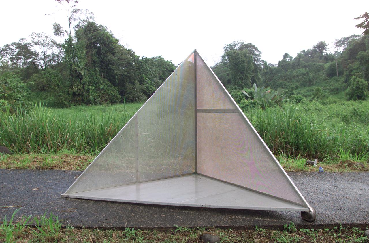
Reflectors setup in the La Selva region of the Costa Rican rain forest by scientist Paul Siqueira from NASA’s Jet Propulsion Lab. These reflectors are used by JPL scientists onboard Dryden's DC-8 aircraft to calibrate the Airborne Synthetic Aperture Radar (AirSAR) system. Scientists place these reflectors at known points on the ground, allowing researchers onboard the aircraft to verify their data. AirSAR 2004 Mesoamerica is a three-week expedition by an international team of scientists that uses an all-weather imaging tool, called the Airborne Synthetic Aperture Radar (AirSAR) which is located onboard NASA's DC-8 airborne laboratory. Scientists from many parts of the world including NASA's Jet Propulsion Laboratory are combining ground research done in several areas in Central America with NASA's AirSAR technology to improve and expand on the quality of research they are able to conduct. The radar, developed by NASA's Jet Propulsion Laboratory, can penetrate clouds and also collect data at night. Its high-resolution sensors operate at multiple wavelengths and modes, allowing AirSAR to see beneath treetops, through thin sand, and dry snow pack. AirSAR's 2004 campaign is a collaboration of many U.S. and Central American institutions and scientists, including NASA; the National Science Foundation; the Smithsonian Institution; National Geographic; Conservation International; the Organization of Tropical Studies; the Central American Commission for Environment and Development; and the Inter-American Development Bank.
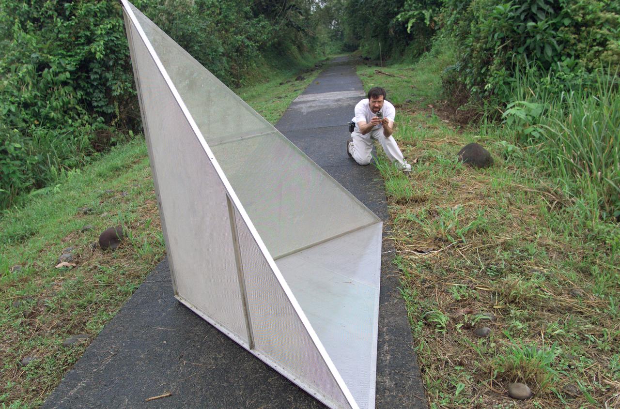
Reflectors setup in the La Selva region of the Costa Rican rain forest by scientist Paul Siqueira from NASA’s Jet Propulsion Lab. These reflectors are used by JPL scientists onboard Dryden's DC-8 aircraft to calibrate the Airborne Synthetic Aperture Radar (AirSAR) system. Scientists place these reflectors at known points on the ground, allowing researchers onboard the aircraft to verify their data. AirSAR 2004 Mesoamerica is a three-week expedition by an international team of scientists that uses an all-weather imaging tool, called the Airborne Synthetic Aperture Radar (AirSAR) which is located onboard NASA's DC-8 airborne laboratory. Scientists from many parts of the world including NASA's Jet Propulsion Laboratory are combining ground research done in several areas in Central America with NASA's AirSAR technology to improve and expand on the quality of research they are able to conduct. The radar, developed by NASA's Jet Propulsion Laboratory, can penetrate clouds and also collect data at night. Its high-resolution sensors operate at multiple wavelengths and modes, allowing AirSAR to see beneath treetops, through thin sand, and dry snow pack. AirSAR's 2004 campaign is a collaboration of many U.S. and Central American institutions and scientists, including NASA; the National Science Foundation; the Smithsonian Institution; National Geographic; Conservation International; the Organization of Tropical Studies; the Central American Commission for Environment and Development; and the Inter-American Development Bank.
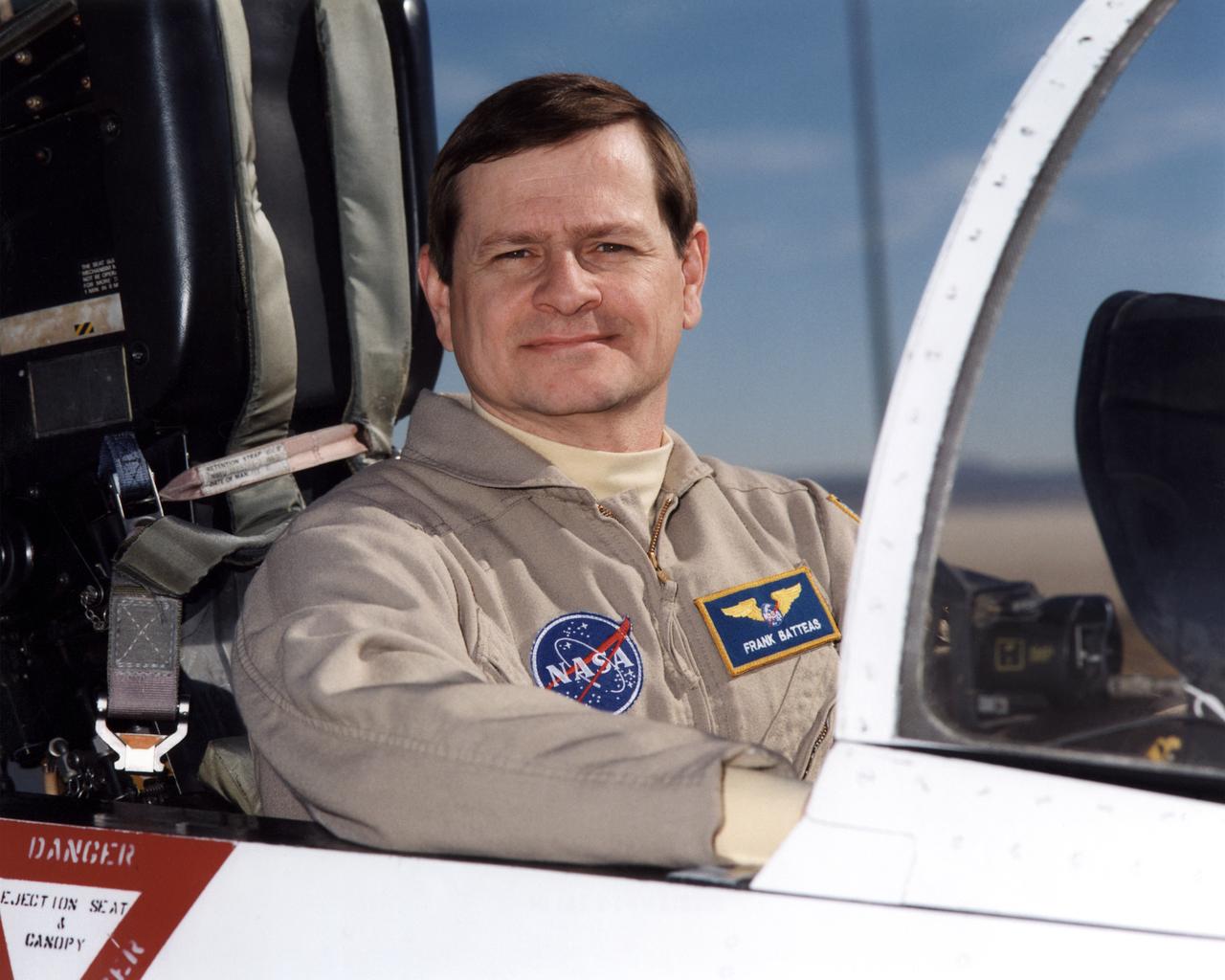
Frank Batteas is a research test pilot in the Flight Crew Branch of NASA's Dryden Flight Research Center, Edwards, California. He is currently a project pilot for the F/A-18 and C-17 flight research projects. In addition, his flying duties include operation of the DC-8 Flying Laboratory in the Airborne Science program, and piloting the B-52B launch aircraft, the King Air, and the T-34C support aircraft. Batteas has accumulated more than 4,700 hours of military and civilian flight experience in more than 40 different aircraft types. Batteas came to NASA Dryden in April 1998, following a career in the U.S. Air Force. His last assignment was at Wright-Patterson Air Force Base, Dayton, Ohio, where Lieutenant Colonel Batteas led the B-2 Systems Test and Evaluation efforts for a two-year period. Batteas graduated from Class 88A of the Air Force Test Pilot School, Edwards Air Force Base, California, in December 1988. He served more than five years as a test pilot for the Air Force's newest airlifter, the C-17, involved in nearly every phase of testing from flutter and high angle-of-attack tests to airdrop and air refueling envelope expansion. In the process, he achieved several C-17 firsts including the first day and night aerial refuelings, the first flight over the North Pole, and a payload-to-altitude world aviation record. As a KC-135 test pilot, he also was involved in aerial refueling certification tests on a number of other Air Force aircraft. Batteas received his commission as a second lieutenant in the U. S. Air Force through the Reserve Officer Training Corps and served initially as an engineer working on the Peacekeeper and Minuteman missile programs at the Ballistic Missile Office, Norton Air Force Base, Calif. After attending pilot training at Williams Air Force Base, Phoenix, Ariz., he flew operational flights in the KC-135 tanker aircraft and then was assigned to research flying at the 4950th Test Wing, Wright-Patterson. He flew extensively modified C-135