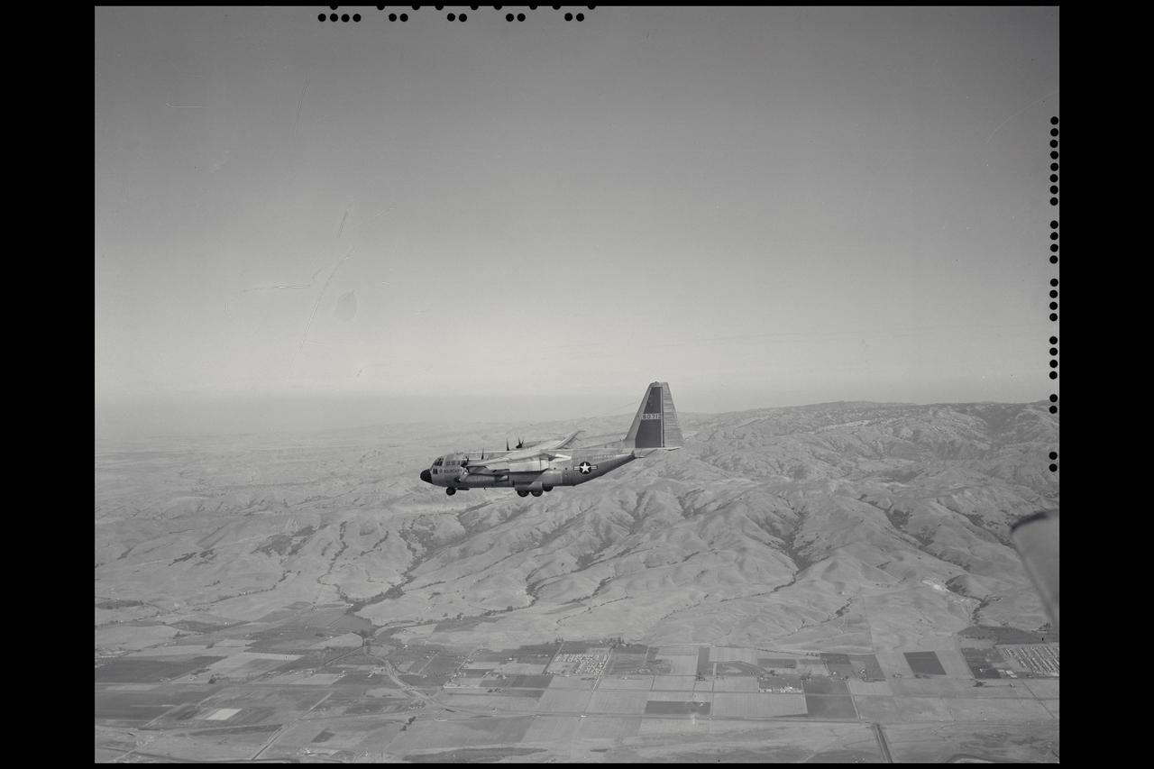
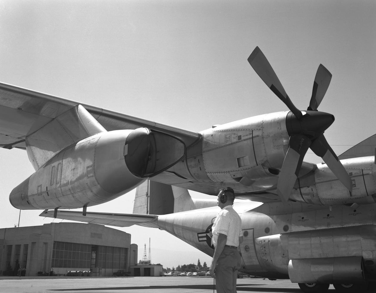
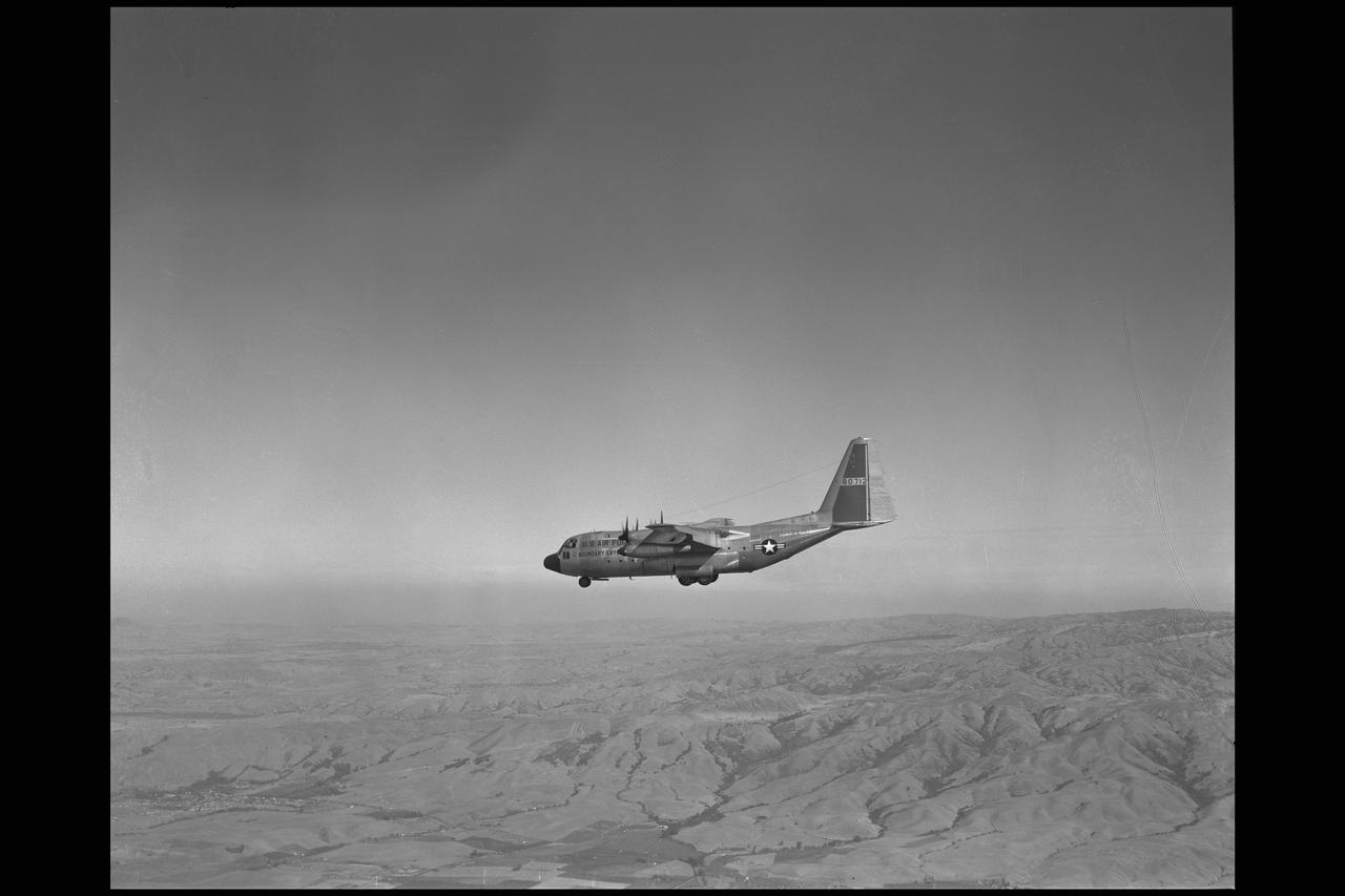
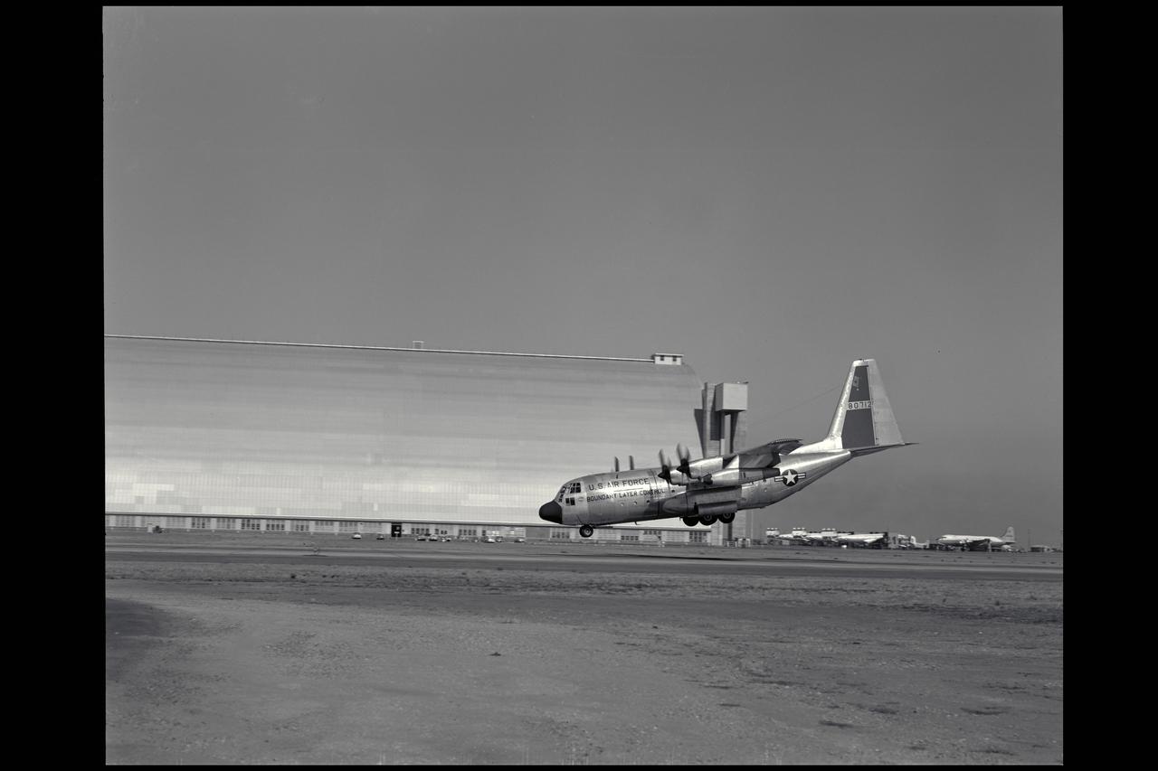
Lockheed NC-130B aircraft in flight over Santa Clara Valley, CA
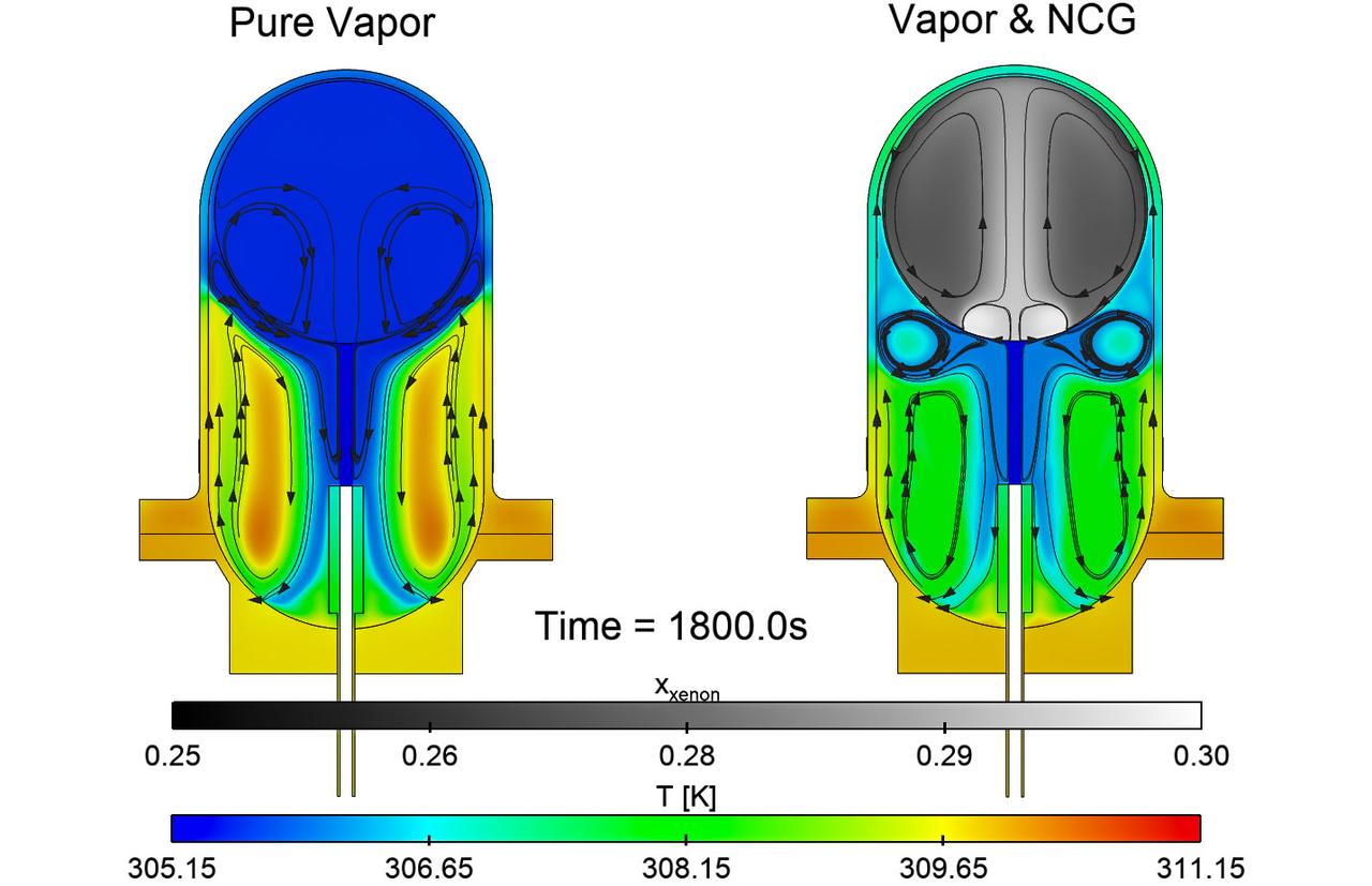
jsc2025e067420 (8/5/2025) --- Simulations of the effects of noncondensable gas on the flow and thermal structures that develop in a fuel tank in microgravity for the ZBOT-NC investigation. On the left, simulation of a tank with pure fluid and on the right, one with a fluid and gas. Credit: Case Western Reserve University
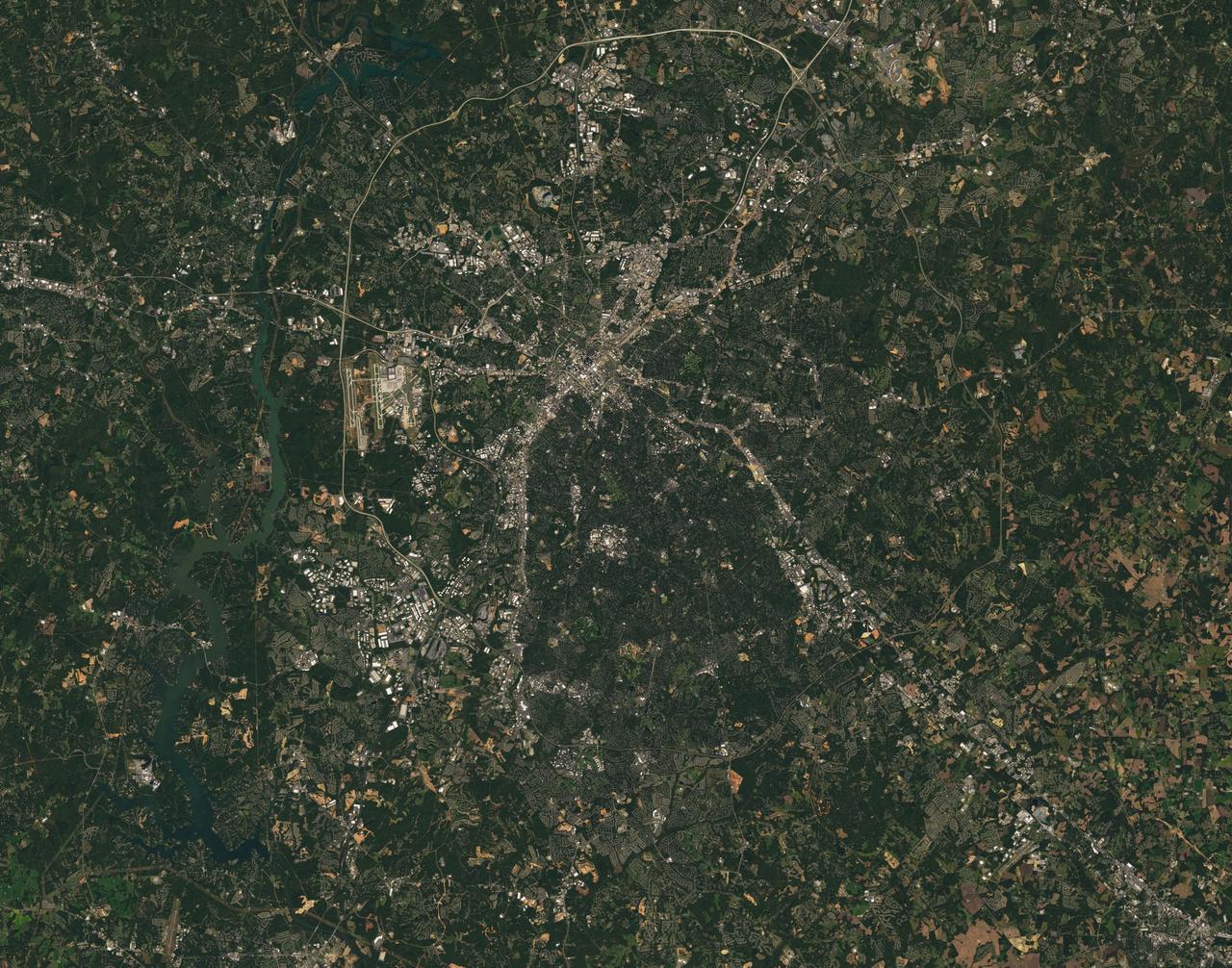
Landsat 7 image of the Charlotte, NC area acquired Oct 18, 2015. Landsat 7 is a U.S. satellite used to acquire remotely sensed images of the Earth's land surface and surrounding coastal regions. It is maintained by the Landsat 7 Project Science Office at the NASA Goddard Space Flight Center in Greenbelt, MD...Landsat satellites have been acquiring images of the Earth’s land surface since 1972. Currently there are more than 2 million Landsat images in the National Satellite Land Remote Sensing Data Archive. For more information visit: <a href="http://landsat.usgs.gov/" rel="nofollow">landsat.usgs.gov/</a>..To learn more about the Landsat satellite go to:.<a href="http://landsat.gsfc.nasa.gov/" rel="nofollow">landsat.gsfc.nasa.gov/</a> Credit: NASA/GSFC/Landsat 7 <b><a href="http://www.nasa.gov/audience/formedia/features/MP_Photo_Guidelines.html" rel="nofollow">NASA image use policy.</a></b> <b><a href="http://www.nasa.gov/centers/goddard/home/index.html" rel="nofollow">NASA Goddard Space Flight Center</a></b> enables NASA’s mission through four scientific endeavors: Earth Science, Heliophysics, Solar System Exploration, and Astrophysics. Goddard plays a leading role in NASA’s accomplishments by contributing compelling scientific knowledge to advance the Agency’s mission. <b>Follow us on <a href="http://twitter.com/NASAGoddardPix" rel="nofollow">Twitter</a></b> <b>Like us on <a href="http://www.facebook.com/pages/Greenbelt-MD/NASA-Goddard/395013845897?ref=tsd" rel="nofollow">Facebook</a></b> <b>Find us on <a href="http://instagrid.me/nasagoddard/?vm=grid" rel="nofollow">Instagram</a></b>
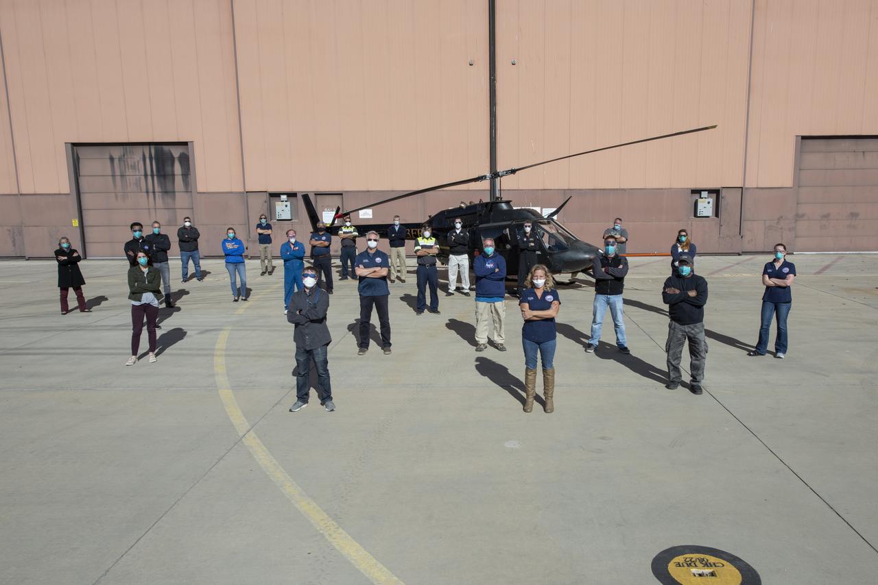
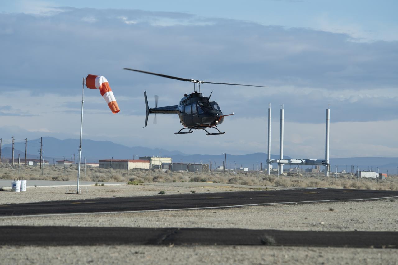
The Advanced Air Mobility National Campaign project’s NC Integrated Dry Run Test team is pictured in front of a Bell OH-58C Kiowa helicopter provided by Flight Research Inc. in Mojave, California the first week of December 2020 at NASA’s Armstrong Flight Research Center in California.
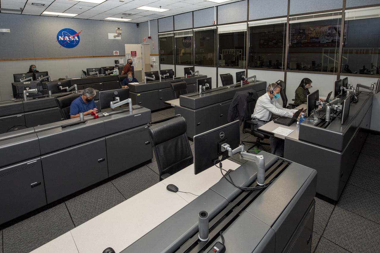
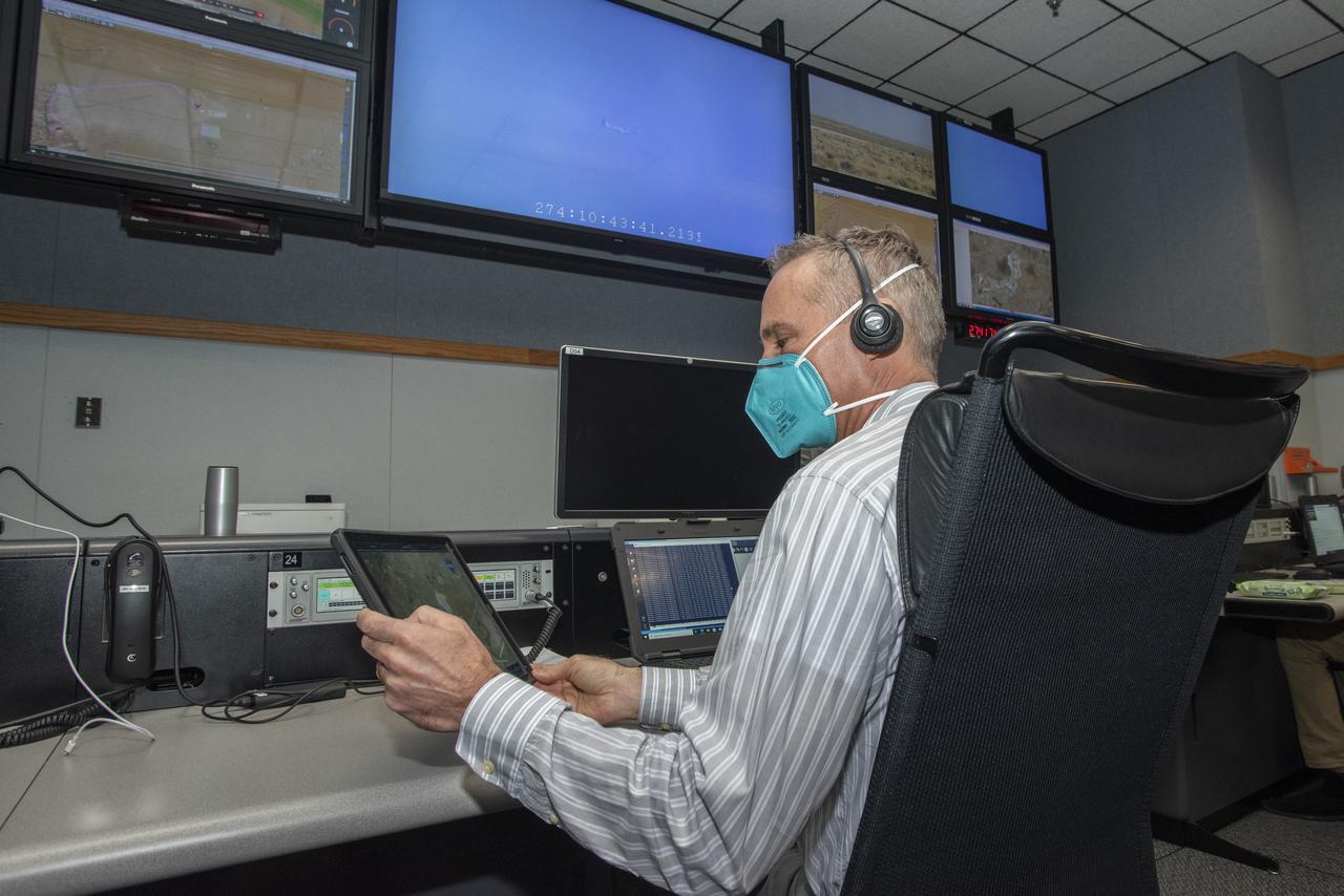
Ames Research Center researchers on the Advanced Air Mobility National Campaign project's Airspace Test Infrastructure (ATI) team monitor surveillance data and metrics from the helicopter in real time during the NC Integrated Dry Run Test team the first week of December 2020 at NASA's Armstrong Flight Research Center in California.
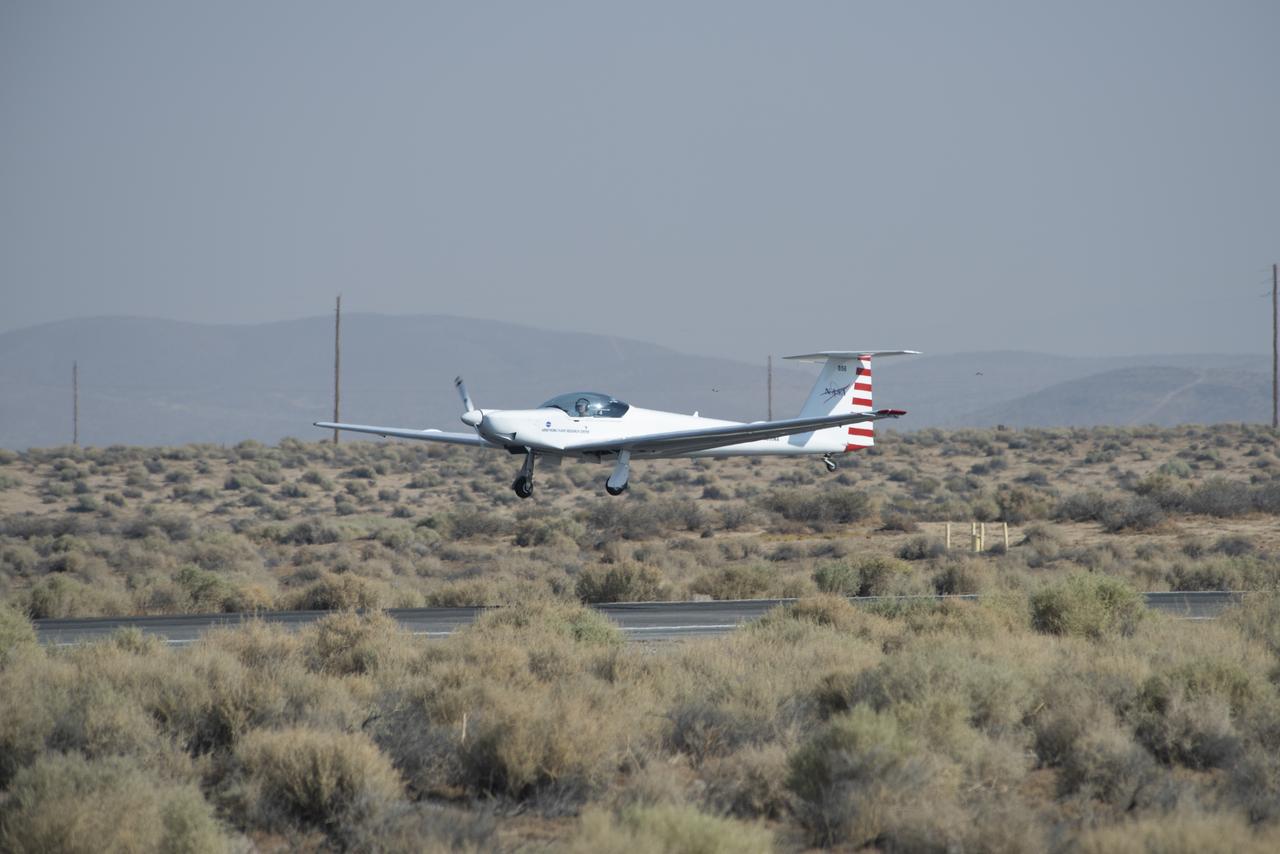
The Advanced Air Mobility National Campaign project conducted connectivity and infrastructure flight tests with a NASA TG-14 glider aircraft at NASA's Armstrong Flight Research Center Sept. 30-Oct. 1, 2020. The flights were preparation for the NC Integrated Dry Run Test in December and allowed pilots to view the routes they will fly during the helicopter test.

Ames Research Center researchers from left to right Yasmin Arbab,  Faisal Omar and Mark Snycerski on the Advanced Air Mobility National Campaign project’s Airspace Test Infrastructure (ATI) team as well as Armstrong’s Sam Simpliciano in the background. The researchers monitor surveillance data from the helicopter in real time during the NC Integrated Dry Run Test the first week of December 2020 at NASA’s Armstrong Flight Research Center in California.
Mark Snycerski, senior research associate at NASA's Ames Research Center in California, monitored inbound telemetry data through collection servers during the Advanced Air Mobility National Campaign's connectivity and infrastructure flight tests. The test used a NASA TG-14 glider aircraft based at NASA's Armstrong Flight Research Center in California Sept. 30-Oct. 1, 2020. The exercise was in preparation for the NC Integrated Dry Run Test in December.

Ames Research Center researchers Yasmin Arbab and Mark Snycerski on the Advanced Air Mobility National Campaign project's Airspace Test Infrastructure (ATI) team monitor surveillance data and connectivity of the flight test infrastructure to a cloud based system in real time during the NC Integrated Dry Run Test team the first week of December 2020 at NASA's Armstrong Flight Research Center in California.

NC-130B in front of NASA Ames Research Center Hangar. A Study of STOL Operational Techniques. BLC instrumentation
close up of CLAM SHELL. NC-130B Aircraft. A Study of STOL Operational Techniques. BLC instrumentation
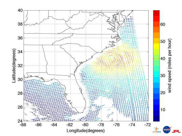
This ISRO-NASA-JPL-Caltech collaborative image shows ocean wind vector data from ISRO OceanSat 2 spacecraft of Hurricane Irene which made landfall early Saturday morning, Aug. 27, just west of Cape Lookout, NC.
ISS028-E-034008 (27 Aug. 2011) --- Some seven hours after Hurricane Irene?s initial landfall at Cape Hatteras, NC, one of the Expedition 28 crew members aboard the International Space Station photographed this image, one of a series following the hurricane?s destructive path along the east coast.
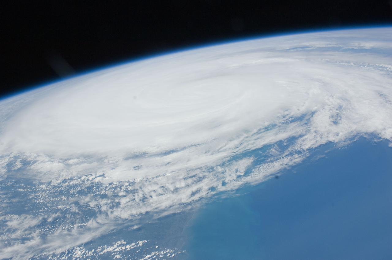
ISS028-E-034018 (27 Aug. 2011) --- Some seven hours after Hurricane Irene?s initial landfall at Cape Hatteras, NC, one of the Expedition 28 crew members aboard the International Space Station photographed this image, one of a series following the hurricane?s destructive path along the east coast.
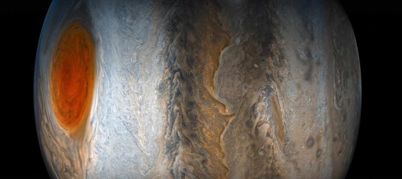
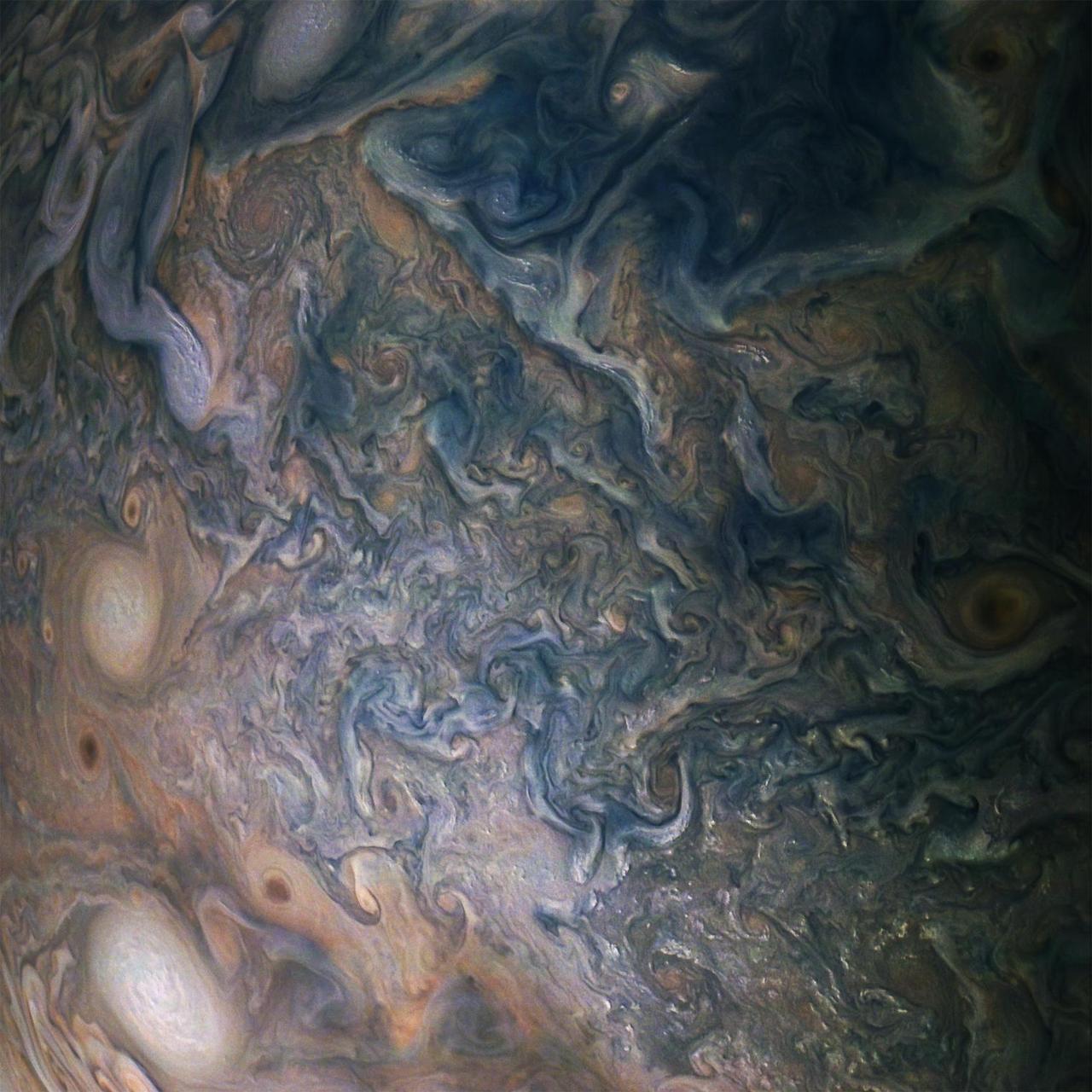
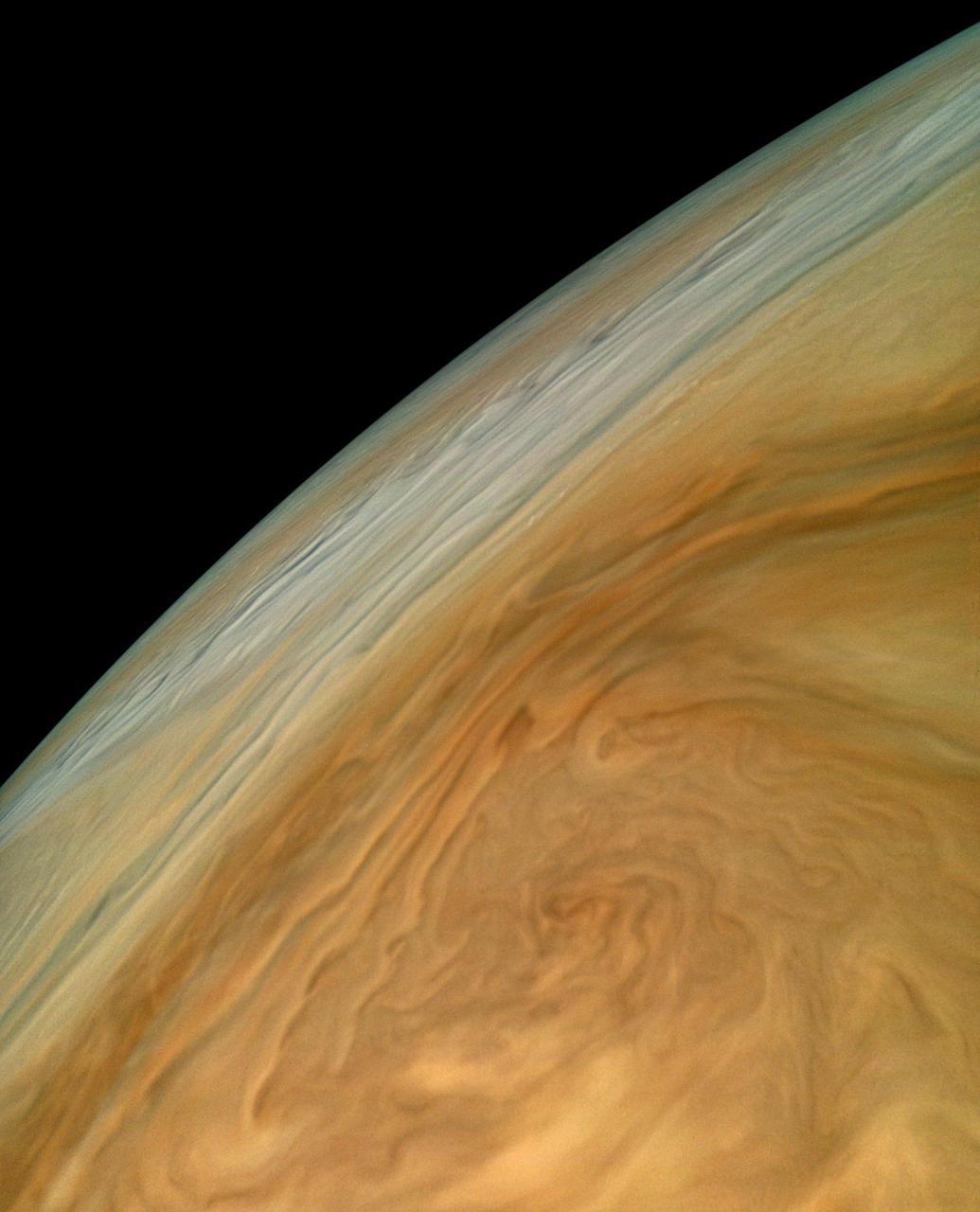
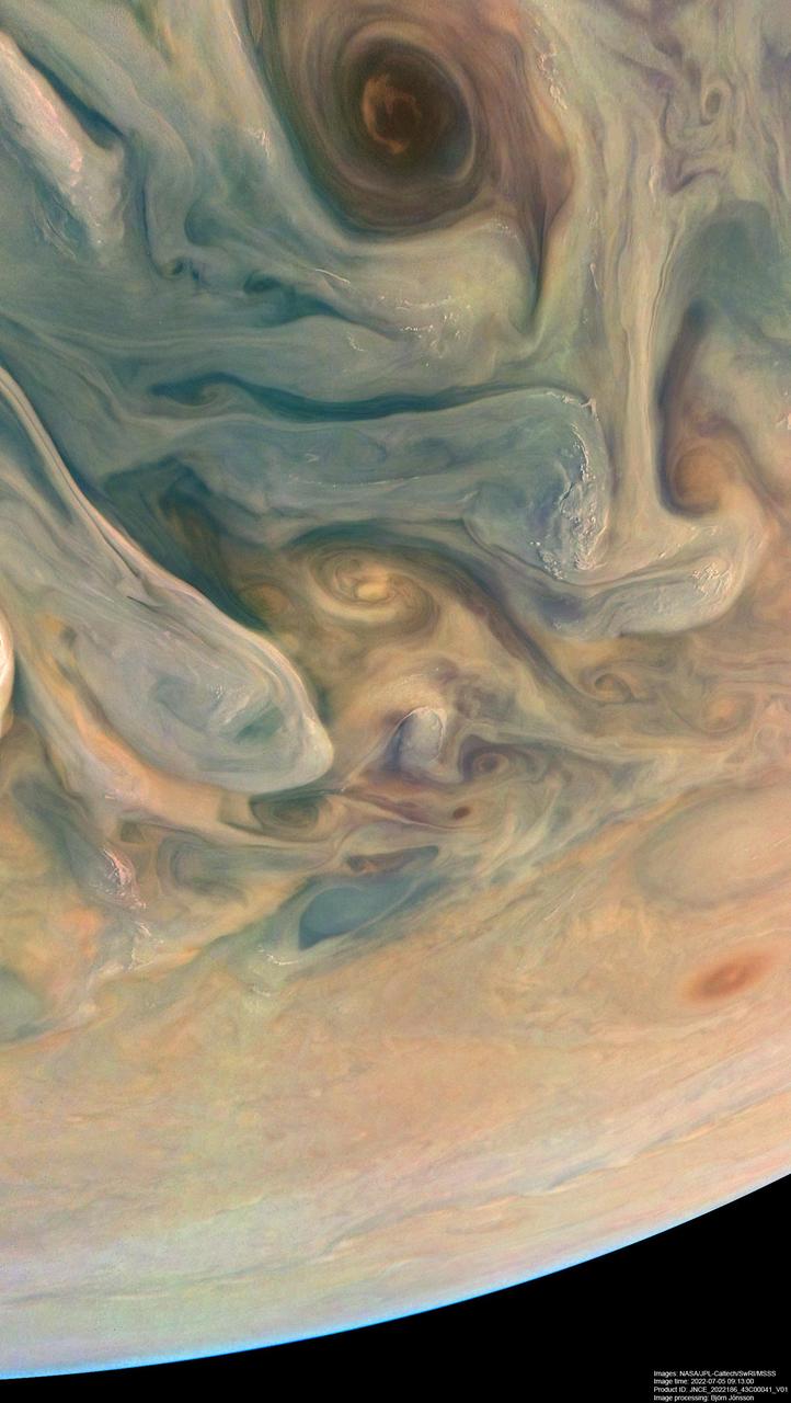
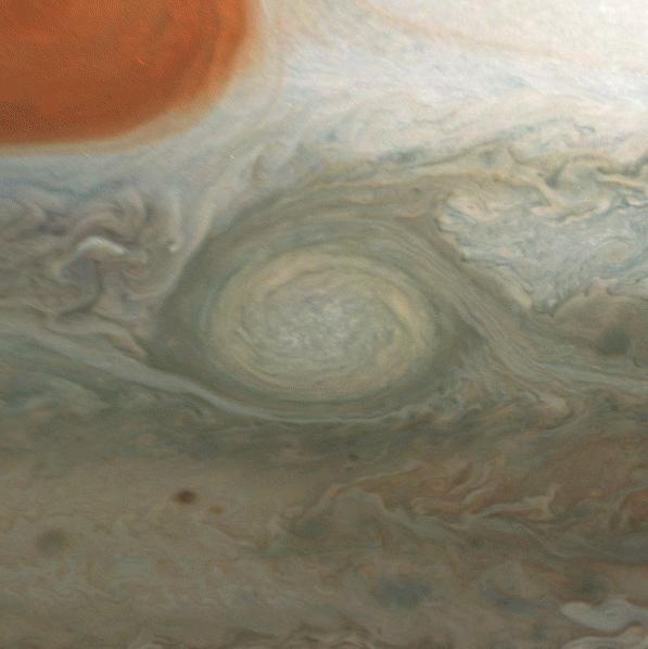
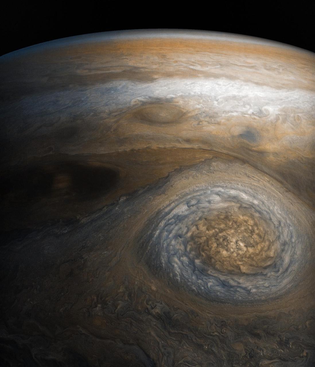
This striking Jovian vista was created by citizen scientists Gerald Eichstädt and Seán Doran using data from the JunoCam imager on NASA's Juno spacecraft. The tumultuous Great Red Spot is fading from Juno's view while the dynamic bands of the southern region of Jupiter come into focus. North is to the left of the image, and south is on the right. The image was taken on July 10, 2017 at 7:12 p.m. PDT (10:12 p.m. EDT), as the Juno spacecraft performed its seventh close flyby of Jupiter. At the time the image was taken, the spacecraft was 10,274 miles (16,535 kilometers) from the tops of the clouds of the planet at a latitude of -36.9 degrees. https://photojournal.jpl.nasa.gov/catalog/PIA21778 **Image Credit: Enhanced Image by Gerald Eichstädt and Seán Doran (CC BY-NC-SA) based on images provided courtesy of NASA/JPL-Caltech/SwRI/MSSS https://creativecommons.org/licenses/by-nc-sa/3.0/
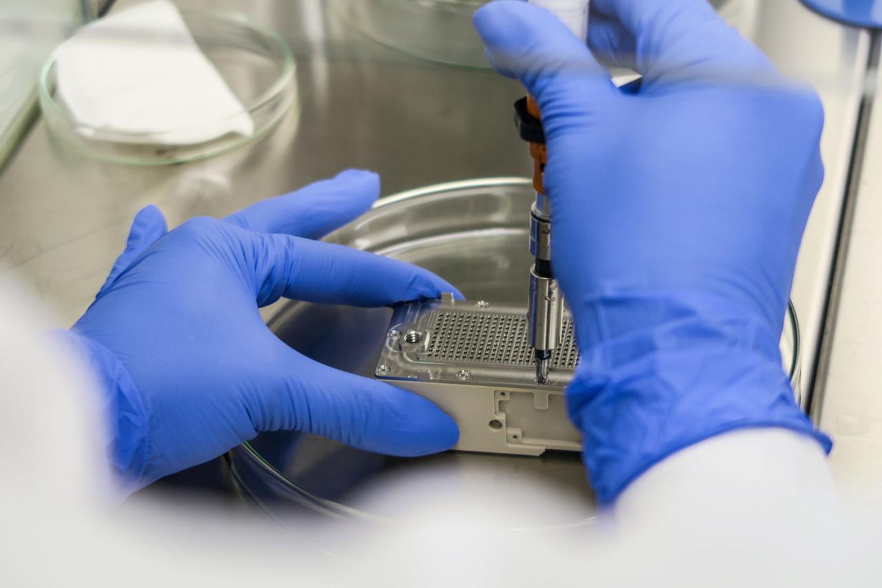
jsc2023e010176 (8/21/2021) --- This image shows the final step of assembling the ESA-Biofilms experiment unit. Inside the experiment unit, growth of the bacterial model organisms is supported under controlled conditions on different antimicrobial surfaces. The ESA-Biofilms investigation studies bacterial biofilm formation and antimicrobial properties of different metal surfaces under spaceflight conditions in altered gravity. Image courtesy of DLR, CC BY-NC-ND 3.0.
Lockheed NC-130B STOL turboprop-powered aircraft with ailerons drooped 30 degrees. Note trailing-edge flaps deflected 90 degrees for increased lift. Two T-56 turboshaft engines, which drove wing-mounted load compressors for boundary-layer control, are mounted on outboard wing pods. Landing approach speed was reduced 30 knots with boundary-layer control
STS039-83-091 (28 April-6 May 1991) --- (HOLD PHOTO WITH BARRIER ISLANDS ALONG THE LEFT SIDE). This photograph of the water sunglint pattern along the Outer Banks of North Carolina was taken with a 70mm handheld camera equipped with color visible film and a 250mm lens. The islands appear as dark areas along the left side of the frame and Cape Hatteras is seen to the left and slightly above frame center. Sunglint is composed of light reflected from the water surface and the patterns seen in this photo are largely the result of sea surface roughness. Smooth water has a mirror-like reflectance and is represented in the photo as a bright area. Rough water, on the other hand, tends to disperse the light reflected from the water surface and, therefore, appears dark. Water currents in this area are extremely dynamic because the swift, northward flowing Gulf Stream (the offshore darker water along the right side of the photo) diverges from the coastline north of Cape Hatteras. The sharp line between bright and dark water is the western boundary of the Gulf Stream.
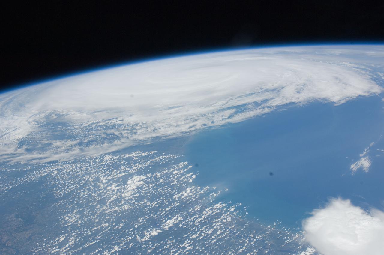
ISS028-E-034004 (27 Aug. 2011) --- Some five and a half hours after Hurricane Irene?s initial landfall at Cape Hatteras, NC, one of the Expedition 28 crew members aboard the International Space Station photographed this image, one of a series following the hurricane?s destructive path along the east coast. At this time, the Hurricane was at 35.5 degrees north latitude and 76.3 degrees west longitude over Cape Hatteras, moving 15 degrees at 13 miles per hour. Winds were at 81 miles per hour, gusting to 98 miles per hour.
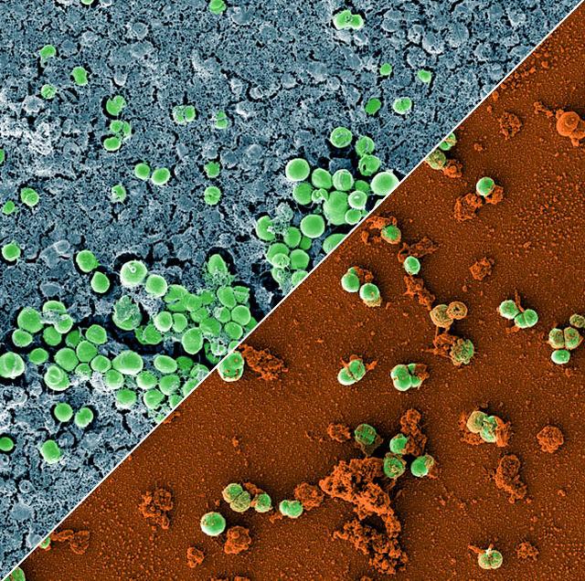
jsc2023e010179 (2/28/2023) --- This image is a composition of two scanning electron microscopic images of the bacterium Staphylococcus capitis on stainless steel versus antimicrobial copper. The image was colored to visualize the bacterial cells (green) either embedded in a biofilm matrix (blue), or covered with copper particles (red/orange). The ESA-Biofilms investigation studies bacterial biofilm formation and antimicrobial properties of different metal surfaces under spaceflight conditions in altered gravity. Both images were taken as part of the preflight experiments for ESA-Biofilms. Image courtesy of DLR, CC BY-NC-ND 3.0.
Lockheed NC-130B (AF58-712) Aircraft. A Study of STOL Operational Techniques; landing approach. Nose-low pitch attitude of the aircraft was required in wave-off (or go-around) at 85 knots with flaps 70 degrees. An increase in stall-speed margin could be required to produce a more positive climb angle. (Nov 1962) Note: Used in publication in Flight Research at Ames; 57 Years of Development and Validation of Aeronautical Technology NASA SP-1998-3300 fig. 104; 60yrs at Ames, Atmosphere of Freedom NASA SP-2000-4314
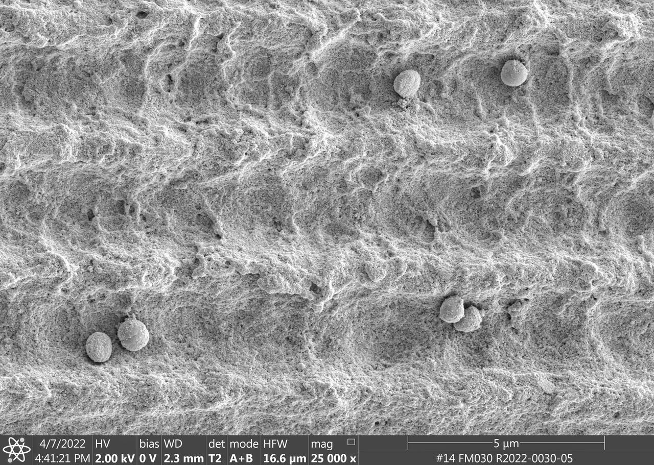
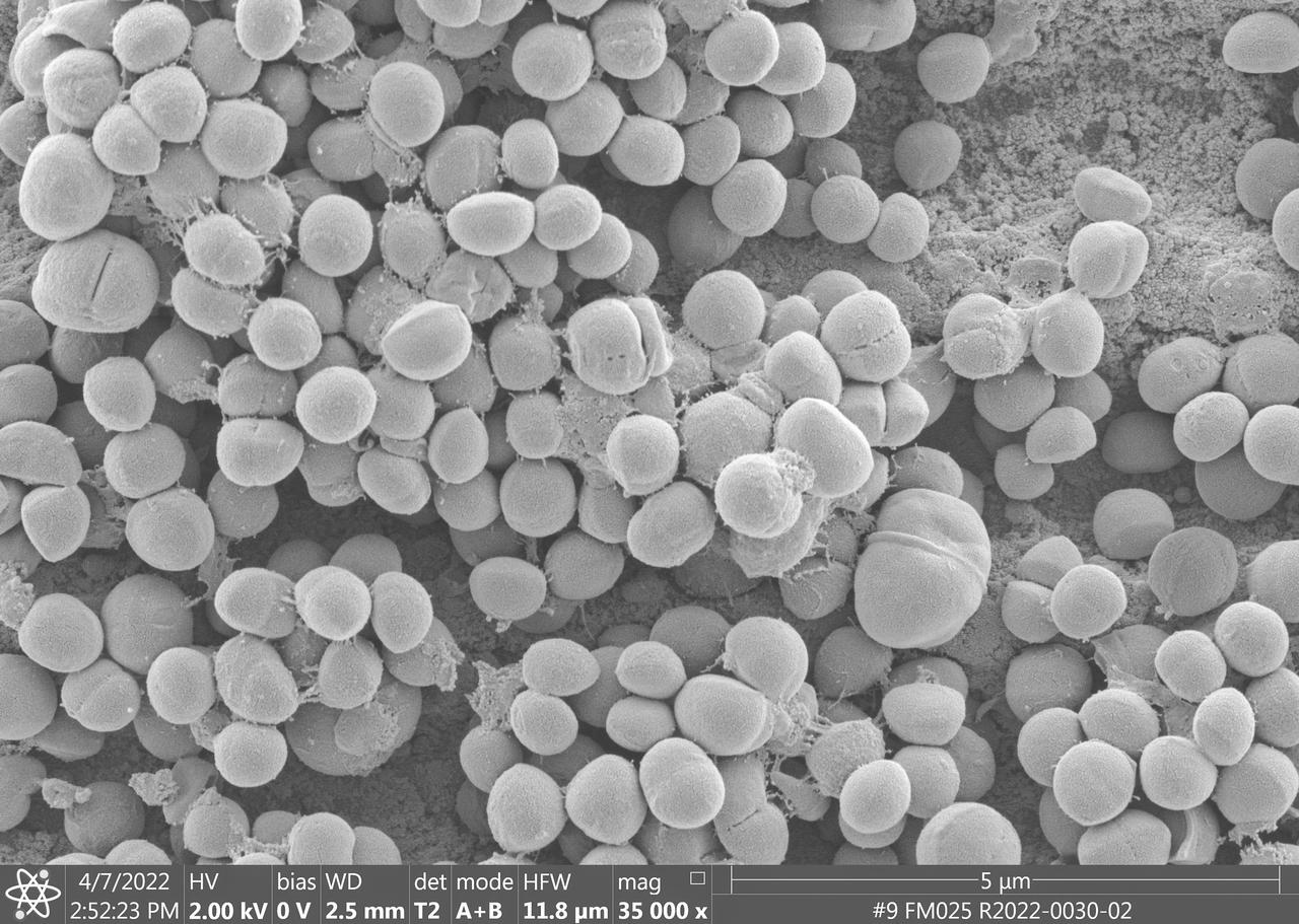
jsc2023e010177 (4/7/2022) --- This image is a scanning electron microscopic image of one of the ESA-Biofilms sample plates from the first launch to the ISS. The sample plate in this image is made of copper, which naturally has antimicrobial properties. This surface has a 3 µm laser structure engraved to the surface which improves antimicrobial efficacy. On the surface, only few cells of the bacterial species Staphylococcus capitis are attached. The cells appear small and are not actively dividing. The ESA-Biofilms investigation studies bacterial biofilm formation and antimicrobial properties of different metal surfaces under spaceflight conditions in altered gravity. Image courtesy of DLR, CC BY-NC-ND 3.0.

jsc2023e010175 (2/28/2023) --- This image shows a monospecies biofilm through the view of a scanning electron microscope. The image was colored to visualize the bacterial cells (orange) embedded in the biofilm matrix (blue). The biofilm was formed by a strain of the bacterial species Staphylococcus capitis that was isolated from the International Space Station. The ESA-Biofilms investigation studies bacterial biofilm formation and antimicrobial properties of different metal surfaces under spaceflight conditions in altered gravity. The image was taken as part of the preflight experiments for ESA-Biofilms together with the Robert Koch Institute in Berlin, Germany. Image courtesy of DLR, CC BY-NC-ND 3.0.
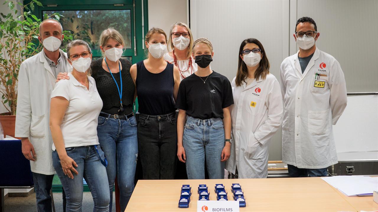
jsc2023e010180 (5/20/2022) --- This is a group picture of the DLR, ESA, and Kayser Italia teams after successful integration of the ESA-Biofilms experiment for its second launch in 2022. The assembled hardware is in the front on the table. The blue experiment containers were later integrated by ESA astronaut Samantha Cristoforetti into the two KUBIK incubators inside the Columbus laboratory aboard the International Space Station. The ESA-Biofilms investigation studies bacterial biofilm formation and antimicrobial properties of different metal surfaces under spaceflight conditions in altered gravity. Image courtesy of DLR, CC BY-NC-ND 3.0.
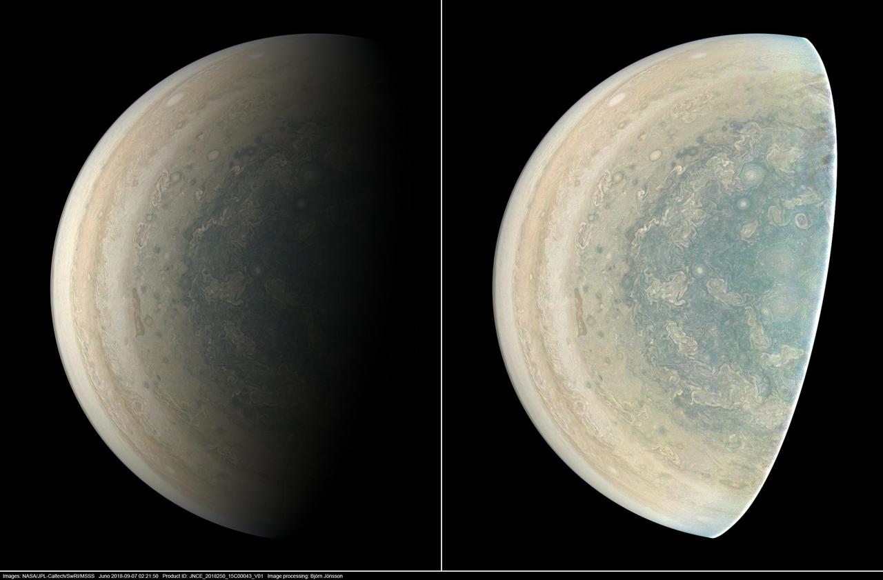
This image was taken at 7:21 p.m. PDT (10:21 p.m. EDT) on Sept. 6, 2018, as the spacecraft performed its 15th close flyby of Jupiter. The version of the image on the left side shows Jupiter in approximate true color, while the same image on the right has been processed to bring out detail close to the terminator and reveals four of the five southern circumpolar cyclones plus the cyclone in the center. Citizen scientist Björn Jónsson created this image using data from the spacecraft's JunoCam imager. https://photojournal.jpl.nasa.gov/catalog/PIA22933. - Enhanced image by Björn Jónsson (CC-NC-SA) based on images provided courtesy of NASA/JPL-Caltech/SwRI/MSSS
A multitude of bright white "pop-up" storms in this Jupiter cloudscape appear in this image from NASA's Juno spacecraft. This color-enhanced image was taken at 1:55 p.m. PDT (4:55 p.m. EDT) on Oct. 29, 2018, as the spacecraft performed its 16th close flyby of Jupiter. Citizen scientists Gerald Eichstädt and Seán Doran created this image using data from the spacecraft's JunoCam imager. https://photojournal.jpl.nasa.gov/catalog/PIA22935 **Image Credit: Enhanced Image by Gerald Eichstädt and Seán Doran (CC BY-NC-SA) based on images provided courtesy of NASA/JPL-Caltech/SwRI/MSSS
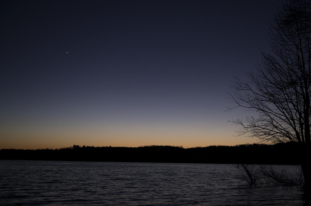
Jupiter, left, and Saturn, right, are seen after sunset above Jordan Lake during the “great conjunction” where the two planets appear a tenth of a degree apart from one another, Monday, Dec. 21, 2020, near Chapel Hill, North Carolina. Photo Credit: (NASA/Bill Ingalls)
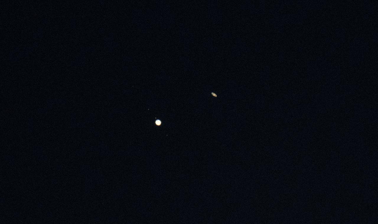
Jupiter, left, and Saturn, right, are seen during the “great conjunction” where the two planets appear a tenth of a degree apart from one another, Monday, Dec. 21, 2020, near Chapel Hill, North Carolina. Photo Credit: (NASA/Bill Ingalls)
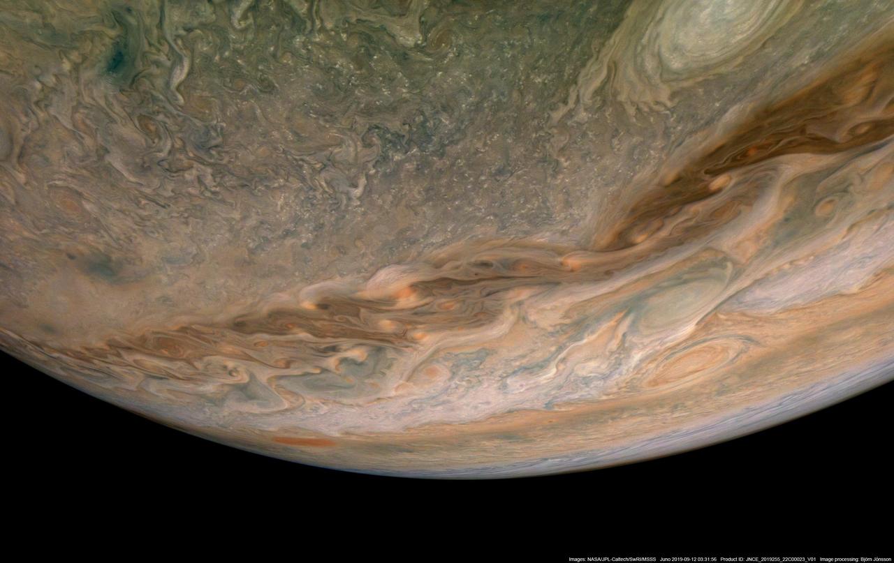
In this view of Jupiter, NASA's Juno spacecraft captures swirling clouds in the region of the giant planet's northern hemisphere known as "Jet N4." Jupiter spins once every 10 hours, and this fast rotation creates strong jet streams, separating its clouds into dark belts and bright zones that stretch across the face of the planet. More than a dozen prevailing winds sweep over Jupiter, some reaching more than 300 miles per hour (480 kilometers per hour) at the equator. The raw image was taken on Sept. 11, 2019 at 8:31 p.m. PDT (11:31 p.m. EDT), as Juno performed its 22nd close flyby of Jupiter. At the time the image was taken, the spacecraft was about 7,540 miles (12,140 kilometers) from the cloud tops at a latitude of 45 degrees. Enhanced image by Björn Jónsson (CC-NC-SA) based on images provided courtesy of NASA/JPL-Caltech/SwRI/MSSS.
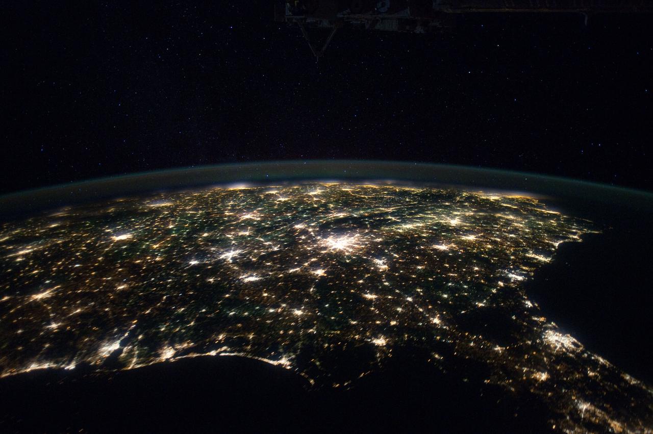
ISS030-E-055569 (29 Jan. 2012) --- Southeastern USA at night is featured in this image photographed by an Expedition 30 crew member on the International Space Station. The brightly lit metropolitan areas of Atlanta, GA (center) and Jacksonville, FL (lower right) appear largest in the image with numerous other urban areas forming an interconnected network of light across the region. A large dark region to the northwest of Jacksonville, FL is the Okefenokee National Wildlife Refuge; likewise the ridges of the Appalachian Mountains form dark swaths to the north of Atlanta, GA and west of Charlotte, NC (center). The faint gold and green line of airglow—caused by ultraviolet radiation exciting the gas molecules in the upper atmosphere—parallels the horizon (or Earth limb).
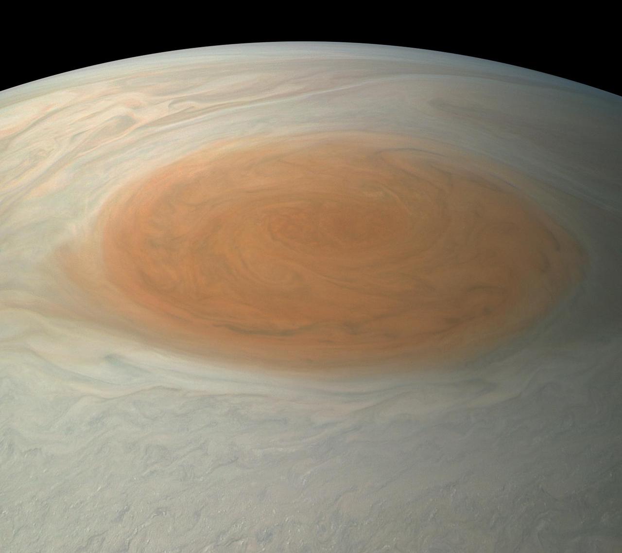
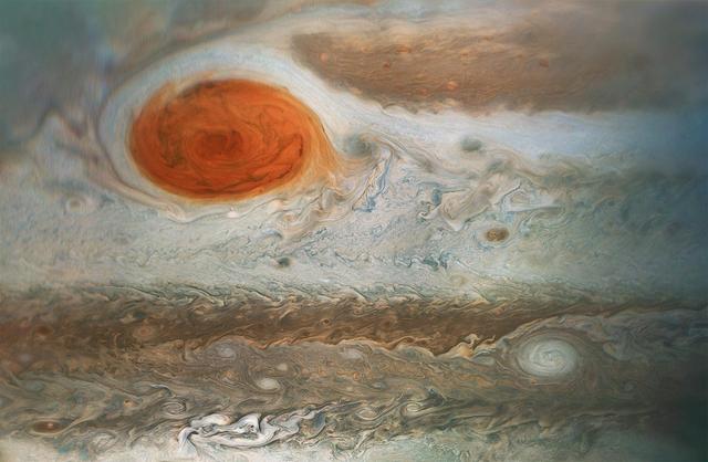
This image of Jupiter's iconic Great Red Spot (GRS) was created by citizen scientist Björn Jónsson using data from the JunoCam imager on NASA's Juno spacecraft. This true-color image offers a natural color rendition of what the Great Red Spot and surrounding areas would look like to human eyes from Juno's position. The tumultuous atmospheric zones in and around the Great Red Spot are clearly visible. The image was taken on July 10, 2017 at 07:10 p.m. PDT (10:10 p.m. EDT), as the Juno spacecraft performed its seventh close flyby of Jupiter. At the time the image was taken, the spacecraft was about 8,648 miles (13,917 kilometers) from the tops of the clouds of the planet at a latitude of -32.6 degrees. https://photojournal.jpl.nasa.gov/catalog/PIA21775. - Enhanced image by Björn Jónsson (CC-NC-SA) based on images provided courtesy of NASA/JPL-Caltech/SwRI/MSSS
A south tropical disturbance has just passed Jupiter's iconic Great Red Spot and is captured stealing threads of orange haze from the Great Red Spot in this series of color-enhanced images from NASA's Juno spacecraft. From left to right, this sequence of images was taken between 2:57 a.m. and 3:36 a.m. PDT (5:57 a.m. and 6:36 a.m. EDT) on April 1, 2018, as the spacecraft performed its 12th close flyby of Jupiter. Citizen scientists Gerald Eichstädt and Seán Doran created this image using data from the spacecraft's JunoCam imager. https://photojournal.jpl.nasa.gov/catalog/PIA22937 ** Image Credit: Enhanced Image by Gerald Eichstädt and Seán Doran (CC BY-NC-SA) based on images provided courtesy of NASA/JPL-Caltech/SwRI/MSSS
jsc2023e010178 (4/7/2022) --- This image taken by a scanning electron microscope shows one of the ESA-Biofilms sample plates from its first launch to the International Space Station. The sample plate in this image is made of stainless steel, which is the reference surface in the experiment since it has no antimicrobial properties. This surface also has a 3 µm laser structure engraved to the surface as control. In contrast to the copper surface, there are many Staphylococcus capitis cells attached to the steel surface that are actively dividing and starting to from components of a biofilm matrix. The ESA-Biofilms investigation studies bacterial biofilm formation and antimicrobial properties of different metal surfaces under spaceflight conditions in altered gravity. Image courtesy of DLR, CC BY-NC-ND 3.0.

NASA Administrator Charles Bolden, space shuttle crew STS-129 and members of the Congressional Black Caucus pose for a group photo at the Capitol Building, Wednesday, Jan. 13, 2010, in Washington. Back row from left to right: U.S. Rep Donna Edwards (D-MD), U.S. Rep Diane Watson (D-CA), NASA Administrator Charles Bolden, astronauts Leland Melvin, Mike Foreman, Robert Satcher, Barry Wilmore, Randy Breznik, and U.S. Rep Mel Watt (D-NC). Front row from left to right: U.S. Rep Robert Scott (D-VA), U.S. Rep. Corrine Brown (D-Fla), U.S. Rep. Barbara Lee (D-CA), U.S. Rep. Donna Christensen (D-VI) and U.S. Rep. Donald Payne (D-NJ). The crew of STS-129 presented the CBC with a montage commemorating their mission. Photo Credit: (NASA/Paul E. Alers)
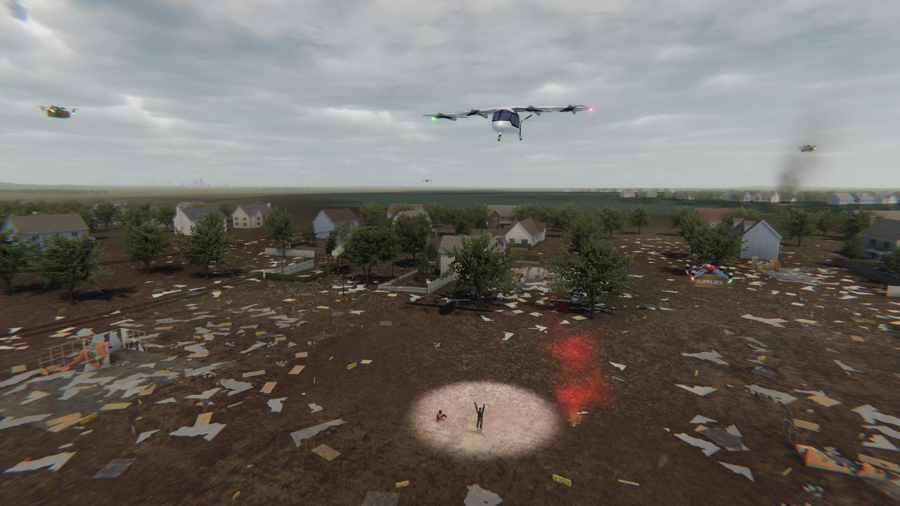
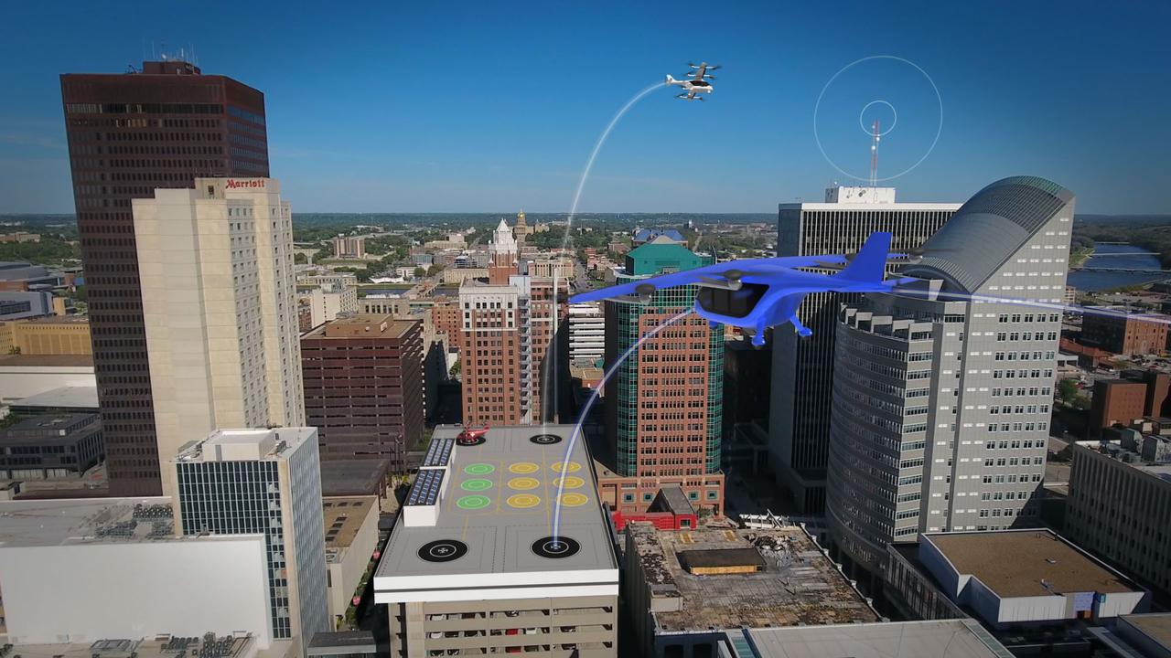
Several projects under NASA's Advanced Air Mobility or AAM mission are working on different elements to help make AAM a reality in emergency operations. This concept graphic shows how a future AAM vehicle could aid in disaster response.
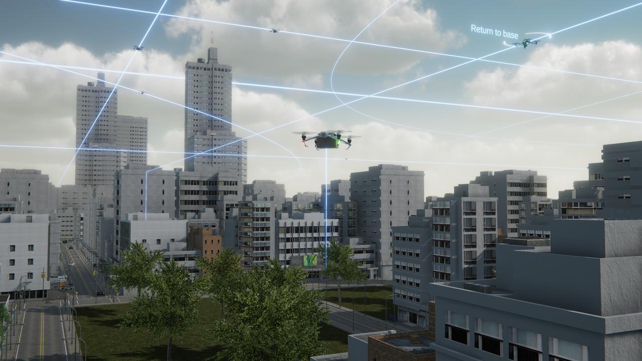
Several projects supporting NASA's Advanced Air Mobility or AAM mission are working on different elements to help make AAM a reality and one of these research areas is automation. This concept graphic shows how elements of automation could be integrated into a future airspace. Technology like this could enable vehicles to operate without a pilot, or if a pilot is in the loop, increase the safety.

See Jupiter's northern polar belt region in this view taken by NASA's Juno spacecraft. This color-enhanced image was taken on Dec. 16, 2017 at 9:47 a.m. PST (12:47 p.m. EST), as Juno performed its tenth close flyby of Jupiter. At the time the image was taken, the spacecraft was about 5,600 miles (8,787 kilometers) from the tops of the clouds of the planet at a latitude of 38.4 degrees north. Citizen scientist Björn Jónsson processed this image using data from the JunoCam imager. This image has been processed from the raw JunoCam framelets by removing the effects of global illumination. Jónsson then increased the contrast and color and sharpened smallscale features. The image has also been cropped. While at first glance the view may appear to be in Jupiter's south, the raw source images were obtained when Juno was above the planet's northern hemisphere looking south, potentially causing a sense of disorientation to the viewer. The geometry of the scene can be explored using the time of the image and the Juno mission module of NASA's Eyes on the Solar System. https://photojournal.jpl.nasa.gov/catalog/PIA21976. - Enhanced image by Björn Jónsson (CC-NC-SA) based on images provided courtesy of NASA/JPL-Caltech/SwRI/MSSS

See Jupiter's Great Red Spot as you've never seen it before in this new Jovian work of art. Artist Mik Petter created this unique, digital artwork using data from the JunoCam imager on NASA's Juno spacecraft. The art form, known as fractals, uses mathematical formulas to create art with an infinite variety of form, detail, color and light. The tumultuous atmospheric zones in and around the Great Red Spot are highlighted by the author's use of colorful fractals. Vibrant colors of various tints and hues, combined with the almost organic-seeming shapes, make this image seem to be a colorized and crowded petri dish of microorganisms, or a close-up view of microscopic and wildly-painted seashells. The original JunoCam image was taken on July 10, 2017 at 7:10 p.m. PDT (10:10 p.m. EDT), as the Juno spacecraft performed its seventh close flyby of Jupiter. The spacecraft captured the image from about 8,648 miles (13,917 kilometers) above the tops of the clouds of the planet at a latitude of -32.6 degrees. https://photojournal.jpl.nasa.gov/catalog/PIA21777 . - Enhanced image by Mik Petter (CC-NC-SA) based on images provided courtesy of NASA/JPL-Caltech/SwRI/MSSS
A swirling storm somersaults through Jupiter's South Equatorial Belt in this view taken by NASA's Juno spacecraft. This feature -- not to be confused with the planet's iconic Great Red Spot -- is escorted by several smaller, reddish vortices above and to the left. This natural color view offers an approximation of what Jupiter would look like to human eyes from Juno's vantage point near the time of closest approach in its orbit. Jupiter's stunning appearance is due to its atmosphere of colorful cloud bands and spots. The vivid red and orange hues are created by chemicals of uncertain composition called "chromophores." The image was taken at 10:28 p.m. PDT on July 15, 2018 (1:28 a.m. EDT on July 16), as the spacecraft performed its 14th close flyby of Jupiter. At the time, Juno was about 4,900 miles (8,000 kilometers) from the planet's cloud tops, above a southern latitude of 36 degrees. Citizen scientist Björn Jónsson created this image using data from the spacecraft's JunoCam imager. https://photojournal.jpl.nasa.gov/catalog/PIA22427. - Enhanced image by Björn Jónsson (CC-NC-SA) based on images provided courtesy of NASA/JPL-Caltech/SwRI/MSSS

This enhanced color Jupiter image, taken by the JunoCam imager on NASA's Juno spacecraft, showcases several interesting features on the apparent edge (limb) of the planet. Prior to Juno's fifth flyby over Jupiter's mysterious cloud tops, members of the public voted on which targets JunoCam should image. This picture captures not only a fascinating variety of textures in Jupiter's atmosphere, it also features three specific points of interest: "String of Pearls," "Between the Pearls," and "An Interesting Band Point." Also visible is what's known as the STB Spectre, a feature in Jupiter's South Temperate Belt where multiple atmospheric conditions appear to collide. JunoCam images of Jupiter sometimes appear to have an odd shape. This is because the Juno spacecraft is so close to Jupiter that it cannot capture the entire illuminated area in one image -- the sides get cut off. Juno acquired this image on March 27, 2017, at 2:12 a.m. PDT (5:12 a.m. EDT), as the spacecraft performed a close flyby of Jupiter. When the image was taken, the spacecraft was about 12,400 miles (20,000 kilometers) from the planet. https://photojournal.jpl.nasa.gov/catalog/PIA21389. - Enhanced image by Björn Jónsson (CC-NC-SA) based on images provided courtesy of NASA/JPL-Caltech/SwRI/MSSS
Colorful swirling clouds in Jupiter's North Equatorial Belt practically fill this image from NASA's Juno spacecraft. This is the closest image captured of the Jovian clouds during this recent flyby of the gas giant planet. The color-enhanced image was taken at 2:08 p.m. PDT (5:08 p.m. EDT) on Oct. 29, 2018 as the spacecraft performed its 16th close flyby of Jupiter. At the time, Juno was about 2,100 miles (3,400 kilometers) from the planet's cloud tops, at approximately 14 degrees north latitude. In other words, the spacecraft was about as close to Jupiter as San Francisco is to Chicago, which is quite close when racing over a planet that's 11 times wider than Earth. Citizen scientist Björn Jónsson created this image using data from the spacecraft's JunoCam imager. https://photojournal.jpl.nasa.gov/catalog/PIA22695. - Enhanced image by Björn Jónsson (CC-NC-SA) based on images provided courtesy of NASA/JPL-Caltech/SwRI/MSSS
This images is one of two true-color images taken 12 minutes apart neatly captures storm movement in the southern hemisphere of Jupiter. NASA's Juno spacecraft took these images during its tenth close flyby of the gas giant planet on Dec. 16, 2017 at 10:12 a.m. PST (1:12 p.m. EST) and 10:24 a.m. PST (1:24 p.m. EST). At the time, the spacecraft was about 8,453 miles (13,604 kilometers) and 19,244 miles (30,970 kilometers) from the tops of the clouds above the planet, with the images centered on south latitudes of 27.96 degrees and 49.91 degrees. The animation reveals the cyclonic motion of the STB Ghost, a large elongated feature in Jupiter's South Temperate Belt. This feature is elongated in the east-west direction and is located near the center in these images. Citizen scientist Björn Jónsson processed the image using data from the JunoCam imager. An animation is available at https://photojournal.jpl.nasa.gov/catalog/PIA21982. - Enhanced image by Björn Jónsson (CC-NC-SA) based on images provided courtesy of NASA/JPL-Caltech/SwRI/MSSS
Several projects supporting NASA's Advanced Air Mobility, or AAM mission, are working on different elements to help make AAM a reality. The team is researching how the addition of AAM could cut traffic commutes, make travel more sustainable, and make road trips shorter. With the addition of AAM, we would be using another dimension in the sky for travel below traditional aircraft and above cars, buses, or trains below.
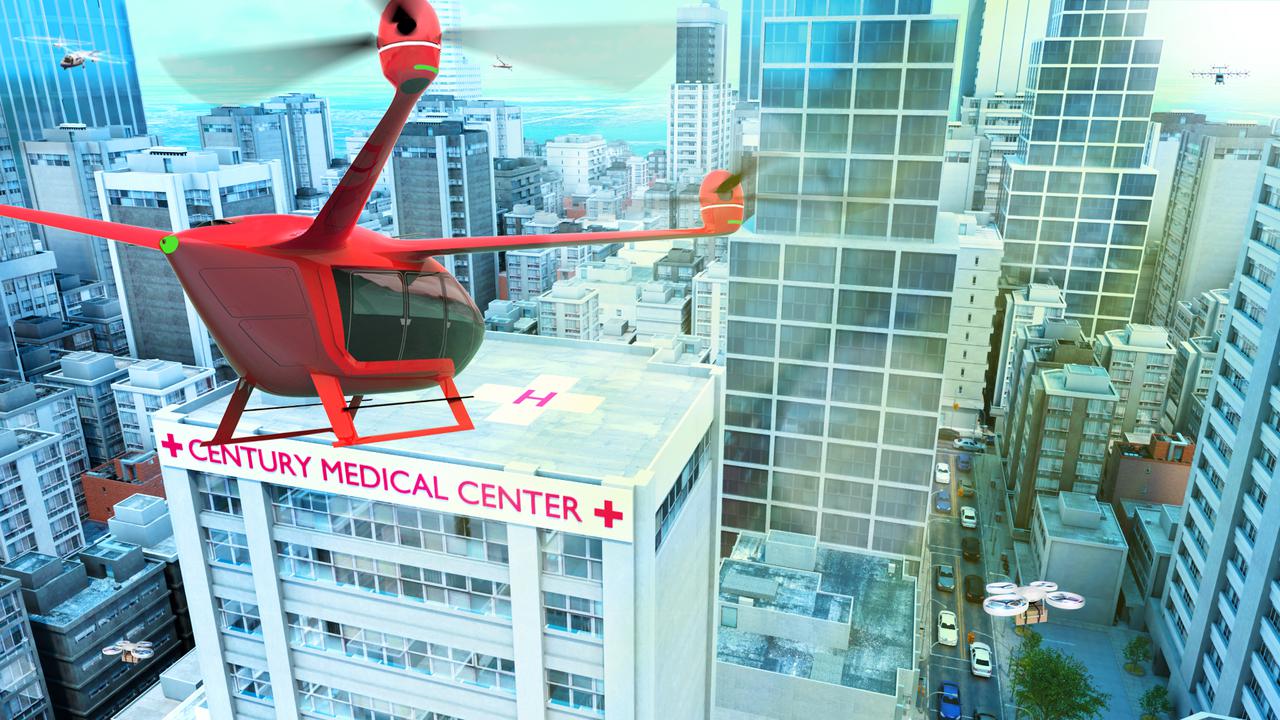
Several projects supporting NASA's Advanced Air Mobility or AAM mission are working on different research initiatives to help make AAM a reality. AAM could be used in healthcare operations in the form of air taxi ambulances or medical supply delivery in the future. This concept graphic shows how a future AAM vehicle could aid in healthcare by carrying passengers to a hospital.
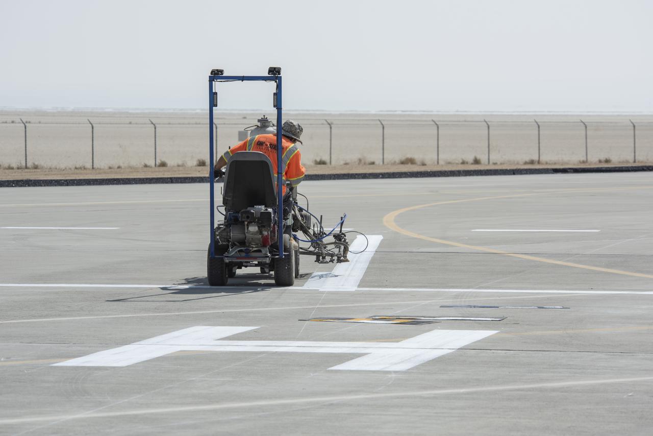
A worker painted vertiports and helipads at NASA's Armstrong Flight Research Center Oct. 6-14, 2020. The Advanced Air Mobility project's National Campaign will use these areas for future flight testing.
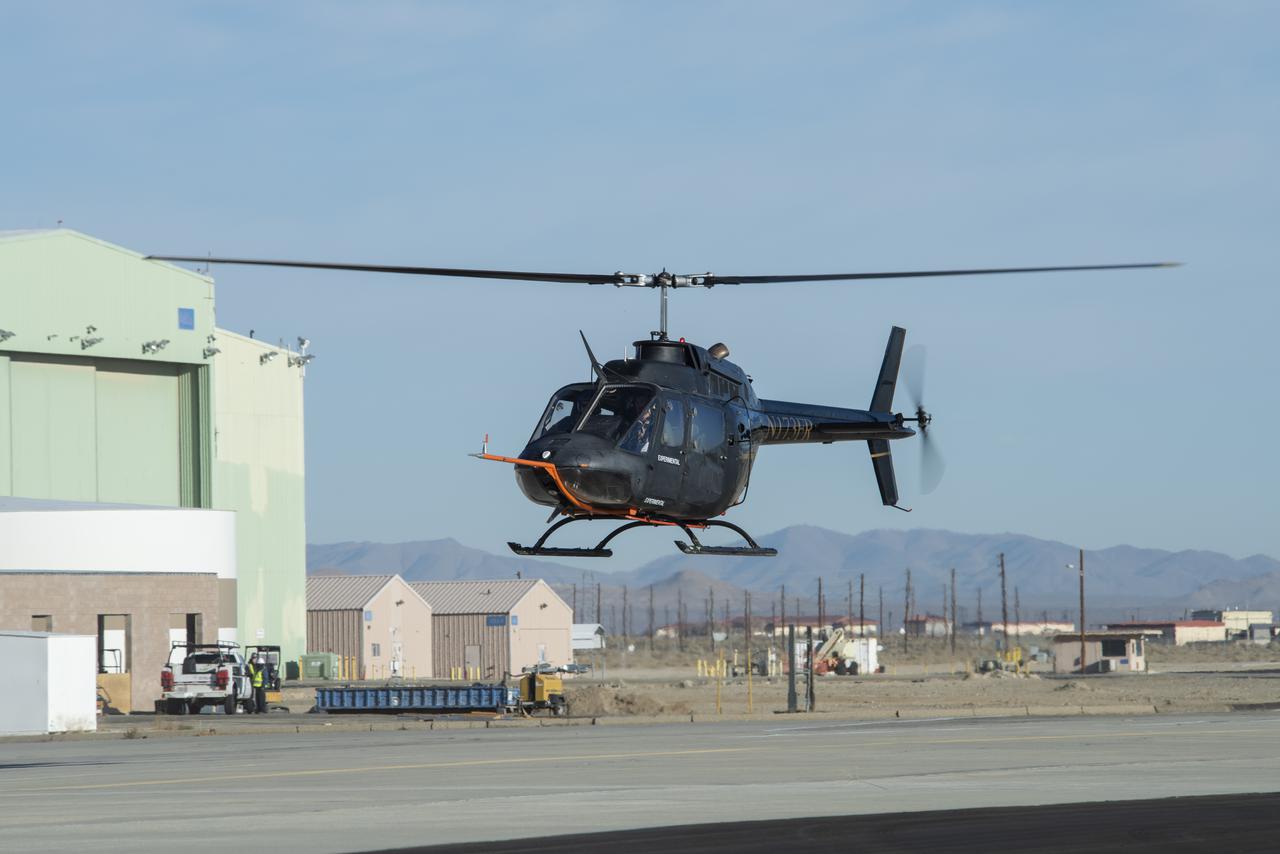
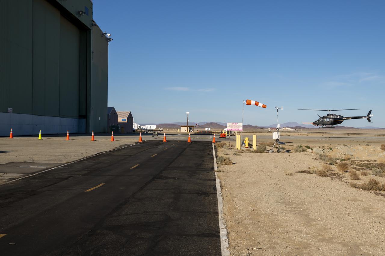
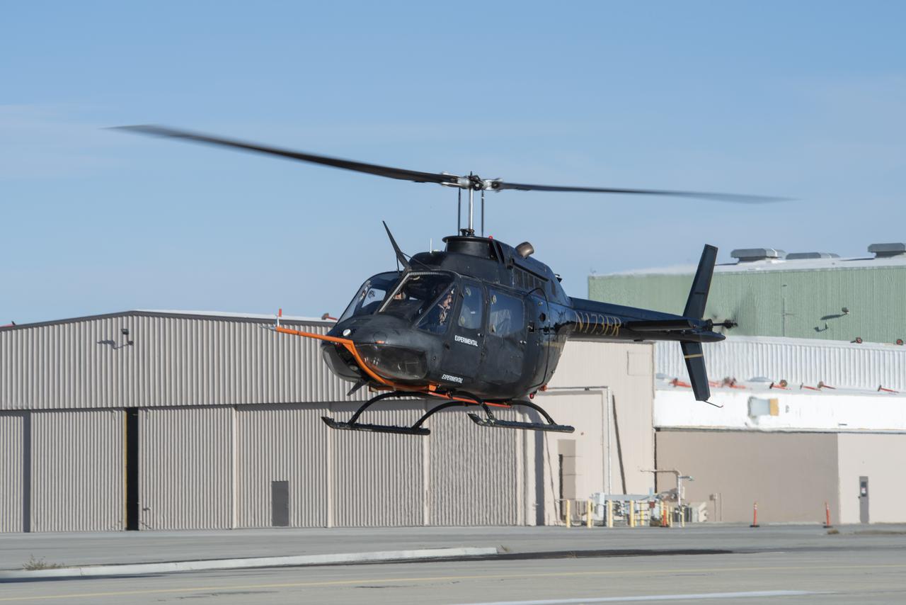
A Bell OH-58C Kiowa helicopter provided by Flight Research Inc. in Mojave, California, flies at NASA’s Armstrong Flight Research Center in California the first week of December 2020. The Advanced Air Mobility National Campaign project used the helicopter as a surrogate urban air mobility vehicle to develop a data baseline for future flight testing. Â

Vertiports and helipads were painted Oct. 6-14, 2020 at NASA’s Armstrong Flight Research Center to support future flight testing for the Advanced Air Mobility project’s National Campaign.
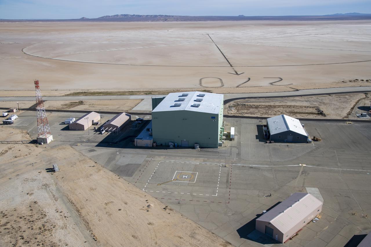
An aerial image taken by one of NASA's photographers during recent helicopter flights shows a view of the windward helipad and surrounding areas and structures that the Advanced Air Mobility National Campaign used during flight research at NASA's Armstrong Flight Research Center in Edwards, California. Part of the compass rose on the Edwards Air Force Base dry lakebed can also be seen.
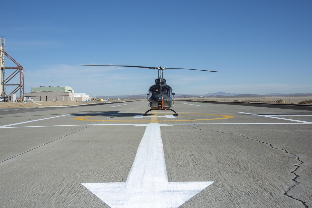
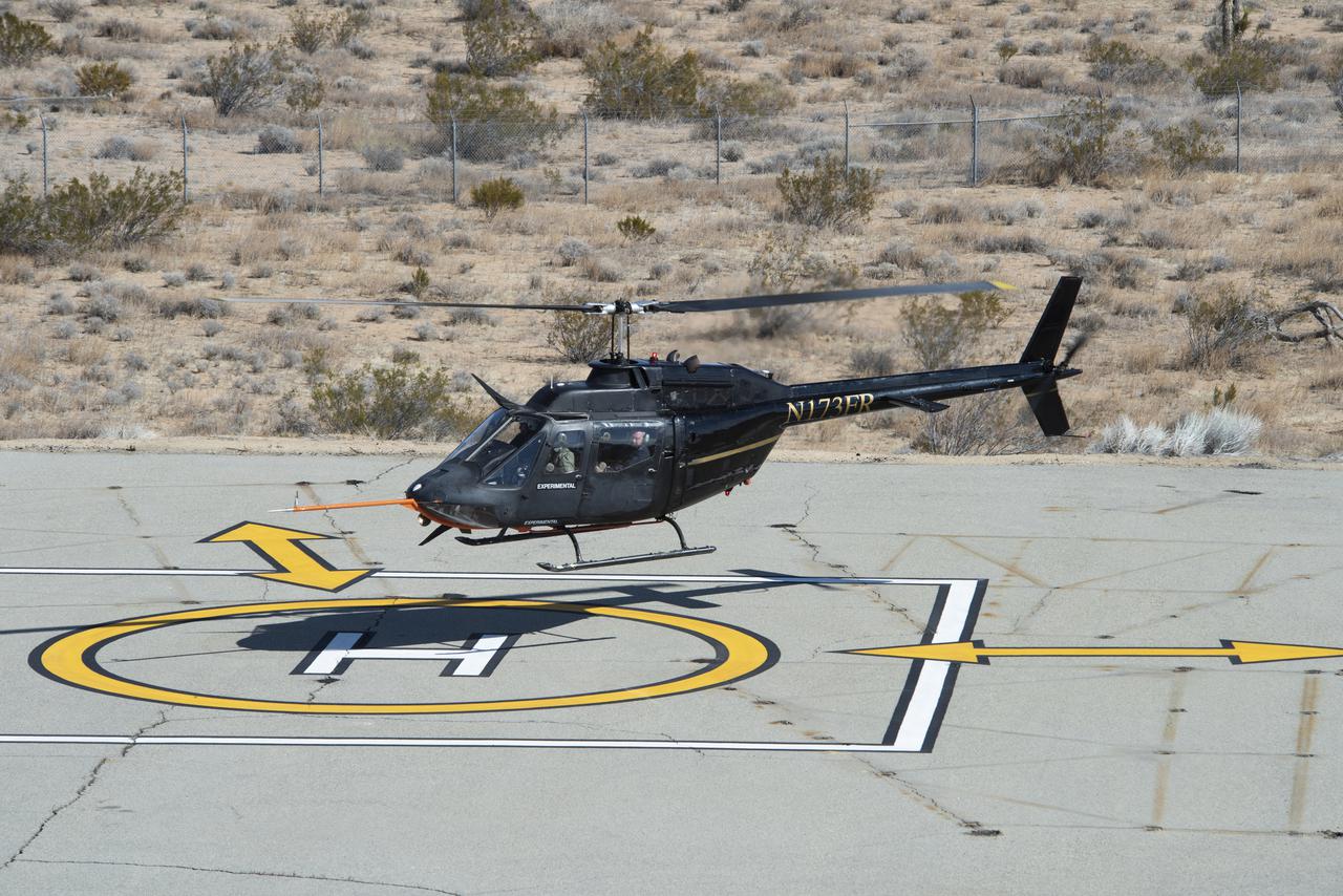
A Bell OH-58C Kiowa helicopter provided by Flight Research Inc. in Mojave, California, sits on a helipad at NASA’s Armstrong Flight Research Center in California the first week of December 2020. The Advanced Air Mobility National Campaign project used the helicopter as a surrogate urban air mobility vehicle to develop and implement infrastructure, including the markings seen in the image, to support safe operations of these vehicles. Â

NASA’s Advanced Air Mobility National Campaign used this Bell OH-58 helicopter owned by Flight Research Inc. to study urban air mobility vehicle performance, flying qualities, and airspace requirements. The helicopter performed test maneuvers at NASA’s Armstrong Flight Research Center in Edwards, California, during two sessions Nov, 8-10, and Dec. 6, and 8-10.
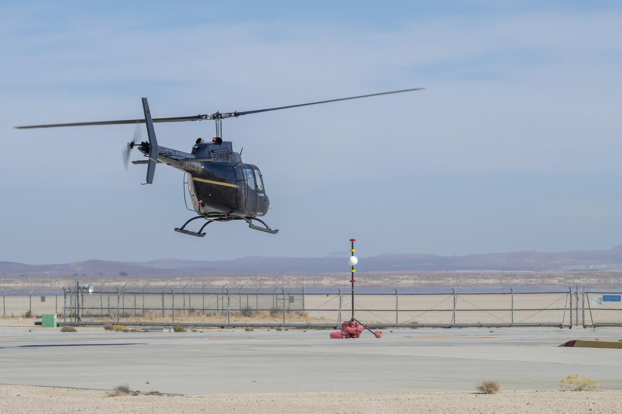
A Bell OH-58 Kiowa helicopter provided by Flight Research Inc. flies around a visual aid, known as a tetherball, created to serve as the pilot's visual height reference while performing handling qualities testing at NASA's Armstrong Flight Research Center in Edwards, California, Nov. 8-10. NASA's Advanced Air Mobility National Campaign used the helicopter to study urban air mobility vehicle and airspace requirements.
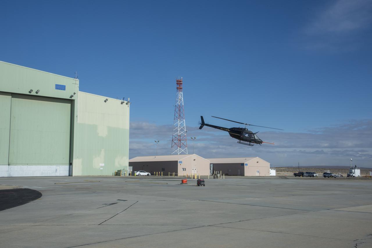
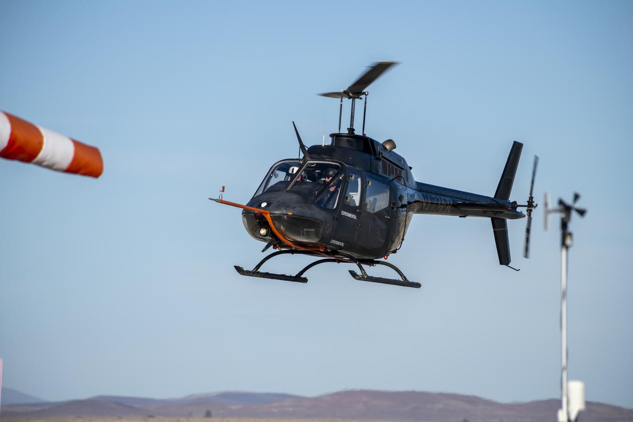
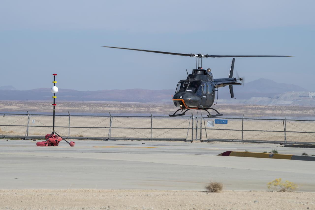
Flight Research Inc.'s Bell OH-58C Kiowa helicopter departs the leeward heliport at NASA's Armstrong Flight Research Center in California in March 2021. The Advanced Air Mobility National Campaign project studied wind and structure interactions as part of a second phase of testing called build II. This helicopter was used as a surrogate urban air mobility or air taxi vehicle.
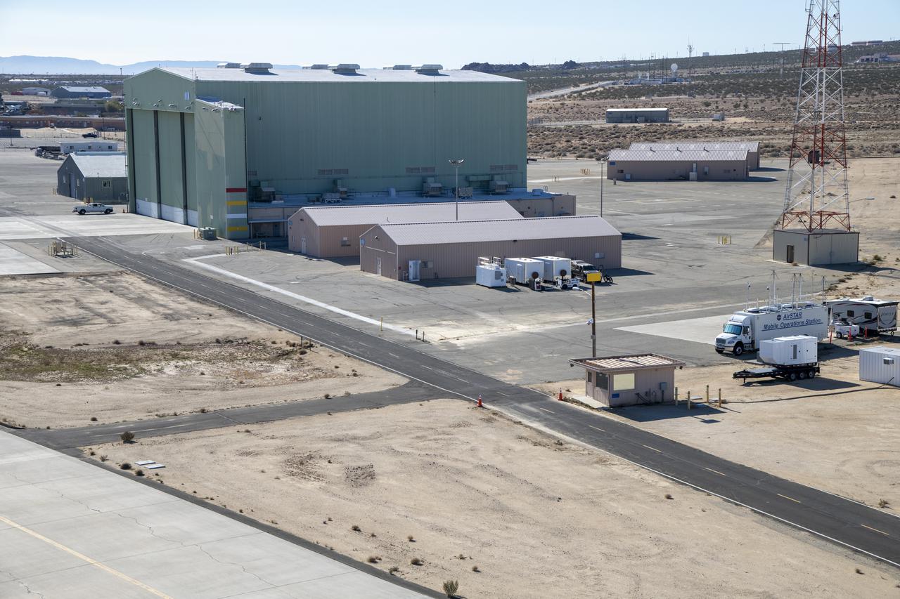
An aerial image taken by one of NASA’s photographers during recent helicopter flights shows a view of the building 4833 structure and the mobile operating facility at NASA’s Armstrong Flight Research Center in Edwards, California. NASA’s Advanced Air Mobility National Campaign uses the mobile operations facility vehicle shown in the lower right corner during test operations. The red, yellow, and white building markings applied to building 4833 are used to provide visual aids to the pilot during handling qualities testing used to research advanced air mobility flight requirements.
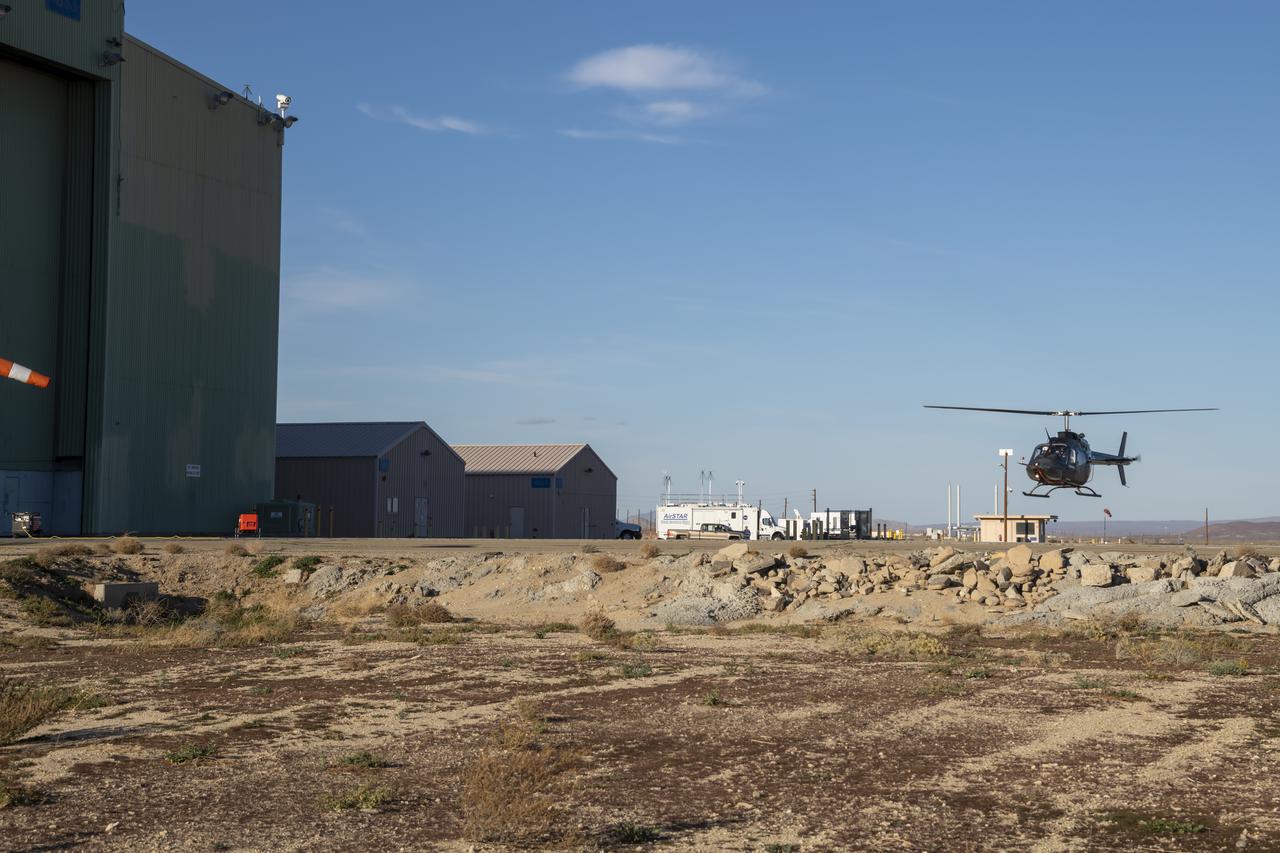
NASA’s Advanced Air Mobility National Campaign flies maneuvers at NASA’s Armstrong Flight Research Center in Edwards, California, Dec. 6, and 8-10. During this testing, the helicopter is used to study controllability characteristics when operating near buildings during heavy wind conditions. The Bell OH-58 Kiowa helicopter provided by Flight Research Inc. was used to study urban air mobility vehicle performance and flying qualities requirements.
Flight Research Inc.'s Bell OH-58C Kiowa helicopter flies vehicle characteristics maneuvers for comparison to developmental urban air mobility (UAM) test maneuvers at NASA's Armstrong Flight Research Center in California in March 2021. The Advanced Air Mobility National Campaign studied flight test techniques that may be used for future UAM certification.
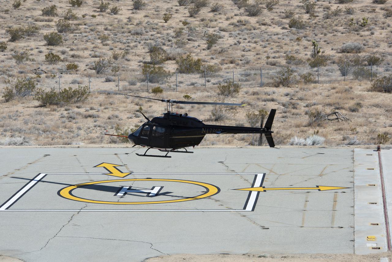
Flight Research Inc.’s Bell OH-58C Kiowa helicopter hovers over a helipad after completing an urban air mobility approach at NASA’s Armstrong Flight Research Center in California in March 2021. The Advanced Air Mobility National Campaign studied the viability of various urban air mobility approach options during a second phase called build II. This helicopter was used as a surrogate urban air mobility or air taxi vehicle.
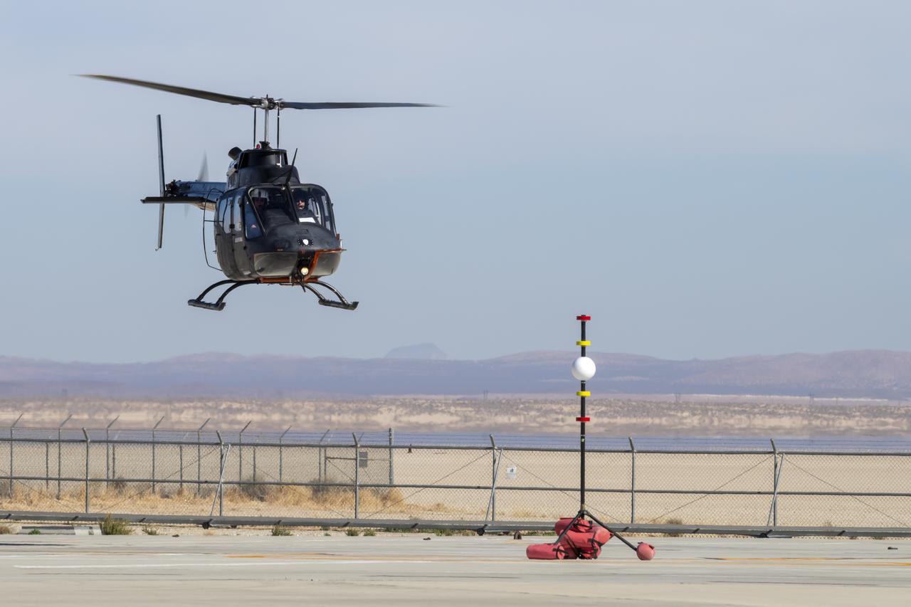
NASA's Advanced Air Mobility National Campaign created a visual aid, known as a tetherball, to serve as the helicopter pilot's height reference while flying different task elements at NASA's Armstrong Flight Research Center in Edwards, California, Nov. 8-10. The Bell OH-58 Kiowa helicopter provided by Flight Research Inc. was used to study urban air mobility vehicle performance and flying qualities requirements.
Flight Research Inc.'s Bell OH-58 helicopter performs different test maneuvers at NASA's Armstrong Flight Research Center in Edwards, California, Nov. 8-10, and Dec. 6, and 8-10. NASA's Advanced Air Mobility National Campaign used the helicopter to study urban air mobility vehicle performance and flying qualities requirements.
NASA's Advanced Air Mobility National Campaign conducts testing to study controllability characteristics when operating near buildings during heavy wind conditions at NASA's Armstrong Flight Research Center in Edwards, California, Dec. 6 and 8-10. The Bell OH-58 Kiowa helicopter provided by Flight Research Inc. was used to study urban air mobility vehicle performance and flying qualities requirements.
A Bell OH-58C Kiowa helicopter provided by Flight Research Inc. in Mojave, California, prepares to land at NASA’s Armstrong Flight Research Center in California the first week of December 2020. The Advanced Air Mobility National Campaign project used the helicopter as a surrogate urban air mobility vehicle to develop a data baseline for future flight testing.

Flight Research Inc.’s Bell OH-58C Kiowa helicopter lands on a helipad at NASA’s Armstrong Flight Research Center in California in March 2021 at the completion of an urban air mobility scenario. The Advanced Air Mobility National Campaign project conducted a second phase of research called build II. This helicopter was used as a surrogate urban air mobility vehicle to study aspects of a future air taxi mission.
Flight Research Inc.’s Bell OH-58C Kiowa helicopter takes off from a research helipad at NASA’s Armstrong Flight Research Center in California in March 2021. The Advanced Air Mobility National Campaign project utilized several heliports and vertiports to study airspace management evolutions that could enable future urban air mobility operations. Tests were conducted during build II where this helicopter was used as a surrogate urban air mobility or air taxi vehicle.
Flight Research Inc.'s Bell OH-58 Kiowa helicopter flies around a visual aid, known as a tetherball, created to serve as the pilot's visual height reference while performing handling qualities testing at NASA's Armstrong Flight Research Center in Edwards, California, Nov. 8-10. NASA's Advanced Air Mobility National Campaign used the helicopter to study urban air mobility vehicle and airspace requirements.

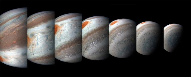
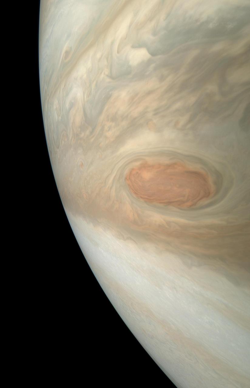
Jupiter's iconic Great Red Spot is a 10,000-mile-wide (16,000-kilometer-wide) storm that has been raging since at least the 1800s — and possibly for more than 350 years. Observations with NASA's Juno spacecraft previously indicated that the vertical extent of the Great Red Spot is over 120 miles (200 kilometers), consistent with a storm feature that develops deep in Jupiter's atmosphere. Since NASA's Voyager spacecraft visited Jupiter in 1979, the Great Red Spot has shrunk from about the size of 1.8 Earths to the size of about 1.3 Earths today. NASA's Juno spacecraft has imaged the Great Red Spot numerous times, providing unique information on the details of how the Great Red Spot dynamically changes while it is shrinking. This montage includes five map-projected mosaics of the giant storm, processed from images obtained by the JunoCam imager during several orbits between July 2017 and July 2019. The mosaics show how the Great Red Spot and nearby areas have changed over the course of the Juno mission. Will the Great Red Spot continue to shrink? Only time will tell, but as we study Jupiter's atmosphere, we learn more about how weather systems work, both on giant planets such as Jupiter and Saturn and also on our own home, Earth. Citizen scientist Björn Jónsson created this montage using JunoCam data. The images cover latitudes from about 5 degrees to 38 degrees south. Enhanced image by Björn Jónsson (CC-NC-SA) based on images provided courtesy of NASA/JPL-Caltech/SwRI/MSSS
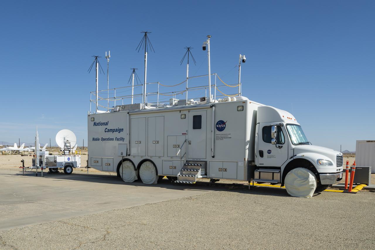
The upgraded NASA Mobile Operations Facility, a mission control and data collection center on wheels, is shown parked at NASA’s Armstrong Flight Research Center in Edwards, California on July 20, 2022. This vehicle is used for NASA's Advanced Air Mobility project’s National Campaign testing.
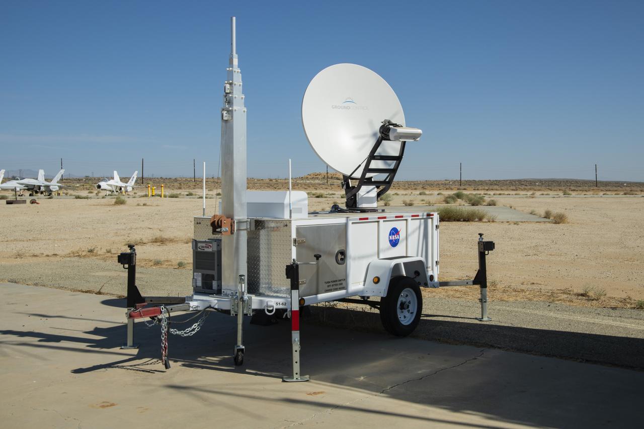
NASA Advanced Air Mobility project’s National Campaign mobile testing trailer is pictured at NASA Armstrong Flight Research Center in Edwards California on July 20, 2022. This trailer supports the Mobile Operations Facility’s data transmission when deployed to test locations.

The NASA Mobile Operations Facility sports new decals while parked at NASA Armstrong Flight Research Center in Edwards, California on July 20, 2022. This vehicle, also known as the MOF, is a mission control and data collection center on wheels. NASA's Advanced Air Mobility project uses it for testing.
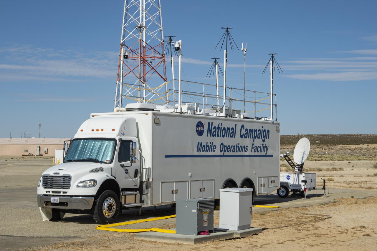
Photos taken on July 20, 2022, show new logos added to the side of the National Campaign’s upgraded Mobile Operations Facility, which has been outfitted to obtain and transmit data from anywhere in the country. This mobile command unit is housed at NASA Armstrong Flight Research Center in Edwards, California.
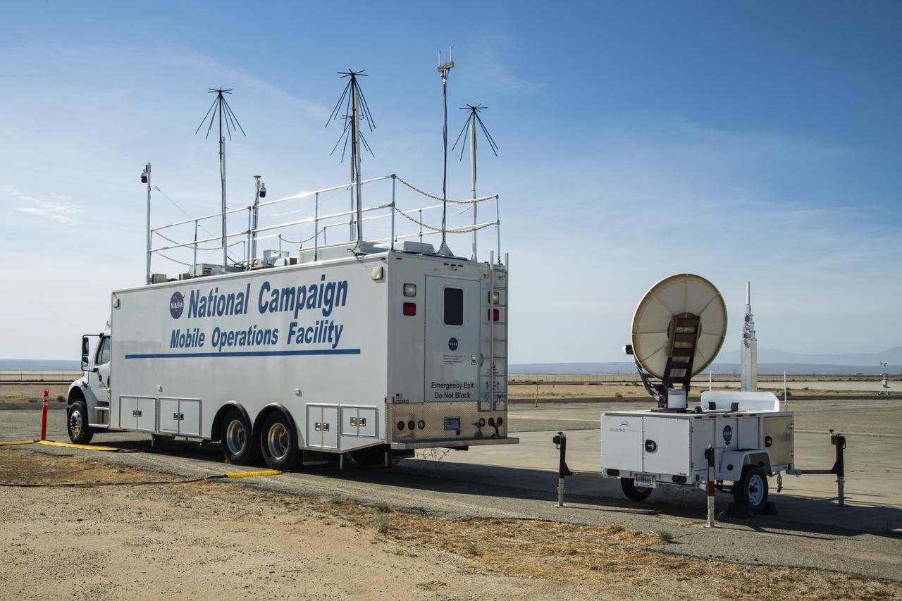
NASA's Mobile Operations Facility is shown here with new decals at NASA Armstrong Flight Research Center in Edwards, California on July 20, 2022. Antennas, sensors, and radar communications, housed inside and outside of the vehicle, help monitor aircraft and transmit data. NASA's Advanced Air Mobility project’s National Campaign uses the vehicle for testing.
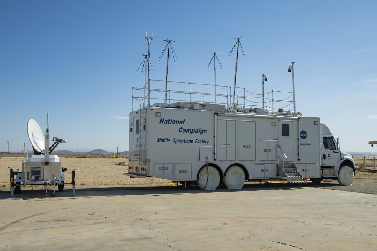
This specially outfitted mission control center, called the Mobile Operations Facility, can travel to any flight-testing site to obtain and transmit critical data. Here it is shown at NASA Armstrong Flight Research Center in Edwards, California on July 20, 2022. The data collected from the vehicle is used by NASA's Advanced Air Mobility project’s National Campaign.
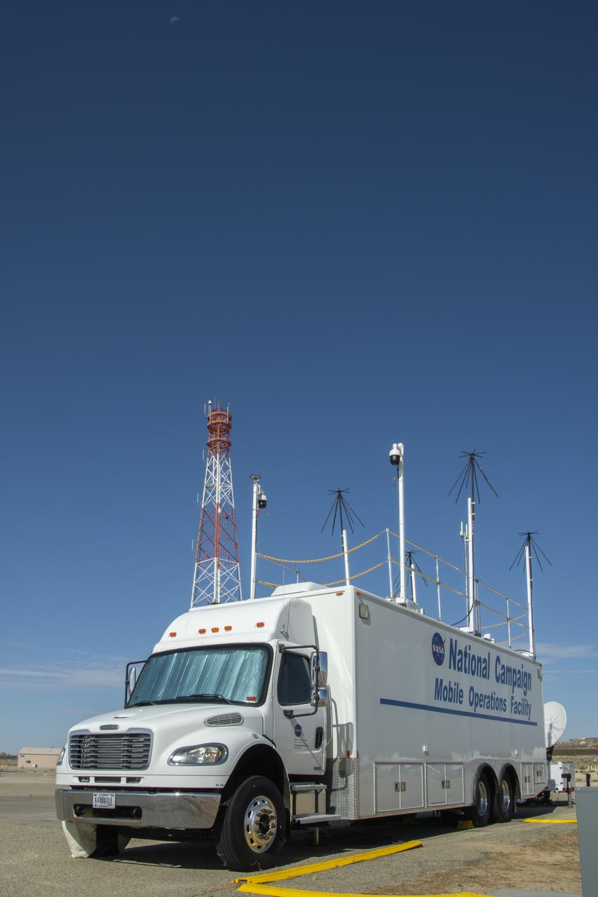
Housed at NASA Armstrong Flight Research Center in Edwards, California, the Advanced Air Mobility project's National Campaign upgraded the Mobile Operations Facility, pictured here on July 20, 2022. This command center on wheels is a key piece of NASA's AAM testing.
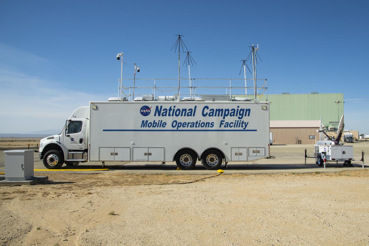
New decals are shown in this image of NASA's Mobile Operations Facility at NASA Armstrong Flight Research Center in Edwards, California on July 20, 2022. NASA's Advanced Air Mobility Project’s National Campaign uses the vehicle for mobile testing efforts.
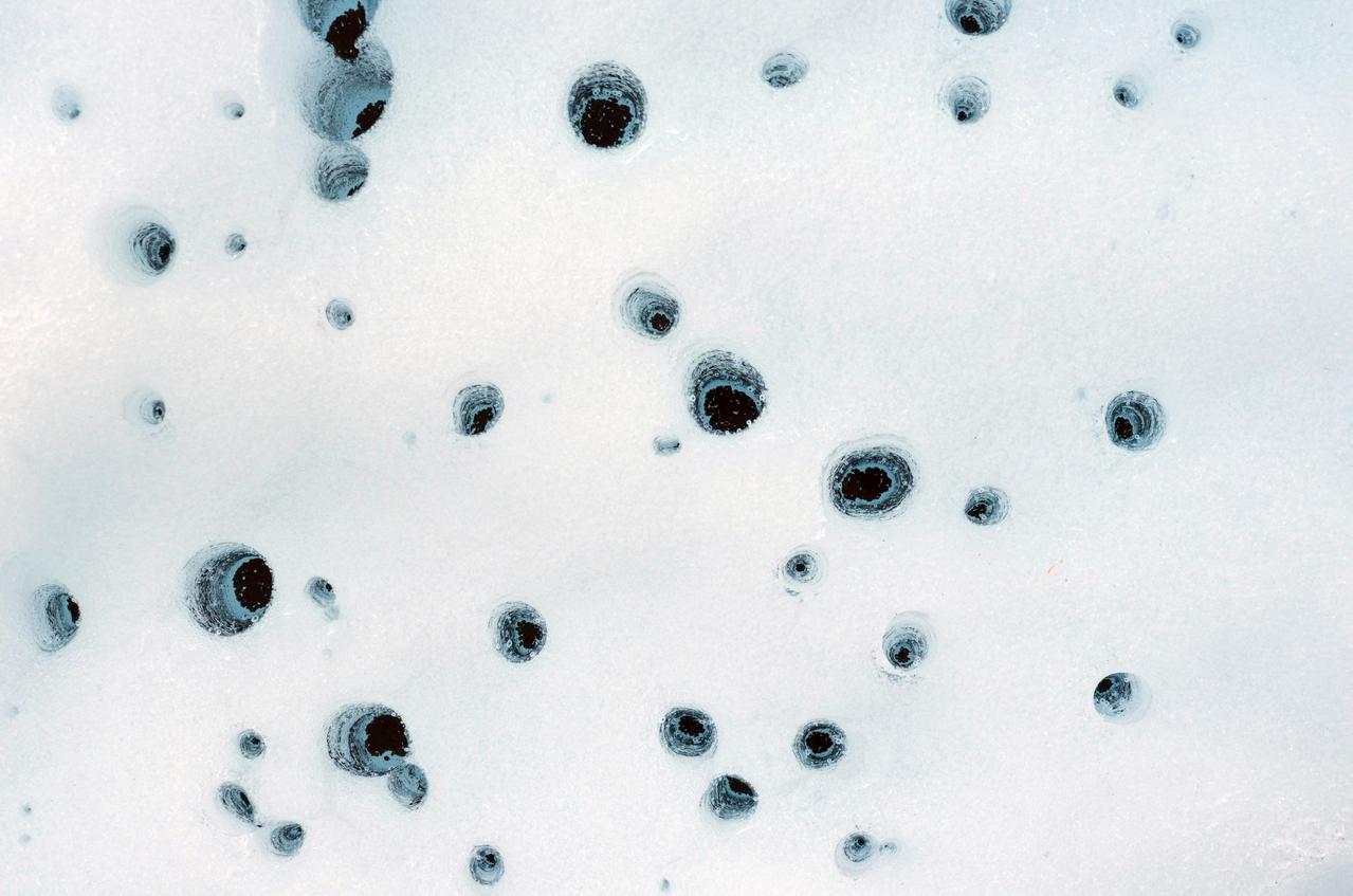
These holes, captured on Alaska's Matanuska Glacier in July 2012, are formed by cryoconite – dust particles that melt into the ice over time, eventually forming small pockets of water below the glacier's surface. Scientists believe similar pockets of water – called cryoconite holes on Earth – could form within dusty water ice on Mars. https://photojournal.jpl.nasa.gov/catalog/PIA26409

This composite image of the Jovian moon Io was generated using data collected by the JunoCam imager aboard NASA's Juno spacecraft during four separate flybys. The resolution of the images gets progressively better as the distance between spacecraft and moon decreases with each flyby. The image of the moon on the far left has a resolution 44 miles (71 kilometers) per pixel. It was taken on April 9, 2022, during Juno's 41st orbit of Jupiter (perijove 41, or PJ41), when the spacecraft flew past Io at a distance of about 66,000 miles (106,000 kilometers). Note the gray, roughly triangular patch at the terminator near the moon's center. Citizen scientist Björn Jónsson created this image using data from JunoCam. The center-left image was acquired on July 5, 2022, during Juno's 43rd orbit of Jupiter (PJ43) at a distance of 53,000 miles (86,000 kilometers). The resolution in this image has improved to 36 miles (58 kilometers) per pixel. In this view, more detail of the gray patch is seen (from a different perspective). Citizen scientist Jason Perry created this image using data from JunoCam. By the time the center-right image of Io was taken on Dec. 14, 2022, (PJ47), the distance between spacecraft and moon had decreased to 40,000 miles (64,000 kilometers), which increased the resolution to 27 miles (43 kilometers) per pixel. Here, the gray triangle appears as three distinct volcanoes with the central vents visible as dark spots in their centers. Characteristics of other nearby volcanoes also begin to stand out. Citizen scientist Mike Ravine created this image using data from JunoCam. The far-right image, taken during Juno's 49th flyby (PJ49) on March 1, 2023, shows that the spacecraft again approached the moon from a changed perspective, allowing different territory on Io's surface to be viewed. The triplet of volcanoes that make up the gray triangular patch are visible near the top of the image, and more detail of the volcanic terrain can be made out. The altitude at the time of closest approach was about 32,000 miles (51,500 kilometers), allowing resolution to increase to 22 miles (35 kilometers) per pixel. Citizen scientist Kevin M. Gill created this image using data from JunoCam. https://photojournal.jpl.nasa.gov/catalog/PIA25887
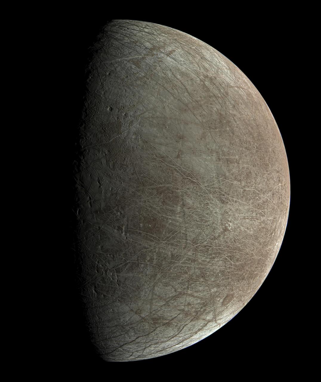
This view of Jupiter's icy moon Europa was captured by JunoCam, the public engagement camera aboard NASA's Juno spacecraft, during the mission's close flyby on Sept. 29, 2022. Citizen scientist Björn Jónsson processed the view to create this image. Jónsson processed the image to enhance the color and contrast. The resolution is about 0.6 miles (1 kilometer) per pixel. JunoCam took the image at an altitude of 945 miles (1,521 kilometers) above a region of the moon called Annwn Regio. In the image, terrain beside the day-night boundary is revealed to be rugged, with pits and troughs. Numerous bright and dark ridges and bands stretch across a fractured surface, revealing the tectonic stresses that the moon has endured over millennia. The circular dark feature at the lower right is Callanish Crater. JunoCam images of Europa help fill in gaps in the maps from images obtained during by NASA's Voyager and Galileo missions. In processing raw images taken by JunoCam, members of the public create deep-space portraits of the Jovian moon that aren't only awe-inspiring but also worthy of further scientific scrutiny. Juno citizen scientists have played an invaluable role in processing the numerous JunoCam images obtained during science operations at Jupiter. https://photojournal.jpl.nasa.gov/catalog/PIA25334
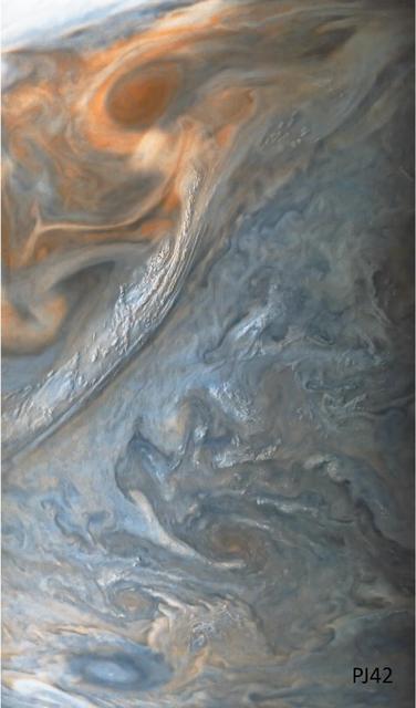
This image of a "jet" in Jupiter's atmosphere was taken by the JunoCam public engagement camera aboard NASA's Juno spacecraft on May 23, 2022. Jupiter's atmosphere is organized into belts and zones, separated by jets, which are associated with turbulence along belt-zone boundaries, leading to chaotic regions of multicolored clouds. In this image, the color in these two regions has been enhanced to bring out detail and show the different layers of cloud decks. Juno's orbit around Jupiter changes every time the spacecraft passes the giant planet, with the point of closest approach – the perijove, or "PJ" – moving steadily northward. As the perijove changes, the resolution of images taken in the northern hemisphere steadily increases. This image of Jet N3 was acquired on PJ42, Juno's 42nd pass by Jupiter, at 41.6 degrees north from an altitude of 2,361 miles (3,800 kilometers). It shows features as small as 1.6 miles (2.6 kilometers) across. Citizen scientist Sergio Díaz processed the image to enhance the color and contrast. https://photojournal.jpl.nasa.gov/catalog/PIA25693
This view of Jupiter's turbulent atmosphere from NASA's Juno spacecraft includes several of the planet's southern jet streams. Using data from Juno's instruments, scientists discovered that Jupiter's powerful atmospheric jet streams extend far deeper than previously imagined. Evidence from Juno shows the jet streams and belts penetrate about 1,800 miles (3,000 kilometers) down into the planet. The storm known as the Great Red Spot is also visible on the horizon, nearly rotated out of view as Juno sped away from Jupiter at about 30 miles per second (48 kilometers per second), which is more than 100,000 mph (160,900 kilometers per hour). Citizen scientist Tanya Oleksuik created this color-enhanced image using data from the JunoCam camera. The original image was taken on Dec. 30, 2020 as the Juno spacecraft performed its 31st close flyby of Jupiter. At the time, the spacecraft was about 31,000 miles (about 50,000 kilometers) from the planet's cloud tops, at a latitude of about 50 degrees South. https://photojournal.jpl.nasa.gov/catalog/PIA23809
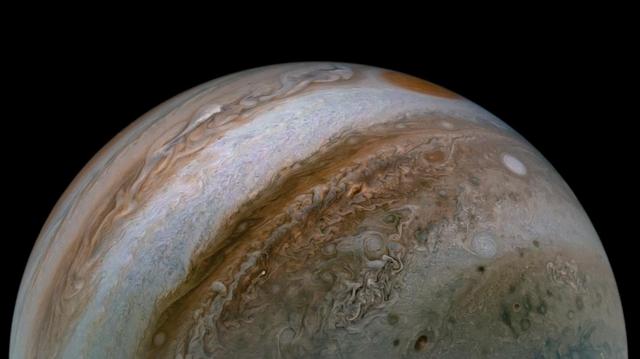
NASA's Juno spacecraft captured this view of Jupiter during the mission's 54th close flyby of the giant planet on Sept. 7, 2023. The colorful zones and belts in Jupiter's atmosphere run from the cloud tops down to approximately 1,860 miles (3,000 kilometers). Citizen scientist Tanya Oleksuik made this image using raw data from the JunoCam instrument, processing the data to enhance details in cloud features and colors. At the time the raw image was taken, the Juno spacecraft was about 52,400 miles (about 84,400 kilometers) above Jupiter's cloud tops. https://photojournal.jpl.nasa.gov/catalog/PIA26077
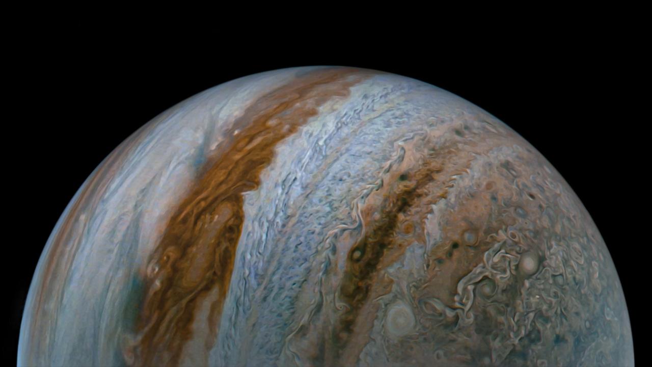
NASA's Juno spacecraft observed the complex colors and structure of Jupiter's clouds as it completed its 43rd close flyby of the giant planet on July 5, 2022. Citizen scientist Björn Jónsson created these two images using raw data from the JunoCam instrument aboard the spacecraft. At the time the raw image was taken, Juno was about 3,300 miles (5,300 kilometers) above Jupiter's cloud tops, at a latitude of about 50 degrees. North is up. At that moment, the spacecraft was traveling at about 130,000 mph (209,000 kilometers per hour) relative to the planet. The image was digitally processed to increase both the color saturation and contrast to sharpen small-scale features and to reduce compression artifacts and noise that typically appear in raw images. This clearly reveals some of the most intriguing aspects of Jupiter's atmosphere, including color variation that results from differing chemical composition, the three-dimensional nature of Jupiter's swirling vortices, and the small, bright "pop-up" clouds that form in the higher parts of the atmosphere. https://photojournal.jpl.nasa.gov/catalog/PIA25018
On March 1, 2023, NASA's Juno mission completed its 49th close flyby of Jupiter. As the spacecraft flew low over the giant planet's cloud tops, its JunoCam instrument captured this look at bands of high-altitude haze forming above cyclones in an area known at Jet N7. Citizen scientist Björn Jónsson processed a raw image from the JunoCam instrument, enhancing the contrast and sharpness. At the time the image was taken, Juno was about 5,095 miles (8,200 kilometers) above Jupiter's cloud tops, at a latitude of about 66 degrees. https://photojournal.jpl.nasa.gov/catalog/PIA25725

This series of enhanced-color images shows Jupiter up close and personal, as NASA's Juno spacecraft performed its eighth flyby of the gas giant planet. The images were obtained by JunoCam. From left to right, the sequence of images taken on Sept. 1, 2017 from 3:03 p.m. to 3:11 p.m. PDT (6:03 p.m. to 6:11 p.m. EDT). At the times the images were taken, the spacecraft ranged from 7,545 to 14,234 miles (12,143 to 22,908 kilometers) from the tops of the clouds of the planet at a latitude range of -28.5406 to -44.4912 degrees. Points of Interest include "Dalmatian Zone/Eye of Odin," "Dark Eye/STB Ghost East End," "Coolest Place on Jupiter," and "Renslow/Hurricane Rachel." The final image in the series on the right shows Jupiter's south pole coming into view. Citizen scientists Gerald Eichstädt and Seán Doran created this image using data from the spacecraft's JunoCam imager. https://photojournal.jpl.nasa.gov/catalog/PIA21780
Clouds in a Jovian jet stream, called Jet N5, swirl in the center of this color-enhanced image from NASA's Juno spacecraft. A brown oval known as a "brown barge" can be seen in the North North Temperate Belt region in the top-left portion of the image. This image was taken at 5:58 p.m. PDT on Sept. 6, 2018 (8:58 p.m. EDT) as the spacecraft performed its 15th close flyby of Jupiter. At the time, Juno was 7,600 miles (12,300 kilometers) from the planet's cloud tops, above a northern latitude of approximately 52 degrees. Citizen scientists Brian Swift and Seán Doran created this image using data from the spacecraft's JunoCam imager. The view has been rotated 90 degrees to the right from the original image. https://photojournal.jpl.nasa.gov/catalog/PIA22689

A multitude of magnificent, swirling clouds in Jupiter's dynamic North North Temperate Belt is captured in this image from NASA's Juno spacecraft. Appearing in the scene are several bright-white "pop-up" clouds as well as an anticyclonic storm, known as a white oval. This color-enhanced image was taken at 1:58 p.m. PDT on Oct. 29, 2018 (4:58 p.m. EDT) as the spacecraft performed its 16th close flyby of Jupiter. At the time, Juno was about 4,400 miles (7,000 kilometers) from the planet's cloud tops, at a latitude of approximately 40 degrees north. Citizen scientists Gerald Eichstädt and Seán Doran created this image using data from the spacecraft's JunoCam imager. https://photojournal.jpl.nasa.gov/catalog/PIA22692
See Jupiter's southern hemisphere in beautiful detail in this new image taken by NASA's Juno spacecraft. The color-enhanced view captures one of the white ovals in the "String of Pearls," one of eight massive rotating storms at 40 degrees south latitude on the gas giant planet. The image was taken on Oct. 24, 2017 at 11:11 a.m. PDT (2:11 p.m. EDT), as Juno performed its ninth close flyby of Jupiter. At the time the image was taken, the spacecraft was 20,577 miles (33,115 kilometers) from the tops of the clouds of the planet at a latitude of minus 52.96 degrees. The spatial scale in this image is 13.86 miles/pixel (22.3 kilometers/pixel). Citizen scientists Gerald Eichstädt and Seán Doran processed this image using data from the JunoCam imager. https://photojournal.jpl.nasa.gov/catalog/PIA21970

Waves of clouds at 37.8 degrees latitude dominate this three-dimensional Jovian cloudscape, courtesy of NASA's Juno spacecraft. JunoCam obtained this enhanced-color picture on May 19, 2017, at 5:50 UTC from an altitude of 5,500 miles (8,900 kilometers). Details as small as 4 miles (6 kilometers) across can be identified in this image. The small bright high clouds are about 16 miles (25 kilometers) across and in some areas appear to form "squall lines" (a narrow band of high winds and storms associated with a cold front). On Jupiter, clouds this high are almost certainly composed of water and/or ammonia ice. Citizen scientists Gerald Eichstädt and Seán Doran created this image using data from the spacecraft's JunoCam imager. https://photojournal.jpl.nasa.gov/catalog/PIA21646
A giant, spiraling storm in Jupiter's southern hemisphere is captured in this animation from NASA's Juno spacecraft. The storm is approximately 5,000 miles (8,000 kilometers) across, or roughly the width of the United States. The counterclockwise motion of the storm, called Oval BA, is clearly on display. A similar rotation can be seen in the famous Great Red Spot at the top of the animation. Juno took the nine images used to produce this movie sequence on Dec. 21, 2018, between 9:24 a.m. PST (12:24 p.m. EST) and 10:07 a.m. PST (1:07 p.m. EST). At the time the images were taken, the spacecraft was between approximately 15,400 miles (24,800 kilometers) and 60,700 miles (97,700 kilometers) from the planet's cloud tops above southern latitudes spanning about 36 to 74 degrees. Citizen scientists Gerald Eichstädt and Seán Doran created this animation using data from the spacecraft's JunoCam imager. Animation available at https://photojournal.jpl.nasa.gov/catalog/PIA22943
NASA's Juno spacecraft was racing away from Jupiter following its seventh close pass of the planet when JunoCam snapped this image on May 19, 2017, from about 29,100 miles (46,900 kilometers) above the cloud tops. The spacecraft was over 65.9 degrees south latitude, with a lovely view of the south polar region of the planet. This image was processed to enhance color differences, showing the amazing variety in Jupiter's stormy atmosphere. The result is a surreal world of vibrant color, clarity and contrast. Four of the white oval storms known as the "String of Pearls" are visible near the top of the image. Interestingly, one orange-colored storm can be seen at the belt-zone boundary, while other storms are more of a cream color. Citizen scientists Gerald Eichstädt and Seán Doran processed this image using data from the JunoCam imager. https://photojournal.jpl.nasa.gov/catalog/PIA21392
This image of Jupiter's turbulent southern hemisphere was captured by NASA's Juno spacecraft as it performed its most recent close flyby of the gas giant planet on Dec. 21, 2018. This new perspective captures the notable Great Red Spot, as well as a massive storm called Oval BA. The storm reached its current size when three smaller spots collided and merged in the year 2000. The Great Red Spot, which is about twice as wide as Oval BA, may have formed from the same process centuries ago. Juno captured Oval BA in another image earlier on in the mission on Feb. 7, 2018. The turbulent regions around, and even the shape of, the storm have significantly changed since then. Oval BA further transformed in recent months, changing color from reddish to a more uniform white. Juno took the three images used to produce this color-enhanced view on Dec. 21, between 9:32 a.m. PST (12:32 p.m. EST) and 9:42 a.m. PST (12:42 p.m. EST). At the time the images were taken, the spacecraft was between approximately 23,800 miles (38,300 kilometers) to 34,500 miles (55,500 kilometers) from the planet's cloud tops above southern latitudes spanning 49.15 to 59.59 degrees. Citizen scientists Gerald Eichstädt and Seán Doran created this image using data from the spacecraft's JunoCam imager. https://photojournal.jpl.nasa.gov/catalog/PIA22942
This enhanced-color image of Jupiter's bands of light and dark clouds was created by citizen scientists Gerald Eichstädt and Seán Doran using data from the JunoCam imager on NASA's Juno spacecraft. Three of the white oval storms known as the "String of Pearls" are visible near the top of the image. Each of the alternating light and dark atmospheric bands in this image is wider than Earth, and each rages around Jupiter at hundreds of miles (kilometers) per hour. The lighter areas are regions where gas is rising, and the darker bands are regions where gas is sinking. Juno acquired the image on May 19, 2017, at 11:30 a.m. PST (2:30 p.m. EST) from an altitude of about 20,800 miles (33,400 kilometers) above Jupiter's cloud tops. https://photojournal.jpl.nasa.gov/catalog/PIA21393
A dynamic storm at the southern edge of Jupiter's northern polar region dominates this Jovian cloudscape, courtesy of NASA's Juno spacecraft. This storm is a long-lived anticyclonic oval named North North Temperate Little Red Spot 1 (NN-LRS-1); it has been tracked at least since 1993, and may be older still. An anticyclone is a weather phenomenon where winds around the storm flow in the direction opposite to that of the flow around a region of low pressure. It is the third largest anticyclonic oval on the planet, typically around 3,700 miles (6,000 kilometers) long. The color varies between red and off-white (as it is now), but this JunoCam image shows that it still has a pale reddish core within the radius of maximum wind speeds. Citizen scientists Gerald Eichstädt and Seán Doran processed this image using data from the JunoCam imager. The image has been rotated so that the top of the image is actually the equatorial regions while the bottom of the image is of the northern polar regions of the planet. The image was taken on July 10, 2017 at 6:42 p.m. PDT (9:42 p.m. EDT), as the Juno spacecraft performed its seventh close flyby of Jupiter. At the time the image was taken, the spacecraft was about 7,111 miles (11,444 kilometers) from the tops of the clouds of the planet at a latitude of 44.5 degrees. https://photojournal.jpl.nasa.gov/catalog/PIA21776
Tumultuous tempests in Jupiter's northern hemisphere are seen in this portrait taken by NASA's Juno spacecraft. Like our home planet, Jupiter has cyclones and anticyclones, along with fast-moving jet streams that circle its globe. This image captures a jet stream, called Jet N6, located on the far right of the image. It is next to an anticyclonic white oval that is the brighter circular feature in the top right corner. The North North Little Red Spot is also visible in this view. The image was taken at 10 p.m. PDT on July 15, 2018 (1 a.m. EDT on July 16), as the spacecraft performed its 14th close flyby of Jupiter. At the time, Juno was about 10,600 miles (17,000 kilometers) from the planet's cloud tops, above a latitude of 59 degrees. Citizen scientists Brian Swift and Seán Doran created this image using data from the spacecraft's JunoCam imager. The image has been rotated clockwise so that north is to the right. The stars were artfully added to the background for effect. https://photojournal.jpl.nasa.gov/catalog/PIA22428
This image of Jupiter's iconic Great Red Spot and surrounding turbulent zones was captured by NASA's Juno spacecraft. The color-enhanced image is a combination of three separate images taken on April 1 between 3:09 a.m. PDT (6:09 a.m. EDT) and 3:24 a.m. PDT (6:24 a.m. EDT), as Juno performed its 12th close flyby of Jupiter. At the time the images were taken, the spacecraft was 15,379 miles (24,749 kilometers) to 30,633 miles (49,299 kilometers) from the tops of the clouds of the planet at a southern latitude spanning 43.2 to 62.1 degrees. Citizen scientists Gerald Eichstädt and Seán Doran processed this image using data from the JunoCam imager. https://photojournal.jpl.nasa.gov/catalog/PIA21985

See Jovian clouds in striking shades of blue in this new view taken by NASA's Juno spacecraft. The Juno spacecraft captured this image when the spacecraft was only 11,747 miles (18,906 kilometers) from the tops of Jupiter's clouds -- that's roughly as far as the distance between New York City and Perth, Australia. The color-enhanced image, which captures a cloud system in Jupiter's northern hemisphere, was taken on Oct. 24, 2017 at 10:24 a.m. PDT (1:24 p.m. EDT) when Juno was at a latitude of 57.57 degrees (nearly three-fifths of the way from Jupiter's equator to its north pole) and performing its ninth close flyby of the gas giant planet. The spatial scale in this image is 7.75 miles/pixel (12.5 kilometers/pixel). Because of the Juno-Jupiter-Sun angle when the spacecraft captured this image, the higher-altitude clouds can be seen casting shadows on their surroundings. The behavior is most easily observable in the whitest regions in the image, but also in a few isolated spots in both the bottom and right areas of the image. Citizen scientists Gerald Eichstädt and Seán Doran processed this image using data from the JunoCam imager. https://photojournal.jpl.nasa.gov/catalog/PIA21972

Jupiter's moon Amalthea casts a shadow on the gas giant planet in this image captured by NASA's Juno spacecraft. The elongated shape of the shadow is a result of both the location of the moon with relation to Jupiter in this image as well as the irregular shape of the moon itself. The image was taken on Sept. 1, 2017 at 2:46 p.m. PDT (5:46 p.m. EDT), as Juno performed its eighth close flyby of Jupiter. At the time the image was taken, the spacecraft was 2,397 miles (3,858 kilometers) from the tops of the clouds of the planet at a latitude of 17.6 degrees. Citizen scientists Gerald Eichstädt and Seán Doran processed this image using data from the JunoCam imager. The image has been rotated so that the top of the image is actually the equatorial regions while the bottom of the image is of the northern polar regions of the planet. https://photojournal.jpl.nasa.gov/catalog/PIA21969

See a jet stream speeding through Jupiter's atmosphere in this new view taken by NASA's Juno spacecraft. The jet stream, called Jet N2, was captured along the dynamic northern temperate belts of the gas giant planet. It is the white stream visible from top left to bottom right in the image. The color-enhanced image was taken at 10:34 p.m. PST on May 23 (1:34 a.m. EST on May 24), as Juno performed its 13th close flyby of Jupiter. At the time the image was taken, the spacecraft was about 3,516 miles (5,659 kilometers) from the tops of the clouds of the planet at a northern latitude of 32.9 degrees. Citizen scientists Gerald Eichstädt and Seán Doran created this image using data from the spacecraft's JunoCam imager. The view is a composite of several separate JunoCam images that were re-projected, blended, and healed. https://photojournal.jpl.nasa.gov/catalog/PIA22422
Small bright clouds dot Jupiter's entire south tropical zone in this image acquired by JunoCam on NASA's Juno spacecraft on May 19, 2017, at an altitude of 7,990 miles (12,858 kilometers). Although the bright clouds appear tiny in this vast Jovian cloudscape, they actually are cloud towers roughly 30 miles (50 kilometers) wide and 30 miles (50 kilometers) high that cast shadows on the clouds below. On Jupiter, clouds this high are almost certainly composed of water and/or ammonia ice, and they may be sources of lightning. This is the first time so many cloud towers have been visible, possibly because the late-afternoon lighting is particularly good at this geometry. Citizen scientists Gerald Eichstädt and Seán Doran created this image using data from the spacecraft's JunoCam imager. https://photojournal.jpl.nasa.gov/catalog/PIA21647
Intricate swirls in Jupiter's volatile northern hemisphere are captured in this color-enhanced image from NASA's Juno spacecraft. Bursts of bright-white "pop-up" clouds appear scattered throughout the scene, with some visibly casting shadows on the neighboring cloud layers beneath them. Juno scientists are using shadows to determine the distances between cloud layers in Jupiter's atmosphere, which provide clues to their composition and origin. This image was taken at 10:27 p.m. PDT on May 23, 2018 (1:27 a.m. EDT on May 24) as the spacecraft performed its 13th close flyby of Jupiter. At the time, Juno was about 7,050 miles (11,350 kilometers) from the planet's cloud tops, above a northern latitude of approximately 49 degrees. Citizen scientists Gerald Eichstädt and Seán Doran created this image using data from the spacecraft's JunoCam imager. https://photojournal.jpl.nasa.gov/catalog/PIA22687
This extraordinary view of Jupiter was captured by NASA's Juno spacecraft on the outbound leg of its 12th close flyby of the gas giant planet. This new perspective of Jupiter from the south makes the Great Red Spot appear as though it is in northern territory. This view is unique to Juno and demonstrates how different our view is when we step off the Earth and experience the true nature of our three-dimensional universe. Juno took the images used to produce this color-enhanced image on April 1 between 3:04 a.m. PDT (6:04 a.m. EDT) and 3:36 a.m. PDT (6:36 a.m. EDT). At the time the images were taken, the spacecraft was between 10,768 miles (17,329 kilometers) to 42,849 miles (68,959 kilometers) from the tops of the clouds of the planet at a southern latitude spanning 34.01 to 71.43 degrees. Citizen scientists Gerald Eichstädt and Seán Doran created this image using data from the spacecraft's JunoCam imager. The view is a composite of several separate JunoCam images that were re-projected, blended, and healed. https://photojournal.jpl.nasa.gov/catalog/PIA22421
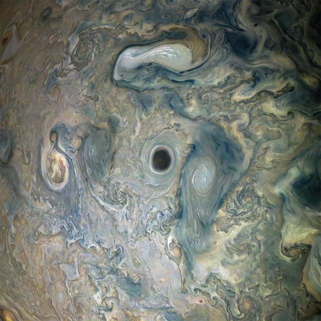
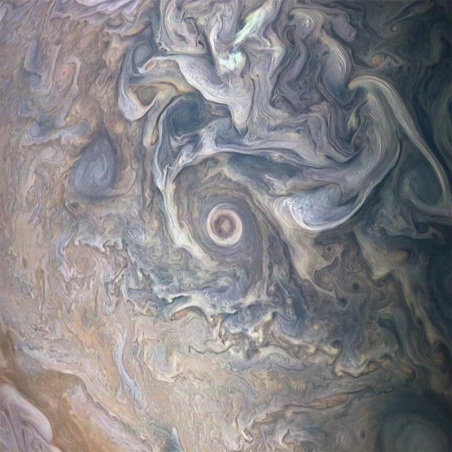
NASA's Juno spacecraft captured this view of an area within a Jovian jet stream showing a vortex that has an intensely dark center. Nearby, other features display bright, high altitude clouds that have puffed up into the sunlight. The color-enhanced image was taken at 12:55 a.m. PDT (3:55 a.m. EDT) on May 29, 2019, as the spacecraft performed its 20th science flyby of Jupiter. At the time, Juno was about 9,200 miles (14,800 kilometers) from the planet's cloud tops, above approximately 52 degrees north latitude. Citizen scientists Gerald Eichstädt and Seán Doran created this image using data from the spacecraft's JunoCam imager. https://photojournal.jpl.nasa.gov/catalog/PIA22948

NASA's Juno spacecraft was a little more than one Earth diameter from Jupiter when it captured this mind-bending, color-enhanced view of the planet's tumultuous atmosphere. Jupiter completely fills the image, with only a hint of the terminator (where daylight fades to night) in the upper right corner, and no visible limb (the curved edge of the planet). Juno took this image of colorful, turbulent clouds in Jupiter's northern hemisphere on Dec. 16, 2017 at 9:43 a.m. PST (12:43 p.m. EST) from 8,292 miles (13,345 kilometers) above the tops of Jupiter's clouds, at a latitude of 48.9 degrees. The spatial scale in this image is 5.8 miles/pixel (9.3 kilometers/pixel).. Citizen scientists Gerald Eichstädt and Seán Doran processed this image using data from the JunoCam imager. https://photojournal.jpl.nasa.gov/catalog/PIA21973