jsc2024e041214 (2/10/2024) --- Dr. Michael Jobst remotely operates a surgical robot aboard the International Space Station using controls at the Virtual Incision offices in Lincoln, Nebraska. Robotic Surgery Tech Demo tests techniques for performing robotic surgery in microgravity using a miniature surgical robot that can be remotely controlled or teleoperated from Earth. Results from this investigation could support the development of robotic systems to perform remote procedures. Miniaturization and the ability to remotely control robots may help to make surgery available anywhere and anytime. Image courtesy of the University of Nebraska-Lincoln.
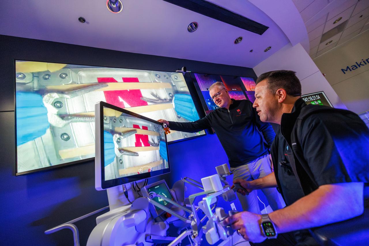
jsc2024e041212 (2/10/2024) --- Professor Shane Farritor (left) watches as Dr. Michael Jobst remotely operates a surgical robot aboard the International Space Station using controls at the Virtual Incision offices in Lincoln, Nebraska. Robotic Surgery Tech Demo tests techniques for performing robotic surgery in microgravity using a miniature surgical robot that can be remotely controlled or teleoperated from Earth. Results from this investigation could support the development of robotic systems to perform these procedures. Miniaturization and the ability to remotely control robots may help to make surgery available anywhere and anytime. Image courtesy of the University of Nebraska-Lincoln.
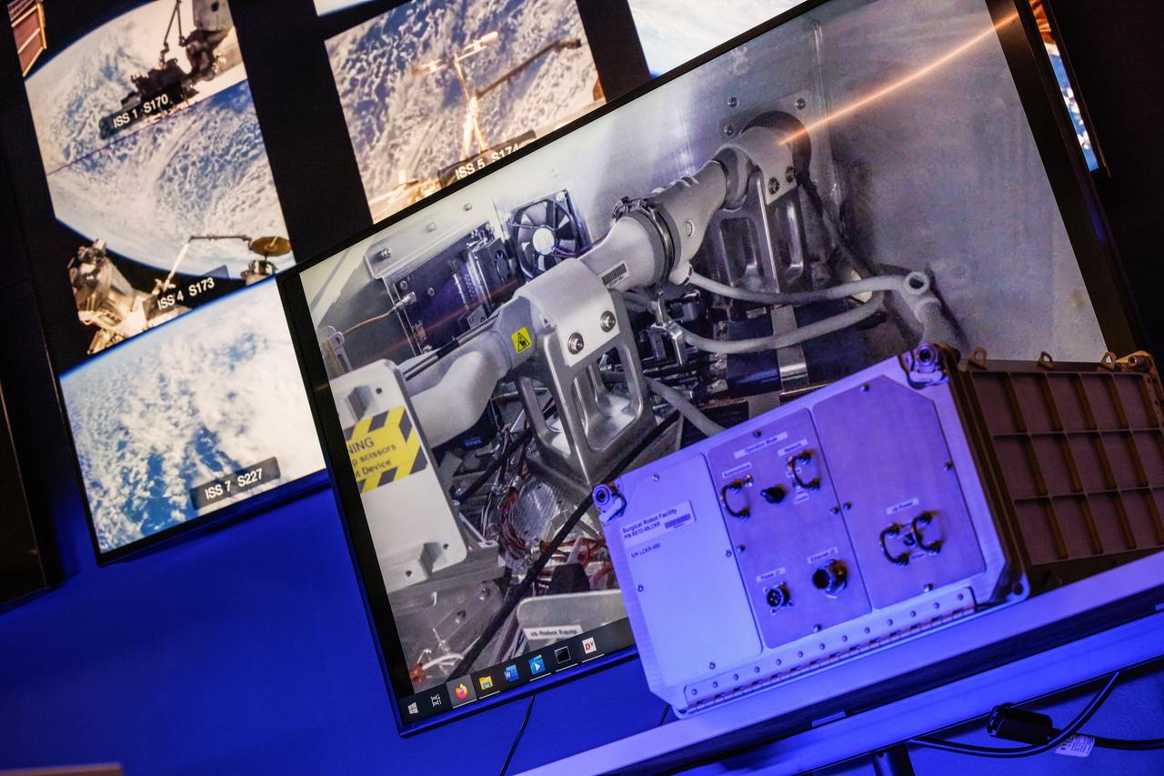
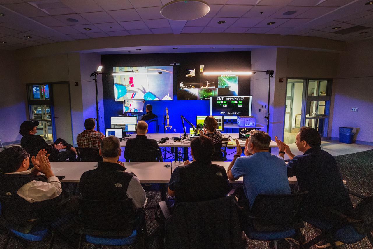
jsc2024e041211 (2/10/2024) --- Robotic Surgery Tech Demo tests techniques for performing robotic surgery in microgravity using a miniature surgical robot that can be remotely controlled or teleoperated from Earth. Several monitors at the Virtual Incision offices in Lincoln, Nebraska show views of the International Space Station during remote operations. Near the center, a larger monitor shows inside the box aboard the space station that houses the surgical robot. Results from this investigation could support the development of robotic systems to perform remote procedures. Miniaturization and the ability to remotely control robots may help to make surgery available anywhere and anytime. Image courtesy of the University of Nebraska-Lincoln.

jsc2024e041215 (2/10/2024) --- Dr. Dmitry Oleynikov remotely operates a surgical robot aboard the International Space Station using controls at the Virtual Incision offices in Lincoln, Nebraska. Robotic Surgery Tech Demo tests techniques for performing a simulated surgical procedure in microgravity using a miniature surgical robot that can be remotely controlled or teleoperated from Earth. Results from this investigation could support the development of robotic systems to perform these procedures. Miniaturization and the ability to remotely control robots may help to make surgery available anywhere and anytime. Image courtesy of the University of Nebraska-Lincoln.

jsc2024e041213 (2/10/2024) --- Dr. Michael Jobst remotely operates a surgical robot aboard the International Space Station using controls at the Virtual Incision offices in Lincoln, Nebraska. Robotic Surgery Tech Demo tests techniques for performing robotic surgery in microgravity using a miniature surgical robot that can be remotely controlled or teleoperated from Earth. Results from this investigation could support the development of robotic systems to perform remote procedures. Miniaturization and the ability to remotely control robots may help to make surgery available anywhere and anytime. Image courtesy of the University of Nebraska-Lincoln.
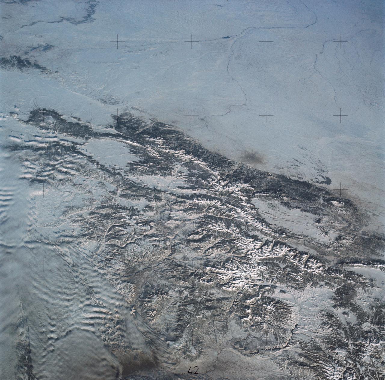
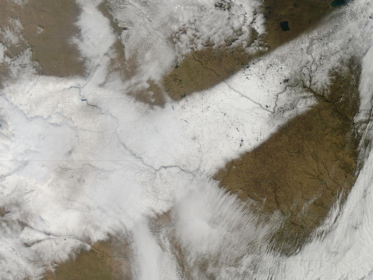
SL4-138-3875 (February 1974) --- A color oblique photograph looking east over the Rocky Mountains and Great Plains. This view covers a portion of the States of Colorado, Wyoming, and Nebraska. A Skylab 4 crewmen took this picture with a hand-held 70mm Hasselblad camera. This entire region, covered with a blanket of snow, depicts much of the structural and topographic features of the Rocky Mountain chain. Man's only apparent change to the snow pattern seen here is the (right center) metropolitan areas of Denver and Colorado Springs, Colorado, which can be observed along the eastern edge of the mountain front. Grand Junction, Colorado on the western slope of the Rocky Mountains is just off the photograph at left center bottom. The major inter-montane valleys of South Park (right center), Middle Park (center), and North Park (left center) are clearly visible and separate the Colorado Rockies Front Range from the high rugged mountains can be discovered such as Pikes Peak near right border (center), Mt. Cunnison region, circular feature accentuated by the Cunnison River (dark) in the right center (bottom) of the photograph. The snow covered peaks of Mts. Harvard, Princeton and Yale form the high region of the Collegiate Range which is the pronounced mountain area in the right center. Snow cover not only enhances mountain features but also the drainage patterns. East of Denver (right corner) the sinuous trace of the South Platte River (center) and its junction with the North Platte River near North Platte, Nebraska. Lake McConaughy in Nebraska is the body of water (black) near the river intersection. The trace of the Republic River in southern Nebraska is visible near the right corner of the photography. Geologic and hydro logic studies using this photograph will be conducted by Dr. Roger Morrison, U.S. Geological Survey. Photo credit: NASA
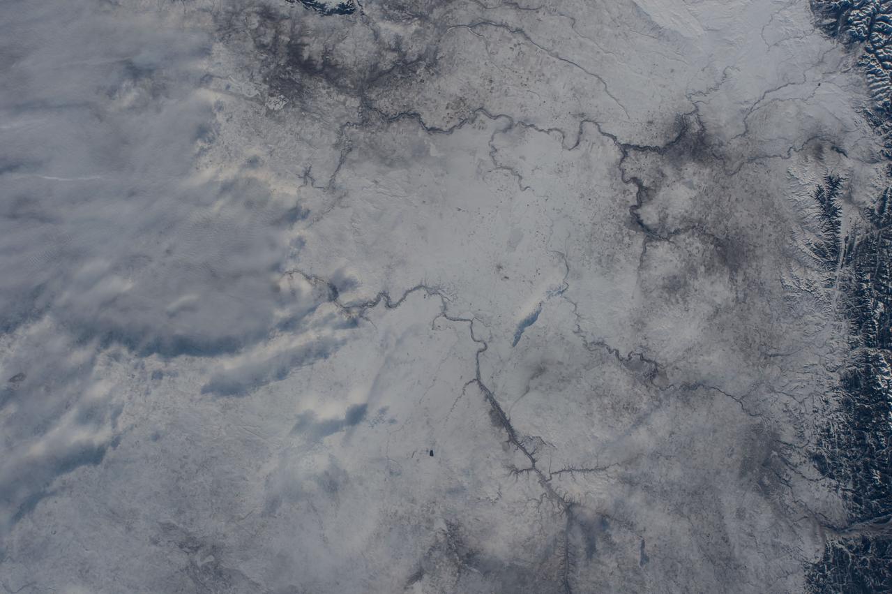
GMT001_00_19_Terry Virts_cold new years eve nebraska to pacific_123
GMT001_00_19_Terry Virts_cold new years eve nebraska to pacific_123
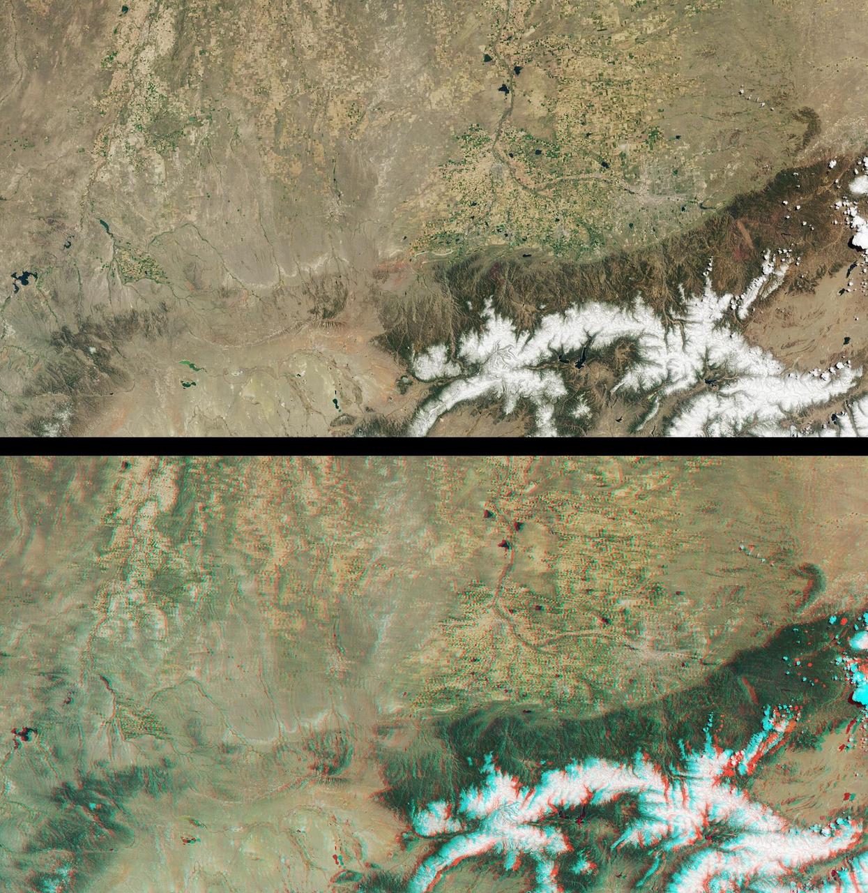
This anaglyph from the MISR instrument aboard NASA Terra spacecraft include portions of southern Wyoming, central Colorado, and western Nebraska. 3D glasses are necessary to view this image.

President Barack Obama talks on the phone with NASA Curiosity Mars rover team aboard Air Force One during a flight to Offutt Air Force Base in Nebraska, Aug. 13, 2012. Official White House Photo by Pete Souza
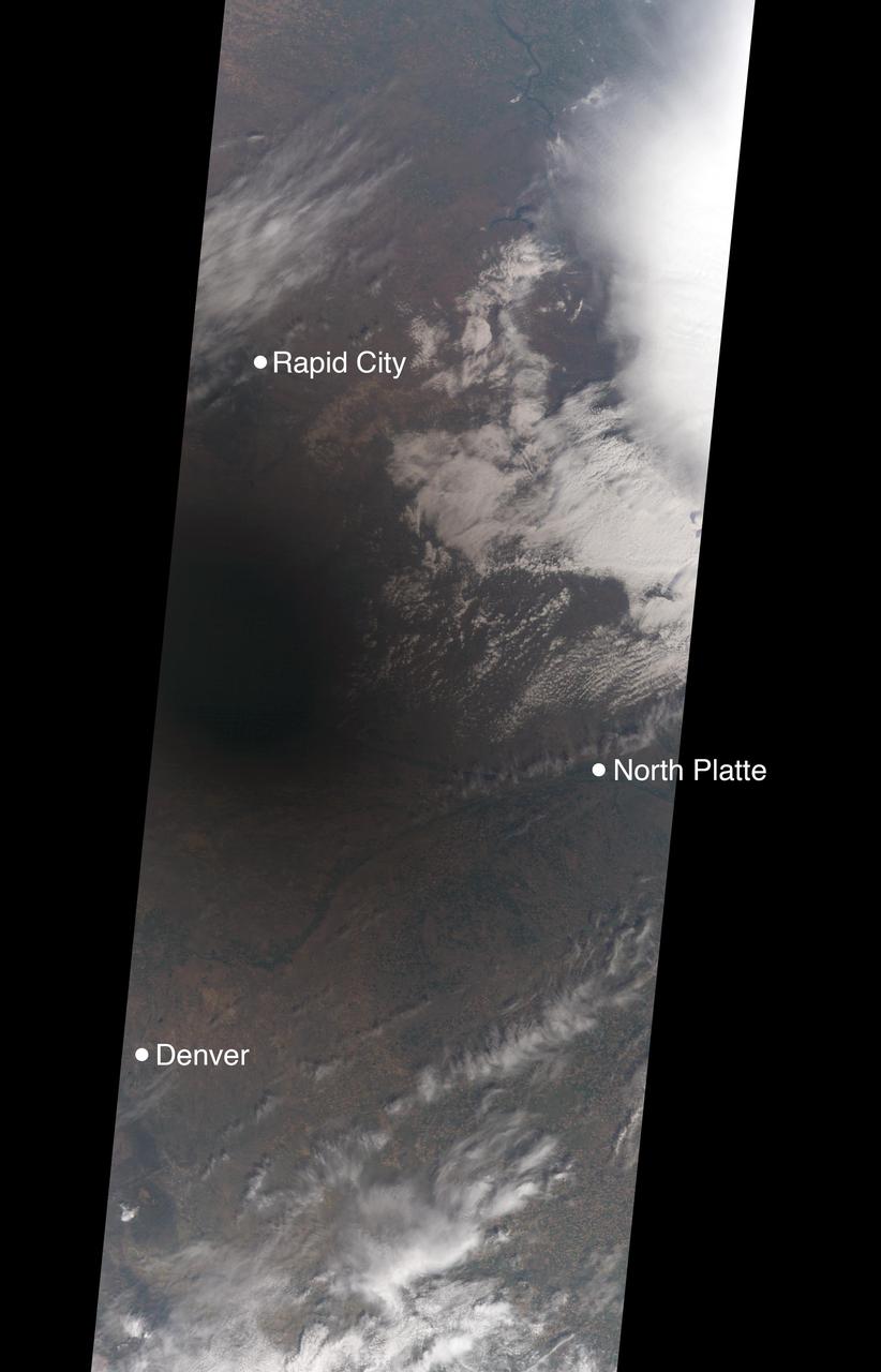
On Aug. 21, 2017, a total solar eclipse swept across the United States -- the first such eclipse in the contiguous 48 states since 1979, and the first cross-country eclipse since 1918. A partial eclipse was visible in all 50 states, and initial estimates suggest that upwards of 20 million people observed the Moon completely obscuring the Sun in the 70-mile-wide (113-kilometer-wide) path of totality. While viewing a total solar eclipse from the ground is an amazing experience, satellites orbiting Earth see the eclipse from a unique perspective. As the Moon's shadow passed through the United States, the Multi-angle Imaging SpectroRadiometer (MISR) instrument aboard NASA's Terra satellite was capturing images of eastern Wyoming and western Nebraska from its altitude of 438 miles (705 kilometers) above the surface. MISR gathers images on a strip about 249 miles (400 kilometers) wide directly below the path of the satellite. Incredibly, given that the shadow of the Moon took only 90 minutes to cross the entire United States, and Terra itself moves at a brisk 16,700 miles per hour from north to south, MISR happened to be in exactly the right place at the right time to capture totality. From the ground, the moment of totality appears suddenly, sweeping over the sky in just a few seconds. "I was unprepared for just how dark it actually was," says Mika Tosca, a researcher who works with MISR data and who observed the eclipse in Nebraska. "The streetlights even turned on. Everything fell silent, and I swear the temperature dropped." From the vantage point of space, however, it’s possible to see the entire shadow of the Moon, with the completely dark, circular umbra and the more diffuse penumbra. MISR contains nine cameras oriented at different angles, viewing forward, downward, and backward along the flight path, resulting in an approximate seven-minute interval for all nine cameras to image a single location on Earth's surface. This animation combines these nine images into a movie showing the motion of the Moon's shadow during this seven-minute period. In the first image, captured by the camera pointing farthest ahead of the satellite, totality has not quite begun in the area seen by MISR. From the second camera onward, totality sweeps across the image area from west to east, beginning just west of the town of Jay Em, Wyoming, and proceeding about halfway across the MISR swath to the town of Alliance, Nebraska. The motion of the lunar shadow in different pairs of images leads to estimates of the local ground speed ranging between 1,480 and 1,820 miles per hour (2,382 and 2,929 kilometers per hour). The spread in values is a measure of the uncertainty of the estimate. At this location, the predicted speed of the eclipse calculated from lunar orbital motion is about 1,658 miles per hour (2,668 kilometers per hour), which falls in the middle of the range estimated from the MISR images. Tosca's observation that the temperature dropped during the eclipse is a well-known phenomenon. The GLOBE Observer, a phone application dedicated to citizen science and sponsored by NASA, encouraged eclipse-goers to record the local air temperature at regular intervals. Data collected by nearby observers in the path of totality show that, on average, temperatures dropped by 9.3 degrees Fahrenheit (5.2 degrees Celsius) during the eclipse. This compares to an average of 5.4 degrees Fahrenheit drop measured at several Nebraska Mesonet weather stations within the path of totality. The decrease in the amount of sunlight reaching Earth affected more than temperatures. Areas that get a large portion of their power from solar energy were naturally concerned about shortages during the eclipse -- the state of California, though not in the path of totality, estimated that 6,000 megawatts of solar power would be lost during the eclipse. An animation is available at https://photojournal.jpl.nasa.gov/catalog/PIA21957
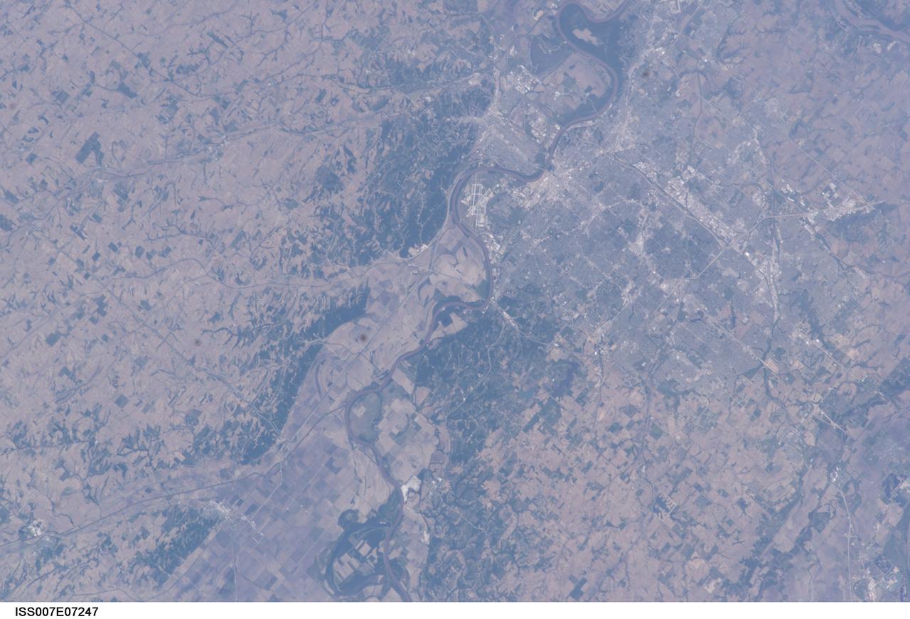
ISS007-E-07247 (13 June 2003) --- This image, photographed by an Expedition 7 crewmember onboard the International Space Station (ISS), features the Missouri River and a near-vertical view of Omaha, Nebraska. With a population estimated at more than three quarters of a million residents, Omaha is situated on high ground to the west of the river while Eppley Airfield and the town of Council Bluffs, Iowa are located on the floodplain.
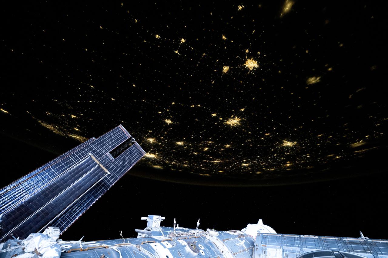
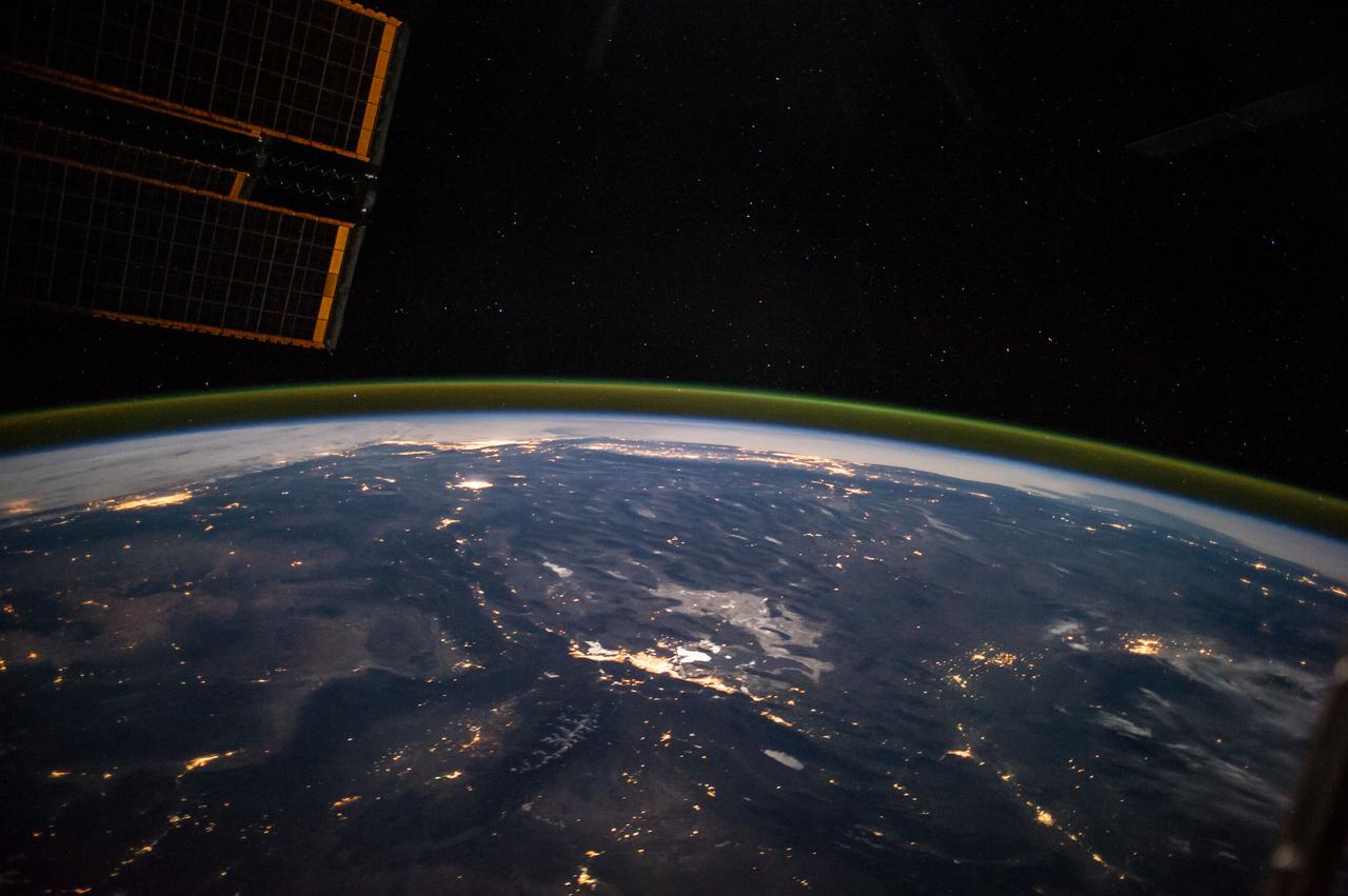
iss073e0148982 (May 21, 2025) --- City lights dot the U.S. landscape looking southeast from 261 miles above Omaha, Nebraska, toward the southern Atlantic coast of the United States in this photograph taken at approximately 11:56 p.m. local time from the International Space Station. Pictured in the foreground, is a set of the orbital outpost's main solar arrays (lower left) and a partially obscured SpaceX Dragon crew spacecraft (lower center) docked to the Harmony module's forward port.
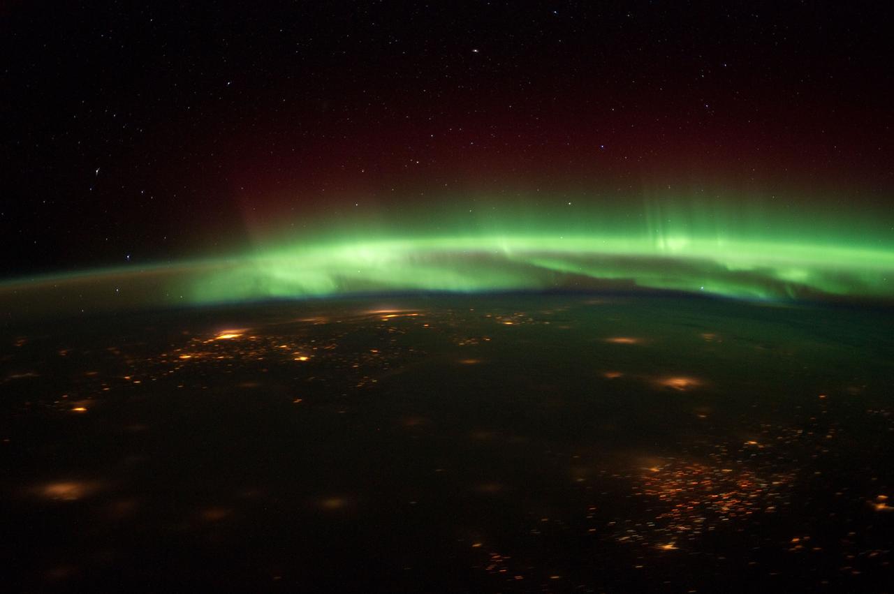
ISS030-E-061267 (25 Jan. 2012) --- Aurora Borealis steals the scene in this nighttime photograph shot from the International Space Station as the orbital outpost flew over the Midwest recently. Cloud cover makes it difficult to identify the cities that are within the captured area. The spacecraft was above south central Nebraska when the photo was taken. The "look" angle is north to northeastward.
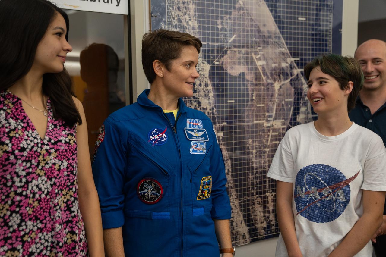
NASA astronaut Anne McClain talks with student essay winners Amanda Gutierrez, left, and Taia Saurer at the agency’s news center at Kennedy Space Center in Florida on Sept. 2, 2022. Gutierrez and Saurer won the Artemis Moon Pod Essay Contest – a nationwide event involving nearly 14,000 students – for their creative visions of a pioneering journey to the Moon. The grand prize was a trip to Kennedy to watch the launch of Artemis I. Gutierrez, 17, is an 11th-grader from Lincoln, Nebraska, while Saurer, 14, is an eighth-grader from Laguna Beach, California.
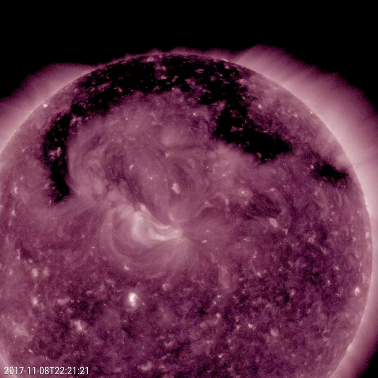
This image from NASA's Solar Dynamics Observatory shows a broad coronal hole was the dominant feature this week on the sun (Nov. 7-9, 2017). It was easily recognizable as the dark expanse across the top of the sun and extending down in each side. Coronal holes are magnetically open areas on the sun that allow high-speed solar wind to gush out into space. They always appear darker in extreme ultraviolet. This one was likely the source of bright aurora that shimmered for numerous observers, with some reaching down even to Nebraska. Movies are available at https://photojournal.jpl.nasa.gov/catalog/PIA22113
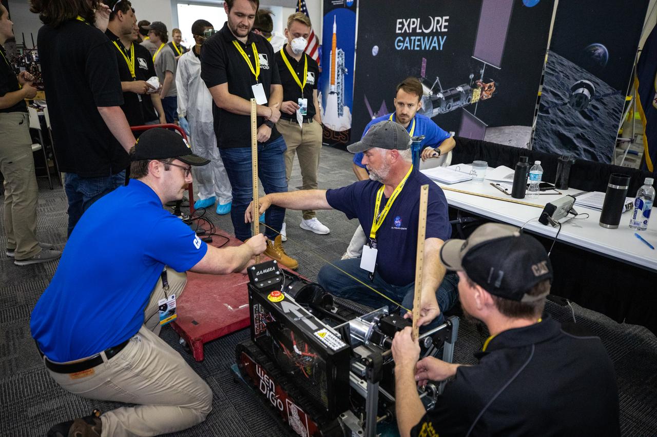
Students from the University of Nebraska-Lincoln prepare their robotic miner for its turn to dig in the mining arena during NASA’s LUNABOTICS competition on May 26, 2022, at the Center for Space Education near the Kennedy Space Center Visitor Complex in Florida. More than 35 teams from around the U.S. have designed and built remote-controlled robots for the mining competition. Teams use their semi-autonomous or remote-controlled robots to maneuver and dig in a supersized sandbox filled with rocks and simulated lunar soil, or regolith. The objective of the challenge is to see which team’s robot can collect and deposit the most rocky regolith within a specified amount of time.
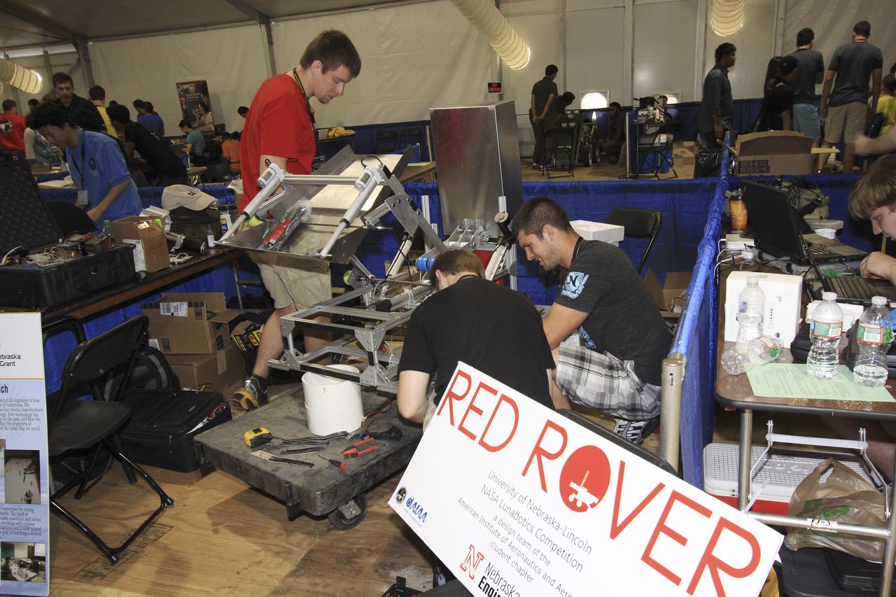
CAPE CANAVERAL, Fla. – At NASA’s Kennedy Space Center Visitor Complex in Florida, students from the University of Nebraska-Lincoln prepare their custom robot for NASA’s Fourth Annual Robotic Mining Competition, held May 20-24. The mining competition is coordinated by Kennedy Space Center’s Education Office for the agency’s Exploration Systems Mission Directorate. Undergraduate and graduate students from 50 universities and colleges in the U.S. and around the world use their remote-controlled robots to maneuver and dig in a supersized sandbox filled with a crushed material called regolith that has characteristics similar to asteroids, moons of Mars and Mars itself. Photo credit: NASA_Jim Grossman
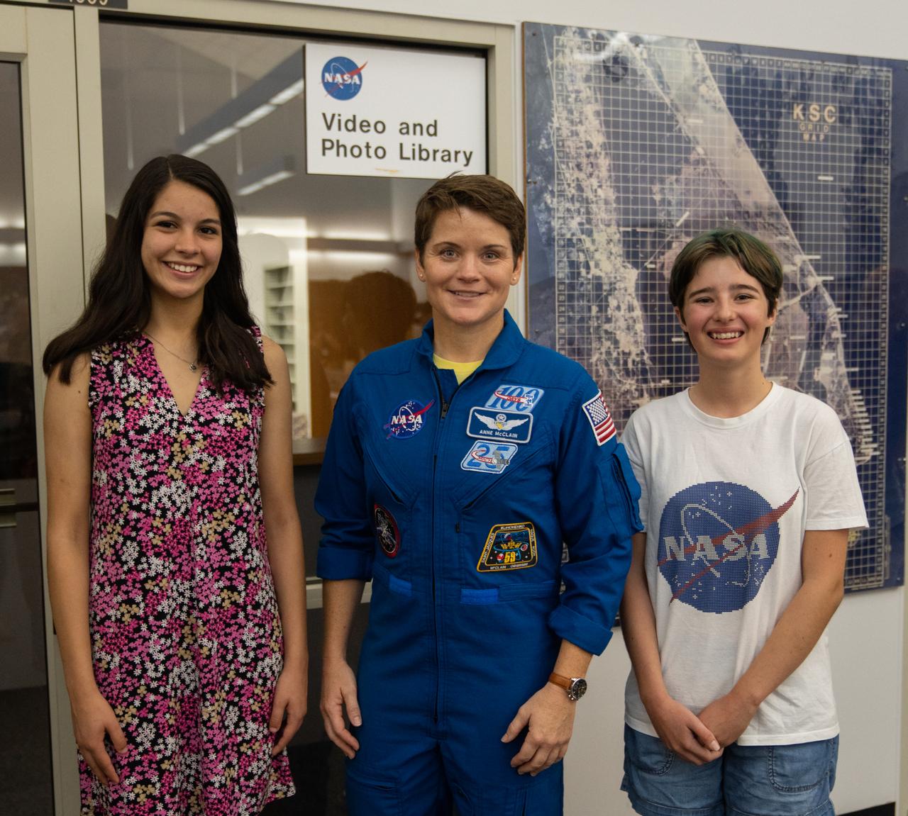
Student essay winners Amanda Gutierrez, left, and Taia Saurer pose with NASA astronaut Anne McClain at the agency’s news center at Kennedy Space Center in Florida on Sept. 2, 2022. Gutierrez and Saurer won the Artemis Moon Pod Essay Contest – a nationwide event involving nearly 14,000 students – for their creative visions of a pioneering journey to the Moon. The grand prize was a trip to Kennedy to watch the launch of Artemis I. Gutierrez, 17, is an 11th-grader from Lincoln, Nebraska, while Saurer, 14, is an eighth-grader from Laguna Beach, California.
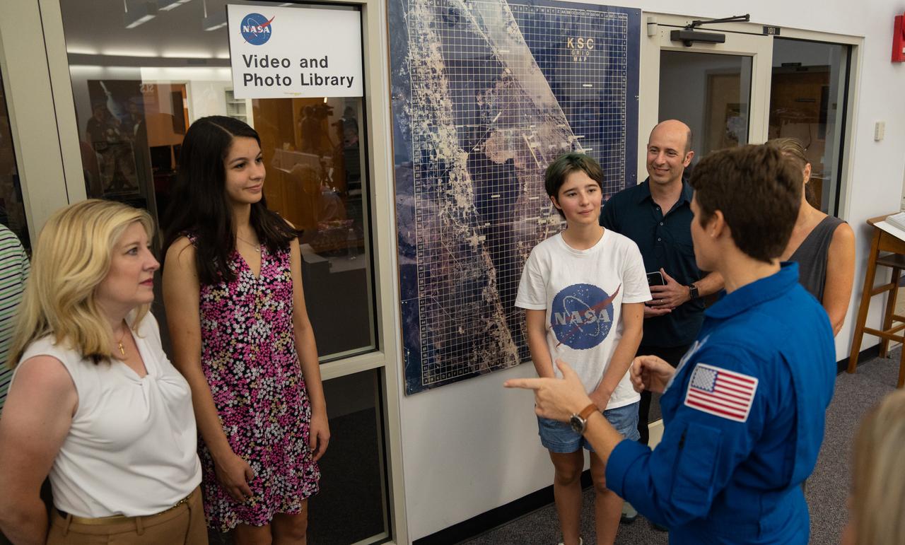
NASA astronaut Anne McClain talks with student essay winners Amanda Gutierrez, second from left, and Taia Saurer, white NASA shirt, at the agency’s news center at Kennedy Space Center in Florida on Sept. 2, 2022. Gutierrez and Saurer won the Artemis Moon Pod Essay Contest – a nationwide event involving nearly 14,000 students – for their creative visions of a pioneering journey to the Moon. The grand prize was a trip to Kennedy to watch the launch of Artemis I. Gutierrez, 17, is an 11th-grader from Lincoln, Nebraska, while Saurer, 14, is an eighth-grader from Laguna Beach, California.
KENNEDY SPACE CENTER, FLA. -- Three male and one female hooded mergansers swim in the quicksilver water of the Merritt Island National Wildlife Refuge, which shares a boundary with Kennedy Space Center. Usually found from Alaska and Canada south to Nebraska, Oregon and Tennessee, hooded mergansers winter south to Mexico and the Gulf Coast, including KSC. The open water of the refuge provides wintering areas for 23 species of migratory waterfowl, as well as a year-round home for great blue herons, great egrets, wood storks, cormorants, brown pelicans and other species of marsh and shore birds. The 92,000-acre refuge is also habitat for more than 310 species of birds, 25 mammals, 117 fishes and 65 amphibians and reptiles.

NASA image acquired July 17, 2011 In mid-July 2011, more than a month after the Missouri River broke through two levees and flooded fields near Hamburg, Iowa, muddy water lingered near the city. Hamburg residents were relieved, however, that a newly built levee had spared the town from flooding. On July 17, 2011, the Advanced Land Imager (ALI) on NASA’s Earth Observing-1 (EO-1) satellite captured this natural-color image. Compared to an image acquired on June 24, flooding has apparently receded slightly in some areas. Sediment-choked water nevertheless lingers on large swaths of land. On July 13, 2011, KETV of Omaha, Nebraska, reported that a newly built, 2-mile levee designed to protect Hamburg already exceeded federal standards. The U.S. Army Corps of Engineers handed control of the levee over to city officials on July 12. In the end, the levee was expected to cost the Army Corps $6 million, and the city of Hamburg about $800,000. On July 18, 2011, the Advanced Hydrological Prediction Service reported moderate flooding along the Missouri River not far from Hamburg, Iowa. In the northwest, the river reached 24.37 feet (7.43 meters) at Nebraska City. In the southeast, the river reached 38.98 feet (11.88 meters) at Brownville, Nebraska. NASA Earth Observatory image created by Jesse Allen and Robert Simmon, using EO-1 ALI data provided courtesy of the NASA EO-1 team. Caption by Michon Scott. Instrument: EO-1 - ALI Credit: <b><a href="http://www.earthobservatory.nasa.gov/" rel="nofollow"> NASA Earth Observatory</a></b> <b><a href="http://www.nasa.gov/centers/goddard/home/index.html" rel="nofollow">NASA Goddard Space Flight Center</a></b> enables NASA’s mission through four scientific endeavors: Earth Science, Heliophysics, Solar System Exploration, and Astrophysics. Goddard plays a leading role in NASA’s accomplishments by contributing compelling scientific knowledge to advance the Agency’s mission. <b>Follow us on <a href="http://twitter.com/NASA_GoddardPix" rel="nofollow">Twitter</a></b> <b>Like us on <a href="http://www.facebook.com/pages/Greenbelt-MD/NASA-Goddard/395013845897?ref=tsd" rel="nofollow">Facebook</a></b> <b>Find us on <a href="http://web.stagram.com/n/nasagoddard/?vm=grid" rel="nofollow">Instagram</a></b>
KENNEDY SPACE CENTER, FLA. -- A female hooded merganser swims solo in the waters of the Merritt Island National Wildlife Refuge at Kennedy Space Center. The male is distinguished by a fan-shaped, black-bordered crest and striped breast. Usually found from Alaska and Canada south to Nebraska, Oregon and Tennessee, hooded mergansers winter south to Mexico and the Gulf Coast, including KSC. The open water of the refuge provides wintering areas for 23 species of migratory waterfowl, as well as a year-round home for great blue herons, great egrets, wood storks, cormorants, brown pelicans and other species of marsh and shore birds. The 92,000-acre refuge is also habitat for more than 310 species of birds, 25 mammals, 117 fishes and 65 amphibians and reptiles
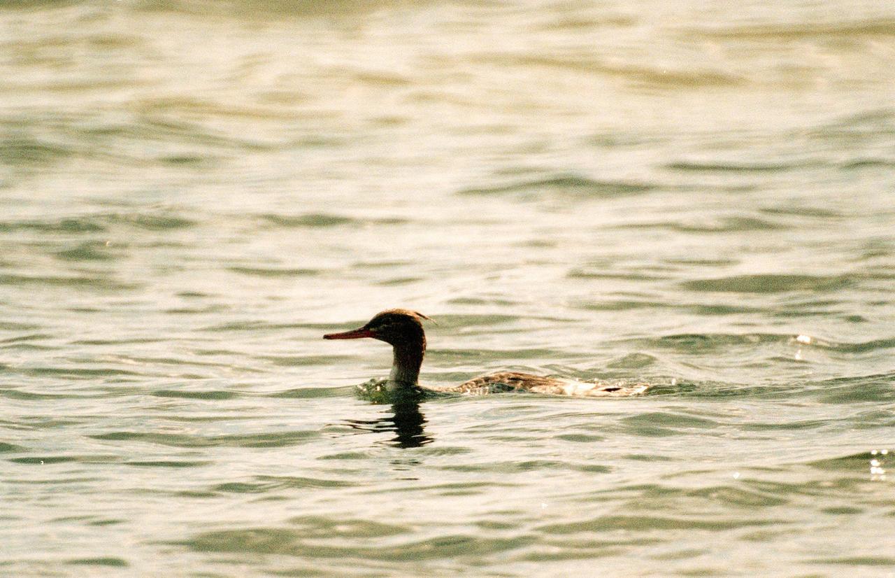
KENNEDY SPACE CENTER, FLA. -- A female red-breasted merganser swims low in the water at the Merritt Island National Wildlife Refuge, which shares a boundary with Kennedy Space Center. Usually found from Alaska and Canada south to Nebraska, Oregon and Tennessee, hooded mergansers winter south to Mexico and the Gulf Coast, including KSC. The open water of the refuge provides wintering areas for 23 species of migratory waterfowl, as well as a year-round home for great blue herons, great egrets, wood storks, cormorants, brown pelicans and other species of marsh and shore birds. The 92,000-acre refuge is also habitat for more than 310 species of birds, 25 mammals, 117 fishes and 65 amphibians and reptiles

This chart describes the Skylab student experiment ED-61, Plant Growth, and experiment ED-62, Plant Phototropism. Two similar proposals were submitted by Joel G. Wordekemper of West Point, Nebraska, and Donald W. Schlack of Downey, California. Wordekemper's experiment (ED-61) was to see how the lack of gravity would affect the growth of roots and stems of plants. Schlack's experiment (ED-62) was to study the effect of light on a seed developing in zero gravity. The growth container of the rice seeds for their experiment consisted of eight compartments arranged in two parallel rows of four. Each had two windowed surfaces to allow periodic photography of the developing seedlings. In March 1972, NASA and the National Science Teachers Association selected 25 experiment proposals for flight on Skylab. Science advisors from the Marshall Space Flight Center aided and assisted the students in developing the proposals for flight on Skylab.
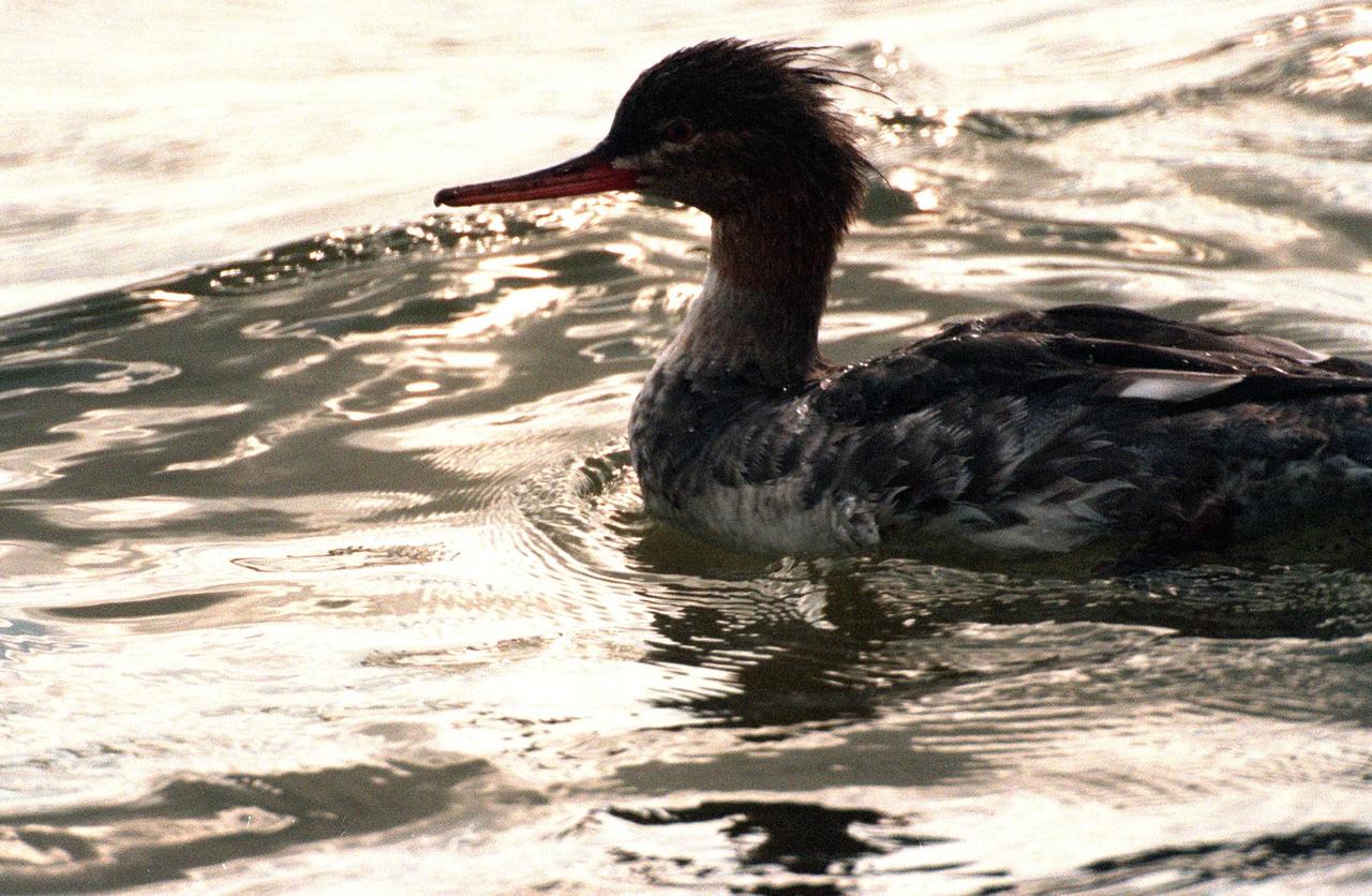
KENNEDY SPACE CENTER, FLA. -- A young female red-breasted merganser swims in the quicksilver water of the Merritt Island National Wildlife Refuge, which shares a boundary with Kennedy Space Center. Usually found from Alaska and Canada south to Nebraska, Oregon and Tennessee, hooded mergansers winter south to Mexico and the Gulf Coast, including KSC. The open water of the refuge provides wintering areas for 23 species of migratory waterfowl, as well as a year-round home for great blue herons, great egrets, wood storks, cormorants, brown pelicans and other species of marsh and shore birds. The 92,000-acre refuge is also habitat for more than 310 species of birds, 25 mammals, 117 fishes and 65 amphibians and reptiles
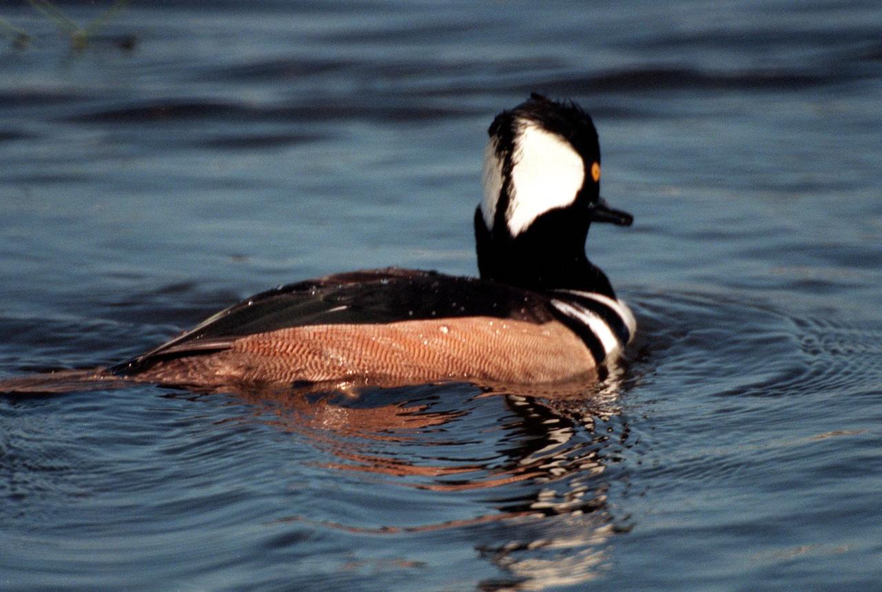
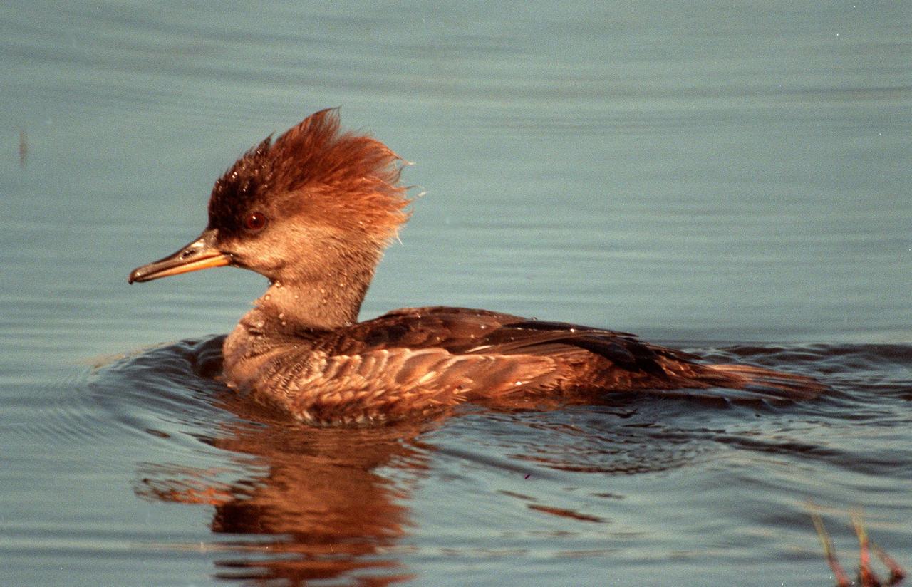
KENNEDY SPACE CENTER, FLA. -- The distinctive fan-shaped, black-bordered crest and striped breast identify this hooded merganser, swimming in the waters of the Merritt Island National Wildlife Refuge at Kennedy Space Center. Usually found from Alaska and Canada south to Nebraska, Oregon and Tennessee, hooded mergansers winter south to Mexico and the Gulf Coast, including KSC. The open water of the refuge provides wintering areas for 23 species of migratory waterfowl, as well as a year-round home for great blue herons, great egrets, wood storks, cormorants, brown pelicans and other species of marsh and shore birds. The 92,000-acre refuge is also habitat for more than 310 species of birds, 25 mammals, 117 fishes and 65 amphibians and reptiles

West Point, Nebraska high school student, Joel C. Wordekemper, is greeted by (left to right): Astronauts Russell L. Schweickart, and Owen K. Garriott; Marshall Space Flight Center (MSFC) Skylab Program Manager, Leland Belew; and MSFC Director of Administration and Technical Services, David Newby, during a tour of MSFC. Wordekemper was among 25 winners of a contest in which some 3,500 high school students proposed experiments for the following year’s Skylab mission. The nationwide scientific competition was sponsored by the National Science Teachers Association and the National Aeronautics and Space Administration (NASA). The winning students, along with their parents and sponsor teachers, visited MSFC where they met with scientists and engineers, participated in design reviews for their experiments, and toured MSFC facilities. Of the 25 students, 6 did not see their experiments conducted on Skylab because the experiments were not compatible with Skylab hardware and timelines. Of the 19 remaining, 11 experiments required the manufacture of additional equipment.

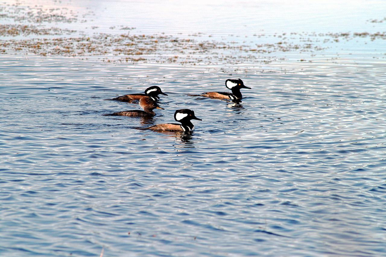
KENNEDY SPACE CENTER, FLA. -- A male and two female hooded mergansers swim in the waters of the Merritt Island National Wildlife Refuge at Kennedy Space Center. The male displays its distinctive fan-shaped, black-bordered crest. Usually found from Alaska and Canada south to Nebraska, Oregon and Tennessee, hooded mergansers winter south to Mexico and the Gulf Coast, including KSC. The open water of the refuge provides wintering areas for 23 species of migratory waterfowl, as well as a year-round home for great blue herons, great egrets, wood storks, cormorants, brown pelicans and other species of marsh and shore birds. The 92,000-acre refuge is also habitat for more than 310 species of birds, 25 mammals, 117 fishes and 65 amphibians and reptiles
ISS041-E-067595 (6 Oct. 2014) --- This moonlit panorama was shot recently with a wide-angle lens by an Expedition 41 crew member aboard the International Space Station, as they looked southwest from a point over Nebraska. The wide-angle lens shows a huge swath of country that stretches from Portland, Oregon (right) to Phoenix, Arizona (left). The largest string of lights is the Ogden-Salt Lake City-Provo area (lower center) in Utah. The Los Angeles and San Francisco metropolitan regions, and the cities of the central valley of California (Bakersfield to Redding) stretch across the horizon. The green airglow layer always appears in night images. Moonlight shows the red tinge of the space station?s solar arrays top left. Moonlight emphasizes the broader-scale geological zones. Nevada?s short, dark, parallel mountain ranges of the basin and range geological province (center) contrast with the expanses of flat terrain of the Colorado Plateau (left) in Colorado, Arizona, Utah and New Mexico. The near-full moon even reveals the vast dry lake bed known as the Bonneville Salt Flats. The black line of the Sierra Nevada marks the edge of California?s well-lit central valley (directly below the San Francisco Bay area).
NASA launched a Terrier-Improved Malemute suborbital sounding rocket carrying the RockSat-X payload with university and community college student experiments at 6:04 a.m. EDT Wednesday, Aug. 12, from NASA’s Wallops Flight Facilityin Virginia. More than 60 students and instructors from across the continental United States, Hawaii and Puerto Rico were on hand to witness the launch of their experiments. The payload flew to an altitude of about 97 miles and descended via parachute into the Atlantic Ocean off the coast of Wallops. Payload recovery operations began after lift-off. Developed by students from seven higher education programs, the experiments flew through the RockSat-X program in conjunction with the Colorado Space Grant Consortium. Participating institutions in this flight are the University of Colorado, Boulder; Northwest Nazarene University, Nampa, Idaho; the University of Puerto Rico; the University of Nebraska, Lincoln; Virginia Tech University, Blacksburg; Capitol Technology University, Laurel, Maryland; and University of Hawai'i Community Colleges at the Honolulu, Kapi'olani, Kaua'i, and Windward campuses. The next launch scheduled from Wallops is a NASA Black Brant IX suborbital sounding rocket carrying several technology development instruments. The launch is scheduled between 7 and 7:41 p.m. Sept. 29. The backup launch days are Sept. 30 through Oct. 12. <b><a href="http://www.nasa.gov/audience/formedia/features/MP_Photo_Guidelines.html" rel="nofollow">NASA image use policy.</a></b> <b><a href="http://www.nasa.gov/centers/goddard/home/index.html" rel="nofollow">NASA Goddard Space Flight Center</a></b> enables NASA’s mission through four scientific endeavors: Earth Science, Heliophysics, Solar System Exploration, and Astrophysics. Goddard plays a leading role in NASA’s accomplishments by contributing compelling scientific knowledge to advance the Agency’s mission. <b>Follow us on <a href="http://twitter.com/NASAGoddardPix" rel="nofollow">Twitter</a></b> <b>Like us on <a href="http://www.facebook.com/pages/Greenbelt-MD/NASA-Goddard/395013845897?ref=tsd" rel="nofollow">Facebook</a></b> <b>Find us on <a href="http://instagrid.me/nasagoddard/?vm=grid" rel="nofollow">Instagram</a></b>
An autumn storm brought the first snow of the season to the Upper Mississippi River Valley and the Midwestern United States in early November, 2013. The Moderate Resolution Imaging Spectroradiometer (MODIS) aboard NASA’s Terra satellite captured this true color image on November 6 just as the storm was clearing. A long band of snow stretching from Colorado in the southwest to Wisconsin in the northeast marked the path of the blowing storm. According to WeatherBug, up to 10 inches blanketed Gordon, Nebraska and Pipestone, Minnesota. Most snow totals in the Central and Northern Plains and Upper Mississippi Valley ranged from 2-5 inches, while Minneapolis-St. Paul metro area picked up 1-2 inches of new snow from the event. Credit: NASA/GSFC/Jeff Schmaltz/MODIS Land Rapid Response Team <b><a href="http://www.nasa.gov/audience/formedia/features/MP_Photo_Guidelines.html" rel="nofollow">NASA image use policy.</a></b> <b><a href="http://www.nasa.gov/centers/goddard/home/index.html" rel="nofollow">NASA Goddard Space Flight Center</a></b> enables NASA’s mission through four scientific endeavors: Earth Science, Heliophysics, Solar System Exploration, and Astrophysics. Goddard plays a leading role in NASA’s accomplishments by contributing compelling scientific knowledge to advance the Agency’s mission. <b>Follow us on <a href="http://twitter.com/NASA_GoddardPix" rel="nofollow">Twitter</a></b> <b>Like us on <a href="http://www.facebook.com/pages/Greenbelt-MD/NASA-Goddard/395013845897?ref=tsd" rel="nofollow">Facebook</a></b> <b>Find us on <a href="http://instagram.com/nasagoddard?vm=grid" rel="nofollow">Instagram</a></b>
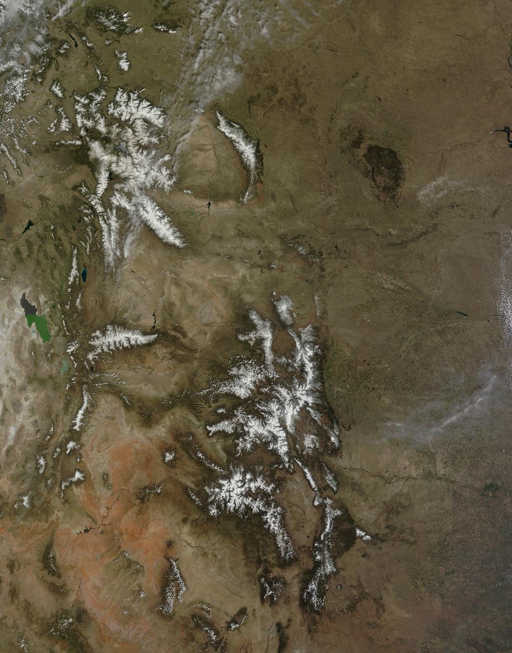
On April 29, 2015 the Moderate Resolution Imaging Spectroradiometer (MODIS) aboard NASA’s Terra satellite captured a true-color image of a typical spring scene in the western United State: snow-crowned Rocky Mountains rising above the faintly greening plains. The Rocky Mountains stretch from British Columbia, Canada to the Rio Grande in New Mexico, a span of roughly 3,000 miles, and contains many of the highest peaks in the continental United States. The tallest, Mount Elbert, rises 14,400 ft. (4,401 m) above sea level, and is located in the San Isabel National Forest, near Leadville, Colorado. This image covers seven Rocky Mountain states. From north to south they are: Montana and Idaho, Wyoming; Utah (with the Great Salt Lake visible) and Colorado; Arizona and New Mexico. To the east, the Great Plain states captured are, from north to south: North Dakota, South Dakota, Nebraska, Kansas, Oklahoma and northwestern Texas. Credit: NASA/GSFC/Jeff Schmaltz/MODIS Land Rapid Response Team <b><a href="http://www.nasa.gov/audience/formedia/features/MP_Photo_Guidelines.html" rel="nofollow">NASA image use policy.</a></b> <b><a href="http://www.nasa.gov/centers/goddard/home/index.html" rel="nofollow">NASA Goddard Space Flight Center</a></b> enables NASA’s mission through four scientific endeavors: Earth Science, Heliophysics, Solar System Exploration, and Astrophysics. Goddard plays a leading role in NASA’s accomplishments by contributing compelling scientific knowledge to advance the Agency’s mission. <b>Follow us on <a href="http://twitter.com/NASAGoddardPix" rel="nofollow">Twitter</a></b> <b>Like us on <a href="http://www.facebook.com/pages/Greenbelt-MD/NASA-Goddard/395013845897?ref=tsd" rel="nofollow">Facebook</a></b> <b>Find us on <a href="http://instagrid.me/nasagoddard/?vm=grid" rel="nofollow">Instagram</a></b>
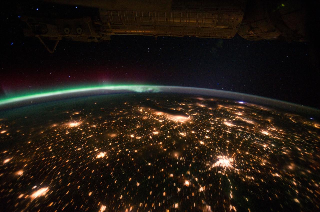
ISS029-E-012564 (29 Sept. 2011) --- The Midwestern United States at night with Aurora Borealis is featured in this image photographed by an Expedition 29 crew member on the International Space Station. The night skies viewed from the space station are illuminated with light from many sources. For example, the Midwestern United States presents a night-time appearance not unlike a patchwork quilt when viewed from orbit. The artificial light from human settlements appears everywhere with a characteristic yellow tinge in this photograph. But green light of the Aurora Borealis also appears strongly in this view (top left)—even seeming to be reflected off Earth’s surface—in Canada—beneath the aurora. A small white patch of light is almost certainly lightning from a storm on the East coast (top right). Part of the International Space Station appears across the top of the image. This photograph highlights the Chicago, IL, metropolitan area as the largest cluster of lights at center, next to the dark patch of Lake Michigan. The other largest metropolitan areas include St. Louis, MO (lower right), Minneapolis–St. Paul, MN (left) and the Omaha–Council Bluffs region on the Nebraska–Iowa border (lower left). City light clusters give an immediate sense of relative city size; demographers have used night time satellite imagery to make estimates of city populations, especially in the developing world where city growth can be very rapid. The U.S. northeast seaboard lies in the most oblique (meaning viewed at an angle) part of the image at top right, just beyond the Appalachian Mts., a dark winding zone without major cities. Scales change significantly in oblique views: Omaha is only 200 kilometers from Des Moines, but appears roughly the same distance from Minneapolis—which is actually 375 kilometers to the north of Des Moines. In addition to the major metropolitan areas, the rectangular NS/EW-oriented pattern of townships is clearly visible in the rural, lower left part of the image. This pattern instantly gives the sense of north orientation (toward the top left corner) and is a distinctive characteristic of the United States, so that ISS crew members can quickly know which continent they are flying over even at night. In contrast to the regular township pattern, interstate highways converge on St. Louis (e.g. Hwy 44), Chicago and other large cities, much like wheel spokes around a central hub. Rivers—major visual features in daylight—become almost invisible at night. The course of the Mississippi River appears as a slightly meandering zone from Minneapolis through St. Louis (dashed line)—the river course continues out of the lower right corner of the image.
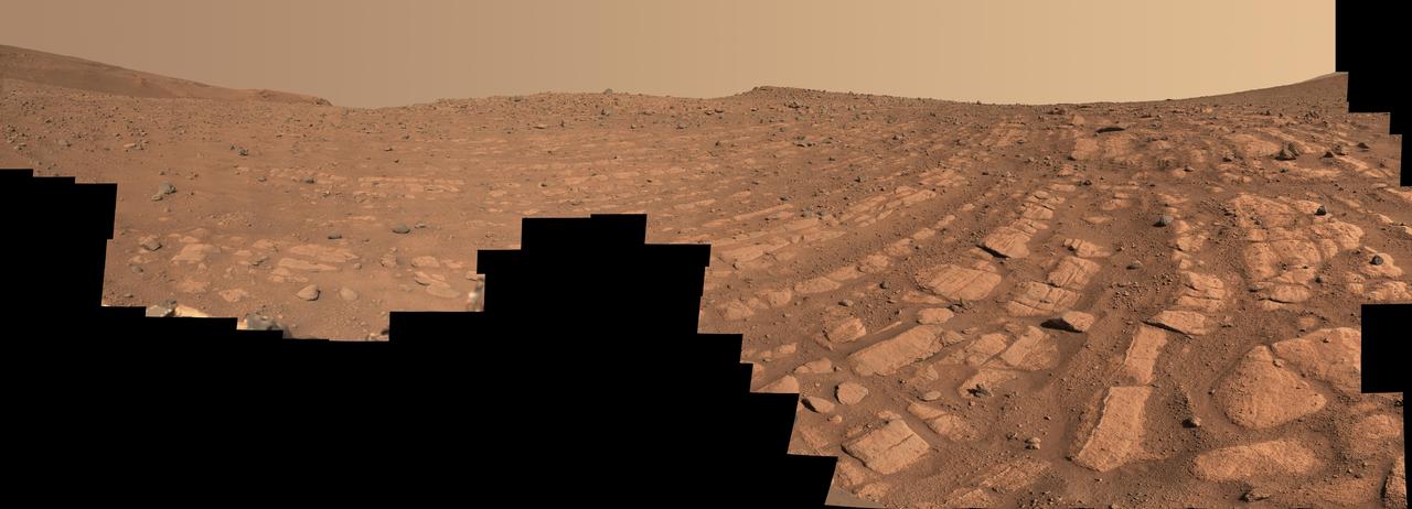
Scientists think that the bands of rocks seen in this image may have been formed by a very fast, deep river – the first of its kind evidence has been found for on Mars. NASA's Perseverance Mars rover captured this mosaic at a location nicknamed "Skrinkle Haven" using its Mastcam-Z camera between Feb. 28 and March 9, 2023 (between the 721st and 729th Martian days, or sols, of the mission). The mosaic is made up of 203 individual images that were stitched together after being sent back from Mars. This natural color view is approximately how the scene would appear to an average person if they were on Mars. "Skrinkle Haven" offers the clearest example of these curved rock layers – called "the curvilinear unit" – that had previously only been seen from space. Scientists are now debating what kind of powerfully flowing water formed those curves: a river like the Mississippi, which winds snakelike across the landscape, or a braided river like Nebraska's Platte, which forms small islands of sediment called sandbars. When viewed from the ground, the curved layers are arranged in rows, and appear to ripple out across the landscape. They could be the remnants of a river's banks that shifted over time – or the remnants of sandbars that formed in the river. The layers were likely much taller in the past; scientists suspect that after these piles of sediment turned to rock, they were sand-blasted by wind over the course of eons and carved down to their present size. Arizona State University leads the operations of the Mastcam-Z instrument, working in collaboration with Malin Space Science Systems in San Diego, on the design, fabrication, testing, and operation of the cameras, and in collaboration with the Niels Bohr Institute of the University of Copenhagen on the design, fabrication, and testing of the calibration targets. A key objective for Perseverance's mission on Mars is astrobiology, including the search for signs of ancient microbial life. The rover will characterize the planet's geology and past climate, pave the way for human exploration of the Red Planet, and be the first mission to collect and cache Martian rock and regolith (broken rock and dust). Subsequent NASA missions, in cooperation with ESA (European Space Agency), would send spacecraft to Mars to collect these sealed samples from the surface and return them to Earth for in-depth analysis. The Mars 2020 Perseverance mission is part of NASA's Moon to Mars exploration approach, which includes Artemis missions to the Moon that will help prepare for human exploration of the Red Planet. https://photojournal.jpl.nasa.gov/catalog/PIA25829
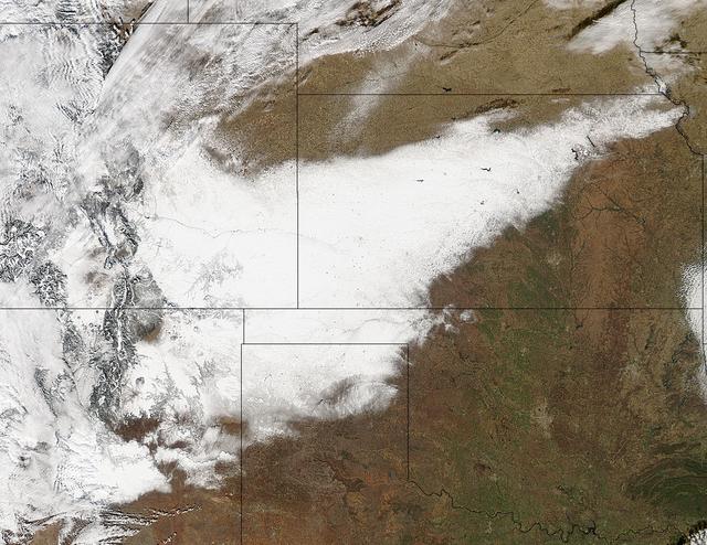
Winter arrived officially on Dec. 22 at 12:35 a.m. EST, but the U.S. Plains states received an early and cool welcome on Dec. 19 from heavy snowfall that was seen by a NASA satellite. NASA's Aqua satellite passed overhead on Dec. 21 at 20:05 UTC (3:05 p.m. EST) and the Moderate Resolution Imaging Spectroradiometer (MODIS) instrument aboard NASA's Aqua satellite captured a visible image of snow blanketing the ground through west and central Kansas, eastern and central Colorado, much of New Mexico, northern Texas and the panhandle of Oklahoma. According to CBS News, blizzard conditions were reported in northern New Mexico, the Texas Panhandle, Oklahoma and northwestern Kansas. The Associated Press reported snow drifts as high as 10 feet in southeast Colorado. Six people lost their lives in traffic accidents from this storm. Heavy snow is expected again today, Dec. 22 in New Mexico and Colorado. Snow is also expected to stretch across the plains into the upper Midwest today, according to the National Weather Service. Portions of many states are expecting some snow today, including the four corners states, north Texas, Kansas, southern Nebraska, western Oklahoma, northern Missouri, Iowa, northern Illinois and southern Wisconsin stretching east into northern New England. The first day of the winter season occurs when the sun is farthest south, either Dec. 21 or 22. The day is also known as the winter solstice. By the second day of winter, NASA's Aqua satellite is going to have a lot more snowfall to observe. Image Credit: NASA Goddard MODIS Rapid Response Team Caption: NASA, Rob Gutro <b><a href="http://www.nasa.gov/audience/formedia/features/MP_Photo_Guidelines.html" rel="nofollow">NASA image use policy.</a></b> <b><a href="http://www.nasa.gov/centers/goddard/home/index.html" rel="nofollow">NASA Goddard Space Flight Center</a></b> enables NASA’s mission through four scientific endeavors: Earth Science, Heliophysics, Solar System Exploration, and Astrophysics. Goddard plays a leading role in NASA’s accomplishments by contributing compelling scientific knowledge to advance the Agency’s mission. <b>Follow us on <a href="http://twitter.com/NASA_GoddardPix" rel="nofollow">Twitter</a></b> <b>Like us on <a href="http://www.facebook.com/pages/Greenbelt-MD/NASA-Goddard/395013845897?ref=tsd" rel="nofollow">Facebook</a></b> <b>Find us on <a href="http://instagrid.me/nasagoddard/?vm=grid" rel="nofollow">Instagram</a></b>
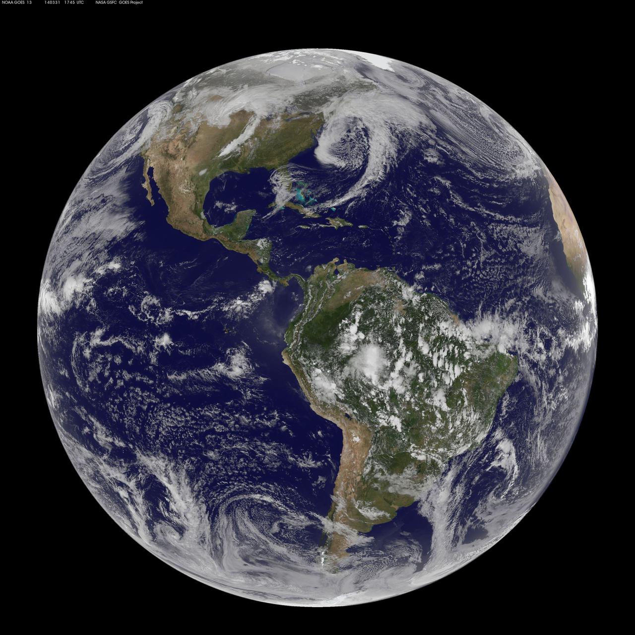
There are three low pressure systems around the U.S. and they resemble dragons on satellite imagery. NOAA's GOES-13 and GOES-15 satellite image from March 31 shows the low pressure systems in the eastern Pacific Ocean, over the nation's Heartland, and in the eastern Atlantic Ocean. All three lows have the signature comma shape that make them appear to be curled up dragons. According to the National Weather Service, the low pressure area approaching the northwestern U.S. is expected to bring rainfall to the coast and areas of snow that stretch from western Washington state south toward the four corners region. The low in the middle of the country is located over Nebraska and dropping snow to the north and west of it. That same low is bringing rain from southern Minnesota south to eastern Texas. Meanwhile, the third low pressure system is bringing rain and snow to parts of New England. NOAA's GOES-East satellite sits in a fixed orbit in space capturing visible and infrared imagery of all weather over the eastern U.S. and Atlantic Ocean. The data to create this image was taken on March 31 at 17:45 UTC/1:45 p.m. EDT by NOAA's GOES-East or GOES-13 satellite and made into an image by NASA/NOAA's GOES Project at NASA's Goddard Space Flight Center in Greenbelt, Md. To create the image NASA/NOAA's GOES Project takes the cloud data from NOAA's GOES-East satellite and overlays it on a true-color image of land and ocean created by data from the Moderate Resolution Imaging Spectroradiometer, or MODIS, instrument that flies aboard NASA's Aqua and Terra satellites. Together, those data created the entire picture of the storm and show its movement. After the storm system passes, the snow on the ground becomes visible. GOES satellites provide the kind of continuous monitoring necessary for intensive data analysis. Geostationary describes an orbit in which a satellite is always in the same position with respect to the rotating Earth. This allows GOES to hover continuously over one position on Earth's surface, appearing stationary. As a result, GOES provide a constant vigil for the atmospheric "triggers" for severe weather conditions such as tornadoes, flash floods, hail storms and hurricanes. For updated information about the storm system, visit NOAA's NWS website: <a href="http://www.weather.gov" rel="nofollow">www.weather.gov</a> For more information about GOES satellites, visit: <a href="http://www.goes.noaa.gov/" rel="nofollow">www.goes.noaa.gov/</a> or goes.gsfc.nasa.gov/ Rob Gutro NASA's Goddard Space Flight Center, Greenbelt, Md. <b><a href="http://www.nasa.gov/audience/formedia/features/MP_Photo_Guidelines.html" rel="nofollow">NASA image use policy.</a></b> <b><a href="http://www.nasa.gov/centers/goddard/home/index.html" rel="nofollow">NASA Goddard Space Flight Center</a></b> enables NASA’s mission through four scientific endeavors: Earth Science, Heliophysics, Solar System Exploration, and Astrophysics. Goddard plays a leading role in NASA’s accomplishments by contributing compelling scientific knowledge to advance the Agency’s mission. <b>Follow us on <a href="http://twitter.com/NASAGoddardPix" rel="nofollow">Twitter</a></b> <b>Like us on <a href="http://www.facebook.com/pages/Greenbelt-MD/NASA-Goddard/395013845897?ref=tsd" rel="nofollow">Facebook</a></b> <b>Find us on <a href="http://instagram.com/nasagoddard?vm=grid" rel="nofollow">Instagram</a></b>