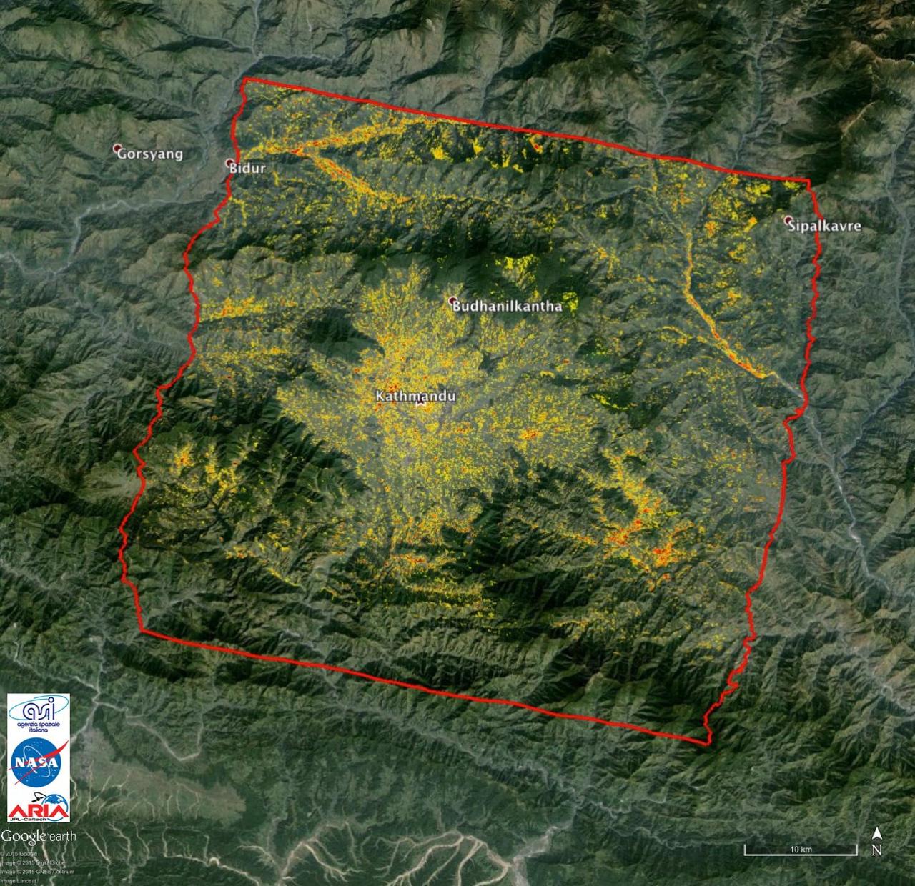
This image, acquired by NASA Terra spacecraft, shows Kathmandu, the capital of Nepal, with a population of about 2.5 million inhabitants for the greater metropolitan area.
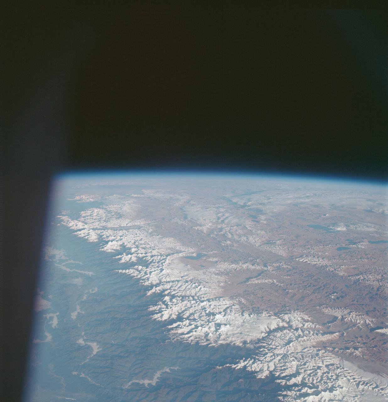
S66-54839 (14 Sept. 1966) --- China, India, and Nepal, looking east, as seen from the Gemini-11 spacecraft during its 37th revolution of Earth. The Great Himalaya Mountain Range is clearly visible. Photo credit: NASA
iss069e003192 (April 13, 2023) --- Clouds gather on Nepal's sub-tropical side of the Himalayas with Mount Everest at the center of this photograph taken by an external high definition camera on the International Space Station as it orbited 263 miles above the Indian subcontinent.
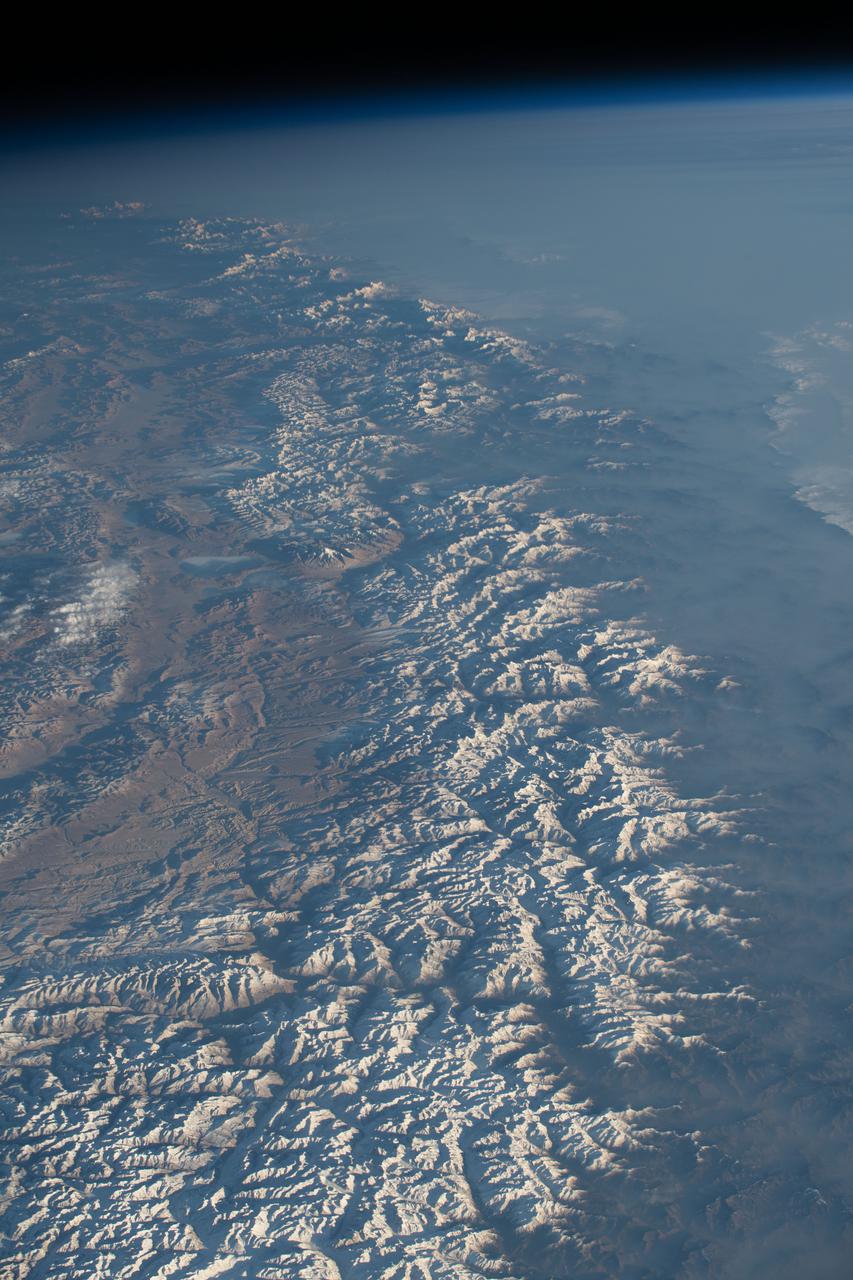
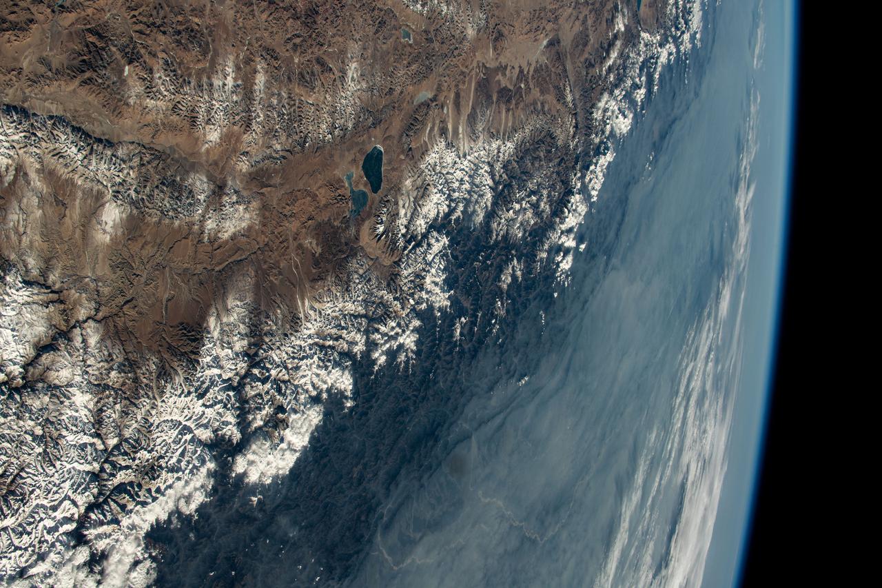
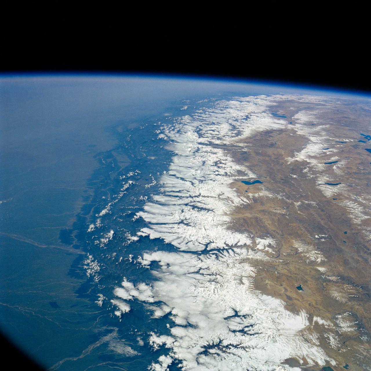
iss074e0603570 (May 20, 2026) --- The snow‑capped Himalayas separate Nepal from China in this photograph from the International Space Station as it orbited 259 miles above the Asian mountain range. The range acts as a climate barrier, trapping cooler, moisture‑laden air on the Nepal side and creating a sharp contrast between Nepal’s lush forests and the much drier Tibetan Plateau to the north. Credit: NASA/Jessica Meir
This false-color map from NASA ARIA project shows the amount of permanent surface movement caused almost entirely by the magnitude 7.8 Gorkha earthquake in Nepal.

NASA data and expertise are providing valuable information for the ongoing response to the April 25, 2015, magnitude 7.8 Gorkha earthquake in Nepal.
NASA data and expertise are providing valuable information for the ongoing response to the April 25, 2015, magnitude 7.8 Gorkha earthquake in Nepal.
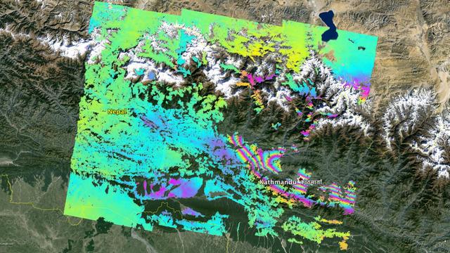
NASA and its partners are contributing important observations and expertise to the ongoing response to the April 25, 2015, magnitude 7.8 Gorkha earthquake in Nepal. The quake was the strongest to occur in that area since the 1934 Nepal-Bihar magnitude 8.0 event and caused significant regional damage and a humanitarian crisis. Scientists with the Advanced Rapid Imaging and Analysis project (ARIA), a collaboration between NASA's Jet Propulsion Laboratory, Pasadena, California, and the California Institute of Technology in Pasadena, analyzed interferometric synthetic aperture radar images from the European Union's Copernicus Sentinel-1A satellite, operated by the European Space Agency and also available from the Alaska Satellite Facility (https://www.asf.alaska.edu), to calculate a map of the deformation of Earth's surface caused by the quake. This false-color map shows the amount of permanent surface movement caused almost entirely by the earthquake, as viewed by the satellite, during a 12-day interval between two Sentinel-1 images acquired on April 17 and April 29, 2015. In the map, surface displacements are seen as color contours (or "fringes"), where each color cycle represents 8 inches (20 centimeters) of surface motion. The contours show the land around Kathmandu has moved upward by more than 40 inches (1 meter). Areas without the color contours have snow or heavy vegetation that affects the radar measurements. Scientists use these maps to build detailed models of the fault and associated land movements to better understand the impact on future earthquake activity. The background image is from Google Earth. The map contains Copernicus data (2015). http://photojournal.jpl.nasa.gov/catalog/PIA19535
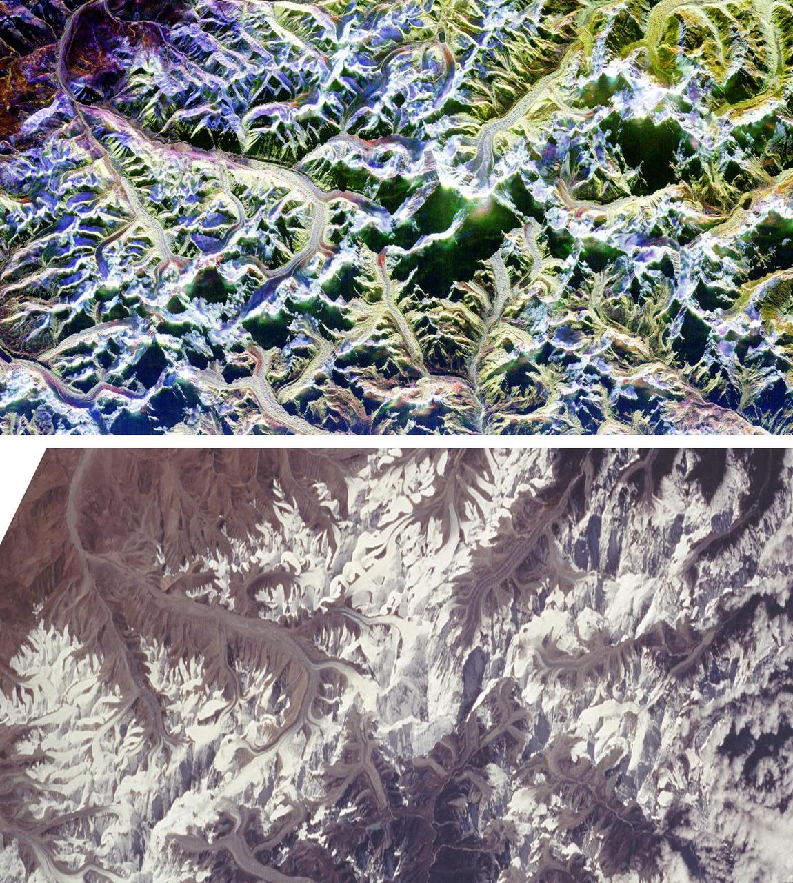
These are two comparison images of Mount Everest and its surroundings, along the border of Nepal and Tibet.
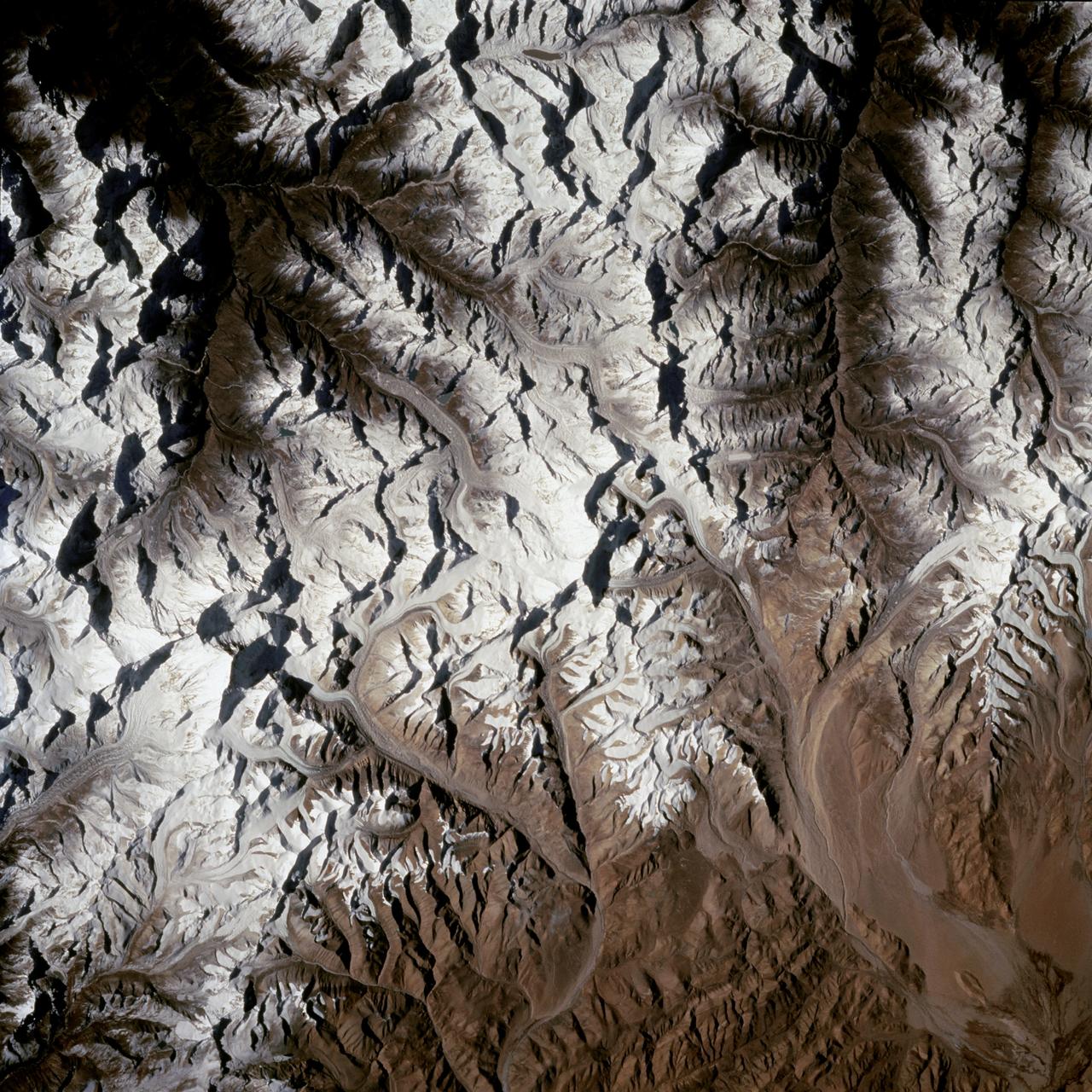
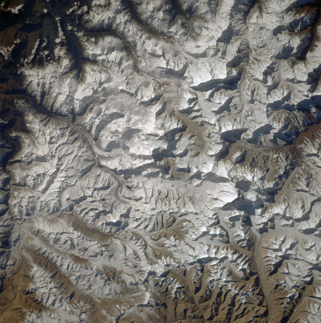
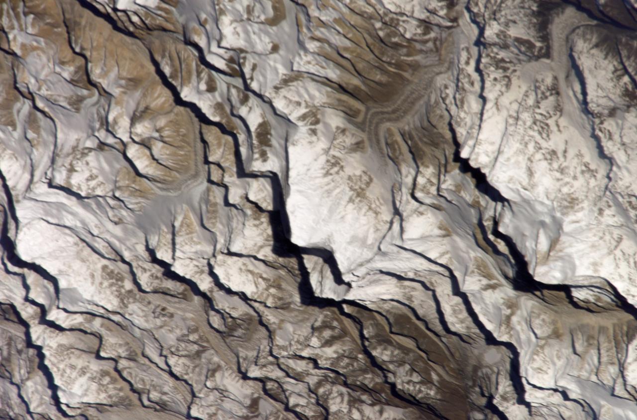
STS066-124-059 (3-14 Nov. 1994) --- Mount Everest region, Nepal and China. Low morning Sun highlights Mount Everest (the highest mountain in the world at 8,848 meters), Cho Oyu (8,153 meters) to the northwest, and other peaks of "The Roof of the World". New snow seems to be confined to the highest peaks. Abundant details of glacier surfaces, including moraines, crevasse fields, and ice falls are displayed for study.
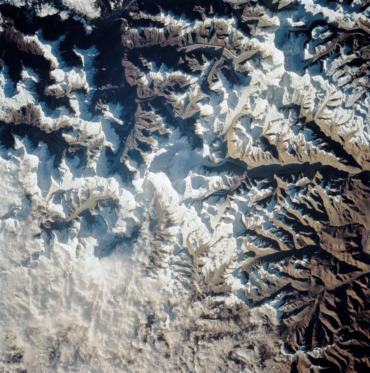
STS058-101-014 (18 Oct-1 Nov 1993) --- The best, most-nearly cloud-free, shuttle view yet of Mount Everest, the highest mountain in the world at 29,028 feet. The peak, on the border between Nepal and China, is almost exactly in the center of the photograph. The challenging North Face is in shadow; valley glaciers radiate in all directions from the central massif.
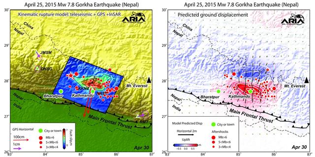
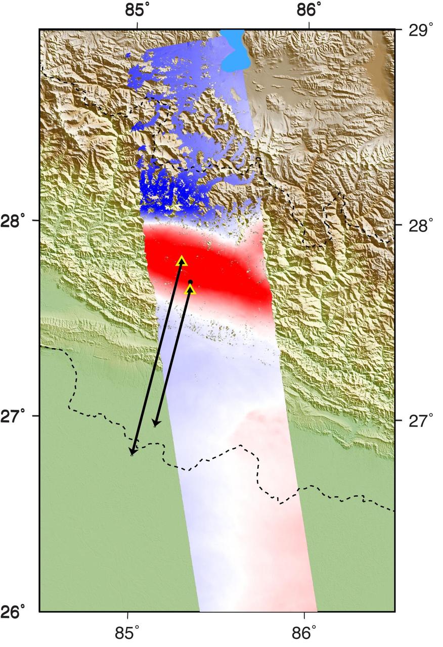
Using a combination of GPS-measured ground motion data, satellite radar data, and seismic observations from instruments distributed around the world, scientists have constructed preliminary estimates of how much the fault responsible for the April 25, 2015, magnitude 7.8 Gorkha earthquake in Nepal moved below Earth's surface (Figure 1). This information is useful for understanding not only what happened in the earthquake but also the potential for future events. It can also be used to infer a map of how Earth's surface moved due to the earthquake over a broader region (Figure 2). The maps created from these data can be viewed at PIA19384. In the first figure, the modeled slip on the fault is shown as viewed from above and indicated by the colors and contours within the rectangle. The peak slip in the fault exceeds 19.7 feet (6 meters). The ground motion measured with GPS is shown by the red and purple arrows and was used to develop the fault slip model. In the second figure, color represents vertical movement and the scaled arrows indicate direction and magnitude of horizontal movement. In both figures, aftershocks are indicated by red dots. Background color and shaded relief reflect regional variations in topography. The barbed lines show where the main fault reaches Earth's surface. The main fault dives northward into the Earth below the Himalaya. http://photojournal.jpl.nasa.gov/catalog/PIA19384
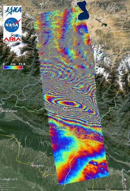
NASA and its partners are contributing important observations and expertise to the ongoing response to the April 25, 2015, magnitude 7.8 Gorkha earthquake in Nepal. The quake was the strongest to occur in that area since the 1934 Nepal-Bihar magnitude 8.0 event and caused significant regional damage and a humanitarian crisis. Scientists with the Advanced Rapid Imaging and Analysis project (ARIA), a collaboration between NASA's Jet Propulsion Laboratory, Pasadena, California, and the California Institute of Technology in Pasadena, analyzed interferometric synthetic aperture radar images from the PALSAR-2 instrument on the ALOS-2 satellite operated by the Japan Aerospace Exploration Agency (JAXA) to calculate a map of the deformation of Earth's surface caused by the quake. This false-color map shows the amount of permanent surface movement caused almost entirely by the earthquake, as viewed by the satellite, during a 70-day interval between two ALOS-2 images, acquired February 21 and May 2, 2015. In the map, surface displacements are seen as color contours (or "fringes"), where each color cycle represents 4.7 inches (11.9 centimeters) of surface motion. The contours show the land around Kathmandu has moved toward the satellite by up to 4.6 feet (1.4 meter), or 5.2 feet (1.6 meters) if we assume purely vertical motion. Areas without the color contours have snow or heavy vegetation that affects the radar measurements. Scientists use these maps to build detailed models of the fault and associated land movements to better understand the impact on future earthquake activity. The PALSAR-2 data were provided by JAXA through the Committee on Earth Observation Satellite (CEOS) in support of the response effort. The background image is from Google Earth. http://photojournal.jpl.nasa.gov/catalog/PIA19383
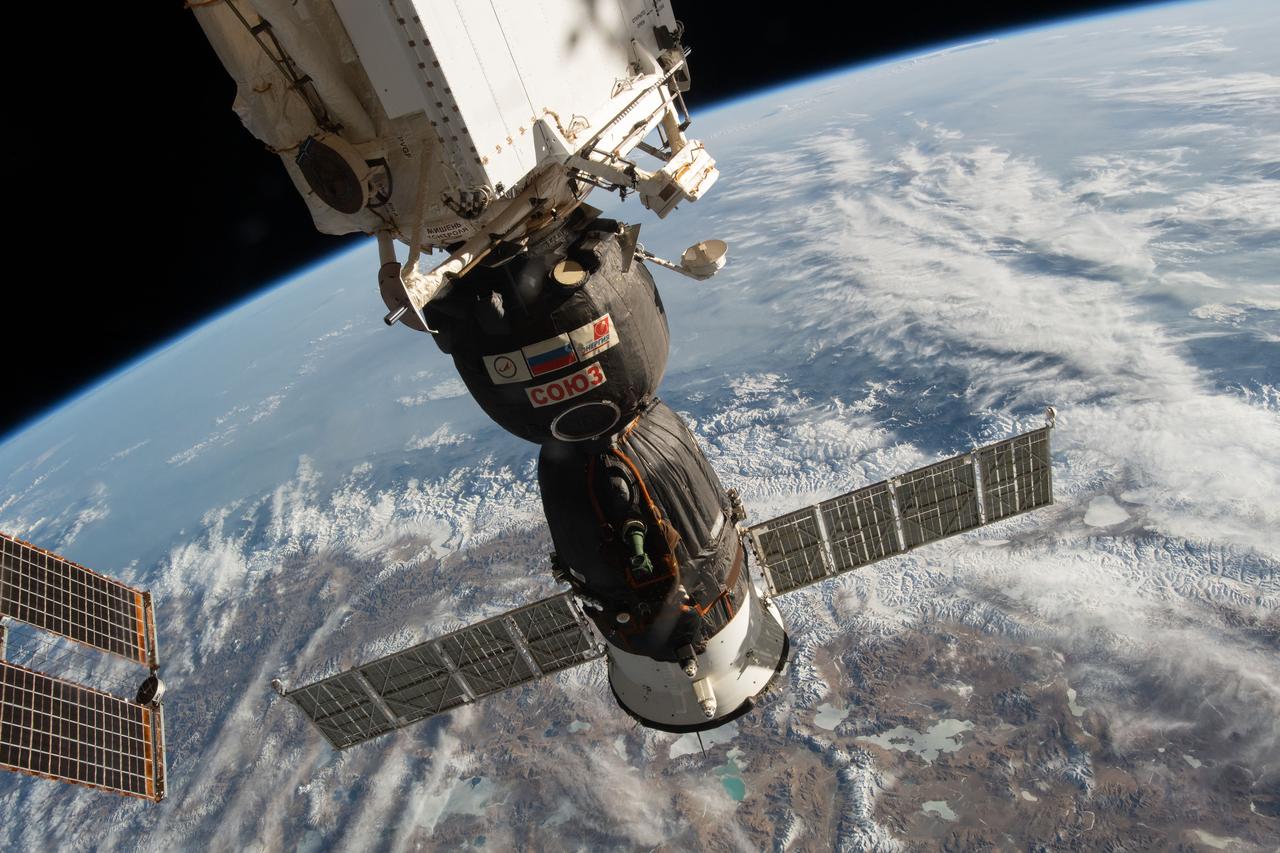
iss059e003532 (March 27, 2019) --- The Soyuz MS-12 crew ship is pictured docked to the Rassvet module as the International Space Station orbited 256 miles above India, Nepal and China.
iss064e031247 (Feb. 11, 2021) --- The Himalayas separating China from India and Nepal are pictured from the International Space Station as it orbited 263 miles above northern Pakistan.
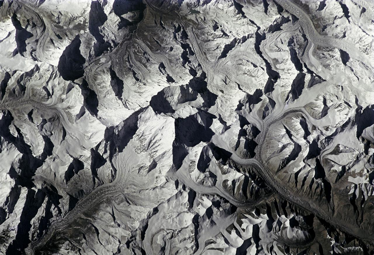
STS080-733-001 (19 Nov.-7 Dec. 1996) --- This view shows Mount Everest, near the border of Nepal and China, which reaches 29,028 feet in elevation (8,848 meters). Mount Everest is to the left of the V-shaped valley (holding picture with numbers on the right). Tibet is to the right, and Nepal is below. Rongbuk Glacier flows to the north while Khumbu Glacier flows to the south from Mount Everest. Many other glaciers are visible. The snow level is about 4,000 meters south of the divide or rain shadow, and about 6,000 meters north of the divide, in the rain shadow.
S63-06445 (15-16 May 1963) --- View of the Himalaya Mountain Range in the India-Nepal-Tibet border area, as photographed from the Mercury-Atlas 9 capsule by astronaut L. Gordon Cooper Jr., during his 22-orbit MA-9 spaceflight. Photo credit: NASA
iss070e097638 (Feb. 11, 2024) --- The Himalayas, separating the Indian subcontinent from China, home to the South Asian nations of Nepal and Bhutan, and with Lakes Mansarovar and Rakshastal on the Chinese side, are pictured from the International Space Station as it orbited 261 miles above.
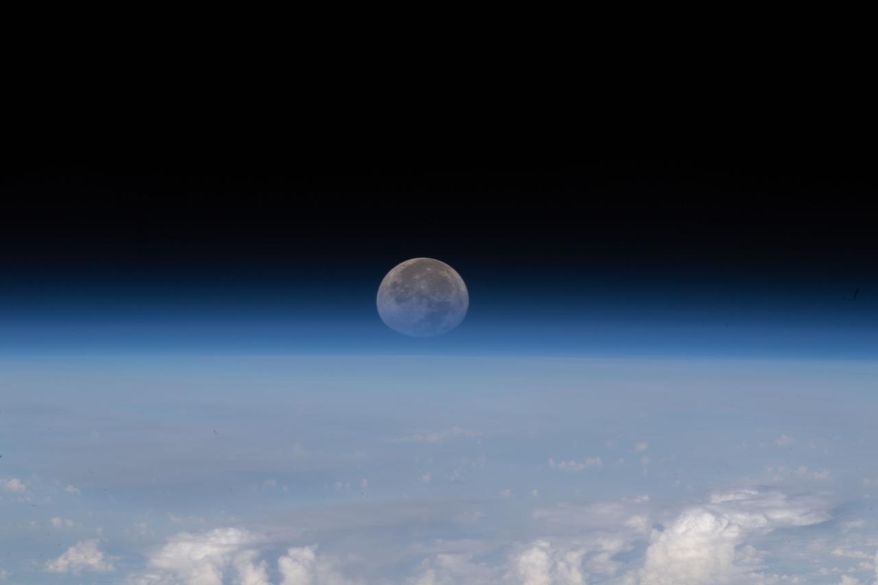
iss067e139457 (June 15, 2022) --- As the Moon sets below Earth's horizon the atmosphere refracts, or bends, its light making it appear flatter in this photograph taken from the International Space Station as it orbited 261 miles above the Himalayas near Kathmandu, the capital of Nepal.
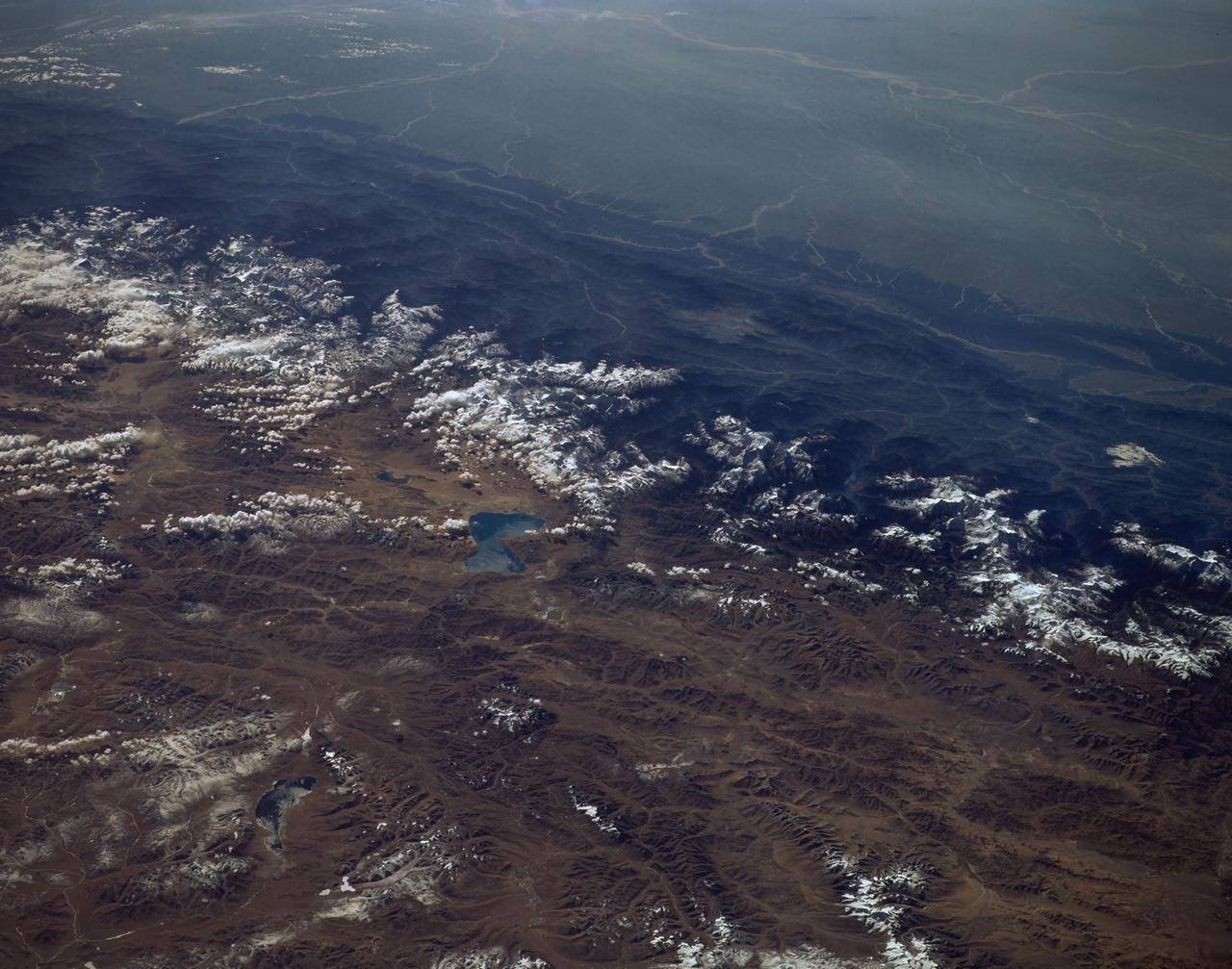
iss054e006869 (Dec. 27, 2017) --- This photograph taken by Expedition 54 crew members aboard the International Space Station reveals striking climate differences of Nepal and the Himalayan mountain range, including Mount Everest (left) and the Tibetan highlands of western China (right).
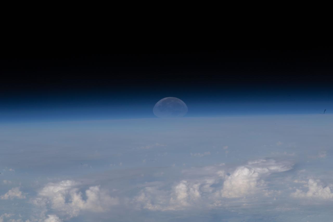
iss067e139458 (June 15, 2022) --- As the Moon sets below Earth's horizon the atmosphere refracts, or bends, its light making it appear flatter in this photograph taken from the International Space Station as it orbited 261 miles above the Himalayas near Kathmandu, the capital of Nepal.
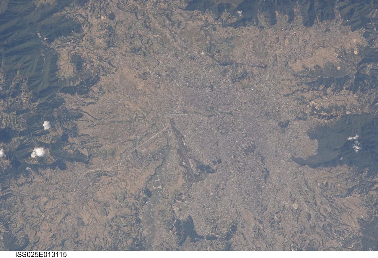
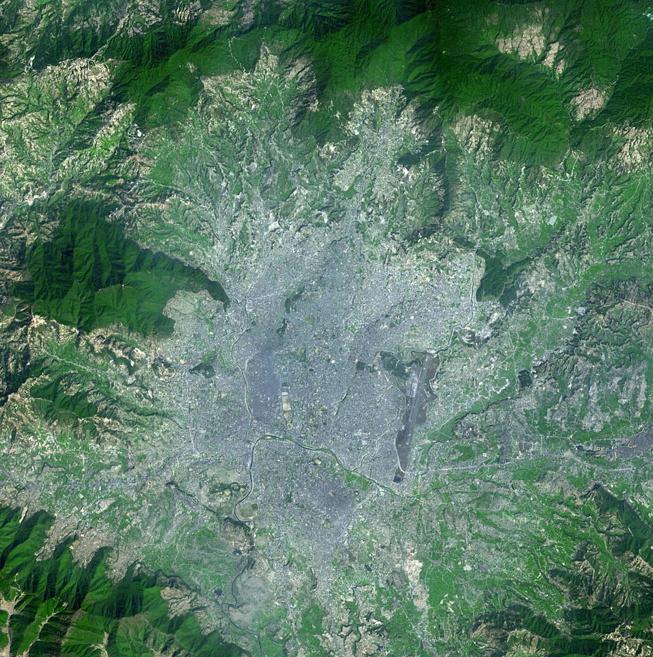
ISS025-E-013115 (9 Nov. 2010) --- Kathmandu, Nepal is featured in this image photographed by an Expedition 25 crew member on the International Space Station. The capital and largest city of Nepal, Kathmandu occupies much of the Kathmandu Valley located near the center of the country. Nepal itself contains much of the Himalaya mountain range between China (Tibet) to the north and India to the south. Geological and fossil evidence indicates that the Kathmandu Valley was filled by a large lake (Paleo-Kathmandu Lake) between approximately 2.8 million and 10,000 years ago, according to scientists. Geologists believe the lake drained in phases over time due both to a drier regional climate, continuing tectonic uplift and faulting in the region, and formation of an integrated valley drainage system as river channels cut through previous natural rock ridge dams. The green vegetated slopes that ring the Kathmandu metro area (light gray, center) include both forest reserves and national parks. The metropolitan area is relatively flat compared to the surrounding high mountains. Tribhuvan International Airport, located near the current eastern margin of the metro area, is the only international airport in Nepal. Archeological evidence suggests that the development of Kathmandu, together with the nearby “sister cities” of Lalitpur and Bhaktapur, began almost 2,000 years ago. Today, Kathmandu and its sister cities form the governmental, cultural, and—as a main access point to the Himalayas for tourism—economic center of the country.
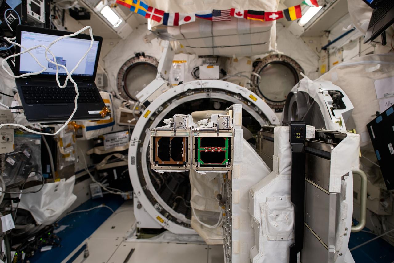
iss059e102911 (6/13/2019 --- Photo documentation taken aboard the International Space Station (ISS) of the JEM Small Satellite Orbital Deployer #11 (J-SSOD #11) micro-satellite deployment mission. J-SSOD#11 deploys the BIRDS-3 Project and Spooky-1 satellites. BIRDS-3 Project is a constellation of three 1U CubeSats developed by Japan, Nepal and Sri Lanka. SpooQy-1 is a 3-Unit (3U) CubeSat developed by the National University of Singapore (NUS).

iss059e104298 (6/17/2019) --- Photo documentation taken of the JEM Small Satellite Orbital Deployer #11 (J-SSOD #11) micro-satellite deployment mission. J-SSOD#11 deploys the Joint Global Multi Nation Birds, known as the BIRDS-3 Project, which is a constellation of three 1U CubeSats developed by Japan, Nepal and Sri Lanka . The satellites, named Uguisu, Raavana-1, and NepaliSat-1, were released into Earth orbit for technology demonstrations.
iss074e0002506 (Dec. 13, 2025) --- The Himalayas—separating the moisture-laden portion of the Indian subcontinent from the arid geography of Tibet, China—are pictured from the International Space Station as it orbited 261 miles above Nepal. At upper right is one of two UltraFlex solar arrays that power the Cygnus XL cargo craft from Northrop Grumman.
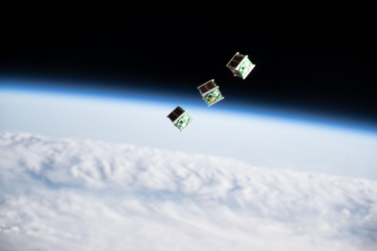
iss059e104766 (June 17, 2019) --- A set of three CubeSats are pictured shortly after being ejected from the Japanese Small Satellite Orbital Deployer attached to a robotic arm outside of the Japan Aerospace Exploration Agency's Kibo laboratory module. The tiny satellites from Nepal, Sri Lanka and Japan were released into Earth orbit for technology demonstrations.

iss059e104771 (6/17/2019) --- Photo documentation taken of the JEM Small Satellite Orbital Deployer #11 (J-SSOD #11) micro-satellite deployment mission. J-SSOD#11 deploys the Joint Global Multi Nation Birds, known as the BIRDS-3 Project, which is a constellation of three 1U CubeSats developed by Japan, Nepal and Sri Lanka . The satellites, named Uguisu, Raavana-1, and NepaliSat-1, were released into Earth orbit for technology demonstrations.
61A-31-089 (30 Oct-6 Nov 1985) --- This photograph looking to the west-northwest along the axis of the Great Himalayan range, shows India, Nepal and China. Mount Everest (8,848 meters) is near the center of the frame. The Ganges Plains are to the left and the Tibet Plateau to the right. The snow line elevations are between 3,000 and 4,000 meters.
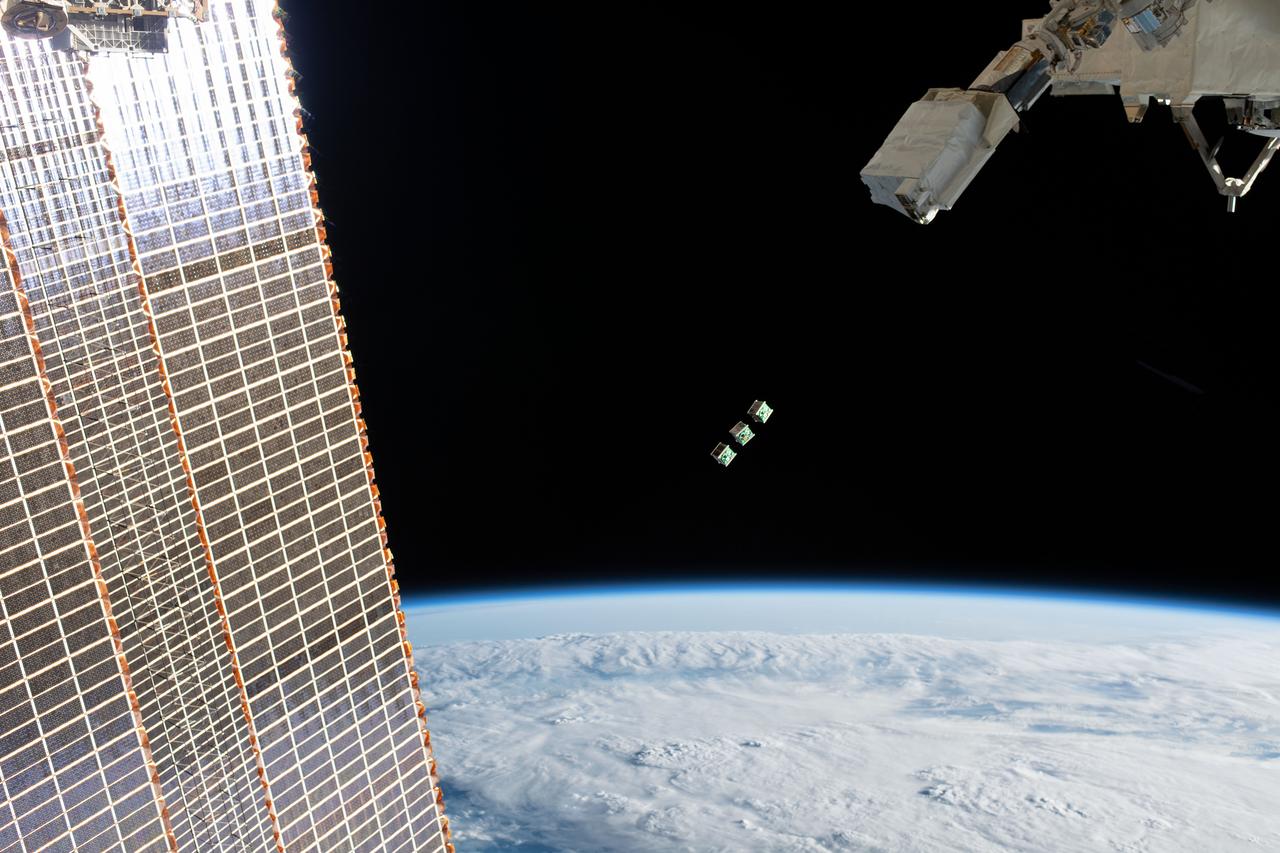
iss059e104296 (June 17, 2019) --- A set of three CubeSats are ejected from the Japanese Small Satellite Orbital Deployer attached to a robotic arm outside of the Japan Aerospace Exploration Agency's Kibo laboratory module. The tiny satellites from Nepal, Sri Lanka and Japan were released into Earth orbit for technology demonstrations. The International Space Station was orbiting 256 miles above the Amazon River in Brazil when an Expedition 59 crewmember took this photograph.
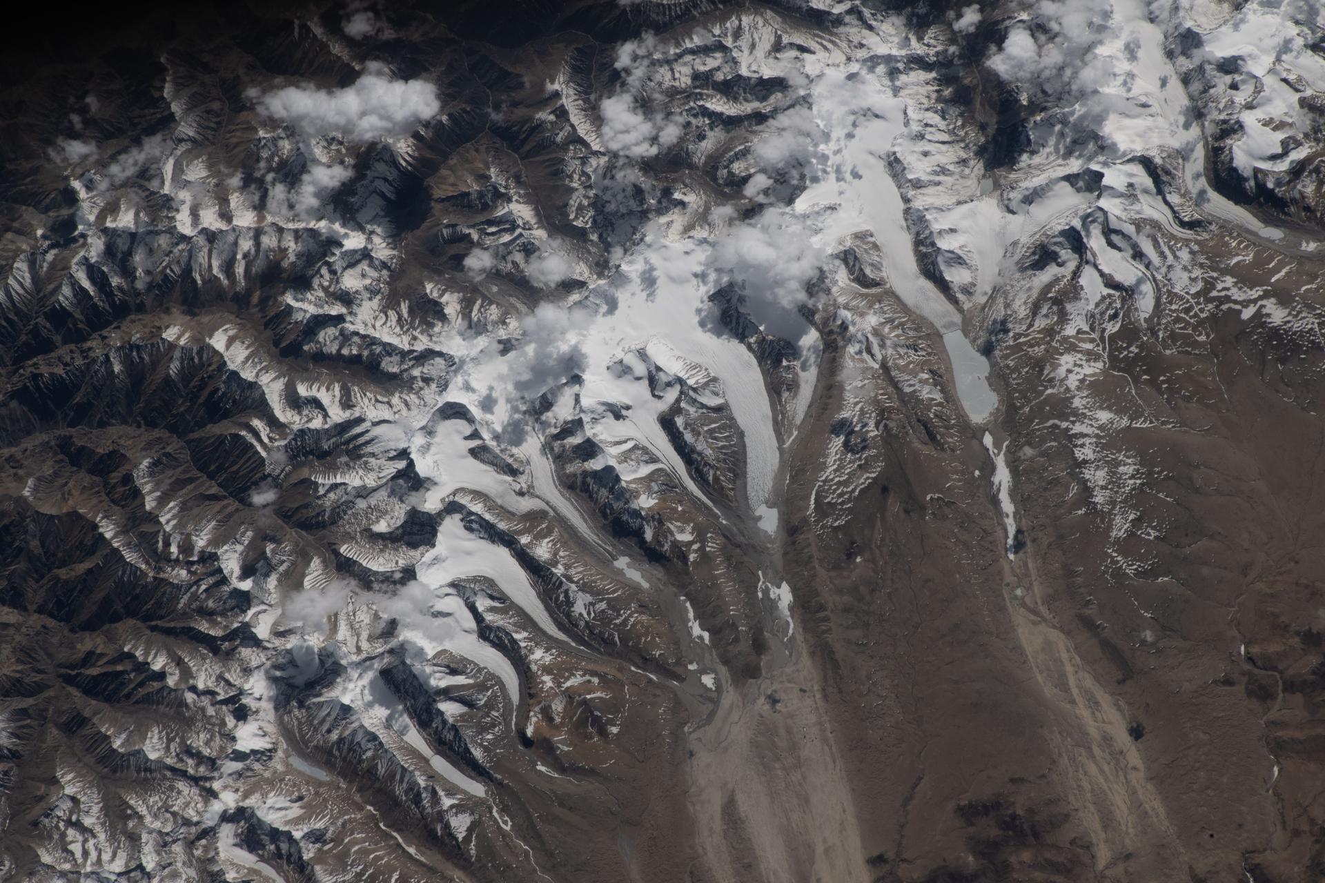
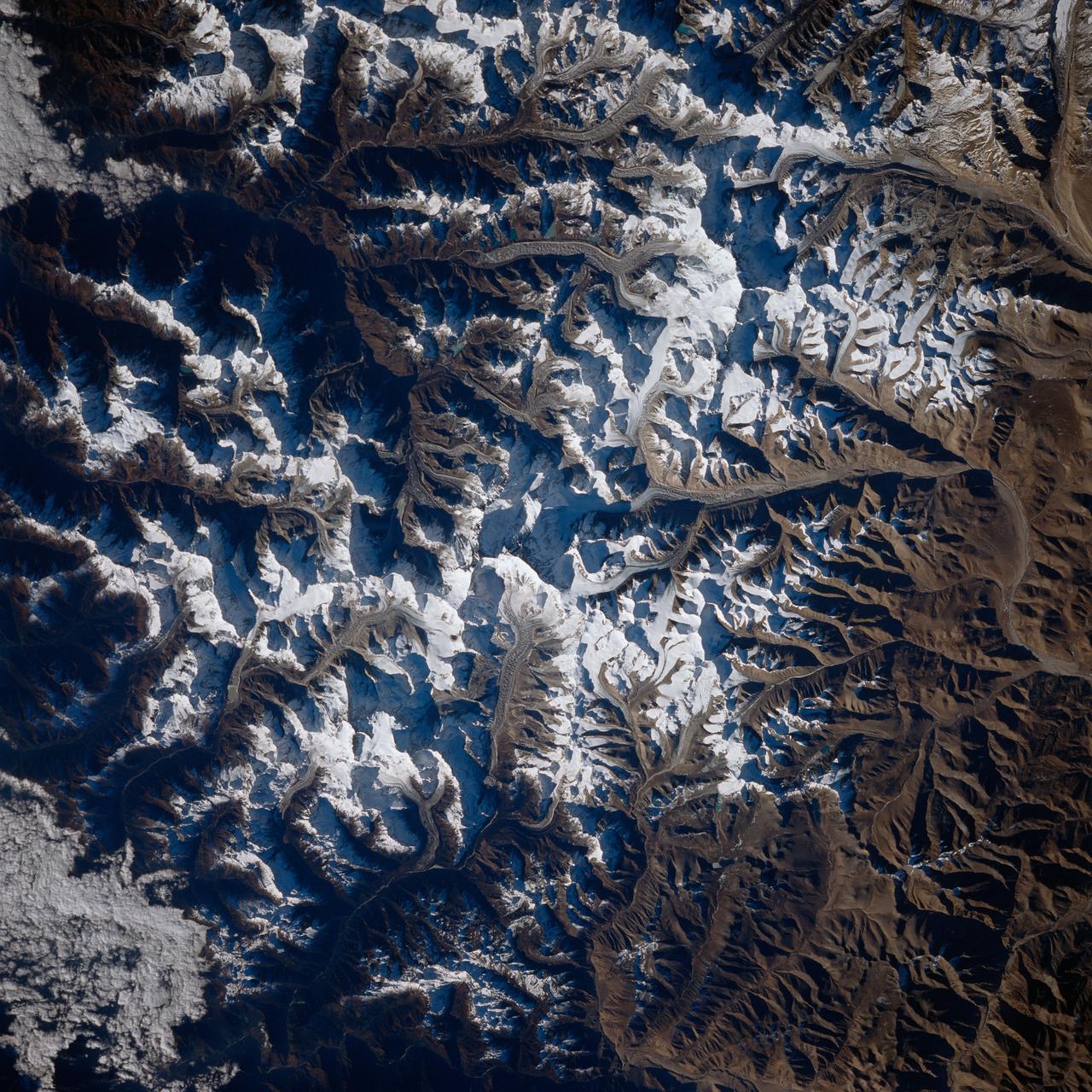
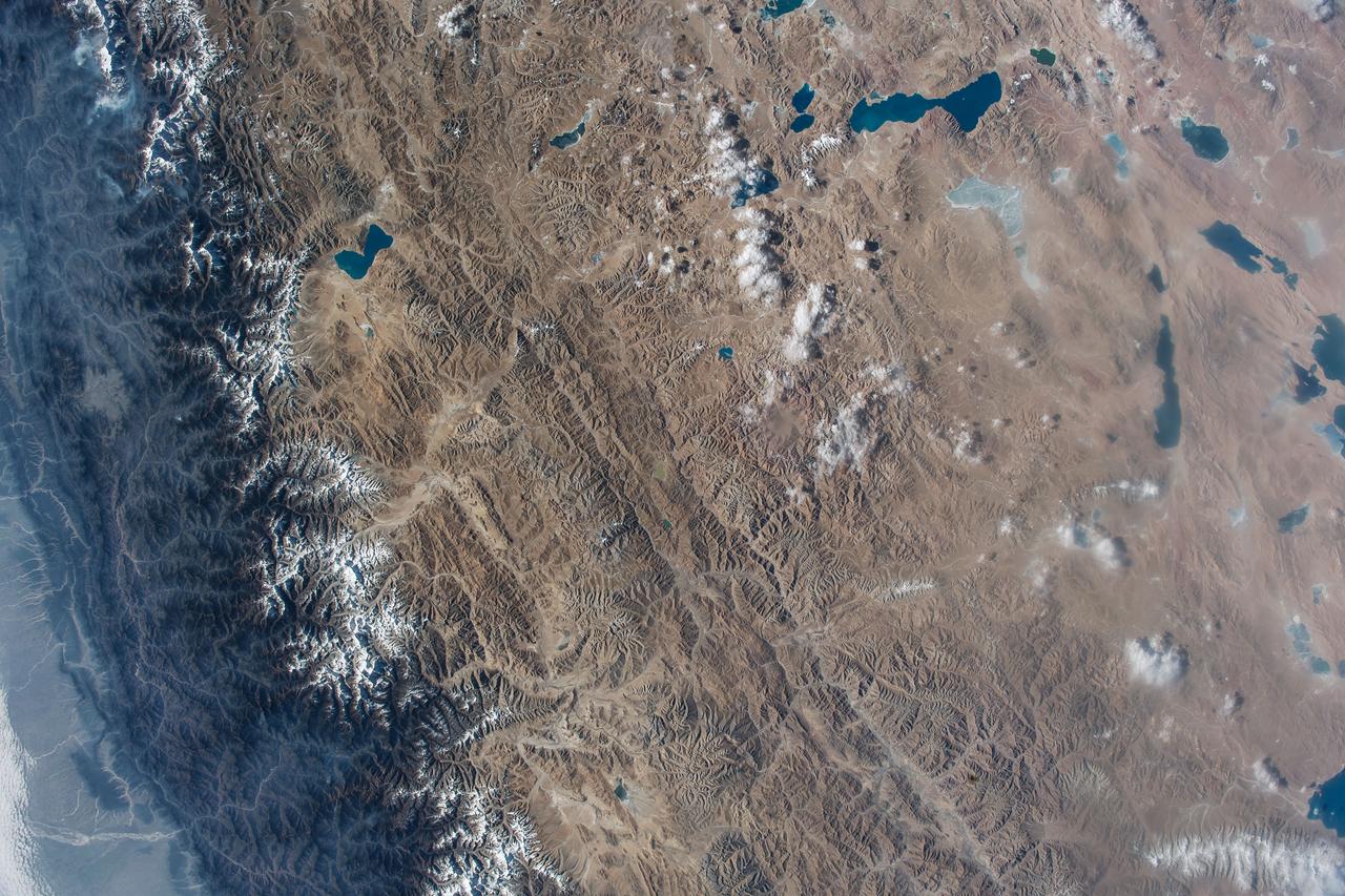
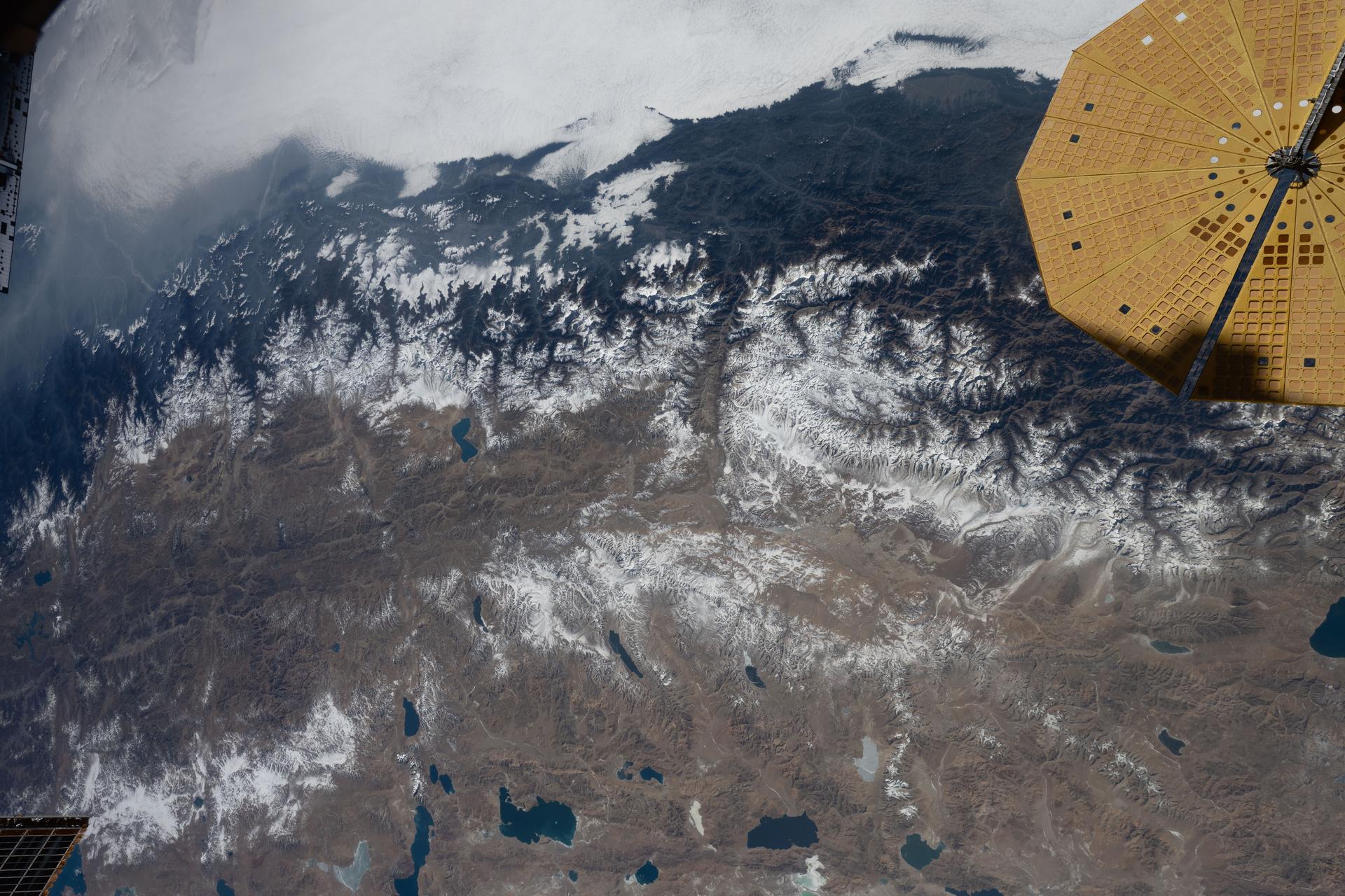
iss074e0603582 (May 20, 2026) --- The Himalayas separate Nepal from China in this photograph from the International Space Station as it orbited 259 miles above the western Tibetan Plateau. Glaciers—slow‑moving rivers of ice that carve paths into mountainsides—flow downhill from the Himalayas’ northern slopes onto China's Tibetan Plateau. Credit: NASA/Jessica Meir
STS087-716-080 (19 November – 5 December 1997) --- Featured in this view is Mount Everest. It is called “Sagarmatha” in Nepal and “Qomolangma Feng” Qomolangma in China (both names meaning “Goddess Mother of the World”), but is known to the western world as Mount Everest. At an altitude of 29,028 feet (8,848 meters) the summit of tallest mountain on Earth (above sea level) reaches two-thirds of the way through the atmosphere. Situated on the border between Nepal and China (27°59’N, 86°56’E), Mount Everest with its low oxygen levels, powerful winds, and extremely cold temperatures has captured the imagination of adventuresome men and women. Sir Edmund Hillary and Tenzing Norgay were the first persons to surmount Mount Everest in 1953. While climbing Everest can be challenging, it can also be tragic. On May 10, 1996, after reaching the summit and descending to camp, several climbers were trapped by a severe and sudden storm. A total of eight people died, making this day the deadliest single tragedy in the history of Mount Everest. This picture is one of the 70mm Earth observations visuals used by the crew at its post flight presentation events.
AS7-07-1748 (15 Oct. 1968) --- The world's dozen peaks which reach a height of greater than five miles above sea level are seen in this photograph from the Apollo 7 spacecraft at an altitude of approximately 130 nautical miles. The 29,028 ft. high Mount Everest is at lower center. On the central horizon can be seen the 28,250 ft. high Mount Godwin-Austen (K-2) some 800 miles northwest of Mount Everest. In the lower right, Mount Kanchenjunga rises 28,208 ft. to separate Nepal from Sikkim. The snow line on the peaks was at 17,500 ft. In the upper right the lake-studded highlands of Tibet are visible.
Astronaut Daniel W. Bursch, Expedition Four flight engineer, was delighted in capturing this image of Mt. Everest in the Himalayan Range from aboard the International Space Station (ISS). The mountain is near frame center. Because the photo was taken close to orbital sunrise, the low sun angle gave tremendous relief to the mountains. Named for Sir George Everest, the British surveyor-general of India, Mount Everest is the tallest point on earth. Standing 29,028 feet tall, it is 5 1/2 miles above sea level. Mount Everest is located half in Nepal and half in Tibet.
STS066-208-025 (3-14 Nov. 1994) --- Mount Everest, the highest mountain in the world at 8,848 meters, was photographed by the crew members aboard the Space Shuttle Atlantis from 165 nautical miles above Earth. Also seen are Cho Oyu (8,153 meters) northwest of Everest, and other peaks in what has been called the "Roof of the World". Abundant details of glacier surfaces, including moraines, crevasse fields and ice falls are displayed for study. Crew members onboard Atlantis were astronauts Donald R. McMonagle, Curtis L. Brown, Jr., Ellen Ochoa, Scott E. Parazynski and Joseph R. Tanner, along with Jean-François Clervoy of the European Space Agency (ESA). The six astronauts spent 11-days in Earth-orbit in support of the Atmospheric Laboratory for Applications and Science (ATLAS-3) mission.
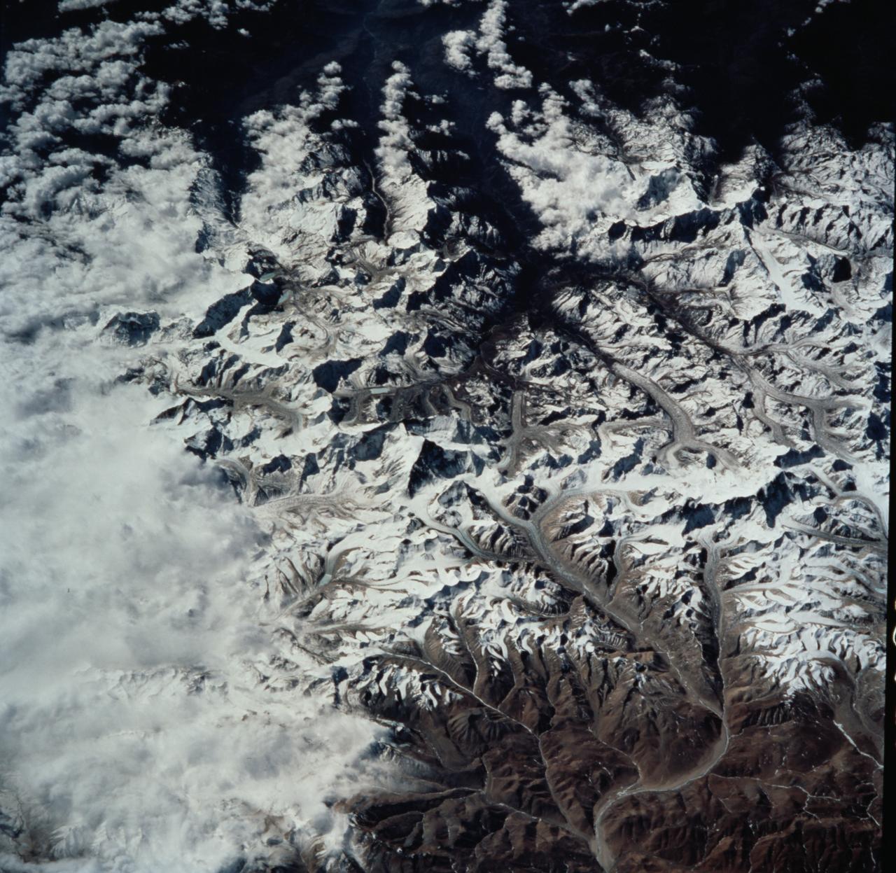
View is southeastward across China (Tibet), half of Nepal and India. The partly frozen lake near the center of the frame is Pei-Ku T'so ("Bos-tie Lake"). The central Himalaya stretches from Mount Everest on the left past Annapurna on the right. Large tributaries converge to form the Ganges River, flowing through the lowland basin south of the Himalaya. This photograph illustrates the rain shadow effect of the Himalaya Chain; wet, warm air from the Indian Ocean is driven against the mountains, lifted, and drained of water that forms ice caps, the abundant rivers, and forests of the foothills. In contrast the high plateau of Tibet is arid, composed largely of topographically-closed basins because stream flow is inadequate to form integrated drainage networks.
STS099-735-046 (11-22 February 2000) ---Mt. Everest (29,028 feet or 8,848 meters), is featured in the center of this 70mm frame photographed by one of the STS-99 crew members. Everest, also called Qomolangma Feng, is just north of the border between Nepal and China. The Himalayas and the Tibetan Plateau are products of the collision of the Indian and Eurasian tectonic plates. With the continuing northward march of India, the crust of the Earth has become thicker and the Tibetan Plateau has been uplifted to an average elevation of about 15,000 feet. According to NASA scientists studying the STS-99 imagery, fossil-bearing limestones are at the summit of the mountain. The scientists say that these limestones were deposited beneath the sea around 510 million years ago (Cambrian to Ordovician time). Glaciers, moraines, and outwash plains are spectacularly displayed. Glacial meltwaters in this area feed the Arun River, eventually reaching the Ganges on the plains of India.