
A paddlewheeler makes its way up the Mississippi River as the moon rises over New Orleans on Sunday evening, August 22, 2021. The August Sturgeon Moon, which was also a rare Blue Moon, was full at 7:02 A.M. local time Sunday but the nearly full moon still put on a show when it rose over New Orleans later that evening. New Orleans is home to the NASA Michoud Assembly Facility where the core stage of the Space Launch System that will return people to the moon is being built. Image credit: NASA/Michael DeMocker
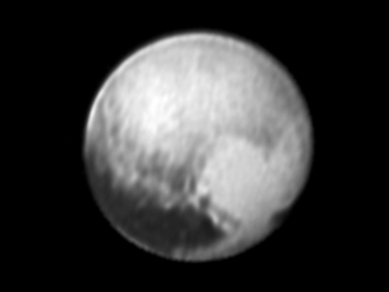
This image of Pluto was taken by New Horizons' Long Range Reconnaissance Imager (LORRI) at 4:18 UT on July 9, 2015, from a range of 3.9 million miles (6.3 million kilometers). It reveals new details on the surface of Pluto, including complex patterns in the transition between the very dark equatorial band (nicknamed "the whale"), which occupies the lower part of the image, and the brighter northern terrain. The bright arc at the bottom of the disk shows that there is more bright terrain beyond the southern margin of the "whale." The side of Pluto that will be studied in great detail during the close encounter on July 14 is now rotating off the visible disk on the right hand side, and will not be seen again until shortly before closest approach. Three consecutive images were combined and sharpened, using a process called deconvolution, to create this view. Deconvolution enhances real detail but can also generate spurious features, including the bright edge seen on the upper and left margins of the disk (though the bright margin on the bottom of the disk is real). The wireframe globe shows the orientation of Pluto in the image: thicker lines indicate the equator and the prime meridian (the direction facing Charon). Central longitude on Pluto is 86°. http://photojournal.jpl.nasa.gov/catalog/PIA19705

Space shuttle Enterprise, mounted atop a NASA 747 Shuttle Carrier Aircraft (SCA), is seen as it flies over the Verrazano Bridge, Friday, April 27, 2012, in New York. Enterprise was the first shuttle orbiter built for NASA performing test flights in the atmosphere and was incapable of spaceflight. Originally housed at the Smithsonian's Steven F. Udvar-Hazy Center, Enterprise will be demated from the SCA and placed on a barge that will eventually be moved by tugboat up the Hudson River to the Intrepid Sea, Air & Space Museum in June. Photo Credit: (NASA/Bill Ingalls)

Space shuttle Enterprise, mounted atop a NASA 747 Shuttle Carrier Aircraft (SCA), is seen as it flies over the Hudson River, Friday, April 27, 2012, in New York. Enterprise was the first shuttle orbiter built for NASA performing test flights in the atmosphere and was incapable of spaceflight. Originally housed at the Smithsonian's Steven F. Udvar-Hazy Center, Enterprise will be demated from the SCA and placed on a barge that will eventually be moved by tugboat up the Hudson River to the Intrepid Sea, Air & Space Museum in June. Photo Credit: (NASA/Bill Ingalls)

Space shuttle Enterprise, mounted atop a NASA 747 Shuttle Carrier Aircraft (SCA), is seen off in the distance behind the Statue of Liberty, Friday, April 27, 2012, in New York. Enterprise was the first shuttle orbiter built for NASA performing test flights in the atmosphere and was incapable of spaceflight. Originally housed at the Smithsonian's Steven F. Udvar-Hazy Center, Enterprise will be demated from the SCA and placed on a barge that will eventually be moved by tugboat up the Hudson River to the Intrepid Sea, Air & Space Museum in June. Photo Credit: (NASA/Bill Ingalls)

Space shuttle Enterprise, mounted atop a NASA 747 Shuttle Carrier Aircraft (SCA), is seen as it flies near the Statue of Liberty, Friday, April 27, 2012, in New York. Enterprise was the first shuttle orbiter built for NASA performing test flights in the atmosphere and was incapable of spaceflight. Originally housed at the Smithsonian's Steven F. Udvar-Hazy Center, Enterprise will be demated from the SCA and placed on a barge that will eventually be moved by tugboat up the Hudson River to the Intrepid Sea, Air & Space Museum in June. Photo Credit: (NASA/Bill Ingalls)
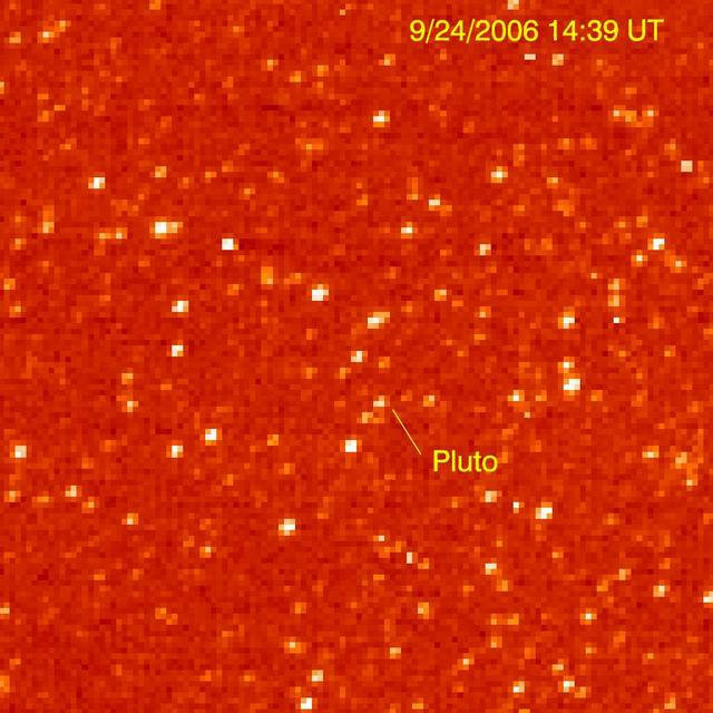
The Long Range Reconnaissance Imager on NASA New Horizons acquired images of the Pluto field three days apart in late September 2006, in order to see Pluto motion against a dense background of stars.
The two pots in this image are a composite of two images of asteroid 2002 JF56 taken on June 11 and June 12, 2006, with the Multispectral Visible Imaging Camera component of the New Horizons Ralph imager.
New Moon

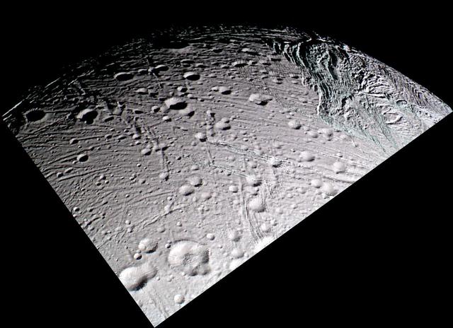
New Territory
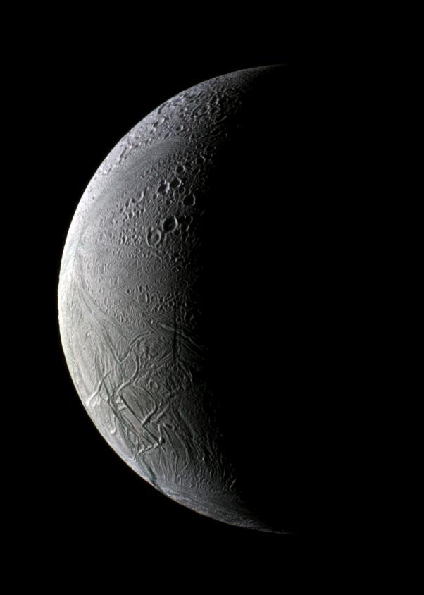
Shiny and New

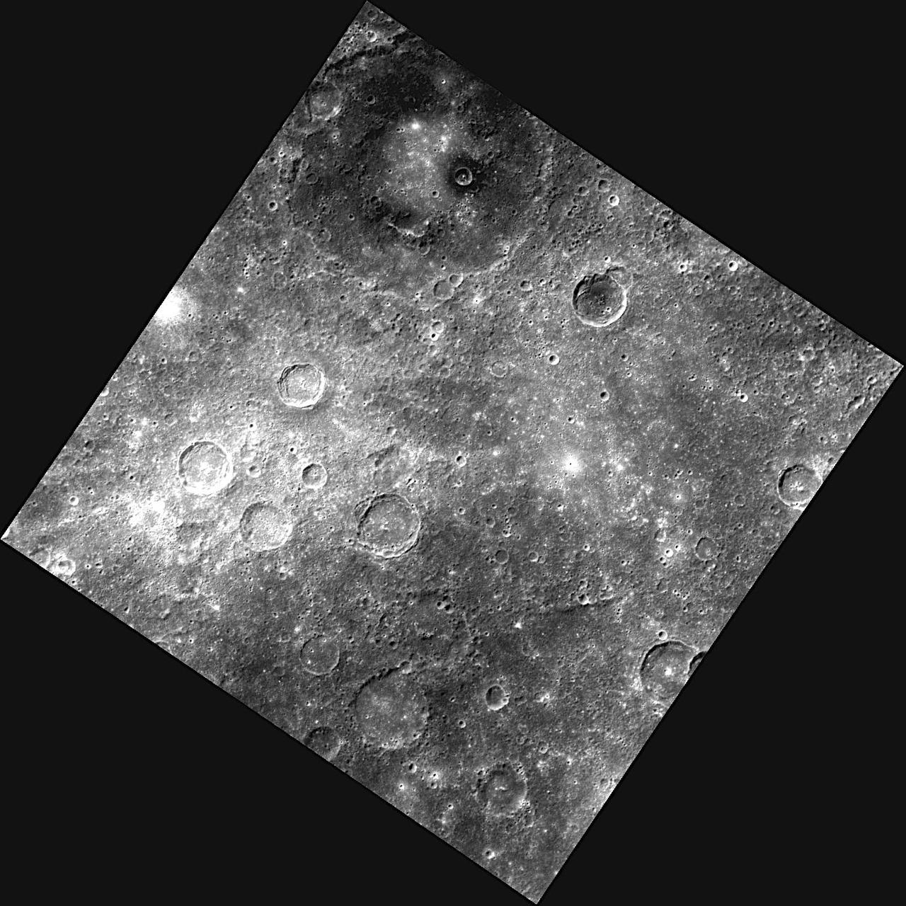
New Craters
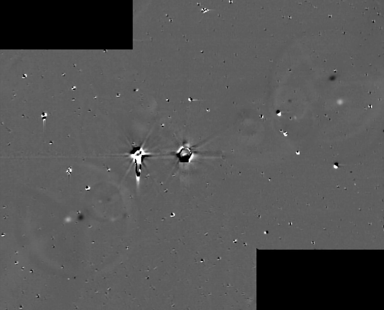
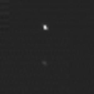
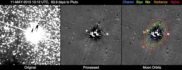
This illustration shows some of the final images used to determine that the coast is clear for New Horizons' flight through the Pluto system. These images show the difference between two sets of 48 combined 10-second exposures with New Horizons Long Range Reconnaissance Imager (LORRI) camera, taken at 8:40 UTC and 10:25 UTC on June 26, 2015, from a range of 21.5 million kilometers (approximately 13 million miles) to Pluto. The known small moons, Nix, Hydra, Kerberos and Styx, are visible as adjacent bright and dark pairs of dots, due to their motion in the 105 minutes between the two image sets. The images have been extensively processed to remove the glare and "ghosts" (i.e., lens flare) from Pluto and Charon, and also to remove background stars, though many of the brighter stars are imperfectly removed and appear as irregular bright and dark blobs. These and other similar sets of images demonstrate that there are no previously unknown moons brighter than 15 times fainter than Styx (the faintest known moon) in the region outside of Charon's orbit, or brighter than five times fainter than Styx in the region between Charon's orbit and a few thousand kilometers above Pluto's surface. http://photojournal.jpl.nasa.gov/catalog/PIA19695

Space shuttle Enterprise, mounted atop a NASA 747 Shuttle Carrier Aircraft (SCA), is seen as it flies over the Hudson River, Friday, April 27, 2012, in New York. Enterprise was the first shuttle orbiter built for NASA performing test flights in the atmosphere and was incapable of spaceflight. Originally housed at the Smithsonian's Steven F. Udvar-Hazy Center, Enterprise will be demated from the SCA and placed on a barge that will eventually be moved by tugboat up the Hudson River to the Intrepid Sea, Air & Space Museum in June. Photo Credit: (NASA/Matt Hedges)

This is the NASA News Center at Kennedy Space Center in Florida, where reporters from television, radio, print and online media outlets have monitored countless launches, landings and other space events in order to deliver the news to the world.
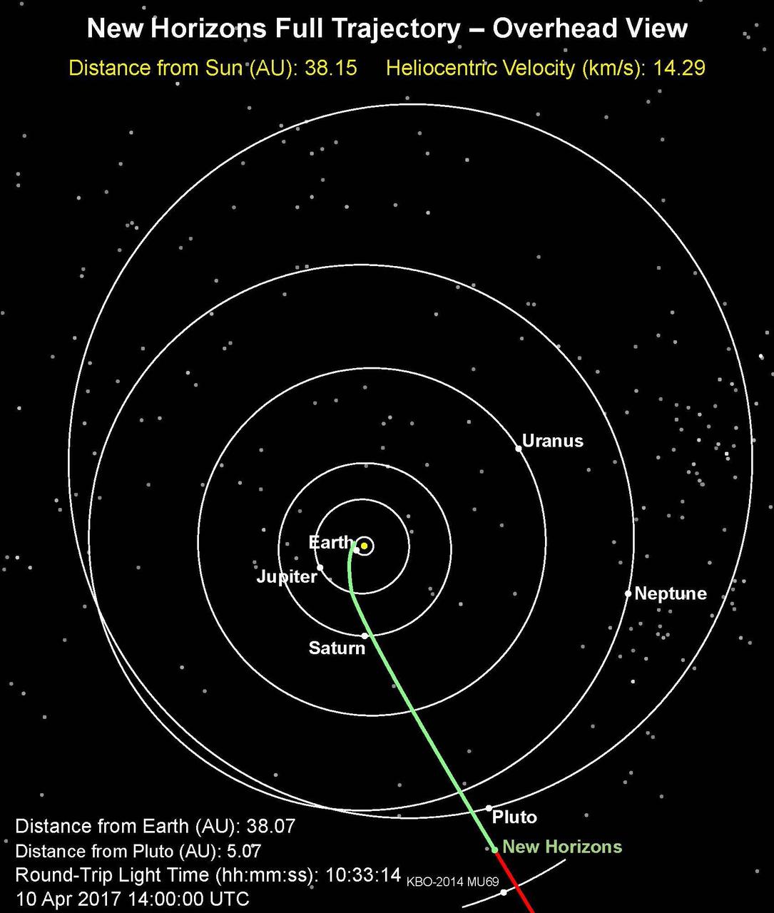
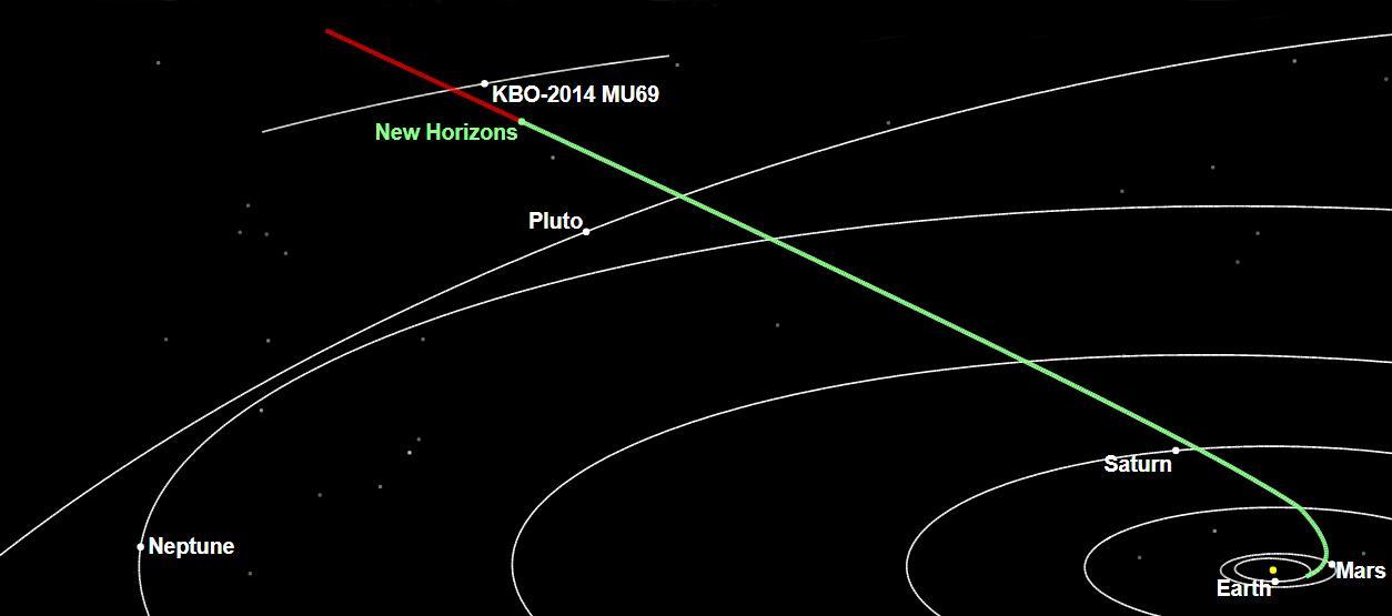
This is an overhead view of NASA's New Horizons full trajectory; the spacecraft has entered a hibernation phase on April 7 that will last until early September. The full article is available at https://photojournal.jpl.nasa.gov/catalog/PIA21589
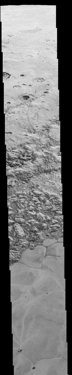
This mosaic is composed of the sharpest views of Pluto that NASA's New Horizons spacecraft obtained during its flyby of the distant planet on July 14, 2015. The pictures are part of a sequence taken near New Horizons' closest approach to Pluto, with resolutions of about 250-280 feet (77-85 meters) per pixel -- revealing features smaller than half a city block on Pluto's diverse surface. The images include a wide variety of spectacular, cratered, mountainous and glacial terrains -- giving scientists and the public alike a breathtaking, super-high resolution window on Pluto's geology. The images form a strip 50 miles (80 kilometers) wide trending from Pluto's jagged horizon about 500 miles (800 kilometers) northwest of the informally named Sputnik Planum, across the al-Idrisi mountains, onto the shoreline of Sputnik Planum and then across its icy plains. They were made with the telescopic Long Range Reconnaissance Imager (LORRI) aboard New Horizons, over a timespan of about a minute centered on 11:36 UT on July 14 -- just about 15 minutes before New Horizons' closest approach to Pluto -- from a range of just 10,000 miles (17,000 kilometers). They were obtained with an unusual observing mode; instead of working in the usual "point and shoot," LORRI snapped pictures every three seconds while the Ralph/Multispectral Visual Imaging Camera (MVIC) aboard New Horizons was scanning the surface. This mode requires unusually short exposures to avoid blurring the images. http://photojournal.jpl.nasa.gov/catalog/PIA20201

This frame from a movie is composed of the sharpest views of Pluto that NASA's New Horizons spacecraft obtained during its flyby of the distant planet on July 14, 2015. The pictures are part of a sequence taken near New Horizons' closest approach to Pluto, with resolutions of about 250-280 feet (77-85 meters) per pixel -- revealing features smaller than half a city block on Pluto's diverse surface. The images include a wide variety of spectacular, cratered, mountainous and glacial terrains -- giving scientists and the public alike a breathtaking, super-high resolution window on Pluto's geology. The images form a strip 50 miles (80 kilometers) wide trending from Pluto's jagged horizon about 500 miles (800 kilometers) northwest of the informally named Sputnik Planum, across the al-Idrisi mountains, onto the shoreline of Sputnik Planum and then across its icy plains. They were made with the telescopic Long Range Reconnaissance Imager (LORRI) aboard New Horizons, over a timespan of about a minute centered on 11:36 UT on July 14 -- just about 15 minutes before New Horizons' closest approach to Pluto -- from a range of just 10,000 miles (17,000 kilometers). They were obtained with an unusual observing mode; instead of working in the usual "point and shoot," LORRI snapped pictures every three seconds while the Ralph/Multispectral Visual Imaging Camera (MVIC) aboard New Horizons was scanning the surface. This mode requires unusually short exposures to avoid blurring the images. http://photojournal.jpl.nasa.gov/catalog/PIA20202
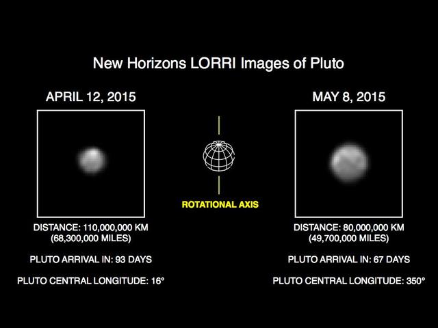
This image of Pluto is part of series of New Horizons Long Range Reconnaissance Imager LORRI photos taken May 8-12, 2015; the image at left shows LORRI view of Pluto just one month earlier.
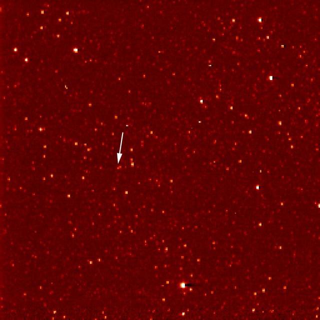
A white arrow marks Pluto in this NASA New Horizons Long Range Reconnaissance Imager picture taken Sept. 21, 2006. Pluto is little more than a faint point of light among a dense field of stars.
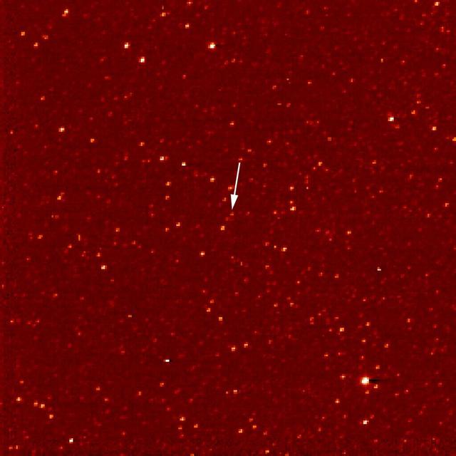
A white arrow marks Pluto in this NASA New Horizons Long Range Reconnaissance Imager picture taken Sept. 24, 2006. Pluto is little more than a faint point of light among a dense field of stars.
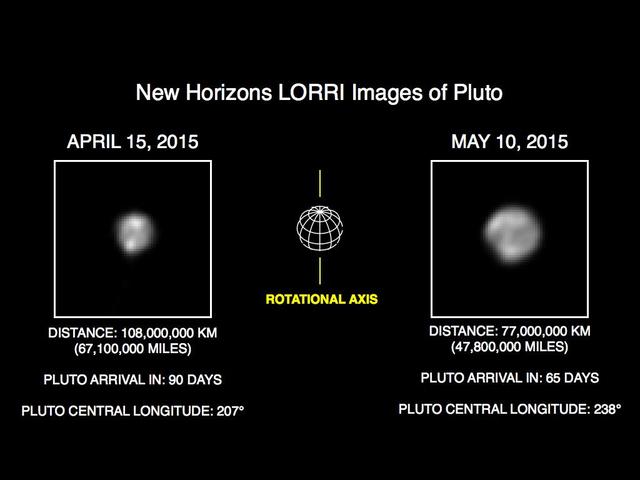
This image of Pluto is part of series of New Horizons Long Range Reconnaissance Imager LORRI photos taken May 8-12, 2015; the image at left shows LORRI view of Pluto just one month earlier.
This mosaic strip, extending across the hemisphere that faced the New Horizons spacecraft as it flew past Pluto on July 14, 2015, now includes all of the highest-resolution images taken by the NASA probe.
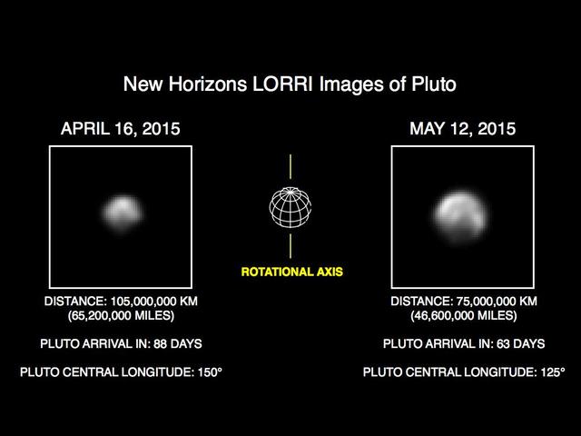
This image of Pluto is part of series of New Horizons Long Range Reconnaissance Imager LORRI photos taken May 8-12, 2015; the image at left shows LORRI view of Pluto just one month earlier.

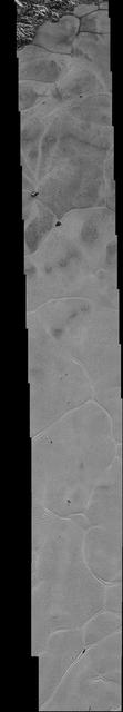
This frame from a movie, which extends across the hemisphere that faced New Horizons spacecraft as it flew past Pluto on July 14, 2015, includes all of the highest-resolution images taken by the NASA probe. With a resolution of about 260 feet (80 meters) per pixel, the movie affords New Horizons scientists and the public the best opportunity to examine the fine details of the various types of terrain the mosaic covers, and determine the processes that formed and shaped them. The view extends from the "limb" of Pluto at the top of the strip, almost to the "terminator" (or day/night line) in the southeast of the encounter hemisphere, seen at the bottom of the strip. The width of the strip ranges from more than 55 miles (90 kilometers) at its northern end to about 45 miles (75 kilometers) at its southern end. The perspective changes greatly along the strip: at its northern end, the view looks out horizontally across the surface, while at its southern end, the view looks straight down onto the surface. This movie pans down the mosaic from top to bottom, offering new views of many of Pluto's distinct landscapes along the way. Starting with hummocky, cratered uplands at top, the view crosses over parallel ridges of the "washboard" terrain; chaotic and angular mountain ranges; the craterless, cellular plains; coarsely "pitted" areas of sublimating nitrogen ice; zones of thin nitrogen ice draped over the topography below; and rugged, dark, mountainous highlands scarred by deep pits. The frames in the movie were obtained by New Horizons' Long Range Reconnaissance Imager (LORRI) approximately 9,850 miles (15,850 kilometers) from Pluto, about 23 minutes before New Horizons' closest approach. LORRI is only capable of obtaining black-and-white images; all color images are made by the Ralph instrument, which has somewhat lower resolution than LORRI. Movies are available at http://photojournal.jpl.nasa.gov/catalog/PIA14457

A total lunar eclipse rises over New Orleans, home of NASA’s Michoud Assembly Facility, in the early morning hours of Tuesday, March 3. A lunar eclipse occurs when Earth passes directly between the Sun and Moon, casting a huge shadow across the Moon’s surface. The Moon appears dark red or orange as the Sun’s light filters through Earth’s atmosphere. This is a composite of 4 images taken during the eclipse.

iss074e0209281 (Jan. 28, 2026) --- The wintry landscape of New Jersey, New York, and Connecticut is seen from the International Space Station as it orbited 259 miles above the Atlantic coast of the United States. Temperatures in New York City ranged from a low of about 14 degrees Fahrenheit to a high of around 23 degrees when this photograph was taken.
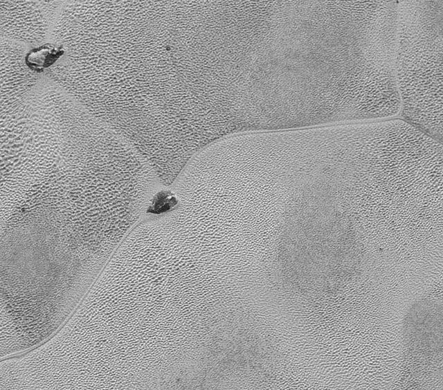
NASA's New Horizons spacecraft continues to transmit the sharpest views of Pluto that it obtained (and recorded) during its flyby of the distant planet on July 14, 2015. The newest image, returned on Dec. 24, 2015, extends New Horizons' highest-resolution swath of Pluto to the very center of the informally named Sputnik Planum, and nearly completes the set of highest-resolution images taken by New Horizons last July. The pictures are part of a sequence taken near New Horizons' closest approach to Pluto, with resolutions of about 250-280 feet (77-85 meters) per pixel -- revealing features smaller than half a city block on Pluto's surface. The images shown here form a strip 50 miles (80 kilometers) wide and more than 400 miles (700 kilometers) long, trending from the northwestern shoreline of Sputnik Planum and out across its icy plains. The images illustrate the polygonal or cellular pattern of the plains, which are thought to result from the convective churning of a deep layer solid, but mobile, nitrogen ice. The surface of Sputnik Planum appears darker toward the shore (at top), possibly implying a change in composition or surface texture. The occasional raised, darker blocks at the cell edges are probably dirty water "icebergs" floating in denser solid nitrogen. The pictures were taken with the telescopic Long Range Reconnaissance Imager (LORRI) aboard New Horizons, from a range of approximately 10,000 miles (17,000 kilometers) over a timespan of about a minute centered on 11:36 UT on July 14 -- just about 15 minutes before New Horizons' closest approach to Pluto. http://photojournal.jpl.nasa.gov/catalog/PIA20336
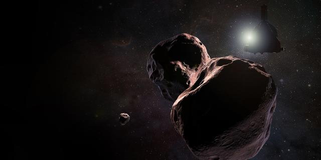
Artist's impression of NASA's New Horizons spacecraft encountering 2014 MU69, a Kuiper Belt object that orbits one billion miles (1.6 billion kilometers) beyond Pluto, on Jan. 1, 2019. https://photojournal.jpl.nasa.gov/catalog/PIA22190

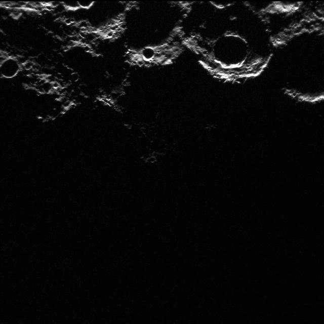
New Moon. By the modern definition, New Moon occurs when the Moon and Sun are at the same geocentric ecliptic longitude. The part of the Moon facing us is completely in shadow then. Pictured here is the traditional New Moon, the earliest visible waxing crescent, which signals the start of a new month in many lunar and lunisolar calendars. NASA's Lunar Reconnaissance Orbiter (LRO) has been in orbit around the Moon since the summer of 2009. Its laser altimeter (LOLA) and camera (LROC) are recording the rugged, airless lunar terrain in exceptional detail, making it possible to visualize the Moon with unprecedented fidelity. This is especially evident in the long shadows cast near the terminator, or day-night line. The pummeled, craggy landscape thrown into high relief at the terminator would be impossible to recreate in the computer without global terrain maps like those from LRO. To download, learn more about this visualization, or to see what the Moon will look like at any hour in 2015, visit <a href="http://svs.gsfc.nasa.gov/goto?4236" rel="nofollow">svs.gsfc.nasa.gov/goto?4236</a> <b><a href="http://www.nasa.gov/audience/formedia/features/MP_Photo_Guidelines.html" rel="nofollow">NASA image use policy.</a></b> <b><a href="http://www.nasa.gov/centers/goddard/home/index.html" rel="nofollow">NASA Goddard Space Flight Center</a></b> enables NASA’s mission through four scientific endeavors: Earth Science, Heliophysics, Solar System Exploration, and Astrophysics. Goddard plays a leading role in NASA’s accomplishments by contributing compelling scientific knowledge to advance the Agency’s mission. <b>Follow us on <a href="http://twitter.com/NASAGoddardPix" rel="nofollow">Twitter</a></b> <b>Like us on <a href="http://www.facebook.com/pages/Greenbelt-MD/NASA-Goddard/395013845897?ref=tsd" rel="nofollow">Facebook</a></b> <b>Find us on <a href="http://instagram.com/nasagoddard?vm=grid" rel="nofollow">Instagram</a></b>
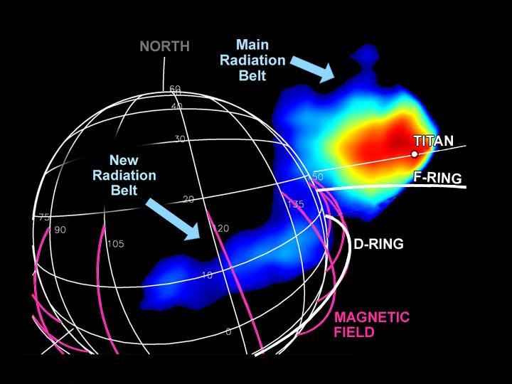
New Radiation Belt
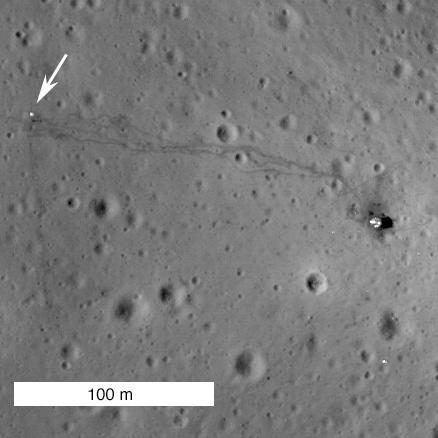
New View of Apollo 14

New Rings for Cassini Division
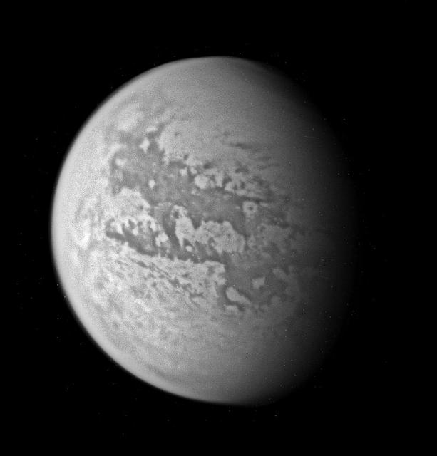
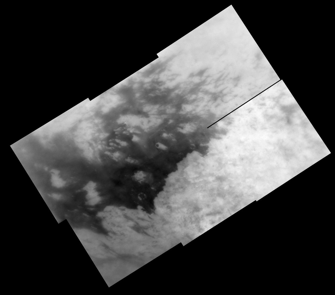
New Titan Territory
Old and New Again

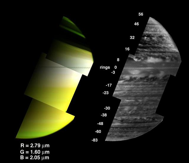
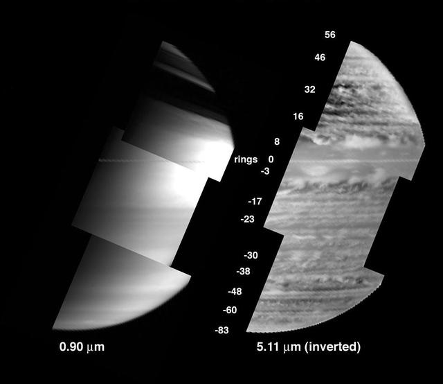
A New Year for Jupiter and Io
The New Three-Color Mosaic
A New View of Saturn

New Cydonia Picture
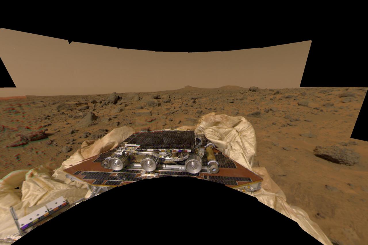
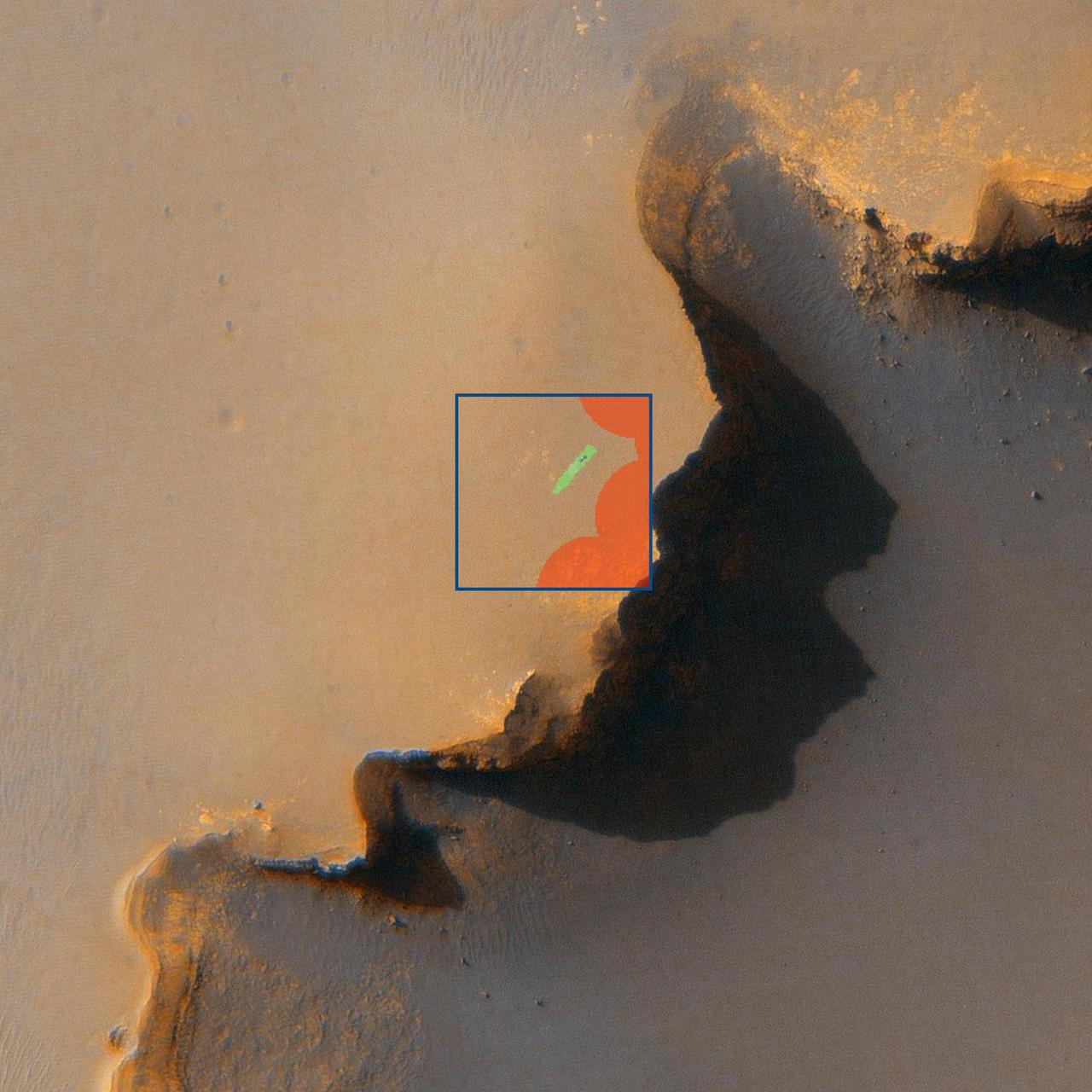
New Perspective of Undeployed Rover
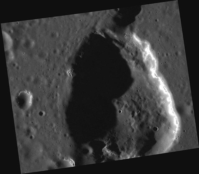
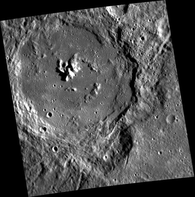
New Details of Geddes Depression
Old and New Graben
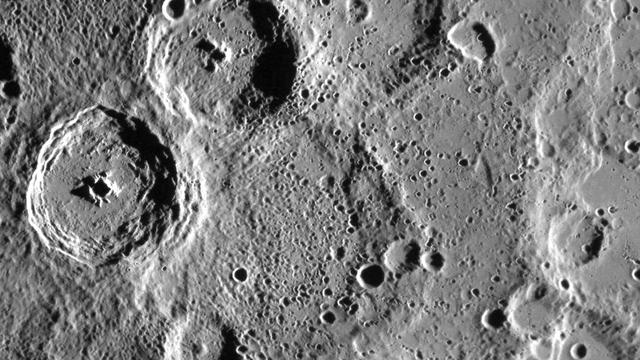
A New View of Spitteler and Holberg

Old Geology and New Geology

New Rings for Cassini Division
New Angle on Degas
Iapetus New Year Flyby
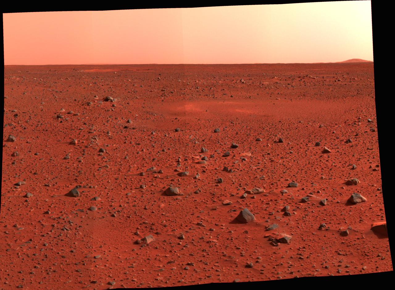
New Real Estate on Mars
Something Old, Something New
A New Look at Old Terrain
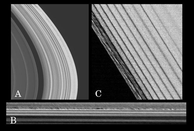
New Ring Phenomena
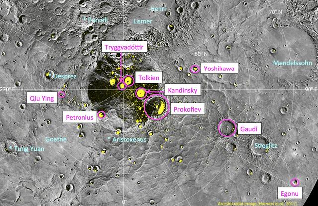
Nine New Names in the North!
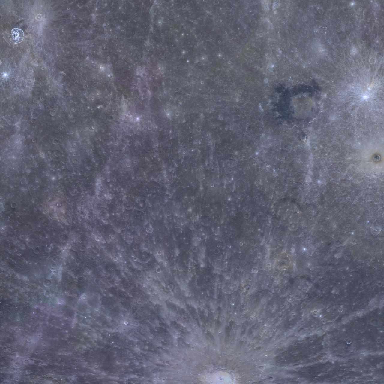
A Colorful New Look
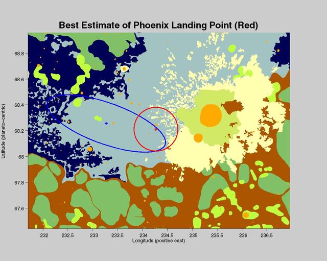
Phoenix New Neighborhood
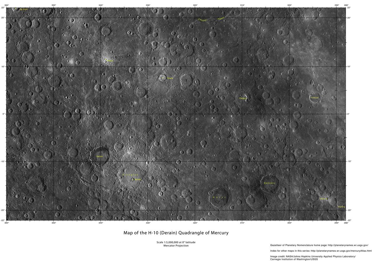
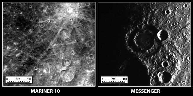
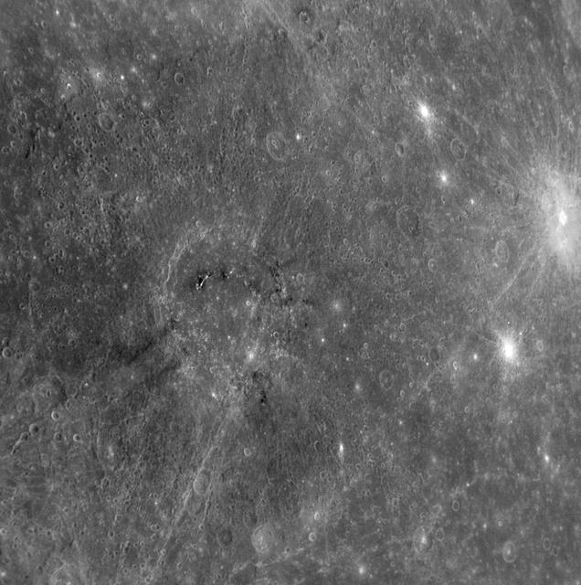
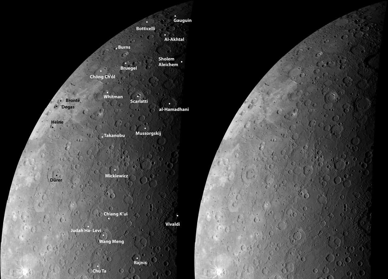
New Maps of Mercury!
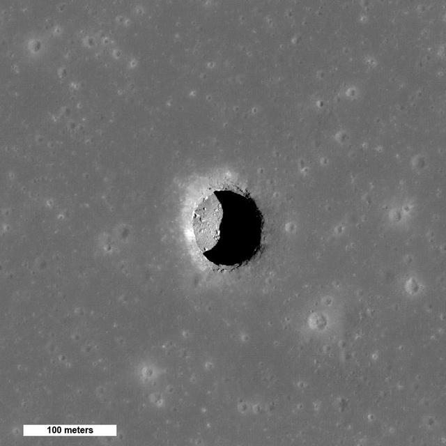
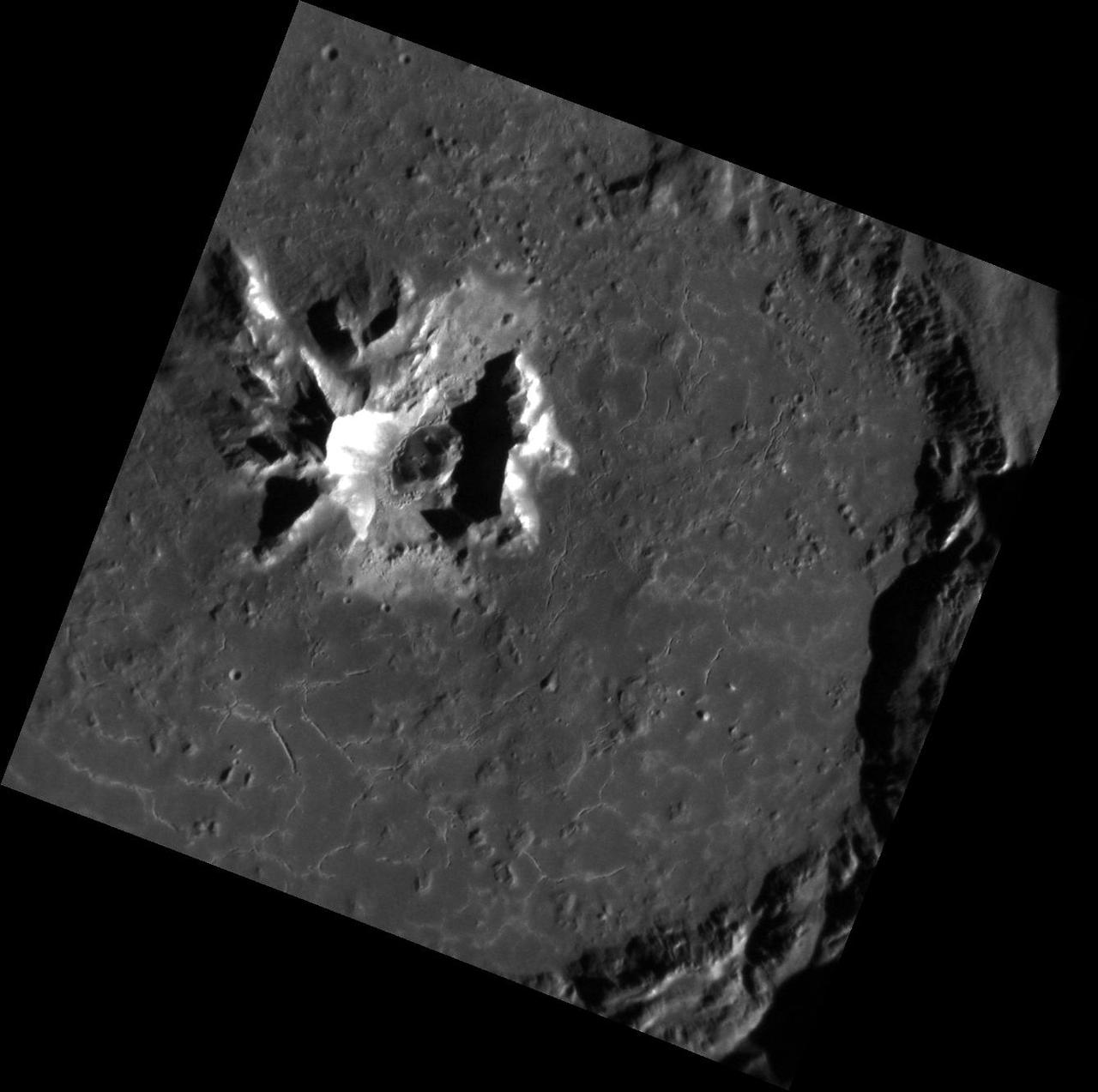
New Views of Lunar Pits
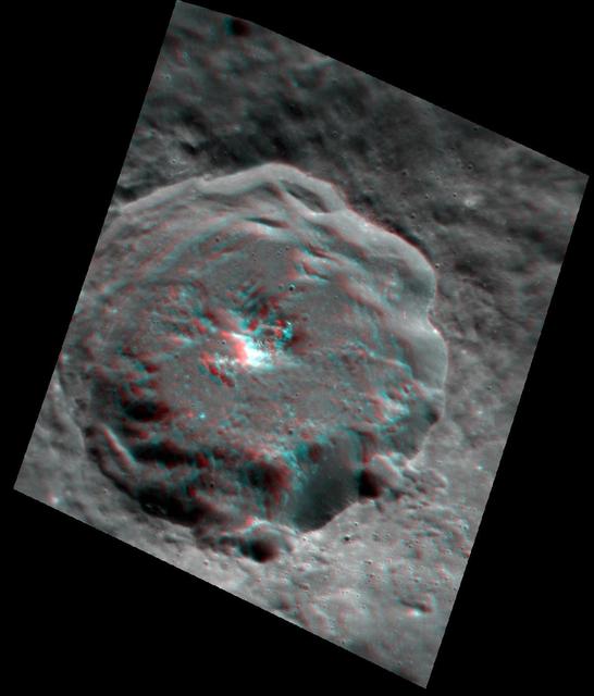
Seeing to New Depths Anaglyph
Happy New Year! Finally!
The New South and the Old North
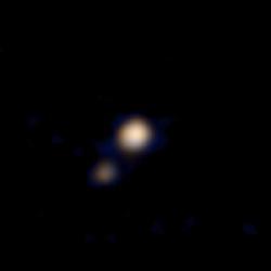
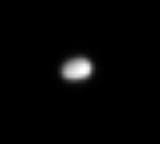
This image of Pluto and its largest moon, Charon, was taken by the Ralph color imager aboard NASA New Horizons spacecraft on April 9 and downlinked to Earth the following day.
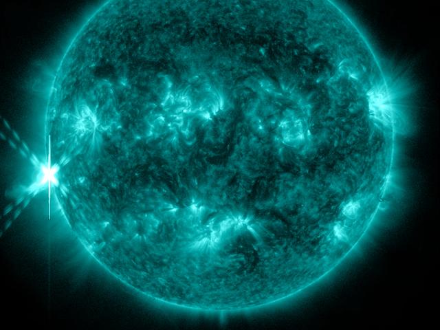
NASA's Solar Dynamics Observatory (SDO) captured this image of an M9-class flare on Oct 20, 2012 at 2:14 p.m. EDT. This image shows light at a wavelength of 131 Angstroms, which corresponds to material at 10 million Kelvin, and is a good wavelength for observing flares. This wavelength is typically colorized as teal, as shown here. To read more go to: <a href="http://www.nasa.gov/mission_pages/sunearth/news/News102012-m9flare.html" rel="nofollow">www.nasa.gov/mission_pages/sunearth/news/News102012-m9fla...</a> Credit: NASA/GSFC/SDO <b><a href="http://www.nasa.gov/audience/formedia/features/MP_Photo_Guidelines.html" rel="nofollow">NASA image use policy.</a></b> <b><a href="http://www.nasa.gov/centers/goddard/home/index.html" rel="nofollow">NASA Goddard Space Flight Center</a></b> enables NASA’s mission through four scientific endeavors: Earth Science, Heliophysics, Solar System Exploration, and Astrophysics. Goddard plays a leading role in NASA’s accomplishments by contributing compelling scientific knowledge to advance the Agency’s mission. <b>Follow us on <a href="http://twitter.com/NASA_GoddardPix" rel="nofollow">Twitter</a></b> <b>Like us on <a href="http://www.facebook.com/pages/Greenbelt-MD/NASA-Goddard/395013845897?ref=tsd" rel="nofollow">Facebook</a></b> <b>Find us on <a href="http://instagrid.me/nasagoddard/?vm=grid" rel="nofollow">Instagram</a></b>

It appeared that New Yorkers were not going to be able to see the transit of the planet Venus across the Sun, but just before the transit was over the sun broke through the clouds and Yvette Lee Kang was able to catch a glimpse of the transit on Tuesday, June 5, 2012 in New York. A transit of Venus occurs when the planet passes directly between the sun and earth. This alignment is rare, coming in pairs that are eight years apart but separated by over a century. The next Venus transit will be in December 2117. Photo Credit: (NASA/Bill Ingalls)
Discovering New Rupes on Mercury http://photojournal.jpl.nasa.gov/catalog/PIA10609
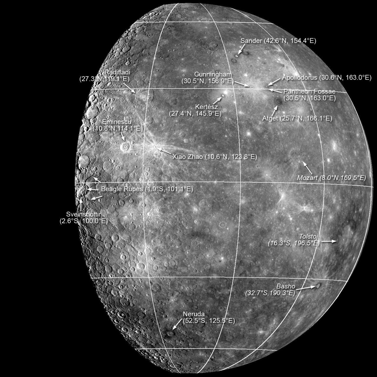
New Names for Features on Mercury http://photojournal.jpl.nasa.gov/catalog/PIA10611
Appreciating Mozart in a New Light http://photojournal.jpl.nasa.gov/catalog/PIA10607

New Delhi, India's capital city, is currently suffering though a period of particularly poor air quality. In early November 2016, monitors at various locations in the area posted air quality index measurements as high as the 900s (the most severe ranking, "hazardous," is any air quality index measurement over 300). Thousands of schools have been closed, and a survey by the Associate Chambers of Commerce and Industry of India reports that 10 percent of the city's workers called in sick due to air-pollution-related health issues. According to several published news reports, the extreme air pollution may be due to a combination of nearby agricultural burning after harvest, urban construction and solid-waste burning, as well as remnants of firecracker smoke and additional car emissions after the celebration of Diwali, the Hindu festival of lights, on October 30. The Multi-angle Imaging SpectroRadiometer (MISR) instrument aboard NASA's Terra satellite passed over the region on Saturday, Nov. 5, 2016, at around 11:05 a.m. local time. At left is an image acquired from MISR's vertical viewing camera. The Himalayas stretch across the northern portion of the image. This towering mountain range tends to concentrate pollution in the region immediately to the south, including New Delhi, by preventing pollutants from blowing northwards. New Delhi, whose location is indicated on the image, is under a patch of especially thick haze. At 6:00 a.m. local time on that date, the U.S. Mission India NowCast Air Quality Index for New Delhi was reported at 751, more than twice the threshold for hazardous air quality. At right, a map of aerosol optical depth is superimposed on the image. Optical depth is a quantitative measure of the abundance of aerosols (tiny particles in the atmosphere). Optical depths for the area around New Delhi have not been calculated because the haze is so thick that the algorithm has classified the area as a cloud. In the region immediately surrounding the thick haze, optical depths approach 1.0. An optical depth of 1.0 means that only about 37 percent of direct sunlight reaches the surface due to interactions with particles in the atmosphere. These data were acquired during Terra orbit 89805. Other MISR data are available through the NASA Langley Research Center; for more information, go to https://eosweb.larc.nasa.gov/project/misr/misr_table. MISR was built and is managed by NASA's Jet Propulsion Laboratory, Pasadena, California, for NASA's Science Mission Directorate, Washington, D.C. The Terra spacecraft is managed by NASA's Goddard Space Flight Center, Greenbelt, Maryland. The MISR data were obtained from the NASA Langley Research Center Atmospheric Science Data Center, Hampton, Virginia. JPL is a division of the California Institute of Technology in Pasadena. http://photojournal.jpl.nasa.gov/catalog/PIA21100

STS-42 Earth observation taken aboard Discovery, Orbiter Vehicle (OV) 103, is of New York City (NYC), New York (41.0N, 74.0W). Snow cover highlights the large areas of development and the many reservoirs in this wintertime scene of the metropolitan NYC area. Features such as Central Park in Manhattan, the George Washington Bridge connecting Manhattan with New Jersey, street patterns in most of the boroughs, La Guardia and JFK airports in Queens, and the extensive harbor system are easily identified.
The New Horizons spacecraft is about 300 million miles (483 million kilometers) from 2014 MU69, the Kuiper Belt object it will encounter on Jan. 1, 2019. https://photojournal.jpl.nasa.gov/catalog/PIA22188

This image from NASA Terra satellite on October 20, 2000, shows New York and Southern New England.

On Sunday, February 3, roughly 800 million eyes from all over the world focused on the Louisiana Superdome in New Orleans as the New England Patriots battled the St. Louis Rams for the NFL Championship in Super Bowl XXXVI. This true color image of New Orleans was acquired on April 26, 2000, by the Enhanced Thematic Mapper plus (ETM+), flying aboard the Landsat 7 satellite. Lake Pontchartrain borders the city to the north. The big river winding its way east to west through the image is the Mississippi. The Louisiana Superdome, built in 1975, sits just inside the rightmost portion of the big river bend that cradles downtown New Orleans. The city, however, may not be around to hold a Super Bowl in 2102. New Orleans is slowly sinking into the Gulf of Mexico. The construction of flood walls and dams north of New Orleans over the past century have prevented sediments carried by the Mississippi River from reaching New Orleans and the Mississippi River Delta. Before the dams were built, river sediments would empty out onto the delta adding layer upon layer of new soil each year. The additional soil prevented the Gulf from subsuming the delta. Unless drastic measures are taken, the city and the delta could be awash in seawater by the end of this century. Image by Robert Simmon, based on data provided by the Landsat 7 Science Team Credit: NASA/GSFC/Landsat <b><a href="http://www.nasa.gov/centers/goddard/home/index.html" rel="nofollow">NASA Goddard Space Flight Center</a></b> enables NASA’s mission through four scientific endeavors: Earth Science, Heliophysics, Solar System Exploration, and Astrophysics. Goddard plays a leading role in NASA’s accomplishments by contributing compelling scientific knowledge to advance the Agency’s mission. <b>Follow us on <a href="http://twitter.com/NASA_GoddardPix" rel="nofollow">Twitter</a></b> <b>Join us on <a href="http://www.facebook.com/pages/Greenbelt-MD/NASA-Goddard/395013845897?ref=tsd" rel="nofollow">Facebook</a></b>
In April 2016, NASA New Horizons spacecraft observed 1994 JR1, a 90-mile 145-kilometer wide Kuiper Belt object KBO orbiting more than 3 billion miles 5 billion kilometers from the sun.

New Employee orientation and swearing-in with L-r in front are Joseph Haglage and Erin Czech

New Employee orientation and swearing-in with Left to right Brandon Baeza, Kailin Kwan, Joseph Haglage

STS058-081-038 (18 Oct-1 Nov 1993) --- Fall colors in the northeast were captured by the STS-58 crew members. Long Island and the lower Hudson River dominate this scene, taken on a clear October day at the peak of the colorful fall foliage season. The maples and oaks of the Hudson Highlands are particularly striking, and contrast with the many lakes and reservoirs north of the city. The New York metropolitan area in New York and New Jersey (including Jersey City and Newark) is easily seen in the foreground. Manhattan Island sits near the middle of the scene, but Central Park foliage is still fairly green. West Point can be seen near the upper right, on the west-pointing bend of the Hudson, and the Catskills are in the far upper left.

Grand Opening of the new Goddard Information and Collaboration Center

New Employee orientation and swearing-in, left to right (far left) unknow) Tracie Perez, Spenser Monheim (behind Tracie) and Daniel Chang

New Employee orientation and swearing-in left to right (far left, unknown) Tracie Perez, Spenser Monheim (behind Tracie),Daniel Chang, Brandon Baeza
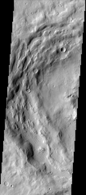
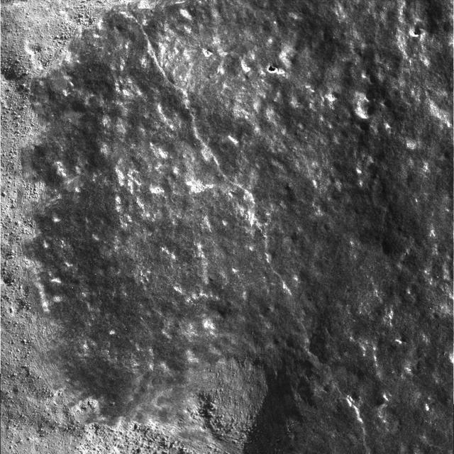
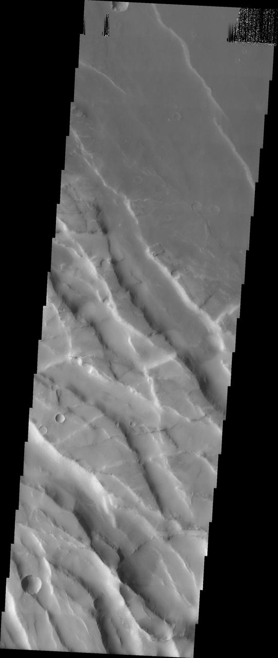
The depressions in the rim of this unnamed crater in Terra Sabaea are being filled with new material. The surface texture of the new material is different from the surrounding older material
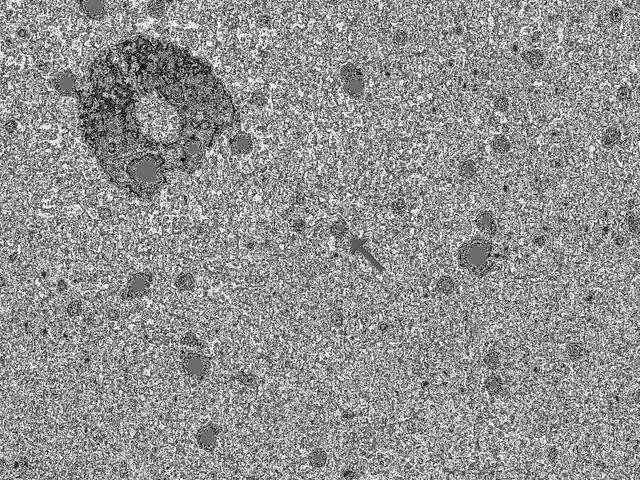
This image shows the results of the New Horizons team first search for potentially hazardous material around Pluto, conducted May 11-12, 2015, from a range of 47 million miles 76 million kilometers.

Clay Flinn, launch weather officer, 4th Weather Squadron, Cape Canaveral Air Force Station, speaks to members of the news media during a Geostationary Operational Environmental Satellite (GOES-R) prelaunch news conference in the Kennedy Space Center's Press Site auditorium in Florida.

Scott Messer, program manager, NASA Missions, United Launch Alliance, speak to members of the news media during a Geostationary Operational Environmental Satellite (GOES-R) prelaunch news conference in the Kennedy Space Center's Press Site auditorium in Florida.

Sandra Smalley, director, Joint Agency Satellite Division, NASA Headquarters, speaks to members of the news media during a Geostationary Operational Environmental Satellite (GOES-R) prelaunch news conference in the Kennedy Space Center's Press Site auditorium in Florida.

This image taken from the Suomi NPP satellite's VIIRS instrument of New Zealand was collected on January 9, 2015 when the phytoplankton were blooming — particularly to the east of the islands and along the Chatham Rise. Derived from the Greek words phyto (plant) and plankton (made to wander or drift), phytoplankton are microscopic organisms that live in watery environments, both salty and fresh. Credit: NASA/Goddard/NPP <b><a href="http://www.nasa.gov/audience/formedia/features/MP_Photo_Guidelines.html" rel="nofollow">NASA image use policy.</a></b> <b><a href="http://www.nasa.gov/centers/goddard/home/index.html" rel="nofollow">NASA Goddard Space Flight Center</a></b> enables NASA’s mission through four scientific endeavors: Earth Science, Heliophysics, Solar System Exploration, and Astrophysics. Goddard plays a leading role in NASA’s accomplishments by contributing compelling scientific knowledge to advance the Agency’s mission. <b>Follow us on <a href="http://twitter.com/NASAGoddardPix" rel="nofollow">Twitter</a></b> <b>Like us on <a href="http://www.facebook.com/pages/Greenbelt-MD/NASA-Goddard/395013845897?ref=tsd" rel="nofollow">Facebook</a></b> <b>Find us on <a href="http://instagram.com/nasagoddard?vm=grid" rel="nofollow">Instagram</a></b>
Naming New Lands - October Flyby

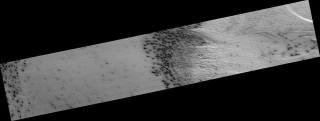
New Gullies on Martian Sand Dune

New QuickMap Feature: 3-D!
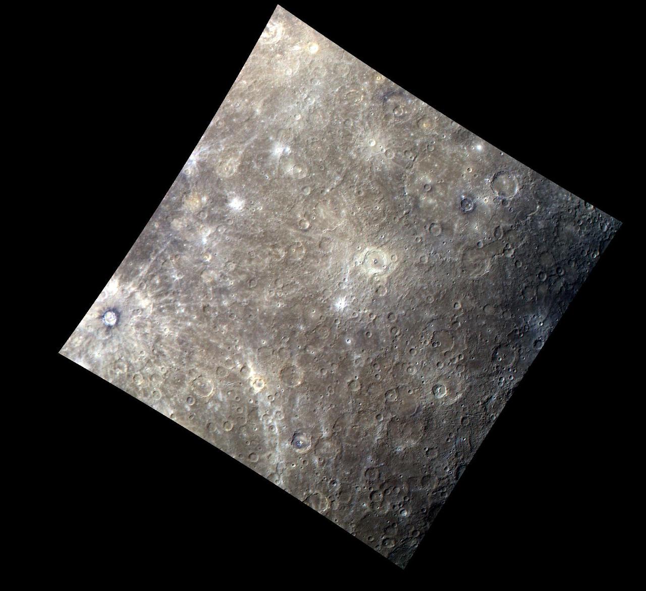
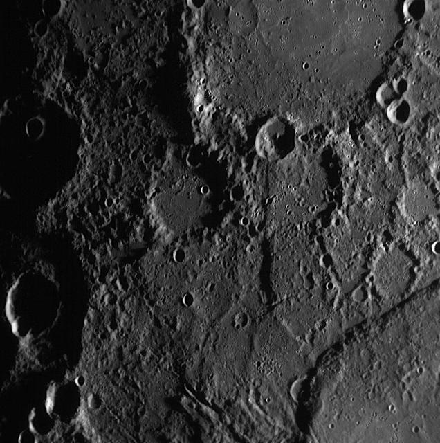
Mercury Craters from a New Perspective

Recovering Spirit Sends a New Picture

New View of Twin Peaks Region
Ring in the New Year to Some Ragtime
A New View of Saturn - Black and White
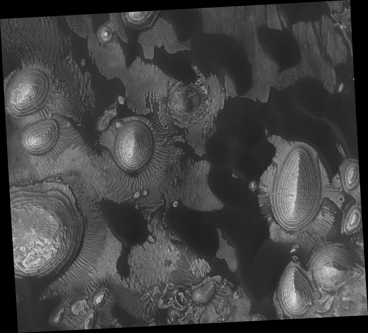
New Vocabulary: Araneiform and Lace Terrains
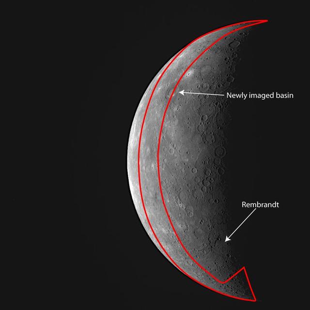
Outlining MESSENGER New Imaging Coverage

Hubble Observes a New Saturn Storm

Naming New Lands - September Flyby
Illinois and New York Wiped Clean
New Images Reveal a Dark Side
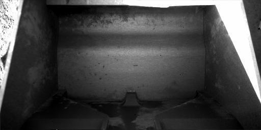
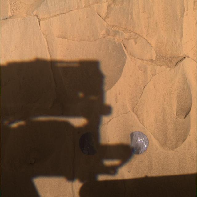
Scoop Ready to Obtain New Sample
Rovers Get New Driving Capability

Grand Opening of the new Goddard Information and Collaboration Center - Center Director Chris Scolese with Robin Dixon