
Joint NASA-NOAA-Air Force Congressional Staff Day Goddard Space Flight Center

Dr. Kathy Sullivan, center, Deputy Administrator of the National Oceanic and Atmospheric Administration (NOAA) and former NASA astronaut is interviewed by a local television network at NOAA's Satellite Operations Facility in Suitland, Md. after the successful launch of the National Polar-orbiting Operational Environmental Satellite System Preparatory Project (NPP) on Friday, Oct. 28, 2011. NPP is a joint venture between NASA and NOAA, and is the nation's newest Earth-observing satellite, which will provide data on climate change science, allow for accurate weather forecasts and advance warning for severe weather. NPP was launched from Vandenberg Air Force Base in California. Photo Credit: (NASA/Carla Cioffi)

The Satellite Operations Facility of the National Oceanic and Atmospheric Administration (NOAA) is seen here minutes before the launch of the National Polar-orbiting Operational Environmental Satellite System Preparatory Project (NPP) on Friday, Oct. 28, 2011 in Suitland, Md. NPP is a joint venture between NASA and NOAA, and is the nation's newest Earth-observing satellite, which will provide data on climate change science, allow for accurate weather forecasts and advance warning for severe weather. NPP was launched from Vandenberg Air Force Base in California. Photo Credit: (NASA/Carla Cioffi)

NASA Deputy Administrator Lori Garver, left, watches the launch of the National Polar-orbiting Operational Environmental Satellite System Preparatory Project (NPP) at the National Oceanic and Atmospheric Administration (NOAA) Satellite Operations Center on Friday, Oct. 28, 2011 in Suitland, Md. U.S Congresswoman Donna Edwards, D-Md., is seen next to Garver. NPP is a joint venture between NASA and NOAA, and is the nation's newest Earth-observing satellite, which will provide data on climate change science, allow for accurate weather forecasts and advance warning for severe weather. NPP was launched from Vandenberg Air Force Base in California. Photo Credit: (NASA/Carla Cioffi)

Col. Robert Swanson, Air Force at the Joint NASA-NOAA-Air Force Congressional Staff Day Goddard Space Flight Center

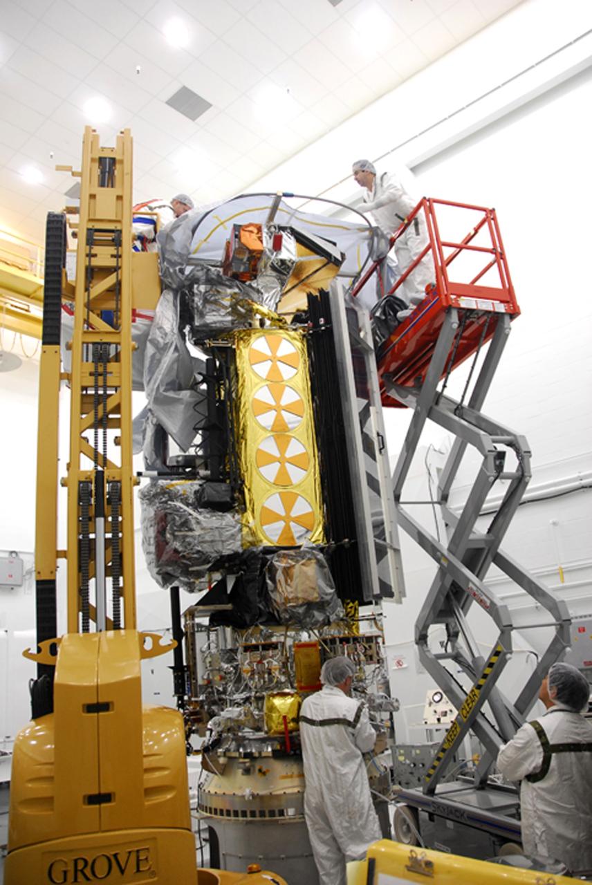
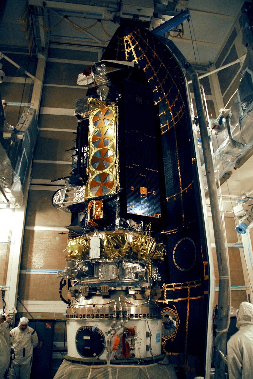
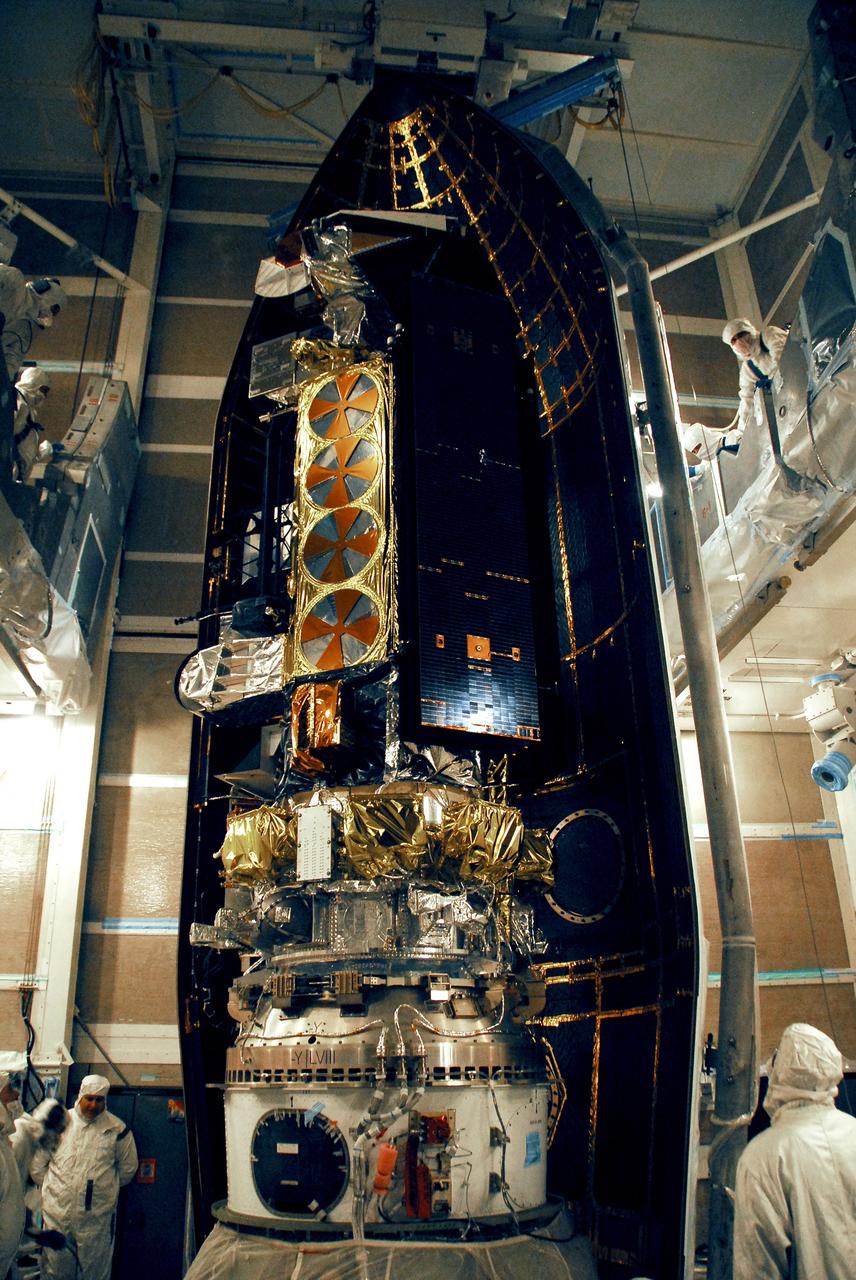
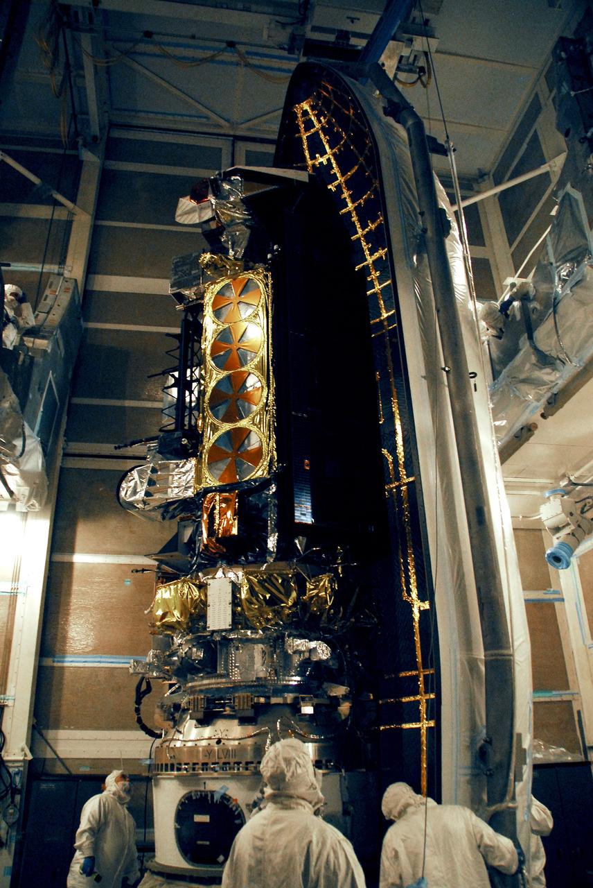
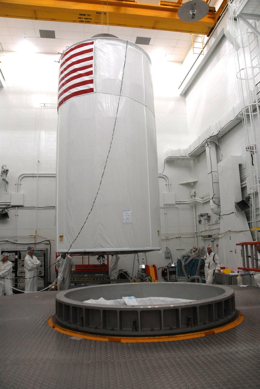
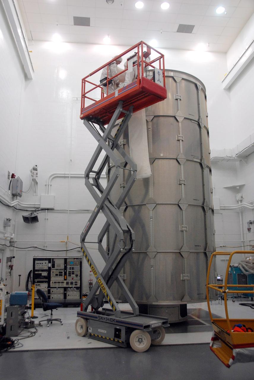
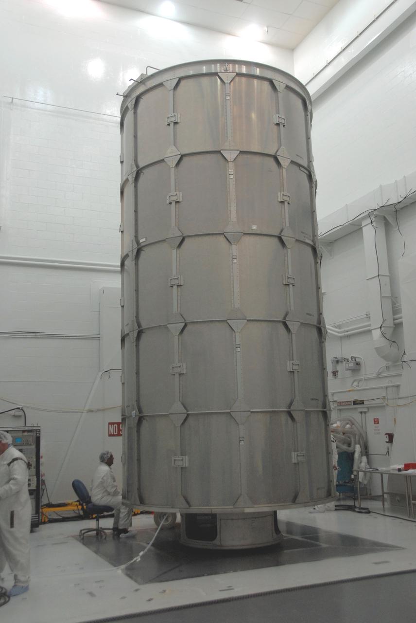
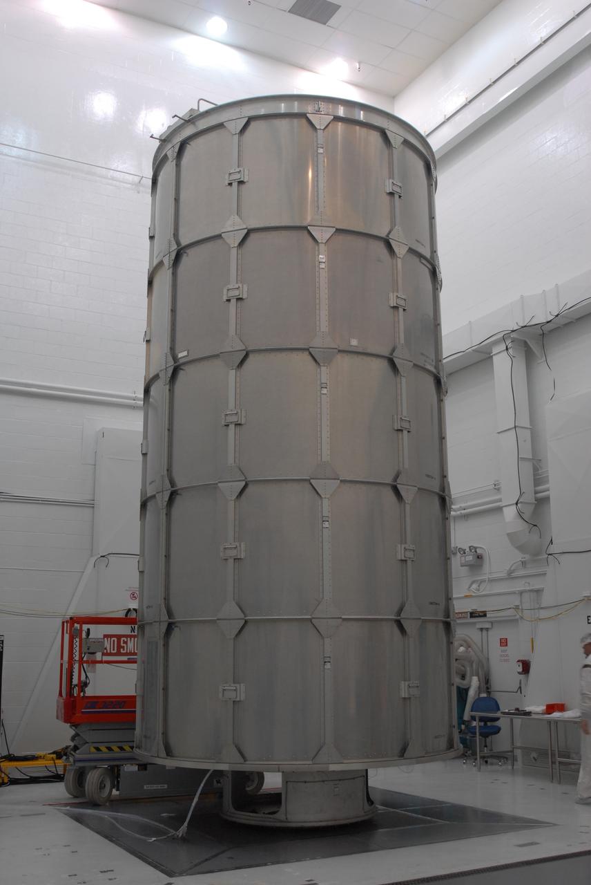
VANDENBERG AIR FORCE BASE, Calif. – Inside the payload processing facility at Vandenberg Air Force Base in California, the NOAA-N Prime satellite has been rotated to a vertical position. NOAA-N Prime is the latest polar-orbiting operational environmental weather satellite developed by NASA for the National Oceanic and Atmospheric Administration. NOAA-N Prime is built by Lockheed Martin and similar to NOAA-N launched on May 20, 2005. Launch of NOAA-N Prime is scheduled for Feb. 4. Photo credit: NASA

VANDENBERG AIR FORCE BASE, Calif. – Inside the payload processing facility at Vandenberg Air Force Base in California, the NOAA-N Prime satellite is rotated toward a vertical position. NOAA-N Prime is the latest polar-orbiting operational environmental weather satellite developed by NASA for the National Oceanic and Atmospheric Administration. NOAA-N Prime is built by Lockheed Martin and similar to NOAA-N launched on May 20, 2005. Launch of NOAA-N Prime is scheduled for Feb. 4. Photo credit: NASA

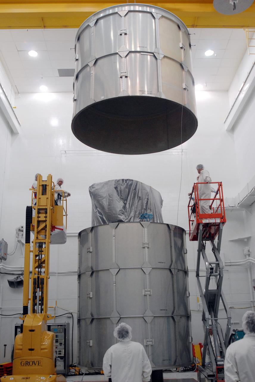
VANDENBERG AIR FORCE BASE, Calif. – Inside the payload processing facility at Vandenberg Air Force Base in California, the shipping container for NOAA-N Prime is lifted. NOAA-N Prime is the latest polar-orbiting operational environmental weather satellite developed by NASA for the National Oceanic and Atmospheric Administration. NOAA-N Prime is built by Lockheed Martin and similar to NOAA-N launched on May 20, 2005. Launch of NOAA-N Prime is scheduled for Feb. 4. Photo credit: NASA

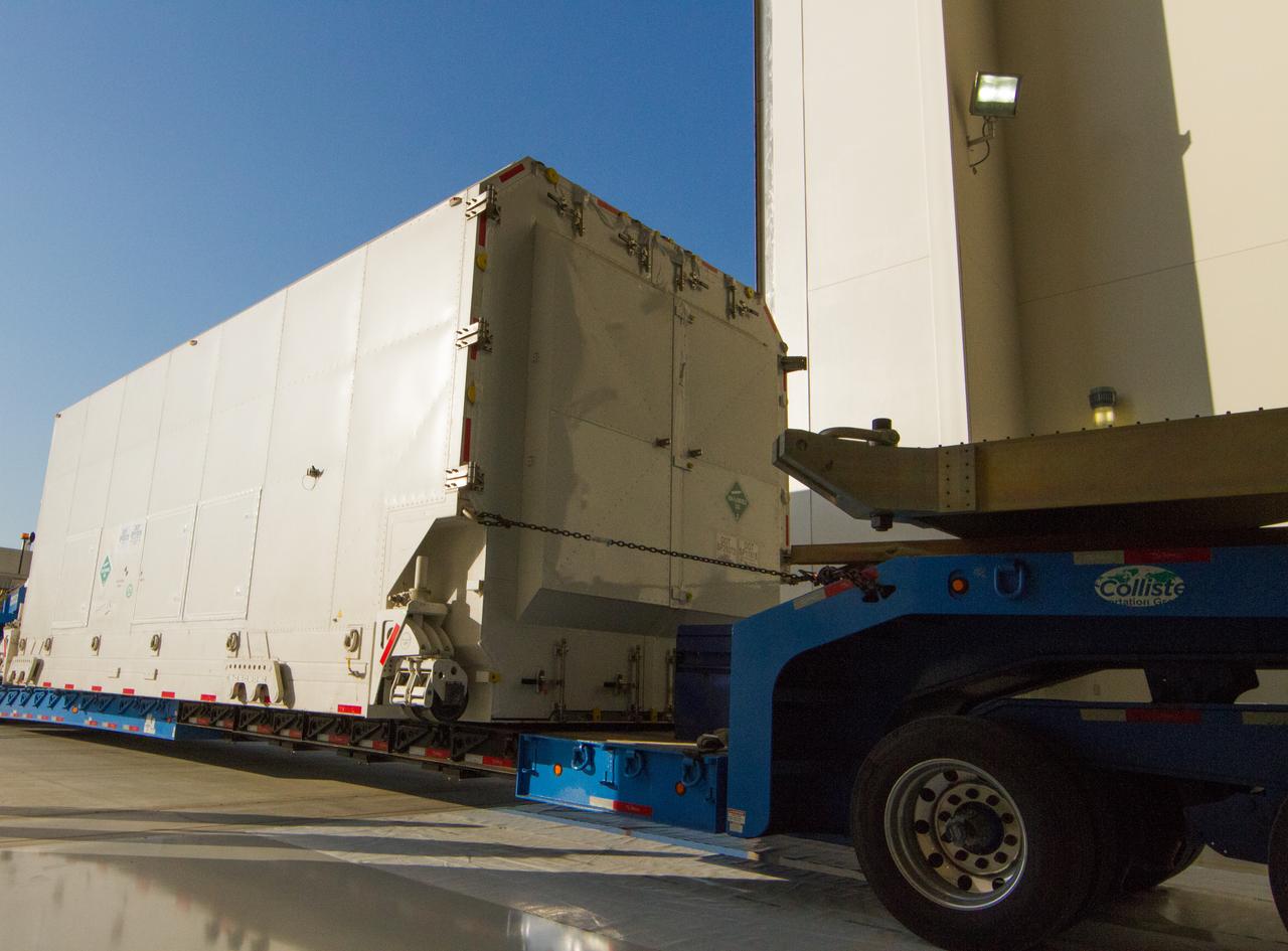
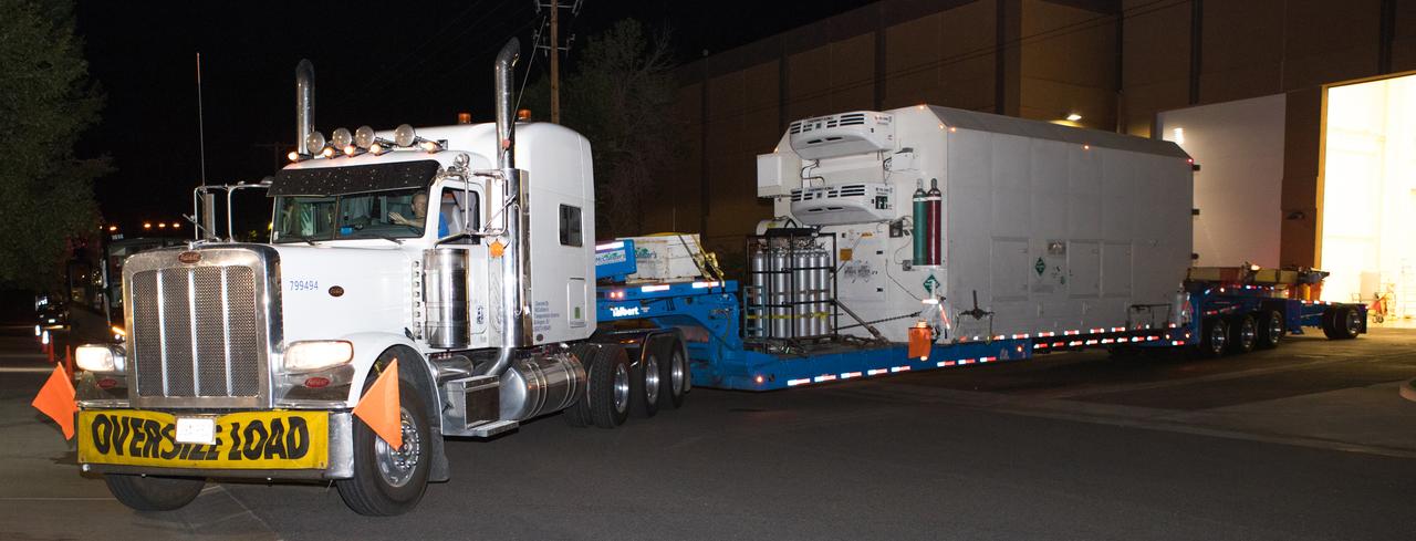
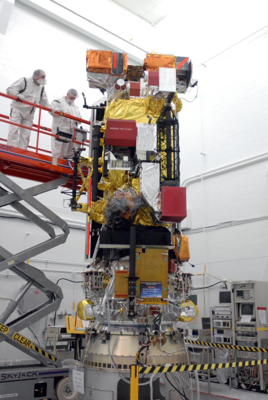
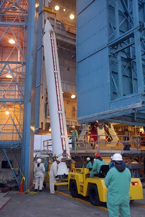
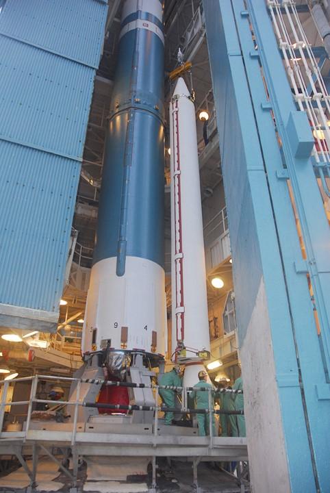
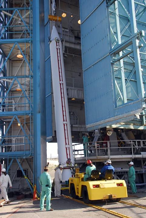
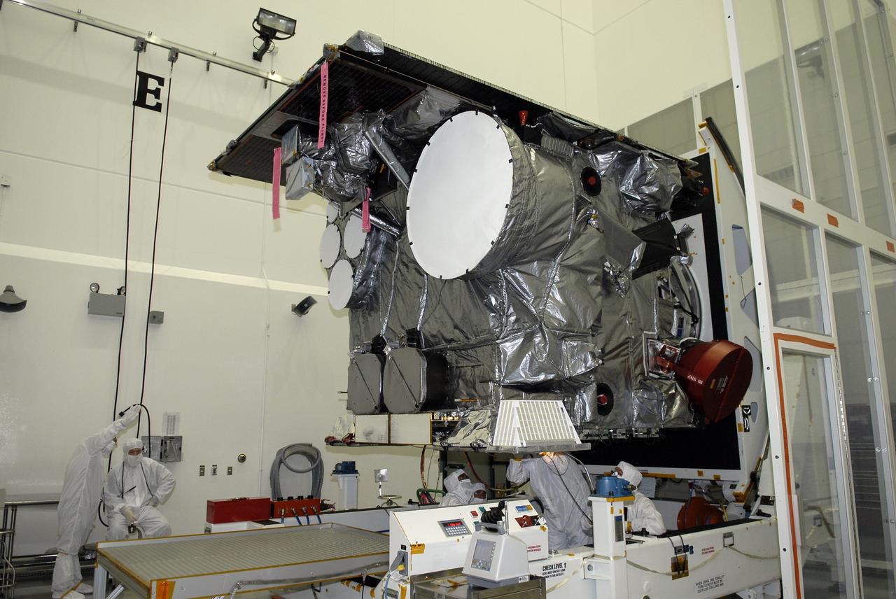
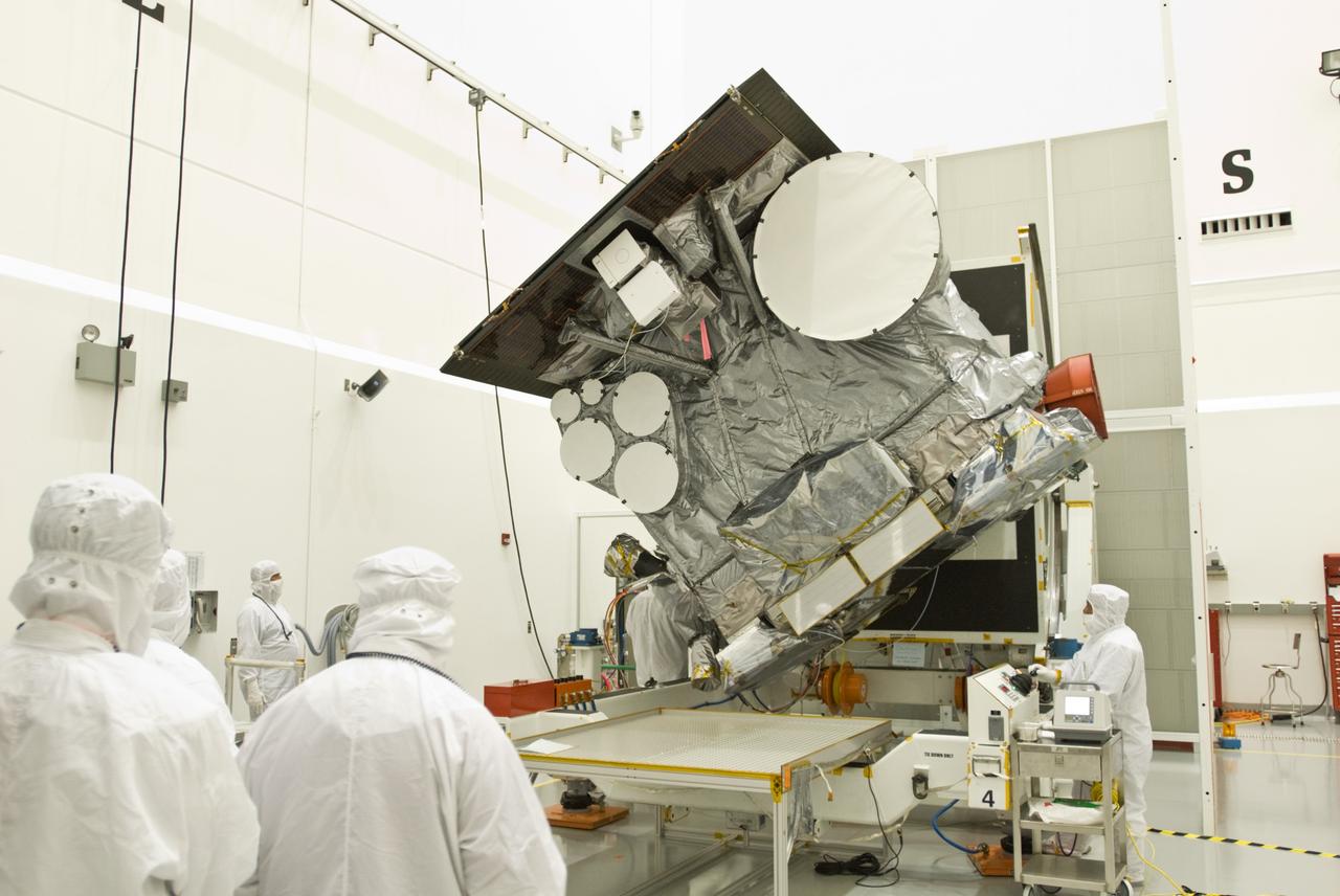
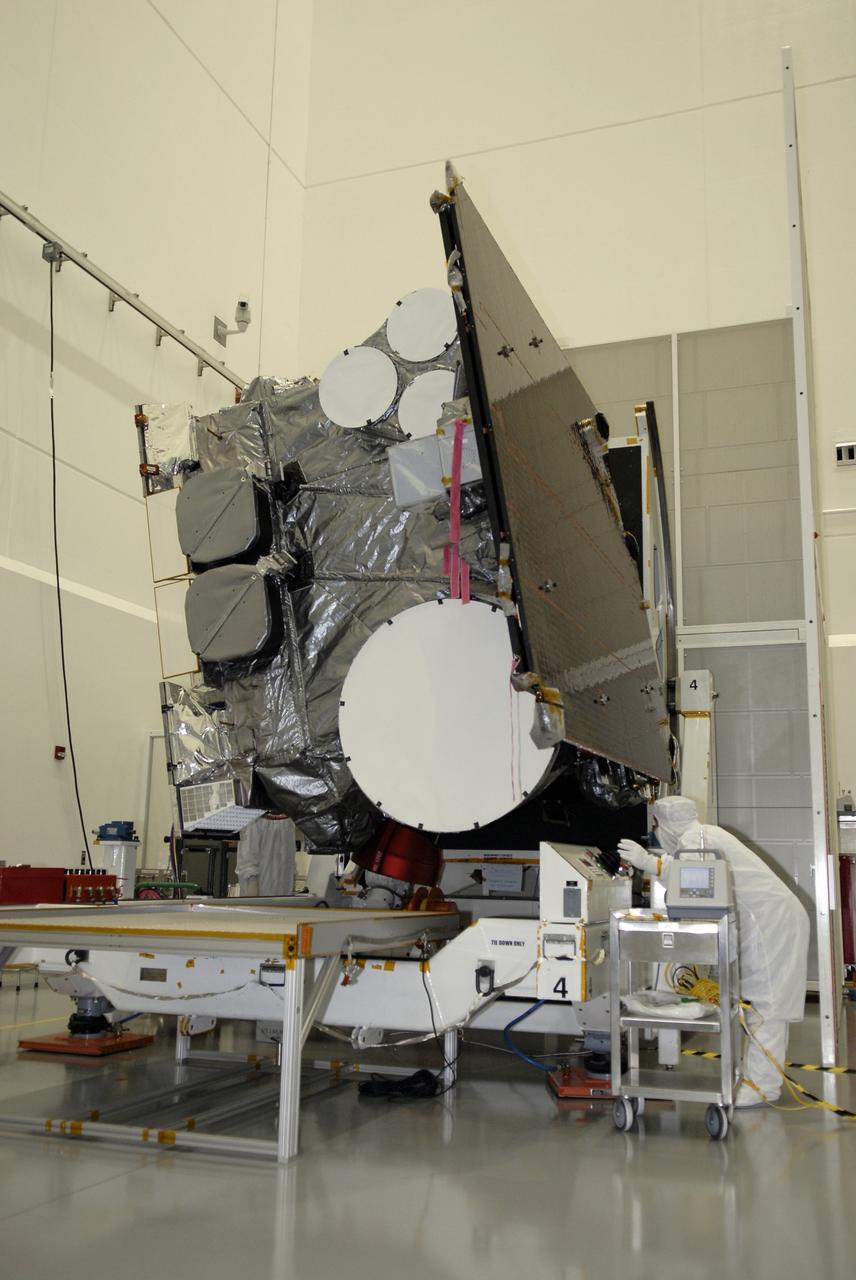
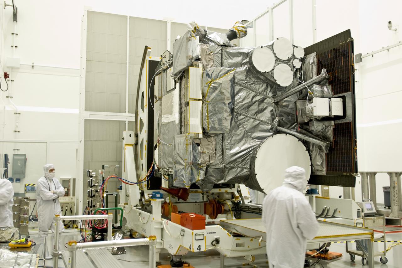
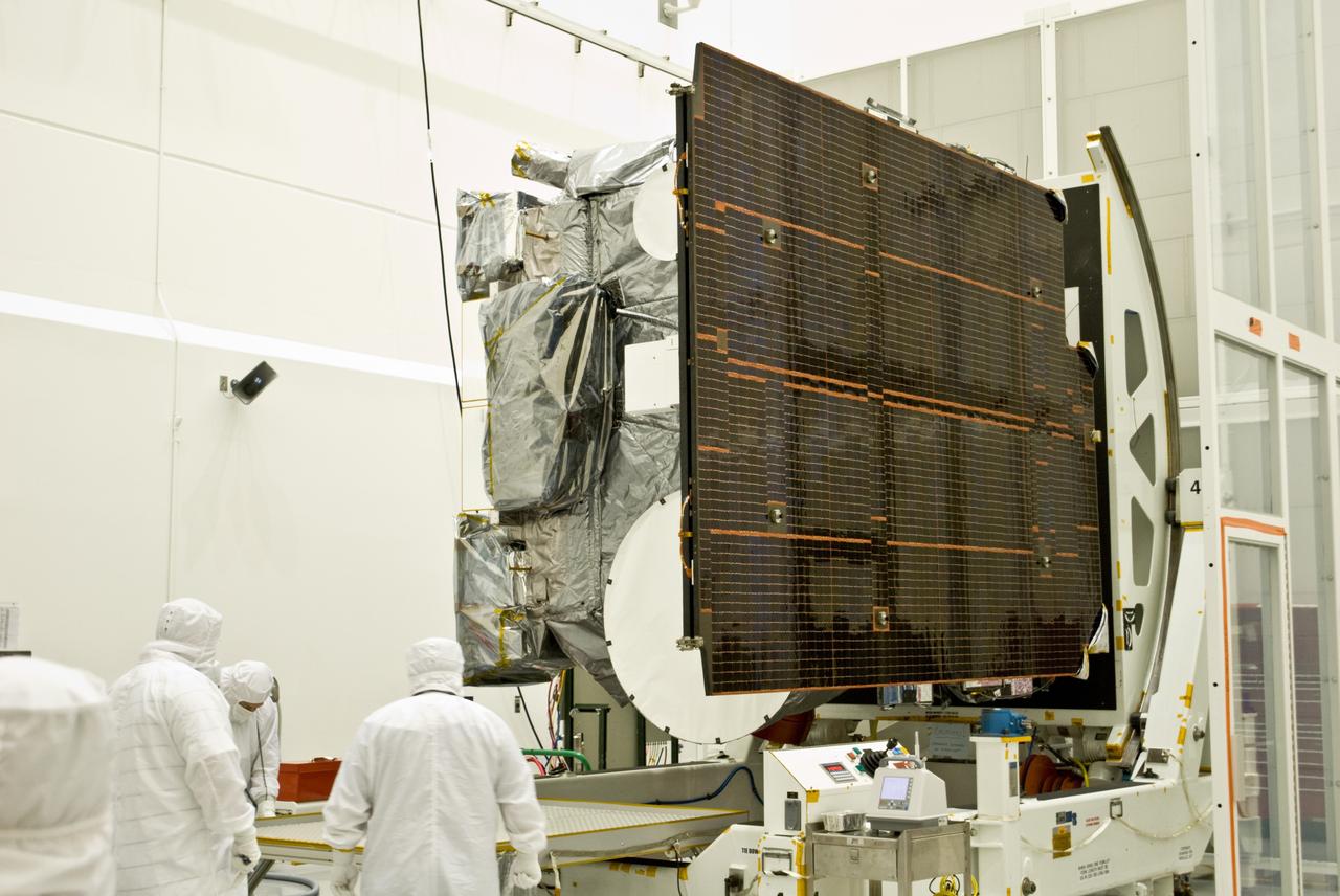
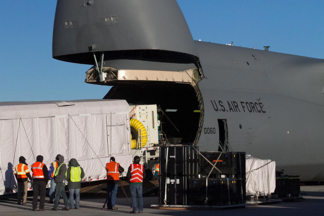
Technicians at Vandenberg Air Force Base in California inspect the shipping container for the Joint Polar Satellite System-1, or JPSS-1, as it arrives at the Astrotech Processing Facility. JPSS is the first in a series four next-generation environmental satellites in a collaborative program between the National Oceanic and Atmospheric Administration (NOAA) and NASA. The satellite is scheduled to liftoff Nov. 10, 2017 atop a United Launch Alliance Delta II rocket.
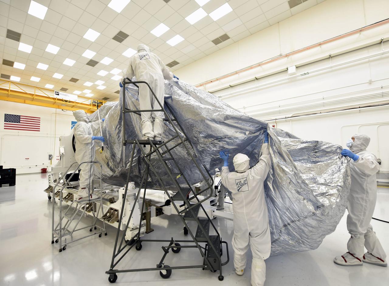
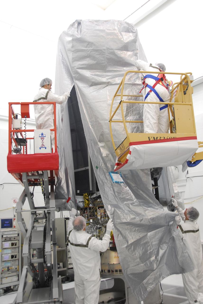
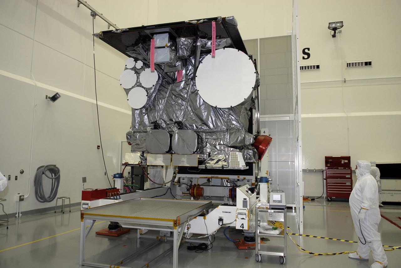
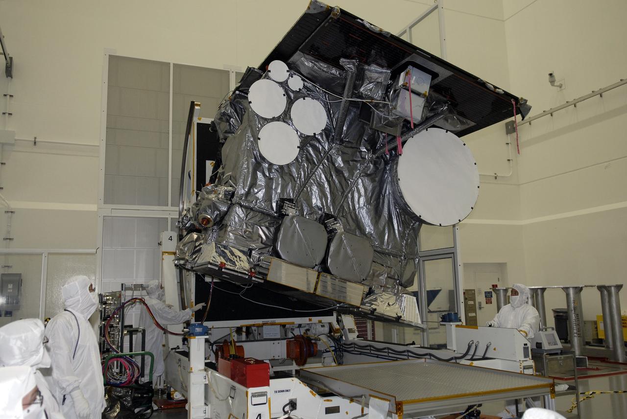
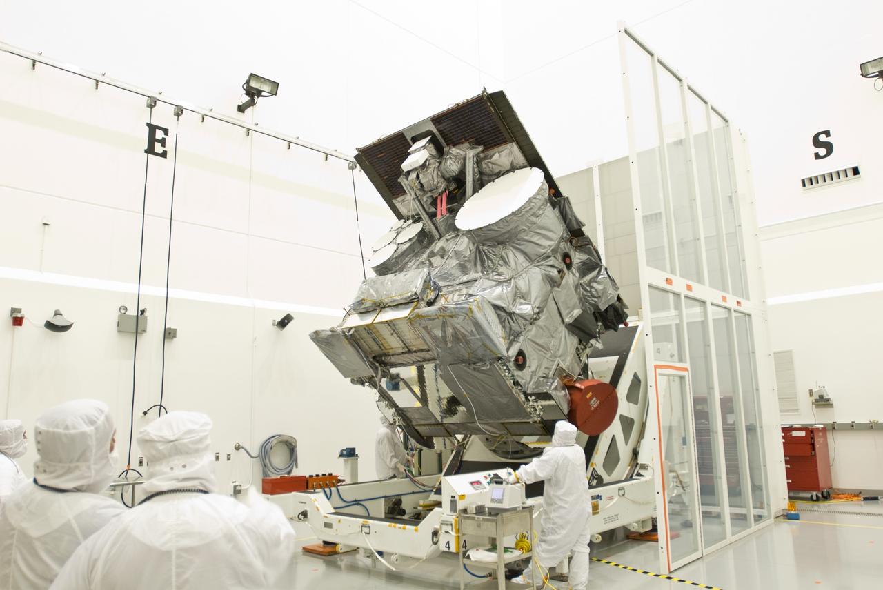
Inside the Astrotech Processing Facility at Vandenberg Air Force Base in California, technicians and engineers remove protective wrapping from the Joint Polar Satellite System-1, or JPSS-1. JPSS is the first in a series four next-generation environmental satellites in a collaborative program between the National Oceanic and Atmospheric Administration (NOAA) and NASA. The satellite is scheduled to liftoff Nov. 10, 2017 atop a United Launch Alliance Delta II rocket.
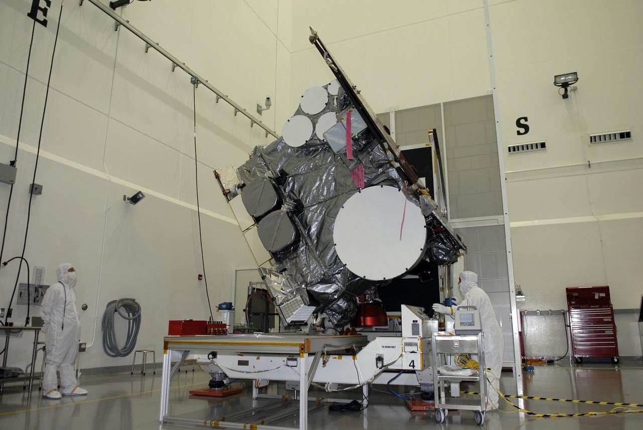
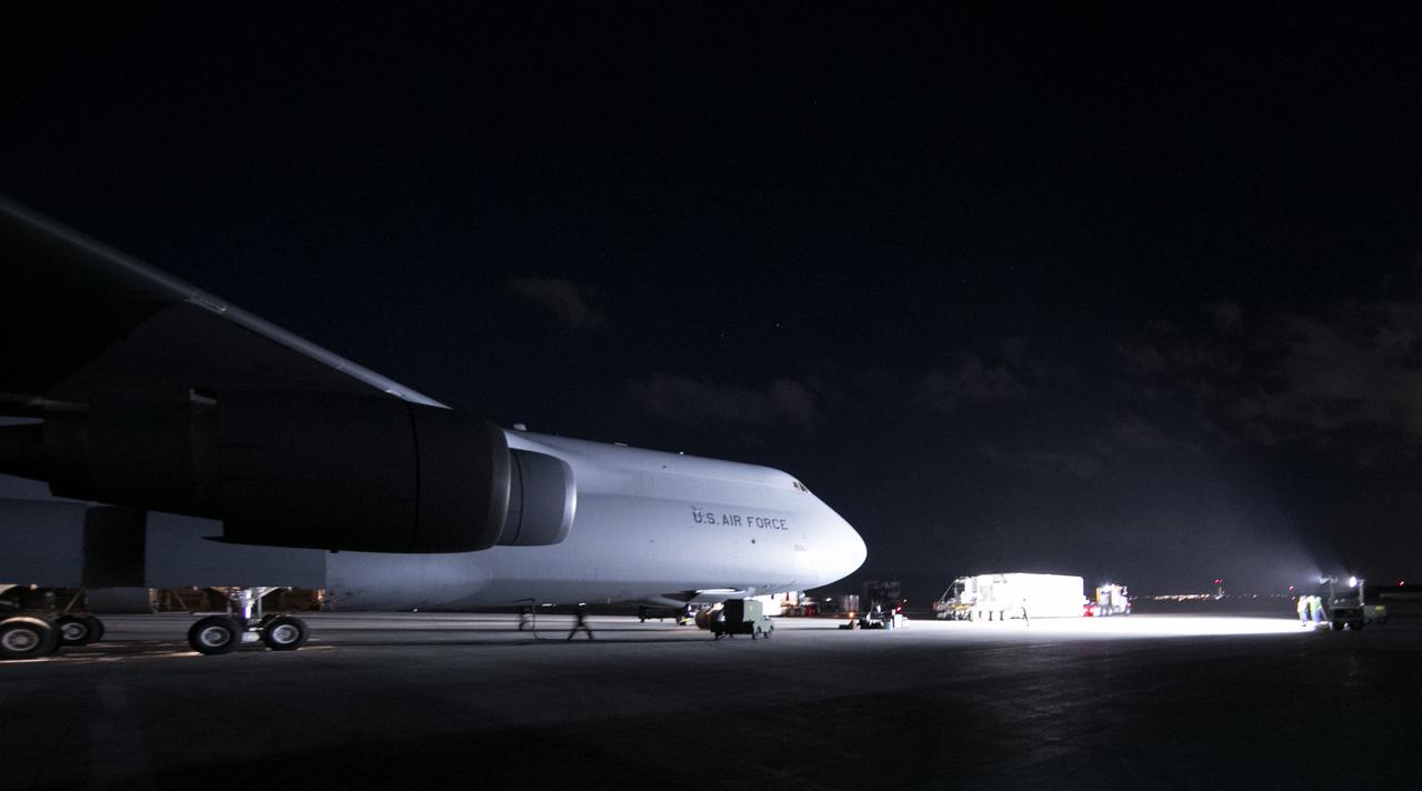
The Joint Polar Satellite System-1, or JPSS-1, arrives at the Astrotech Processing Facility at Vandenberg Air Force Base in California. JPSS is the first in a series four next-generation environmental satellites in a collaborative program between the National Oceanic and Atmospheric Administration (NOAA) and NASA. The satellite is scheduled to liftoff Nov. 10, 2017 atop a United Launch Alliance Delta II rocket.
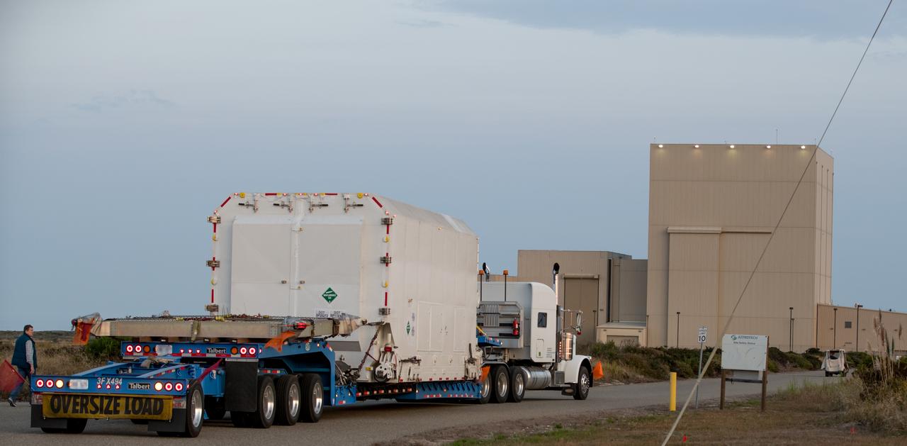
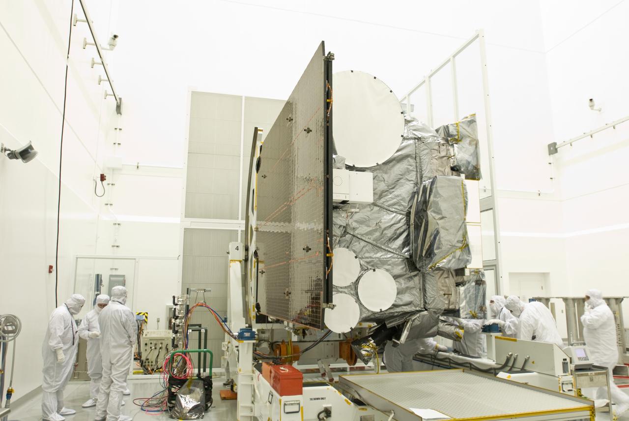
The Joint Polar Satellite System-1, or JPSS-1, arrives at the Astrotech Processing Facility at Vandenberg Air Force Base in California. JPSS is the first in a series four next-generation environmental satellites in a collaborative program between the National Oceanic and Atmospheric Administration (NOAA) and NASA. The satellite is scheduled to liftoff Nov. 10, 2017 atop a United Launch Alliance Delta II rocket.
The Joint Polar Satellite System-1, or JPSS-1, arrives at the Astrotech Processing Facility at Vandenberg Air Force Base in California. JPSS is the first in a series four next-generation environmental satellites in a collaborative program between the National Oceanic and Atmospheric Administration (NOAA) and NASA. The satellite is scheduled to liftoff Nov. 10, 2017 atop a United Launch Alliance Delta II rocket.
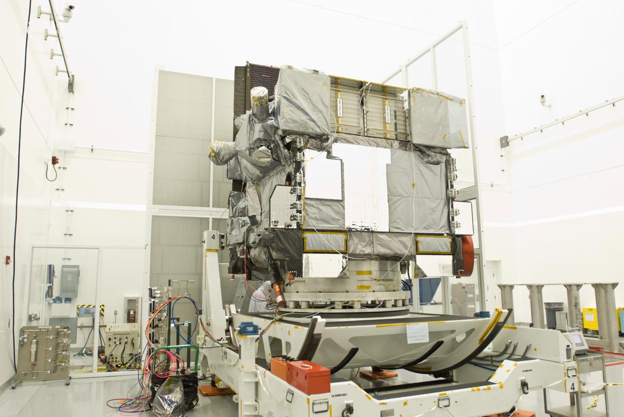
The Joint Polar Satellite System-1, or JPSS-1, arrives at the Astrotech Processing Facility at Vandenberg Air Force Base in California. JPSS is the first in a series four next-generation environmental satellites in a collaborative program between the National Oceanic and Atmospheric Administration (NOAA) and NASA. The satellite is scheduled to liftoff Nov. 10, 2017 atop a United Launch Alliance Delta II rocket.
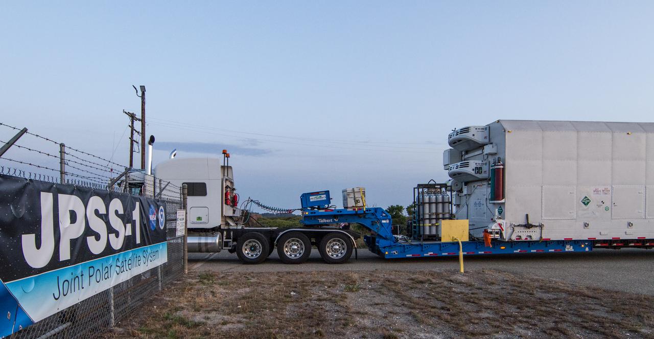
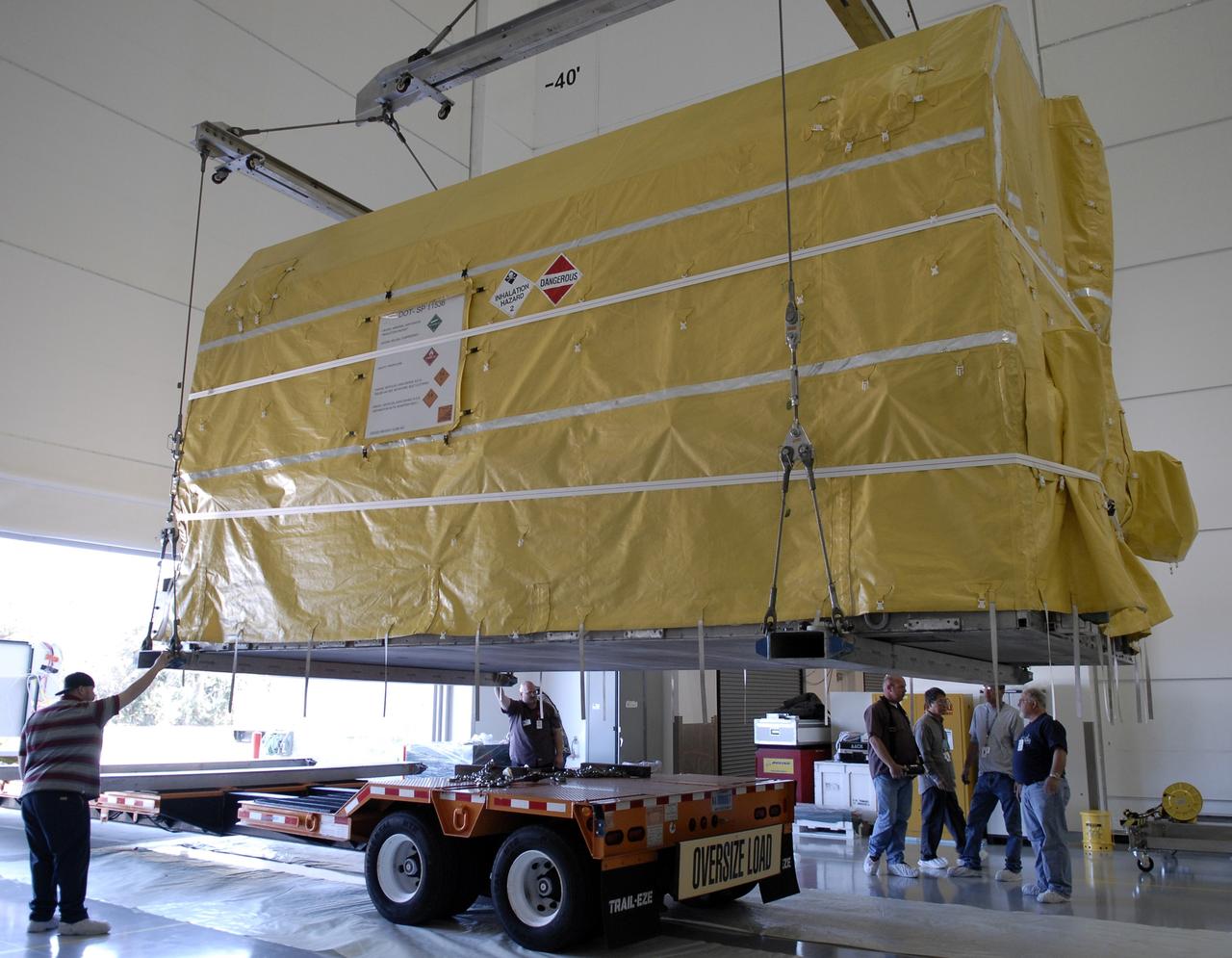
Still packed inside its shipping container, the Joint Polar Satellite System-1, or JPSS-1, has just arrived at the Astrotech Processing Facility at Vandenberg Air Force Base in California. JPSS is the first in a series four next-generation environmental satellites in a collaborative program between the National Oceanic and Atmospheric Administration (NOAA) and NASA. The satellite is scheduled to liftoff Nov. 10, 2017 atop a United Launch Alliance Delta II rocket.
The Joint Polar Satellite System-1, or JPSS-1, arrives at the Astrotech Processing Facility at Vandenberg Air Force Base in California. JPSS is the first in a series four next-generation environmental satellites in a collaborative program between the National Oceanic and Atmospheric Administration (NOAA) and NASA. The satellite is scheduled to liftoff Nov. 10, 2017 atop a United Launch Alliance Delta II rocket.

A technician at Vandenberg Air Force Base in California inspects the shipping container for the Joint Polar Satellite System-1, or JPSS-1, as it arrives at the Astrotech Processing Facility. JPSS is the first in a series four next-generation environmental satellites in a collaborative program between the National Oceanic and Atmospheric Administration (NOAA) and NASA. The satellite is scheduled to liftoff Nov. 10, 2017 atop a United Launch Alliance Delta II rocket.

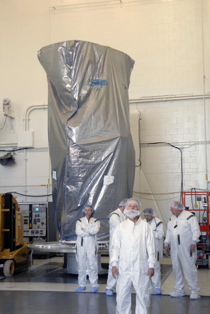
VANDENBERG AIR FORCE BASE, Calif. – Another view of the NOAA-N Prime satellite in the payload processing facility at Vandenberg Air Force Base in California. NOAA-N Prime is the latest polar-orbiting operational environmental weather satellite developed by NASA for the National Oceanic and Atmospheric Administration. It is built by Lockheed Martin and similar to NOAA-N launched on May 20, 2005. Launch of NOAA-N Prime is scheduled for Feb. 4. Photo credit: NASA

VANDENBERG AIR FORCE BASE, Calif. – Inside the payload processing facility at Vandenberg Air Force Base in California, workers get ready to remove the shipping container from NOAA-N Prime, the latest polar-orbiting operational environmental weather satellite developed by NASA for the National Oceanic and Atmospheric Administration. NOAA-N Prime is built by Lockheed Martin and similar to NOAA-N launched on May 20, 2005. Launch of NOAA-N Prime is scheduled for Feb. 4. Photo credit: NASA

VANDENBERG AIR FORCE BASE, Calif. – Another view of the NOAA-N Prime satellite in the payload processing facility at Vandenberg Air Force Base in California. NOAA-N Prime is the latest polar-orbiting operational environmental weather satellite developed by NASA for the National Oceanic and Atmospheric Administration. It is built by Lockheed Martin and similar to NOAA-N launched on May 20, 2005. Launch of NOAA-N Prime is scheduled for Feb. 4. Photo credit: NASA

VANDENBERG AIR FORCE BASE, Calif. – In the NASA payload processing facility at Vandenberg Air Force Base in California, the NOAA-N Prime satellite is bagged before moving it. NOAA-N Prime is the latest polar-orbiting operational environmental weather satellite developed by NASA for the National Oceanic and Atmospheric Administration. It is built by Lockheed Martin and similar to NOAA-N launched on May 20, 2005. Launch of NOAA-N Prime is scheduled for Feb. 4. Photo credit: NASA/Robert Hargreaves Jr., VAFB

VANDENBERG AIR FORCE BASE, Calif. – Another view of the NOAA-N Prime satellite in the payload processing facility at Vandenberg Air Force Base in California. NOAA-N Prime is the latest polar-orbiting operational environmental weather satellite developed by NASA for the National Oceanic and Atmospheric Administration. It is built by Lockheed Martin and similar to NOAA-N launched on May 20, 2005. Launch of NOAA-N Prime is scheduled for Feb. 4. Photo credit: NASA

VANDENBERG AIR FORCE BASE, Calif. – The NOAA-N Prime satellite is displayed in the payload processing facility at Vandenberg Air Force Base in California. NOAA-N Prime is the latest polar-orbiting operational environmental weather satellite developed by NASA for the National Oceanic and Atmospheric Administration. It is built by Lockheed Martin and similar to NOAA-N launched on May 20, 2005. Launch of NOAA-N Prime is scheduled for Feb. 4. Photo credit: NASA
VANDENBERG AIR FORCE BASE, Calif. – Inside the payload processing facility at Vandenberg Air Force Base in California, an overhead crane moves the NOAA-N Prime satellite to a stand. NOAA-N Prime is built by Lockheed Martin and similar to NOAA-N launched on May 20, 2005. Launch of NOAA-N Prime is scheduled for Feb. 4. Photo credit: NASA

VANDENBERG AIR FORCE BASE, Calif. – Inside the payload processing facility at Vandenberg Air Force Base in California, NOAA-N Prime, the latest polar-orbiting operational environmental weather satellite developed by NASA for the National Oceanic and Atmospheric Administration, is revealed after removal of the shipping container. NOAA-N Prime is built by Lockheed Martin and similar to NOAA-N launched on May 20, 2005. Launch of NOAA-N Prime is scheduled for Feb. 4. Photo credit: NASA
VANDENBERG AIR FORCE BASE, Calif. – Another view of the NOAA-N Prime satellite in the payload processing facility at Vandenberg Air Force Base in California. NOAA-N Prime is the latest polar-orbiting operational environmental weather satellite developed by NASA for the National Oceanic and Atmospheric Administration. It is built by Lockheed Martin and similar to NOAA-N launched on May 20, 2005. Launch of NOAA-N Prime is scheduled for Feb. 4. Photo credit: NASA/Joe Davila, VAFB
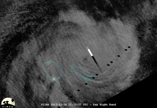
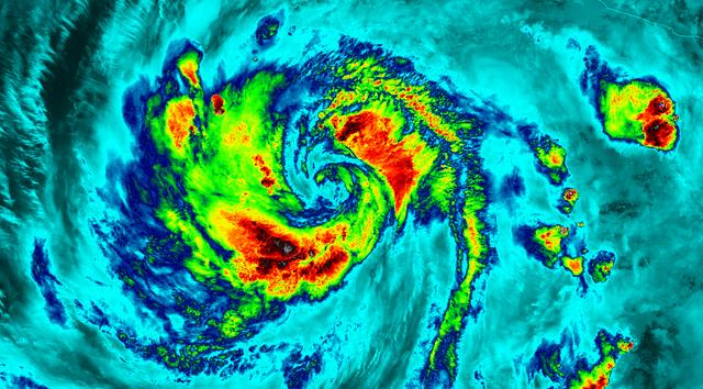
This night-time view of Cyclone Evan was taken from the Visible Infrared Imaging Radiometer Suite (VIIRS) on NASA/NOAA's Suomi National Polar-orbiting Partnership on Dec. 16, 2012. The rectangular bright object in the image is a lightning flash. "Because of the scan time as compared to how quickly lightning flashes, you get a nice streak in the data," said William Straka, of the University of Wisconsin-Madison, who provided this image. On Dec. 17 at 0900 UTC (4 a.m. EST), Cyclone Evan had maximum sustained winds near 115 knots (132 mph/213 kph). Evan was a Category 4 cyclone on the Saffir-Simpson Scale and was battering Fiji. Image Credit: NASA/NOAA/UWM/William Straka Text Credit: NASA Goddard/Rob Gutro <b><a href="http://www.nasa.gov/audience/formedia/features/MP_Photo_Guidelines.html" rel="nofollow">NASA image use policy.</a></b> <b><a href="http://www.nasa.gov/centers/goddard/home/index.html" rel="nofollow">NASA Goddard Space Flight Center</a></b> enables NASA’s mission through four scientific endeavors: Earth Science, Heliophysics, Solar System Exploration, and Astrophysics. Goddard plays a leading role in NASA’s accomplishments by contributing compelling scientific knowledge to advance the Agency’s mission. <b>Follow us on <a href="http://twitter.com/NASA_GoddardPix" rel="nofollow">Twitter</a></b> <b>Like us on <a href="http://www.facebook.com/pages/Greenbelt-MD/NASA-Goddard/395013845897?ref=tsd" rel="nofollow">Facebook</a></b> <b>Find us on <a href="http://instagrid.me/nasagoddard/?vm=grid" rel="nofollow">Instagram</a></b>
VANDENBERG AIR FORCE BASE, Calif. – In Building 1610 at Vandenberg Air Force Base in California, the United Launch Alliance direct mate adapter, or DMA, is installed on the NOAA-N Prime's payload attach fitting underneath the spacecraft. The DMA is needed to install the payload canister around the spacecraft for the journey to the launch pad. NOAA-N Prime is the latest polar-orbiting operational environmental weather satellite developed by NASA for the National Oceanic and Atmospheric Administration. Launch of NOAA-N Prime is scheduled for Feb. 4. Photo credit: NASA/Doug Kolkow, VAFB
VANDENBERG AIR FORCE BASE, Calif. – In Building 1610 at Vandenberg Air Force Base in California, the United Launch Alliance direct mate adapter, or DMA, is installed on the NOAA-N Prime's payload attach fitting underneath the spacecraft. The DMA is needed to install the payload canister around the spacecraft for the journey to the launch pad. NOAA-N Prime is the latest polar-orbiting operational environmental weather satellite developed by NASA for the National Oceanic and Atmospheric Administration. Launch of NOAA-N Prime is scheduled for Feb. 4. Photo credit: NASA/Doug Kolkow, VAFB
VANDENBERG AIR FORCE BASE, Calif. – On Space Launch Complex 2 at Vandenberg Air Force Base in California, a solid rocket booster is raised to vertical. The booster will be lifted into the service tower and installed on the Delta II rocket for the NOAA-N Prime satellite. NOAA-N Prime is the latest polar-orbiting operational environmental weather satellite developed by NASA for the National Oceanic and Atmospheric Administration. It is built by Lockheed Martin and similar to NOAA-N launched on May 20, 2005. Launch of NOAA-N Prime is scheduled for Feb. 4. Photo credit: NASA/Joe Davila, VAFB
VANDENBERG AIR FORCE BASE, Calif. – On Space Launch Complex 2 at Vandenberg Air Force Base in California, a solid rocket booster is lifted alongside the Delta II rocket for installation. The booster is being prepared for the launch of the NOAA-N Prime satellite. NOAA-N Prime is the latest polar-orbiting operational environmental weather satellite developed by NASA for the National Oceanic and Atmospheric Administration. It is built by Lockheed Martin and similar to NOAA-N launched on May 20, 2005. Launch of NOAA-N Prime is scheduled for Feb. 4. Photo credit: NASA/Joe Davila, VAFB
VANDENBERG AIR FORCE BASE, Calif. – In the NASA payload processing facility at Vandenberg Air Force Base in California, workers place a protective cover around the NOAA-N Prime satellite before moving it. NOAA-N Prime is the latest polar-orbiting operational environmental weather satellite developed by NASA for the National Oceanic and Atmospheric Administration. It is built by Lockheed Martin and similar to NOAA-N launched on May 20, 2005. Launch of NOAA-N Prime is scheduled for Feb. 4. Photo credit: NASA/Robert Hargreaves Jr., VAFB
VANDENBERG AIR FORCE BASE, Calif. – On Space Launch Complex 2 at Vandenberg Air Force Base in California, another solid rocket booster is raised to vertical for installation on the Delta II rocket for the NOAA-N Prime satellite. NOAA-N Prime is the latest polar-orbiting operational environmental weather satellite developed by NASA for the National Oceanic and Atmospheric Administration. It is built by Lockheed Martin and similar to NOAA-N launched on May 20, 2005. Launch of NOAA-N Prime is scheduled for Feb. 4. Photo credit: NASA/Joe Davila, VAFB
VANDENBERG AIR FORCE BASE, Calif. – In the NASA payload processing facility at Vandenberg Air Force Base in California, workers prepare to place a protective cover around the NOAA-N Prime satellite before moving it. NOAA-N Prime is the latest polar-orbiting operational environmental weather satellite developed by NASA for the National Oceanic and Atmospheric Administration. It is built by Lockheed Martin and similar to NOAA-N launched on May 20, 2005. Launch of NOAA-N Prime is scheduled for Feb. 4. Photo credit: NASA/Robert Hargreaves Jr., VAFB
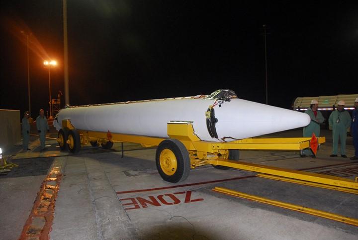
VANDENBERG AIR FORCE BASE, Calif. – A solid rocket booster arrives on Space Launch Complex 2 at Vandenberg Air Force Base in California. The booster will be lifted into the service tower and installed on the Delta II rocket for the NOAA-N Prime satellite. NOAA-N Prime is the latest polar-orbiting operational environmental weather satellite developed by NASA for the National Oceanic and Atmospheric Administration. It is built by Lockheed Martin and similar to NOAA-N launched on May 20, 2005. Launch of NOAA-N Prime is scheduled for Feb. 4. Photo credit: NASA/Joe Davila, VAFB
VANDENBERG AIR FORCE BASE, Calif. – Another solid rocket booster arrives on Space Launch Complex 2 at Vandenberg Air Force Base in California. The booster will be lifted into the service tower and installed on the Delta II rocket for the NOAA-N Prime satellite. NOAA-N Prime is the latest polar-orbiting operational environmental weather satellite developed by NASA for the National Oceanic and Atmospheric Administration. It is built by Lockheed Martin and similar to NOAA-N launched on May 20, 2005. Launch of NOAA-N Prime is scheduled for Feb. 4. Photo credit: NASA/Joe Davila, VAFB
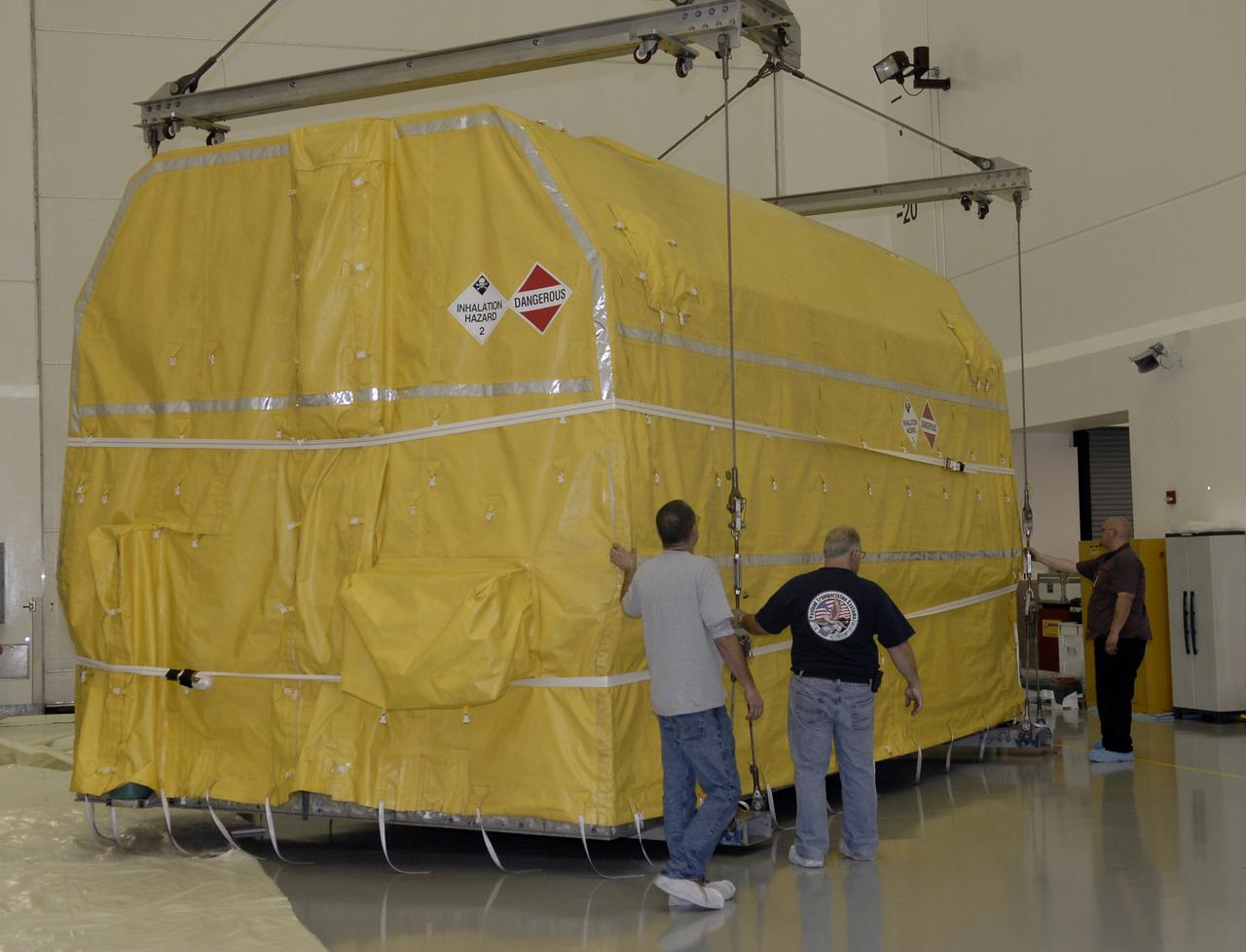
VANDENBERG AIR FORCE BASE, Calif. – The latest polar-orbiting operational environmental weather satellite developed by NASA for the National Oceanic and Atmospheric Administration, called NOAA-N Prime, is offloaded from the trailer at Vandenberg Air Force Base, Calif. The spacecraft will be moved into a NASA payload processing facility and prepared for a Feb. 4 launch. NOAA-N Prime, built by Lockheed Martin, is similar to NOAA-N launched on May 20, 2005.

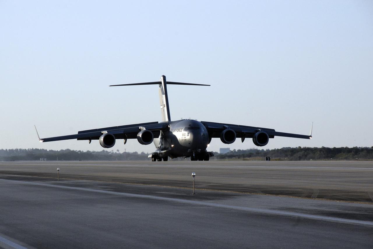
VANDENBERG AIR FORCE BASE, Calif. – The latest polar-orbiting operational environmental weather satellite developed by NASA for the National Oceanic and Atmospheric Administration, called NOAA-N Prime, is offloaded from the C-5A military cargo aircraft at Vandenberg Air Force Base, Calif., in preparation for a Feb. 4 launch. NOAA-N Prime, built by Lockheed Martin, is similar to NOAA-N launched on May 20, 2005.
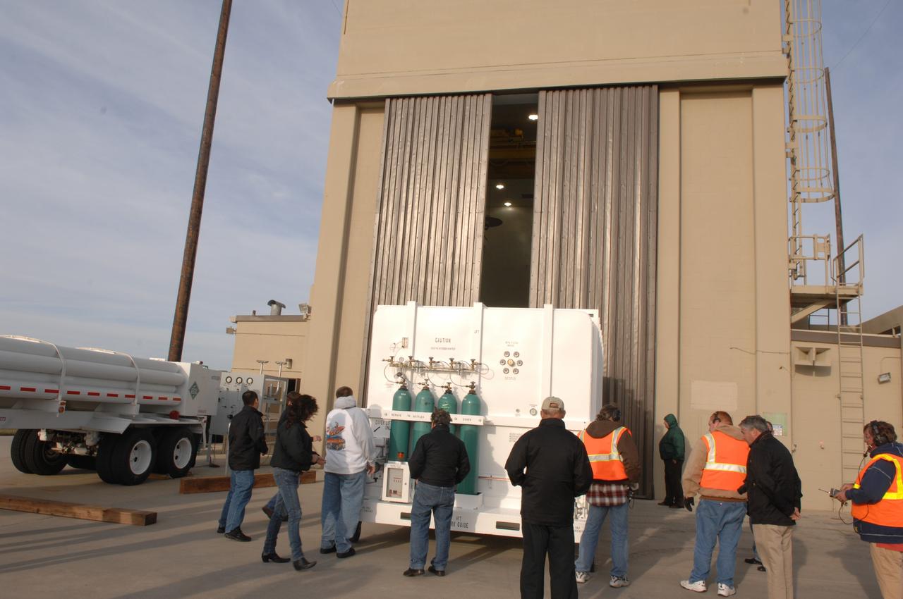
VANDENBERG AIR FORCE BASE, Calif. – The latest polar-orbiting operational environmental weather satellite developed by NASA for the National Oceanic and Atmospheric Administration, called NOAA-N Prime, is moved into a NASA payload processing facility to be prepared for a Feb. 4 launch. NOAA-N Prime, built by Lockheed Martin, is similar to NOAA-N launched on May 20, 2005.
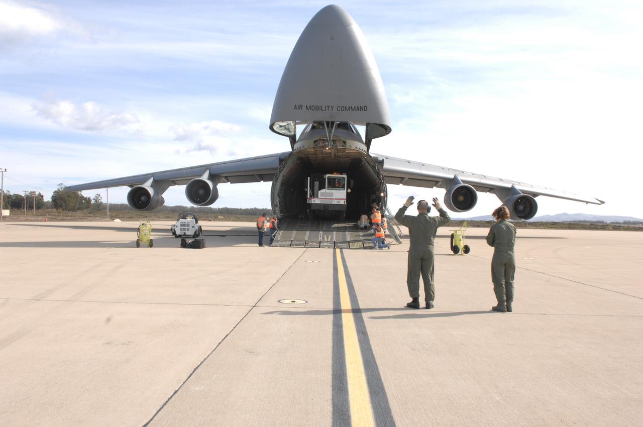
VANDENBERG AIR FORCE BASE, Calif. – The latest polar-orbiting operational environmental weather satellite developed by NASA for the National Oceanic and Atmospheric Administration, called NOAA-N Prime, is being offloaded from the C-5A military cargo aircraft at Vandenberg Air Force Base, Calif., in preparation for a Feb. 4 launch. NOAA-N Prime, built by Lockheed Martin, is similar to NOAA-N launched on May 20, 2005.
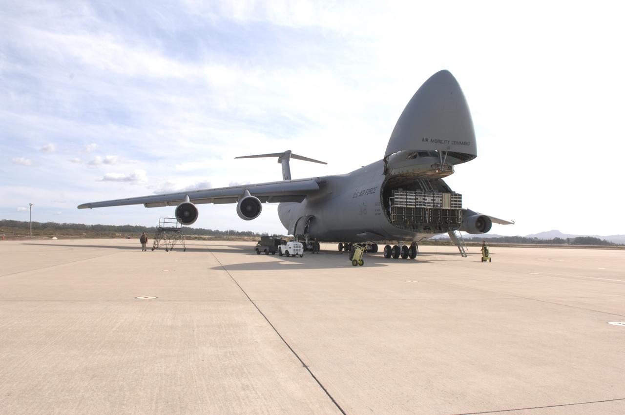
VANDENBERG AIR FORCE BASE, Calif. – The latest polar-orbiting operational environmental weather satellite developed by NASA for the National Oceanic and Atmospheric Administration, called NOAA-N Prime, arrived by C-5A military cargo aircraft at Vandenberg Air Force Base, Calif., in preparation for a Feb. 4 launch. NOAA-N Prime, built by Lockheed Martin, is similar to NOAA-N launched on May 20, 2005.
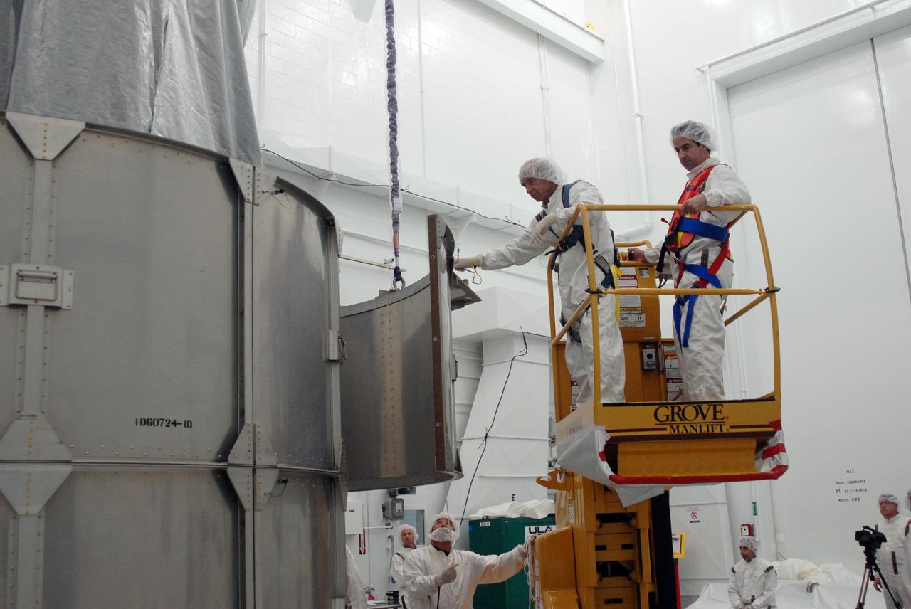
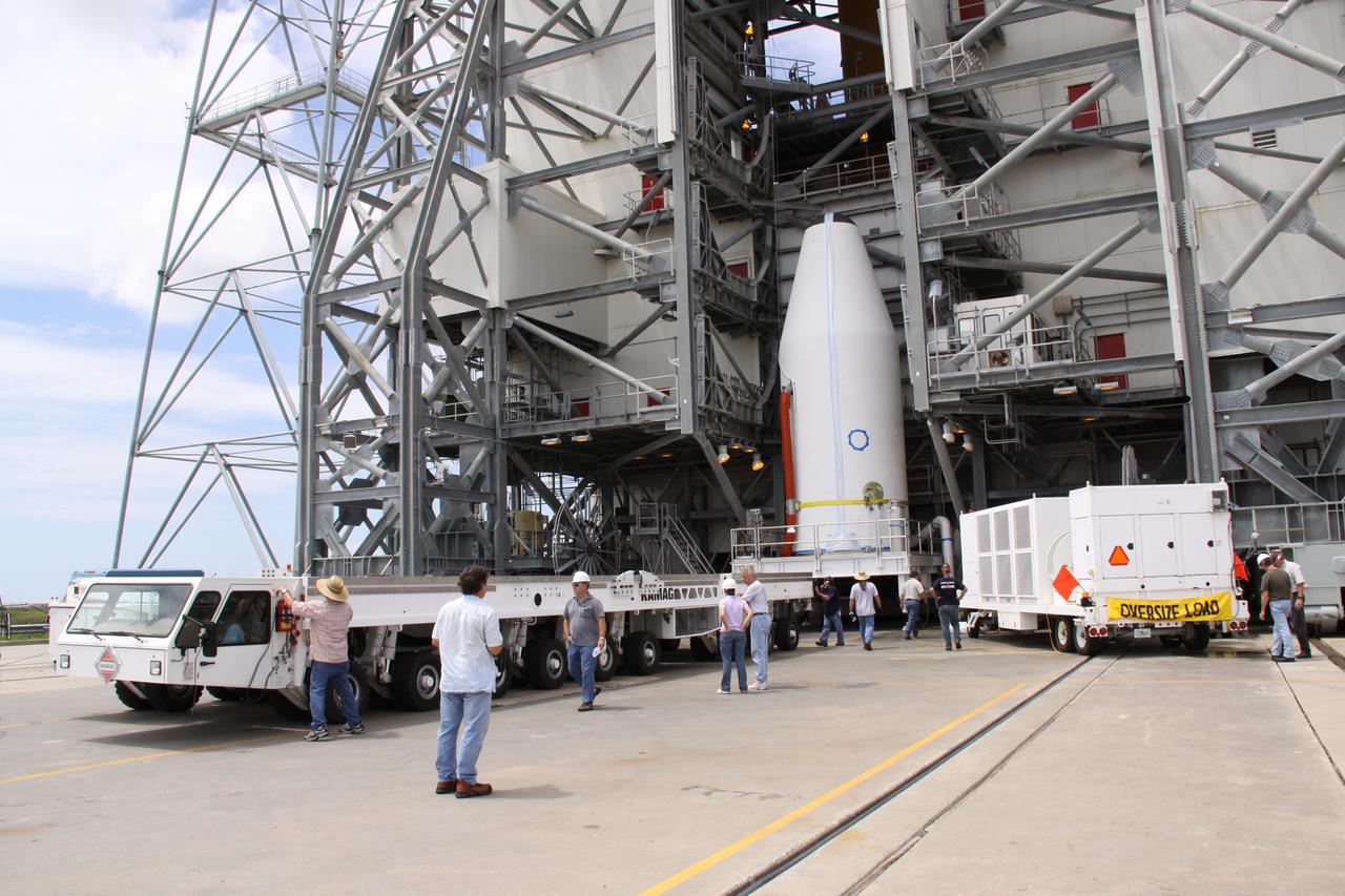
VANDENBERG AIR FORCE BASE, Calif. -- The first half of the fairing is moved into place around the NOAA-N Prime spacecraft in the launch service tower on Space Launch Complex 2 at Vandenberg Air Force Base in California. The fairing is a molded structure that fits flush with the outside surface of the rocket and forms an aerodynamically smooth nose cone, protecting the spacecraft during launch and ascent. NOAA-N Prime is the latest polar-orbiting operational environmental weather satellite developed by NASA for the National Oceanic and Atmospheric Administration. It is built by Lockheed Martin and similar to NOAA-N that was launched on May 20, 2005. Launch of NOAA-N Prime aboard a Delta II rocket is scheduled for Feb. 4. Photo credit: NASA
VANDENBERG AIR FORCE BASE, Calif. -- The first half of the fairing is moved into place around the NOAA-N Prime spacecraft in the launch service tower on Space Launch Complex 2 at Vandenberg Air Force Base in California. The fairing is a molded structure that fits flush with the outside surface of the rocket and forms an aerodynamically smooth nose cone, protecting the spacecraft during launch and ascent. NOAA-N Prime is the latest polar-orbiting operational environmental weather satellite developed by NASA for the National Oceanic and Atmospheric Administration. It is built by Lockheed Martin and similar to NOAA-N that was launched on May 20, 2005. Launch of NOAA-N Prime aboard a Delta II rocket is scheduled for Feb. 4. Photo credit: NASA
VANDENBERG AIR FORCE BASE, Calif. -- The first half of the fairing is moved into place around the NOAA-N Prime spacecraft in the launch service tower on Space Launch Complex 2 at Vandenberg Air Force Base in California. The fairing is a molded structure that fits flush with the outside surface of the rocket and forms an aerodynamically smooth nose cone, protecting the spacecraft during launch and ascent. NOAA-N Prime is the latest polar-orbiting operational environmental weather satellite developed by NASA for the National Oceanic and Atmospheric Administration. It is built by Lockheed Martin and similar to NOAA-N that was launched on May 20, 2005. Launch of NOAA-N Prime aboard a Delta II rocket is scheduled for Feb. 4. Photo credit: NASA
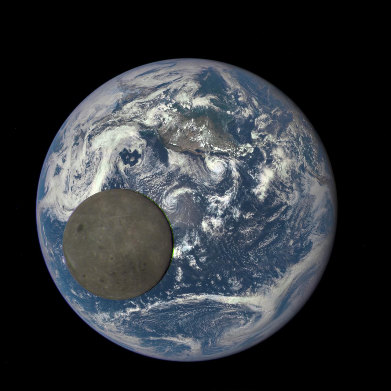
This animation still image shows the far side of the moon, illuminated by the sun, as it crosses between the DISCOVR spacecraft's Earth Polychromatic Imaging Camera (EPIC) camera and telescope, and the Earth - one million miles away. Credits: NASA/NOAA A NASA camera aboard the Deep Space Climate Observatory (DSCOVR) satellite captured a unique view of the moon as it moved in front of the sunlit side of Earth last month. The series of test images shows the fully illuminated “dark side” of the moon that is never visible from Earth. The images were captured by NASA’s Earth Polychromatic Imaging Camera (EPIC), a four megapixel CCD camera and telescope on the DSCOVR satellite orbiting 1 million miles from Earth. From its position between the sun and Earth, DSCOVR conducts its primary mission of real-time solar wind monitoring for the National Oceanic and Atmospheric Administration (NOAA).
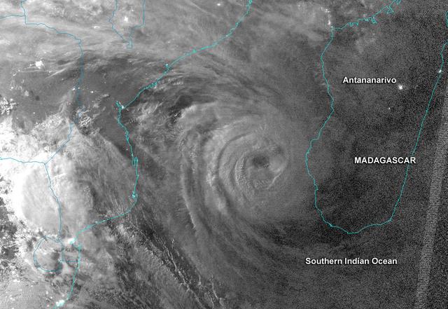
This night-time image revealed Cyclone Haruna's massive eye before it made landfall in southwestern Madagascar. This image was taken from the VIIRS instrument that flies aboard the NASA-NOAA Suomi NPP satellite. The image was taken on Feb. 20 at 2242 UTC (5:42 p.m. EST/U.S.) and shows a clear eye, surrounded by very powerful thunderstorms. The bright lights of the Capital city of Antananarivo are seen in this image. The capital city lies about 300 nautical miles northwest of the storm's center. Haruna's center made landfall near Manombo, Madagascar around 0600 UTC (1 a.m. EST/U.S.) and its eye became cloud-filled quickly. For the entire storm history, visit NASA's Hurricane Page: <a href="http://www.nasa.gov/mission_pages/hurricanes/archives/2013/h2013_Haruna.html" rel="nofollow">www.nasa.gov/mission_pages/hurricanes/archives/2013/h2013...</a> Text: Credit: Univ.of Wisconsin/NASA/NOAA <b><a href="http://www.nasa.gov/audience/formedia/features/MP_Photo_Guidelines.html" rel="nofollow">NASA image use policy.</a></b> <b><a href="http://www.nasa.gov/centers/goddard/home/index.html" rel="nofollow">NASA Goddard Space Flight Center</a></b> enables NASA’s mission through four scientific endeavors: Earth Science, Heliophysics, Solar System Exploration, and Astrophysics. Goddard plays a leading role in NASA’s accomplishments by contributing compelling scientific knowledge to advance the Agency’s mission. <b>Follow us on <a href="http://twitter.com/NASA_GoddardPix" rel="nofollow">Twitter</a></b> <b>Like us on <a href="http://www.facebook.com/pages/Greenbelt-MD/NASA-Goddard/395013845897?ref=tsd" rel="nofollow">Facebook</a></b> <b>Find us on <a href="http://instagram.com/nasagoddard?vm=grid" rel="nofollow">Instagram</a></b>
NASA-NOAA's Suomi NPP satellite flew over Hurricane Blanca in the Eastern Pacific Ocean and gathered infrared data on the storm that was false-colored to show locations of the strongest thunderstorms within the storm. The Visible Infrared Imaging Radiometer Suite or VIIRS instrument aboard the satellite gathered infrared data of the storm that was made into an image at the University of Wisconsin-Madison. The image was false-colored to show temperature. Coldest cloud top temperatures indicate higher, stronger, thunderstorms within a tropical cyclone. Those are typically the strongest storms with potential for heavy rainfall. VIIRS is a scanning radiometer that collects visible and infrared imagery and "radiometric" measurements. Basically it means that VIIRS data is used to measure cloud and aerosol properties, ocean color, sea and land surface temperature, ice motion and temperature, fires, and Earth's albedo (reflected light). The VIIRS image from June 5 at 8:11 UTC (4:11 a.m. EDT) showed two areas of coldest cloud top temperatures and strongest storms were west-southwest and east-northeast of the center of Blanca's circulation center. On June 5 at 5 a.m. EDT (0900 UTC) Blanca's maximum sustained winds were near 105 mph (165 kph) with higher gusts. The National Hurricane Center (NHC) forecast expects some strengthening during the next day or so. Weakening is forecast to begin by late Saturday. At that time, NHC placed the center of Hurricane Blanca near latitude 14.3 North, longitude 106.2 West. That puts the center about 350 miles (560 km) south-southwest of Manzanillo, Mexico and about 640 miles (1,030 km) south-southeast of Cabo San Lucas, Mexico. The estimated minimum central pressure is 968 millibars (28.59 inches). Blanca is moving toward the northwest near 10 mph (17 kph). A northwestward to north-northwestward motion at a similar forward speed is expected to continue through Saturday night. Blanca has been stirring up surf along the coast of southwestern Mexico and will reach the Pacific coast of the Baja California peninsula and the southern Gulf of California later today, June 5. These swells are likely to cause life-threatening surf and rip current conditions. On the forecast track, the center of Blanca will approach the southern Baja California peninsula on Sunday. NHC cautions that "Interests in the southern Baja California peninsula should monitor the progress of Blanca. A tropical storm or hurricane watch will likely be required for a portion of Baja California Sur later today." The NHC forecast track shows Blanca making landfall in the southeastern tip of Baja California on Sunday, June 7 and tracking north-northeast along the Baja California peninsula, for several days following. Image credit: Credits: NASA/NOAA/UW-CIMSS <b><a href="http://www.nasa.gov/audience/formedia/features/MP_Photo_Guidelines.html" rel="nofollow">NASA image use policy.</a></b> <b><a href="http://www.nasa.gov/centers/goddard/home/index.html" rel="nofollow">NASA Goddard Space Flight Center</a></b> enables NASA’s mission through four scientific endeavors: Earth Science, Heliophysics, Solar System Exploration, and Astrophysics. Goddard plays a leading role in NASA’s accomplishments by contributing compelling scientific knowledge to advance the Agency’s mission. <b>Follow us on <a href="http://twitter.com/NASAGoddardPix" rel="nofollow">Twitter</a></b> <b>Like us on <a href="http://www.facebook.com/pages/Greenbelt-MD/NASA-Goddard/395013845897?ref=tsd" rel="nofollow">Facebook</a></b> <b>Find us on <a href="http://instagrid.me/nasagoddard/?vm=grid" rel="nofollow">Instagram</a></b>
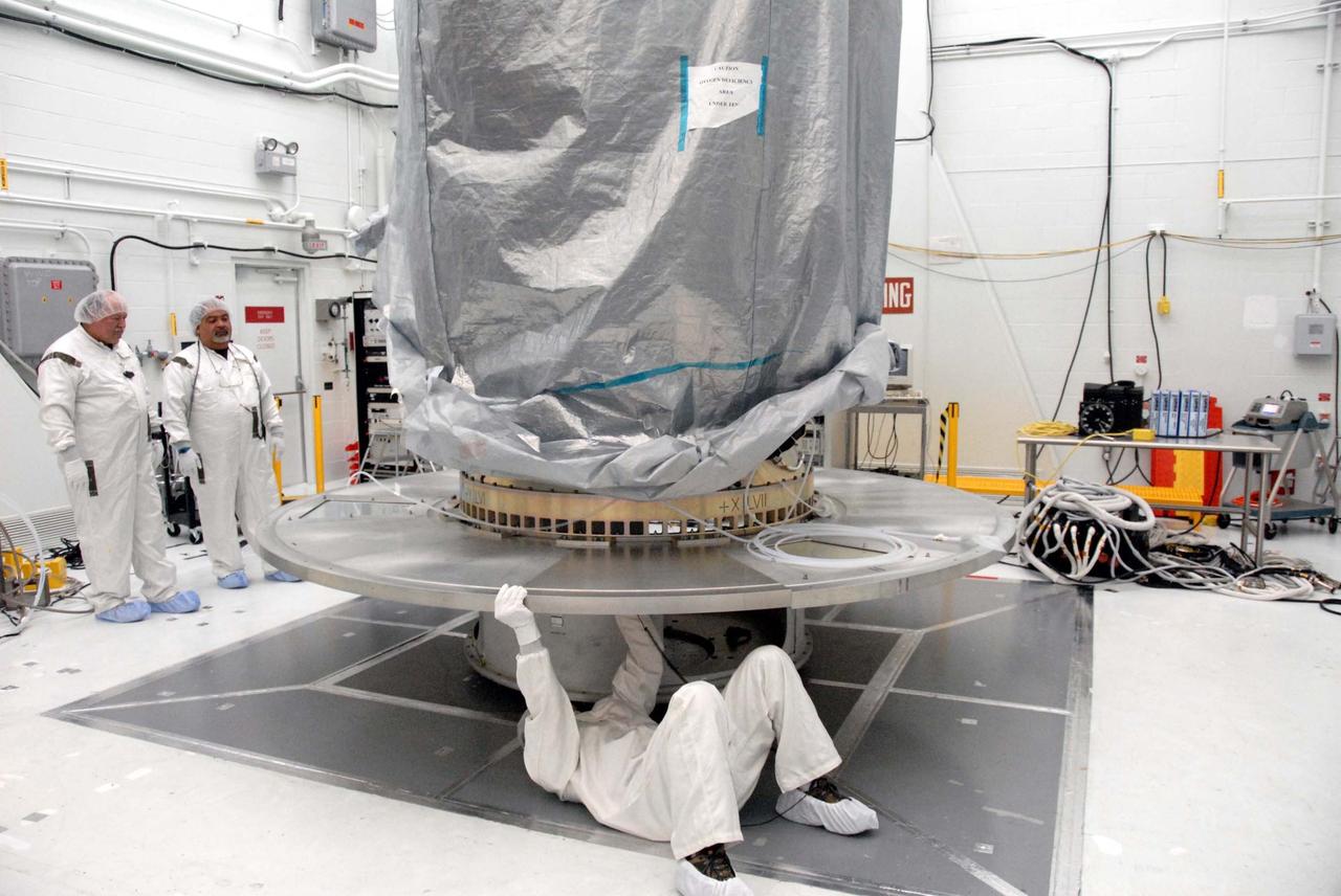
VANDENBERG AIR FORCE BASE, Calif. -- In Bldg. 1610 at Vandenberg Air Force Base in California, the covered NOAA-N Prime spacecraft is lifted off its stand. It will be moved to a transporter. NOAA-N Prime is the latest polar-orbiting operational environmental weather satellite developed by NASA for the National Oceanic and Atmospheric Administration. The satellite is scheduled to launch Feb. 4 aboard a Delta II rocket from Vandenberg Air Force Base. Photo credit: NASA/ Daniel Liberotti, VAFB
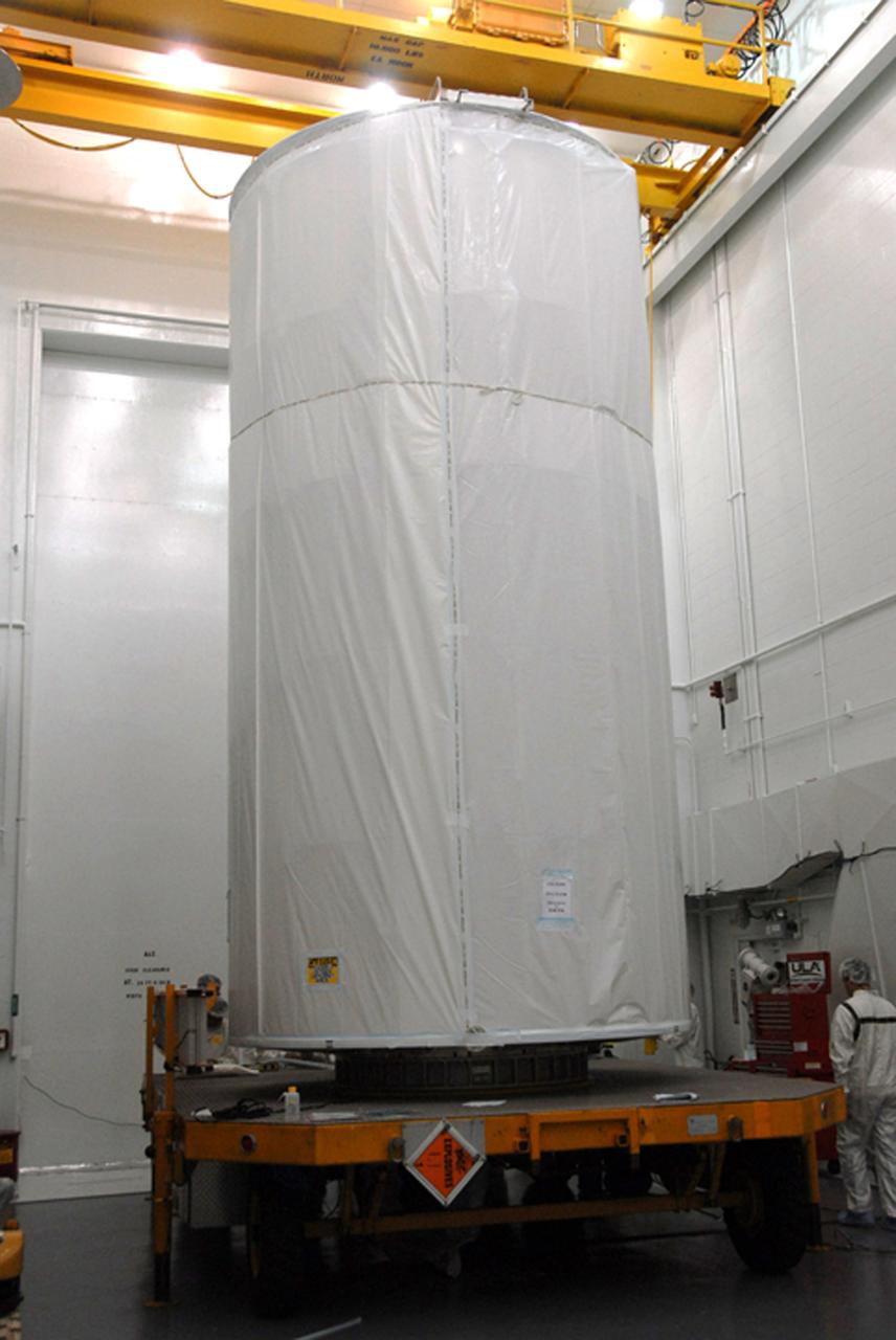
VANDENBERG AIR FORCE BASE, Calif. -- In Bldg. 1610 at Vandenberg Air Force Base in California, a transportation canister is being placed around the NOAA-N Prime spacecraft. NOAA-N Prime is the latest polar-orbiting operational environmental weather satellite developed by NASA for the National Oceanic and Atmospheric Administration. The satellite is scheduled to launch Feb. 4 aboard a Delta II rocket from Vandenberg Air Force Base. Photo credit: NASA/ Daniel Liberotti, VAFB
VANDENBERG AIR FORCE BASE, Calif. -- In Bldg. 1610 at Vandenberg Air Force Base in California, the NOAA-N Prime spacecraft is waiting for a transportation canister to be placed around it. NOAA-N Prime is the latest polar-orbiting operational environmental weather satellite developed by NASA for the National Oceanic and Atmospheric Administration. The satellite is scheduled to launch Feb. 4 aboard a Delta II rocket from Vandenberg Air Force Base. Photo credit: NASA/ Daniel Liberotti, VAFB
VANDENBERG AIR FORCE BASE, Calif. -- In Bldg. 1610 at Vandenberg Air Force Base in California, workers begin attaching a protective cover over the transportation cover of the NOAA-N Prime spacecraft. The spacecraft will be moved to a transporter. NOAA-N Prime is the latest polar-orbiting operational environmental weather satellite developed by NASA for the National Oceanic and Atmospheric Administration. The satellite is scheduled to launch Feb. 4 aboard a Delta II rocket from Vandenberg Air Force Base. Photo credit: NASA/ Daniel Liberotti, VAFB
VANDENBERG AIR FORCE BASE, Calif. -- At Space Launch Complex 2 at Vandenberg Air Force Base in California, the NOAA-N Prime spacecraft is set up for an RF and other tests. NOAA-N Prime is the latest polar-orbiting operational environmental weather satellite developed by NASA for the National Oceanic and Atmospheric Administration. The satellite is scheduled to launch Feb. 4 aboard a Delta II rocket from Vandenberg Air Force Base. Photo credit: NASA/ Daniel Liberotti, VAFB
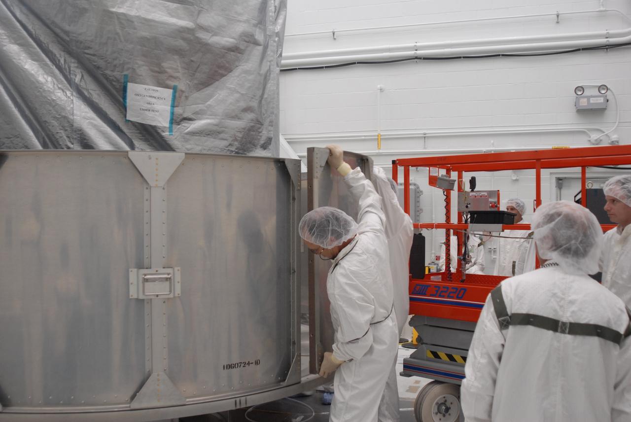
VANDENBERG AIR FORCE BASE, Calif. -- In Bldg. 1610 at Vandenberg Air Force Base in California, workers help guide a second-row segment of a transportation canister toward the NOAA-N Prime spacecraft for installation. NOAA-N Prime is the latest polar-orbiting operational environmental weather satellite developed by NASA for the National Oceanic and Atmospheric Administration. The satellite is scheduled to launch Feb. 4 aboard a Delta II rocket from Vandenberg Air Force Base. Photo credit: NASA/ Daniel Liberotti, VAFB
VANDENBERG AIR FORCE BASE, Calif. -- In Bldg. 1610 at Vandenberg Air Force Base in California, workers place the first of the lower segments of a transportation canister around the NOAA-N Prime spacecraft. NOAA-N Prime is the latest polar-orbiting operational environmental weather satellite developed by NASA for the National Oceanic and Atmospheric Administration. The satellite is scheduled to launch Feb. 4 aboard a Delta II rocket from Vandenberg Air Force Base. Photo credit: NASA/ Daniel Liberotti, VAFB
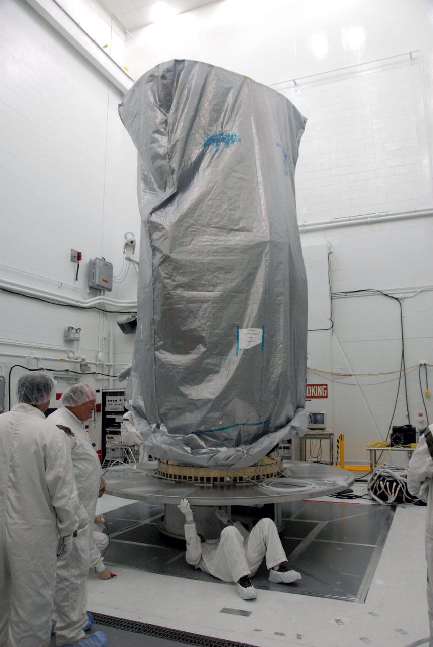
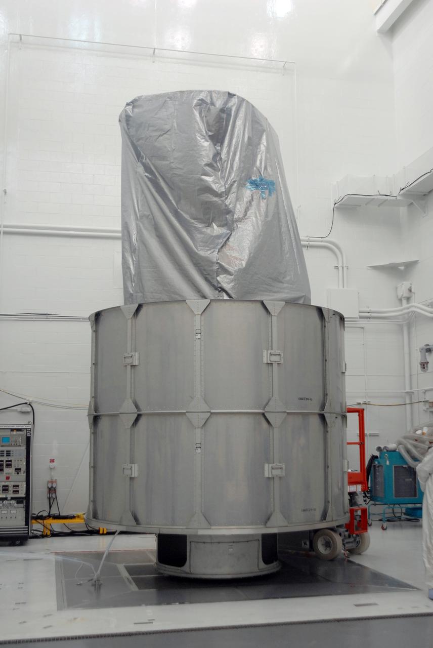
VANDENBERG AIR FORCE BASE, Calif. -- A transportation canister surrounds the NOAA-N Prime spacecraft in Bldg. 1610 at Vandenberg Air Force Base in California. The spacecraft will be moved to a transporter. NOAA-N Prime is the latest polar-orbiting operational environmental weather satellite developed by NASA for the National Oceanic and Atmospheric Administration. The satellite is scheduled to launch Feb. 4 aboard a Delta II rocket from Vandenberg Air Force Base. Photo credit: NASA/ Daniel Liberotti, VAFB
VANDENBERG AIR FORCE BASE, Calif. -- In Bldg. 1610 at Vandenberg Air Force Base in California, the NOAA-N Prime spacecraft is encased inside a transportation canister. NOAA-N Prime is the latest polar-orbiting operational environmental weather satellite developed by NASA for the National Oceanic and Atmospheric Administration. The satellite is scheduled to launch Feb. 4 aboard a Delta II rocket from Vandenberg Air Force Base. Photo credit: NASA/ Daniel Liberotti, VAFB
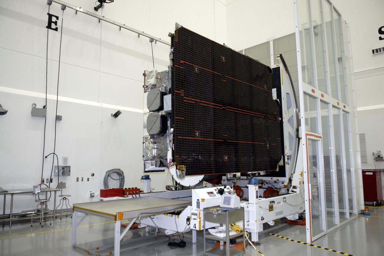
CAPE CANAVERAL, Fla. – At the Astrotech payload processing facility in Titusville, Fla., the GOES-O satellite is on a rotation stand. The latest Geostationary Operational Environmental Satellite, GOES-O was developed by NASA for the National Oceanic and Atmospheric Administration, or NOAA. Once in orbit, GOES-O will be designated GOES-14, and NASA will provide on-orbit checkout and then transfer operational responsibility to NOAA. The GOES-O satellite is targeted to launch April 28 onboard a United Launch Alliance Delta IV expendable launch vehicle. Photo credit: NASA/Kim Shiflett
VANDENBERG AIR FORCE BASE, Calif. -- In Bldg. 1610 at Vandenberg Air Force Base in California, workers guide an upper segment of the transportation canister toward the NOAA-N Prime spacecraft. NOAA-N Prime is the latest polar-orbiting operational environmental weather satellite developed by NASA for the National Oceanic and Atmospheric Administration. The satellite is scheduled to launch Feb. 4 aboard a Delta II rocket from Vandenberg Air Force Base. Photo credit: NASA/ Daniel Liberotti, VAFB
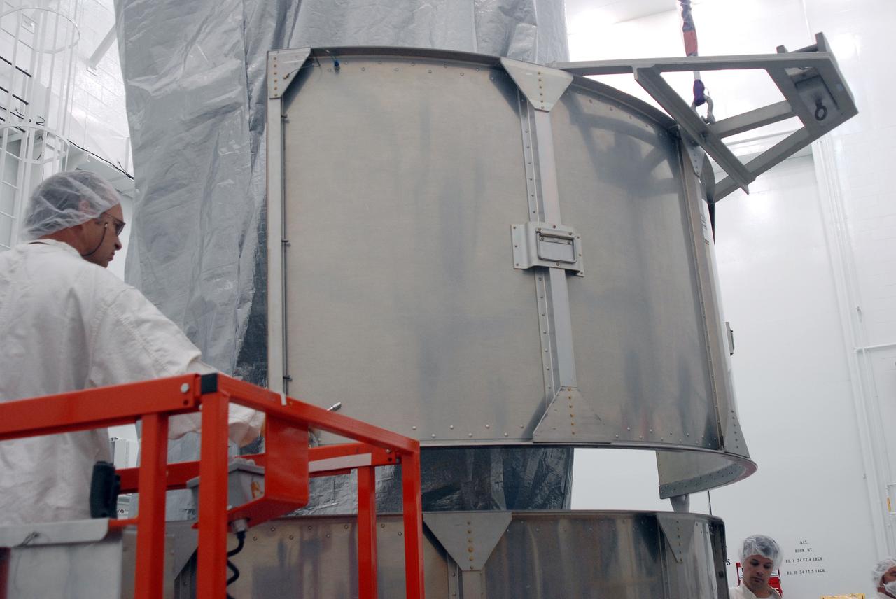
VANDENBERG AIR FORCE BASE, Calif. -- In Bldg. 1610 at Vandenberg Air Force Base in California, a second-row segment of a transportation canister is put in place for installation around the NOAA-N Prime spacecraft. NOAA-N Prime is the latest polar-orbiting operational environmental weather satellite developed by NASA for the National Oceanic and Atmospheric Administration. The satellite is scheduled to launch Feb. 4 aboard a Delta II rocket from Vandenberg Air Force Base. Photo credit: NASA/ Daniel Liberotti, VAFB
VANDENBERG AIR FORCE BASE, Calif. -- In Bldg. 1610 at Vandenberg Air Force Base in California, two rows of the transportation canister are installed around the NOAA-N Prime spacecraft. NOAA-N Prime is the latest polar-orbiting operational environmental weather satellite developed by NASA for the National Oceanic and Atmospheric Administration. The satellite is scheduled to launch Feb. 4 aboard a Delta II rocket from Vandenberg Air Force Base. Photo credit: NASA/ Daniel Liberotti, VAFB
VANDENBERG AIR FORCE BASE, Calif. -- In Bldg. 1610 at Vandenberg Air Force Base in California, workers place another lower segment of a transportation canister around the NOAA-N Prime spacecraft. NOAA-N Prime is the latest polar-orbiting operational environmental weather satellite developed by NASA for the National Oceanic and Atmospheric Administration. The satellite is scheduled to launch Feb. 4 aboard a Delta II rocket from Vandenberg Air Force Base. Photo credit: NASA/ Daniel Liberotti, VAFB
VANDENBERG AIR FORCE BASE, Calif. -- In Bldg. 1610 at Vandenberg Air Force Base in California, the covered NOAA-N Prime spacecraft is lowered onto a transporter. NOAA-N Prime is the latest polar-orbiting operational environmental weather satellite developed by NASA for the National Oceanic and Atmospheric Administration. The satellite is scheduled to launch Feb. 4 aboard a Delta II rocket from Vandenberg Air Force Base. Photo credit: NASA/ Daniel Liberotti, VAFB
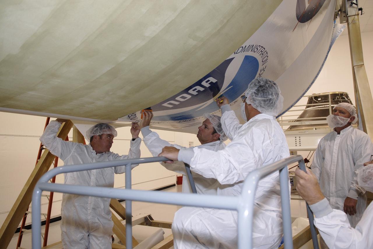
CAPE CANAVERAL, Fla. – At the Astrotech payload processing facility in Titusville, Fla., technicians apply the NOAA decal to the fairing that will encapsulate the GOES-O satellite during launch. The latest Geostationary Operational Environmental Satellite, GOES-O was developed by NASA for the National Oceanic and Atmospheric Administration, or NOAA. The GOES satellites continuously provide observations of 60 percent of the Earth including the continental United States, providing weather monitoring and forecast operations as well as a continuous and reliable stream of environmental information and severe weather warnings. Once in orbit, GOES-O will be designated GOES-14, and NASA will provide on-orbit checkout and then transfer operational responsibility to NOAA. The GOES-O satellite is targeted to launch April 28 onboard a United Launch Alliance Delta IV expendable launch vehicle. Photo credit: NASA/Kim Shiflett
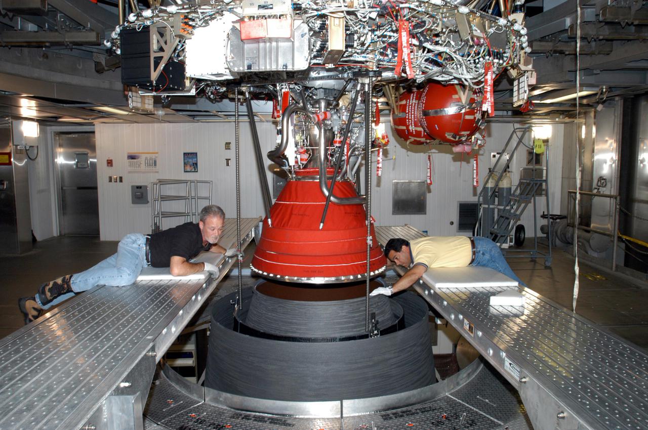
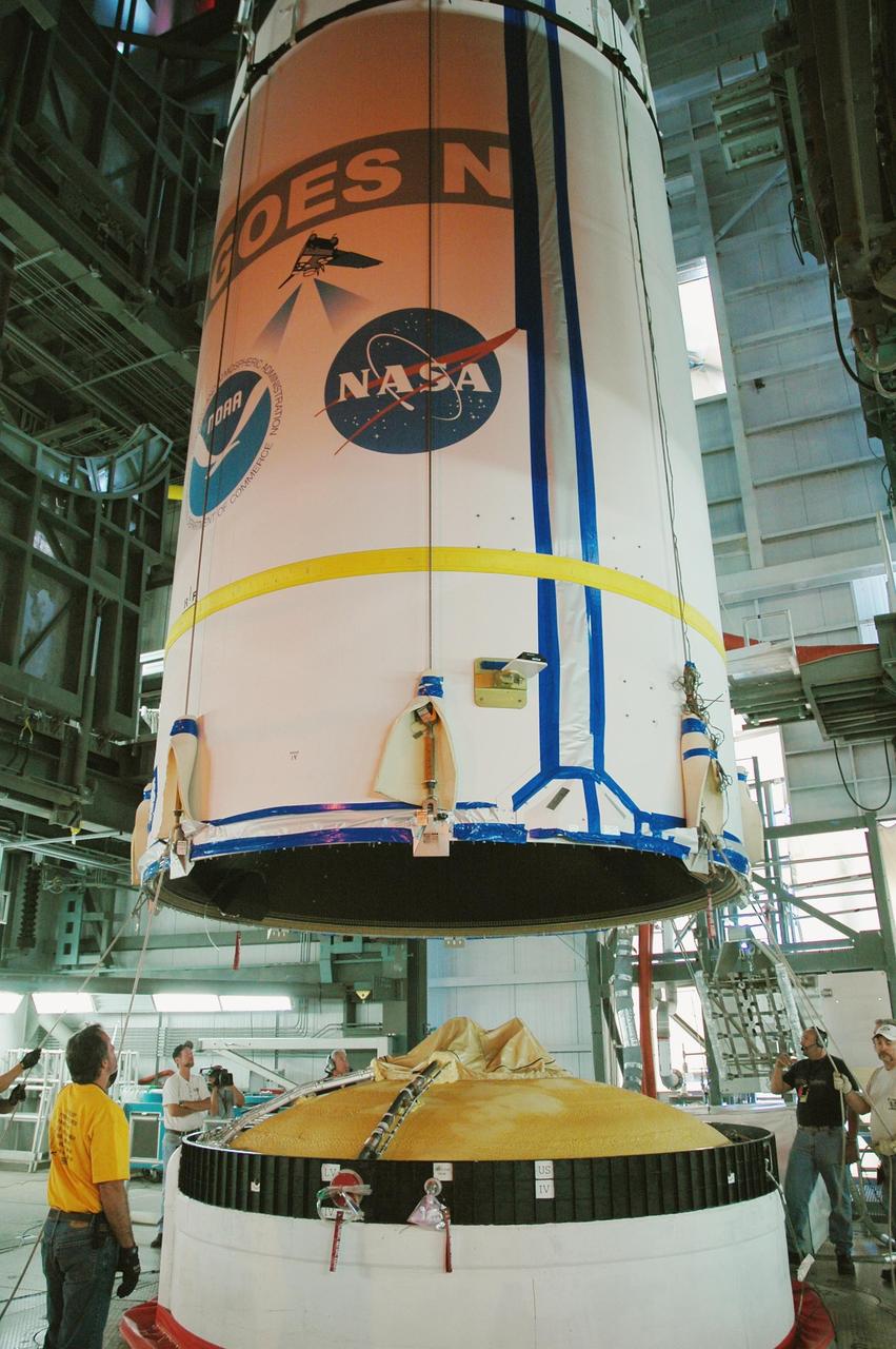
KENNEDY SPACE CENTER, FLA. - At the Delta Operations Center, Jack Reynolds and Leslie Guzman (left and right), with Pratt and Whitney, closely guide the nozzle for the RL-10 engine on the second stage of the Boeing Delta IV rocket. The Delta IV is the launch vehicle for the Geostationary Operational Environmental Satellite (GOES-N), scheduled to launch in April 2005 from Cape Canaveral Air Force Station. GOES-N is a weather satellite for NASA and NOAA (National Oceanic and Atmospheric Administration). The first in a series of three advanced weather satellites including GOES-O and GOES-P, the GOES-N will provide continuous monitoring necessary for intensive data analysis. It will provide a constant vigil for the atmospheric “triggers” of severe weather conditions such as tornadoes, flash floods, hail storms and hurricanes. When these conditions develop, GOES-N will be able to monitor storm development and track their movements.
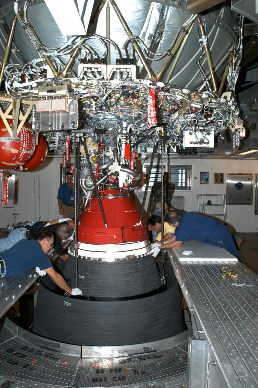
KENNEDY SPACE CENTER, FLA. - At the Delta Operations Center, Jack Reynolds and Leslie Guzman (background) and other workers attach the nozzle for the RL-10 engine to the second stage of the Boeing Delta IV rocket. The Delta IV is the launch vehicle for the Geostationary Operational Environmental Satellite (GOES-N), scheduled to launch in April 2005 from Cape Canaveral Air Force Station. GOES-N is a weather satellite for NASA and NOAA (National Oceanic and Atmospheric Administration). The first in a series of three advanced weather satellites including GOES-O and GOES-P, the GOES-N will provide continuous monitoring necessary for intensive data analysis. It will provide a constant vigil for the atmospheric “triggers” of severe weather conditions such as tornadoes, flash floods, hail storms and hurricanes. When these conditions develop, GOES-N will be able to monitor storm development and track their movements.
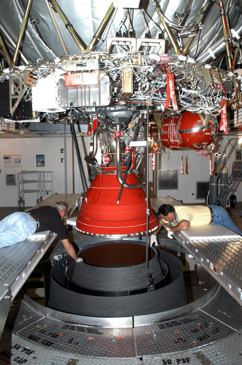
KENNEDY SPACE CENTER, FLA. - At the Delta Operations Center, Jack Reynolds and Leslie Guzman (left and right), with Pratt and Whitney, closely guide the nozzle for the RL-10 engine on the second stage of the Boeing Delta IV rocket. The Delta IV is the launch vehicle for the Geostationary Operational Environmental Satellite (GOES-N), scheduled to launch in April 2005 from Cape Canaveral Air Force Station. GOES-N is a weather satellite for NASA and NOAA (National Oceanic and Atmospheric Administration). The first in a series of three advanced weather satellites including GOES-O and GOES-P, the GOES-N will provide continuous monitoring necessary for intensive data analysis. It will provide a constant vigil for the atmospheric “triggers” of severe weather conditions such as tornadoes, flash floods, hail storms and hurricanes. When these conditions develop, GOES-N will be able to monitor storm development and track their movements.
KENNEDY SPACE CENTER, FLA. - At the Delta Operations Center, Jack Reynolds and Leslie Guzman (both at left), with Pratt and Whitney, prepare the nozzle for the RL-10 engine to be attached to the second stage of the Boeing Delta IV rocket. The Delta IV is the launch vehicle for the Geostationary Operational Environmental Satellite (GOES-N), scheduled to launch in April 2005 from Cape Canaveral Air Force Station. GOES-N is a weather satellite for NASA and NOAA (National Oceanic and Atmospheric Administration). The first in a series of three advanced weather satellites including GOES-O and GOES-P, the GOES-N will provide continuous monitoring necessary for intensive data analysis. It will provide a constant vigil for the atmospheric “triggers” of severe weather conditions such as tornadoes, flash floods, hail storms and hurricanes. When these conditions develop, GOES-N will be able to monitor storm development and track their movements.
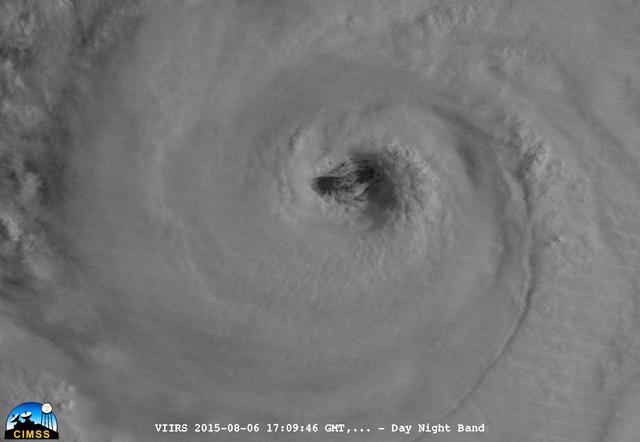
On August 6, 2015, NASA-NOAA's Suomi NPP satellite passed over powerful Typhoon Soudelor when it was headed toward Taiwan. The Visible Infrared Imaging Radiometer Suite (VIIRS) instrument aboard NASA-NOAA's Suomi satellite captured this night-time infrared close-up image of Soudelor's eye. At 1500 UTC (11 a.m. EDT) on August 6, 2015, Typhoon Soudelor had maximum sustained winds near 90 knots (103.6 mph/166.7 kph). It was centered near 21.3 North latitude and 127.5 East longitude, about 324 nautical miles (372.9 miles/600 km) south of Kadena Air Base, Okinawa, Japan. It was moving to the west at 10 knots (11.5 mph/18.5 kph). Credit: UWM/CIMSS/SSEC, William Straka III <b><a href="http://www.nasa.gov/audience/formedia/features/MP_Photo_Guidelines.html" rel="nofollow">NASA image use policy.</a></b> <b><a href="http://www.nasa.gov/centers/goddard/home/index.html" rel="nofollow">NASA Goddard Space Flight Center</a></b> enables NASA’s mission through four scientific endeavors: Earth Science, Heliophysics, Solar System Exploration, and Astrophysics. Goddard plays a leading role in NASA’s accomplishments by contributing compelling scientific knowledge to advance the Agency’s mission. <b>Follow us on <a href="http://twitter.com/NASAGoddardPix" rel="nofollow">Twitter</a></b> <b>Like us on <a href="http://www.facebook.com/pages/Greenbelt-MD/NASA-Goddard/395013845897?ref=tsd" rel="nofollow">Facebook</a></b> <b>Find us on <a href="http://instagrid.me/nasagoddard/?vm=grid" rel="nofollow">Instagram</a></b>

On August 6, 2015, NASA-NOAA's Suomi NPP satellite passed over powerful Typhoon Soudelor when it was headed toward Taiwan. The Visible Infrared Imaging Radiometer Suite (VIIRS) instrument aboard NASA-NOAA's Suomi satellite captured an infrared image of the typhoon. The infrared image that showed there were some thunderstorms within the typhoon with very cold cloud top temperatures, colder than -63F/-53C. Temperatures that cold stretch high into the troposphere and are capable of generating heavy rain. Credit: UWM/CIMSS/SSEC, William Straka III <b><a href="http://www.nasa.gov/audience/formedia/features/MP_Photo_Guidelines.html" rel="nofollow">NASA image use policy.</a></b> <b><a href="http://www.nasa.gov/centers/goddard/home/index.html" rel="nofollow">NASA Goddard Space Flight Center</a></b> enables NASA’s mission through four scientific endeavors: Earth Science, Heliophysics, Solar System Exploration, and Astrophysics. Goddard plays a leading role in NASA’s accomplishments by contributing compelling scientific knowledge to advance the Agency’s mission. <b>Follow us on <a href="http://twitter.com/NASAGoddardPix" rel="nofollow">Twitter</a></b> <b>Like us on <a href="http://www.facebook.com/pages/Greenbelt-MD/NASA-Goddard/395013845897?ref=tsd" rel="nofollow">Facebook</a></b> <b>Find us on <a href="http://instagrid.me/nasagoddard/?vm=grid" rel="nofollow">Instagram</a></b>
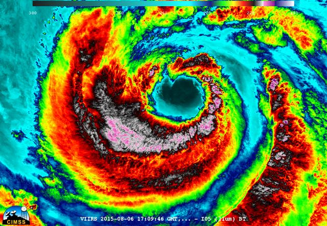
On August 6, 2015, NASA-NOAA's Suomi NPP satellite passed over powerful Typhoon Soudelor when it was headed toward Taiwan. The Visible Infrared Imaging Radiometer Suite (VIIRS) instrument aboard NASA-NOAA's Suomi satellite captured this night-time infrared close-up image of Soudelor's eye. The infrared image that showed there were some thunderstorms within the typhoon with very cold cloud top temperatures, colder than -63F/-53C. Temperatures that cold stretch high into the troposphere and are capable of generating heavy rain. At 1500 UTC (11 a.m. EDT) on August 6, 2015, Typhoon Soudelor had maximum sustained winds near 90 knots (103.6 mph/166.7 kph). It was centered near 21.3 North latitude and 127.5 East longitude, about 324 nautical miles (372.9 miles/600 km) south of Kadena Air Base, Okinawa, Japan. It was moving to the west at 10 knots (11.5 mph/18.5 kph). Credit: UWM/CIMSS/SSEC, William Straka III <b><a href="http://www.nasa.gov/audience/formedia/features/MP_Photo_Guidelines.html" rel="nofollow">NASA image use policy.</a></b> <b><a href="http://www.nasa.gov/centers/goddard/home/index.html" rel="nofollow">NASA Goddard Space Flight Center</a></b> enables NASA’s mission through four scientific endeavors: Earth Science, Heliophysics, Solar System Exploration, and Astrophysics. Goddard plays a leading role in NASA’s accomplishments by contributing compelling scientific knowledge to advance the Agency’s mission. <b>Follow us on <a href="http://twitter.com/NASAGoddardPix" rel="nofollow">Twitter</a></b> <b>Like us on <a href="http://www.facebook.com/pages/Greenbelt-MD/NASA-Goddard/395013845897?ref=tsd" rel="nofollow">Facebook</a></b> <b>Find us on <a href="http://instagrid.me/nasagoddard/?vm=grid" rel="nofollow">Instagram</a></b>
CAPE CANAVERAL, Fla. – At the Astrotech payload processing facility in Titusville, Fla., ., a technician checks the GOES-O satellite as it rotates on the stand. The latest Geostationary Operational Environmental Satellite, GOES-O was developed by NASA for the National Oceanic and Atmospheric Administration, or NOAA. Once in orbit, GOES-O will be designated GOES-14, and NASA will provide on-orbit checkout and then transfer operational responsibility to NOAA. The GOES-O satellite is targeted to launch April 28 onboard a United Launch Alliance Delta IV expendable launch vehicle. Photo credit: NASA/Kim Shiflett
CAPE CANAVERAL, Fla. – At the Astrotech payload processing facility in Titusville, Fla., a technician examines the GOES-O satellite as it completes rotation on the stand. The latest Geostationary Operational Environmental Satellite, GOES-O was developed by NASA for the National Oceanic and Atmospheric Administration, or NOAA. Once in orbit, GOES-O will be designated GOES-14, and NASA will provide on-orbit checkout and then transfer operational responsibility to NOAA. The GOES-O satellite is targeted to launch April 28 onboard a United Launch Alliance Delta IV expendable launch vehicle. Photo credit: NASA_Kim Shiflett
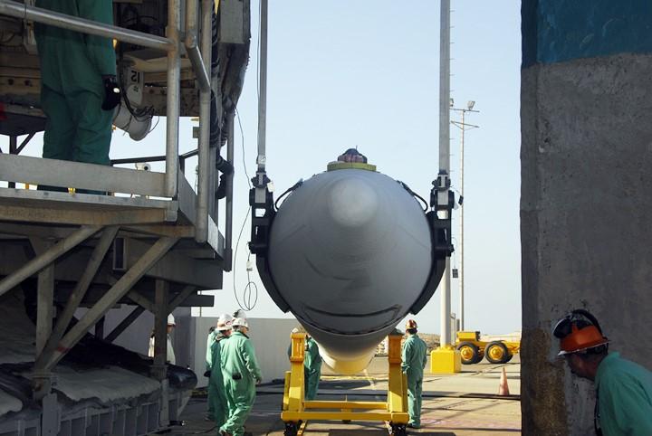
CAPE CANAVERAL, Fla. – The latest Geostationary Operational Environmental Satellite, or GOES, is lifted from the transporter and moved into the Astrotech payload processing facility in Titusville, Fla. Developed by NASA for the National Oceanic and Atmospheric Administration, or NOAA, the GOES-O satellite is targeted to launch April 28 onboard a United Launch Alliance Delta IV expendable launch vehicle. Once in orbit, GOES-O will be designated GOES-14, and NASA will provide on-orbit checkout and then transfer operational responsibility to NOAA. GOES-O will be placed in on-orbit storage as a replacement for an older GOES satellite. The satellite will undergo final testing of the imaging system, instrumentation, communications and power systems. Photo credit: NASA/Kim Shiflett
CAPE CANAVERAL, Fla. – At the Astrotech payload processing facility in Titusville, Fla., technicians at right and left examine the GOES-O satellite as it rotates on the stand. The latest Geostationary Operational Environmental Satellite, GOES-O was developed by NASA for the National Oceanic and Atmospheric Administration, or NOAA. Once in orbit, GOES-O will be designated GOES-14, and NASA will provide on-orbit checkout and then transfer operational responsibility to NOAA. The GOES-O satellite is targeted to launch April 28 onboard a United Launch Alliance Delta IV expendable launch vehicle. Photo credit: NASA/Kim Shiflett
CAPE CANAVERAL, Fla. – In the Astrotech payload processing facility in Titusville, Fla., the GOES-O satellite is rotated on a stand toward a vertical position after blanket inspection. The latest Geostationary Operational Environmental Satellite, GOES-O was developed by NASA for the National Oceanic and Atmospheric Administration, or NOAA. Once in orbit, GOES-O will be designated GOES-14, and NASA will provide on-orbit checkout and then transfer operational responsibility to NOAA. The GOES-O satellite is targeted to launch April 28 onboard a United Launch Alliance Delta IV expendable launch vehicle. Photo credit: NASA/Jim Grossmann
CAPE CANAVERAL, Fla. – At the Astrotech payload processing facility in Titusville, Fla., technicians complete the rotation of the GOES-O satellite on the stand. The latest Geostationary Operational Environmental Satellite, GOES-O was developed by NASA for the National Oceanic and Atmospheric Administration, or NOAA. Once in orbit, GOES-O will be designated GOES-14, and NASA will provide on-orbit checkout and then transfer operational responsibility to NOAA. The GOES-O satellite is targeted to launch April 28 onboard a United Launch Alliance Delta IV expendable launch vehicle. Photo credit: NASA/Kim Shiflett
CAPE CANAVERAL, Fla. – In the Astrotech payload processing facility in Titusville, Fla., the GOES-O satellite is rotated on a stand for blanket inspection. The latest Geostationary Operational Environmental Satellite, GOES-O was developed by NASA for the National Oceanic and Atmospheric Administration, or NOAA. Once in orbit, GOES-O will be designated GOES-14, and NASA will provide on-orbit checkout and then transfer operational responsibility to NOAA. The GOES-O satellite is targeted to launch April 28 onboard a United Launch Alliance Delta IV expendable launch vehicle. Photo credit: NASA/Jim Grossmann
CAPE CANAVERAL, Fla. – At the Astrotech payload processing facility in Titusville, Fla., a technician checks the GOES-O satellite as it begins rotating on the stand. The latest Geostationary Operational Environmental Satellite, GOES-O was developed by NASA for the National Oceanic and Atmospheric Administration, or NOAA. Once in orbit, GOES-O will be designated GOES-14, and NASA will provide on-orbit checkout and then transfer operational responsibility to NOAA. The GOES-O satellite is targeted to launch April 28 onboard a United Launch Alliance Delta IV expendable launch vehicle. Photo credit: NASA/Kim Shiflett
CAPE CANAVERAL, Fla. – In the Astrotech payload processing facility in Titusville, Fla., the GOES-O satellite is rotated on a stand for blanket inspection. The latest Geostationary Operational Environmental Satellite, GOES-O was developed by NASA for the National Oceanic and Atmospheric Administration, or NOAA. Once in orbit, GOES-O will be designated GOES-14, and NASA will provide on-orbit checkout and then transfer operational responsibility to NOAA. The GOES-O satellite is targeted to launch April 28 onboard a United Launch Alliance Delta IV expendable launch vehicle. Photo credit: NASA/Jim Grossmann
CAPE CANAVERAL, Fla. – In the Astrotech payload processing facility in Titusville, Fla., the GOES-O satellite is rotated on a stand for blanket inspection. The latest Geostationary Operational Environmental Satellite, GOES-O was developed by NASA for the National Oceanic and Atmospheric Administration, or NOAA. Once in orbit, GOES-O will be designated GOES-14, and NASA will provide on-orbit checkout and then transfer operational responsibility to NOAA. The GOES-O satellite is targeted to launch April 28 onboard a United Launch Alliance Delta IV expendable launch vehicle. Photo credit: NASA/Jim Grossmann
CAPE CANAVERAL, Fla. – At the Astrotech payload processing facility in Titusville, Fla., technicians examine the progress of the GOES-O satellite as it rotates on the stand. The latest Geostationary Operational Environmental Satellite, GOES-O was developed by NASA for the National Oceanic and Atmospheric Administration, or NOAA. Once in orbit, GOES-O will be designated GOES-14, and NASA will provide on-orbit checkout and then transfer operational responsibility to NOAA. The GOES-O satellite is targeted to launch April 28 onboard a United Launch Alliance Delta IV expendable launch vehicle. Photo credit: NASA/Kim Shiflett
CAPE CANAVERAL, Fla. – In the Astrotech payload processing facility in Titusville, Fla., the GOES-O satellite has been rotated on its stand to a vertical position after blanket inspection. The latest Geostationary Operational Environmental Satellite, GOES-O was developed by NASA for the National Oceanic and Atmospheric Administration, or NOAA. Once in orbit, GOES-O will be designated GOES-14, and NASA will provide on-orbit checkout and then transfer operational responsibility to NOAA. The GOES-O satellite is targeted to launch April 28 onboard a United Launch Alliance Delta IV expendable launch vehicle. Photo credit: NASA/Jim Grossmann
CAPE CANAVERAL, Fla. – In the Astrotech payload processing facility in Titusville, Fla., the GOES-O satellite is rotated on a stand for blanket inspection. The latest Geostationary Operational Environmental Satellite, GOES-O was developed by NASA for the National Oceanic and Atmospheric Administration, or NOAA. Once in orbit, GOES-O will be designated GOES-14, and NASA will provide on-orbit checkout and then transfer operational responsibility to NOAA. The GOES-O satellite is targeted to launch April 28 onboard a United Launch Alliance Delta IV expendable launch vehicle. Photo credit: NASA/Jim Grossmann
CAPE CANAVERAL, Fla. – In the Astrotech payload processing facility in Titusville, Fla., the latest Geostationary Operational Environmental Satellite, or GOES, is lowered onto the floor. Developed by NASA for the National Oceanic and Atmospheric Administration, or NOAA, the GOES-O satellite is targeted to launch April 28 onboard a United Launch Alliance Delta IV expendable launch vehicle. Once in orbit, GOES-O will be designated GOES-14, and NASA will provide on-orbit checkout and then transfer operational responsibility to NOAA. GOES-O will be placed in on-orbit storage as a replacement for an older GOES satellite. The satellite will undergo final testing of the imaging system, instrumentation, communications and power systems. Photo credit: NASA/Kim Shiflett
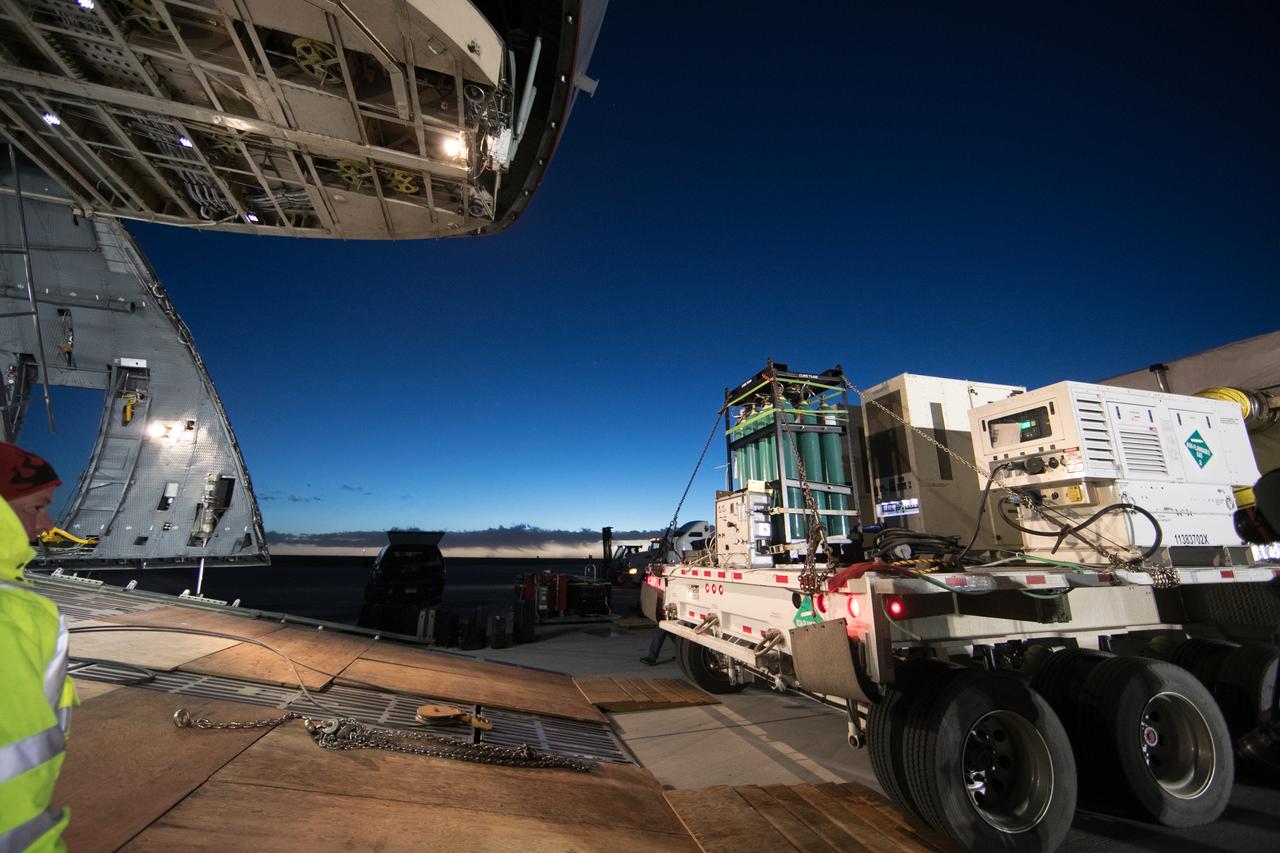
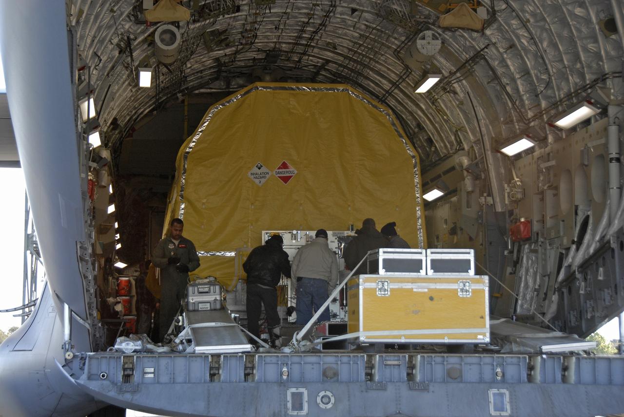
At Buckley Air Force Base in Aurora, Colorado, NOAA's Geostationary Operational Environmental Satellite-S (GOES-S) is being loaded into the cargo hold of a U.S. Air Force C-5M super Galaxy cargo aircraft. GOES-S will be flown to NASA's Kennedy Space Center in Florida. After it arrives at Kennedy's Shuttle Landing Facility, it will be offloaded and transported to the Astrotech Space Operations facility in Titusville, Florida, to prepare it for launch. GOES-S is the second in a series of four advanced geostationary weather satellites. The GOES-R series - consisting of the GOES-R, GOES-S, GOES-T and GOES-U spacecraft - will significantly improve the detection and observation of environmental phenomena that directly affect public safety, protection of property and the nation's economic health and prosperity. GOES-S is slated to launch March 1, 2018 aboard a United Launch Alliance Atlas V rocket from Cape Canaveral Air Force Station in Florida.

At Buckley Air Force Base in Aurora, Colorado, NOAA's Geostationary Operational Environmental Satellite-S (GOES-S) is being loaded into the cargo hold of a U.S. Air Force C-5M super Galaxy cargo aircraft. GOES-S will be flown to NASA's Kennedy Space Center in Florida. After it arrives at Kennedy's Shuttle Landing Facility, it will be offloaded and transported to the Astrotech Space Operations facility in Titusville, Florida, to prepare it for launch. GOES-S is the second in a series of four advanced geostationary weather satellites. The GOES-R series - consisting of the GOES-R, GOES-S, GOES-T and GOES-U spacecraft - will significantly improve the detection and observation of environmental phenomena that directly affect public safety, protection of property and the nation's economic health and prosperity. GOES-S is slated to launch March 1, 2018 aboard a United Launch Alliance Atlas V rocket from Cape Canaveral Air Force Station in Florida.
At Buckley Air Force Base in Aurora, Colorado, NOAA's Geostationary Operational Environmental Satellite-S (GOES-S) is being loaded into the cargo hold of a U.S. Air Force C-5M super Galaxy cargo aircraft. GOES-S will be flown to NASA's Kennedy Space Center in Florida. After it arrives at Kennedy's Shuttle Landing Facility, it will be offloaded and transported to the Astrotech Space Operations facility in Titusville, Florida, to prepare it for launch. GOES-S is the second in a series of four advanced geostationary weather satellites. The GOES-R series - consisting of the GOES-R, GOES-S, GOES-T and GOES-U spacecraft - will significantly improve the detection and observation of environmental phenomena that directly affect public safety, protection of property and the nation's economic health and prosperity. GOES-S is slated to launch March 1, 2018 aboard a United Launch Alliance Atlas V rocket from Cape Canaveral Air Force Station in Florida.

At Buckley Air Force Base in Aurora, Colorado, NOAA's Geostationary Operational Environmental Satellite-S (GOES-S) is being loaded into the cargo hold of a U.S. Air Force C-5M super Galaxy cargo aircraft. GOES-S will be flown to NASA's Kennedy Space Center in Florida. After it arrives at Kennedy's Shuttle Landing Facility, it will be offloaded and transported to the Astrotech Space Operations facility in Titusville, Florida, to prepare it for launch. GOES-S is the second in a series of four advanced geostationary weather satellites. The GOES-R series - consisting of the GOES-R, GOES-S, GOES-T and GOES-U spacecraft - will significantly improve the detection and observation of environmental phenomena that directly affect public safety, protection of property and the nation's economic health and prosperity. GOES-S is slated to launch March 1, 2018 aboard a United Launch Alliance Atlas V rocket from Cape Canaveral Air Force Station in Florida.
NOAA's Geostationary Operational Environmental Satellite-S (GOES-S) will be loaded into a U.S. Air Force C-5M Super Galaxy cargo aircraft and flown to NASA's Kennedy Space Center in Florida. After it arrives at Kennedy's Shuttle Landing Facility, it will be offloaded and transported to the Astrotech Space Operations facility in Titusville, Florida, to prepare it for launch. GOES-S is the second in a series of four advanced geostationary weather satellites. The GOES-R series - consisting of the GOES-R, GOES-S, GOES-T and GOES-U spacecraft - will significantly improve the detection and observation of environmental phenomena that directly affect public safety, protection of property and the nation's economic health and prosperity. GOES-S is slated to launch March 1, 2018 aboard a United Launch Alliance Atlas V rocket from Cape Canaveral Air Force Station in Florida.
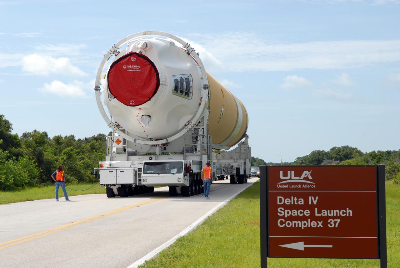
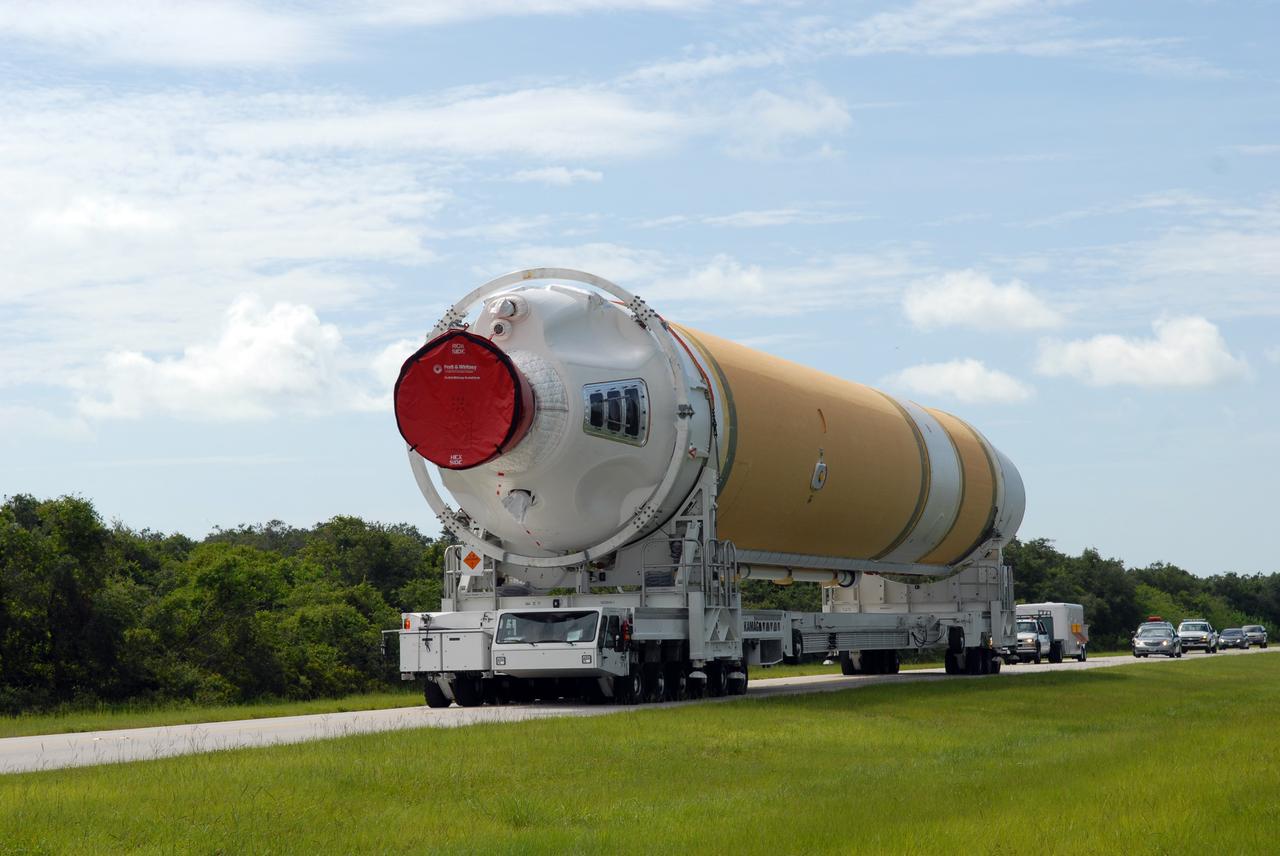
CAPE CANAVERAL, Fla. – The United Launch Alliance Delta IV first stage is being transported to the Horizontal Integration Facility on Cape Canaveral Air Force Station's Launch Complex 37. The Delta IV is the launch vehicle for the latest Geostationary Operational Environmental Satellite, known as GOES-P, developed by NASA for the National Oceanic and Atmospheric Administration, or NOAA. Photo credit: NASA/Jim Grossmann
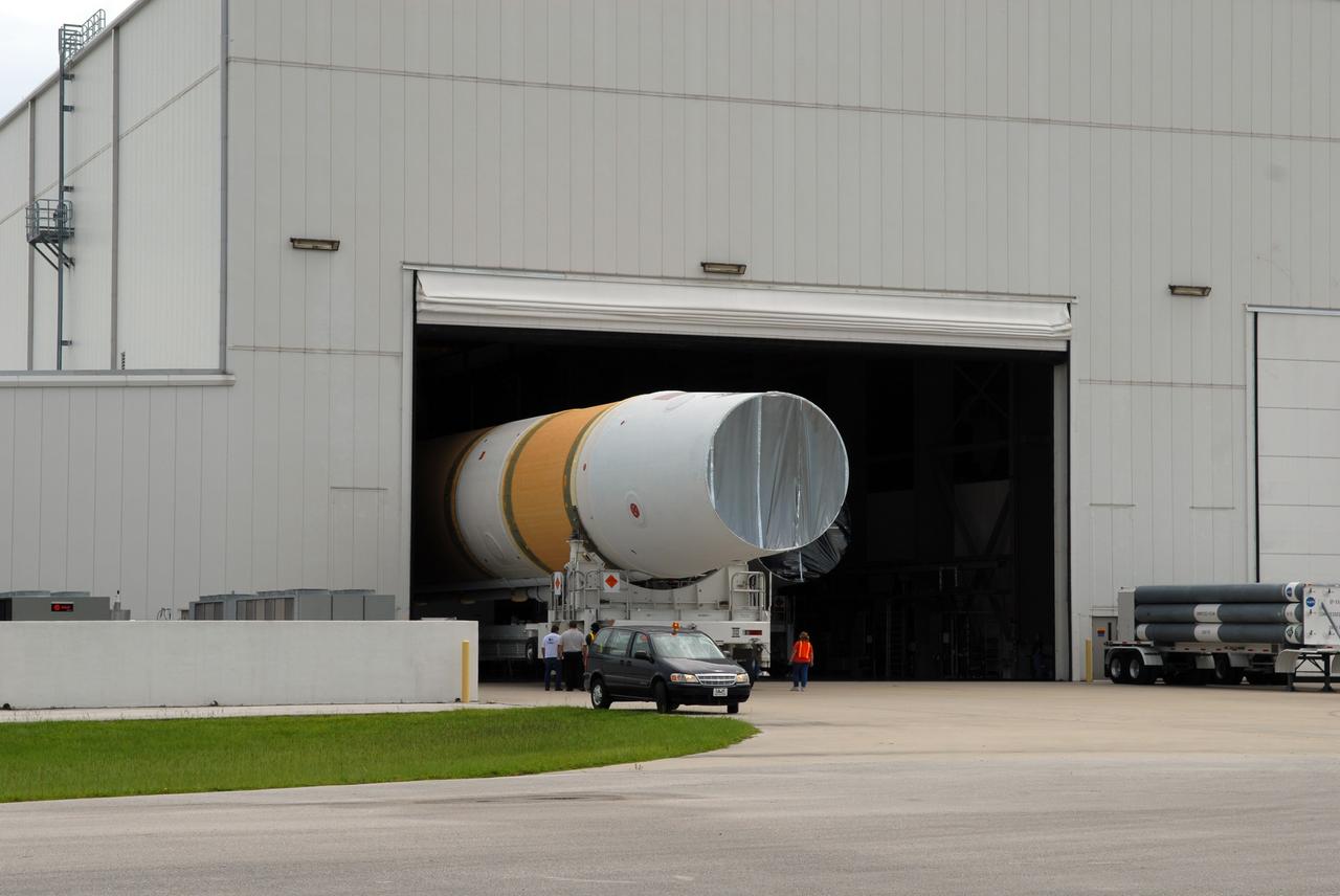
CAPE CANAVERAL, Fla. – The United Launch Alliance Delta IV first stage rolls into the Horizontal Integration Facility on Cape Canaveral Air Force Station's Launch Complex 37. The Delta IV is the launch vehicle for the latest Geostationary Operational Environmental Satellite, known as GOES-P, developed by NASA for the National Oceanic and Atmospheric Administration, or NOAA. Photo credit: NASA/Jim Grossmann
KENNEDY SPACE CENTER, FLA. - On Launch Complex 37 at Cape Canaveral Air Force Station in Florida, the GOES-N spacecraft is lowered toward the second stage of the Boeing Delta IV rocket for mating. GOES-N is the latest in a series of Geostationary Operational Environmental Satellites for NOAA and NASA, providing continuous monitoring necessary for intensive data analysis. GOES-N is scheduled to be launched May 18 in an hour-long window between 6:14 and 7:14 p.m. EDT. Photo credit: NASA/Charisse Nahser
CAPE CANAVERAL, Fla. – The United Launch Alliance Delta IV first stage is being transported to the Horizontal Integration Facility on Cape Canaveral Air Force Station's Launch Complex 37. The Delta IV is the launch vehicle for the latest Geostationary Operational Environmental Satellite, known as GOES-P, developed by NASA for the National Oceanic and Atmospheric Administration, or NOAA. Photo credit: NASA/Jim Grossmann
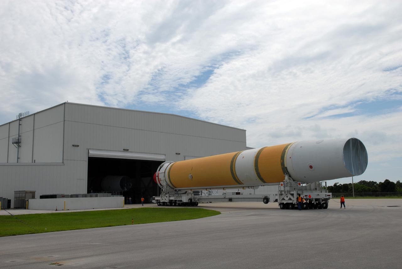
CAPE CANAVERAL, Fla. – The United Launch Alliance Delta IV first stage rolls toward the Horizontal Integration Facility on Cape Canaveral Air Force Station's Launch Complex 37. The Delta IV is the launch vehicle for the latest Geostationary Operational Environmental Satellite, known as GOES-P, developed by NASA for the National Oceanic and Atmospheric Administration, or NOAA. Photo credit: NASA/Jim Grossmann
VANDENBERG AIR FORCE BASE, Calif. -- In the mobile service tower on Space Launch Complex 2 at Vandenberg Air Force Base in California, the NOAA-N Prime spacecraft is closed out for encapsulation and installation on the launch vehicle, a Delta II rocket. NOAA-N Prime is the latest polar-orbiting operational environmental weather satellite developed by NASA for the National Oceanic and Atmospheric Administration. The satellite is scheduled to launch Feb. 4 aboard the Delta II from Vandenberg Air Force Base. Photo credit: NASA/VAFB
CAPE CANAVERAL, Fla. – On Launch Complex 37 at Cape Canaveral Air Force Station in Florida, the GOES-O satellite is fitted with a sling to lift it into the mobile service tower where it will be mated with the United Launch Alliance Delta IV expendable launch vehicle. The GOES-O satellite is targeted to launch no earlier than June 26. The latest Geostationary Operational Environmental Satellite, GOES-O was developed by NASA for the National Oceanic and Atmospheric Administration, or NOAA. The GOES satellites continuously provide observations of 60 percent of the Earth including the continental United States, providing weather monitoring and forecast operations as well as a continuous and reliable stream of environmental information and severe weather warnings. Once in orbit, GOES-O will be designated GOES-14, and NASA will provide on-orbit checkout and then transfer operational responsibility to NOAA. Photo credit: NASA/Jack Pfaller
CAPE CANAVERAL, Fla. – The latest Geostationary Operational Environmental Satellite, or GOES, is prepared for offloading from the C-17 military cargo aircraft at the Shuttle Landing Facility at NASA's Kennedy Space Center in Florida. Developed by NASA for the National Oceanic and Atmospheric Administration, or NOAA, the GOES-O satellite is targeted to launch April 28 onboard a United Launch Alliance Delta IV expendable launch vehicle. Once in orbit, GOES-O will be designated GOES-14, and NASA will provide on-orbit checkout and then transfer operational responsibility to NOAA. GOES-O will be placed in on-orbit storage as a replacement for an older GOES satellite. After arriving, the satellite was transported to Astrotech in Titusville, Fla., where final testing of the imaging system, instrumentation, communications and power systems will be performed. Photo credit: NASA/Kim Shiflett
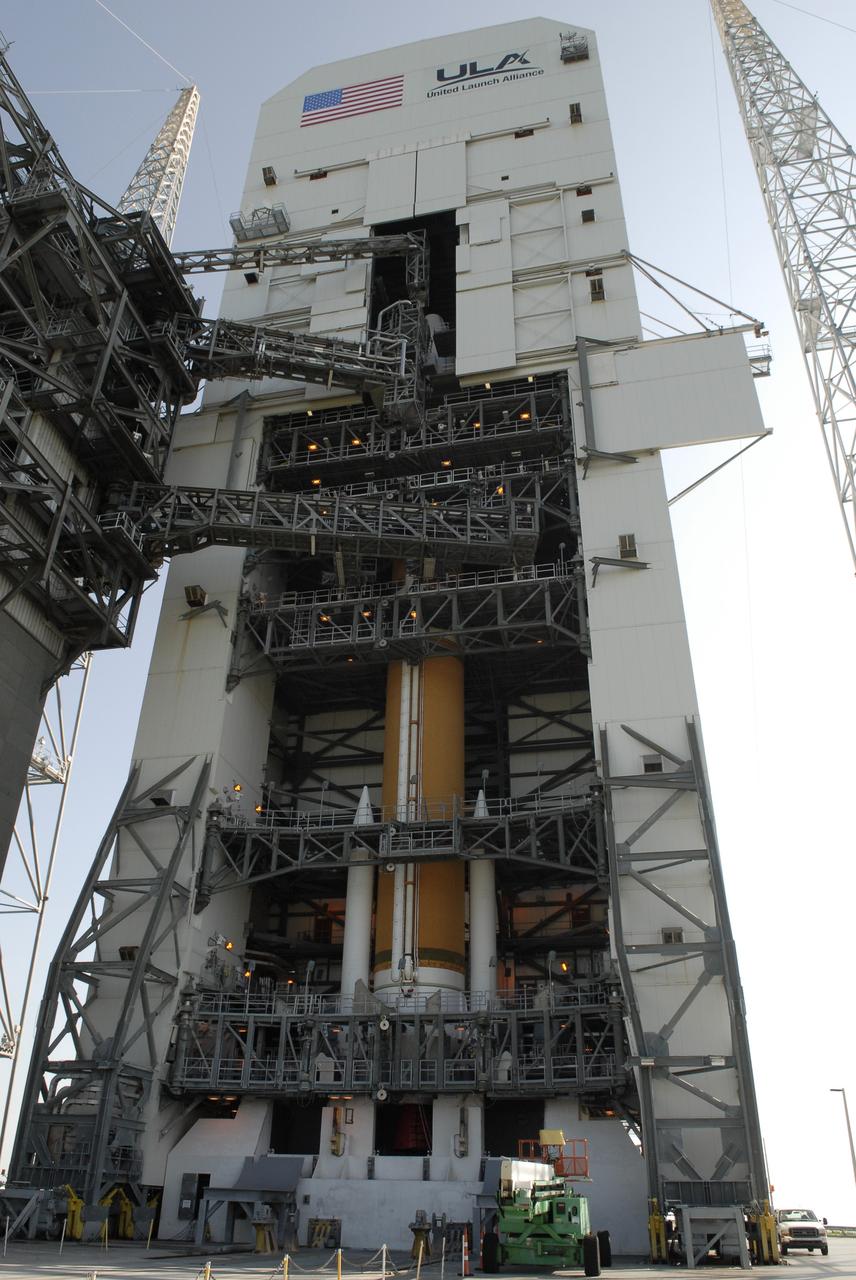
CAPE CANAVERAL, Fla. – On Launch Complex 37 at Cape Canaveral Air Force Station in Florida, the GOES-O satellite is seen in the top of the mobile service tower, where it has been mated with the United Launch Alliance Delta IV expendable launch vehicle below. The GOES-O satellite is targeted to launch June 26. The latest Geostationary Operational Environmental Satellite, GOES-O was developed by NASA for the National Oceanic and Atmospheric Administration, or NOAA. The GOES satellites continuously provide observations of 60 percent of the Earth including the continental United States, providing weather monitoring and forecast operations as well as a continuous and reliable stream of environmental information and severe weather warnings. Once in orbit, GOES-O will be designated GOES-14, and NASA will provide on-orbit checkout and then transfer operational responsibility to NOAA. Photo credit: NASA/Kim Shiflett
CAPE CANAVERAL, Fla. – The latest Geostationary Operational Environmental Satellite, or GOES, arrives on a C-17 military cargo aircraft at the Shuttle Landing Facility at NASA's Kennedy Space Center in Florida from its manufacturing plant in El Segundo, Calif. Developed by NASA for the National Oceanic and Atmospheric Administration, or NOAA, the GOES-O satellite is targeted to launch April 28 onboard a United Launch Alliance Delta IV expendable launch vehicle. Once in orbit, GOES-O will be designated GOES-14, and NASA will provide on-orbit checkout and then transfer operational responsibility to NOAA. GOES-O will be placed in on-orbit storage as a replacement for an older GOES satellite. After arriving, the satellite was transported to Astrotech in Titusville, Fla., where final testing of the imaging system, instrumentation, communications and power systems will be performed. Photo credit: NASA/Kim Shiflett
CAPE CANAVERAL, Fla. – On Launch Complex 37 at Cape Canaveral Air Force Station in Florida, the GOES-O satellite is being prepared for its lift into the mobile service tower where it will be mated with the United Launch Alliance Delta IV expendable launch vehicle. The GOES-O satellite is targeted to launch no earlier than June 26. The latest Geostationary Operational Environmental Satellite, GOES-O was developed by NASA for the National Oceanic and Atmospheric Administration, or NOAA. The GOES satellites continuously provide observations of 60 percent of the Earth including the continental United States, providing weather monitoring and forecast operations as well as a continuous and reliable stream of environmental information and severe weather warnings. Once in orbit, GOES-O will be designated GOES-14, and NASA will provide on-orbit checkout and then transfer operational responsibility to NOAA. Photo credit: NASA/Jack Pfaller