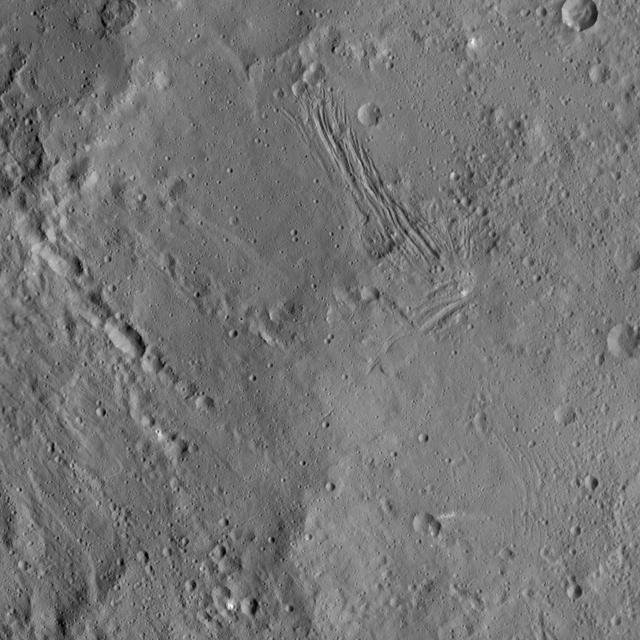
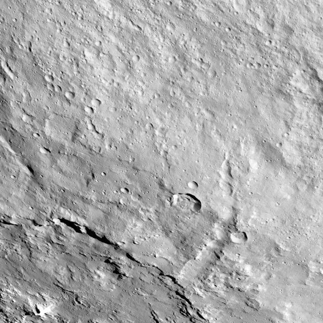
This image of Nar Sulcus in Yalode Crater was obtained by NASA's Dawn spacecraft on May 19, 2018 from an altitude of about 875 miles (1410 kilometers). Nar Sulcus is located at about 42 degrees south in latitude and 280 degrees east in longitude. https://photojournal.jpl.nasa.gov/catalog/PIA22469
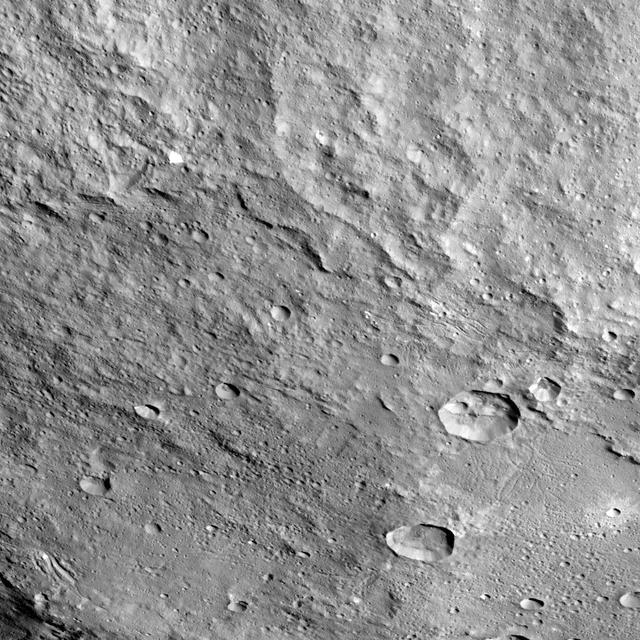
This image shows the eastern part of a feature called Nar Sulcus in Yalode Crater on dwarf planet Ceres, as seen by NASA's Dawn spacecraft. The term "sulcus" (plural: sulci) describes terrain with long, parallel fractures. Sulci are very common on icy moons -- for example, at the south pole of Enceladus, as seen in PIA11686. Nar Sulcus, 31 miles (50 kilometer) long, is the only feature of its kind identified on Ceres. It may point to an episode of tectonic deformation resulting from the evolution of the crater, which is the second largest on Ceres. The impact that formed Yalode heated Ceres' mixture of ice, rock and salt, perhaps causing a large volume to melt. When this material subsequently refroze, it would expand (just as water does when it turns to ice in your freezer). That may have created stresses that fractured the ground, forming Nar Sulcus. The name "Nar Sulcus" refers to the Azerbaijani festival of the pomegranate harvest. That festival is held in October and November in the city of Goychay, center of pomegranate cultivation in Azerbaijan. Dawn took this image on August 15, 2016, from its low-altitude mapping orbit, at a distance of about 240 miles (385 kilometers) above the surface. The image resolution is 120 feet (35 meters) per pixel. https://photojournal.jpl.nasa.gov/catalog/PIA21400
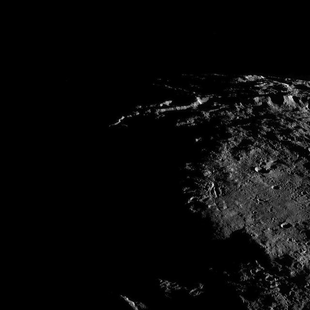
Sunlit cliffs tower above Yalode Crater on Ceres in this shadowy perspective view. At 152 miles (260 kilometers) in diameter, Yalode is one of Ceres' largest craters. A fissure called Nar Sulcus is seen just right of center. Dawn took this image on Oct. 19, 2016, from its second extended-mission science orbit (XMO2), at a distance of about 920 miles (1,480 kilometers) above the surface. The image resolution is about 460 feet (140 meters) per pixel. http://photojournal.jpl.nasa.gov/catalog/PIA21236
This image from NASA's Dawn spacecraft shows the large craters Urvara (top) and Yalode (bottom) on dwarf planet Ceres. These features are so big that they must be observed from high altitudes in order to fit in the frame of a single image. Urvara is (101 miles (163 kilometers) in diameter, while Yalode is 162 miles (260 kilometers) in diameter. The two giant craters were formed at different times. Yalode is almost 1 billion years older than Urvara, which is about 120 million to 140 million years old. Yalode's relatively smooth floor indicates Ceres' crust material became close to -- or even reached -- the melting temperature of ice as a consequence of the heat generated by the impact. On the other hand, the smaller Urvara has rougher terrain. This suggests Urvara had either a lower temperature increase from the impact, or a colder crust temperature at the time of the crater's formation, or a combination of the two. Indeed, Ceres' interior was warmer in the past, and has been slowly cooling as its supply of radioactive isotopes, whose decay represents Ceres' main heat source, has been decreasing over time. This picture also reveals geological details such, as the feature Nar Sulcus inside Yalode and a central peak in Urvara. Urvara is named after the Indian and Iranian deity of plants and fields. Yalode is named for the Dahomey goddess, worshipped by women at the harvest rites. This image was obtained by NASA's Dawn spacecraft on June 9, 2015. The spacecraft was then in its survey orbit (2,700 miles, 4,400 kilometers above the surface), when the footprint of Dawn's framing camera on Ceres' surface was about 260 miles (420 kilometers) across on Ceres' surface. The resolution is 1,400 feet (410 meters) per pixel. The central coordinates of the picture are 43 degrees south latitude, 278 degrees east in longitude. https://photojournal.jpl.nasa.gov/catalog/PIA21917
This image from NASA's Dawn spacecraft shows the northeastern rim of Urvara Crater on Ceres at lower left. To the right of the crater, the long, narrow feature that appears to jut out toward the north is called Pongal Catena, which is about 60 miles (96 km) long. Catenae are large grooves or troughs that can have various origins. They refer to chains of closely connected craters formed by a series of impacts, as found on Jupiter's moon Ganymede. They can also represent large faults created by internal forces, for example in this example found on Mars. The mechanism that formed Pongal Catena is not understood yet, but it likely formed as a consequence of the stresses generated by the large impacts that resulted in the formation of the Urvara and Yalode craters. Pongal catena is one of several types of fractures found in this region that reflect a complex history. A feature called Nar Sulcus is another example. Studying the geometry of these features and their relationships can help shed light on the nature of Ceres' subsurface. This image was obtained on September 28, 2015, from an altitude of about 915 miles (1,470 kilometers). Pongal Catena is centered at 37.4 degrees south latitude, 267.7 degrees east longitude. This feature gets its name from the Tamil (Sri Lanka and southern India) harvest festival observed in mid-January. It is a time for giving thanks to nature, and we thank Ceres for all the wonders it has offered us so far. https://photojournal.jpl.nasa.gov/catalog/PIA21408
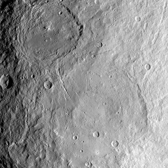
Yalode crater is so large -- at 162 miles, 260 kilometers in diameter -- that a variety of vantage points is necessary to understand its geological context. This view of the northern portion of Yalode is one of many images NASA's Dawn spacecraft has taken of this crater. The large impact that formed the crater likely involved a lot of heat, which explains the relatively smooth crater floor punctuated by smaller craters. A couple of larger craters in Yalode have polygonal shapes. This type of crater shape is frequently found on Ceres and may be indicative of extensive underground fractures. The larger crater to the right of center in this image is called Lono (12 miles, 20 kilometers in diameter) and the one below it is called Besua (11 miles, 17 kilometers). Some of the small craters are accompanied by ejecta blankets that are more reflective than their surroundings. The strange Nar Sulcus fractures can be seen in the bottom left corner of the picture. Linear features seen throughout the image may have formed when material collapsed above empty spaces underground. These linear features include linear chains of craters called catenae. Dawn took this image on September 27, 2015, from 915 miles (1,470 kilometers) altitude. The center coordinates of this image are 32 degrees south latitude and 300 degrees east longitude. Yalode gets its name from a goddess worshipped by women at the harvest rites in the Dahomey culture of western Africa. Besua takes its name from the Egyptian grain god, and Lono from the Hawaiian god of agriculture. https://photojournal.jpl.nasa.gov/catalog/PIA21410

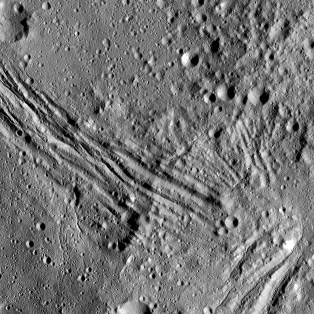
This collage shows some of the most interesting geological sites that NASA's Dawn spacecraft has revealed at dwarf planet Ceres. Images were acquired with the spacecraft's framing camera during various phases of the mission: Survey orbit at a distance of about 2,700 miles (4,400 kilometers); high-altitude mapping orbit (HAMO) at a distance of 915 miles (1,470 kilometers) from Ceres; and low-altitude mapping orbit (LAMO) at an altitude of 240 miles (385 kilometers). In the first row, from left to right: Ceres in shown in false color, roughly centered on Occator Crater, home of the brightest area on Ceres. This picture combines color images obtained by Dawn in its survey orbit. Red corresponds to a wavelength range around 980 nanometers (near infrared), green to a wavelength range around 750 nanometers (red, visible light) and blue to a wavelength range of around 430 nanometers (blue, visible light). This picture illustrates the diversity of terrains on Ceres where the bluish material points to recently emplaced material and the brownish background material is associated with older terrains. Juling Crater (12 miles, 20 kilometers in diameter) as seen in LAMO. Central coordinates are 36 degrees south latitude, 168 degrees east longitude. It is named after the Sakai/Orang Asli (Malaysia) spirit of the crops. This crater displays evidence for the presence of ice -- for example, in the form of a large flow feature seen at the top of the image. Oxo Crater (6 miles, 10 kilometers in diameter) as seen in LAMO. Center coordinates are 42 degrees north latitude, 0 degrees east longitude. It is named after the god of agriculture in Afro-Brazilian beliefs of Yoruba derivation. Oxo hosts the first site at which Dawn detected ice on Ceres, exposed by a landslide. Ahuna Mons is not only a volcano, but also the tallest mountain on Ceres. It is about 2.5 miles (4 kilometers) high and 11 miles (17 kilometers) wide. Center coordinates are 10 degrees south latitude, 316 degrees east longitude. This view combines images obtained in LAMO in blue (430 nanometers), green (750 nanometers) and infrared (980 nanometers) color filters. Ahuna is named after the Sumi tribe (Nagaland, northeastern India) traditional post-harvest thanksgiving festival. Second Row Occator Crater (57 miles, 92 kilometers across) is seen in LAMO images. Center coordinates are 20 degrees north latitude, 239 degrees east longitude. Named after the Roman agricultural deity of the harrowing. This image shows a "Type I" flow feature with a thick "toe" typical of rock glaciers and icy landslides on Earth as viewed in LAMO. The flow feature, found in Ghanan Crater (77 degrees north latitude, 31 degrees east longitude), is one of the most voluminous on Ceres. Enhanced color view of Haulani Crater (21 miles, 34 kilometers in diameter) in color observed in HAMO. Central coordinates: 6 degrees north latitude, 11 degrees east longitude. Named after the Hawaiian plant goddess. Kokopelli Crater (21 miles, 34 kilometers in diameter) seen in LAMO. Central coordinates: 18 degrees north latitude, 125 degrees east longitude. Named after the Pueblo (SW USA) fertility deity, who presides over agriculture. This crater displays a nice arrangement of scarps that likely formed when the crater partly collapsed during its formation. Third Row Central region of Occator Crater, called Cerealia Facula, seen in color. The facula -- or "bright spot" -- is about 9 miles (14 kilometers) in diameter. Center coordinates: 20 N, 240 E. Cerealia refers to the major festival in Ancient Rome that celebrates the grain goddess Ceres (8 days in mid- to late April). The view was produced by combining the highest resolution images of Occator obtained in LAMO (at image scales of 35 meters, or 115 feet, per pixel) with color images obtained in HAMO (at image scales of 135 meters, or about 440 feet, per pixel). The three images used to produce the color were taken using filters centered at 430, 750 and 980 nanometers (the last being slightly beyond the range of human vision, in the near-infrared). North part of Nar Sulcus seen in LAMO. The full feature is about 39 miles (63 km) in length and is located around 42 degrees south latitude, 280 degrees east longitude. Nar is a Azerbaijani festival of pomegranate harvest held in October-November in Goychay city, center of pomegranate cultivation in Azerbaijan. A sulcus is a set of parallel furrows or ridges. Ikapati Crater (31 miles, 50 kilometers in diameter) seen in LAMO. Central coordinates: 34 degrees north latitude, 46 degrees east longitude. Ikapati is named after the Philippine goddess of the cultivated lands. The crater has a smooth floor, probably because heat from the impact that formed Ikapati caused ice in the ground to melt, and then refreeze. This view of Ceres, taken in LAMO, shows an area located at approximately 86 degrees south longitude, 177 degrees east longitude. This part of Ceres, near the south pole, has such long shadows because, from the perspective of this location, the sun is near the horizon. At the time this image was taken, the sun was 4 degrees north of the equator. If you were standing this close to Ceres' south pole, the sun would never get high in the sky during the course of a nine-hour Cerean day. https://photojournal.jpl.nasa.gov/catalog/PIA22090