Nearside Spectacular
Nearside of the Moon
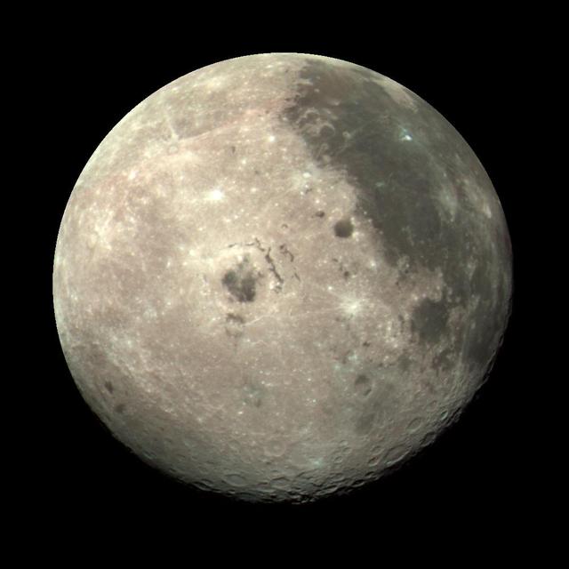
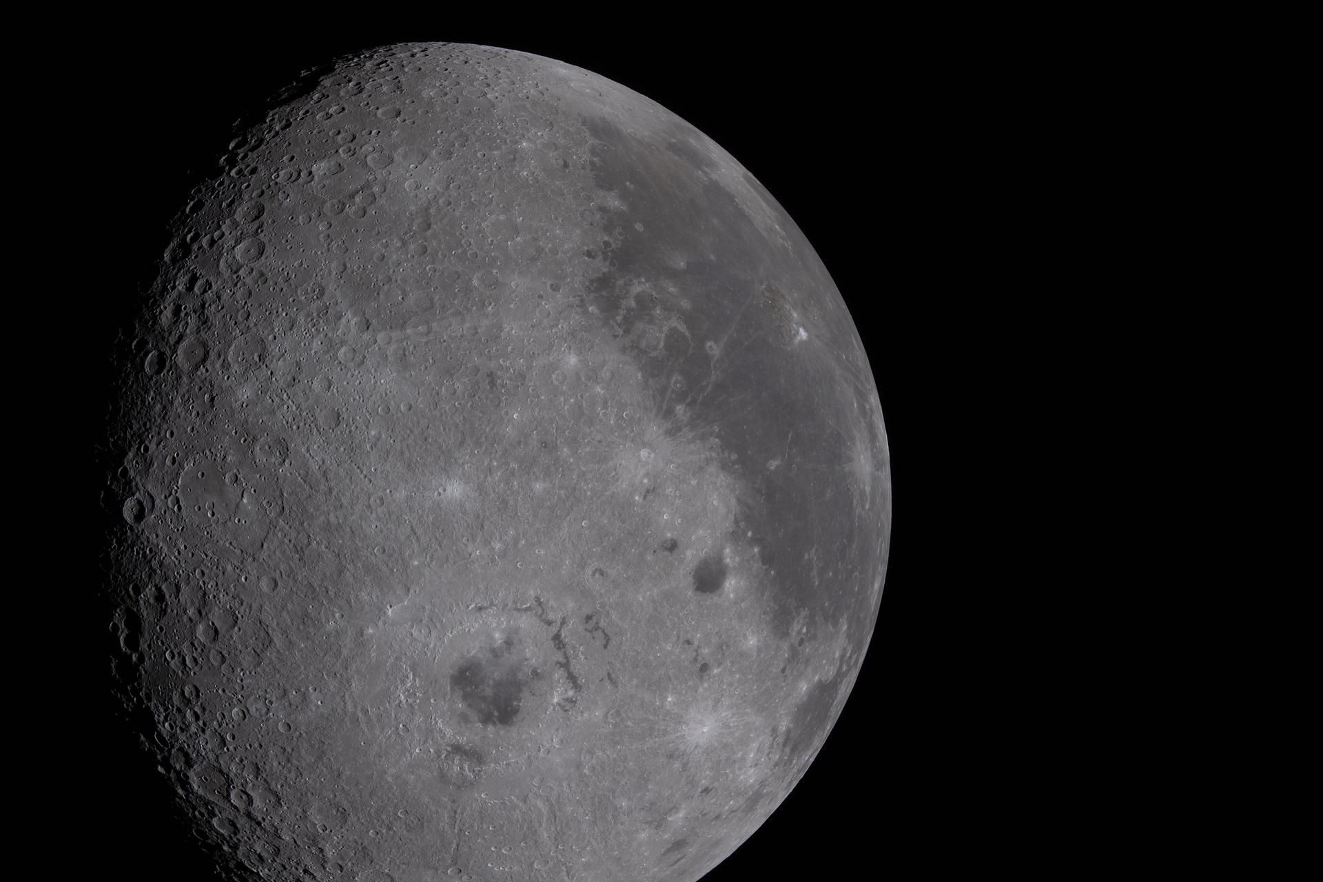
art002e009057 (April 4, 2026) - A view of the nearside of the Moon, the side we always see from Earth. Some of the far side is visible, as well, on the left edge, just beyond the black patch that is Orientale basin, a nearly 600-mile-wide crater that straddles the Moon’s near and far sides and is partly visible from Earth. The dark areas in the center and right side of the disk are ancient lava flows, which are unique to the near side of the Moon. The white dot at the bottom of the disk, with white rays shooting out from it, is Tycho crater, one of the younger craters on the Moon at 108 million years old.
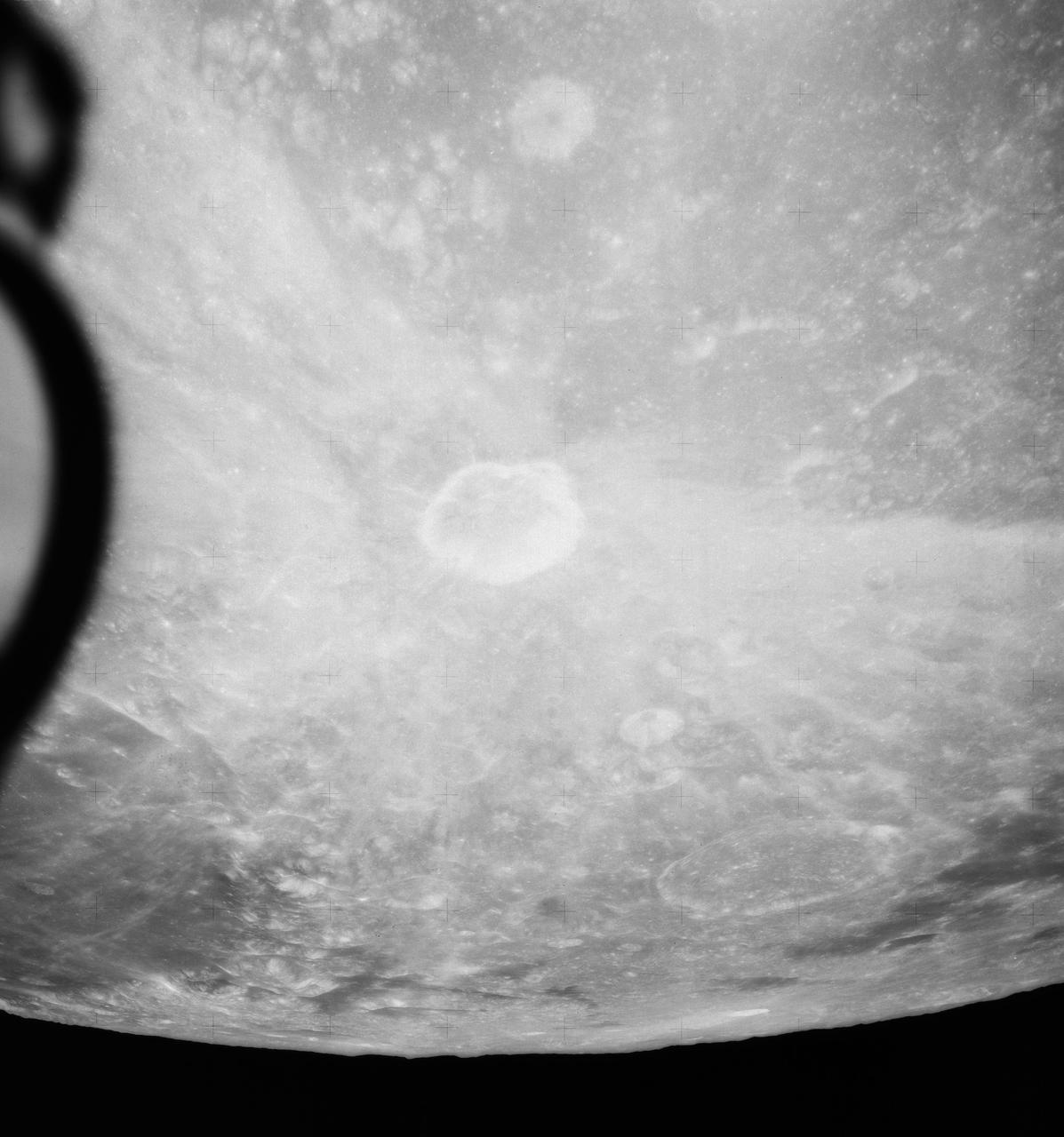
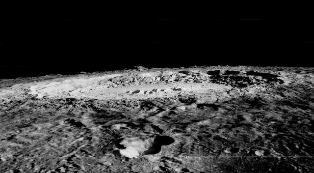
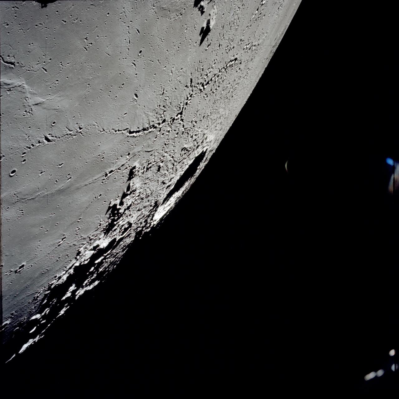
AS16-120-19237 (April 1972) --- An oblique view of a portion of the lunar nearside as photographed from the Apollo 16 spacecraft in lunar orbit. The small, bright crater is Lassell D at the northeastern edge of Mare Nubium (Sea of Clouds). The area seen in this picture is immediately west of Lassell C Crater, southwest of Guoricke Crater, and southwest of Davy Crater.

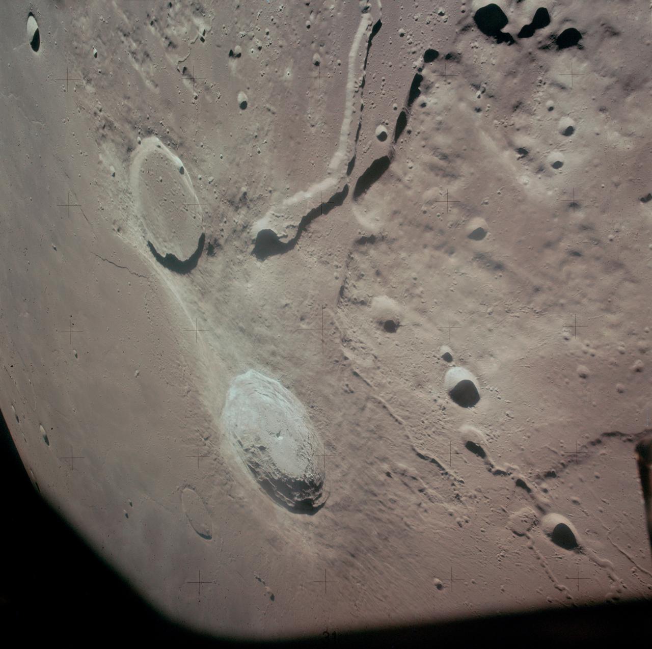
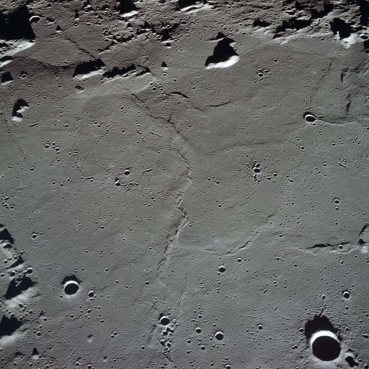
The linear rille Rima Ariadaeus is found on the nearside of the Moon, nestled between Mare Tranquillitatis and Mare Vaporum in this image taken by NASA Lunar Reconnaissance Orbiter.
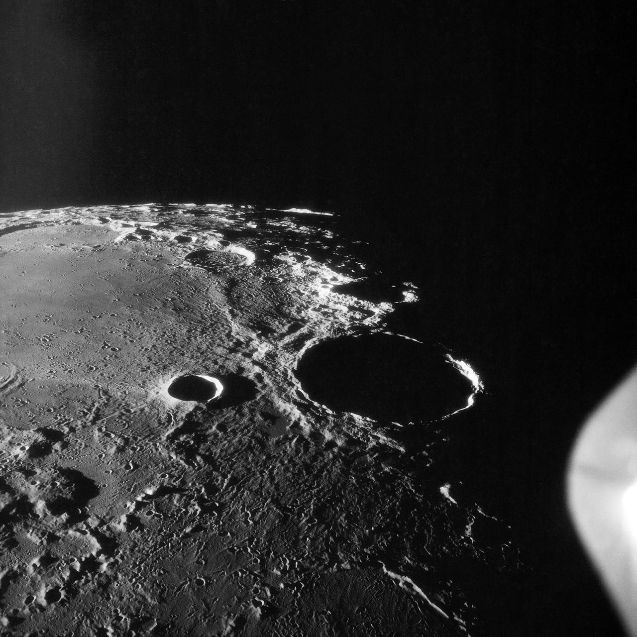
S71-44669 (31 July-2 Aug. 1971) --- An oblique view of the rayed crater Proclus on the lunar nearside, as photographed by the Fairchild metric camera in the SIM bay of the Apollo 15 Command and Service Modules (CSM) in lunar orbit. This view is looking north. The Sea of Crisis is at upper right. Proclus, which is 28 kilometers (16.58 statute miles) in diameter, is located at 47 degrees east longitude and 16 degrees north latitude. The Marsh of Sleep is at lower left. A small portion of the Sea of Tranquility can be seen at upper left. The crater Macrobius is located at upper left. The three-inch mapping camera was one of eight lunar orbital science experiments mounted in the SIM bay.
AS15-88-12002 (31 July-2 Aug. 1971) --- An oblique view of a portion of the lunar nearside located near the northeast edge of the Ocean of Storms (Oceanus Procellarum), photographed by astronaut Alfred M. Worden, command module pilot, from the Apollo 15 spacecraft in lunar orbit, showing the bright-appearing crater Aristarchus on the left, the crater Herodotus on the right, and Schroter's Valley at lower right. This view is looking southward. Aristarchus the head of Schroter's Valley, a sinuous rille in the Aristarchus Plateau, is called Cobra Head. The coordinates of the center of Aristarchus crater are 47.5 degrees west longitude and 23.6 degrees north latitude. While Worden remained in the Command and Service Modules (CSM) in lunar orbit, astronauts David R. Scott, commander; and James B. Irwin, lunar module pilot, descended in the Lunar Module (LM) "Falcon" to explore the moon.
AS10-31-4650 (18-26 May 1969) --- This Apollo 10 oblique telephoto view of the lunar nearside is centered on the crater Hyginus located at 6.3 degrees north latitude, near the northeast margin of Central Bay. HOLD PICTURE WITH SKY AT TOP. The crater is about 10 kilometers (6.5 statue miles) in diameter. From the crater the prominent Hyginus Rille extends east-southeast toward the camera and northwest toward the Sea of Vapors. The rille is about 3 kilometers (2 statue miles) wide and more than 200 kilometers (130 statue miles) long. The horizon is not visible in this photograph, taken from the Command and Service Modules. The sunrise terminator is between the spacecraft and the horizon. At the time this picture was taken Apollo 10 was 325 kilometers (200 statute miles) southeast of Hyginus.
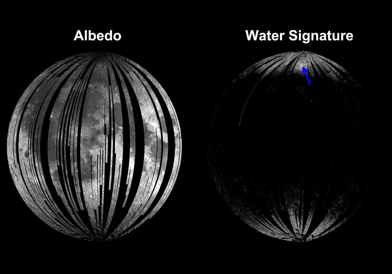
A linear gravity anomaly intersecting the Crisium basin on the nearside of the moon has been revealed by NASA GRAIL mission. The GRAIL gravity gradient data are shown at left, with the location of the anomaly indicated.
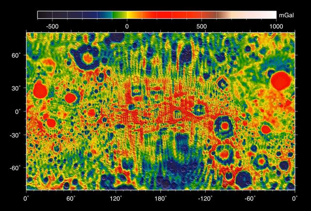
This map shows the gravity field of the moon from the Lunar Prospector mission. The viewing perspective, known as a Mercator projection, shows the far side of the moon in the center and the nearside as viewed from Earth at either side.
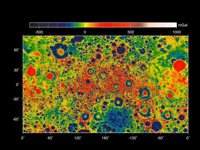
This map shows the gravity field of the moon as measured by NASA GRAIL mission. The viewing perspective, known as a Mercator projection, shows the far side of the moon in the center and the nearside as viewed from Earth at either side.
art002e009276 (April 6, 2026) - In this view of the Moon, the near side (the hemisphere we see from Earth), is visible at the top half of the Moon disk. It is identifiable by the dark splotches. These are ancient lava flows from a time early in the Moon’s history when it was volcanically active. The large crater that appears below the lava flows, dark in the center, is Orientale basin, a nearly 600-mile-wide crater that straddles the Moon’s near and far sides as is partly visible from Earth on the edge of the Moon. In this image, we have a full view of the crater. Everything below the crater is the far side, the hemisphere we don’t get to see from Earth because the Moon rotates on its axis at the same rate that it orbits round us.
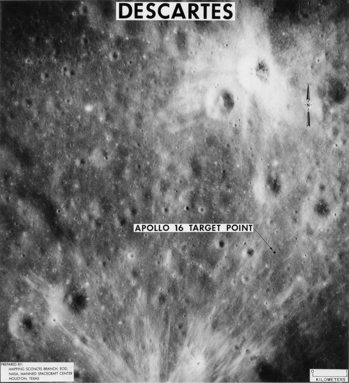
S71-44150 (February 1971) --- A vertical view of the Apollo 16 landing site located in the Descartes area on the lunar nearside. The overlay indicates the location of the proposed touchdown point for the Apollo 16 Lunar Module (LM). Descartes is located west of the Sea of Nectar and southwest of the Sea of Tranquility. This photograph was taken with a 500mm lens camera from lunar orbit by the Apollo 16 crew. Astronauts John W. Young, commander; and Charles M. Duke Jr., lunar module pilot; descended in the Apollo 16 LM "Orion" to explore the Descartes highlands landing site on the moon. Astronaut Thomas K. Mattingly II, command module pilot, remained with the Command and Service Modules (CSM) "Casper" in lunar orbit.
Copernicus is 93 km wide and is located within the Mare Imbrium Basin, northern nearside of the Moon 10 degrees N., 20 degrees W.. This image from NASA's Lunar Orbiter shows crater floor, floor mounds, rim, and rayed ejecta. http://photojournal.jpl.nasa.gov/catalog/PIA00094
This color image of the Moon was taken by NASA's Galileo spacecraft at 9:35 a.m. PST Dec. 9, 1990, at a range of about 350,000 miles. The concentric, circular Orientale basin, is near the center; the nearside is to the right, the far side to the left. http://photojournal.jpl.nasa.gov/catalog/PIA00113
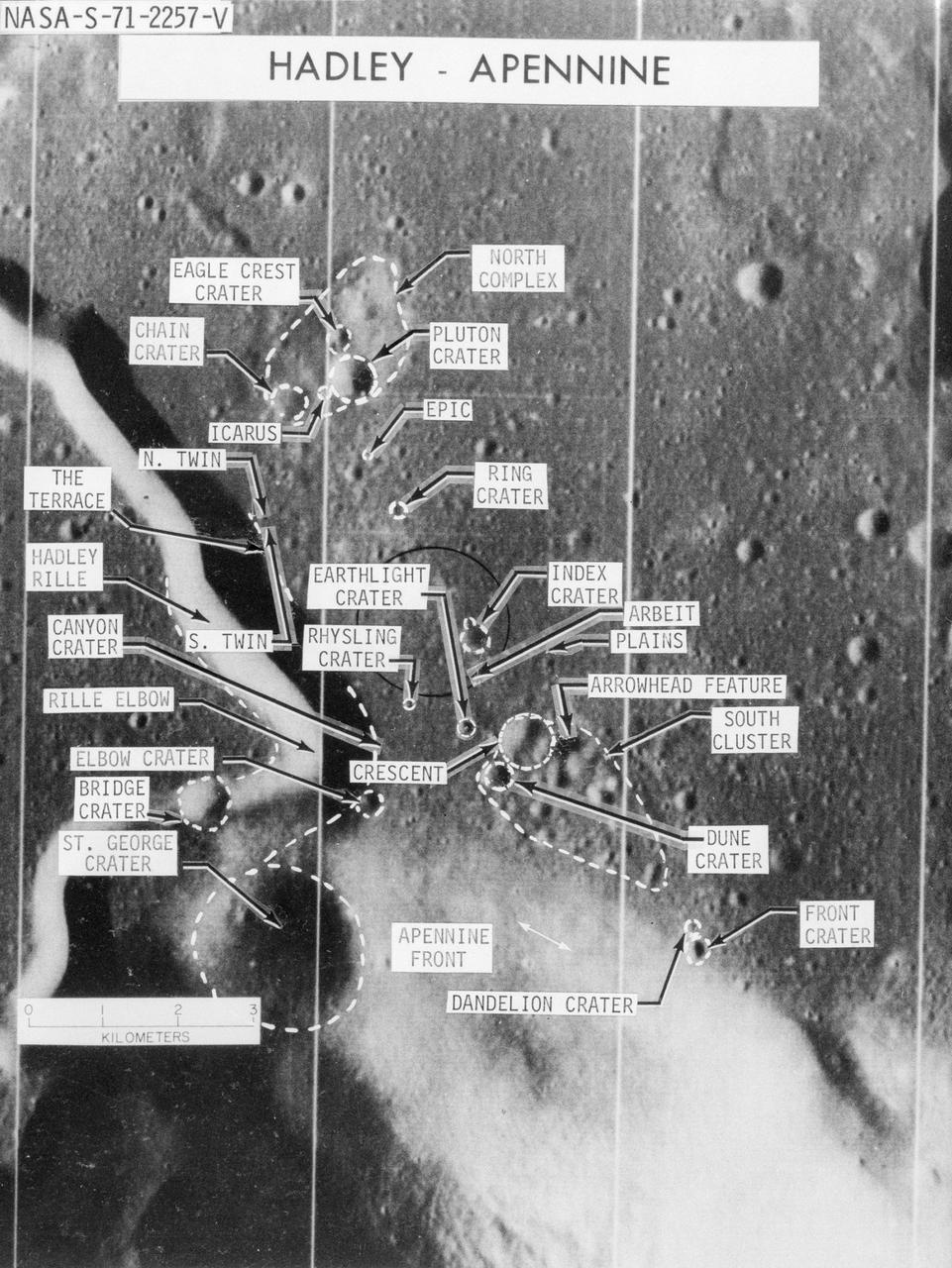
S71-02257 (June 1971) --- An enlarged Lunar Orbiter photograph showing the Apollo 15 landing area in the Hadley-Apennine region on the lunar nearside. The overlay identifies numerous lunar features in the area.
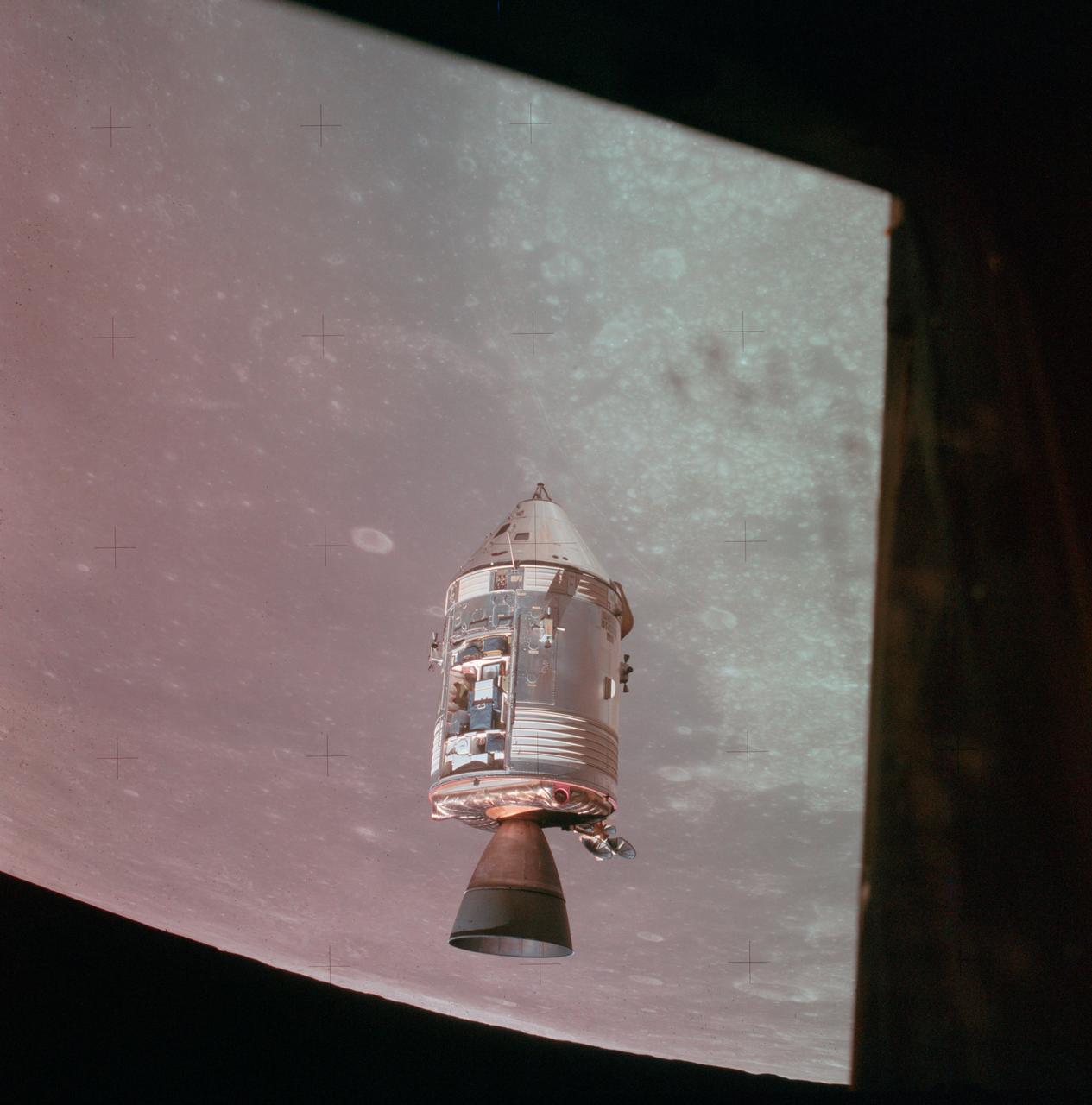
AS15-88-11969 (30 July 1971) --- A view of the Apollo 15 Command and Service Modules (CSM) in lunar orbit as photographed from the Lunar Module (LM) just after rendezvous. The lunar nearside is in the background. This view is looking southeast into the Sea of Fertility. The crater Taruntius is at the right center edge of the picture.
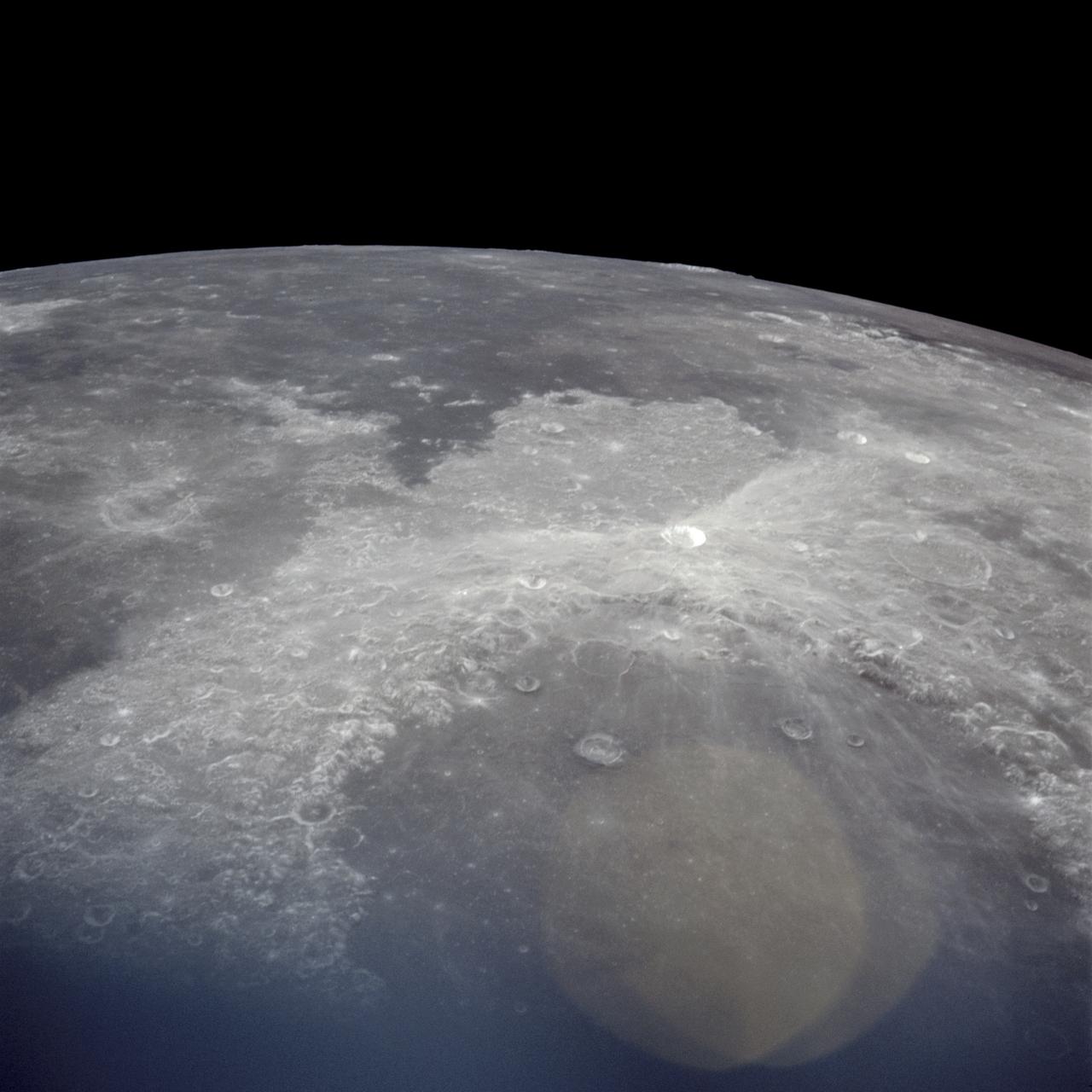
AS17-145-22287 (7-19 Dec. 1972) --- An oblique view of the large crater Copernicus on the lunar nearside, as photographed from the Apollo 17 spacecraft in lunar orbit. This view is looking generally southwest toward the crater on the horizon. The coordinates of the center of Copernicus are approximately 20 degrees west longitude and 9.5 degrees north latitude.
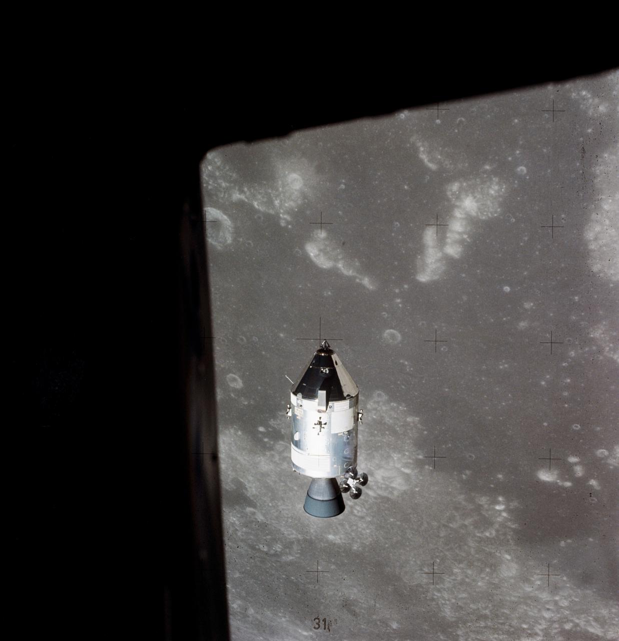
AS15-88-11974 (30 July 1971) --- A view of the Apollo 15 Command and Service Modules (CSM) in lunar orbit as photographed from the Lunar Module (LM) just after rendezvous. The lunar nearside is in the background. This view is looking southeast into the Sea of Fertility. The crater Taruntius is at the right center edge of the picture.

About 50,000 Clementine images were processed to produce the four orthographic views of the Moon. The images show albedo variations (normalized brightness or reflectivity) of the surface at a wavelength of 750 nm (just longward of visible red). The image projection is centered at 0 degree latitude and 180 degrees longitude. Mare Moscoviense (dark albedo feature upper left of image center) and South Pole-Aitken Basin (dark feature at bottom) represent maria regions largely absent on the lunar farside. The Clementine altimeter showed Aitken Basin to consist of a topographic rim about 2500 km in diameter, an inner shelf ranging from 400 to 600 km in width, and an irregular depressed floor about 12 km in depth. http://photojournal.jpl.nasa.gov/catalog/PIA00302
AS16-121-19438 (April 1972) --- An oblique view of a portion of the lunar nearside as photographed from the Apollo 16 spacecraft in lunar orbit, looking across the Sea of Crises southwesterly into the Sea of Tranquility. The conspicuous, bright-rayed crater is Proclus. The crater Taruntius in the northeasterly portion of the Sea of Fertility is near the left center edge. A portion of the Sea of Serenity is visible on the horizon at upper right.
S69-34478 (21 May 1969) --- An oblique view of Barbara Mesa on the lunar nearside is seen in this color reproduction taken from a telecast made by the color television camera aboard the Apollo 10 spacecraft as it orbited the moon. This area is located generally east of Maskelyne crater on the southern edge of the Sea of Tranquility (Mare Tranquillitatis). Barbara Mesa is located at about 32 degrees 45 minutes east longitude and 1 degree 45 minutes north latitude.
AS10-27-3908 (18-26 May 1969) --- An Apollo 10 photograph of the lunar nearside looking westward across Apollo Landing Site 3 in Central Bay. Bruce, the prominent crater in the lower right corner, is about 3.7 statute miles in diameter. Topographic features on the surface of Central Bay are accentuated by the low sun angle.
S70-54740 (December 1970) --- A lunar orbiter photograph showing a vertical view of the Apollo 14 landing site located in the Fra Mauro highlands on the lunar nearside. The predicted landing point is 17 degrees 27 minutes 46 seconds west longitude and 3 degrees 40 minutes 19 seconds south latitude. North is toward the right side of the picture. Cone Crater, the largest lunar feature visible, is located near the northeast corner of the photograph. The landing point is between Triplet Crater and Doublet Crater in the center of the picture.

S72-01713 (July 1972) --- A vertical view of the Apollo 17 landing site in the Taurus-Littrow area of the lunar nearside, with an overlay showing the Lunar Roving Vehicle traverse proposed for the second extravehicular activity. The scale at the bottom is measured in kilometers. One kilometer equals 0.6214 statute miles. The coordinates of the Apollo 17 touchdown point are 30 degrees 44 minutes 58 seconds east longitude and 20 degrees 9 minutes 50 seconds north latitude. This photograph was taken from lunar orbit on an earlier Apollo mission.

S72-32719 (March 1972) --- With four of the six planned lunar missions completed, this chart has been prepared to show the various areas of the lunar "nearside" to be visited by astronauts representing the NASA Apollo program. Apollo's 11, 12, 14 and 15 are shown at their respective landing points. Apollo 16 and Apollo 17, planned for later this year at Descartes and Taurus Littrow, respectively, also are depicted on the map.

S71-40085 (July 1971) --- An enlarged Lunar Orbiter photograph of the Apollo 15 landing area in the Hadley-Apennine region on the nearside of the moon. The overlay indicates the location of the numerous informally-named surface features. These names will facilitate understanding the verbal descriptions from the astronauts during their lunar surface extravehicular activity (EVA). This is an August 1967, Lunar Orbiter V photograph of Site 26.1.
AS11-42-6237 (20 July 1969) --- An Apollo 11 oblique view of the large crater Theophilus located at the northwest edge of the Sea of Nectar on the lunar nearside. Theophilus is about 60 statute miles in diameter. The smooth area is Mare Nectaris. The smaller crater Madler, about 14 statute miles in diameter, is located to the east of Theophilus. Visible in the background are the large crater Fracastorius and the smaller crater Beaumont. The coordinates of the center of this photograph are 29 degrees east longitude and 11 degrees south latitude.
AS12-47-6876 (November 1969) --- An Apollo 12 high-oblique view of the lunar nearside looking northeast toward the crater Copernicus (in center near horizon), as photographed from lunar orbit. The shaded crater in the foreground is Reinhold. Reinhold B is the crater next to Reinhold which as the small crater in the center of it. Also, visible is the keyhole-shaped crater Fauth near the crater Copernicus.
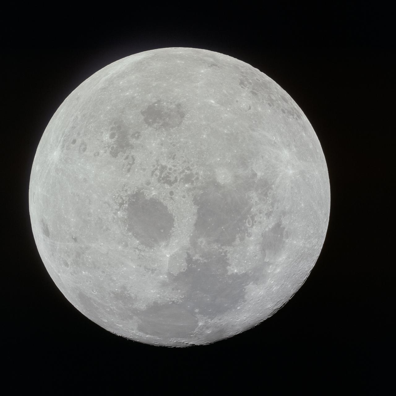
AS11-44-6665 (21 July 1969) --- This outstanding view of the entire nearside surface of the moon was photographed from the Apollo 11 spacecraft during its trans-Earth journey homeward. When this picture was taken, the spacecraft was already 10,000 nautical miles away. Onboard Apollo 11 were astronauts Neil A. Armstrong, commander; Michael Collins, command module pilot; and Edwin E. Aldrin Jr., lunar module pilot.
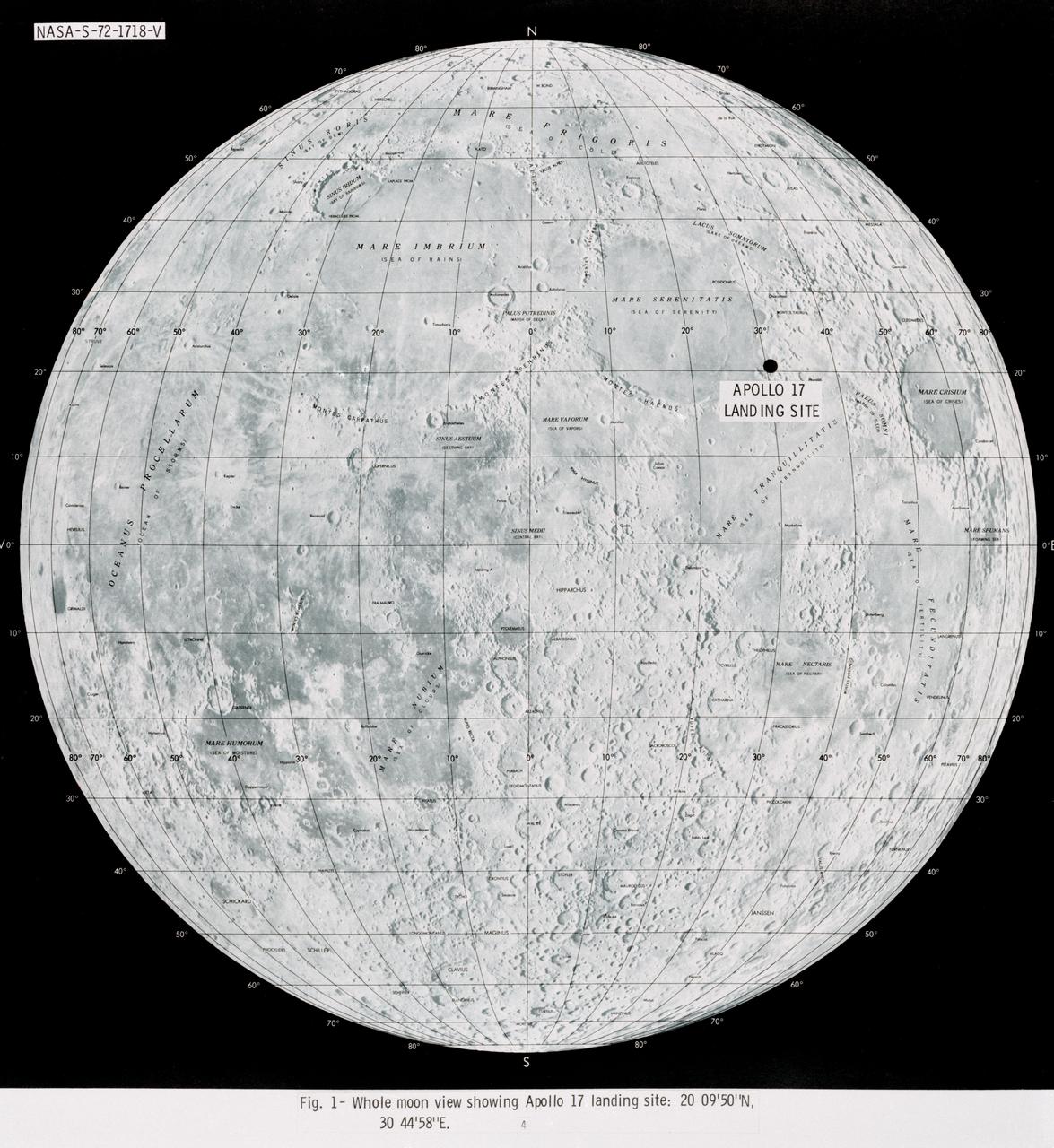
S72-01718 (July 1972) --- A photographic illustration of a full moon showing the location of the Apollo 17 landing site on the lunar nearside. The black dot pinpointing the landing site is in the Taurus-Littrow area at the southeastern edge of the Sea of Serenity. The coordinates of the landing point are 30 degrees 44 minutes 58 seconds east longitude and 20 degrees 9 minutes 50 seconds north latitude.
S69-34476 (21 May 1969) --- An oblique view of a group of craters just west of the Sea of Fertility (Mare Fecunditatis) on the lunar nearside is seen in this color reproduction taken from a telecast made by the color television aboard the Apollo 10 spacecraft as it orbited the moon. In this area are Gutenberg I, Capella A, Capella D, Capella E, and Capella M.

AS16-122-19592 (16-27 April 1972) --- An oblique view of the Border Sea area on the lunar nearside, as photographed from the Apollo 16 spacecraft in lunar orbit. Mare Marginus is at the left edge of the picture. This view is looking generally west by northwest. Goddard Crater is located at lower left. A portion of the Ibn Yunus Crater can be seen in the lower left corner adjoining the southeastern edge of Goddard. The Al-Biruni Crater is at lower right edge. The Hubble Crater is at right center edge.
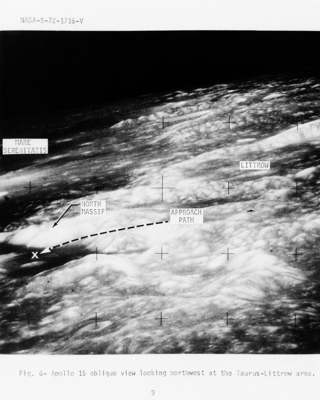
S72-01716 (July 1972) --- An oblique view of the Taurus-Littrow area on the lunar nearside, as photographed from the Apollo 15 spacecraft in lunar orbit. This is an enlarged view. The "X" marks the landing site of the scheduled Apollo 17 lunar landing mission. The overlay points out several features in the photograph. The coordinates of the Apollo 17 touchdown point are 30 degrees 44 minutes 58 seconds east longitude and 20 degrees 9 minutes 50 seconds north latitude.
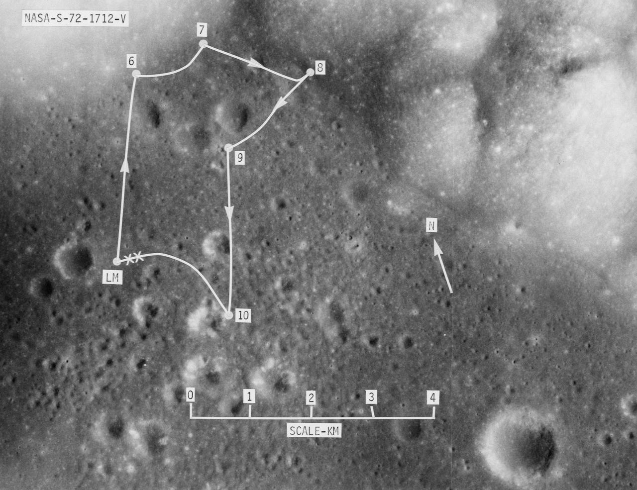
S72-01712 (July 1972) --- A vertical view of the Apollo 17 landing site in the Taurus-Littrow area of the lunar nearside, with an overlay showing the Lunar Roving Vehicle traverse proposed for the third extravehicular activity. The scale at the bottom is measured in kilometers. One kilometer equals 0.6214 statute miles. The coordinates of the Apollo 17 touchdown point are 30 degrees 44 minutes 58 seconds east longitude and 20 degrees 9 minutes 50 seconds north latitude. This photograph was taken from lunar orbit on an earlier Apollo mission.
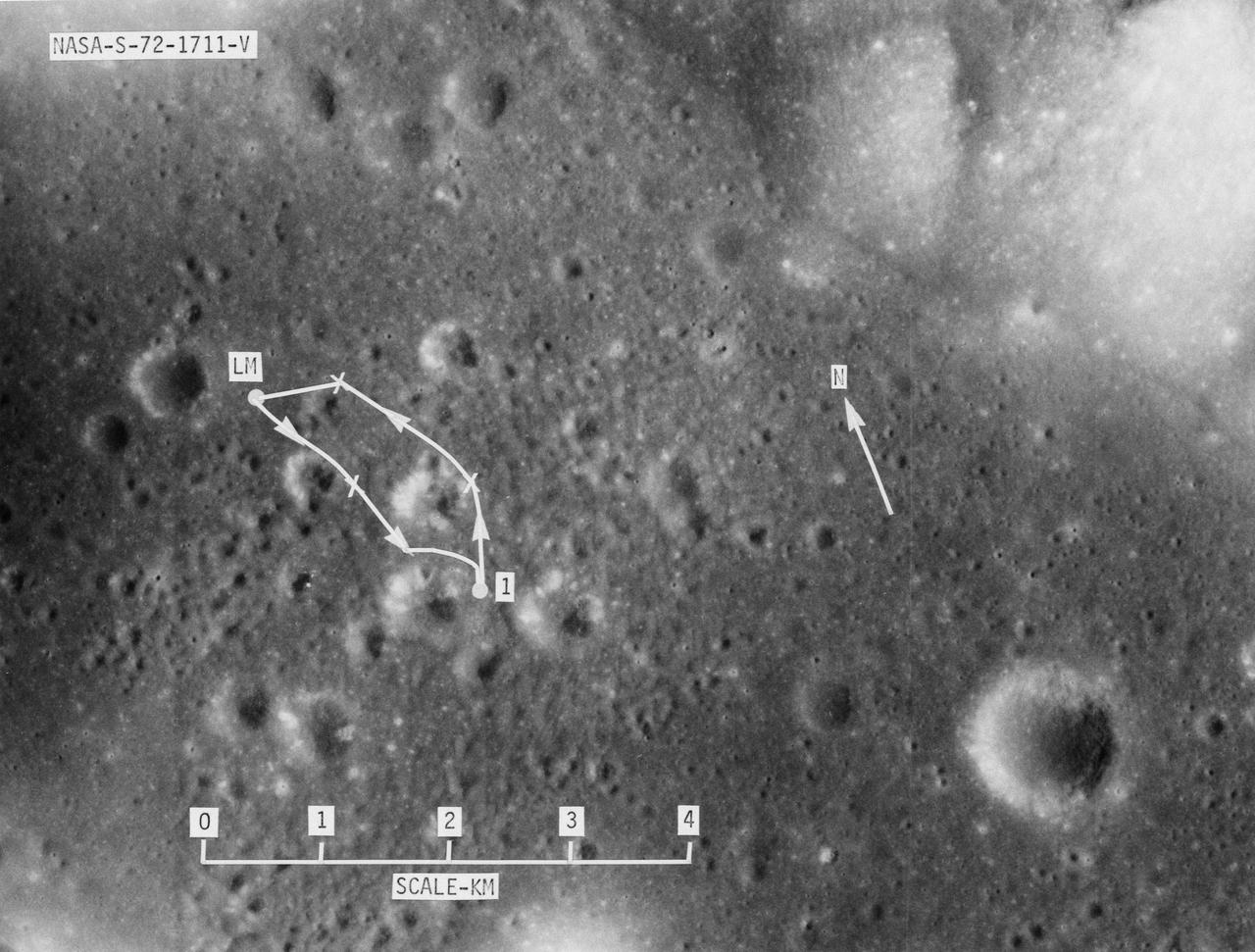
S72-01711 (July 1972) --- A vertical view of the Apollo 17 landing site in the Taurus-Littrow area of the lunar nearside, with an overlay showing the Lunar Roving Vehicle traverse proposed for the first extravehicular activity. The scale at the bottom is measured in kilometers. One kilometer equals 0.6214 statute mile. The coordinates of the Apollo 17 touchdown point are 30 degrees 44 minutes 58 seconds east longitude and 20 degrees 9 minutes 50 seconds north latitude. This photograph was taken from lunar orbit on an earlier Apollo mission.
art002e009627 (April 6, 2026) – During the first shift of the lunar flyby observation period, the Artemis II crew captured more than two-thirds of the Moon, highlighting surface details on the nearside, including the 600-mile-wide impact crater, Orientale basin, along the boundary between the near and far sides. They also captured the Grimaldi crater, a dark, round feature northeast of Orientale, known for its dark mare lava floor and heavily worn rim.
art002e012153 (April 6, 2026) - The small, bright spot in the center of the image is the crater that the Artemis II crew have proposed as Carroll, after Commander Reid Wiseman’s late wife. About 3.5 miles across (5.6 km in diameter), the proposed Carroll crater is on the nearside of the lunar surface on the western edge and would be visible from Earth with powerful telescopes.
art002e012183 (April 6, 2026) - On the first shift during the lunar flyby observation period, the Artemis II crew captured more than two-thirds of the Moon showcasing the intricate features of the nearside. The 600-mile-wide impact crater, Orientale basin, lies along the transition between the near and far sides and is sometimes partly visible from Earth. The round black spot northeast of Orientale is Grimaldi crater, known for its exceptionally dark mare lava floor and heavily degraded rim. Credit: NASA
AS16-120-19228 (16-27 April 1972) --- Strongly textured terrain north of the lunar farside King Crater which is centered near 120.5 degrees east longitude and 5.5 degrees north latitude. This near vertical oblique view eastward was photographed from the Apollo 16 spacecraft in lunar orbit with a Hasselblad camera equipped with a 250mm telephoto lens. Several irregular areas characterized by conspicuously smooth surfaces interrupt the rough texture in this view of the eastern quarter of the large, unnamed crater between King and Guyot. Similar "ponds" occur at varied levels in the rim deposits of the nearside craters Copernicus and Tycho. Hold picture with the smooth area at the top.
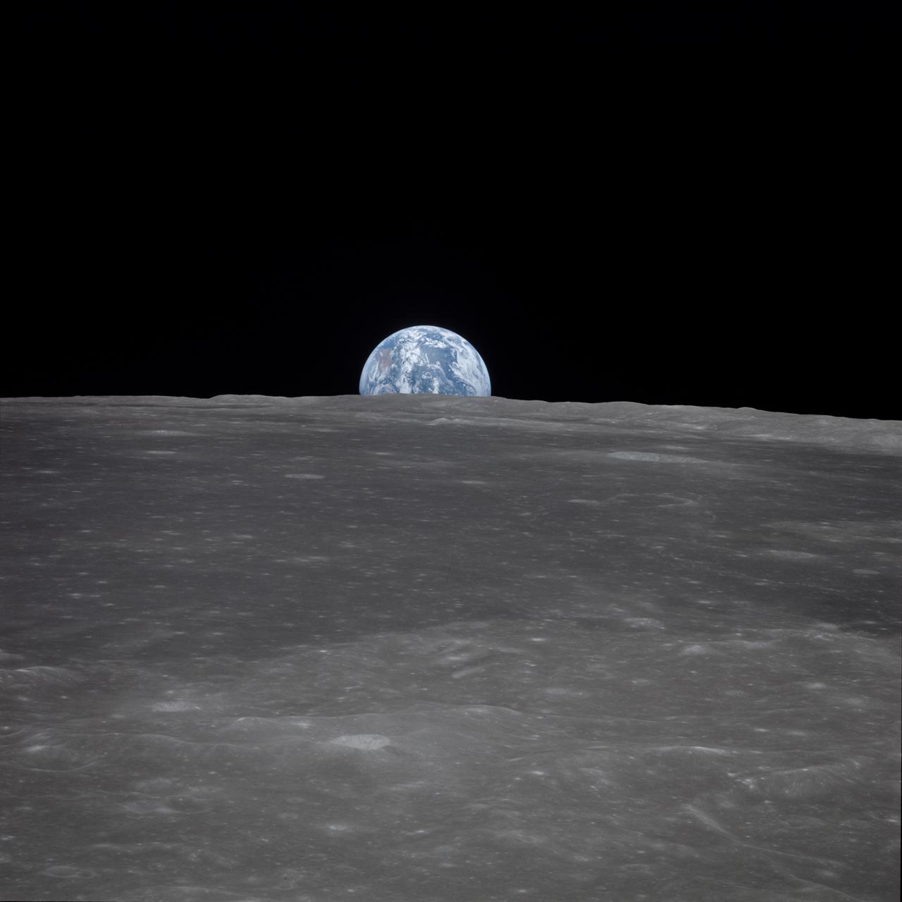
AS11-44-6548 (16-24 July 1969) --- This view from the Apollo 11 spacecraft shows Earth rising above the moon's horizon. The lunar terrain pictured is in the area of Smyth's Sea on the nearside. Coordinates of the center of the terrain are 86 degrees east longitude and 3 degrees north latitude. While astronauts Neil A. Armstrong, commander, and Edwin E. Aldrin Jr., lunar module pilot, descended in the Lunar Module (LM) "Eagle" to explore the Sea of Tranquility region of the moon, astronaut Michael Collins, command module pilot, remained with the Command and Service Modules (CSM) "Columbia" in lunar orbit.
AS11-44-6550 (16-24 July 1969) --- This view from the Apollo 11 spacecraft shows Earth rising above the moon's horizon. The lunar terrain pictured is in the area of Smyth's Sea on the nearside. Coordinates of the center of the terrain are 86 degrees east longitude and 3 degrees north latitude. While astronauts Neil A. Armstrong, commander, and Edwin E. Aldrin Jr., lunar module pilot, descended in the Lunar Module (LM) "Eagle" to explore the Sea of Tranquility region of the moon, astronaut Michael Collins, command module pilot, remained with the Command and Service Modules (CSM) "Columbia" in lunar orbit. Apollo 11 was NASA's first lunar landing mission in the Apollo program.

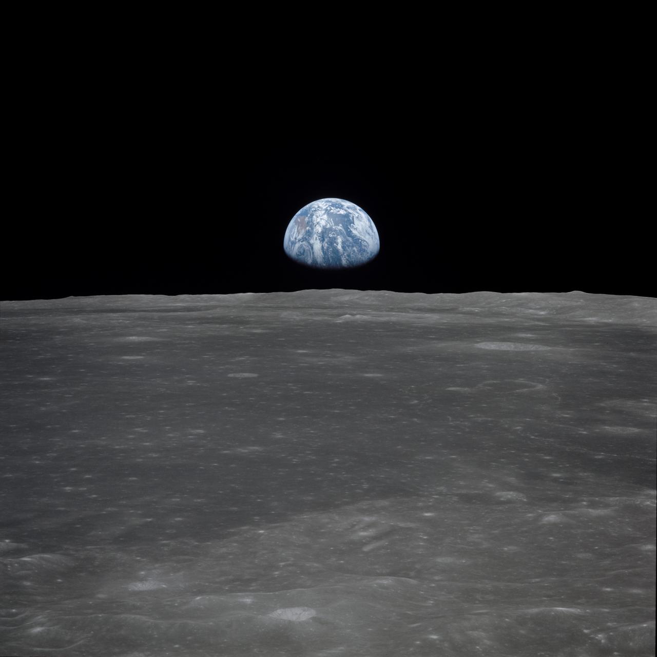
AS11-44-6551 (July 1969) --- This view from the Apollo 11 spacecraft shows the Earth rising above the moon's horizon. The lunar terrain pictured is in the area of Smyth's Sea on the nearside. Coordinates of the center of the terrain are 85 degrees east longitude and 3 degrees north latitude. While astronauts Neil A. Armstrong, commander, and Edwin E. Aldrin Jr., lunar module pilot, descended in the Lunar Module (LM) "Eagle" to explore the Sea of Tranquility region of the moon, astronaut Michael Collins, command module pilot, remained with the Command and Service Modules (CSM) "Columbia" in lunar orbit.

AS11-44-6549 (16-24 July 1969) --- This view from the Apollo 11 spacecraft shows Earth rising above the moon's horizon. The lunar terrain pictured is in the area of Smyth's Sea on the nearside. Coordinates of the center of the terrain are 86 degrees east longitude and 3 degrees north latitude. While astronauts Neil A. Armstrong, commander, and Edwin E. Aldrin Jr., lunar module pilot, descended in the Lunar Module (LM) "Eagle" to explore the Sea of Tranquility region of the moon, astronaut Michael Collins, command module pilot, remained with the Command and Service Modules (CSM) "Columbia" in lunar orbit.

AS11-44-6552 (16-24 July 1969) --- This view of Earth rising over the moon's horizon was taken from the Apollo spacecraft. The lunar terrain pictured is in the area of Smyth's Sea on the nearside. Coordinates of the center of the terrain are 85 degrees east longitude and 3 degrees north latitude. While astronaut Neil A. Armstrong, commander; and Edwin E. Aldrin Jr., lunar module pilot, descended in the Lunar Module (LM) "Eagle" to explore the Sea of Tranquility region of the moon, astronaut Michael Collins remained with the Command and Service Modules (CSM) "Columbia" in lunar orbit.
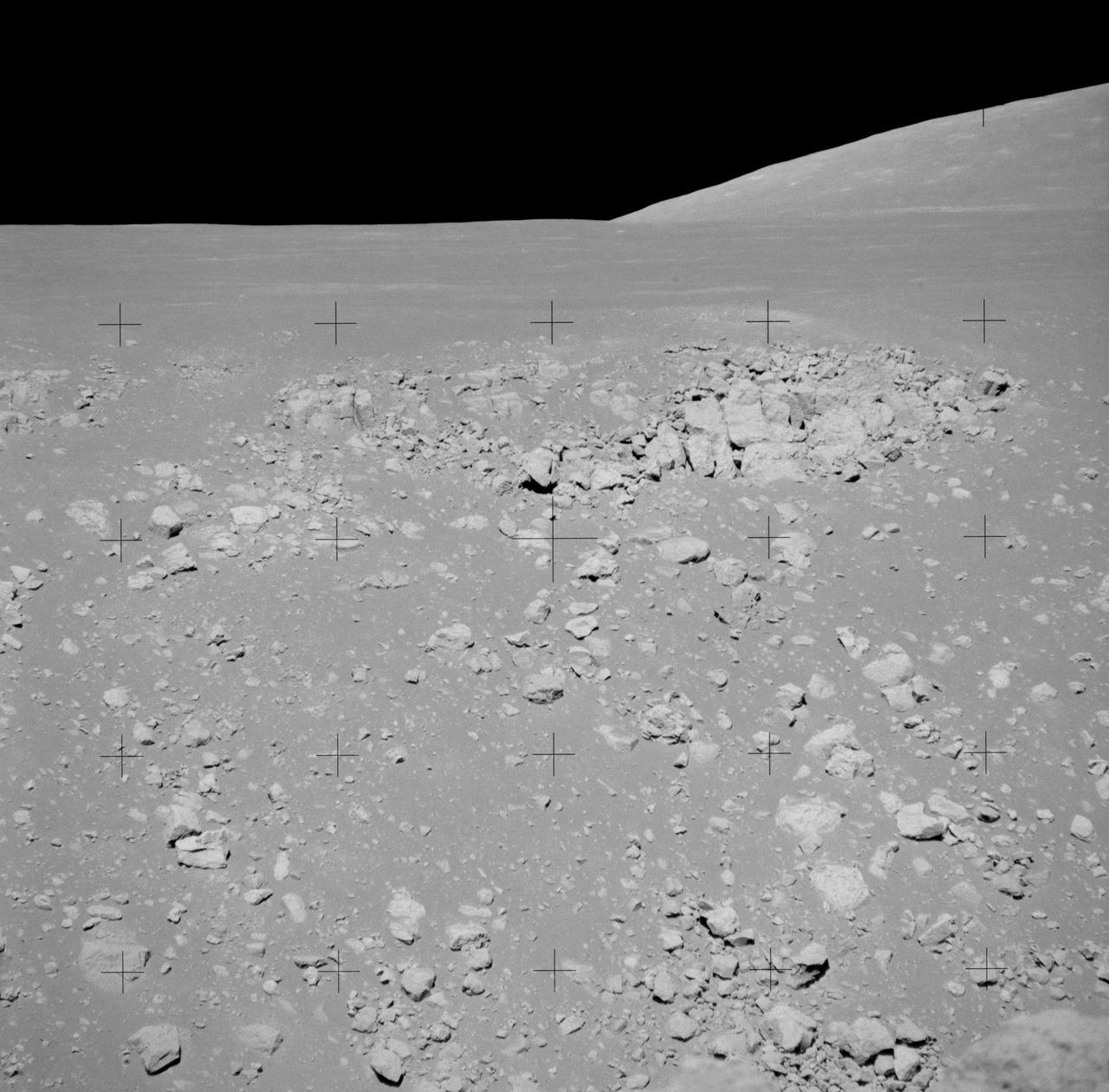
AS15-89-12100 (2 Aug. 1971) --- A telephoto lens view looking across Hadley Rille, photographed during the third Apollo 15 lunar surface extravehicular activity (EVA) at the Hadley-Apennine landing site on the nearside of the moon. The blocky outcrop at the top of the west wall of the rille is about 1.9 kilometers (1.1 statute miles) from the camera. About one-half of the debris-covered wall is visible in the photograph. On the horizon the northern end of Hill 305 is more than 16 kilometers (10 statute miles) from the camera.

AS11-44-6642 (21 July 1969) --- The Apollo 11 Lunar Module ascent stage, with astronauts Neil A. Armstrong and Edwin E. Aldrin Jr. aboard, is photographed from the Command and Service Modules (CSM) during rendezvous in lunar orbit. The Lunar Module (LM) was making its docking approach to the CSM. Astronaut Michael Collins remained with the CSM in lunar orbit while the other two crewmen explored the lunar surface. The large, dark-colored area in the background is Smyth's Sea, centered at 85 degrees east longitude and 2 degrees south latitude on the lunar surface (nearside). This view looks west. The Earth rises above the lunar horizon.
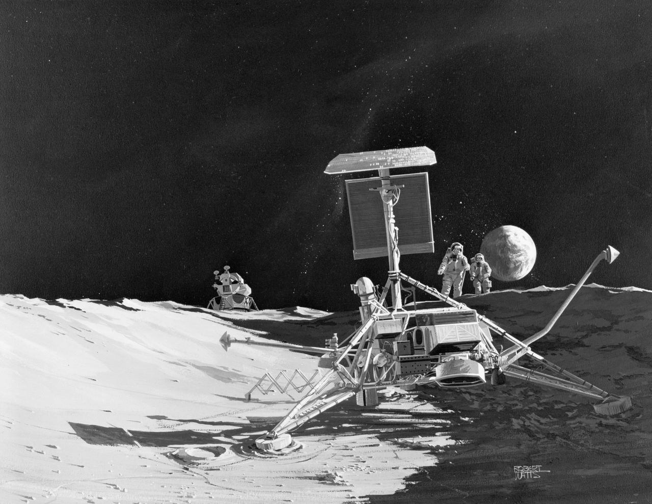
S69-55553 (October 1969) --- Ryan Aeronautical Company artist's concept depicting a close-up view of Surveyor 3 resting in the Ocean of Storms on the lunar nearside. Two Apollo 12 astronauts are seen approaching in the background. The Apollo 12 Lunar Module (LM) is in the left background. The Earth is in the right background. The inspection of Surveyor 3, which has been resting on the moon since April 1967, is an important objective of the Apollo 12 lunar landing mission. Selected pieces of Surveyor 3 will be brought back to Earth for scientific examination. Ryan landing radar has guided both Surveyor and Apollo spacecraft to soft landings on the moon.
art002e009562 (April 6, 2026) - The Orion spacecraft is seen in the foreground lit up by the Sun. A waxing gibbous Moon is visible in the background. Orientale basin, a 600-mile-wide impact crater ringed by mountains, is visible toward the center bottom of the Moon. This basin straddles the Moon’s near and far sides. To the left of Orientale, which has a patch of ancient lava in its basin, is the far side; this is the hemisphere we don’t get to see from Earth. To the right of Orientale is the near side, the hemisphere we see every day from Earth. The nearside is notable for giant, dark patches of ancient lave flows that cover its surface.
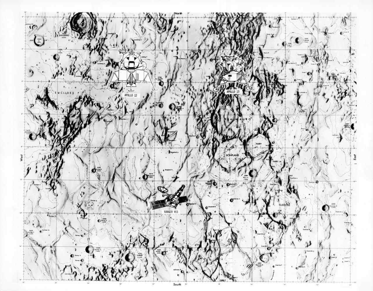
S70-28115 (January 1970) --- This overlay map of terrain on the lunar nearside shows the area of the landing site of the upcoming Apollo 13 mission, in relation to two previous NASA landings. The proposed Apollo 13 landing site is located in the highlands north of Fra Mauro. The coordinates of the planned site are 17.550 degrees west longitude and 3.617 degrees south latitude. The landing site of the Apollo 12 mission, which was highlighted by a lunar landing on Nov. 19, 1969, is located approximately 105 nautical miles west of the Apollo 13 site. The landing site of the unmanned Ranger 7 space vehicle, which impacted on the moon on July 31, 1964, at 10.74 degrees south latitude and 20.7 degrees west longitude, is approximately 130 nautical miles south-southwest of the Apollo 13 site, and approximately 140 nautical miles south-southeast of the Apollo 12 site.
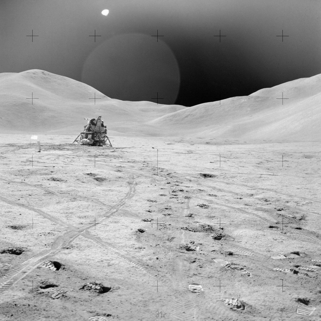
AS15-82-11057 (2 Aug. 1971) --- The Lunar Module (LM) "Falcon" is photographed against the barren lunarscape during the third Apollo 15 lunar surface extravehicular activity (EVA) at the Hadley-Apennine landing site on the lunar nearside. This view is looking southeast. The Apennine Front is in the left background; and Hadley Delta Mountain is in the right background. The object next to the United States flag is the Solar Wind Composition (SWC) experiment. Last Crater is to the right of the LM. Note bootprints and tracks of the Lunar Roving Vehicle (LRV). The light spherical object at the top is a reflection in the lens of the camera. While astronauts David R. Scott and James B. Irwin descended in the LM to explore the moon, astronaut Alfred M. Worden remained with the Command and Service Modules (CSM) in lunar orbit.
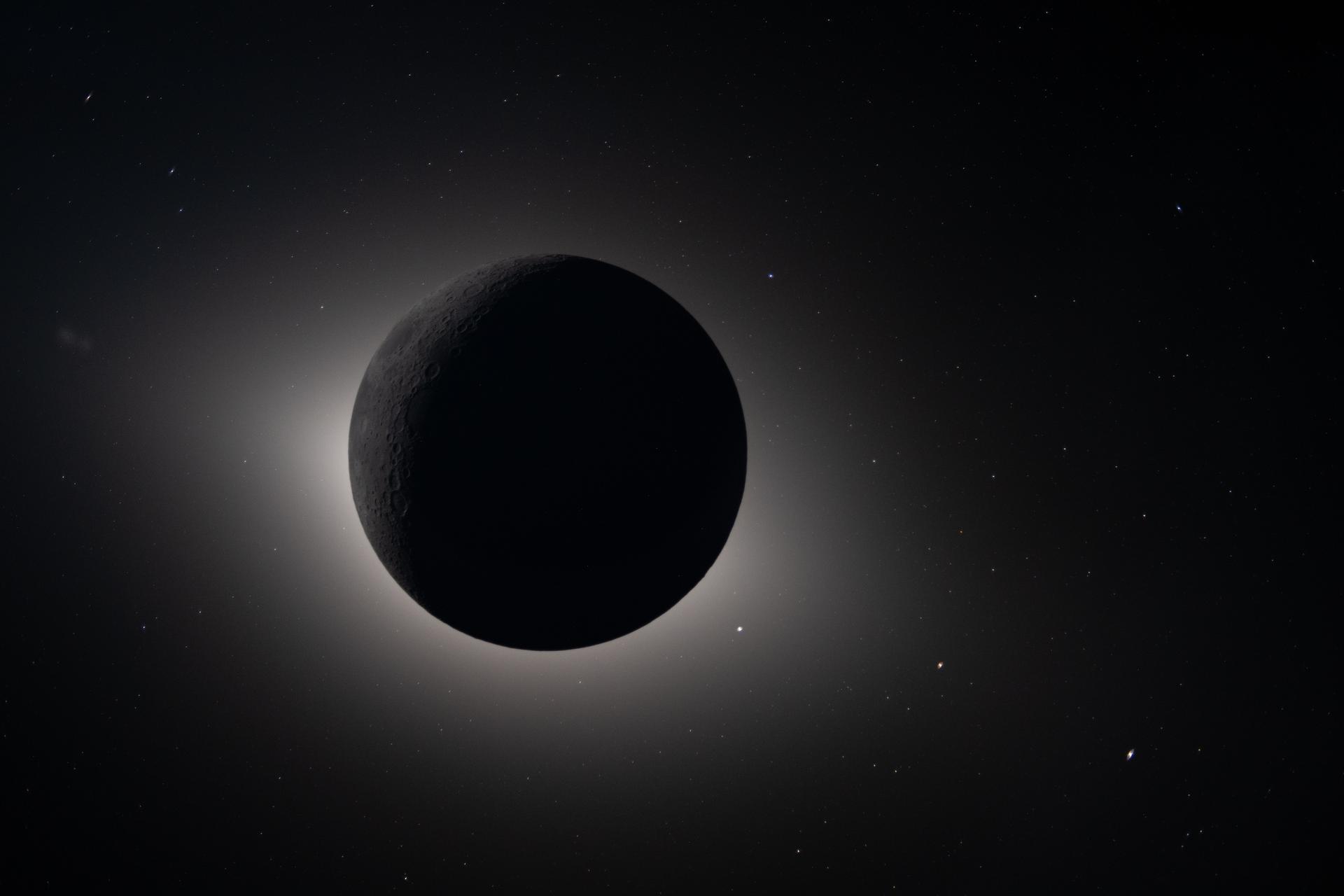
art002e009301 (April 6, 2026) – Captured by the Artemis II crew during their lunar flyby on April 6, 2026, this image shows the Moon fully eclipsing the Sun. From the crew’s perspective, the Moon appears large enough to completely block the Sun, creating nearly 54 minutes of totality and extending the view far beyond what is possible from Earth. We see a glowing halo around the dark lunar disk. The science community is investigating whether this effect is due to the corona, zodiacal light, or a combination of the two. Also visible are stars, typically too faint to see when imaging the Moon, but with the Moon in darkness stars are readily imaged. This unique vantage point provides both a striking visual and a valuable opportunity for astronauts to document their observations during humanity’s return to deep space. The faint glow of the nearside of the Moon is visible in this image, having been illuminated by light reflected off the Earth.
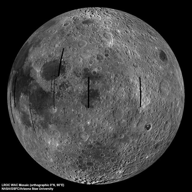
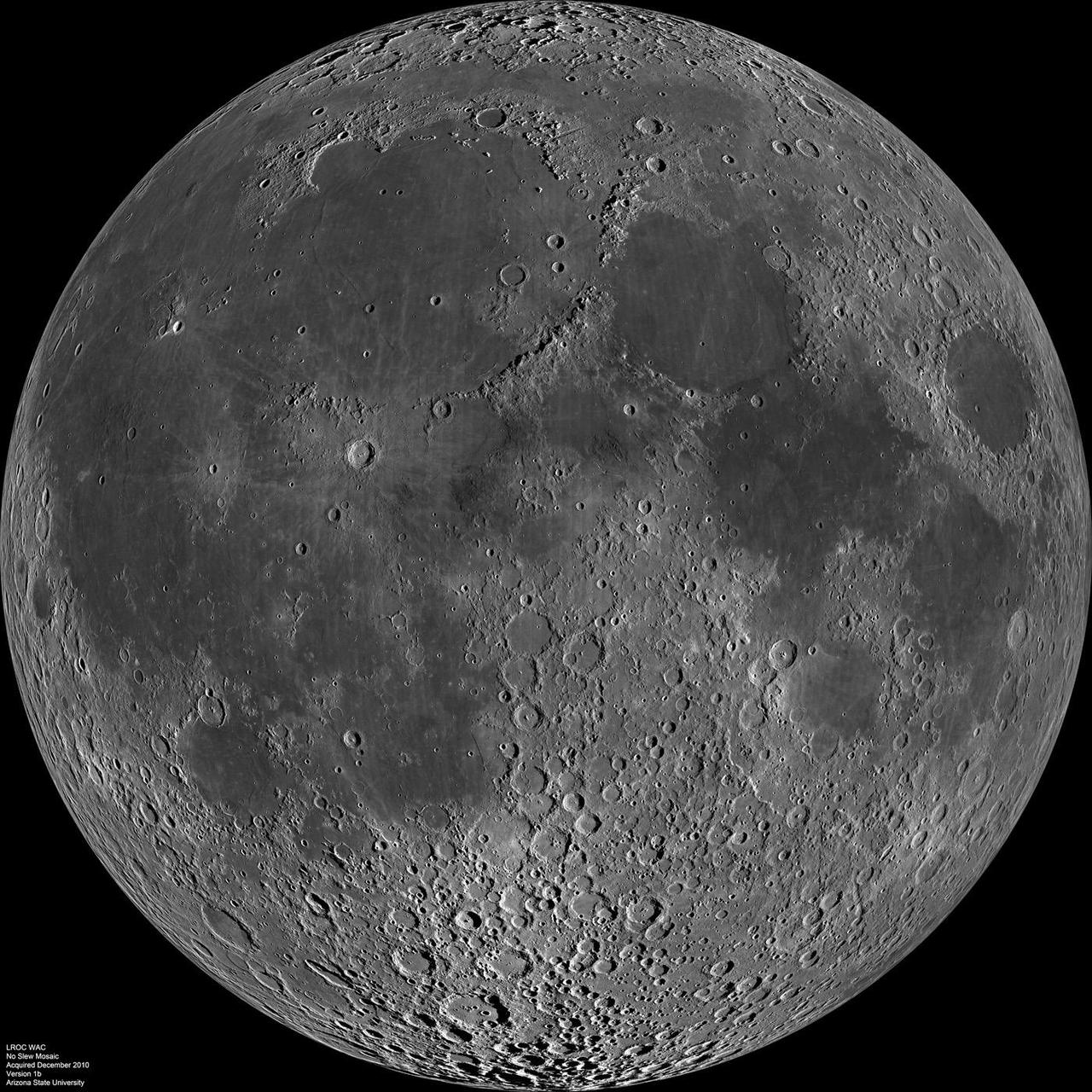
NASA image release September 9, 2010 LROC Wide Angle Camera (WAC) view of the Moon seen from 90° east longitude. Half the nearside is visible to the left, and half the farside to the right. Credit: NASA/GSFC/Arizona State University To read more go to: <a href="http://www.nasa.gov/mission_pages/LRO/multimedia/lroimages/lroc-20100909_mooneast.html" rel="nofollow">www.nasa.gov/mission_pages/LRO/multimedia/lroimages/lroc-...</a> <b><a href="http://www.nasa.gov/centers/goddard/home/index.html" rel="nofollow">NASA Goddard Space Flight Center</a></b> contributes to NASA’s mission through four scientific endeavors: Earth Science, Heliophysics, Solar System Exploration, and Astrophysics. Goddard plays a leading role in NASA’s endeavors by providing compelling scientific knowledge to advance the Agency’s mission. <b>Follow us on <a href="http://twitter.com/NASA_GoddardPix" rel="nofollow">Twitter</a></b> <b>Join us on <a href="http://www.facebook.com/pages/Greenbelt-MD/NASA-Goddard/395013845897?ref=tsd" rel="nofollow">Facebook</a></b>

NASA image release March 11, 2011 Caption: The lunar farside as never seen before! LROC WAC orthographic projection centered at 180° longitude, 0° latitude. Credit: NASA/Goddard/Arizona State University. Because the moon is tidally locked (meaning the same side always faces Earth), it was not until 1959 that the farside was first imaged by the Soviet Luna 3 spacecraft (hence the Russian names for prominent farside features, such as Mare Moscoviense). And what a surprise - unlike the widespread maria on the nearside, basaltic volcanism was restricted to a relatively few, smaller regions on the farside, and the battered highlands crust dominated. A different world from what we saw from Earth. Of course, the cause of the farside/nearside asymmetry is an interesting scientific question. Past studies have shown that the crust on the farside is thicker, likely making it more difficult for magmas to erupt on the surface, limiting the amount of farside mare basalts. Why is the farside crust thicker? That is still up for debate, and in fact several presentations at this week's Lunar and Planetary Science Conference attempt to answer this question. The Clementine mission obtained beautiful mosaics with the sun high in the sky (low phase angles), but did not have the opportunity to observe the farside at sun angles favorable for seeing surface topography. This WAC mosaic provides the most complete look at the morphology of the farside to date, and will provide a valuable resource for the scientific community. And it's simply a spectacular sight! The Lunar Reconnaissance Orbiter Camera (LROC) Wide Angle Camera (WAC) is a push-frame camera that captures seven color bands (321, 360, 415, 566, 604, 643, and 689 nm) with a 57-km swath (105-km swath in monochrome mode) from a 50 km orbit. One of the primary objectives of LROC is to provide a global 100 m/pixel monochrome (643 nm) base map with incidence angles between 55°-70° at the equator, lighting that is favorable for morphological interpretations. Each month, the WAC provides nearly complete coverage of the Moon under unique lighting. As an added bonus, the orbit-to-orbit image overlap provides stereo coverage. Reducing all these stereo images into a global topographic map is a big job, and is being led by LROC Team Members from the German Aerospace Center (Deutsches Zentrum für Luft- und Raumfahrt; DLR). Several preliminary WAC topographic products have appeared in LROC featured images over the past year (Orientale basin, Sinus Iridum). For a sneak preview of the WAC global DEM with the WAC global mosaic, view a rotating composite moon (70 MB video from ASU's LROC website). The WAC topographic dataset will be completed and released later this year. The global mosaic released today is comprised of over 15,000 WAC images acquired between November 2009 and February 2011. The non-polar images were map projected onto the GLD100 shape model (WAC derived 100 m/pixel DTM), while polar images were map projected on the LOLA shape model. In addition, the LOLA derived crossover corrected ephemeris, and an improved camera pointing, provide accurate positioning (better than 100 m) of each WAC image. As part of the March 2011 PDS release, the LROC team posted the global map in ten regional tiles. Eight of the tiles are equirectangular projections that encompass 60° latitude by 90° longitude. In addition, two polar stereographic projections are available for each pole from ±60° to the pole. These reduced data records (RDR) products will be available for download on March 15, 2011. As the mission progresses, and our knowledge of the lunar photometric function increases, improved and new mosaics will be released! Work your way around the moon with these six orthographic projections constructed from WAC mosaics. The nearside view linked below is different from that released on 21 February. To read more con't here: <a href="http://www.nasa.gov/mission_pages/LRO/news/lro-farside.html" rel="nofollow">www.nasa.gov/mission_pages/LRO/news/lro-farside.html</a> <b><a href="http://www.nasa.gov/centers/goddard/home/index.html" rel="nofollow">NASA Goddard Space Flight Center</a></b> enables NASA’s mission through four scientific endeavors: Earth Science, Heliophysics, Solar System Exploration, and Astrophysics. Goddard plays a leading role in NASA’s accomplishments by contributing compelling scientific knowledge to advance the Agency’s mission. <b>Follow us on <a href="http://twitter.com/NASA_GoddardPix" rel="nofollow">Twitter</a></b> <b>Join us on <a href="http://www.facebook.com/pages/Greenbelt-MD/NASA-Goddard/395013845897?ref=tsd" rel="nofollow">Facebook</a></b>
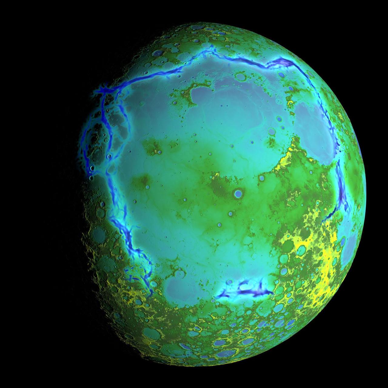
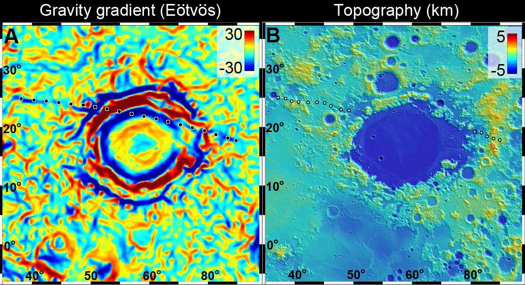
Topography of Earth's moon generated from data collected by the Lunar Orbiter Laser Altimeter, aboard NASA's Lunar Reconnaissance Orbiter, with the gravity anomalies bordering the Procellarum region superimposed in blue. The border structures are shown using gravity gradients calculated with data from NASA's Gravity Recovery and Interior Laboratory (GRAIL) mission. These gravity anomalies are interpreted as ancient lava-flooded rift zones buried beneath the volcanic plains (or maria) on the nearside of the Moon. Launched as GRAIL A and GRAIL B in September 2011, the probes, renamed Ebb and Flow, operated in a nearly circular orbit near the poles of the moon at an altitude of about 34 miles (55 kilometers) until their mission ended in December 2012. The distance between the twin probes changed slightly as they flew over areas of greater and lesser gravity caused by visible features, such as mountains and craters, and by masses hidden beneath the lunar surface. The twin spacecraft flew in a nearly circular orbit until the end of the mission on Dec. 17, 2012, when the probes intentionally were sent into the moon's surface. NASA later named the impact site in honor of late astronaut Sally K. Ride, who was America's first woman in space and a member of the GRAIL mission team. GRAIL's prime and extended science missions generated the highest-resolution gravity field map of any celestial body. The map will provide a better understanding of how Earth and other rocky planets in the solar system formed and evolved. The GRAIL mission was managed by NASA's Jet Propulsion Laboratory (JPL) in Pasadena, California, for NASA's Science Mission Directorate in Washington. The mission was part of the Discovery Program managed at NASA's Marshall Space Flight Center in Huntsville, Alabama. GRAIL was built by Lockheed Martin Space Systems in Denver. For more information about GRAIL, please visit <a href="http://grail.nasa.gov" rel="nofollow">grail.nasa.gov</a>. Credit: NASA/Colorado School of Mines/MIT/GSFC/Scientific Visualization Studio

NASA's Lunar Reconnaissance Orbiter (LRO) recently captured a unique view of Earth from the spacecraft's vantage point in orbit around the moon. "The image is simply stunning," said Noah Petro, Deputy Project Scientist for LRO at NASA's Goddard Space Flight Center in Greenbelt, Maryland. "The image of the Earth evokes the famous 'Blue Marble' image taken by Astronaut Harrison Schmitt during Apollo 17, 43 years ago, which also showed Africa prominently in the picture." In this composite image we see Earth appear to rise over the lunar horizon from the viewpoint of the spacecraft, with the center of the Earth just off the coast of Liberia (at 4.04 degrees North, 12.44 degrees West). The large tan area in the upper right is the Sahara Desert, and just beyond is Saudi Arabia. The Atlantic and Pacific coasts of South America are visible to the left. On the moon, we get a glimpse of the crater Compton, which is located just beyond the eastern limb of the moon, on the lunar farside. LRO was launched on June 18, 2009, and has collected a treasure trove of data with its seven powerful instruments, making an invaluable contribution to our knowledge about the moon. LRO experiences 12 earthrises every day; however the spacecraft is almost always busy imaging the lunar surface so only rarely does an opportunity arise such that its camera instrument can capture a view of Earth. Occasionally LRO points off into space to acquire observations of the extremely thin lunar atmosphere and perform instrument calibration measurements. During these movements sometimes Earth (and other planets) pass through the camera's field of view and dramatic images such as the one shown here are acquired. This image was composed from a series of images taken Oct. 12, when LRO was about 83 miles (134 kilometers) above the moon's farside crater Compton. Capturing an image of the Earth and moon with LRO's Lunar Reconnaissance Orbiter Camera (LROC) instrument is a complicated task. First the spacecraft must be rolled to the side (in this case 67 degrees), then the spacecraft slews with the direction of travel to maximize the width of the lunar horizon in LROC's Narrow Angle Camera image. All this takes place while LRO is traveling faster than 3,580 miles per hour (over 1,600 meters per second) relative to the lunar surface below the spacecraft! The high-resolution Narrow Angle Camera (NAC) on LRO takes black-and-white images, while the lower resolution Wide Angle Camera (WAC) takes color images, so you might wonder how we got a high-resolution picture of the Earth in color. Since the spacecraft, Earth, and moon are all in motion, we had to do some special processing to create an image that represents the view of the Earth and moon at one particular time. The final Earth image contains both WAC and NAC information. WAC provides the color, and the NAC provides high-resolution detail. "From the Earth, the daily moonrise and moonset are always inspiring moments," said Mark Robinson of Arizona State University in Tempe, principal investigator for LROC. "However, lunar astronauts will see something very different: viewed from the lunar surface, the Earth never rises or sets. Since the moon is tidally locked, Earth is always in the same spot above the horizon, varying only a small amount with the slight wobble of the moon. The Earth may not move across the 'sky', but the view is not static. Future astronauts will see the continents rotate in and out of view and the ever-changing pattern of clouds will always catch one's eye, at least on the nearside. The Earth is never visible from the farside; imagine a sky with no Earth or moon - what will farside explorers think with no Earth overhead?" NASA's first Earthrise image was taken with the Lunar Orbiter 1 spacecraft in 1966. Perhaps NASA's most iconic Earthrise photo was taken by the crew of the Apollo 8 mission as the spacecraft entered lunar orbit on Christmas Eve Dec. 24, 1968. That evening, the astronauts -- Commander Frank Borman, Command Module Pilot Jim Lovell, and Lunar Module Pilot William Anders -- held a live broadcast from lunar orbit, in which they showed pictures of the Earth and moon as seen from their spacecraft. Said Lovell, "The vast loneliness is awe-inspiring and it makes you realize just what you have back there on Earth." Credit: NASA/Goddard/Arizona State University <b><a href="http://www.nasa.gov/audience/formedia/features/MP_Photo_Guidelines.html" rel="nofollow">NASA image use policy.</a></b> <b><a href="http://www.nasa.gov/centers/goddard/home/index.html" rel="nofollow">NASA Goddard Space Flight Center</a></b> enables NASA’s mission through four scientific endeavors: Earth Science, Heliophysics, Solar System Exploration, and Astrophysics. Goddard plays a leading role in NASA’s accomplishments by contributing compelling scientific knowledge to advance the Agency’s mission. <b>Follow us on <a href="http://twitter.com/NASAGoddardPix" rel="nofollow">Twitter</a></b> <b>Like us on <a href="http://www.facebook.com/pages/Greenbelt-MD/NASA-Goddard/395013845897?ref=tsd" rel="nofollow">Facebook</a></b> <b>Find us on <a href="http://instagrid.me/nasagoddard/?vm=grid" rel="nofollow">Instagram</a></b>