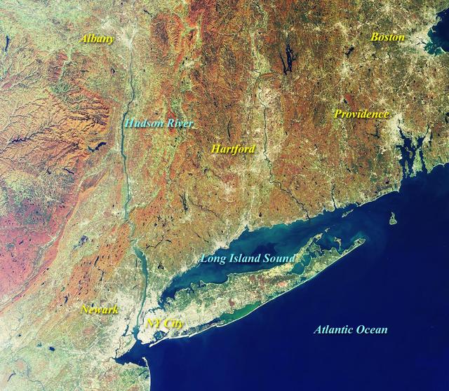
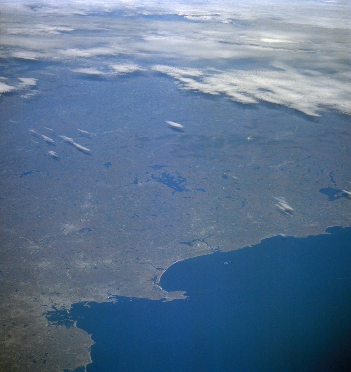
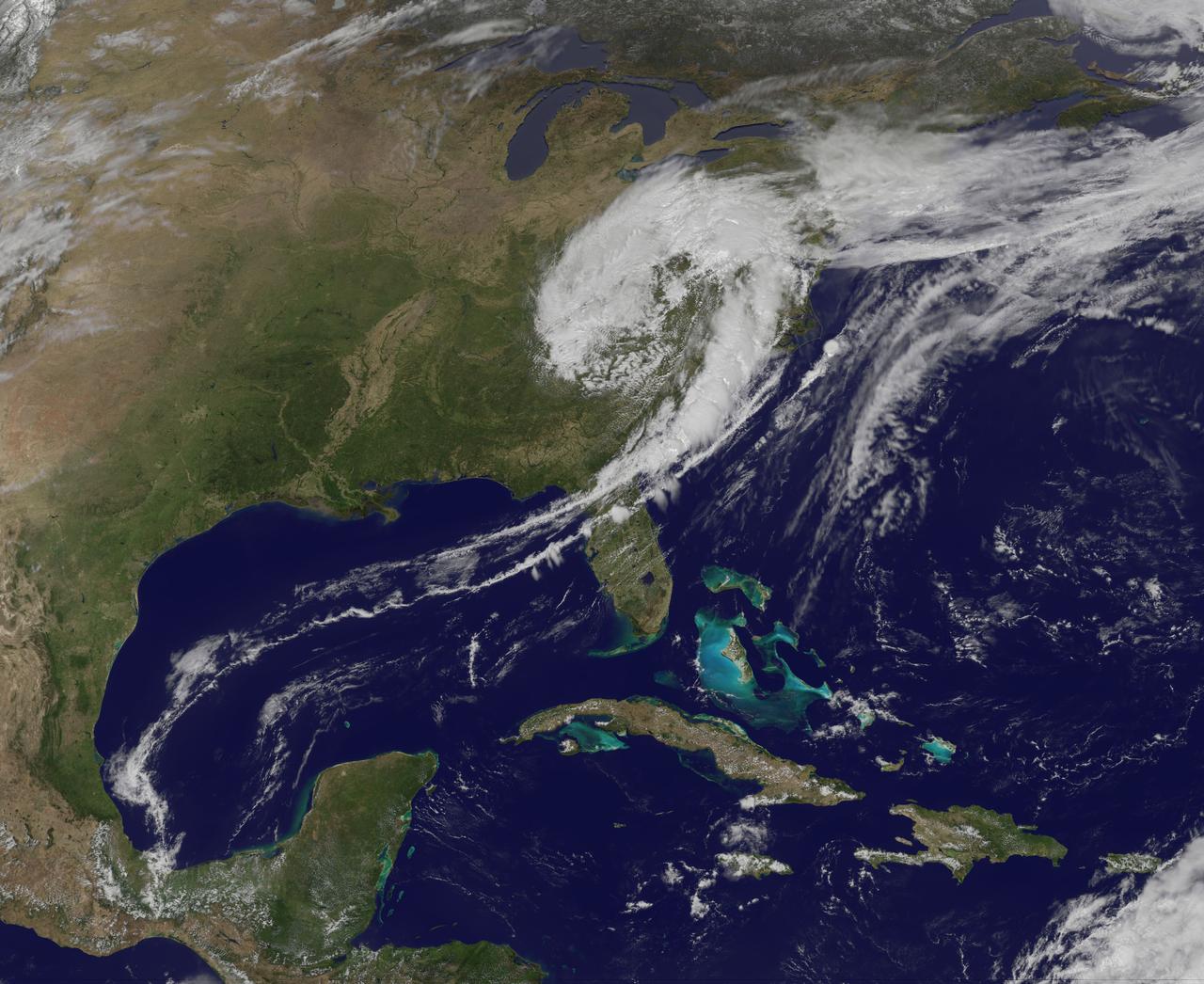
This image from NASA Terra satellite on October 20, 2000, shows New York and Southern New England.

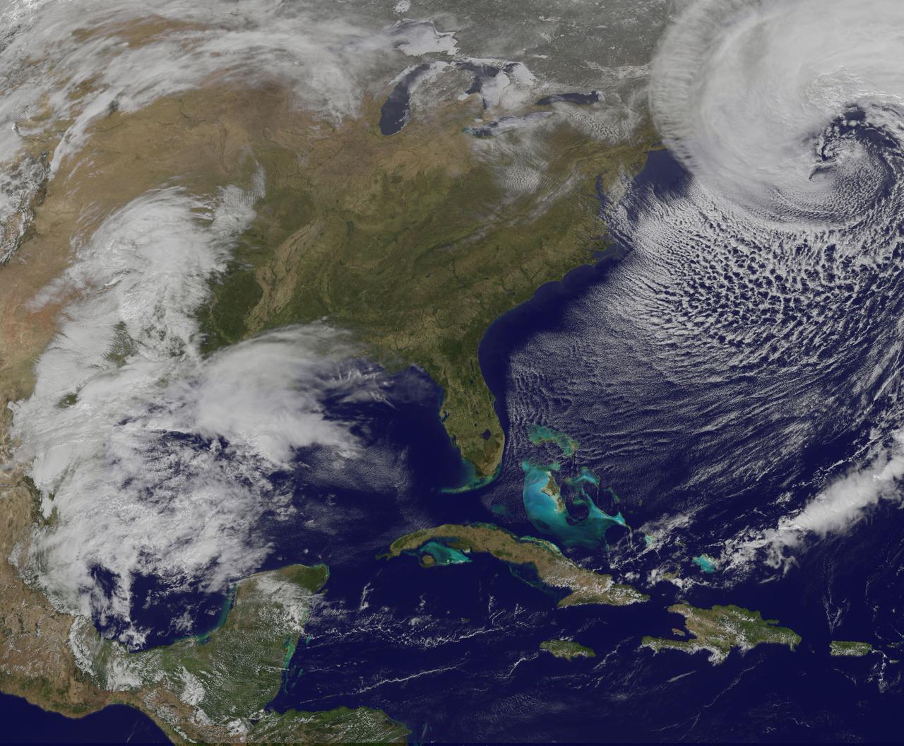
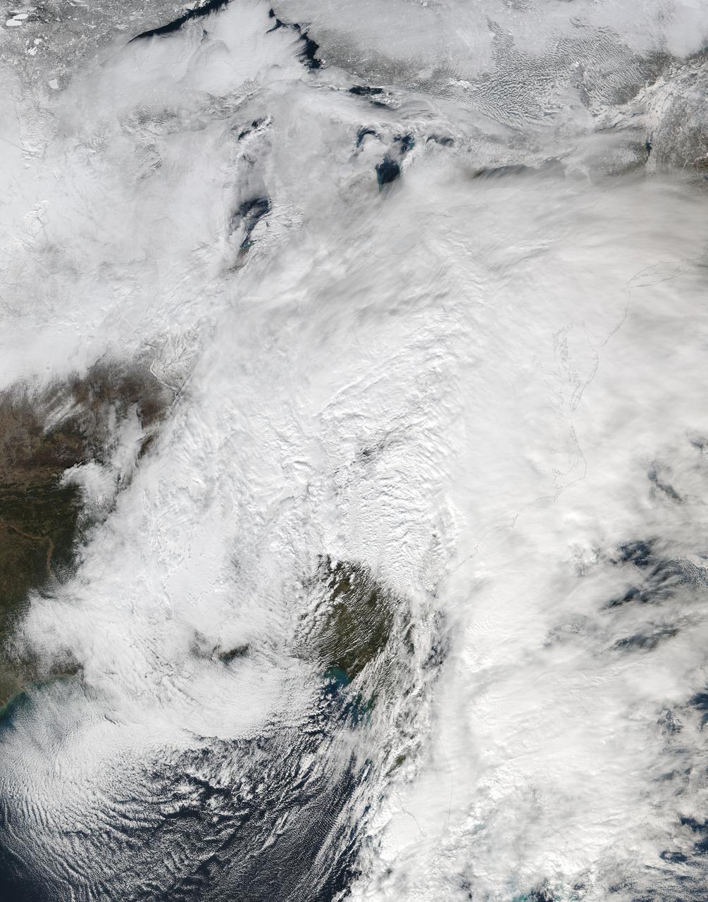
The U.S. National Weather Service called it a “a crippling and historic winter blizzard.” In late January 2015, transportation systems from Trenton to Portland were shut down, and more than 35 million people hunkered down for extreme snowfall and biting winds. For those in New England, it turned out to be a monstrous storm. For the Mid-Atlantic region, not so much. Vast swaths of Massachusetts, Connecticut, Rhode Island, New Hampshire, Maine, and Long Island (NY) were blanketed with 15 to 25 inches (40 to 60 centimeters) of snow as of midday on January 27, 2015, and snow was expected to continue into January 28. Sustained winds reached gale force, with hurricane-force gusts along the coastlines. Storm surges sent ice and water into the streets of Scituate and Nantucket, Massachusetts. Many New England towns, including the city of Boston, were expected to approach all-time snowfall records. The Visible Infrared Imaging Radiometer Suite on the Suomi NPP satellite acquired these nighttime images at 1:45 am US eastern standard time (06:45 Universal Time) on January 27, 2015. The top image, lit by moonlight and city lights, shows a nor'easter off the coast of the East Coast of the United States. City lights are blurred somewhat by the cloud cover. The second image shows the same scene in longwave infrared radiation, with brighter shades representing the colder temperatures of snow-producing clouds. NASA Earth Observatory image by Jesse Allen, using VIIRS data from the Suomi National Polar-orbiting Partnership. Read more: <a href="http://earthobservatory.nasa.gov/IOTD/view.php?id=85166&eocn=home&eoci=iotd_title" rel="nofollow">earthobservatory.nasa.gov/IOTD/view.php?id=85166&eocn...</a> Via: <b><a href="http://www.earthobservatory.nasa.gov/" rel="nofollow"> NASA Earth Observatory</a></b> <b><a href="http://www.nasa.gov/audience/formedia/features/MP_Photo_Guidelines.html" rel="nofollow">NASA image use policy.</a></b> <b><a href="http://www.nasa.gov/centers/goddard/home/index.html" rel="nofollow">NASA Goddard Space Flight Center</a></b> enables NASA’s mission through four scientific endeavors: Earth Science, Heliophysics, Solar System Exploration, and Astrophysics. Goddard plays a leading role in NASA’s accomplishments by contributing compelling scientific knowledge to advance the Agency’s mission. <b>Follow us on <a href="http://twitter.com/NASAGoddardPix" rel="nofollow">Twitter</a></b> <b>Like us on <a href="http://www.facebook.com/pages/Greenbelt-MD/NASA-Goddard/395013845897?ref=tsd" rel="nofollow">Facebook</a></b> <b>Find us on <a href="http://instagram.com/nasagoddard?vm=grid" rel="nofollow">Instagram</a></b>

The U.S. National Weather Service called it a “a crippling and historic winter blizzard.” In late January 2015, transportation systems from Trenton to Portland were shut down, and more than 35 million people hunkered down for extreme snowfall and biting winds. For those in New England, it turned out to be a monstrous storm. For the Mid-Atlantic region, not so much. Vast swaths of Massachusetts, Connecticut, Rhode Island, New Hampshire, Maine, and Long Island (NY) were blanketed with 15 to 25 inches (40 to 60 centimeters) of snow as of midday on January 27, 2015, and snow was expected to continue into January 28. Sustained winds reached gale force, with hurricane-force gusts along the coastlines. Storm surges sent ice and water into the streets of Scituate and Nantucket, Massachusetts. Many New England towns, including the city of Boston, were expected to approach all-time snowfall records. The Visible Infrared Imaging Radiometer Suite on the Suomi NPP satellite acquired these nighttime images at 1:45 am US eastern standard time (06:45 Universal Time) on January 27, 2015. The top image, lit by moonlight and city lights, shows a nor'easter off the coast of the East Coast of the United States. City lights are blurred somewhat by the cloud cover. The second image shows the same scene in longwave infrared radiation, with brighter shades representing the colder temperatures of snow-producing clouds. NASA Earth Observatory image by Jesse Allen, using VIIRS data from the Suomi National Polar-orbiting Partnership. Read more: <a href="http://earthobservatory.nasa.gov/IOTD/view.php?id=85166&eocn=home&eoci=iotd_title" rel="nofollow">earthobservatory.nasa.gov/IOTD/view.php?id=85166&eocn...</a> Via: <b><a href="http://www.earthobservatory.nasa.gov/" rel="nofollow"> NASA Earth Observatory</a></b> <b><a href="http://www.nasa.gov/audience/formedia/features/MP_Photo_Guidelines.html" rel="nofollow">NASA image use policy.</a></b> <b><a href="http://www.nasa.gov/centers/goddard/home/index.html" rel="nofollow">NASA Goddard Space Flight Center</a></b> enables NASA’s mission through four scientific endeavors: Earth Science, Heliophysics, Solar System Exploration, and Astrophysics. Goddard plays a leading role in NASA’s accomplishments by contributing compelling scientific knowledge to advance the Agency’s mission. <b>Follow us on <a href="http://twitter.com/NASAGoddardPix" rel="nofollow">Twitter</a></b> <b>Like us on <a href="http://www.facebook.com/pages/Greenbelt-MD/NASA-Goddard/395013845897?ref=tsd" rel="nofollow">Facebook</a></b> <b>Find us on <a href="http://instagram.com/nasagoddard?vm=grid" rel="nofollow">Instagram</a></b>

iss074e0300243 (Feb. 2, 2026) --- The wintry landscape of the southern New England region of the United States is seen from the International Space Station as it orbited 262 miles above North America. Temperatures in Boston, Massachusetts, ranged from a low of about 23 degrees Fahrenheit to a high of around 35 degrees when this photograph was taken.
The strong coastal storm currently off the coast of New England will continue to bring strong winds and heavy snow to coastal portions of the Northeast on Wednesday. The storm will move into the Canadian Maritimes by Thursday. This image was taken by GOES East at 17:31 UTC on March 26, 2014. <b><a href="http://goes.gsfc.nasa.gov/" rel="nofollow">Credit: NOAA/NASA GOES Project</a></b> <b><a href="http://www.nasa.gov/audience/formedia/features/MP_Photo_Guidelines.html" rel="nofollow">NASA image use policy.</a></b> <b><a href="http://www.nasa.gov/centers/goddard/home/index.html" rel="nofollow">NASA Goddard Space Flight Center</a></b> enables NASA’s mission through four scientific endeavors: Earth Science, Heliophysics, Solar System Exploration, and Astrophysics. Goddard plays a leading role in NASA’s accomplishments by contributing compelling scientific knowledge to advance the Agency’s mission. <b>Follow us on <a href="http://twitter.com/NASAGoddardPix" rel="nofollow">Twitter</a></b> <b>Like us on <a href="http://www.facebook.com/pages/Greenbelt-MD/NASA-Goddard/395013845897?ref=tsd" rel="nofollow">Facebook</a></b> <b>Find us on <a href="http://instagram.com/nasagoddard?vm=grid" rel="nofollow">Instagram</a></b>
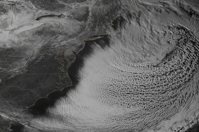
Yet another potent winter storm battered the northeastern United States on February 14-15, 2015. The nor'easter brought 12 to 20 inches (30 to 50 centimeters) of snow across much of eastern New England, along with tropical storm force winds over 60 miles (100 kilometers) per hour. The latest snowfall pushed Boston to its highest monthly total on record—58 inches and counting—and its third highest yearly snow total. This image was acquired by the GOES-East weather satellite at 3:45 p.m. Eastern Standard Time (20:45 Universal Time) on February 15, 2015, as the storm was mostly out to sea. Note the comma-like shape of the nor'easter, which spawned blizzard conditions at coastal locations. The official meteorological definition of a blizzard is three consecutive hours of falling or blowing snow with winds gusting above 35 miles (56 kilometers) per hour and visibility below one-fourth of a mile (0.4 kilometers). As of February 17, the snow depth near Boston was greater than in all but two reported locations in Alaska. It was significantly higher than the notoriously snowy states of Michigan, Wisconsin, and Minnesota. Only Buffalo, New York, had a higher snow pack. On February 16-17, more snow and ice fell across the eastern United States from northern Mississippi all the way to Maine. Read more: <a href="http://1.usa.gov/19wR4LI" rel="nofollow">1.usa.gov/19wR4LI</a> Via: <b><a href="http://www.earthobservatory.nasa.gov/" rel="nofollow"> NASA Earth Observatory</a></b> GOES image courtesy of the NASA/NOAA GOES Project Science team. Terra MODIS image by Jeff Schmaltz, LANCE/EOSDIS Rapid Response at NASA Goddard Space Flight Center. Caption by Mike Carlowicz. <b><a href="http://www.nasa.gov/audience/formedia/features/MP_Photo_Guidelines.html" rel="nofollow">NASA image use policy.</a></b> <b><a href="http://www.nasa.gov/centers/goddard/home/index.html" rel="nofollow">NASA Goddard Space Flight Center</a></b> enables NASA’s mission through four scientific endeavors: Earth Science, Heliophysics, Solar System Exploration, and Astrophysics. Goddard plays a leading role in NASA’s accomplishments by contributing compelling scientific knowledge to advance the Agency’s mission. <b>Follow us on <a href="http://twitter.com/NASAGoddardPix" rel="nofollow">Twitter</a></b> <b>Like us on <a href="http://www.facebook.com/pages/Greenbelt-MD/NASA-Goddard/395013845897?ref=tsd" rel="nofollow">Facebook</a></b> <b>Find us on <a href="http://instagram.com/nasagoddard?vm=grid" rel="nofollow">Instagram</a></b>
SL2-103-967 (22 June 1973) --- This view of lower New England, (41.5N, 72.0W) shows a rare cloud-free area stretching from northern Long Island across the states of Connecticut, Rhode Island and Massachusetts. The total area covered by this photo is more than 25,000 square miles and includes all of Rhode Island, most of Massachusetts and Connecticut, part of New York and the coastal waters of the Atlantic Ocean. Cape Cod, Boston and the offshore islands are distinctive features. Photo credit: NASA
Another large snowstorm affecting New England was dropping more snow on the region and breaking records on February 9, as NOAA's GOES-East satellite captured an image of the clouds associated with the storm system. On Feb. 9, NOAA's National Weather Service in Boston, Massachusetts noted that "The 30-day snowfall total at Boston ending 7 a.m. this morning is 61.6 inches. This exceeds the previous maximum 30 day snowfall total on record at Boston, which was 58.8 inches ending Feb 7 1978." The GOES-East image was created by NASA/NOAA's GOES Project at NASA's Goddard Space Flight Center in Greenbelt, Maryland. It showed a blanket of clouds over the U.S. northeast that stretched down to the Mid-Atlantic where there was no snow on the ground in Washington, D.C. NOAA's National Weather Service Weather Prediction Center provided a look at the extent of the storm system and noted "Heavy snow will impact portions of New York State and New England as the new week begins. Freezing rain will spread from western Pennsylvania to Long Island, with rain for the mid-Atlantic states." The low pressure area bringing the snow to the northeast was located in central Pennsylvania. A cold front extended southward from the low across the Tennessee Valley while a stationary boundary extended eastward from the low across the central mid-Atlantic. To create the image, NASA/NOAA's GOES Project takes the cloud data from NOAA's GOES-East satellite and overlays it on a true-color image of land and ocean created by data from the Moderate Resolution Imaging Spectroradiometer, or MODIS, instrument that flies aboard NASA's Aqua and Terra satellites. Together, those data created the entire picture of the storm. NOAA's GOES satellites provide the kind of continuous monitoring necessary for intensive data analysis. Geostationary describes an orbit in which a satellite is always in the same position with respect to the rotating Earth. This allows GOES to hover continuously over one position on Earth's surface, appearing stationary. As a result, GOES provide a constant vigil for the atmospheric triggers for severe weather conditions such as tornadoes, flash floods, hail storms and hurricanes. For updated information about the storm system, visit NOAA's NWS website: <a href="http://www.weather.gov" rel="nofollow">www.weather.gov</a> For more information about GOES satellites, visit: <a href="http://www.goes.noaa.gov/" rel="nofollow">www.goes.noaa.gov/</a> or goes.gsfc.nasa.gov/ Rob Gutro NASA's Goddard Space Flight Center <b><a href="http://goes.gsfc.nasa.gov/" rel="nofollow">Credit: NOAA/NASA GOES Project</a></b> <b><a href="http://www.nasa.gov/audience/formedia/features/MP_Photo_Guidelines.html" rel="nofollow">NASA image use policy.</a></b> <b><a href="http://www.nasa.gov/centers/goddard/home/index.html" rel="nofollow">NASA Goddard Space Flight Center</a></b> enables NASA’s mission through four scientific endeavors: Earth Science, Heliophysics, Solar System Exploration, and Astrophysics. Goddard plays a leading role in NASA’s accomplishments by contributing compelling scientific knowledge to advance the Agency’s mission. <b>Follow us on <a href="http://twitter.com/NASAGoddardPix" rel="nofollow">Twitter</a></b> <b>Like us on <a href="http://www.facebook.com/pages/Greenbelt-MD/NASA-Goddard/395013845897?ref=tsd" rel="nofollow">Facebook</a></b> <b>Find us on <a href="http://instagram.com/nasagoddard?vm=grid" rel="nofollow">Instagram</a></b>
iss072e394484 (Dec. 18, 2024) --- The gleaming New England coast from Massachusetts to Maine is pictured from the International Space Station as it orbited 262 miles above Quebec, Canada.
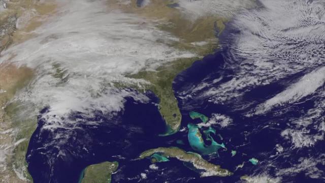
![The monster winter storm that brought icing to the U.S. southeast moved northward along the Eastern Seaboard and brought snow, sleet and rain from the Mid-Atlantic to New England on February 13. A new image from NOAA's GOES satellite showed clouds associated with the massive winter storm stretch from the U.S. southeast to the northeast. Data from NOAA's GOES-East satellite taken on Feb. 13 at 1455 UTC/9:45 a.m. EST were made into an image by NASA/NOAA's GOES Project at NASA's Goddard Space Flight Center in Greenbelt, Md. The clouds and fallen snow data from NOAA's GOES-East satellite were overlaid on a true-color image of land and ocean created by data from the Moderate Resolution Imaging Spectroradiometer or MODIS instrument that flies aboard NASA's Aqua and Terra satellites.The image showed that the clouds associated with the storm were blanketing much of the U.S. East Coast. At 3:11 a.m. EST, a surface map issued by the National Weather Service or NWS showed the storm's low pressure area was centered over eastern North Carolina. Since then, the low has continued to track north along the eastern seaboard. By 11 a.m. EST, precipitation from the storm was falling from South Carolina to Maine, according to National Weather Service radar. By 11 a.m. EST, the Washington, D.C. region snow and sleet totals ranged from 3" in far eastern Maryland to over 18" in the northern and western suburbs in Maryland and Virginia. NWS reported that snow, sleet and rain were still falling and more snow is expected as the back side of the low moves into the region. The New York City region remained under an NWS Winter Storm Warning until 6 a.m. on Friday, February 14 and the National Weather Service expects minor coastal impacts Thursday into Friday afternoon. New England was also being battered by the storm. At 10:56 a.m. EST, Barnstable, Mass. on Cape Cod was experiencing rain and winds gusting to 28 mph. An NWS wind advisory is in effect for Cape Cod until 7 p.m. EST. Further north, Portland, Maine was experiencing heavy snow with winds from the northeast at 6 mph. The National Weather Service in Gray, Maine noted "Significant snowfall is likely for much of western Maine and New Hampshire as this storm passes by. There will be a mix or changeover to sleet and freezing rain over southern and coastal sections tonight...before all areas end as a period of snow Friday (Feb. 14) morning." On February 13 at 10 a.m. EST, NOAA's National Weather Service noted "An abundance of Atlantic moisture getting wrapped into the storm will continue to fuel widespread precipitation...which should lift through the Mid-Atlantic States and Northeast Thursday into Friday. A wide swath of heavy snow accumulations are expected with this storm...but air [moving] off the warmer ocean water should change snow over to rain along the coastal areas. Also...a narrow axis of sleet and freezing rain will be possible within the transition zone...which is expected to set up near the I-95 corridor." For updates on local forecasts, watches and warnings, visit NOAA's <a href="http://www.weather.gov" rel="nofollow">www.weather.gov</a> webpage. GOES satellites provide the kind of continuous monitoring necessary for intensive data analysis. Geostationary describes an orbit in which a satellite is always in the same position with respect to the rotating Earth. This allows GOES to hover continuously over one position on Earth's surface, appearing stationary. As a result, GOES provide a constant vigil for the atmospheric "triggers" for severe weather conditions such as tornadoes, flash floods, hail storms and hurricanes. For updated information about the storm system, visit NOAA's WPC website: <a href="http://www.hpc.ncep.noaa.gov/" rel="nofollow">www.hpc.ncep.noaa.gov/</a> For more information about GOES satellites, visit: <a href="http://www.goes.noaa.gov/" rel="nofollow">www.goes.noaa.gov/</a> or <a href="http://goes.gsfc.nasa.gov/" rel="nofollow">goes.gsfc.nasa.gov/</a> Credit: NASA/GSFC/Jeff Schmaltz/MODIS Land Rapid Response Team <b><a href="http://www.nasa.gov/audience/formedia/features/MP_Photo_Guidelines.html" rel="nofollow">NASA image use policy.</a></b> <b><a href="http://www.nasa.gov/centers/goddard/home/index.html" rel="nofollow">NASA Goddard Space Flight Center</a></b> enables NASA’s mission through four scientific endeavors: Earth Science, Heliophysics, Solar System Exploration, and Astrophysics. Goddard plays a leading role in NASA’s accomplishments by contributing compelling scientific knowledge to advance the Agency’s mission. <b>Follow us on <a href="http://twitter.com/NASAGoddardPix" rel="nofollow">Twitter</a></b> <b>Like us on <a href="http://www.facebook.com/pages/Greenbelt-MD/NASA-Goddard/395013845897?ref=tsd" rel="nofollow">Facebook</a></b> <b>Find us on <a href="http://instagram.com/nasagoddard?vm=grid" rel="nofollow">Instagram</a></b>](https://images-assets.nasa.gov/image/GSFC_20171208_Archive_e001228/GSFC_20171208_Archive_e001228~medium.jpg)
The monster winter storm that brought icing to the U.S. southeast moved northward along the Eastern Seaboard and brought snow, sleet and rain from the Mid-Atlantic to New England on February 13. A new image from NOAA's GOES satellite showed clouds associated with the massive winter storm stretch from the U.S. southeast to the northeast. Data from NOAA's GOES-East satellite taken on Feb. 13 at 1455 UTC/9:45 a.m. EST were made into an image by NASA/NOAA's GOES Project at NASA's Goddard Space Flight Center in Greenbelt, Md. The clouds and fallen snow data from NOAA's GOES-East satellite were overlaid on a true-color image of land and ocean created by data from the Moderate Resolution Imaging Spectroradiometer or MODIS instrument that flies aboard NASA's Aqua and Terra satellites.The image showed that the clouds associated with the storm were blanketing much of the U.S. East Coast. At 3:11 a.m. EST, a surface map issued by the National Weather Service or NWS showed the storm's low pressure area was centered over eastern North Carolina. Since then, the low has continued to track north along the eastern seaboard. By 11 a.m. EST, precipitation from the storm was falling from South Carolina to Maine, according to National Weather Service radar. By 11 a.m. EST, the Washington, D.C. region snow and sleet totals ranged from 3" in far eastern Maryland to over 18" in the northern and western suburbs in Maryland and Virginia. NWS reported that snow, sleet and rain were still falling and more snow is expected as the back side of the low moves into the region. The New York City region remained under an NWS Winter Storm Warning until 6 a.m. on Friday, February 14 and the National Weather Service expects minor coastal impacts Thursday into Friday afternoon. New England was also being battered by the storm. At 10:56 a.m. EST, Barnstable, Mass. on Cape Cod was experiencing rain and winds gusting to 28 mph. An NWS wind advisory is in effect for Cape Cod until 7 p.m. EST. Further north, Portland, Maine was experiencing heavy snow with winds from the northeast at 6 mph. The National Weather Service in Gray, Maine noted "Significant snowfall is likely for much of western Maine and New Hampshire as this storm passes by. There will be a mix or changeover to sleet and freezing rain over southern and coastal sections tonight...before all areas end as a period of snow Friday (Feb. 14) morning." On February 13 at 10 a.m. EST, NOAA's National Weather Service noted "An abundance of Atlantic moisture getting wrapped into the storm will continue to fuel widespread precipitation...which should lift through the Mid-Atlantic States and Northeast Thursday into Friday. A wide swath of heavy snow accumulations are expected with this storm...but air [moving] off the warmer ocean water should change snow over to rain along the coastal areas. Also...a narrow axis of sleet and freezing rain will be possible within the transition zone...which is expected to set up near the I-95 corridor." For updates on local forecasts, watches and warnings, visit NOAA's <a href="http://www.weather.gov" rel="nofollow">www.weather.gov</a> webpage. GOES satellites provide the kind of continuous monitoring necessary for intensive data analysis. Geostationary describes an orbit in which a satellite is always in the same position with respect to the rotating Earth. This allows GOES to hover continuously over one position on Earth's surface, appearing stationary. As a result, GOES provide a constant vigil for the atmospheric "triggers" for severe weather conditions such as tornadoes, flash floods, hail storms and hurricanes. For updated information about the storm system, visit NOAA's WPC website: <a href="http://www.hpc.ncep.noaa.gov/" rel="nofollow">www.hpc.ncep.noaa.gov/</a> For more information about GOES satellites, visit: <a href="http://www.goes.noaa.gov/" rel="nofollow">www.goes.noaa.gov/</a> or <a href="http://goes.gsfc.nasa.gov/" rel="nofollow">goes.gsfc.nasa.gov/</a> Credit: NASA/GSFC/Jeff Schmaltz/MODIS Land Rapid Response Team <b><a href="http://www.nasa.gov/audience/formedia/features/MP_Photo_Guidelines.html" rel="nofollow">NASA image use policy.</a></b> <b><a href="http://www.nasa.gov/centers/goddard/home/index.html" rel="nofollow">NASA Goddard Space Flight Center</a></b> enables NASA’s mission through four scientific endeavors: Earth Science, Heliophysics, Solar System Exploration, and Astrophysics. Goddard plays a leading role in NASA’s accomplishments by contributing compelling scientific knowledge to advance the Agency’s mission. <b>Follow us on <a href="http://twitter.com/NASAGoddardPix" rel="nofollow">Twitter</a></b> <b>Like us on <a href="http://www.facebook.com/pages/Greenbelt-MD/NASA-Goddard/395013845897?ref=tsd" rel="nofollow">Facebook</a></b> <b>Find us on <a href="http://instagram.com/nasagoddard?vm=grid" rel="nofollow">Instagram</a></b>
![The monster winter storm that brought icing to the U.S. southeast moved northward along the Eastern Seaboard and brought snow, sleet and rain from the Mid-Atlantic to New England on February 13. A new image from NOAA's GOES satellite showed clouds associated with the massive winter storm stretch from the U.S. southeast to the northeast. Data from NOAA's GOES-East satellite taken on Feb. 13 at 1455 UTC/9:45 a.m. EST were made into an image by NASA/NOAA's GOES Project at NASA's Goddard Space Flight Center in Greenbelt, Md. The clouds and fallen snow data from NOAA's GOES-East satellite were overlaid on a true-color image of land and ocean created by data from the Moderate Resolution Imaging Spectroradiometer or MODIS instrument that flies aboard NASA's Aqua and Terra satellites.The image showed that the clouds associated with the storm were blanketing much of the U.S. East Coast. At 3:11 a.m. EST, a surface map issued by the National Weather Service or NWS showed the storm's low pressure area was centered over eastern North Carolina. Since then, the low has continued to track north along the eastern seaboard. By 11 a.m. EST, precipitation from the storm was falling from South Carolina to Maine, according to National Weather Service radar. By 11 a.m. EST, the Washington, D.C. region snow and sleet totals ranged from 3" in far eastern Maryland to over 18" in the northern and western suburbs in Maryland and Virginia. NWS reported that snow, sleet and rain were still falling and more snow is expected as the back side of the low moves into the region. The New York City region remained under an NWS Winter Storm Warning until 6 a.m. on Friday, February 14 and the National Weather Service expects minor coastal impacts Thursday into Friday afternoon. New England was also being battered by the storm. At 10:56 a.m. EST, Barnstable, Mass. on Cape Cod was experiencing rain and winds gusting to 28 mph. An NWS wind advisory is in effect for Cape Cod until 7 p.m. EST. Further north, Portland, Maine was experiencing heavy snow with winds from the northeast at 6 mph. The National Weather Service in Gray, Maine noted "Significant snowfall is likely for much of western Maine and New Hampshire as this storm passes by. There will be a mix or changeover to sleet and freezing rain over southern and coastal sections tonight...before all areas end as a period of snow Friday (Feb. 14) morning." On February 13 at 10 a.m. EST, NOAA's National Weather Service noted "An abundance of Atlantic moisture getting wrapped into the storm will continue to fuel widespread precipitation...which should lift through the Mid-Atlantic States and Northeast Thursday into Friday. A wide swath of heavy snow accumulations are expected with this storm...but air [moving] off the warmer ocean water should change snow over to rain along the coastal areas. Also...a narrow axis of sleet and freezing rain will be possible within the transition zone...which is expected to set up near the I-95 corridor." For updates on local forecasts, watches and warnings, visit NOAA's <a href="http://www.weather.gov" rel="nofollow">www.weather.gov</a> webpage. GOES satellites provide the kind of continuous monitoring necessary for intensive data analysis. Geostationary describes an orbit in which a satellite is always in the same position with respect to the rotating Earth. This allows GOES to hover continuously over one position on Earth's surface, appearing stationary. As a result, GOES provide a constant vigil for the atmospheric "triggers" for severe weather conditions such as tornadoes, flash floods, hail storms and hurricanes. For updated information about the storm system, visit NOAA's WPC website: <a href="http://www.hpc.ncep.noaa.gov/" rel="nofollow">www.hpc.ncep.noaa.gov/</a> For more information about GOES satellites, visit: <a href="http://www.goes.noaa.gov/" rel="nofollow">www.goes.noaa.gov/</a> or <a href="http://goes.gsfc.nasa.gov/" rel="nofollow">goes.gsfc.nasa.gov/</a> Credit: NASA/GSFC/Jeff Schmaltz/MODIS Land Rapid Response Team <b><a href="http://www.nasa.gov/audience/formedia/features/MP_Photo_Guidelines.html" rel="nofollow">NASA image use policy.</a></b> <b><a href="http://www.nasa.gov/centers/goddard/home/index.html" rel="nofollow">NASA Goddard Space Flight Center</a></b> enables NASA’s mission through four scientific endeavors: Earth Science, Heliophysics, Solar System Exploration, and Astrophysics. Goddard plays a leading role in NASA’s accomplishments by contributing compelling scientific knowledge to advance the Agency’s mission. <b>Follow us on <a href="http://twitter.com/NASAGoddardPix" rel="nofollow">Twitter</a></b> <b>Like us on <a href="http://www.facebook.com/pages/Greenbelt-MD/NASA-Goddard/395013845897?ref=tsd" rel="nofollow">Facebook</a></b> <b>Find us on <a href="http://instagram.com/nasagoddard?vm=grid" rel="nofollow">Instagram</a></b>](https://images-assets.nasa.gov/image/GSFC_20171208_Archive_e001229/GSFC_20171208_Archive_e001229~medium.jpg)
The monster winter storm that brought icing to the U.S. southeast moved northward along the Eastern Seaboard and brought snow, sleet and rain from the Mid-Atlantic to New England on February 13. A new image from NOAA's GOES satellite showed clouds associated with the massive winter storm stretch from the U.S. southeast to the northeast. Data from NOAA's GOES-East satellite taken on Feb. 13 at 1455 UTC/9:45 a.m. EST were made into an image by NASA/NOAA's GOES Project at NASA's Goddard Space Flight Center in Greenbelt, Md. The clouds and fallen snow data from NOAA's GOES-East satellite were overlaid on a true-color image of land and ocean created by data from the Moderate Resolution Imaging Spectroradiometer or MODIS instrument that flies aboard NASA's Aqua and Terra satellites.The image showed that the clouds associated with the storm were blanketing much of the U.S. East Coast. At 3:11 a.m. EST, a surface map issued by the National Weather Service or NWS showed the storm's low pressure area was centered over eastern North Carolina. Since then, the low has continued to track north along the eastern seaboard. By 11 a.m. EST, precipitation from the storm was falling from South Carolina to Maine, according to National Weather Service radar. By 11 a.m. EST, the Washington, D.C. region snow and sleet totals ranged from 3" in far eastern Maryland to over 18" in the northern and western suburbs in Maryland and Virginia. NWS reported that snow, sleet and rain were still falling and more snow is expected as the back side of the low moves into the region. The New York City region remained under an NWS Winter Storm Warning until 6 a.m. on Friday, February 14 and the National Weather Service expects minor coastal impacts Thursday into Friday afternoon. New England was also being battered by the storm. At 10:56 a.m. EST, Barnstable, Mass. on Cape Cod was experiencing rain and winds gusting to 28 mph. An NWS wind advisory is in effect for Cape Cod until 7 p.m. EST. Further north, Portland, Maine was experiencing heavy snow with winds from the northeast at 6 mph. The National Weather Service in Gray, Maine noted "Significant snowfall is likely for much of western Maine and New Hampshire as this storm passes by. There will be a mix or changeover to sleet and freezing rain over southern and coastal sections tonight...before all areas end as a period of snow Friday (Feb. 14) morning." On February 13 at 10 a.m. EST, NOAA's National Weather Service noted "An abundance of Atlantic moisture getting wrapped into the storm will continue to fuel widespread precipitation...which should lift through the Mid-Atlantic States and Northeast Thursday into Friday. A wide swath of heavy snow accumulations are expected with this storm...but air [moving] off the warmer ocean water should change snow over to rain along the coastal areas. Also...a narrow axis of sleet and freezing rain will be possible within the transition zone...which is expected to set up near the I-95 corridor." For updates on local forecasts, watches and warnings, visit NOAA's <a href="http://www.weather.gov" rel="nofollow">www.weather.gov</a> webpage. GOES satellites provide the kind of continuous monitoring necessary for intensive data analysis. Geostationary describes an orbit in which a satellite is always in the same position with respect to the rotating Earth. This allows GOES to hover continuously over one position on Earth's surface, appearing stationary. As a result, GOES provide a constant vigil for the atmospheric "triggers" for severe weather conditions such as tornadoes, flash floods, hail storms and hurricanes. For updated information about the storm system, visit NOAA's WPC website: <a href="http://www.hpc.ncep.noaa.gov/" rel="nofollow">www.hpc.ncep.noaa.gov/</a> For more information about GOES satellites, visit: <a href="http://www.goes.noaa.gov/" rel="nofollow">www.goes.noaa.gov/</a> or <a href="http://goes.gsfc.nasa.gov/" rel="nofollow">goes.gsfc.nasa.gov/</a> Credit: NASA/GSFC/Jeff Schmaltz/MODIS Land Rapid Response Team <b><a href="http://www.nasa.gov/audience/formedia/features/MP_Photo_Guidelines.html" rel="nofollow">NASA image use policy.</a></b> <b><a href="http://www.nasa.gov/centers/goddard/home/index.html" rel="nofollow">NASA Goddard Space Flight Center</a></b> enables NASA’s mission through four scientific endeavors: Earth Science, Heliophysics, Solar System Exploration, and Astrophysics. Goddard plays a leading role in NASA’s accomplishments by contributing compelling scientific knowledge to advance the Agency’s mission. <b>Follow us on <a href="http://twitter.com/NASAGoddardPix" rel="nofollow">Twitter</a></b> <b>Like us on <a href="http://www.facebook.com/pages/Greenbelt-MD/NASA-Goddard/395013845897?ref=tsd" rel="nofollow">Facebook</a></b> <b>Find us on <a href="http://instagram.com/nasagoddard?vm=grid" rel="nofollow">Instagram</a></b>
SL2-05-381 (22 June 1973) --- Boston, MA and the New England Coastline (43.5N, 84.0W) can be seen in this view. The typical rugged rocky coast of Maine is the result of heavy glacial action producing the rocky cliffs, jagged spurs of land and islands that characterize Main's Atlantic Coast. During the last Ice Age, extensive sediments were laid down producing a landscape of rolling hills with rocky outcrops. Photo credit: NASA
iss072e186812 (Nov. 14, 2024) --- The city lights along the New England coast of the United States including New Haven, Connecticut; Providence, Rhode Island; and Boston, Massachusetts, are pictured from the United States as it orbited 254 miles above the Atlantic Ocean.
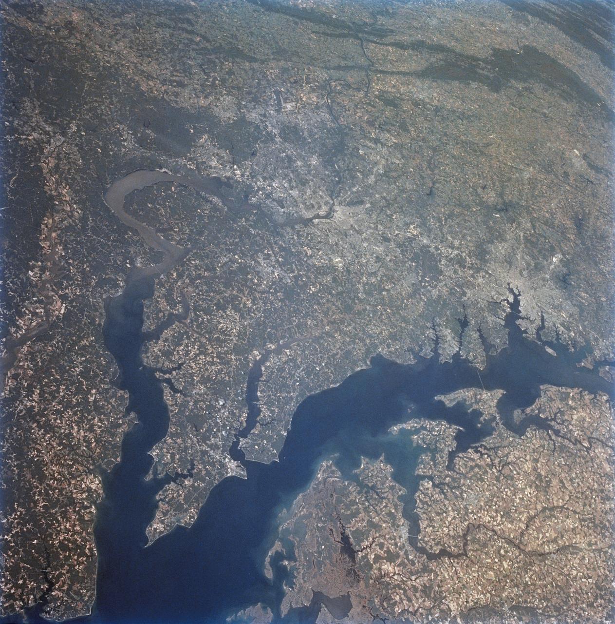
STS058-105-016 (18 Oct-1 Nov 1993) --- This photograph includes much of the heart of New England, stretching from Boston and Boston Harbor (lower left) across New Hampshire and Vermont to Lake Champlain (upper left), and up to southern Maine (Portland is just off the photo at right center). The colors in this photograph are less vivid than those in STS-58-81-038, because the color changes on the deciduous trees in central and northern New England were past their peak when this photograph was taken. North of Boston flows the Merrimack River (which forms part of the state boundary between Massachusetts and New Hampshire). It is delineated by the small industrial towns (Concord, Manchester, Nashua, Lowell) which grew up on its banks. The White Mountains of New Hampshire are seen near the center, and Mt. Washington (6,288 feet) is capped with snow.

NASA Administrator Charles Bolden speaks with young professionals about their project on New England water resources during the annual DEVELOP Earth Science Application Showcase at NASA headquarters Tuesday, August 5, 2014. The Earth Science Applications Showcase highlights the work of over 150 participants in the 10-week DEVELOP program that started in June. The DEVELOP Program bridges the gap between NASA Earth science and society, building capacity in both its participants and partner organizations, to better prepare them to handle the challenges that face our society and future generations. Photo Credit: (NASA/Aubrey Gemignani)
STS068-234-044 (30 September-11 October 1994) --- From the wetlands in Maryland to the nation's capital and onto Baltimore, this 70mm photograph from the Space Shuttle Endeavour shows some details of the historic Chesapeake Bay and Potomac River area. With the rather low altitude of Endeavour at 115 nautical miles, features as small as Kennedy Memorial Stadium and Andrews Air Force Base are clearly seen.
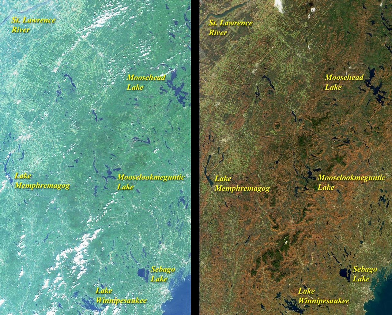
These images from NASA Terra satellite include eastern Vermont, New Hampshire, and western Maine, as well as the southeastern corner of Quebec province between August and October, 2000.
iss056e077502 (July 5, 2018) --- The International Space Station orbited over New England and across Canada capturing the Sun's glint on the North Atlantic Ocean just off the North American coast..
NASA and NOAA satellites are providing various views of the major winter storm marching toward the U.S. East coast on March 13. The storm is forecast to merge with another system and is expected to bring large snowfall totals from the Mid-Atlantic to New England. NASA's Aqua satellite gathered infrared data from the storm system and the area ahead of the storm for cloud and ground temperatures. NOAA's GOES-East satellite provided visible and infrared imagery that showed the extent and the movement of the system. Forecasters at the National Weather Service's Weather Prediction Center (WPC) noted that the low pressure system crossing the Midwest states and Ohio Valley is expected to merge with another low off the southeast U.S. coast. WPC stated "This will allow for a strong nor'easter to develop near the coast and cause a late-season snowstorm from the central Appalachians to New England, including many of the big cities in the Northeast U.S." Credits: NASA/NOAA GOES Project

jsc2017e009671 (01/26/2017) --- Former NFL player Emanuel McNeil (New England Patriots and New York Jets) provides a photo opportunity for a Johnson Space Center(JSC) Staff Member in front of the NASA Mars Rover image. Emanuel is touring JSC as part of the Super Bowl tailgate event. The JSC Center Director invited former NFL players during the week leading up to the Super Bowl. NASA Photographer Lauren Harnett.

jsc2017e009678 (01/26/2017) --- Former NFL player Mickey Washington (New England Patriots, Washington Redskins, Buffalo Bills, Jacksonville Jaguars, and New Orleans Saints) provides a picture opportunity for a Johnson Space Center staff member during the JSC Super Bowl Tailgate event. Many former NFL players attended the event that included a tour of Mission Control and other JSC areas. NASA Photographer Lauren Harnett.
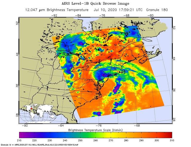
NASA's Atmospheric Infrared Sounder (AIRS) collected this image of Tropical Storm Fay over New England at around 2 p.m. local time on Friday, July 10. The center of the storm made landfall about 10 miles (15 kilometers) north-northeast of Atlantic City, New Jersey, at around 5 p.m. local time, when Fay had maximum sustained winds of around 50 mph (85 kph). In the infrared AIRS image, the purple regions indicate very cold clouds lofted high into the atmosphere by the storm. These clouds are generally linked to heavy rainfall. Warmer clouds closer to the ground show up as green and blue, while the orange areas denote mostly cloud-free parts of the sky. AIRS, together with the Advanced Microwave Sounding Unit (AMSU), measures the infrared and microwave radiation emitted from Earth to study the planet's weather and climate. Both instruments observe Earth from NASA's Aqua satellite, which launched in 2002. AIRS and AMSU work in tandem to make simultaneous observations down to Earth's surface, even in the presence of heavy clouds. With more than 2,000 channels sensing different regions of the atmosphere, the system creates a global, three-dimensional map of atmospheric temperature and humidity, cloud amounts and heights, greenhouse gas concentrations, and many other atmospheric phenomena. https://photojournal.jpl.nasa.gov/catalog/PIA23783
This true color image of the Continental United States was taken on Nov. 25, 2013 by the Suomi NPP satellite and shows the system as it moves through the South and Midwest. The National Weather Service noted that a complex and powerful storm system continues to generate widespread moderate to heavy rainfall and snows in various parts of the eastern United States as travelers make their way to destinations to celebrate Thanksgiving and Hanukkah on Nov. 28. There are two low-pressure areas working together. One was centered near New Jersey while the other was located over the Carolinas. From the Southeast to New England widespread moderate to heavy rainfall is expected. The rains will also affect the Mid-Atlantic and Southeastern United States, although those regions are not expected to get as much of a soaking. The Appalachians and interior New England are expected to receive snowfall. Areas of heavy snow are forecast for northwestern Indiana and northwestern Pennsylvania on Nov. 27. Snows will blanket the north central United States from the Dakotas to Minnesota, Iowa, Wisconsin, Michigan, the Ohio and Tennessee Valleys, upstate New York and parts of northern New England. The National Weather Service noted that cold air is moving in behind the storm and drop temperatures along the eastern U.S. making for a chilly Thanksgiving. Credit: NASA/NOAA <b><a href="http://www.nasa.gov/audience/formedia/features/MP_Photo_Guidelines.html" rel="nofollow">NASA image use policy.</a></b> <b><a href="http://www.nasa.gov/centers/goddard/home/index.html" rel="nofollow">NASA Goddard Space Flight Center</a></b> enables NASA’s mission through four scientific endeavors: Earth Science, Heliophysics, Solar System Exploration, and Astrophysics. Goddard plays a leading role in NASA’s accomplishments by contributing compelling scientific knowledge to advance the Agency’s mission. <b>Follow us on <a href="http://twitter.com/NASA_GoddardPix" rel="nofollow">Twitter</a></b> <b>Like us on <a href="http://www.facebook.com/pages/Greenbelt-MD/NASA-Goddard/395013845897?ref=tsd" rel="nofollow">Facebook</a></b> <b>Find us on <a href="http://instagram.com/nasagoddard?vm=grid" rel="nofollow">Instagram</a></b>

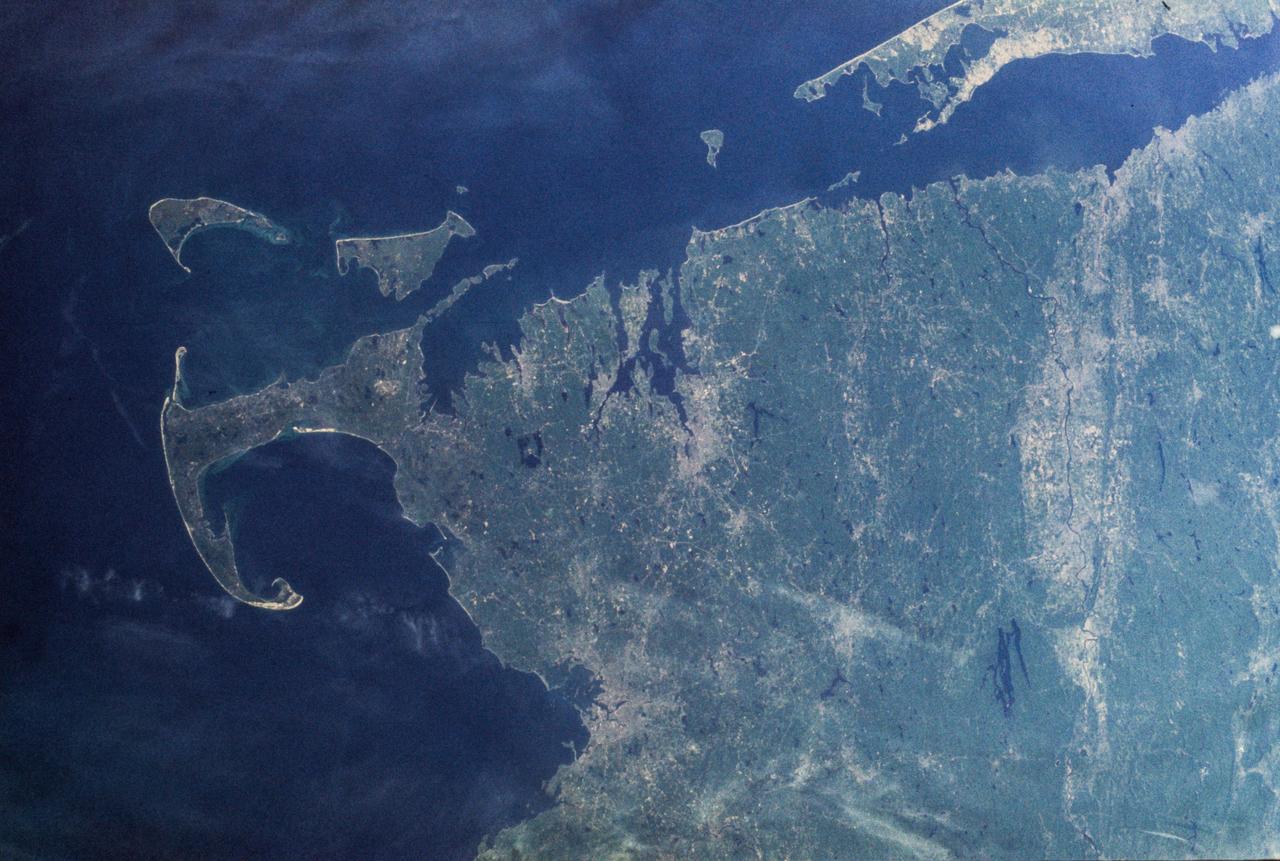
STS073-725-031 (24 October 1995) --- The contrasting colors of fall in New England are captured on this northward-looking photo of Martha's Vineyard, Nantucket Island, and the famous hook-shaped Cape Cod. Light-colored patches of urbanization are scattered throughout the scene, the most evident being the greater Boston area along the shores of Massachusetts Bay. The cape is composed of rock debris that, according to NASA scientists studying Columbia's photo collection, was deposited along the end of glacier some 20,000 years ago.
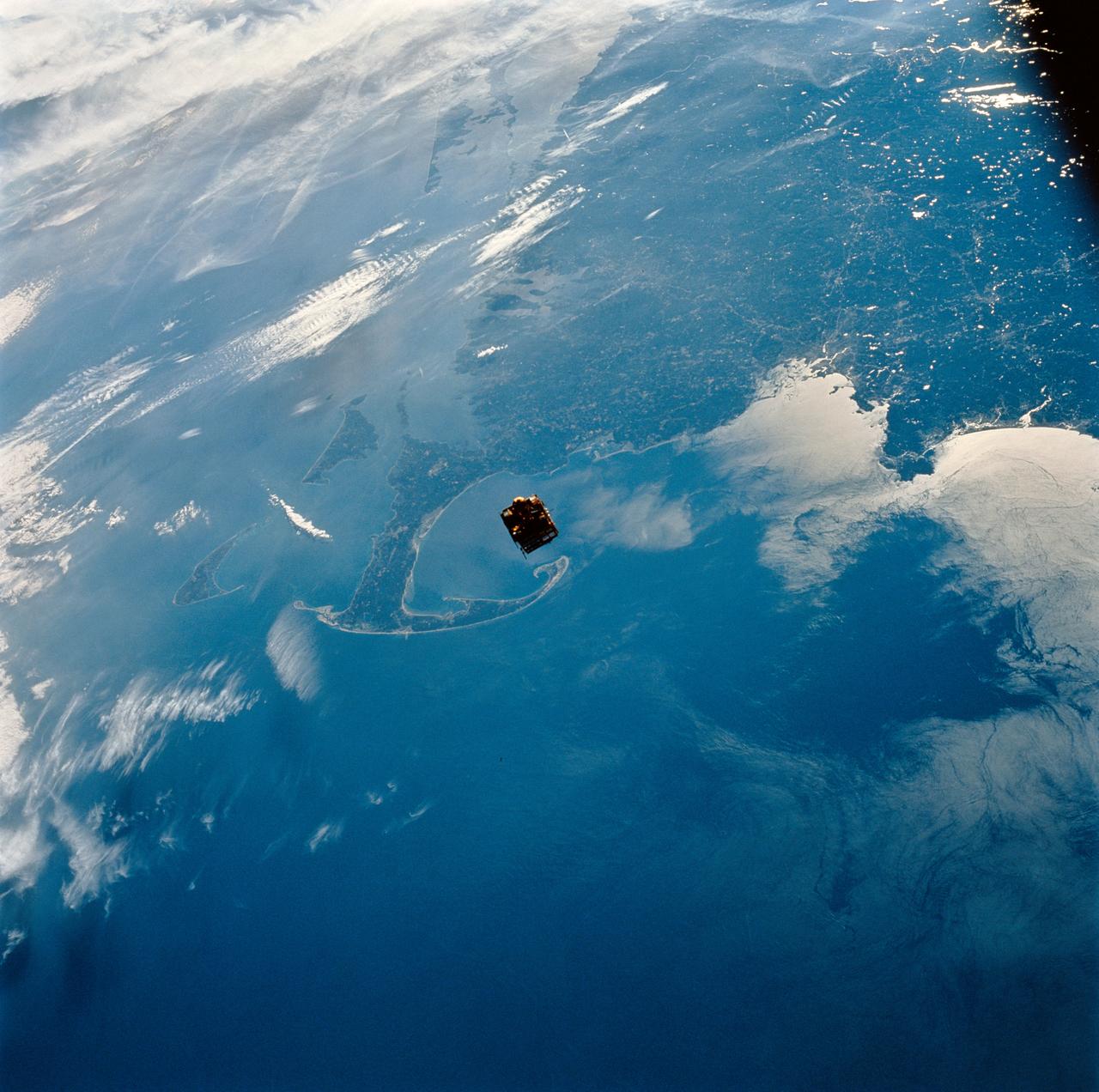
STS064-111-041 (12 Sept. 1994) ---- Backdropped against New England's coast, the Shuttle Pointed Autonomous Research Tool for Astronomy (SPARTAN-201) satellite begins its separation from the space shuttle Discovery. The free-flying spacecraft, 130 nautical miles above Cape Cod at frame center, remained some 40 miles away from Discovery until the crew retrieved it two days later. Photo credit: NASA or National Aeronautics and Space Administration
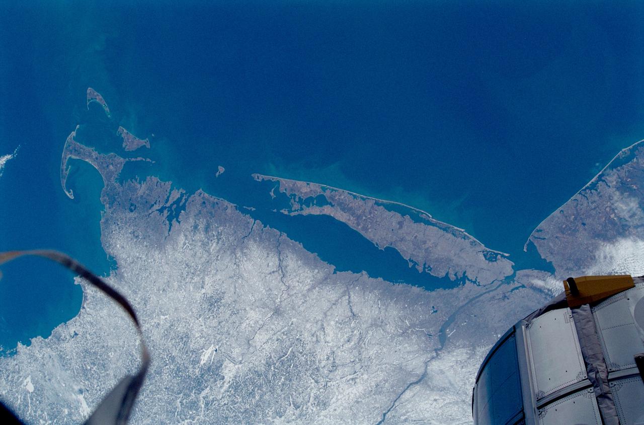
STS102-336-035 (8-21 March 2001) --- One of the STS-102 astronauts aimed a 35mm camera through windows on the aft flight deck of the Space Shuttle Discovery to capture this synoptic southeast view of several New England states. The moderating influence of the Atlantic Ocean is visible along the coastline. The southern limit of the snow-covered landscape can be traced from southeast Massachusetts (left center) westward along the northern shore of Long Island Sound and includes the northern end of New Jersey (right center). In addition to Long Island (center), other prominent features on this image include: Cape Cod, Martha's Vineyard, Nantucket, and Block Islands; as well as the Hudson River (bottom center). Several southerly-draining river systems are discernible in Connecticut and extensive wetlands are observed along New York and New Jersey coastal areas.
The storm system that moved through the northeastern U.S. dropped large snowfall totals up to a foot in southern New England to a couple of inches in Virginia. On January 22, 2014, the day after the event, the Moderate Resolution Imaging Spectroradiometer instrument that flies aboard NASA's Aqua satellite captured this image of the snowfall at 18:10 UTC/1:10 p.m. EST. In the image, snowfall covers the ground in all six New England states, New York, Pennsylvania, New Jersey, Delaware, Maryland, West Virginia, Ohio, Virginia, Washington, D.C. and North Carolina. Image Credit: NASA Goddard MODIS Rapid Response Team Text: Rob Gutro, NASA Goddard Space Flight Center <b><a href="http://www.nasa.gov/audience/formedia/features/MP_Photo_Guidelines.html" rel="nofollow">NASA image use policy.</a></b> <b><a href="http://www.nasa.gov/centers/goddard/home/index.html" rel="nofollow">NASA Goddard Space Flight Center</a></b> enables NASA’s mission through four scientific endeavors: Earth Science, Heliophysics, Solar System Exploration, and Astrophysics. Goddard plays a leading role in NASA’s accomplishments by contributing compelling scientific knowledge to advance the Agency’s mission. <b>Follow us on <a href="http://twitter.com/NASAGoddardPix" rel="nofollow">Twitter</a></b> <b>Like us on <a href="http://www.facebook.com/pages/Greenbelt-MD/NASA-Goddard/395013845897?ref=tsd" rel="nofollow">Facebook</a></b> <b>Find us on <a href="http://instagram.com/nasagoddard?vm=grid" rel="nofollow">Instagram</a></b>
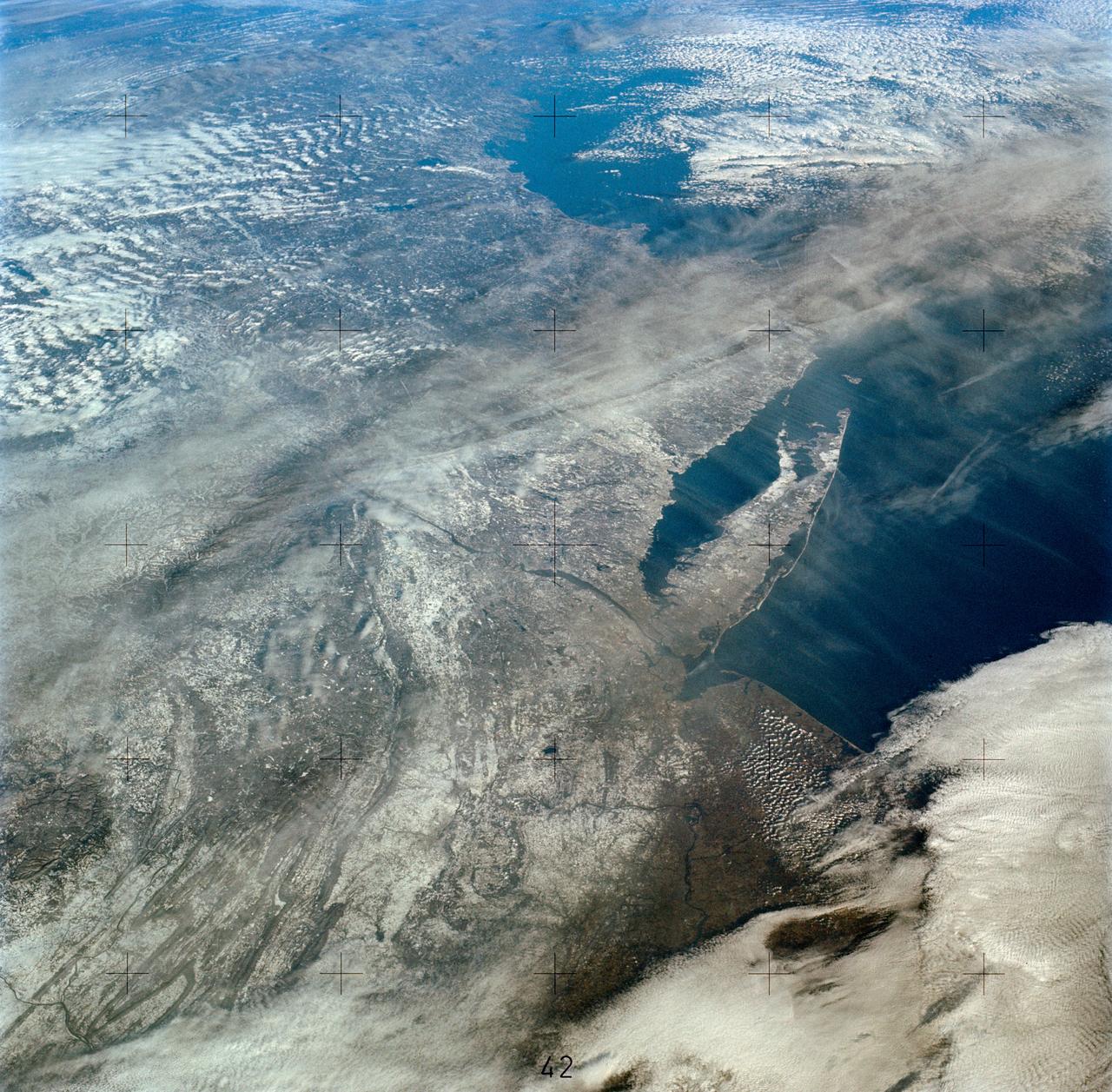
SL4-138-3894 (5 Jan. 1974) --- An oblique view of a portion of the northeastern part of the United States, as photographed from the Skylab space station in Earth orbit by one of the Skylab 4 crewmen. The camera used was a hand-held 70mm Hasselblad, and with SO-368 medium-speed Ektachrome film. This is an excellent example of the regional view which is available from space. The entire area of New Jersey, eastern Pennsylvania, southeastern New York, and southern New England can be examined in one view. Long Island, New York City and the lower Hudson River Valley are readily seen in their regional framework. The Boston area, although blurred by clouds, is also included. The spackling of the snow enhances the contrast, especially of terrain and cultural features. Different levels of clouds can be studies, especially the crossing layers of cirrus in the center of the photograph, with the lower cirrus trending north-south and the upper (probably associated with a jet stream) trending east-west. Photo credit: NASA
51F-S-162 (6 Aug 1985) ---Mission Operations Director George W.S. Abbey, right, shakes hands with Astronaut C. Gordon Fullerton, as the seven-member 51F crew descends from its "home" for eight days. Other Challenger crewmembers egressing the spacecraft are, left to right, F. Story Musgrave, mission specialist; John-David Bartoe, payload specialist; Roy D. Bridges, Jr., Karl J. Henize, mission specialist; Loren W. Acton, payload specialist; and Anthony W. England, mission specicalist. Fullerton, commander, earlier successfully landed Challenger on a Mojave desert dry lake bed. Three years ago, Fullerton was pilot of STS-3, on which the Columbia's scheduled Edwards landing was moved to New Mexico because of weather and runway conditions here.
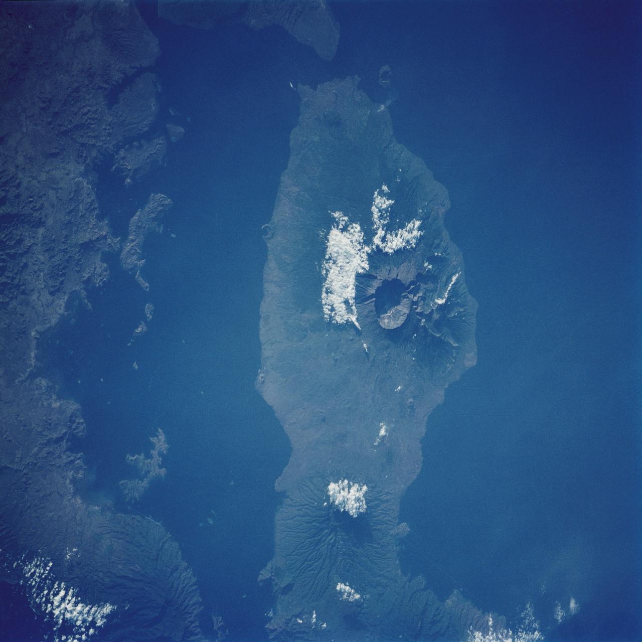
STS026-038-056 (29 Sept. - 3 Oct. 1988) --- Tambora Caldera, Sumbawa Island, Indonesia as photographed with a 70mm handheld Hasselblad camera. Tambora is a 6-kilometer-wide and 650-meter-deep Caldera formed in 1815 as a result of a huge volcanic eruption. Gases from the eruption were ejected high into Earth's atmosphere and transported around the globe. The atmospheric gases trapped part of the incoming sunglint, resulting in extremely cold weather. In New England, snow fell in June, and freezes occurred throughout the summer of 1816, which became known as "the year without a summer." This photo was shown by the STS-26 astronaut crew during its Oct. 11, l988 post-flight press conference.
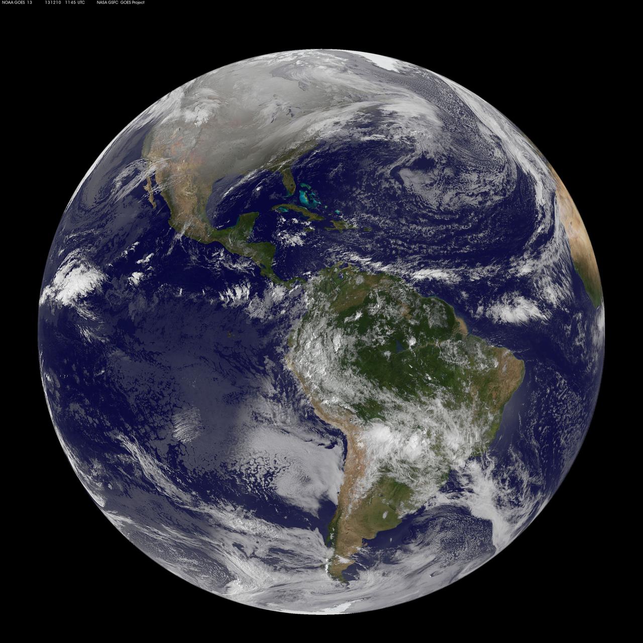
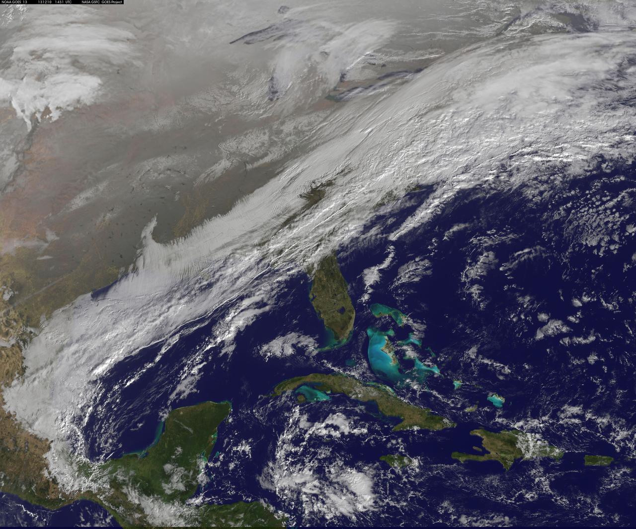
This full disc image of earth shows the strom system on Dec. 10, 2013 at 1445 UTC. According to the National Weather Service snow is falling from Tennessee Valley into the Mid-Atlantic and New England Tuesday . The fast moving system is creating swath of 2 to 7 inches of snow from southwest Virginia to the New England coast. Heavy Lake Effect snows will also impact the Lower Great Lakes into later this week, with up to two feet of accumulation. <b><a href="http://goes.gsfc.nasa.gov/" rel="nofollow">Credit: NOAA/NASA GOES Project</a></b> <b><a href="http://www.nasa.gov/audience/formedia/features/MP_Photo_Guidelines.html" rel="nofollow">NASA image use policy.</a></b> <b><a href="http://www.nasa.gov/centers/goddard/home/index.html" rel="nofollow">NASA Goddard Space Flight Center</a></b> enables NASA’s mission through four scientific endeavors: Earth Science, Heliophysics, Solar System Exploration, and Astrophysics. Goddard plays a leading role in NASA’s accomplishments by contributing compelling scientific knowledge to advance the Agency’s mission. <b>Follow us on <a href="http://twitter.com/NASA_GoddardPix" rel="nofollow">Twitter</a></b> <b>Like us on <a href="http://www.facebook.com/pages/Greenbelt-MD/NASA-Goddard/395013845897?ref=tsd" rel="nofollow">Facebook</a></b> <b>Find us on <a href="http://instagrid.me/nasagoddard/?vm=grid" rel="nofollow">Instagram</a></b>
This image shows the strom system on Dec. 10, 2013 at 1445 UTC. According to the National Weather Service snow is falling from Tennessee Valley into the Mid-Atlantic and New England Tuesday . The fast moving system is creating swath of 2 to 7 inches of snow from southwest Virginia to the New England coast. Heavy Lake Effect snows will also impact the Lower Great Lakes into later this week, with up to two feet of accumulation. <b><a href="http://goes.gsfc.nasa.gov/" rel="nofollow">Credit: NOAA/NASA GOES Project</a></b> <b><a href="http://www.nasa.gov/audience/formedia/features/MP_Photo_Guidelines.html" rel="nofollow">NASA image use policy.</a></b> <b><a href="http://www.nasa.gov/centers/goddard/home/index.html" rel="nofollow">NASA Goddard Space Flight Center</a></b> enables NASA’s mission through four scientific endeavors: Earth Science, Heliophysics, Solar System Exploration, and Astrophysics. Goddard plays a leading role in NASA’s accomplishments by contributing compelling scientific knowledge to advance the Agency’s mission. <b>Follow us on <a href="http://twitter.com/NASA_GoddardPix" rel="nofollow">Twitter</a></b> <b>Like us on <a href="http://www.facebook.com/pages/Greenbelt-MD/NASA-Goddard/395013845897?ref=tsd" rel="nofollow">Facebook</a></b> <b>Find us on <a href="http://instagrid.me/nasagoddard/?vm=grid" rel="nofollow">Instagram</a></b>

NOAA's GOES-East satellite provided a look at the frigid eastern two-thirds of the U.S. on Jan. 7, 2015, that shows a blanket of northern snow, lake-effect snow from the Great Lakes and clouds behind the Arctic cold front. A visible picture captured at 1600 UTC (11 a.m. EST) showed the effects of the latest Arctic outbreak. The cold front that brought the Arctic air has moved as far south as Florida, and stretches back over the Gulf of Mexico and just west of Texas today. The image shows clouds behind the frontal boundary stretching from the Carolinas west over the Heartland. Farther north, a wide band of fallen snow covers the ground from New England west to Montana, with rivers appearing like veins. The GOES-East satellite image also shows wind-whipped lake-effect snows off the Great Lakes, blowing to the southeast. Meanwhile, Florida, the nation's warm spot appeared almost cloud-free. To create the image, NASA/NOAA's GOES Project used cloud data from NOAA's GOES-East satellite and overlaid it on a true-color image of land and ocean created by data from the Moderate Resolution Imaging Spectroradiometer, or MODIS, instrument that flies aboard NASA's Aqua and Terra satellites. Together, those data created the entire picture of the Arctic outbreak. The forecast from NOAA's National Weather Service Weather Prediction Center (WPC) calls for more snow along the Appalachian Mountains from Tennessee north to upstate New York. Snow is also expected to fall from New England west to Montana, and in eastern New Mexico and the Colorado Rockies. The WPC summary for Jan. 7 noted: Bitter cold will be felt from the western High Plains to the Mid-Atlantic and Northeast U.S. for the next few days. Widespread subzero overnight lows are forecast for the Dakotas, Upper Midwest, Great Lakes, and interior New England. Wind Chill Advisories and Warnings are in effect for many of these areas. GOES-East provides visible and infrared images over the eastern U.S. and the Atlantic Ocean from its fixed orbit in space. NOAA's GOES satellites provide the kind of continuous monitoring necessary for intensive data analysis. Geostationary describes an orbit in which a satellite is always in the same position with respect to the rotating Earth. This allows GOES to hover continuously over one position on Earth's surface, appearing stationary. As a result, GOES provide a constant vigil for the atmospheric triggers for severe weather conditions such as tornadoes, flash floods, hail storms and hurricanes. For updated information about the storm system, visit NOAA's NWS website: <a href="http://www.weather.gov" rel="nofollow">www.weather.gov</a> For more information about GOES satellites, visit: <a href="http://www.goes.noaa.gov/" rel="nofollow">www.goes.noaa.gov/</a> or goes.gsfc.nasa.gov/ Rob Gutro NASA's Goddard Space Flight Center, Greenbelt, Md. <b><a href="http://www.nasa.gov/audience/formedia/features/MP_Photo_Guidelines.html" rel="nofollow">NASA image use policy.</a></b> <b><a href="http://www.nasa.gov/centers/goddard/home/index.html" rel="nofollow">NASA Goddard Space Flight Center</a></b> enables NASA’s mission through four scientific endeavors: Earth Science, Heliophysics, Solar System Exploration, and Astrophysics. Goddard plays a leading role in NASA’s accomplishments by contributing compelling scientific knowledge to advance the Agency’s mission. <b>Follow us on <a href="http://twitter.com/NASAGoddardPix" rel="nofollow">Twitter</a></b> <b>Like us on <a href="http://www.facebook.com/pages/Greenbelt-MD/NASA-Goddard/395013845897?ref=tsd" rel="nofollow">Facebook</a></b> <b>Find us on <a href="http://instagram.com/nasagoddard?vm=grid" rel="nofollow">Instagram</a></b>
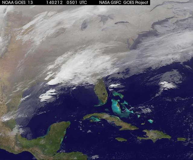
A new NASA video of NOAA's GOES satellite imagery shows three days of movement of the massive winter storm that stretches from the southern U.S. to the northeast. Visible and infrared imagery from NOAA's GOES-East or GOES-13 satellite from Feb. 10 at 1815 UTC/1:15 p.m. EST to Feb. 12 to 1845 UTC/1:45 p.m. EST were compiled into a video made by NASA/NOAA's GOES Project at NASA's Goddard Space Flight Center in Greenbelt, Md. In the video, viewers can see the development and movement of the clouds associated with the progression of the frontal system and related low pressure areas that make up the massive storm. The video also shows the snow covered ground over the Great Lakes region and Ohio Valley that stretches to northern New England. The clouds and fallen snow data from NOAA's GOES-East satellite were overlaid on a true-color image of land and ocean created by data from the Moderate Resolution Imaging Spectroradiometer or MODIS instrument that flies aboard NASA's Aqua and Terra satellites. On February 12 at 10 a.m. EST, NOAA's National Weather Service or NWS continued to issue watches and warnings from Texas to New England. Specifically, NWS cited Winter Storm Warnings and Winter Weather Advisories were in effect from eastern Texas eastward across the interior section of southeastern U.S. states and across much of the eastern seaboard including the Appalachians. Winter storm watches are in effect for portions of northern New England as well as along the western slopes of northern and central Appalachians. For updates on local forecasts, watches and warnings, visit NOAA's <a href="http://www.weather.gov" rel="nofollow">www.weather.gov</a> webpage. NOAA's Weather Prediction Center or WPC noted the storm is expected to bring "freezing rain spreading into the Carolinas, significant snow accumulations are expected in the interior Mid-Atlantic states tonight into Thursday and ice storm warnings and freezing rain advisories are in effect across much of central Georgia. GOES satellites provide the kind of continuous monitoring necessary for intensive data analysis. Geostationary describes an orbit in which a satellite is always in the same position with respect to the rotating Earth. This allows GOES to hover continuously over one position on Earth's surface, appearing stationary. As a result, GOES provide a constant vigil for the atmospheric "triggers" for severe weather conditions such as tornadoes, flash floods, hail storms and hurricanes. For updated information about the storm system, visit NOAA's WPC website; <a href="http://www.hpc.ncep.noaa.gov/" rel="nofollow">www.hpc.ncep.noaa.gov/</a> For more information about GOES satellites, visit: <a href="http://www.goes.noaa.gov/" rel="nofollow">www.goes.noaa.gov/</a> or <a href="http://goes.gsfc.nasa.gov/" rel="nofollow">goes.gsfc.nasa.gov/</a> Rob Gutro NASA's Goddard Space Flight Center <b><a href="http://goes.gsfc.nasa.gov/" rel="nofollow">Credit: NOAA/NASA GOES Project</a></b> <b><a href="http://www.nasa.gov/audience/formedia/features/MP_Photo_Guidelines.html" rel="nofollow">NASA image use policy.</a></b> <b><a href="http://www.nasa.gov/centers/goddard/home/index.html" rel="nofollow">NASA Goddard Space Flight Center</a></b> enables NASA’s mission through four scientific endeavors: Earth Science, Heliophysics, Solar System Exploration, and Astrophysics. Goddard plays a leading role in NASA’s accomplishments by contributing compelling scientific knowledge to advance the Agency’s mission. <b>Follow us on <a href="http://twitter.com/NASAGoddardPix" rel="nofollow">Twitter</a></b> <b>Like us on <a href="http://www.facebook.com/pages/Greenbelt-MD/NASA-Goddard/395013845897?ref=tsd" rel="nofollow">Facebook</a></b> <b>Find us on <a href="http://instagrid.me/nasagoddard/?vm=grid" rel="nofollow">Instagram</a></b>
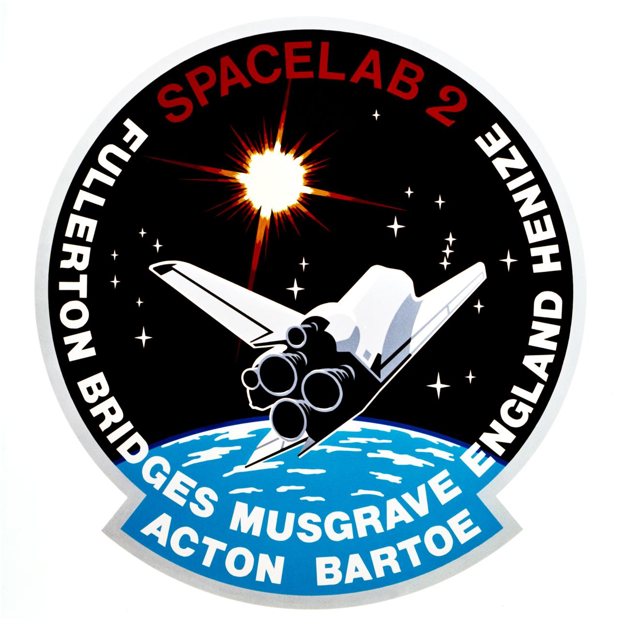
S85-29498 (June 1985) --- The crew members of space shuttle mission STS-51F have chosen as their insignia this design by Houston artist Skip Bradley. The space shuttle Challenger is depicted ascending toward the heavens in search of new knowledge in the field of solar and stellar astronomy, with its Spacelab 2 payload. The constellations Leo and Orion are in the positions they will be in, relative to the sun during the flight. The nineteen stars signify that this will be the 19th STS flight. Crew members for the mission are astronauts C. Gordon Fullerton, commander; Roy D. Bridges, pilot; F. Story Musgrave, Anthony W. England and Karl J. Henize, mission specialist; and payload specialists Loren W. Acton and John David Bartoe. The NASA insignia design for space shuttle flights is reserved for use by the astronauts and for other official use as the NASA Administrator may authorize. Public availability has been approved only in the forms of illustrations by the various news media. When and if there is any change in this policy, which is not anticipated, the change will be publicly announced. Photo credit: NASA
On Sunday, February 3, roughly 800 million eyes from all over the world focused on the Louisiana Superdome in New Orleans as the New England Patriots battled the St. Louis Rams for the NFL Championship in Super Bowl XXXVI. This true color image of New Orleans was acquired on April 26, 2000, by the Enhanced Thematic Mapper plus (ETM+), flying aboard the Landsat 7 satellite. Lake Pontchartrain borders the city to the north. The big river winding its way east to west through the image is the Mississippi. The Louisiana Superdome, built in 1975, sits just inside the rightmost portion of the big river bend that cradles downtown New Orleans. The city, however, may not be around to hold a Super Bowl in 2102. New Orleans is slowly sinking into the Gulf of Mexico. The construction of flood walls and dams north of New Orleans over the past century have prevented sediments carried by the Mississippi River from reaching New Orleans and the Mississippi River Delta. Before the dams were built, river sediments would empty out onto the delta adding layer upon layer of new soil each year. The additional soil prevented the Gulf from subsuming the delta. Unless drastic measures are taken, the city and the delta could be awash in seawater by the end of this century. Image by Robert Simmon, based on data provided by the Landsat 7 Science Team Credit: NASA/GSFC/Landsat <b><a href="http://www.nasa.gov/centers/goddard/home/index.html" rel="nofollow">NASA Goddard Space Flight Center</a></b> enables NASA’s mission through four scientific endeavors: Earth Science, Heliophysics, Solar System Exploration, and Astrophysics. Goddard plays a leading role in NASA’s accomplishments by contributing compelling scientific knowledge to advance the Agency’s mission. <b>Follow us on <a href="http://twitter.com/NASA_GoddardPix" rel="nofollow">Twitter</a></b> <b>Join us on <a href="http://www.facebook.com/pages/Greenbelt-MD/NASA-Goddard/395013845897?ref=tsd" rel="nofollow">Facebook</a></b>
National Weather Service forecasters have been tracking a low pressure area that moved from the Midwest into the Atlantic Ocean today, and is expected to become a strong nor'easter that will bring blizzard conditions to the northeastern U.S. The path of the system was captured in a NASA movie of NOAA's GOES-East satellite imagery. On Monday, January 26, 2015, the National Weather Service noted: A storm system off the East Coast will continue to strengthen as it develops into a major nor'easter on Monday. As the storm moves up the coast, it is expected to bring snowfall of 1-3 feet or more to many parts of the Northeast through Tuesday evening, including New York City and Boston. Strong, gusty winds will combine with the snow to create blizzard conditions along and near the coast. Winter storm warnings are in effect for the panhandles of West Virginia and Maryland, much of interior New England down to the northern Mid-Atlantic as well as for Nantucket Island, Massachusetts. Winter weather advisories are in effect for portions of the Ohio Valley, Mid-Atlantic and the southern Appalachians as well as a narrow area across interior New England. To create the video and imagery, NASA/NOAA's GOES Project located at NASA's Goddard Space Flight Center in Greenbelt, Maryland overlays the cloud data from NOAA's GOES-East satellite on a true-color image of land and ocean created by data from the Moderate Resolution Imaging Spectroradiometer, or MODIS, instrument that flies aboard NASA's Aqua and Terra satellites. Together, these data create the entire animation of the storm and show its movement. GOES satellites provide the kind of continuous monitoring necessary for intensive data analysis. Geostationary describes an orbit in which a satellite is always in the same position with respect to the rotating Earth. This allows GOES to hover continuously over one position on Earth's surface, appearing stationary. As a result, GOES provide a constant vigil for the atmospheric "triggers" for severe weather conditions such as tornadoes, flash floods, hail storms and hurricanes. For updated information about the storm system, visit NOAA's NWS website: <a href="http://www.weather.gov" rel="nofollow">www.weather.gov</a> For more information about GOES satellites, visit: <a href="http://www.goes.noaa.gov/" rel="nofollow">www.goes.noaa.gov/</a> or goes.gsfc.nasa.gov/ Rob Gutro NASA's Goddard Space Flight Center
National Weather Service forecasters have been tracking a low pressure area that moved from the Midwest into the Atlantic Ocean today, and is expected to become a strong nor'easter that will bring blizzard conditions to the northeastern U.S. The path of the system was captured in a NASA movie of NOAA's GOES-East satellite imagery. (This GOES 13 image was captured on January 26, 2015 at 1445 UTC.) On Monday, January 26, 2015, the National Weather Service noted: A storm system off the East Coast will continue to strengthen as it develops into a major nor'easter on Monday. As the storm moves up the coast, it is expected to bring snowfall of 1-3 feet or more to many parts of the Northeast through Tuesday evening, including New York City and Boston. Strong, gusty winds will combine with the snow to create blizzard conditions along and near the coast. Winter storm warnings are in effect for the panhandles of West Virginia and Maryland, much of interior New England down to the northern Mid-Atlantic as well as for Nantucket Island, Massachusetts. Winter weather advisories are in effect for portions of the Ohio Valley, Mid-Atlantic and the southern Appalachians as well as a narrow area across interior New England. To create the video and imagery, NASA/NOAA's GOES Project located at NASA's Goddard Space Flight Center in Greenbelt, Maryland overlays the cloud data from NOAA's GOES-East satellite on a true-color image of land and ocean created by data from the Moderate Resolution Imaging Spectroradiometer, or MODIS, instrument that flies aboard NASA's Aqua and Terra satellites. Together, these data create the entire animation of the storm and show its movement. GOES satellites provide the kind of continuous monitoring necessary for intensive data analysis. Geostationary describes an orbit in which a satellite is always in the same position with respect to the rotating Earth. This allows GOES to hover continuously over one position on Earth's surface, appearing stationary. As a result, GOES provide a constant vigil for the atmospheric "triggers" for severe weather conditions such as tornadoes, flash floods, hail storms and hurricanes. For updated information about the storm system, visit NOAA's NWS website: <a href="http://www.weather.gov" rel="nofollow">www.weather.gov</a> For more information about GOES satellites, visit: <a href="http://www.goes.noaa.gov/" rel="nofollow">www.goes.noaa.gov/</a> or goes.gsfc.nasa.gov/ Rob Gutro NASA's Goddard Space Flight Center
NASA image captured April 12, 2011 at 1731 UTC (1:31 p.m. EDT) A giant swirl of clouds that form an apostrophe-like shape over the eastern U.S. was spotted in visible imagery from the Geostationary Operational Environmental Satellite, GOES-13 on April 12, 2011 at 1731 UTC (1:31 p.m. EDT). The GOES-13 satellite monitors weather over the eastern continental U.S. and Atlantic Ocean, while GOES-11 monitors the western U.S. and the Eastern Pacific Ocean. GOES-13 captured this image of the clouds associated with a strong upper level low pressure area that is moving though the Tennessee River Valley and bringing moderate to heavy rainfall as it moves eastward. The low is forecast by the National Weather Service to bring unsettled conditions to the Mid-Atlantic and then to New England late Tuesday and Wednesday as it tracks northeast. Severe thunderstorms are possible today in extreme eastern Virginia and North Carolina as the cold front associated with the low pushes through that region. Meanwhile, rainfall from the low stretches from Massachusetts south to Florida today. It seems that New Englanders are having a tough time getting warm spring weather and this low won't help as it moves north. The low pressure area may even bring some light to moderate snowfall on the northern fringe of the storm. The GOES series of satellites keep an eye on the weather happening over the continental U.S. and eastern Pacific and Atlantic Oceans. NASA's GOES Project, located at NASA's Goddard Space Flight Center in Greenbelt, Md., procures and manages the development and launch of the GOES series of satellites for NOAA and creates images and animations. The GOES satellites are operated by NOAA. Rob Gutro NASA's Goddard Space Flight Center <b><a href="http://goes.gsfc.nasa.gov/" rel="nofollow">Credit: NOAA/NASA GOES Project</a></b> <b><a href="http://www.nasa.gov/centers/goddard/home/index.html" rel="nofollow">NASA Goddard Space Flight Center</a></b> enables NASA’s mission through four scientific endeavors: Earth Science, Heliophysics, Solar System Exploration, and Astrophysics. Goddard plays a leading role in NASA’s accomplishments by contributing compelling scientific knowledge to advance the Agency’s mission. <b>Follow us on <a href="http://twitter.com/NASA_GoddardPix" rel="nofollow">Twitter</a></b> <b>Join us on <a href="http://www.facebook.com/pages/Greenbelt-MD/NASA-Goddard/395013845897?ref=tsd" rel="nofollow">Facebook</a></b>
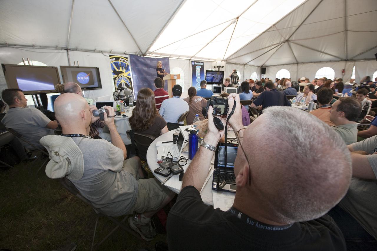
CAPE CANAVERAL, Fla. - At NASA's Kennedy Space Center in Florida, NASA's space shuttle Discovery Flow Director Stephanie Stilson has a rapt audience in the participants of NASA's STS-132 Tweetup. NASA is hosting 150 people from around the world and providing them with a behind-the-scenes perspective to share with their followers via the social networking service Twitter. Attendees were randomly selected from more than 1,000 online registrations and include people from more than 30 states, the District of Columbia, Puerto Rico, the Netherlands, New Zealand and England. The Tweeters are being given the chance to meet with shuttle technicians, managers, engineers and astronauts, to take a tour of Kennedy, and to experience the exhilaration of the launch of space shuttle Atlantis' STS-132 mission. A tent was set up especially for the occasion near the countdown clock at Kennedy's Press Site. Atlantis' liftoff is set for 2:20 p.m. EDT on May 14. STS-132 is the 34th mission to the station and the last scheduled flight for Atlantis. For more information on the STS-132 mission objectives, payload and crew, visit http:__www.nasa.gov_mission_pages_shuttle_shuttlemissions_sts132_index.html. Photo Credit: NASA_Amanda Diller
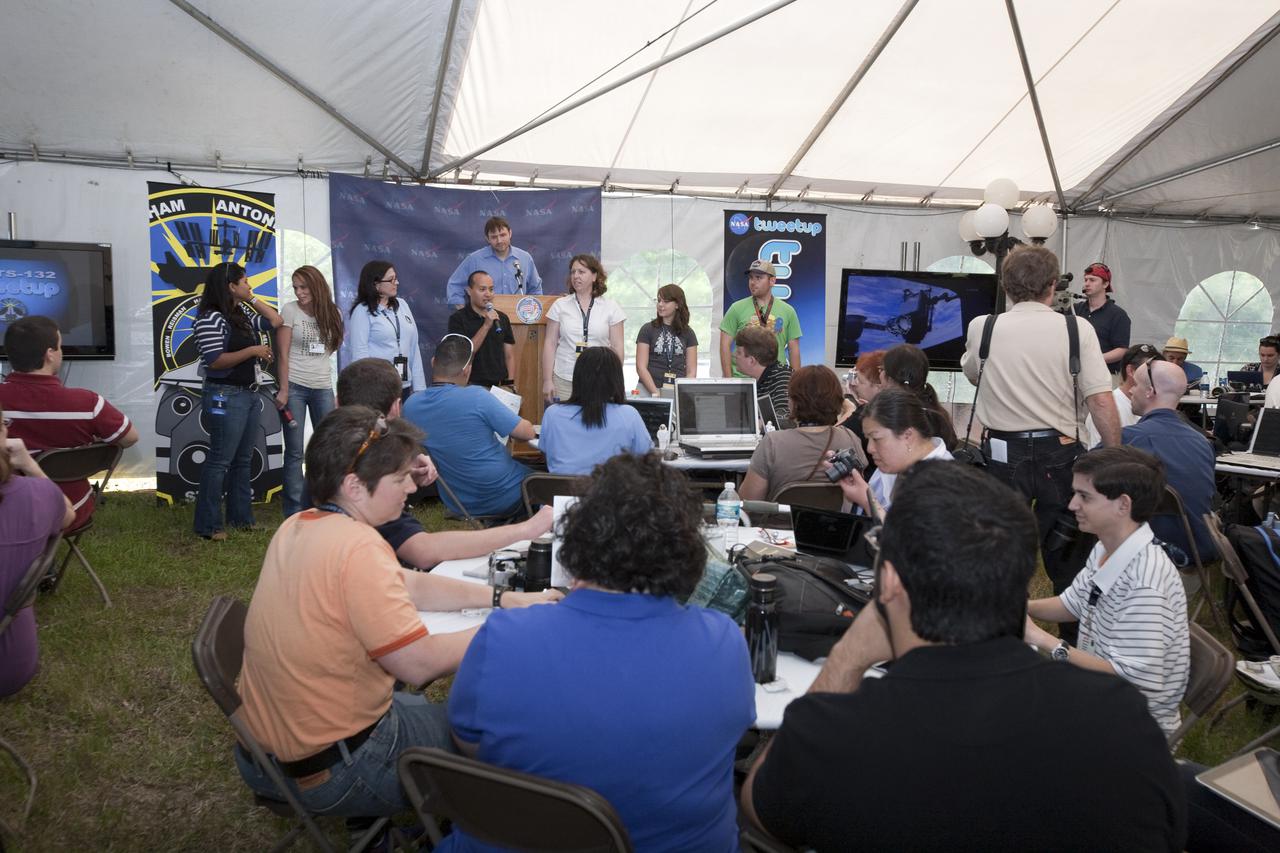
CAPE CANAVERAL, Fla. - At NASA's Kennedy Space Center in Florida, the support personnel for NASA's STS-132 Tweetup introduce themselves to the participants. NASA is hosting 150 people from around the world and providing them with a behind-the-scenes perspective to share with their followers via the social networking service Twitter. Attendees were randomly selected from more than 1,000 online registrations and include people from more than 30 states, the District of Columbia, Puerto Rico, the Netherlands, New Zealand and England. The Tweeters are being given the chance to meet with shuttle technicians, managers, engineers and astronauts, to take a tour of Kennedy, and to experience the exhilaration of the launch of space shuttle Atlantis' STS-132 mission. A tent was set up especially for the occasion near the countdown clock at Kennedy's Press Site. Atlantis' liftoff is set for 2:20 p.m. EDT on May 14. STS-132 is the 34th mission to the station and the last scheduled flight for Atlantis. For more information on the STS-132 mission objectives, payload and crew, visit http:__www.nasa.gov_mission_pages_shuttle_shuttlemissions_sts132_index.html. Photo Credit: NASA_Amanda Diller
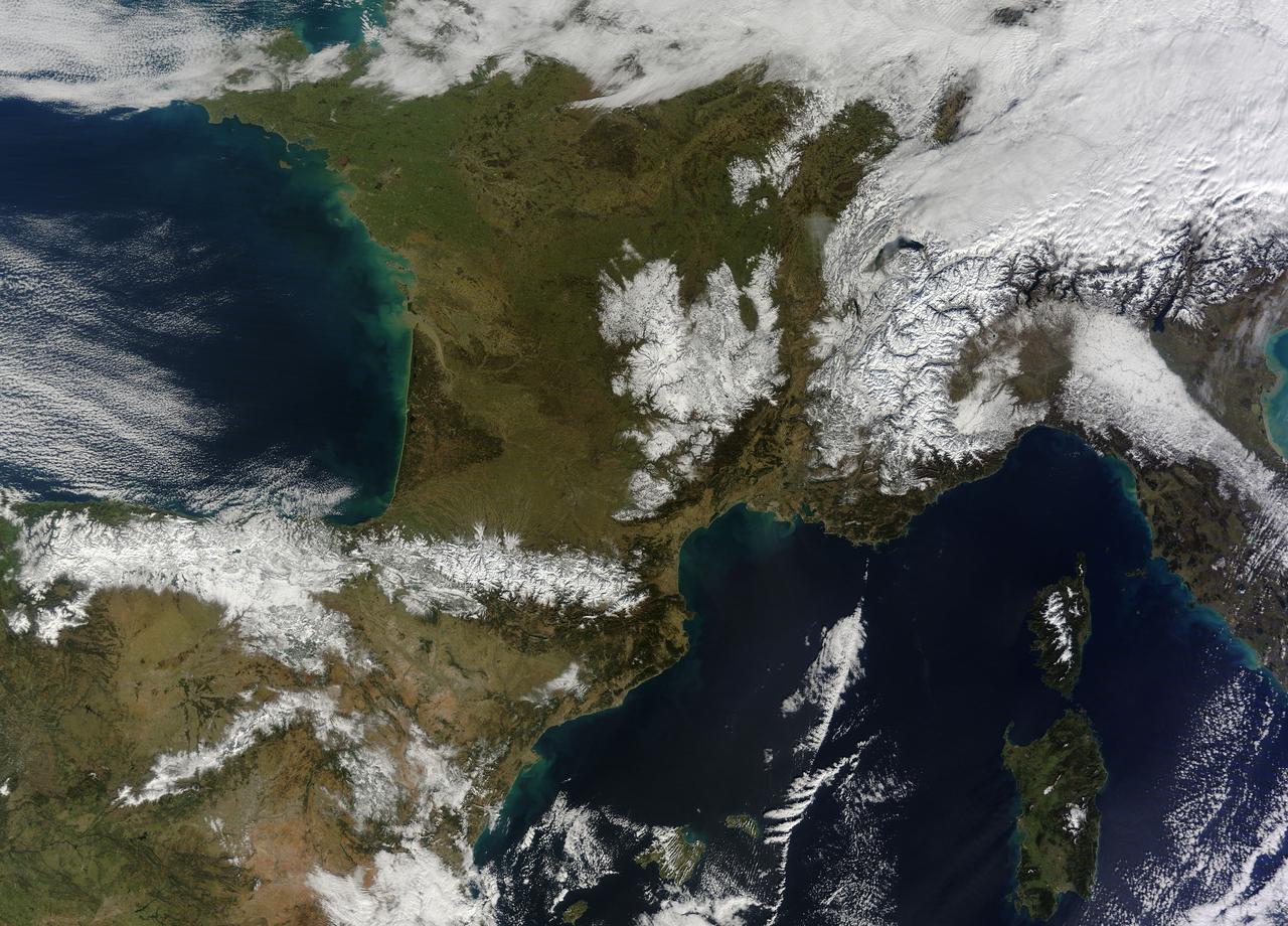
In February 2015, New England was not alone in dealing with the wrath of Old Man Winter. Thick snow blanketed mountain ranges in southwestern Europe after a winter storm pushed through the region in early February. The Moderate Resolution Imaging Spectroradiometer (MODIS) on NASA’s Terra satellite captured this true-color image of the snow-covered peaks of the Cantabrian Mountains, the Pyrenees, the Alps, and Massif Central on February 9, 2015. Credit: NASA/GSFC/Jeff Schmaltz/MODIS Land Rapid Response Team <b><a href="http://www.nasa.gov/audience/formedia/features/MP_Photo_Guidelines.html" rel="nofollow">NASA image use policy.</a></b> <b><a href="http://www.nasa.gov/centers/goddard/home/index.html" rel="nofollow">NASA Goddard Space Flight Center</a></b> enables NASA’s mission through four scientific endeavors: Earth Science, Heliophysics, Solar System Exploration, and Astrophysics. Goddard plays a leading role in NASA’s accomplishments by contributing compelling scientific knowledge to advance the Agency’s mission. <b>Follow us on <a href="http://twitter.com/NASAGoddardPix" rel="nofollow">Twitter</a></b> <b>Like us on <a href="http://www.facebook.com/pages/Greenbelt-MD/NASA-Goddard/395013845897?ref=tsd" rel="nofollow">Facebook</a></b> <b>Find us on <a href="http://instagram.com/nasagoddard?vm=grid" rel="nofollow">Instagram</a></b>

CAPE CANAVERAL, Fla. - At NASA's Kennedy Space Center in Florida, NASA's Ron Woods, a flight crew equipment specialist, presents one of his space-themed paintings to the participants in NASA's STS-132 Tweetup. NASA is hosting 150 people from around the world and providing them with a behind-the-scenes perspective to share with their followers via the social networking service Twitter. Attendees were randomly selected from more than 1,000 online registrations and include people from more than 30 states, the District of Columbia, Puerto Rico, the Netherlands, New Zealand and England. The Tweeters are being given the chance to meet with shuttle technicians, managers, engineers and astronauts, to take a tour of Kennedy, and to experience the exhilaration of the launch of space shuttle Atlantis' STS-132 mission. A tent was set up especially for the occasion near the countdown clock at Kennedy's Press Site. Atlantis' liftoff is set for 2:20 p.m. EDT on May 14. STS-132 is the 34th mission to the station and the last scheduled flight for Atlantis. For more information on the STS-132 mission objectives, payload and crew, visit http:__www.nasa.gov_mission_pages_shuttle_shuttlemissions_sts132_index.html. Photo Credit: NASA_Amanda Diller
NASA-NOAA's Suomi NPP satellite passed over the large low pressure area on January 22 at 1855 UTC (1:55 p.m. EST) that stretched from New England south to Florida. Credit: Credits: NASA/NOAA/Goddard Rapid Response Team Credit: NASA/Goddard/Suomi NPP/VIIRS <b><a href="http://www.nasa.gov/audience/formedia/features/MP_Photo_Guidelines.html" rel="nofollow">NASA image use policy.</a></b> <b><a href="http://www.nasa.gov/centers/goddard/home/index.html" rel="nofollow">NASA Goddard Space Flight Center</a></b> enables NASA’s mission through four scientific endeavors: Earth Science, Heliophysics, Solar System Exploration, and Astrophysics. Goddard plays a leading role in NASA’s accomplishments by contributing compelling scientific knowledge to advance the Agency’s mission. <b>Follow us on <a href="http://twitter.com/NASAGoddardPix" rel="nofollow">Twitter</a></b> <b>Like us on <a href="http://www.facebook.com/pages/Greenbelt-MD/NASA-Goddard/395013845897?ref=tsd" rel="nofollow">Facebook</a></b> <b>Find us on <a href="http://instagrid.me/nasagoddard/?vm=grid" rel="nofollow">Instagram</a></b>
A thick blanket of low clouds covered the English Channel, Celtic Sea and Irish Sea on March 13, 2014. The fog also crept over major cities in the United Kingdom and Ireland. While citizens living in parts of Ireland, England, Wales, Scotland and Northern Ireland were posting ground-based photos of fog-shrouded landscape on social media, the internet and news outlets, the scene was also captured from space. The Moderate Resolution Imaging Spectroradiometer (MODIS) aboard NASA’s Aqua captured this true-color image of the cloudy day at 13:00 UTC (1:00 p.m. in London) on that same day. The dense fog (low clouds) affected air travel, causing the cancellation of hundreds of flights going through London City Airport, where visibility was reported at less than 100 meters (328 ft) – less than the length of an American football field. Flights were also cancelled at Heathrow, Gatwick and Manchester. A private helicopter flying to Northern Ireland went down in by the fog near the Norfolk-Suffolk border, with loss of four lives. Driving was little better in many areas, causing the Met Office to issue a yellow weather warning and to caution drivers of difficult conditions. The lowest visibility of the day was reported at Roches Point weather station. Located at the southeastern tip of Cork Harbor, Ireland, the station reported visibility of less than 50 meters (164 ft) – the length of an Olympic size swimming pool. In this image, the fog-covered Celtic Sea is located in the southwest. Ireland lies under tendrils of low cloud in the northwest corner of the image. Banks of clouds part around England, near the center of the image, and southern Wales (top and center) completely under the foggy blanket. Fog also creeps over the coasts of France, Belgium and the Netherlands on the east side of the English Channel. Credit: NASA/GSFC/Jeff Schmaltz/MODIS Land Rapid Response Team <b><a href="http://www.nasa.gov/audience/formedia/features/MP_Photo_Guidelines.html" rel="nofollow">NASA image use policy.</a></b> <b><a href="http://www.nasa.gov/centers/goddard/home/index.html" rel="nofollow">NASA Goddard Space Flight Center</a></b> enables NASA’s mission through four scientific endeavors: Earth Science, Heliophysics, Solar System Exploration, and Astrophysics. Goddard plays a leading role in NASA’s accomplishments by contributing compelling scientific knowledge to advance the Agency’s mission. <b>Follow us on <a href="http://twitter.com/NASAGoddardPix" rel="nofollow">Twitter</a></b> <b>Like us on <a href="http://www.facebook.com/pages/Greenbelt-MD/NASA-Goddard/395013845897?ref=tsd" rel="nofollow">Facebook</a></b> <b>Find us on <a href="http://instagram.com/nasagoddard?vm=grid" rel="nofollow">Instagram</a></b>
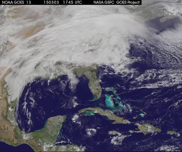
A winter storm was bringing snow, sleet and freezing rain from lower Mississippi Valley to Northeastern U.S. on Thursday, March 5, 2015. A new NASA animation of NOAA's GOES-East satellite imagery showed the progression of the clouds associated with the storm system that triggered winter storm warnings and winter weather advisories from the southern Plains eastward through the Mid-Atlantic and southern New England coast. The system also triggered flood warnings along and to the west of the central Appalachians. An animation of GOES satellite visible and infrared imagery from March 3 through March 5 showed clouds associated with a cold front push over U.S. East coast. Behind the front, Arctic air is expected to drop low temperatures into the single numbers from Washington, D.C. to Minnesota overnight. Temperatures in the Carolinas and Tennessee are expected to drop to the low 20s. NOAA's National Weather Service Weather Prediction Center (NWS NPC) in College Park, Maryland noted "a strong cold front moving across the eastern U.S. will bring heavy snow from parts of the Ohio Valley to the Northeast today (March 5) with rain, freezing rain and sleet possible from parts of the lower Mississippi Valley across the Southeast to the southern Mid-Atlantic. Snowfall totals of 5 to 10 inches are possible for some areas. Winter Storm Warnings remain in effect from Texas to Nantucket." The animation ends at 17:45 UTC (12:45 p.m. EST). Before the end of the animation, the low pressure center along an arctic frontal boundary was nearly stationary over western North Carolina at 9 a.m. EST on March 5, according to the NWS NPC. NWS radar and surface observations indicated an extended swath of precipitation from near the Texas Gulf Coast through the interior eastern U.S. into southern New England. NPC's storm summary noted at that time "rain was changing to sleet/freezing rain and to all snow along a band within this swath as colder air continues to filter in from the north. Some areas in Tennessee, the northern mid-Atlantic and southern New England were reporting moderate to heavy snow." To create the video and imagery, NASA/NOAA's GOES Project takes the cloud data from NOAA's GOES-East satellite and overlays it on a true-color image of land and ocean created by data from the Moderate Resolution Imaging Spectroradiometer, or MODIS, instrument that flies aboard NASA's Aqua and Terra satellites. Together, those data created the entire picture of the storm and show its movement. After the storm system passes, the snow on the ground becomes visible. GOES satellites provide the kind of continuous monitoring necessary for intensive data analysis. Geostationary describes an orbit in which a satellite is always in the same position with respect to the rotating Earth. This allows GOES to hover continuously over one position on Earth's surface, appearing stationary. For updated information about the storm system, visit NOAA's NWS website: <a href="http://www.weather.gov" rel="nofollow">www.weather.gov</a> For more information about GOES satellites, visit: <a href="http://www.goes.noaa.gov/" rel="nofollow">www.goes.noaa.gov/</a> or goes.gsfc.nasa.gov/ Rob Gutro NASA's Goddard Space Flight Center <b><a href="http://www.nasa.gov/audience/formedia/features/MP_Photo_Guidelines.html" rel="nofollow">NASA image use policy.</a></b> <b><a href="http://www.nasa.gov/centers/goddard/home/index.html" rel="nofollow">NASA Goddard Space Flight Center</a></b> enables NASA’s mission through four scientific endeavors: Earth Science, Heliophysics, Solar System Exploration, and Astrophysics. Goddard plays a leading role in NASA’s accomplishments by contributing compelling scientific knowledge to advance the Agency’s mission. <b>Follow us on <a href="http://twitter.com/NASAGoddardPix" rel="nofollow">Twitter</a></b> <b>Like us on <a href="http://www.facebook.com/pages/Greenbelt-MD/NASA-Goddard/395013845897?ref=tsd" rel="nofollow">Facebook</a></b> <b>Find us on <a href="http://instagrid.me/nasagoddard/?vm=grid" rel="nofollow">Instagram</a></b>
NASA image acquired September 2, 2011 To download the full high res go to: <a href="http://earthobservatory.nasa.gov/IOTD/view.php?id=52059" rel="nofollow">earthobservatory.nasa.gov/IOTD/view.php?id=52059</a> Nearly a week after Hurricane Irene drenched New England with rainfall in late August 2011, the Connecticut River was spewing muddy sediment into Long Island Sound and wrecking the region's farmland just before harvest. The Thematic Mapper on the Landsat 5 satellite acquired this true-color satellite image on September 2, 2011. With its headwaters near the Canadian border, the Connecticut River drains nearly 11,000 square miles (28,500 square kilometers) and receives water from at least 33 tributaries in Vermont, New Hampshire, Massachusetts, and Connecticut. The 410-mile river—New England's longest—enters Long Island Sound near Old Lyme, Connecticut, and is estimated to provide 70 percent of the fresh water entering the Sound. When Irene blew through the region on August 27-28, substantial portions of the Connecticut River watershed received more than 6 to 8 inches (15-20 centimeters) of rainfall, and several locations received more than 10 inches (25 centimeters). Whole towns were cut off from overland transportation—particularly upstream in Vermont, which suffered its worst flooding in 80 years. Thousands of people saw their homes flooded, if not washed off their foundations, at a time of year when rivers are usually at their lowest. Preliminary estimates of river flow at Thompsonville, Connecticut, (not shown in this image) reached 128,000 cubic feet per second (cfs) on August 30, nearly 64 times the usual flow (2,000 cfs) for early fall and the highest flow rate since May 1984. At the mouth of the river—where flow is tidal, and therefore not gauged—the peak water height reached 6.9 feet (2.1 meters) above sea level, almost a foot higher than at any time in the past 10 years. According to Suzanne O'Connell, an environmental scientist working along the Connecticut River at Wesleyan University, the torrent of water coursing through New England picked up silt and clay from the river valleys, giving it the tan color shown in the image above. At Essex, Connecticut, the turbidity (muddiness) of the water was 50 times higher than pre-Irene values. To the east, the Thames River appears to be carrying very little sediment at all on September 2. According to O'Connell, the Thames "drains glaciated terrain, so fine sediment was removed long ago." Most of the land surface in the Thames basin is "just bedrock, till, and glacial erratics." Unlike the Connecticut, areas within the Thames watershed only received 2 to 4 inches of rain in most locations. The flooding that occurred in the aftermath of Hurricane Irene inundated farmland in Massachusetts and Connecticut just before harvest time, the Associated Press noted. Crops were drowned under inches to feet of water. The substantial amounts of soil, sediment, and water deposited on land during the flood could also pose trouble for farmers in coming seasons. "It's notable that whole segments of river bank are just gone," said Andrew Fisk of the Connecticut River Watershed Council. "That's not just loss of sediment. That's land disappearing down river." <b>NASA Earth Observatory image by Robert Simmon, using Landsat 5 data from the U.S. Geological Survey Global Visualization Viewer. Caption by Michael Carlowicz, with interpretation help from Suzanne O'Connell, Wesleyan University, and Andrew Fisk, Connecticut River Watershed Council.</b> Instrument: Landsat 5 - TM Credit: <b><a href="http://www.earthobservatory.nasa.gov/" rel="nofollow"> NASA Earth Observatory</a></b> <b><a href="http://www.nasa.gov/centers/goddard/home/index.html" rel="nofollow">NASA Goddard Space Flight Center</a></b> enables NASA’s mission through four scientific endeavors: Earth Science, Heliophysics, Solar System Exploration, and Astrophysics. Goddard plays a leading role in NASA’s accomplishments by contributing compelling scientific knowledge to advance the Agency’s mission. <b>Follow us on <a href="http://twitter.com/NASA_GoddardPix" rel="nofollow">Twitter</a></b> <b>Like us on <a href="http://www.facebook.com/pages/Greenbelt-MD/NASA-Goddard/395013845897?ref=tsd" rel="nofollow">Facebook</a></b> <b>Find us on <a href="http://web.stagram.com/n/nasagoddard/?vm=grid" rel="nofollow">Instagram</a></b>
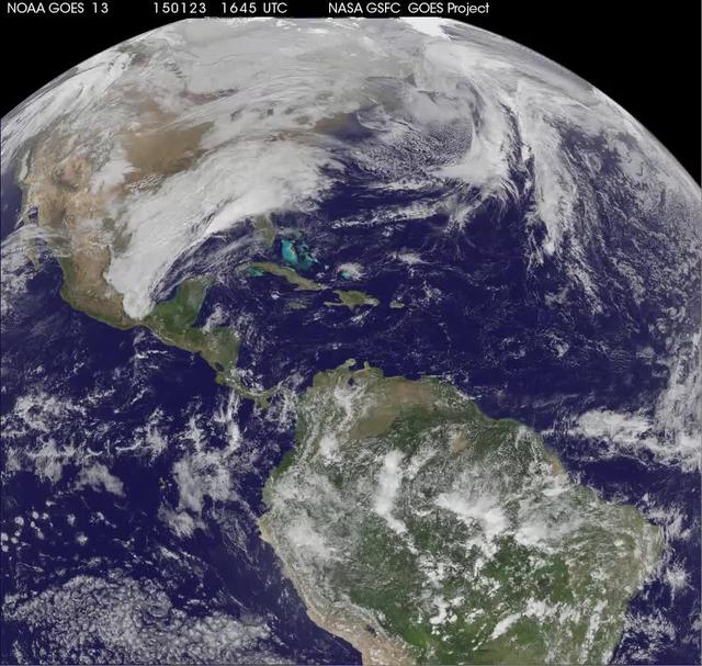
National Weather Service forecasters have been tracking a low pressure area that moved from the Midwest into the Atlantic Ocean today, and is expected to become a strong nor'easter that will bring blizzard conditions to the northeastern U.S. The path of the system was captured in a NASA movie of NOAA's GOES-East satellite imagery. An animation of visible and infrared imagery from NOAA's Geostationary Operational Environmental or GOES satellite captured over the period of January 24 through 26 showed the progression of the developing nor'easter. The satellite animation began on Jan. 24 when clouds associated with a cold front preceding the low, pushed off the U.S. East coast. The front was followed by a low pressure area that moved from the Midwest to the southeast. That low moved over the Carolinas and exited into the Atlantic Ocean on Jan. 26. NOAA's National Weather Service forecast calls for the low to intensify along the Eastern Seaboard and bring blizzard conditions to the northeastern U.S. on Monday night, January 26 and Tuesday, January 27. On Monday, January 26, 2015, the National Weather Service noted: A storm system off the East Coast will continue to strengthen as it develops into a major nor'easter on Monday. As the storm moves up the coast, it is expected to bring snowfall of 1-3 feet or more to many parts of the Northeast through Tuesday evening, including New York City and Boston. Strong, gusty winds will combine with the snow to create blizzard conditions along and near the coast. Winter storm warnings are in effect for the panhandles of West Virginia and Maryland, much of interior New England down to the northern Mid-Atlantic as well as for Nantucket Island, Massachusetts. Winter weather advisories are in effect for portions of the Ohio Valley, Mid-Atlantic and the southern Appalachians as well as a narrow area across interior New England. To create the video and imagery, NASA/NOAA's GOES Project located at NASA's Goddard Space Flight Center in Greenbelt, Maryland overlays the cloud data from NOAA's GOES-East satellite on a true-color image of land and ocean created by data from the Moderate Resolution Imaging Spectroradiometer, or MODIS, instrument that flies aboard NASA's Aqua and Terra satellites. Together, these data create the entire animation of the storm and show its movement. GOES satellites provide the kind of continuous monitoring necessary for intensive data analysis. Geostationary describes an orbit in which a satellite is always in the same position with respect to the rotating Earth. This allows GOES to hover continuously over one position on Earth's surface, appearing stationary. As a result, GOES provide a constant vigil for the atmospheric "triggers" for severe weather conditions such as tornadoes, flash floods, hail storms and hurricanes. For updated information about the storm system, visit NOAA's NWS website: <a href="http://www.weather.gov" rel="nofollow">www.weather.gov</a> For more information about GOES satellites, visit: <a href="http://www.goes.noaa.gov/" rel="nofollow">www.goes.noaa.gov/</a> or goes.gsfc.nasa.gov/ Rob Gutro NASA's Goddard Space Flight Center
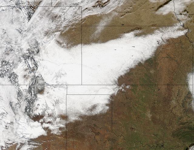
Winter arrived officially on Dec. 22 at 12:35 a.m. EST, but the U.S. Plains states received an early and cool welcome on Dec. 19 from heavy snowfall that was seen by a NASA satellite. NASA's Aqua satellite passed overhead on Dec. 21 at 20:05 UTC (3:05 p.m. EST) and the Moderate Resolution Imaging Spectroradiometer (MODIS) instrument aboard NASA's Aqua satellite captured a visible image of snow blanketing the ground through west and central Kansas, eastern and central Colorado, much of New Mexico, northern Texas and the panhandle of Oklahoma. According to CBS News, blizzard conditions were reported in northern New Mexico, the Texas Panhandle, Oklahoma and northwestern Kansas. The Associated Press reported snow drifts as high as 10 feet in southeast Colorado. Six people lost their lives in traffic accidents from this storm. Heavy snow is expected again today, Dec. 22 in New Mexico and Colorado. Snow is also expected to stretch across the plains into the upper Midwest today, according to the National Weather Service. Portions of many states are expecting some snow today, including the four corners states, north Texas, Kansas, southern Nebraska, western Oklahoma, northern Missouri, Iowa, northern Illinois and southern Wisconsin stretching east into northern New England. The first day of the winter season occurs when the sun is farthest south, either Dec. 21 or 22. The day is also known as the winter solstice. By the second day of winter, NASA's Aqua satellite is going to have a lot more snowfall to observe. Image Credit: NASA Goddard MODIS Rapid Response Team Caption: NASA, Rob Gutro <b><a href="http://www.nasa.gov/audience/formedia/features/MP_Photo_Guidelines.html" rel="nofollow">NASA image use policy.</a></b> <b><a href="http://www.nasa.gov/centers/goddard/home/index.html" rel="nofollow">NASA Goddard Space Flight Center</a></b> enables NASA’s mission through four scientific endeavors: Earth Science, Heliophysics, Solar System Exploration, and Astrophysics. Goddard plays a leading role in NASA’s accomplishments by contributing compelling scientific knowledge to advance the Agency’s mission. <b>Follow us on <a href="http://twitter.com/NASA_GoddardPix" rel="nofollow">Twitter</a></b> <b>Like us on <a href="http://www.facebook.com/pages/Greenbelt-MD/NASA-Goddard/395013845897?ref=tsd" rel="nofollow">Facebook</a></b> <b>Find us on <a href="http://instagrid.me/nasagoddard/?vm=grid" rel="nofollow">Instagram</a></b>
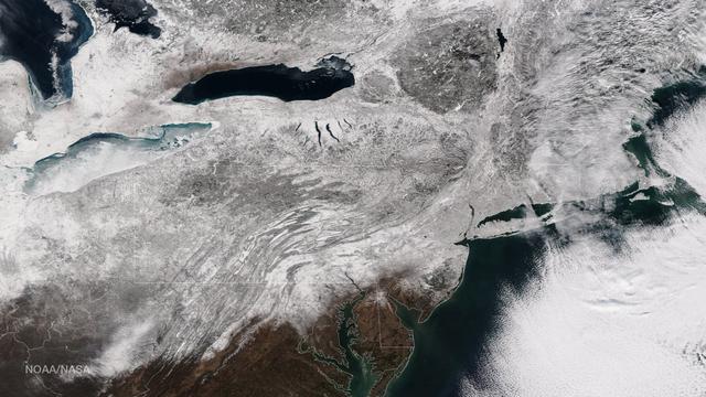
As the storm moves offshore and the skies clear over the Northeast United States, the extent of snowfall from the blizzard is shown in this image from the Suomi NPP satellite imagery, taken on January 28, 2015 at 1:50 EST. Portions of Suffolk County, New York and parts of eastern and southern New England, including areas in and around Portland, Maine, Boston, Massachusetts, and Providence, Rhode Island, received more than 20 inches of snowfall. Up to 36 inches of snow were reported in Auburn, Hudson and Lunenburg, Massachusetts. Credit: NASA/NOAA/NPP/VIIRS Via: <b><a href="www.nnvl.noaa.gov/" rel="nofollow"> NOAA Environmental Visualization Laboratory</a></b> <b><a href="http://www.nasa.gov/audience/formedia/features/MP_Photo_Guidelines.html" rel="nofollow">NASA image use policy.</a></b> <b><a href="http://www.nasa.gov/centers/goddard/home/index.html" rel="nofollow">NASA Goddard Space Flight Center</a></b> enables NASA’s mission through four scientific endeavors: Earth Science, Heliophysics, Solar System Exploration, and Astrophysics. Goddard plays a leading role in NASA’s accomplishments by contributing compelling scientific knowledge to advance the Agency’s mission. <b>Follow us on <a href="http://twitter.com/NASAGoddardPix" rel="nofollow">Twitter</a></b> <b>Like us on <a href="http://www.facebook.com/pages/Greenbelt-MD/NASA-Goddard/395013845897?ref=tsd" rel="nofollow">Facebook</a></b> <b>Find us on <a href="http://instagram.com/nasagoddard?vm=grid" rel="nofollow">Instagram</a></b>
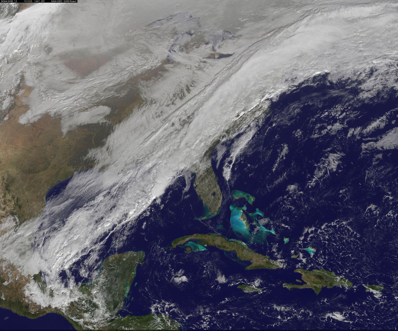
A long, strong, cold front draped over the eastern U.S. is marking a stark change from record-warmth to very cold temperatures. This NOAA GOES-East satellite image from December 23 at 1515 UTC/10:15 a.m. EST shows a powerful cold front covering the U.S. East Coast and stretching into the central and southwestern Gulf of Mexico. According to the National Weather Service, that front is bringing rain and embedded thunderstorms over the Mid-Atlantic and Southeastern U.S. The same system is bringing lingering wintry precipitation to northern New England and upstate New York. Behind the cold front, much colder and dry Canadian air will filter in under high pressure and bring sunshine over the eastern U.S. in time for Christmas. The image was created by the NASA GOES Project at NASA's Goddard Space Flight Center, Greenbelt, Md. Rob Gutro NASA Goddard Space Flight Center <b><a href="http://www.nasa.gov/audience/formedia/features/MP_Photo_Guidelines.html" rel="nofollow">NASA image use policy.</a></b> <b><a href="http://www.nasa.gov/centers/goddard/home/index.html" rel="nofollow">NASA Goddard Space Flight Center</a></b> enables NASA’s mission through four scientific endeavors: Earth Science, Heliophysics, Solar System Exploration, and Astrophysics. Goddard plays a leading role in NASA’s accomplishments by contributing compelling scientific knowledge to advance the Agency’s mission. <b>Follow us on <a href="http://twitter.com/NASA_GoddardPix" rel="nofollow">Twitter</a></b> <b>Like us on <a href="http://www.facebook.com/pages/Greenbelt-MD/NASA-Goddard/395013845897?ref=tsd" rel="nofollow">Facebook</a></b> <b>Find us on <a href="http://instagram.com/nasagoddard?vm=grid" rel="nofollow">Instagram</a></b>
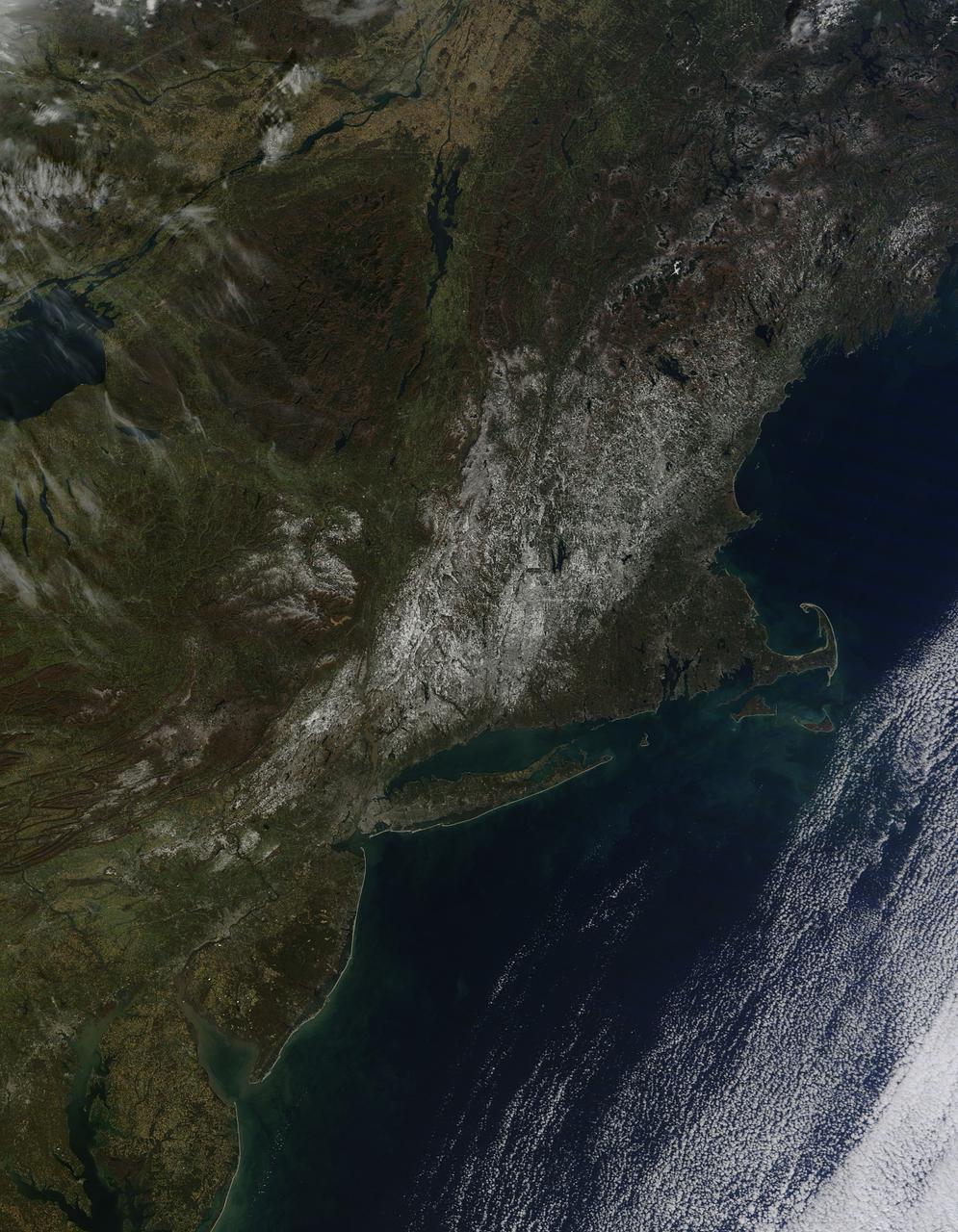
Last weekend's late October snow may have melted in Maryland, Delaware, parts of Pennsylvania and New Jersey, but residents in north central Connecticut are still dealing with the effects of the storm. According to Connecticut Light and Power, 430,868 residents were still without power today, Nov. 3, 2011. For estimated restoration times, visit their website at: <a href="http://www.cl-p.com/stormcenter/estimates/" rel="nofollow">www.cl-p.com/stormcenter/estimates/</a>. A late October snowstorm from a Nor'easter blanketed the eastern U.S. from West Virginia to Maine and broke records the weekend before Halloween Monday. NASA's Aqua satellite flew over the region on October 30 after the snow was ending in New England and captured the ghostly blanket of white. When NASA's Aqua satellite passed over the northeastern U.S. on November 2, 2011 at 2:00 p.m. EDT, the Moderate Resolution Imaging Spectroradiometer (MODIS) instrument captured a detailed image of the remaining snowfall. Snow still covers the ground in western and central Connecticut, southeastern New York, western and central Massachusetts, and parts of Vermont, New Hampshire and Maine. Over the Atlantic, cirrocumulus clouds create a diagonal border. The image was created at NASA's Goddard Space Flight Center in Greenbelt, Md. Image Credit: NASA Goddard MODIS Rapid Response Team; Caption: NASA Goddard, Rob Gutro <b><a href="http://www.nasa.gov/audience/formedia/features/MP_Photo_Guidelines.html" rel="nofollow">NASA image use policy.</a></b> <b><a href="http://www.nasa.gov/centers/goddard/home/index.html" rel="nofollow">NASA Goddard Space Flight Center</a></b> enables NASA’s mission through four scientific endeavors: Earth Science, Heliophysics, Solar System Exploration, and Astrophysics. Goddard plays a leading role in NASA’s accomplishments by contributing compelling scientific knowledge to advance the Agency’s mission. <b>Follow us on <a href="http://twitter.com/NASA_GoddardPix" rel="nofollow">Twitter</a></b> <b>Like us on <a href="http://www.facebook.com/pages/Greenbelt-MD/NASA-Goddard/395013845897?ref=tsd" rel="nofollow">Facebook</a></b> <b>Find us on <a href="http://instagrid.me/nasagoddard/?vm=grid" rel="nofollow">Instagram</a></b>
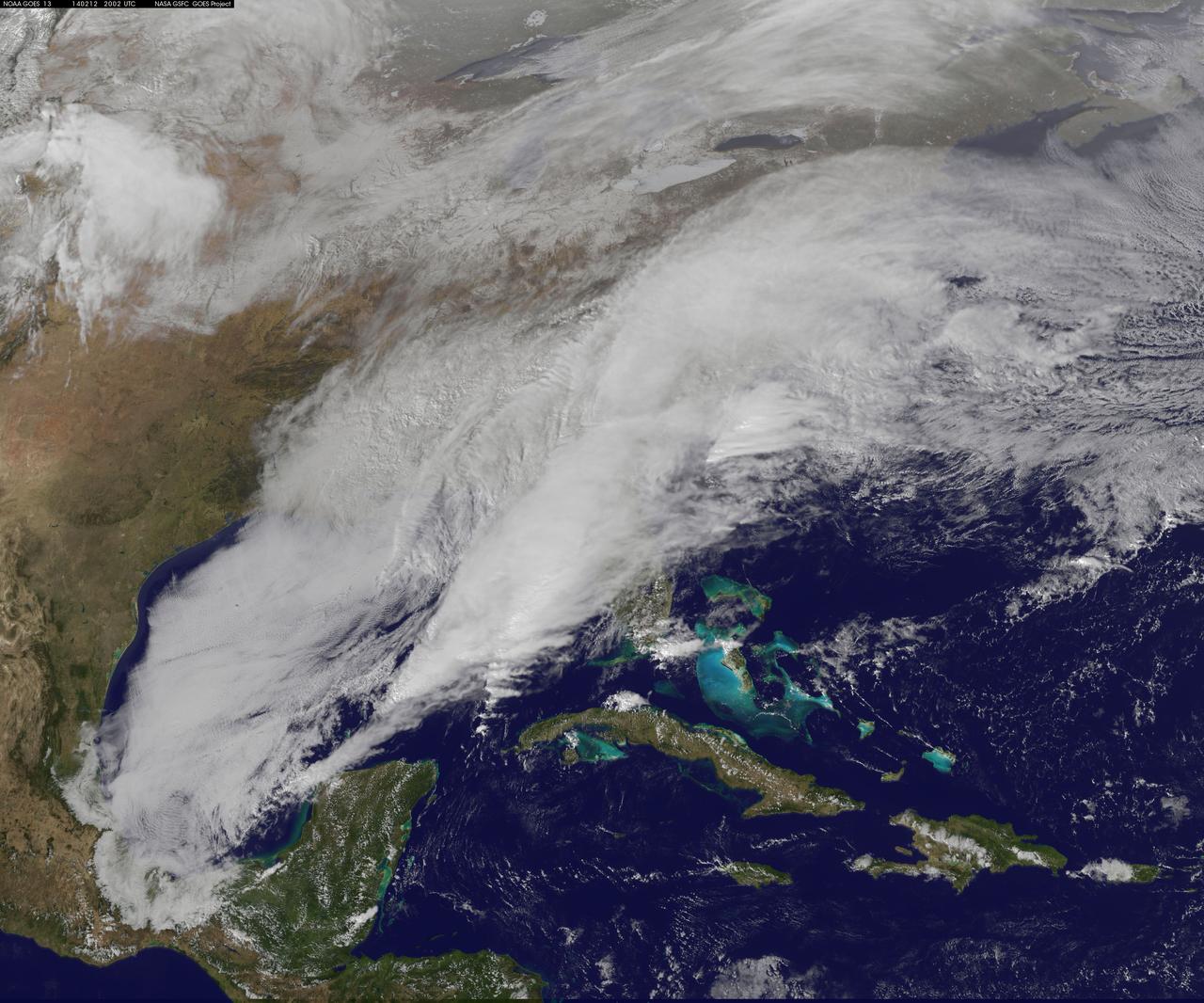
<b>View a video of the storm here: <a href="http://bit.ly/1m9aJFY" rel="nofollow">bit.ly/1m9aJFY</a></b> This visible image of the winter storm over the U.S. south and East Coast was taken by NOAA's GOES-13 satellite on Feb. 12 at 1855 UTC/1:55 p.m. EST. Snow covered ground can be seen over the Great Lakes region and Ohio Valley. On February 12 at 10 a.m. EST, NOAA's National Weather Service or NWS continued to issue watches and warnings from Texas to New England. Specifically, NWS cited Winter Storm Warnings and Winter Weather Advisories were in effect from eastern Texas eastward across the interior section of southeastern U.S. states and across much of the eastern seaboard including the Appalachians. Winter storm watches are in effect for portions of northern New England as well as along the western slopes of northern and central Appalachians. For updates on local forecasts, watches and warnings, visit NOAA's <a href="http://www.weather.gov" rel="nofollow">www.weather.gov</a> webpage. NOAA's Weather Prediction Center or WPC noted the storm is expected to bring "freezing rain spreading into the Carolinas, significant snow accumulations are expected in the interior Mid-Atlantic states tonight into Thursday and ice storm warnings and freezing rain advisories are in effect across much of central Georgia. GOES satellites provide the kind of continuous monitoring necessary for intensive data analysis. Geostationary describes an orbit in which a satellite is always in the same position with respect to the rotating Earth. This allows GOES to hover continuously over one position on Earth's surface, appearing stationary. As a result, GOES provide a constant vigil for the atmospheric "triggers" for severe weather conditions such as tornadoes, flash floods, hail storms and hurricanes. For updated information about the storm system, visit NOAA's WPC website; <a href="http://www.hpc.ncep.noaa.gov/" rel="nofollow">www.hpc.ncep.noaa.gov/</a> For more information about GOES satellites, visit: <a href="http://www.goes.noaa.gov/" rel="nofollow">www.goes.noaa.gov/</a> or <a href="http://goes.gsfc.nasa.gov/" rel="nofollow">goes.gsfc.nasa.gov/</a> Rob Gutro NASA's Goddard Space Flight Center <b><a href="http://goes.gsfc.nasa.gov/" rel="nofollow">Credit: NOAA/NASA GOES Project</a></b> <b><a href="http://www.nasa.gov/audience/formedia/features/MP_Photo_Guidelines.html" rel="nofollow">NASA image use policy.</a></b> <b><a href="http://www.nasa.gov/centers/goddard/home/index.html" rel="nofollow">NASA Goddard Space Flight Center</a></b> enables NASA’s mission through four scientific endeavors: Earth Science, Heliophysics, Solar System Exploration, and Astrophysics. Goddard plays a leading role in NASA’s accomplishments by contributing compelling scientific knowledge to advance the Agency’s mission. <b>Follow us on <a href="http://twitter.com/NASAGoddardPix" rel="nofollow">Twitter</a></b> <b>Like us on <a href="http://www.facebook.com/pages/Greenbelt-MD/NASA-Goddard/395013845897?ref=tsd" rel="nofollow">Facebook</a></b> <b>Find us on <a href="http://instagrid.me/nasagoddard/?vm=grid" rel="nofollow">Instagram</a></b>

Dr. Robert Hutchings Goddard (1882-1945). Dr. Goddard has been recognized as the father of American rocketry and as one of the pioneers in the theoretical exploration of space. Robert Hutchings Goddard, born in Worcester, Massachusetts, on October 5, 1882, was theoretical scientist as well as a practical engineer. His dream was the conquest of the upper atmosphere and ultimately space through the use of rocket propulsion. Dr. Goddard, died in 1945, but was probably as responsible for the dawning of the Space Age as the Wrights were for the beginning of the Air Age. Yet his work attracted little serious attention during his lifetime. However, when the United States began to prepare for the conquest of space in the 1950's, American rocket scientists began to recognize the debt owed to the New England professor. They discovered that it was virtually impossible to construct a rocket or launch a satellite without acknowledging the work of Dr. Goddard. More than 200 patents, many of which were issued after his death, covered this great legacy. <b><a href="http://www.nasa.gov/centers/goddard/home/index.html" rel="nofollow">NASA Goddard Space Flight Center</a></b> enables NASA’s mission through four scientific endeavors: Earth Science, Heliophysics, Solar System Exploration, and Astrophysics. Goddard plays a leading role in NASA’s accomplishments by contributing compelling scientific knowledge to advance the Agency’s mission. <b>Follow us on <a href="http://twitter.com/NASA_GoddardPix" rel="nofollow">Twitter</a></b> <b>Join us on <a href="http://www.facebook.com/pages/Greenbelt-MD/NASA-Goddard/395013845897?ref=tsd" rel="nofollow">Facebook</a></b>

Even with a major scientific expedition about to set sail one block away, Woods Hole, Massachusetts, hangs on to its centuries old New England charm. --- The <b><a href="http://naames.larc.nasa.gov/" rel="nofollow">North Atlantic Aerosols and Marine Ecosystems Study </a></b> (NAAMES) is a five year investigation to resolve key processes controlling ocean system function, their influences on atmospheric aerosols and clouds and their implications for climate. Michael Starobin joined the NAAMES field campaign on behalf of Earth Expeditions and NASA Goddard Space Flight Center’s Office of Communications. He presented stories about the important, multi-disciplinary research being conducted by the NAAMES team, with an eye towards future missions on the NASA drawing board. This is a NAAMES photo essay put together by Starobin, a collection of 49 photographs and captions. Photo and Caption Credit: Michael Starobin <b><a href="http://www.nasa.gov/audience/formedia/features/MP_Photo_Guidelines.html" rel="nofollow">NASA image use policy</a></b> <b><a href="http://www.nasa.gov/centers/goddard/home/index.html" rel="nofollow">NASA Goddard Space Flight Center</a></b> enables NASA’s mission through four scientific endeavors: Earth Science, Heliophysics, Solar System Exploration, and Astrophysics. Goddard plays a leading role in NASA’s accomplishments by contributing compelling scientific knowledge to advance the Agency’s mission. <b>Follow us on <a href="http://twitter.com/NASAGoddardPix" rel="nofollow">Twitter</a></b> <b>Like us on <a href="http://www.facebook.com/pages/Greenbelt-MD/NASA-Goddard/395013845897?ref=tsd" rel="nofollow">Facebook</a></b> <b>Find us on <a href="https://www.instagram.com/nasagoddard/?hl=en" rel="nofollow">Instagram</a></b>
Dr. Robert Hutchings Goddard (1882-1945). Dr. Goddard has been recognized as the father of American rocketry and as one of the pioneers in the theoretical exploration of space. Robert Hutchings Goddard, born in Worcester, Massachusetts, on October 5, 1882, was theoretical scientist as well as a practical engineer. His dream was the conquest of the upper atmosphere and ultimately space through the use of rocket propulsion. Dr. Goddard, died in 1945, but was probably as responsible for the dawning of the Space Age as the Wrights were for the beginning of the Air Age. Yet his work attracted little serious attention during his lifetime. However, when the United States began to prepare for the conquest of space in the 1950's, American rocket scientists began to recognize the debt owed to the New England professor. They discovered that it was virtually impossible to construct a rocket or launch a satellite without acknowledging the work of Dr. Goddard. More than 200 patents, many of which were issued after his death, covered this great legacy. <b><a href="http://www.nasa.gov/centers/goddard/home/index.html" rel="nofollow">NASA Goddard Space Flight Center</a></b> enables NASA’s mission through four scientific endeavors: Earth Science, Heliophysics, Solar System Exploration, and Astrophysics. Goddard plays a leading role in NASA’s accomplishments by contributing compelling scientific knowledge to advance the Agency’s mission. <b>Follow us on <a href="http://twitter.com/NASA_GoddardPix" rel="nofollow">Twitter</a></b> <b>Join us on <a href="http://www.facebook.com/pages/Greenbelt-MD/NASA-Goddard/395013845897?ref=tsd" rel="nofollow">Facebook</a></b>
Dr. Robert Hutchings Goddard (1882-1945). Dr. Goddard has been recognized as the father of American rocketry and as one of the pioneers in the theoretical exploration of space. Robert Hutchings Goddard, born in Worcester, Massachusetts, on October 5, 1882, was theoretical scientist as well as a practical engineer. His dream was the conquest of the upper atmosphere and ultimately space through the use of rocket propulsion. Dr. Goddard, died in 1945, but was probably as responsible for the dawning of the Space Age as the Wrights were for the beginning of the Air Age. Yet his work attracted little serious attention during his lifetime. However, when the United States began to prepare for the conquest of space in the 1950's, American rocket scientists began to recognize the debt owed to the New England professor. They discovered that it was virtually impossible to construct a rocket or launch a satellite without acknowledging the work of Dr. Goddard. More than 200 patents, many of which were issued after his death, covered this great legacy. <b><a href="http://www.nasa.gov/centers/goddard/home/index.html" rel="nofollow">NASA Goddard Space Flight Center</a></b> enables NASA’s mission through four scientific endeavors: Earth Science, Heliophysics, Solar System Exploration, and Astrophysics. Goddard plays a leading role in NASA’s accomplishments by contributing compelling scientific knowledge to advance the Agency’s mission. <b>Follow us on <a href="http://twitter.com/NASA_GoddardPix" rel="nofollow">Twitter</a></b> <b>Join us on <a href="http://www.facebook.com/pages/Greenbelt-MD/NASA-Goddard/395013845897?ref=tsd" rel="nofollow">Facebook</a></b>
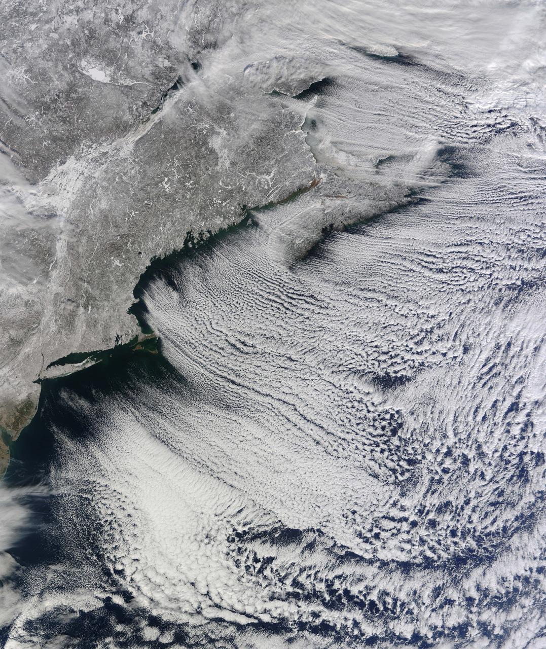
NASA image acquired January 24, 2011 What do you get when you mix below-freezing air temperatures, frigid northwest winds from Canada, and ocean temperatures hovering around 39 to 40 degrees Fahrenheit (4 to 5 degrees Celsius)? Paved highways of clouds across the skies of the North Atlantic. The Moderate Resolution Imaging Spectroradiometer (MODIS) on NASA’s Terra satellite collected this natural-color view of New England, the Canadian Maritimes, and coastal waters at 10:25 a.m. U.S. Eastern Standard Time on January 24, 2011. Lines of clouds stretch from northwest to southeast over the North Atlantic, while the relatively cloudless skies over land afford a peek at the snow that blanketed the Northeast just a few days earlier. Cloud streets form when cold air blows over warmer waters, while a warmer air layer—or temperature inversion—rests over top of both. The comparatively warm water of the ocean gives up heat and moisture to the cold air mass above, and columns of heated air—thermals—naturally rise through the atmosphere. As they hit the temperature inversion like a lid, the air rolls over like the circulation in a pot of boiling water. The water in the warm air cools and condenses into flat-bottomed, fluffy-topped cumulus clouds that line up parallel to the wind. Though they are easy to explain in a broad sense, cloud streets have a lot of mysteries on the micro scale. A NASA-funded researcher from the University of Wisconsin recently observed an unusual pattern in cloud streets over the Great Lakes. Cloud droplets that should have picked up moisture from the atmosphere and grown in size were instead shrinking as they moved over Lake Superior. Read more in an interview at What on Earth? NASA image by Jeff Schmaltz, MODIS Rapid Response Team, Goddard Space Flight Center. Caption by Michael Carlowicz. Instrument: Terra - MODIS Credit: <b><a href="http://www.earthobservatory.nasa.gov/" rel="nofollow"> NASA Earth Observatory</a></b> <b><a href="http://www.nasa.gov/centers/goddard/home/index.html" rel="nofollow">NASA Goddard Space Flight Center</a></b> enables NASA’s mission through four scientific endeavors: Earth Science, Heliophysics, Solar System Exploration, and Astrophysics. Goddard plays a leading role in NASA’s accomplishments by contributing compelling scientific knowledge to advance the Agency’s mission. <b>Follow us on <a href="http://twitter.com/NASA_GoddardPix" rel="nofollow">Twitter</a></b> <b>Join us on <a href="http://www.facebook.com/pages/Greenbelt-MD/NASA-Goddard/395013845897?ref=tsd" rel="nofollow">Facebook</a></b>
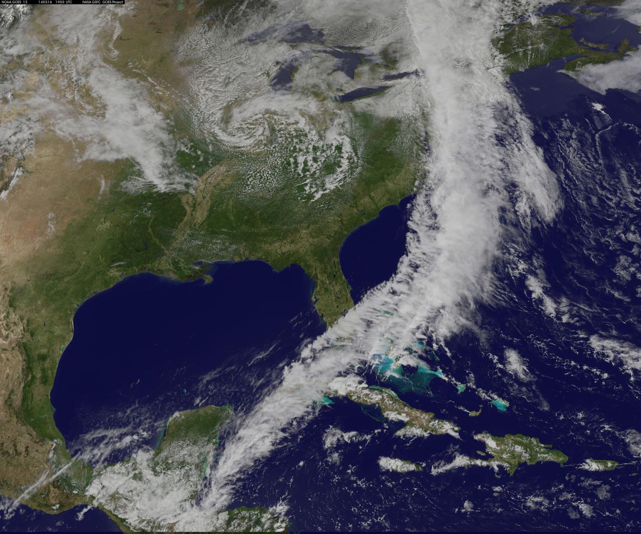
NOAA's GOES-East satellite captured an image of a powerful cold front that triggered flash flood watches and warnings along the U.S. East Coast on May 16. NOAA's National Weather Service noted flash flooding was possible from New England into eastern North Carolina today, May 16. The clouds associated with the long cold front was captured using visible data from NOAA's GOES-East or GOES-13 satellite on at 1900 UTC (3:00 p.m. EDT) and was made into an image by NASA/NOAA's GOES Project at NASA's Goddard Space Flight Center in Greenbelt, Md. The clouds stretched from Maine south through the Mid-Atlantic down to southern Florida with a tail of clouds extending into the western Caribbean Sea. South of Lake Michigan the rounded swirl of clouds indicates another low pressure system. GOES satellites provide the kind of continuous monitoring necessary for intensive data analysis. Geostationary describes an orbit in which a satellite is always in the same position with respect to the rotating Earth. This allows GOES to hover continuously over one position on Earth's surface, appearing stationary. As a result, GOES provide a constant vigil for the atmospheric "triggers" for severe weather conditions such as tornadoes, flash floods, hail storms and hurricanes. For updated information about the storm system, visit NOAA's National Weather Service website: <a href="http://www.weather.gov" rel="nofollow">www.weather.gov</a> For more information about GOES satellites, visit: <a href="http://www.goes.noaa.gov/" rel="nofollow">www.goes.noaa.gov/</a> or <a href="http://goes.gsfc.nasa.gov/" rel="nofollow">goes.gsfc.nasa.gov/</a> Rob Gutro NASA's Goddard Space Flight Center <b><a href="http://www.nasa.gov/audience/formedia/features/MP_Photo_Guidelines.html" rel="nofollow">NASA image use policy.</a></b> <b><a href="http://www.nasa.gov/centers/goddard/home/index.html" rel="nofollow">NASA Goddard Space Flight Center</a></b> enables NASA’s mission through four scientific endeavors: Earth Science, Heliophysics, Solar System Exploration, and Astrophysics. Goddard plays a leading role in NASA’s accomplishments by contributing compelling scientific knowledge to advance the Agency’s mission. <b>Follow us on <a href="http://twitter.com/NASAGoddardPix" rel="nofollow">Twitter</a></b> <b>Like us on <a href="http://www.facebook.com/pages/Greenbelt-MD/NASA-Goddard/395013845897?ref=tsd" rel="nofollow">Facebook</a></b> <b>Find us on <a href="http://instagram.com/nasagoddard?vm=grid" rel="nofollow">Instagram</a></b>
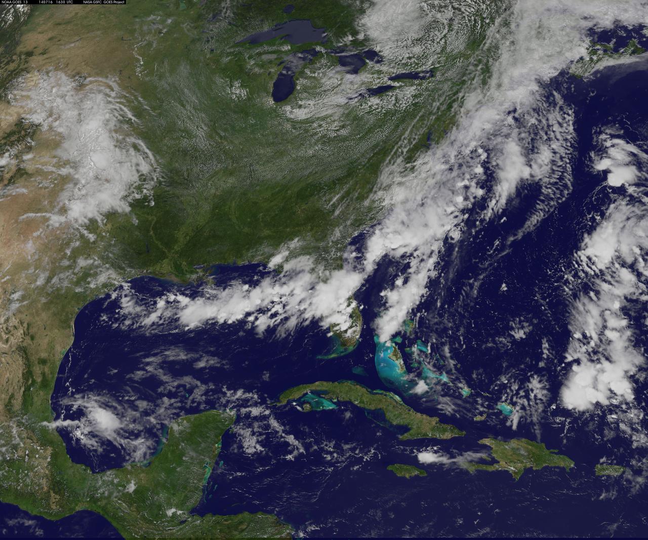
Summertime heat and humidity in the U.S. East Coast is on hold for a couple of days thanks to a cold front and that brought clouds, showers, thunderstorms, and some severe weather on July 16 to the coast. The National Oceanic and Atmospheric Administration (NOAA) noted that the dip in the jet stream will create below normal temperatures for most of the Central and Eastern U.S. for the next couple of days. NOAA's GOES-East satellite captured an image of the clouds associated with the cold front on July 16 at 1630 UTC (12:30 p.m. EDT).The clouds follow the front which stretches from the Florida panhandle, across Florida and up the U.S. East Coast into eastern Canada. Along the front lie two areas of low pressure, one over eastern New England, and the other offshore from South Carolina. Both of those low pressure areas are associated with additional cloudiness along the front. GOES satellites are managed by NOAA. The image was created by the NASA/NOAA GOES Project at NASA's Goddard Space Flight Center in Greenbelt, Maryland. GOES satellites provide the kind of continuous monitoring necessary for intensive data analysis. Geostationary describes an orbit in which a satellite is always in the same position with respect to the rotating Earth. This allows GOES to hover continuously over one position on Earth's surface, appearing stationary. As a result, GOES provide a constant vigil for the atmospheric "triggers" for severe weather conditions such as tornadoes, flash floods, hail storms and hurricanes. For updated information about the storm system, visit NOAA's National Weather Service website: <a href="http://www.weather.gov" rel="nofollow">www.weather.gov</a> For more information about GOES satellites, visit: <a href="http://www.goes.noaa.gov/" rel="nofollow">www.goes.noaa.gov/</a> or <a href="http://goes.gsfc.nasa.gov/" rel="nofollow">goes.gsfc.nasa.gov/</a> Image Credit: NASA/NOAA GOES Project, Text: Rob Gutro <b><a href="http://www.nasa.gov/audience/formedia/features/MP_Photo_Guidelines.html" rel="nofollow">NASA image use policy.</a></b> <b><a href="http://www.nasa.gov/centers/goddard/home/index.html" rel="nofollow">NASA Goddard Space Flight Center</a></b> enables NASA’s mission through four scientific endeavors: Earth Science, Heliophysics, Solar System Exploration, and Astrophysics. Goddard plays a leading role in NASA’s accomplishments by contributing compelling scientific knowledge to advance the Agency’s mission. <b>Follow us on <a href="http://twitter.com/NASAGoddardPix" rel="nofollow">Twitter</a></b> <b>Like us on <a href="http://www.facebook.com/pages/Greenbelt-MD/NASA-Goddard/395013845897?ref=tsd" rel="nofollow">Facebook</a></b> <b>Find us on <a href="http://instagram.com/nasagoddard?vm=grid" rel="nofollow">Instagram</a></b>
NASA images acquired October 15, 2012 The Visible Infrared Imaging Radiometer Suite (VIIRS) on the Suomi NPP satellite captured these nighttime views of the Persian Gulf region on September 30, October 5, October 10, and October 15, 2012. The images are from the VIIRS “day-night band,” which detects light in a range of wavelengths from green to near-infrared and uses filtering techniques to observe signals such as gas flares, auroras, wildfires, city lights, and reflected moonlight. Each image includes an inset of the Moon in four different phases. September 30 shows the Persian Gulf by the light of the full Moon; October 15 shows the effects of a new Moon. As the amount of moonlight decreases, some land surface features become harder to detect, but the lights from cities and ships become more obvious. Urbanization is most apparent along the northeastern coast of Saudi Arabia, in Qatar, and in the United Arab Emirates (UAE). In Qatar and UAE, major highways can even be discerned by nighttime lights. In eighteenth-century England, a small group of entrepreneurs, inventors and free thinkers—James Watt and Charles Darwin’s grandfathers among them—started a club. They named it the Lunar Society, and the “lunaticks” scheduled their dinner meetings on evenings of the full Moon. The timing wasn’t based on any kind of superstition, it was based on practicality. In the days before electricity, seeing one’s way home after dark was far easier by the light of a full Moon. In the early twenty-first century, electricity has banished the need for such careful scheduling, but the light of the full Moon still makes a difference. NASA Earth Observatory image by Jesse Allen and Robert Simmon, using VIIRS day-night band data from the Suomi National Polar-orbiting Partnership. Suomi NPP is the result of a partnership between NASA, the National Oceanic and Atmospheric Administration, and the Department of Defense. Caption by Michon Scott. Instrument: Suomi NPP - VIIRS Credit: <b><a href="http://www.earthobservatory.nasa.gov/" rel="nofollow"> NASA Earth Observatory</a></b> <b>Click here to view all of the <a href="http://earthobservatory.nasa.gov/Features/NightLights/" rel="nofollow"> Earth at Night 2012 images </a></b> <b>Click here to <a href="http://earthobservatory.nasa.gov/NaturalHazards/view.php?id=79834" rel="nofollow"> read more </a> about this image </b> <b><a href="http://www.nasa.gov/audience/formedia/features/MP_Photo_Guidelines.html" rel="nofollow">NASA image use policy.</a></b> <b><a href="http://www.nasa.gov/centers/goddard/home/index.html" rel="nofollow">NASA Goddard Space Flight Center</a></b> enables NASA’s mission through four scientific endeavors: Earth Science, Heliophysics, Solar System Exploration, and Astrophysics. Goddard plays a leading role in NASA’s accomplishments by contributing compelling scientific knowledge to advance the Agency’s mission. <b>Follow us on <a href="http://twitter.com/NASA_GoddardPix" rel="nofollow">Twitter</a></b> <b>Like us on <a href="http://www.facebook.com/pages/Greenbelt-MD/NASA-Goddard/395013845897?ref=tsd" rel="nofollow">Facebook</a></b> <b>Find us on <a href="http://instagram.com/nasagoddard?vm=grid" rel="nofollow">Instagram</a></b>
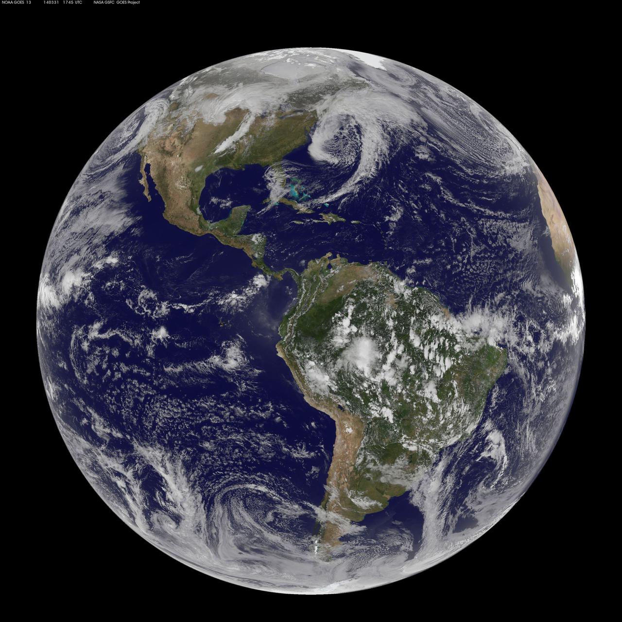
There are three low pressure systems around the U.S. and they resemble dragons on satellite imagery. NOAA's GOES-13 and GOES-15 satellite image from March 31 shows the low pressure systems in the eastern Pacific Ocean, over the nation's Heartland, and in the eastern Atlantic Ocean. All three lows have the signature comma shape that make them appear to be curled up dragons. According to the National Weather Service, the low pressure area approaching the northwestern U.S. is expected to bring rainfall to the coast and areas of snow that stretch from western Washington state south toward the four corners region. The low in the middle of the country is located over Nebraska and dropping snow to the north and west of it. That same low is bringing rain from southern Minnesota south to eastern Texas. Meanwhile, the third low pressure system is bringing rain and snow to parts of New England. NOAA's GOES-East satellite sits in a fixed orbit in space capturing visible and infrared imagery of all weather over the eastern U.S. and Atlantic Ocean. The data to create this image was taken on March 31 at 17:45 UTC/1:45 p.m. EDT by NOAA's GOES-East or GOES-13 satellite and made into an image by NASA/NOAA's GOES Project at NASA's Goddard Space Flight Center in Greenbelt, Md. To create the image NASA/NOAA's GOES Project takes the cloud data from NOAA's GOES-East satellite and overlays it on a true-color image of land and ocean created by data from the Moderate Resolution Imaging Spectroradiometer, or MODIS, instrument that flies aboard NASA's Aqua and Terra satellites. Together, those data created the entire picture of the storm and show its movement. After the storm system passes, the snow on the ground becomes visible. GOES satellites provide the kind of continuous monitoring necessary for intensive data analysis. Geostationary describes an orbit in which a satellite is always in the same position with respect to the rotating Earth. This allows GOES to hover continuously over one position on Earth's surface, appearing stationary. As a result, GOES provide a constant vigil for the atmospheric "triggers" for severe weather conditions such as tornadoes, flash floods, hail storms and hurricanes. For updated information about the storm system, visit NOAA's NWS website: <a href="http://www.weather.gov" rel="nofollow">www.weather.gov</a> For more information about GOES satellites, visit: <a href="http://www.goes.noaa.gov/" rel="nofollow">www.goes.noaa.gov/</a> or goes.gsfc.nasa.gov/ Rob Gutro NASA's Goddard Space Flight Center, Greenbelt, Md. <b><a href="http://www.nasa.gov/audience/formedia/features/MP_Photo_Guidelines.html" rel="nofollow">NASA image use policy.</a></b> <b><a href="http://www.nasa.gov/centers/goddard/home/index.html" rel="nofollow">NASA Goddard Space Flight Center</a></b> enables NASA’s mission through four scientific endeavors: Earth Science, Heliophysics, Solar System Exploration, and Astrophysics. Goddard plays a leading role in NASA’s accomplishments by contributing compelling scientific knowledge to advance the Agency’s mission. <b>Follow us on <a href="http://twitter.com/NASAGoddardPix" rel="nofollow">Twitter</a></b> <b>Like us on <a href="http://www.facebook.com/pages/Greenbelt-MD/NASA-Goddard/395013845897?ref=tsd" rel="nofollow">Facebook</a></b> <b>Find us on <a href="http://instagram.com/nasagoddard?vm=grid" rel="nofollow">Instagram</a></b>
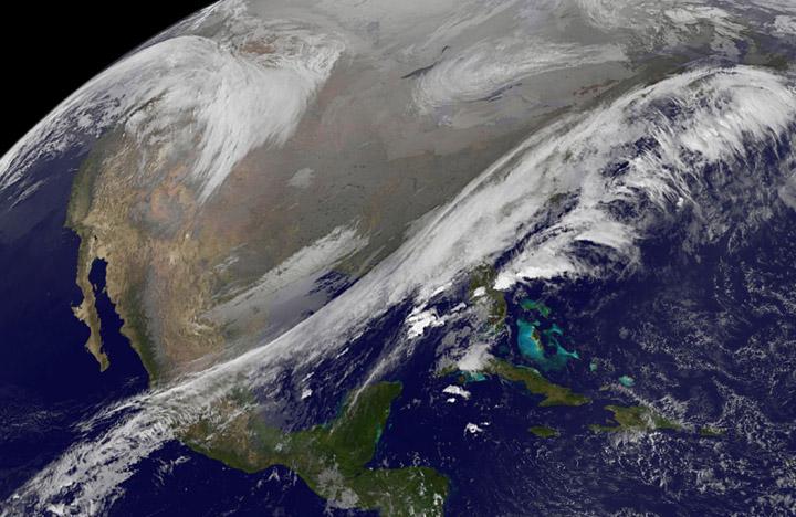
This NOAA's GOES satellite infrared image taken on Nov. 25 at 11:45 UTC (6:45 a.m. EST) shows two main weather systems over the U.S. Credit: NASA/NOAA GOES Project As the U.S. Thanksgiving holiday approaches this Thursday, November 27, NOAA's GOES-East and GOES-West satellites are keeping a weather eye out for storms that may affect early travelers. In an image from Nov. 25, the satellites show an active weather pattern is in place for travelers across the central and eastern U.S. NOAA's GOES-East satellite provides visible and infrared images over the eastern U.S. and the Atlantic Ocean, while NOAA's GOES-West satellite covers the western U.S. and Pacific Ocean from its fixed orbit in space. Data from both satellites were combined at NASA's GOES Project to create a full view of the U.S. on Nov. 25 at 11:45 UTC (6:45 a.m. EST). The image shows clouds associated with cold front stretching from the Gulf of Mexico over northern Florida and along the U.S. East coast to eastern Canada. Clouds associated with another area of low pressure are in the northern Rockies and northwestern U.S. To create the image, NASA/NOAA's GOES Project takes the cloud data from NOAA's GOES-East satellite and overlays it on a true-color image of land and ocean created by data from the Moderate Resolution Imaging Spectroradiometer, or MODIS, instrument that flies aboard NASA's Aqua and Terra satellites. Together, those data created the entire picture of the storm and show its movement. After the storm system passes, the snow on the ground becomes visible. NOAA's National Weather Service Weather Prediction Center said "a storm system will develop off the coast of the Carolinas early Wednesday (Nov. 25) and strengthen as it moves rapidly up the East Coast Wednesday into early Thursday (Nov. 26). Heavy snow is likely to begin in the central Appalachians early Wednesday morning, spreading northeast through the interior Mid-Atlantic into New England by Wednesday night. Winter Storm Watches are in effect for these areas." For travelers in the western U.S., the Northern Rocky Mountains are expected to receive more snow from the north side of a stationary frontal boundary. South of the boundary rain showers will affect the lower valley. The National Weather Service calls for cold weather to continue in the northern Plains and Upper Midwest as a Canadian surface high pressure rules the weather. The U.S. Southwest will experience nice weather for mid-week. In the Pacific Northwest, the National Weather Service noted that a warm front will bring rain, heavy at times, to the Cascades today and tonight. There will be a break in the heavier rains on Wednesday, then another period of heavy rain for the Cascades Wednesday night through Friday morning as a cold front slowly drags through the area. NOAA's GOES satellites provide the kind of continuous monitoring necessary for intensive data analysis. Geostationary describes an orbit in which a satellite is always in the same position with respect to the rotating Earth. This allows GOES to hover continuously over one position on Earth's surface, appearing stationary. As a result, GOES provide a constant vigil for the atmospheric triggers for severe weather conditions such as tornadoes, flash floods, hail storms and hurricanes.