
New NASA Administrator Michael Griffin makes a point during a town hall meeting with NASA Dryden employees on Tuesday, May 24, 2005.
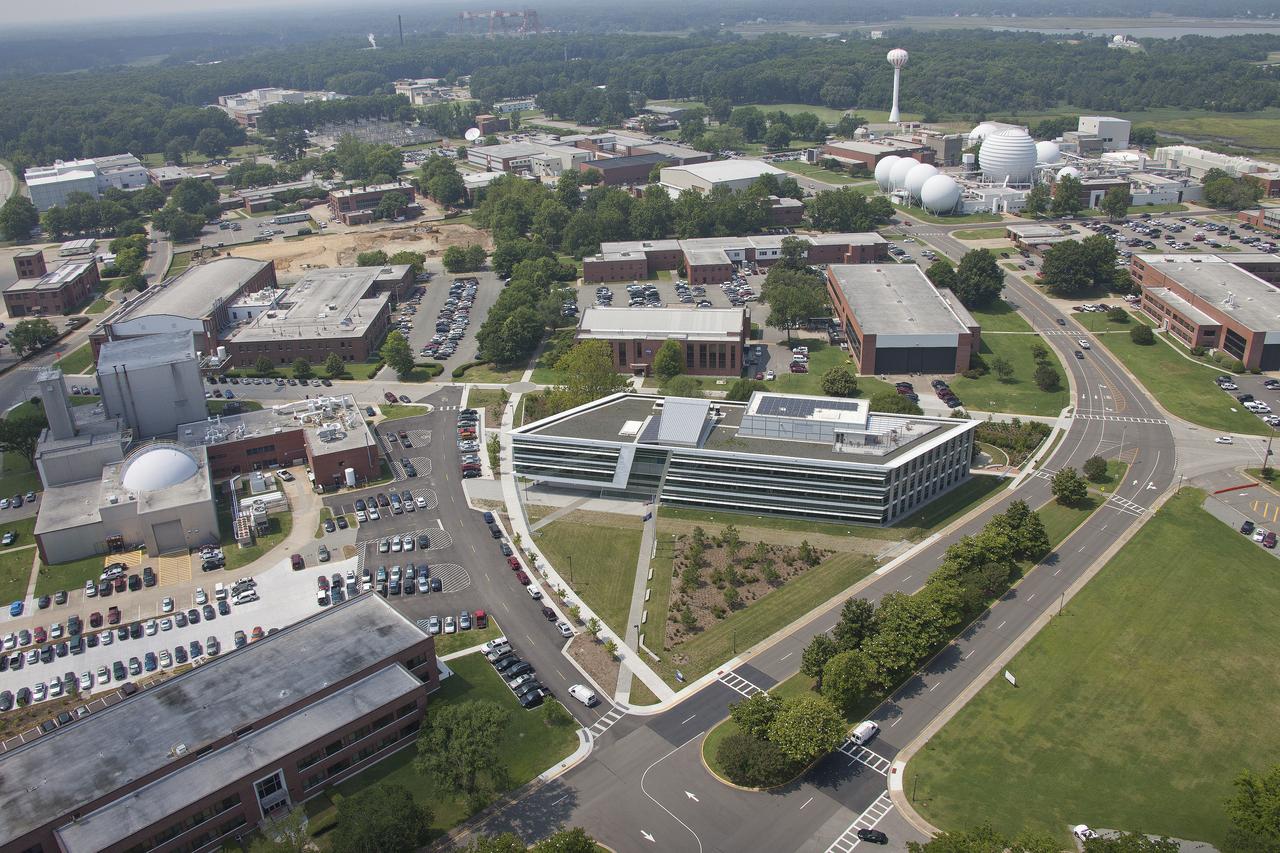
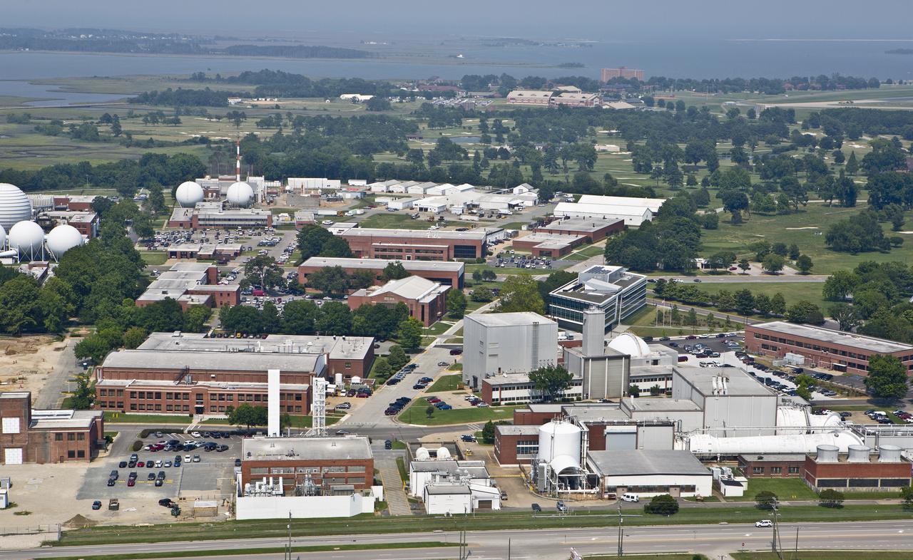
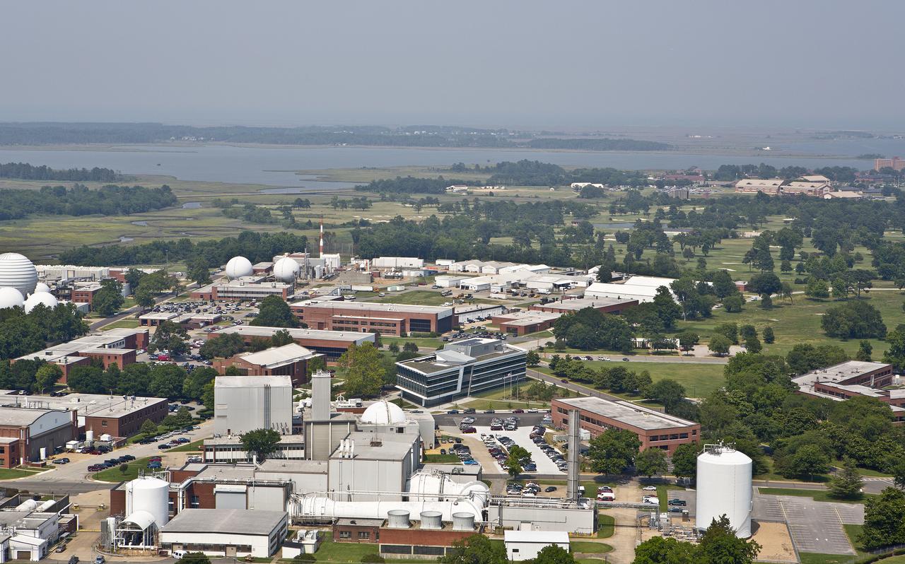
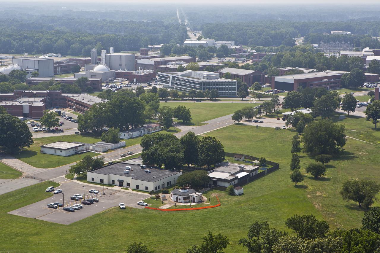
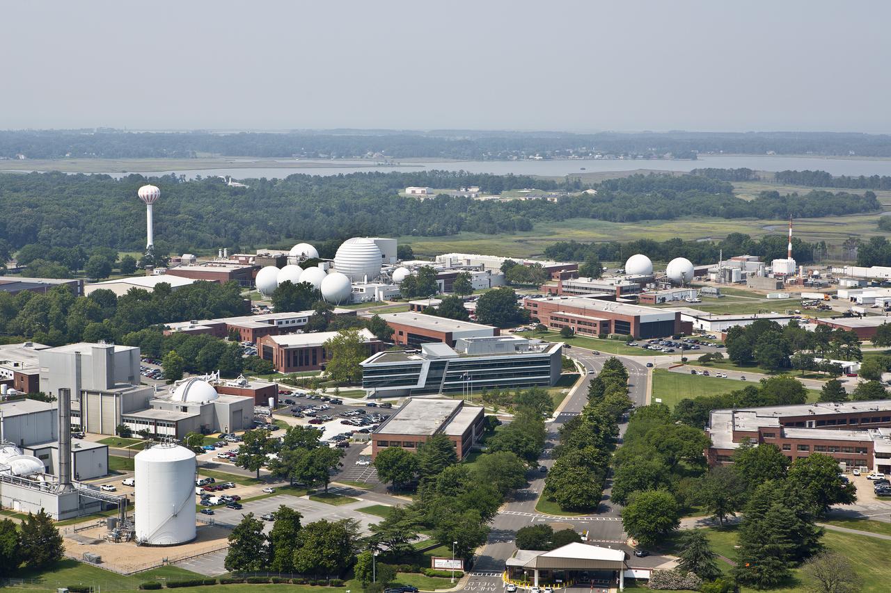
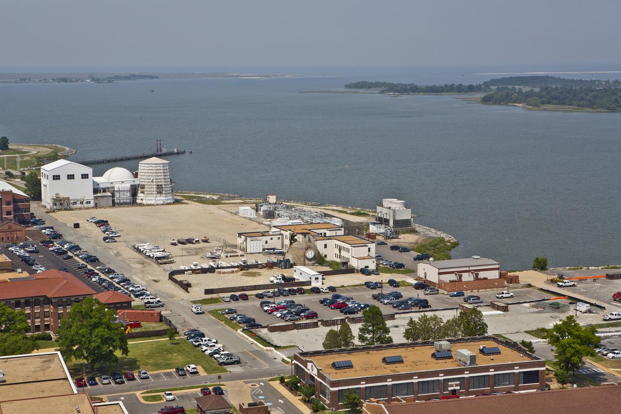
Aerial of NASA Langley Research Center New Town Center Head Quarters
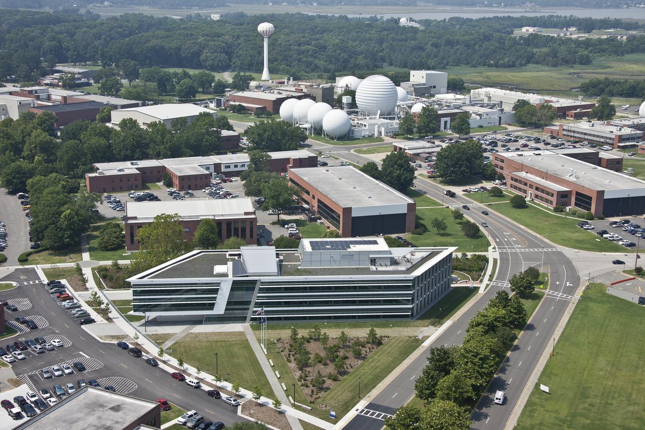
Aerial of NASA Langley Research Center New Town Center Head Quarters

Aerial of NASA Langley Research Center New Town Center Head Quarters

Aerial of NASA Langley Research Center New Town Center Head Quarters

Aerial of NASA Langley Research Center New Town Center Head Quarters
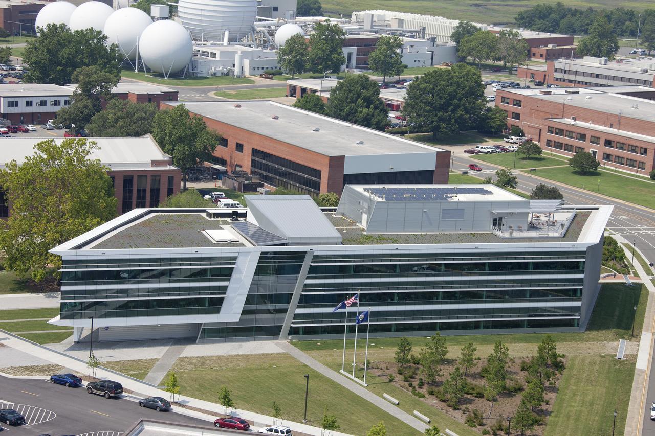
Aerial of NASA Langley Research Center New Town Center Head Quarters
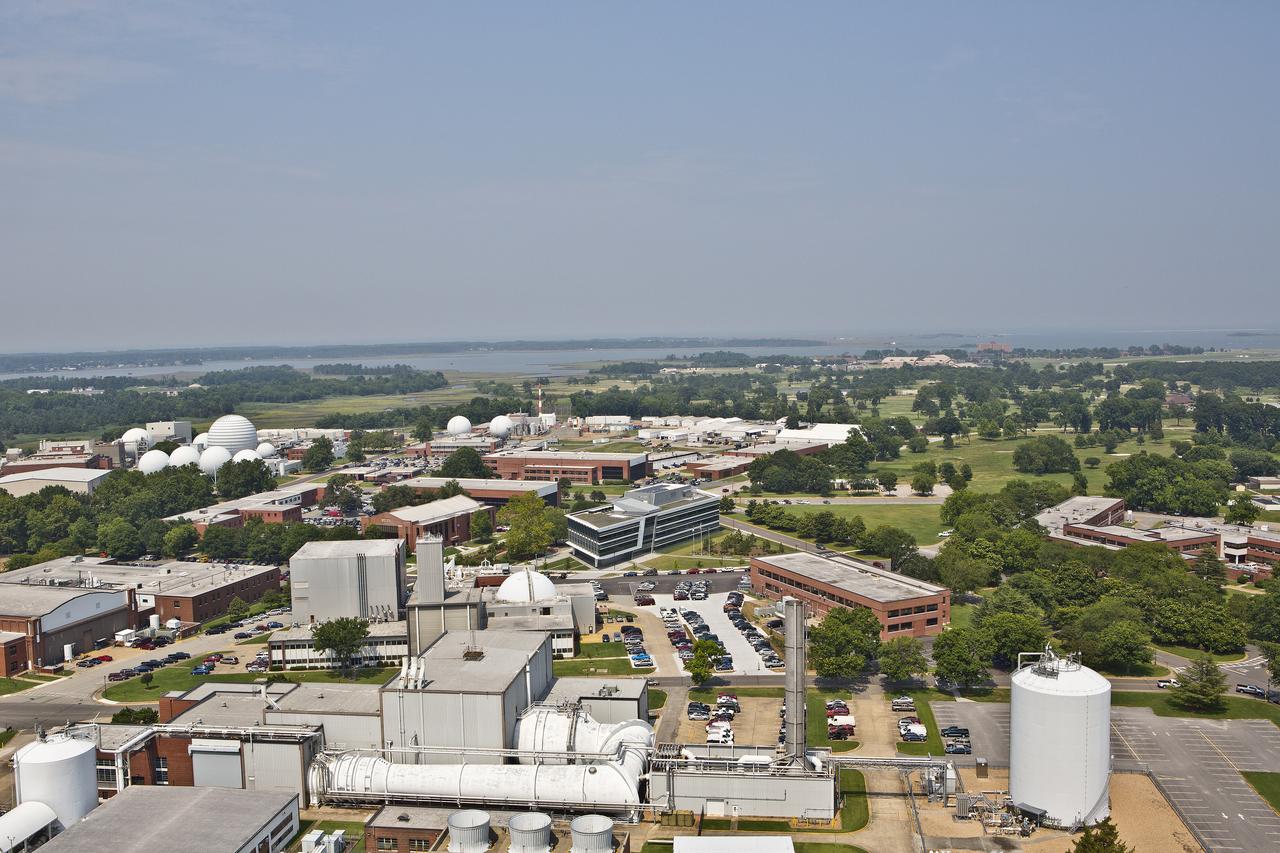
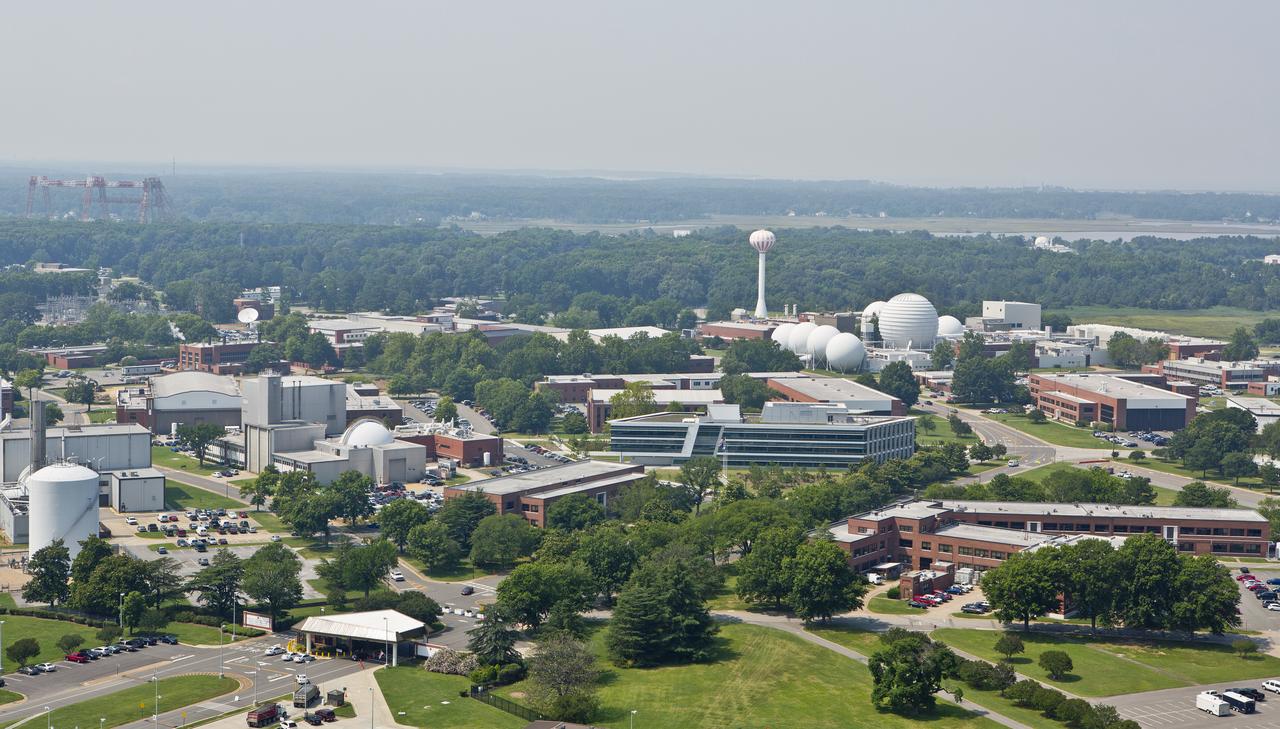
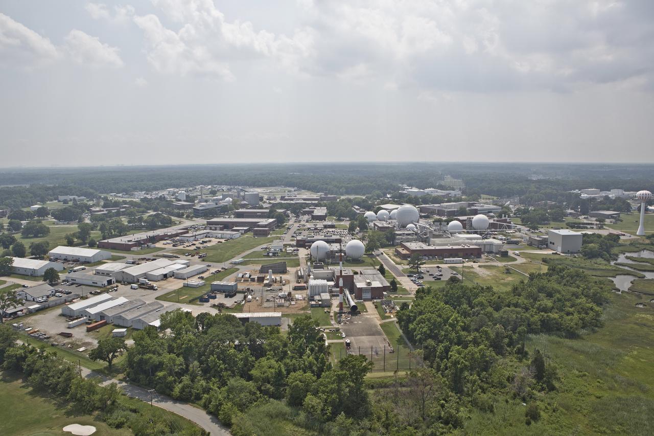
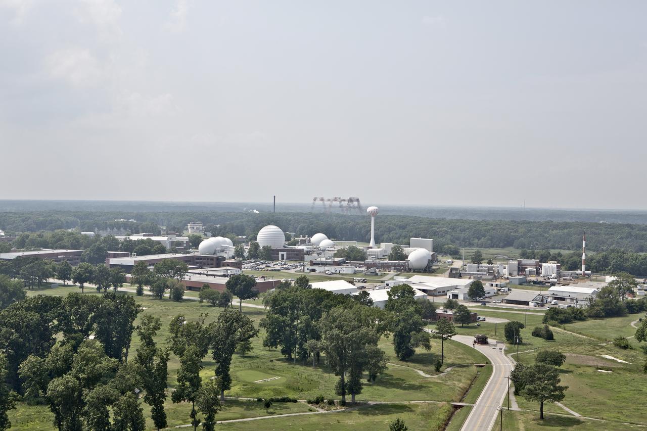
Aerial of NASA Langley Reaseach Center west side
Aerial view of NASA Langley Research Center west side
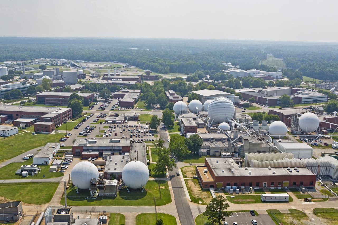
Aerials of NASA Langley Research Center west area
Aerial of NASA Langley Reaseach Center west side
Aerial view of NASA Langley Research Center west side
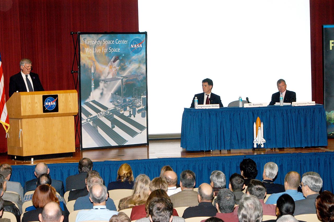
KENNEDY SPACE CENTER, FLA. -- Center Director Jim Kennedy introduces U.S. Reps. Dave Weldon and Tom Feeney in a Town Hall meeting at KSC. Weldon and Feeney commented on the new mission for NASA outlined by President George W. Bush Jan. 14. The congressmen and Kennedy also answered questions from employees in the audience.

KENNEDY SPACE CENTER, FLA. --After a Town Hall meeting at KSC, Center Director Jim Kennedy and U.S. Reps. Dave Weldon and Tom Feeney pause for a photo before heading to the NASA-KSC News Center for a press conference. Weldon and Feeney discussed the new mission for NASA outlined by President George W. Bush Jan. 14. The congressmen and Kennedy also answered questions from employees in the audience.
Aerials of NASA Langley Research Center west area
Aerial view of NASA Langley Research Center west side
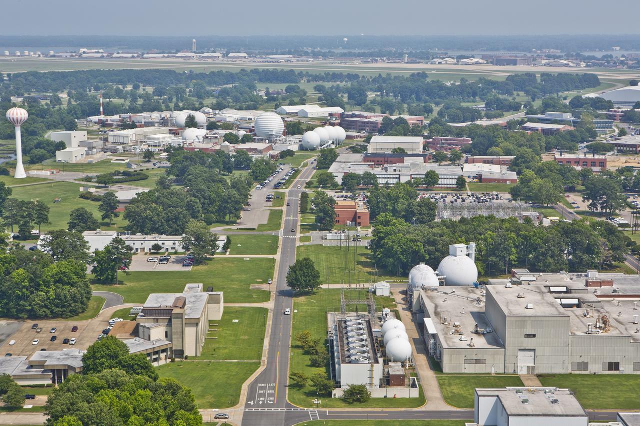
Aerials of NASA Langley Research Center west area
Aerial view of NASA Langley Research Center west side

Patti Bieling, news chief at NASA’s Kennedy Space Center in Florida, moderates a virtual Town Hall meeting on Jan. 13, 2022, for Kennedy employees. Center Director Janet Petro and other center executive leaders hosted the virtual town hall to provide updates on center milestones and answer questions.

KENNEDY SPACE CENTER, FLA. -- In a Town Hall meeting at KSC, Center Director Jim Kennedy (center) joined U.S. Reps. Dave Weldon (left) and Tom Feeney (right) to discuss the new mission for NASA outlined by President George W. Bush Jan. 14. The congressmen and Kennedy also answered questions from employees in the audience.

KENNEDY SPACE CENTER, FLA. -- U.S. Rep. Tom Feeney addresses employees in a Town Hall meeting at KSC with comments on the new mission for NASA outlined by President George W. Bush Jan. 14. He shared the stage with U.S. Rep. Dave Weldon and Center Director Jim Kennedy. All three later answered questions from employees in the audience.

KENNEDY SPACE CENTER, FLA. -- U.S. Rep. Dave Weldon addresses employees in a Town Hall meeting at KSC with comments on the new mission for NASA outlined by President George W. Bush Jan. 14. He shared the stage with U.S. Rep. Tom Feeney and Center Director Jim Kennedy. All three later answered questions from employees in the audience.
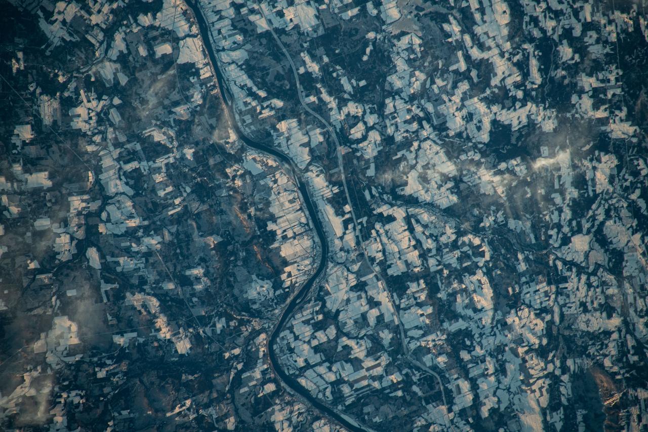
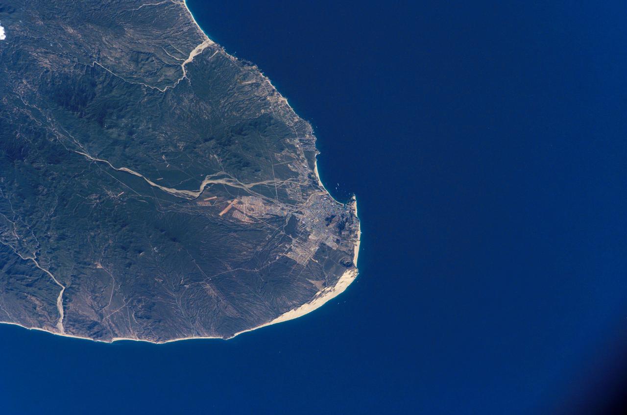
iss070e031278 (Nov. 25, 2023) --- The Canadian town of Carleton North, split by the St John River in the province of New Brunswick, borders Maine in the United States. The blue-gray colors of the landscape reveal the frigid temperatures in far North America in this photograph from the International Space Station as it orbited 262 miles above
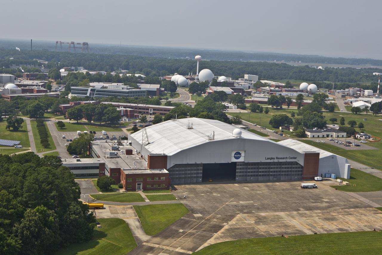
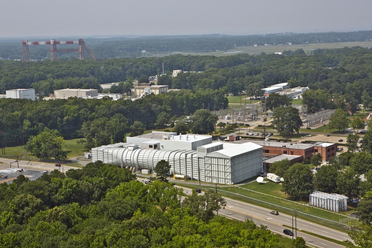
Aerial of NASA Langley Research Center Hangar
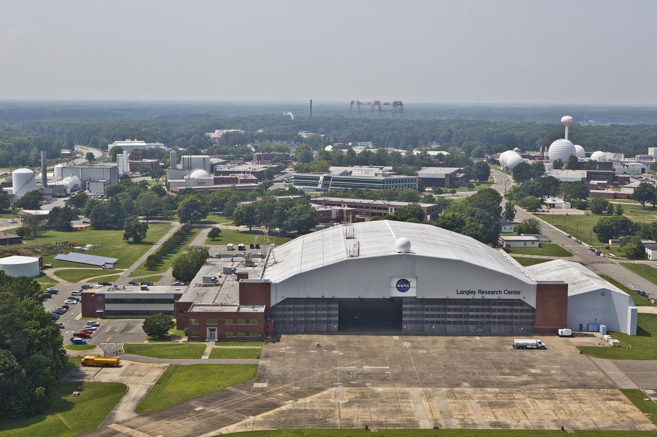
Aerial of NASA Langley Research Center Hangar
Aerials of NASA Langley Research Center east side with spin tunnel
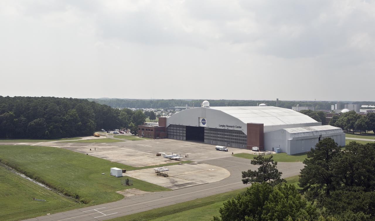
NASA Langley Hangar
Aerial of west area of Langley Research Center
Aerial of west area of Langley Research Center

Aerial of NASA Langley Research Center Hangar
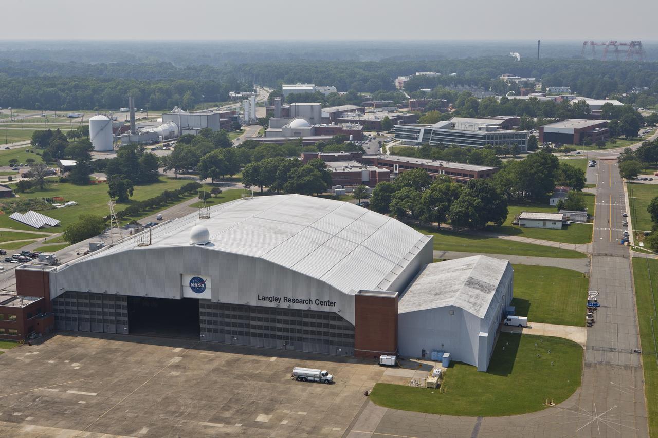
Aerial of NASA Langley Research Center Hangar
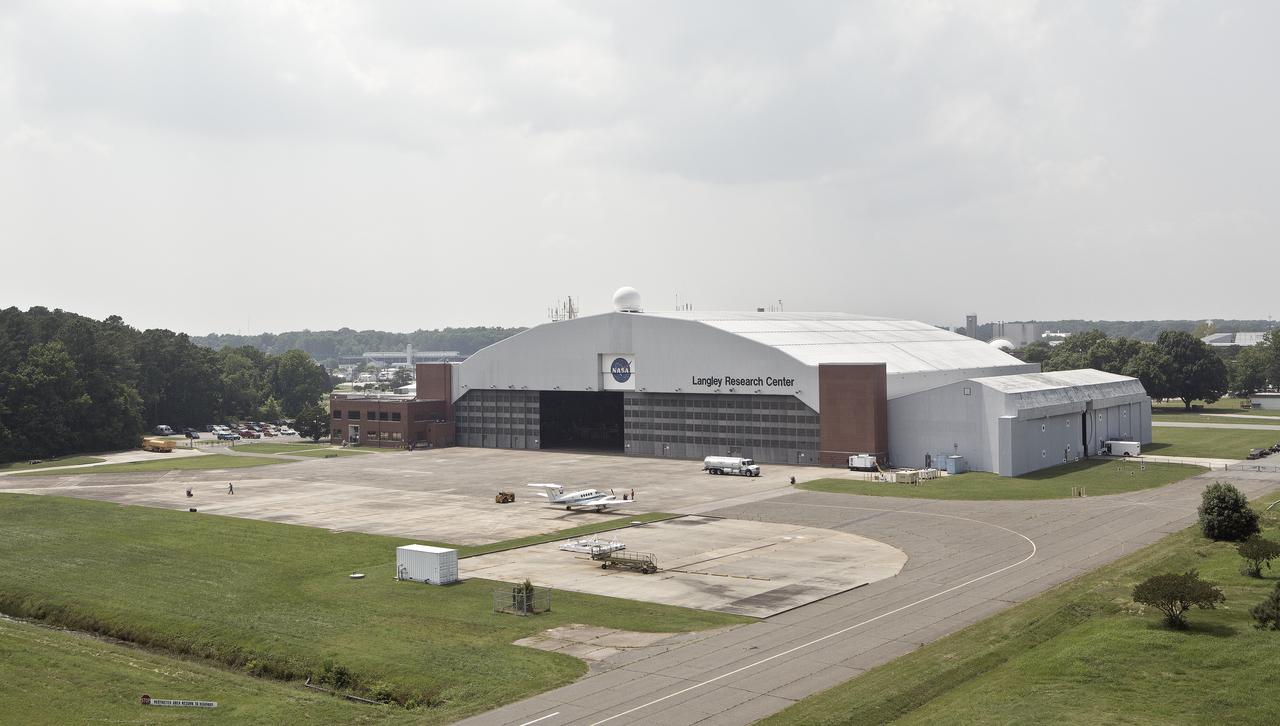
NASA Langley Hangar
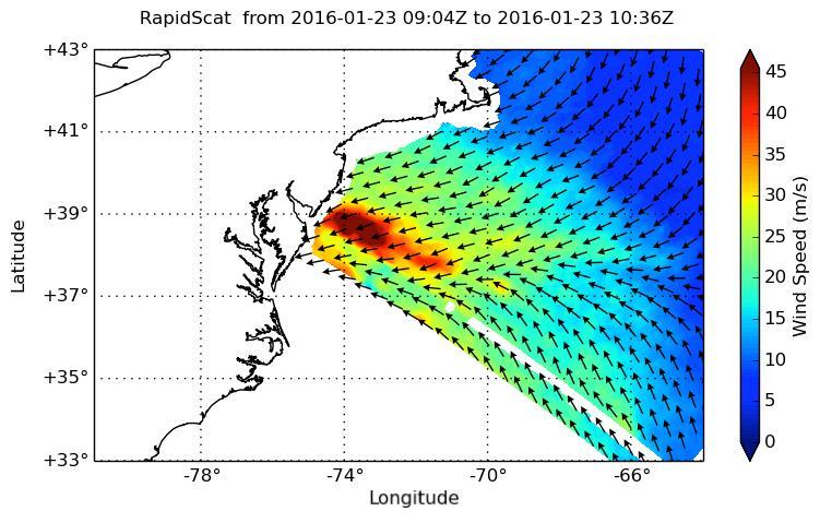
NASA's ISS-RapidScat instrument on the International Space Station provided a look at the strong winds that led to coastal flooding in southern New Jersey during the historic winter storm that blanketed much of the U.S. East Coast, starting Jan. 23, 2016. At 2 a.m. PST on Jan. 23, RapidScat showed sustained winds as strong as 45 meters per second (100 mph/162 kilometers per hour) along the coast of southern New Jersey. Many beachfront towns in this region were flooded as winds pushed ocean waters inland. The town of Cape May, New Jersey, reported a flood level of 8.98 feet (2.74 meters) -- the highest on record. This image shows ocean winds near the surface off the U.S. East Coast, from the hook of Cape Cod at top center to the South Carolina coastline at bottom left. Southern New Jersey and the northern edge of Delaware are directly in the path of the highest wind speeds. http://photojournal.jpl.nasa.gov/catalog/PIA20366
STS058-105-016 (18 Oct-1 Nov 1993) --- This photograph includes much of the heart of New England, stretching from Boston and Boston Harbor (lower left) across New Hampshire and Vermont to Lake Champlain (upper left), and up to southern Maine (Portland is just off the photo at right center). The colors in this photograph are less vivid than those in STS-58-81-038, because the color changes on the deciduous trees in central and northern New England were past their peak when this photograph was taken. North of Boston flows the Merrimack River (which forms part of the state boundary between Massachusetts and New Hampshire). It is delineated by the small industrial towns (Concord, Manchester, Nashua, Lowell) which grew up on its banks. The White Mountains of New Hampshire are seen near the center, and Mt. Washington (6,288 feet) is capped with snow.
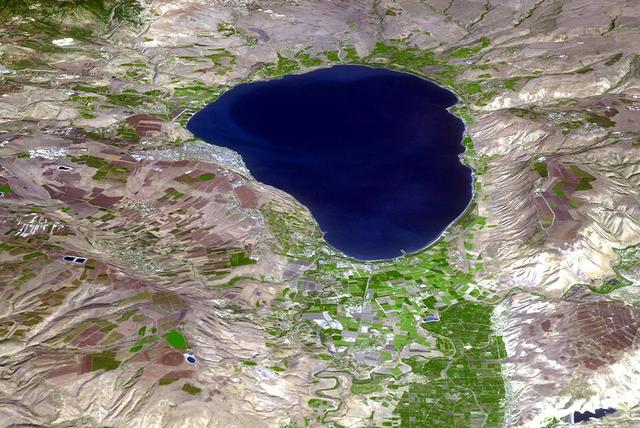
The Sea of Galilee (or Sea of Kinneret) in northern Israel is the lowest freshwater lake on Earth. The lake's main source is the Jordan River, in the Jordan Rift Valley. In antiquity, the Greeks, Hasmoneans, and Romans founded towns on the lake. In the New Testament, much of the ministry of Jesus occured on the shores of the Sea. (Information from Wikipedia.) The image was acquired October 14, 2018, and is located at 32.8 degrees north, 35.6 degrees east. https://photojournal.jpl.nasa.gov/catalog/PIA24130

Senior leaders at NASA’s Kennedy Space Center in Florida participate in a virtual town hall hosted at the NASA News Center auditorium on Feb. 17, 2021. From left to right are Kelvin Manning, associate director, technical; Bob Cabana, center director; Janet Petro, deputy director; and Burt Summerfield, associate director, management. The panel addressed a variety of topics and answered questions submitted by the Kennedy workforce.

New NASA Administrator Michael Griffin (right) shares a moment with Director Kevin Petersen (left) and F-15B project manager Stephen Corda (center) during Griffin's visit to NASA Dryden Flight Research Center on Tuesday, May 24.
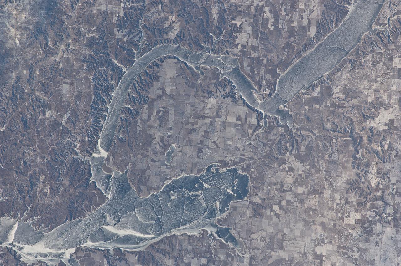
ISS030-E-059433 (19 Jan. 2012) --- Ice cover on Lake Sakakawea in North Dakota is featured in this image photographed by an Expedition 30 crew member on the International Space Station. This striking photograph illustrates the harsh winter conditions frequently experienced in North Dakota. Ice covers the surface of northwestern Lake Sakakawea, a reservoir on the Missouri River in west-central North Dakota. A local weather station near New Town, ND reported an air temperature of approximately -24 °C (-11 °F), with a wind chill of approximately -32 °C (-25 °F) at 10:36 local time – six minutes before the image was taken. In addition to the grey ice on the lake, a dusting of white snow highlights agricultural fields to the north and northeast, as well as fissures and irregularities in the ice surfaces. For a sense of scale, the arms of the lake to either side of New Town are approximately 10 kilometers (6 miles) apart. Lake Sakakawea is named—in the Hidatsa language—for the Shoshone woman generally known as Sacagawea, or “Bird Woman”. She accompanied the Lewis and Clark Expedition in 1805–1806 as an interpreter and guide. The lake was created following the completion of Garrison Dam (not shown) on the Missouri River in 1954. With a surface area of approximately 148,924 hectares (368,000 acres) and length of 286 kilometers (178 miles), Lake Sakakawea is one of the largest artificial reservoirs in the USA.

More than 650 volunteers - many of them employees at NASA's Stennis Space Center - weathered rain and cold to transform Bay St. Louis' old City Park into a playground Dec. 17. Volunteers assembled and erected a slide, swing set, jungle gym, sand box and planter benches in an eight-hour time frame. The playground was the first new structure built in the town devastated by Hurricane Katrina and the first on the Gulf Coast after the storm. The project was financed and led by nonprofit organization KaBOOM!, whose vision is to create a great place to play within walking distance of every child in America.

Space shuttle Discovery, mounted atop a NASA 747 Shuttle Carrier Aircraft (SCA) is seen from Top of the Town in Arlington, Virginia as it flies near the U.S. Capitol, Tuesday, April 17, 2012, in Washington. Discovery, the first orbiter retired from NASA’s shuttle fleet, completed 39 missions, spent 365 days in space, orbited the Earth 5,830 times, and traveled 148,221,675 miles. NASA will transfer Discovery to the National Air and Space Museum to begin its new mission to commemorate past achievements in space and to educate and inspire future generations of explorers. Photo Credit: (NASA/Chris Gunn)

Douglas Loverro, NASA’s new associate administrator for the Human Exploration and Operations Mission Directorate, right, joins NASA’s Marshall Space Flight Center Director Jody Singer to answer questions from the Marshall team at a Dec. 17 town hall. Loverro discussed the importance of the workforce, positivity and the unifying and inspirational nature of space exploration. “At the end of the day, we depend on the workforce, not on Headquarters to further exploration,” Loverro said. “My job is to listen to you and translate that into telling Congress and the administration what you need to complete your job. We're seeking a common purpose, on a common mission. I'm relying on you to tell me what you need to get this mission done.”

NASA Dryden research pilot Jim Smolka (left) details a recent flight experiment on a modified F-15B research aircraft to test range program manager Jerry McKee, center director Kevin Petersen and NASA Administrator Michael Griffin (right) during Griffin's initial visit to NASA's Dryden Flight Research Center on Tuesday, May 24.
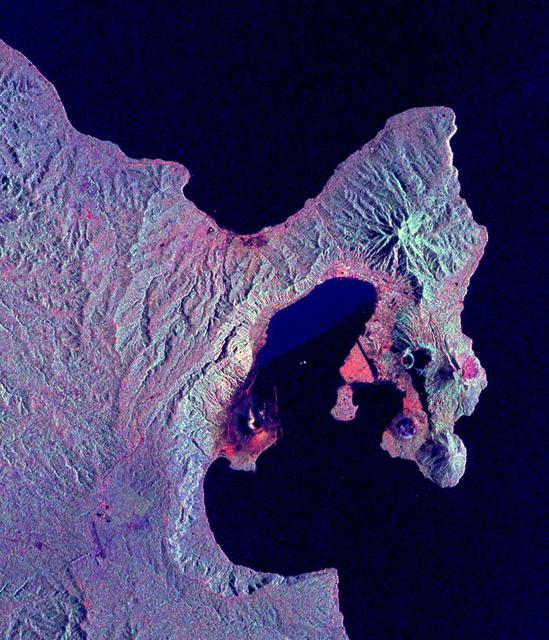
This is a radar image of the Rabaul volcano on the island of New Britain, Papua, New Guinea taken almost a month after its September 19, 1994, eruption that killed five people and covered the town of Rabaul and nearby villages with up to 75 centimeters (30 inches) of ash. More than 53,000 people have been displaced by the eruption. The image was acquired by the Spaceborne Imaging Radar-C/X-band Synthetic Aperture Radar (SIR-C/X-SAR) aboard the space shuttle Endeavour on its 173rd orbit on October 11, 1994. This image is centered at 4.2 degrees south latitude and 152.2 degrees east longitude in the southwest Pacific Ocean. The area shown is approximately 21 kilometers by 25 kilometers (13 miles by 15.5 miles). North is toward the upper right. The colors in this image were obtained using the following radar channels: red represents the L-band (horizontally transmitted and received); green represents the L-band (horizontally transmitted and vertically received); blue represents the C-band (horizontally transmitted and vertically received). Most of the Rabaul volcano is underwater and the caldera (crater) creates Blanche Bay, the semi-circular body of water that occupies most of the center of the image. Volcanic vents within the caldera are visible in the image and include Vulcan, on a peninsula on the west side of the bay, and Rabalanakaia and Tavurvur (the circular purple feature near the mouth of the bay) on the east side. Both Vulcan and Tavurvur were active during the 1994 eruption. Ash deposits appear red-orange on the image, and are most prominent on the south flanks of Vulcan and north and northwest of Tavurvur. A faint blue patch in the water in the center of the image is a large raft of floating pumice fragments that were ejected from Vulcan during the eruption and clog the inner bay. Visible on the east side of the bay are the grid-like patterns of the streets of Rabaul and an airstrip, which appears as a dark northwest-trending band at the right-center of the image. Ashfall and subsequent rains caused the collapse of most buildings in the town of Rabaul. Mudflows and flooding continue to pose serious threats to the town and surrounding villages. Volcanologists and local authorities expect to use data such as this radar image to assist them in identifying the mechanisms of the eruption and future hazardous conditions that may be associated with the vigorously active volcano. http://photojournal.jpl.nasa.gov/catalog/PIA01767

CAPE CANAVERAL, Fla. - At NASA's Kennedy Space Center in Florida, Jacobs Technology Deputy General Manager Lorna Kenna speaks at a town hall meeting providing attendees an opportunity to learn about the Test and Operations Support Contract, or TOSC, hiring process and to introduce the organization's management team. NASA recently awarded its TOSC contract to Jacobs Technology Inc. of Tullahoma, Tenn. Jacobs will provide overall management and implementation of ground systems capabilities, flight hardware processing and launch operations at Kennedy. These tasks will support the International Space Station, Ground Systems Development and Operations, and the Space Launch System, Orion Multi-Purpose Crew Vehicle and Launch Services programs. For more information, visit http://www.nasa.gov/centers/kennedy/news/tosc_awarded.html Photo credit: NASA/Dimitri Gerondidakis

CAPE CANAVERAL, Fla. - At NASA's Kennedy Space Center in Florida, Jacobs Technology General Manager Andy Allen speaks at a town hall meeting providing attendees an opportunity to learn about the Test and Operations Support Contract, or TOSC, hiring process and to introduce the organization's management team. NASA recently awarded its TOSC contract to Jacobs Technology Inc. of Tullahoma, Tenn. Jacobs will provide overall management and implementation of ground systems capabilities, flight hardware processing and launch operations at Kennedy. These tasks will support the International Space Station, Ground Systems Development and Operations, and the Space Launch System, Orion Multi-Purpose Crew Vehicle and Launch Services programs. For more information, visit http://www.nasa.gov/centers/kennedy/news/tosc_awarded.html Photo credit: NASA/Dimitri Gerondidakis
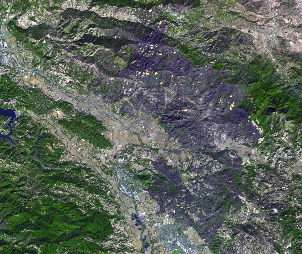
Thousands of acres damaged by the ongoing Kincade Fire in Northern California's Sonoma County are visible in this new image from the Advanced Spaceborne Thermal Emission and Reflection Radiometer (ASTER) instrument aboard NASA's Terra satellite. The image was taken at 11:01 a.m. PST (2:01 p.m. EST) on Nov. 3, 2019. The burned area appears dark gray in ASTER's visible channels. Hotspots, where the fire is still smoldering, appear as yellow dots in ASTER's heat-sensing, thermal infrared channels. After starting on Oct. 23, forcing residents to evacuate, the fire had burned 77,758 acres and destroyed 372 structures by Nov. 3, according to the California Department of Forestry and Fire Protection. It is now over 80% contained. The town of Healdsburg is in the center of the image, which covers an area of about 24 by 25 miles (39 by 40 kilometers). https://photojournal.jpl.nasa.gov/catalog/PIA23426
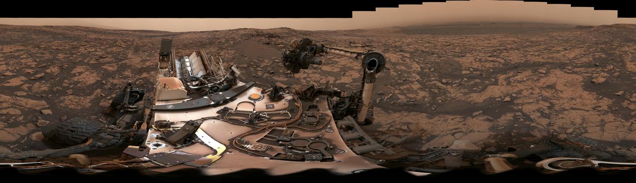
After snagging a new rock sample on August 9, 2018 (Sol 2137), NASA's Curiosity rover surveyed its surroundings on Mars, producing a 360-degree panorama of its current location on Vera Rubin Ridge. The scene is presented with a color adjustment that approximates white balancing, to resemble how the rocks and sand would appear under daytime lighting conditions on Earth. Two versions are included here: one with scale bars, and one without. The panorama includes umber skies, darkened by a fading global dust storm. It also includes a rare view by the Mast Camera of the rover itself, revealing a thin layer of dust on Curiosity's deck. In the foreground is the rover's most recent drill target, named "Stoer" after a town in Scotland near where important discoveries about early life on Earth were made in lakebed sediments. https://photojournal.jpl.nasa.gov/catalog/PIA22545

KENNEDY SPACE CENTER, FLA. -- In a wooded area of Kennedy Space Center, robins gather on a tree branch just beginning to show new Spring growth. A member of the thrush family, robins inhabit towns, gardens, open woodlands and agricultural lands. They range through most of North America, spending winters in large roosts mostly in the United States but also Newfoundland, southern Ontario and British Columbia. The Center shares a boundary with the Merritt Island National Wildlife Refuge, a haven and habitat for more than 331 species of birds. The Refuge encompasses 92,000 acres that are also a habitat for 31 mammals, 117 fishes, and 65 amphibians and reptiles. The marshes and open water of the refuge provide wintering areas for 23 species of migratory waterfowl, as well as a year-round home for great blue herons, great egrets, wood storks, cormorants, brown pelicans and other species of marsh and shore birds, as well as a variety of insects
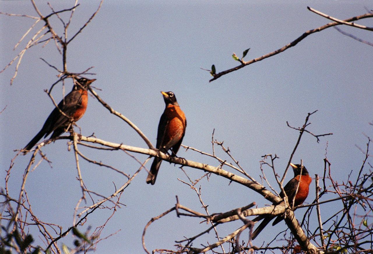
KENNEDY SPACE CENTER, FLA. -- In a wooded area of Kennedy Space Center, robins gather on a tree branch just beginning to show new Spring growth. A member of the thrush family, robins inhabit towns, gardens, open woodlands and agricultural lands. They range through most of North America, spending winters in large roosts mostly in the United States but also Newfoundland, southern Ontario and British Columbia. The Center shares a boundary with the Merritt Island National Wildlife Refuge, a haven and habitat for more than 331 species of birds. The Refuge encompasses 92,000 acres that are also a habitat for 31 mammals, 117 fishes, and 65 amphibians and reptiles. The marshes and open water of the refuge provide wintering areas for 23 species of migratory waterfowl, as well as a year-round home for great blue herons, great egrets, wood storks, cormorants, brown pelicans and other species of marsh and shore birds, as well as a variety of insects

Edward Saxe-Coburg-Gotha, the Duke of Windsor, visits the National Advisory Committee for Aeronautics (NACA) Lewis Flight Propulsion Laboratory in Cleveland, Ohio. He is seen in this photograph shaking hands with Associate Director Abe Silverstein. Lewis Director Ray Sharp is in the background. Cleveland mayor Thomas Burke and other local officials were also on hand to greet Edward. Silverstein led the group on a tour of Lewis’ new 8- by 6-Foot Supersonic Wind Tunnel where the Duke inquired about the operation of the facility’s flexible walls, the types of components tested, and the generation of airflow. The Duke was in town in 1951 to promote his new autobiography, A King’s Story, at the American Booksellers Convention. Edward had assumed the British throne in January 1936, only to renounce the position less than a year later to controversially marry Wallis Simpson. Ongoing concerns over the couple’s relationship to the German government resulted in his World War II assignment to the Bahamas. Edward spent the remainder of his life in France.
The Advanced Spaceborne Thermal Emission and Reflection (ASTER) instrument onboard NASA's Terra spacecraft obtained near-infrared data of the ongoing Kilauea volcano eruption and its impact on the Leilani Estates area on May 15, 2018 (left) and June 23, 2018 (right). The current eruption began May 3. Red areas are vegetated, while white areas are clouds or volcanic plumes. The new dark areas show where the ground has been covered with lava flows. The lava seen here, flowing a high rate of volume from a vent designated Fissure 8, flowed eastward to the coast. In early June 2018, these rapidly moving flows destroying hundreds of homes in and around the towns of Vacationland and Kapoho, and filled in Kapoho Bay. The flows are now creating a new broad delta, extending the island of Hawaii. A plume has formed where incandescent lava flows into the Pacific. In the ASTER observation obtained on June 23, a well-developed leveed and perched lava channel flowing from left to right is clearly seen. For the month of June, flow activity was mostly confined to Fissure 8 and areas fed by this lava channel. The image was acquired June 23, 2018, covers an area of about 14 by 14 miles (23 by 23 kilometers), and is located at 19.6 degrees north, 154.9 degrees west. https://photojournal.jpl.nasa.gov/catalog/PIA22593
STS098-382-0014 (7-20 February 2001) City Lights of the Northeastern Seaboard of the U.S. were captured with a 35mm camera by one of the STS-98 astronauts aboard the Space Shuttle Atlantis. The nighttime scene shows the bright lights of several major cities that span a distance from Connecticut (left middle) to states south of Virginia (right middle). Lights from both very large urban areas as well as smaller towns and cities are visible. The largest cluster of brightness emanates from the greater New York metropolitan area (left center) and then a series of bright spots progress southwesterly to include Philadelphia (PA), Baltimore (MD), Washington (D.C.), Richmond (VA), and finally ending with the Newport News/ Norfolk (VA) lights (top center). Many of the major ground transportation arteries can be seen as radial, linear features that radiate outward from the central business districts of the cities. Even the lights of smaller cities such as Allentown, Reading, Lancaster, York, and Harrisburg (PA) are visible (bottom center).
ISS012-E-07151 (5 November 2005) --- Cabo San Lucas, Baja California Sur, Mexico is featured in this image photographed by an Expedition 12 crewmember on the International Space Station. The built-up areas of the Cabo (cape) San Lucas stand out as bright, angular areas inland from the main bay on the tip of the Baja California peninsula. The town is centered on the bay, which looks out onto the blue waters of the Gulf of California. Three dry river beds (white sands in this arid environment) descend from rugged, wooded hills to the coastline. Rivers sands then accumulate to form white beaches visible along the coastline adjacent to the city. Cabo San Lucas (current population 41,000) is a tourist hotspot known for its mild sunny winter weather, and is frequented mainly by visitors from around the world. New neighborhoods are spreading north and northwest along major roads, and larger developments stretch northeast along the coast for 40 kilometers from Cabo San Lucas to the slightly larger city of San Jose del Cabo (not visible).
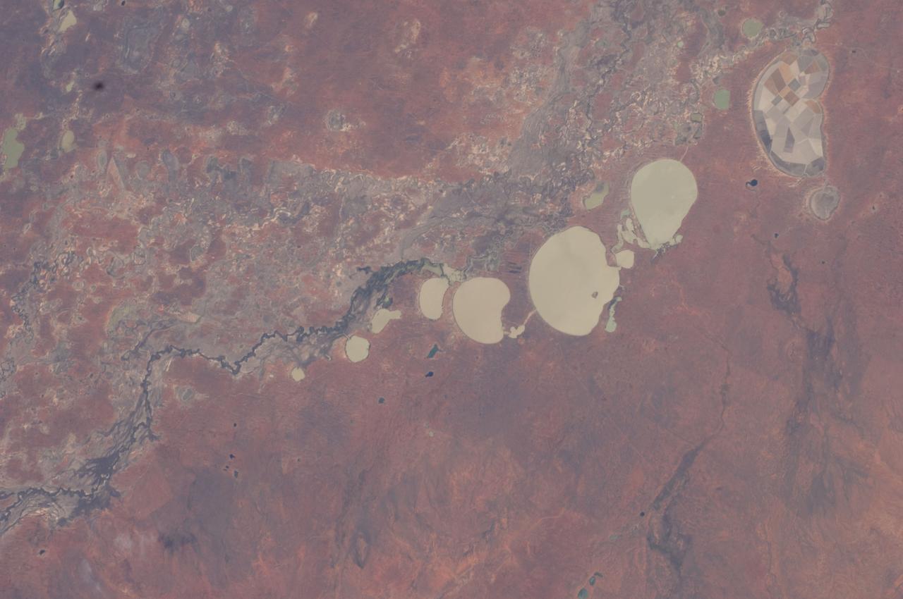
ISS030-E-009186 (3 Dec. 2011) --- The Menindee Lakes, New South Wales, Australia are featured in this image photographed by an Expedition 30 crew member on the International Space Station. The Menindee Lakes comprise a system of ephemeral, freshwater lakes fed by the Darling River when it floods. The lakes lie in the far west of New South Wales, Australia, near the town of Menindee. The longest is Lake Tandou (18.6 kilometers north?south dimension), visible at the upper right of this photograph. The lakes appear to have a small amount of water flooding them. The Darling River itself was flowing, as indicated by the dark water and blackened mud along its course (left). The Darling River flows southwest in tortuous fashion (bottom left to upper right). In the flat landscapes of this part of Australia, the river has created several inland deltas in its course to the sea, with characteristic diverging channel patterns, marked by younger sediments, which appear grayer than the surrounding ancient red soils and rocks. One such inland delta appears at right where minor channels wind across the countryside. The apex of another inland delta appears at upper right. Some of the Menindee Lakes have been incorporated in an artificially regulated overflow system providing for flood control, water storage for domestic use and livestock, as well as downstream irrigation. The lakes are also important as wetlands supporting a rich diversity of birds. The floor of one lake, Lake Tandou, is also used as prime agricultural land, as can be seen by its patchwork of irrigated fields, and is protected from flooding.
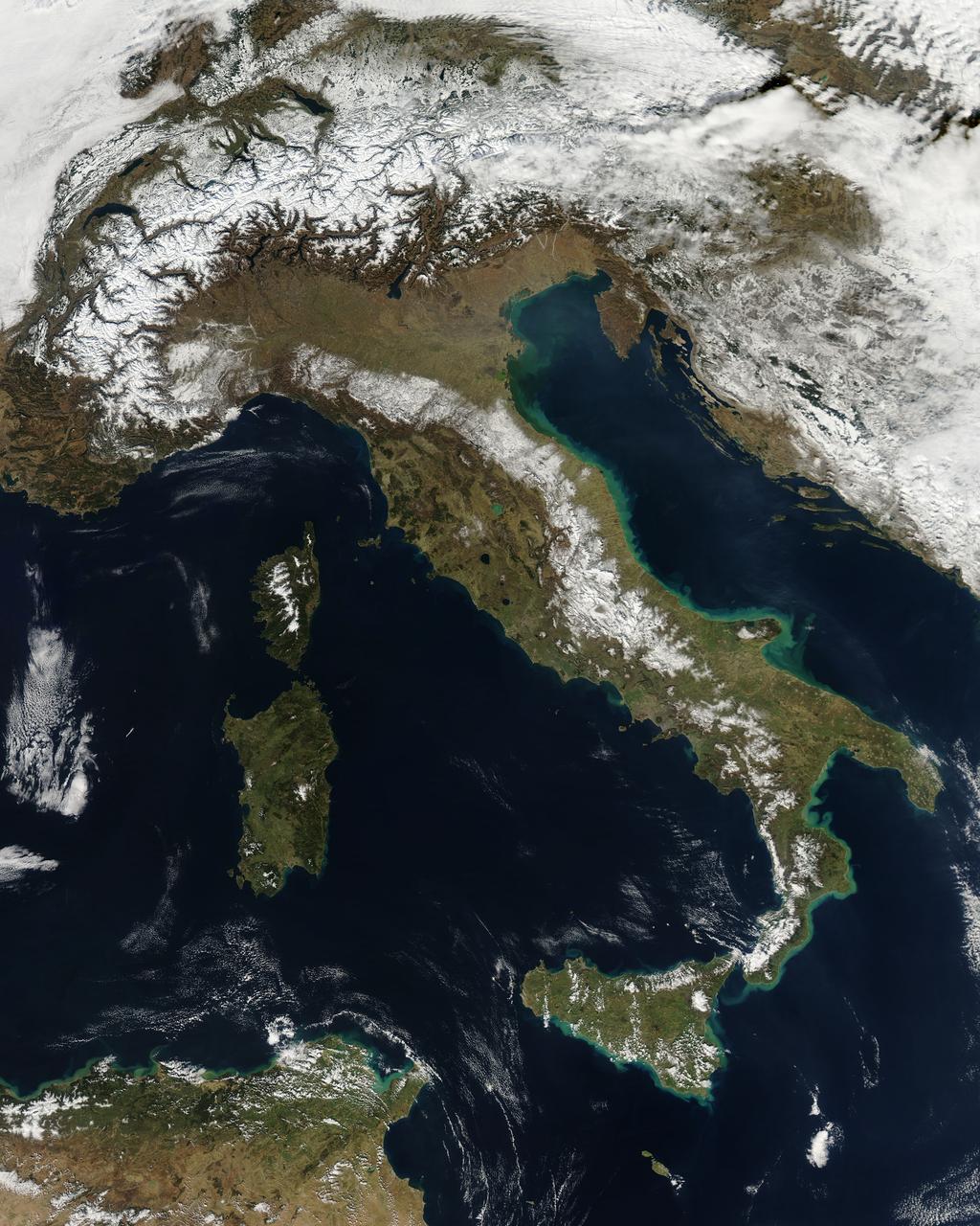
NASA image acquired February 24, 2012 By late February, 2012, the great European cold wave had begun to loosen its frigid grip, but significant snow still remained in the region. The Moderate Resolution Imaging Spectroradiometer (MODIS) aboard the Aqua satellite captured this true-color image of snow in Italy on February 24 at 12:35 UTC (1:30 p.m. local time). In the north of the image, bright white clouds blanket the region in a broad arc. Snow, which tends to be generally less bright that clouds, covers the Alps in the north of Italy. The Apennine Mountains, which form the backbone of the Italian peninsula, also carry a blanket of snow. Although clouds and snow can, at times, be distinguished visually in a true-color image, sometimes they can appear very similar. When it is important to clearly define snow from cloud, false color images are often helpful. Rome, which can be seen as a gray smudge on the southwestern coast of the peninsula, recorded highs of a spring-like 50°F the day this image was captured, but earlier in the month the temperatures dove as low as 26°F on February 5. During that cold snap a rare intense snowfall blanketed Rome, causing the closure of the Colosseum, the Roman Forum and the Palatine Hill due to concerns of the risk of icy footing for tourists, and roads became impassible. Further north, temperatures plummeted to −21 °C (−6 °F) on 7 February. On February 11, news media reported over 2 meters (6.5 feet) of snow had fallen in Urbino, a walled town situated on a high sloping hillside on the eastern side of the Apennine Mountains. That same snowfall cut access to many remote towns in the Apennines, blocking roads and trapping some people in the homes. Credit: NASA/GSFC/Jeff Schmaltz/MODIS Land Rapid Response Team <b><a href="http://www.nasa.gov/centers/goddard/home/index.html" rel="nofollow">NASA Goddard Space Flight Center</a></b> enables NASA’s mission through four scientific endeavors: Earth Science, Heliophysics, Solar System Exploration, and Astrophysics. Goddard plays a leading role in NASA’s accomplishments by contributing compelling scientific knowledge to advance the Agency’s mission. <b>Follow us on <a href="http://twitter.com/NASA_GoddardPix" rel="nofollow">Twitter</a></b> <b>Like us on <a href="http://www.facebook.com/pages/Greenbelt-MD/NASA-Goddard/395013845897?ref=tsd" rel="nofollow">Facebook</a></b> <b>Find us on <a href="http://instagrid.me/nasagoddard/?vm=grid" rel="nofollow">Instagram</a></b>
In December 2016, snow fell in the Sahara for the first time since 1979. In 1984, the charitable supergroup Band Aid sang: “There won’t be snow in Africa this Christmas time.” In fact, it does snow in Africa at high elevations. Kilimanjaro has long had a cap of snow and ice, though it has been shrinking. Skiiers travel for natural and manufactured snow in the Atlas Mountains of Morocco and Algeria, as well as a few spots in South Africa and Lesotho. Nonetheless, snow on the edge of the Sahara Desert is rare. On December 19, 2016, snow fell on the Algerian town of Ain Sefra, which is sometimes referred to as the “gateway to the desert.” The town of roughly 35,000 people sits between the Atlas Mountains and the northern edge of the Sahara. The last recorded snowfall in Ain Sefra occurred in February 1979. The Enhanced Thematic Mapper Plus (ETM+) on the Landsat 7 satellite acquired this natural-color image of snow in North Africa on December 19, 2016. This scene shows an area near the border of Morocco and Algeria, south of the city of Bouarfa and southwest of Ain Sefra. Though the news has been dominated by snow in the Saharan city, a review of several years of satellite data suggests that snow is also pretty rare in this section of the Atlas range. Read more: <a href="http://go.nasa.gov/2hIH4Xe" rel="nofollow">go.nasa.gov/2hIH4Xe</a> NASA Earth Observatory image by Joshua Stevens, using Landsat data from the U.S. Geological Survey. Caption by Mike Carlowicz. b><a href="http://www.nasa.gov/audience/formedia/features/MP_Photo_Guidelines.html" rel="nofollow">NASA image use policy.</a> <b><a href="http://www.nasa.gov/centers/goddard/home/index.html" rel="nofollow">NASA Goddard Space Flight Center</a></b> enables NASA’s mission through four scientific endeavors: Earth Science, Heliophysics, Solar System Exploration, and Astrophysics. Goddard plays a leading role in NASA’s accomplishments by contributing compelling scientific knowledge to advance the Agency’s mission. <b>Follow us on <a href="http://twitter.com/NASAGoddardPix" rel="nofollow">Twitter</a></b> <b>Like us on <a href="http://www.facebook.com/pages/Greenbelt-MD/NASA-Goddard/395013845897?ref=tsd" rel="nofollow">Facebook</a></b> <b>Find us on <a href="http://instagrid.me/nasagoddard/?vm=grid" rel="nofollow">Instagram</a></b>

The U.S. National Weather Service called it a “a crippling and historic winter blizzard.” In late January 2015, transportation systems from Trenton to Portland were shut down, and more than 35 million people hunkered down for extreme snowfall and biting winds. For those in New England, it turned out to be a monstrous storm. For the Mid-Atlantic region, not so much. Vast swaths of Massachusetts, Connecticut, Rhode Island, New Hampshire, Maine, and Long Island (NY) were blanketed with 15 to 25 inches (40 to 60 centimeters) of snow as of midday on January 27, 2015, and snow was expected to continue into January 28. Sustained winds reached gale force, with hurricane-force gusts along the coastlines. Storm surges sent ice and water into the streets of Scituate and Nantucket, Massachusetts. Many New England towns, including the city of Boston, were expected to approach all-time snowfall records. The Visible Infrared Imaging Radiometer Suite on the Suomi NPP satellite acquired these nighttime images at 1:45 am US eastern standard time (06:45 Universal Time) on January 27, 2015. The top image, lit by moonlight and city lights, shows a nor'easter off the coast of the East Coast of the United States. City lights are blurred somewhat by the cloud cover. The second image shows the same scene in longwave infrared radiation, with brighter shades representing the colder temperatures of snow-producing clouds. NASA Earth Observatory image by Jesse Allen, using VIIRS data from the Suomi National Polar-orbiting Partnership. Read more: <a href="http://earthobservatory.nasa.gov/IOTD/view.php?id=85166&eocn=home&eoci=iotd_title" rel="nofollow">earthobservatory.nasa.gov/IOTD/view.php?id=85166&eocn...</a> Via: <b><a href="http://www.earthobservatory.nasa.gov/" rel="nofollow"> NASA Earth Observatory</a></b> <b><a href="http://www.nasa.gov/audience/formedia/features/MP_Photo_Guidelines.html" rel="nofollow">NASA image use policy.</a></b> <b><a href="http://www.nasa.gov/centers/goddard/home/index.html" rel="nofollow">NASA Goddard Space Flight Center</a></b> enables NASA’s mission through four scientific endeavors: Earth Science, Heliophysics, Solar System Exploration, and Astrophysics. Goddard plays a leading role in NASA’s accomplishments by contributing compelling scientific knowledge to advance the Agency’s mission. <b>Follow us on <a href="http://twitter.com/NASAGoddardPix" rel="nofollow">Twitter</a></b> <b>Like us on <a href="http://www.facebook.com/pages/Greenbelt-MD/NASA-Goddard/395013845897?ref=tsd" rel="nofollow">Facebook</a></b> <b>Find us on <a href="http://instagram.com/nasagoddard?vm=grid" rel="nofollow">Instagram</a></b>

The U.S. National Weather Service called it a “a crippling and historic winter blizzard.” In late January 2015, transportation systems from Trenton to Portland were shut down, and more than 35 million people hunkered down for extreme snowfall and biting winds. For those in New England, it turned out to be a monstrous storm. For the Mid-Atlantic region, not so much. Vast swaths of Massachusetts, Connecticut, Rhode Island, New Hampshire, Maine, and Long Island (NY) were blanketed with 15 to 25 inches (40 to 60 centimeters) of snow as of midday on January 27, 2015, and snow was expected to continue into January 28. Sustained winds reached gale force, with hurricane-force gusts along the coastlines. Storm surges sent ice and water into the streets of Scituate and Nantucket, Massachusetts. Many New England towns, including the city of Boston, were expected to approach all-time snowfall records. The Visible Infrared Imaging Radiometer Suite on the Suomi NPP satellite acquired these nighttime images at 1:45 am US eastern standard time (06:45 Universal Time) on January 27, 2015. The top image, lit by moonlight and city lights, shows a nor'easter off the coast of the East Coast of the United States. City lights are blurred somewhat by the cloud cover. The second image shows the same scene in longwave infrared radiation, with brighter shades representing the colder temperatures of snow-producing clouds. NASA Earth Observatory image by Jesse Allen, using VIIRS data from the Suomi National Polar-orbiting Partnership. Read more: <a href="http://earthobservatory.nasa.gov/IOTD/view.php?id=85166&eocn=home&eoci=iotd_title" rel="nofollow">earthobservatory.nasa.gov/IOTD/view.php?id=85166&eocn...</a> Via: <b><a href="http://www.earthobservatory.nasa.gov/" rel="nofollow"> NASA Earth Observatory</a></b> <b><a href="http://www.nasa.gov/audience/formedia/features/MP_Photo_Guidelines.html" rel="nofollow">NASA image use policy.</a></b> <b><a href="http://www.nasa.gov/centers/goddard/home/index.html" rel="nofollow">NASA Goddard Space Flight Center</a></b> enables NASA’s mission through four scientific endeavors: Earth Science, Heliophysics, Solar System Exploration, and Astrophysics. Goddard plays a leading role in NASA’s accomplishments by contributing compelling scientific knowledge to advance the Agency’s mission. <b>Follow us on <a href="http://twitter.com/NASAGoddardPix" rel="nofollow">Twitter</a></b> <b>Like us on <a href="http://www.facebook.com/pages/Greenbelt-MD/NASA-Goddard/395013845897?ref=tsd" rel="nofollow">Facebook</a></b> <b>Find us on <a href="http://instagram.com/nasagoddard?vm=grid" rel="nofollow">Instagram</a></b>
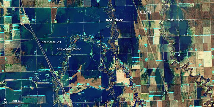
NASA Satellite image acquired March 21, 2010. To see a high res of this image go here: <a href="http://www.flickr.com/photos/gsfc/4455124807/in/photostream/">www.flickr.com/photos/gsfc/4455124807/in/photostream/</a> On March 21, 2010, the Red River crested at 36.99 feet (11.27 meters), according to the National Weather Service. The New York Times reported that the river’s crest was 1 foot (0.3 meters) below predictions and 4 feet (1 meter) below 2009’s record crest. A cold front passing through the area on March 19, 2010, slowed the rate of snowmelt feeding local rivers. That, combined with sandbags and dykes, spared the metropolitan area of Fargo, North Dakota, from serious flooding. North of town, however, agricultural fields and roads flooded. The Advanced Land Imager (ALI) on NASA’s Earth Observing-1 (EO-1) satellite captured these images of fields north of Fargo on March 21, 2010. The top image uses shortwave infrared light, and the bottom image uses visible light. Muddy waters and fallow fields blend together in the true-color image (bottom), but the false-color image (top) distinguishes better between water and land. Blue indicates water and green indicates vegetation. Fallow fields, bare ground, and paved surfaces appear in shades of brown. Cyan suggests pale water and/or sediment. Wide swaths of blue show large areas of standing water. The Sheyenne, Red, and Buffalo Rivers all flow through the area pictured here. According to The New York Times, flooding in rural areas around Fargo resulted primarily from the Red River’s failure to absorb water from the tributaries feeding it. Much of the standing water apparent in this image occurs around the Sheyenne and Buffalo Rivers. Overflowing tributaries left several inches of standing water in agricultural fields and on highways. About 10 miles (16 kilometers) north of Fargo, flooding forced the closure of Interstate 29. NASA image created by Jesse Allen, using EO-1 ALI data provided courtesy of the NASA EO-1 team and the United States Geological Survey. Caption by Michon Scott.. Instrument: EO-1 - ALI. To learn more about this image go here: <a href="http://earthobservatory.nasa.gov/NaturalHazards/view.php?id=43211" rel="nofollow">earthobservatory.nasa.gov/NaturalHazards/view.php?id=43211</a> To learn more about NASA's Goddard Space Flight Center go here: <a href="http://www.nasa.gov/centers/goddard/home/index.html" rel="nofollow">www.nasa.gov/centers/goddard/home/index.html</a>
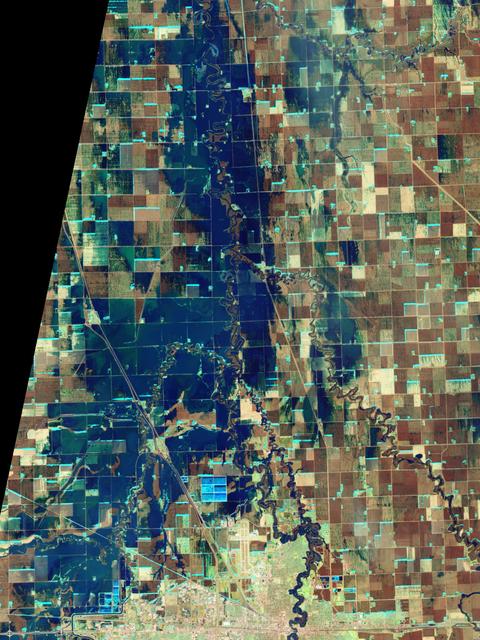
NASA Satellite image acquired March 21, 2010. To see a high res more detail of this image go here: <a href="http://www.flickr.com/photos/gsfc/4455125023/in/photostream/">www.flickr.com/photos/gsfc/4455125023/in/photostream/</a> On March 21, 2010, the Red River crested at 36.99 feet (11.27 meters), according to the National Weather Service. The New York Times reported that the river’s crest was 1 foot (0.3 meters) below predictions and 4 feet (1 meter) below 2009’s record crest. A cold front passing through the area on March 19, 2010, slowed the rate of snowmelt feeding local rivers. That, combined with sandbags and dykes, spared the metropolitan area of Fargo, North Dakota, from serious flooding. North of town, however, agricultural fields and roads flooded. The Advanced Land Imager (ALI) on NASA’s Earth Observing-1 (EO-1) satellite captured these images of fields north of Fargo on March 21, 2010. The top image uses shortwave infrared light, and the bottom image uses visible light. Muddy waters and fallow fields blend together in the true-color image (bottom), but the false-color image (top) distinguishes better between water and land. Blue indicates water and green indicates vegetation. Fallow fields, bare ground, and paved surfaces appear in shades of brown. Cyan suggests pale water and/or sediment. Wide swaths of blue show large areas of standing water. The Sheyenne, Red, and Buffalo Rivers all flow through the area pictured here. According to The New York Times, flooding in rural areas around Fargo resulted primarily from the Red River’s failure to absorb water from the tributaries feeding it. Much of the standing water apparent in this image occurs around the Sheyenne and Buffalo Rivers. Overflowing tributaries left several inches of standing water in agricultural fields and on highways. About 10 miles (16 kilometers) north of Fargo, flooding forced the closure of Interstate 29. NASA image created by Jesse Allen, using EO-1 ALI data provided courtesy of the NASA EO-1 team and the United States Geological Survey. Caption by Michon Scott. Instrument: EO-1 - ALI. To learn more about this image go here: <a href="http://earthobservatory.nasa.gov/NaturalHazards/view.php?id=43211" rel="nofollow">earthobservatory.nasa.gov/NaturalHazards/view.php?id=43211</a> To learn more about NASA's Goddard Space Flight Center go here: <a href="http://www.nasa.gov/centers/goddard/home/index.html" rel="nofollow">www.nasa.gov/centers/goddard/home/index.html</a>
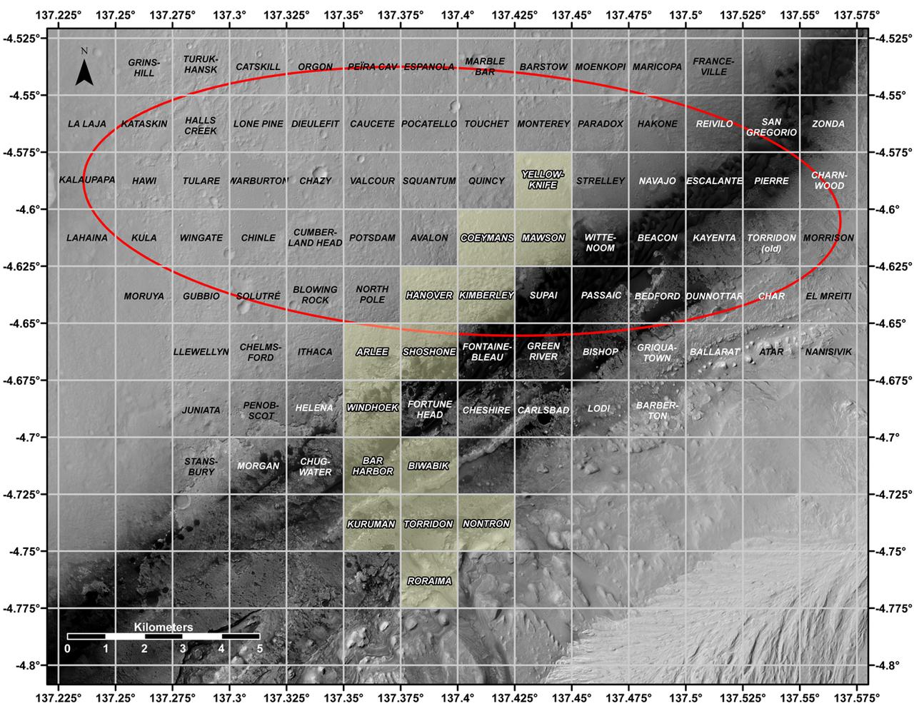
This map shows all the quadrant themes for NASA's Curiosity Mars rover, which is currently in the Roraima quadrant seen at the bottom. The red oval indicates the landing ellipse where the rover was targeted to touch down in 2012. The yellow-tinted quadrants are areas the rover has driven through since then. Themes are chosen in advance of the rover's arrival in a new quadrant; the rover's path couldn't be planned until after the team knew where it landed. Martian latitude and longitude is provided around the outside of the map. With the Curiosity mission, scientists began using quadrant themes to organize the long lists of unofficial nicknames needed to catalog its observations, whether hills, craters, boulders, rocks, and even tiny features on rock surfaces. Scientist deplete these lists of names quickly – especially with Curiosity, which has used more than 10,000 names over nearly 11 years of exploring Mars. Different science "targets" all require names – including targets for the rover's cameras, the rocks on which it places its arm instruments and drill, and the surfaces it zaps with its laser instrument. Curiosity's team chooses quadrant themes based on sites of geological interest on Earth. Its current quadrant, Roraima, is named for the northernmost state of Brazil, and for Mount Roraima, the highest peak in the Pacaraima mountains, located near the border of Venezuela, Brazil, and Guyana. The sulfate-enriched region Curiosity is currently exploring, with its flat-topped hills and steep slopes, reminded the rover team of the "table-top" mountains in the Pacaraima range. This is the first quadrant theme the team has chosen related to South America. Previously explored quadrants include Torridon, based on sites in Scotland, and Nontron, based on the French region where the town of Nontron can be found. While in the Nontron quadrant, which was located in a clay-enriched region, Curiosity drilled a rock sample that included a notable amount of nontronite – a clay mineral that was first discovered on Earth near Nontron. Each quadrant is 0.025 degrees of latitude and longitude, or approximately 0.7 miles (1.2 kilometers) on each side. https://photojournal.jpl.nasa.gov/catalog/PIA25914
ISS018-E-035716 (24 Feb. 2009) --- Minchinmavida and Chaiten Volcanoes in Chile are featured in this image photographed by an Expedition 18 crewmember on the International Space Station. The Andes mountain chain along the western coastline of South America includes numerous active stratovolcanoes. The majority of these volcanoes are formed, and fed, by magma generated as the oceanic Nazca tectonic plate moves northeastward and plunges beneath the less dense South American continental tectonic plate (a process known as subduction). The line of Andean volcanoes marks the approximate location of the subduction zone. This astronaut photograph highlights two volcanoes located near the southern boundary of the Nazca ? South America subduction zone in southern Chile. Dominating the scene is the massive Minchinmavida stratovolcano at center. An eruption of this glaciated volcano was observed by Charles Darwin during his Galapagos Island voyage in 1834; the last recorded eruption took place the following year. The white, snow covered summit of Minchinmavida is blanketed by gray ash erupted from its much smaller but now active neighbor to the west, Volcan (volcano) Chaiten. The historically inactive Chaiten volcano, characterized by a large lava dome within a caldera (an emptied and collapsed magma chamber beneath a volcano) roared back to life unexpectedly on May 2, 2008, generating dense ash plumes and forcing the evacuation of the nearby town of Chaiten. Volcanic activity continues at Chaiten, including partial collapse of a new lava dome and generation of a pyroclastic flow several days before this photograph was taken. A steam and ash plume is visible extending to the northeast from the eruptive center of the volcano.

“The day after the Columbia tragedy I knew exactly what I wanted to do with my life. I go to my physics class and tell a friend, ‘I want to go work for NASA.’ My physics teacher walks by and overhears the conversation. She starts the class and says ‘I want to go around the classroom and hear about what everybody wants to do with their life.’ She gets to me. I was super excited. ‘I’m going to work for NASA, I’m going to be an engineer, I’m going to make sure everybody flies safe.’ And she bursts out laughing. And everyone else starts laughing. I’m like, ‘what is the joke?’ And she says to me, ‘If you ever get the opportunity to work for NASA, you make sure you come take me out to lunch.’ And that ended up being the joke of the day at my entire high school. “I think we have a very long way to go. I think that there are not enough educational resources. There are not enough pipeline opportunities. I come from a single-parent family. We weren’t rich. We lived in a New Jersey suburb in a very small town where the idea of a girl going to NASA — it just seemed impossible. I think that we have long way to go to reach out to some of those smaller, under-serving communities where individuals may not have the resources. Where teachers can’t even motivate kids to do something big because they don’t even believe it themselves. I do believe there are strides happening — but I don’t think we’re there yet.” — Brittani Sims, Flight Systems Engineer, Kennedy Space Center Interviewer: NASA / Thalia Patrinos
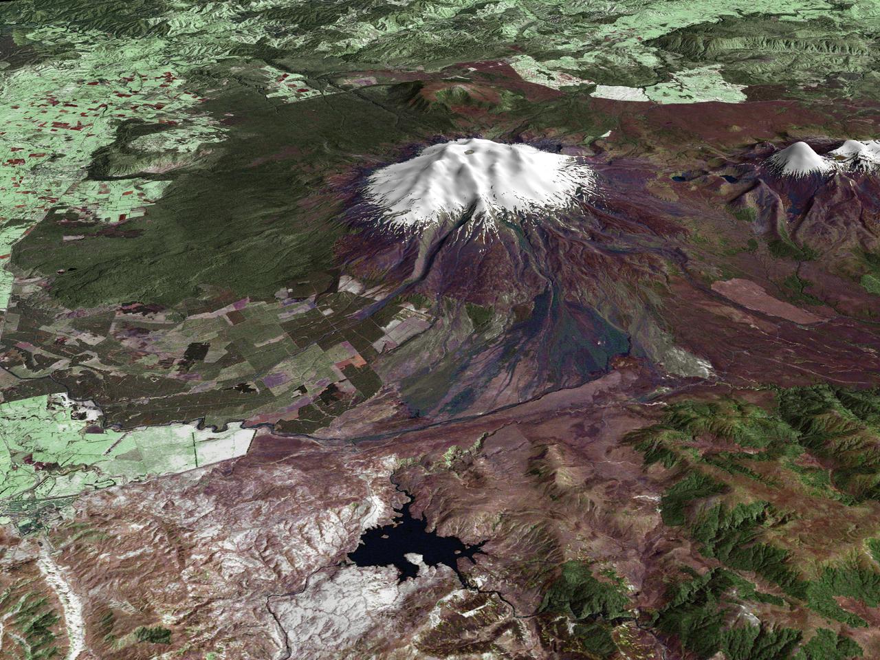
All around the world, people live in places where the threat of natural disaster is high. On the North Island of New Zealand, the Mount Ruapehu volcano is just such a threat. A towering, active stratovolcano (the classic cone-shaped volcano), snow-capped Ruapehu Volcano is pictured in this enhanced-color image. The image is made from topography data collected by the Shuttle Radar Topography Mission aboard the Space Shuttle Endeavour, launched on February 11, 2000, and imagery collected by the Landsat satellite on October 23, 2002. Ruapehu is one of New Zealand’s most active volcanoes, with ten eruptions since 1861. The eruptions aren’t the only threat from the volcano, however. Among the most serious threats is a volcanic mudflow called a lahar. In between eruptions, a lake forms in the volcano’s caldera from melting snow. If a previous eruption has deposited a dam of ash, rocks and mud in the lake’s natural overflow point, then the lake becomes dangerously full, held back only by the temporary dam. In this scene, the lake is nestled among the ridges at the top of the volcano. Eventually, the dam gives way and a massive flow of mud and debris churns down the mountain toward farmland and towns below. Scientists estimate that Ruapehu has experienced 60 lahars in the last 150 years. A devastating lahar in 1953 killed more than 150 people, who died when a passenger train plunged into a ravine when a railroad bridge was taken out by the lahar. The flank of the volcano below the lake is deeply carved by the path of previous lahars; the gouge can be seen just left of image center. Currently scientists in the region are predicting that the lake will overflow in a lahar sometime in the next year. There is great controversy about how to deal with the threat. News reports from the region indicate that the government is planning to invest in a high-tech warning system that will alert those who might be affected well in advance of any catastrophic release. Others feel that the government should combat the threat through engineering at the top of the mountain, for example, by undertaking a controlled release of the lake. Credit Landsat data provided courtesy of the University of Maryland Global Land Cover Facility Landsat processing by Laura Rocchio, Landsat Project Science Office SRTM 3-arcsecond elevation data courtesy of SRTM Team NASA/JPL/NIMA Visualization created by Earth Observatory staff. <b><a href="http://www.nasa.gov/centers/goddard/home/index.html" rel="nofollow">NASA Goddard Space Flight Center</a></b> enables NASA’s mission through four scientific endeavors: Earth Science, Heliophysics, Solar System Exploration, and Astrophysics. Goddard plays a leading role in NASA’s accomplishments by contributing compelling scientific knowledge to advance the Agency’s mission. <b>Follow us on <a href="http://twitter.com/NASA_GoddardPix" rel="nofollow">Twitter</a></b> <b>Join us on <a href="http://www.facebook.com/pages/Greenbelt-MD/NASA-Goddard/395013845897?ref=tsd" rel="nofollow">Facebook</a></b>
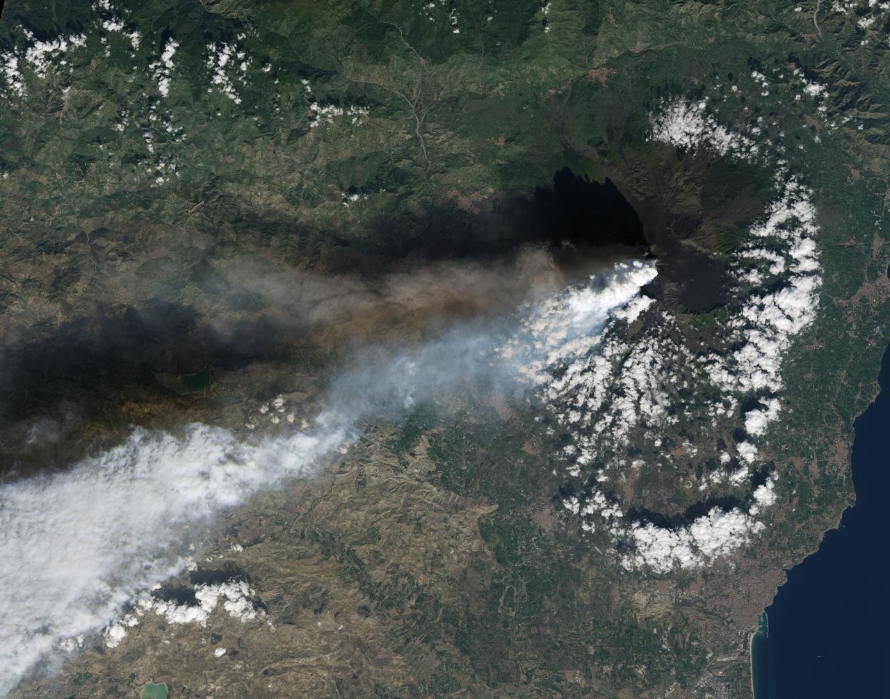
Twin volcanic plumes—one of ash, one of gas—rose from Sicily’ Mount Etna on the morning of October 26, 2013. L’Istituto Nazionale di Geofisica e Vulcanologia (INGV) Osservatorio Etneo (National Institute of Geophysics and Volcanology Etna Observatory) reported that Etna was experiencing its first paroxysm in six months. Multiple eruption columns are common at Etna, a result of complex plumbing within the volcano. The Northeast Crater, one of several on Etna’s summit, was emitting the ash column, while the New Southeast Crater was simultaneously venting mostly gas. This natural-color image collected by Landsat 8 shows the view from space at 11:38 a.m. local time. The towering, gas-rich plume cast a dark shadow over the lower, ash-rich plume and Etna’s northwestern flank. Relatively fresh lava flows (less than a century or so old) are dark gray; vegetation is green; and the tile-roofed buildings of Bronte and Biancavilla lend the towns an ochre hue. NASA Earth Observatory image by Jesse Allen and Robert Simmon, using Landsat data from the USGS Earth Explorer. Photograph ©2013, Boris Behncke. Caption by Robert Simmon with contributions from Boris Behncke. Instrument: Landsat 8 - OLI More info: <a href="http://1.usa.gov/1cEcOFi" rel="nofollow">1.usa.gov/1cEcOFi</a> Credit: <b><a href="http://www.earthobservatory.nasa.gov/" rel="nofollow"> NASA Earth Observatory</a></b> <b><a href="http://www.nasa.gov/audience/formedia/features/MP_Photo_Guidelines.html" rel="nofollow">NASA image use policy.</a></b> <b><a href="http://www.nasa.gov/centers/goddard/home/index.html" rel="nofollow">NASA Goddard Space Flight Center</a></b> enables NASA’s mission through four scientific endeavors: Earth Science, Heliophysics, Solar System Exploration, and Astrophysics. Goddard plays a leading role in NASA’s accomplishments by contributing compelling scientific knowledge to advance the Agency’s mission. <b>Follow us on <a href="http://twitter.com/NASA_GoddardPix" rel="nofollow">Twitter</a></b> <b>Like us on <a href="http://www.facebook.com/pages/Greenbelt-MD/NASA-Goddard/395013845897?ref=tsd" rel="nofollow">Facebook</a></b> <b>Find us on <a href="http://instagram.com/nasagoddard?vm=grid" rel="nofollow">Instagram</a></b>
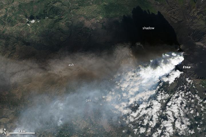
Twin volcanic plumes—one of ash, one of gas—rose from Sicily’ Mount Etna on the morning of October 26, 2013. L’Istituto Nazionale di Geofisica e Vulcanologia (INGV) Osservatorio Etneo (National Institute of Geophysics and Volcanology Etna Observatory) reported that Etna was experiencing its first paroxysm in six months. Multiple eruption columns are common at Etna, a result of complex plumbing within the volcano. The Northeast Crater, one of several on Etna’s summit, was emitting the ash column, while the New Southeast Crater was simultaneously venting mostly gas. This natural-color image collected by Landsat 8 shows the view from space at 11:38 a.m. local time. The towering, gas-rich plume cast a dark shadow over the lower, ash-rich plume and Etna’s northwestern flank. Relatively fresh lava flows (less than a century or so old) are dark gray; vegetation is green; and the tile-roofed buildings of Bronte and Biancavilla lend the towns an ochre hue. NASA Earth Observatory image by Jesse Allen and Robert Simmon, using Landsat data from the USGS Earth Explorer. Photograph ©2013, Boris Behncke. Caption by Robert Simmon with contributions from Boris Behncke. Instrument: Landsat 8 - OLI More info: <a href="http://1.usa.gov/1cEcOFi" rel="nofollow">1.usa.gov/1cEcOFi</a> Credit: <b><a href="http://www.earthobservatory.nasa.gov/" rel="nofollow"> NASA Earth Observatory</a></b> <b><a href="http://www.nasa.gov/audience/formedia/features/MP_Photo_Guidelines.html" rel="nofollow">NASA image use policy.</a></b> <b><a href="http://www.nasa.gov/centers/goddard/home/index.html" rel="nofollow">NASA Goddard Space Flight Center</a></b> enables NASA’s mission through four scientific endeavors: Earth Science, Heliophysics, Solar System Exploration, and Astrophysics. Goddard plays a leading role in NASA’s accomplishments by contributing compelling scientific knowledge to advance the Agency’s mission. <b>Follow us on <a href="http://twitter.com/NASA_GoddardPix" rel="nofollow">Twitter</a></b> <b>Like us on <a href="http://www.facebook.com/pages/Greenbelt-MD/NASA-Goddard/395013845897?ref=tsd" rel="nofollow">Facebook</a></b> <b>Find us on <a href="http://instagram.com/nasagoddard?vm=grid" rel="nofollow">Instagram</a></b>
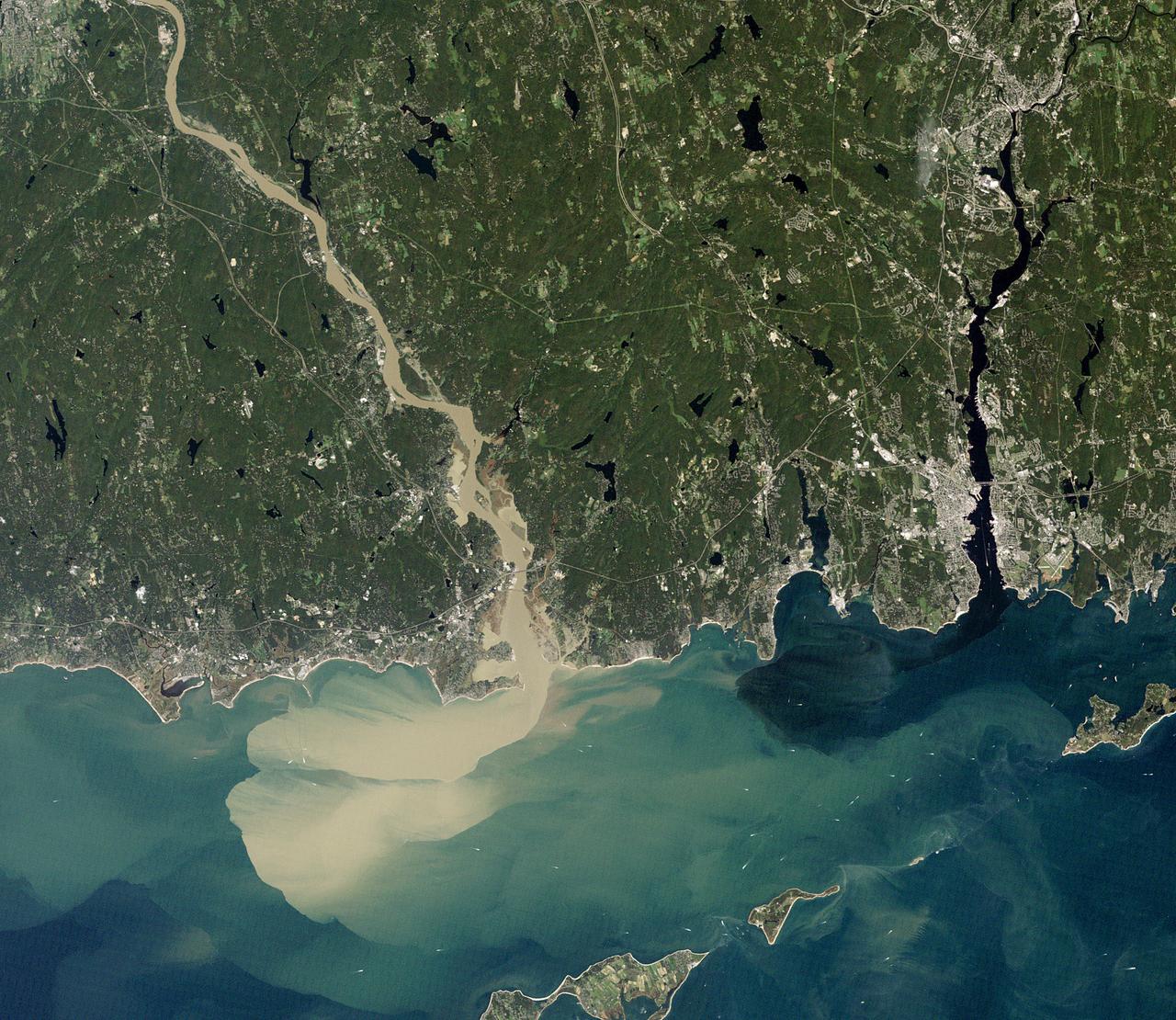
NASA image acquired September 2, 2011 To download the full high res go to: <a href="http://earthobservatory.nasa.gov/IOTD/view.php?id=52059" rel="nofollow">earthobservatory.nasa.gov/IOTD/view.php?id=52059</a> Nearly a week after Hurricane Irene drenched New England with rainfall in late August 2011, the Connecticut River was spewing muddy sediment into Long Island Sound and wrecking the region's farmland just before harvest. The Thematic Mapper on the Landsat 5 satellite acquired this true-color satellite image on September 2, 2011. With its headwaters near the Canadian border, the Connecticut River drains nearly 11,000 square miles (28,500 square kilometers) and receives water from at least 33 tributaries in Vermont, New Hampshire, Massachusetts, and Connecticut. The 410-mile river—New England's longest—enters Long Island Sound near Old Lyme, Connecticut, and is estimated to provide 70 percent of the fresh water entering the Sound. When Irene blew through the region on August 27-28, substantial portions of the Connecticut River watershed received more than 6 to 8 inches (15-20 centimeters) of rainfall, and several locations received more than 10 inches (25 centimeters). Whole towns were cut off from overland transportation—particularly upstream in Vermont, which suffered its worst flooding in 80 years. Thousands of people saw their homes flooded, if not washed off their foundations, at a time of year when rivers are usually at their lowest. Preliminary estimates of river flow at Thompsonville, Connecticut, (not shown in this image) reached 128,000 cubic feet per second (cfs) on August 30, nearly 64 times the usual flow (2,000 cfs) for early fall and the highest flow rate since May 1984. At the mouth of the river—where flow is tidal, and therefore not gauged—the peak water height reached 6.9 feet (2.1 meters) above sea level, almost a foot higher than at any time in the past 10 years. According to Suzanne O'Connell, an environmental scientist working along the Connecticut River at Wesleyan University, the torrent of water coursing through New England picked up silt and clay from the river valleys, giving it the tan color shown in the image above. At Essex, Connecticut, the turbidity (muddiness) of the water was 50 times higher than pre-Irene values. To the east, the Thames River appears to be carrying very little sediment at all on September 2. According to O'Connell, the Thames "drains glaciated terrain, so fine sediment was removed long ago." Most of the land surface in the Thames basin is "just bedrock, till, and glacial erratics." Unlike the Connecticut, areas within the Thames watershed only received 2 to 4 inches of rain in most locations. The flooding that occurred in the aftermath of Hurricane Irene inundated farmland in Massachusetts and Connecticut just before harvest time, the Associated Press noted. Crops were drowned under inches to feet of water. The substantial amounts of soil, sediment, and water deposited on land during the flood could also pose trouble for farmers in coming seasons. "It's notable that whole segments of river bank are just gone," said Andrew Fisk of the Connecticut River Watershed Council. "That's not just loss of sediment. That's land disappearing down river." <b>NASA Earth Observatory image by Robert Simmon, using Landsat 5 data from the U.S. Geological Survey Global Visualization Viewer. Caption by Michael Carlowicz, with interpretation help from Suzanne O'Connell, Wesleyan University, and Andrew Fisk, Connecticut River Watershed Council.</b> Instrument: Landsat 5 - TM Credit: <b><a href="http://www.earthobservatory.nasa.gov/" rel="nofollow"> NASA Earth Observatory</a></b> <b><a href="http://www.nasa.gov/centers/goddard/home/index.html" rel="nofollow">NASA Goddard Space Flight Center</a></b> enables NASA’s mission through four scientific endeavors: Earth Science, Heliophysics, Solar System Exploration, and Astrophysics. Goddard plays a leading role in NASA’s accomplishments by contributing compelling scientific knowledge to advance the Agency’s mission. <b>Follow us on <a href="http://twitter.com/NASA_GoddardPix" rel="nofollow">Twitter</a></b> <b>Like us on <a href="http://www.facebook.com/pages/Greenbelt-MD/NASA-Goddard/395013845897?ref=tsd" rel="nofollow">Facebook</a></b> <b>Find us on <a href="http://web.stagram.com/n/nasagoddard/?vm=grid" rel="nofollow">Instagram</a></b>
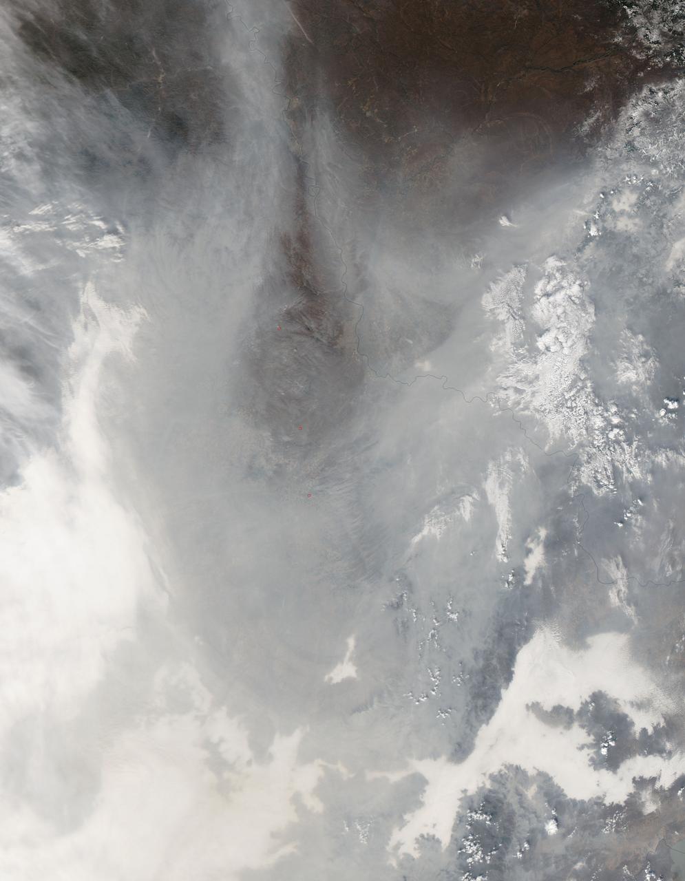
Chinese authorities shut down much of Harbin – a city of more than 10 million people – as unusually high levels of pollution shrouded the city and the surrounding region in mid-October, 2013. Measurements taken on October 20, 2013 scored the air quality index in the city at 500, the highest possible reading. Levels above 300 are considered hazardous to human health. The Moderate Resolution Imaging Spectroradiometer (MODIS) on NASA’s Aqua satellite acquired this true-color image of northeastern China on October 21. The brightest areas are fog, which is tinged with gray or yellow due to the air pollution. Other cloud-free areas have a pall of gray and brown smog that blots out the city and surrounding towns. Harbin lies under the Y-shaped patch of fog and smog in the south-central section of the image, completely obscured from view. Some neighborhoods experienced concentrations of fine particulate matter (PM 2.5) as high as 1,000 micrograms per cubic meter. For comparison the U.S. Environmental Protection Agency’s air quality standards state that PM 2.5 should remain below 35 micrograms per cubic meter. It is extremely rare for particulate levels to reach such high levels in the absence of a dust storm or forest fire. Chinese authorities grounded airplanes, shuttered thousands of schools and closed major roads in response to the surge in pollution. A few days after pollution levels started to rise, Harbin hospitals reported a 30 percent increase in admissions related to respiratory problems, and several Harbin pharmacies were sold out of pollution facemasks, according to media reports. Cold weather and lack of wind helped fuel the pollution outbreak, but human factors also played an important role. Wheat and corn farmers in the region light fires in the fall to burn off debris following the harvest. Also, city officials turned on Harbin’s city-wide, coal-powered heating system just prior to the pollution outbreak, according to China’s state-run Xinhua News Agency. Credit: NASA/GSFC/Jeff Schmaltz/MODIS Land Rapid Response Team <b><a href="http://www.nasa.gov/audience/formedia/features/MP_Photo_Guidelines.html" rel="nofollow">NASA image use policy.</a></b> <b><a href="http://www.nasa.gov/centers/goddard/home/index.html" rel="nofollow">NASA Goddard Space Flight Center</a></b> enables NASA’s mission through four scientific endeavors: Earth Science, Heliophysics, Solar System Exploration, and Astrophysics. Goddard plays a leading role in NASA’s accomplishments by contributing compelling scientific knowledge to advance the Agency’s mission. <b>Follow us on <a href="http://twitter.com/NASA_GoddardPix" rel="nofollow">Twitter</a></b> <b>Like us on <a href="http://www.facebook.com/pages/Greenbelt-MD/NASA-Goddard/395013845897?ref=tsd" rel="nofollow">Facebook</a></b> <b>Find us on <a href="http://instagram.com/nasagoddard?vm=grid" rel="nofollow">Instagram</a></b>
On April 9, 2013 at 11:52 GMT, a magnitude 6.3 earthquake hit southwestern Iran's Bushehr province near the town of Kaki. Preliminary information is that several villages have been destroyed and many people have died, as reported by BBC News. This perspective view of the region was acquired Nov. 17, 2012, by the Advanced Spaceborne Thermal Emission and Reflection Radiometer (ASTER) instrument on NASA's Terra spacecraft. The location of the earthquake's epicenter is marked with a yellow star. Vegetation is displayed in red; the vertical exaggeration of the topography is 2X. The image is centered near 28.5 degrees north latitude, 51.6 degrees east longitude. With its 14 spectral bands from the visible to the thermal infrared wavelength region and its high spatial resolution of 15 to 90 meters (about 50 to 300 feet), ASTER images Earth to map and monitor the changing surface of our planet. ASTER is one of five Earth-observing instruments launched Dec. 18, 1999, on Terra. The instrument was built by Japan's Ministry of Economy, Trade and Industry. A joint U.S./Japan science team is responsible for validation and calibration of the instrument and data products. The broad spectral coverage and high spectral resolution of ASTER provides scientists in numerous disciplines with critical information for surface mapping and monitoring of dynamic conditions and temporal change. Example applications are: monitoring glacial advances and retreats; monitoring potentially active volcanoes; identifying crop stress; determining cloud morphology and physical properties; wetlands evaluation; thermal pollution monitoring; coral reef degradation; surface temperature mapping of soils and geology; and measuring surface heat balance. The U.S. science team is located at NASA's Jet Propulsion Laboratory, Pasadena, Calif. The Terra mission is part of NASA's Science Mission Directorate, Washington, D.C. More information about ASTER is available at <a href="http://asterweb.jpl.nasa.gov/" rel="nofollow">asterweb.jpl.nasa.gov/</a>. Image Credit: NASA/GSFC/METI/ERSDAC/JAROS, and U.S./Japan ASTER Science Team Image Addition Date: 2013-04-10 <b><a href="http://www.nasa.gov/audience/formedia/features/MP_Photo_Guidelines.html" rel="nofollow">NASA image use policy.</a></b> <b><a href="http://www.nasa.gov/centers/goddard/home/index.html" rel="nofollow">NASA Goddard Space Flight Center</a></b> enables NASA’s mission through four scientific endeavors: Earth Science, Heliophysics, Solar System Exploration, and Astrophysics. Goddard plays a leading role in NASA’s accomplishments by contributing compelling scientific knowledge to advance the Agency’s mission. <b>Follow us on <a href="http://twitter.com/NASA_GoddardPix" rel="nofollow">Twitter</a></b> <b>Like us on <a href="http://www.facebook.com/pages/Greenbelt-MD/NASA-Goddard/395013845897?ref=tsd" rel="nofollow">Facebook</a></b> <b>Find us on <a href="http://instagram.com/nasagoddard?vm=grid" rel="nofollow">Instagram</a></b>
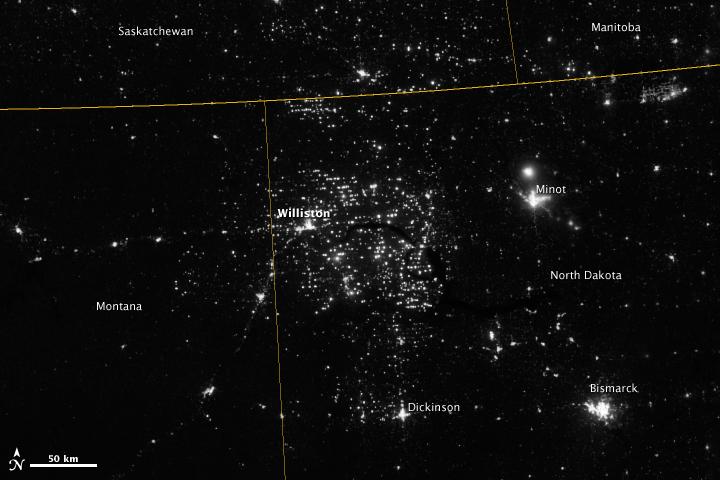
Northwestern North Dakota is one of the least-densely populated parts of the United States. Cities and people are scarce, but satellite imagery shows the area has been aglow at night in recent years. The reason: the area is home to the Bakken shale formation, a site where oil production is booming. Companies hoping to extract oil from the Bakken formation have drilled hundreds of new wells in the last few years; natural gas often bubbles up to the surface as part of the process. Lacking the infrastructure to pipe the gas away, many drillers simply burn it in a practice known as flaring. On November 12, 2012, the Visible Infrared Imaging Radiometer Suite (VIIRS) on the Suomi NPP satellite captured this nighttime view of widespread gas flaring throughout the area. Many of the specks of light are evidence of gas flaring, though others may be the lights around drilling equipment. Some of the brighter areas correspond to towns and cities including Williston, Minot, and Dickinson. The image was captured by the VIIRS “day-night band,” which detects light in a range of wavelengths from green to near-infrared and uses filtering techniques to observe signals such as gas flares, auroras, wildfires, city lights, and reflected moonlight. When VIIRS acquired the image, the moon was in its waning crescent phase, meaning it was reflecting only a small amount of light. According to the U.S. Energy Information Administration, natural gas production from the Bakken shale has increased more than 20-fold between 2007 and 2010. Gas production averaged over 485 million cubic feet per day in September 2011, compared to the 2005 average of about 160 million cubic feet per day. Due to the lack of gas pipeline and processing facilities in the region, about 29 percent of that gas is flared. NASA Earth Observatory image by Jesse Allen and Robert Simmon, using VIIRS Day-Night Band data from the Suomi National Polar-orbiting Partnership. Suomi NPP is the result of a partnership between NASA, the National Oceanic and Atmospheric Administration, and the Department of Defense. Caption by Adam Voiland. Instrument: Suomi NPP - VIIRS Credit: <b><a href="http://www.earthobservatory.nasa.gov/" rel="nofollow"> NASA Earth Observatory</a></b> <b>Click here to view all of the <a href="http://earthobservatory.nasa.gov/Features/NightLights/" rel="nofollow"> Earth at Night 2012 images </a></b> <b>Click here to <a href="http://earthobservatory.nasa.gov/NaturalHazards/view.php?id=79810" rel="nofollow"> read more </a> about this image </b> <b><a href="http://www.nasa.gov/audience/formedia/features/MP_Photo_Guidelines.html" rel="nofollow">NASA image use policy.</a></b> <b><a href="http://www.nasa.gov/centers/goddard/home/index.html" rel="nofollow">NASA Goddard Space Flight Center</a></b> enables NASA’s mission through four scientific endeavors: Earth Science, Heliophysics, Solar System Exploration, and Astrophysics. Goddard plays a leading role in NASA’s accomplishments by contributing compelling scientific knowledge to advance the Agency’s mission. <b>Follow us on <a href="http://twitter.com/NASA_GoddardPix" rel="nofollow">Twitter</a></b> <b>Like us on <a href="http://www.facebook.com/pages/Greenbelt-MD/NASA-Goddard/395013845897?ref=tsd" rel="nofollow">Facebook</a></b> <b>Find us on <a href="http://instagram.com/nasagoddard?vm=grid" rel="nofollow">Instagram</a></b>