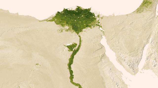
Urbanized areas of northern Egypt are visible amidst the deserts of Egypt. The image captured July 9-15, 2012 also shows the Nile River which provides life-sustaining water to the region. The image was created from the Visible-Infrared Imager/Radiometer Suite (VIIRS) instrument aboard the Suomi National Polar-orbiting Partnership or Suomi NPP satellite, a partnership between NASA and the National Oceanic and Atmospheric Administration, or NOAA. Credit: NASA/NOAA To read more go to: <a href="http://www.nasa.gov/mission_pages/NPP/news/vegetation.html" rel="nofollow">www.nasa.gov/mission_pages/NPP/news/vegetation.html</a> <b><a href="http://www.nasa.gov/audience/formedia/features/MP_Photo_Guidelines.html" rel="nofollow">NASA image use policy.</a></b> <b><a href="http://www.nasa.gov/centers/goddard/home/index.html" rel="nofollow">NASA Goddard Space Flight Center</a></b> enables NASA’s mission through four scientific endeavors: Earth Science, Heliophysics, Solar System Exploration, and Astrophysics. Goddard plays a leading role in NASA’s accomplishments by contributing compelling scientific knowledge to advance the Agency’s mission. <b>Follow us on <a href="http://twitter.com/NASA_GoddardPix" rel="nofollow">Twitter</a></b> <b>Like us on <a href="http://www.facebook.com/pages/Greenbelt-MD/NASA-Goddard/395013845897?ref=tsd" rel="nofollow">Facebook</a></b> <b>Find us on <a href="http://instagram.com/nasagoddard?vm=grid" rel="nofollow">Instagram</a></b>
The Nile River Delta of Egypt (30.0N, 31.0E) irrigated by the Nile River and its many distributaries, is some of the richest farm land in the world and home to some 45 million people, over half of Egypt's population. The capital city of Cairo is at the apex of the delta. Just across the river from Cairo can be seen the ancient three big pyramids and sphinx at Giza and the Suez Canal is just to the right of the delta.
iss072e905240 (March 22, 2025) --- Egypt's Nile Delta region, home to about 39 million people and where the Nile, Africa's longest river, drains into the Mediterranean Sea, is pictured from the International Space Station at 11:01 p.m. local time as it orbited 261 miles above.
STS-56 Earth observation of the northeastern Nile Delta was photographed from the Earth-orbiting Discovery, Orbiter Vehicle (OV) 103. The branch of the Nile featured in the frame is Daimietta. The Suez Canal marks the boundary of the Nile Delta agriculture and the Sinai Desert to the right. Lake Masada, the dark waterlogged area to the west (left) of Port Said is becoming more saline as the Aswan Dam has reduced sediment downstream. This sediment reduction, according to NASA scientists studying the STS-56 photography, has resulted in increased coastal erosion and the intrusion of a salt-water lens to the ground water, particularly in the northeastern portions of the delta. Center pivot irrigation fields are located along either side of the Ramses Canal, which connects the Daimietta Nile with Great Bitter Lake. This canal has been re-dug three or four times in the past 3,000 years. Historians note that the canal's most famous use was as the departure point of the fleet of Pharaoh Necho. The fleet circumnavigated Africa clockwise from the head of the Red Sea to the Mediterranean coast of the Nile (probably the Rosetta Nile) in a three-year voyage circa 660 BC.
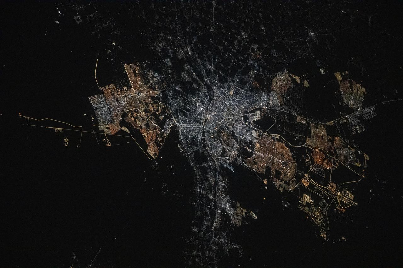
iss073e0134628 (May 22, 2025) --- Cairo, Egypt, the Arab nation's largest city with a population of 10.1 million and located near the Nile Delta, and its surrounding suburbs are pictured at approximately 12:!6 a.m. local time from the International Space Station as it orbited 259 miles above.
On the left is a radar image of asteroid 1998 WT24 taken in December 2001 by scientists using NASA's the 230-foot (70-meter) DSS-14 antenna at Goldstone, California. On the right is a radar image of the same asteroid acquired on Dec. 11, 2015, during the asteroid's most recent Earth flyby. The radar images from 2001 (on the left), have a resolution of about 60 feet (19 meters) per pixel. The radar image from 2015 (on the right) achieved a spatial resolution as fine as 25 feet (7.5 meters) per pixel. The 2015 radar image was obtained using the same DSS-14 antenna at Goldstone to transmit high-power microwaves toward the asteroid. However, this time, the radar echoes bounced off the asteroid were received by the National Radio Astronomy Observatory's 100-meter (330-foot) Green Bank Telescope in West Virginia. The next visit of asteroid 1998 WT24 to Earth's neighborhood will be on Nov. 11, 2018, when it will make a distant pass at about 12.5-million miles (52 lunar distances). http://photojournal.jpl.nasa.gov/catalog/PIA20216
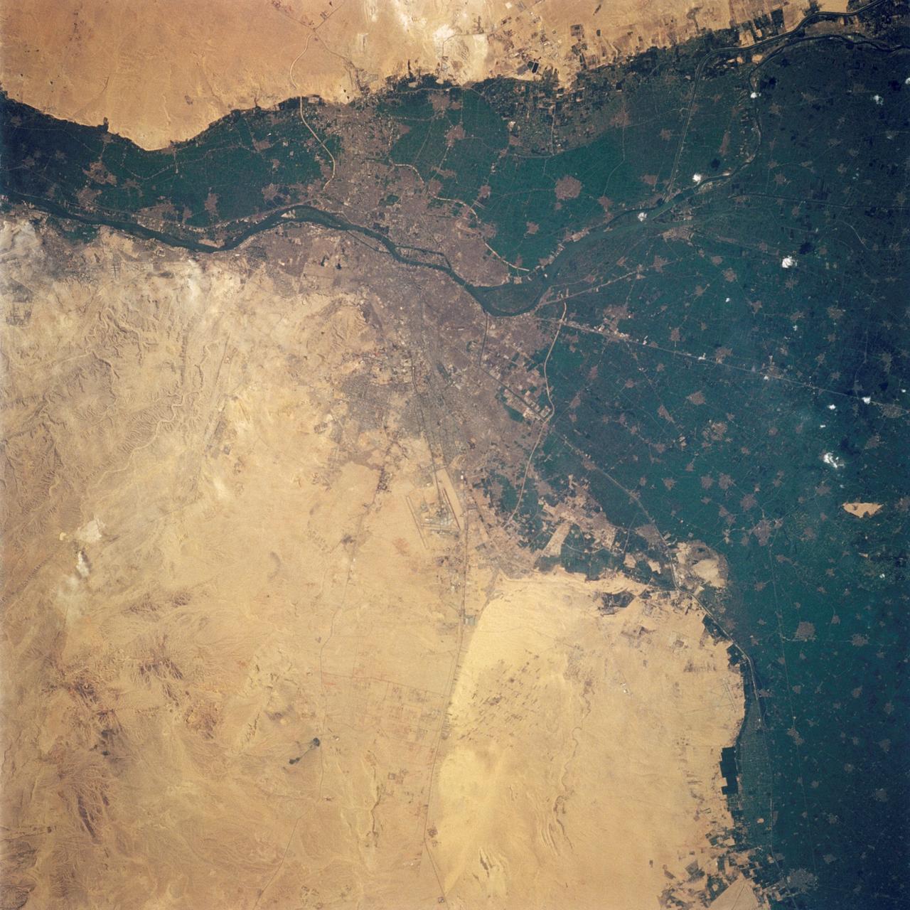
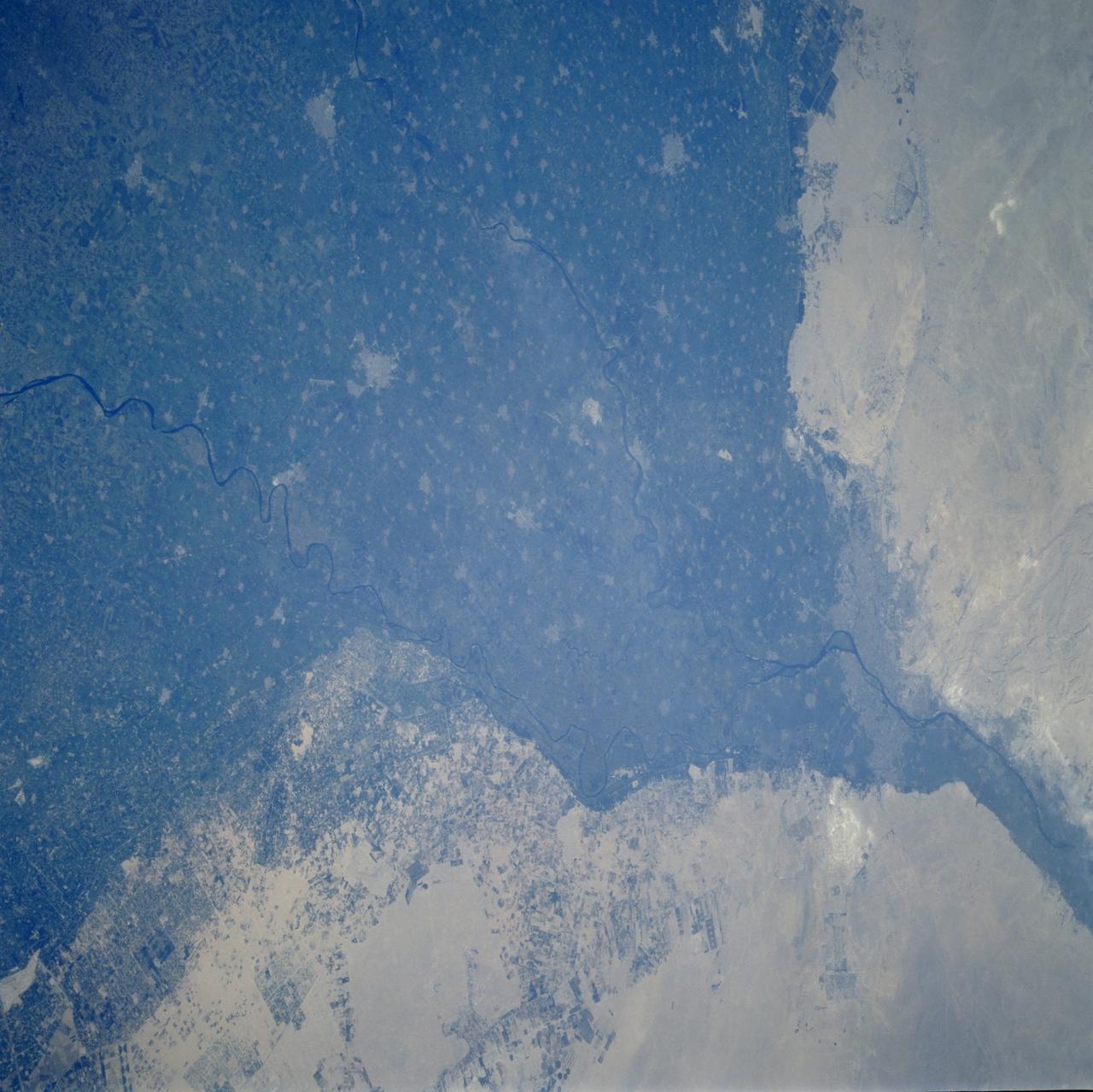
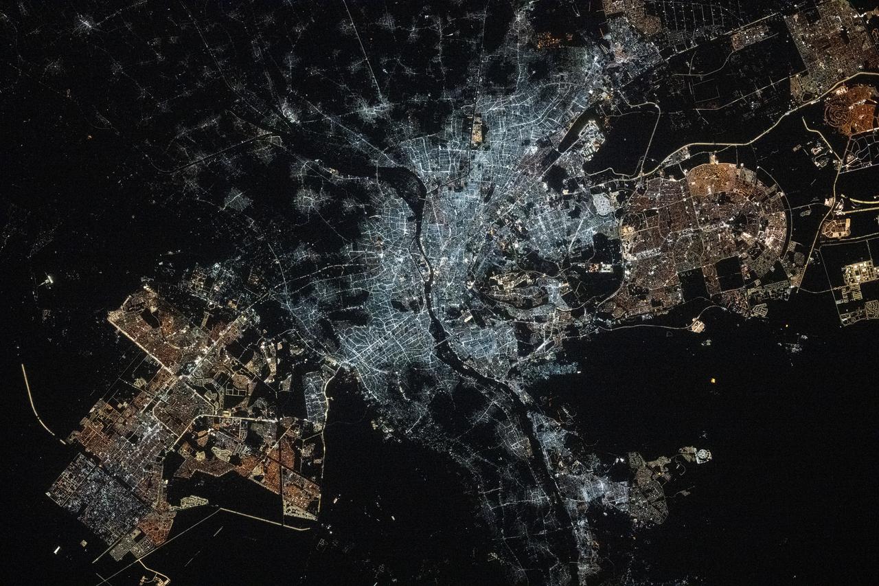
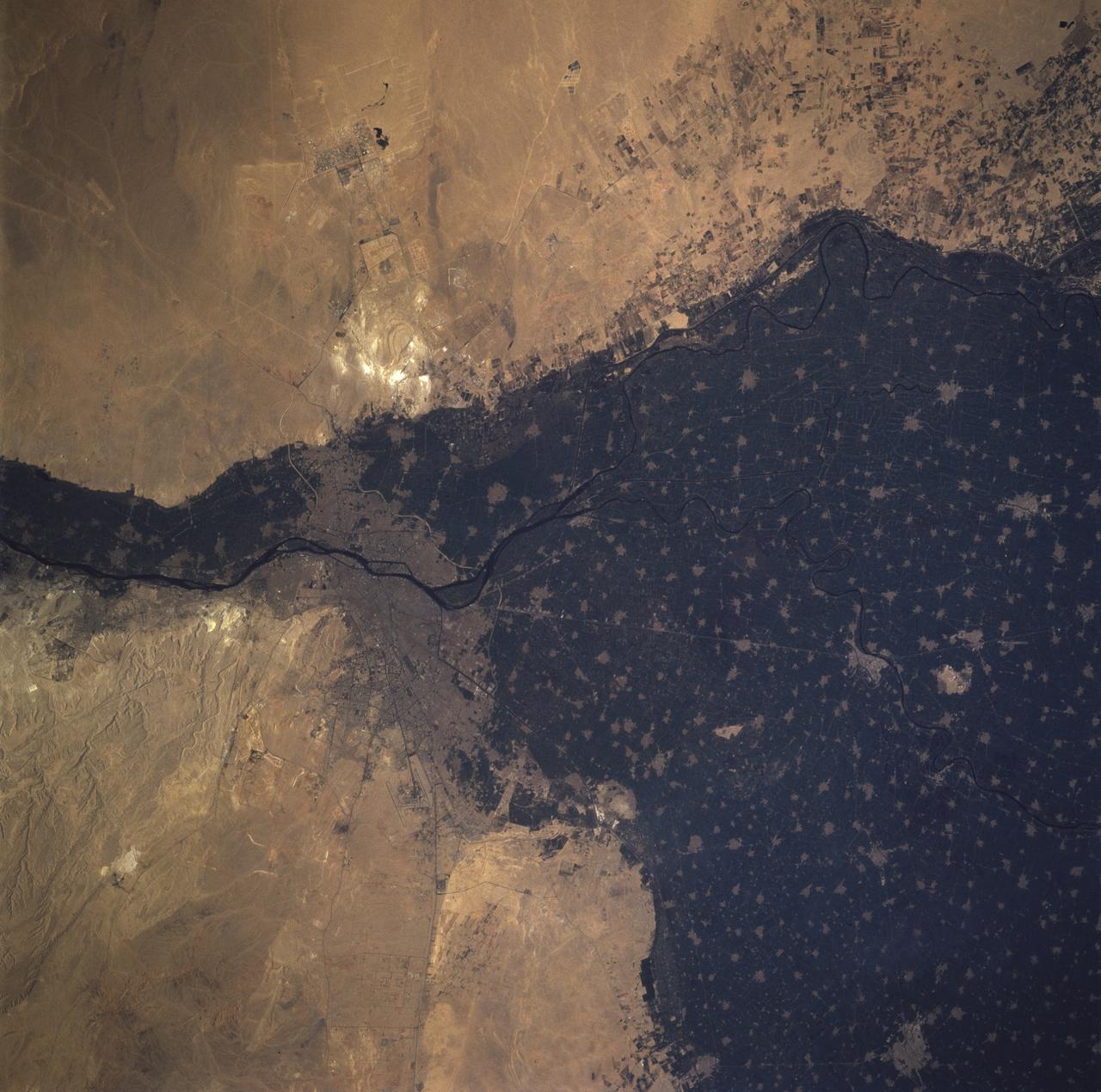
STS062-108-058 (4-18 March 1994) --- Cairo lies at the apex of the great delta of the Nile: the delta is marked by the strong greens of cultivated lands, Cairo by the gray sprawl along the river and the eastern delta apex as it develops in the direction of the airports and Suez. The city of El Giza lies on the west side of the Nile with the Giza pyramids in the desert just beyond the cultivated lands. Several major canals lead water to parts of the delta more distant from the Nile; generally these can be recognized as straighter, more engineered waterways. Towards the top left, the bifurcation of the Rosetta and Damietta branches of the Nile can be seen. These are the two major present-day veins of the Nile as it approaches the Mediterranean.
iss067e090312 (May 29, 2022) --- The Nile Delta is pictured from the International Space Station at an altitude of 262 miles above the Mediterranean Sea off the coast of Israel. The sun's glint beams off the Rosetta and the Damietta branches of the Nile River at the base of the Nile Delta.
iss061e004613 (Oct. 9, 2019) --- Looking like a leaf on a vine, the Faiyum Oasis extends west of the Nile River and south of Cairo, Egypt. The fertile area at the left of the photograph is the Nile Delta opening up into the Mediterranean Sea.
STS106-701-025 (8-20 September 2000) --- One of the STS-106 crew members on board the Space Shuttle Atlantis used a handheld 70mm camera to photograph this image of Cairo, Egypt, the largest city in Africa. Its population is nearly 16 million, a figure which translates to approximately 130,000 people per square mile. Metropolitan Cairo shows as a gray area in the green of the Nile River valley at the apex of the Delta. The shadows of the three major pyramids at Giza on the Western edge of the city are visible. They are right below the bright new road construction. This side of the metropolitan area is experiencing rapid growth. According to geologists who have been studying shuttle-to-Earth imagery for many years, this photograph documents some of the many changes in land use in the Western Desert.

Night Earth Observations taken by Expedition 63 crew. Folder indicates: Nile River delta taken with 24mm lens.
STS121-334-026 (4-17 July 2006) --- This photo, featuring an easterly view of the Nile River, the Nile River Delta, Sinai Peninsula, the Suez Canal, Red Sea and part of the Mediterranean Sea, was taken by one of the STS-121 crewmembers aboard the Space Shuttle Discovery. Cairo, Egypt, can be seen at far right.
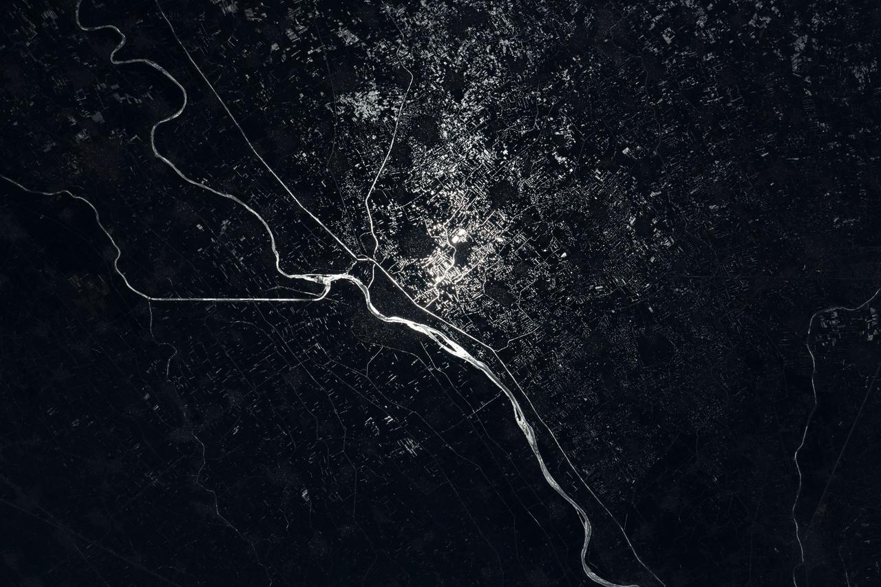
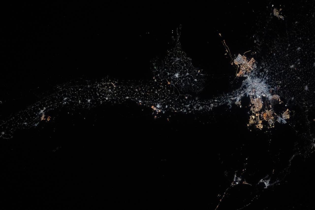
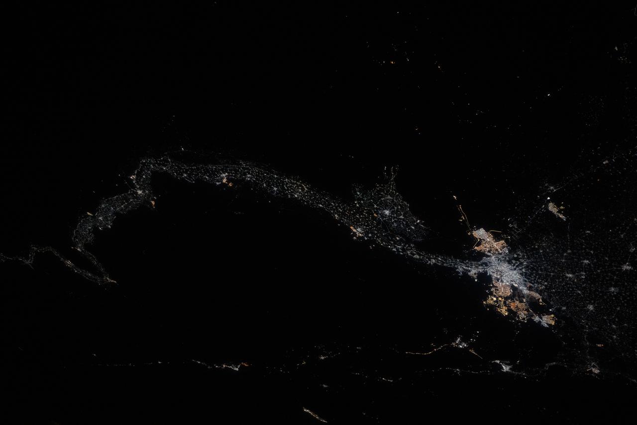
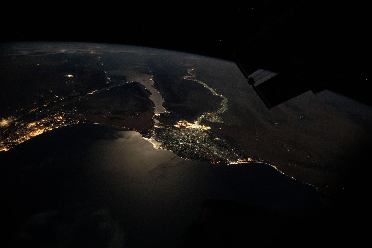
iss067e089285 (May 29, 2022) --- The Damietta Branch of the Nile River splits into canals in the central portion of the Nile Delta in Egypt. Lights from several cities surrounding the Egyptian waterways are pictured in this nighttime photograph from the International Space Station as it orbited 262 miles above the Mediterranean Sea off the coast of the Sinai Peninsula.
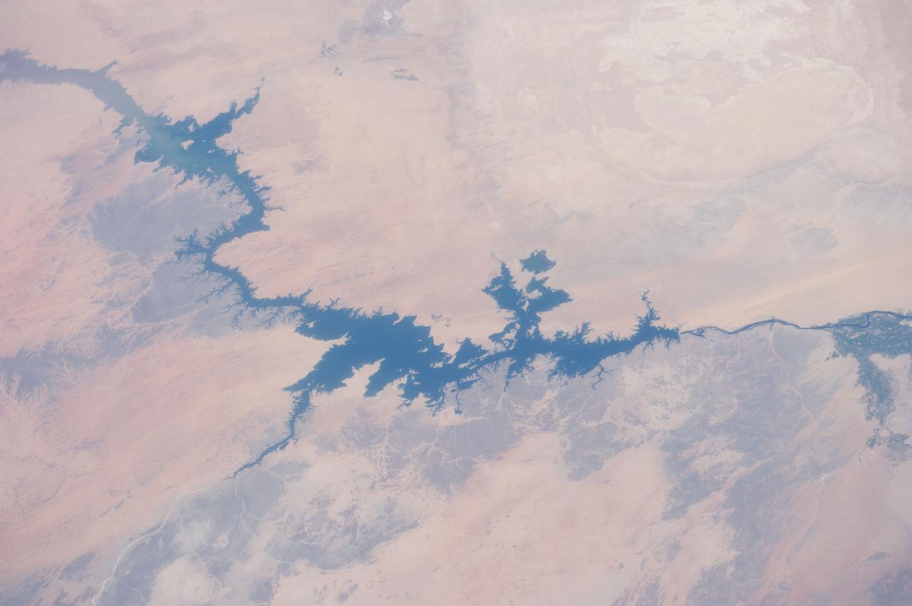
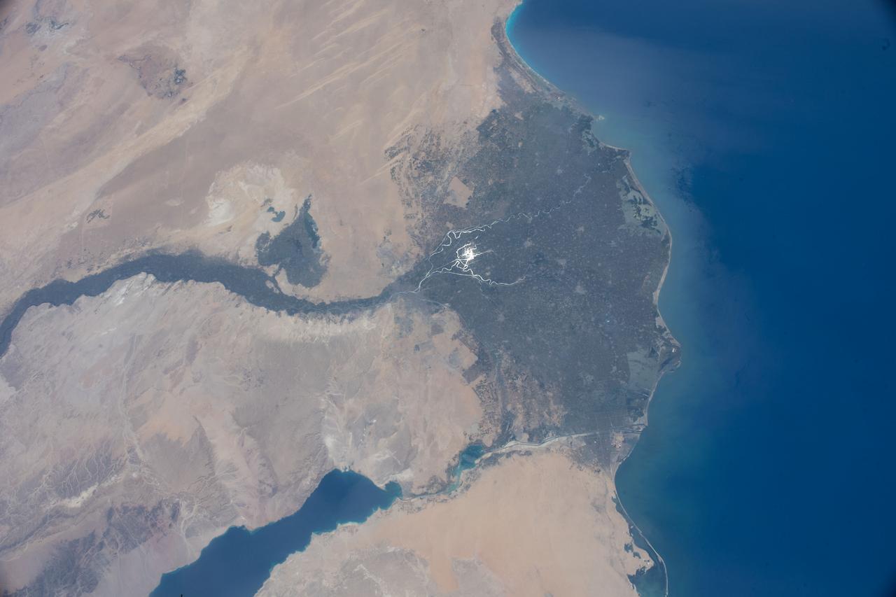
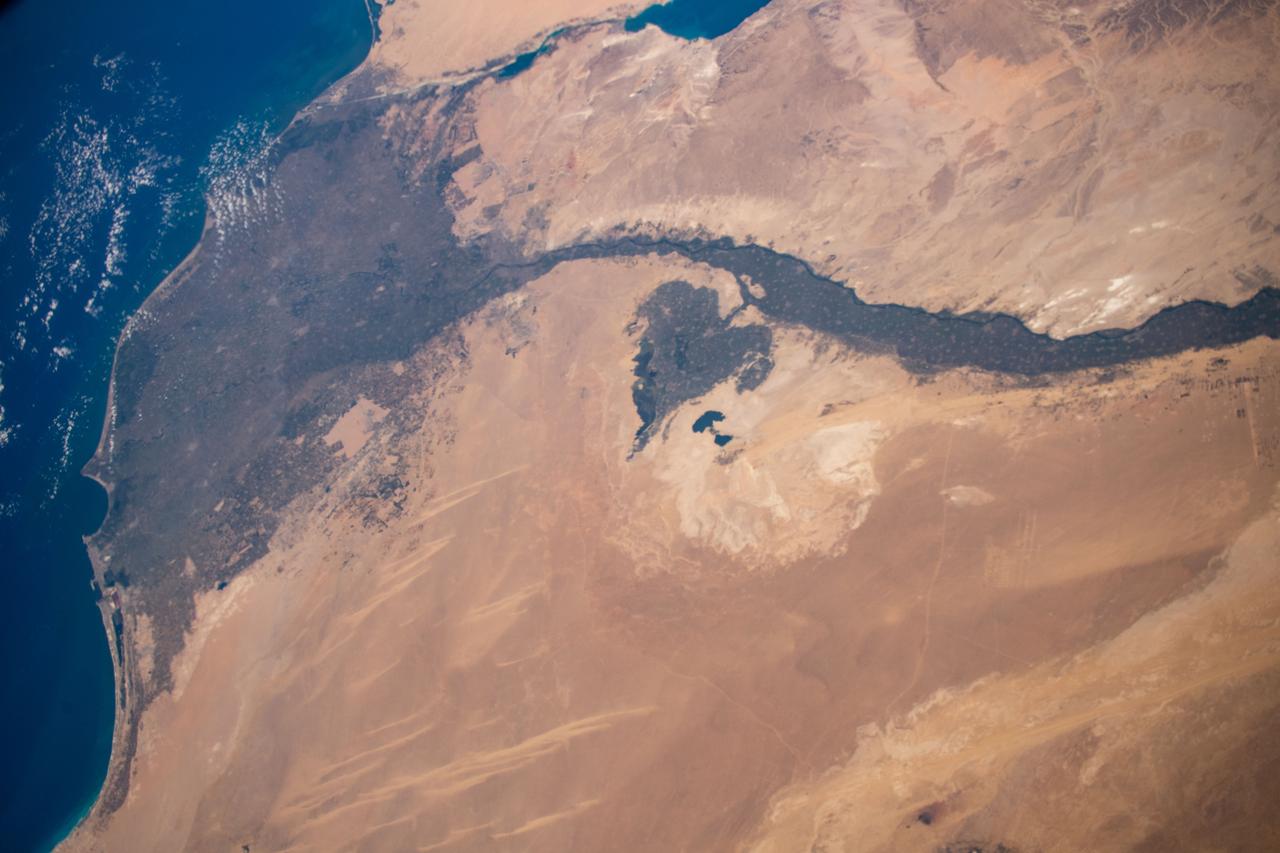
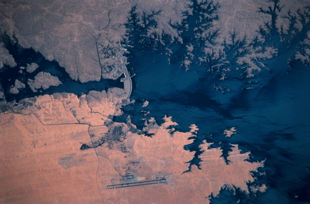
ISS040-E-105768 (23 Aug. 2014) --- One of the Expedition 40 crew members aboard the International Space Station, flying at an altitude of 221 nautical miles, captured this image of Egypt's Nile River and Lake Nasser on Aug. 23, 2014. The Aswan High Dam is to the right of center in the 70mm focal-length image, as the Nile flows southward (to the right in this image) toward Cairo and it?s Mediterranean delta (both out of frame at right). The Red Sea, which runs more or less parallel to the Nile, is out of frame at bottom.
SL3-122-2620 (July-September 1973) --- Skylab 3 Earth view of the Nile Delta, Egypt and Suez Canal. Photo credit: NASA
STS058-92-064 (18 Oct-1 Nov 1993) --- This oblique view, looking northeast from central Egypt, shows great expanses of the sand covered and rocky Western Desert in the foreground (bottom). The dark patches bottom right are the Dakhla Oases on the south side of an escarpment. For centuries camel trains have moved from here to the Nile Valley, seen here as a broad green line winding through the desert. The northern half of Egypt's Nile appears here, from about the latitude of Luxor to the delta. Green colors indicate the small area of crops which feed Egypt's population of 55 million. The Nile Delta is partly obscured by a band of clouds, but can be discerned at the coast as a flattened triangle of green. The smaller triangle close by is the Faiyum Basin, a depression irrigated by water from the Nile. The coast of the Mediterranean Sea appears left.
SL3-115-1917 (July-September 1973) --- Skylab 3 Earth view of the United Arab Republic (UAR), Nile Delta, Cairo, Suez Canal, Sinai and Dead Sea. Photo credit: NASA

iss067e286515 (Aug. 21, 2022) --- This oblique view of Turkey and the island nation of Cyprus is pictured from the International Space Station as it orbited 257 miles above the Nile Delta in Egypt.

"Earth observation taken during a night pass by the Expedition 37 crew. Folder lists this as Cairo, Tel-Aviv, at night. " Per Twitter message this is Cairo and the Nile Delta.
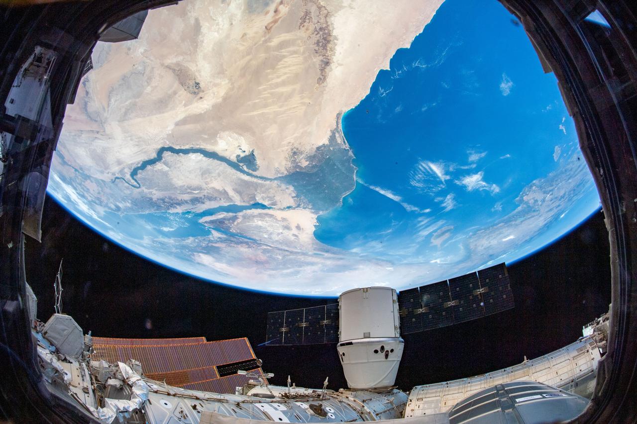
iss060e035437 (Aug. 13, 2019) -- The SpaceX Dragon resupply ship is pictured attached to the International Space Station's Harmony module as the orbital complex flew 260 miles above the Nile River Delta in Egypt.
iss064e052447 (April 4, 2021) --- The Nile Delta, The Sinai Peninsula, and The Mediterranean Sea are pictured in the Middle East from the International Space Station as it orbited 263 miles above Egypt.
iss055e007948 (April 1, 2018) --- This view looking southwest over the Egyptian delta, the Nile River and the Mediterranean sea was taken from the International Space Station as it was orbiting above the Middle Eastern nation of Jordan.
ISS028-E-014970 (10 July 2011) --- One of the crewmembers aboard the International Space Station recorded this oblique view showing the Nile River Delta and the Sinai Peninsula, with a 28 millimeter lens. The Mediterranean Coast is at far left.

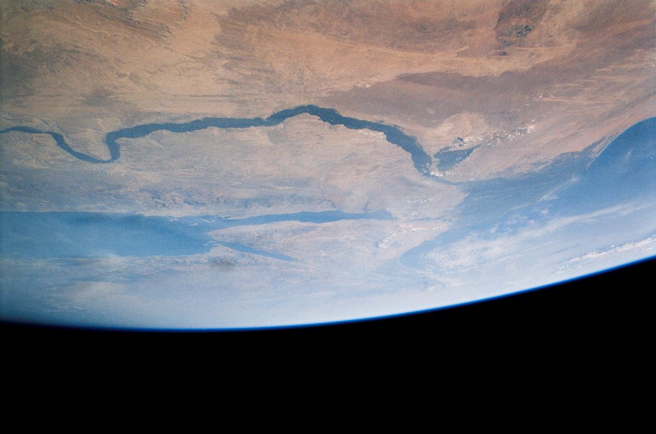
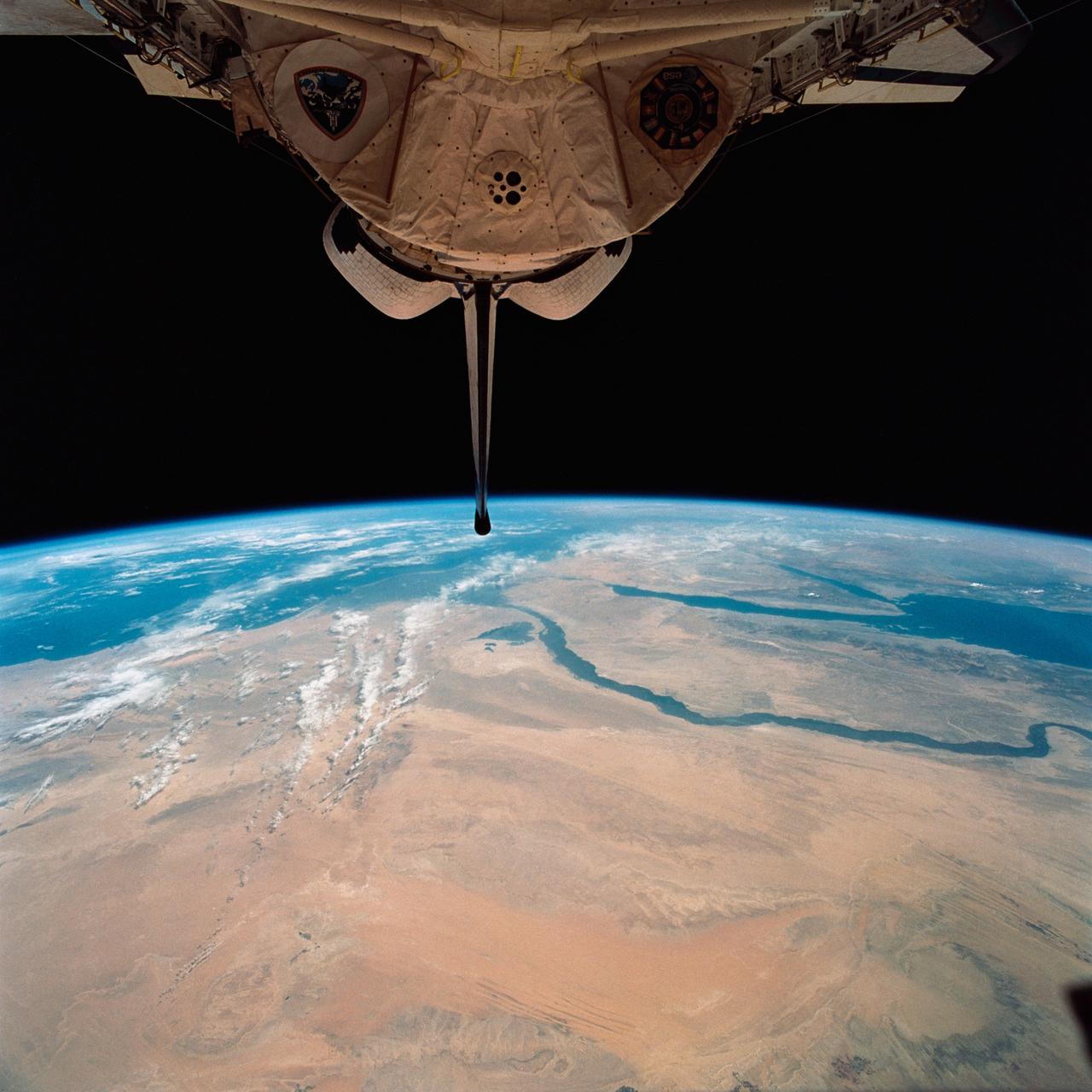
STS083-709-030 (4-8 April 1997) --- Panorama over the Nile River, Sinai Peninsula and the Red Sea. Looking past the Orbiter's tail, this view extends from central Egypt eastward to Saudi Arabia on the horizon. Two major water systems, seen in this view, the Nile River and the Red Sea are used for world commerce and transportation in this region. The Nile is flanked immediately by agriculture then beyond by desert. This emphasizes the importance of the river waters to sustain a thriving local population. The Nile River delta is north under the clouds on the upper left-hand corner of the photo. Geologically, the Red Sea is a spreading center between the Arabian and the African Plates, and will continue to widen slowly over a long period of time.
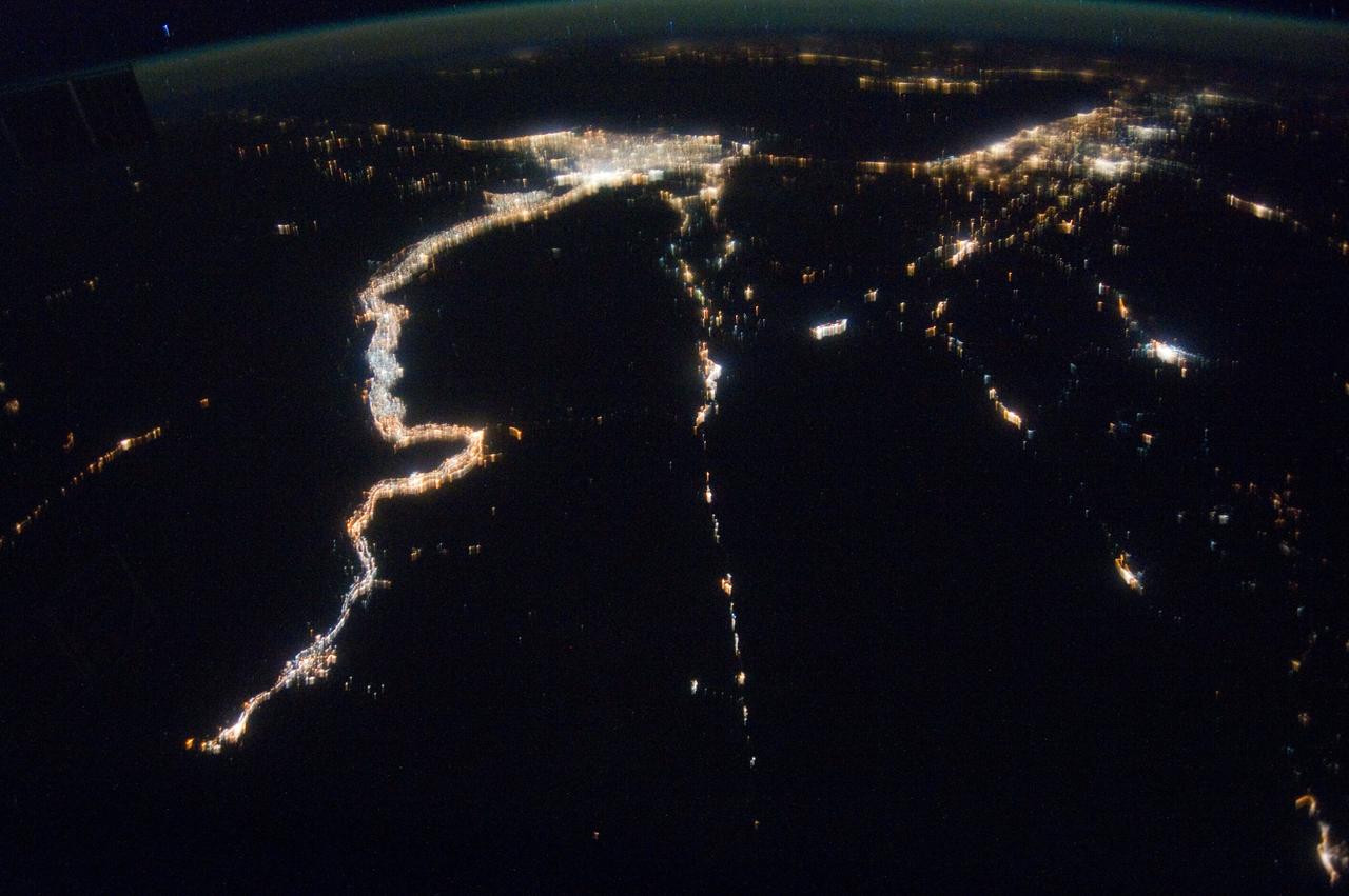
iss073e0422279 (July 18, 2025) --- Egypt’s Nile River stretches from left to right in this nighttime view from the International Space Station, with the brightest city lights tracing its path from Minya to New Bani Sewf City, and onward to the sprawling metropolitan area of Cairo at the base of the Nile Delta. This photograph was taken at approximately 1:32 a.m. local time while the station was orbiting 259 miles above Earth.
iss073e0422271 (July 18, 2025) --- Egypt’s Nile River stretches from Luxor—home to the ancient Valley of the Kings—at the far left of this nighttime view from the International Space Station, all the way to the sprawling metropolitan area of Cairo at the base of the Nile Delta. This photograph was taken at approximately 1:30 a.m. local time while the station was orbiting 259 miles above Earth.
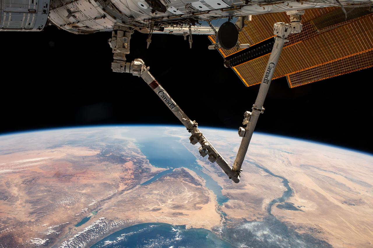
iss070e007599 (Oct. 20, 2023) --- The Canadarm2 robotic arm extends from the International Space Station as it orbited 261 miles above Turkey. Below, the Sinai Peninsula, the Red Sea, and the Nile River Delta are pictured leading toward the Mediterranean Sea at bottom.
iss060e056082 (Sept. 2, 2019) --- The International Space Station was flying 255 miles above the border between Sudan and Egypt near 1 a.m. local time when an Expedition 60 crewmember photographed this oblique view of the Nile River and its delta.
iss073e0175630 (May 23, 2025) --- Cairo, Egypt, and its surrounding metropolitan area with a population of about 22.6 million, near the base of the Nile Delta is pictured at approximately 11:28 p.m. local time from the International Space Station as it orbited 259 miles above the Middle Eastern nation.
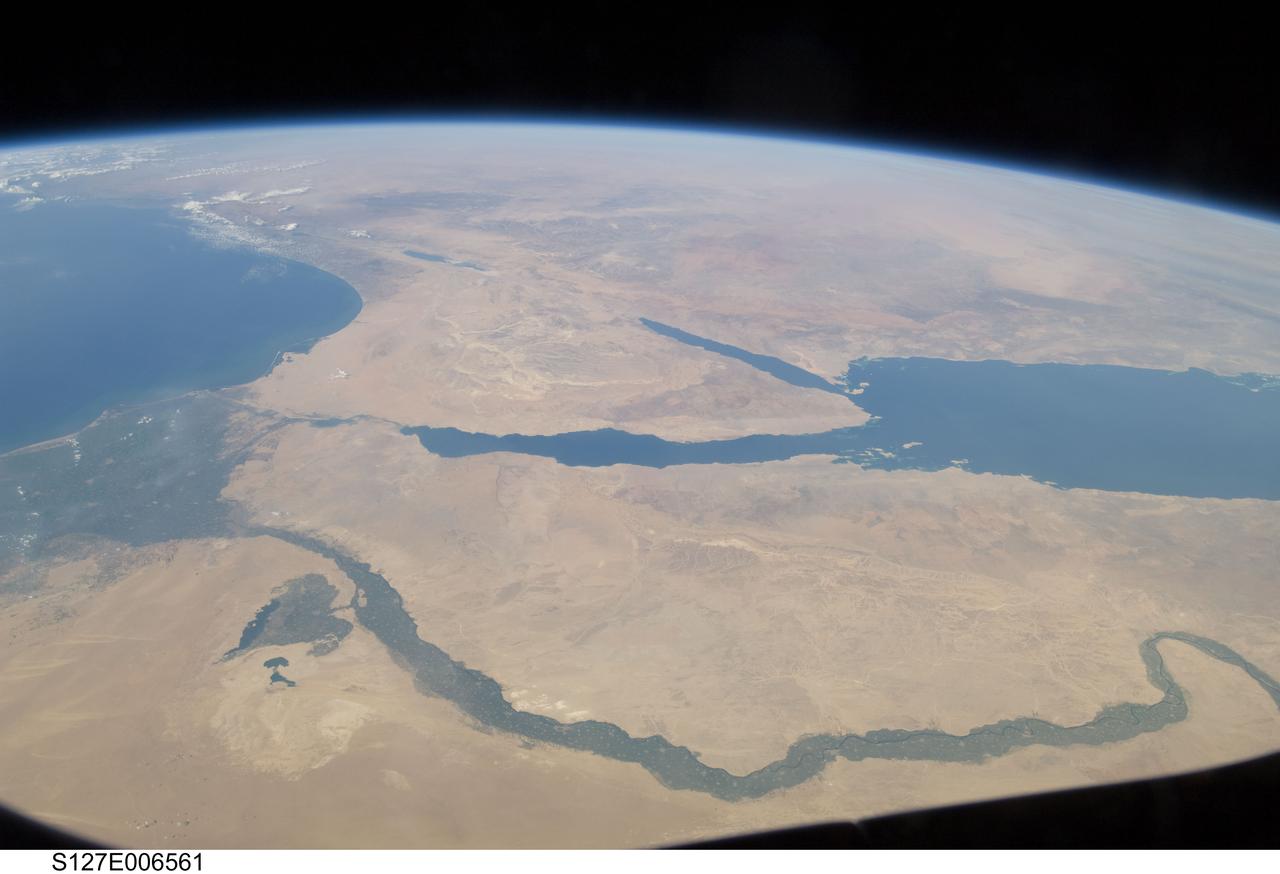
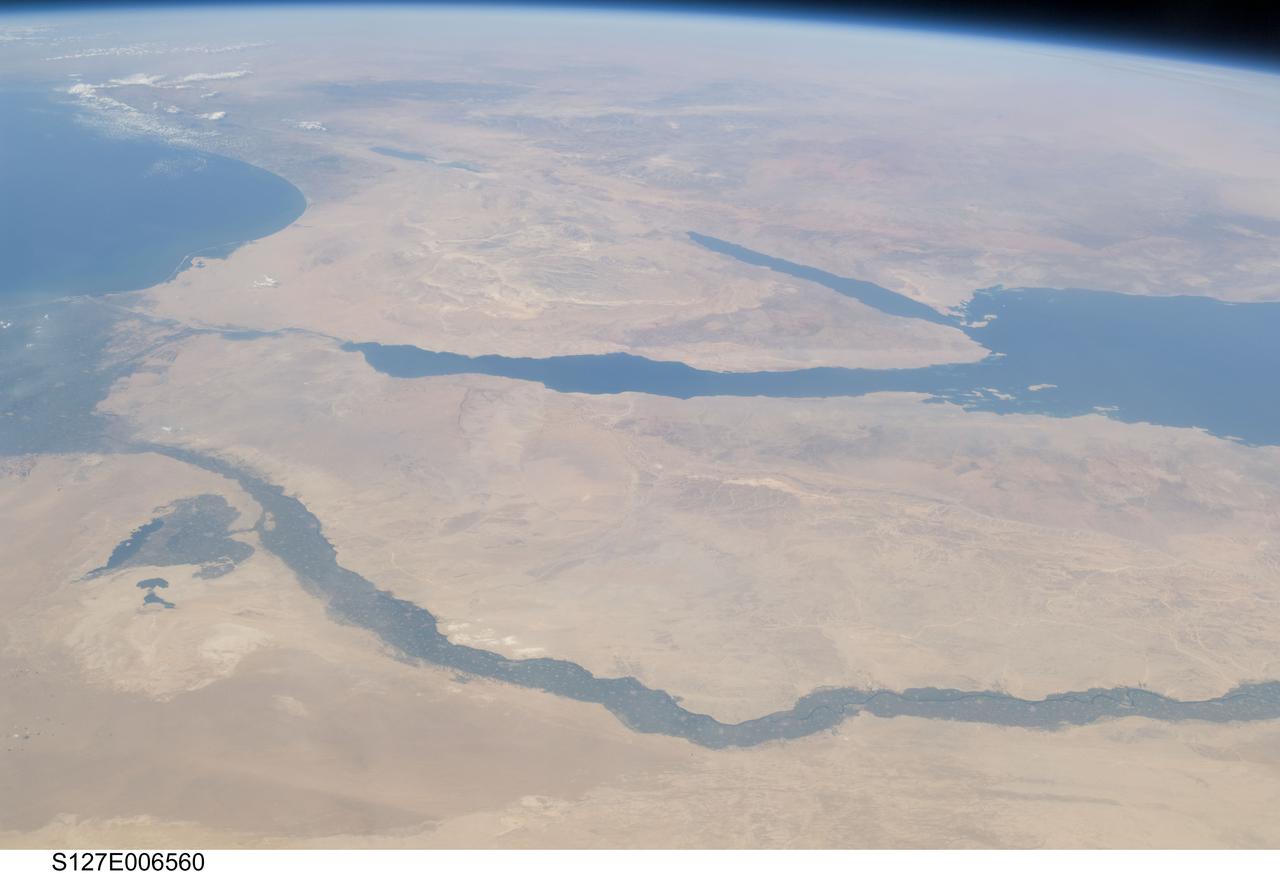
S127-E-006561 (17 July 2009) -- The Nile River and its delta in Egypt and the Sinai Peninsula and part of the Mediterranean Sea and Red Sea are just a few of the geographic features recognizable in this photograph, taken from an aft window on the Earth-orbiting Space Shuttle Endeavour.
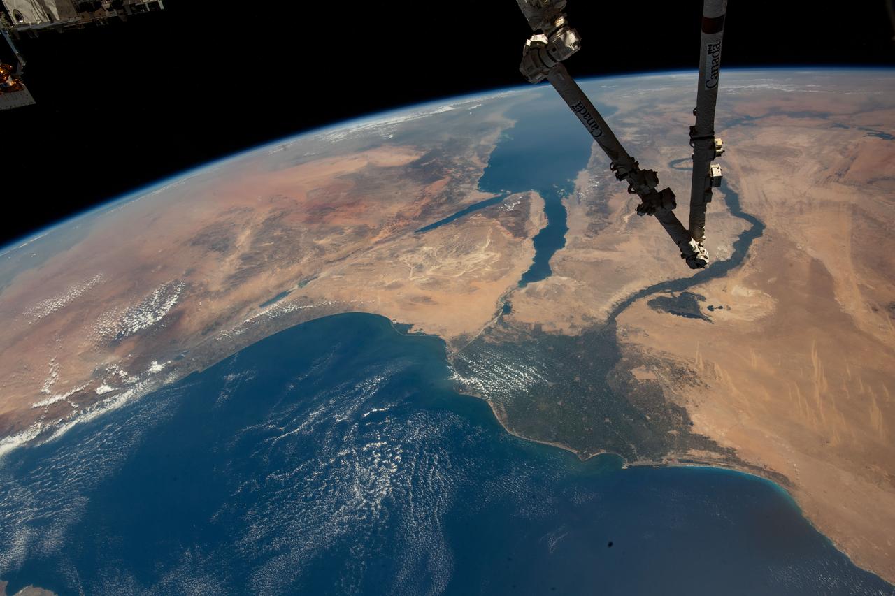
iss067e286504 (Aug. 21, 2022) --- The Canadarm2 robotic arm extends from the top right foreground, with the Nile Delta and the Red Sea, situated in the Arabian Peninsula, pictured from the International Space Station as it orbited 257 miles above the Mediterranean Sea.
ISS028-E-033108 (18 Aug. 2011) --- The Nile River Delta and part of the Mediterranean Sea can be seen in this night time photo captured by one of the Expedition 28 crew members aboard the International Space Station, flying at an altitude of approximately 220 miles. A 38-mm focal length was used to record the image.
S65-34776 (3-7 June 1965) --- This photograph shows the Nile Delta, Egypt, the Suez Canal, Israel, Jordan, Syria, Saudi Arabia, and Iraq as seen from the Gemini-Titan 4 (GT-4) spacecraft during its 12th revolution of Earth.
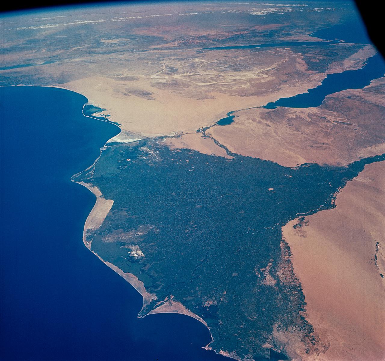
S127-E-006560 (17 July 2009) -- The Nile River and its delta in Egypt and the Sinai Peninsula and part of the Mediterranean Sea and Red Sea are just a few of the geographic features recognizable in this photograph, taken from an aft window on the Earth-orbiting Space Shuttle Endeavour.
iss065e074560 (May 20, 2021) --- This nighttime photograph, taken from the International Space Station as it orbited 263 miles above Turkey, highlights the Moon's glint on the Mediterranean Sea and the Gulf of Suez. The city lights along the Nile Delta and the eastern Mediterranean coast also figure prominently in the picture.
iss073e0343877 (July 15, 2025) --- Egypt's metropolitan area of Cairo, New Cairo City, and Giza, including their surrounding suburbs at the base of the Nile Delta with a population of about 22.6 million, is pictured at approximately 2:21 a.m. local time from the International Space Station as it orbited 259 miles above.
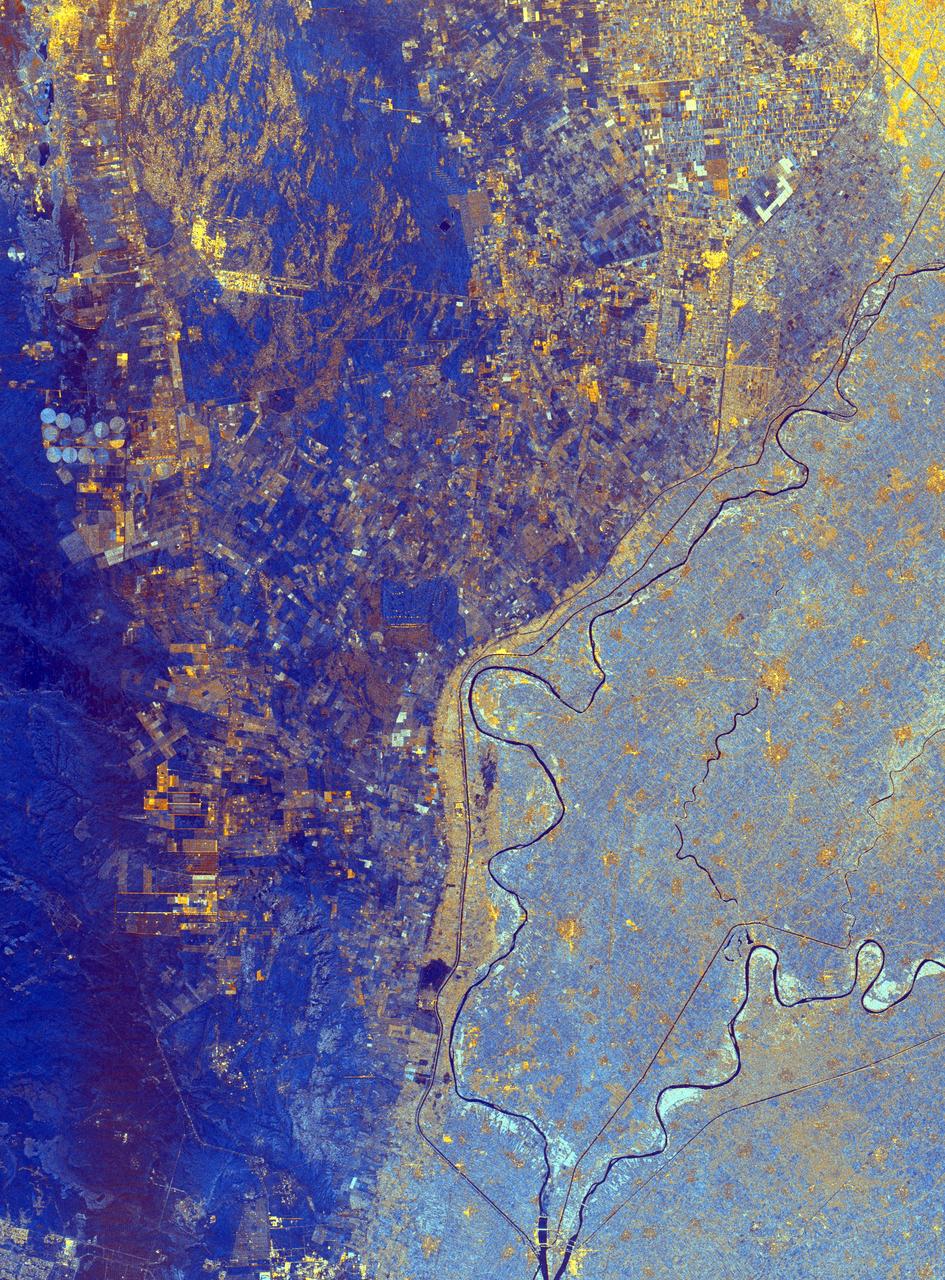
This spaceborne radar image shows the area just north of the city of Cairo, Egypt, where the Nile River splits into two main branches.
AST-09-555 (19 July 1975) --- A vertical view of a portion of the Arab Republic of Egypt, as photographed from the Apollo spacecraft in Earth orbit during the joint U.S.-USSR Apollo-Soyuz Test Project mission. The Nile Delta is in the most northerly corner of the picture. The City of Cairo on the Nile River is in the center of the photograph. The Gulf of Suez is in the most easterly corner of the picture. El Faiyum is south-southwest of Cairo. This picture was taken at an altitude of 223 kilometers (138 statute miles), with a 70mm Hasselblad camera using medium-speed Ektachrome QX-807 type film.

STS077-732-089 (19-29 May 1996) --- This photograph encompasses an area comprising 99 percent of the Egyptian population of close to 60 million people. North is roughly to the right side of the photograph. Cairo, the capital and principal city, lies at the apex of the Nile Delta. Alexandria is in the top right corner of the frame. The Suez Canal connects the Red Sea and the Mediterranean Sea and is in the bottom of the photograph. The Delta itself is 100 miles long and 160 miles wide at the coast. This view brings out the details of the Eastern Desert that rises abruptly from the Nile valley. This desert supports some vegetation in contrast to the sandier Western desert. It has more relief with some of the peaks rising to 6,000 feet. Rainfall in the region ranges from a high of 7 inches at Alexandria to 0.1 inch in the Eastern Desert. Most of Egypt’s mineral resources are concentrated in this area.
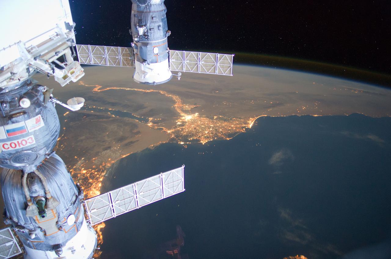
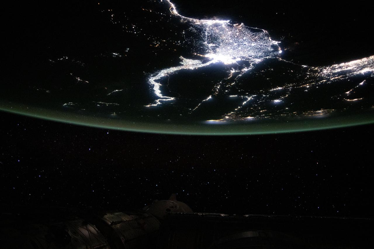
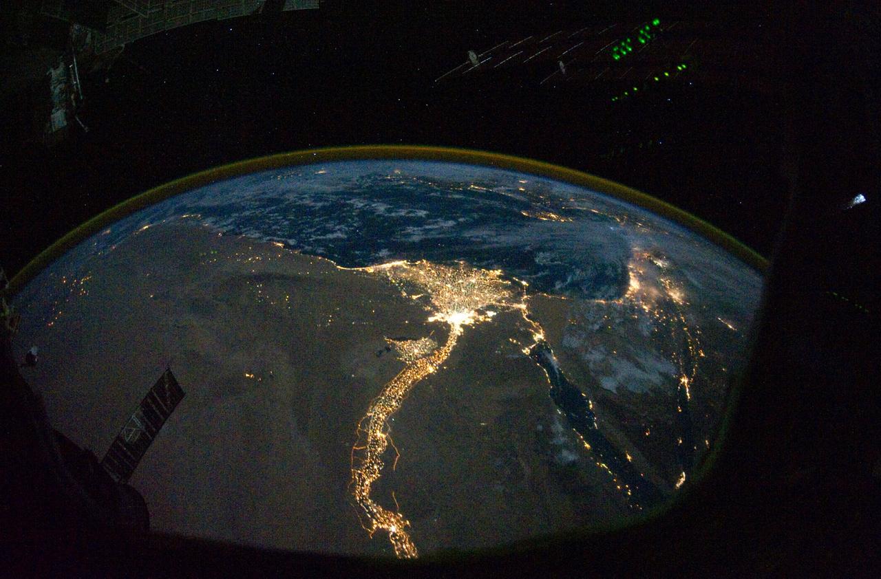
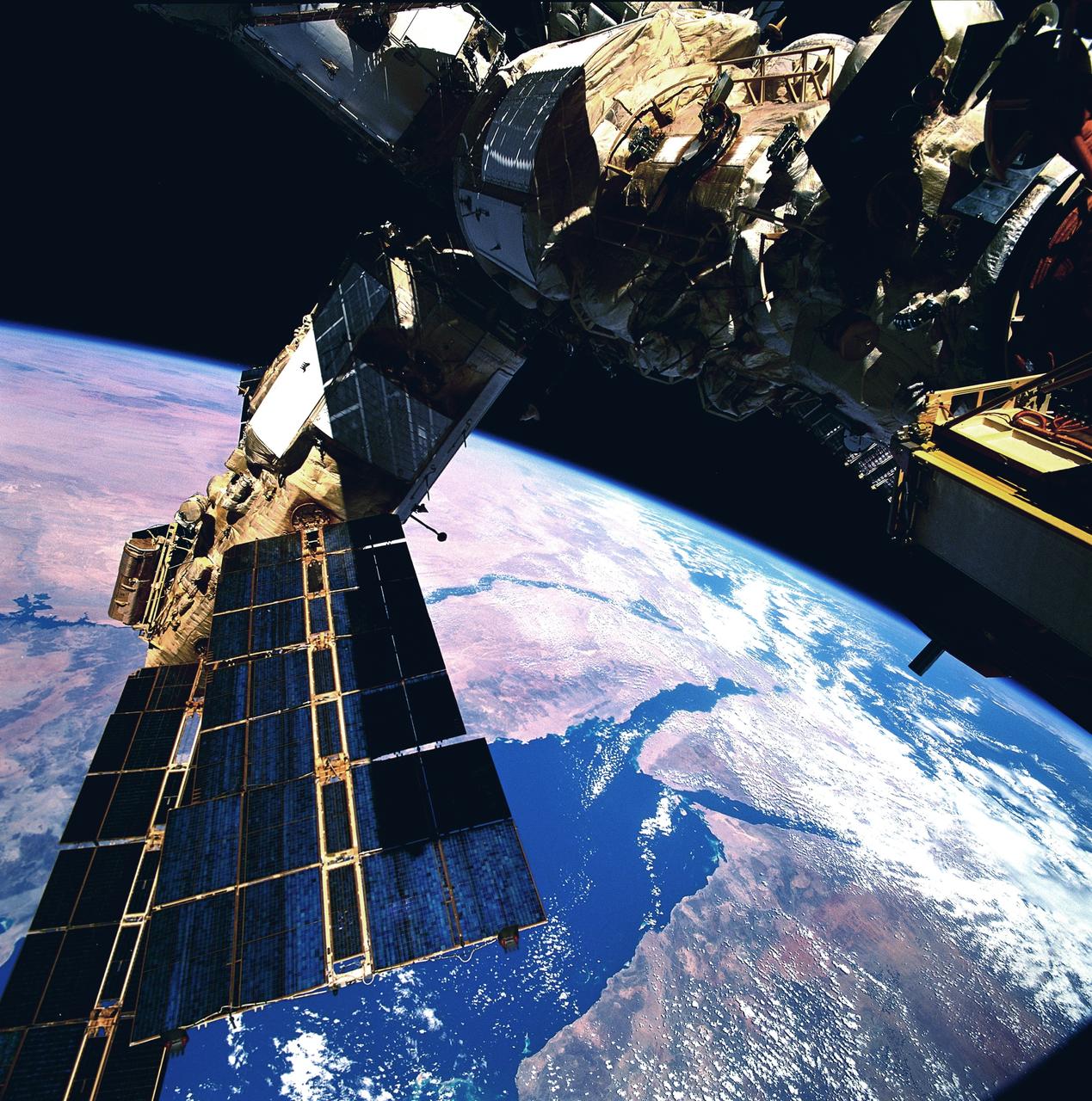
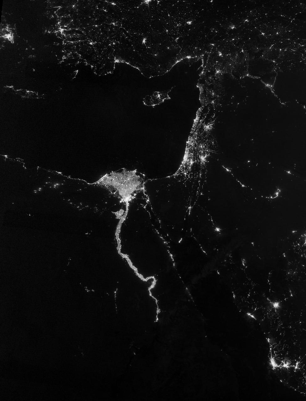
ISS031-E-095276 (4 June 2012) --- Much of the Middle East is seen in this night time image photographed by one of the Expedition 31 crew members aboard the International Space Station as it flew some 240 miles above the Mediterranean Sea on June 4, 2012. The Nile River Delta is easily recognizable in center frame, and city lights make it easy to see both Cairo and Alexandria, Egypt near the Delta. Two Russian spacecraft -- a Soyuz (left) and a Progress -- appear in the frame while they are docked to the station.
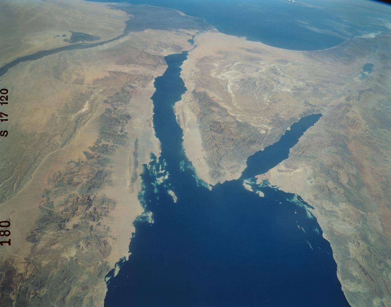
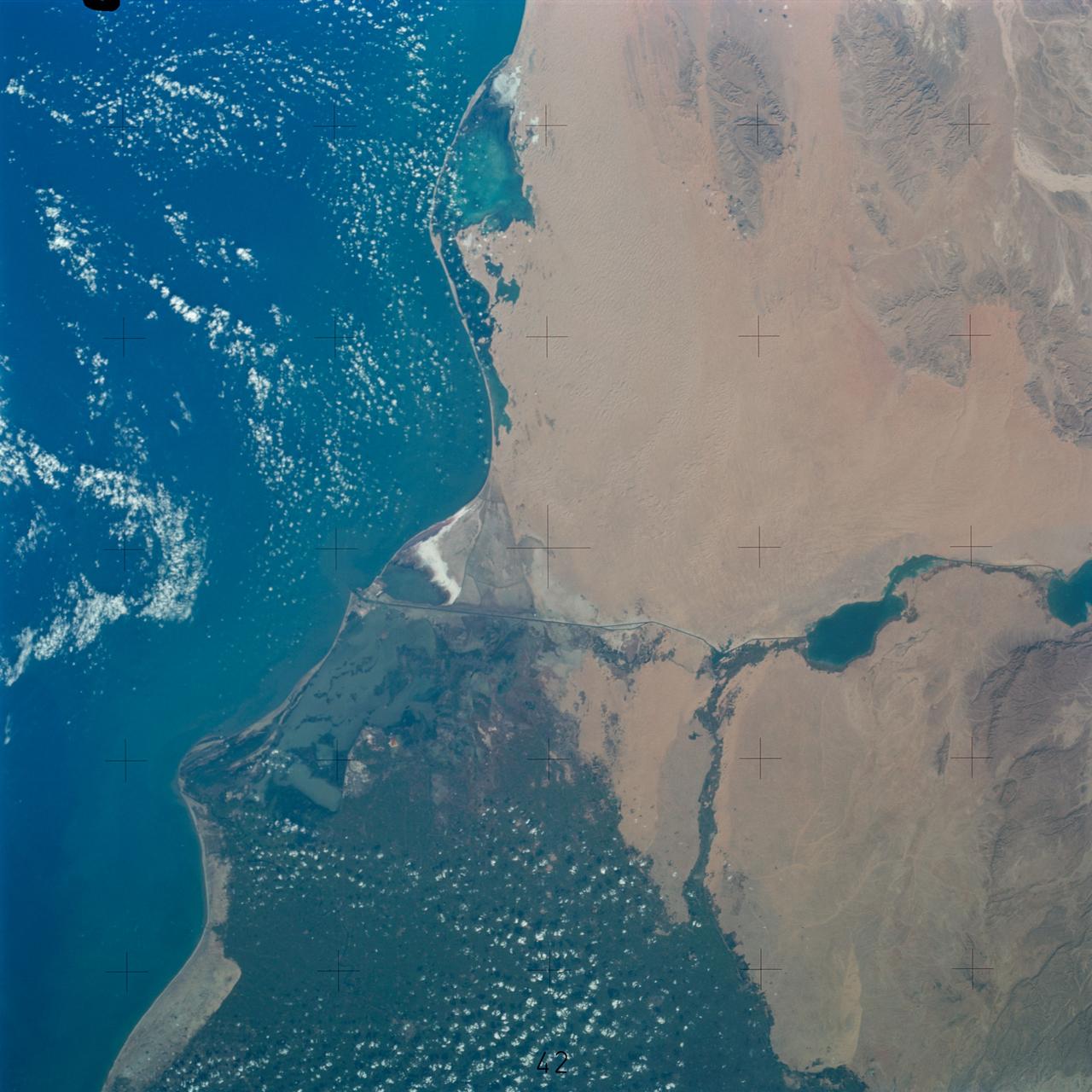
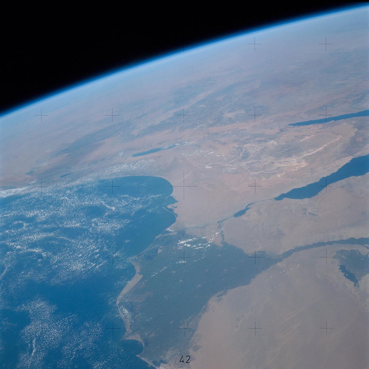
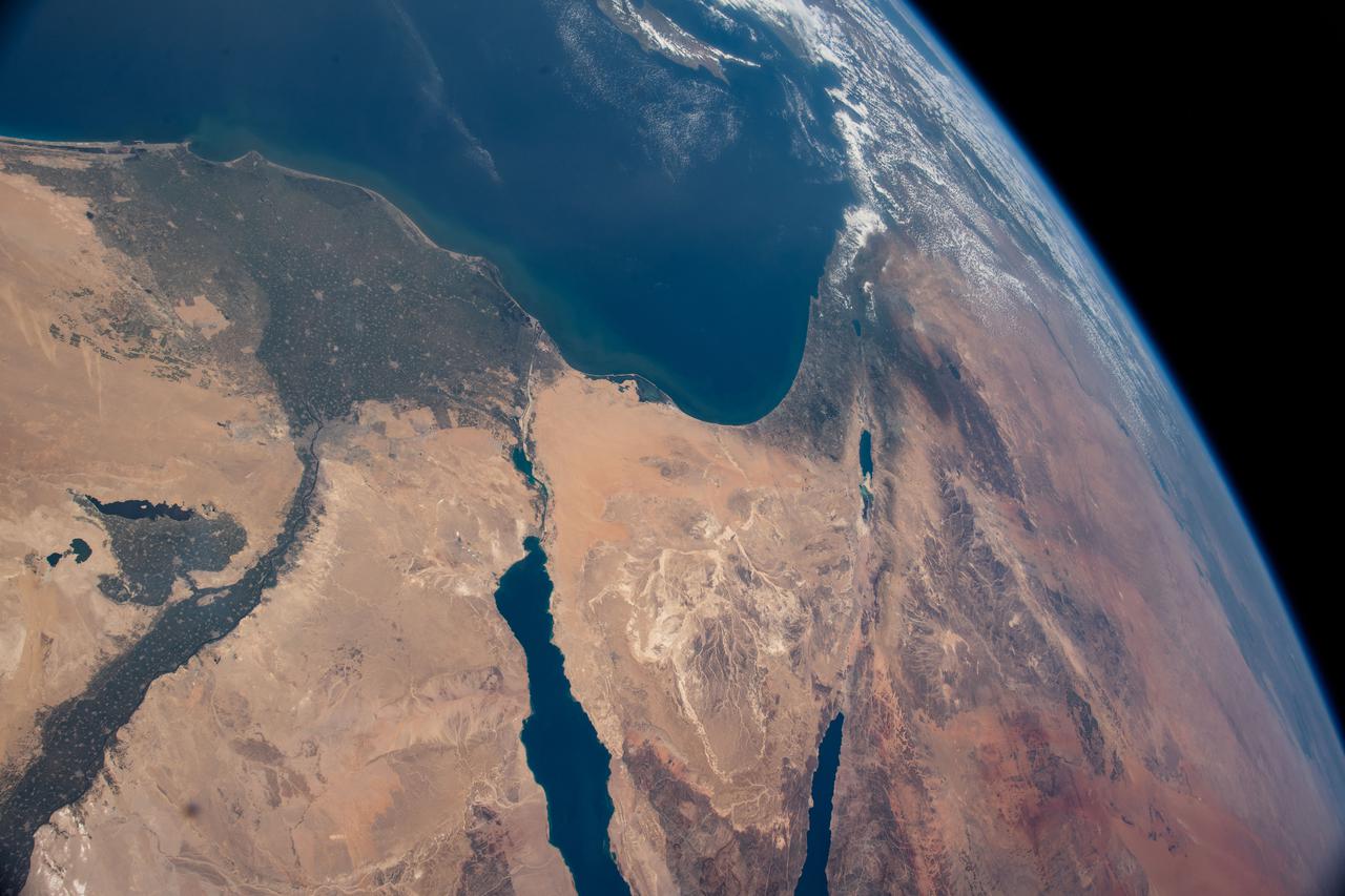
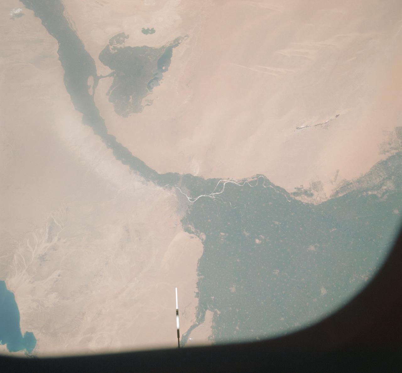
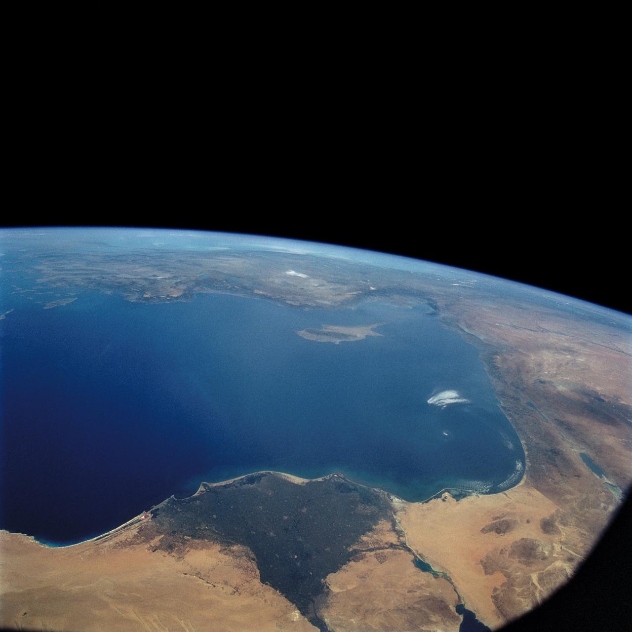
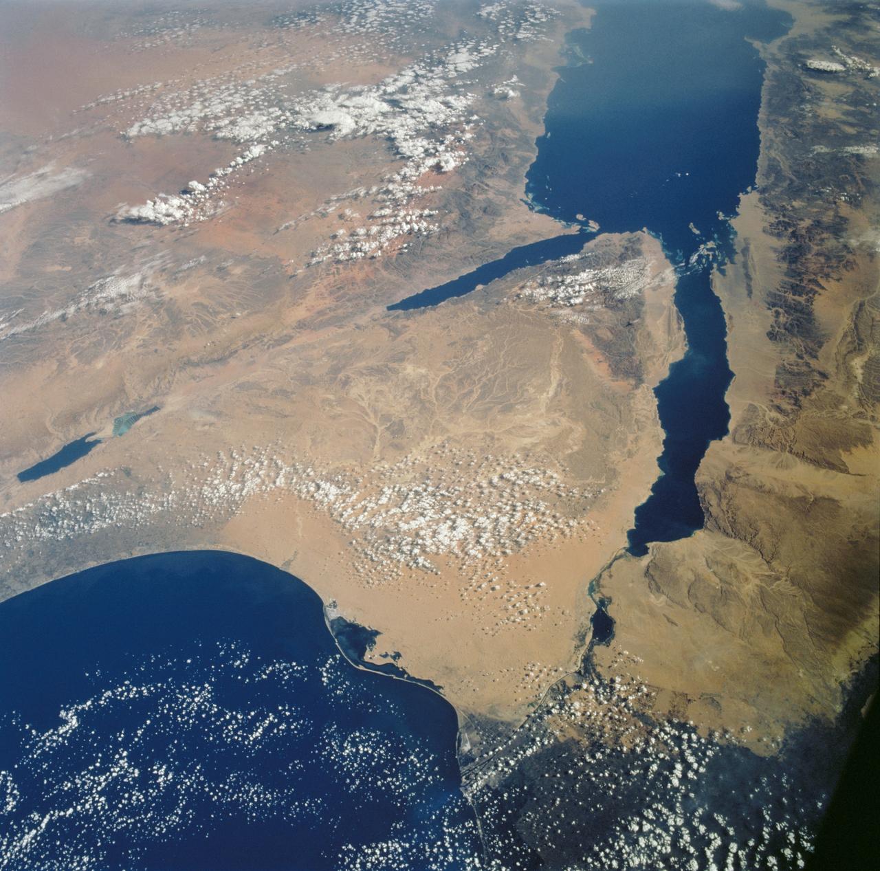
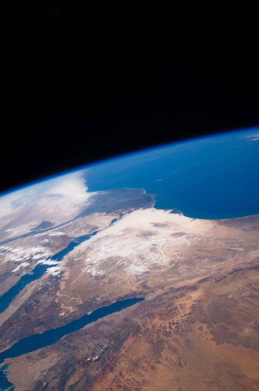
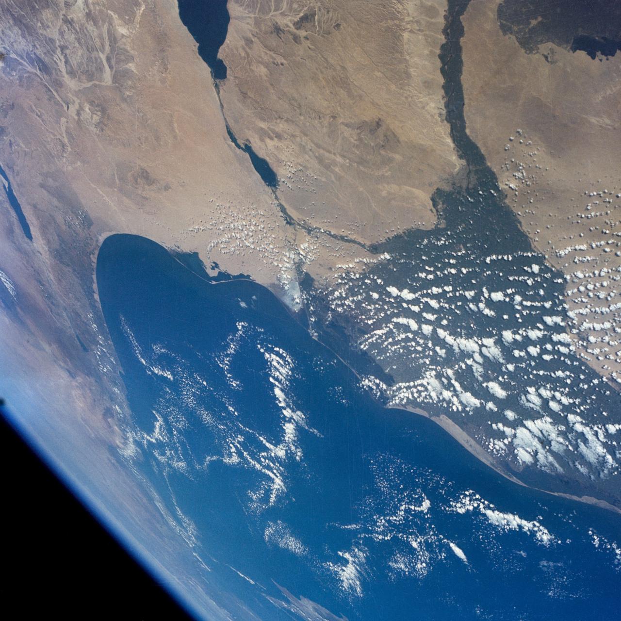
An excellent panoramic view of the entire Sinai Peninsula (29.0N, 34.0E) and the nearby Nile River Delta and eastern Mediterranean coastal region. The Suez Canal, at the top of the scene just to the right of the Delta, connects the Mediterranean Sea with the Gulf of Suez on the west side of the Sinai Peninsula and the Gulf of Aqaba is on the west where they both flow into the Red Sea. At upper right, is the Dead Sea, Jordan River and Lake Tiberius.
STS081-717-096 (12-22 Jan. 1997) --- The crewmembers, like astronauts 30 years ago, found the Nile River and its conspicuous delta an irresistible photo target from space, in this case from the Space Shuttle Atlantis' overhead windows. The majority of people living in Egypt reside in the city of Cairo. One of the most intensely cultivated lands in the world, the Nile delta can lay claim to some of the highest levels of soil salinity, as well as to being one of the highest users of fertilizer. The majority of Egypt's arable land is located in the delta. Cairo is "young" when compared to Egypt's long history, and has been a city since the Roman Empire. Although the city itself is relatively young, a site on the eastern bank of the Nile became the first capital of Egypt around 4225 BC. The city was called "Oun", but later was renamed Heliopolis by the Greeks. In 1991 the population of Cairo was estimated to be 54,600,000. The Pyramids of Gizai, one of the Seven Wonders of the Ancient World, can be seen on the western edge of the Nile delta and Cairo. The smallest and youngest of three Old Kingdom pyramids, Menkaure, is hard to distinguish because of its small size which casts a small shadow. Khafre is located between Menkaure and the Great Pyramid, and was originally 143 meters high. From the ground it appears that Khafre is taller than the other pyramids but this is an illusion caused by Khafre being built on higher ground. Khufu, or the Great Pyramid, was the first of the three to be built, and at an original height of 147 meters, is the tallest pyramid.
STS102-303-017 (8-21 March 2001)--- The STS-102 crew members used a 35mm camera on the flight deck of the Space Shuttle Discovery to record this image of the Aswan High Dam. The structure was completed in 1970 and is one of the largest earthen embankment dams in the world. It is 364 feet (111 meters) tall, 12,565 feet (3,830 meters) long and nearly 3,281 feet (1,000 meters) wide. When it was built the new reservoir required relocation of nearly 100,000 residents and some archaeological sites. Although the reservoir has benefited Egypt by providing power and controlling floods, according to NASA scientists, it has also had detrimental effects on the Nile system. Before the dam, an estimated 110 million tons of silt was deposited by the annual flood of the Nile, enriching agricultural lands and maintaining the land of the Nile delta. Now this sediment is trapped behind the dam, requiring artificial fertilization of agricultural lands and leading to erosion and saltwater intrusion where the Nile river meets the Mediterranean Sea.
At the top of today's VIS image is a delta deposit that was created by the flow from the rim channel into the crater. Deltas form when sediments settle out due to a decrease in speed of a river system. Deltas often form where large rivers flow into the ocean, like the Mississippi and Nile deltas. This can also occur where rivers flow into large lakes, such as the Great Salt Lake and Lake St. Clair river deltas. It is believed that the Jezero Crater delta formed this way. The delta in Jezero Crater has been chosen as the location for the Mars 2020 mission. Orbit Number: 77838 Latitude: 18.1853 Longitude: 77.4252 Instrument: VIS Captured: 2019-07-02 11:53 https://photojournal.jpl.nasa.gov/catalog/PIA23386
On the left side of today's VIS image is the Jezero Crater delta deposit. This feature was created by the flow from the rim channel into the crater. Deltas form when sediments settle out due to a decrease in speed of a river system. Deltas often form where large rivers flow into the ocean, like the Mississippi and Nile deltas. This can also occur where rivers flow into large lakes, such as the Great Salt Lake and Lake St. Clair river deltas. It is believed that the Jezero Crater delta formed this way. Jezero Crater is the home of the Mars 2020 rover – Perseverance – and its little helicopter buddy – Ingenuity. The Mars 2020 mission is focused on the delta, and the information it holds about a time when Mars was much wetter. Orbit Number: 95046 Latitude: 18.449 Longitude: 77.436 Instrument: VIS Captured: 2023-05-19 09:28 https://photojournal.jpl.nasa.gov/catalog/PIA26252
STS057-73-075 (21 June-1 July 1993) --- Eastern Mediterranean from an unusually high vantage point over the Nile River, this north-looking view shows not only the eastern Mediterranean but also the entire landmass of Asia Minor, with the Black Sea dimly visible at the horizon. Many of the Greek islands can be seen in the Aegean Sea (top left), off the coast of Asia Minor. Cyprus is visible under atmospheric dust in the northeast corner of the Mediterranean. The dust cloud covers the east end of the Mediterranean, its western edge demarcated by a line that cuts the center of the Nile Delta. This dust cloud originated far to the west, in Algeria, and moved northeast over Sicily, southern Italy, and Greece. Part of the cloud then moved on over the Black Sea, but another part swerved southward back towards Egypt. A gyre of clouds in the southeast corner of the Mediterranean indicates a complementary counterclockwise (cyclonic) circulation of air. The Euphrates River appears as a thin green line (upper right) in the yellow Syrian Desert just south of the blue-green mountains of Turkey. The Dead Sea (lower right) lies in a rift valley which extends north into Turkey and south thousands of miles down the Gulf of Aqaba, the Red Sea, and on through East Africa. The straight international boundary between Israel and Egypt (where the coastline angles) is particularly clear in this view, marked by the thicker vegetation on the Israeli side of the border. The green delta of the Nile River appears in the foreground, with the great conurbation of Cairo seen as a gray area at the apex of the triangle. Most of Egypt's 52 million inhabitants live in the delta. On the east side of the delta, the Suez Canal is visible. On the western corner of the delta lies the ancient city of Alexandria, beside the orange and white salt pans. The World War II battlesite El Alamein lies on the coast.
STS080-745-004 (19 Nov.-7 Dec. 1996) --- A view to the west showing Asia in the foreground and Africa in the background, as photographed by the space shuttle Columbia crewmembers. The Mediterranean Sea is to the upper right and the Red Sea to the lower left (holding photograph with NASA numbers on left). Sinai Peninsula is between the two with the Gulf of Suez above and the Gulf of Aqaba below. The Suez Canal connects the Gulf of Suez with the Mediterranean Sea. The triangular shaped dark area beyond is the Nile River Delta. The thin green fertile valley of the Nile crosses the photograph from a point at Cairo (near dark triangle area) past the great bend at Luxor with Thebes and the Valley of the Kings, and on the left into the Nubian Desert with the Aswan High Dam at the very left edge of the photograph. To the horizon is the Western Desert of Egypt and Libya. The foreground is the northwest portion of Saudi Arabia, an area known as the Hejaz with the southern portions of Israel and Jordan to the lower right.
41G-120-177 (5-13 Oct 1984) --- Egypt and the Nile River Delta are easily recognizable in this 250mm frame. Cairo and the Egyptian pyramids are also visible in the lower left side of this photograph. The crew consisted of astronauts Robert L. Crippen, commander, Jon A. McBride, pilot; mission specialist’s Kathryn D. Sullivan, Sally K. Ride, and David D. Leestma; Canadian astronaut Marc Garneau; and Paul D. Scully-Power payload specialist.
ISS030-E-112822 (25 Feb. 2012) --- This nighttime image photographed by one of the Expedition 30 crew members aboard the International Space Station provides a look toward the Mediterranean Sea. Along the left side, the night lights clearly depict the high population associated with the Nile River and its delta and the Alexandria, Egypt area (top left center). The Gulf of Suez and the Suez Canal are seen to the right.
ISS030-E-112823 (25 Feb. 2012) --- This nighttime image photographed by one of the Expedition 30 crew members aboard the International Space Station provides a look toward the Mediterranean Sea. Along the left side, the night lights clearly depict the high population associated with the Nile River and its delta and the Alexandria, Egypt area (top left center). The Gulf of Suez and the Suez Canal are seen to the right.
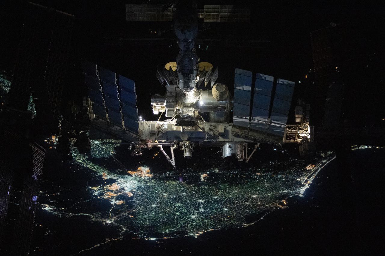
iss066e080034 (Nov. 8, 2021) -- The International Space Station is pictured from the SpaceX Crew Dragon Endeavour during a fly around of the orbiting lab that took place following its undocking from the Harmony module’s space-facing port on Nov. 8, 2021. The orbital complex was flying over 250 miles above the Nile Delta in Egypt when this photograph was taken.
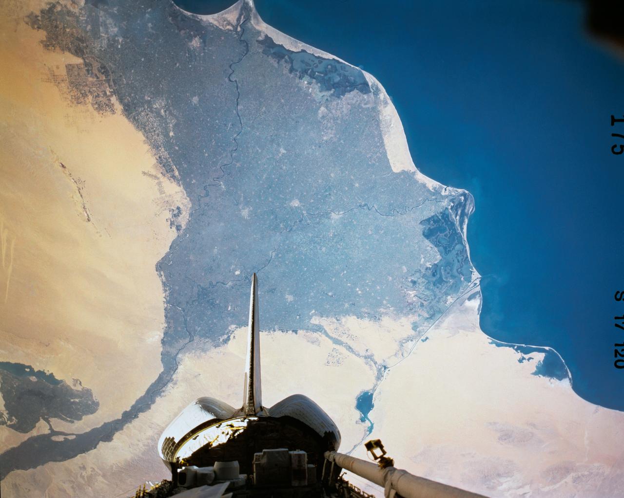
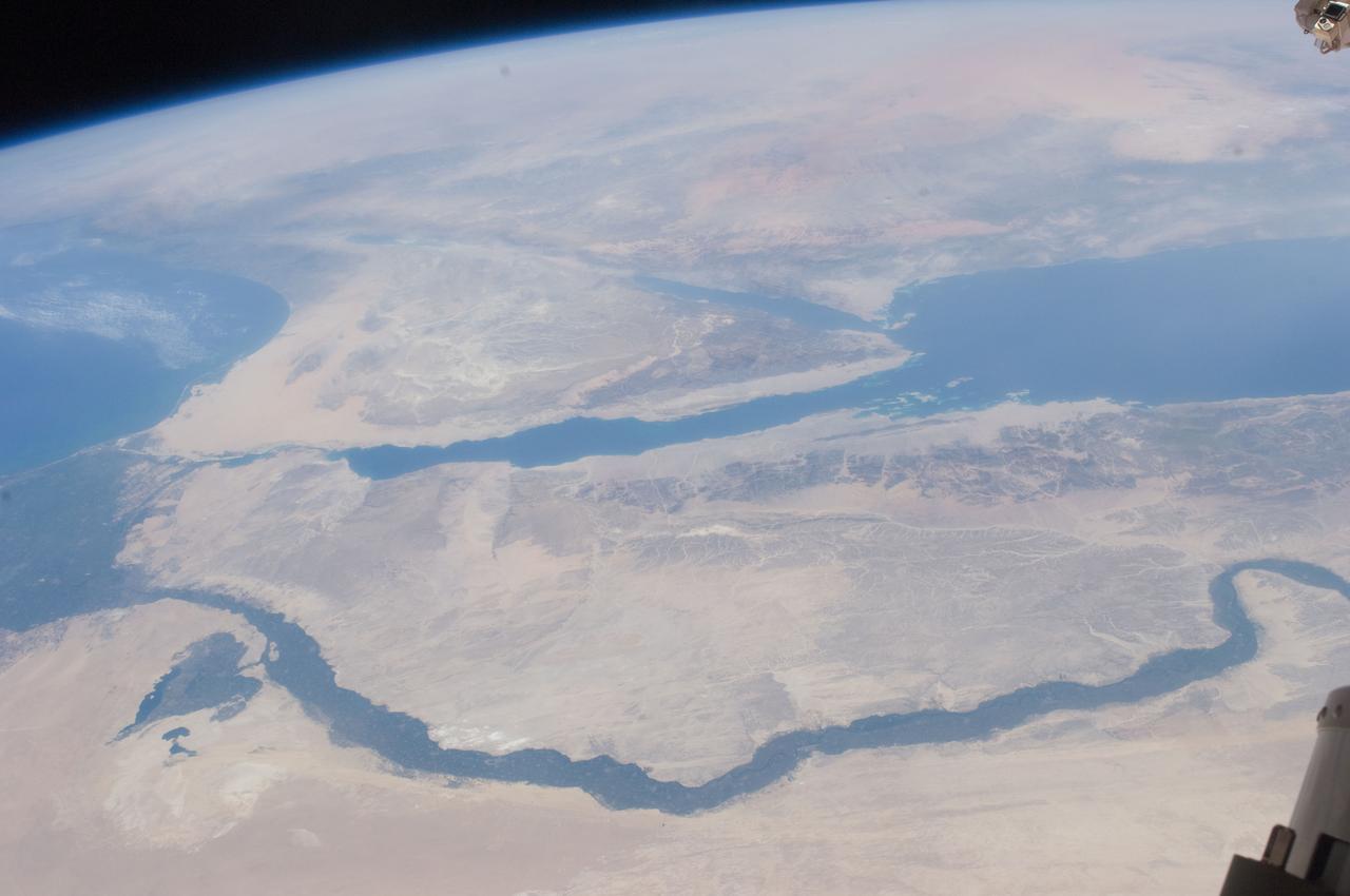
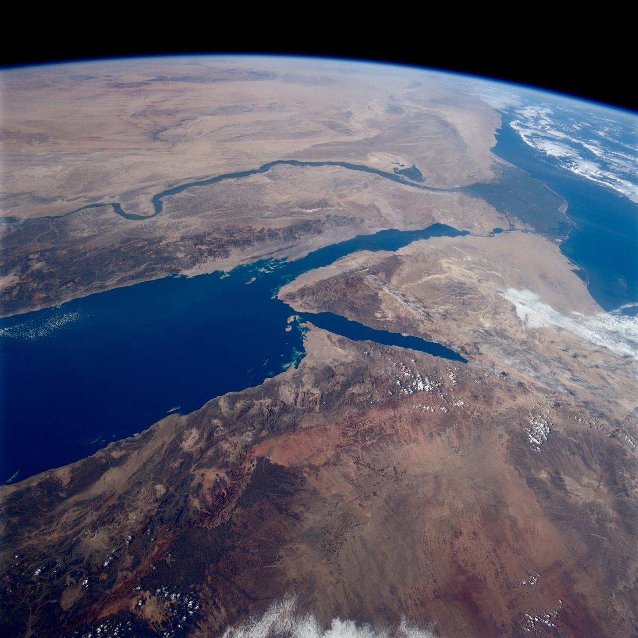
STS112-702-002 (7-18 October 2002) --- Egypt's triangular Sinai Peninsula lies in the center of this view, photographed from the Space Shuttle Atlantis, with the dark greens of the Nile delta lower right. In this southwesterly view, the Red Sea, with its characteristic parallel coastlines, stretches toward the top. At the bottom of the image, the Suez Canal appears as an irregular line joining the Red Sea to the Mediterranean Sea (lower left). The Dead Sea in central Israel, with its light blue salt ponds at the south end, appears on the left margin.
From 220 miles above Earth, one of the Expedition 25 crew members on the International Space Station took this night time photo featuring the bright lights of Cairo and Alexandria, Egypt on the Mediterranean coast. The Nile River and its delta stand out clearly as well. On the horizon, the airglow of the atmosphere is seen across the Mediterranean. The Sinai Peninsula, at right, is outlined with lights highlighting the Gulf of Suez and Gulf of Aqaba. Credit: NASA
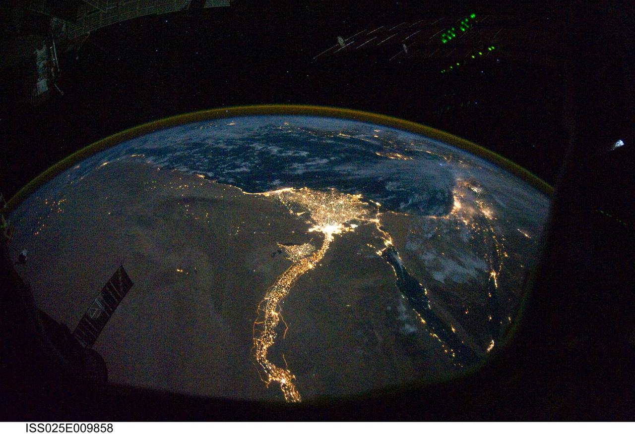
ISS025-E-009858 (28 Oct. 2010) --- From 220 miles above Earth, one of the Expedition 25 crew members on the International Space Station took this night time photo featuring the bright lights of Cairo and Alexandria, Egypt on the Mediterranean coast. The Nile River and its delta stand out clearly as well. On the horizon, the airglow of the atmosphere is seen across the Mediterranean. The Sinai Peninsula, at right, is outlined with lights highlighting the Gulf of Suez and Gulf of Aqaba.
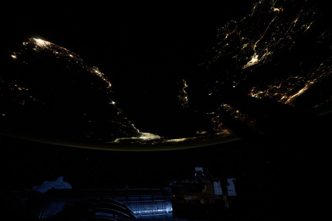
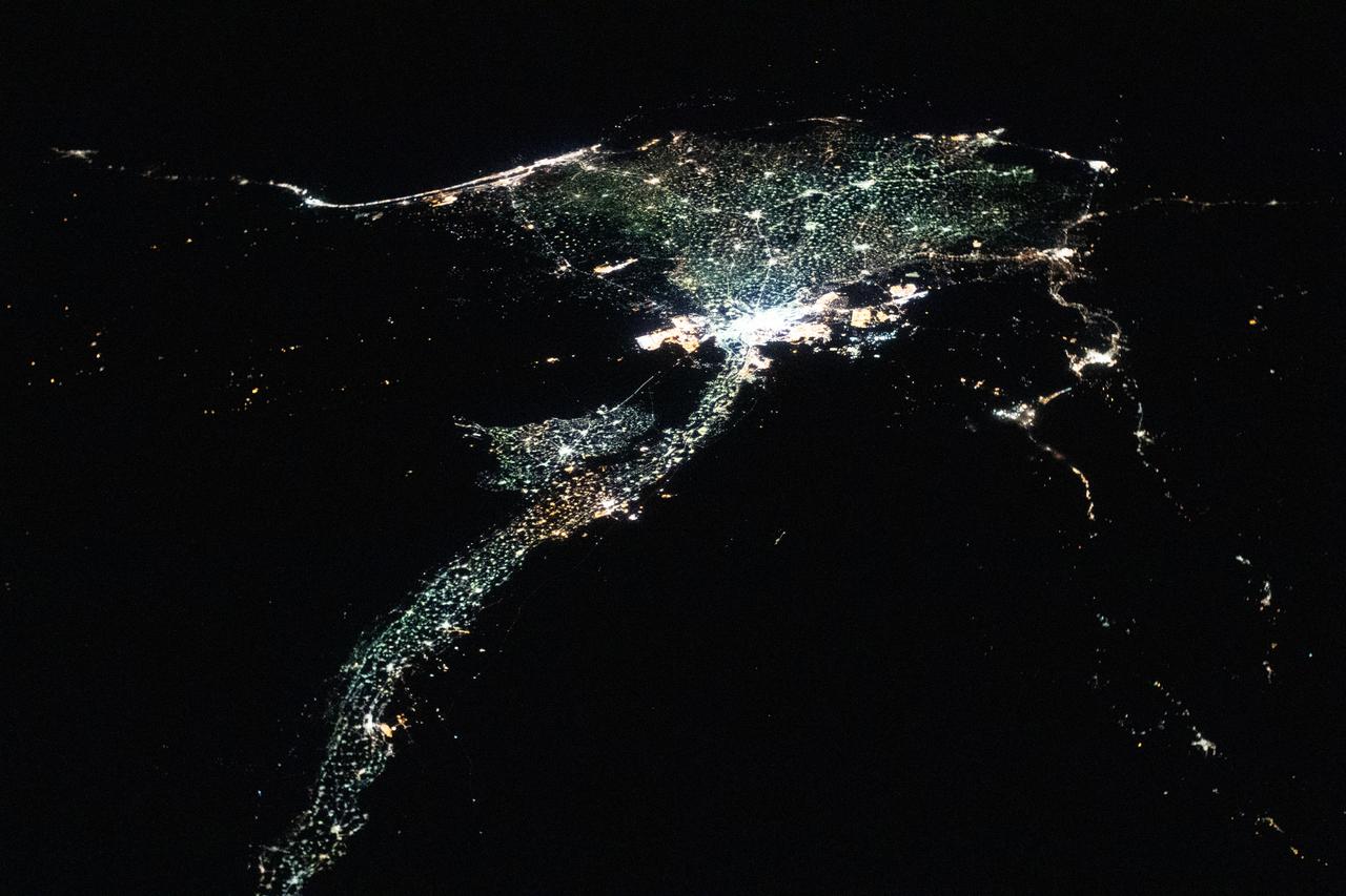
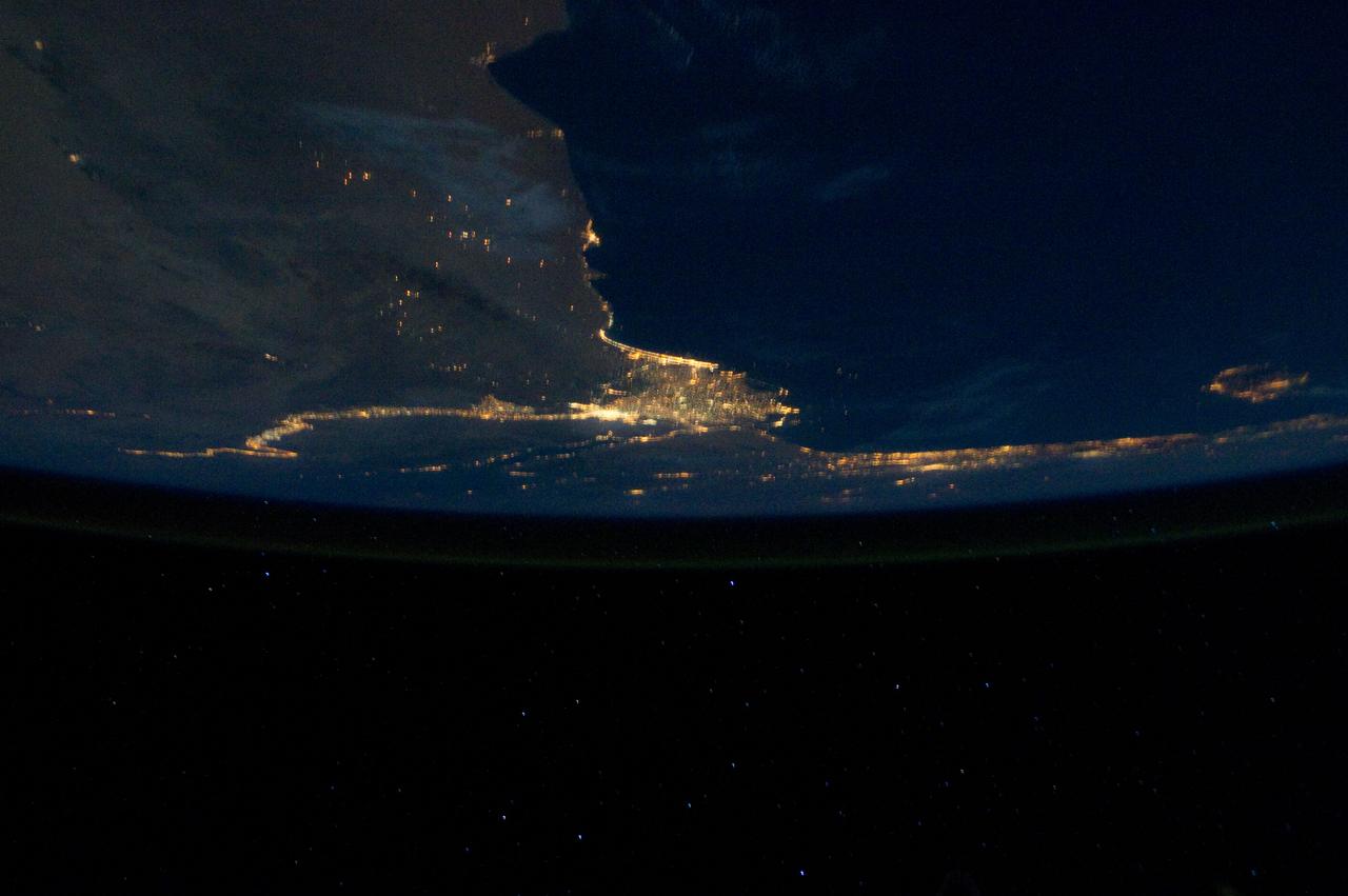
iss073e0312086 (May 22, 2025) --- At top left, the city lights of Benghazi, Libya, arc downward toward the glow of civilization on Egypt's Nile Delta outlining Africa's Mediterranean Sea coast. Israel's metropolitan lights then round north and east into Istanbul, Turkey (far right), and Athens, Greece, and their surrounding suburbs in southern Europe. Resting in the center of the Mediterranean's darkness is the Greek island of Crete.
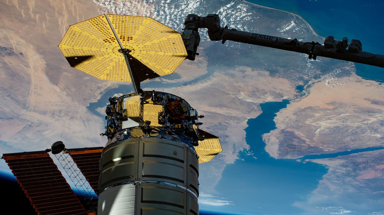
iss073e0767188 (Sept. 23, 2025) --- Northrop Grumman's Cygnus XL cargo craft is pictured installed to the Unity module's Earth-facing port as the International Space Station orbited 259 miles above the Mediterranean Sea. The Red Sea and Egypt's Nile Delta are viewed from the vantage point of an external high definition camera on the orbital outpost. Extending from the upper right, is the Canadarm2 robotic arm that had captured Cygnus after its arrival on Sept. 18, 2025.
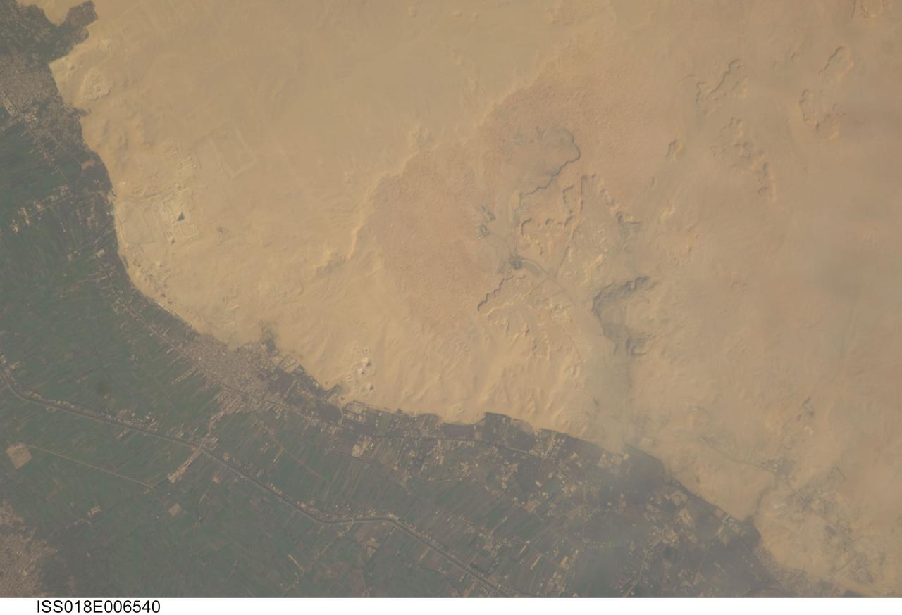
ISS018-E-006540 (31 Oct. 2008) --- Cities of the Dead and the Nile River Delta in Egypt are featured in this image photographed by an Expedition 18 crewmember on the International Space Station. The ancient pharaohs (kings) and queens of Egypt established several royal cemeteries, or necropoli (cities of the dead) along the Nile River valley. On the western bank, these cities of the dead were built on a gravelly desert plateau formed of limestone and clay overlooking the river -- several scarps are visible at upper right. The most widely recognized features of royal Egyptian necropoli are pyramids, which frequently served as both tombs and monuments for their occupants. This detailed photograph illustrates a portion of the Nile Delta that includes two royal cemetery complexes, Abusir and Saqqara-North. The present day village of Abusir is clearly visible as a grey-white irregular patch of urban materials that contrasts with adjacent green agricultural fields of the Delta and tan desert sands and gravels to the west. The historical necropolis of Abusir is located to the northwest of the village at bottom center. Three pyramids are readily visible in the image, all built by kings of the 5th Dynasty (2465--2323 BC): Sahure, Niuserre and Neferirkare. The site of Abusir was likely chosen due to the existence of a lake -- now dry -- that facilitated transport of building materials for the pyramids and other structures. The northern portion of the large necropolis of Saqqara is also visible to the south-southwest of the village of Abusir. The largest pyramid in this complex is that of Djoser, a king of the 3rd Dynasty (2650--2575 BC). Other readily visible pyramids include that of Userkaf (5th Dynasty) and Teti (6th Dynasty: 2323--2150 BC), attesting to the long history of use of the Saqqara necropolis.
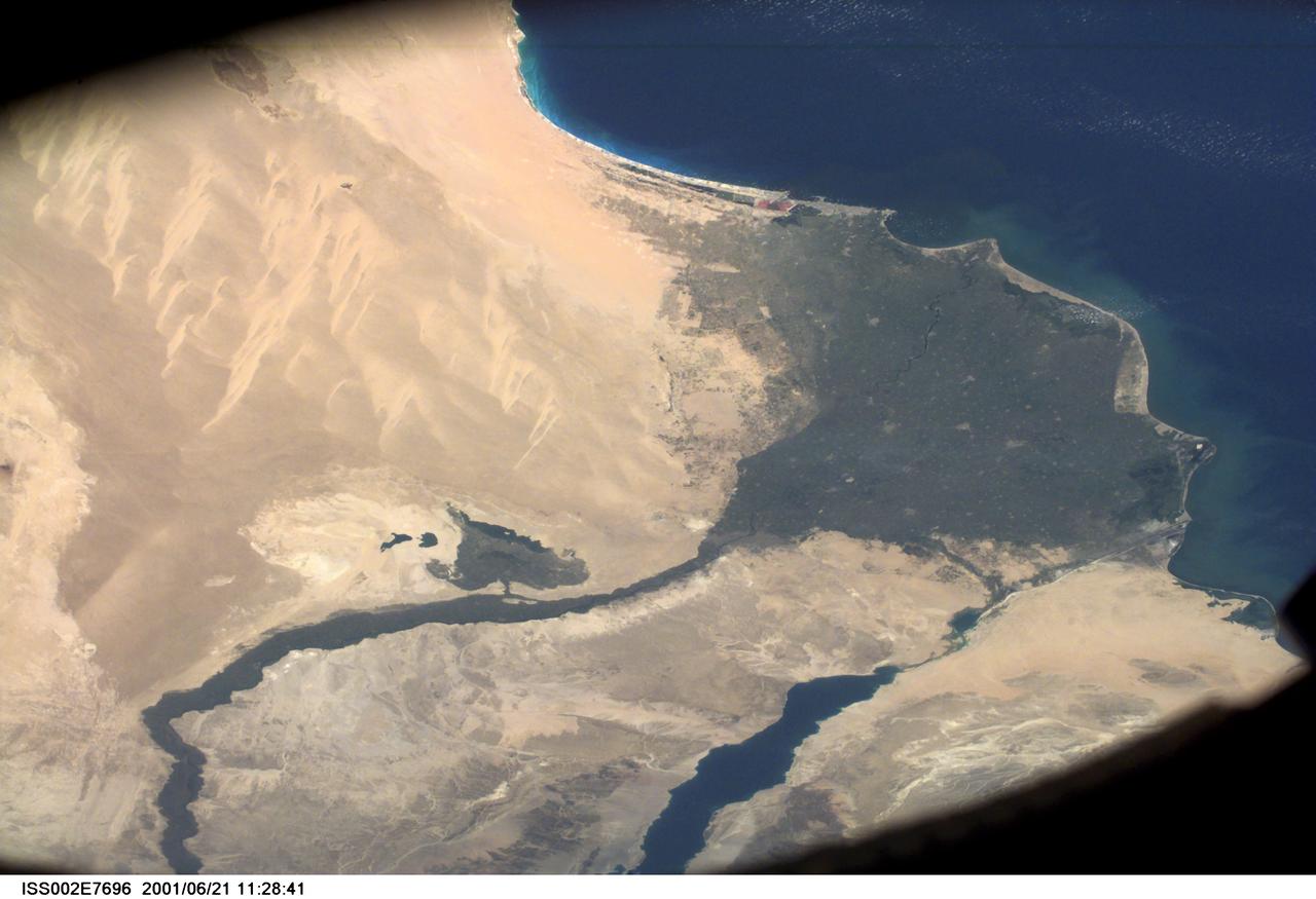
SS002-E-7696 (21 June 2001) --- Wide view of the Nile River and Suez Canal, Egypt, as photographed with a digital still camera aboard the International Space Station (ISS).
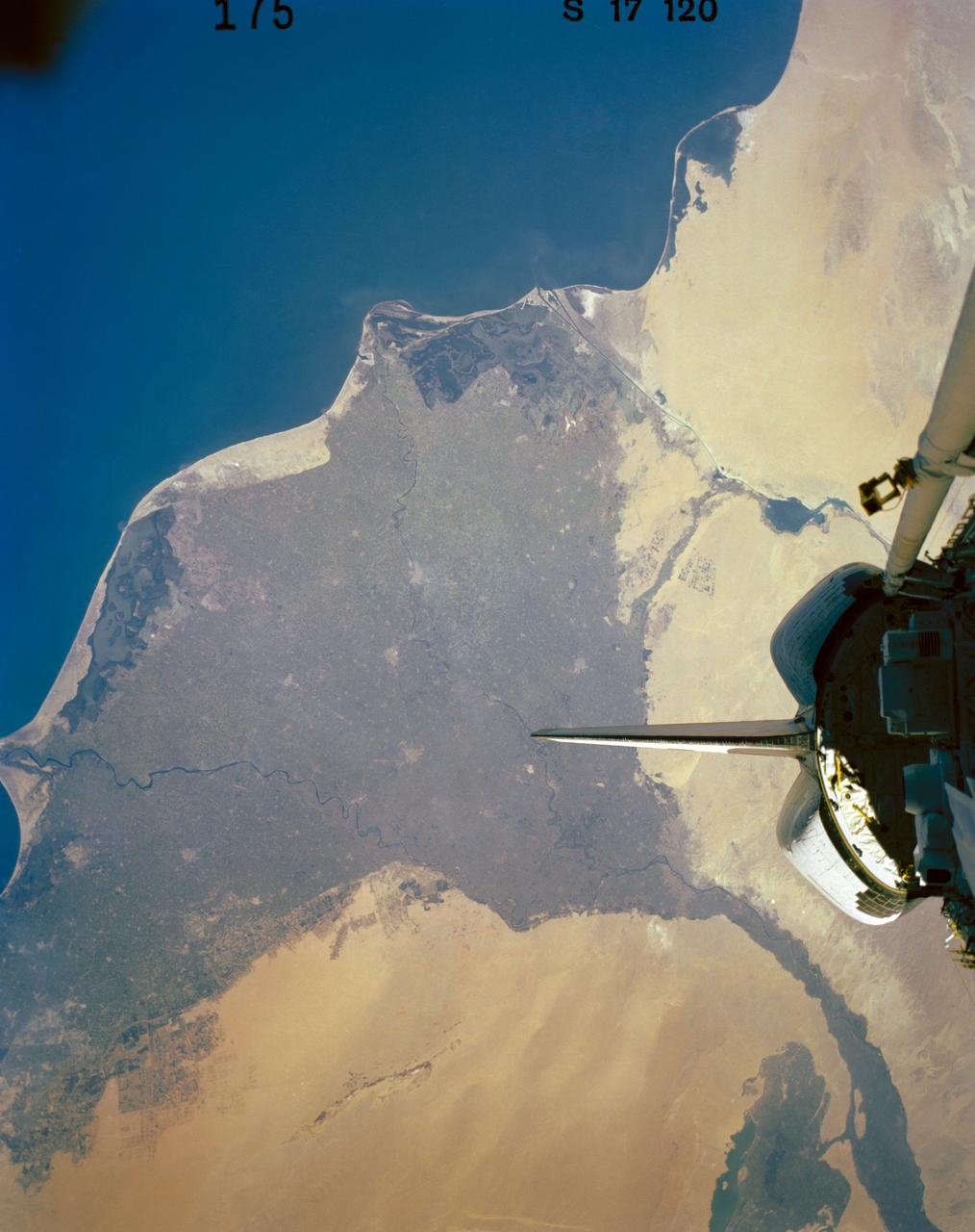
41G-120-175 (5-13 Oct. 1984) --- Egypt and the Nile River Delta are easily recognizable in this 250mm frame photographed by one of the seven 41-G crew members aboard the Earth-orbiting space shuttle Challenger. Cairo and the Egyptian pyramids are also visible in the lower left side of this photograph. The 41-G crew consisted of astronauts Robert L. Crippen, commander, Jon A. McBride, pilot; Mission Specialists Kathryn D. Sullivan, Sally K. Ride, and David D. Leestma; along with Canadian astronaut Marc Garneau; and Paul D. Scully-Power, both payload specialists. Photo credit: NASA
STS076-734-084 (22 - 31 March 1996) --- A clear scene of the Sinai Peninsula and the Nile River Delta forms the backdrop for this 70mm scene of Russia's Mir Space Station, as photographed from the aft flight deck of the Space Shuttle Atlantis. Atlantis docked with Mir on March 23, 1996, and remained linked until March 28, 1996. Astronaut Shannon W. Lucid transferred from the STS-76 crew to the Mir-21 crew, which grew from two to three. She will remain aboard Mir for approximately 140 days, as a cosmonaut guest researcher.
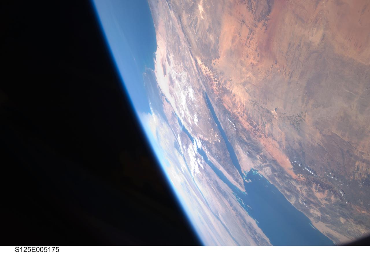
S125-E-005175 (12 May 2009) --- Among the first group of still images downlinked by the STS-125 crewmembers onboard the Space Shuttle Atlantis was this high oblique scene looking toward the Red Sea, Sinai Peninsula and the Mediterranean Sea. Saudi Arabia is in the foreground and Egypt?s Nile River and its delta can be seen (left) toward the horizon. Israel and Jordan can be seen near the top edge of the frame. The Gulf of Suez and the Gulf of Aqaba (near frame center) extend from the Red Sea toward the Mediterranean Sea.
S125-E-005173 (12 May 2009) --- Among the first group of still images downlinked by the STS-125 crewmembers onboard the Space Shuttle Atlantis was this high oblique scene looking toward the Sinai Peninsula and the Mediterranean Sea. The Red Sea is just out of frame at bottom right. Saudi Arabia is in the right foreground and Egypt?s Nile River and its delta can be seen (lower left) toward the horizon. Jordan and a small portion of Israel can be seen near the top of the frame. The Gulf of Suez and the Gulf of Aqaba extend from the Red Sea toward the Mediterranean.
S65-63849 (8 Dec. 1965) --- The eastern Mediterranean area as seen from the National Aeronautics and Space Administration's Gemini-7 spacecraft. The Nile Delta in Egypt is at bottom. The Suez Canal, Gulf of Suez and Red Sea are in the center of the photograph. The Sinai Peninsula is in the upper right corner of the picture. The body of water at the top edge of the photograph is the Gulf of Aqaba. The Dead Sea can be seen at top center. Israel, Palestine, Jordan and Syria are also at top center. The Island of Cyprus is at extreme left. Astronauts Frank Borman and James A. Lovell Jr. took this picture using a modified 70mm Hasselblad camera, with Eastman Kodak, Ektachrome MS (S.O. 217) color film. Photo credit: NASA
ISS029-E-031143 (15 Oct. 2011) --- One of the Expedition 29 crew members aboard the International Space Station recorded this oblique view showing the Mediterranean Sea area, including parts of Turkey, the Nile River and the river's delta, and the Sinai Peninsula, on Oct. 15, 2011. At first look, the image appears to have been photographed in daylight, but actually it was taken at 01:01:26 GMT. Some areas of the photo like the river and river delta appear as the brightest areas because of either man-made lighting (mostly incandescent) or man-made lighting reflected off nearby surfaces. The other areas appear to be illuminated naturally by moonlight, starlight, or back-scattered light from the atmosphere. A 20-mm focal length was used to record the image.
ISS029-E-031157 (15 Oct. 2011) --- One of the Expedition 29 crew members aboard the International Space Station recorded this oblique view showing the Mediterranean Sea area, including the Nile River and the river's delta, and the Sinai Peninsula, on Oct. 15, 2011. Cyprus is visible at left. At first look, the image appears to have been photographed in daylight, but actually it was taken at 01:01:08 GMT. Some areas of the photo like the river and river delta appear as the brightest areas because of either man-made lighting (mostly incandescent) or man-made lighting reflected off nearby surfaces. The other areas appear to be illuminated naturally by moonlight, starlight, or back-scattered light from the atmosphere. A 20-mm focal length was used to record the image.
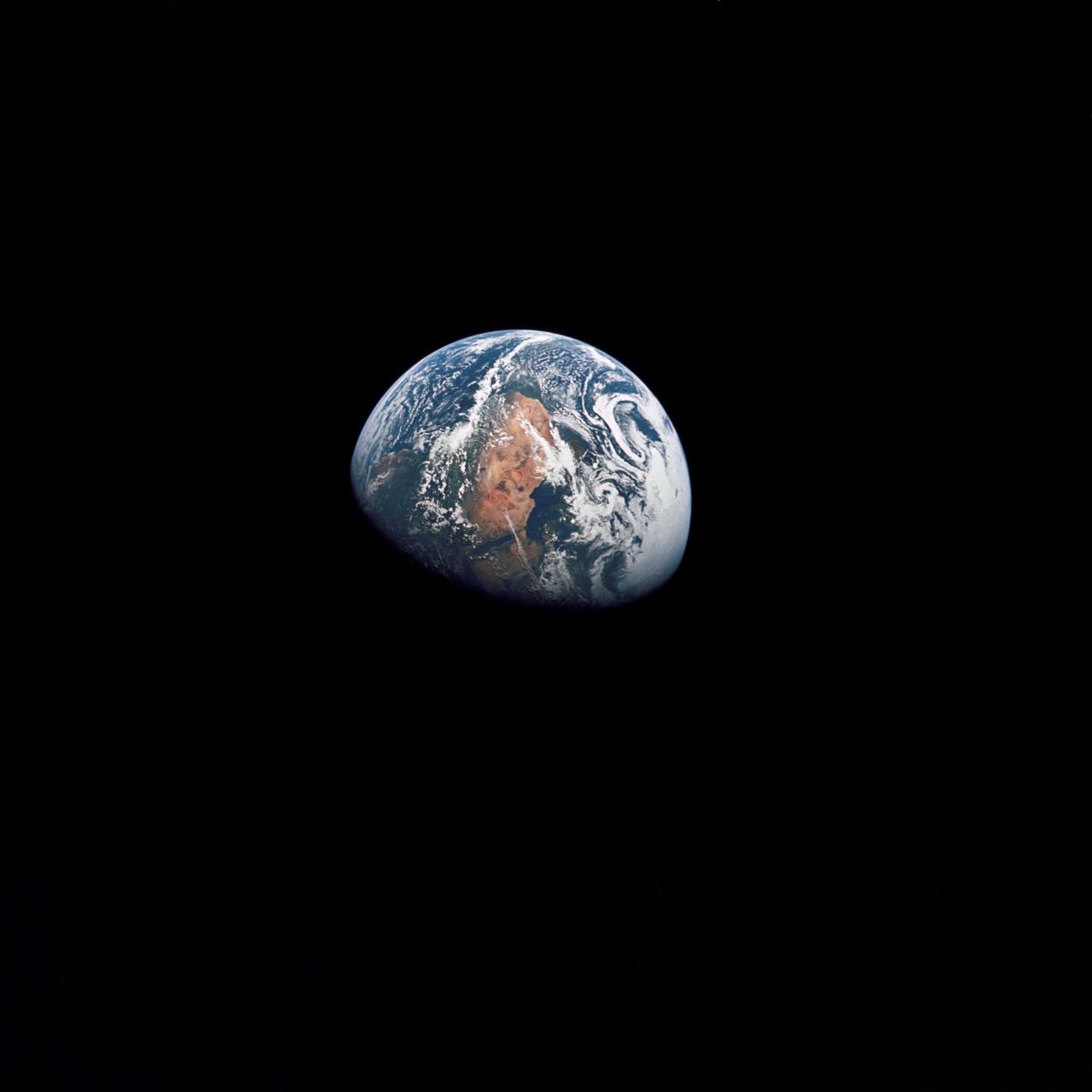
AS10-34-5026 (18-26 May 1969) --- An Apollo 10 photograph of Earth taken from 100,000 miles away. Visible are many areas of Europe and Africa. Among the features and countries identifiable are Portugal, Spain, Italy, the Mediterranean Sea, Greece, Turkey, Bulgaria, the Black Sea, Libya, Egypt, Saudi Arabia, the Sinai Peninsula, the Nile Delta, Lake Chad, and South Africa. The crew members for Apollo 10 are astronauts Thomas P. Stafford, commander; John W. Young, command module pilot; and Eugene E. Cernan, lunar module pilot. Astronaut Young remained in lunar orbit, in the Command and Service Modules (CSM) "Charlie Brown", while astronauts Stafford and Cernan descended to within nine miles of the lunar surface, in the Lunar Module (LM) "Snoopy".
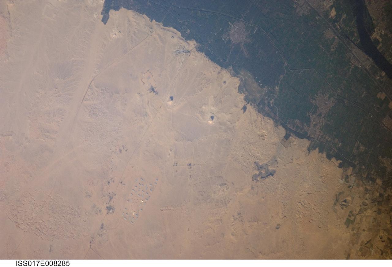
ISS017-E-008285 (30 May 2008) --- Pyramids of Dashur, Egypt are featured in this image photographed by an Expedition 17 crewmember on the International Space Station. While the pyramids of Giza are perhaps the most famous, there are several other ancient Egyptian royal necropolis ("city of the dead") sites situated along the Nile River and its delta. One of these sites is located near the village of Dashur (upper right). The gray-brown built area of Dashur is surrounded by green agricultural land of the Nile Delta, which forms a distinct boundary with the tan desert to the west. It is in the desert that the monuments of the ancient rulers of Egypt are found. Several monuments are visible in this image, including the large Red and Bent Pyramids built by Snofru, first king of the 4th Dynasty that lasted from 2575-2465 BC. Other visible monuments include the pyramid complexes of Amenemhat III and Sesostris III, both kings of the 12th Dynasty (1991-1783 BC). Both of these complexes are poorly preserved, due both to unstable ground conditions, and dismantling of the limestone blocks forming the outer pyramid casings during later historical periods. The Bent Pyramid (lower right) is so called as the slope of the outer face was lessened halfway through construction, leading to a distinctive "bent" profile -- explanations for why this was done include decreasing the mass of the pyramid to prevent collapse, or to reduce the work necessary to complete it. The Red Pyramid to the north (center) was built after the Bent Pyramid, and is named for the coloration of the building stone at the structure's core. An irregular dark feature to the southeast of the Bent Pyramid is not a shadow cast by a monument; it is an irrigation feature extending into the desert.

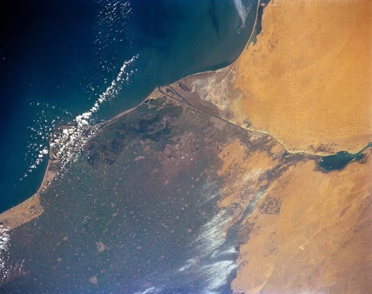
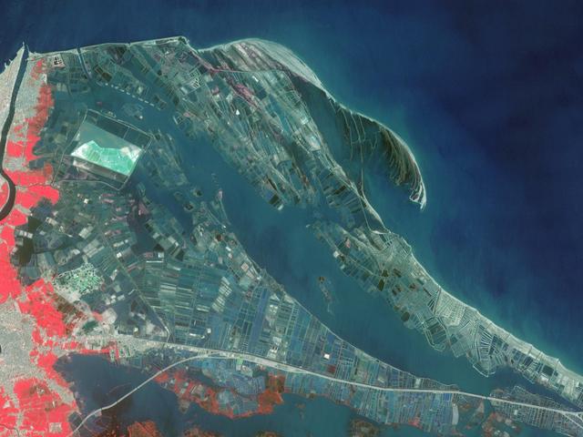
ISS013-E-76441 (4 Sept. 2006) --- Aquaculture in the Nile delta, Egypt is featured in this image photographed by an Expedition 13 crewmember on the International Space Station. In the last three decades, a series of lagoons and lakes with greater and lesser connection to the sea have been greatly modified for the production of fish along the northeast coast of the Nile delta. Partial sunglint in this image reveals numerous details in one such fishery. Waves generated by northwesterly winds (lower left to upper right) have generated the frond-like sand spit along the coast (top). Faint sea swells are visible at upper left. Dark patches in the center are shadows cast by small clouds (also visible as dull white masses against the silver-grey sunglint). Dark curved lines on the inshore (western) side of the spit show prior positions of the spit. Most of Musallas Lagoon occupies the lower half of the image. By contrast with spit, the shores of the lagoon are everywhere occupied by a network of man-made structures--mainly short dikes enclosing hundreds of aquaculture ponds. The total area under fish production is estimated to be 8,000 hectares in the lagoon, which provides more than half of the aquaculture production for Egypt, largely in the form of two species of mullet. An outlet to the Mediterranean Sea (top right), allows sea-water recharge to the lagoon. Wind helps to circulate the water in this shallow lagoon--bright wind streaks on the lagoon (lower left) show this circulation driven by the north-northwest wind on this day.
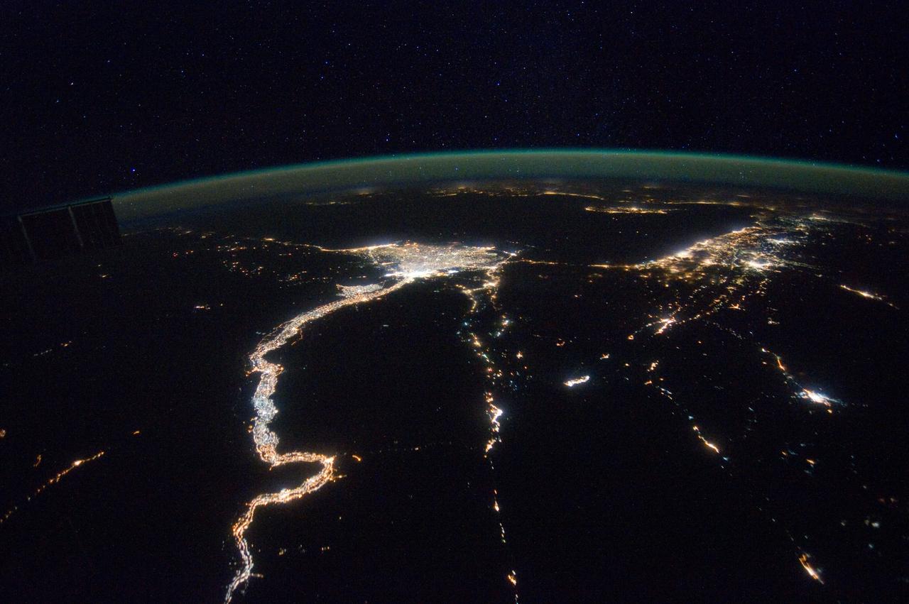
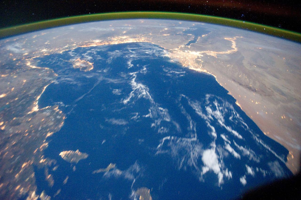
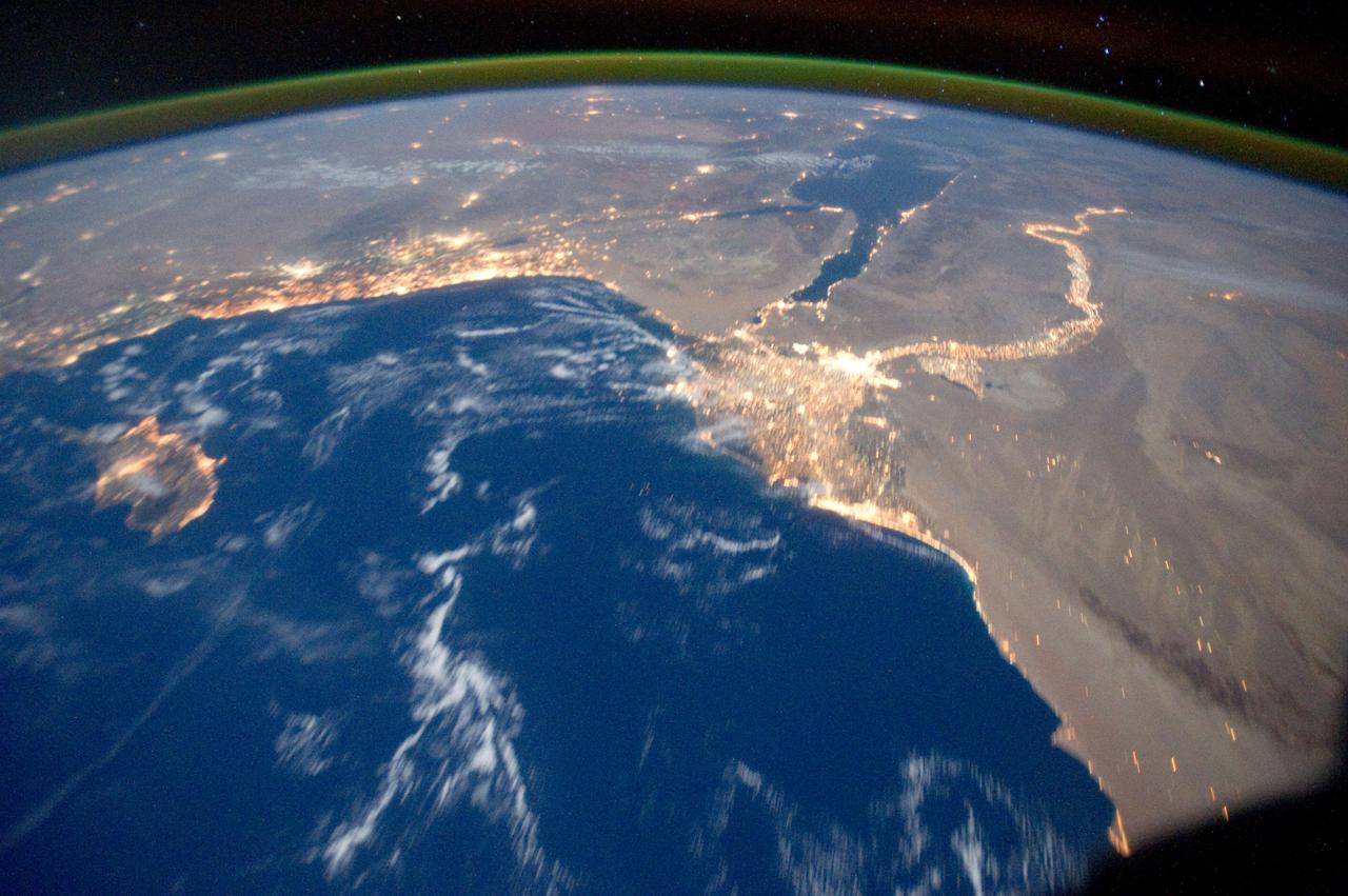
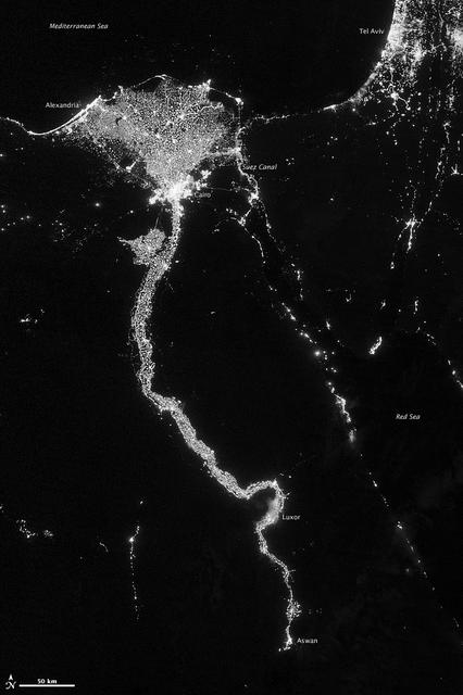
NASA image acquired October 13, 2012 The Nile River Valley and Delta comprise less than 5 percent of Egypt’s land area, but provide a home to roughly 97 percent of the country’s population. Nothing makes the location of human population clearer than the lights illuminating the valley and delta at night. On October 13, 2012, the Visible Infrared Imaging Radiometer Suite (VIIRS) on the Suomi NPP satellite captured this nighttime view of the Nile River Valley and Delta. This image is from the VIIRS “day-night band,” which detects light in a range of wavelengths from green to near-infrared and uses filtering techniques to observe signals such as gas flares, auroras, wildfires, city lights, and reflected moonlight. The city lights resemble a giant calla lily, just one with a kink in its stem near the city of Luxor. Some of the brightest lights occur around Cairo, but lights are abundant along the length of the river. Bright city lights also occur along the Suez Canal and around Tel Aviv. Away from the lights, however, land and water appear uniformly black. This image was acquired near the time of the new Moon, and little moonlight was available to brighten land and water surfaces. NASA Earth Observatory image by Jesse Allen and Robert Simmon, using VIIRS Day-Night Band data from the Suomi National Polar-orbiting Partnership. Suomi NPP is the result of a partnership between NASA, the National Oceanic and Atmospheric Administration, and the Department of Defense. Caption by Michon Scott. Instrument: Suomi NPP - VIIRS Credit: <b><a href="http://www.earthobservatory.nasa.gov/" rel="nofollow"> NASA Earth Observatory</a></b> <b>Click here to view all of the <a href="http://earthobservatory.nasa.gov/Features/NightLights/" rel="nofollow"> Earth at Night 2012 images </a></b> <b>Click here to <a href="http://earthobservatory.nasa.gov/NaturalHazards/view.php?id=79807" rel="nofollow"> read more </a> about this image </b> <b><a href="http://www.nasa.gov/audience/formedia/features/MP_Photo_Guidelines.html" rel="nofollow">NASA image use policy.</a></b> <b><a href="http://www.nasa.gov/centers/goddard/home/index.html" rel="nofollow">NASA Goddard Space Flight Center</a></b> enables NASA’s mission through four scientific endeavors: Earth Science, Heliophysics, Solar System Exploration, and Astrophysics. Goddard plays a leading role in NASA’s accomplishments by contributing compelling scientific knowledge to advance the Agency’s mission. <b>Follow us on <a href="http://twitter.com/NASA_GoddardPix" rel="nofollow">Twitter</a></b> <b>Like us on <a href="http://www.facebook.com/pages/Greenbelt-MD/NASA-Goddard/395013845897?ref=tsd" rel="nofollow">Facebook</a></b> <b>Find us on <a href="http://instagram.com/nasagoddard?vm=grid" rel="nofollow">Instagram</a></b>
NASA image acquired October 13, 2012 The Nile River Valley and Delta comprise less than 5 percent of Egypt’s land area, but provide a home to roughly 97 percent of the country’s population. Nothing makes the location of human population clearer than the lights illuminating the valley and delta at night. On October 13, 2012, the Visible Infrared Imaging Radiometer Suite (VIIRS) on the Suomi NPP satellite captured this nighttime view of the Nile River Valley and Delta. This image is from the VIIRS “day-night band,” which detects light in a range of wavelengths from green to near-infrared and uses filtering techniques to observe signals such as gas flares, auroras, wildfires, city lights, and reflected moonlight. The city lights resemble a giant calla lily, just one with a kink in its stem near the city of Luxor. Some of the brightest lights occur around Cairo, but lights are abundant along the length of the river. Bright city lights also occur along the Suez Canal and around Tel Aviv. Away from the lights, however, land and water appear uniformly black. This image was acquired near the time of the new Moon, and little moonlight was available to brighten land and water surfaces. NASA Earth Observatory image by Jesse Allen and Robert Simmon, using VIIRS Day-Night Band data from the Suomi National Polar-orbiting Partnership. Suomi NPP is the result of a partnership between NASA, the National Oceanic and Atmospheric Administration, and the Department of Defense. Caption by Michon Scott. Instrument: Suomi NPP - VIIRS Credit: <b><a href="http://www.earthobservatory.nasa.gov/" rel="nofollow"> NASA Earth Observatory</a></b> <b>Click here to view all of the <a href="http://earthobservatory.nasa.gov/Features/NightLights/" rel="nofollow"> Earth at Night 2012 images </a></b> <b>Click here to <a href="http://earthobservatory.nasa.gov/NaturalHazards/view.php?id=79807" rel="nofollow"> read more </a> about this image </b> <b><a href="http://www.nasa.gov/audience/formedia/features/MP_Photo_Guidelines.html" rel="nofollow">NASA image use policy.</a></b> <b><a href="http://www.nasa.gov/centers/goddard/home/index.html" rel="nofollow">NASA Goddard Space Flight Center</a></b> enables NASA’s mission through four scientific endeavors: Earth Science, Heliophysics, Solar System Exploration, and Astrophysics. Goddard plays a leading role in NASA’s accomplishments by contributing compelling scientific knowledge to advance the Agency’s mission. <b>Follow us on <a href="http://twitter.com/NASA_GoddardPix" rel="nofollow">Twitter</a></b> <b>Like us on <a href="http://www.facebook.com/pages/Greenbelt-MD/NASA-Goddard/395013845897?ref=tsd" rel="nofollow">Facebook</a></b> <b>Find us on <a href="http://instagram.com/nasagoddard?vm=grid" rel="nofollow">Instagram</a></b>
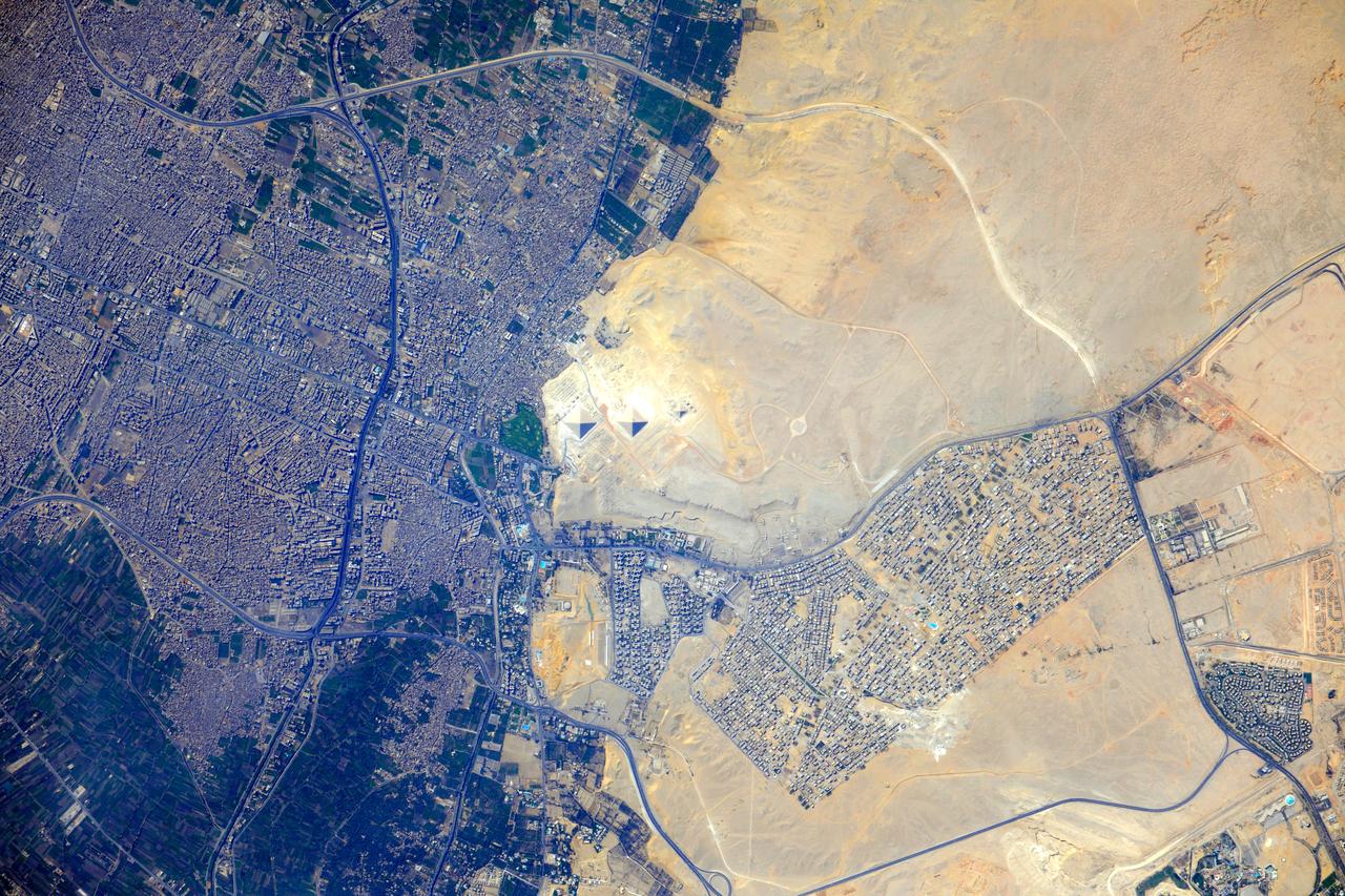
ISS032-E-009123 (26 July 2012) --- Pyramids at Giza, Egypt are featured in this image photographed by an Expedition 32 crew member on the International Space Station. The Great Pyramids at Giza (center) are the last of the Seven Wonders of the Ancient World, and are perhaps the most famous of the ancient monuments in the Nile River Delta region of Egypt. They are also a favorite subject of photography from orbit ? particularly when high resolution imagery can be obtained. The southeast-facing sides of the pyramids of the pharaohs Khufu, Khafre, and Menkaure are all brightly illuminated by the sun, while the northwest facing sides are in shadow. This shadowing also highlights smaller unfinished pyramids to the south of Menkaure?s pyramid, as well as fields of rectangular flat roofed mastabas (tombs) to the east and west of Khufu?s pyramid. While not as grand as the pyramids, mastabas were the burial places of prominent persons during the periods of the ancient pharaohs. To the southeast of Khufu?s pyramid, the head and rear haunches of the Sphinx are also visible (albeit not clearly). It is a short distance between the glories of ancient Egypt and the modern Cairo metropolitan area to the north and east. The green vegetation of a hotel golf course (center left), and the numerous building and streets of El Giza, provide stark contrast to the bare rock and soil of the adjacent desert. Roadways visible in the desert (right) connect the urban regions to the east with further development to the north.

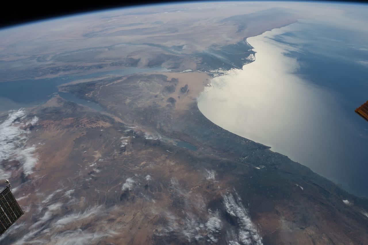
ISS036-E-011050 (22 June 2013) --- An Egyptian dust plume and the Red Sea are featured in this image photographed by an Expedition 36 crew member on the International Space Station. This photograph provides a panoramic view of most of the length of the Red Sea, with the northernmost end, the Gulf of Suez, just visible at top center—fully 1,900 kilometers (ground distance) from the space station. The River Nile snakes its way northward through the Sahara Desert at top left. Much closer to the camera—but still more than 550 kilometers distant from the ground point above which the space station is orbiting—is a prominent dust plume surging out over the clear water of the Red Sea (foreground), reaching most of the way to Saudi Arabia. The “point source” of this plume is the delta of the southern Egyptian river Khor Baraka. Images from the spacecraft have shown that this delta is a common source for dust plumes, mainly because it is a relatively large area of exposed, loose sand and clay, easily lofted into the air. But the river also cuts through a high range of hills in a narrow valley that channels the wind, making it blow faster. This dramatic view of the Red Sea shows the generally parallel margins of the opposing coastlines. According to scientists, the rift or depression which now holds the Red Sea has been opening slowly for about 30 million years, and is nearly 300 kilometers wide in the region of the dust plume. Scientists believe the depression only recently filled with seawater within the last approximately five million years.