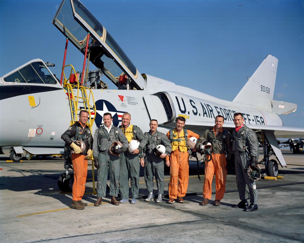
A Rock Like None Before, Brushed

This Saturn equinox, captured here in a mosaic of light and dark, is the first witnessed up close by an emissary from Earth, none other than our NASA faithful robotic explorer, Cassini.

Left to right: workhorse F-15B #836, "Mr. Bones" F-15D #884, and "2nd to None" F-15D #897 on the back ramp at NASA's Neil A. Armstrong Flight Research Center.

Left to right: "2nd to None" (F-15D #897), "Mr. Bones" (F-15D #884), and workhorse F-15B #836 on the back ramp at NASA's Neil A. Armstrong Flight Research Center.

Clark Johnson inspects components tested in the Environmental Laboratory at NASA’s Armstrong Flight Research Center in California. He ensures none of the research items were damaged during testing and a check to see that the workmanship standards for the components are met.

Dust devils on Mars often create long, dark markings where they pull a thin coat of dust off the surface. This image shows a cluster of these tracks on the flat ground below the south polar layered deposits, but none on the layers themselves. This tells us that either dust devils do not cross the layers, or they do not leave a track there. There are several possible reasons for this. For instance, the dust might be thick enough that the vortex of the dust devil doesn't expose darker material from underneath the surface. https://photojournal.jpl.nasa.gov/catalog/PIA23064

ISS030-E-177178 (14 March 2012) --- Robonaut 2 – the first dexterous humanoid robot in space – is pictured in the Destiny laboratory of the International Space Station measuring the air flow in front of vents inside the station to ensure that none of the ventilation ductwork gets clogged or blocked.

STS-31 Mission Specialist (MS) Bruce McCandless II, wearing liquid cooling and ventilation garment (LCVG), works his way out of the extravehicular mobility unit (EMU) lower torso on the middeck of Discovery, Orbiter Vehicle (OV) 103. McCandless was in a standby mode to perform extravehicular activity (EVA) if needed to support Hubble Space Telescope (HST) deployment and post- deployment tasks. None was needed. His helmet and gloves freefloat in the background.

This sky map shows the location of the star HD 219134 (circle), host to the nearest confirmed rocky planet found to date outside of our solar system. The star lies just off the "W" shape of the constellation Cassiopeia and can be seen with the naked eye in dark skies. It actually has multiple planets, none of which are habitable. http://photojournal.jpl.nasa.gov/catalog/PIA19832

This VIS image shows several channels located in Terra Sabaea. The flow was from the top of the image towards the bottom. These channels are located north of Hellas Planum and are following the topographic gradient down into the Hellas basin. None of these channels have been named. Orbit Number: 81919 Latitude: -17.5776 Longitude: 65.3522 Instrument: VIS Captured: 2020-06-02 12:33 https://photojournal.jpl.nasa.gov/catalog/PIA24112

This close-up video clip shows a pair of active regions (the brighter areas) move and change as they rotate with the sun over just a 17-hour period (Oct. 4-5, 2017). They were observed in a wavelength of extreme ultraviolet light that reveals plasma heated to over a million degrees. The arches above the regions consist of charge particles spinning along and revealing magnetic field lines. Each one shows a few minor bursts of material none of them were serious. Animations are available at https://photojournal.jpl.nasa.gov/catalog/PIA22039

Pluto's present, hazy atmosphere is almost entirely free of clouds, though scientists from NASA's New Horizons mission have identified some cloud candidates after examining images taken by the New Horizons Long Range Reconnaissance Imager and Multispectral Visible Imaging Camera, during the spacecraft's July 2015 flight through the Pluto system. All are low-lying, isolated small features -- no broad cloud decks or fields -- and while none of the features can be confirmed with stereo imaging, scientists say they are suggestive of possible, rare condensation clouds. http://photojournal.jpl.nasa.gov/catalog/PIA21127

This diagram depicts conditions observed by NASA's Cassini spacecraft during a flyby in Dec. 2013, when Saturn's magnetosphere was highly compressed, exposing Titan to the full force of the solar wind. In analyzing data from the encounter, scientists with Cassini's magnetometer team observed that the giant moon interacted with the solar wind much like the planets Mars and Venus, or a comet -- none of which possess their own internal magnetic field. Specifically, they saw that the solar wind draped itself around Titan, creating a shockwave that formed around Titan where the full-force solar wind rammed into the moon's atmosphere. Previously, researchers had thought Titan would have a different sort of interaction with the solar wind because of the moon's complex atmospheric chemistry. http://photojournal.jpl.nasa.gov/catalog/PIA19055

NASA's Juno mission captured this view of Jupiter's intriguing, icy moon Europa during a close pass on Sept. 29, 2022. The contrast has been enhanced to help scientists look for signs of eruptions along the limb and terminator – the dividing line between the day and night sides of the moon. None were identified. When processed this way, the image shows features on Europa's night side illuminated by sunlight reflected from Jupiter, also called Jupiter shine. Along the terminator, low-angle sunlight highlights topography on the moon's surface. At the time the image was taken, the Juno spacecraft was 945 miles (1,521 kilometers) from Europa. Citizen scientist Brian Swift processed the image from raw data from the spacecraft's JunoCam public engagement camera, brightening darker regions and enhancing the contrast. https://photojournal.jpl.nasa.gov/catalog/PIA25694

S61-01250 (20 Jan. 1961) --- Photo of the Mercury astronauts standing beside a Convair 106-B aircraft. They are, left to right, M. Scott Carpenter, L. Gordon Cooper Jr., John H. Glenn Jr., Virgil I. Grissom, Walter M. Schirra Jr., Alan B. Shepard Jr. and Donald K. Slayton. EDITOR'S NOTE: Astronaut Gus Grissom died in the Apollo 1 -- Apollo/Saturn (AS-204) -- fire at Cape Kennedy, Florida on Jan. 27, 1967. Astronaut Deke Slayton died from complications of a brain tumor, in League City, Texas on June 13, 1993. Astronaut Shepard died after a lengthy illness in Monterey, California, on July 21, 1998. As of Jan. 1, 1977 none of the seven astronauts remained with the NASA Space Program. However, in October 1998, United States Senator Glenn (Democrat-Ohio) flew as payload specialist on the STS-95 mission. Photo credit: NASA
The Near-Infrared Mapping Spectrometer (NIMS) instrument looks at Jupiter's Great Red Spot, in these views from June 26, 1996. NIMS studies infrared wavelengths of light that our eye cannot see. These maps are at four different infrared wavelengths, each one picked to reveal something different about the atmosphere. The top image is a false color map of a wavelength that is at the red edge of our ability to see. It shows the shapes of features that we would see with our eyes. The second map is of ammonia ice, red showing where the most ice is, blue where none exists. The differences between this and the first image are due to the amount and size of ammonia ice crystals. The third map down is from a wavelength that shows cloud heights, with the highest clouds in red, and the lowest in blue. The bottom map uses a wavelength that shows the hot Jupiter shining through the clouds. Red represents the thinnest clouds, and blue is thickest where it is more difficult to see below. Comparing the bottom two images, note that the highest clouds are in the center of the Great Red Spot, while there are relatively few clouds around the edges. http://photojournal.jpl.nasa.gov/catalog/PIA00501

NASA's Curiosity Mars rover captured evidence of a solar storm's charged particles arriving at the Martian surface in this three-frame video taken by one of the rover's navigation cameras on May 20, 2024, the 4,190th Martian day, or sol, of the mission. The mission regularly captures videos to try and catch dust devils, or dust-bearing whirlwinds. While none were spotted in this particular sequence of images, engineers did see streaks and specks – visual artifacts created when charged particles from the Sun hit the camera's image detector. The particles do not damage the detector. The images in this sequence appear grainy because navigation-camera images are processed to highlight changes in the landscape from frame to frame. When there isn't much change – in this case, the rover was parked &ndash more noise appears in the image. Curiosity's Radiation Assessment Detector (RAD) measured a sharp increase in radiation at this time – the biggest radiation surge the mission has seen since landing in 2012. Animation available at https://photojournal.jpl.nasa.gov/catalog/PIA26302
This picture is illuminated by sunlight from the upper left. Some portions of the martian south polar residual cap have long, somewhat curved troughs instead of circular pits. These appear to form in a layer of material that may be different than that in which "swiss cheese" circles and pits form, and none of these features has any analog in the north polar cap or elsewhere on Mars. This picture shows the "fingerprint" terrain as a series of long, narrow depressions considered to have formed by collapse and widening by sublimation of ice. Unlike the north polar cap, the south polar region stays cold enough in summer to retain frozen carbon dioxide. Viking Orbiter observations during the late 1970s showed that very little water vapor comes off the south polar cap during summer, indicating that any frozen water that might be there remains solid throughout the year. This Mars Global Surveyor (MGS) Mars Orbiter Camera (MOC) image was obtained in early southern spring on August 4, 1999. It shows an area 3 x 5 kilometers (1.9 x 3.1 miles) at a resolution of about 7.3 meters (24 ft) per pixel. Located near 86.0°S, 53.9°W. http://photojournal.jpl.nasa.gov/catalog/PIA02373

At a distance of 6,000 light years from Earth, the star cluster RCW 38 is a relatively close star-forming region. This area is about 5 light years across, and contains thousands of hot, very young stars formed less than a million years ago, 190 of which exposed x-rays to Chandra. Enveloping the star cluster, the diffused cloud of x-rays shows an excess of high energy x-rays, which indicates that the x-rays come from trillion-volt electrons moving in a magnetic field. Such particles are typically produced by exploding stars, or in the strong magnetic fields around neutron stars or black holes, none of which are evident in RCW 38. One possible origin for the particles, could be an undetected supernova that occurred in the cluster, possibly thousands of years ago, producing a shock wave that is interacting with the young stars. Regardless of the origin of these energetic electrons, their presence could change the chemistry of the disks that will eventually form planets around the stars in the cluster.

SL4-142-4548 (27 Jan. 1974) --- An oblique view of northwestern Mexico, as photographed from the Skylab space station in Earth orbit by one of the Skylab 4 crewmen. The camera used was a hand-held 70mm Hasselblad, with SO-368 medium-speed Ektachrome film. This photograph was taken on a sweep down the coast to document the fault patterns of southern California and northwest Mexico. SL4-142-4532 gives an excellent overview of the entire region. The specific reason for this picture was an attempt to see if the Agua Blanca Fault in Baja California extends to the east toward the Gulf of California. Several attempts were made by the Skylab 4 crew to visually detect such an extension, but none was found. The report was that the fault disappeared into an area of sand and heavily eroded material that obscured any feature that might be present deeper. This area of sand and loose material is the light-colored area in the center of Baja at the extreme north part of the photograph. In addition to this geology the Pinacate volcanic field in Sonora, the sand dunes in Sonora, and the sediment flow patterns of the Colorado River entering the Gulf are additional areas of study utilizing this photograph. Photo credit: NASA

NASA Acting Administrator Robert Lightfoot addresses a standing room-only crowd at the March 20 National Space Club Huntsville breakfast. Lightfoot, who recently announced he will be retiring from the agency on April 30, praised NASA's Marshall Space Flight Center and spoke about where the agency is headed over the next two decades. “I get to be nostalgic now, as I leave the Agency. This work was going on before I got here, and it’s going to keep going on after I leave,” said Lightfoot. “In this nation where we hear a lot about what we can't do, NASA is a demonstration of what this nation can do. The Space Launch System rocket is taking shape right here at Marshall. The passion our team has on our exploration journey is second to none and there seems to be a sense of urgency to get to that first launch. Exploration gives us hope for the future, and brings today's generation on board to forge its own path to the next great milestones for humanity.” National Space Club Huntsville's mission is to promote the awareness of civilian and military applications for rocketry and astronautics. Participation in its events helps raise money for scholarships and STEM engagement in the community.

In just about seven hours, NASA's Solar Dynamics Observatory spacecraft saw the moon transit the Sun two times (Sept. 9-10, 2018). Transits occur when an object passes between a larger body and the viewer. The first transit lasted about an hour and covered 92 percent of the Sun at its peak. The second transit lasted about 50 minutes and covered just 34 percent of the Sun at its peak. The Moon appears to go in one direction in the first transit and the opposite direction in the second. This is because the SDO spacecraft orbits around Earth, moving in the same direction as the Moon but faster. On the first transit it catches up with and passes the Moon. As SDO swings back around the far side of Earth, it encounters the Moon again from the far side of Earth, where it appears to travel in the opposite direction. The images were taken in a wavelength of extreme ultraviolet light. None of this was visible from Earth. Movies are available at https://photojournal.jpl.nasa.gov/catalog/PIA22723

Research Support Building

Research Support Building

Research Support Building

Research Support Building

Research Support Building

Research Support Building

Research Support Building

Research Support Building

Research Support Building

Research Support Building

Research Support Building

Research Support Building

Research Support Building

Research Support Building

Research Support Building

Research Support Building

Research Support Building

Research Support Building

Research Support Building

Research Support Building

Research Support Building

Research Support Building

Research Support Building

Research Support Building

Research Support Building

Research Support Building

Research Support Building

Research Support Building

Research Support Building

Research Support Building

Research Support Building

Research Support Building

Research Support Building

Research Support Building

Research Support Building

Research Support Building

Research Support Building

Research Support Building

Research Support Building

Research Support Building

Research Support Building

Research Support Building

Research Support Building

Research Support Building

Research Support Building

Research Support Building

Research Support Building

Research Support Building

Research Support Building

Research Support Building

Research Support Building

Research Support Building

Research Support Building

Research Support Building

Research Support Building

Research Support Building

Research Support Building

Research Support Building

Research Support Building

Research Support Building

Research Support Building

Research Support Building

Research Support Building

Research Support Building

Research Support Building

Research Support Building

Research Support Building

Research Support Building

Research Support Building

Research Support Building

Research Support Building

Research Support Building

Research Support Building

Research Support Building

Research Support Building

Research Support Building

Research Support Building

Scientists on NASA's EMIT mission used data from its powerful imaging spectrometer, developed at the agency's Jet Propulsion Laboratory, to map the presence and geographic distributions of three key minerals in the planet's arid regions. The three substances – hematite, goethite, and kaolinite – are thought to have an effect on atmospheric and surface temperatures when wind lofts them into the air, forming dust storms. The data, collected over the course of a year ending in November 2023, was used to create this map. Red represents hematite, green goethite, and blue kaolinite. Magenta indicates regions with hematite and kaolinite, while yellow shows areas that hematite and goethite, and cyan signifies locations with goethite and kaolinite. White indicates the presence of all three, and black signifies portions of the study area that contain none of them. In total, EMIT – short for the Earth Surface Mineral Dust Source Investigation – is mapping 10 minerals as part of its prime mission. In addition to hematite, goethite, and kaolinite, it is also monitoring illite, vermiculite, calcite, dolomite, montmorillonite, chlorite, and gypsum. Launched to the International Space Station in July 2022, EMIT was developed in response to the need for more detailed surface mineral composition information to advance climate science. Researchers know that darker, iron oxide-rich substances, such as hematite and goethite, absorb the Sun's energy and warm the surrounding air, while non-iron-based, whiter substances like kaolinite reflect light and heat, cooling the air. Whether those effects have a net warming or cooling impact, however, has remained uncertain. The missing piece has been the composition – the color, essentially – of the surface in the places dust typically originates. To date, the mission has captured more than 55,000 "scenes" – 50-by-50-mile (80-by-80-kilometer) images of the surface – in its study area, which includes arid regions within a 6,900-mile-wide (11,000-kilometer-wide) belt between 51.6 degrees north and south latitude. https://photojournal.jpl.nasa.gov/catalog/PIA26116