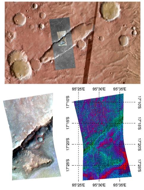
Durham, North Carolina, Students Study Martian Volcanism
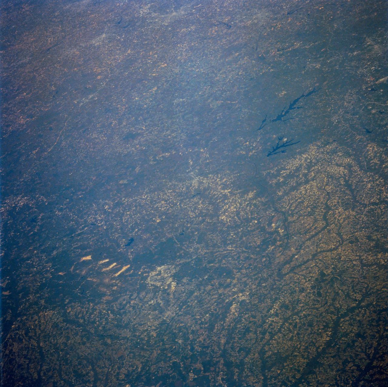
STS058-100-073 (18 Oct-1 Nov 1993) --- An unusually clear, northwestward view of central North Carolina shows the farms and timber of the inner coastal plain. The city of Fayetteville, and Fort Bragg to the west, is prominent at lower left center. The Research Triangle of Raleigh, Durham and Chapel Hill can be seen at upper right, upstream from Jordan Lake and Harris Lake on the New Hope River.

AS09-20-3128 (3-13 March 1969) --- Cape Hatteras, North Carolina, area as photographed from the Apollo 9 spacecraft during its Earth-orbital mission. Cape Lookout is near bottom of picture. Cape Hatteras juts the farthest out into the Atlantic. Largest inland body of water is Pamlico Sound; and to the north of it is Albemarle Sound.

AS09-20-3126 (3-13 March 1969) --- Oblique view of the U.S. South Atlantic coastal area as photographed from the Apollo 9 spacecraft during its Earth-orbital mission in March of 1969. This view shows area north from Goldsboro, North Carolina, looking over the Pamlico River and Albemarle Sound at the Portsmouth-Norfolk-Newport News area. The Delaware peninsula and New Jersey lie under snow. Long Island, New York, is barely visible under the clouds in the background. Richmond is left of center.

These images of mixing waters and moving ships off the North Carolina Coast were acquired by NASA Terra satellite on October 11, 2000 Terra orbit 4344.
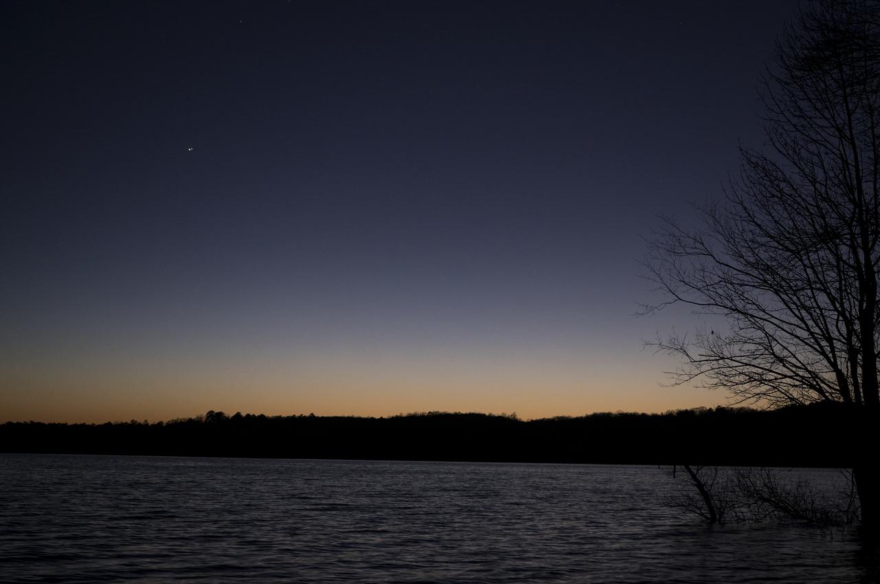
Jupiter, left, and Saturn, right, are seen after sunset above Jordan Lake during the “great conjunction” where the two planets appear a tenth of a degree apart from one another, Monday, Dec. 21, 2020, near Chapel Hill, North Carolina. Photo Credit: (NASA/Bill Ingalls)
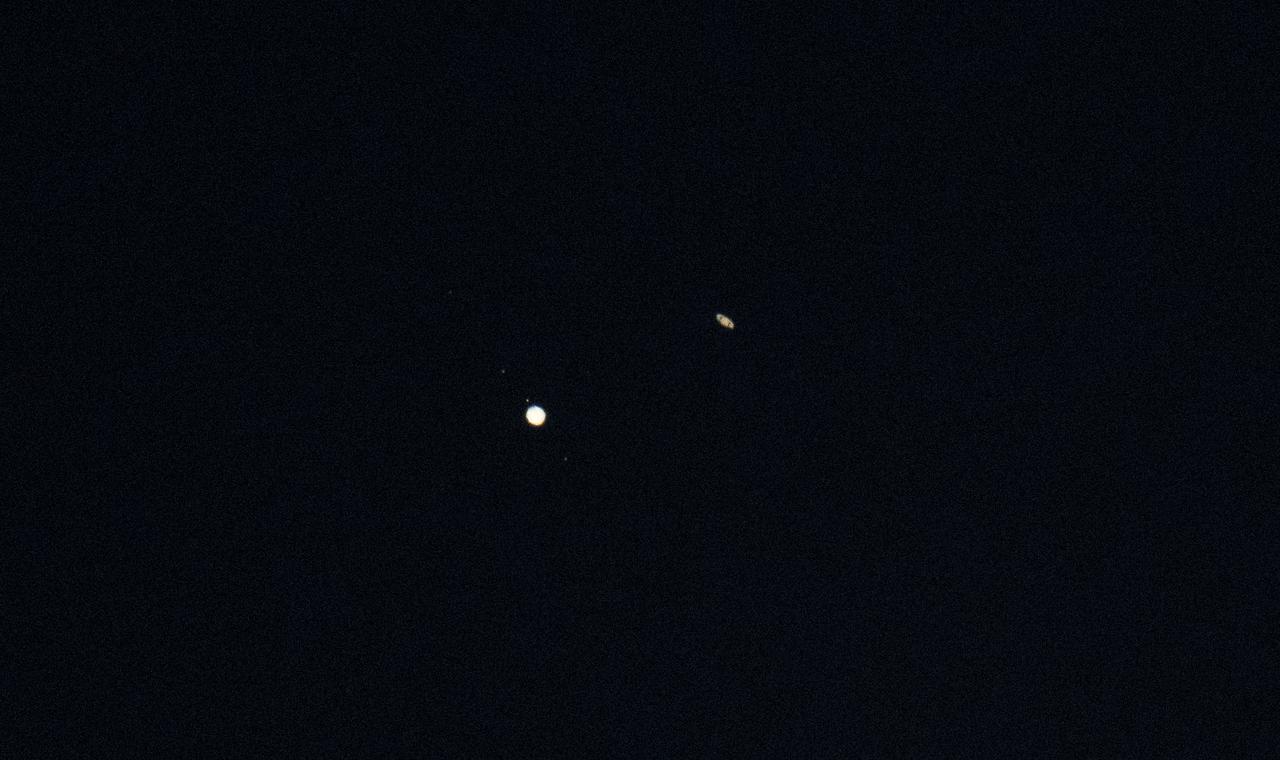
Jupiter, left, and Saturn, right, are seen during the “great conjunction” where the two planets appear a tenth of a degree apart from one another, Monday, Dec. 21, 2020, near Chapel Hill, North Carolina. Photo Credit: (NASA/Bill Ingalls)

ISS034-E-040247 (5 Feb. 2013) --- In the International Space Station’s Kibo laboratory, NASA astronaut Tom Marshburn, Expedition 34 flight engineer, uses a microphone to talk with students from his native home state. Speaking from the North Carolina Museum of Natural Sciences in Raleigh, the kids asked questions such as what it’s like to eat in space and work in stiff spacesuits.

A Mod-1 2000-kilowatt wind turbine designed by National Aeronautics and Space Administration (NASA) Lewis Research Center and constructed in Boone, North Carolina. The wind turbine program was a joint program between NASA and the Energy Research and Development Administration (ERDA) during the 1970s to develop less expensive forms of energy. NASA Lewis was assigned the responsibility of developing large horizontal-axis wind turbines. The program included a series of increasingly powerful wind turbines, designated: Mod-0A, Mod-1, WTS-4, and Mod-5. The program’s first device was a Mod-0 100-kilowatt wind turbine test bed at NASA’s Plum Brook Station. There were four Mod-0A 200-kilowatt turbines built in New Mexico, Hawaii, Puerto Rico, and Rhode Island. The 2000-kilowatt wind turbine in North Carolina, seen here, was the only Mod-1 machine constructed. The two-bladed, 200-foot diameter device was built in May 1979 and began operation that September. The Mod-1 turbine performed exceedingly well and was fully integrated into the local power grid. NASA researchers also used the North Carolina device to study its effect on noise and television transmission.
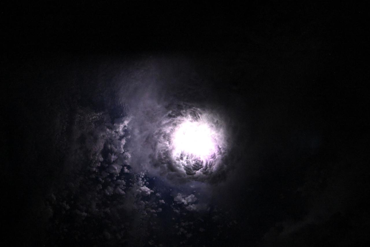
iss073e0080280 (May 15, 2025) --- This nebula-like formation is actually lightning illuminating the clouds during a storm off the coast of North Carolina in this photograph from the International Space Station as it orbited 260 miles above the Atlantic Ocean.

iss073e0080625 (May 15, 2025) --- This nebula-like formation is actually lightning illuminating the clouds during a storm off the coast of North Carolina in this photograph from the International Space Station as it orbited 260 miles above the Atlantic Ocean.
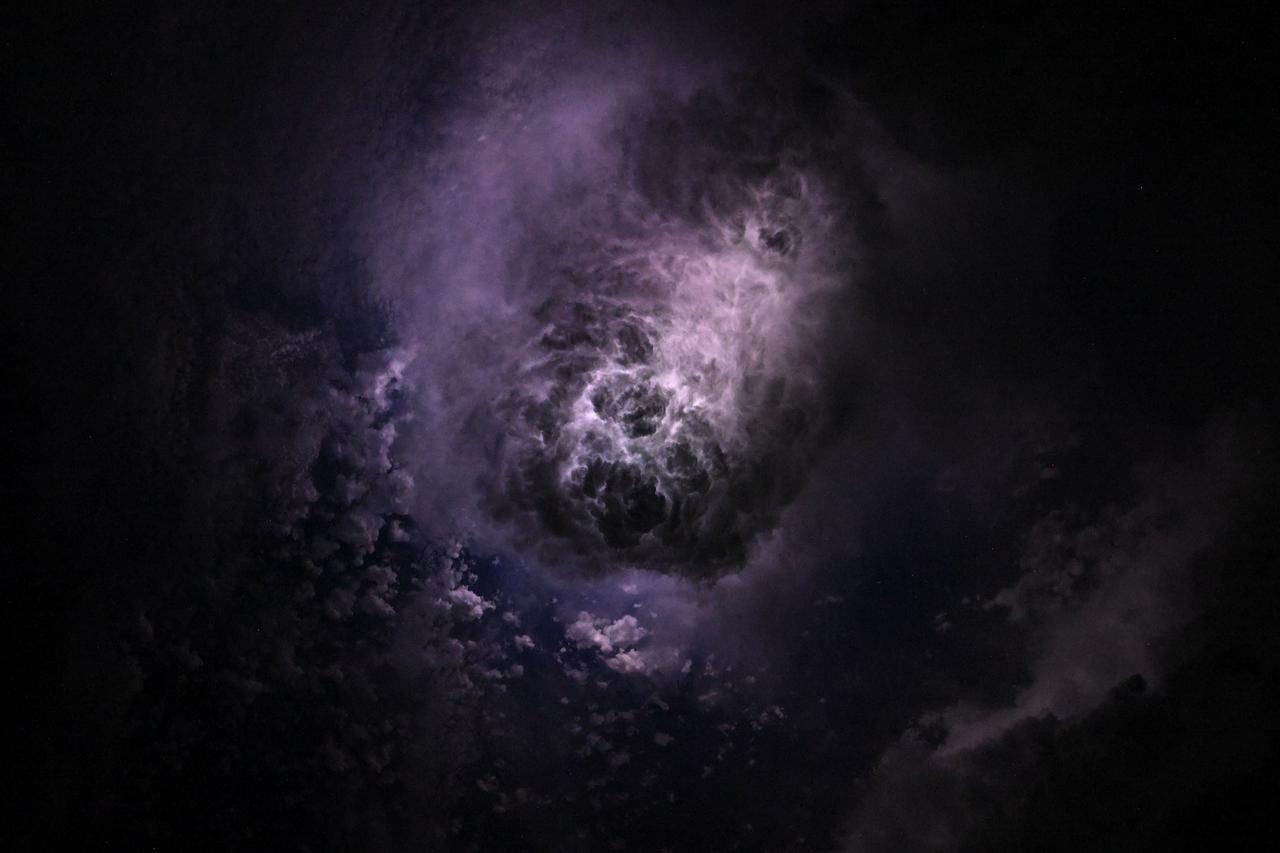
iss073e0080327 (May 15, 2025) --- This nebula-like formation is actually lightning illuminating the clouds during a storm off the coast of North Carolina in this photograph from the International Space Station as it orbited 260 miles above the Atlantic Ocean.
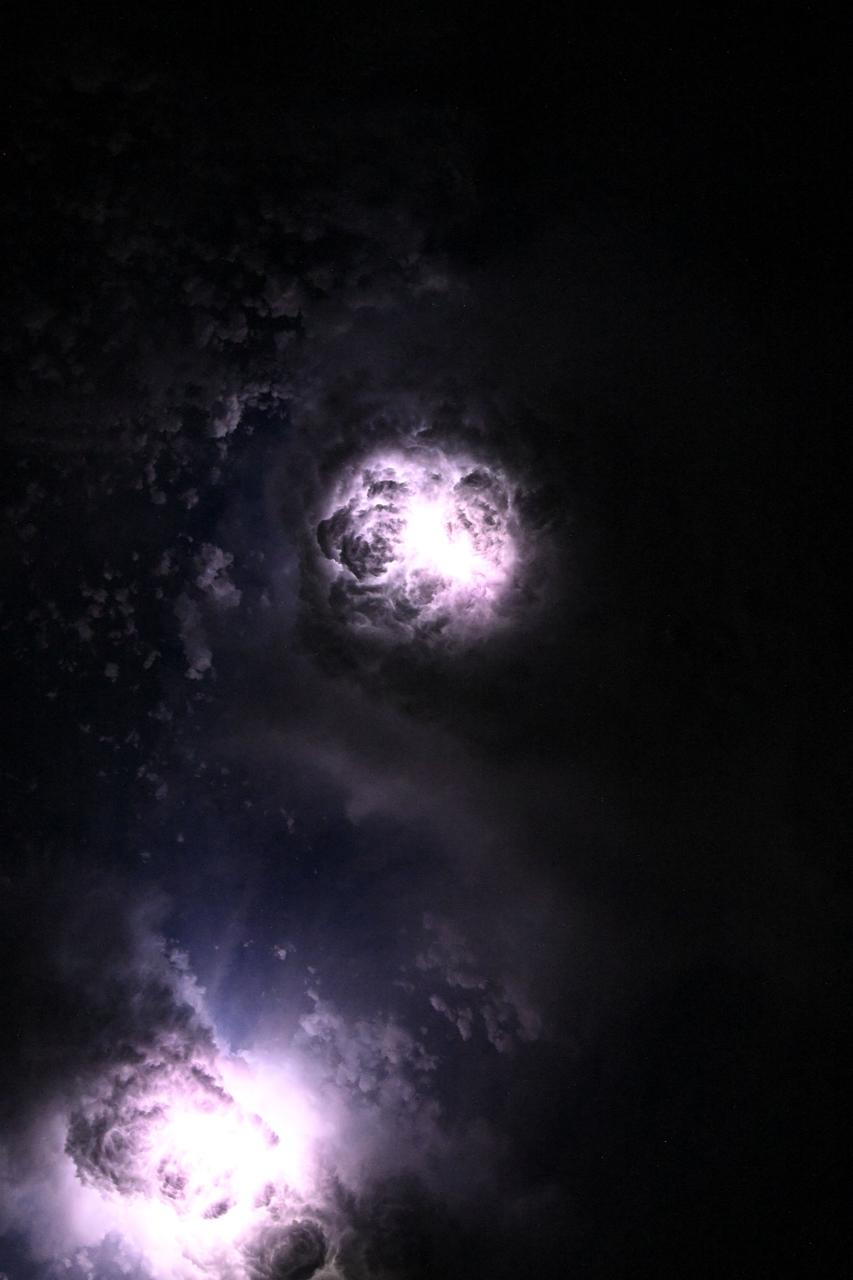
iss073e0081060 (May 15, 2025) --- This nebula-like formation is actually lightning illuminating the clouds during a storm off the coast of North Carolina in this photograph from the International Space Station as it orbited 260 miles above the Atlantic Ocean.
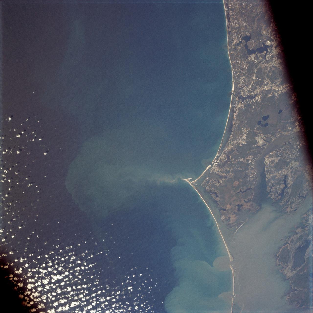
Vertical Earth Observation taken by the Apollo 9 crew. View is of North Carolina including Cape Lookout and Pamilco Sound. Film magazine was E,film type was SO-368 Ektachrome with 0.460 - 0.710 micrometers film / filter transmittance response and haze filter,80mm lens. Latitude was 34.35 N by Longitude 76.30 W, Overlap was 0%, Altitude miles were 116 and cloud cover was 15%.
NASA SeaWinds radar instrument eyed the center of a massive hurricane -- Floyd -- as it ripped past Georgia and the Carolinas Wednesday afternoon, September 15, then marched toward a midnight strike at Cape Fear, North Carolina.

Student dancers from the North Carolina School of the Arts dance "Jordan" from Sweet Fields, Choreographed by Twayle Tharp, as the Centerville High School Chorus sings during the National Tribute to Sally Ride at the John F. Kennedy Center for the Performing Arts, Monday, May 20, 2013 in Washington. Photo Credit: (NASA/Bill Ingalls)
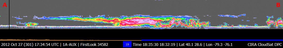
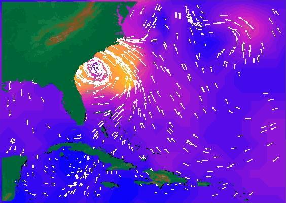
NASA CloudSat passed over Sandy at 10:32 a.m. EDT on Oct. 27, 2012. Light to moderate precipitation associated with parts of the outer bands of Hurricane Sandy were moving on shore into parts of North Carolina.
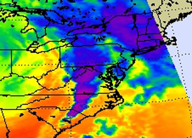
NASA Aqua satellite captured an infrared image of the storms on April 16, 2011 showing very cold, high cloud tops of the strong thunderstorms that spawned tornadoes in North Carolina and Virginia.

NASA Terra spacecraft passed over Hurricane Irene while it was just north of the Bahamas on Aug. 25, 2011. At the time, Irene was a category three hurricane making landfall in North Carolina on the morning of Aug. 27 as a category one hurricane.

iss059e038323 (April 30, 2019) --- Cape Lookout, North Carolina is pictured as the International Space Station orbited 256 miles above the United States' Atlantic coast.
ISS043E182257 (05/08/2015) --- Hurricane Anna moves onto the US east coast with 50 mile an hour winds and heavy rain. Anna moved first into just north of Myrtle Beach South Carolina and is moving toward North Carolina and later Virginia. This image was taken by the crew onboard the International Space Station, Expedition 43.
iss071e243849 (June 21, 2024) --- The east coast of the United States including North Carolina, Virginia, Maryland, Delaware, and New Jersey, is pictured from the International Space Station as it orbited 265 miles above the Atlantic Ocean.

iss056e162821 (Sept. 14, 2018) --- Hurricane Florence is pictured from the International Space Station as a category 1 storm as it was making landfall near Wrightsville Beach, North Carolina.

iss056e162811 (Sept. 14, 2018) --- Hurricane Florence is pictured from the International Space Station as a category 1 storm as it was making landfall near Wrightsville Beach, North Carolina.
iss056e162819 (Sept. 14, 2018) --- Hurricane Florence is pictured from the International Space Station as a category 1 storm as it was making landfall near Wrightsville Beach, North Carolina.
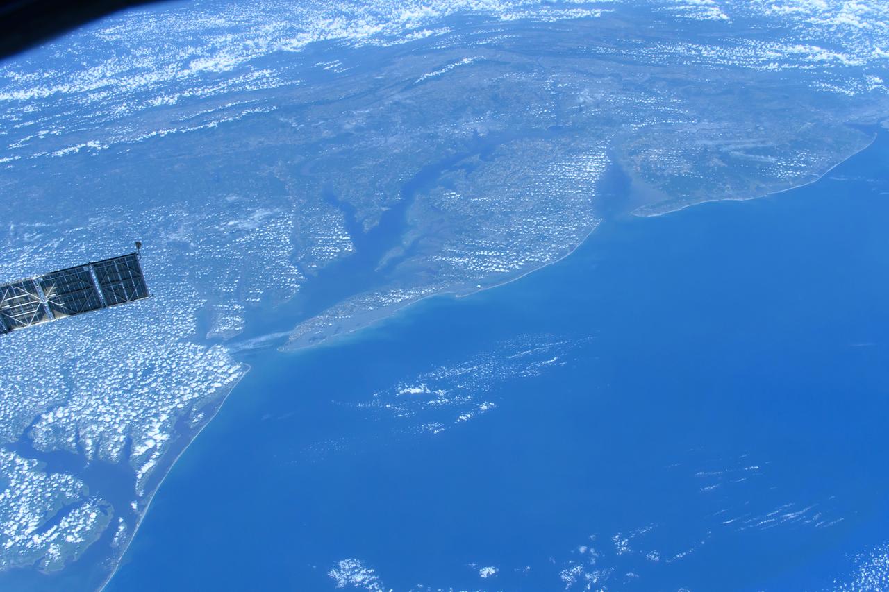
ISS006-E-50419 (2003) --- This digital still camera image of Cape Hatteras and Cape Lookout, North Carolina, with a Soyuz vehicle docked to the orbital outpost in the foreground was taken by Expedition 6 crewmember Don Pettit during his 5 1/2 month stay on the International Space Station (ISS). The largest inland body of water is Pamlico Sound. Kitty Hawk, on North Carolina's Outer Banks is also visible. On Dec. 17, 2003, the world celebrates a century of human flight with the anniversary of the Wright Brothers' first flight at Kitty Hawk. The brothers used the Outer Banks' prevailing winds and a 90-foot hill (Kill Devil Hill) to successfully demonstrate powered flight.

Charleston is the largest city in South Carolina, with almost 1 million people. It was founded in 1670 by the English. By 1690, it was the 5th largest city in North America. The 1699 earthquake and fire destroyed 1/3 of town. Malaria and yellow fever were endemic. The location attracted pirates. In 1860, South Carolina became the first state to declare secession from US. In 1886 a major earthquake damaged 2000 bldgs. More recently, in 1989 Hurricane Hugo devastated ¾ of homes in the historic district. The image was acquired August 15, 2023, covers an area of 18.1 by 18.6 km, and is located at 32.8 degrees north, 79.9 degrees west. https://photojournal.jpl.nasa.gov/catalog/PIA26507

iss056e162187 (Sept. 12, 2018) --- Cameras outside the International Space Station captured a stark and sobering view of Hurricane Florence the morning of Sept. 12 as it churned across the Atlantic in a west-northwesterly direction with winds of 130 miles an hour. The National Hurricane Center forecasts additional strengthening for Florence before it reaches the coastline of North Carolina and South Carolina early Friday, Sept. 14.

iss056e162190 (Sept. 12, 2018) --- Cameras outside the International Space Station captured a stark and sobering view of Hurricane Florence the morning of Sept. 12 as it churned across the Atlantic in a west-northwesterly direction with winds of 130 miles an hour. The National Hurricane Center forecasts additional strengthening for Florence before it reaches the coastline of North Carolina and South Carolina early Friday, Sept. 14.

iss056e162202 (Sept. 12, 2018) --- Cameras outside the International Space Station captured a stark and sobering view of Hurricane Florence the morning of Sept. 12 as it churned across the Atlantic in a west-northwesterly direction with winds of 130 miles an hour. The National Hurricane Center forecasts additional strengthening for Florence before it reaches the coastline of North Carolina and South Carolina early Friday, Sept. 14.

iss056e162175 (Sept. 12, 2018) --- Cameras outside the International Space Station captured a stark and sobering view of Hurricane Florence the morning of Sept. 12 as it churned across the Atlantic in a west-northwesterly direction with winds of 130 miles an hour. The National Hurricane Center forecasts additional strengthening for Florence before it reaches the coastline of North Carolina and South Carolina early Friday, Sept. 14.

iss056e162207 (Sept. 12, 2018) --- Cameras outside the International Space Station captured a stark and sobering view of Hurricane Florence the morning of Sept. 12 as it churned across the Atlantic in a west-northwesterly direction with winds of 130 miles an hour. The National Hurricane Center forecasts additional strengthening for Florence before it reaches the coastline of North Carolina and South Carolina early Friday, Sept. 14.

iss056e162178 (Sept. 12, 2018) --- Cameras outside the International Space Station captured a stark and sobering view of Hurricane Florence the morning of Sept. 12 as it churned across the Atlantic in a west-northwesterly direction with winds of 130 miles an hour. The National Hurricane Center forecasts additional strengthening for Florence before it reaches the coastline of North Carolina and South Carolina early Friday, Sept. 14.

Artists Bob and Louise McCall in their Paradise Valley, Arizona studio, in front of "Celebrating One Hundred Years of Powered Flight 1903-2003." The mural was created to celebrate the achievements of Wilbur and Orville Wright and to commemorate a century of powered flight. Many of the epic flights represented in the painting took place in the skies over NASA Dryden Flight Research Center. An equally important goal of this celebration is to encourage the values that have characterized 100 years of aviation history: ingenuity, inventiveness, persistence, creativity and courage. These values hold true not just for pioneers of flight, but also for all pioneers of invention and innovation, and they will remain an important part of America's future. "Celebrating One Hundred Years of Powered Flight, 1903-2003", documents many significant achievements in aeronautics and space flight from the dawn of powered flight to the present. Historic aircraft and spacecraft serve as the backdrop, highlighting six figures representing the human element that made these milestones possible. These figures stand, symbolically supported by the words of Wilbur Wright, "It is my belief that flight is possible…" The quote was taken from a letter written to his father on September 3rd, 1900, announcing Wilbur's intention to make "some experiments with a flying machine" at Kitty Hawk, North Carolina. "This year, Bob is helping us commemorate the Centennial of Flight with a beautiful mural slated for placement in our Dryden Flight Research Center that documents the history of flight from the Wright Flyer to the International Space Station. We should all take note, I think, that in the grand scheme of things, one hundred years is a very short period of time. In that blink of an eye we've gone from Kitty Hawk to Tranquility Base and now look forward to our rovers traversing the surface of Mars. Despite the challenges we face, the future we envision, like the future depicted in the artwork of Bo
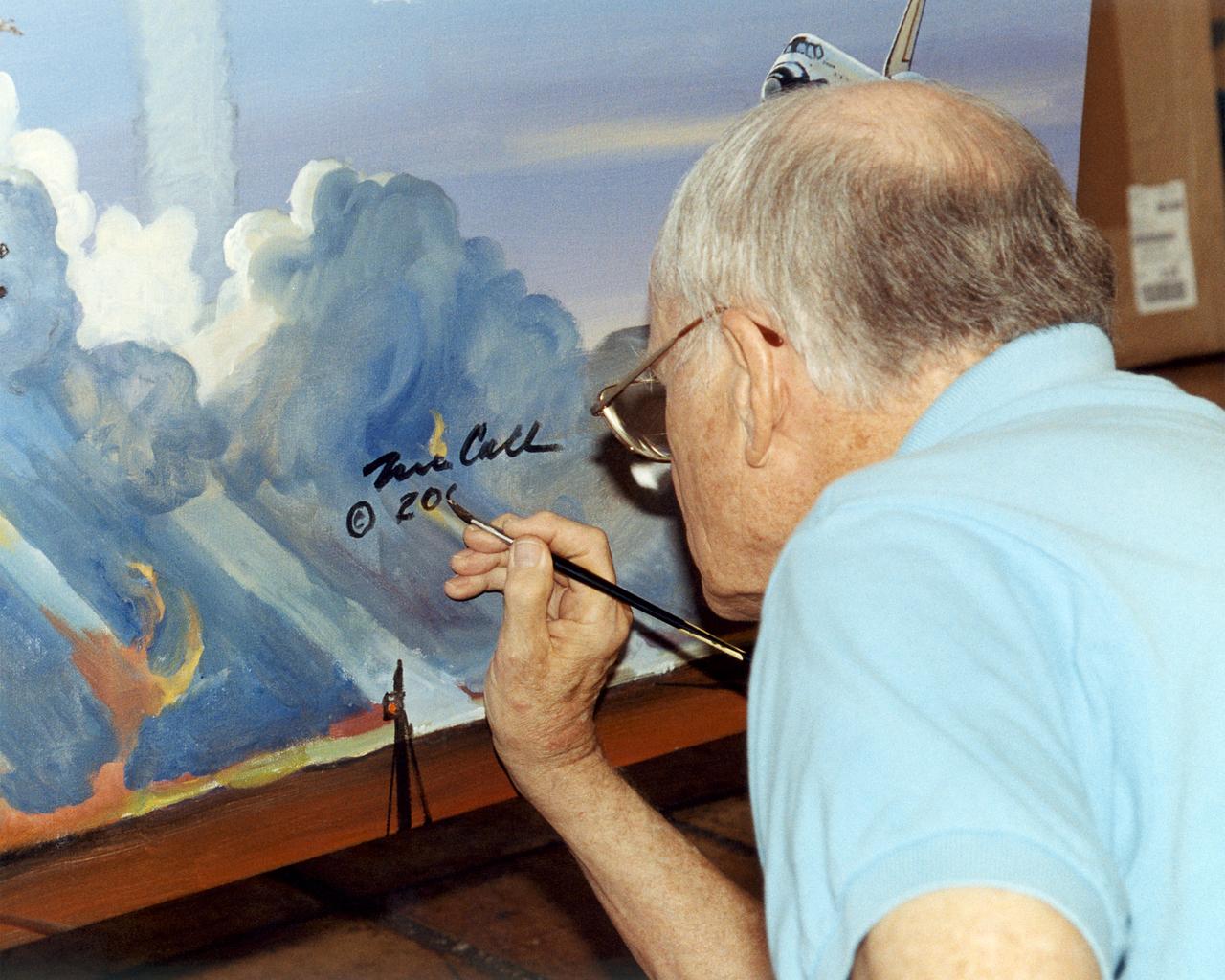
Artist Bob McCall signs the Centennial of Flight Mural in his Paradise Valley, Arizona Studio. The mural was created to celebrate the achievements of Wilbur and Orville Wright and to commemorate a century of powered flight. Many of the epic flights represented in the painting took place in the skies over NASA Dryden Flight Research Center. An equally important goal of this celebration is to encourage the values that have characterized 100 years of aviation history: ingenuity, inventiveness, persistence, creativity and courage. These values hold true not just for pioneers of flight, but also for all pioneers of invention and innovation, and they will remain an important part of America's future. "Celebrating One Hundred Years of Powered Flight, 1903-2003", documents many significant achievements in aeronautics and space flight from the dawn of powered flight to the present. Historic aircraft and spacecraft serve as the backdrop, highlighting six figures representing the human element that made these milestones possible. These figures stand, symbolically supported by the words of Wilbur Wright, "It is my belief that flight is possible…" The quote was taken from a letter written to his father on September 3rd, 1900, announcing Wilbur's intention to make "some experiments with a flying machine" at Kitty Hawk, North Carolina. "This year, Bob is helping us commemorate the Centennial of Flight with a beautiful mural slated for placement in our Dryden Flight Research Center that documents the history of flight from the Wright Flyer to the International Space Station. We should all take note, I think, that in the grand scheme of things, one hundred years is a very short period of time. In that blink of an eye we've gone from Kitty Hawk to Tranquility Base and now look forward to our rovers traversing the surface of Mars. Despite the challenges we face, the future we envision, like the future depicted in the artwork of Bob McCall, is a future of boundless possibility. "

The mural was created to celebrate the achievements of Wilbur and Orville Wright and to commemorate a century of powered flight. Central to the composition is the 1903 Wright Flyer. "On Dec. 17, 1903, the Wright brothers inaugurated the aerial age with their successful first flights of a heavier-than-air flying machine at Kitty Hawk, N.C. This airplane, known as the Wright Flyer, sometimes referred to as the Kitty Hawk Flyer, was the product of a sophisticated four-year program of research and development conducted by Wilbur and Orville Wright beginning in 1899. During the Wrights' design and construction of their experimental aircraft, they also pioneered many of the basic tenets and techniques of modern aeronautical engineering, such as the use of a wind tunnel and flight testing as design tools. Their seminal accomplishment encompassed not only the breakthrough first flight of an airplane, but also the equally important achievement of establishing the foundation of aeronautical engineering." Dr. Peter Jakab, Curator of Aviation, National Air and Space Museum, Smithsonian Institution "Celebrating One Hundred Years of Powered Flight, 1903-2003", documents many significant achievements in aeronautics and space flight from the dawn of powered flight to the present. Historic aircraft and spacecraft serve as the backdrop, highlighting six figures representing the human element that made these milestones possible. These figures stand, symbolically supported by the words of Wilbur Wright, "It is my belief that flight is possible…" The quote was taken from a letter written to his father on September 3rd, 1900, announcing Wilbur's intention to make "some experiments with a flying machine" at Kitty Hawk, North Carolina. "This year, Bob is helping us commemorate the Centennial of Flight with a beautiful mural slated for placement in our Dryden Flight Research Center that documents the history of flight from the Wright Flyer to the International Space Station. We should

iss070e015193 (Oct. 29, 2023) --- The gleaming Atlantic coast of North Carolina, from the cities of Kitty Hawk (far left) to Wilmington (far right), is pictured from the International Space Station as it orbited 261 miles above the eastern United States.

ISS028-E-034022 (27 Aug. 2011) --? One of the Expedition 28 crew members aboard the International Space Station photographed this panoramic view of Hurricane Irene looking northeastward from Florida over the open Atlantic on the afternoon of the day before it struck the Cape Hatteras, North Carolina area as a Category 2 storm.
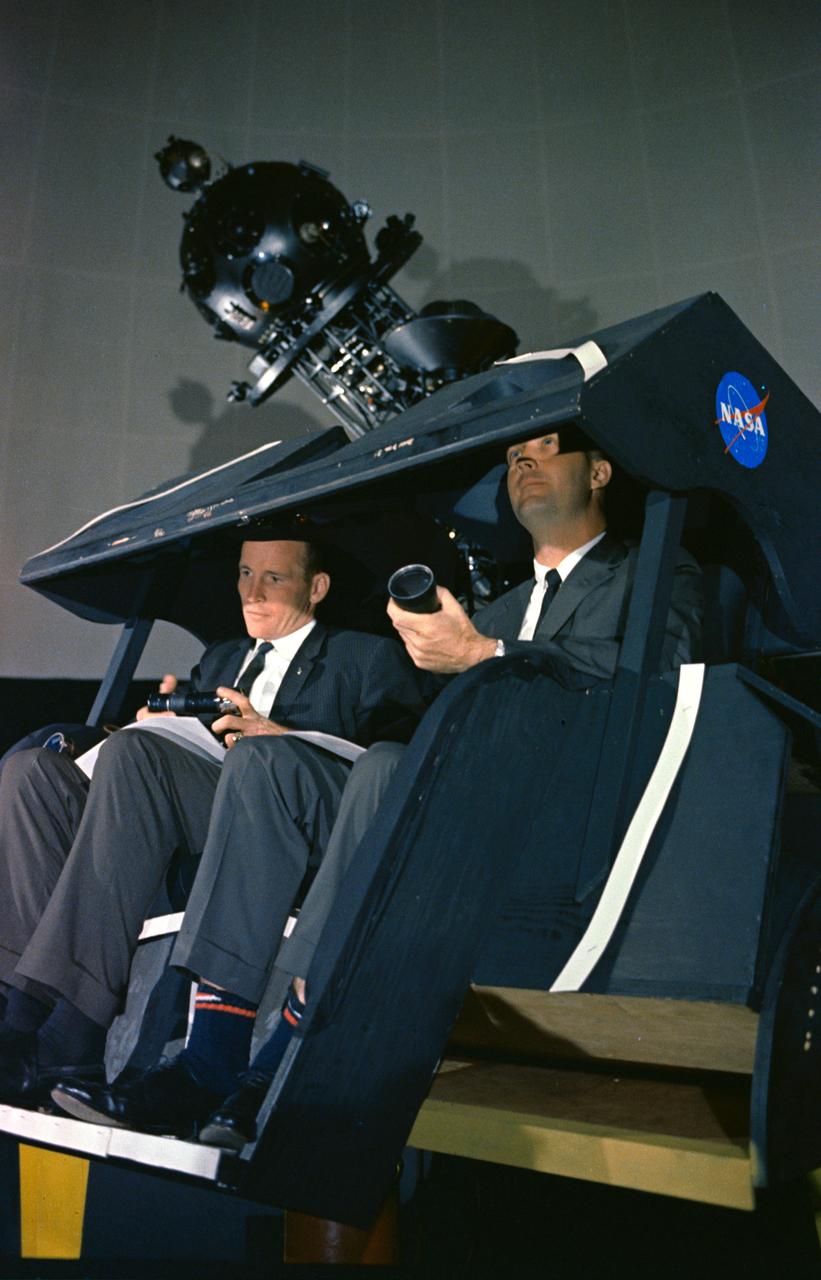
S65-29652 (7 May 1965) --- Astronauts James A. McDivitt (right) and Edward H. White II are shown at the Morehead Planetarium in North Carolina, checking out celestial navigation equipment as part of their training for the Gemini-Titan 4 mission. The NASA Headquarters alternative photo number is 65-H-277.

iss062e046715 (Feb. 22, 2020) --- This oblique view of the eastern United States highlights the coasts (bottom left to top right) of New Jersey, Delaware, Maryland, Virginia and North Carolina. The International Space Station was orbiting 265 miles above Canada when this photograph was taken by an Expedition 62 crewmember.

iss066e125232 ?(Jan. 23, 2022) --- The east coast of the United States is pictured looking from Pamlico Sound in North Carolina, at bottom, to the panhandle of Florida, at top, in this photogrpah taken from the International Space Station as it orbited 259 miles above the Atlantic Ocean.

At about 6:00 a.m. EDT (10:00 UTC) on May 10, 2015, Tropical Storm Ana made landfall between Myrtle Beach and North Myrtle Beach, South Carolina. One day earlier, on the morning of May 9, the Moderate Resolution Imaging Spectroradiometer (MODIS) on NASA’s Terra satellite acquired this true-color image of the storm off the coast of the Carolinas. At the time, Ana had just evolved from a subtropical storm to a tropical storm with maximum sustained winds of 93 kilometers (58 miles) per hour. Ana’s life ashore was brief – the storm was downgraded to a tropical depression at 2:00 p.m. EDT (14:00 UTC) on May 10. During that time, parts of South Carolina and eastern North Carolina was drenched with heavy rain – some areas reported over 6 inches of rainfall – and heavy winds. A water spout was reported in Dare County, North Carolina, and the storm contributed to significant beach erosion along the coast. Credit: NASA/GSFC/Jeff Schmaltz/MODIS Land Rapid Response Team <b><a href="http://www.nasa.gov/audience/formedia/features/MP_Photo_Guidelines.html" rel="nofollow">NASA image use policy.</a></b> <b><a href="http://www.nasa.gov/centers/goddard/home/index.html" rel="nofollow">NASA Goddard Space Flight Center</a></b> enables NASA’s mission through four scientific endeavors: Earth Science, Heliophysics, Solar System Exploration, and Astrophysics. Goddard plays a leading role in NASA’s accomplishments by contributing compelling scientific knowledge to advance the Agency’s mission. <b>Follow us on <a href="http://twitter.com/NASAGoddardPix" rel="nofollow">Twitter</a></b> <b>Like us on <a href="http://www.facebook.com/pages/Greenbelt-MD/NASA-Goddard/395013845897?ref=tsd" rel="nofollow">Facebook</a></b> <b>Find us on <a href="http://instagrid.me/nasagoddard/?vm=grid" rel="nofollow">Instagram</a></b>

CAPE CANAVERAL, Fla. – Inside the Space Life Sciences Laboratory, or SLSL, at NASA’s Kennedy Space Center in Florida, Dr. Matthew Mickens, a plant biologist from North Carolina Agriculture and Technical State University in North Carolina, measures radish plants that were just harvested from a plant growth chamber. The plants were grown under red and blue LED lights. The plant experiment at Kennedy is part of the Advanced Exploration Systems, or AES, program in NASA’s Human Exploration and Operations Mission Directorate. This plant experiment studies the effects of different types of lighting on plants such as radishes and leaf lettuce. Results of these studies will help provide information on how to grow food sources for deep space exploration missions. AES projects pioneer new approaches for rapidly developing prototype systems, demonstrating key capabilities and validating operational concepts for future human missions beyond Earth orbit. Photo credit: NASA/Frank Ochoa-Gonzales

CAPE CANAVERAL, Fla. – Inside the Space Life Sciences Laboratory, or SLSL, at NASA’s Kennedy Space Center in Florida, Dr. Matthew Mickens, a plant biologist from North Carolina Agriculture and Technical State University in North Carolina, measures radish plants that were just harvested from a plant growth chamber. The plants were grown under red and blue LED lights. The plant experiment at Kennedy is part of the Advanced Exploration Systems, or AES, program in NASA’s Human Exploration and Operations Mission Directorate. This plant experiment studies the effects of different types of lighting on plants such as radishes and leaf lettuce. Results of these studies will help provide information on how to grow food sources for deep space exploration missions. AES projects pioneer new approaches for rapidly developing prototype systems, demonstrating key capabilities and validating operational concepts for future human missions beyond Earth orbit. Photo credit: NASA/Frank Ochoa-Gonzales

KENNEDY SPACE CENTER, FLA. - Two blue-winged teals swim in a pond near KSC. The species prefers marshes and shallow ponds and lakes for nesting and range from Canada to North Carolina, the Gulf Coast and Southern California, as well as Florida. KSC shares a boundary with the National Merritt Island Wildlife Refuge, which provides wintering areas for 23 species of migratory waterfowl, as well as a year-round home for great blue herons, great egrets, wood storks, cormorants, brown pelicans and other species of marsh and shore birds.

KENNEDY SPACE CENTER, FLA. -- A female anhinga roosts in branches near the water. Anhingas can be found in freshwater ponds and swamps where there is thick vegetation and tall trees. Male anhingas are black and gray; females are distinguished by a buff-colored neck and breast. When anhingas are in their breeding plumage they have a blue ring around their eyes, as seen here. The female lays three to five light blue eggs. The nest is in a tree and it is made of sticks and lined with leaves. The chicks hatch in about a month. Anhingas breed off the Gulf Coast and the Atlantic Coast from North Carolina to Texas and in the Mississippi Valley north to Kentucky and Missouri. They winter along the Gulf Coast north to North Carolina. The anhinga diet is primarily fish. Using their sharp bills, anhingas spear the fish, flip them in the air and swallow them head-first. KSC shares a boundary with the Merritt Island Wildlife Nature Refuge. The refuge is a habitat for more than 310 species of birds, 25 mammals, 117 fishes and 65 amphibians and reptiles. In addition, the Refuge supports 19 endangered or threatened wildlife species on Federal or State lists, more than any other single refuge in the U.S. Photo credit: NASA/Dimitri Gerondidakis
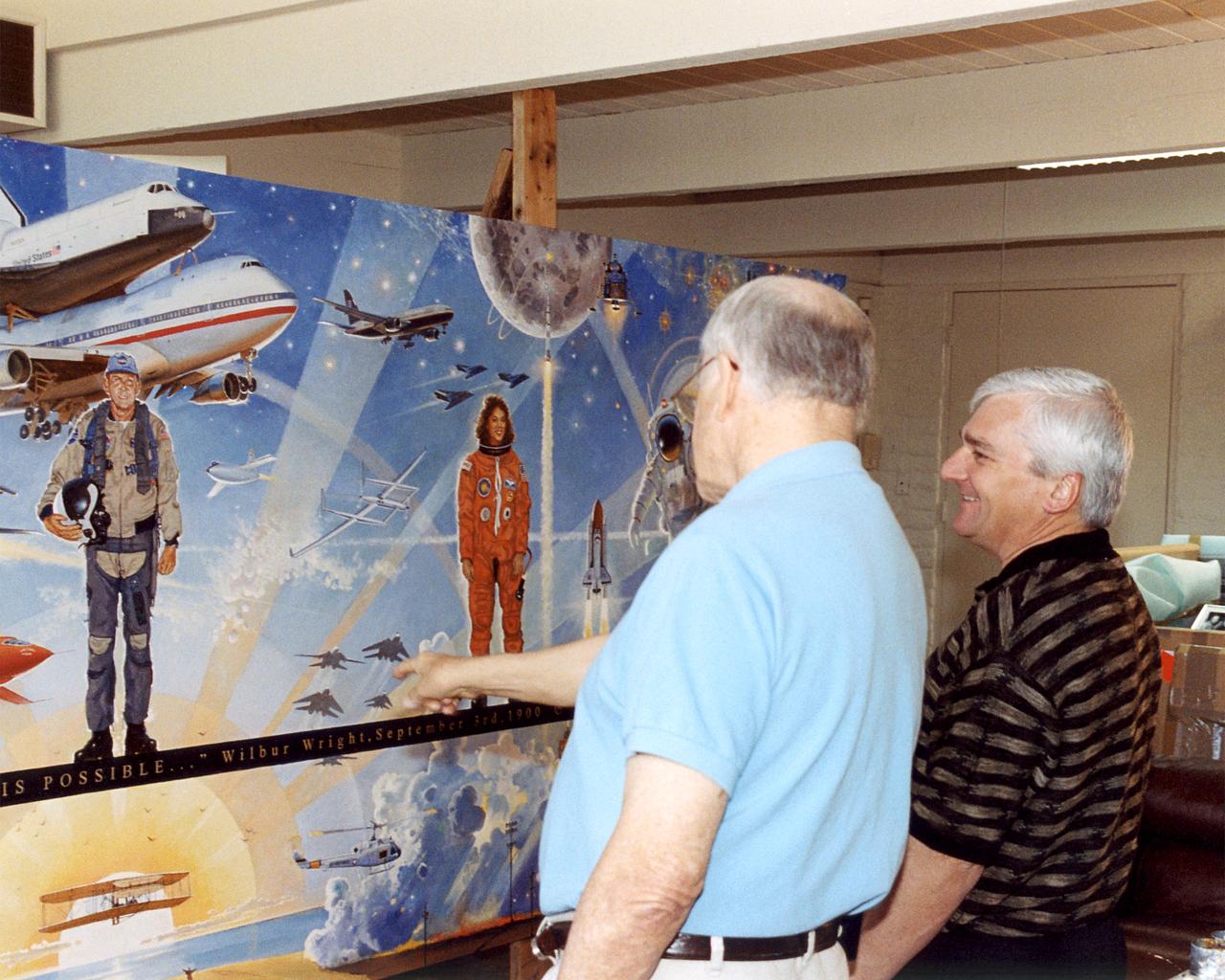
Bob Mccall and NASA Dryden Director Kevin Petersen stand by "Celebrating One Hundred Years of Powered Flight, 1903-2003", in the artist's studio in Paradise Valley, Arizona. The mural was created to celebrate the achievements of Wilbur and Orville Wright and to commemorate a century of powered flight. Many of the epic flights represented in the painting took place in the skies over NASA Dryden Flight Research Center. An equally important goal of this celebration will be to encourage the values that have characterized 100 years of aviation history: ingenuity, inventiveness, persistence, creativity and courage. These values hold true not just for pioneers of flight, but also for all pioneers of invention and innovation, and they will remain an important part of America's future. "Celebrating One Hundred Years of Powered Flight, 1903-2003", documents many significant achievements in aeronautics and space flight from the dawn of powered flight to the present. Historic aircraft and spacecraft serve as the backdrop, highlighting six figures representing the human element that made these milestones possible. These figures stand, symbolically supported by the words of Wilbur Wright, "It is my belief that flight is possible…" The quote was taken from a letter written to his father on September 3rd, 1900, announcing Wilbur's intention to make "some experiments with a flying machine" at Kitty Hawk, North Carolina. "This year, Bob is helping us commemorate the Centennial of Flight with a beautiful mural slated for placement in our Dryden Flight Research Center that documents the history of flight from the Wright Flyer to the International Space Station. We should all take note, I think, that in the grand scheme of things, one hundred years is a very short period of time. In that blink of an eye we've gone from Kitty Hawk to Tranquility Base and now look forward to our rovers traversing the surface of Mars. Despite the challenges we face, the future we envision, like the fu
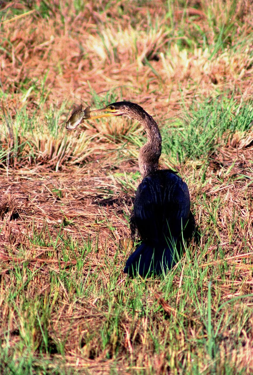
KENNEDY SPACE CENTER, FLA. -- Spotted in the Merritt Island National Wildlife Refuge, which shares a boundary with the space center, an anhinga captures a fish in its long, dagger-shaped bill. It is also known as the "snakebird" because in the water its body is submerged so that only its head and long, slender neck are visible. Ranging the Atlantic and Gulf Coasts from North Carolina to Texas, north in the Mississippi Valley to Arkansas and Tennessee, and in the South to South America, it inhabits freshwater ponds and swamps with thick vegetation. They are often seen with wings half-open, drying them in the sun since they lack oil glands with which to preen
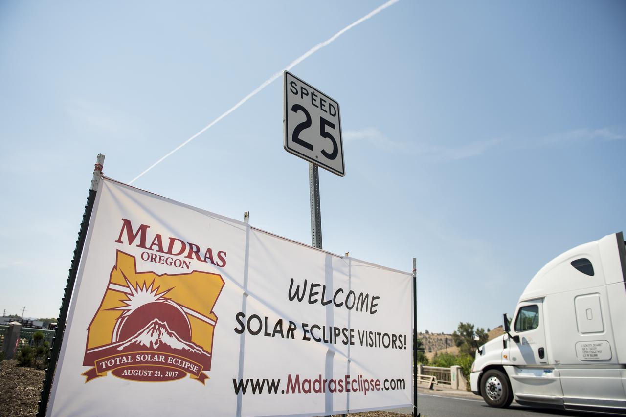
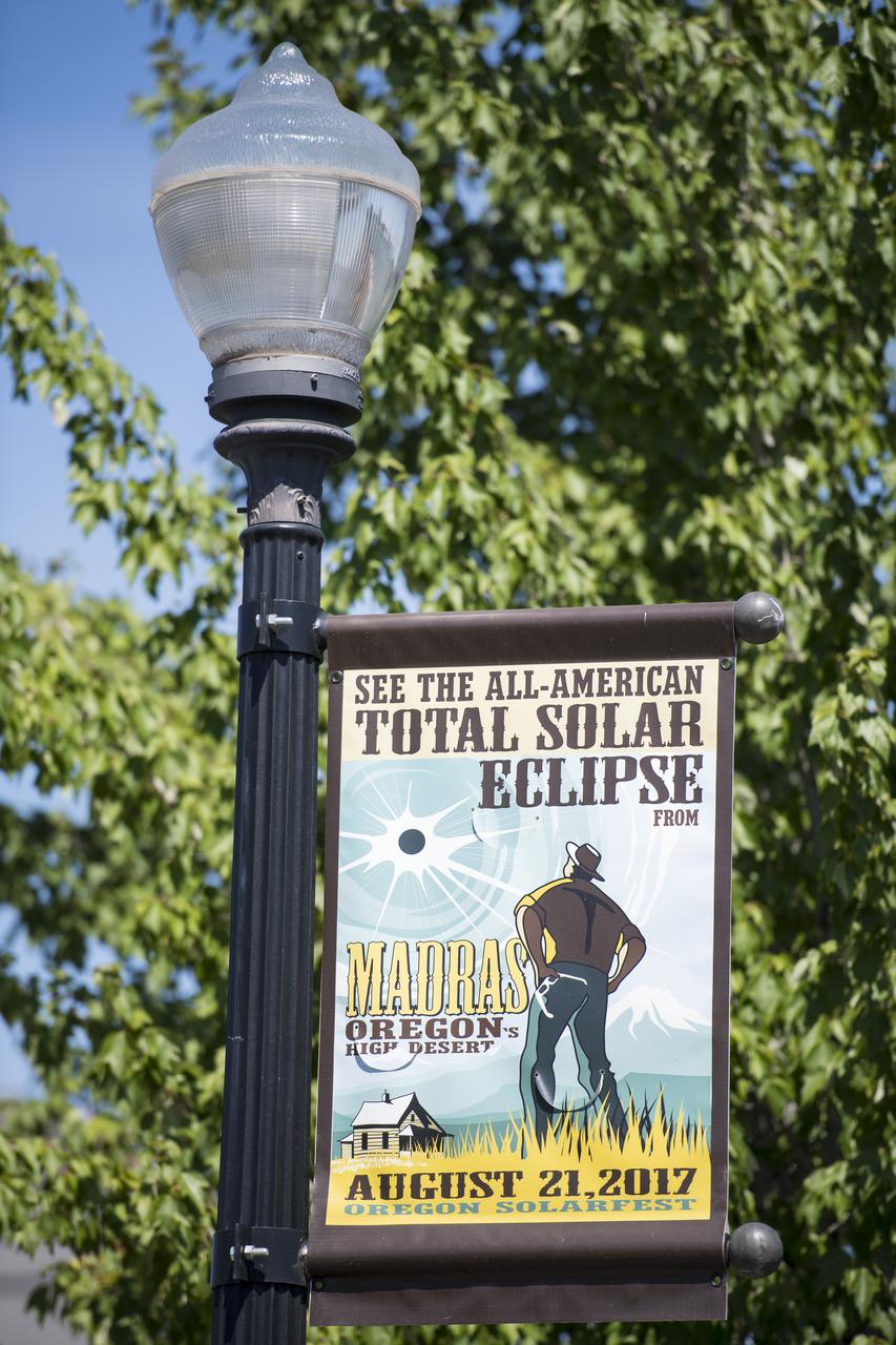
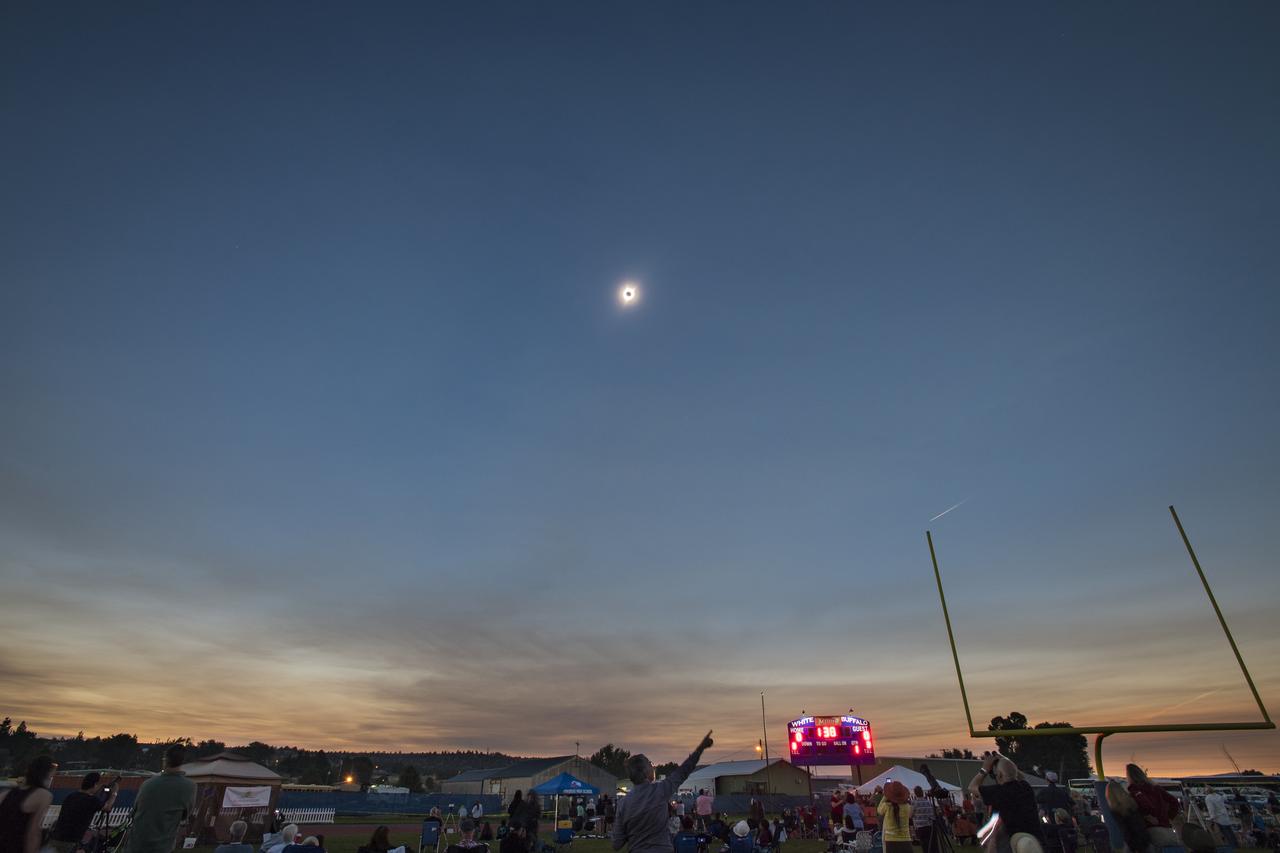
A welcome sign is seen along the roads in Madras, Oregon, where thousands of visitors are expected for the total solar eclipse, Saturday, August 19, 2017. The eclipse will be sweeping across a narrow portion of the contiguous United States from Lincoln Beach, Oregon to Charleston, South Carolina on August 21. A partial solar eclipse will be visible across the entire North American continent along with parts of South America, Africa, and Europe. Photo Credit: (NASA/Aubrey Gemignani)

KENNEDY SPACE CENTER, FLA. -- An immature -- therefore white -- Little Blue Heron (center, with black bill) joins Roseate Spoonbills and a pair of Great Egrets in a lake near Kennedy Space Center. The heron ranges along the east coast of the United States, from New York to Texas, inland to Oklahoma. It winters from South Carolina to South America. For habitat the Little Blue Heron prefers freshwater swamps and lagoons in the South, coastal thickets on islands in the North. The species is often observed in large mixed concentrations of herons and egrets

A boy watches the total solar eclipse through protective glasses in Madras, Oregon on Monday, Aug. 21, 2017. A total solar eclipse swept across a narrow portion of the contiguous United States from Lincoln Beach, Oregon to Charleston, South Carolina. A partial solar eclipse was visible across the entire North American continent along with parts of South America, Africa, and Europe. Photo Credit: (NASA/Aubrey Gemignani)

People are seen as they watch a total solar eclipse through protective glasses in Madras, Oregon on Monday, Aug. 21, 2017. A total solar eclipse swept across a narrow portion of the contiguous United States from Lincoln Beach, Oregon to Charleston, South Carolina. A partial solar eclipse was visible across the entire North American continent along with parts of South America, Africa, and Europe. Photo Credit: (NASA/Aubrey Gemignani)

People are seen as they watch a total solar eclipse through protective glasses in Madras, Oregon on Monday, Aug. 21, 2017. A total solar eclipse swept across a narrow portion of the contiguous United States from Lincoln Beach, Oregon to Charleston, South Carolina. A partial solar eclipse was visible across the entire North American continent along with parts of South America, Africa, and Europe. Photo Credit: (NASA/Aubrey Gemignani)
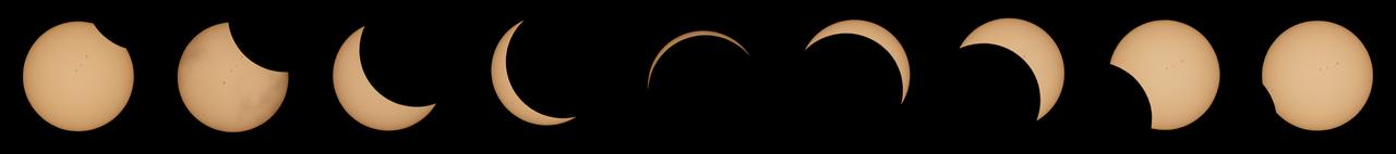
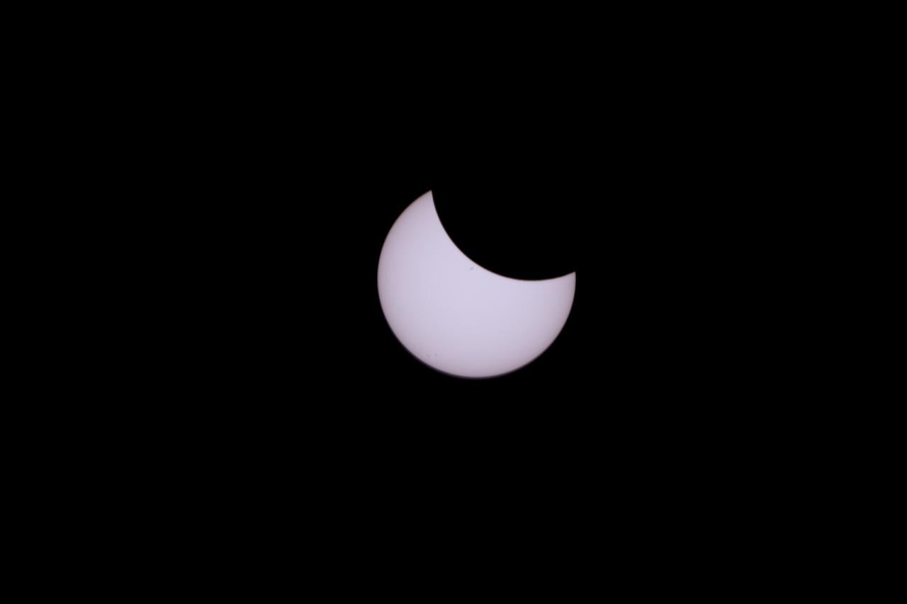
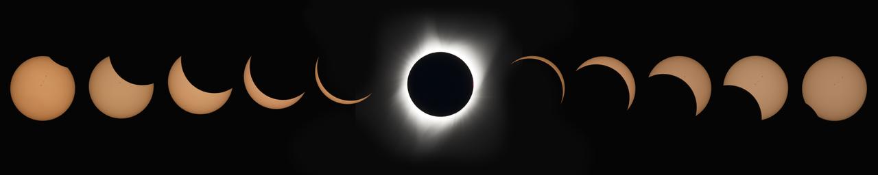
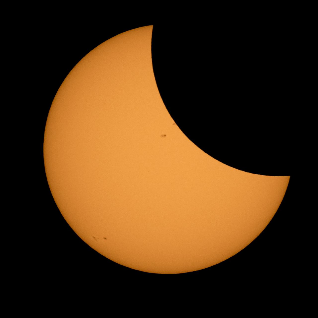
This composite image of nine pictures shows the progression of a partial solar eclipse near Banner, Wyoming on Monday, Aug. 21, 2017. A total solar eclipse swept across a narrow portion of the contiguous United States from Lincoln Beach, Oregon to Charleston, South Carolina. A partial solar eclipse was visible across the entire North American continent along with parts of South America, Africa, and Europe. Photo Credit: (NASA/Joel Kowsky)
View of the partial solar eclipse from NASA's Goddard Space Flight Center in Greenbelt, Md on Monday, August 21, 2017. A total solar eclipse swept across a narrow portion of the contiguous United States from Lincoln Beach, Oregon to Charleston, South Carolina. A partial solar eclipse was visible across the entire North American continent along with parts of South America, Africa, and Europe. Credit: NASA/Goddard/Rebecca Roth
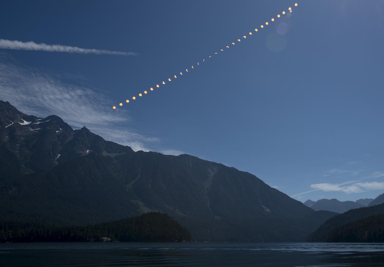
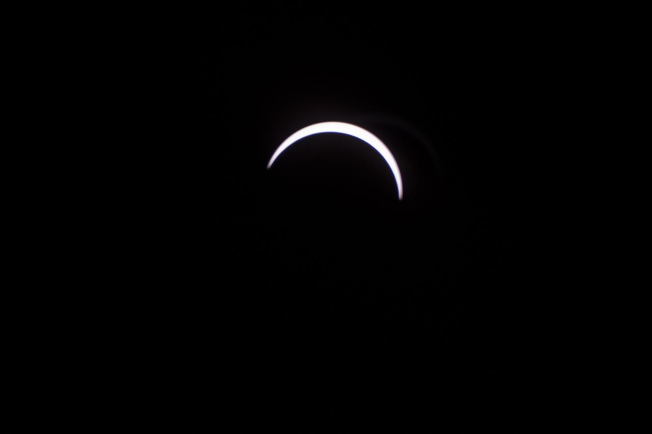
The Moon is seen as it starts passing in front of the Sun during a solar eclipse from Ross Lake, Northern Cascades National Park, Washington on Monday, Aug. 21, 2017. A total solar eclipse swept across a narrow portion of the contiguous United States from Lincoln Beach, Oregon to Charleston, South Carolina. A partial solar eclipse was visible across the entire North American continent along with parts of South America, Africa, and Europe. Photo Credit: (NASA/Bill Ingalls)
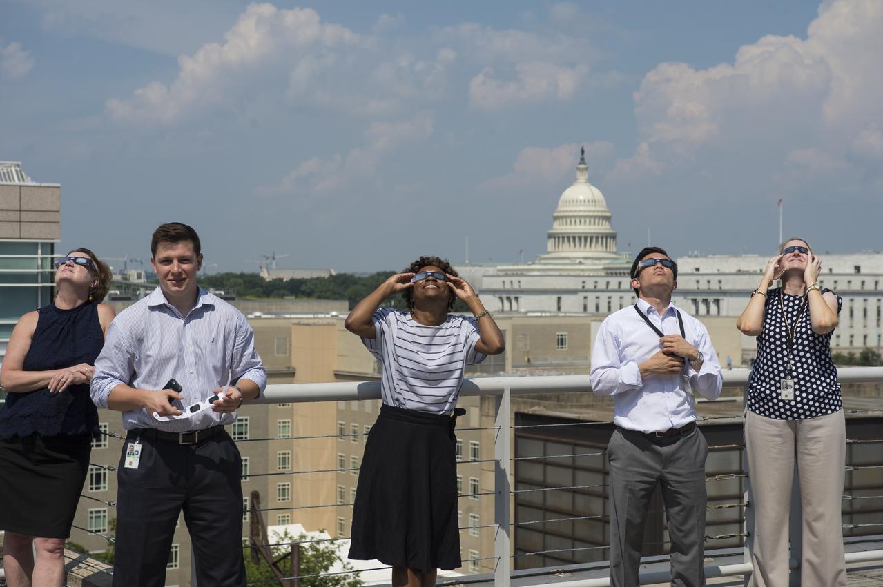
NASA employees and contractors use protective glasses to view a partial solar eclipse from NASA Headquarters Tuesday, Aug. 22, 2017 in Washington. A total solar eclipse swept across a narrow portion of the contiguous United States from Lincoln Beach, Oregon to Charleston, South Carolina. A partial solar eclipse was visible across the entire North American continent along with parts of South America, Africa, and Europe. Photo Credit: (NASA/Gwen Pitman)

jsc2023e038728 (6/22/2023) --- Students hold Hoshi-Tomo badges at The Japanese Language School in Charlotte, North Carolina. Two types of Hoshi-Tomo badges were designed by students. “Hoshi” implies star(s), planet(s), or the Earth in Japanese. “Tomo” means friend(s) in Japanese. I-Space Essay provides students and teachers the online opportunity to create wishes, which are delivered to the International Space Station's Japanese Experimental Module Kibo. Image courtesy of Mitsumura-Tosho and IHI Corporation.
This composite image shows the progression of a partial solar eclipse over Ross Lake, in Northern Cascades National Park, Washington on Monday, Aug. 21, 2017. A total solar eclipse swept across a narrow portion of the contiguous United States from Lincoln Beach, Oregon to Charleston, South Carolina. A partial solar eclipse was visible across the entire North American continent along with parts of South America, Africa, and Europe. Photo Credit: (NASA/Bill Ingalls)

The Moon is seen passing in front of the Sun during a total solar eclipse on Monday, August 21, 2017 from onboard a NASA Gulfstream III aircraft flying 25,000 feet above the Oregon coast. A total solar eclipse swept across a narrow portion of the contiguous United States from Lincoln Beach, Oregon to Charleston, South Carolina. A partial solar eclipse was visible across the entire North American continent along with parts of South America, Africa, and Europe. Photo Credit: (NASA/Carla Thomas)

People are seen as they watch a total solar eclipse through protective glasses in Madras, Oregon on Monday, Aug. 21, 2017. A total solar eclipse swept across a narrow portion of the contiguous United States from Lincoln Beach, Oregon to Charleston, South Carolina. A partial solar eclipse was visible across the entire North American continent along with parts of South America, Africa, and Europe. Photo Credit: (NASA/Aubrey Gemignani)

Dave Punaro reflects the shadow of the partial eclipse into a box during the total solar eclipse in Madras, Oregon on Monday, Aug. 21, 2017. A total solar eclipse swept across a narrow portion of the contiguous United States from Lincoln Beach, Oregon to Charleston, South Carolina. A partial solar eclipse was visible across the entire North American continent along with parts of South America, Africa, and Europe. Photo Credit: (NASA/Aubrey Gemignani)
The Sun is seen as it rises behind Jack Mountain head of the solar eclipse, Monday, Aug. 21, 2017, Ross Lake, Northern Cascades National Park, Washington. A total solar eclipse will sweep across a narrow portion of the contiguous United States from Lincoln Beach, Oregon to Charleston, South Carolina. A partial solar eclipse was visible across the entire North American continent along with parts of South America, Africa, and Europe. Photo Credit: (NASA/Bill Ingalls)

Eirik Olsen, of Seattle, Washington, plays giant Jenga while waiting to watch the total solar eclipse in Madras, Oregon on Saturday, August 19, 2017. The eclipse will be sweeping across a narrow portion of the contiguous United States from Lincoln Beach, Oregon to Charleston, South Carolina on August 21. A partial solar eclipse will be visible across the entire North American continent along with parts of South America, Africa, and Europe. Photo Credit: (NASA/Aubrey Gemignani)
The Moon is seen passing in front of the Sun during a total solar eclipse on Monday, August 21, 2017 from onboard a NASA Gulfstream III aircraft flying 25,000 feet above the Oregon coast. A total solar eclipse swept across a narrow portion of the contiguous United States from Lincoln Beach, Oregon to Charleston, South Carolina. A partial solar eclipse was visible across the entire North American continent along with parts of South America, Africa, and Europe. Photo Credit: (NASA/Carla Thomas)

An example of collaboration between NASA and the FAA, at NASA’s air traffic management laboratory near the Dallas/Ft. Worth International Airport in Texas, researchers Al Capps (seated) and Paul Borchers demonstrate tools that air traffic managers have been successfully testing since 2017 at the Charlotte Douglas International Airport in North Carolina to more efficiently direct departing traffic.
The Moon is seen passing in front of the Sun during a solar eclipse from Ross Lake, Northern Cascades National Park, Washington on Monday, Aug. 21, 2017. A total solar eclipse swept across a narrow portion of the contiguous United States from Lincoln Beach, Oregon to Charleston, South Carolina. A partial solar eclipse was visible across the entire North American continent along with parts of South America, Africa, and Europe. Photo Credit: (NASA/Bill Ingalls)
The Moon is seen passing in front of the Sun during a total solar eclipse on Monday, August 21, 2017 from onboard a NASA Gulfstream III aircraft flying 25,000 feet above the Oregon coast. A total solar eclipse swept across a narrow portion of the contiguous United States from Lincoln Beach, Oregon to Charleston, South Carolina. A partial solar eclipse was visible across the entire North American continent along with parts of South America, Africa, and Europe. Photo Credit: (NASA/Carla Thomas)
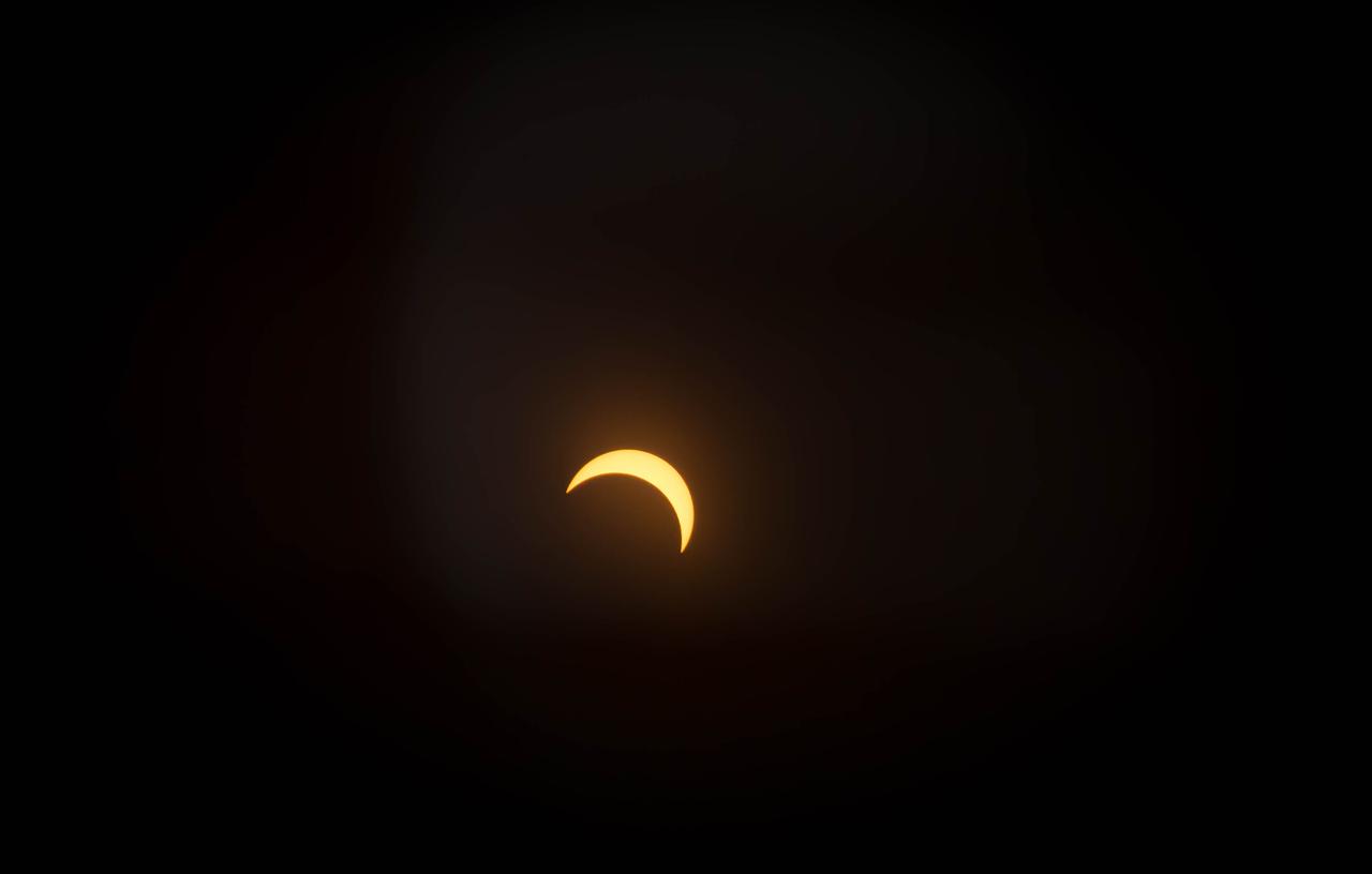
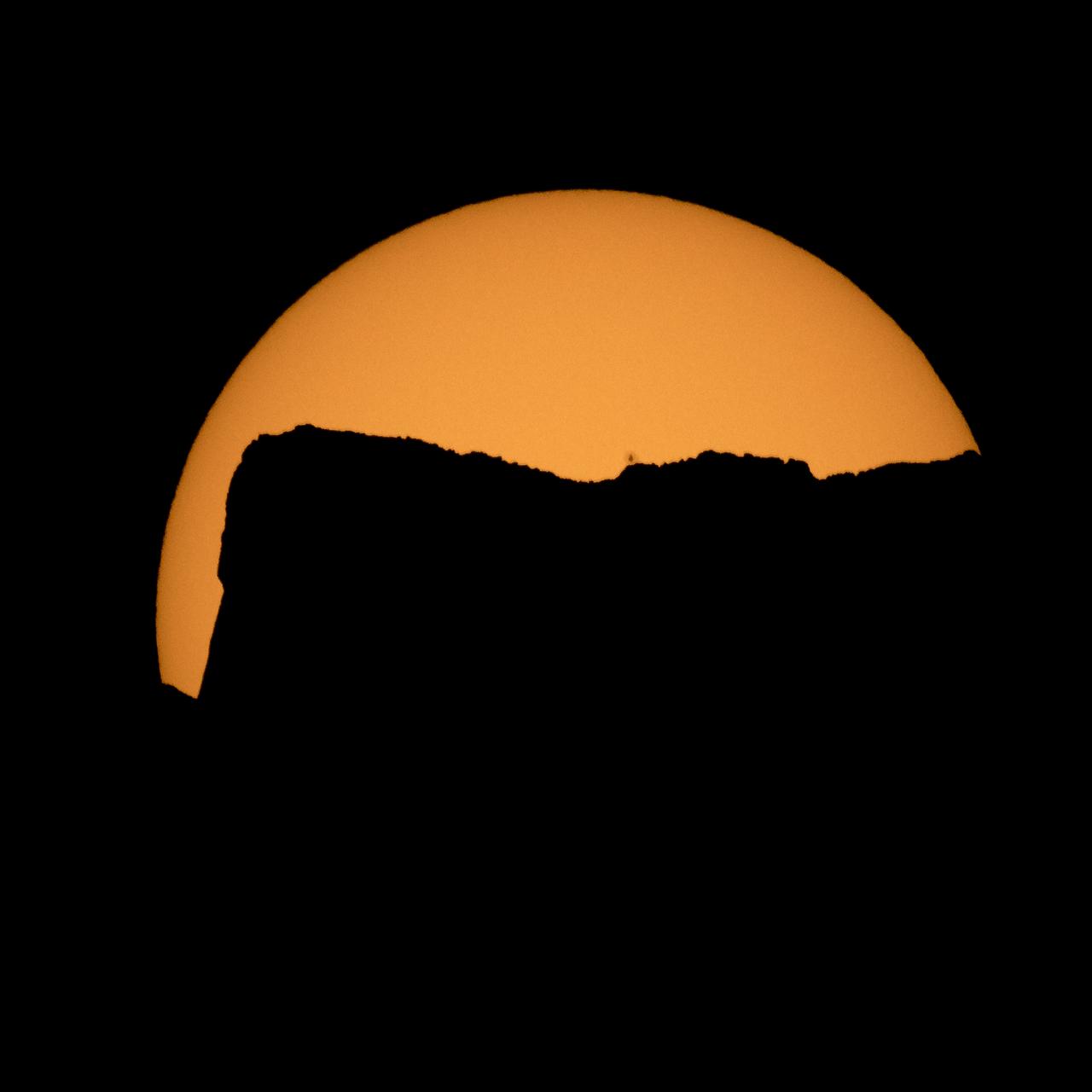
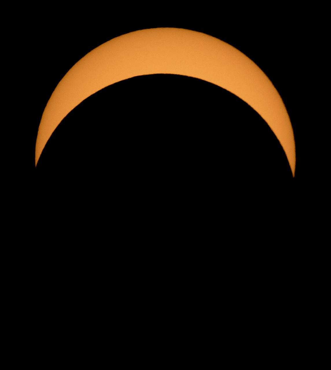
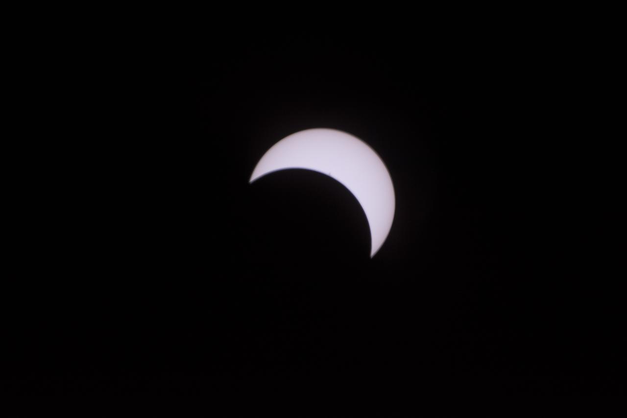
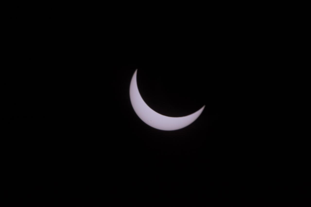
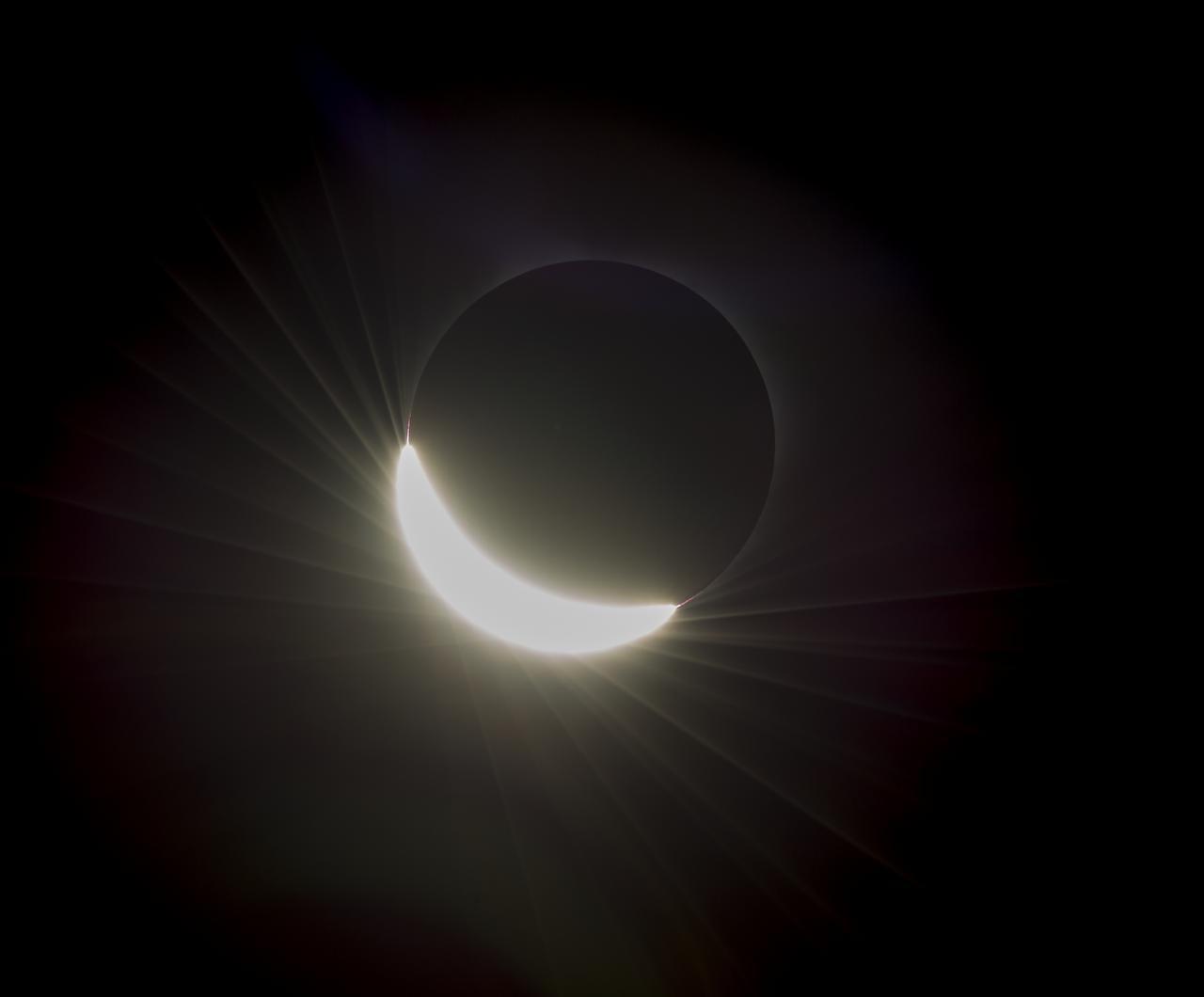
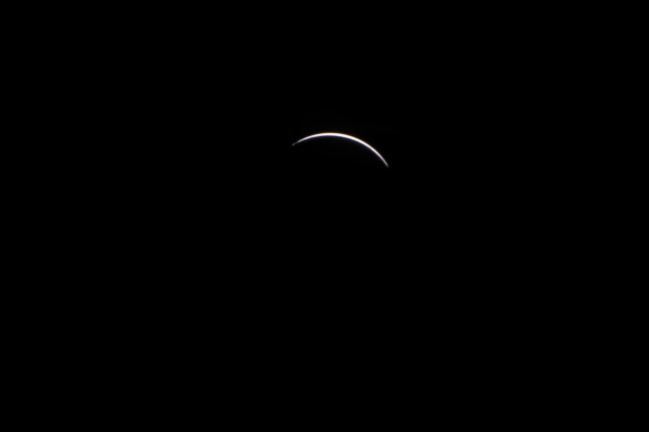
The Baily's Beads effect is seen as the moon makes its final move over the sun during the total solar eclipse on Monday, August 21, 2017 above Madras, Oregon. A total solar eclipse swept across a narrow portion of the contiguous United States from Lincoln Beach, Oregon to Charleston, South Carolina. A partial solar eclipse was visible across the entire North American continent along with parts of South America, Africa, and Europe. Photo Credit: (NASA/Aubrey Gemignani)
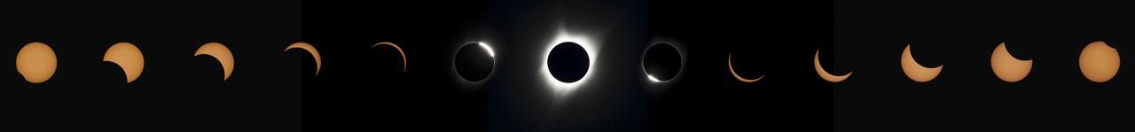
This composite image of thirteen photographs shows the progression of a total solar eclipse at Madras High School in Madras, Oregon on Monday, August 21, 2017. A total solar eclipse swept across a narrow portion of the contiguous United States from Lincoln Beach, Oregon to Charleston, South Carolina. A partial solar eclipse was visible across the entire North American continent along with parts of South America, Africa, and Europe. Photo Credit: (NASA/Aubrey Gemignani)
The Moon is seen passing in front of the Sun during a total solar eclipse on Monday, August 21, 2017 from onboard a NASA Gulfstream III aircraft flying 25,000 feet above the Oregon coast. A total solar eclipse swept across a narrow portion of the contiguous United States from Lincoln Beach, Oregon to Charleston, South Carolina. A partial solar eclipse was visible across the entire North American continent along with parts of South America, Africa, and Europe. Photo Credit: (NASA/Carla Thomas)
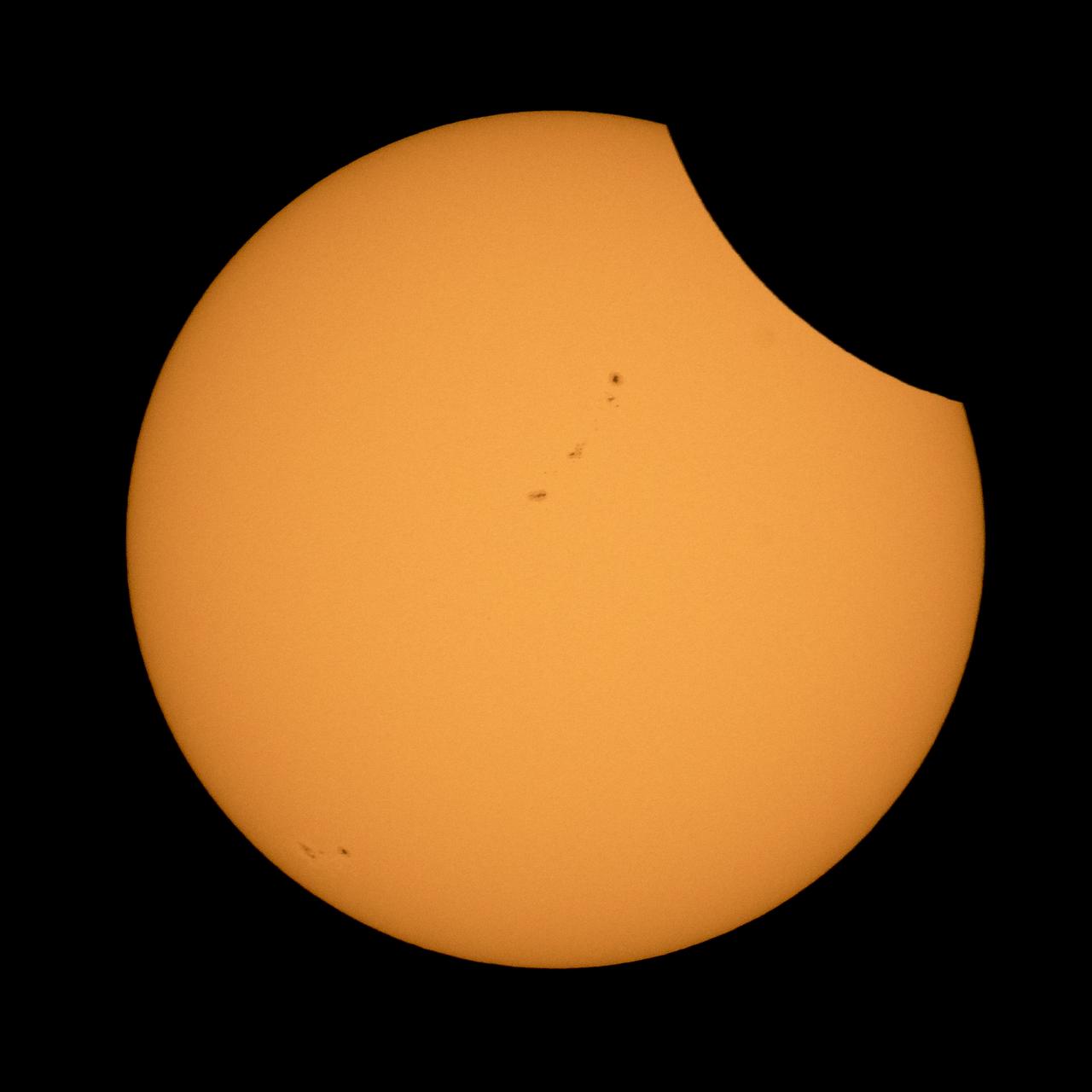
A total solar eclipse is seen on Monday, Aug. 21, 2017 above Madras, Oregon. A total solar eclipse swept across a narrow portion of the contiguous United States from Lincoln Beach, Oregon to Charleston, South Carolina. A partial solar eclipse was visible across the entire North American continent along with parts of South America, Africa, and Europe. Photo Credit: (NASA/Aubrey Gemignani)
The last glimmer of the sun is seen as the moon makes its final move over the sun during the total solar eclipse on Monday, August 21, 2017 above Madras, Oregon. A total solar eclipse swept across a narrow portion of the contiguous United States from Lincoln Beach, Oregon to Charleston, South Carolina. A partial solar eclipse was visible across the entire North American continent along with parts of South America, Africa, and Europe. Photo Credit: (NASA/Aubrey Gemignani)

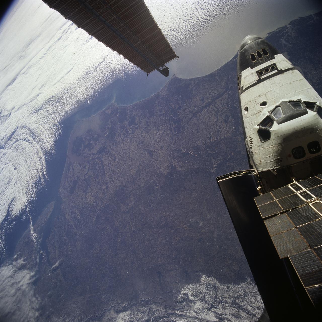
S120-E-006255 (25 Oct. 2007) --- The International Space Station is featured in this image photographed by a STS-120 crewmember as Space Shuttle Discovery approaches the station during rendezvous and docking activities on flight day three. Docking occurred at 7:40 a.m. (CDT) on Oct. 25, 2007, as the two spacecraft flew over the Atlantic Ocean just off the coast of North Carolina.
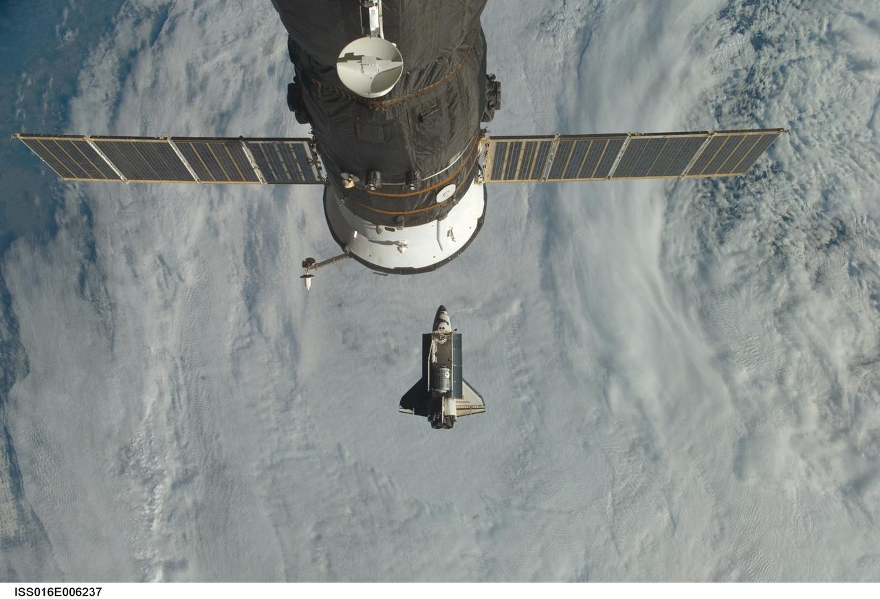
ISS016-E-006237 (25 Oct. 2007) --- Backdropped by a cloud-covered part of Earth, Space Shuttle Discovery (STS-120) approaches the International Space Station during STS-120 rendezvous and docking operations. Docking occurred at 7:40 a.m. (CDT) on Oct. 25, 2007, as the two spacecraft flew over the Atlantic Ocean just off the coast of North Carolina. The Harmony node is visible in Discovery's cargo bay. A Russian spacecraft, docked to the station, is visible in the foreground.
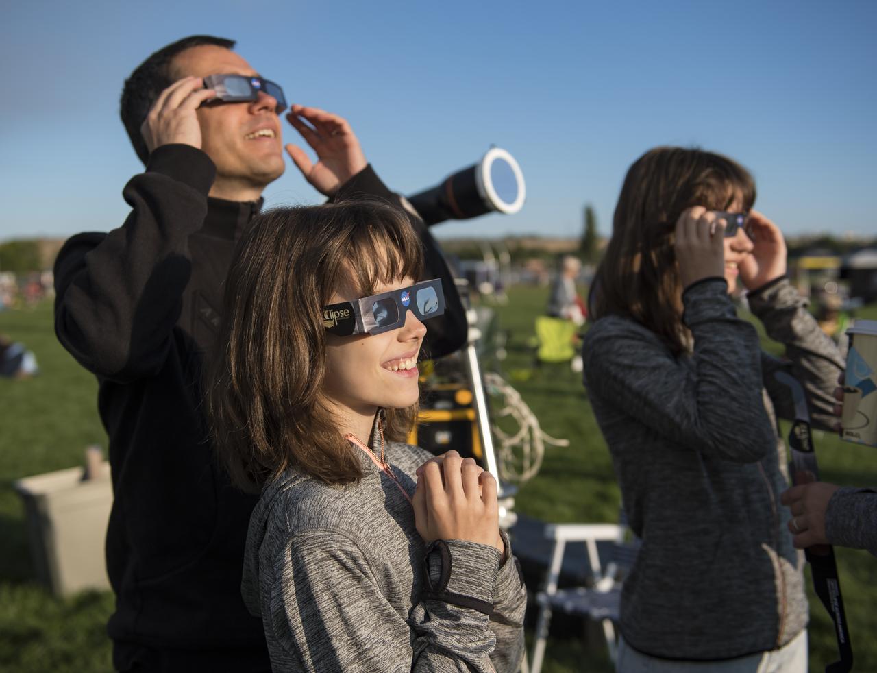
Klaus Koschinsky, left, and his daughters, Claudia, center, and Tanja, right, from Munich, Germany, are seen as they watch a total solar eclipse through protective glasses in Madras, Oregon on Monday, Aug. 21, 2017. A total solar eclipse swept across a narrow portion of the contiguous United States from Lincoln Beach, Oregon to Charleston, South Carolina. A partial solar eclipse was visible across the entire North American continent along with parts of South America, Africa, and Europe. Photo Credit: (NASA/Aubrey Gemignani)

On December 17, 1903, two brothers from Dayton, Ohio, named Wilbur and Orville Wright, were successful in flying an airplane they built. Their powered aircraft flew for 12 seconds above the sand dunes of Kitty Hawk, North Carolina, making them the first men to pilot a heavier-than-air machine that took off on its own power, remained under control, and sustained flight.
A sign is seen along the roads in Madras, Oregon, where thousands of visitors are expected for the total solar eclipse, Saturday, August 19, 2017. The eclipse will be sweeping across a narrow portion of the contiguous United States from Lincoln Beach, Oregon to Charleston, South Carolina on August 21. A partial solar eclipse will be visible across the entire North American continent along with parts of South America, Africa, and Europe. Photo Credit: (NASA/Aubrey Gemignani)
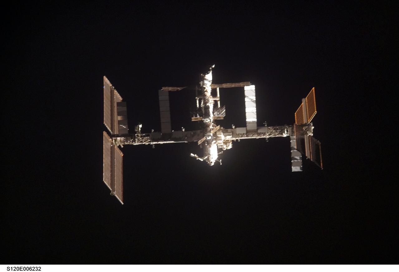
S120-E-006232 (25 Oct. 2007) --- The International Space Station is featured in this image photographed by a STS-120 crewmember as Space Shuttle Discovery approaches the station during rendezvous and docking activities on flight day three. Docking occurred at 7:40 a.m. (CDT) on Oct. 25, 2007, as the two spacecraft flew over the Atlantic Ocean just off the coast of North Carolina.

The Moon is seen passing in front of the Sun during a solar eclipse from Ross Lake, Northern Cascades National Park, Washington on Monday, Aug. 21, 2017. A total solar eclipse swept across a narrow portion of the contiguous United States from Lincoln Beach, Oregon to Charleston, South Carolina. A partial solar eclipse was visible across the entire North American continent along with parts of South America, Africa, and Europe. Photo Credit: (NASA/Bill Ingalls)
The Moon is seen passing in front of the Sun during a total solar eclipse on Monday, August 21, 2017 from onboard a NASA Gulfstream III aircraft flying 25,000 feet above the Oregon coast. A total solar eclipse swept across a narrow portion of the contiguous United States from Lincoln Beach, Oregon to Charleston, South Carolina. A partial solar eclipse was visible across the entire North American continent along with parts of South America, Africa, and Europe. Photo Credit: (NASA/Carla Thomas)

Smokey Bear, left, and Judy Reese of the Crooked River National Grassland, right, wave at passersby as crowds arrive to watch the total solar eclipse in Madras, Oregon on Saturday, August 19, 2017. The eclipse will be sweeping across a narrow portion of the contiguous United States from Lincoln Beach, Oregon to Charleston, South Carolina on August 21. A partial solar eclipse will be visible across the entire North American continent along with parts of South America, Africa, and Europe. Photo Credit: (NASA/Aubrey Gemignani)

The Moon is seen passing in front of the Sun at the point of the maximum of the partial solar eclipse near Banner, Wyoming on Monday, Aug. 21, 2017. A total solar eclipse swept across a narrow portion of the contiguous United States from Lincoln Beach, Oregon to Charleston, South Carolina. A partial solar eclipse was visible across the entire North American continent along with parts of South America, Africa, and Europe. Photo Credit: (NASA/Joel Kowsky)

NASA employees and contractors use protective glasses to view a partial solar eclipse from NASA Headquarters Monday, Aug. 21, 2017 in Washington. A total solar eclipse swept across a narrow portion of the contiguous United States from Lincoln Beach, Oregon to Charleston, South Carolina. A partial solar eclipse was visible across the entire North American continent along with parts of South America, Africa, and Europe. Photo Credit: (NASA/Gwen Pitman)
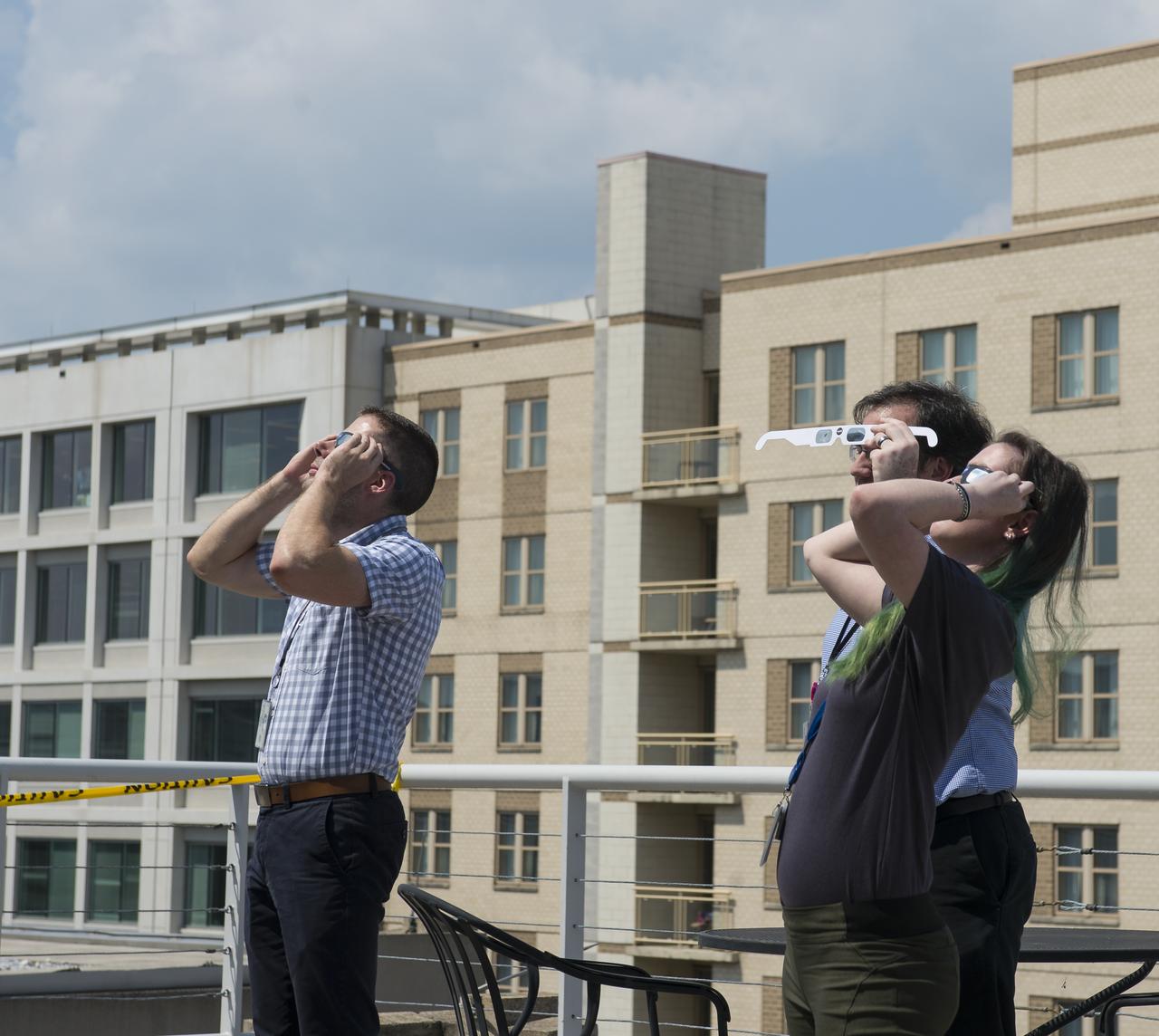
NASA employees and contractors use protective glasses to view a partial solar eclipse from NASA Headquarters Tuesday, Aug. 22, 2017 in Washington. A total solar eclipse swept across a narrow portion of the contiguous United States from Lincoln Beach, Oregon to Charleston, South Carolina. A partial solar eclipse was visible across the entire North American continent along with parts of South America, Africa, and Europe. Photo Credit: (NASA/Gwen Pitman)
The Moon is seen passing in front of the Sun during a solar eclipse from Ross Lake, Northern Cascades National Park, Washington on Monday, Aug. 21, 2017. A total solar eclipse swept across a narrow portion of the contiguous United States from Lincoln Beach, Oregon to Charleston, South Carolina. A partial solar eclipse was visible across the entire North American continent along with parts of South America, Africa, and Europe. Photo Credit: (NASA/Bill Ingalls)

NASA employees and contractors use protective glasses to view a partial solar eclipse from NASA Headquarters Monday, Aug. 21, 2017 in Washington. A total solar eclipse swept across a narrow portion of the contiguous United States from Lincoln Beach, Oregon to Charleston, South Carolina. A partial solar eclipse was visible across the entire North American continent along with parts of South America, Africa, and Europe. Photo Credit: (NASA/Gwen Pitman)
The Moon is seen passing in front of the Sun during a total solar eclipse on Monday, August 21, 2017 from onboard a NASA Gulfstream III aircraft flying 25,000 feet above the Oregon coast. A total solar eclipse swept across a narrow portion of the contiguous United States from Lincoln Beach, Oregon to Charleston, South Carolina. A partial solar eclipse was visible across the entire North American continent along with parts of South America, Africa, and Europe. Photo Credit: (NASA/Carla Thomas)

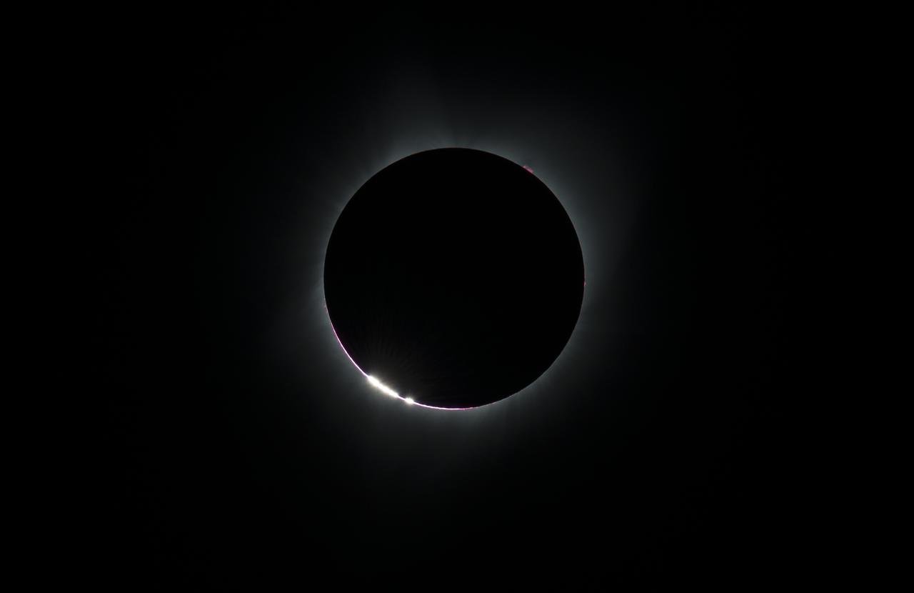
Some prominences are seen as the moon begins to move off the sun during the total solar eclipse on Monday, August 21, 2017 above Madras, Oregon. A total solar eclipse swept across a narrow portion of the contiguous United States from Lincoln Beach, Oregon to Charleston, South Carolina. A partial solar eclipse was visible across the entire North American continent along with parts of South America, Africa, and Europe. Photo Credit: (NASA/Aubrey Gemignani)
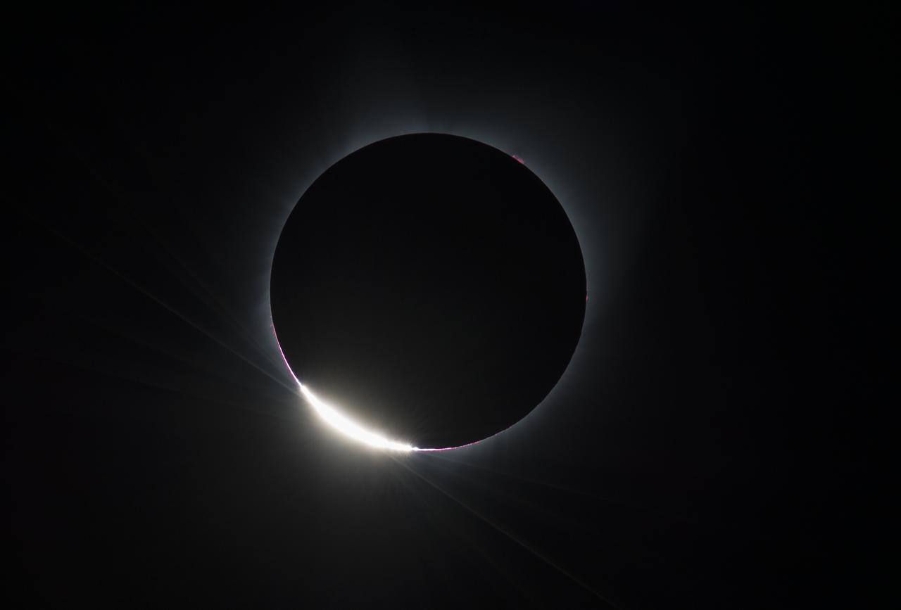
The Diamond Ring effect is seen as the moon makes its final move over the sun during the total solar eclipse on Monday, August 21, 2017 above Madras, Oregon. A total solar eclipse swept across a narrow portion of the contiguous United States from Lincoln Beach, Oregon to Charleston, South Carolina. A partial solar eclipse was visible across the entire North American continent along with parts of South America, Africa, and Europe. Photo Credit: (NASA/Aubrey Gemignani)

NASA employees and contractors use protective glasses to view a partial solar eclipse from NASA Headquarters Monday, Aug. 21, 2017 in Washington. A total solar eclipse swept across a narrow portion of the contiguous United States from Lincoln Beach, Oregon to Charleston, South Carolina. A partial solar eclipse was visible across the entire North American continent along with parts of South America, Africa, and Europe. Photo Credit: (NASA/Gwen Pitman)

A man drums during the partial phase of the total solar eclipse in Madras, Oregon on Monday, Aug. 21, 2017. A total solar eclipse swept across a narrow portion of the contiguous United States from Lincoln Beach, Oregon to Charleston, South Carolina. A partial solar eclipse was visible across the entire North American continent along with parts of South America, Africa, and Europe. Photo Credit: (NASA/Aubrey Gemignani)
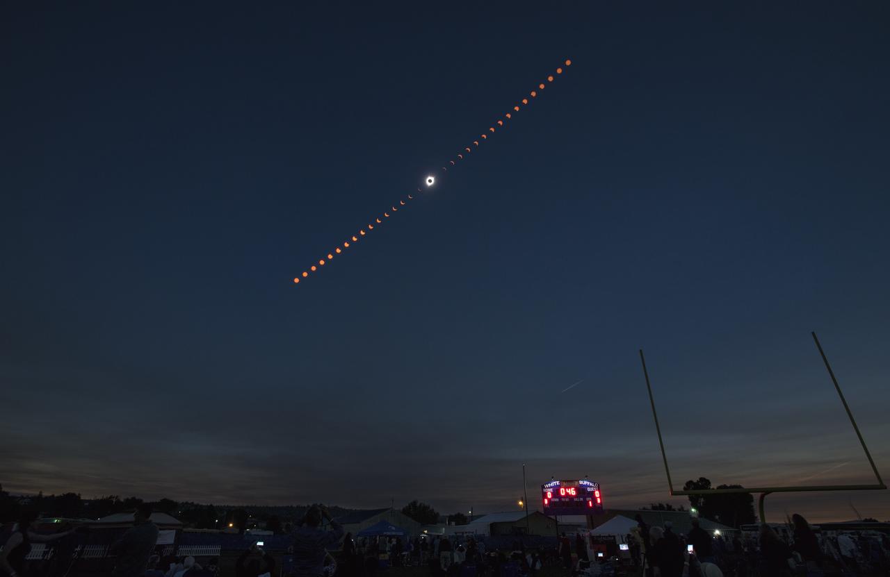
This composite image shows the progression of a total solar eclipse over Madras, Oregon on Monday, Aug. 21, 2017. A total solar eclipse swept across a narrow portion of the contiguous United States from Lincoln Beach, Oregon to Charleston, South Carolina. A partial solar eclipse was visible across the entire North American continent along with parts of South America, Africa, and Europe. Photo Credit: (NASA/Aubrey Gemignani)

NASA employees and contractors use protective glasses to view a partial solar eclipse from NASA Headquarters Monday, Aug. 21, 2017 in Washington. A total solar eclipse swept across a narrow portion of the contiguous United States from Lincoln Beach, Oregon to Charleston, South Carolina. A partial solar eclipse was visible across the entire North American continent along with parts of South America, Africa, and Europe. Photo Credit: (NASA/Gwen Pitman)
A total solar eclipse is seen on Monday, August 21, 2017 above Madras, Oregon. A total solar eclipse swept across a narrow portion of the contiguous United States from Lincoln Beach, Oregon to Charleston, South Carolina. A partial solar eclipse was visible across the entire North American continent along with parts of South America, Africa, and Europe. Photo Credit: (NASA/Aubrey Gemignani)

The Moon is seen passing in front of the Sun during a total solar eclipse on Monday, August 21, 2017 from onboard a NASA Gulfstream III aircraft flying 25,000 feet above the Oregon coast. A total solar eclipse swept across a narrow portion of the contiguous United States from Lincoln Beach, Oregon to Charleston, South Carolina. A partial solar eclipse was visible across the entire North American continent along with parts of South America, Africa, and Europe. Photo Credit: (NASA/Carla Thomas)

A sign is seen along the roads in Madras, Oregon, where thousands of visitors are expected for the total solar eclipse, Saturday, August 19, 2017. The eclipse will be sweeping across a narrow portion of the contiguous United States from Lincoln Beach, Oregon to Charleston, South Carolina on August 21. A partial solar eclipse will be visible across the entire North American continent along with parts of South America, Africa, and Europe. Photo Credit: (NASA/Aubrey Gemignani)
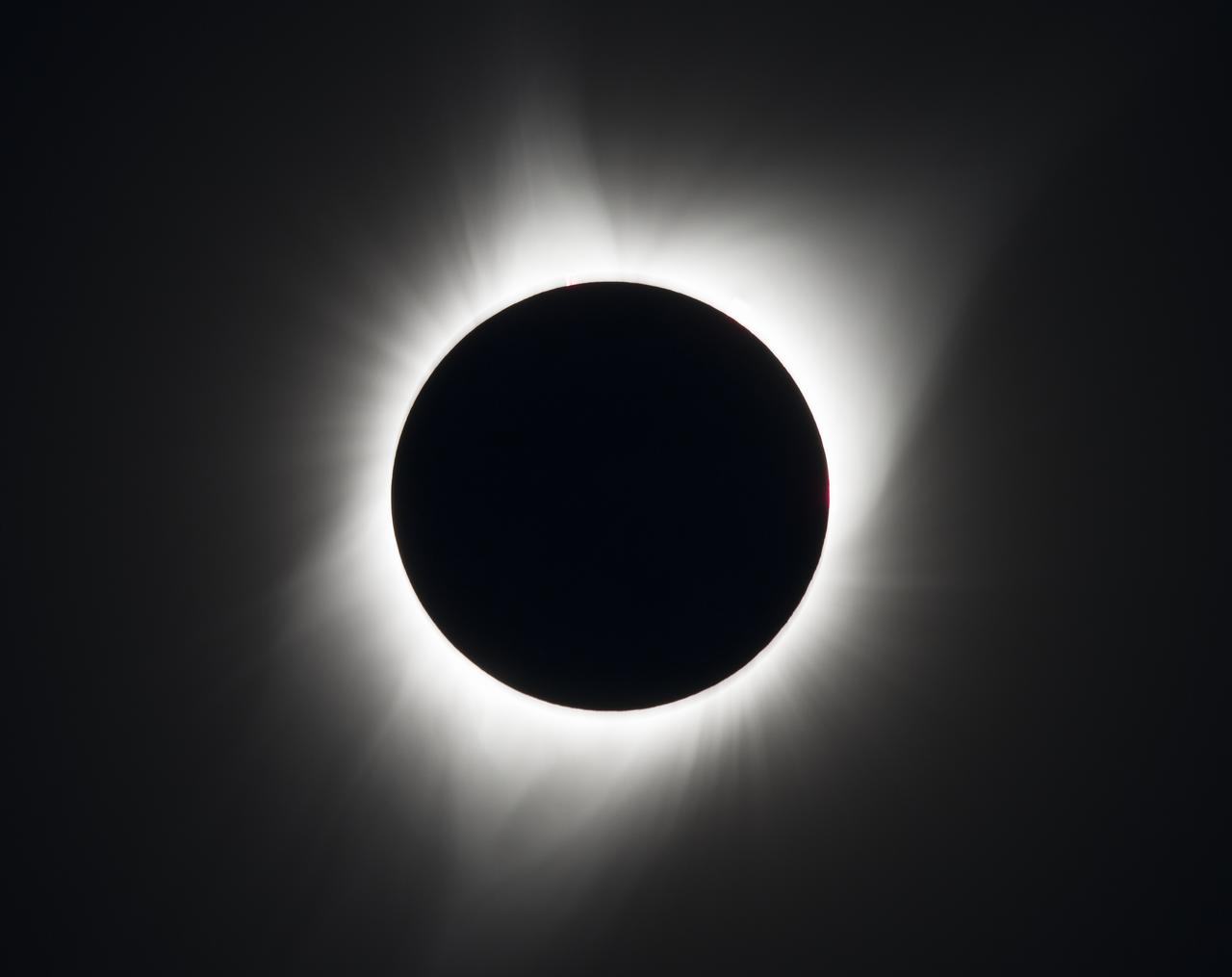
A total solar eclipse is seen on Monday, August 21, 2017 above Madras, Oregon. A total solar eclipse swept across a narrow portion of the contiguous United States from Lincoln Beach, Oregon to Charleston, South Carolina. A partial solar eclipse was visible across the entire North American continent along with parts of South America, Africa, and Europe. Photo Credit: (NASA/Aubrey Gemignani)

The Vasquez family from Eureka and Edgewood, Washington take a photo during the total solar eclipse in Madras, Oregon on Monday, Aug. 21, 2017. A total solar eclipse swept across a narrow portion of the contiguous United States from Lincoln Beach, Oregon to Charleston, South Carolina. A partial solar eclipse was visible across the entire North American continent along with parts of South America, Africa, and Europe. Photo Credit: (NASA/Aubrey Gemignani)
STS081-720-081 (12-22 Jan. 1997) --- As seen from Russia's Mir space station while docked to the Space Shuttle Atlantis, this scene provides a panorama of the central Atlantic coast of the United States. The view extends from the Chesapeake Bay at the top of the view to Charleston, South Carolina near the lower right corner. Heavy snow-cover on the Appalachian Mountains (on the left of the photo) contrasts with the darker piedmont. The dark piedmont, in turn, changes sharply in the center of the photo to the gray-colored coastal plain. Cape Hatteras, Cape Lookout and Cape Fear (top to bottom) mark the points along the North Carolina coast. Another boundary can be seen offshore. The clouds and the line of lighter-colored water off Cape Hatteras mark the western edge of the warm Gulf Stream which runs northward along the coast to Cape Hatteras before it shoots eastward across the Atlantic.