
For five years, Jeremy Harbeck has worked as a support scientist for NASA’s Operation IceBridge, an airborne mission to study polar ice. The data processing that he does typically takes place in an office at NASA’s Goddard Space Flight Center in Maryland. However, to speed the process of delivering data to the Arctic sea ice forecasting community, Harbeck traveled to Greenland for the first time in spring 2015. He had just arrived at Greenland’s Thule Air Base on March 20 when a mechanical issue grounded the aircraft. No science flight could happen for a few days. As teams in the United States and Greenland scrambled to locate and deliver a replacement part, researchers on the ground waited. Some of them hiked to what was locally known as “the iceberg.” The unnamed berg pictured above has been frozen in place by sea ice in North Star Bay. Harbeck shot the photograph—a composite of four 49-second images—on March 21 at about 2:30 a.m. local time. The sun never fully sets at this time of year in the Arctic, so sunlight appears on the left side of the image. Lights from Thule are visible on the right side. Look for the Milky Way (top left) and a few very faint meteors visible in the early morning sky. Harbeck left the dock at Thule with sea ice scientist (and current IceBridge project scientist) Nathan Kurtz and a local recreation officer at about 10 p.m. From there, the group hiked 2.4 kilometers (1.5 miles) across the still-thick sea ice in weather that Harbeck called a “pleasant” minus 18 degrees Celsius (0 degrees Fahrenheit). They paused frequently on the way, and they even circled the berg to check for polar bears. “You don’t have a sense of scale of this berg until you get up to it,” Harbeck said. “It’s about the size of my apartment building, and that’s only the part protruding from the water.” Assuming the berg is ungrounded (which is uncertain), about one-tenth of its mass is above water. Photograph by Jeremy Harbeck, support scientist for NASA's Operation IceBridge mission. Caption by Kathryn Hansen. Credit: <b><a href="http://www.earthobservatory.nasa.gov/" rel="nofollow"> NASA Earth Observatory</a></b> <b><a href="http://www.nasa.gov/audience/formedia/features/MP_Photo_Guidelines.html" rel="nofollow">NASA image use policy.</a></b> <b><a href="http://www.nasa.gov/centers/goddard/home/index.html" rel="nofollow">NASA Goddard Space Flight Center</a></b> enables NASA’s mission through four scientific endeavors: Earth Science, Heliophysics, Solar System Exploration, and Astrophysics. Goddard plays a leading role in NASA’s accomplishments by contributing compelling scientific knowledge to advance the Agency’s mission. <b>Follow us on <a href="http://twitter.com/NASAGoddardPix" rel="nofollow">Twitter</a></b> <b>Like us on <a href="http://www.facebook.com/pages/Greenbelt-MD/NASA-Goddard/395013845897?ref=tsd" rel="nofollow">Facebook</a></b> <b>Find us on <a href="http://instagrid.me/nasagoddard/?vm=grid" rel="nofollow">Instagram</a></b>

This infrared image from NASA Spitzer Space Telescope shows a swirling landscape of stars known as the North America nebula. Clusters of young stars about one million years old can be found throughout the image.

This visible light/infrared image from NASA Spitzer Space Telescope shows a swirling landscape of stars known as the North America nebula. Clusters of young stars about one million years old can be found throughout the image.

Chasma Boreale is a long, flat-floored valley that cuts deep into Mars north polar icecap. This image is part of an All Star set marking the occasion of NASA Mars Odyssey as the longest-working Mars spacecraft in history.

This view of the North America nebula combines both visible and infrared light observations, taken by the Digitized Sky Survey and NASA Spitzer Space Telescope. Clusters of young stars about one million years old can be found throughout the image.
The SOFIA telescope team collected baseline operational measurements during several nights of characterization testing in March 2008 while the SOFIA 747SP aircraft that houses the German-built infrared telescope was parked on an unlit ramp next to its hangar at the NASA Dryden Flight Operations Facility in Palmdale, Calif. The primary celestial target was Polaris, the North Star. The activity provided the team with a working knowledge of how telescope operating systems interact and the experience of tracking celestial targets from the ground.

The SOFIA telescope team collected baseline operational measurements during several nights of characterization testing in March 2008 while the SOFIA 747SP aircraft that houses the German-built infrared telescope was parked on an unlit ramp next to its hangar at the NASA Dryden Flight Operations Facility in Palmdale, Calif. The primary celestial target was Polaris, the North Star. The activity provided the team with a working knowledge of how telescope operating systems interact and the experience of tracking celestial targets from the ground.

The SOFIA telescope team collected baseline operational measurements during several nights of characterization testing in March 2008 while the SOFIA 747SP aircraft that houses the German-built infrared telescope was parked on an unlit ramp next to its hangar at the NASA Dryden Flight Operations Facility in Palmdale, Calif. The primary celestial target was Polaris, the North Star. The activity provided the team with a working knowledge of how telescope operating systems interact and the experience of tracking celestial targets from the ground.

The SOFIA telescope team collected baseline operational measurements during several nights of characterization testing in March 2008 while the SOFIA 747SP aircraft that houses the German-built infrared telescope was parked on an unlit ramp next to its hangar at the NASA Dryden Flight Operations Facility in Palmdale, Calif. The primary celestial target was Polaris, the North Star. The activity provided the team with a working knowledge of how telescope operating systems interact and the experience of tracking celestial targets from the ground.

The SOFIA telescope team collected baseline operational measurements during several nights of characterization testing in March 2008 while the SOFIA 747SP aircraft that houses the German-built infrared telescope was parked on an unlit ramp next to its hangar at the NASA Dryden Flight Operations Facility in Palmdale, Calif. The primary celestial target was Polaris, the North Star. The activity provided the team with a working knowledge of how telescope operating systems interact and the experience of tracking celestial targets from the ground.

The SOFIA telescope team collected baseline operational measurements during several nights of characterization testing in March 2008 while the SOFIA 747SP aircraft that houses the German-built infrared telescope was parked on an unlit ramp next to its hangar at the NASA Dryden Flight Operations Facility in Palmdale, Calif. The primary celestial target was Polaris, the North Star. The activity provided the team with a working knowledge of how telescope operating systems interact and the experience of tracking celestial targets from the ground.
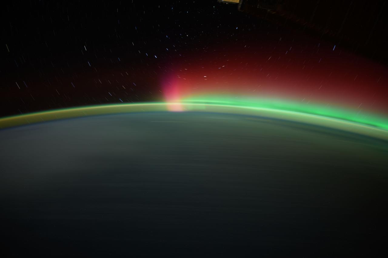
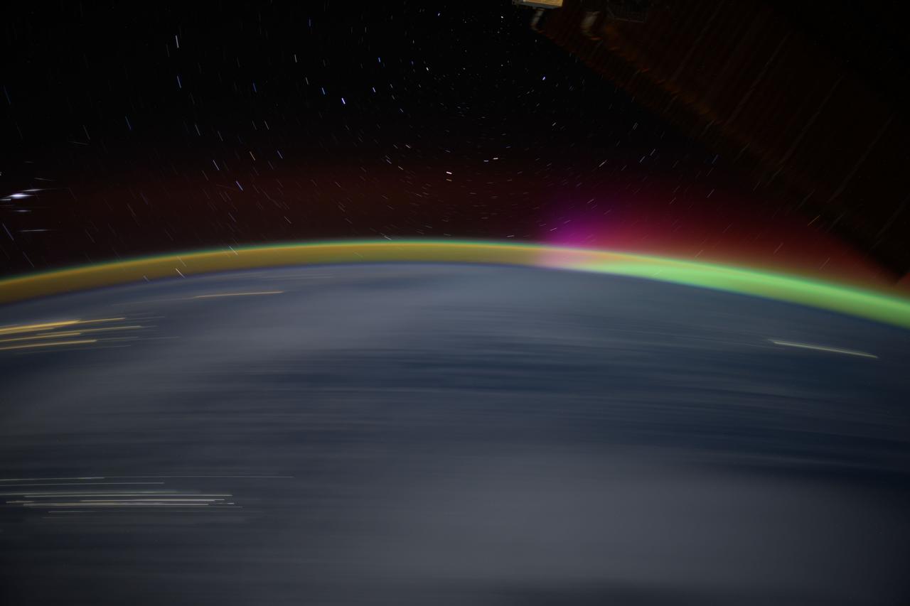
iss072e147691 (Nov. 9, 2024) --- Star trails, an aurora, and Earth's atmospheric glow highlight this long-duration photograph taken from the International Space Station as it orbited 259 miles above the North Pacific Ocean.
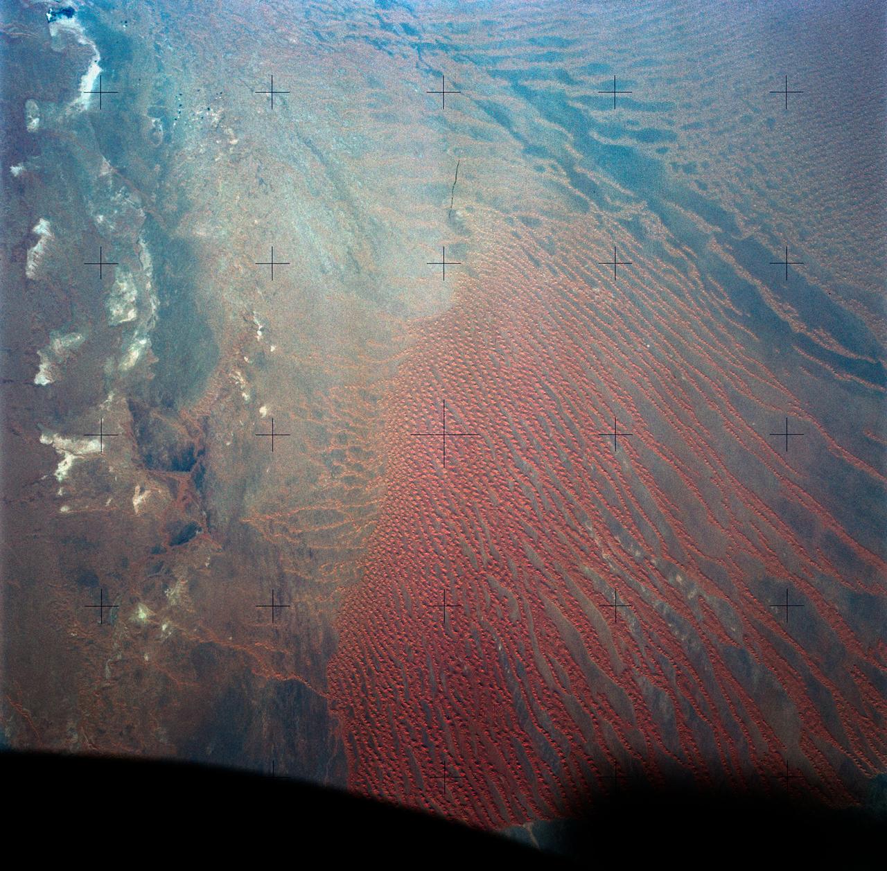
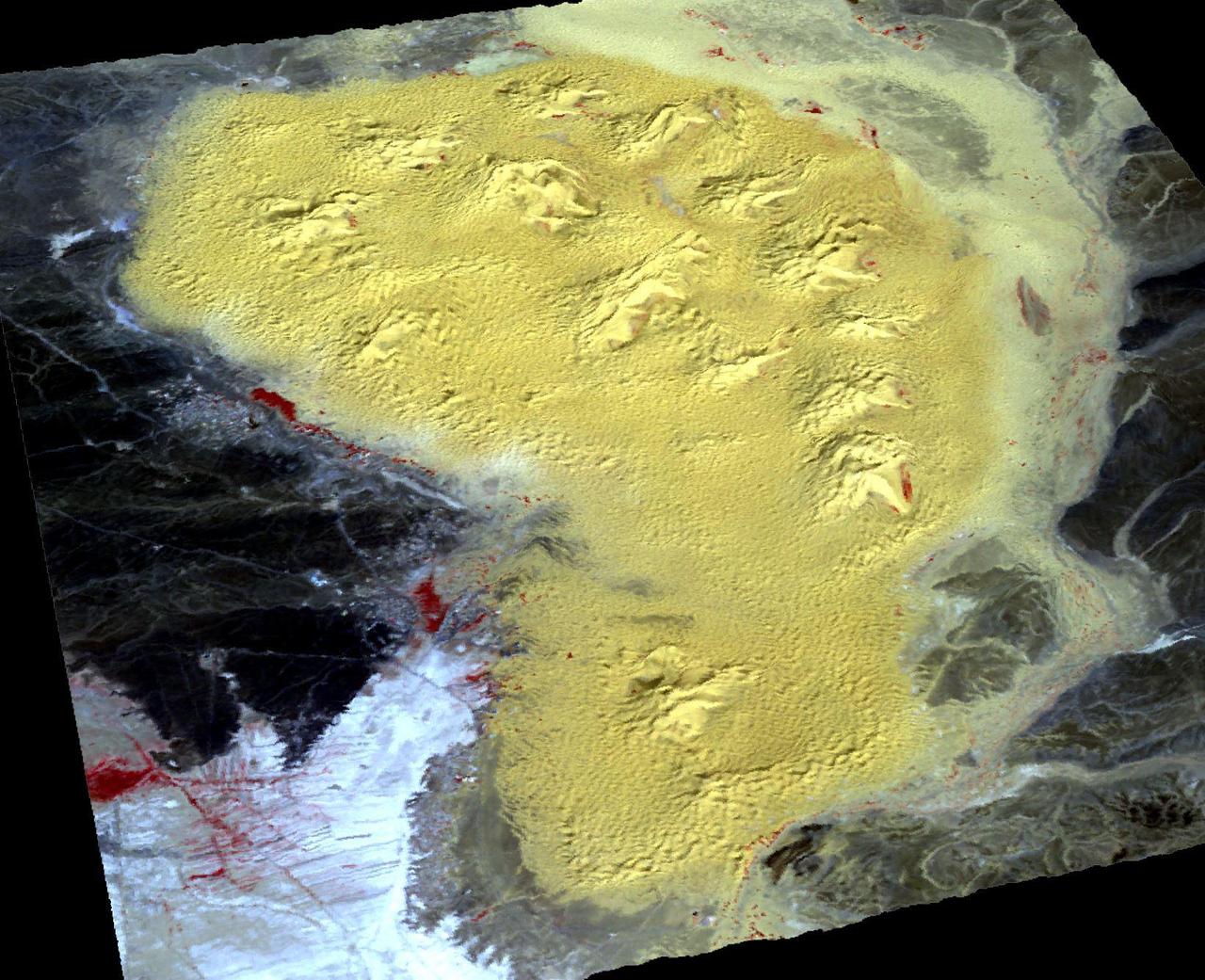
SL4-138-3820 (31 Dec. 1973) --- An north-looking oblique view of chains of star sand dunes in eastern Algeria as seen from the Skylab space station in Earth orbit. This picture was taken by one of the Skylab 4 crewmen with a hand-held 70mm Hasselblad camera. The low sun angle of about 25 degrees above horizontal enhances the detail in this picture. The coordinates of the center of the photograph are approximately 29.5 degrees north latitude and 5.0 degrees east longitude in the Grand Erg Oriental. The field of view at the base of the photograph is approximately 200 kilometers (125 miles). The individual dunes are roughly star-shaped rather than simple crescents which are common in dune fields. In this region the stars are aligned along ridges. The causes of these and a wide variety of other dune forms are little understood. Descriptions and photographs from Skylab 4 will be used by the U.S. Geological Survey in their world-wide study of dunes. Photo credit: NASA
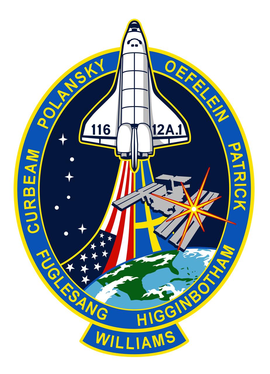
Signifying the continuing assembly of the International Space Station (ISS), the STS-116 crew patch depicts the space shuttle rising above the Earth and the ISS. The United States and Swedish flags trail the orbiter, depicting the international composition of the STS-116 crew. The seven stars of the constellation Ursa Major are used to provide direction to the North Star, which is superimposed over the installation location of the P5 truss on ISS.
ISS030-E-007397 (24 Nov. 2011) --- This is a panoramic view of Earth's atmospheric limb photographed by an Expedition 30 crew member aboard the International Space Station when it was over a point centered approximately at 41.5 degrees north latitude and 179.9 degrees west longitude (central North Pacific – right at the International Dateline). The view is looking westward, well after sunset. The panorama includes airglow, some cloud formations, a portion of the space station silhouetted at the top of the frame and a star field.
iss072e515922 (Jan. 16, 2025) --- Northrop Grumman's Cygnus space freighter is pictured berthed to the International Space Station's Earth-facing port on the Unity module. This long-duration photograph also highlights Earth's atmospheric glow and star trails as the orbital outpost soared 262 miles above the North Atlantic Ocean.
iss072e030147 (Oct. 7, 2024) --- The atmospheric glow, caused by atoms and moelcules excited by sunlight, blankets Earth's nighttime horizon with a sparkling field of stars above in this photograph from the International Space Station as it orbited 270 miles above the Pacific Ocean north of Auckland, New Zealand.
iss070e103599 (Feb. 29, 2024) --- The SpaceX Dragon "Endurance" spacecraft is pictured docked to the Harmony module's space-facing port as the International Space Station orbited 263 miles above the north Atlantic Ocean. Other highlights in this long-duration photograph include circular star trails and the atmospheric glow above Earth's horizon.
iss072e147765 (Nov. 9, 2024) --- The streaks of city lights, star trails, an aurora, and Earth's atmospheric glow highlight this long-duration photograph taken from the International Space Station as it orbited 259 miles above the North Pacific Ocean off the coast of Japan.
This image of the dwarf spiral galaxy NGC 247 was taken by Galaxy Evolution Explorer on October 13, 2003, in a single orbit exposure of 1600 seconds. The region that looks like a "hole" in the upper part of the galaxy is a location with a deficit of gas and therefore a lower star formation rate and ultraviolet brightness. Optical images of this galaxy show a bright star on the southern edge. This star is faint and red in the Galaxy Evolution Explorer ultraviolet image, revealing that it is a foreground star in our Milky Way galaxy. The string of background galaxies to the North-East (upper left) of NGC 247 is 355 million light years from our Milky Way galaxy whereas NGC 247 is a mere 9 million light years away. The faint blue light that can be seen in the Galaxy Evolution Explorer image of the upper two of these background galaxies may indicate that they are in the process of merging together. http://photojournal.jpl.nasa.gov/catalog/PIA04922
This illustration shows a cool star, called W1906+40, marked by a raging storm near one of its poles. The storm is thought to be similar to the Great Red Spot on Jupiter. Scientists discovered it using NASA's Kepler and Spitzer space telescopes. The location of the storm is estimated to be near the north pole of the star based on computer models of the data. The telescopes cannot see the storm itself, but learned of its presence after observing how the star's light changes over time. The storm travels around with the star, making a full lap about every 9 hours. When it passes into a telescope's field of view, it causes light of particular infrared and visible wavelengths to dip in brightness. The storm has persisted for at least two years. Astronomers aren't sure why it has lasted so long. While planets are known to have cloudy storms, this is the best evidence yet for a star with the same type of storm. The star, W1906+40, belongs to a thermally cool class of objects called L-dwarfs. Some L-dwarfs are considered stars because they fuse atoms and generate light, as our sun does, while others, called brown dwarfs, are known as "failed stars" for their lack of atomic fusion. The L-dwarf W1906+40 is thought to be a star based on estimates of its age (the older the L-dwarf, the more likely it is a star). Its temperature is about 2,200 Kelvin (3,500 degrees Fahrenheit). That may sound scorching hot, but as far as stars go, it is relatively cool. Cool enough, in fact, for clouds to form in its atmosphere. W1906+40 is located 53 light-years away in the constellation Lyra. http://photojournal.jpl.nasa.gov/catalog/PIA20055
This artist's conception shows the silhouette of a rocky planet, dubbed HD 219134b, as it passes in front of its star. At 21 light-years away, the planet is the closest outside of our solar system that can be seen crossing, or transiting, its star -- a bonus for astronomers because transiting planets make ideal specimens for detailed studies of their atmospheres. It was discovered using the HARPS-North instrument on the Italian 3.6-meter National Galileo Telescope in the Canary Islands, and NASA's Spitzer Space Telescope. The planet, which is about 1.6 times the size of Earth, is also the nearest confirmed rocky planet outside our solar system. It orbits a star that is cooler and smaller than our sun, whipping closely around it in a mere three days. The proximity of the planet to the star means that it would be scorching hot and not habitable. Transiting planets are ideal targets for astronomers wanting to know more about planetary compositions and atmospheres. As a planet passes in front of its star, it causes the starlight to dim, and telescopes can measure this effect. If molecules are present in the planet's atmosphere, they can absorb certain wavelengths of light, leaving imprints in the starlight. This type of technique will be used in the future to investigate potentially habitable planets and search for signs of life. http://photojournal.jpl.nasa.gov/catalog/PIA19831
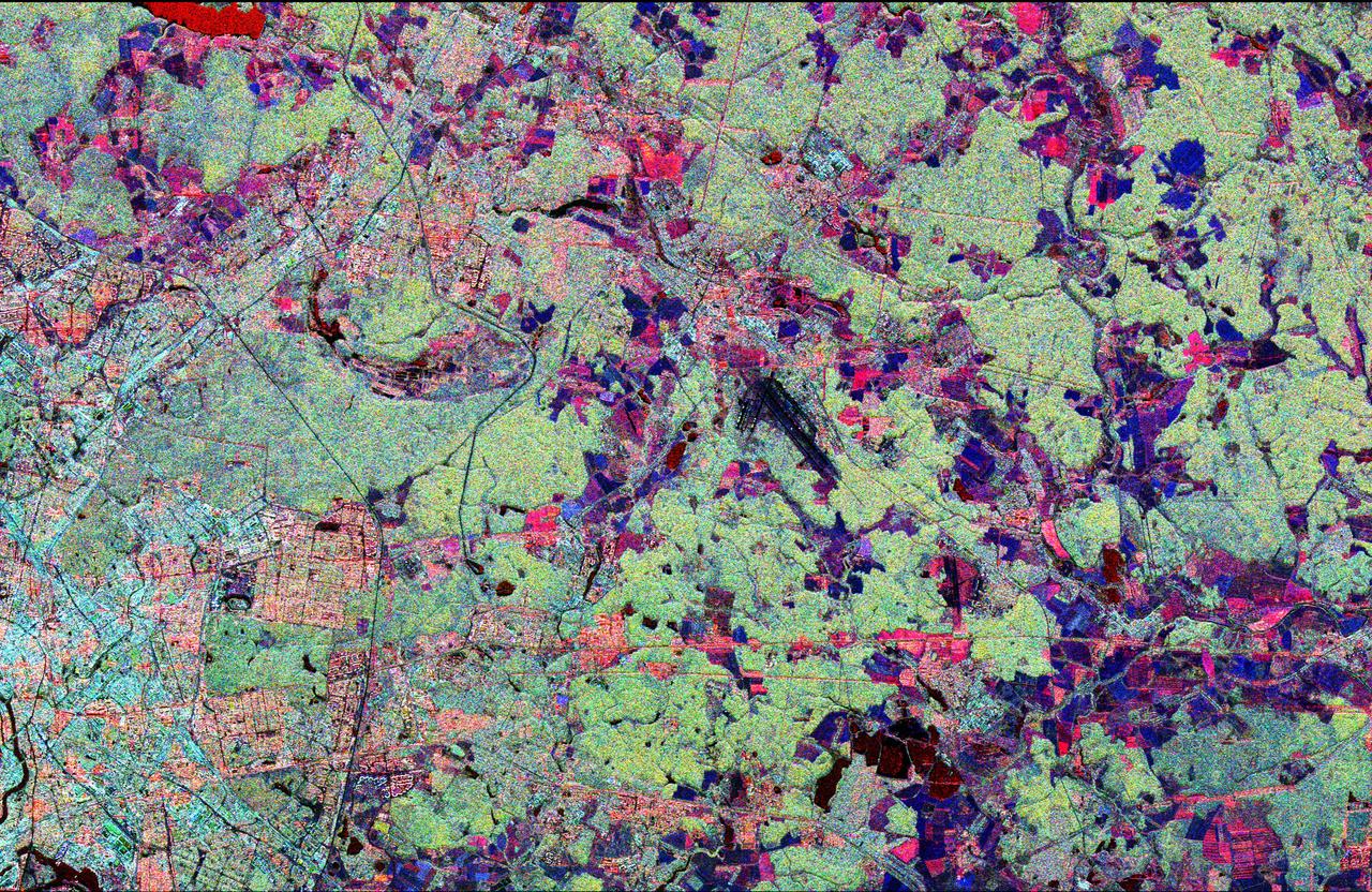
This radar image shows the Star City cosmonaut training center, east of Moscow, Russia. Four American astronauts are training here for future long-duration flights aboard the Russian Mir space station. These joint flights are giving NASA and the Russian Space Agency experience necessary for the construction of the international Alpha space station, beginning in late 1997. This image was acquired by the Spaceborne Imaging Radar-C/X-band Synthetic Aperture Radar (SIR-C/X-SAR), on its 62nd orbit on October 3, 1994. This Star City image is centered at 55.55 degrees north latitude and 38.0 degrees east longitude. The area shown is approximately 32 kilometers by 49 kilometers (20 miles by 30 miles). North is to the top in this image. The radar illumination is from the top of the image. The image was produced using three channels of SIR-C radar data: red indicates L-band (23 cm wavelength, horizontally transmitted and received); green indicates L-band (horizontally transmitted and vertically received); blue indicates C-band (6 cm wavelength, horizontally transmitted and vertically received). In general, dark pink areas are agricultural; pink and light blue areas are urban communities; black areas represent lakes and rivers; dark blue areas are cleared forest; and light green areas are forested. The prominent black runways just right of center are Shchelkovo Airfield, about 4 km long. The textured pale blue-green area east and southeast of Shchelkovo Airfield is forest. Just east of the runways is a thin railroad line running southeast; the Star City compound lies just east of the small bend in the rail line. Star City contains the living quarters and training facilities for Russian cosmonauts and their families. Moscow's inner loop road is visible at the lower left edge of the image. The Kremlin is just off the left edge, on the banks of the meandering Moskva River. The Klyazma River snakes to the southeast from the reservoir in the upper left (shown in bright red), passing just east of Star City and flowing off the lower right edge of the image. The dark blue band of the Vorya River runs north-south in the upper right quadrant, east of Star City. http://photojournal.jpl.nasa.gov/catalog/PIA01775

jsc2023e038728 (6/22/2023) --- Students hold Hoshi-Tomo badges at The Japanese Language School in Charlotte, North Carolina. Two types of Hoshi-Tomo badges were designed by students. “Hoshi” implies star(s), planet(s), or the Earth in Japanese. “Tomo” means friend(s) in Japanese. I-Space Essay provides students and teachers the online opportunity to create wishes, which are delivered to the International Space Station's Japanese Experimental Module Kibo. Image courtesy of Mitsumura-Tosho and IHI Corporation.
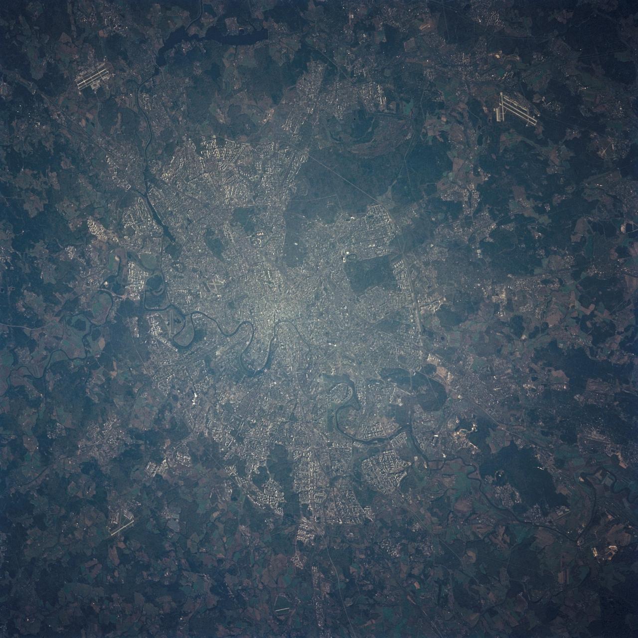
STS068-236-027 (30 September-11 October 1994) --- The STS-68 crewmembers used a 70mm camera to photograph this early morning nadir view of wheel-shaped Moscow. Star City, Russia facility, north of the city, is among the detail seen in the view, photographed from 115 nautical miles above Earth. Six NASA astronauts spent a week and a half aboard the Space Shuttle Endeavour in support of the Space Radar Laboratory 2 (SRL-2) mission.
ISS011-E-12415 (31 August 2005) --- Aurora Borealis and lights in Finland, Russia, Estonia and Latvia are featured in this digital still picture taken by the Expedition 11 crew aboard the international space station. If it were daylight parts of the Eastern Baltic Sea would be visible. The station was over a point on Earth located at 50.6 degrees north latitude and 15.1 degees east longitude at the time. The cluster of stars to the lower right of the thin crescent Moon is the Praesepe or Beehive Cluster in Cancer. Just to the right of that is the planet Saturn.

Juno's Radiation Monitoring Investigation used the Stellar Reference Unit (SRU) star camera to collect this image of Jupiter's ring -- half in Jupiter's shadow -- during Juno's 13th science orbit on July 16, 2018. The image was collected from a unique high latitude vantage point (55 degrees north latitude) just as Juno flew inside the ring. The bright inner band is Jupiter's main ring, the halo ring is to its left, and the gossamer rings are to its right. https://photojournal.jpl.nasa.gov/catalog/PIA22963

iss059e027422 (April 19, 2019) --- The Gulf of Mexico and Galveston Bay including Houston, Texas and its surrounding cities are pictured as the International Space Station orbited 256 miles above the Lone Star State. Lake Livingston and the Trinity River (upper left) are seen to the north of the Houston area. At lower right is a portion of one of two UltraFlex solar arrays that power Northrop Grumman's Cygnus cargo craft.

This animation shows the overlap of the field of view of Juno's Stellar Reference Unit (SRU) star camera (in yellow) and Juno's Microwave Radiometer (MWR) Antenna-1 beam (in red). The animation depicts Juno flying over Jupiter's North pole where the planet's massive northern aurora is located. Juno observes Jupiter's lightning using multiple instruments which detect lightning at different parts of its spectrum. Animation avaiable at https://photojournal.jpl.nasa.gov/catalog/PIA22967
For the first time scientists have calculated the age of star dunes (or pyramid dunes). Some of the tallest – over 100 m high – are located in the Erg Chebbi sand sea in southeast Morocco. Using luminescence dating techniques, the dunes were found to have formed over 13,000 years ago. The perspective view has 5X vertical exaggeration. The image was acquired October 2, 2020, covers an area of 13.5 by 20.4 km, and is located at 31.2 degrees north, 4 degrees west. https://photojournal.jpl.nasa.gov/catalog/PIA26287
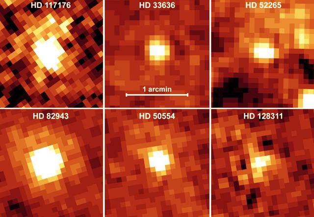
NASA's Spitzer Space Telescope recently captured these infrared images of six older stars with known planets. The yellow, fuzzy blobs are stars circled by disks of dust, or "debris disks," like the one that surrounds our own Sun. Though astronomers had predicted that stars with planets would harbor debris disks, they could not detect such disks until now. Spitzer was able to sense these dusty disks via their warm infrared glows. Specifically, the presence of the disks was inferred from an excess amount of infrared emission relative to what is emitted from the parent star alone. The stars themselves are similar in age and temperature to our Sun. In astronomical terms, they are stellar main sequence stars, with spectral types of F, G, or K. These planet-bearing stars have a median age of four billion years. For reference, our Sun is classified as a G star, with an age of approximately five billion years. The disks surrounding these planetary systems are comprised of cool material, with temperatures less than 100 Kelvin (-173 degrees Celsius). They are10 times farther away from their parent stars than Earth is from the Sun, and are thought to be analogues of the comet-filled Kuiper Belt in our solar system. The contrast scale is the same for each image. The images are approximately 2 arcminutes on each side. North is oriented upward and east is to the left. The pictures were taken with the 70-micron filter of Spitzer's multiband imaging photometer. The telescope resolution at 70 microns is 17 arcseconds and there is no evidence for any emission extended beyond the telescope resolution. http://photojournal.jpl.nasa.gov/catalog/PIA07098
This image from NASA's Spitzer Space Telescope shows infant stars "hatching" in the head of the hunter constellation, Orion. Astronomers suspect that shockwaves from a supernova explosion in Orion's head, nearly three million years ago, may have initiated this newfound birth. The region featured in this Spitzer image is called Barnard 30. It is located approximately 1,300 light-years away and sits on the right side of Orion's "head," just north of the massive star Lambda Orionis. Wisps of green in the cloud are organic molecules called polycyclic aromatic hydrocarbons. These molecules are formed anytime carbon-based materials are burned incompletely. On Earth, they can be found in the sooty exhaust from automobile and airplane engines. They also coat the grills where charcoal-broiled meats are cooked. Tints of orange-red in the cloud are dust particles warmed by the newly forming stars. The reddish-pink dots at the top of the cloud are very young stars embedded in a cocoon of cosmic gas and dust. Blue spots throughout the image are background Milky Way along this line of sight. This composite includes data from Spitzer's infrared array camera instrument, and multiband imaging photometer instrument. Light at 4.5 microns is shown as blue, 8.0 microns is green, and 24 microns is red. http://photojournal.jpl.nasa.gov/catalog/PIA09411
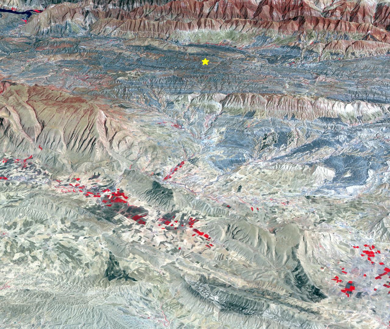
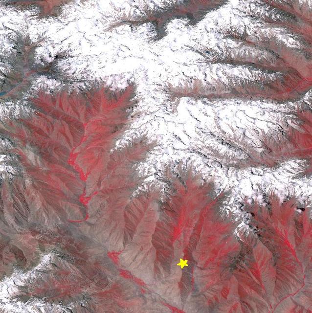
On Sunday, Nov. 12, 2017, a magnitude 7.3 earthquake struck along the Iran-Iraq border near Halabjah, Iraq. The earthquake was felt as far away as Kuwait, Qatar, Turkey, Lebanon and Israel. Extensive damage and numerous casualties were reported in the area near the epicenter (yellow star on image). The earthquake occurred along the boundary between the Arabian and Eurasian tectonic plates. This is an earthquake-prone area, and has experienced many deadly earthquakes in the past. In this perspective-view image, bright red areas are crops in fields, pale red on mountain ridges are shrubs and trees, dark gray areas are traces of earlier brush fires, and gray and tan colors are different rock types. The image was acquired Sept. 8, 2017, and the star marks the earthquake epicenter at 34.9 degrees north, 45.9 degrees east. https://photojournal.jpl.nasa.gov/catalog/PIA22112
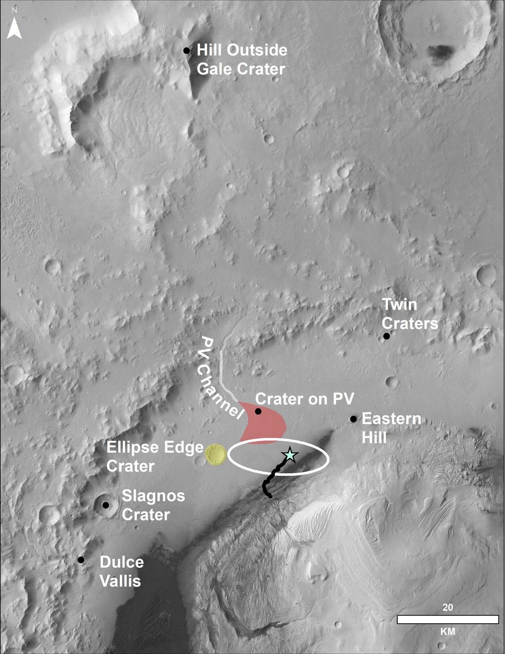
This image of the northwestern portion of Mars' Gale Crater and terrain north of it, from the European Space Agency's Mars Express orbiter, provides a locator map for some features visible in an October 2017 panorama from NASA's Curiosity Mars rover (see PIA22210, Fig. 1). A blue star marks the rover's landing site, on the floor of Gale Crater near the base of Mount Sharp. That layered mountain occupies the middle of the crater. The black line indicates the path of the rover's traverse from its August 2012 landing to about the location on lower Mount Sharp, where the panorama was acquired. North is toward the top. At lower right is a 20-kilometer (12.4-mile) scale bar. The base-map image was taken by the High Resolution Stereo Camera on Mars Express. https://photojournal.jpl.nasa.gov/catalog/PIA22208
STS-56 Earth observation shows of some of the highest mountain peaks in the world taken from Discovery, Orbiter Vehicle (OV) 103, as it passed over India and China. The top of the view shows one of the snow and ice-covered massifs in the great Karakorum Range of north India. A star-shaped peak at top left reaches 23,850 feet. Glaciers can be seen in valleys at these high elevations. The international border between India to the south (top) and China (bottom) snakes left to right along a river near the top of the scene, then veers into the muntains at top left. Larger valleys, despite their elevation (all in excess of 14,000 feet), are occupied by transport routes joining points in India, China and the southern republics of the CIS. The ancient Silk Route between China and the Middle East lies not far to the north (outside the bottom of the frame).
![This image from NASA Spitzer Space Telescope, shows the wispy filamentary structure of Henize 206, is a four-color composite mosaic created by combining data from an infrared array camera IRAC. The LMC is a small satellite galaxy gravitationally bound to our own Milky Way. Yet the gravitational effects are tearing the companion to shreds in a long-playing drama of 'intergalactic cannibalism.' These disruptions lead to a recurring cycle of star birth and star death. Astronomers are particularly interested in the LMC because its fractional content of heavy metals is two to five times lower than is seen in our solar neighborhood. [In this context, 'heavy elements' refer to those elements not present in the primordial universe. Such elements as carbon, oxygen and others are produced by nucleosynthesis and are ejected into the interstellar medium via mass loss by stars, including supernova explosions.] As such, the LMC provides a nearby cosmic laboratory that may resemble the distant universe in its chemical composition. The primary Spitzer image, showing the wispy filamentary structure of Henize 206, is a four-color composite mosaic created by combining data from an infrared array camera (IRAC) at near-infrared wavelengths and the mid-infrared data from a multiband imaging photometer (MIPS). Blue represents invisible infrared light at wavelengths of 3.6 and 4.5 microns. Note that most of the stars in the field of view radiate primarily at these short infrared wavelengths. Cyan denotes emission at 5.8 microns, green depicts the 8.0 micron light, and red is used to trace the thermal emission from dust at 24 microns. The separate instrument images are included as insets to the main composite. An inclined ring of emission dominates the central and upper regions of the image. This delineates a bubble of hot, x-ray emitting gas that was blown into space when a massive star died in a supernova explosion millions of years ago. The shock waves from that explosion impacted a cloud of nearby hydrogen gas, compressed it, and started a new generation of star formation. The death of one star led to the birth of many new stars. This is particularly evident in the MIPS inset, where the 24-micron emission peaks correspond to newly formed stars. The ultraviolet and visible-light photons from the new stars are absorbed by surrounding dust and re-radiated at longer infrared wavelengths, where it is detected by Spitzer. This emission nebula was cataloged by Karl Henize (HEN-eyes) while spending 1948-1951 in South Africa doing research for his Ph.D. dissertation at the University of Michigan. Henize later became a NASA astronaut and, at age 59, became the oldest rookie to fly on the Space Shuttle during an eight-day flight of the Challenger in 1985. He died just short of his 67th birthday in 1993 while attempting to climb the north face of Mount Everest, the world's highest peak. http://photojournal.jpl.nasa.gov/catalog/PIA05517](https://images-assets.nasa.gov/image/PIA05517/PIA05517~medium.jpg)
This image from NASA Spitzer Space Telescope, shows the wispy filamentary structure of Henize 206, is a four-color composite mosaic created by combining data from an infrared array camera IRAC. The LMC is a small satellite galaxy gravitationally bound to our own Milky Way. Yet the gravitational effects are tearing the companion to shreds in a long-playing drama of 'intergalactic cannibalism.' These disruptions lead to a recurring cycle of star birth and star death. Astronomers are particularly interested in the LMC because its fractional content of heavy metals is two to five times lower than is seen in our solar neighborhood. [In this context, 'heavy elements' refer to those elements not present in the primordial universe. Such elements as carbon, oxygen and others are produced by nucleosynthesis and are ejected into the interstellar medium via mass loss by stars, including supernova explosions.] As such, the LMC provides a nearby cosmic laboratory that may resemble the distant universe in its chemical composition. The primary Spitzer image, showing the wispy filamentary structure of Henize 206, is a four-color composite mosaic created by combining data from an infrared array camera (IRAC) at near-infrared wavelengths and the mid-infrared data from a multiband imaging photometer (MIPS). Blue represents invisible infrared light at wavelengths of 3.6 and 4.5 microns. Note that most of the stars in the field of view radiate primarily at these short infrared wavelengths. Cyan denotes emission at 5.8 microns, green depicts the 8.0 micron light, and red is used to trace the thermal emission from dust at 24 microns. The separate instrument images are included as insets to the main composite. An inclined ring of emission dominates the central and upper regions of the image. This delineates a bubble of hot, x-ray emitting gas that was blown into space when a massive star died in a supernova explosion millions of years ago. The shock waves from that explosion impacted a cloud of nearby hydrogen gas, compressed it, and started a new generation of star formation. The death of one star led to the birth of many new stars. This is particularly evident in the MIPS inset, where the 24-micron emission peaks correspond to newly formed stars. The ultraviolet and visible-light photons from the new stars are absorbed by surrounding dust and re-radiated at longer infrared wavelengths, where it is detected by Spitzer. This emission nebula was cataloged by Karl Henize (HEN-eyes) while spending 1948-1951 in South Africa doing research for his Ph.D. dissertation at the University of Michigan. Henize later became a NASA astronaut and, at age 59, became the oldest rookie to fly on the Space Shuttle during an eight-day flight of the Challenger in 1985. He died just short of his 67th birthday in 1993 while attempting to climb the north face of Mount Everest, the world's highest peak. http://photojournal.jpl.nasa.gov/catalog/PIA05517
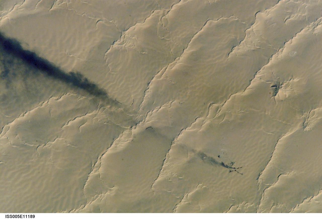
ISS005-E-11189 (25 August 2002) --- Calanscio Sand Sea, Libya is featured in this digital image photographed by an Expedition 5 crewmember on the International Space Station (ISS). A plume of black smoke blowing westward is silhouetted against yellow linear dunes in the great sand sea of northeast Libya. Smoke from flares at remote well heads is commonly seen by astronauts flying over the Sahara Desert. NASA scientists studying the Station imagery had the following observations about the image. The plume dispersal pattern visible at the left edge of the image may be due to upper-level winds or gravitational settling of heavier particulates. The regular pattern of linear dunes is generated by two major winds: the dominant north wind (north is towards the top right) determines the orientation of the sand dunes. Gentler easterly winds, as were blowing when this view was taken, make the dunes asymmetric, with a gentle windward (west) slope and an over steeped downwind slope. Some over steepened slopes even cast shadows in the early morning light. One mound of sand (top right), due north of the well head, does not fit the pattern of linear dunes. This type is known as a star dune.
Tumultuous tempests in Jupiter's northern hemisphere are seen in this portrait taken by NASA's Juno spacecraft. Like our home planet, Jupiter has cyclones and anticyclones, along with fast-moving jet streams that circle its globe. This image captures a jet stream, called Jet N6, located on the far right of the image. It is next to an anticyclonic white oval that is the brighter circular feature in the top right corner. The North North Little Red Spot is also visible in this view. The image was taken at 10 p.m. PDT on July 15, 2018 (1 a.m. EDT on July 16), as the spacecraft performed its 14th close flyby of Jupiter. At the time, Juno was about 10,600 miles (17,000 kilometers) from the planet's cloud tops, above a latitude of 59 degrees. Citizen scientists Brian Swift and Seán Doran created this image using data from the spacecraft's JunoCam imager. The image has been rotated clockwise so that north is to the right. The stars were artfully added to the background for effect. https://photojournal.jpl.nasa.gov/catalog/PIA22428
CAPE CANAVERAL, Fla. – This is the radome beneath which is the NASA Debris Radar. It is located at a remote site on North Merritt Island in Florida. One of the largest of its kind in the world, the C-band radar provided critical support to pinpoint debris during the launch of space shuttle Atlantis on the STS-125 mission. The need for this radar was identified after the Columbia tragedy. It worked together with smaller X-band radars placed on the solid rocket booster ship Liberty Star and the U.S. Army landing craft utility ship Brandy Station. Together they provided extremely high resolution images of any debris that created by Atlantis during launch. Photo credit: NASA/Troy Cryder
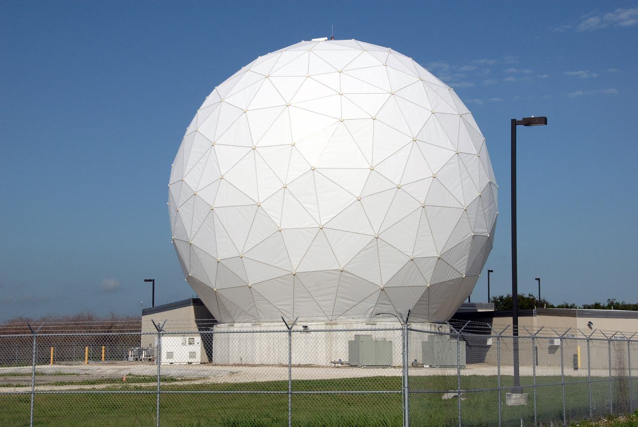
CAPE CANAVERAL, Fla. – This is the radome beneath which is the NASA Debris Radar. It is located at a remote site on North Merritt Island in Florida. One of the largest of its kind in the world, the C-band radar provided critical support to pinpoint debris during the launch of space shuttle Atlantis on the STS-125 mission. The need for this radar was identified after the Columbia tragedy. It worked together with smaller X-band radars placed on the solid rocket booster ship Liberty Star and the U.S. Army landing craft utility ship Brandy Station. Together they provided extremely high resolution images of any debris that created by Atlantis during launch. Photo credit: NASA/Troy Cryder
On Sunday, Nov. 6, 2016, at 7:44 p.m. local time, a magnitude 5.0 earthquake struck near the town of Cushing, Oklahoma. Numerous buildings were damaged by the temblor, but only a few minor injuries were reported. Cushing is home to one of the world's largest oil storage terminals; no damage was reported to the petroleum facilities. A star marks the epicenter of the earthquake,which occurred at a depth of 3.1 miles (5 kilometers). The image was acquired April 28, 2011, covers an area of 7 by 9 miles (11.4 by 14.5 kilometers), and is located at 36 degrees north, 96.8 degrees west. http://photojournal.jpl.nasa.gov/catalog/PIA21099
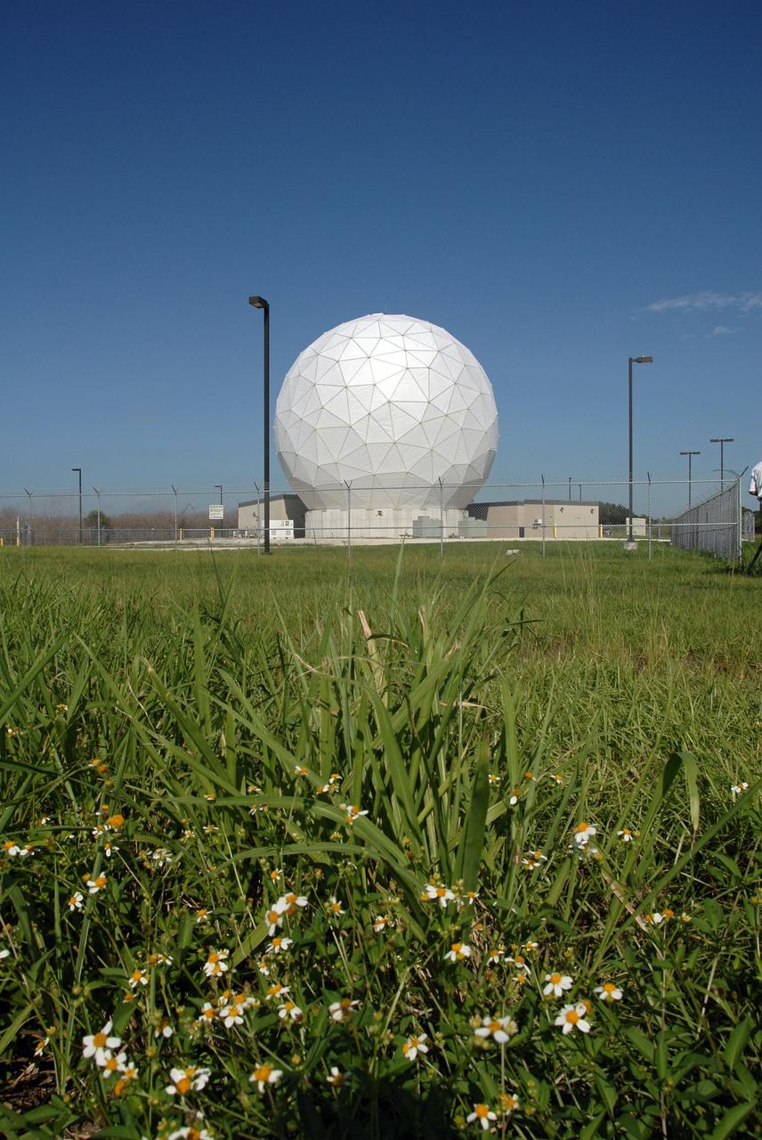
CAPE CANAVERAL, Fla. – This is the radome beneath which is the NASA Debris Radar. It is located at a remote site on North Merritt Island in Florida. One of the largest of its kind in the world, the C-band radar provided critical support to pinpoint debris during the launch of space shuttle Atlantis on the STS-125 mission. The need for this radar was identified after the Columbia tragedy. It worked together with smaller X-band radars placed on the solid rocket booster ship Liberty Star and the U.S. Army landing craft utility ship Brandy Station. Together they provided extremely high resolution images of any debris that created by Atlantis during launch. Photo credit: NASA/Troy Cryder
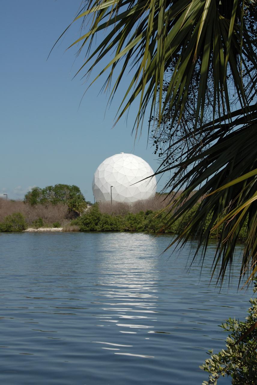
CAPE CANAVERAL, Fla. – This is the radome beneath which is the NASA Debris Radar. It is located at a remote site on North Merritt Island in Florida. One of the largest of its kind in the world, the C-band radar provided critical support to pinpoint debris during the launch of space shuttle Atlantis on the STS-125 mission. The need for this radar was identified after the Columbia tragedy. It worked together with smaller X-band radars placed on the solid rocket booster ship Liberty Star and the U.S. Army landing craft utility ship Brandy Station. Together they provided extremely high resolution images of any debris that created by Atlantis during launch. Photo credit: NASA/Troy Cryder
CAPE CANAVERAL, Fla. – This view is NASA's C-band, Debris Radar antenna inside the radome at a site on North Merritt Island in Florida. One of the largest of its kind in the world, the C-band radar provided critical support to pinpoint debris during the launch of space shuttle Atlantis on the STS-125 mission. The need for this radar was identified after the Columbia tragedy. It worked together with smaller X-band radars placed on the solid rocket booster ship Liberty Star and the U.S. Army landing craft utility ship Brandy Station. Together they provided extremely high resolution images of any debris that created by Atlantis during launch. Photo credit: NASA/Troy Cryder

CAPE CANAVERAL, Fla. – An engineer analyzes data from NASA's C-band Debris Radar antenna at a site on North Merritt Island in Florida. One of the largest of its kind in the world, the C-band radar provided critical support to pinpoint debris during the launch of space shuttle Atlantis on the STS-125 mission. The need for this radar was identified after the Columbia tragedy. It worked together with smaller X-band radars placed on the solid rocket booster ship Liberty Star and the U.S. Army landing craft utility ship Brandy Station. Together they provided extremely high resolution images of any debris that created by Atlantis during launch. Photo credit: NASA/Troy Cryder

Designed by the STS-88 crew members, this patch commemorates the first assembly flight to carry United States-built hardware for constructing the International Space Station (ISS). This flight's primary task was to assemble the cornerstone of the Space Station: the Node with the Functional Cargo Block (FGB). The rising sun symbolizes the dawning of a new era of international cooperation in space and the beginning of a new program: the International Space Station. The Earth scene outlines the countries of the Station Partners: the United States, Russia, those of the European Space Agency (ESA), Japan, and Canada. Along with the Pressurized Mating Adapters (PMA) and the Functional Cargo Block, the Node is shown in the final mated configuration while berthed to the Space Shuttle during the STS-88/2A mission. The Big Dipper Constellation points the way to the North Star, a guiding light for pioneers and explorers for generations. In the words of the crew, These stars symbolize the efforts of everyone, including all the countries involved in the design and construction of the International Space Station, guiding us into the future.
This image from NASA's Spitzer Space Telescope shows infant stars "hatching" in the head of the hunter constellation, Orion. Astronomers suspect that shockwaves from a supernova explosion in Orion's head, nearly three million years ago, may have initiated this newfound birth . The region featured in this Spitzer image is called Barnard 30. It is located approximately 1,300 light-years away and sits on the right side of Orion's "head," just north of the massive star Lambda Orionis. Wisps of red in the cloud are organic molecules called polycyclic aromatic hydrocarbons. These molecules are formed anytime carbon-based materials are burned incompletely. On Earth, they can be found in the sooty exhaust from automobile and airplane engines. They also coat the grills where charcoal-broiled meats are cooked. This image shows infrared light captured by Spitzer's infrared array camera. Light with wavelengths of 8 and 5.8 microns (red and orange) comes mainly from dust that has been heated by starlight. Light of 4.5 microns (green) shows hot gas and dust; and light of 3.6 microns (blue) is from starlight. http://photojournal.jpl.nasa.gov/catalog/PIA09412
STS088-S-001 (September 1998) --- Designed by the crew members, this STS-88 patch commemorates the first assembly flight to carry United States-built hardware for constructing the International Space Station (ISS). This flight's primary task is to assemble the cornerstone of the space station: the Node with the Functional Cargo Block (FGB). The rising sun symbolizes the dawning of a new era of international cooperation in space and the beginning of a new program: the International Space Station. The Earth scene outlines the countries of the Station Partners: the United States, Russia, those of the European Space Agency (ESA), Japan, and Canada. Along with the Pressurized Mating Adapters (PMA) and the Functional Cargo Block, the Node is shown in the final mated configuration while berthed to the space shuttle during the STS-88/2A mission. The Big Dipper Constellation points the way to the North Star, a guiding light for pioneers and explorers for generations. In the words of the crew, "These stars symbolize the efforts of everyone, including all the countries involved in the design and construction of the International Space Station, guiding us into the future." The NASA insignia design for space shuttle flights is reserved for use by the astronauts and for other official use as the NASA Administrator may authorize. Public availability has been approved only in the forms of illustrations by the various news media. When and if there is any change in this policy, which is not anticipated, the change will be publicly announced. Photo credit: NASA
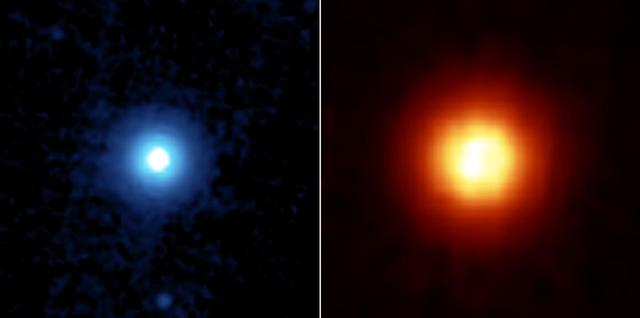
NASA's Spitzer Space Telescope recently captured these images of the star Vega, located 25 light years away in the constellation Lyra. Spitzer was able to detect the heat radiation from the cloud of dust around the star and found that the debris disc is much larger than previously thought. This side by side comparison, taken by Spitzer's multiband imaging photometer, shows the warm infrared glows from dust particles orbiting the star at wavelengths of 24 microns (figure 2 in blue) and 70 microns (figure 3 in red). Both images show a very large, circular and smooth debris disc. The disc radius extends to at least 815 astronomical units. (One astronomical unit is the distance from Earth to the Sun, which is 150-million kilometers or 93-million miles). Scientists compared the surface brightness of the disc in the infrared wavelengths to determine the temperature distribution of the disc and then infer the corresponding particle size in the disc. Most of the particles in the disc are only a few microns in size, or 100 times smaller than a grain of Earth sand. These fine dust particles originate from collisions of embryonic planets near the star at a radius of approximately 90 astronomical units, and are then blown away by Vega's intense radiation. The mass and short lifetime of these small particles indicate that the disc detected by Spitzer is the aftermath of a large and relatively recent collision, involving bodies perhaps as big as the planet Pluto. The images are 3 arcminutes on each side. North is oriented upward and east is to the left. http://photojournal.jpl.nasa.gov/catalog/PIA07218

ISS013-E-75141 (2 Sept. 2006) --- Erg Oriental, Algeria is featured in this image photographed by an Expedition 13 crewmember onboard the International Space Station. One of the main interests of rainless regions like the Sahara Desert to landscape science is that the work of flowing water--mainly streams and rivers--becomes less important than the work of wind. According to scientists, over millennia, and if enough sand is available, winds can generate dunes of enormous size, arranged in regular patterns. Long, generally north-south trending linear dunes stretch across much of northeast Algeria covering a vast tract (approximately 140,000 kilometers square) of the Sahara Desert known as the Erg Oriental. Erg means dune sea in Arabic, and the term has been adopted into modern geology. Spanning this image diagonally are a series of two kilometer-wide linear dunes, comprised of red sand, from a point on the southwest margin of the erg (center point 28.9N 4.8W). The dune chains are more than 100 meters high. The "streets" between the dunes are grayer areas free of sand. Linear dune chains are usually generated roughly parallel with the dominant winds. It also seems to be true that linear dunes are built by stronger winds. This detailed view shows that smaller dunes, known as star dunes, are built on top of the linear dunes. By contrast, star dunes seem to form in weak wind regimes, with winds from different directions in each season -- resulting in characteristic "arms" snaking away from a central point. Some scientists therefore think the dunes in this image were generated in two earlier climatic phases, different from that of today. (1) During a phase when winds were stronger and dominantly from one direction (the south), major linear sand masses accumulated. (2) Later, when wind strengths declined, the star dunes formed. Modern features--known as wind streaks--on the edge of the present erg (not shown), younger than either the linear or star dunes, show that present-day sand-moving winds blow from the southwest.
VANDENBERG AIR FORCE BASE, Calif. – Orbital Sciences’ L-1011 carrier aircraft taxies to the runway at Vandenberg Air Force Base in California. The aircraft is transporting Orbital’s Pegasus rocket and NASA’s Nuclear Spectroscopic Telescope Array, or NuSTAR, to the U.S. Army's Ronald Reagan Ballistic Missile Defense Test Site on Kwajalein Atoll, part of the Marshall Islands in the Pacific Ocean. The Pegasus, mated to its NuSTAR payload, will be launched from the carrier aircraft 117 nautical miles south of Kwajalein at latitude 6.75 degrees north of the equator. The high-energy X-ray telescope will conduct a census of black holes, map radioactive material in young supernovae remnants, and study the origins of cosmic rays and the extreme physics around collapsed stars. Launch is scheduled for June 13. For more information, visit http://www.nasa.gov/nustar. Photo credit: NASA/Randy Beaudoin, VAFB
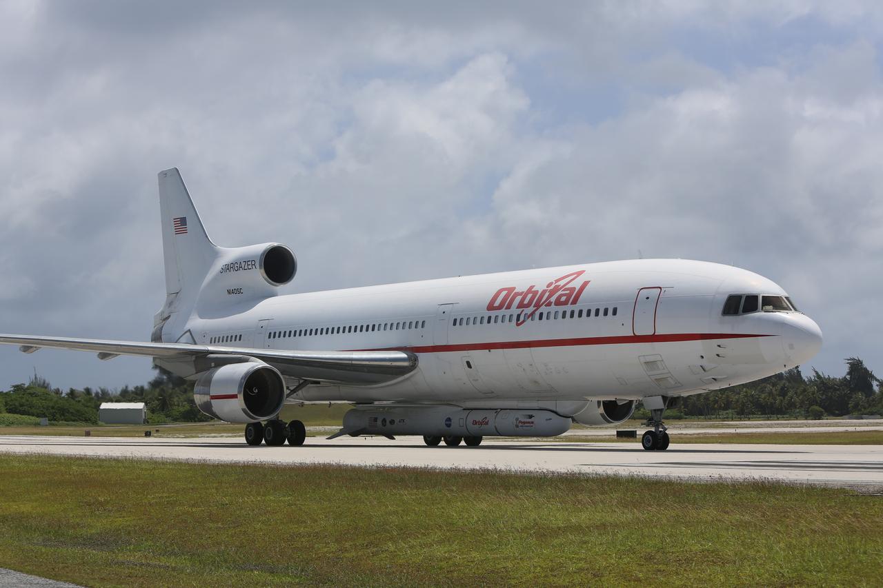
KWAJALEIN ATOLL, Marshall Islands – Orbital Sciences' L-1011 carrier aircraft approaches the runway at the U.S. Army's Ronald Reagan Ballistic Missile Defense Test Site on Kwajalein Atoll to deliver Orbital’s Pegasus rocket and NASA’s Nuclear Spectroscopic Telescope Array, or NuSTAR, for launch. The Pegasus, mated to its NuSTAR payload, will be launched from the carrier aircraft 117 nautical miles south of Kwajalein at latitude 6.75 degrees north of the equator. The high-energy X-ray telescope will conduct a census of black holes, map radioactive material in young supernovae remnants, and study the origins of cosmic rays and the extreme physics around collapsed stars. Launch and deployment of the telescope is scheduled for June 13. For more information, visit http://www.nasa.gov/nustar. Photo courtesy of Orbital Sciences Corp.
KWAJALEIN ATOLL, Marshall Islands – An Orbital Sciences’ Pegasus rocket and NASA’s Nuclear Spectroscopic Telescope Array, or NuSTAR, are delivered to the U.S. Army's Ronald Reagan Ballistic Missile Defense Test Site on Kwajalein Atoll secured beneath Orbital’s L-1011 carrier aircraft. The Pegasus, mated to its NuSTAR payload, will be launched from the carrier aircraft 117 nautical miles south of Kwajalein at latitude 6.75 degrees north of the equator. The high-energy X-ray telescope will conduct a census of black holes, map radioactive material in young supernovae remnants, and study the origins of cosmic rays and the extreme physics around collapsed stars. Launch and deployment of the telescope is scheduled for June 13. For more information, visit http://www.nasa.gov/nustar. Photo courtesy of Orbital Sciences Corp.

The one-man submarine dubbed DeepWorker 2000 sits on the deck of Liberty Star, one of two KSC solid rocket booster recovery ships. Inside the sub is the pilot, Anker Rasmussen. The sub is being tested on its ability to duplicate the sometimes hazardous job United Space Alliance (USA) divers perform to recover the expended boosters in the ocean after a launch. The boosters splash down in an impact area about 140 miles east of Jacksonville and after recovery are towed back to KSC for refurbishment by the specially rigged recovery ships. DeepWorker 2000 was built by Nuytco Research Ltd., North Vancouver, British Columbia. It is 8.25 feet long, 5.75 feet high, and weighs 3,800 pounds. USA is a prime contractor to NASA for the Space Shuttle program
KENNEDY SPACE CENTER, FLA. - Andrew Shepard, expedition leader, National Undersea Research Center, University of North Carolina at Wilmington, N. Car., poses on deck of the Liberty Star with some of the equipment to be used in the Oculina Banks project. The ship will be the site of an undersea expedition to characterize the condition of the deep-sea coral reefs and reef fish populations in the Oculina Banks, a marine protected area, 20 miles offshore of the east coast of Florida. He and other scientists will be deploying an underwater robot, a seafloor sampler, and the Passive Acoustic Monitoring System (PAMS). Dr. Grant Gilmore was co-principle investigator of the PAMS, originally developed by NASA to monitor the impact of rocket launches on wildlife refuge lagoons at KSC. The research is sponsored by NOAA Fisheries. The ship departed from Port Canaveral April 29 and will return May 9.

VANDENBERG AIR FORCE BASE, Calif. – Orbital Sciences’ L-1011 carrier aircraft, transporting Orbital’s Pegasus rocket and NASA’s Nuclear Spectroscopic Telescope Array, or NuSTAR, leaves Vandenberg Air Force Base in California behind on its way to the U.S. Army's Ronald Reagan Ballistic Missile Defense Test Site on Kwajalein Atoll, part of the Marshall Islands in the Pacific Ocean. The Pegasus, mated to its NuSTAR payload, will be launched from the carrier aircraft 117 nautical miles south of Kwajalein at latitude 6.75 degrees north of the equator. The high-energy X-ray telescope will conduct a census of black holes, map radioactive material in young supernovae remnants, and study the origins of cosmic rays and the extreme physics around collapsed stars. Launch is scheduled for June 13. For more information, visit http://www.nasa.gov/nustar. Photo credit: NASA/Randy Beaudoin, VAFB
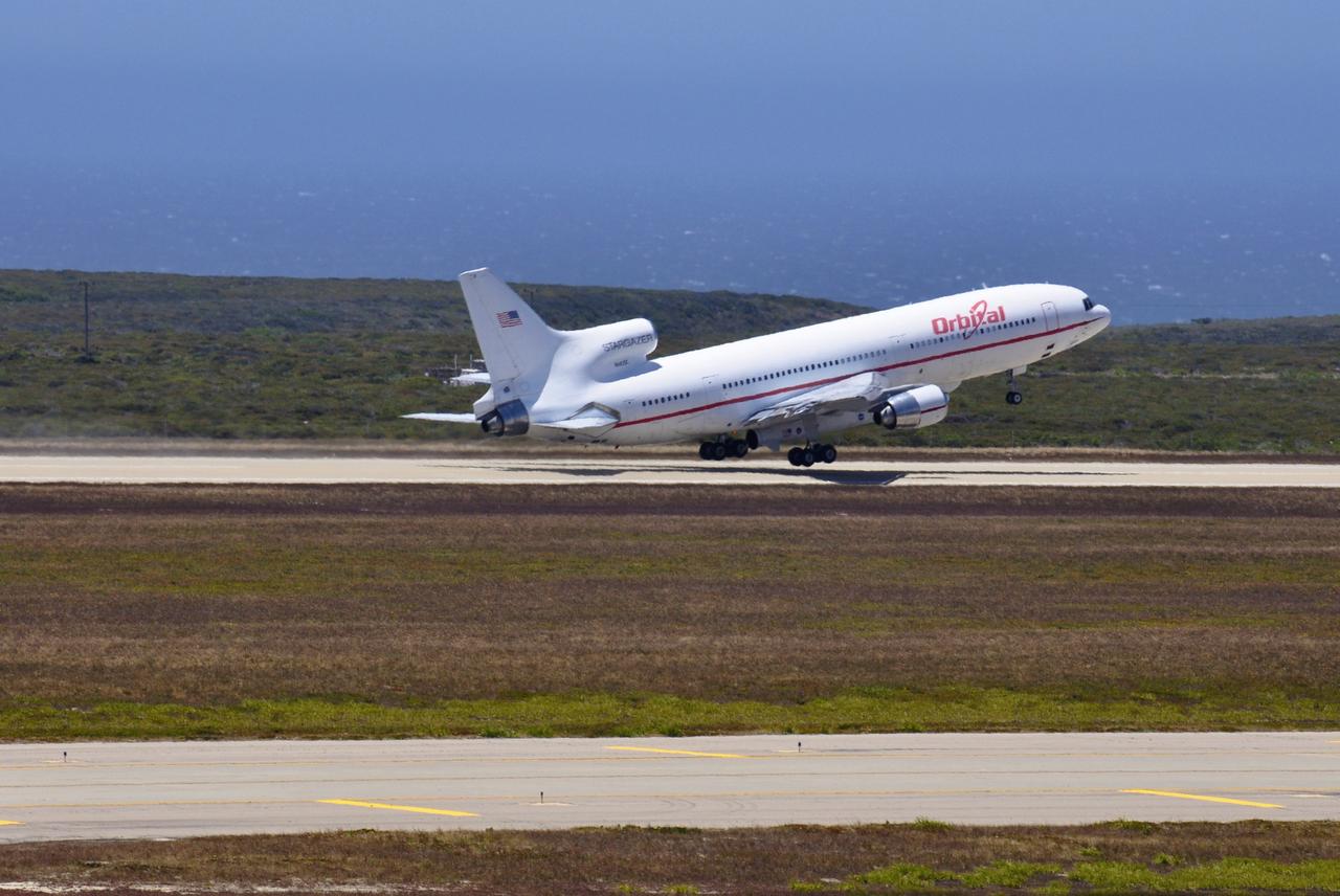
VANDENBERG AIR FORCE BASE, Calif. – Orbital Sciences’ L-1011 carrier aircraft appears to hover above the runway as it departs from Vandenberg Air Force Base in California. The aircraft is transporting Orbital’s Pegasus rocket and NASA’s Nuclear Spectroscopic Telescope Array, or NuSTAR, to the U.S. Army's Ronald Reagan Ballistic Missile Defense Test Site on Kwajalein Atoll, part of the Marshall Islands in the Pacific Ocean. The Pegasus, mated to its NuSTAR payload, will be launched from the carrier aircraft 117 nautical miles south of Kwajalein at latitude 6.75 degrees north of the equator. The high-energy X-ray telescope will conduct a census of black holes, map radioactive material in young supernovae remnants, and study the origins of cosmic rays and the extreme physics around collapsed stars. Launch is scheduled for June 13. For more information, visit http://www.nasa.gov/nustar. Photo credit: NASA/Randy Beaudoin, VAFB

KENNEDY SPACE CENTER, FLA. -- Inside the clean-room "tent" of Building 1555 at North Vandenberg Air Force Base, a technician places a star tracker cover on the AIM spacecraft during testing of the solar array panel deployment. The AIM spacecraft will fly three instruments designed to study polar mesospheric clouds located at the edge of space, 50 miles above the Earth's surface in the coldest part of the planet's atmosphere. The mission's primary goal is to explain why these clouds form and what has caused them to become brighter and more numerous and appear at lower latitudes in recent years. AIM's results will provide the basis for the study of long-term variability in the mesospheric climate and its relationship to global climate change. AIM is scheduled to be mated to its launch vehicle, Orbital Sciences' Pegasus XL, during the second week of April, after which final inspections will be conducted. Launch is scheduled for April 25.
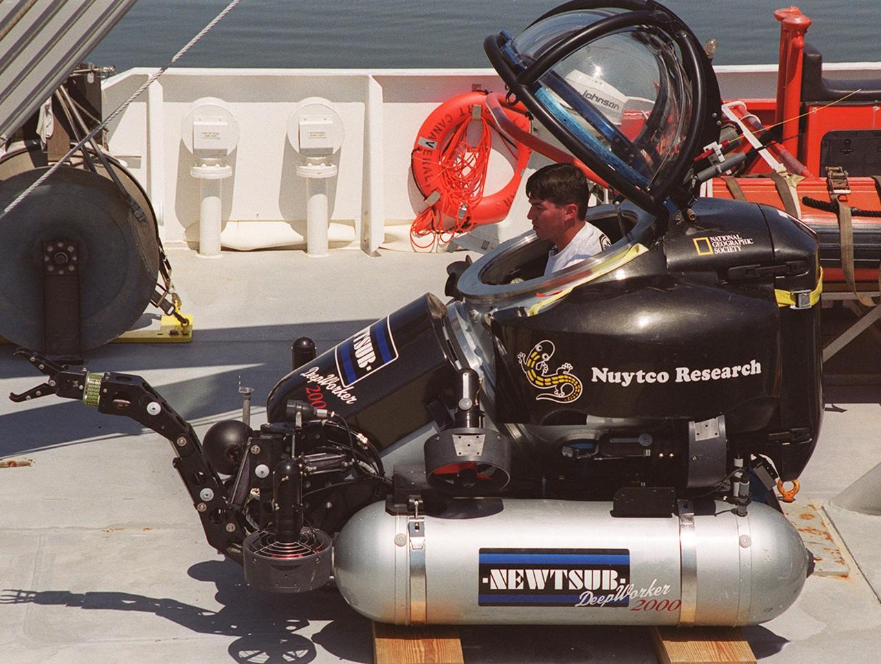
The one-man submarine dubbed DeepWorker 2000 sits on the deck of Liberty Star, one of two KSC solid rocket booster recovery ships. Inside the sub is the pilot, Anker Rasmussen. The sub is being tested on its ability to duplicate the sometimes hazardous job United Space Alliance (USA) divers perform to recover the expended boosters in the ocean after a launch. The boosters splash down in an impact area about 140 miles east of Jacksonville and after recovery are towed back to KSC for refurbishment by the specially rigged recovery ships. DeepWorker 2000 was built by Nuytco Research Ltd., North Vancouver, British Columbia. It is 8.25 feet long, 5.75 feet high, and weighs 3,800 pounds. USA is a prime contractor to NASA for the Space Shuttle program
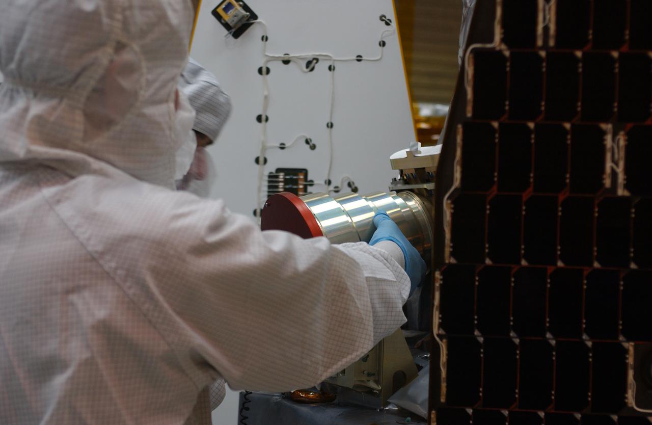
Inside the clean-room "tent" of Building 1555 at North Vandenberg Air Force Base, a technician places a star tracker cover on the AIM spacecraft during testing of the solar array panel deployment. The AIM spacecraft will fly three instruments designed to study polar mesospheric clouds located at the edge of space, 50 miles above the Earth's surface in the coldest part of the planet's atmosphere. The mission's primary goal is to explain why these clouds form and what has caused them to become brighter and more numerous and appear at lower latitudes in recent years. AIM's results will provide the basis for the study of long-term variability in the mesospheric climate and its relationship to global climate change. AIM is scheduled to be mated to its launch vehicle, Orbital Sciences' Pegasus XL, during the second week of April, after which final inspections will be conducted. Launch is scheduled for April 25.
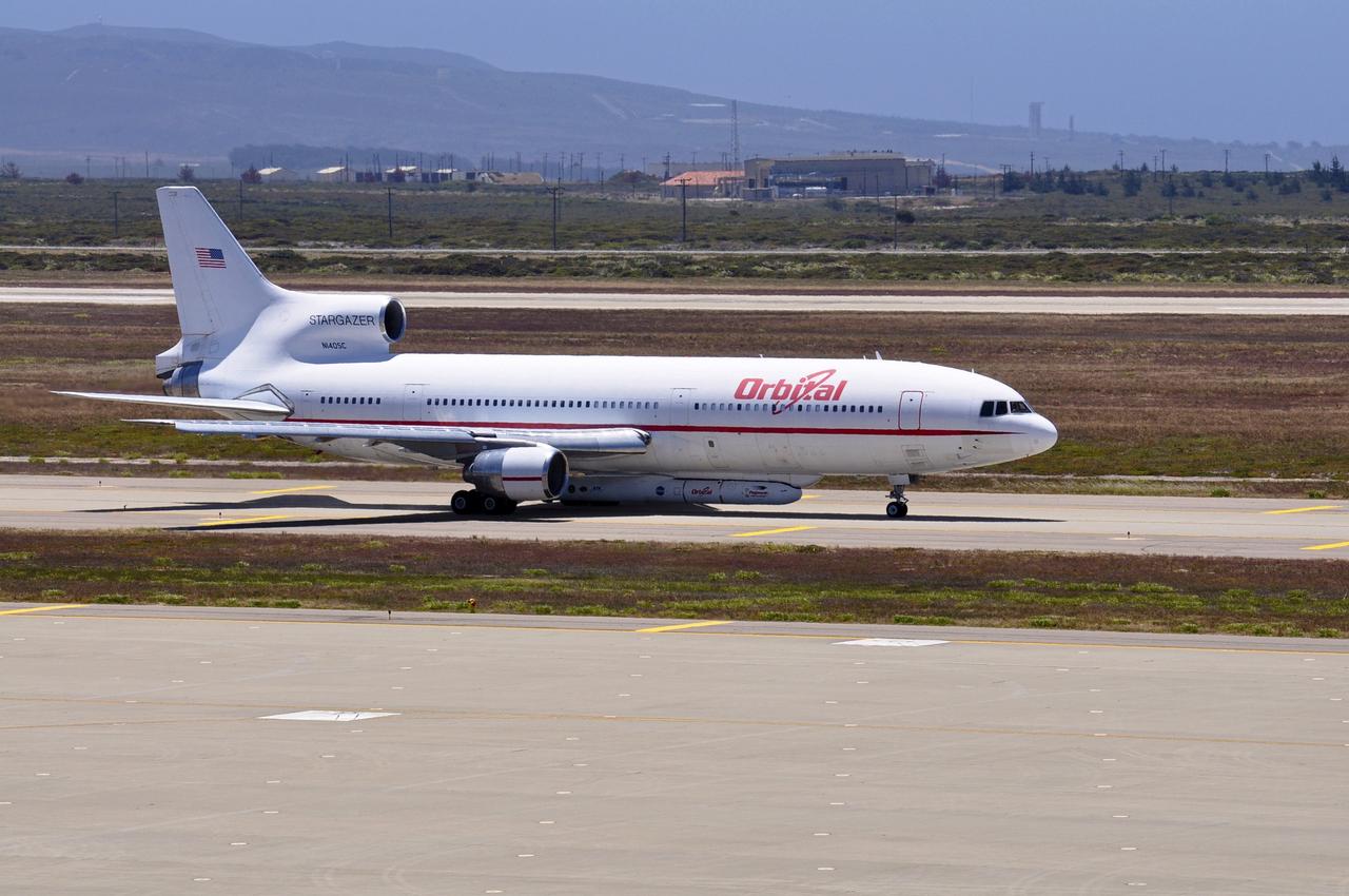
VANDENBERG AIR FORCE BASE, Calif. – Orbital Sciences’ L-1011 carrier aircraft taxies to the runway at Vandenberg Air Force Base in California. The aircraft is transporting Orbital’s Pegasus rocket and NASA’s Nuclear Spectroscopic Telescope Array, or NuSTAR, to the U.S. Army's Ronald Reagan Ballistic Missile Defense Test Site on Kwajalein Atoll, part of the Marshall Islands in the Pacific Ocean. The Pegasus, mated to its NuSTAR payload, will be launched from the carrier aircraft 117 nautical miles south of Kwajalein at latitude 6.75 degrees north of the equator. The high-energy X-ray telescope will conduct a census of black holes, map radioactive material in young supernovae remnants, and study the origins of cosmic rays and the extreme physics around collapsed stars. Launch is scheduled for June 13. For more information, visit http://www.nasa.gov/nustar. Photo credit: NASA/Randy Beaudoin, VAFB
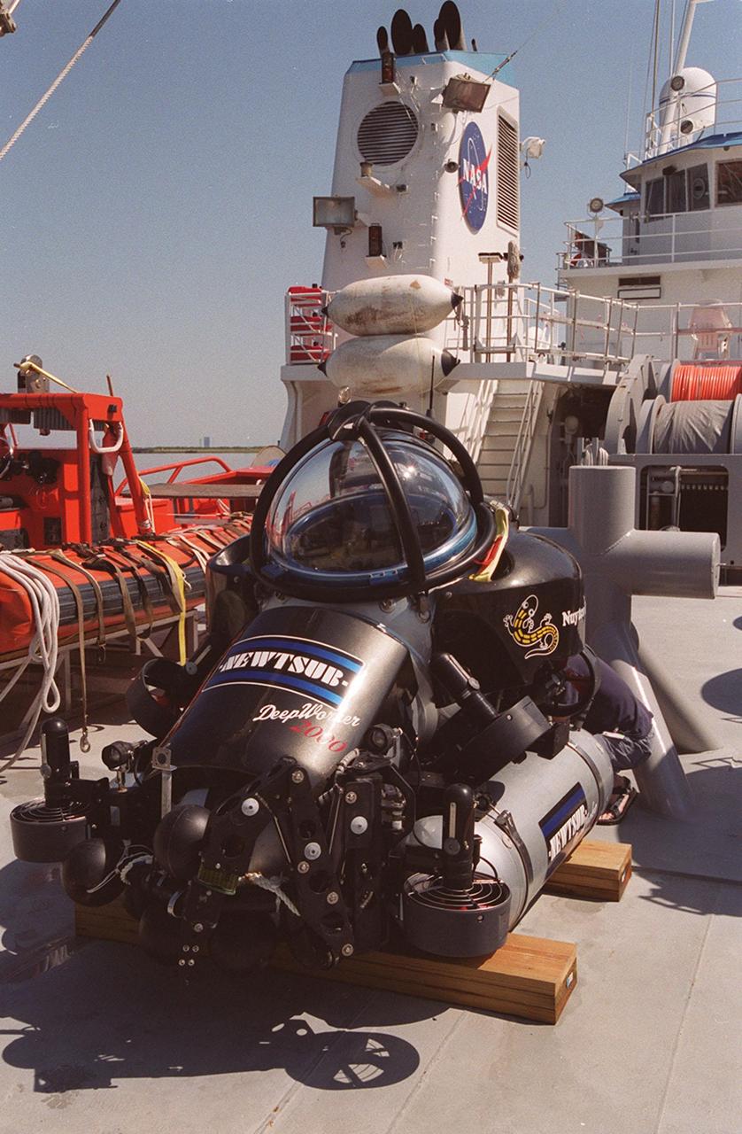
The one-man submarine dubbed DeepWorker 2000 sits on the deck of Liberty Star, one of two KSC solid rocket booster recovery ships. The sub is being tested on its ability to duplicate the sometimes hazardous job United Space Alliance (USA) divers perform to recover the expended boosters in the ocean after a launch. The boosters splash down in an impact area about 140 miles east of Jacksonville and after recovery are towed back to KSC for refurbishment by the specially rigged recovery ships. DeepWorker 2000 was built by Nuytco Research Ltd., North Vancouver, British Columbia. It is 8.25 feet long, 5.75 feet high, and weighs 3,800 pounds. USA is a prime contractor to NASA for the Space Shuttle program
These "stars" found on the floor of Ceres' Occator Crater belong to the Vinalia Faculae. The faculae are deposits of salts, in particular sodium carbonate, possibly extruded through fractures connecting the surface to a deep reservoir of salty liquid. The images used in this montage were obtained by NASA's Dawn spacecraft in June 2018 from an altitude of about 21 miles (34 kilometers). NASA announced the conclusion of Dawn's mission operations was Oct. 31, 2018, when the spacecraft depleted its hydrazine. The center of this feature is located at about 20.2 degrees north latitude and 241.3 degrees east longitude, in the eastern part of Occator Crater. Occator Crater is named after the Roman agricultural deity of the harrowing, a helper of Ceres, the goddess of agriculture, grain crops, fertility and motherly relationships. https://photojournal.jpl.nasa.gov/catalog/PIA22980
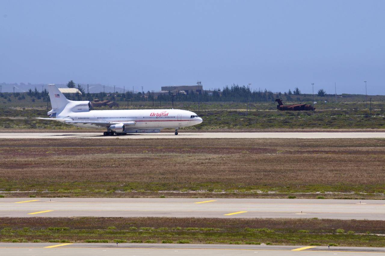
VANDENBERG AIR FORCE BASE, Calif. – Orbital Sciences’ L-1011 carrier aircraft prepares for takeoff from the runway at Vandenberg Air Force Base in California. The aircraft is transporting Orbital’s Pegasus rocket and NASA’s Nuclear Spectroscopic Telescope Array, or NuSTAR, to the U.S. Army's Ronald Reagan Ballistic Missile Defense Test Site on Kwajalein Atoll, part of the Marshall Islands in the Pacific Ocean. The Pegasus, mated to its NuSTAR payload, will be launched from the carrier aircraft 117 nautical miles south of Kwajalein at latitude 6.75 degrees north of the equator. The high-energy X-ray telescope will conduct a census of black holes, map radioactive material in young supernovae remnants, and study the origins of cosmic rays and the extreme physics around collapsed stars. Launch is scheduled for June 13. For more information, visit http://www.nasa.gov/nustar. Photo credit: NASA/Randy Beaudoin, VAFB
VANDENBERG AIR FORCE BASE, Calif. – An Orbital Sciences’ Pegasus rocket and NASA’s Nuclear Spectroscopic Telescope Array, or NuSTAR, are installed under Orbital’s L-1011 carrier aircraft and await departure from Vandenberg Air Force Base in California for the U.S. Army's Ronald Reagan Ballistic Missile Defense Test Site on Kwajalein Atoll, part of the Marshall Islands in the Pacific Ocean. The Pegasus, mated to its NuSTAR payload, will be launched from the carrier aircraft 117 nautical miles south of Kwajalein at latitude 6.75 degrees north of the equator. The high-energy X-ray telescope will conduct a census of black holes, map radioactive material in young supernovae remnants, and study the origins of cosmic rays and the extreme physics around collapsed stars. Launch is scheduled for June 13. For more information, visit http://www.nasa.gov/nustar. Photo credit: NASA/Randy Beaudoin, VAFB
On Oct. 26, 2015, NASA Terra spacecraft acquired this image of northeastern Afghanistan where a magnitude 7.5 earthquake struck the Hindu Kush region. The earthquake's epicenter was at a depth of 130 miles (210 kilometers), on a probable shallowly dipping thrust fault. At this location, the Indian subcontinent moves northward and collides with Eurasia, subducting under the Asian continent, and raising the highest mountains in the world. This type of earthquake is common in the area: a similar earthquake occurred 13 years ago about 12 miles (20 kilometers) away. This perspective image from the Advanced Spaceborne Thermal Emission and Reflection Radiometer (ASTER) instrument on NASA's Terra spacecraft, looking southwest, shows the hypocenter with a star. The image was acquired July 8, 2015, and is located near 36.4 degrees north, 70.7 degrees east. http://photojournal.jpl.nasa.gov/catalog/PIA20035
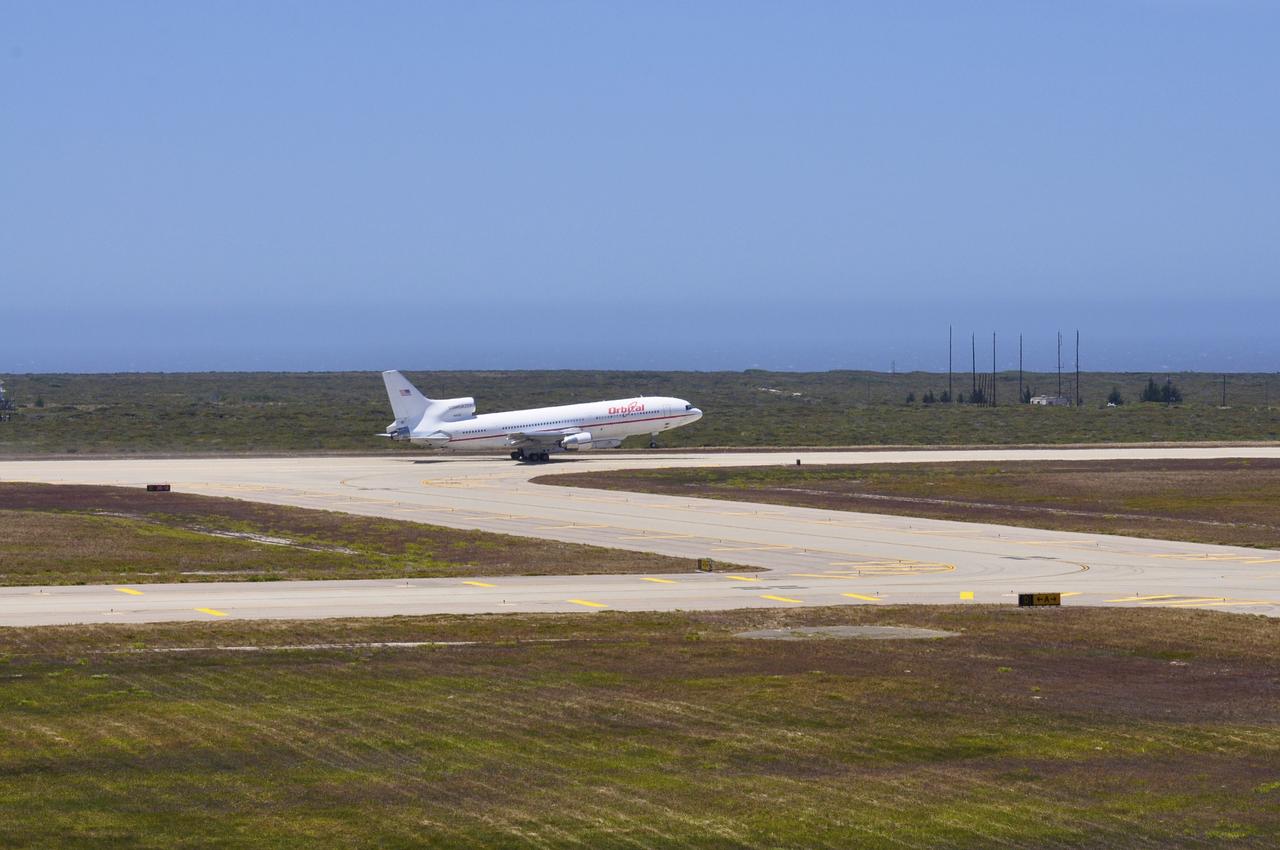
VANDENBERG AIR FORCE BASE, Calif. – Orbital Sciences’ L-1011 carrier aircraft lifts off the runway as it departs from Vandenberg Air Force Base in California. The aircraft is transporting Orbital’s Pegasus rocket and NASA’s Nuclear Spectroscopic Telescope Array, or NuSTAR, to the U.S. Army's Ronald Reagan Ballistic Missile Defense Test Site on Kwajalein Atoll, part of the Marshall Islands in the Pacific Ocean. The Pegasus, mated to its NuSTAR payload, will be launched from the carrier aircraft 117 nautical miles south of Kwajalein at latitude 6.75 degrees north of the equator. The high-energy X-ray telescope will conduct a census of black holes, map radioactive material in young supernovae remnants, and study the origins of cosmic rays and the extreme physics around collapsed stars. Launch is scheduled for June 13. For more information, visit http://www.nasa.gov/nustar. Photo credit: NASA/Randy Beaudoin, VAFB
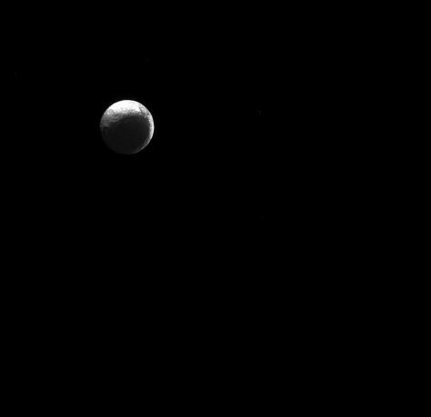
The moon Iapetus, like the "force" in Star Wars, has both a light side and a dark side. Scientists think that Iapetus' (914 miles or 1471 kilometers across) dark/light asymmetry was actually created by material migrating away from the dark side. For a simulation of how scientists think the asymmetry formed, see Thermal Runaway Model . Lit terrain seen here is on the Saturn-facing hemisphere of Iapetus. North on Iapetus is up and rotated 43 degrees to the right. The image was taken in green light with the Cassini spacecraft narrow-angle camera on Jan. 4, 2015. The view was acquired at a distance of approximately 2.5 million miles (4 million kilometers) from Iapetus. Image scale is 15 miles (24 kilometers) per pixel. http://photojournal.jpl.nasa.gov/catalog/pia18307
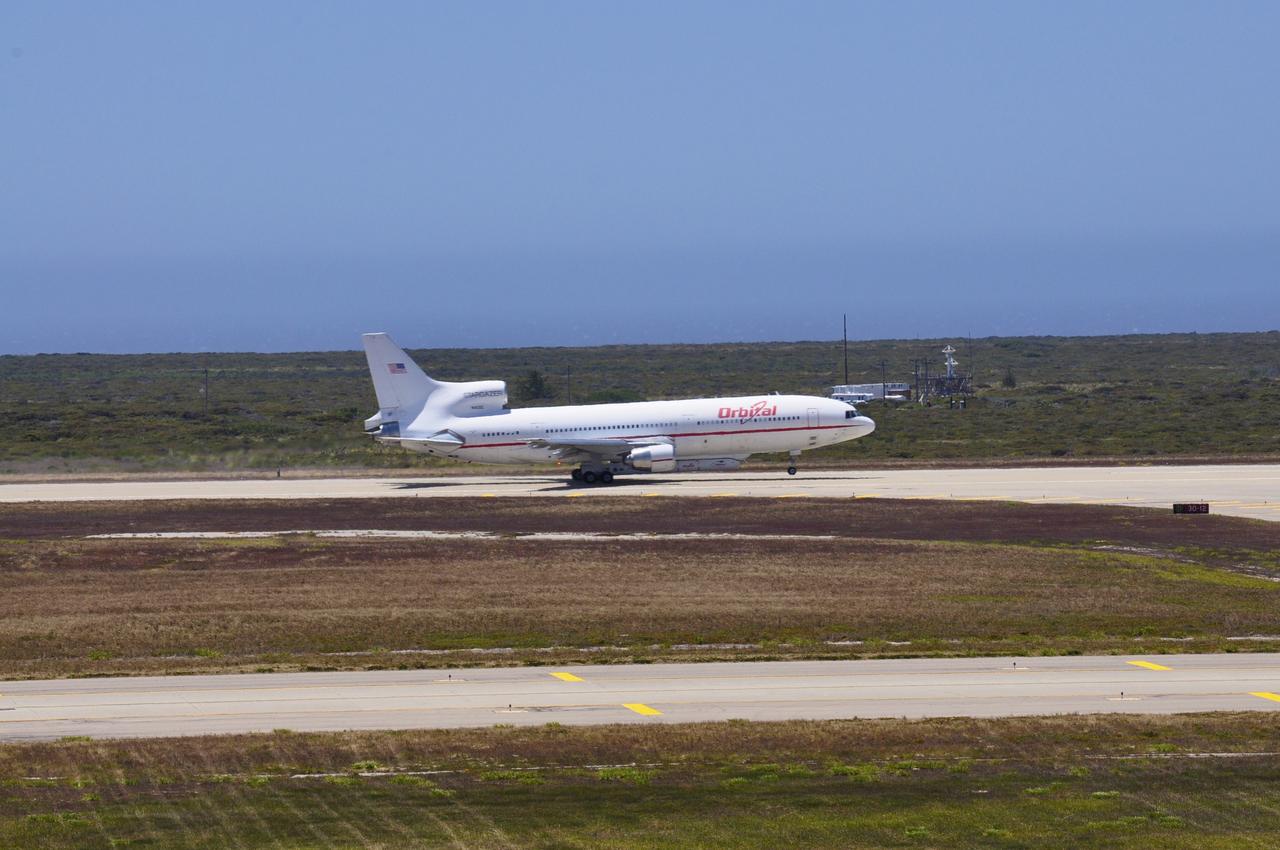
VANDENBERG AIR FORCE BASE, Calif. – The nose gear of Orbital Sciences’ L-1011 carrier aircraft rises from the runway as the plane takes off from Vandenberg Air Force Base in California. The aircraft is transporting Orbital’s Pegasus rocket and NASA’s Nuclear Spectroscopic Telescope Array, or NuSTAR, to the U.S. Army's Ronald Reagan Ballistic Missile Defense Test Site on Kwajalein Atoll, part of the Marshall Islands in the Pacific Ocean. The Pegasus, mated to its NuSTAR payload, will be launched from the carrier aircraft 117 nautical miles south of Kwajalein at latitude 6.75 degrees north of the equator. The high-energy X-ray telescope will conduct a census of black holes, map radioactive material in young supernovae remnants, and study the origins of cosmic rays and the extreme physics around collapsed stars. Launch is scheduled for June 13. For more information, visit http://www.nasa.gov/nustar. Photo credit: NASA/Randy Beaudoin, VAFB

Inside the clean-room "tent" of Building 1555 at North Vandenberg Air Force Base, technicians place a star tracker cover on the AIM spacecraft during testing of the solar array panel deployment. The AIM spacecraft will fly three instruments designed to study polar mesospheric clouds located at the edge of space, 50 miles above the Earth's surface in the coldest part of the planet's atmosphere. The mission's primary goal is to explain why these clouds form and what has caused them to become brighter and more numerous and appear at lower latitudes in recent years. AIM's results will provide the basis for the study of long-term variability in the mesospheric climate and its relationship to global climate change. AIM is scheduled to be mated to its launch vehicle, Orbital Sciences' Pegasus XL, during the second week of April, after which final inspections will be conducted. Launch is scheduled for April 25.

The one-man submarine dubbed DeepWorker 2000 sits on the deck of Liberty Star, one of two KSC solid rocket booster recovery ships. The sub is being tested on its ability to duplicate the sometimes hazardous job United Space Alliance (USA) divers perform to recover the expended boosters in the ocean after a launch. The boosters splash down in an impact area about 140 miles east of Jacksonville and after recovery are towed back to KSC for refurbishment by the specially rigged recovery ships. DeepWorker 2000 was built by Nuytco Research Ltd., North Vancouver, British Columbia. It is 8.25 feet long, 5.75 feet high, and weighs 3,800 pounds. USA is a prime contractor to NASA for the Space Shuttle program
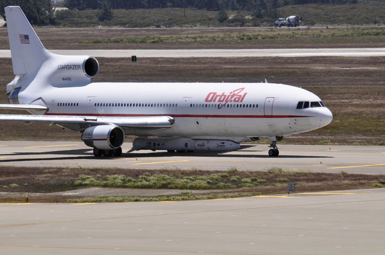
VANDENBERG AIR FORCE BASE, Calif. – Orbital Sciences’ L-1011 carrier aircraft taxies to the runway at Vandenberg Air Force Base in California. The aircraft is transporting Orbital’s Pegasus rocket and NASA’s Nuclear Spectroscopic Telescope Array, or NuSTAR, to the U.S. Army's Ronald Reagan Ballistic Missile Defense Test Site on Kwajalein Atoll, part of the Marshall Islands in the Pacific Ocean. The Pegasus, mated to its NuSTAR payload, will be launched from the carrier aircraft 117 nautical miles south of Kwajalein at latitude 6.75 degrees north of the equator. The high-energy X-ray telescope will conduct a census of black holes, map radioactive material in young supernovae remnants, and study the origins of cosmic rays and the extreme physics around collapsed stars. Launch is scheduled for June 13. For more information, visit http://www.nasa.gov/nustar. Photo credit: NASA/Randy Beaudoin, VAFB

VANDENBERG AIR FORCE BASE, Calif. – An Orbital Sciences’ Pegasus rocket and NASA’s Nuclear Spectroscopic Telescope Array, or NuSTAR, are installed under Orbital’s L-1011 carrier aircraft awaiting departure from Vandenberg Air Force Base in California for the U.S. Army's Ronald Reagan Ballistic Missile Defense Test Site on Kwajalein Atoll, part of the Marshall Islands in the Pacific Ocean. The Pegasus, mated to its NuSTAR payload, will be launched from the carrier aircraft 117 nautical miles south of Kwajalein at latitude 6.75 degrees north of the equator. The high-energy X-ray telescope will conduct a census of black holes, map radioactive material in young supernovae remnants, and study the origins of cosmic rays and the extreme physics around collapsed stars. Launch is scheduled for June 13. For more information, visit http://www.nasa.gov/nustar. Photo credit: NASA/Randy Beaudoin, VAFB
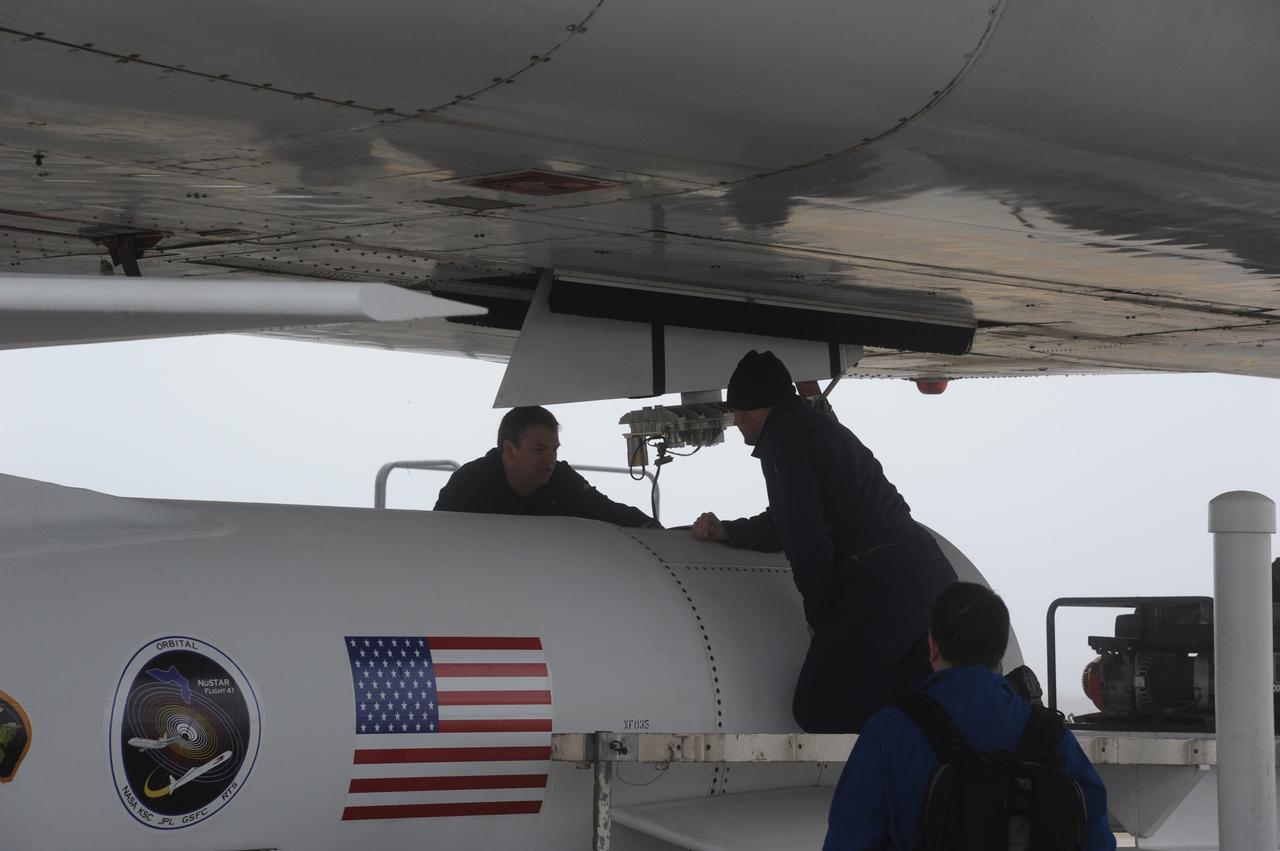
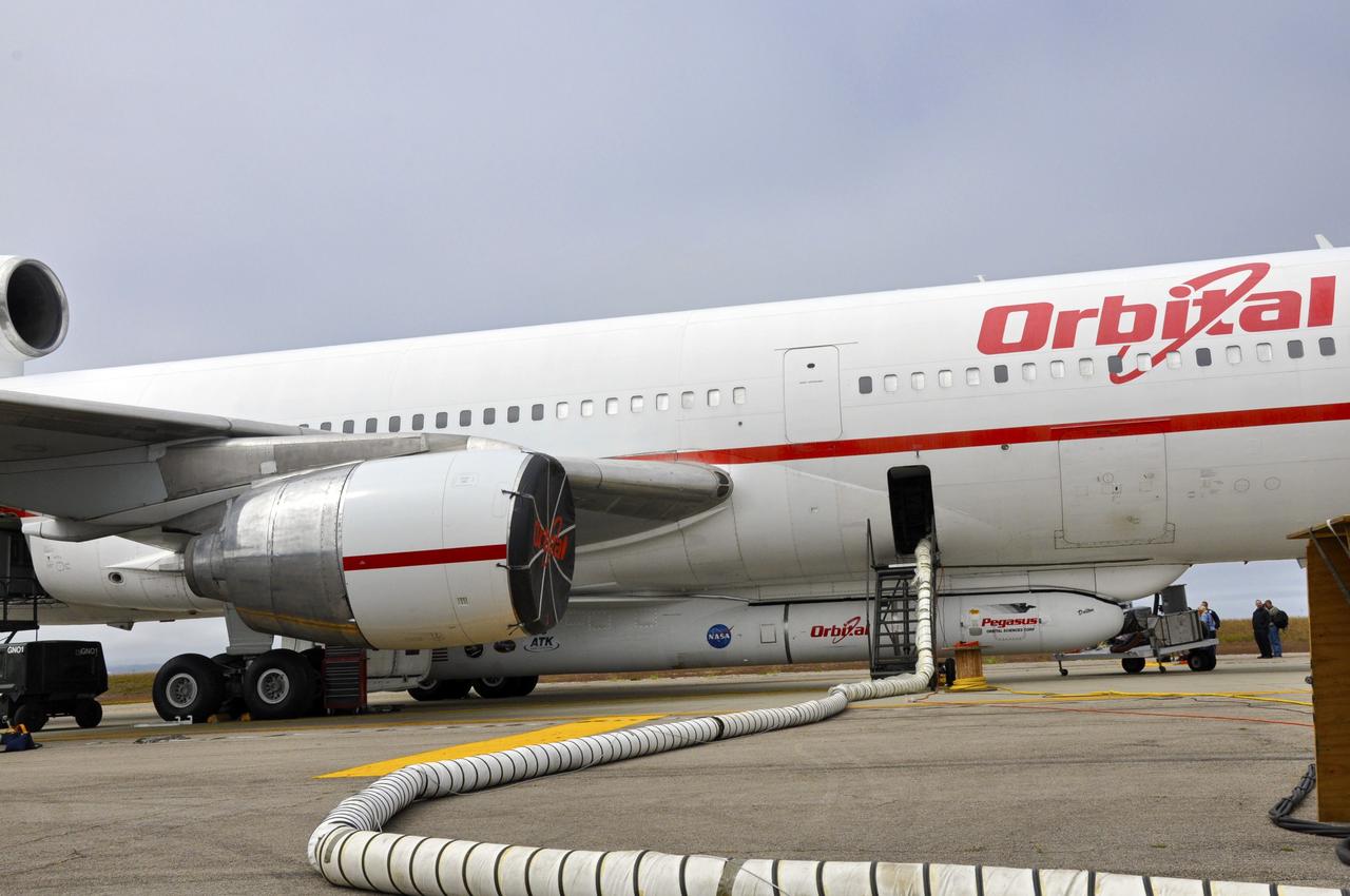
VANDENBERG AIR FORCE BASE, Calif. – Technicians prepare to attach NASA’s Nuclear Spectroscopic Telescope Array, or NuSTAR, mated to Orbital Sciences’ Pegasus XL rocket, beneath Orbital’s L-1011 carrier aircraft at the “hot pad,” located on the ramp adjacent to the runway on Vandenberg Air Force Base in California. The duo will be flown from Vandenberg to the U.S. Army's Ronald Reagan Ballistic Missile Defense Test Site on Kwajalein Atoll, part of the Marshall Islands in the Pacific Ocean. The Pegasus and its NuSTAR payload will be launched June 13 from the carrier aircraft 117 nautical miles south of Kwajalein at latitude 6.75 degrees north of the equator. The high-energy X-ray telescope will conduct a census of black holes, map radioactive material in young supernovae remnants, and study the origins of cosmic rays and the extreme physics around collapsed stars. For more information, visit http://www.nasa.gov/nustar. Photo credit: NASA/Chris Wiant, VAFB
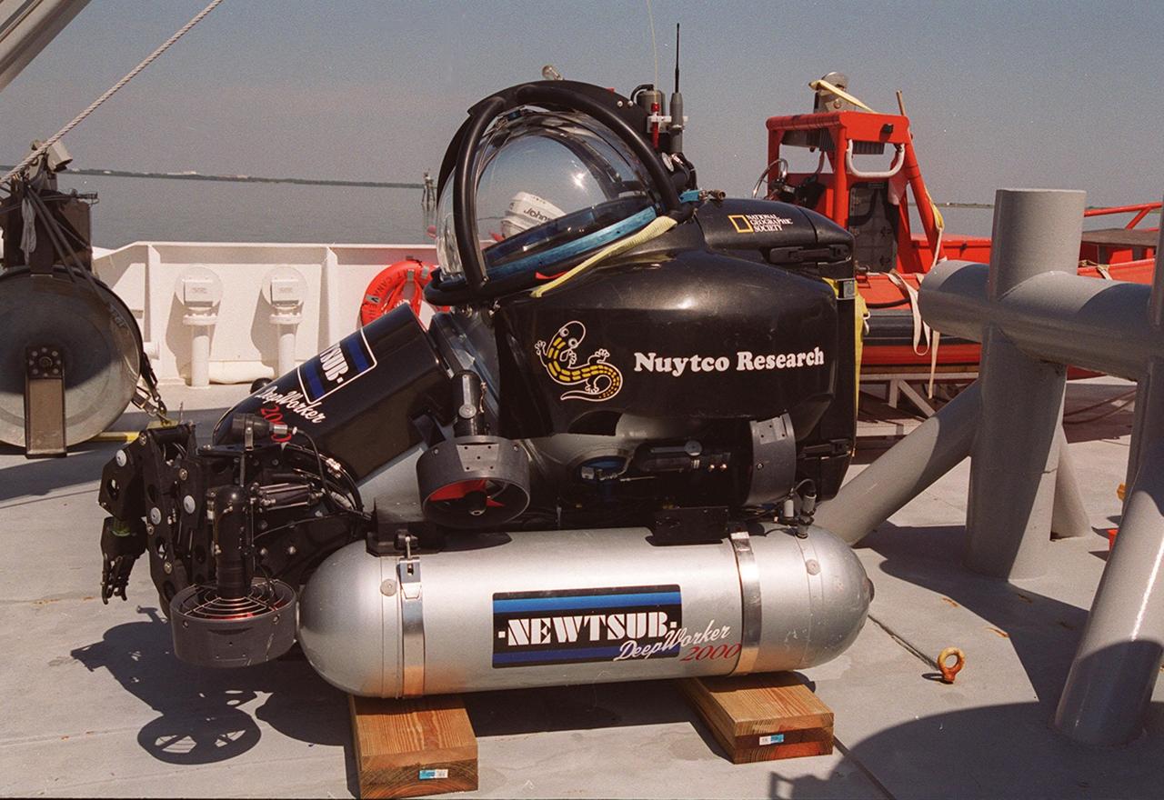
The one-man submarine dubbed DeepWorker 2000 sits on the deck of Liberty Star, one of two KSC solid rocket booster recovery ships. The sub is being tested on its ability to duplicate the sometimes hazardous job United Space Alliance (USA) divers perform to recover the expended boosters in the ocean after a launch. The boosters splash down in an impact area about 140 miles east of Jacksonville and after recovery are towed back to KSC for refurbishment by the specially rigged recovery ships. DeepWorker 2000 was built by Nuytco Research Ltd., North Vancouver, British Columbia. It is 8.25 feet long, 5.75 feet high, and weighs 3,800 pounds. USA is a prime contractor to NASA for the Space Shuttle program
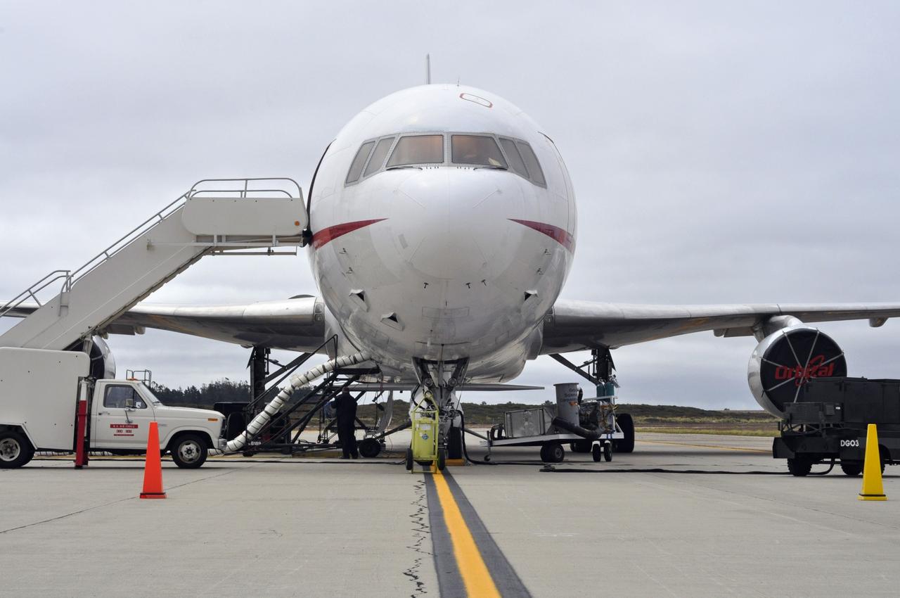
VANDENBERG AIR FORCE BASE, Calif. – Preparations are under way for the departure of Orbital Sciences’ L-1011 carrier aircraft from Vandenberg Air Force Base in California. The aircraft is transporting Orbital’s Pegasus rocket and NASA’s Nuclear Spectroscopic Telescope Array, or NuSTAR, to the U.S. Army's Ronald Reagan Ballistic Missile Defense Test Site on Kwajalein Atoll, part of the Marshall Islands in the Pacific Ocean. The Pegasus, mated to its NuSTAR payload, will be launched from the carrier aircraft 117 nautical miles south of Kwajalein at latitude 6.75 degrees north of the equator. The high-energy X-ray telescope will conduct a census of black holes, map radioactive material in young supernovae remnants, and study the origins of cosmic rays and the extreme physics around collapsed stars. Launch is scheduled for June 13. For more information, visit http://www.nasa.gov/nustar. Photo credit: NASA/Randy Beaudoin, VAFB
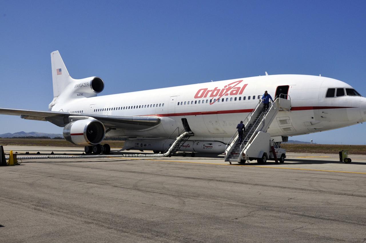
VANDENBERG AIR FORCE BASE, Calif. – The flight crew boards Orbital Sciences’ L-1011 carrier aircraft at Vandenberg Air Force Base in California. The aircraft is transporting Orbital’s Pegasus rocket and NASA’s Nuclear Spectroscopic Telescope Array, or NuSTAR, to the U.S. Army's Ronald Reagan Ballistic Missile Defense Test Site on Kwajalein Atoll, part of the Marshall Islands in the Pacific Ocean. The Pegasus, mated to its NuSTAR payload, will be launched from the carrier aircraft 117 nautical miles south of Kwajalein at latitude 6.75 degrees north of the equator. The high-energy X-ray telescope will conduct a census of black holes, map radioactive material in young supernovae remnants, and study the origins of cosmic rays and the extreme physics around collapsed stars. Launch is scheduled for June 13. For more information, visit http://www.nasa.gov/nustar. Photo credit: NASA/Randy Beaudoin, VAFB

VANDENBERG AIR FORCE BASE, Calif. – Final preparations are under way for the departure of Orbital Sciences’ L-1011 carrier aircraft from Vandenberg Air Force Base in California. The aircraft is transporting Orbital’s Pegasus rocket and NASA’s Nuclear Spectroscopic Telescope Array, or NuSTAR, to the U.S. Army's Ronald Reagan Ballistic Missile Defense Test Site on Kwajalein Atoll, part of the Marshall Islands in the Pacific Ocean for launch. The Pegasus, mated to its NuSTAR payload, will be launched from the carrier aircraft 117 nautical miles south of Kwajalein at latitude 6.75 degrees north of the equator. The high-energy X-ray telescope will conduct a census of black holes, map radioactive material in young supernovae remnants, and study the origins of cosmic rays and the extreme physics around collapsed stars. Launch is scheduled for June 13. For more information, visit http://www.nasa.gov/nustar. Photo credit: NASA/Randy Beaudoin, VAFB
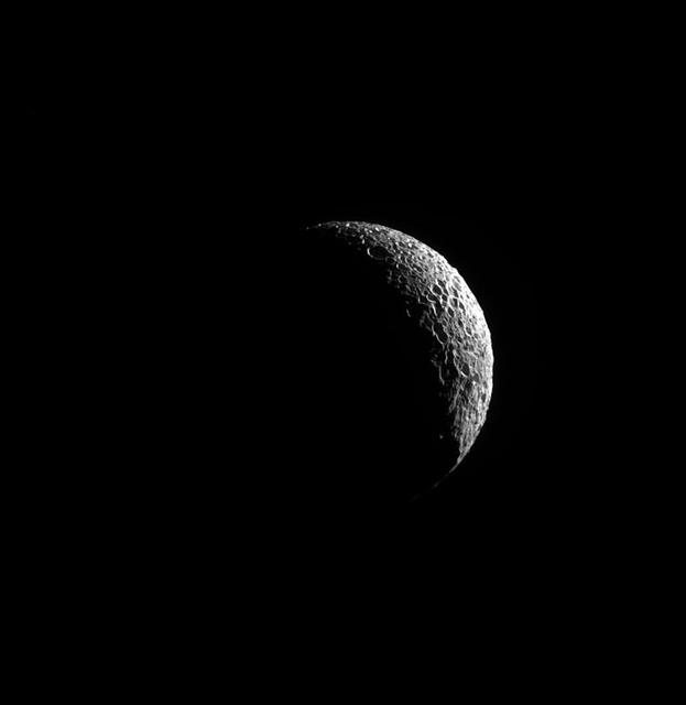
A thin sliver of Mimas is illuminated, the long shadows showing off its many craters, indicators of the moon's violent history. The most famous evidence of a collision on Mimas (246 miles, or 396 kilometers across) is the crater Herschel that gives Mimas its Death Star-like appearance. See PIA12568 for more on Herschel. This view looks toward the anti-Saturn hemisphere of Mimas. North on Mimas is up and rotated 40 degrees to the right. The image was taken in visible light with the Cassini spacecraft narrow-angle camera on May 20, 2013. The view was acquired at a distance of approximately 100,000 miles (200,000 kilometers) from Mimas and at a Sun-Mimas-spacecraft, or phase, angle of 130 degrees. Image scale is 4,000 feet (1 kilometer) per pixel. http://photojournal.jpl.nasa.gov/catalog/PIA18285
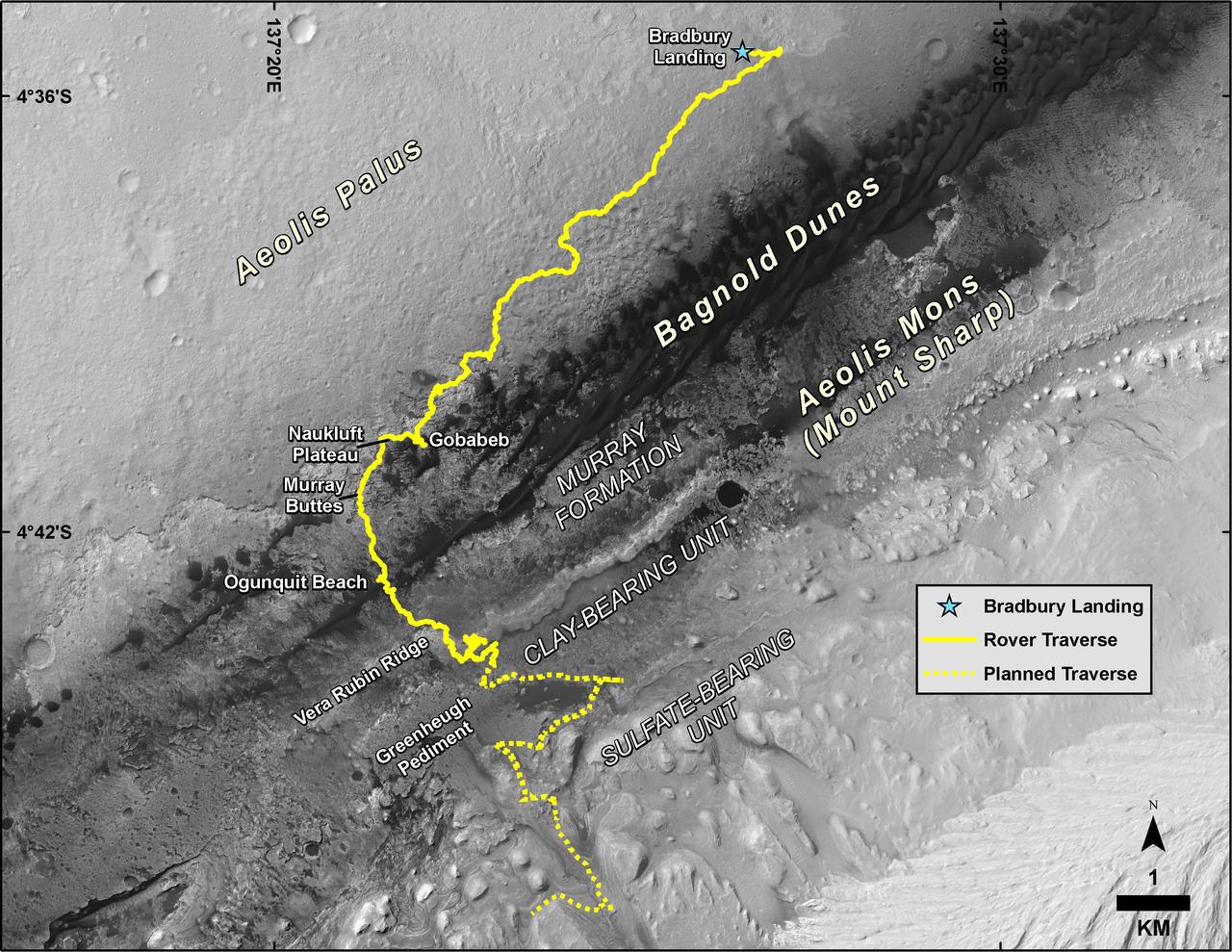
This map shows the route driven by NASA's Curiosity Mars rover, from the location where it landed in August 2012 to its location in August 2019, and its planned path to additional geological layers of lower "Mount Sharp." The blue star near top center marks "Bradbury Landing," the site where Curiosity arrived on Mars on Aug. 5, 2012, PDT (Aug. 6, EDT and Universal Time). Curiosity landed on Aeolis Palus, the plains surrounding Aeolis Mons (Mount Sharp) in Gale Crater. The base image for the map is from the High Resolution Imaging Science Experiment (HiRISE) camera on the Mars Reconnaissance Orbiter. North is up. "Bagnold Dunes" form a band of dark, wind-blown material at the foot of Mount Sharp. The scale bar at lower right represents one kilometer (0.62 mile). https://photojournal.jpl.nasa.gov/catalog/PIA23412
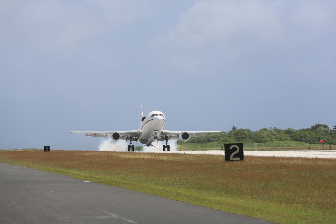
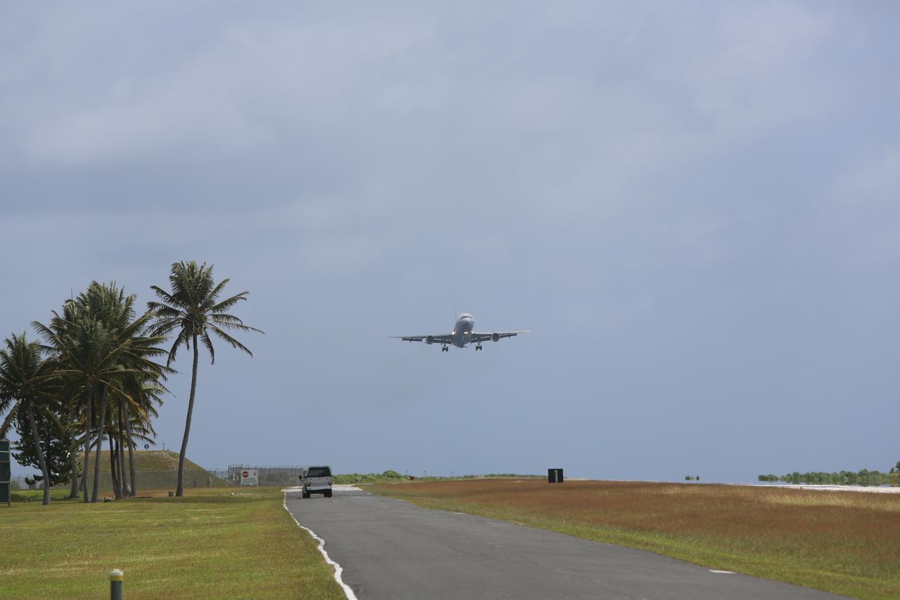
KWAJALEIN ATOLL, Marshall Islands – Orbital Sciences' L-1011 carrier aircraft touches down at the U.S. Army's Ronald Reagan Ballistic Missile Defense Test Site on Kwajalein Atoll, delivering Orbital’s Pegasus rocket and NASA’s Nuclear Spectroscopic Telescope Array, or NuSTAR, from Vandenberg Air Force Base in California. The Pegasus, mated to its NuSTAR payload, will be launched from the carrier aircraft 117 nautical miles south of Kwajalein at latitude 6.75 degrees north of the equator. The high-energy X-ray telescope will conduct a census of black holes, map radioactive material in young supernovae remnants, and study the origins of cosmic rays and the extreme physics around collapsed stars. Launch and deployment of the telescope is scheduled for June 13. For more information, visit http:__www.nasa.gov_nustar. Photo courtesy of Orbital Sciences Corp.
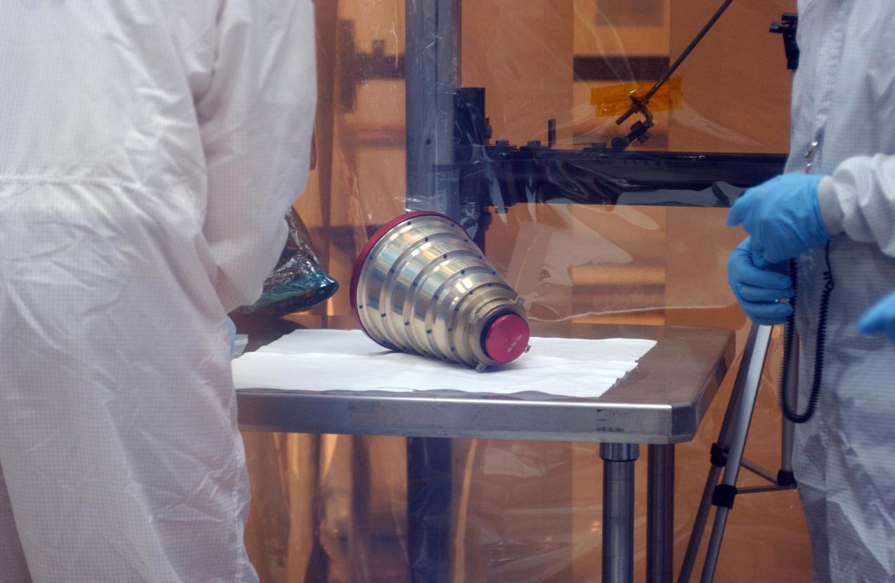
KENNEDY SPACE CENTER, FLA. -- Inside the clean-room "tent" of Building 1555 at North Vandenberg Air Force Base, a star tracker cover is ready for placement on the AIM spacecraft during testing of the solar array panel deployment. The AIM spacecraft will fly three instruments designed to study polar mesospheric clouds located at the edge of space, 50 miles above the Earth's surface in the coldest part of the planet's atmosphere. The mission's primary goal is to explain why these clouds form and what has caused them to become brighter and more numerous and appear at lower latitudes in recent years. AIM's results will provide the basis for the study of long-term variability in the mesospheric climate and its relationship to global climate change. AIM is scheduled to be mated to its launch vehicle, Orbital Sciences' Pegasus XL, during the second week of April, after which final inspections will be conducted. Launch is scheduled for April 25.

VANDENBERG AIR FORCE BASE, Calif. – Orbital Sciences’ L-1011 carrier aircraft prepares for takeoff from the runway at Vandenberg Air Force Base in California. The aircraft is transporting Orbital’s Pegasus rocket and NASA’s Nuclear Spectroscopic Telescope Array, or NuSTAR, to the U.S. Army's Ronald Reagan Ballistic Missile Defense Test Site on Kwajalein Atoll, part of the Marshall Islands in the Pacific Ocean. The Pegasus, mated to its NuSTAR payload, will be launched from the carrier aircraft 117 nautical miles south of Kwajalein at latitude 6.75 degrees north of the equator. The high-energy X-ray telescope will conduct a census of black holes, map radioactive material in young supernovae remnants, and study the origins of cosmic rays and the extreme physics around collapsed stars. Launch is scheduled for June 13. For more information, visit http://www.nasa.gov/nustar. Photo credit: NASA/Randy Beaudoin, VAFB
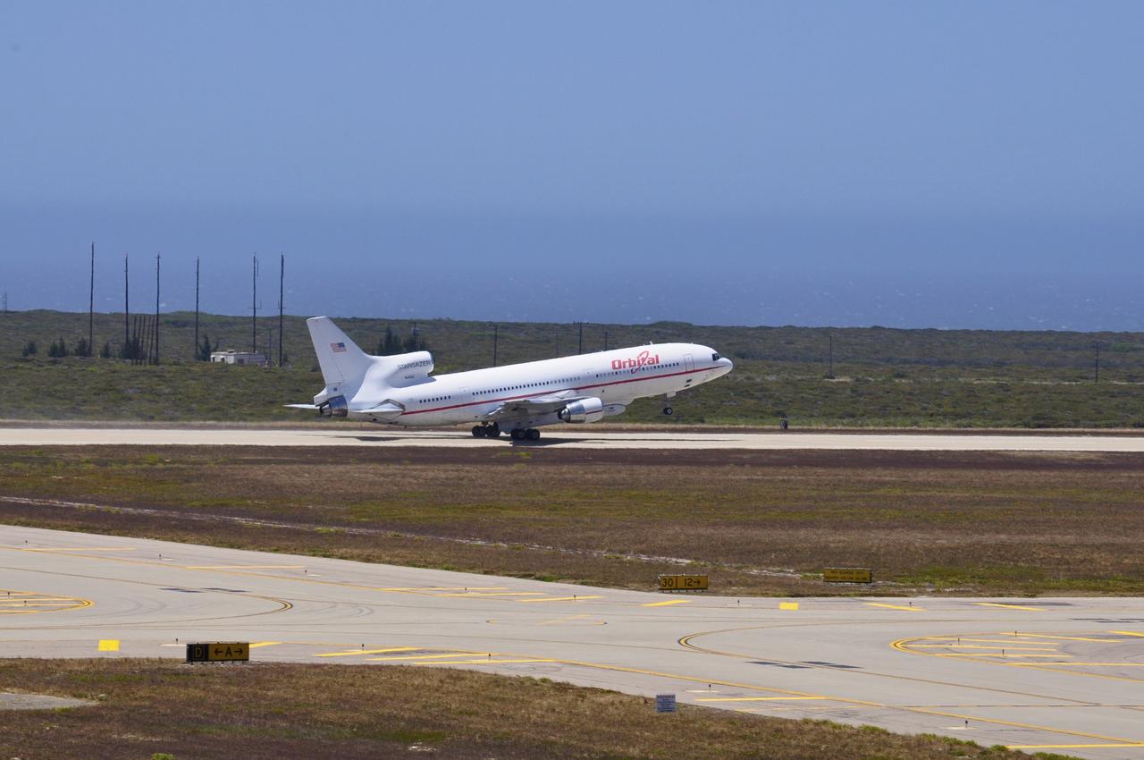
VANDENBERG AIR FORCE BASE, Calif. – Orbital Sciences’ L-1011 carrier aircraft lifts off the runway as it departs from Vandenberg Air Force Base in California. The aircraft is transporting Orbital’s Pegasus rocket and NASA’s Nuclear Spectroscopic Telescope Array, or NuSTAR, to the U.S. Army's Ronald Reagan Ballistic Missile Defense Test Site on Kwajalein Atoll, part of the Marshall Islands in the Pacific Ocean. The Pegasus, mated to its NuSTAR payload, will be launched from the carrier aircraft 117 nautical miles south of Kwajalein at latitude 6.75 degrees north of the equator. The high-energy X-ray telescope will conduct a census of black holes, map radioactive material in young supernovae remnants, and study the origins of cosmic rays and the extreme physics around collapsed stars. Launch is scheduled for June 13. For more information, visit http://www.nasa.gov/nustar. Photo credit: NASA/Randy Beaudoin, VAFB
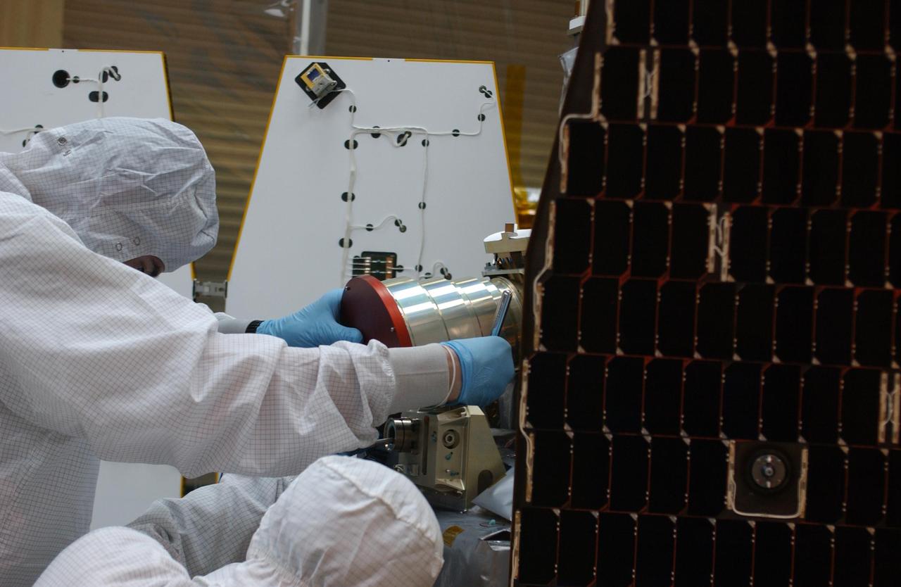
KENNEDY SPACE CENTER, FLA. -- Inside the clean-room "tent" of Building 1555 at North Vandenberg Air Force Base, technicians place a star tracker cover on the AIM spacecraft during testing of the solar array panel deployment. The AIM spacecraft will fly three instruments designed to study polar mesospheric clouds located at the edge of space, 50 miles above the Earth's surface in the coldest part of the planet's atmosphere. The mission's primary goal is to explain why these clouds form and what has caused them to become brighter and more numerous and appear at lower latitudes in recent years. AIM's results will provide the basis for the study of long-term variability in the mesospheric climate and its relationship to global climate change. AIM is scheduled to be mated to its launch vehicle, Orbital Sciences' Pegasus XL, during the second week of April, after which final inspections will be conducted. Launch is scheduled for April 25.

CAPE CANAVERAL, Fla. – Technicians work the console collecting data from NASA's C-band Debris Radar antenna at a site on North Merritt Island in Florida. One of the largest of its kind in the world, the C-band radar provided critical support to pinpoint debris during the launch of space shuttle Atlantis on the STS-125 mission. The need for this radar was identified after the Columbia tragedy. It worked together with smaller X-band radars placed on the solid rocket booster ship Liberty Star and the U.S. Army landing craft utility ship Brandy Station. Together they provided extremely high resolution images of any debris that created by Atlantis during launch. Photo credit: NASA/Troy Cryder
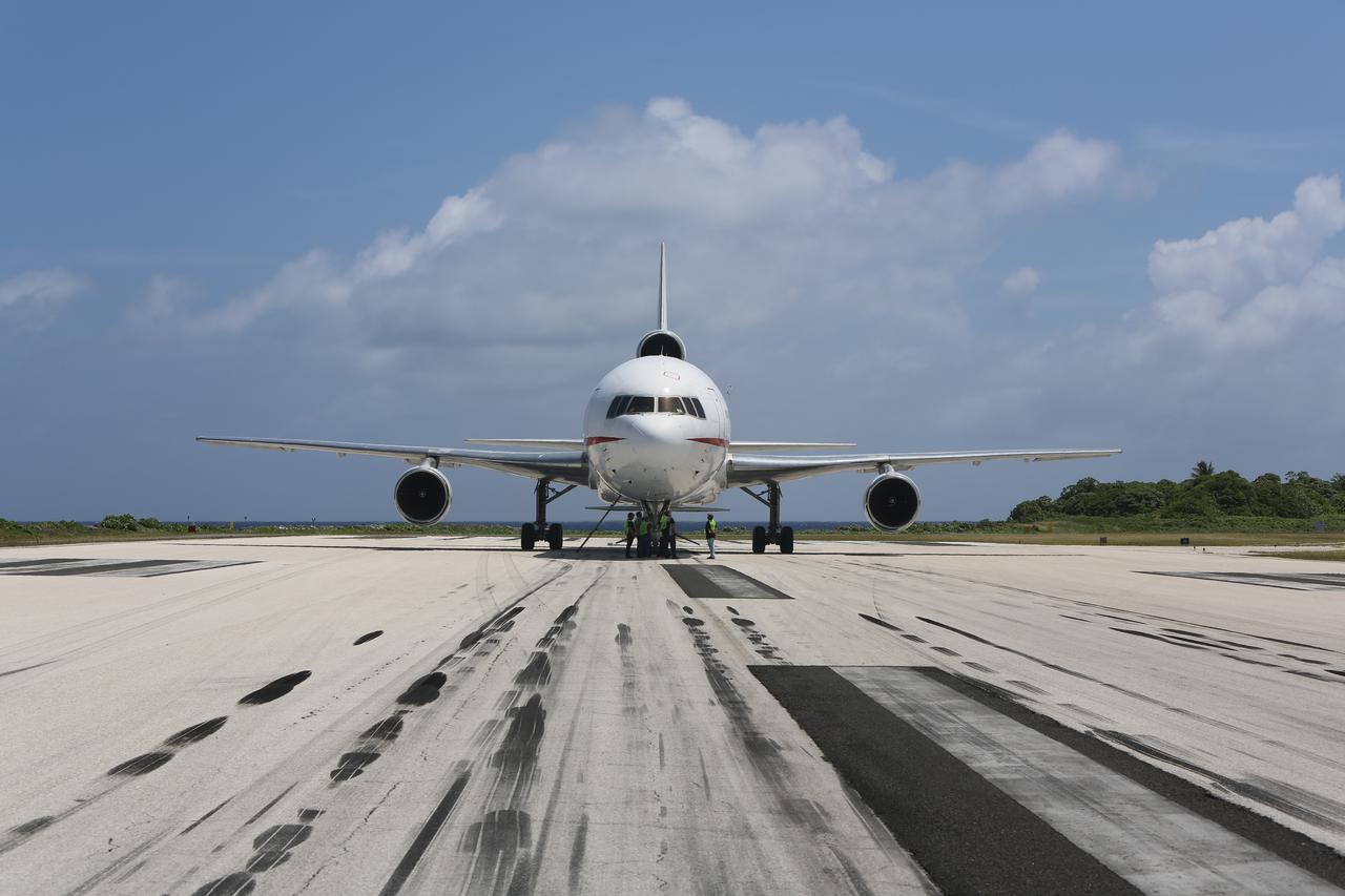
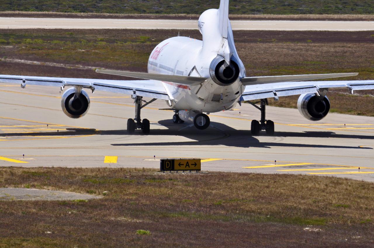
KWAJALEIN ATOLL, Marshall Islands – Orbital Sciences' L-1011 carrier aircraft has arrived at the U.S. Army's Ronald Reagan Ballistic Missile Defense Test Site on Kwajalein Atoll, delivering Orbital’s Pegasus rocket and NASA’s Nuclear Spectroscopic Telescope Array, or NuSTAR, from Vandenberg Air Force Base in California. The Pegasus, mated to its NuSTAR payload, will be launched from the carrier aircraft 117 nautical miles south of Kwajalein at latitude 6.75 degrees north of the equator. The high-energy X-ray telescope will conduct a census of black holes, map radioactive material in young supernovae remnants, and study the origins of cosmic rays and the extreme physics around collapsed stars. Launch and deployment of the telescope is scheduled for June 13. For more information, visit http://www.nasa.gov/nustar. Photo courtesy of Orbital Sciences Corp.

VANDENBERG AIR FORCE BASE, Calif. – Final preparations are under way for the departure of Orbital Sciences’ L-1011 carrier aircraft from Vandenberg Air Force Base in California. The aircraft is transporting Orbital’s Pegasus rocket and NASA’s Nuclear Spectroscopic Telescope Array, or NuSTAR, to the U.S. Army's Ronald Reagan Ballistic Missile Defense Test Site on Kwajalein Atoll, part of the Marshall Islands in the Pacific Ocean. The Pegasus, mated to its NuSTAR payload, will be launched from the carrier aircraft 117 nautical miles south of Kwajalein at latitude 6.75 degrees north of the equator. The high-energy X-ray telescope will conduct a census of black holes, map radioactive material in young supernovae remnants, and study the origins of cosmic rays and the extreme physics around collapsed stars. Launch is scheduled for June 13. For more information, visit http://www.nasa.gov/nustar. Photo credit: NASA/Randy Beaudoin, VAFB
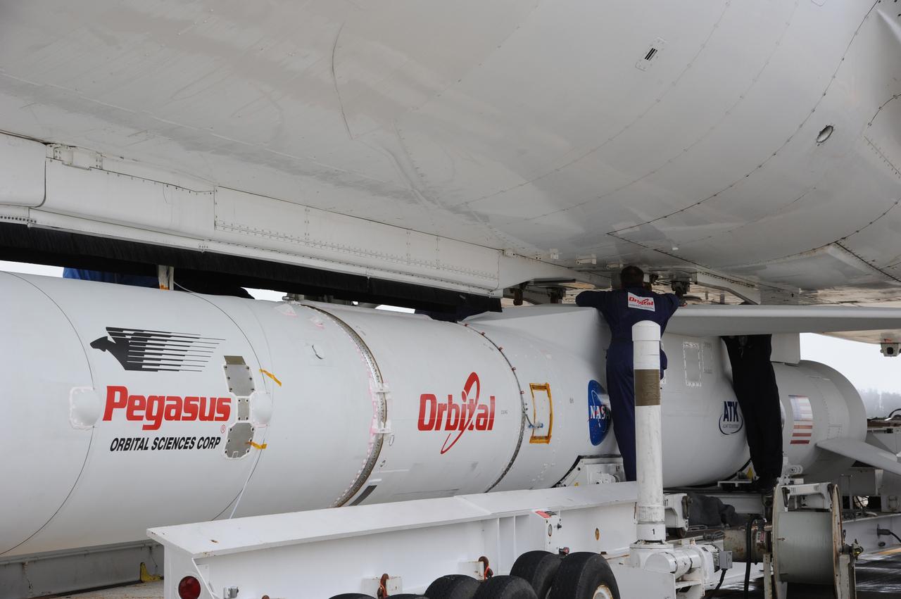
VANDENBERG AIR FORCE BASE, Calif. – Technicians attach NASA’s Nuclear Spectroscopic Telescope Array, or NuSTAR, mated to Orbital Sciences’ Pegasus XL rocket, beneath Orbital’s L-1011 carrier aircraft at the “hot pad,” located on the ramp adjacent to the runway on Vandenberg Air Force Base in California. The duo will be flown from Vandenberg to the U.S. Army's Ronald Reagan Ballistic Missile Defense Test Site on Kwajalein Atoll, part of the Marshall Islands in the Pacific Ocean. The Pegasus and its NuSTAR payload will be launched June 13 from the carrier aircraft 117 nautical miles south of Kwajalein at latitude 6.75 degrees north of the equator. The high-energy X-ray telescope will conduct a census of black holes, map radioactive material in young supernovae remnants, and study the origins of cosmic rays and the extreme physics around collapsed stars. For more information, visit http://www.nasa.gov/nustar. Photo credit: NASA/Chris Wiant, VAFB

The one-man submarine dubbed DeepWorker 2000 sits on the deck of Liberty Star, one of two KSC solid rocket booster recovery ships. The sub is being tested on its ability to duplicate the sometimes hazardous job United Space Alliance (USA) divers perform to recover the expended boosters in the ocean after a launch. The boosters splash down in an impact area about 140 miles east of Jacksonville and after recovery are towed back to KSC for refurbishment by the specially rigged recovery ships. DeepWorker 2000 was built by Nuytco Research Ltd., North Vancouver, British Columbia. It is 8.25 feet long, 5.75 feet high, and weighs 3,800 pounds. USA is a prime contractor to NASA for the Space Shuttle program

This is an illustration of a supermassive black hole, weighing as much as 21 million suns, located in the middle of the ultradense galaxy M60-UCD1. The dwarf galaxy is so dense that millions of stars fill the sky as seen by an imaginary visitor. Because no light can escape from the black hole, it appears simply in silhouette against the starry background. The black hole's intense gravitational field warps the light of the background stars to form ring-like images just outside the dark edges of the black hole's event horizon. Combined observations by the Hubble Space Telescope and Gemini North telescope determined the presence of the black hole inside such a small and dense galaxy. More info: Astronomers using data from NASA’s Hubble Space Telescope and ground observation have found an unlikely object in an improbable place -- a monster black hole lurking inside one of the tiniest galaxies ever known. The black hole is five times the mass of the one at the center of our Milky Way galaxy. It is inside one of the densest galaxies known to date -- the M60-UCD1 dwarf galaxy that crams 140 million stars within a diameter of about 300 light-years, which is only 1/500th of our galaxy’s diameter. If you lived inside this dwarf galaxy, the night sky would dazzle with at least 1 million stars visible to the naked eye. Our nighttime sky as seen from Earth’s surface shows 4,000 stars. The finding implies there are many other compact galaxies in the universe that contain supermassive black holes. The observation also suggests dwarf galaxies may actually be the stripped remnants of larger galaxies that were torn apart during collisions with other galaxies rather than small islands of stars born in isolation. “We don’t know of any other way you could make a black hole so big in an object this small,” said University of Utah astronomer Anil Seth, lead author of an international study of the dwarf galaxy published in Thursday’s issue of the journal Nature. Seth’s team of astronomers used the Hubble Space Telescope and the Gemini North 8-meter optical and infrared telescope on Hawaii’s Mauna Kea to observe M60-UCD1 and measure the black hole’s mass. The sharp Hubble images provide information about the galaxy’s diameter and stellar density. Gemini measures the stellar motions as affected by the black hole’s pull. These data are used to calculate the mass of the black hole. Black holes are gravitationally collapsed, ultra-compact objects that have a gravitational pull so strong that even light cannot escape. Supermassive black holes -- those with the mass of at least one million stars like our sun -- are thought to be at the centers of many galaxies. The black hole at the center of our Milky Way galaxy has the mass of four million suns. As heavy as that is, it is less than 0.01 percent of the Milky Way’s total mass. By comparison, the supermassive black hole at the center of M60-UCD1, which has the mass of 21 million suns, is a stunning 15 percent of the small galaxy’s total mass. “That is pretty amazing, given that the Milky Way is 500 times larger and more than 1,000 times heavier than the dwarf galaxy M60-UCD1,” Seth said. One explanation is that M60-UCD1 was once a large galaxy containing 10 billion stars, but then it passed very close to the center of an even larger galaxy, M60, and in that process all the stars and dark matter in the outer part of the galaxy were torn away and became part of M60. The team believes that M60-UCD1 may eventually be pulled to fully merge with M60, which has its own monster black hole that weighs a whopping 4.5 billion solar masses, or more than 1,000 times bigger than the black hole in our galaxy. When that happens, the black holes in both galaxies also likely will merge. Both galaxies are 50 million light-years away. The Hubble Space Telescope is a project of international cooperation between NASA and the European Space Agency. NASA's Goddard Space Flight Center in Greenbelt, Maryland, manages the telescope. The Space Telescope Science Institute (STScI) in Baltimore conducts Hubble science operations. STScI is operated for NASA by the Association of Universities for Research in Astronomy, Inc., in Washington. For images and more information about Hubble, visit: <a href="http://www.nasa.gov/hubble" rel="nofollow">www.nasa.gov/hubble</a> <b><a href="http://www.nasa.gov/audience/formedia/features/MP_Photo_Guidelines.html" rel="nofollow">NASA image use policy.</a></b> <b><a href="http://www.nasa.gov/centers/goddard/home/index.html" rel="nofollow">NASA Goddard Space Flight Center</a></b> enables NASA’s mission through four scientific endeavors: Earth Science, Heliophysics, Solar System Exploration, and Astrophysics. Goddard plays a leading role in NASA’s accomplishments by contributing compelling scientific knowledge to advance the Agency’s mission. <b>Follow us on <a href="http://twitter.com/NASAGoddardPix" rel="nofollow">Twitter</a></b> <b>Like us on <a href="http://www.facebook.com/pages/Greenbelt-MD/NASA-Goddard/395013845897?ref=tsd" rel="nofollow">Facebook</a></b> <b>Find us on <a href="http://instagram.com/nasagoddard?vm=grid" rel="nofollow">Instagram</a></b>
STS054-S-001 (July 1992) --- Designed by the crew members, the STS-54 crew patch depicts our national symbol, the American bald eagle, soaring above the Earth; and represents the United States Space Shuttle as a national asset in service to America and the world. The eagle is clutching an eight pointed star in its talons and is placing this larger star among a constellation of four others representing the placement of the fifth Tracking and Data Relay Satellite (TDRS) into orbit among the four already in service. The blackness of space with stars conspicuously absent represents the mission?s other primary objective in carrying the Diffuse X-ray Spectrometer into orbit to conduct astronomical observations of x-ray sources within the galaxy and throughout the universe. The depiction of our planet showing the crew?s home continent of North America is an expression of their and NASA?s intention that the medical and scientific experiments conducted onboard are for the benefit of all mankind. The clouds and blue of the Earth represent the crew?s part in NASA?s Mission to Planet Earth in conducting Earth observation photography. The NASA insignia design for space shuttle flights is reserved for use by the astronauts and for other official use as the NASA Administrator may authorize. Public availability has been approved only in the form of illustrations by the various news media. When and if there is any change in this policy, which we do not anticipate, it will be publicly announced. Photo credit: NASA
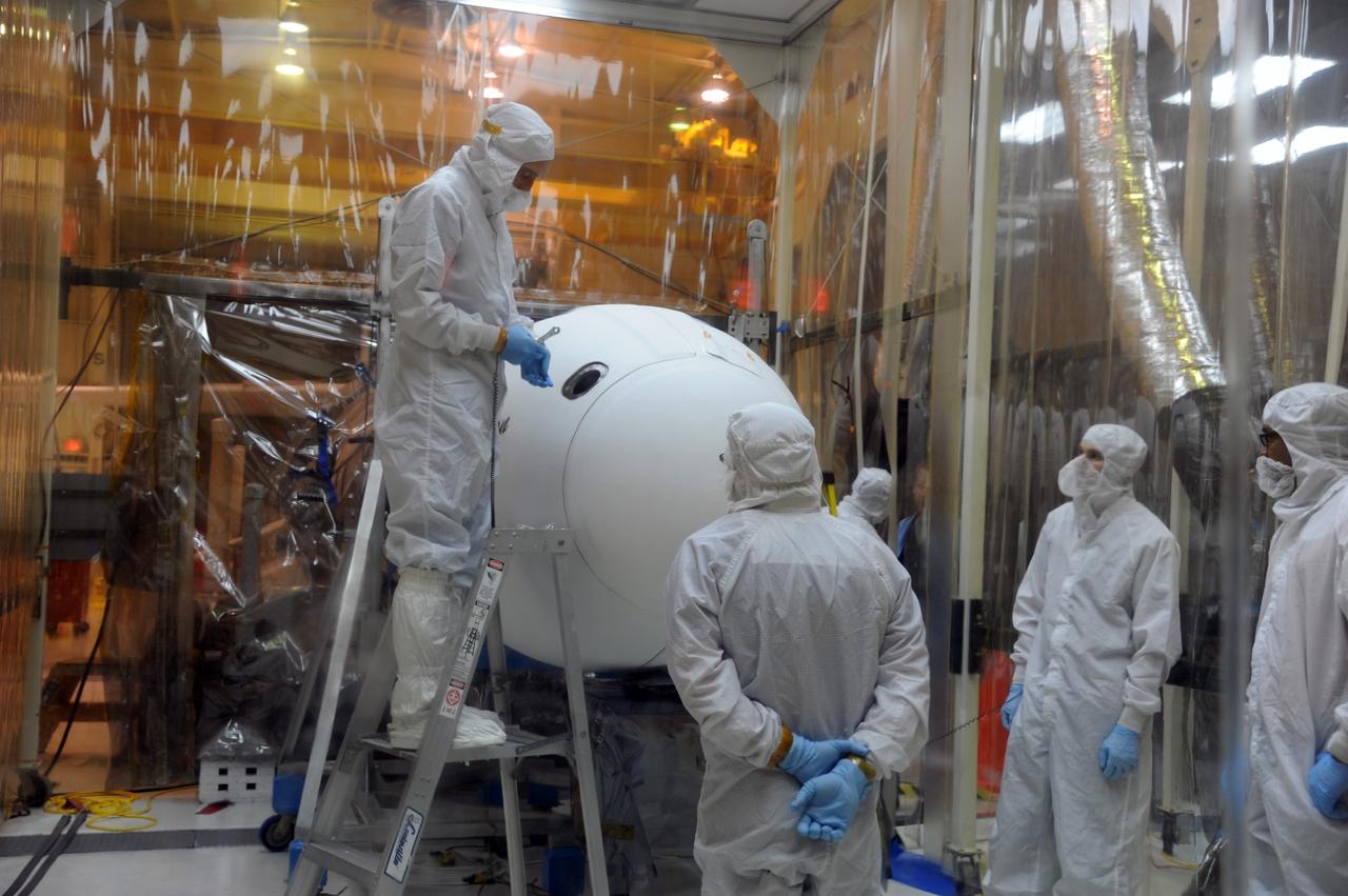
VANDENBERG AIR FORCE BASE, Calif. – In Orbital Sciences’ hangar on Vandenberg Air Force Base in California, the Pegasus fairing has been secured around NASA’s Nuclear Spectroscopic Telescope Array, or NuSTAR. Access to the spacecraft was needed for compatibility testing to verify communication with a tracking station in Hawaii. With the change in the launch timeframe to June, this station will be needed to support launch. After processing of Orbital’s Pegasus XL rocket and the spacecraft is complete, they will be flown on Orbital's L-1011 carrier aircraft from Vandenberg, to the U.S. Army's Ronald Reagan Ballistic Missile Defense Test Site on Kwajalein Atoll, part of the Marshall Islands in the Pacific Ocean. The Pegasus, mated to its NuSTAR payload, will be launched from the carrier aircraft 117 nautical miles south of Kwajalein at latitude 6.75 degrees north of the equator. The high-energy X-ray telescope will conduct a census of black holes, map radioactive material in young supernovae remnants, and study the origins of cosmic rays and the extreme physics around collapsed stars. Launch is scheduled for June 13. For more information, visit http://www.nasa.gov/nustar. Photo credit: U.S. Air Force 30th Space Wing/Aaron Taubman, VAFB
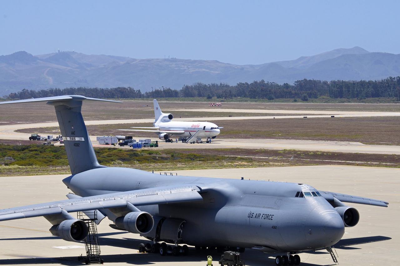
VANDENBERG AIR FORCE BASE, Calif. – A U.S. Air Force C-5 Galaxy cargo aircraft, foreground, sits on the tarmac at Vandenberg Air Force Base in California as final preparations are under way for the departure of Orbital Sciences’ L-1011 carrier aircraft for the U.S. Army's Ronald Reagan Ballistic Missile Defense Test Site on Kwajalein Atoll, part of the Marshall Islands in the Pacific Ocean. Orbital’s L-1011 is transporting their Pegasus rocket and NASA’s Nuclear Spectroscopic Telescope Array, or NuSTAR, to Kwajalein for launch. The Pegasus, mated to its NuSTAR payload, will be launched from the carrier aircraft 117 nautical miles south of Kwajalein at latitude 6.75 degrees north of the equator. The high-energy X-ray telescope will conduct a census of black holes, map radioactive material in young supernovae remnants, and study the origins of cosmic rays and the extreme physics around collapsed stars. Launch is scheduled for June 13. For more information, visit http://www.nasa.gov/nustar. Photo credit: NASA/Randy Beaudoin, VAFB
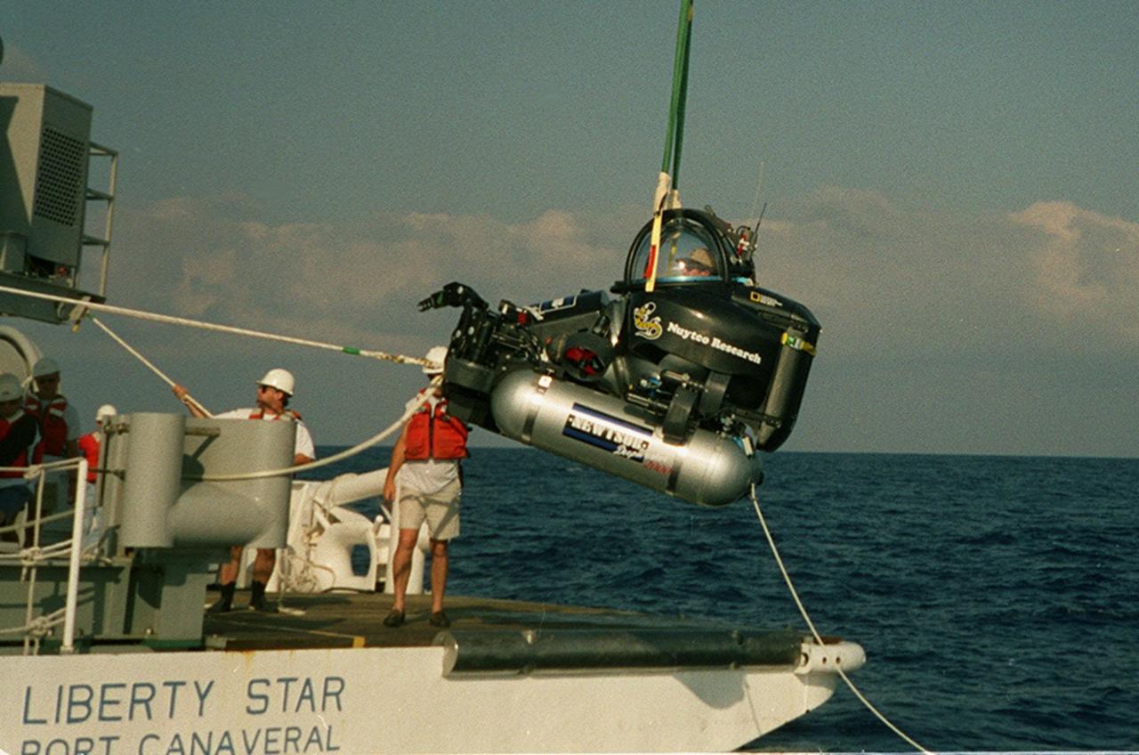
KENNEDY SPACE CENTER, FLA. -- After a successful dive, the one-man submarine known as DeepWorker 2000 is lifted from Atlantic waters near Cape Canaveral, Fla., onto the deck of the Liberty Star, one of two KSC solid rocket booster recovery ships. Inside the sub is the pilot, Anker Rasmussen. The sub is being tested on its ability to duplicate the sometimes hazardous job United Space Alliance (USA) divers perform to recover the expended boosters in the ocean after a launch. The boosters splash down in an impact area about 140 miles east of Jacksonville and after recovery are towed back to KSC for refurbishment by the specially rigged recovery ships. DeepWorker 2000 will be used in a demonstration during retrieval operations after the upcoming STS-101 launch. The submarine pilot will demonstrate capabilities to cut tangled parachute riser lines using a manipulator arm and attach a Diver Operator Plug to extract water and provide flotation for the booster. DeepWorker 2000 was built by Nuytco Research Ltd., North Vancouver, British Columbia. It is 8.25 feet long, 5.75 feet high, and weighs 3,800 pounds. USA is a prime contractor to NASA for the Space Shuttle program
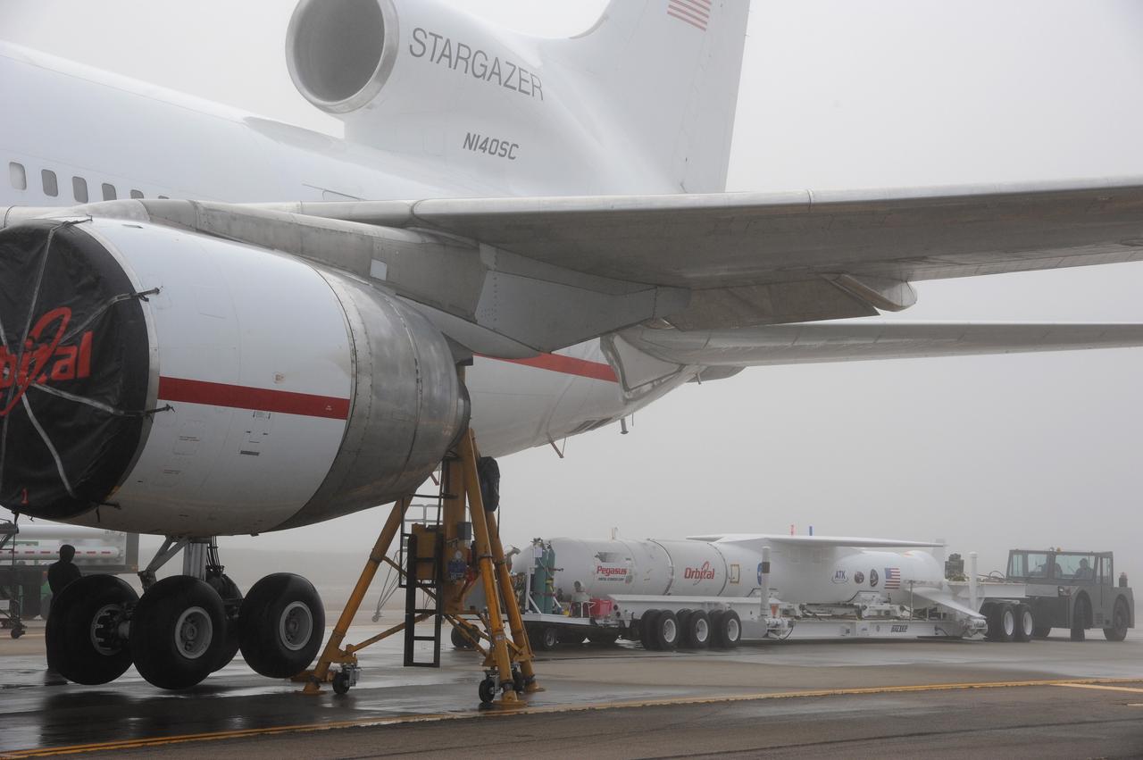
VANDENBERG AIR FORCE BASE, Calif. – NASA’s Nuclear Spectroscopic Telescope Array, or NuSTAR, mated to Orbital Sciences’ Pegasus XL rocket, rolls toward Orbital’s L-1011 carrier aircraft at the “hot pad,” located on the ramp adjacent to the runway on Vandenberg Air Force Base in California. Operations are under way to attach the rocket beneath the L-1011 aircraft. The duo will be flown from Vandenberg to the U.S. Army's Ronald Reagan Ballistic Missile Defense Test Site on Kwajalein Atoll, part of the Marshall Islands in the Pacific Ocean. The Pegasus and its NuSTAR payload will be launched June 13 from the carrier aircraft 117 nautical miles south of Kwajalein at latitude 6.75 degrees north of the equator. The high-energy X-ray telescope will conduct a census of black holes, map radioactive material in young supernovae remnants, and study the origins of cosmic rays and the extreme physics around collapsed stars. For more information, visit http://www.nasa.gov/nustar. Photo credit: NASA/Chris Wiant, VAFB
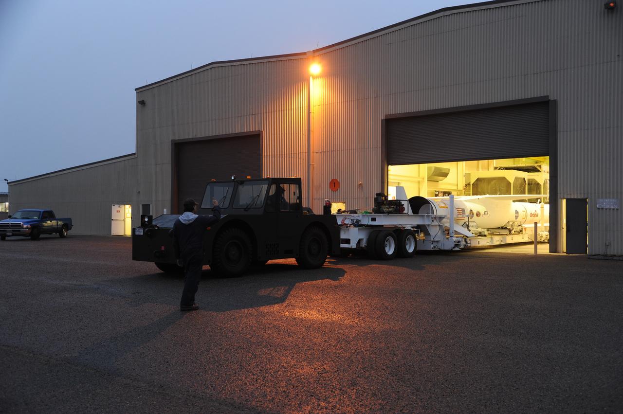
VANDENBERG AIR FORCE BASE, Calif. – NASA’s Nuclear Spectroscopic Telescope Array, or NuSTAR, mated to Orbital Sciences’ Pegasus XL rocket, rolls out of Orbital’s processing hangar headed for the “hot pad,” located on the ramp adjacent to the runway on Vandenberg Air Force Base in California. At the hot pad, the rocket will be attached beneath Orbital’s L-1011 carrier aircraft. The duo will be flown from Vandenberg to the U.S. Army's Ronald Reagan Ballistic Missile Defense Test Site on Kwajalein Atoll, part of the Marshall Islands in the Pacific Ocean. The Pegasus and its NuSTAR payload will be launched June 13 from the carrier aircraft 117 nautical miles south of Kwajalein at latitude 6.75 degrees north of the equator. The high-energy X-ray telescope will conduct a census of black holes, map radioactive material in young supernovae remnants, and study the origins of cosmic rays and the extreme physics around collapsed stars. For more information, visit http://www.nasa.gov/nustar. Photo credit: NASA/Chris Wiant, VAFB
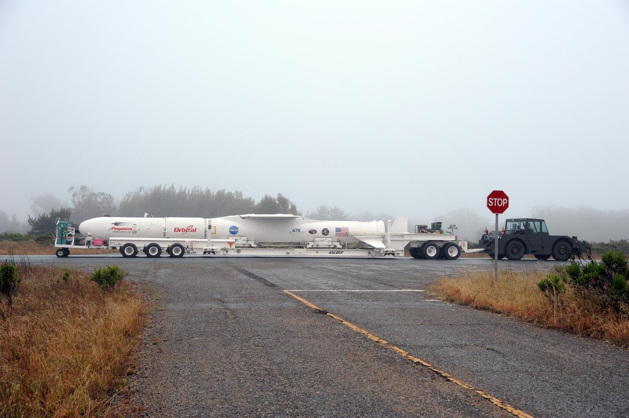
VANDENBERG AIR FORCE BASE, Calif. – NASA’s Nuclear Spectroscopic Telescope Array, or NuSTAR, mated to Orbital Sciences’ Pegasus XL rocket, travels along the roadway from Orbital’s processing hangar to the “hot pad,” located on the ramp adjacent to the runway on Vandenberg Air Force Base in California. At the hot pad, the rocket will be attached beneath Orbital’s L-1011 carrier aircraft. The duo will be flown from Vandenberg to the U.S. Army's Ronald Reagan Ballistic Missile Defense Test Site on Kwajalein Atoll, part of the Marshall Islands in the Pacific Ocean. The Pegasus and its NuSTAR payload will be launched June 13 from the carrier aircraft 117 nautical miles south of Kwajalein at latitude 6.75 degrees north of the equator. The high-energy X-ray telescope will conduct a census of black holes, map radioactive material in young supernovae remnants, and study the origins of cosmic rays and the extreme physics around collapsed stars. For more information, visit http://www.nasa.gov/nustar. Photo credit: NASA/Chris Wiant, VAFB
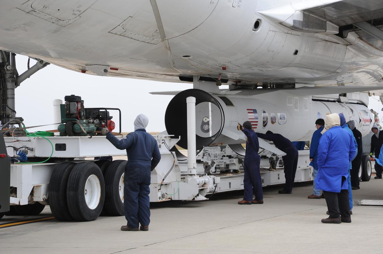
VANDENBERG AIR FORCE BASE, Calif. – Preparations are under way to roll the transporter from under NASA’s Nuclear Spectroscopic Telescope Array, or NuSTAR, mated to Orbital Sciences’ Pegasus XL rocket, which was just attached beneath Orbital’s L-1011 carrier aircraft at the “hot pad,” located on the ramp adjacent to the runway on Vandenberg Air Force Base in California. The duo will be flown from Vandenberg to the U.S. Army's Ronald Reagan Ballistic Missile Defense Test Site on Kwajalein Atoll, part of the Marshall Islands in the Pacific Ocean. The Pegasus and its NuSTAR payload will be launched June 13 from the carrier aircraft 117 nautical miles south of Kwajalein at latitude 6.75 degrees north of the equator. The high-energy X-ray telescope will conduct a census of black holes, map radioactive material in young supernovae remnants, and study the origins of cosmic rays and the extreme physics around collapsed stars. For more information, visit http://www.nasa.gov/nustar. Photo credit: NASA/Chris Wiant, VAFB
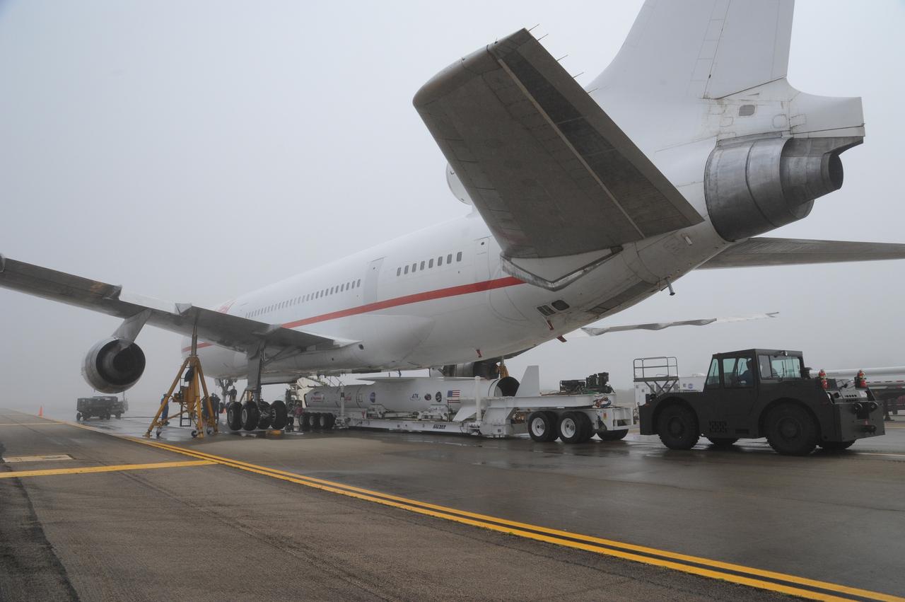
VANDENBERG AIR FORCE BASE, Calif. – NASA’s Nuclear Spectroscopic Telescope Array, or NuSTAR, mated to Orbital Sciences’ Pegasus XL rocket, is positioned under Orbital’s L-1011 carrier aircraft at the “hot pad,” located on the ramp adjacent to the runway on Vandenberg Air Force Base in California. Operations are under way to attach the rocket beneath the L-1011 aircraft. The duo will be flown from Vandenberg to the U.S. Army's Ronald Reagan Ballistic Missile Defense Test Site on Kwajalein Atoll, part of the Marshall Islands in the Pacific Ocean. The Pegasus and its NuSTAR payload will be launched June 13 from the carrier aircraft 117 nautical miles south of Kwajalein at latitude 6.75 degrees north of the equator. The high-energy X-ray telescope will conduct a census of black holes, map radioactive material in young supernovae remnants, and study the origins of cosmic rays and the extreme physics around collapsed stars. For more information, visit http://www.nasa.gov/nustar. Photo credit: NASA/Chris Wiant, VAFB