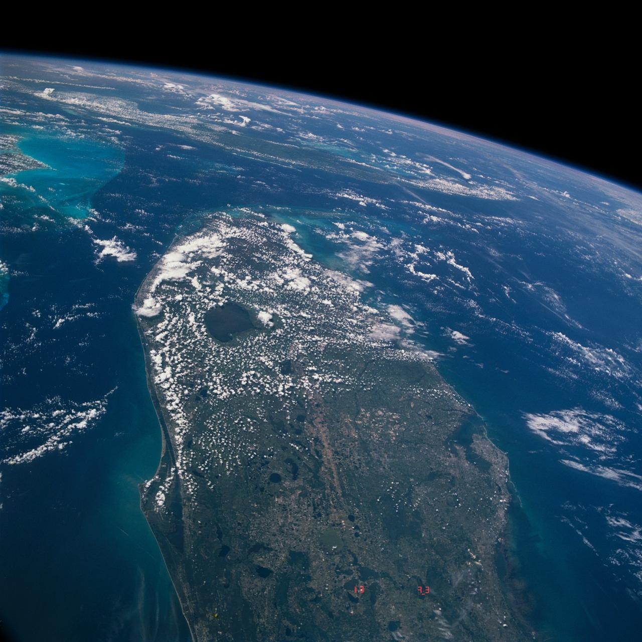
S66-54565 (14 Sept. 1966) --- Central portion of Florida, Gulf of Mexico to Atlantic Ocean, Cape Kennedy is at left center of photo, as seen from the Gemini-11 spacecraft during its 29th revolution of Earth. Photo lacks detail due to low sun angle. Sunglint on lakes is visible. Photo credit: NASA
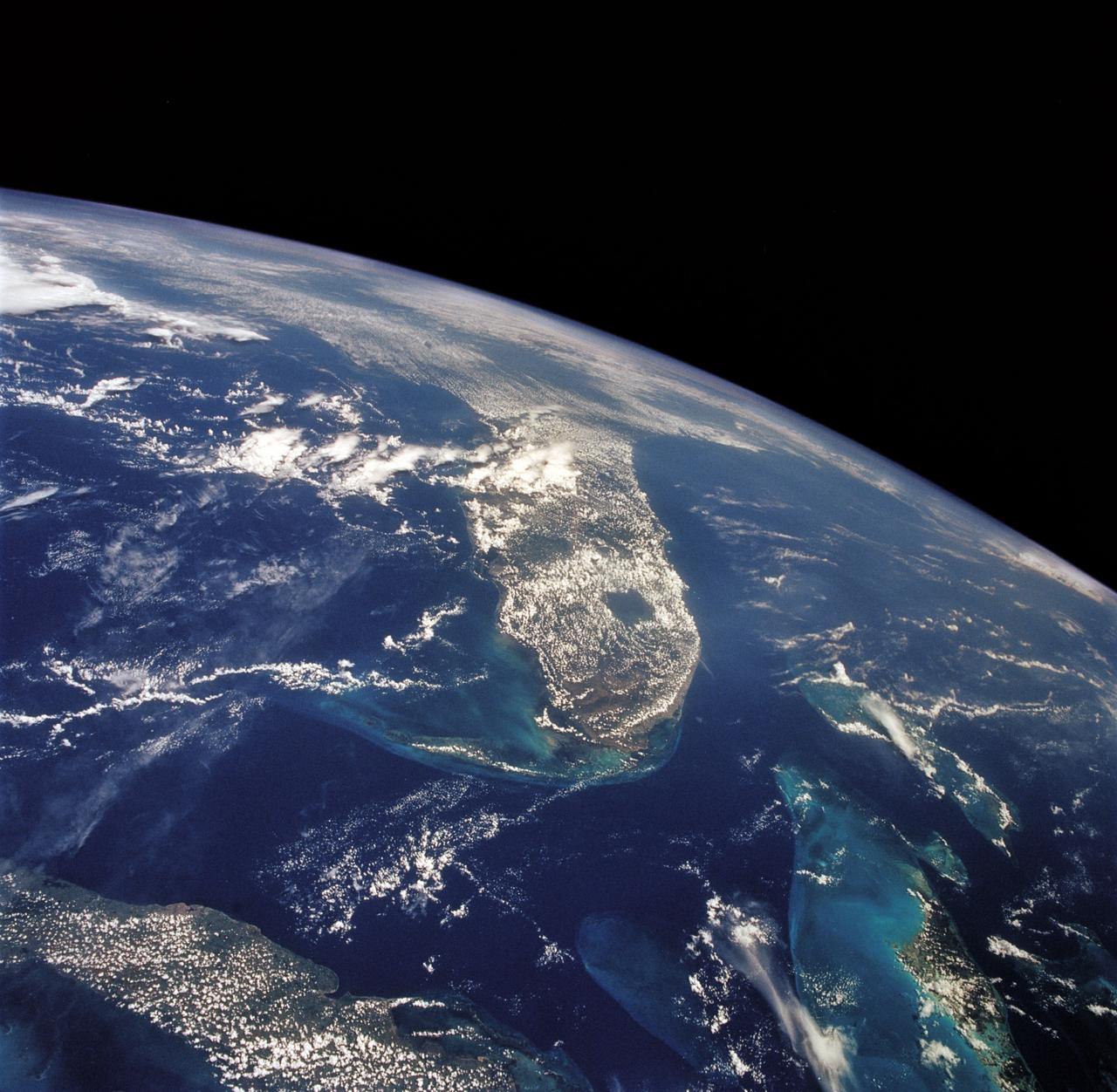
STS040-613-049 (5-14 June 1991) --- This oblique scene from the Earth-orbiting Space Shuttle Columbia shows southern Florida, several of the Bahama Islands and parts of the Atlantic Ocean, the Gulf of Mexico and the Caribbean Sea. The nine-day STS-40/Spacelab Life Sciences (SLS-1) mission started with launch from Kennedy Space Center (KSC), visible in lower left. Cuba can be seen at top center. The picture was photographed with a handheld Rolleiflex camera, aimed through Columbia's aft flight deck windows.
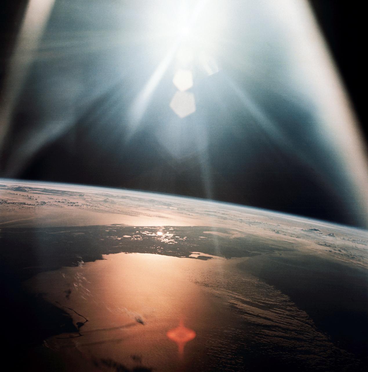
AS07-08-1933 (20 Oct. 1968) --- The morning sun reflects on the Gulf of Mexico and the Atlantic Ocean as seen from the Apollo 7 spacecraft at an altitude of 120 nautical miles above Earth. Most of Florida peninsula appears as a dark silhouette. This photograph was made during the spacecraft's 134th revolution of Earth, some 213 hours and 19 minutes after liftoff.
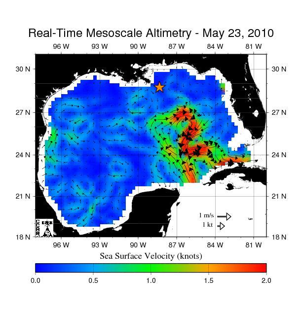
The northern portion of the Gulf of Mexico Loop Current, shown in red, appears about to detach a large ring of current, creating a separate eddy. An eddy is a large, warm, clockwise-spinning vortex of water -- the ocean version of a cyclone.
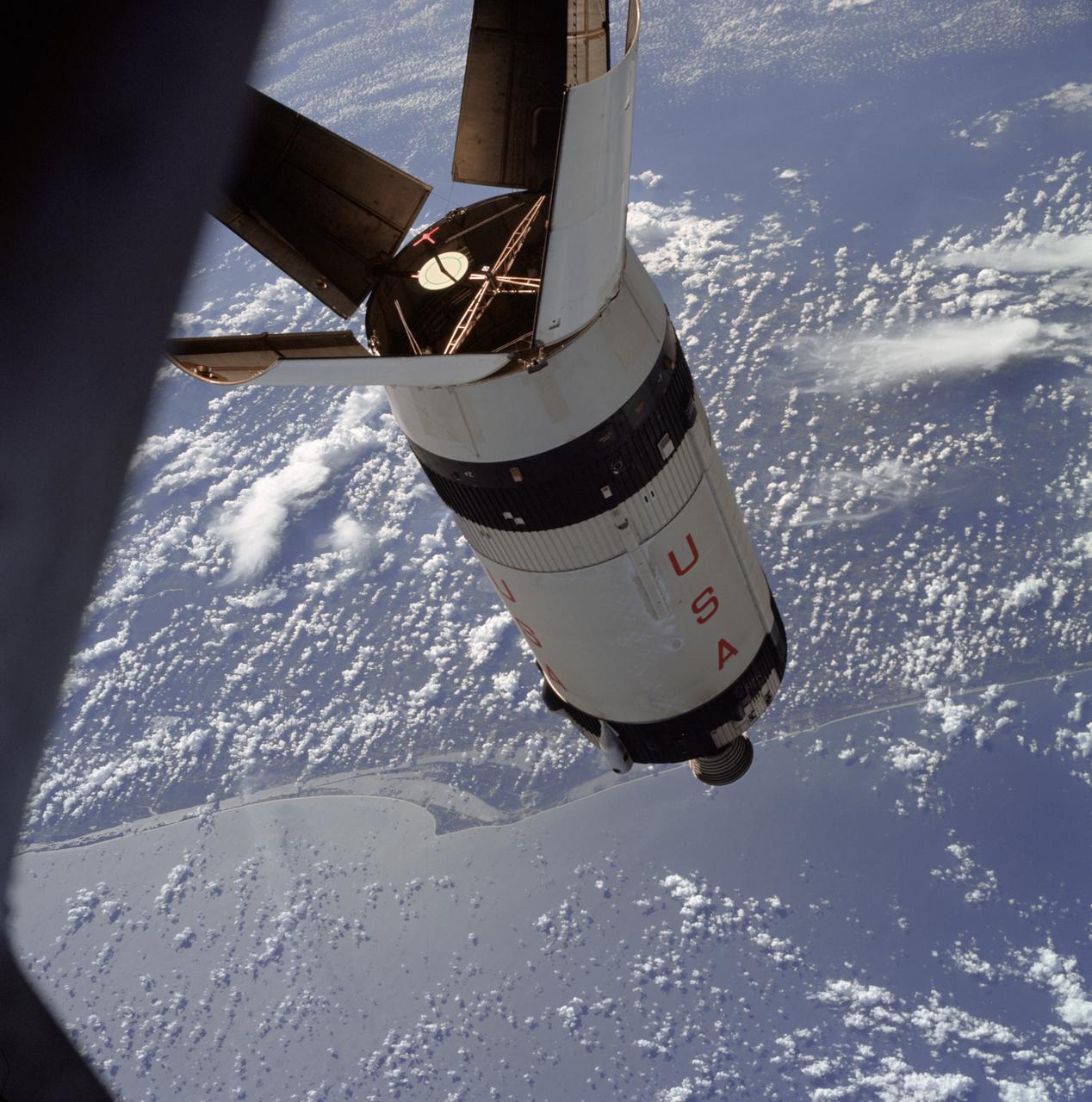
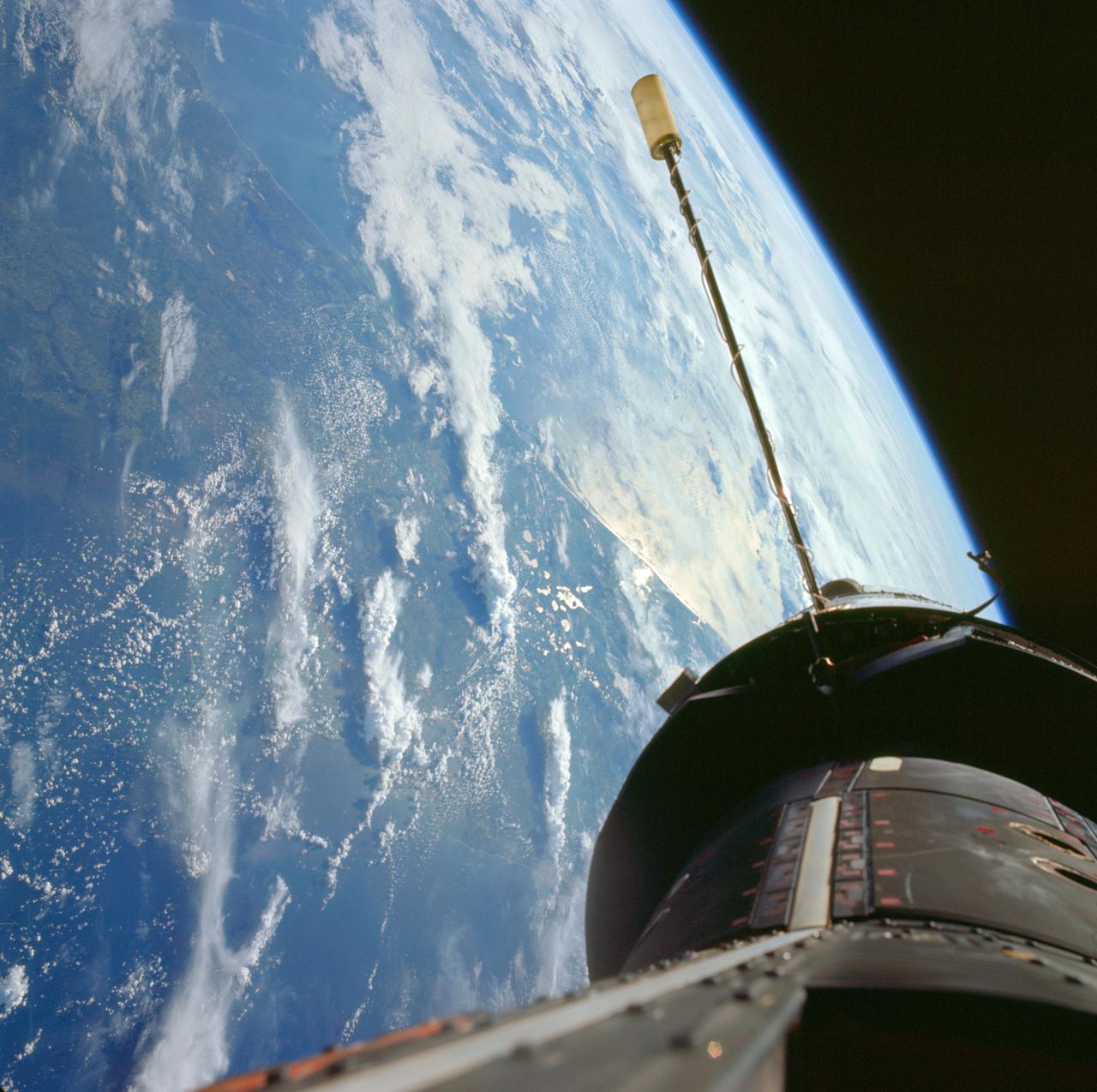
AS07-03-1545 (11 Oct. 1968) --- The expended Saturn S-IVB stage as photographed from the Apollo 7 spacecraft during transposition and docking maneuvers at an approximate altitude of 125 nautical miles, at ground elapsed time of three hours and 16 minutes (beginning of third revolution). This view is over the Atlantic Ocean off the coast of Cape Kennedy, Florida. The Florida coastline from Flagler Beach southward to Vero Beach is clearly visible in picture. Much of the Florida peninsula can be seen. Behind the open panels is the Gulf of Mexico. Distance between the Apollo 7 spacecraft and the S-IVB is approximately 100 feet. The round, white disc inside the open panels of the S-IVB is a simulated docking target similar to that used on the Lunar Module (LM) for docking during lunar missions.
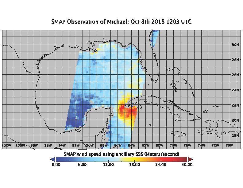
On the morning of Oct. 8, 2018, the NASA Soil Moisture Active Passive (SMAP) Radiometer got a snapshot of Hurricane Michael, which has intensified to a Category 2 hurricane over the warm waters of the Gulf of Mexico. The radiance acquired by the SMAP L-band Microwave Radiometer can see through clouds and rains, and is sensitive to the extreme ocean surface winds under a tropical storm or hurricane. Areas in red represent higher wind speeds; areas in blue have lower wind speeds. https://photojournal.jpl.nasa.gov/catalog/PIA22747
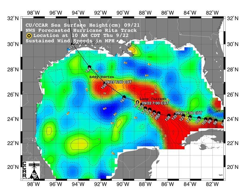
This sea surface height map of the Gulf of Mexico, with the Florida peninsula on the right and the Texas-Mexico Gulf Coast on the left, is based on altimeter data from four satellites including NASA’s Topex/Poseidon and Jason. Red indicates a strong circulation of much warmer waters, which can feed energy to a hurricane. This area stands 35 to 60 centimeters (about 13 to 23 inches) higher than the surrounding waters of the Gulf. The actual track of a hurricane is primarily dependent upon steering winds, which are forecasted through the use of atmospheric models. However, the interaction of the hurricane with the upper ocean is the primary source of energy for the storm. Hurricane intensity is therefore greatly affected by the upper ocean temperature structure and can exhibit explosive growth over warm ocean currents and eddies. Eddies are currents of water that run contrary to the direction of the main current. According to the forecasted track through the Gulf of Mexico, Hurricane Rita will continue crossing the warm waters of a Gulf of Mexico circulation feature called the Loop Current and then pass near a warm-water eddy called the Eddy Vortex, located in the north central Gulf, south of Louisiana. http://photojournal.jpl.nasa.gov/catalog/PIA06427
iss061e029039 (Nov. 4, 2019) --- Baja California, with the Sun's glint beaming off the Gulf of California, is pictured as the International Space Station orbited 256 miles above the Pacific Ocean southwest of Tijuana, Mexico.
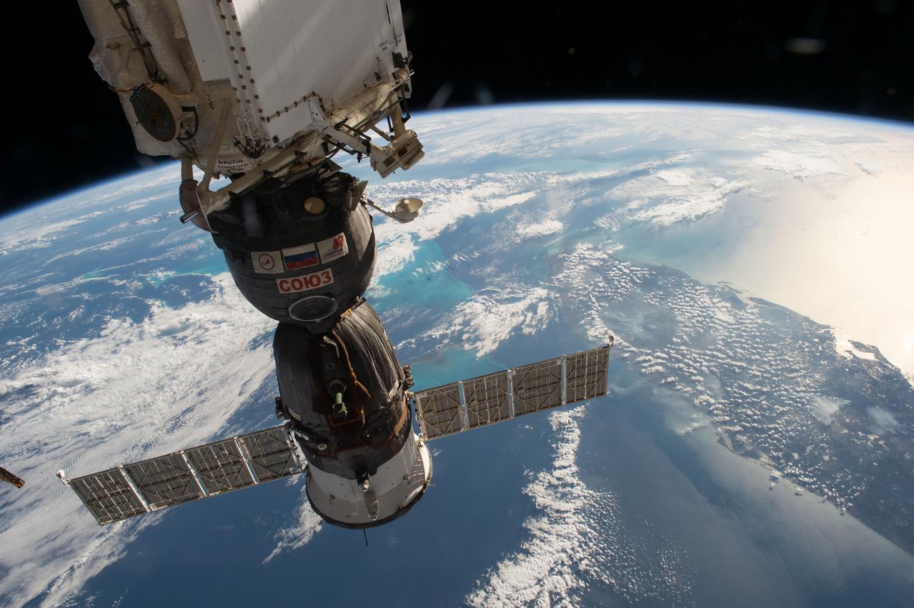
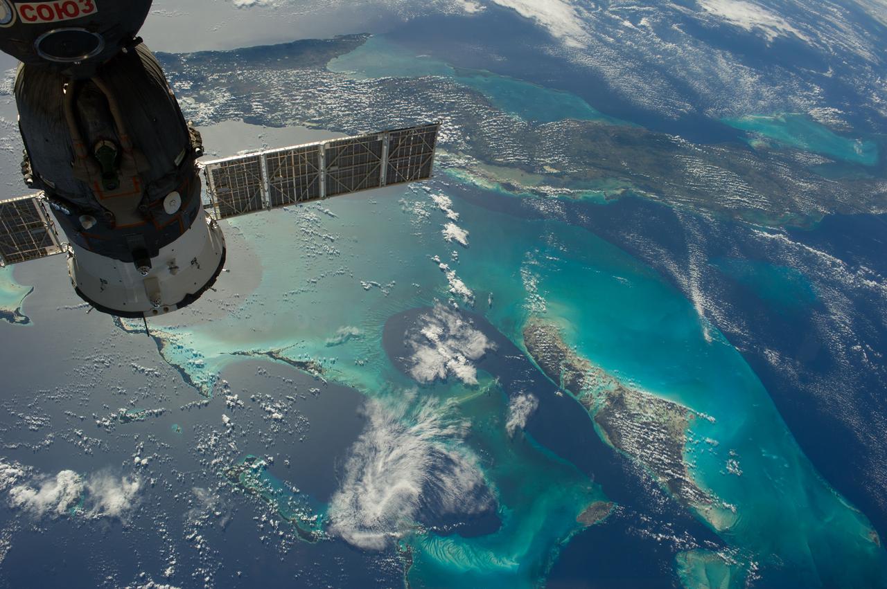
iss050e038462 (02/03/2017) --- A Russian Soyuz spacecraft can be seen in this image from the International Space Station as it passes over the American state of Florida surrounded by the blue waters of the Gulf of Mexico on the west side and the Atlantic Ocean on the other.
iss059e027945 (April 20, 2019) --- The state of Florida, with the Gulf of Mexico on its east coast, the Atlantic Ocean on its west coast and the International Space Station's solar arrays in the foreground are pictured as the orbital complex flew 254 miles above Earth's surface.
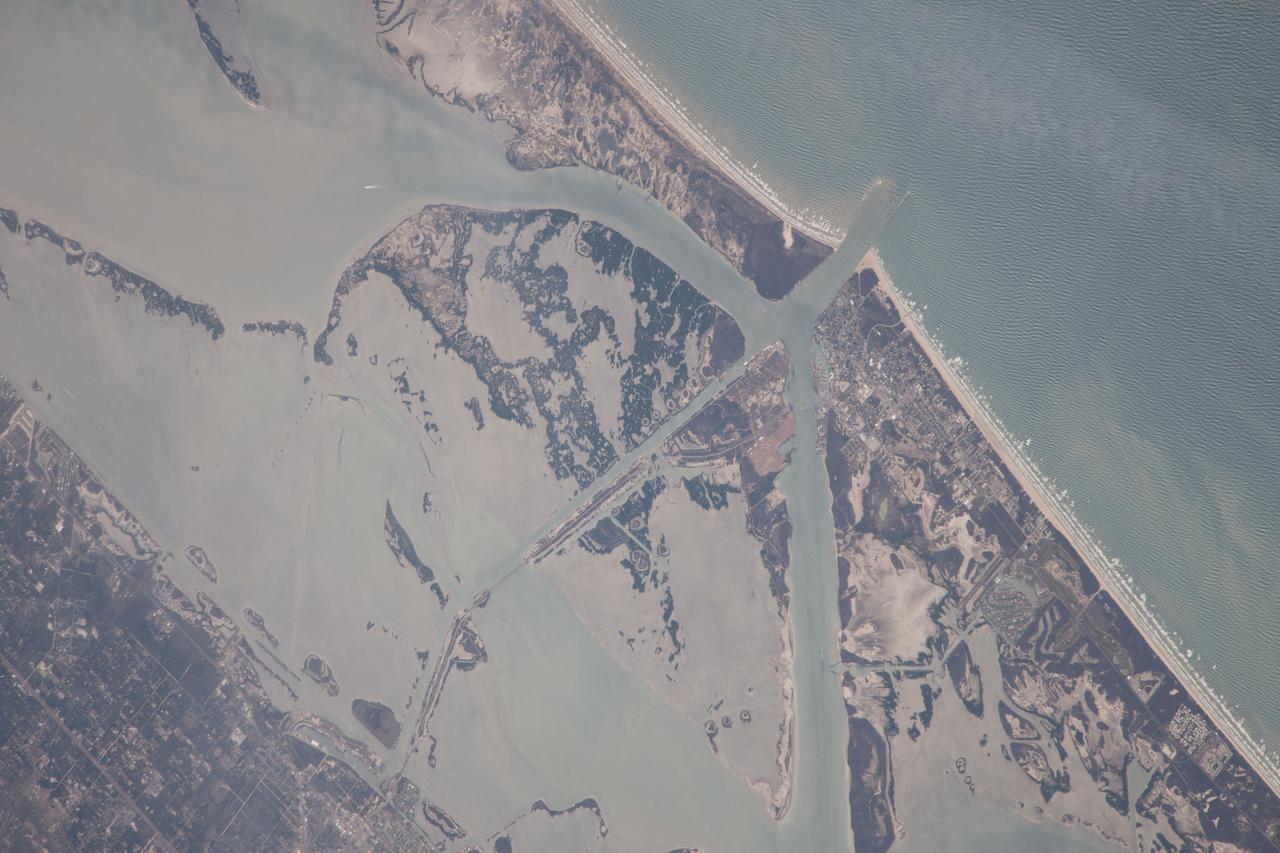
ISS038-E-57806 (21 Feb. 2014) --- One of the Expedition 38 crew members aboard the International Space Station photographed this image of the Gulf of Mexico's Intracoastal Waterway in southern Texas. Represented in the photo are 18 kilometers (11.2 miles) of the overall 4800 kilometers-long (3000 miles) barge channel that lies on the protected inshore of the coastal islands of the southern and eastern USA, including coastal Texas. The small city of Port Aransas lies on a barrier island fully 18 kilometers (11.2 miles) seaward of the mainland and its sister city, Aransas Pass (lower left). This image shows parts of the waterway that are artificial, as in the straight sector leading into Corpus Christi Bay. Corpus Christi lies outside the lower margin of the image. Other sectors of the waterway are natural bays such as Aransas Bay. Jetties protect the inlet into the Gulf of Mexico (top right). Inlets at many points cut through the barrier islands to give shipping access to the Gulf of Mexico and the Atlantic Ocean.
ISS029-E-042846 (16 Nov. 2011) --- Parts of the U.S. and Mexico are seen in this image photographed by one of the Expedition 29 crew members from the International Space Station as it flew above the Pacific Ocean on Nov. 16, 2011. The Salton Sea is in the center of the frame, with the Gulf of Cortez, Mexico's Baja California and the Colorado River in the upper right quadrant. The Los Angeles Basin and Santa Catalina and San Clemente islands are at the bottom center edge of the image. Lake Mead and the Las Vegas area of Nevada even made it into the frame in the upper left quadrant.
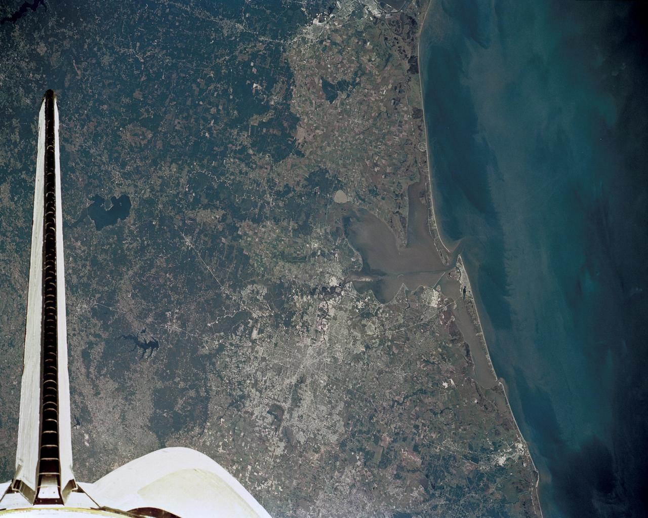
51J-143-126 (5 Oct. 1985) --- The vertical stabilizer of the Earth-orbiting Space Shuttle Atlantis serves to partially frame this scene of Metropolitan Houston. Hold photo with vertical tail at top so that north will be at top. America's fourth largest city, with its radiating highway network, lies at the junction between the East Texas piney woods, containing lakes Conroe and Livingston (near top center and top right, respectively), and the coastal prairie, now largely farmland (left side of frame). The coast stretches from the left at Freeport and the mouth of the Brazos River, past Galveston and Texas City, and the circle of the High Island Salt Dome (clearly seen at lower right near the Bolivar Peninsula), to Port Arthur on the Neches River (far right). Patterns of muddy and clear water are particularly well-displayed in Galveston and Trinity Bays, as well as in the Gulf of Mexico. With a close look, the Harris County Domed Stadium (Astrodome) can be recognized on Houston's south side. The NASA Johnson Space Center (JSC) and the Clear Lake City area are easily delineated some 25 miles southeast of downtown Houston. The scene was recorded on film by one of the STS-51J crewmembers using a handheld Hasselblad camera and 70mm film.
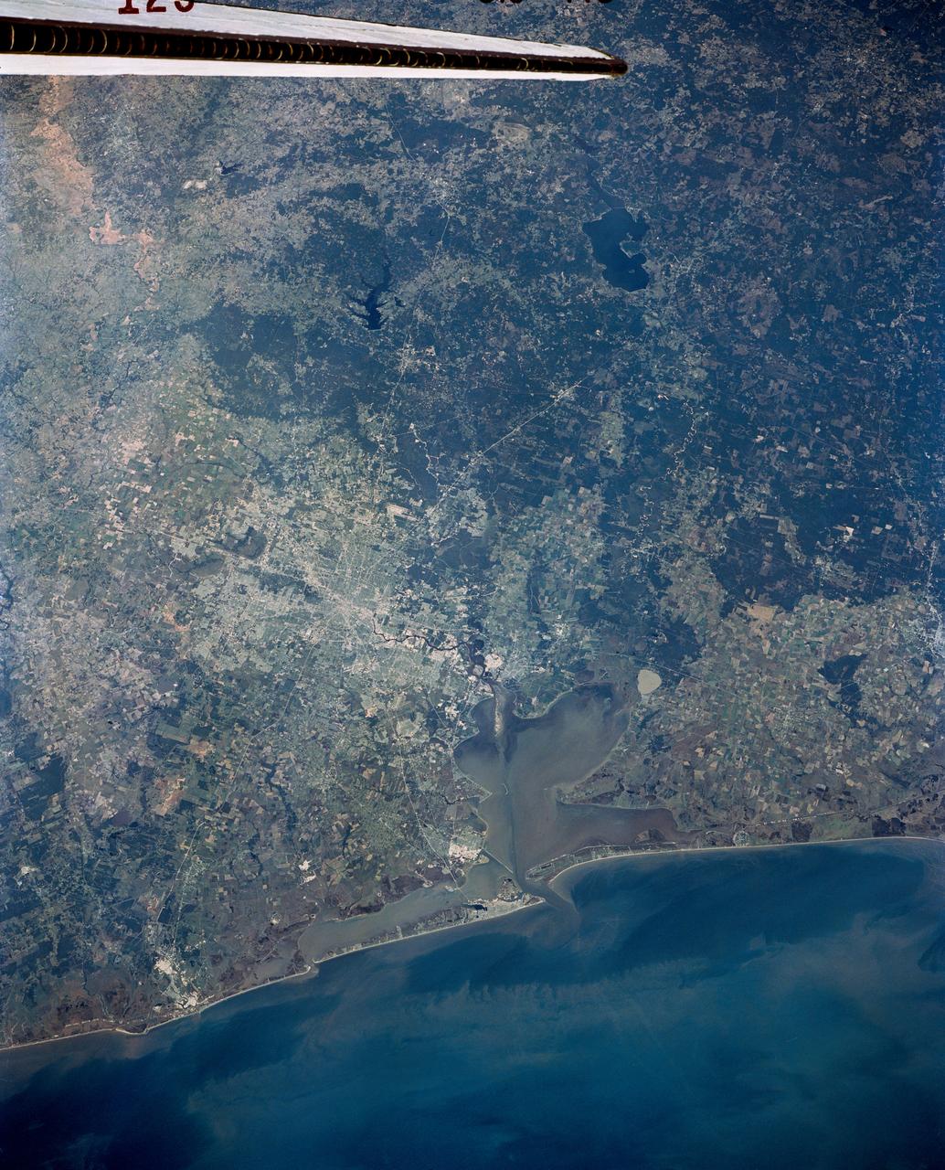
Long regarded as one of the best photo of Houston, Texas (29.5N, 95.0W), this view from space shows the entire greater Houston/Galveston region in remarkable detail and clarity. The dark north/south line in the water between Houston and Galveston is the Houston Ship Channel. NASA's Johnson Space Center and Mission Control is located on the north shore of Clear Lake west of the channel. The extensive road and highway network can be seen in great detail.
ISS038-E-021401 (24 Dec. 2013) --- The Caribbean country of Cuba is pictured in this high oblique image, photographed by one of the Expedition 38 crew members aboard the International Space Station. Andros ISland, part of the Bahamas, is Cuba is an archipelago of islands in the northern Caribbean Sea at the confluence with the Gulf of Mexico and the Atlantic Ocean. A Russian Soyuz spacecraft is docked to the station.
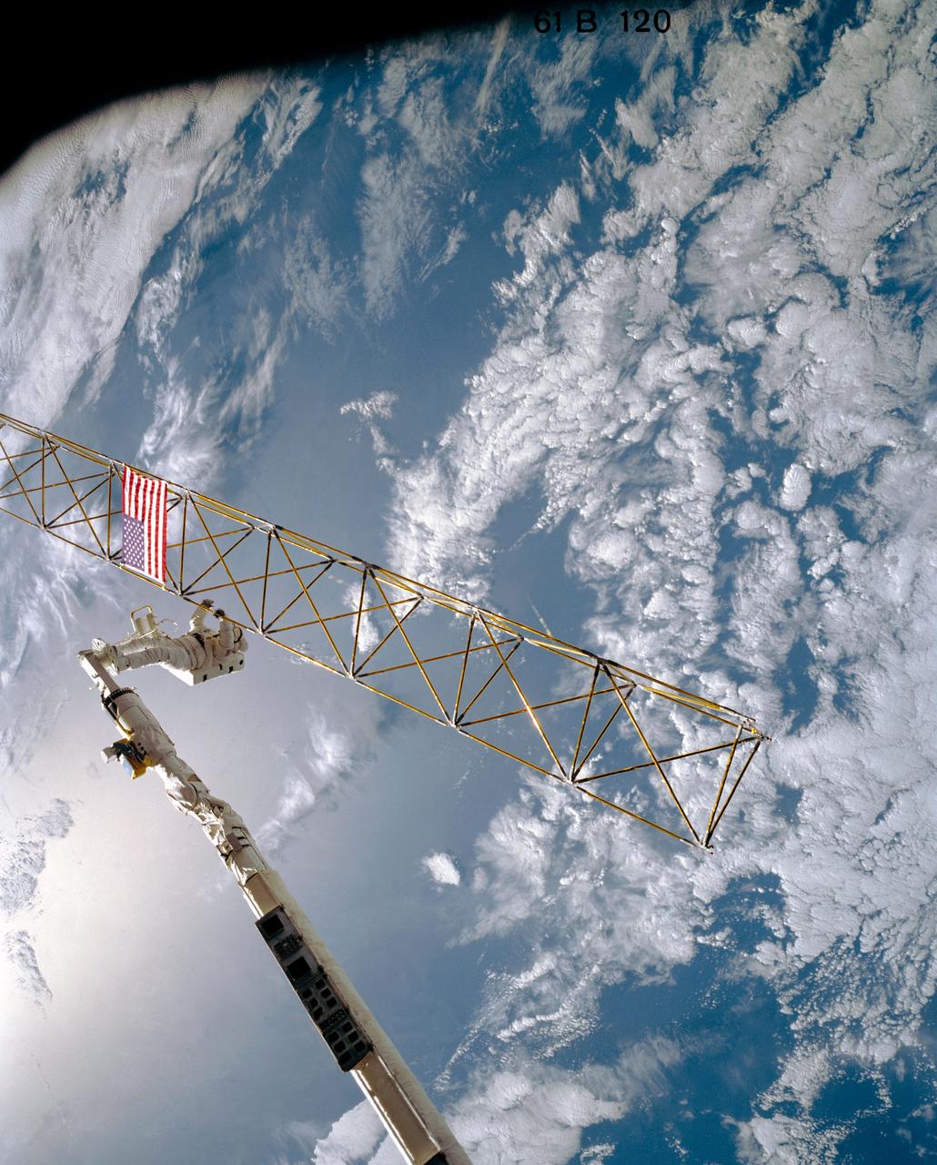
Astronaut Sherwood C. Spring, anchored to the foot restraint on the remote manipulator system (RMS) arm, checks joints on the tower-like Assembly Concept for Construction of Erectable Space Structures (ACCESS) device extending from the payload bay as the Atlantis flies over white clouds and blue ocean waters. The Gulf of Mexico waters form the backdrop for the scene.
ISS038-E-019899 (23 Dec. 2013) --- The Caribbean country of Cuba appears at the top of this high oblique image, photographed by one of the Expedition 38 crew members aboard the International Space Station. Andros Island, part of the Bahamas, is in the bottom of the frame. Cuba is an archipelago of islands in the northern Caribbean Sea at the confluence with the Gulf of Mexico and the Atlantic Ocean. A Russian Soyuz spacecraft is docked to the station.
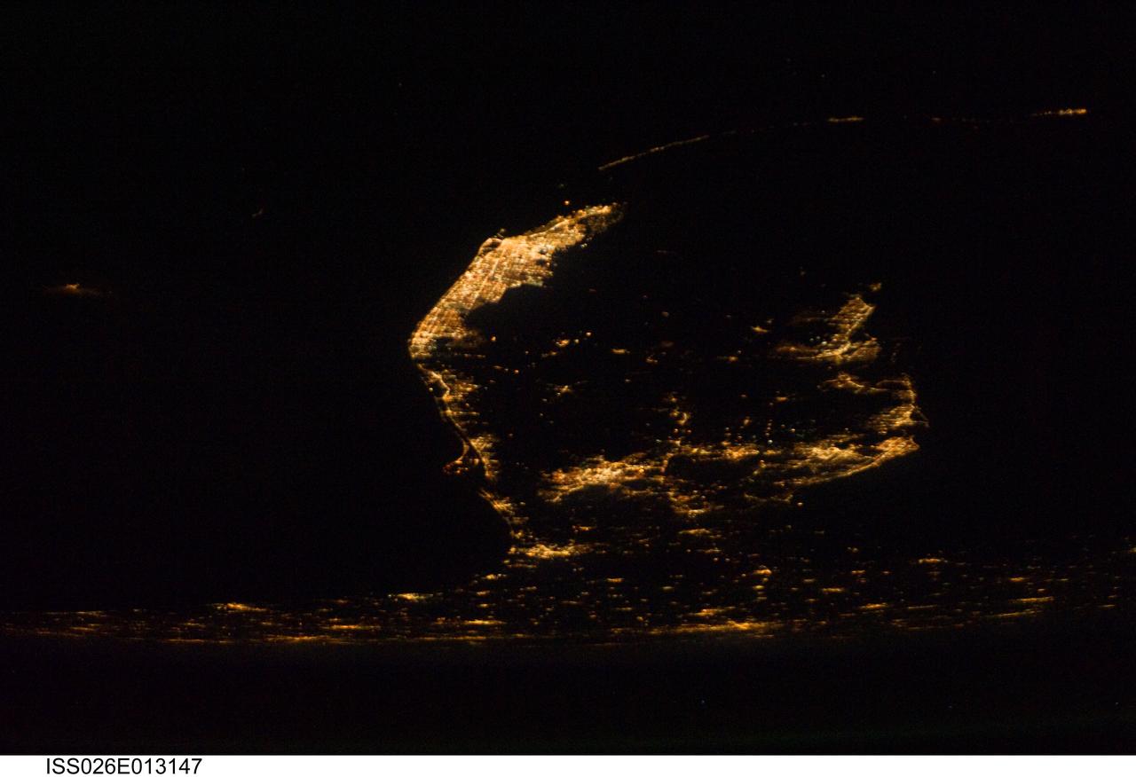
ISS026-E-013147 (28 Dec. 2010) --- A southerly looking night view of the upper two thirds of the Florida peninsula was recorded by one of the Expedition 26 crew members aboard the International Space Station on Dec. 28, 2010. Cape Canaveral and the Kennedy Space Center are very well lighted on the left (Atlantic Ocean) side of the peninsula. The Tampa-St. Petersburg area is seen on the Gulf of Mexico or right side of the frame. At bottom or in the north areas of the picture are portions of the state?s panhandle as well as cities and communities in southern Georgia.
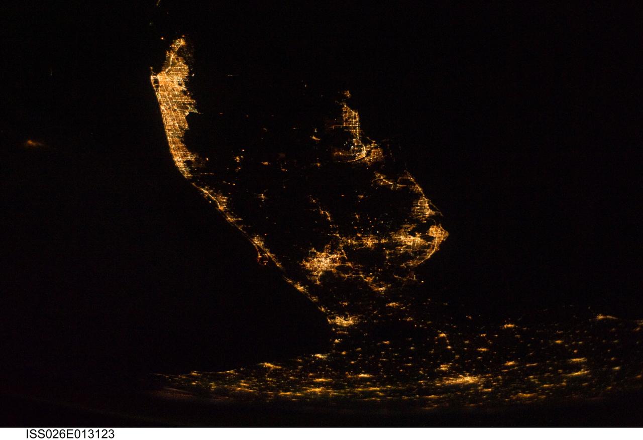
ISS026-E-013123 (28 Dec. 2010) --- A southerly looking night view of the upper two thirds of the Florida peninsula was recorded by one of the Expedition 26 crew members aboard the International Space Station on Dec. 28, 2010. Cape Canaveral and the Kennedy Space Center are very well lighted on the left (Atlantic Ocean) side of the peninsula. The Tampa-St. Petersburg area is seen on the Gulf of Mexico or right side of the frame. At bottom or in the north areas of the picture are portions of the state?s panhandle as well as cities and communities in southern Georgia.
S66-63440 (12 Nov. 1966) --- Area of northwestern Mexico as seen from the Gemini-12 spacecraft during its 16th revolution of Earth. View is looking northwest. Body of water in the foreground is the Gulf of California. Pacific Ocean is in the background. Peninsula in center of picture is Baja California. States of Sonora (upper right) and Sinaloa (lower center) of Mexican mainland is in right foreground. City of Guaymas, Sonora, is near the center of the picture. Photo credit: NASA
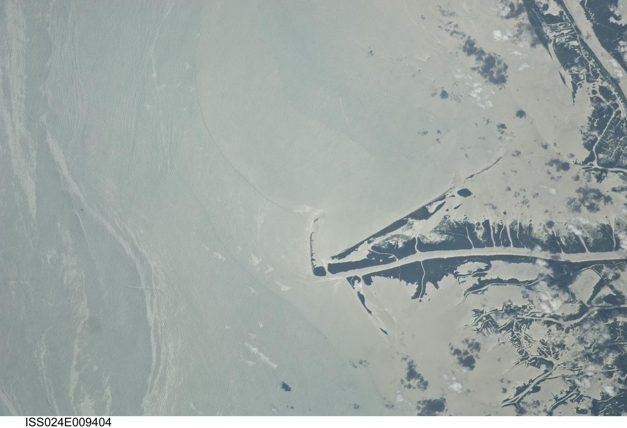
ISS024-E-009404 (23 July 2010) --- This photo taken from the International Space Station on July 23, 2010, shows the Gulf of Mexico oil spill as part of ongoing observations of the region. When this image was taken, three months after the explosion on the Deepwater Horizon oil rig, the leak had been plugged for eight days. Water surfaces appear bright and land surfaces appear dark in the image. The stark contrast is due to sun glint, in which the sun is reflected brilliantly off all water surfaces back towards the astronaut observer on board the station. The sun glint reveals various features in the Gulf of Mexico, especially sheens of oil as packets of long bright streaks seen on the left side of the image. Sediments carried by the Mississippi River have a light-yellow coloration in this image, with distinct margins between plumes that likely mark tidal pulses of river water into the Gulf of Mexico. A boat wake cuts across one of the oil packets at image lower left. Daily National Oceanic and Atmospheric Administration (NOAA) maps of oil distribution show predicted heavier and lighter oil movement near the Gulf coastline. The maps show that on the day this image was taken, the north edge of the ?oiled? zone was expected to bank up against the delta. The observed spread of the surface oil in the approximately 100 days since the explosion highlights the connectivity between the deepwater areas and coastlines of the Gulf of Mexico.
ISS006-E-51456 (2003) --- Marias Islands, Mexico is featured in this image photographed by an Expedition Six crewmember on the International Space Station. The view shows the land-sea interactions along a section of Mexico's west coast just south of Mazatlan and the Isla Marias archipelago. The islands are a manifestation of intersecting plate boundaries -- the East Pacific Rise spreading center that traces south from the Gulf of California, and the subduction zone that consumes the Cocos plate beneath southern Mexico. These islands are biologically important: they comprise the Islas Marias Biosphere Reserve and contain endemic species of raccoons and rabbits, and important habitat for birds and marine life. Between the islands and the mainland, swirling surface currents are highlighted by the sun glint reflecting off the ocean surface. Along the Mexican coast, water flows out from a coastal lagoon, and near shore currents carry sediment (light colored water) along the beach front.
51C-44-026 (24-27 January 1985) --- This oblique view of the Florida peninsula was photographed from the Earth-orbiting Space Shuttle Discovery during the DOD-devoted mission. Many popular features of the state can be delineated in the scene. Kennedy Space Center (KSC), from which this and all Space Shuttle missions are launched, is on the jutting Cape Canaveral, visible on the east Atlantic Coast. The spacecraft was flying at an altitude of 190 nautical miles. A handheld Hasselblad camera, with 70mm Kodak natural color Ektachrome ASA 64 film, was used to expose the frame. Crew members for the flight were astronauts Thomas K. Mattingly, Loren J. Shriver, Ellison S. Onizuka, James F. Buchli, and Gary E. Payton of the United States Air Force.
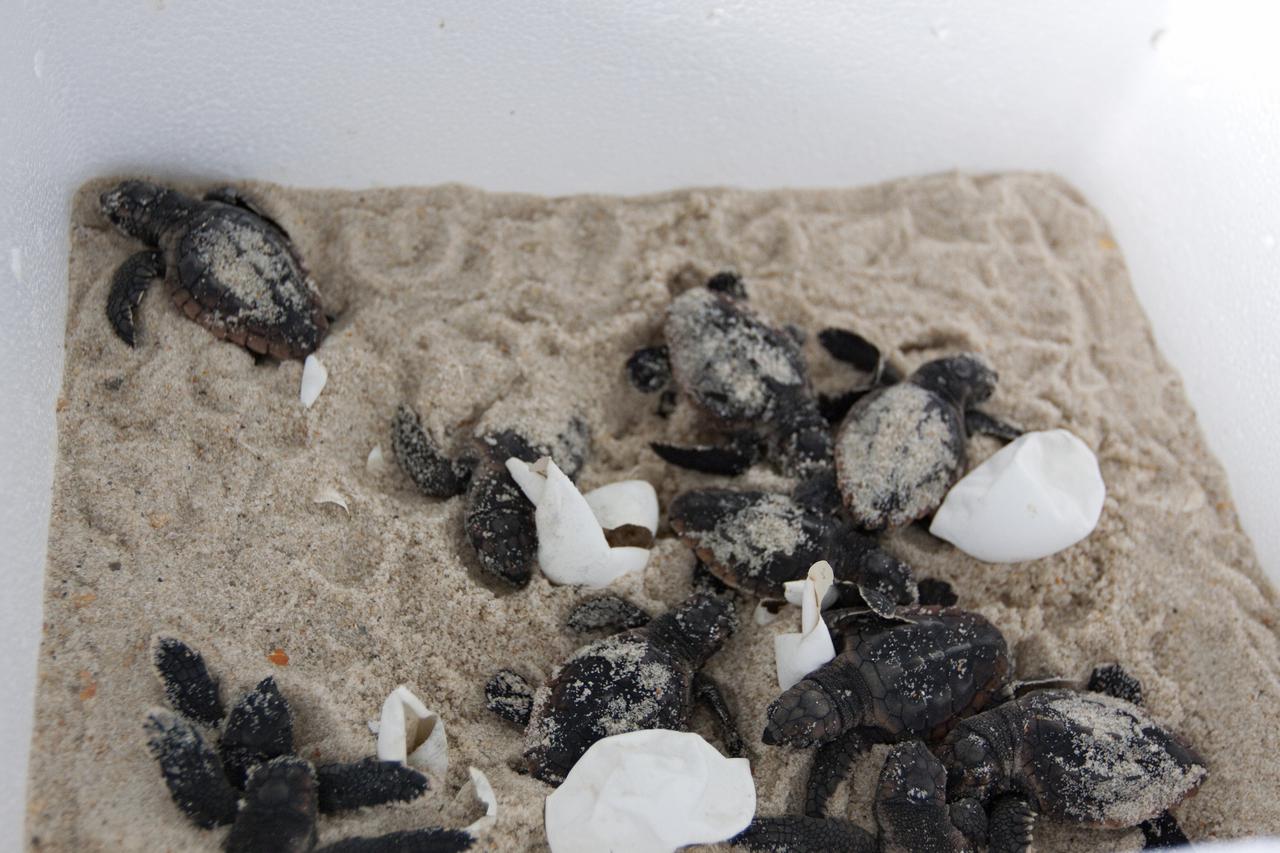
CAPE CANAVERAL, Fla. -- In a climate-controlled facility at NASA's Kennedy Space Center in Florida, newly-hatched Loggerhead turtles emerge from their eggs brought from beaches along the northern U.S. Gulf Coast. The eggs will be monitored by biologists and hatchery workers until incubation is complete. The hatchlings will be released at different points along a 100-mile stretch of the Atlantic Ocean shoreline. That includes beaches adjacent to the Merritt Island National Wildlife Refuge, which is located inside Kennedy. The release and relocation work is part of an effort by the U.S. Fish and Wildlife Service, the Florida Fish and Wildlife Conservation Commission, the National Park Service, NOAA, FedEx and conservationists to help minimize the risk to this year's sea turtle hatchlings from impacts of the BP Deepwater Horizon oil spill in the Gulf of Mexico. This plan involves carefully moving an anticipated 700 nests during the next several months. Photo credit: NASA_Troy Cryder
CAPE CANAVERAL, Fla. -- In a secure, climate-controlled facility at NASA's Kennedy Space Center in Florida, newly-hatched Loggerhead turtles emerge from their eggs brought from beaches along the northern U.S. Gulf Coast. The eggs will be monitored by biologists and hatchery workers until incubation is complete. The hatchlings will be released at different points along a 100-mile stretch of the Atlantic Ocean shoreline. That includes beaches adjacent to the Merritt Island National Wildlife Refuge, which is located inside Kennedy. The release and relocation work is part of an effort by the U.S. Fish and Wildlife Service, the Florida Fish and Wildlife Conservation Commission, the National Park Service, NOAA, FedEx and conservationists to help minimize the risk to this year's sea turtle hatchlings from impacts of the BP Deepwater Horizon oil spill in the Gulf of Mexico. This plan involves carefully moving an anticipated 700 nests during the next several months. Photo credit: NASA_Troy Cryder
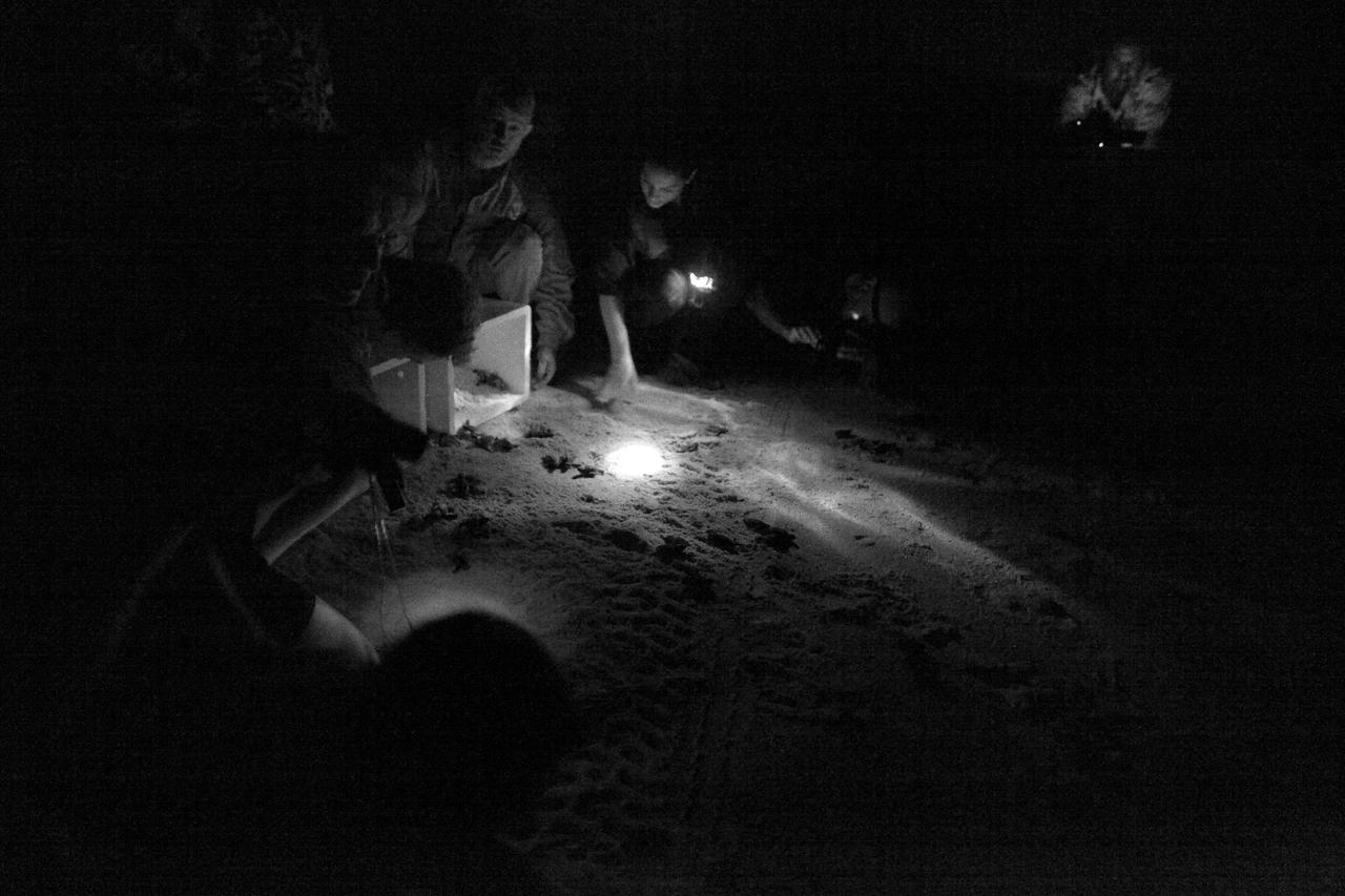
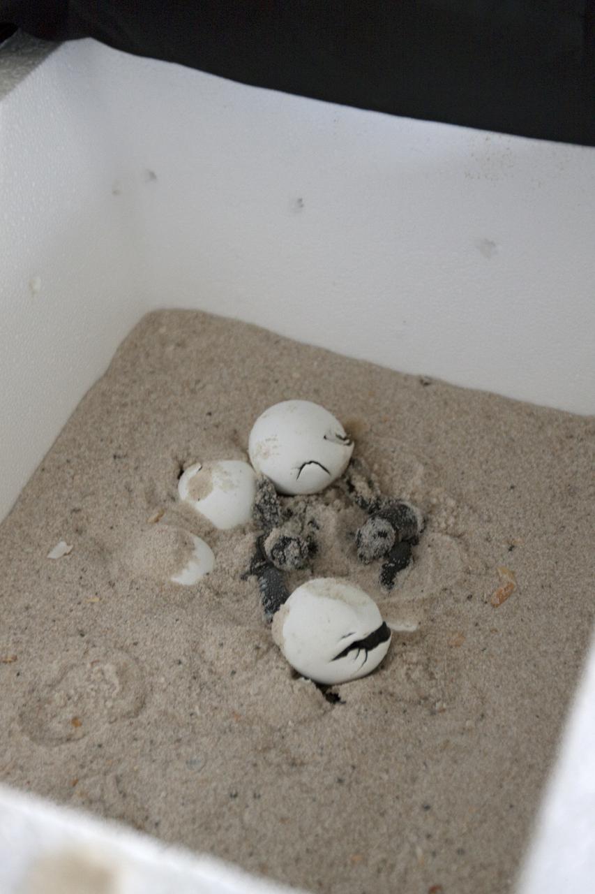
CAPE CANAVERAL, Fla. -- Hatchlings from endangered loggerhead turtle eggs, brought from beaches along the northern U.S. Gulf Coast, are being released into the Atlantic Ocean at Playalinda Beach, adjacent to the Merritt Island National Wildlife Refuge within NASA's Kennedy Space Center in Florida. The release and relocation work is part of an effort by the U.S. Fish and Wildlife Service, the Florida Fish and Wildlife Conservation Commission, the National Park Service, NOAA, FedEx and conservationists to help minimize the risk to this year's sea turtle hatchlings from impacts of the BP Deepwater Horizon oil spill in the Gulf of Mexico. This plan involves carefully moving an anticipated 700 nests deposited on Florida Panhandle and Alabama beaches during the next several months. Note: The photos were shot using an infrared filter to protect the hatchlings. Photo credit: NASA_Dimitri Gerondidakis
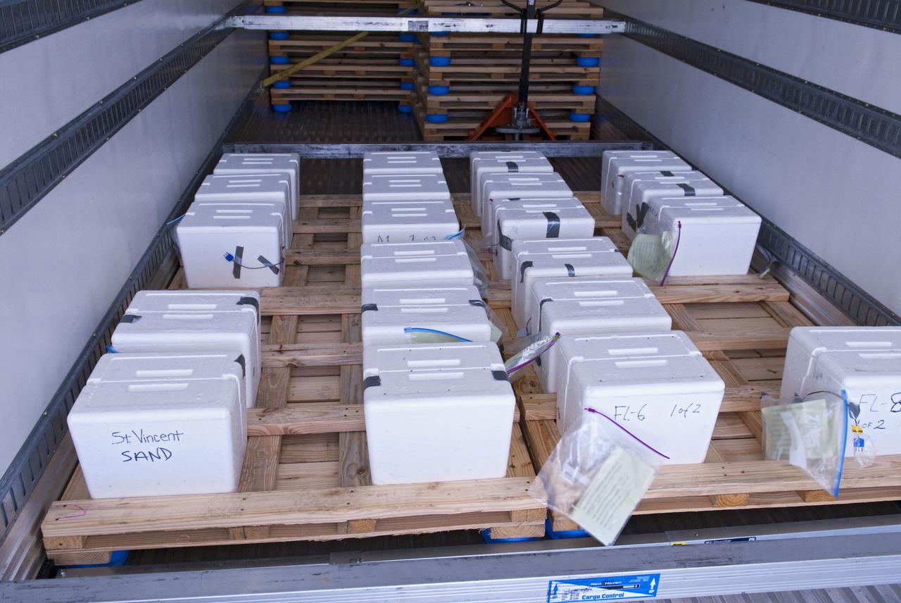
CAPE CANAVERAL, Fla. -- A new batch of endangered sea turtle eggs brought from beaches along the northern U.S. Gulf Coast arrive at NASA's Kennedy Space Center in Florida. Nests of Kemp’s ridley and Loggerhead turtle eggs from Gulf Shores, Ala., and various Florida Gulf Coast beaches are being transported by a specially equipped FedEx truck to a secure, climate-controlled facility at Kennedy. They will be monitored by biologists and hatchery workers until incubation is complete. The hatchlings will be released at different points along a 100-mile stretch of the Atlantic Ocean shoreline. That includes beaches adjacent to the Merritt Island National Wildlife Refuge, which is located inside Kennedy. The release and relocation work is part of an effort by the U.S. Fish and Wildlife Service, the Florida Fish and Wildlife Conservation Commission, the National Park Service, NOAA, FedEx and conservationists to help minimize the risk to this year’s sea turtle hatchlings from impacts of the BP Deepwater Horizon oil spill in the Gulf of Mexico. This plan involves carefully moving an anticipated 700 nests during the next several months. Photo credit: NASA_Ben Smegelsky
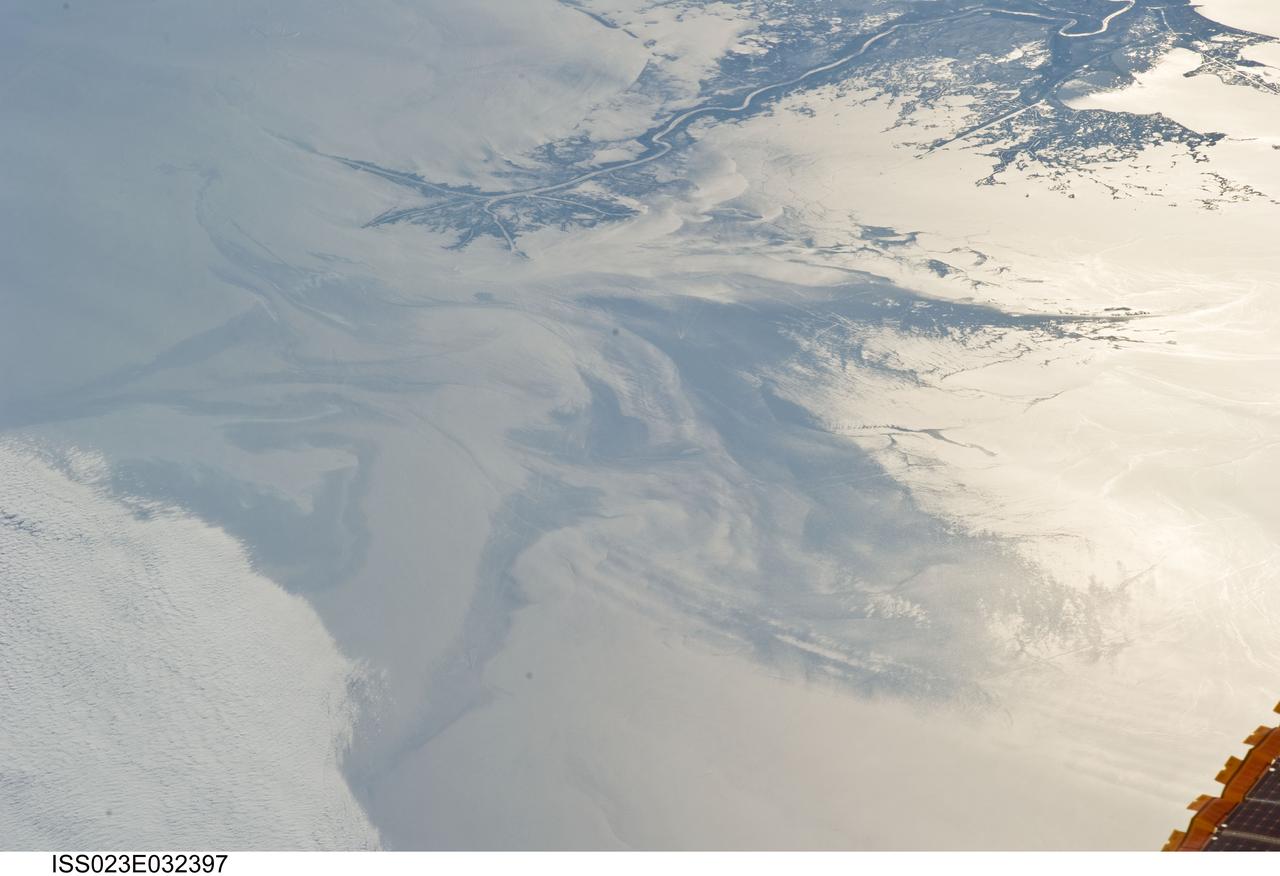
ISS023-E-032397 (4 May 2010) --- The Gulf of Mexico oil spill is featured in this image photographed by an Expedition 23 crew member on the International Space Station. On April 20, 2010 the oil rig Deepwater Horizon suffered an explosion and sank two days later. Shortly thereafter oil began leaking into the Gulf of Mexico from ruptured pipes as safety cutoff mechanisms failed to operate. Automated nadir-viewing orbital NASA sensors have been tracking the growth of the oil spill as it has spread towards the northern Gulf Coast. This detailed photograph provides a different viewing perspective on the ongoing event. The image is oblique, meaning that it was taken with a sideways viewing angle from the space station, rather than the ?straight down? or nadir view typical of automated satellite sensors. The view is towards the west; the ISS was located over the eastern edge of the Gulf of Mexico when the image was taken. The Mississippi River Delta and nearby Louisiana coast (top) appear dark in the sunglint that illuminates most of the image. This phenomenon is caused by sunlight reflecting off the water surface ? much like a mirror ? directly back towards the astronaut observer onboard the orbital complex. The sunglint improves the identification of the oil spill (colored dark to light gray) which is creating a different water texture, and therefore a contrast, between the smooth and rougher water of the reflective ocean surface (colored silver to white). Wind and water current patterns have modified the oil spill?s original shape into streamers and elongated masses. Efforts are ongoing to contain the spill and protect fragile coastal ecosystems and habitats such as the Chandeleur Islands (right center). Other features visible in the image include a solid field of low cloud cover at the lower left corner of the image. A part of one of the ISS solar arrays is visible at lower right. Wave patterns at lower right are most likely caused by tidal effects.
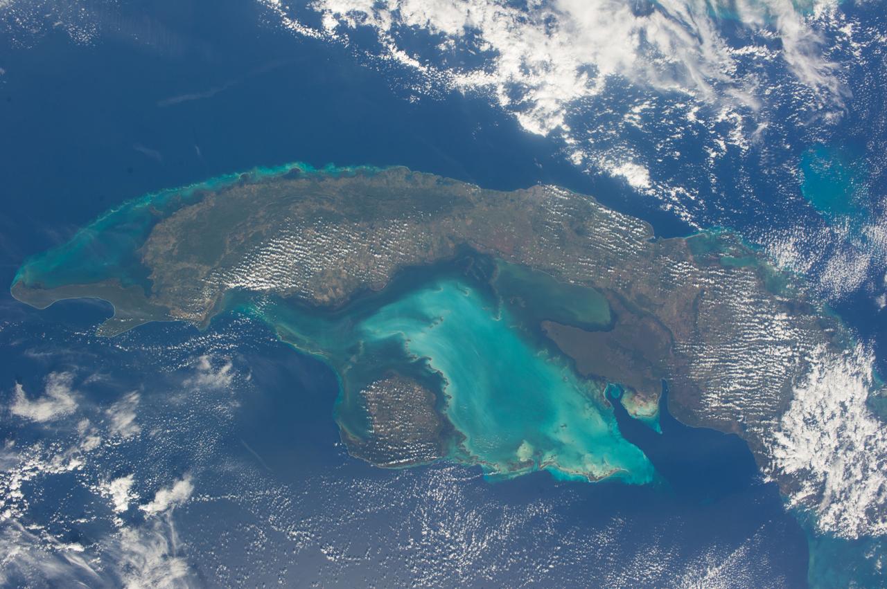
ISS038-E-021397 (24 Dec. 2013) --- The Caribbean country of Cuba is pictured in this nadir image, photographed by one of the Expedition 38 crew members aboard the International Space Station. (Note: North is at the top of the picture.) Cuba is an archipelago of islands in the northern Caribbean Sea at the confluence with the Gulf of Mexico and the Atlantic Ocean. In the southeast, the dark coastal area is home to the Sierra Maestra mountains. It is the highest mountain range on the island, with Pico Turquino reaching nearly 2000 meters. On the central southern coast of the island is the Sierra Del Escambray mountain range, including the 1160 meter-high Pico San Juan, Cuba's second highest peak.
S66-38070 (5 June 1966) --- Northwestern Mexico as seen from the Gemini-9A spacecraft during its 32nd revolution of Earth. The large penisula is Baja California. The body of water at lower right is the Pacific Ocean. The land mass at upper left is the State of Sonora. The Gulf of California separates Sonora from the peninsula. The nose of the spacecraft is at left; and at right is the open hatch of the spacecraft. Astronaut Eugene A. Cernan, pilot, took this picture with his modified 70mm Hasselblad EVA camera, using Eastman Kodak, Ektachrome, MS (S.O. 217) color film. Photo credit: NASA
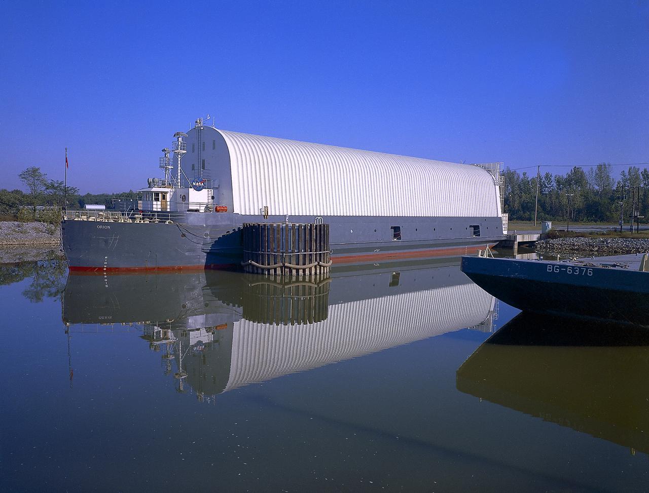
NASA used barges for transporting full-sized stages for the Saturn I, Saturn IB, and Saturn V vehicles between the Marshall Space Flight Center (MSFC), the manufacturing plant at the Michoud Assembly Facility (MAF), the Mississippi Test Facility for testing, and the Kennedy Space Center. The barges traveled from the MSFC dock to the MAF, a total of 1,086.7 miles up the Tennessee River and down the Mississippi River. The barges also transported the assembled stages of the Saturn vehicle from the MAF to the Kennedy Space Center, a total of 932.4 miles along the Gulf of Mexico and up along the Atlantic Ocean, for the final assembly and the launch. This photograph shows the barge Orion at the MSFC dock.
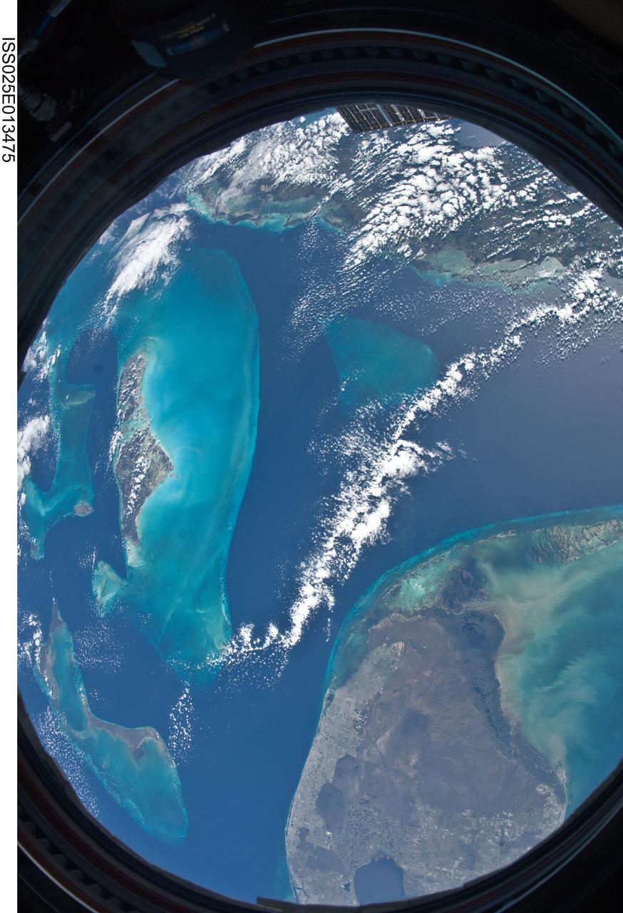
ISS025-E-013475 (9 Nov. 2010) --- Parts of the Atlantic, Gulf of Mexico and Caribbean Sea are easily noted in this unusual circular shaped image exposed by one of the Expedition 25 crew members aboard the International Space Station 220 miles above Earth. A 16mm f/2.8D lens gives this image a fish-eye effect, and the frame of the Cupola window adds to the circular shape. The southern portion of the Florida peninsula, including the elongated metropolitan Miami area, Lake Okeechobee and the Florida Keys, lies just a few kilometers away from islands in the Bahamas chain and the "Tongue of the Ocean." Andros is the largest visible island to the left of center.
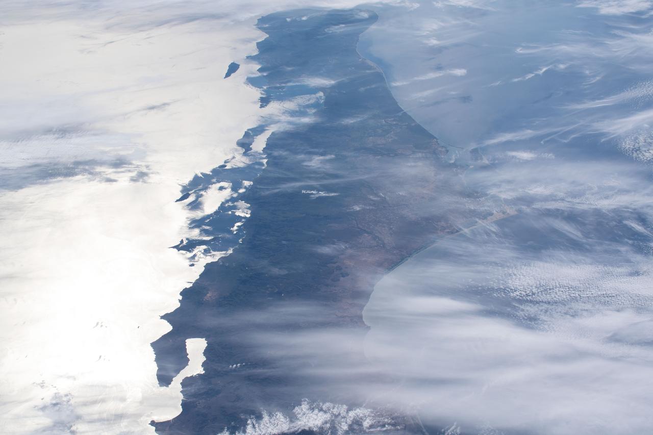
This unique photo offers a view of the Florida peninsula, western Bahamas, north central Cuba and the deep blue waters of the Gulf Stream, that hugs the east coast of Florida (27.0N, 82.0W). In addition to being an excellent photograph for showing the geographical relationships between the variety of landforms in this scene, the typical effect of the land-sea breeze is very much in evidence as few clouds over water, cumulus build up over landmass.
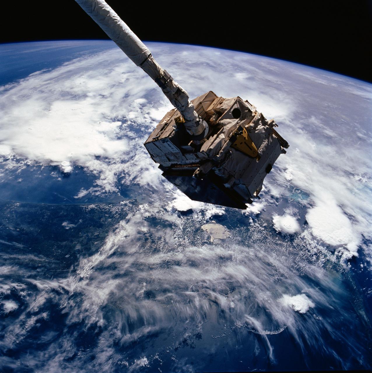
41C-36-1618 (7 April 1984) --- The Remote Manipulator System (RMS) arm suspends the giant Long Duration Exposure Facility (LDEF) high above the Gulf of Mexico prior to releasing it into space. Carried into Earth orbit with the STS-41C crew by the Space Shuttle Challenger, LDEF will remain in space until retrieved by a future Shuttle mission, in nine or ten months. Florida and the Bahama Banks are visible near the Earth's horizon in the 70mm frame.
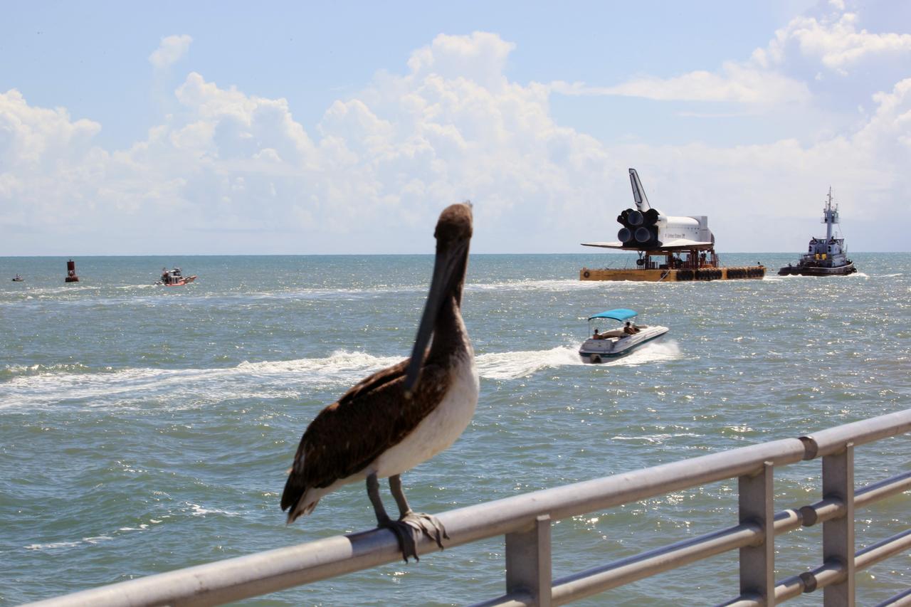
CAPE CANAVERAL, Fla. – The high-fidelity space shuttle model glides past the fishing pier – and this long-beaked fisherman -- near the mouth of Port Canaveral as it heads into the Atlantic Ocean, in the distance. The model is en route by barge from NASA’s Kennedy Space Center in Florida to Space Center Houston, NASA Johnson Space Center’s official visitor center. Its journey to Texas will take it south along the Florida coastline, around Key West and into the Gulf of Mexico. The model was built in Apopka, Fla., by Guard-Lee and installed at the Kennedy Space Center Visitor Complex in 1993. The model is expected to arrive June 1 in Houston and to be transported June 3 to Space Center Houston, its final destination, where it will become part of a unique display telling the story of the space shuttle’s achievements and the nationwide team that made them possible. For more information about Space Center Houston, visit http://www.spacecenter.org. Photo credit: NASA/Dimitri Gerondidakis
ISS023-E-032398 (4 May 2010) --- Japan Aerospace Exploration Agency (JAXA) astronaut Soichi Noguchi, Expedition 23 flight engineer, photographed the Mississippi Delta showing the oil slick in the Gulf of Mexico on May 4, 2010. Part of the river delta and nearby Louisiana coast appear dark in the sunglint. This phenomenon is caused by sunlight reflecting off the water surface, in a mirror-like manner, directly back towards the astronaut observer onboard the International Space Station (ISS). The sunglint improves the identification of the oil spill which is creating a different water texture (and therefore a contrast) between the smooth and rougher water of the reflective ocean surface. Other features which cause a change in surface roughness that can be seen in sunglint are wind gusts, naturally occurring oils that will be gathered by and take the form of water currents or wave patterns, and less windy areas behind islands.
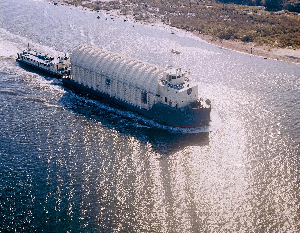
NASA used barges for transporting full-sized stages for the Saturn I, Saturn IB, and Saturn V vehicles between the Marshall Space Flight Center (MSFC), the manufacturing plant at the Michoud Assembly Facility (MAF), the Mississippi Test Facility for testing, and the Kennedy Space Center. The barges traveled from the MSFC dock to the MAF, a total of 1,086.7 miles up the Tennessee River and down the Mississippi River. The barges also transported the assembled stages of the Saturn vehicle from the MAF to the Kennedy Space Center, a total of 932.4 miles along the Gulf of Mexico and up along the Atlantic Ocean, for the final assembly and the launch. Pictured is the barge Palaemon carrying Saturn IV S-IB flight stage enroute to MSFC.
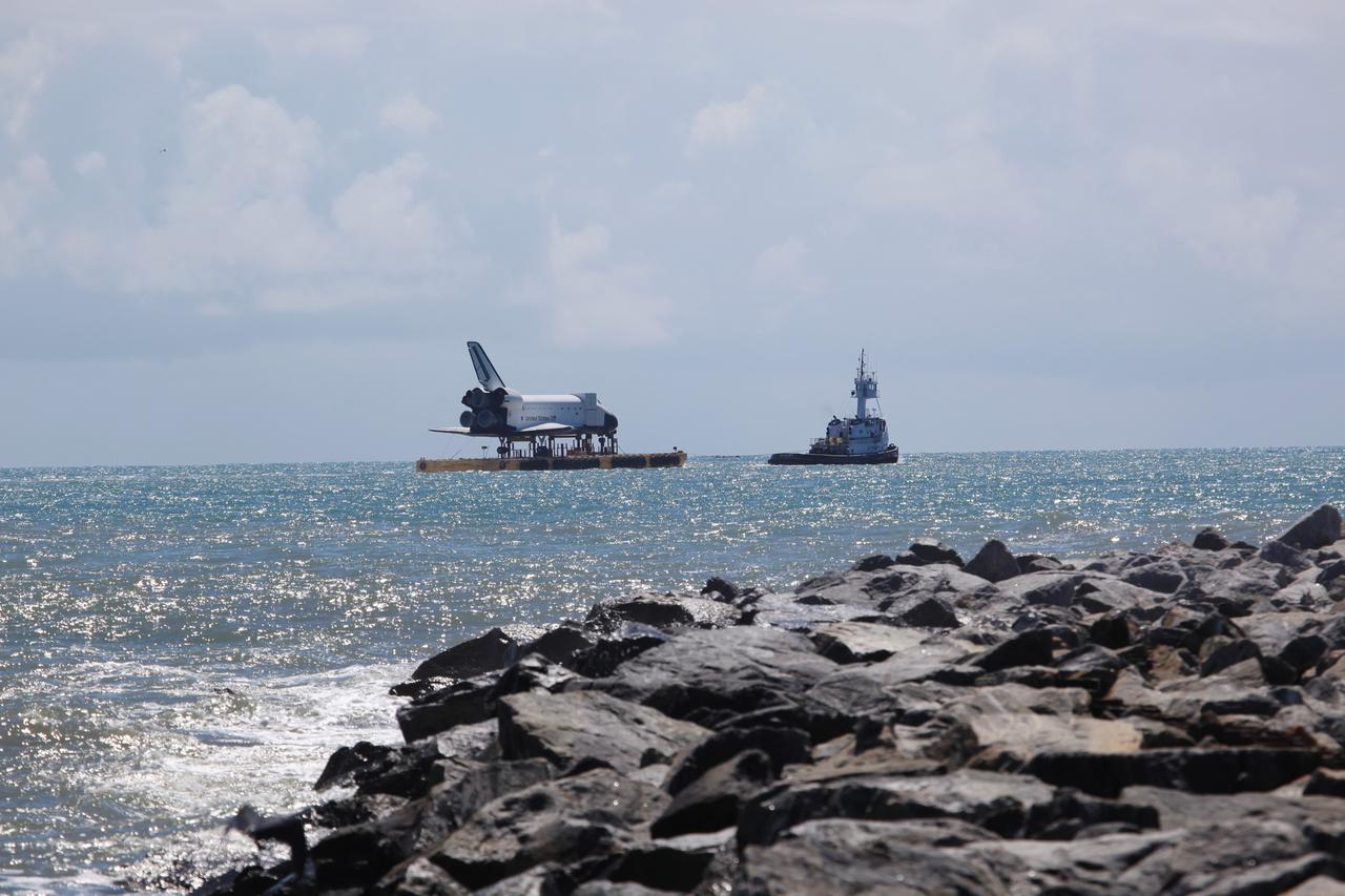
CAPE CANAVERAL, Fla. – The high-fidelity space shuttle model sails through Port Canaveral into the Atlantic Ocean. The model is en route by barge from NASA’s Kennedy Space Center in Florida to Space Center Houston, NASA Johnson Space Center’s official visitor center. Its journey to Texas will take it south along the Florida coastline, around Key West and into the Gulf of Mexico. The model was built in Apopka, Fla., by Guard-Lee and installed at the Kennedy Space Center Visitor Complex in 1993. The model is expected to arrive June 1 in Houston and to be transported June 3 to Space Center Houston, its final destination, where it will become part of a unique display telling the story of the space shuttle’s achievements and the nationwide team that made them possible. For more information about Space Center Houston, visit http://www.spacecenter.org. Photo credit: NASA/Dimitri Gerondidakis
ISS017-E-013701 (19 Aug. 2008) ---- This frame is a westward-looking oblique view of Tropical Storm Fay, as seen about 4:43 p.m. (EDT) on Aug. 19, 2008 from the International Space Station from a vantage point of 220 statute miles above the Atlantic Ocean just northeast of the Bahama Islands (approximately 28.4 degrees north latitude and 75.0 degrees west longitude). Fay had sustained winds of 55 nautical miles per hour with gusts to 65 nautical miles per hour and was estimated to be centered just northwest of Lake Okeechobee, Florida (around 27.3 degrees north latitude and 81.0 degrees west longitude. This panoramic view includes the Gulf of Mexico to the west of the storm.

ISS023-E-032396 (4 May 2010) --- Japan Aerospace Exploration Agency (JAXA) astronaut Soichi Noguchi, Expedition 23 flight engineer, photographed the tail end of the Mississippi Delta showing the oil slick in the Gulf of Mexico on May 4, 2010. Part of the river delta and nearby Louisiana coast appear dark in the sunglint. This phenomenon is caused by sunlight reflecting off the water surface, in a mirror-like manner, directly back towards the astronaut observer onboard the International Space Station (ISS). The sunglint improves the identification of the oil spill which is creating a different water texture (and therefore a contrast) between the smooth and rougher water of the reflective ocean surface. Other features which cause a change in surface roughness that can be seen in sunglint are wind gusts, naturally occurring oils that will be gathered by and take the form of water currents or wave patterns, and less windy areas behind islands.
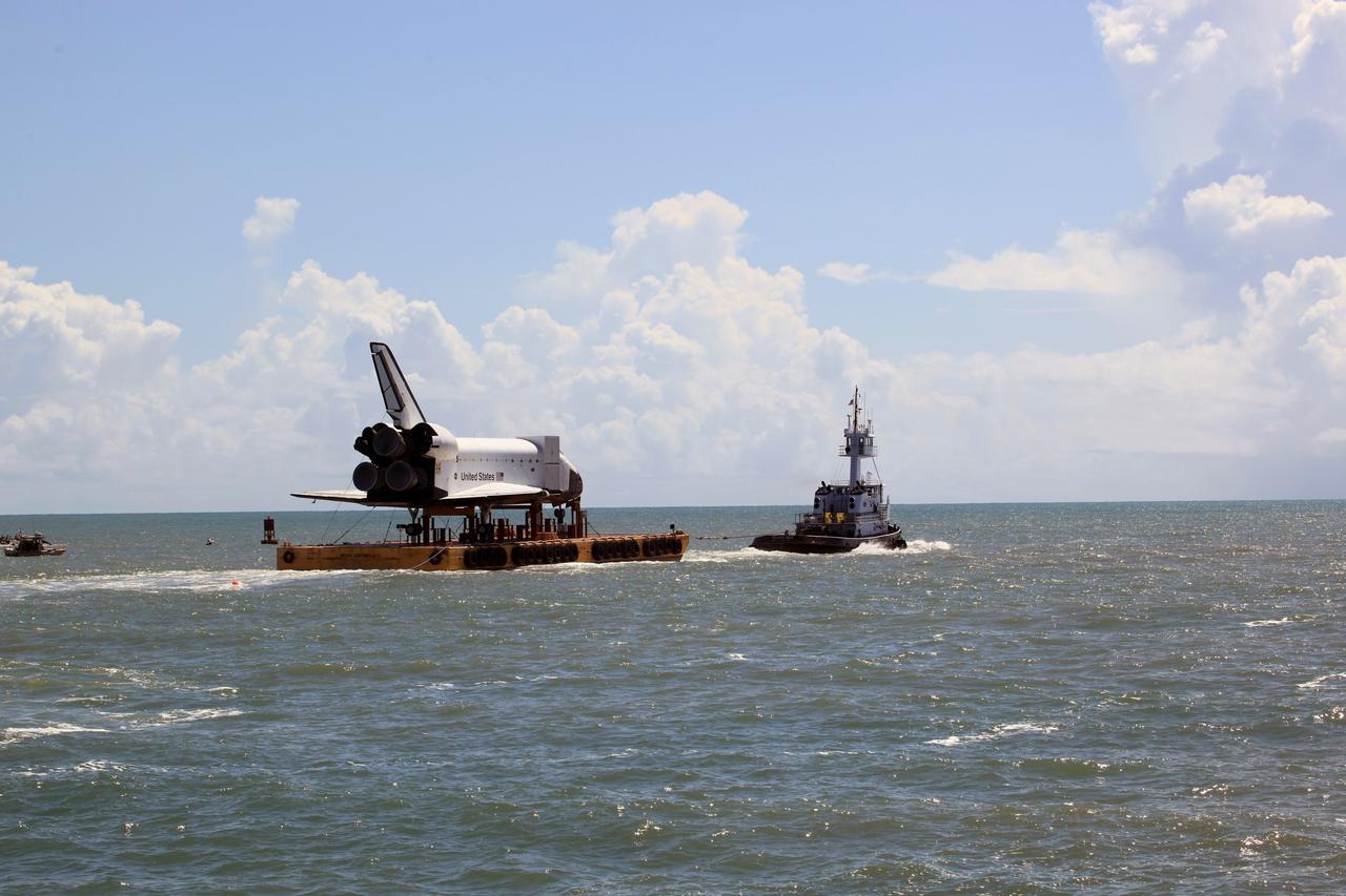
CAPE CANAVERAL, Fla. – The high-fidelity space shuttle model nears the mouth of Port Canaveral as it heads toward the Atlantic Ocean, in the distance. The model is en route by barge from NASA’s Kennedy Space Center in Florida to Space Center Houston, NASA Johnson Space Center’s official visitor center. Its journey to Texas will take it south along the Florida coastline, around Key West and into the Gulf of Mexico. The model was built in Apopka, Fla., by Guard-Lee and installed at the Kennedy Space Center Visitor Complex in 1993. The model is expected to arrive June 1 in Houston and to be transported June 3 to Space Center Houston, its final destination, where it will become part of a unique display telling the story of the space shuttle’s achievements and the nationwide team that made them possible. For more information about Space Center Houston, visit http://www.spacecenter.org. Photo credit: NASA/Dimitri Gerondidakis
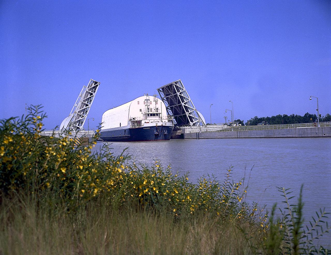
NASA used barges for transporting full-sized stages for the Saturn I, Saturn IB, and Saturn V vehicles between the Marshall Space Flight Center (MSFC), the manufacturing plant at the Michoud Assembly Facility (MAF), the Mississippi Test Facility for testing, and the Kennedy Space Center. The barges traveled from the MSFC dock to the MAF, a total of 1,086.7 miles up the Tennessee River and down the Mississippi River. The barges also transported the assembled stages of the Saturn vehicle from the MAF to the Kennedy Space Center, a total of 932.4 miles along the Gulf of Mexico and up along the Atlantic Ocean, for the final assembly and the launch. This photograph shows the barge Poseidon loaded with the Saturn V S-II (second) stage passing through a bascule bridge.
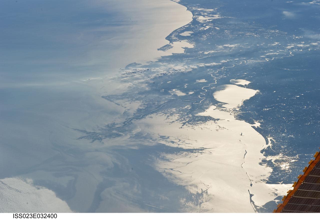
ISS023-E-032400 (4 May 2010) --- Japan Aerospace Exploration Agency (JAXA) astronaut Soichi Noguchi, Expedition 23 flight engineer, photographed the Mississippi Delta showing the oil slick in the Gulf of Mexico on May 4, 2010. Part of the river delta and nearby Louisiana coast appear dark in the sunglint. This phenomenon is caused by sunlight reflecting off the water surface, in a mirror-like manner, directly back towards the astronaut observer onboard the International Space Station (ISS). The sunglint improves the identification of the oil spill which is creating a different water texture (and therefore a contrast) between the smooth and rougher water of the reflective ocean surface. Other features which cause a change in surface roughness that can be seen in sunglint are wind gusts, naturally occurring oils that will be gathered by and take the form of water currents or wave patterns, and less windy areas behind islands.

An oil slick in the Gulf of Mexico following Hurricane Ida – a high-end Category 4 when it made landfall near Port Fourchon, Louisiana, on Aug. 29, 2021 – appears as a green trail in the inset false-color graphic provided by NASA's Delta-X project, while the surrounding seawater appears orange. The National Oceanic and Atmospheric Administration (NOAA) regularly monitors U.S. coastal waters for potential spills and noticed slicks that appeared just off the coast after the hurricane. They were able to use this information from Delta-X to corroborate other data they had about oil slicks in the area (satellite image in the second inset picture). The blue-green swath crossing from the Gulf of Mexico over the Louisiana coast denotes the flight path of the Delta-X radar instrument on Sept. 1, just before 11:30 a.m. CDT. Charged with studying the Mississippi River Delta, Delta-X was gearing up to collect data on Louisiana's coastal wetlands when Hurricane Ida barreled ashore in late August. The storm damaged buildings and infrastructure alike, resulting in power outages, flooding, and oil slicks in the Gulf of Mexico. Oil tends to smooth out the bumps on the ocean's surface, which results in a distinct radar signal that the Delta-X mission was able to pick out of their data. Delta-X added flight paths to their planned schedule – with the support of NASA's Applied Science Disaster Program – in order to collect information over the gulf in areas of interest to NOAA. Delta-X is studying two wetlands – the Atchafalaya and Terrebonne Basins – by land, boat, and air to quantify water and sediment flow as well as vegetation growth. While the Atchafalaya Basin has been gaining land through sediment accumulation, Terrebonne Basin, which is right next to the Atchafalaya, has been rapidly losing land. The data collected by the project will be applied to models used to forecast which areas of the delta are likely to gain or lose land under various sea level rise, river flow, and watershed management scenarios. The mission uses several instruments to collect its data. Affixed to the bottom of a Gulfstream-III airplane, one of those instruments, the all-weather Uninhabited Aerial Vehicle Synthetic Aperture Radar (UAVSAR), bounces radar signals off of Earth's surface, forming a kind of image of a particular area. Repeated images of the same regions, captured at different times, enable researchers to detect changes in those areas, such as fluctuating water levels beneath the vegetation as the tides move in and out of these wetlands. In addition to radar measurements, teams from Caltech, Louisiana State University, Florida International University, and other collaborating institutions gather water and vegetation samples – among other data – by boat, other airborne sensors, and from instruments on the ground. Funded by NASA's Earth Venture Suborbital (EVS-3) program, Delta-X is managed by the agency's Jet Propulsion Laboratory. Caltech in Pasadena, California, manages JPL for NASA. Fall 2021 was Delta-X's last scheduled field campaign, although the five-year mission will run through the end of 2023. https://photojournal.jpl.nasa.gov/catalog/PIA24540
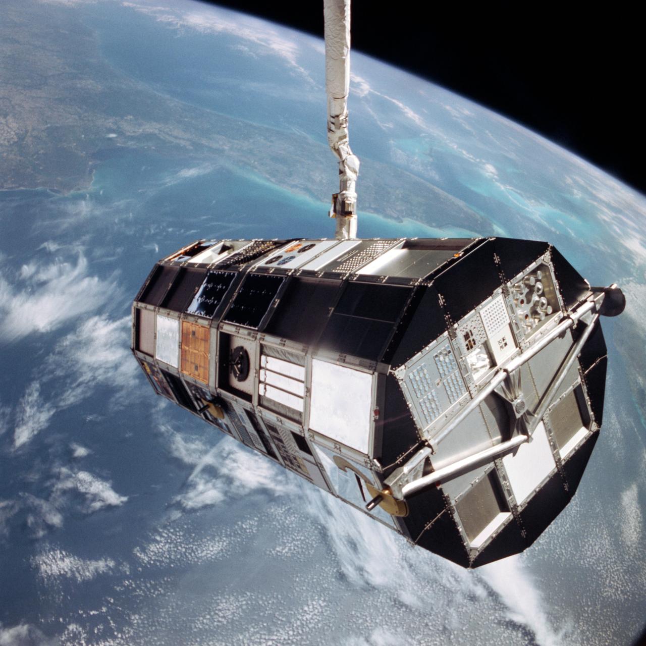
STS057-93-052 (24 June 1993) --- The European Retrievable Carrier (EURECA) is held in the grasp of the Space Shuttle Endeavour's Remote Manipulator System (RMS). The photo was taken after EURECA's "capture" from Earth-orbit but prior to its berthing in the Shuttle's cargo bay. The southern two-thirds of the state of Florida, part of the Gulf of Mexico and clouds over the Atlantic form the backdrop for the 70mm image.
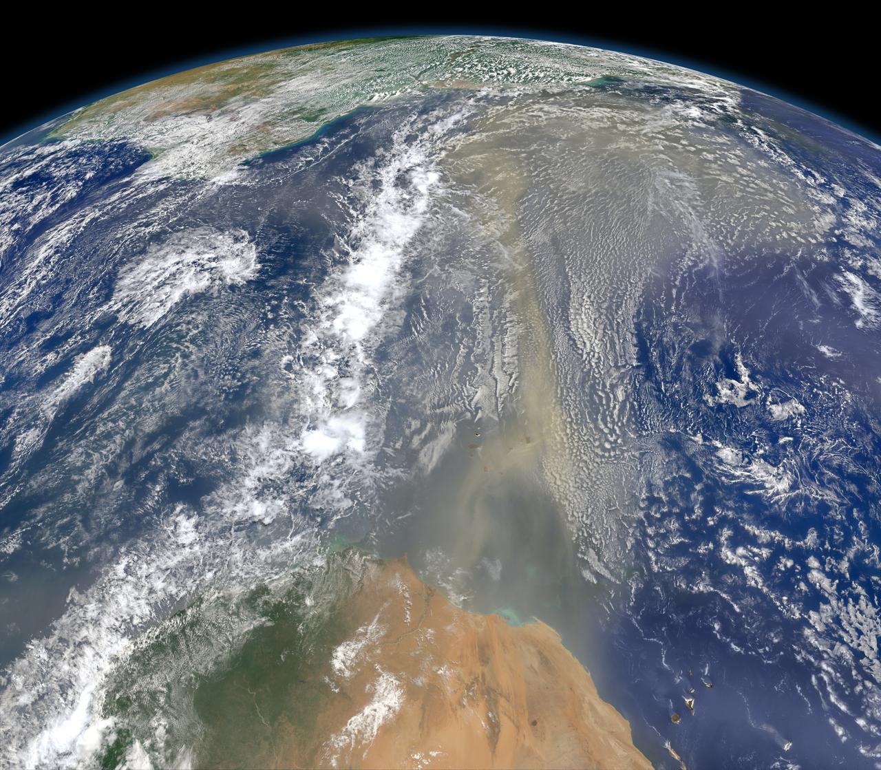
A piece of Africa—actually lots of them—began to arrive in the Americas in June 2014. On June 23, a lengthy river of dust from western Africa began to push across the Atlantic Ocean on easterly winds. A week later, the influx of dust was affecting air quality as far away as the southeastern United States. This composite image, made with data from the Visible Infrared Imaging Radiometer Suite (VIIRS) on Suomi NPP, shows dust heading west toward South America and the Gulf of Mexico on June 25, 2014. The dust flowed roughly parallel to a line of clouds in the intertropical convergence zone, an area near the equator where the trade winds come together and rain and clouds are common. In imagery captured by the Moderate Resolution Imaging Spectroradiometer (MODIS), the dust appeared to be streaming from Mauritania, Senegal, and Western Sahara, though some of it may have originated in countries farther to the east. Saharan dust has a range of impacts on ecosystems downwind. Each year, dust events like the one pictured here deliver about 40 million tons of dust from the Sahara to the Amazon River Basin. The minerals in the dust replenish nutrients in rainforest soils, which are continually depleted by drenching, tropical rains. Research focused on peat soils in the Everglades show that African dust has been arriving regularly in South Florida for thousands of years as well. In some instances, the impacts are harmful. Infusion of Saharan dust, for instance, can have a negative impact on air quality in the Americas. And scientists have linked African dust to outbreaks of certain types of toxic algal blooms in the Gulf of Mexico and southern Florida. Read more: <a href="http://1.usa.gov/1snkzmS" rel="nofollow">1.usa.gov/1snkzmS</a> NASA images by Norman Kuring, NASA’s Ocean Color web. Caption by Adam Voiland. Credit: <b><a href="http://www.earthobservatory.nasa.gov/" rel="nofollow"> NASA Earth Observatory</a></b> <b><a href="http://www.nasa.gov/audience/formedia/features/MP_Photo_Guidelines.html" rel="nofollow">NASA image use policy.</a></b> <b><a href="http://www.nasa.gov/centers/goddard/home/index.html" rel="nofollow">NASA Goddard Space Flight Center</a></b> enables NASA’s mission through four scientific endeavors: Earth Science, Heliophysics, Solar System Exploration, and Astrophysics. Goddard plays a leading role in NASA’s accomplishments by contributing compelling scientific knowledge to advance the Agency’s mission. <b>Follow us on <a href="http://twitter.com/NASAGoddardPix" rel="nofollow">Twitter</a></b> <b>Like us on <a href="http://www.facebook.com/pages/Greenbelt-MD/NASA-Goddard/395013845897?ref=tsd" rel="nofollow">Facebook</a></b> <b>Find us on <a href="http://instagram.com/nasagoddard?vm=grid" rel="nofollow">Instagram</a></b>
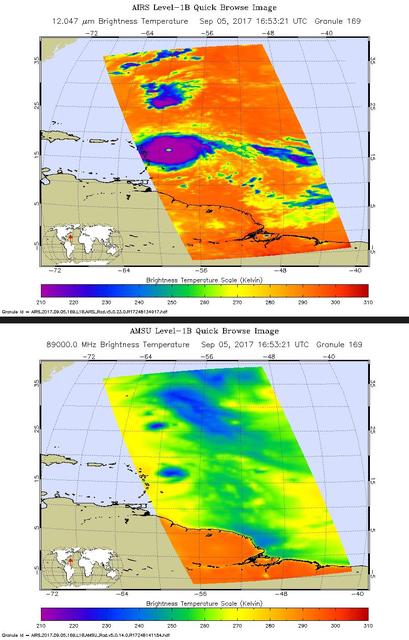
Hurricane Irma is the strongest hurricane ever recorded outside the Caribbean Sea and Gulf of Mexico. These two images from the Atmospheric Infrared Sounder (AIRS) instrument aboard NASA's Aqua satellite show what Hurricane Irma looked like when Aqua passed overhead just before 1 p.m. local time (10 a.m. PDT) on Sept. 5, 2017. Forecasts at the National Hurricane Center have Irma passing near the major islands to its west before turning northward near Florida this weekend. The first image (top) is an infrared snapshot from AIRS (see Figure 1 for larger image). In orange and red areas, the ocean surface shines through, while blue and purple areas represent cold, high clouds that obscure what lies below. Typical of well-developed hurricanes, Irma is nearly circular with a well-defined eye at its center. The eye is about 25 miles (40 kilometers) in diameter. Careful scrutiny shows a red pixel in the center of the eye, which means that AIRS achieved a bulls-eye with one of its "looks" and was able to see to the ocean between the dense clouds in the eye wall. The second image (bottom) shows the view through AIRS' microwave-colored "lenses" (see Figure 2 for larger image). Here the ocean surface looks yellow, while green represents various degrees of cloudiness. Blue shows areas where it is raining heavily. The eye is not apparent in this image because the "pixel size" of the microwave sounder, about 30 miles (50 kilometers), is larger than the eye and therefore cannot "thread the needle." The infrared sounder, on the other hand, has a pixel size of only 10 miles (16.5 kilometers) and can distinguish the small eye. https://photojournal.jpl.nasa.gov/catalog/PIA21941
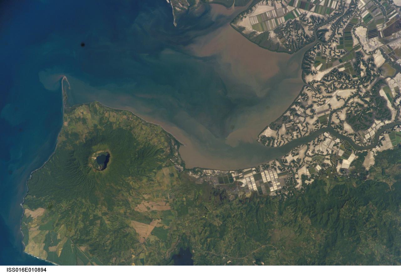
ISS016-E-010894 (17 Nov. 2007) --- Cosiguina Volcano, Nicaragua is featured in this image photographed by an Expedition 16 crewmember on the International Space Station. Three Central American countries (El Salvador, Honduras, and Nicaragua) include coastline along the Gulf of Fonseca that opens into the Pacific Ocean. The southern boundary of the Gulf is a peninsula formed by the Cosiguina volcano illustrated in this view. Cosiguina is a stratovolcano, typically tall cone-shaped structures formed by alternating layers of solidified lava and volcanic rocks (ash, pyroclastic flows, breccias) produced by explosive eruptions. The summit crater is filled with a lake (Laguna Cosiguina). The volcano last erupted in 1859, but its most famous activity occurred in 1835 when it produced the largest historical eruption in Nicaragua. Ash from the 1835 eruption has been found in Mexico, Costa Rica, and Jamaica. The volcano has been quiet since 1859, only an instant in terms of geological time. An earthquake swarm was measured near Cosiguina in 2002, indicating that tectonic forces are still active in the region although the volcano is somewhat isolated from the line of more recently active Central American volcanoes to the northwest and southeast. Intermittently observed gas bubbles in Laguna Cosiguina, and a hot spring along the eastern flank of the volcano are the only indicators of hydrothermal activity at the volcano. The fairly uniform vegetation cover (green) on the volcano's sides also attest to a general lack of gas emissions or "hot spots" on the 872 meter high cone, according to NASA scientists who study the photos downlinked from the orbital outpost.
NASA-NOAA's Suomi NPP satellite flew over Hurricane Blanca in the Eastern Pacific Ocean and gathered infrared data on the storm that was false-colored to show locations of the strongest thunderstorms within the storm. The Visible Infrared Imaging Radiometer Suite or VIIRS instrument aboard the satellite gathered infrared data of the storm that was made into an image at the University of Wisconsin-Madison. The image was false-colored to show temperature. Coldest cloud top temperatures indicate higher, stronger, thunderstorms within a tropical cyclone. Those are typically the strongest storms with potential for heavy rainfall. VIIRS is a scanning radiometer that collects visible and infrared imagery and "radiometric" measurements. Basically it means that VIIRS data is used to measure cloud and aerosol properties, ocean color, sea and land surface temperature, ice motion and temperature, fires, and Earth's albedo (reflected light). The VIIRS image from June 5 at 8:11 UTC (4:11 a.m. EDT) showed two areas of coldest cloud top temperatures and strongest storms were west-southwest and east-northeast of the center of Blanca's circulation center. On June 5 at 5 a.m. EDT (0900 UTC) Blanca's maximum sustained winds were near 105 mph (165 kph) with higher gusts. The National Hurricane Center (NHC) forecast expects some strengthening during the next day or so. Weakening is forecast to begin by late Saturday. At that time, NHC placed the center of Hurricane Blanca near latitude 14.3 North, longitude 106.2 West. That puts the center about 350 miles (560 km) south-southwest of Manzanillo, Mexico and about 640 miles (1,030 km) south-southeast of Cabo San Lucas, Mexico. The estimated minimum central pressure is 968 millibars (28.59 inches). Blanca is moving toward the northwest near 10 mph (17 kph). A northwestward to north-northwestward motion at a similar forward speed is expected to continue through Saturday night. Blanca has been stirring up surf along the coast of southwestern Mexico and will reach the Pacific coast of the Baja California peninsula and the southern Gulf of California later today, June 5. These swells are likely to cause life-threatening surf and rip current conditions. On the forecast track, the center of Blanca will approach the southern Baja California peninsula on Sunday. NHC cautions that "Interests in the southern Baja California peninsula should monitor the progress of Blanca. A tropical storm or hurricane watch will likely be required for a portion of Baja California Sur later today." The NHC forecast track shows Blanca making landfall in the southeastern tip of Baja California on Sunday, June 7 and tracking north-northeast along the Baja California peninsula, for several days following. Image credit: Credits: NASA/NOAA/UW-CIMSS <b><a href="http://www.nasa.gov/audience/formedia/features/MP_Photo_Guidelines.html" rel="nofollow">NASA image use policy.</a></b> <b><a href="http://www.nasa.gov/centers/goddard/home/index.html" rel="nofollow">NASA Goddard Space Flight Center</a></b> enables NASA’s mission through four scientific endeavors: Earth Science, Heliophysics, Solar System Exploration, and Astrophysics. Goddard plays a leading role in NASA’s accomplishments by contributing compelling scientific knowledge to advance the Agency’s mission. <b>Follow us on <a href="http://twitter.com/NASAGoddardPix" rel="nofollow">Twitter</a></b> <b>Like us on <a href="http://www.facebook.com/pages/Greenbelt-MD/NASA-Goddard/395013845897?ref=tsd" rel="nofollow">Facebook</a></b> <b>Find us on <a href="http://instagrid.me/nasagoddard/?vm=grid" rel="nofollow">Instagram</a></b>
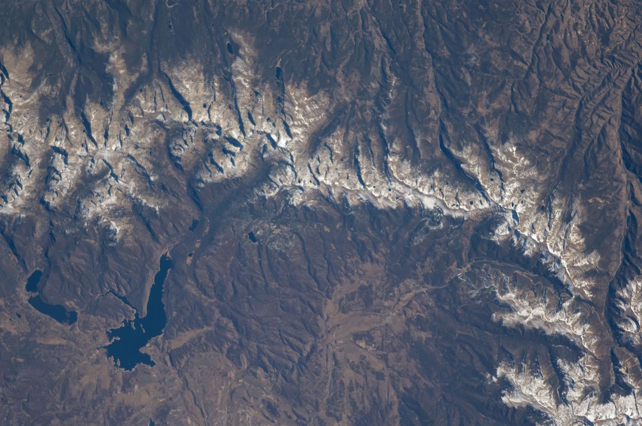
ISS018-E-005660 (28 Oct. 2008) --- The Great Divide of the Rocky Mountains in Colorado is featured in this image photographed by an Expedition 18 crewmember on the International Space Station. This view highlights a portion of the Great Divide in the Rocky Mountains approximately 31 kilometers due west of Boulder, Colorado. The Great Divide is one of four continental divides recognized by geographers and hydrologists in North America -- the others being the Northern, Eastern, and Saint Lawrence Seaway Divides -- but it is still generally (and erroneously) known as "the" Continental Divide. The Great Divide is a hydrologic boundary defined by the ultimate destination of precipitation -- rainfall on the western side of the Divide flows to the Pacific Ocean, while rainfall on the eastern side of the Divide flows to the Gulf of Mexico. It is easy to visualize such a boundary traced along the high ridges of the Rocky Mountains, but in regions of less topography more detailed study of the local geomorphology and hydrology are required to map the location of the Divide. This portion of the Rocky Mountains also hosts the Niwot Ridge Long Term Ecological Research (LTER) site. Part of the National Science Foundation LTER program, the Niwot Ridge LTER site studies climate interactions with tundra and alpine ecosystems. Niwot Ridge is visible in this image as a large eastward spur off the central spine of the mountains. The entire Niwot LTER site is located at elevations higher than 3000 m, and includes an active cirque glacier and glacial landforms, tarns (glacial lakes), and permafrost. Lake Granby, located to the west of the Great Divide, is a reservoir on the Colorado River and the second-largest manmade body of water in the state of Colorado. Storage of water began in 1949. Today, the Lake is popular location for fishing, boating and camping.
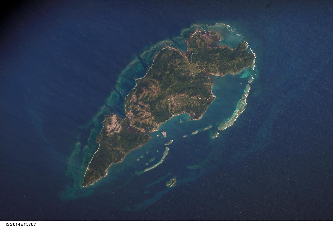
ISS014-E-15767 (1 March 2007) --- Guanaja Island, Honduras is featured in this image photographed by an Expedition 14 crewmember on the International Space Station. Guanaja Island is located along the southwestern margin of the Gulf of Mexico, approximately 60 kilometers north of mainland Honduras. The island is situated near the western edge of the Cayman Ridge, a topographic feature comprised of rock types indicative of ancient volcanic islands, sedimentary layers, and ocean crust. The Ridge formed as a result of tectonic interactions between the North American, South American, and Caribbean Plates. Guanaja and the nearby islands of Roatan and Utila (not shown) comprise the only portions of the western Cayman Ridge currently exposed above water. The island is also notable for its largely undeveloped character -- the exception being highly concentrated development on Bonacca Cay, a small island (roughly 0.5 kilometers by 0.3 kilometers) located along the southeastern coastline of the main island. The main island has little in the way of roads or other infrastructure -- a canal is the major means of traversing the island - making it an attractive destination for hikers and eco-tourists. The clear waters and reefs that almost completely encircle Guanaja also attract divers. In 1998, hurricane Mitch destroyed almost all (97 percent) of the island's mangrove forests, impacting coastal habitats and resulting in soil erosion. Regeneration of mangroves is slow and active reseeding efforts have been suggested as the only means to restore the forests.

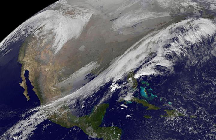
NOAA's GOES-East satellite provided a look at the frigid eastern two-thirds of the U.S. on Jan. 7, 2015, that shows a blanket of northern snow, lake-effect snow from the Great Lakes and clouds behind the Arctic cold front. A visible picture captured at 1600 UTC (11 a.m. EST) showed the effects of the latest Arctic outbreak. The cold front that brought the Arctic air has moved as far south as Florida, and stretches back over the Gulf of Mexico and just west of Texas today. The image shows clouds behind the frontal boundary stretching from the Carolinas west over the Heartland. Farther north, a wide band of fallen snow covers the ground from New England west to Montana, with rivers appearing like veins. The GOES-East satellite image also shows wind-whipped lake-effect snows off the Great Lakes, blowing to the southeast. Meanwhile, Florida, the nation's warm spot appeared almost cloud-free. To create the image, NASA/NOAA's GOES Project used cloud data from NOAA's GOES-East satellite and overlaid it on a true-color image of land and ocean created by data from the Moderate Resolution Imaging Spectroradiometer, or MODIS, instrument that flies aboard NASA's Aqua and Terra satellites. Together, those data created the entire picture of the Arctic outbreak. The forecast from NOAA's National Weather Service Weather Prediction Center (WPC) calls for more snow along the Appalachian Mountains from Tennessee north to upstate New York. Snow is also expected to fall from New England west to Montana, and in eastern New Mexico and the Colorado Rockies. The WPC summary for Jan. 7 noted: Bitter cold will be felt from the western High Plains to the Mid-Atlantic and Northeast U.S. for the next few days. Widespread subzero overnight lows are forecast for the Dakotas, Upper Midwest, Great Lakes, and interior New England. Wind Chill Advisories and Warnings are in effect for many of these areas. GOES-East provides visible and infrared images over the eastern U.S. and the Atlantic Ocean from its fixed orbit in space. NOAA's GOES satellites provide the kind of continuous monitoring necessary for intensive data analysis. Geostationary describes an orbit in which a satellite is always in the same position with respect to the rotating Earth. This allows GOES to hover continuously over one position on Earth's surface, appearing stationary. As a result, GOES provide a constant vigil for the atmospheric triggers for severe weather conditions such as tornadoes, flash floods, hail storms and hurricanes. For updated information about the storm system, visit NOAA's NWS website: <a href="http://www.weather.gov" rel="nofollow">www.weather.gov</a> For more information about GOES satellites, visit: <a href="http://www.goes.noaa.gov/" rel="nofollow">www.goes.noaa.gov/</a> or goes.gsfc.nasa.gov/ Rob Gutro NASA's Goddard Space Flight Center, Greenbelt, Md. <b><a href="http://www.nasa.gov/audience/formedia/features/MP_Photo_Guidelines.html" rel="nofollow">NASA image use policy.</a></b> <b><a href="http://www.nasa.gov/centers/goddard/home/index.html" rel="nofollow">NASA Goddard Space Flight Center</a></b> enables NASA’s mission through four scientific endeavors: Earth Science, Heliophysics, Solar System Exploration, and Astrophysics. Goddard plays a leading role in NASA’s accomplishments by contributing compelling scientific knowledge to advance the Agency’s mission. <b>Follow us on <a href="http://twitter.com/NASAGoddardPix" rel="nofollow">Twitter</a></b> <b>Like us on <a href="http://www.facebook.com/pages/Greenbelt-MD/NASA-Goddard/395013845897?ref=tsd" rel="nofollow">Facebook</a></b> <b>Find us on <a href="http://instagram.com/nasagoddard?vm=grid" rel="nofollow">Instagram</a></b>
This NOAA's GOES satellite infrared image taken on Nov. 25 at 11:45 UTC (6:45 a.m. EST) shows two main weather systems over the U.S. Credit: NASA/NOAA GOES Project As the U.S. Thanksgiving holiday approaches this Thursday, November 27, NOAA's GOES-East and GOES-West satellites are keeping a weather eye out for storms that may affect early travelers. In an image from Nov. 25, the satellites show an active weather pattern is in place for travelers across the central and eastern U.S. NOAA's GOES-East satellite provides visible and infrared images over the eastern U.S. and the Atlantic Ocean, while NOAA's GOES-West satellite covers the western U.S. and Pacific Ocean from its fixed orbit in space. Data from both satellites were combined at NASA's GOES Project to create a full view of the U.S. on Nov. 25 at 11:45 UTC (6:45 a.m. EST). The image shows clouds associated with cold front stretching from the Gulf of Mexico over northern Florida and along the U.S. East coast to eastern Canada. Clouds associated with another area of low pressure are in the northern Rockies and northwestern U.S. To create the image, NASA/NOAA's GOES Project takes the cloud data from NOAA's GOES-East satellite and overlays it on a true-color image of land and ocean created by data from the Moderate Resolution Imaging Spectroradiometer, or MODIS, instrument that flies aboard NASA's Aqua and Terra satellites. Together, those data created the entire picture of the storm and show its movement. After the storm system passes, the snow on the ground becomes visible. NOAA's National Weather Service Weather Prediction Center said "a storm system will develop off the coast of the Carolinas early Wednesday (Nov. 25) and strengthen as it moves rapidly up the East Coast Wednesday into early Thursday (Nov. 26). Heavy snow is likely to begin in the central Appalachians early Wednesday morning, spreading northeast through the interior Mid-Atlantic into New England by Wednesday night. Winter Storm Watches are in effect for these areas." For travelers in the western U.S., the Northern Rocky Mountains are expected to receive more snow from the north side of a stationary frontal boundary. South of the boundary rain showers will affect the lower valley. The National Weather Service calls for cold weather to continue in the northern Plains and Upper Midwest as a Canadian surface high pressure rules the weather. The U.S. Southwest will experience nice weather for mid-week. In the Pacific Northwest, the National Weather Service noted that a warm front will bring rain, heavy at times, to the Cascades today and tonight. There will be a break in the heavier rains on Wednesday, then another period of heavy rain for the Cascades Wednesday night through Friday morning as a cold front slowly drags through the area. NOAA's GOES satellites provide the kind of continuous monitoring necessary for intensive data analysis. Geostationary describes an orbit in which a satellite is always in the same position with respect to the rotating Earth. This allows GOES to hover continuously over one position on Earth's surface, appearing stationary. As a result, GOES provide a constant vigil for the atmospheric triggers for severe weather conditions such as tornadoes, flash floods, hail storms and hurricanes.

A major winter storm is poised to wallop the Mid-Atlantic and bring large amounts of snow to cities including Baltimore, Md., Washington, D.C. area on March 2 and 3, according to NOAA's National Weather Service. NOAA's GOES-East satellite captured this image of the clouds associated with the winter storm as it continued moving east toward those cities. On March 2, the National Weather Prediction Center in College Park, Md. noted that there is a slight risk for severe thunderstorms over parts of the western Gulf Coast and the Lower Mississippi Valley as a result of the southern portion of the system. The update at 7 a.m. EST noted that freezing rain/sleet is possible over parts of the lower Mississippi Valley and parts of the central Appalachians, while eastern Texas and the lower Mississippi Valley into the Ohio Valley are expected to experience heavy rain. The NWS Short Range Forecast Discussion stated "A strong storm over the Southern Plains/Lower Mississippi Valley will advance northeastward along a quasi-stationary front to off the Southern Mid-Atlantic Coast by Monday evening. Moisture from the Gulf of Mexico will overrun and pool along the associated front producing an area of snow extending from the Central Plains into the Northeast." The clouds are associated with a cold from that stretches from eastern Maine through Maryland and west into the Tennessee Valley. The low pressure center associated with the front was located over Arkansas. At NASA/NOAA's GOES Project at NASA's Goddard Space Flight Center in Greenbelt, Md. the cloud data from NOAA's GOES-East satellite were overlaid on a true-color image of land and ocean created by data from the Moderate Resolution Imaging Spectroradiometer or MODIS instrument that flies aboard NASA's Aqua and Terra satellites. Together, those data created the entire picture of the position of this major winter storm. GOES satellites provide the kind of continuous monitoring necessary for intensive data analysis. Geostationary describes an orbit in which a satellite is always in the same position with respect to the rotating Earth. This allows GOES to hover continuously over one position on Earth's surface, appearing stationary. As a result, GOES provide a constant vigil for the atmospheric "triggers" for severe weather conditions such as tornadoes, flash floods, hail storms and hurricanes. For updated information about the storm system, visit NOAA's NWS website: <a href="http://www.weather.gov" rel="nofollow">www.weather.gov</a> For more information about GOES satellites, visit: <a href="http://www.goes.noaa.gov/" rel="nofollow">www.goes.noaa.gov/</a> or <a href="http://goes.gsfc.nasa.gov/" rel="nofollow">goes.gsfc.nasa.gov/</a> Rob Gutro NASA Goddard Space Flight Center, Greenbelt, Md. <b><a href="http://www.nasa.gov/audience/formedia/features/MP_Photo_Guidelines.html" rel="nofollow">NASA image use policy.</a></b> <b><a href="http://www.nasa.gov/centers/goddard/home/index.html" rel="nofollow">NASA Goddard Space Flight Center</a></b> enables NASA’s mission through four scientific endeavors: Earth Science, Heliophysics, Solar System Exploration, and Astrophysics. Goddard plays a leading role in NASA’s accomplishments by contributing compelling scientific knowledge to advance the Agency’s mission. <b>Follow us on <a href="http://twitter.com/NASAGoddardPix" rel="nofollow">Twitter</a></b> <b>Like us on <a href="http://www.facebook.com/pages/Greenbelt-MD/NASA-Goddard/395013845897?ref=tsd" rel="nofollow">Facebook</a></b> <b>Find us on <a href="http://instagram.com/nasagoddard?vm=grid" rel="nofollow">Instagram</a></b>
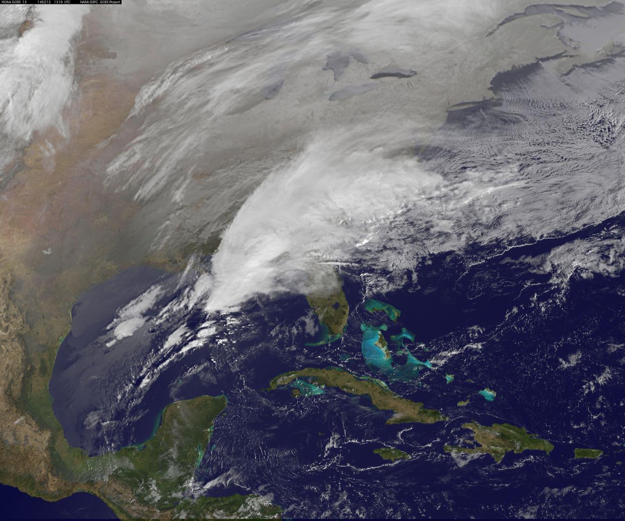
Clouds associated with the major winter storm that is bringing wintry precipitation and chilly temperatures to the U.S. south is the focus in an image from NOAA's GOES-East satellite today, February 12 at 1310 UTC/ 8:10 EST. Rain, freezing rain, sleet and snow are part of the large front that stretches from eastern Texas to the Carolinas in the Geostationary Operational Environmental satellite or GOES image. NOAA's weather maps show several areas of low pressure along the frontal boundary. One low pressure is in the northern Gulf of Mexico, while the other is in the Atlantic Ocean, just south of South Carolina. (Insert link: <a href="http://www.hpc.ncep.noaa.gov/noaa/noaad1.gif" rel="nofollow">www.hpc.ncep.noaa.gov/noaa/noaad1.gif</a>). NOAA's National Weather Service has been issuing watches and warnings throughout the south that extend along Mid-Atlantic east coast. The visible cloud and ground snow data in this image was taken from NOAA's GOES-East satellite. The image was created by the NASA GOES Project at NASA's Goddard Space Flight Center in Greenbelt, Md. The clouds and fallen snow were overlaid on a true-color image of land and ocean created by data from the Moderate Resolution Imaging Spectroradiometer or MODIS instrument that flies aboard NASA's Aqua and Terra satellites. NOAA's Weather Prediction Center, or WPC noted on Feb. 11 at 3:59 a.m. EST, "Once the intensifying surface low moves off the Southeast coast and begins its track up the Eastern Seaboard Wednesday night...winter weather will start lifting northward into the northern Mid-Atlantic states." GOES satellites provide the kind of continuous monitoring necessary for intensive data analysis. Geostationary describes an orbit in which a satellite is always in the same position with respect to the rotating Earth. This allows GOES to hover continuously over one position on Earth's surface, appearing stationary. As a result, GOES provide a constant vigil for the atmospheric "triggers" for severe weather conditions such as tornadoes, flash floods, hail storms and hurricanes. For updated information about the storm system, visit NOAA's WPC website; <a href="http://www.hpc.ncep.noaa.gov/" rel="nofollow">www.hpc.ncep.noaa.gov/</a> For more information about GOES satellites, visit: <a href="http://www.goes.noaa.gov/" rel="nofollow">www.goes.noaa.gov/</a> or <a href="http://goes.gsfc.nasa.gov/" rel="nofollow">goes.gsfc.nasa.gov/</a> Rob Gutro NASA's Goddard Space Flight Center <b><a href="http://www.nasa.gov/audience/formedia/features/MP_Photo_Guidelines.html" rel="nofollow">NASA image use policy.</a></b> <b><a href="http://www.nasa.gov/centers/goddard/home/index.html" rel="nofollow">NASA Goddard Space Flight Center</a></b> enables NASA’s mission through four scientific endeavors: Earth Science, Heliophysics, Solar System Exploration, and Astrophysics. Goddard plays a leading role in NASA’s accomplishments by contributing compelling scientific knowledge to advance the Agency’s mission. <b>Follow us on <a href="http://twitter.com/NASAGoddardPix" rel="nofollow">Twitter</a></b> <b>Like us on <a href="http://www.facebook.com/pages/Greenbelt-MD/NASA-Goddard/395013845897?ref=tsd" rel="nofollow">Facebook</a></b> <b>Find us on <a href="http://instagram.com/nasagoddard?vm=grid" rel="nofollow">Instagram</a></b>
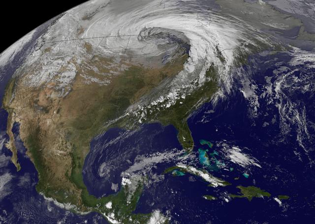
NASA image acquired October 26, 2010 The storm that swept across the center of the United States on October 26 and October 27, 2010, was memorable to those who experienced it because of its strong winds, rain, hail, and widespread tornadoes. Meteorologists get excited about the storm because it set a record for the lowest pressure (not associated with a hurricane) measured over land in the continental United States. At 5:13 p.m. CDT, the weather station in Bigfork, Minnesota recorded 955.2 millibars (28.21 inches of pressure). Pressure is one indicator of a storm’s strength, and this measurement corresponds to the pressure seen in a Category 3 hurricane. This image, taken by the GOES satellite on October 26, shows the storm system circling around the area of extreme low pressure. Such extratropical cyclones form over the United States in the spring and fall, when the temperature difference from north to south is large. Warm, high-pressure air rushes toward the cooler, low-pressure air in the north. Because the Earth is rotating, the air moving in ends up circling the area of low pressure, creating the cyclone shown in the image. The intensity of the storm is determined by the pressure difference between the center and the outer edges. Extreme low pressure in the center of the storm, therefore, is an indicator that the storm was very intense. The animation shows the storm developing starting late on October 25 and running through October 27. The cyclone formed very quickly on October 26, taking a distinctive comma shape as the day went on. The storm developed so quickly, in fact, that it is classified as a bomb, an extremely fast developing storm (dropping at least one millibar of pressure per hour for 24 hours), more common over water than land. The storm was also huge. Though the area of low pressure is centered over the Upper Midwest, the storm reached from the Gulf of Mexico into Canada, and from the Rocky Mountains to the Atlantic Ocean. Extratropical cyclones bring an array of unsettled weather, including strong wind, rain, hail, and tornadoes, and this cyclone brought all of that. On October 26–27, winds gusted up to 78 miles per hour in Michigan, with high winds throughout the Midwest. The National Weather Service reported 61 tornadoes over the two days. Heavy snow also fell in the north. NASA Earth Observatory imagery created by Jesse Allen, using imagery provided courtesy of the NASA GOES Project Science Office. Caption by Holli RIebeek. Instrument: GOES Credit: <b><a href="http://www.earthobservatory.nasa.gov/" rel="nofollow"> NASA Earth Observatory</a></b> <b><a href="http://www.nasa.gov/centers/goddard/home/index.html" rel="nofollow">NASA Goddard Space Flight Center</a></b> enables NASA’s mission through four scientific endeavors: Earth Science, Heliophysics, Solar System Exploration, and Astrophysics. Goddard plays a leading role in NASA’s accomplishments by contributing compelling scientific knowledge to advance the Agency’s mission. <b>Follow us on <a href="http://twitter.com/NASA_GoddardPix" rel="nofollow">Twitter</a></b> <b>Join us on <a href="http://www.facebook.com/pages/Greenbelt-MD/NASA-Goddard/395013845897?ref=tsd" rel="nofollow">Facebook</a></b>