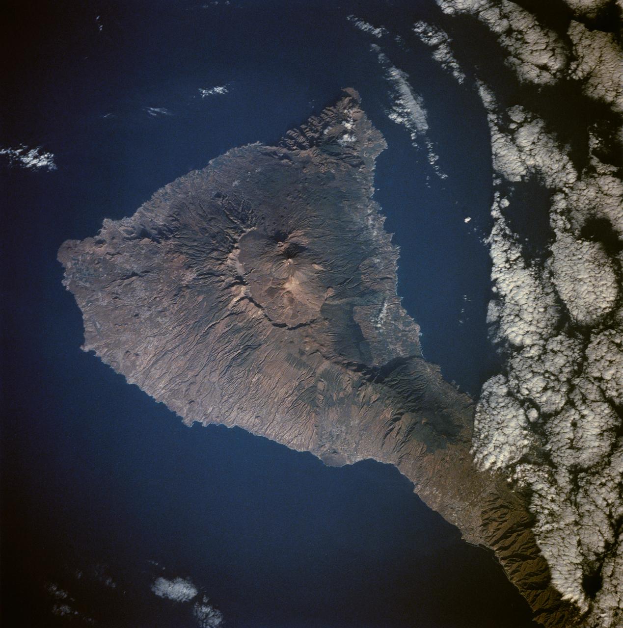
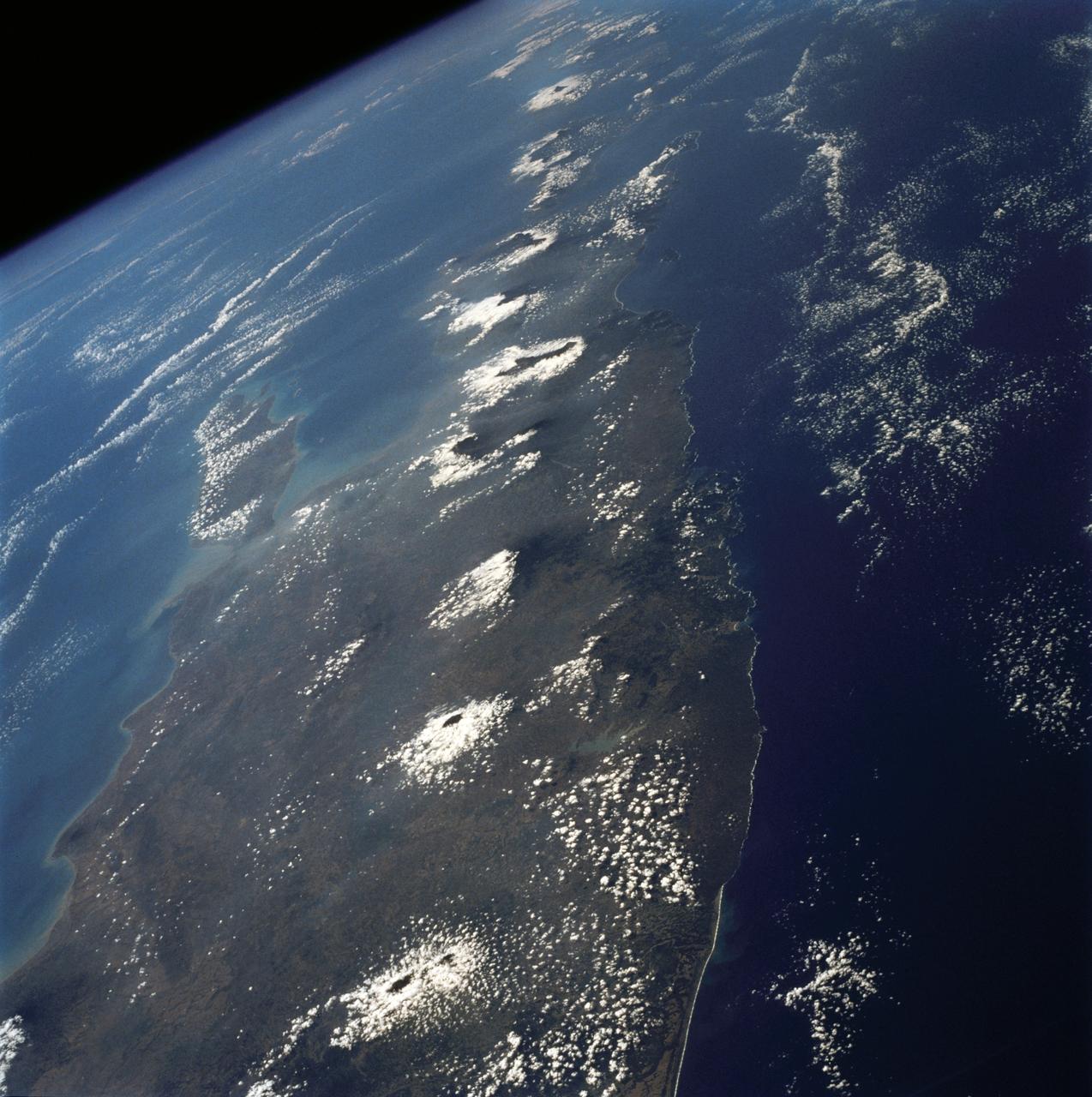
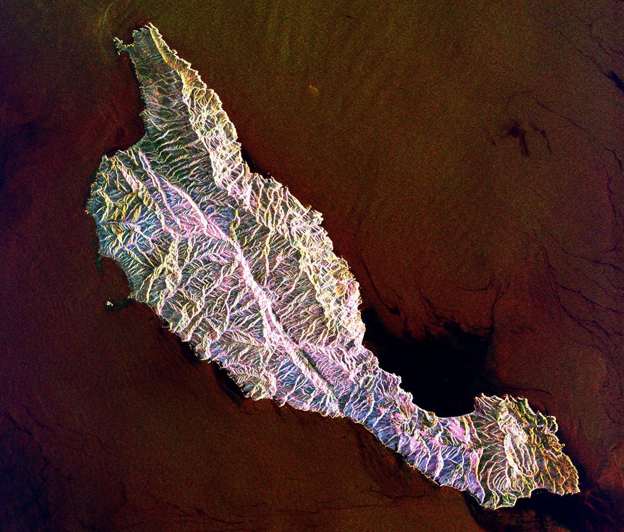
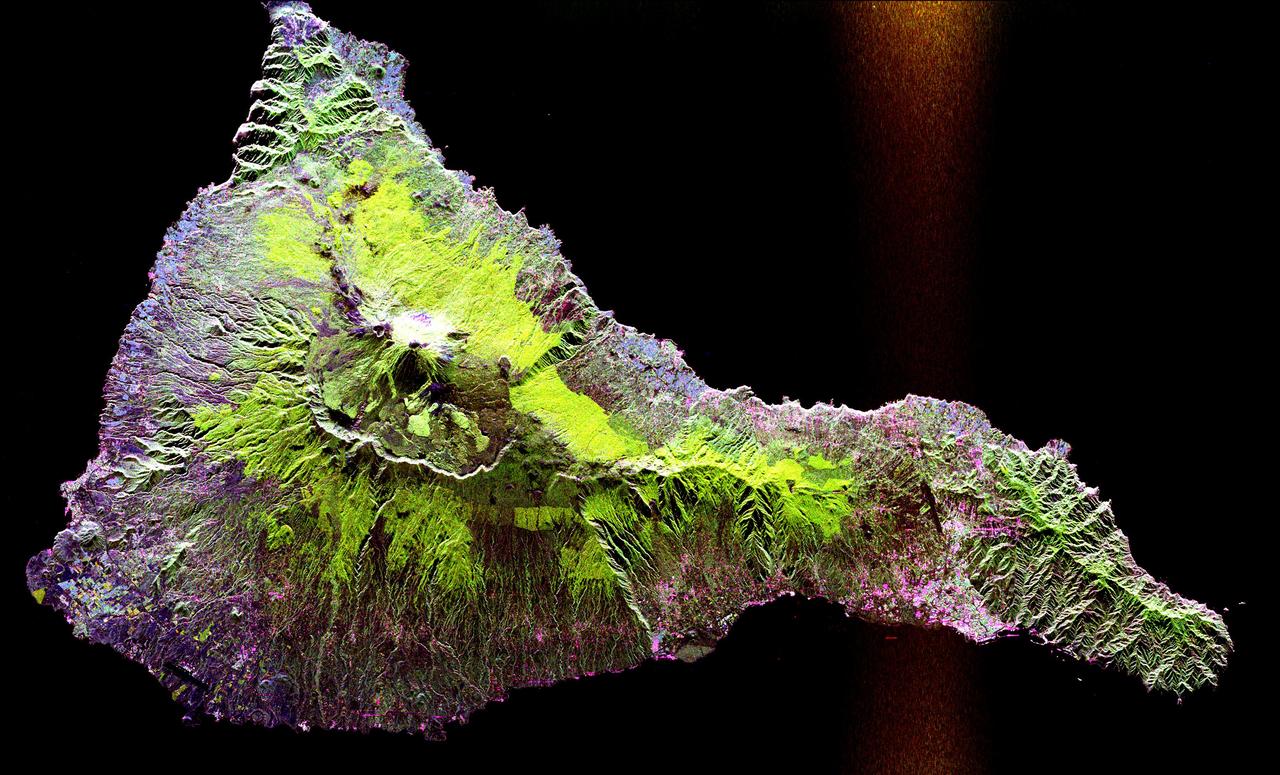
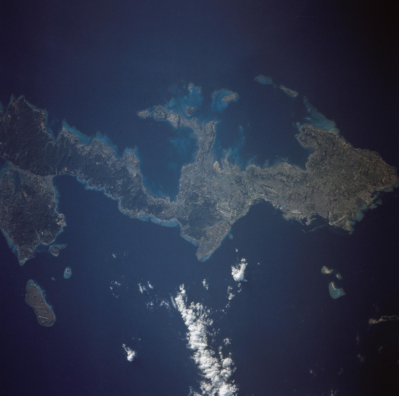
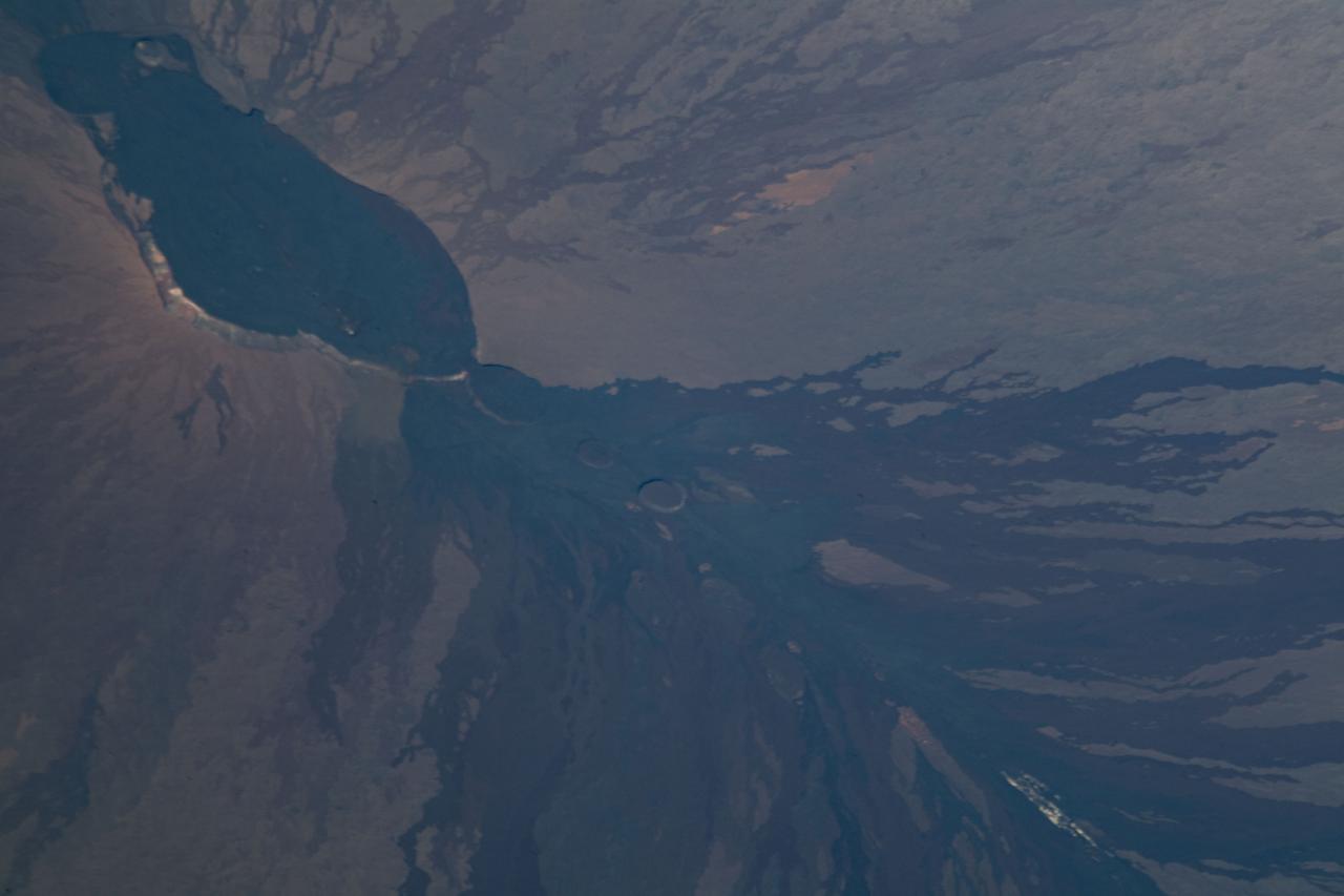
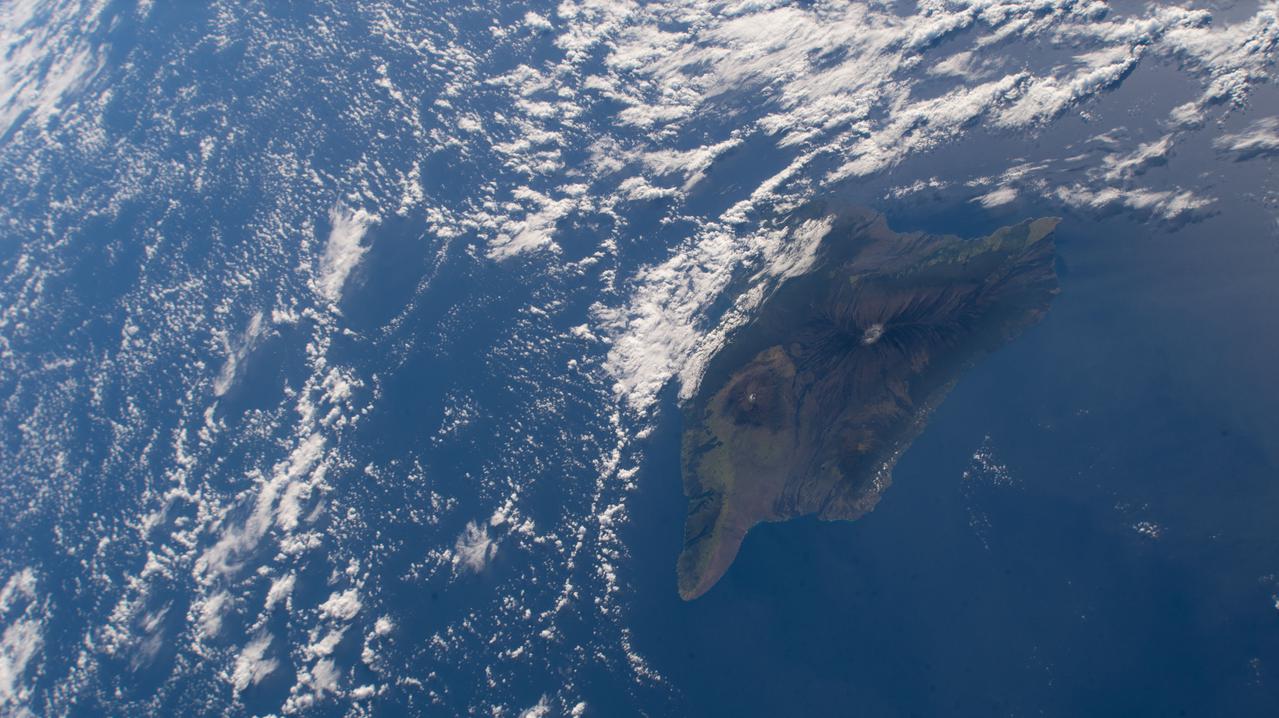
Tenarife Island is one of the most volcanically active of the Canary Island archipelago, Atlantic Ocean, just off the NW coast of Africa, (28.5N, 16.5W). The old central caldera, nearly filled in by successive volcanic activity culminating in two stratocones. From those two peaks, a line of smaller cinder cones extend to the point of the island. Extensive gullies dissect the west side of the island and some forests still remain on the east side.
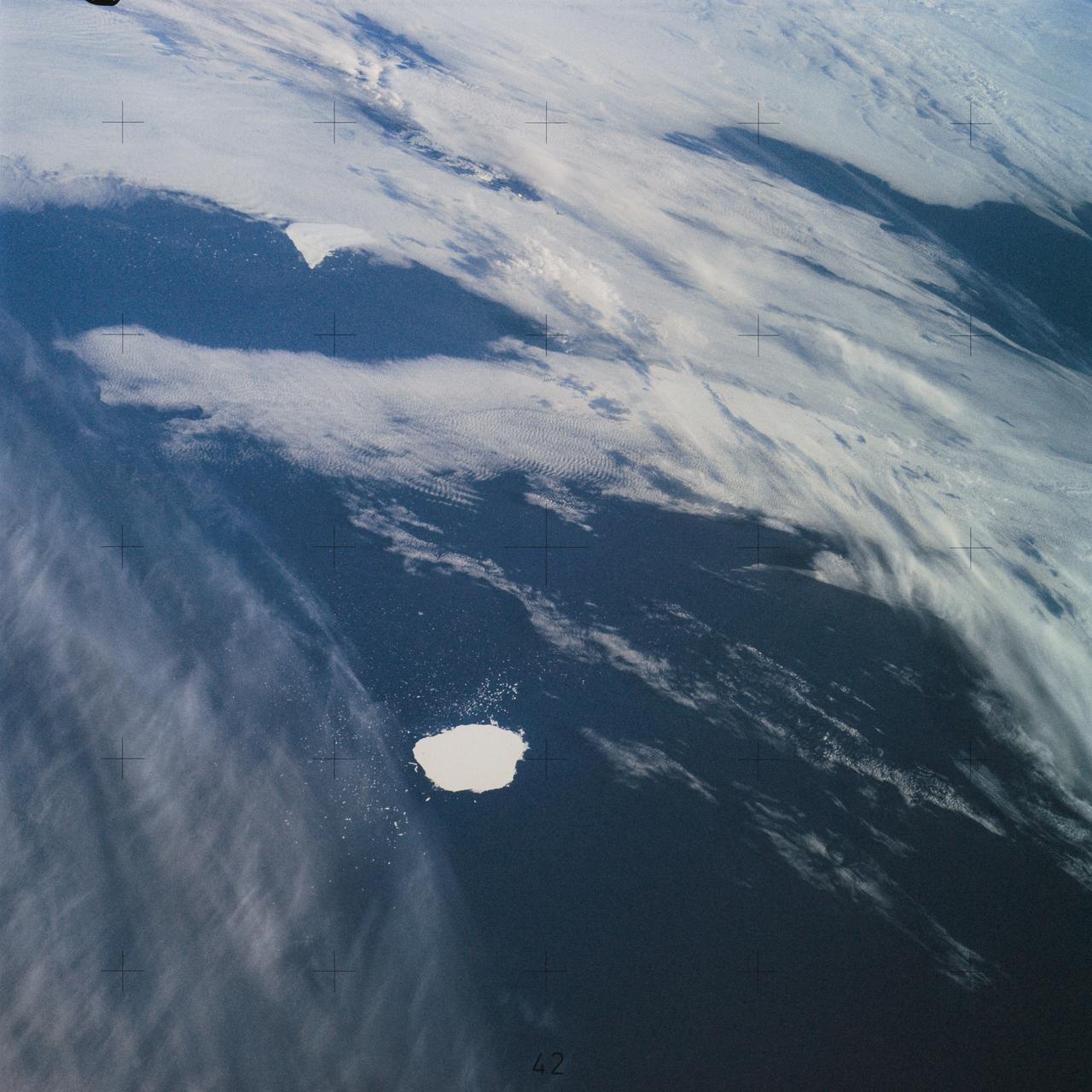
SL4-142-4577 (28 Jan. 1974) --- Two large ice islands in the vicinity of South Georgia Island in the South Atlantic Ocean, as photographed from the Skylab space station in Earth orbit by one of the Skylab 4 crewmen. The camera used was a hand-held 70mm Hasselblad, with SO-368 medium-speed Ektachrome. One of the ice islands is partially obscured by clouds. Ice islands were observed as large as 45 by 60 kilometers (27 x 37 miles) and as far north as 45 degrees south latitude. The size and distribution of the "small" icebergs (to a ship they would look very large) can be used to study the local winds and currents. Recent research has suggested the possibility of towing such Antarctic icebergs to selected areas and using them as water supplies. One such iceberg would contain many times the water as in Lake Powell. Photo credit: NASA
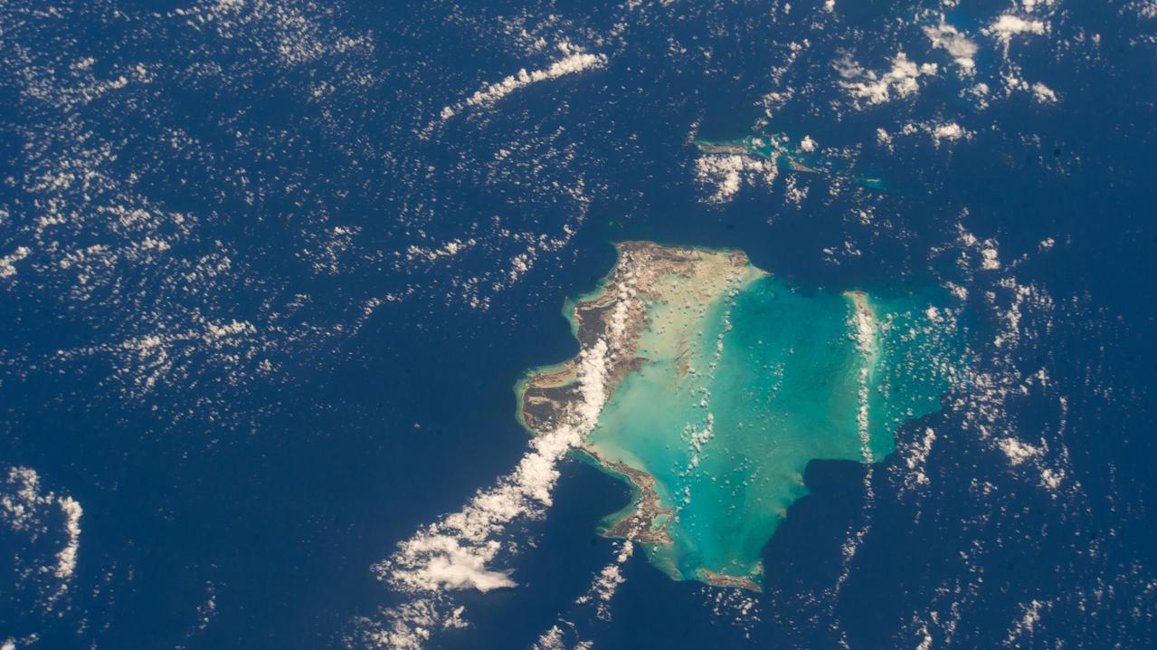
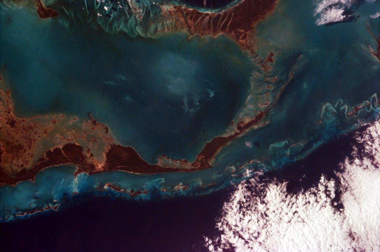
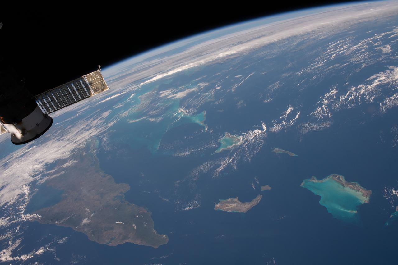
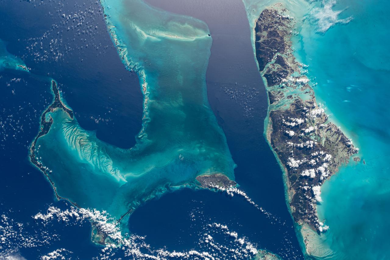
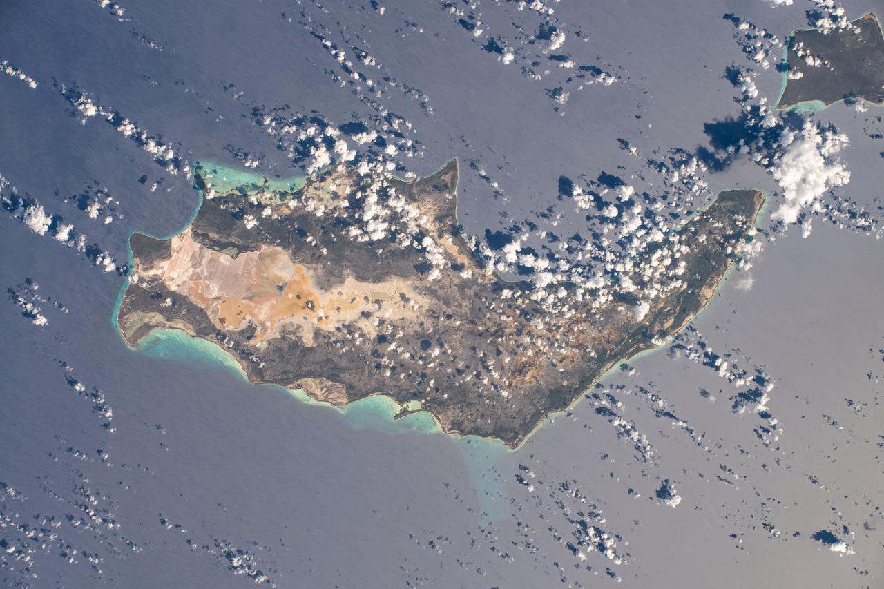
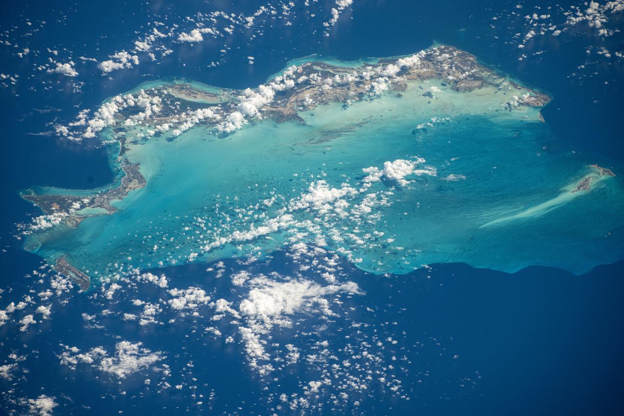
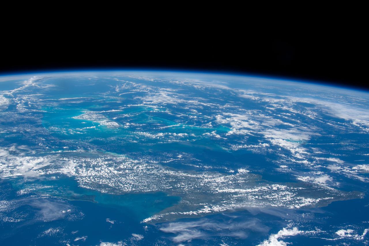
iss073e0118628 (May 26, 2025) --- The Turks and Caicos Islands, an archipelago and British Overseas Territory in the Atlantic Ocean southeast of The Bahamas, are pictured from the International Space Station as it orbited 261 miles above.
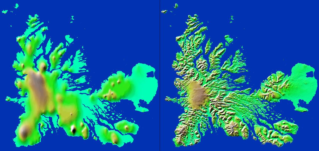
These two images show exactly the same area, Kerguelen Island in the southern Indian Ocean. The image on the left was created using the best global topographic data set previously available, the U.S. Geological Survey GTOPO30.
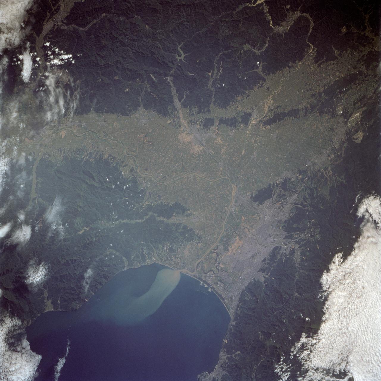
iss073e0285020 (July 14, 2025) --- Perth, Australia, with a population of about 2.3 million on the island continent's Indian Ocean coast, is pictured from the International Space Station as it orbited 263 miles above. Credit: Roscosmos
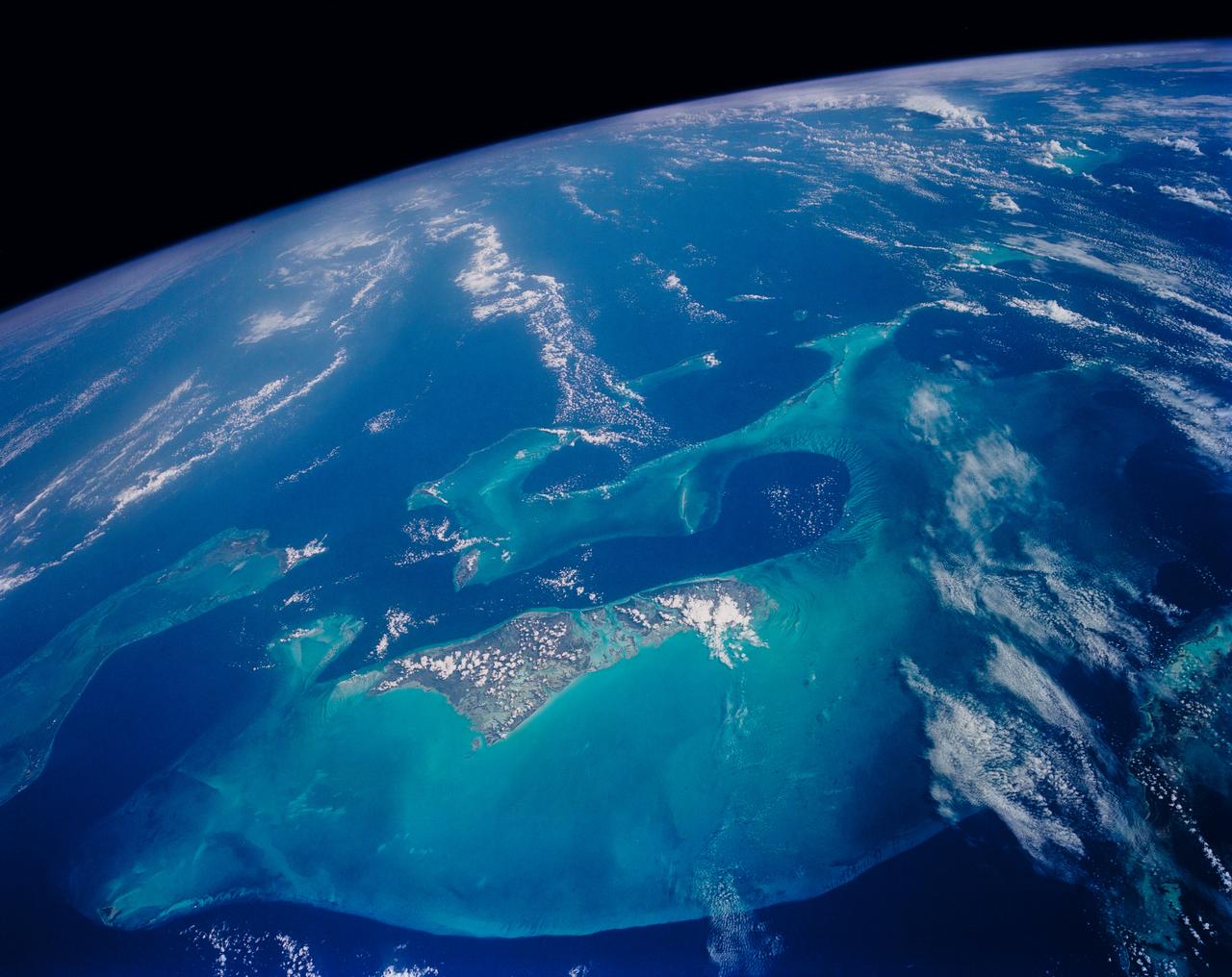
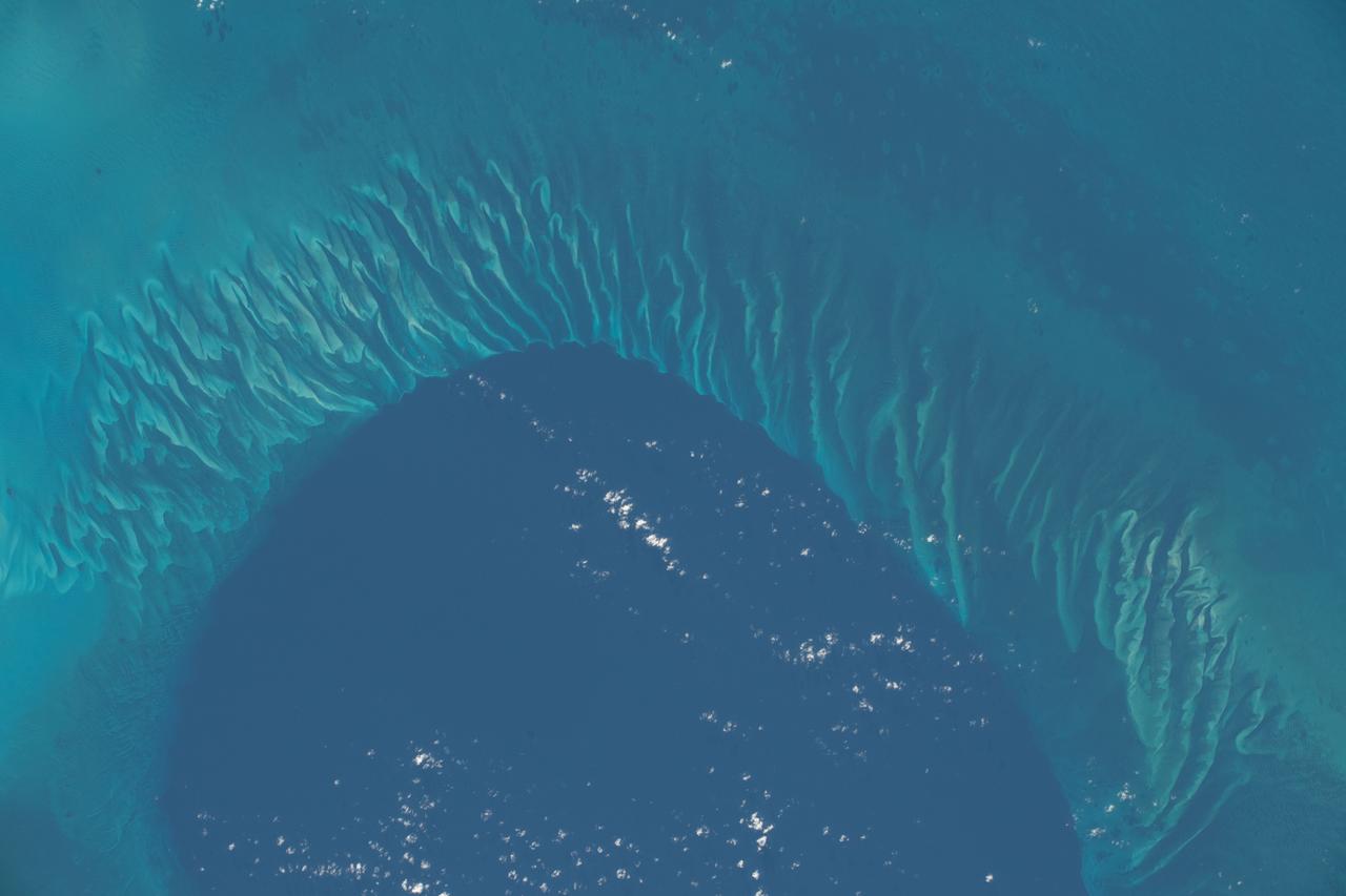
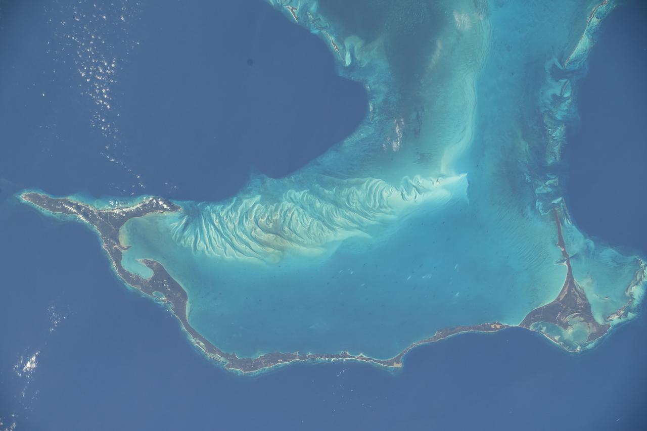
The light blue shallow water platforms of the Bahamas, (24.0N, 77.0W) which are separated by very deep dark blue channels make for a striking scene. In the foreground is Andros Island and in the background are the Tongue of the Ocean, the Exuma Islands, Exuma Sound and the Atlantic Ocean. The Bahamas are one of the few regions where calcium carbonate precipitates directly out of the water, as the mineral aragonite, to form the coral reef islands.
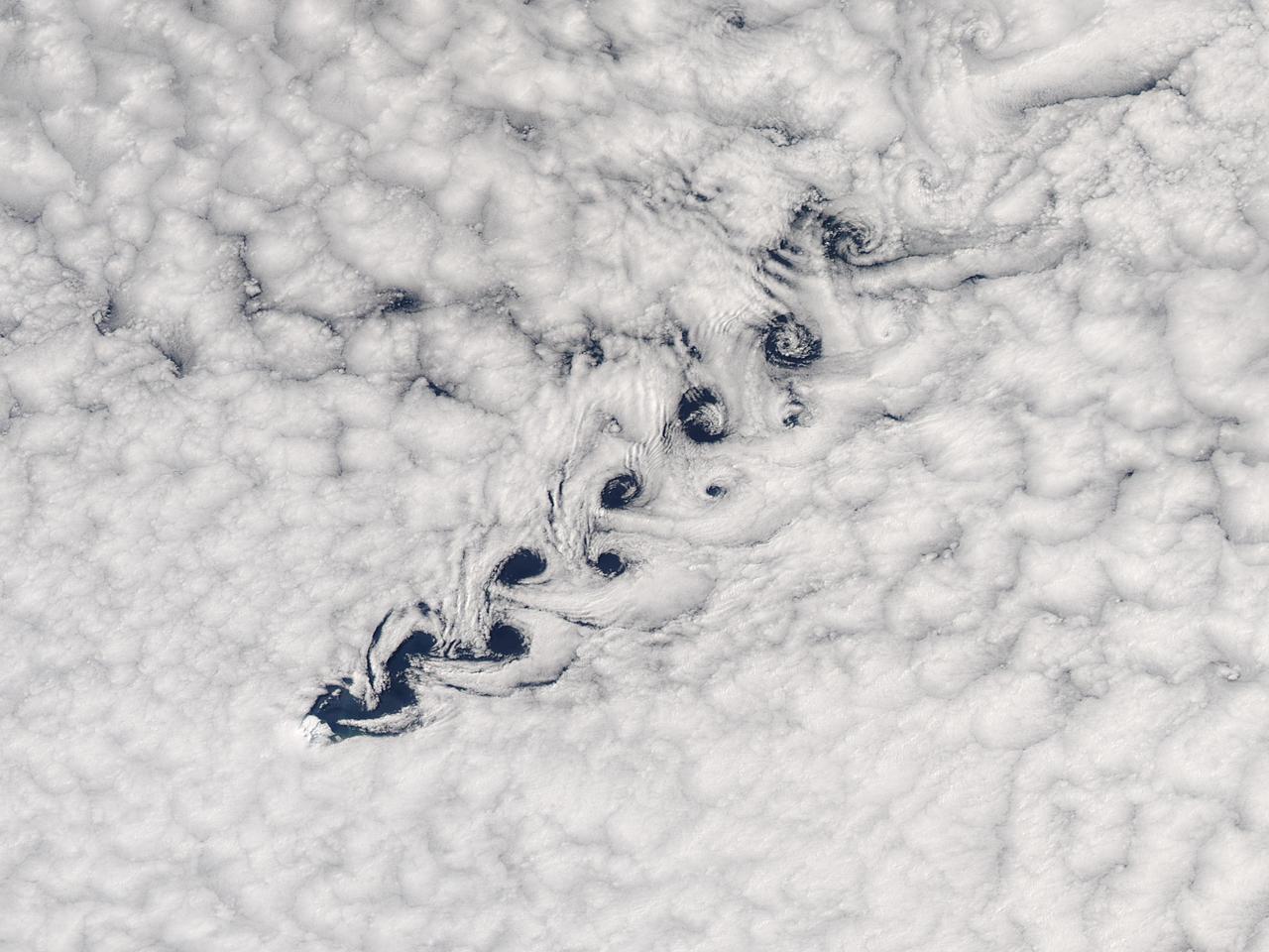
Cloud vortices off Heard Island, south Indian Ocean. The Moderate Resolution Imaging Spectroradiometer (MODIS) aboard NASA’s Aqua satellite captured this true-color image of sea ice off Heard Island on Nov 2, 2015 at 5:02 AM EST (09:20 UTC). Credit: NASA/GSFC/Jeff Schmaltz/MODIS Land Rapid Response Team
STS026-43-082 (29 Sept. - 3 Oct. 1988) --- This 70mm northerly oriented frame over the Pacific Ocean features the Hawaiian Islands chain. The islands perturb the prevailing northeasterly winds producing extensive cloud wakes in the lee of the islands. Photo experts feel that atmospheric haze in the Hawaii wake is probably a result of the continuing eruptions of Kilauea volcano on the southeast coast. From the lower right corner in a diagonal directed upward to the north are the islands of Nihau, Kauai, Oahu, Molokai, Lanai, Maui, Kahoolawe, and Hawaii. This photo was shown during the post-flight press conference on October 11, 1988 by the STS-26 astronauts, who at one time during the flight wore Hawaiian attire to pay tribute to the working staff of the Hawaii tracking station.
The island of Java (8.0S, 112.0E), perhaps better than any other, illustrates the volcanic origin of Pacific Island groups. Seen in this single view are at least a dozen once active volcano craters. Alignment of the craters even defines the linear fault line of Java as well as the other some 1500 islands of the Indonesian Archipelago. Deep blue water of the Indian Ocean to the south contrasts to the sediment laden waters of the Java Sea to the north.
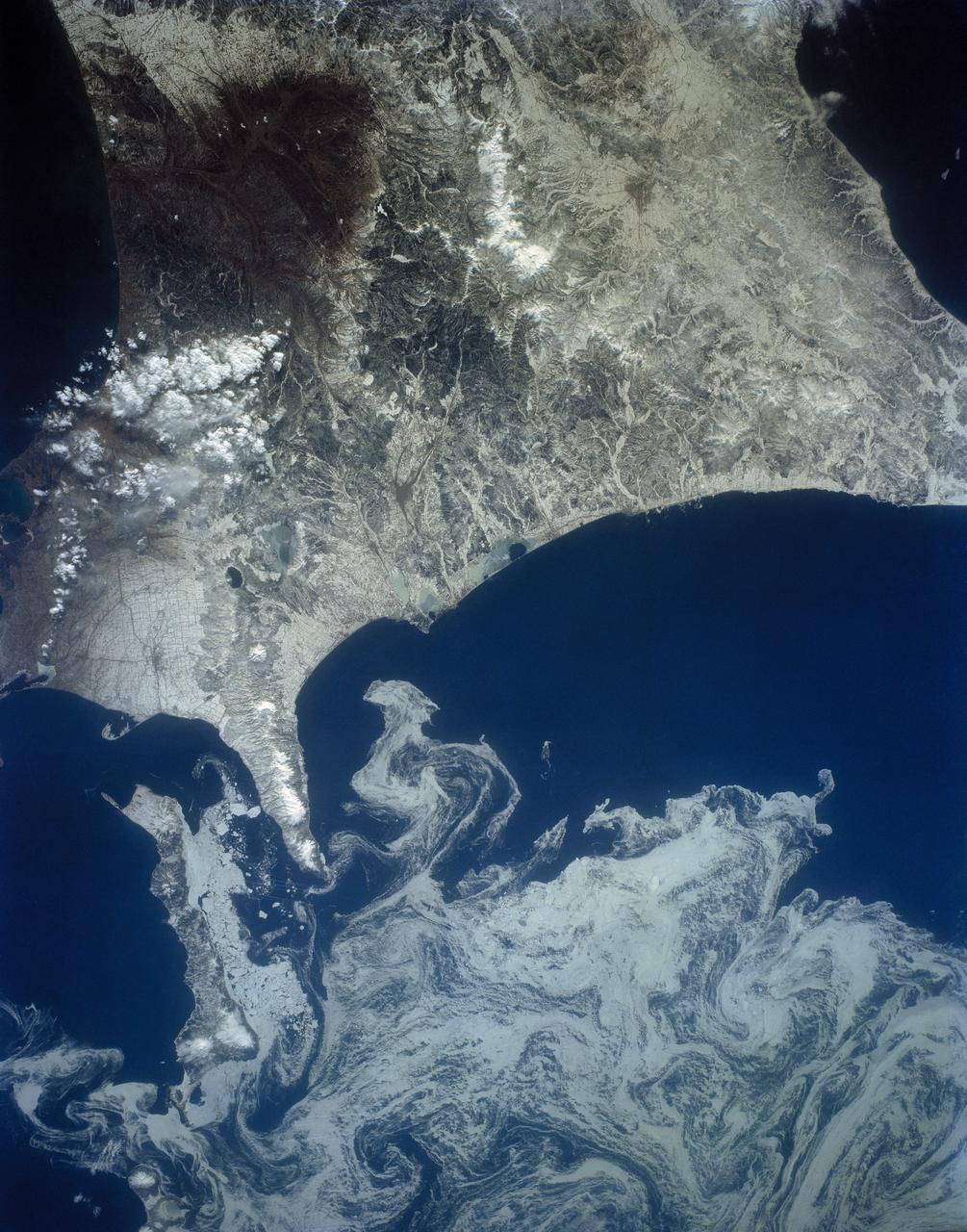
The northeast coast of Hokkaido and Kunashir Island, Japan (44.0N, 143.0E) are seen bordered by drifting sea ice. The sea ice has formed a complex pattern of eddies in response to surface water currents and winds. Photos of this kind aid researchers in describing local ocean current patterns and the effects of wind speed and direction on the drift of surface material, such as ice floes or oil. Kunashir is the southernmost of the Kuril Islands.
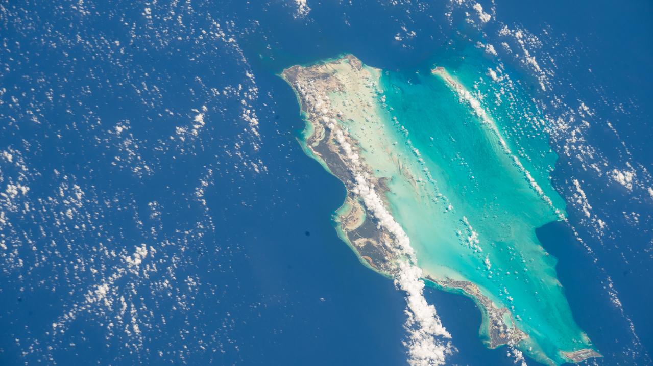
iss073e0098600 (May 26, 2025) --- The Turks and Caicos Islands, a British Overseas Territory in the Atlantic Ocean with a population of approximately 49,300, are pictured from the International Space Station as it orbited 260 miles above.
NASA Terra spacecraft acquired this image of the Republic of Seychelles, an island country with an archipelago of 115 islands in the Indian Ocean.
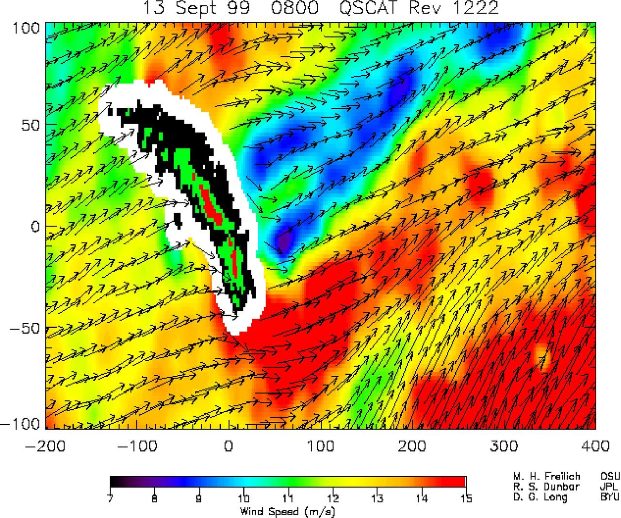
NASA SeaWinds instrument on the QuikScat satellite shows winds are blocked by an island mountain barrier on South Georgia Island, in the South Atlantic Ocean in the year 2000.
The Sovereign Democratic Republic of the Fiji Islands, commonly known as Fiji, is an independent nation consisting of some 332 islands surrounding the Koro Sea in the South Pacific Ocean. This image shows Viti Levu, the largest island in the group.
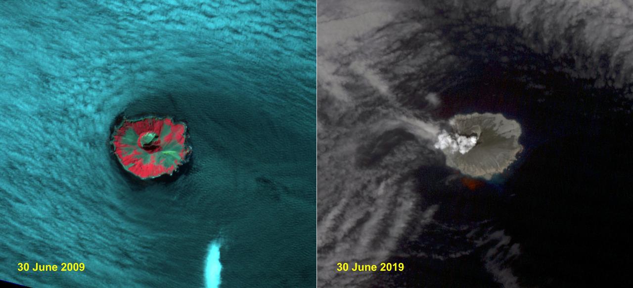
Raikoke volcanic island is near the center of the Kuril Islands in the Sea of Okhotsk in the northwest Pacific Ocean. The island is roughly circular with dimensions of 2.0 by 2.5 kilometers. On June 22, the volcano erupted with a gas and ash plume reaching 17 kilometers. The two ASTER images, acquired exactly 10 years apart on June 30, dramatically depict the changes to the island. In 2009, vegetation (red) covered most of the island. The 2019 image shows an ash and steam plume rising from the caldera. There is no trace of any vegetation, ash deposits having buried everything. The images are located at 48.3 degrees north, 153.2 degrees east. https://photojournal.jpl.nasa.gov/catalog/PIA23326
AST-19-1555 (24 July 1975) --- A sunglint in the South Western Pacific Ocean, as photographed from the Apollo spacecraft in Earth orbit during the joint U.S.-USSR Apollo-Soyuz Test Project mission. The island is Bougainville of the Solomon Islands group. The horizon of Earth is in the background. The picture was taken at an altitude of 231 kilometers (143 statute miles), with a 70mm Hasselblad camera using medium-speed Ektachrome QX-807 type film.
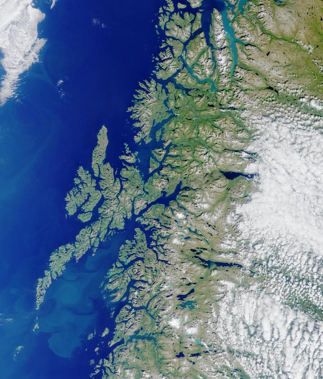
Lofoten Islands, Norway. Norway is deeply indented by fjords, rises precipitously to high plateaus, and is united with the ocean by numerous islands. This image from NASA Terra satellite is MISR Mystery Image Quiz #2.

This radar image shows the volcanic island of Reunion, about 700 km 434 miles east of Madagascar in the southwest Indian Ocean. The southern half of the island is dominated by the active volcano, Piton de la Fournaise.
This space radar image shows the rugged topography of Santa Cruz Island, part of the Channel Islands National Park in the Pacific Ocean off the coast of Santa Barbara and Ventura, Calif.
STS040-613-049 (5-14 June 1991) --- This oblique scene from the Earth-orbiting Space Shuttle Columbia shows southern Florida, several of the Bahama Islands and parts of the Atlantic Ocean, the Gulf of Mexico and the Caribbean Sea. The nine-day STS-40/Spacelab Life Sciences (SLS-1) mission started with launch from Kennedy Space Center (KSC), visible in lower left. Cuba can be seen at top center. The picture was photographed with a handheld Rolleiflex camera, aimed through Columbia's aft flight deck windows.
There are special places on Earth that sometimes write their personal signature in the clouds. The Crozet Islands are one such place, thanks to the tall volcanic peaks that grace the islands. When air flows around these tall peaks, it gets pushed around the islands as well as up and over the peak. The net effect of the flowing air flowing around the solid, tall peaks is much like the solid bow of a ship cutting through standing water. In each case v-shaped waves are formed behind the motion. In liquid, this is called a wake; in the atmosphere, when clouds are present or created, they are known as ship-wave-shaped clouds. The Moderate Resolution Imaging Spectroradiometer (MODIS) aboard NASA’s Terra satellite captured this true-color image as it passed over the Crozet Islands on November 26, 2014. Three distinct waves are seen behind the three largest islands. From west to east these are Pig Island, Possession Island and East Island. Credit: NASA/GSFC/Jeff Schmaltz/MODIS Land Rapid Response Team <b><a href="http://www.nasa.gov/audience/formedia/features/MP_Photo_Guidelines.html" rel="nofollow">NASA image use policy.</a></b> <b><a href="http://www.nasa.gov/centers/goddard/home/index.html" rel="nofollow">NASA Goddard Space Flight Center</a></b> enables NASA’s mission through four scientific endeavors: Earth Science, Heliophysics, Solar System Exploration, and Astrophysics. Goddard plays a leading role in NASA’s accomplishments by contributing compelling scientific knowledge to advance the Agency’s mission. <b>Follow us on <a href="http://twitter.com/NASAGoddardPix" rel="nofollow">Twitter</a></b> <b>Like us on <a href="http://www.facebook.com/pages/Greenbelt-MD/NASA-Goddard/395013845897?ref=tsd" rel="nofollow">Facebook</a></b> <b>Find us on <a href="http://instagram.com/nasagoddard?vm=grid" rel="nofollow">Instagram</a></b>
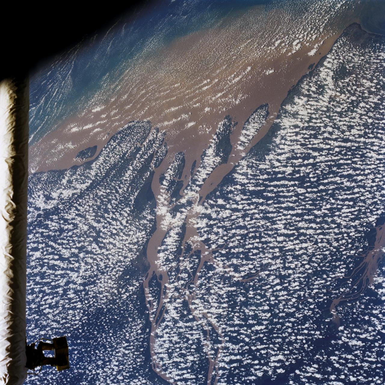
STS046-80-009 (31 July-8 Aug. 1992) --- A view of the mouth of the Amazon River and the Amazon Delta shows a large sediment plume expanding outward into the Atlantic Ocean. The sediment plume can be seen hugging the coast north of the Delta. This is caused by the west-northwest flowing Guyana Current. The large island of Marajo is partially visible through the clouds.
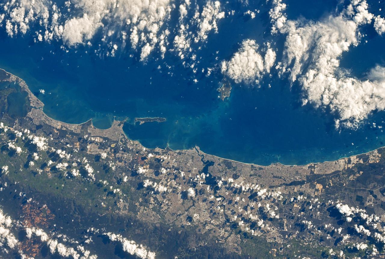
This radar image shows the Teide volcano on the island of Tenerife in the Canary Islands. The Canary Islands, part of Spain, are located in the eastern Atlantic Ocean off the coast of Morocco. Teide has erupted only once in the 20th Century, in 1909, but is considered a potentially threatening volcano due to its proximity to the city of Santa Cruz de Tenerife, shown in this image as the purple and white area on the lower right edge of the island. The summit crater of Teide, clearly visible in the left center of the image, contains lava flows of various ages and roughnesses that appear in shades of green and brown. Different vegetation zones, both natural and agricultural, are detected by the radar as areas of purple, green and yellow on the volcano's flanks. Scientists are using images such as this to understand the evolution of the structure of Teide, especially the formation of the summit caldera and the potential for collapse of the flanks. The volcano is one of 15 identified by scientists as potentially hazardous to local populations, as part of the international The image was acquired by the Spaceborne Imaging Radar-C/X-Band Synthetic Aperture Radar (SIR-C/X-SAR) onboard the space shuttle Endeavour on October 11, 1994. SIR-C/X-SAR, a joint mission of the German, Italian and the United States space agencies, is part of NASA's Mission to Planet Earth. The image is centered at 28.3 degrees North latitude and 16.6 degrees West longitude. North is toward the upper right. The area shown measures 90 kilometers by 54.5 kilometers (55.8 miles by 33.8 miles). The colors in the image are assigned to different frequencies and polarizations of the radar as follows: red is L-band horizontally transmitted, horizontally received; green is L-band horizontally transmitted, vertically received; blue is C-band horizontally transmitted, vertically received. http://photojournal.jpl.nasa.gov/catalog/PIA01779
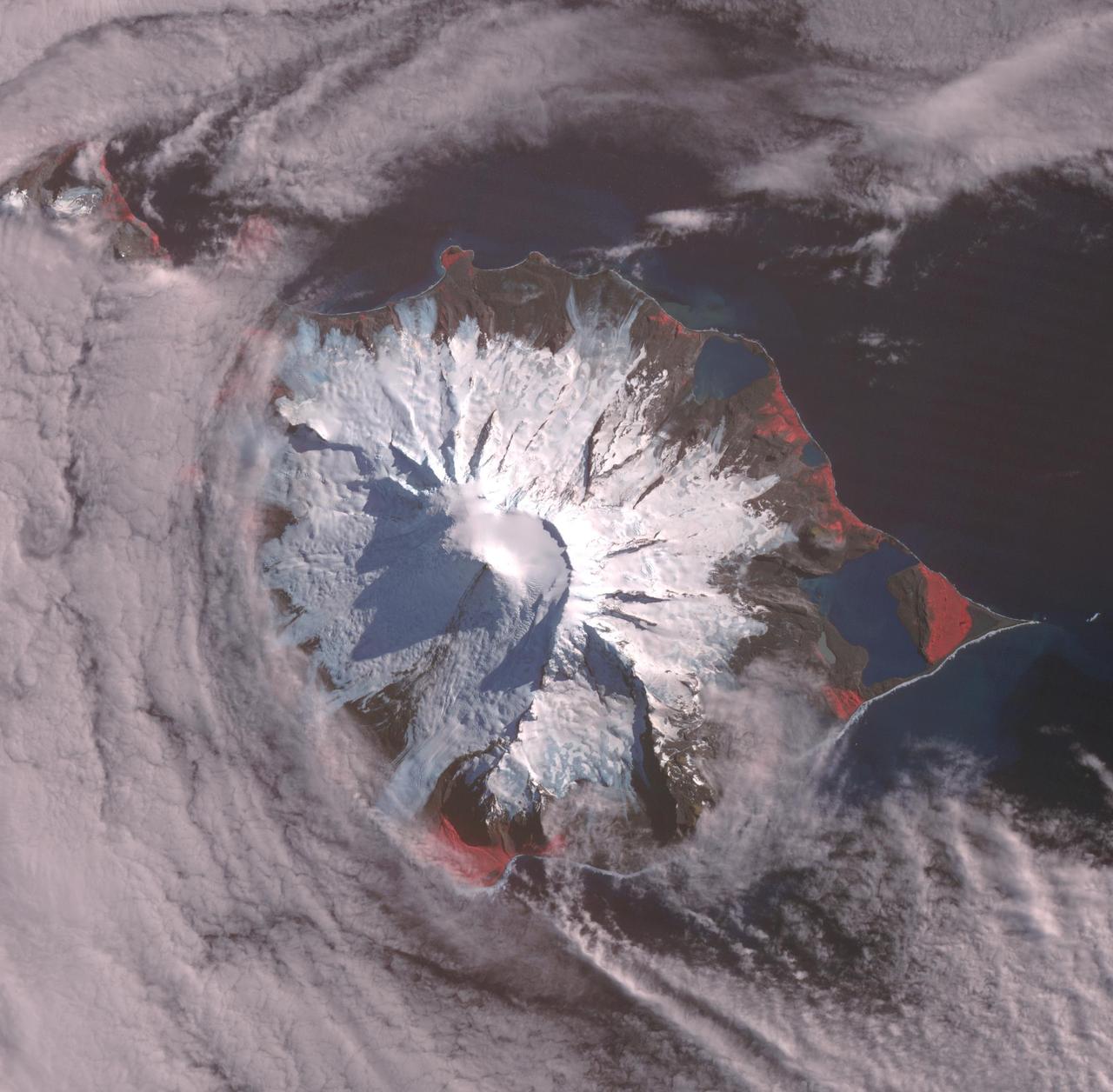
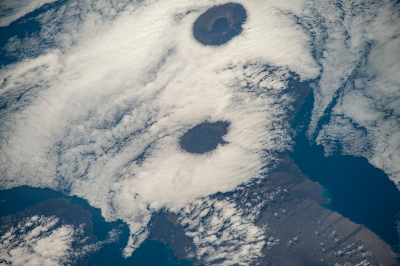
Heard, a remote volcanic island located in the southern Indian Ocean, is an Australian Territory. It consists of two volcanic structures: Big Ben and the smaller Mt. Dixon. The active Mawson Peak is located within a 5-6 km-wide caldera breached to the SW side of Big Ben. Intermittent eruptions have occurred since 1910; the latest in May 2023. The image was acquired March 18, 2025, covers an area of 39.7 by 40.4 km, and is located at 53 degrees south, 73.5 degrees east. https://photojournal.jpl.nasa.gov/catalog/PIA26509
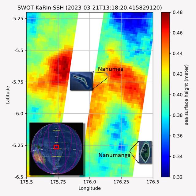
The recently launched Surface Water and Ocean Topography (SWOT) mission collected data on sea levels around two of the inhabited islands of Tuvalu, a nation in the South Pacific Ocean that has been threatened with sea level rise that substantially exceeds the global average. The image shows two areas of red that indicate higher than normal sea levels around two of Tuvalu's inhabited islands, Nanumanga and Nanumea. The higher sea levels were likely caused by internal tides or circular currents called eddies. The SWOT data illuminates for the first time these small ocean features that, when they occur on top of rising sea levels, can lead to episodic flooding along coastlines. The Tuvalu data was collected March 21, 2023. Rising seas are a direct consequence of climate change. On a global scale, the combination of warming ocean waters and ice melt from glaciers and ice sheets is leading to sea level rise that is occurring at an ever-increasing rate. The current rate of rise is more than 0.15 inches (4 millimeters) per year, an increase from 0.08 inches (2 millimeters) per year in 1993. This seemingly small increase holds great significance for coastal communities that have seen more than a century of persistent sea level rise. The gap between the average high tide and flooding conditions has narrowed, and coastal impacts driven by sea level rise have increased in frequency and severity in recent years. This is particularly true for low-lying island nations like Tuvalu, located about 620 miles (1,000 kilometers) north of Fiji. Sea level rise does not occur at the same rate everywhere across the globe, and can be exacerbated by natural ocean fluctuations that occur over time periods from years to decades. For Tuvalu, the amount of sea level rise has been substantially higher than the global average over the past three decades. The amount of rise, when coupled with Tuvalu's low land elevations, places the country increasingly under threat. In the near term, sea level rise will combine with naturally occurring ocean variability and storms to exacerbate events like coastal flooding. Monitoring and understanding sea level change is critical for Tuvalu and other low-lying island nations. Launched on Dec. 16, 2022, from Vandenberg Space Force Base in central California, SWOT collected the Tuvalu sea level data during a period of commissioning, calibration, and validation. Engineers are checking out the performance of the satellite's systems and science instruments before the planned start of science operations in summer 2023. https://photojournal.jpl.nasa.gov/catalog/PIA25777
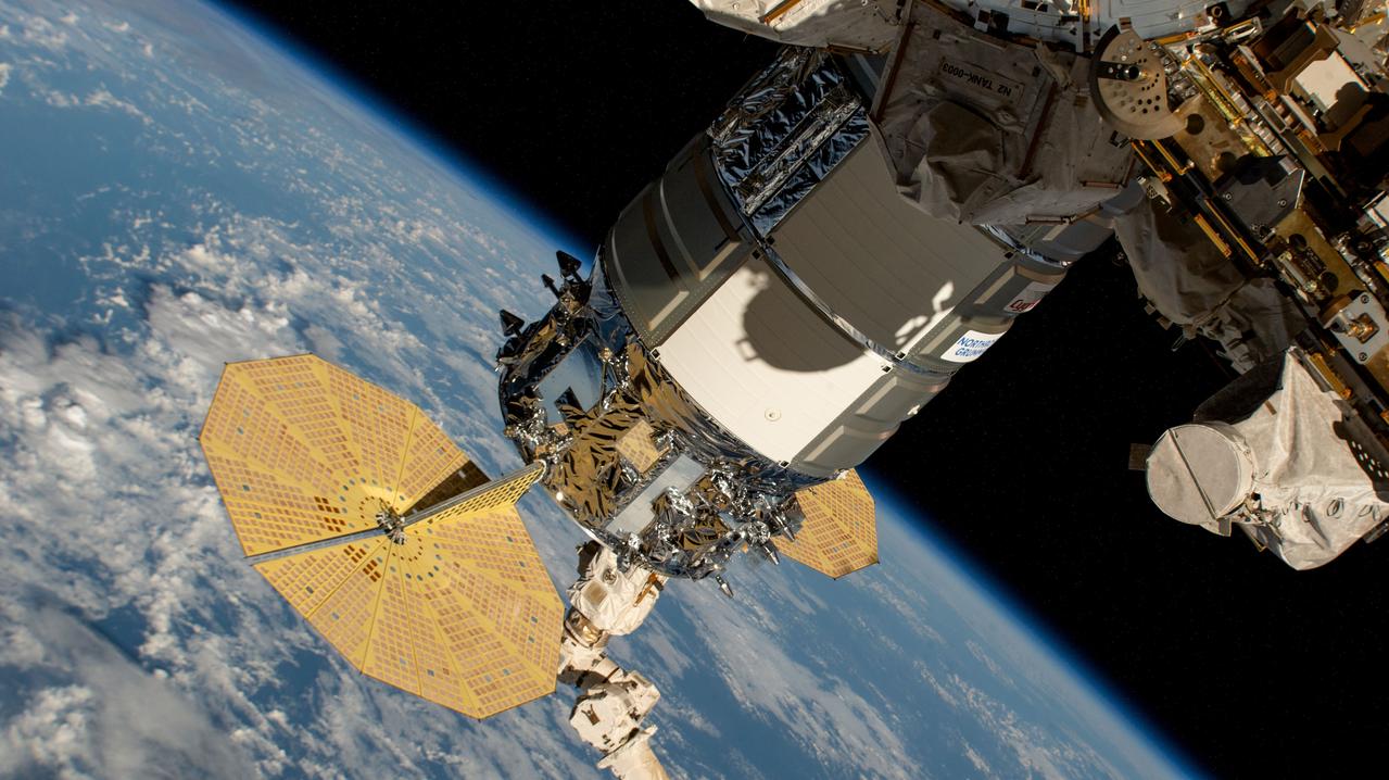
iss071e439629 (Aug. 6, 2024) --- Still in the grips of the Canadarm2 robotic arm, the Northrop Grumman Cygnus space freighter is pictured attached to the Unity module's Earth-facing port. The International Space Station was orbiting 262 miles above a cloudy Pacific Ocean halfway between the U.S. island of Hawaii and the island nation of the Republic of Kiribati at the time of this photograph.
ISS033-E-007873 (27 Sept. 2012) --- Wake Island is featured in this image photographed by an Expedition 33 crew member on the International Space Station. The atoll of Wake Island is located in the central Pacific Ocean approximately 4,000 kilometers to the west-southwest of Hawaii and 2,400 kilometers to the northwest of Guam. In addition to Wake Island, the atoll includes the smaller Peale and Wilkes Island for a total land surface area of 6.5 square kilometers. Like many atolls in the Pacific, the islands and associated reefs formed around a submerged volcano. The lagoon in the center of the islands—characterized by shallow, light blue water in contrast to the surrounding darker, deeper Pacific Ocean waters—marks the approximate location of the summit crater of the volcano.
ISS030-E-122047 (6 March 2012) --- Pagan Island, Northern Marianas is featured in this image photographed by an Expedition 30 crew member on the International Space Station. A steam plume flows south from the peak of Pagan Island’s northernmost volcano in this photograph. Pagan is part of the Commonwealth of the Northern Marianas, an island chain of volcanoes that form the margin between the Pacific Ocean (to the east) and the Philippine Sea (to the west). Pagan is made up of two stratovolcanoes separated by an isthmus, and is one of the more volcanically active islands. The last eruption was in 2010, but the island was completely evacuated in 1981 when a large eruption forced the small Micronesian community to flee. According to NASA scientists, the islands themselves mark the tectonic boundary where the old, cold Pacific plate is subducted beneath the younger, less dense Philippine Sea crust at the Marianas Trench. The subduction results in substantial volcanic activity on the upper plate, forming the island arc of the Marianas. Considered to be one of the type examples for an oceanic subduction zone, the Marianas Trench includes the deepest spot in Earth’s oceans (more than 10,000 meters). The foreshortened appearance of the island is due to the viewing angle and distance from the space station, which was located over the Pacific Ocean approximately 480 kilometers to the southeast of Pagan Island when the image was taken.
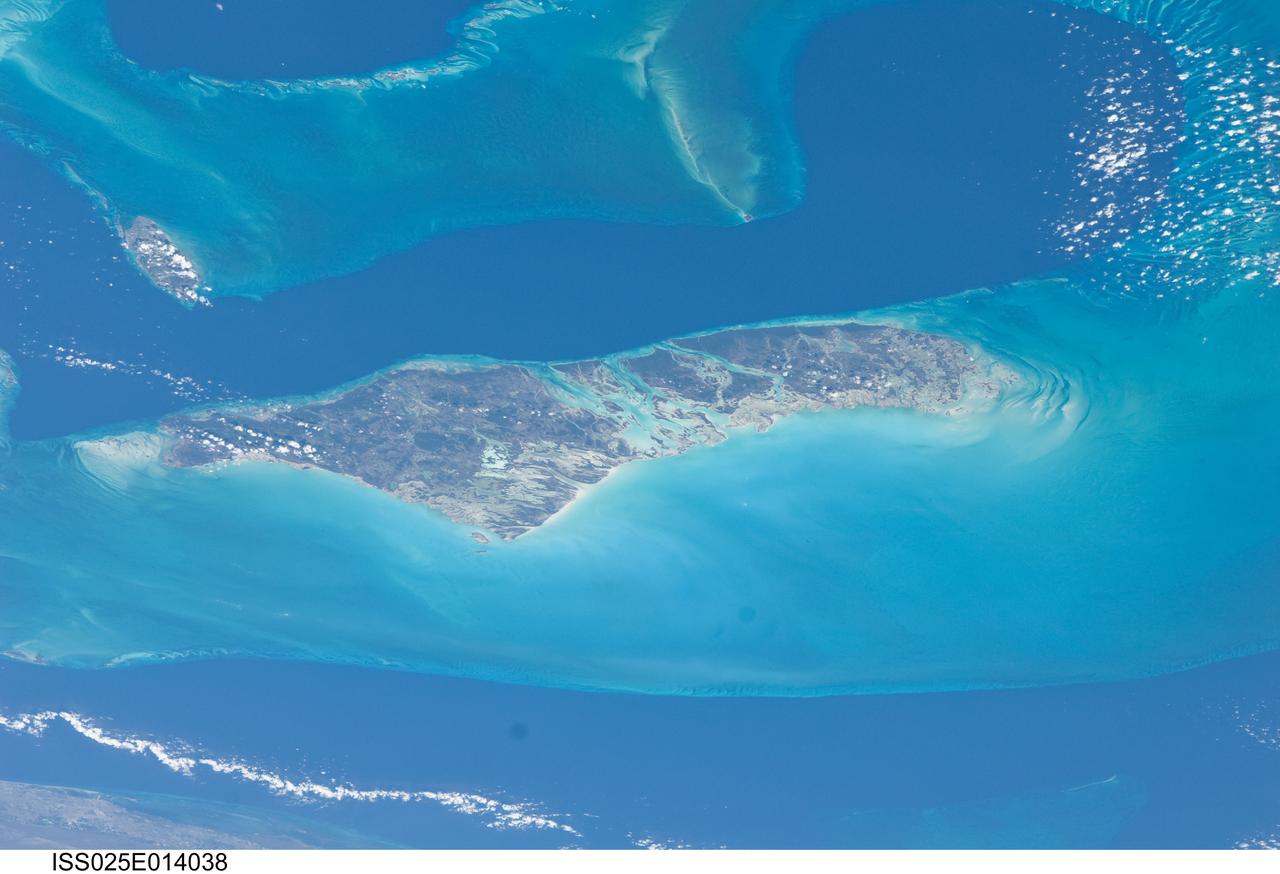
ISS025-E-014038 (10 Nov. 2010) --- Andros Island and the Tongue of the Ocean, a deep oceanic trench in the Bahamas separating the islands of Andros and nearby New Providence, captured the attention of a camera-bearing member of the Expedition 25 crew orbiting Earth onboard the International Space Station, some 220 miles above.
This image from NASA EarthKAM captures the tropical beauty of the major islands of the Little Bahama Bank, the most northerly of the island groups that comprise the Bahamas.
Banjul is the capital of The Gambia; it is located on St. Mary's Island, where the Gambia River enters the Atlantic Ocean in western Africa. The small city is surrounded by mangroves and water; it is connected to the rest of the country by ferries and a bridge. Peanut processing is the country's principal industry (Wikipedia). The image was acquired December 17, 2009, covers an area of 27.4 by 43.2 km, and is located at 13.5 degrees north, 16.6 degrees west. https://photojournal.jpl.nasa.gov/catalog/PIA24416
This almost totally cloud free, photo of the island of Timor, Indonesia (9.0S, 125.0E) illustrates the volcanic origin of the over 1500 islands of Indonesia. Close examination of the photo reveals several eroded volcanoes on the Island of Timor and several of the adjacent islands. The linear alignment of the volcanoes, as seen from space, indicates the edges of the tectonic plates of the Earth's crust where volcanic activity is most common.
This distant view of Mt. Fuji, on the main home island of Honshu, Japan (34.0N, 139.0E) was taken from about 450 miles to the south. Evan at that great distance, the majestic and inspiring Mt. Fuji is still plainly visible and easily recognized as a world renowned symbol of Japan. The snow capped extinct volcano lies just a few miles south of Tokyo.
The southern half of the island of Okinawa, Japan (26.5N, 128.0E) can be seen in this nearly cloud free view. Okinawa is part of the Ryuku Islands which extend from Taiwan northeastward to Kyushu, southernmost of the Japanese Home Islands. The large military base at Kadena, with large runways, is visible near the center of the scene. Kadena is one of several emergency landing sites around the world for the space shuttle.

The Maldives nation, in the Indian Ocean, faces an environmental threat from sea level rise, as 80% of its islands are less than 1 m above seal level. To counter this threat, the country is creating a new artificial island, Hulhumale. The capital city of Male, southwest of the new island and the airport, houses 130,000 people in 2.5 sq km. By 2019, more than 50,000 people had moved to Hulhumale, with plans to host 240,000 of the nation's people by the mid-2020s (BBC.com, December 31, 2020). The ASTER image was acquired December 22, 2018, the Landsat-5 image (Figure 1) was acquired February 3, 1999. The images cover an area of 9.2 by 11.3 km, and are located at 4.2 degrees north, 73.5 degrees east. https://photojournal.jpl.nasa.gov/catalog/PIA24381
iss055e023639 (April 14, 2018) --- A trio of islands that are part of the volcanic ten-island nation of Cape Verde is pictured off the northwestern coast of Africa as the International Space Station orbited over the Atlantic Ocean.

iss055e023781 (April 14, 2018) --- New York state's Long Island and the Atlantic Ocean coasts of New Jersey, Connecticut and Rhode Island are pictured from the International Space Station as it orbited over the eastern coast of the United States.
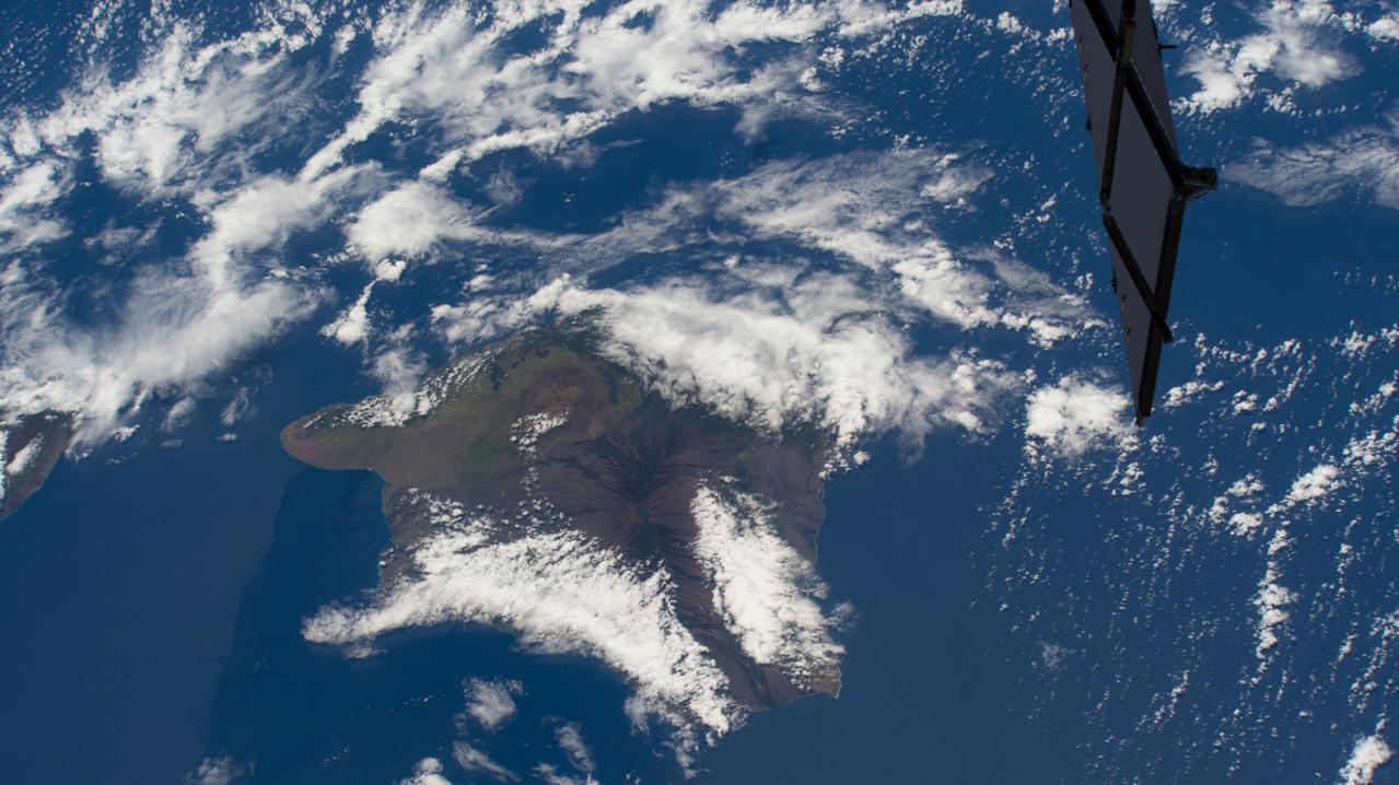
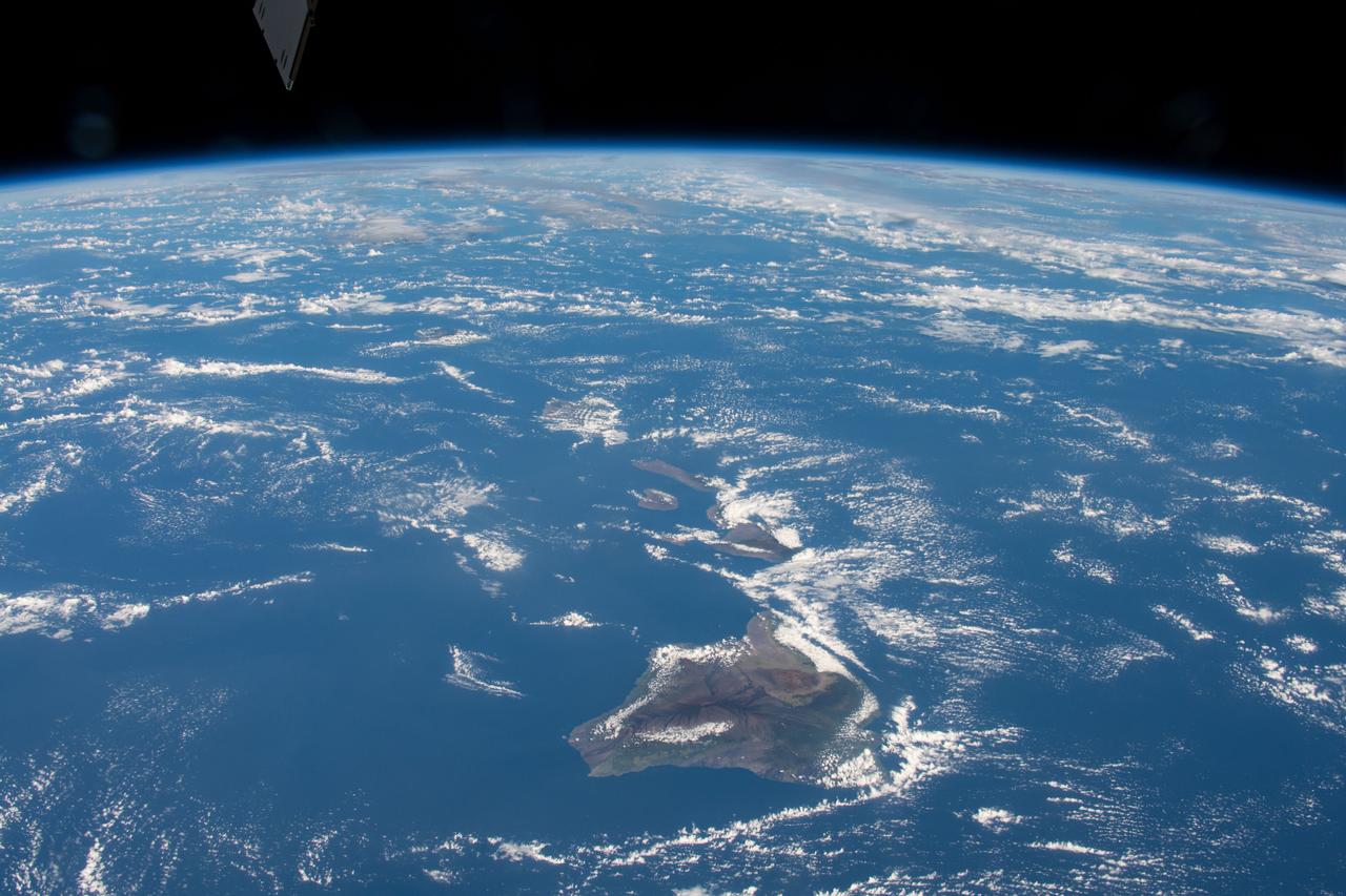
iss069e025331 (June 24, 2023) -- Clouds cover the Island of Hawaii, the youngest and largest of eight islands in the chain, as the International Space Station orbited 258 miles above the Pacific Ocean.
iss055e023643 (April 14, 2018) --- Another view of a trio of islands that are part of the volcanic ten-island nation of Cape Verde is pictured off the northwestern coast of Africa as the International Space Station orbited over the Atlantic Ocean.
iss063e040531 (July 6, 2020) --- Mauna Loa, the world's largest active volcano, was pictured on the island of Hawaii as the International Space Station orbited above the Pacific Ocean to the northeast of the island chain.
iss068e025397 (Nov. 28, 2022) --- The peak of La Cumbre Volcano on Ecuador's Fernandina Island, part of the Galapagos Islands, is surrounded by clouds in this photograph from the International Space Station as it orbited 261 miles above the Pacific Ocean.

iss053e180184 (Nov. 12, 2017) --- The islands of (from left) Abaiang, Tarawa and Maiana are part of the Gilbert Islands and make up part of the republic of Kiribati in the Pacific Ocean. Kiribati is comprised of a total of 33 coral atolls and isles.
iss058e002206 (Jan. 5, 2018) --- Portions of Cuba, The Bahamas and the Turks and Caicos Islands are viewed from the International Space Station as the orbital complex flew 252 miles above the Atlantic Ocean. At left, is the aft end of the Progress 70 resupply ship from Russia attached to the Pirs docking compartment.
iss063e105773 (Oct. 8, 2020) --- The Hawaiian island chain was pictured as the International Space Station orbited above the Pacific Ocean.
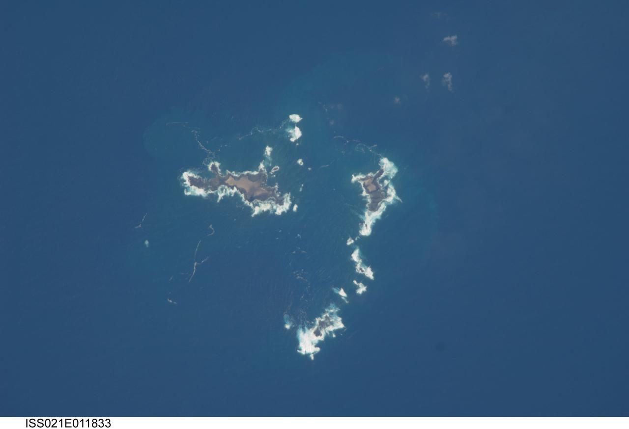
ISS021-E-011833 (22 Oct. 2009) --- The southern Savage Islands in the Atlantic Ocean are featured in this image photographed by an Expedition 21 crew member on the International Space Station. The Savage Islands, or Ilhas Selvagens in Portuguese, comprise a small archipelago in the eastern North Atlantic Ocean between the archipelago of Madeira to the north and the Canary Islands to the south. Like other island groups, the Savage Islands are thought to have been produced by volcanism related to a mantle plume or ?hot spot?. Mantle plumes are relatively fixed regions of upwelling magma that can feed volcanoes on an overlying tectonic plate. Active volcanoes form over the plume, and become dormant as they are carried away on the moving tectonic plate. Scientists believe that over geologic time, this creates a line of older extinct volcanoes, seamounts, and islands extending from the leading active volcanoes that are currently over the plume. This view illustrates the smaller and more irregularly-shaped Ilheus do Norte, Ilheu de Fora, and Selvagem Pequena. Spain and Portugal both claim sovereignty over the Savage Islands. All of the islands of the archipelago are ringed by bright white breaking waves along the fringing beaches. Coral reefs that surround the Savage Islands make it very difficult to land boats there, and there is no permanent settlement on the islands.
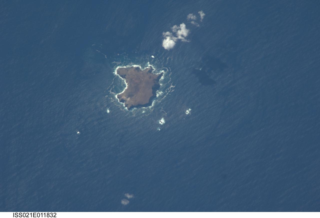
ISS021-E-011832 (22 Oct. 2009) --- The northern Savage Islands in the Atlantic Ocean are featured in this image photographed by an Expedition 21 crew member on the International Space Station. The Savage Islands, or Ilhas Selvagens in Portuguese, comprise a small archipelago in the eastern North Atlantic Ocean between the archipelago of Madeira to the north and the Canary Islands to the south. Like other island groups, the Savage Islands are thought to have been produced by volcanism related to a mantle plume or “hot spot”. Mantle plumes are relatively fixed regions of upwelling magma that can feed volcanoes on an overlying tectonic plate. Active volcanoes form over the plume, and become dormant as they are carried away on the moving tectonic plate. Scientists believe that over geologic time, this creates a line of older extinct volcanoes, seamounts, and islands extending from the leading active volcanoes that are currently over the plume. This view illustrates Selvagem Grande, the largest of the islands with an approximate area of four square kilometers. All of the islands of the archipelago are ringed by bright white breaking waves along the fringing beaches. Coral reefs that surround the Savage Islands make it very difficult to land boats there, and there is no permanent settlement on the islands.
The island of Phuket on the Indian Ocean coast of Thailand is a major tourist destination and was also in the path of the tsunami that washed ashore on December 26, 2004. These simulated natural color ASTER images show a 27 kilometer (17-mile) long stretch of coast north of the Phuket airport on December 31 (right), along with an image acquired two years earlier (left). The changes along the coast are obvious where the vegetation has been stripped away. http://photojournal.jpl.nasa.gov/catalog/PIA07227
The Republic of Maldives is a country located in the Indian Ocean, southwest of India. It comprises twenty-six atolls, and 1192 coral islands, with an average ground elevation of 1.5 m. Tourism and fishing account for more than half of the country's GDP. Kulhudhuffushi, seen in the upper right corner, is the capital of Haa Dhaalu Atoll administrative division in the north of the Maldives. The image was acquired April 3, 2013, covers an area of 30.3 by 45.2 km, and is located at 6.5 degrees north, 73 degrees east. http://photojournal.jpl.nasa.gov/catalog/PIA21166
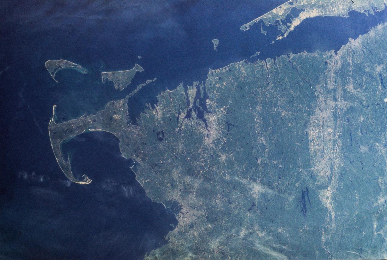
SL2-103-967 (22 June 1973) --- This view of lower New England, (41.5N, 72.0W) shows a rare cloud-free area stretching from northern Long Island across the states of Connecticut, Rhode Island and Massachusetts. The total area covered by this photo is more than 25,000 square miles and includes all of Rhode Island, most of Massachusetts and Connecticut, part of New York and the coastal waters of the Atlantic Ocean. Cape Cod, Boston and the offshore islands are distinctive features. Photo credit: NASA
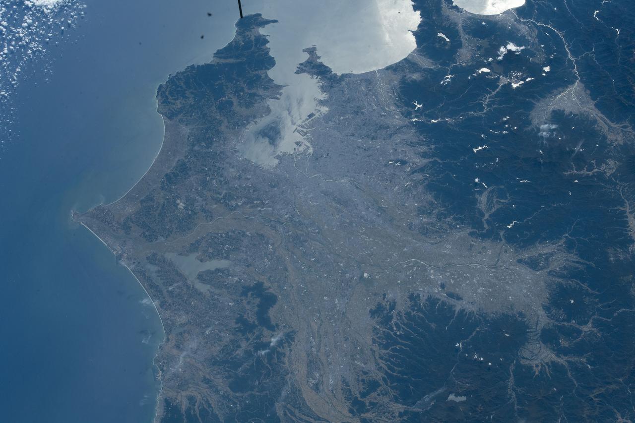
iss068e006998 (Oct. 2, 2022) --- Tokyo, Japan, on the coast of the Pacific Ocean, is pictured from the International Space Station as it orbited 260 miles above the island nation.
iss068e036382 (Jan. 2, 2023) --- A portion of the Atlantic Ocean surrounded by the island nation of the Bahamas is pictured from the International Space Station as it orbited 259 miles above.
iss064e059496 (April 14, 2021) --- A cloud formation swirls in the Atlantic Ocean south of Alaska's Aleutian Islands as the International Space Station soared 265 miles above.
iss066e108216 (Dec. 1, 2021) --- The island nation of the Bahamas is pictured from the International Space Station as it orbited 263 miles above the Atlantic Ocean.
iss063e084654 (Sept. 4, 2020) --- Inagua National Park, part of The Bahamas island nation, is pictured from the International Space Station as it was orbiting above the Atlantic Ocean.
S103-E-5361 (24 December 1999) --- This vertical view from the Space Shuttle Discovery shows two small islands of the Marianas Islands (Saipan and Tinian) in Micronesia in the Pacific Ocean. The STS-103 crew recorded this electronic still image at 28:05:53 GMT, December 24, 1999.

iss071e378497 (July 21, 2024) -- The Quirimbas Islands lie in the western Indian Ocean off the coast of Mozambique. The archipelago consists of 32 islands, partially linked to the coastline by coral reefs, mangroves, and sand bars. As the International Space Station orbited 262 miles above, NASA astronaut Matthew Dominick captured this photo.

iss065e051411 (May 23, 2021) --- A starry sky, an atmospheric glow and the night lights of the island nation of Mauritius (center left) and Réunion Island (bottom right), a French department, stand out as the International Space Station orbited 265 miles above of Madagascar on its northeast Indian Ocean coast.

iss056e129864 (Aug. 7, 2018) --- Hurricane Hector was pictured by an Expedition 56 crew member as the International Space Station orbited 250 miles above the Pacific Ocean almost due south of the big island of Hawaii which anchors the Hawaiian island chain.
iss055e005323 (March 25, 2018) --- The International Space Station was orbiting above the Tasman Sea when an Expedition 55 crew member took this picture of New Zealand's North Island where the city of Auckland is located. The sun's glint over the South Pacific Ocean and the Tasman Sea clearly outlines the island nation.
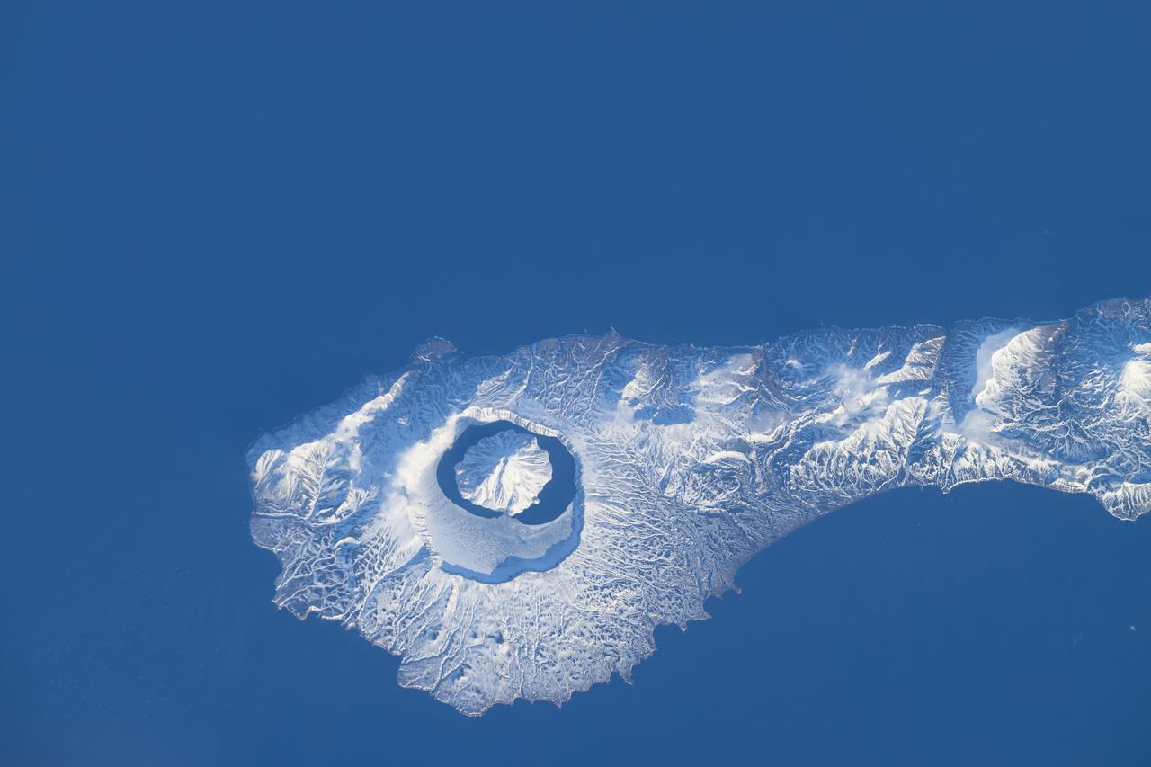
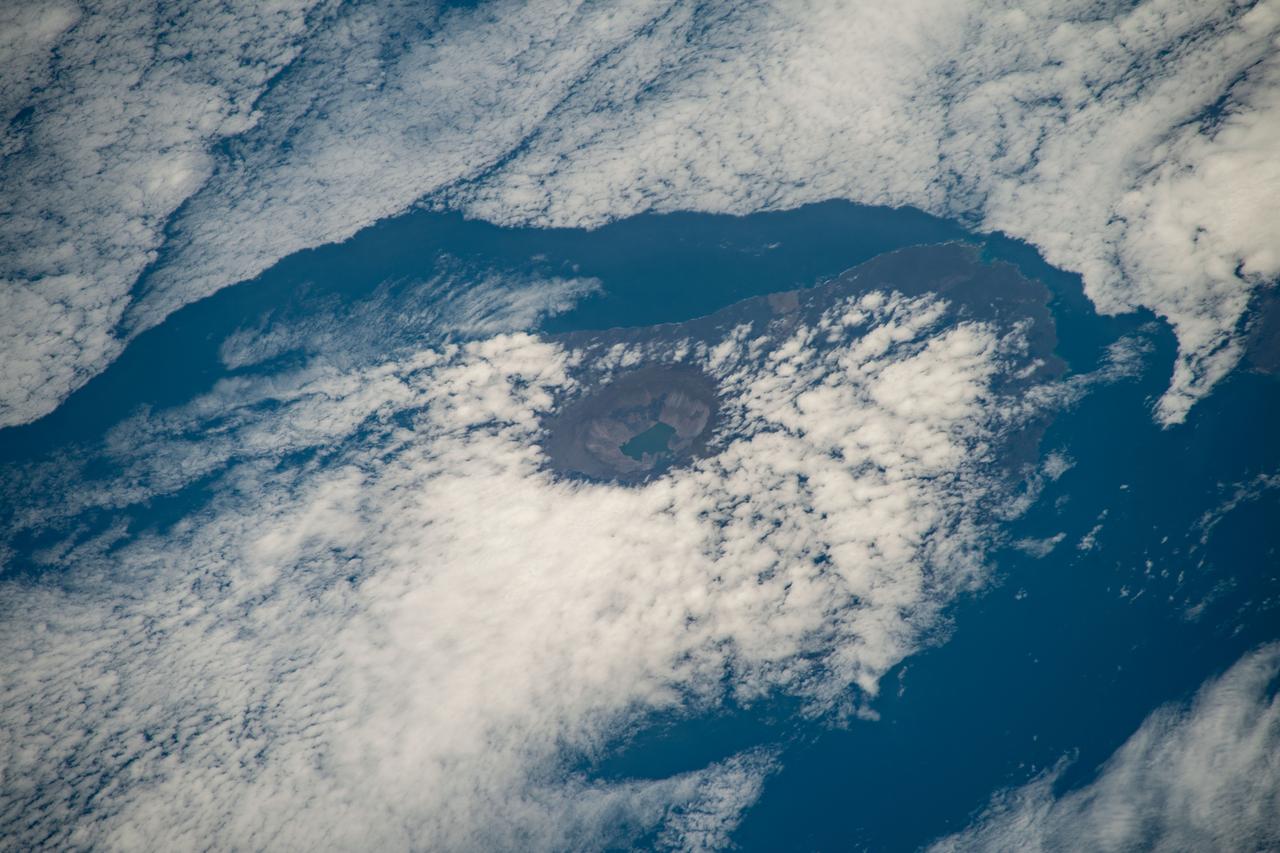
iss071e046424 (April 29, 2024) --- The snow-covered Onekotan Island, part of Russia's Kuril Islands, is home to the Tao-Rusyr Caldera stratovolcano in this photograph. Inside the caldera is the Krenitsyna Volcano peak surrounded by the partially ice-covered Kol'tsevoe Lake. The International Space Station was orbiting 259 miles above the Pacific Ocean at the time of this photograph.
iss066e137869 (Feb. 8, 2022) --- Hawaii's big island and its two major volcanoes Mauna Kea and Mauna Loa are pictured from the International Space Station as it orbited 258 miles above the Pacific Ocean south of the Hawaiian island chain
ss069e033721 (July 17, 2023) -- The Great Exuma, an island in the Bahamas, is pictured from the International Space Station as it soared 259 miles above. The bright teal water of the Atlantic Ocean can be seen surrounding the island, while the Exuma International Airport is seen near the center of the land.
iss068e025399 (Nov. 28, 2022) --- From top, the peaks of Wolf Volcano and Darwin Volcano on Ecuador's Isabel Island, part of the Galapagos Islands, are surrounded by clouds in this photograph from the International Space Station as it orbited 261 miles above the Pacific Ocean.
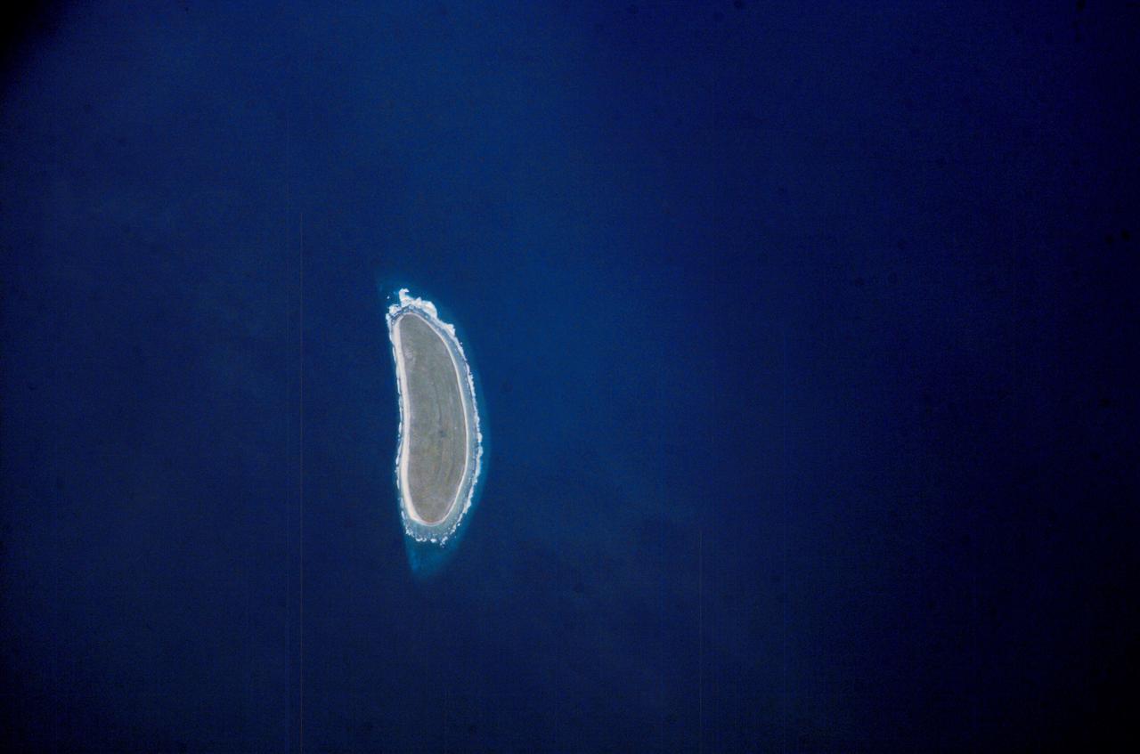
ISS010-E-09287 (3 December 2004) --- Howland Island, Oceania is featured in this digital image photographed by an Expedition 10 crewmember on the International Space Station (ISS). Howland Island is a United States possession located in the north Pacific between Australia and the Hawaiian Islands. Prior to 1890, organic nitrate (guano) was mined from the island by both the United States and the British. This tiny island is currently part of the US National Wildlife Refuge system, and provides nesting areas and forage for a variety of birds and marine wildlife. The island is composed of coral fragments and is surrounded by an active fringing reef. White breakers encircling the island indicate the position of the reef. Astronauts aboard the Space Station photograph numerous reefs around the world as part of a global mapping and monitoring program. High-resolution images such as this one are used to update geographic maps of reefs and islands, assess the health of reef ecosystems, and calculate bathymetry of the surrounding ocean bottom.
The entire Hawaiian Island Archipelago (21.5N, 158.0W) is seen in this single view. The islands are a favorite international resort and tourist attraction drawing visitors from all over the world to enjoy the tropical climate, year round beaches and lush island flora. Being volcanic in origin, the islands' offer a rugged landscape and on the big island of Hawaii, there is still an occasional volcanic eruption of lava flows and steam vents.
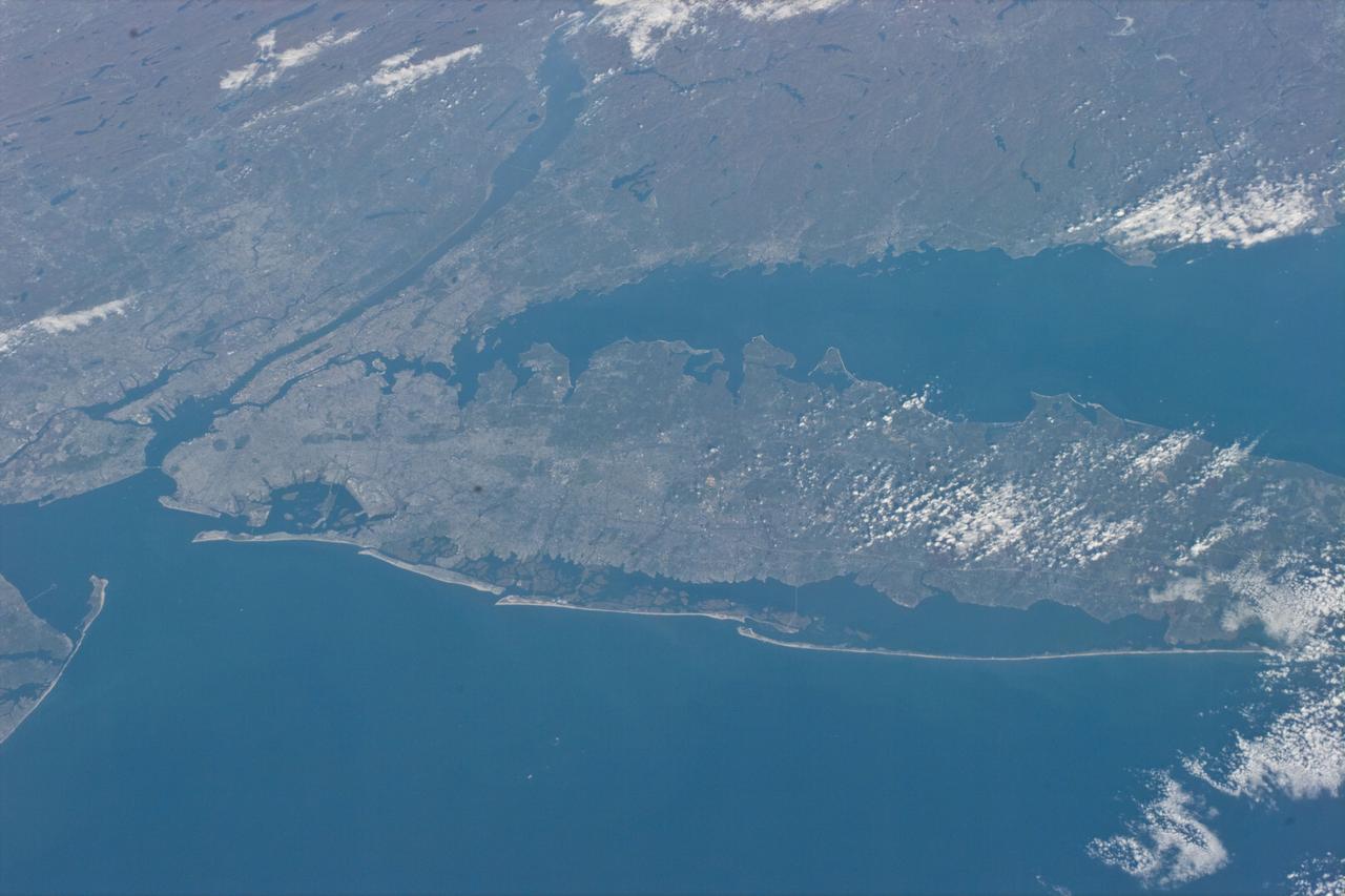
STS073-E-5098 (30 Oct. 1995) --- Long Island, New York stretches across the scene. The New York City metropolitan complex is at the left; Central Park can be seen as a dark rectangle between the Hudson and East Rivers. Sandy beaches of the Long Island barrier islands mark the boundary between Atlantic Ocean and quiet lagoons and marshes. The frame was exposed with the Electronic Still Camera (ESC).
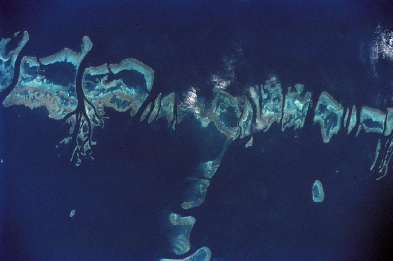
STS111-368-036 (5-19 June 2002) --- This photo, giving detail of the Pompey Island Group in the Southern Great Barrier Reef off Australia, was taken by the STS-111 crewmembers aboard the Space Shuttle Endeavour. Ocean flow between the islands has produced unique wash features in the structures of the island banks. The Gateway to Astronaut Photography of Earth (link to http://eol.jsc.nasa.gov/sseop/) provides searchable access to other photographs of Earth taken by astronauts.
The city of Sapporo on the northernmost of the Japanese Home Island of Hokkaido (43.5N, 141.5E), host to the 1986 Winter Olympic Games is situated along the margin of a large valley which extends across the island from the Sea of Japan to the Pacific Ocean. The Valley is largely cultivated (the lighter green of the cultivated land distinguishes it from the gray urban development of Sapporo), but much of the island remains heavily forested.
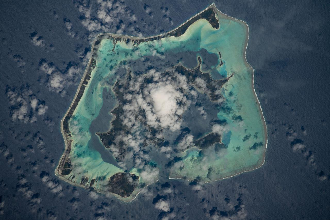
STS008-32-748 (30 Aug-5 Sept 1983) --- Bora-Bora, with its wide-fringing reef, stands out in the center of this photographed, taken over the Society Island chain from the Earth-orbiting Space Shuttle Challenger on its third spaceflight. In the upper left corner are the islands of Raiatea and Tahaa. The ancient volcano islands are very slowly sinking into the oceanic crust, while coral growth maintains a reef platform.
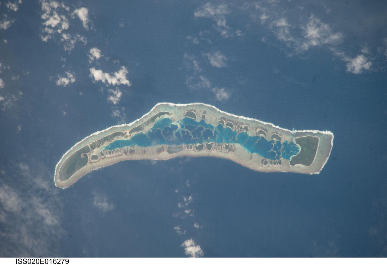
ISS020-E-016279 (1 July 2009) --- Millennium Island is featured in this image photographed by an Expedition 20 crew member on the International Space Station. Millennium Island ? known as Caroline Island prior to 2000 ? is located at the southern end of the Line Islands in the South Pacific Ocean. This uninhabited island is part of the Republic of Kiribati, an island nation comprised of 32 atolls (including Millennium Island) and one raised coral island. Millennium Island is formed from a number of smaller islets built on coral reefs. The coral reefs grew around a now-submerged volcanic peak, leaving a ring of coral around an inner lagoon. The islands above the waterline are composed primarily of limestone rock and sand derived from the reefs. At a maximum height of approximately 6 m above sea level, Millennium Island has been identified as being at great risk from sea level rise by the United Nations. The islets of Millennium Island are readily visible in this photograph as irregular green vegetated areas surrounding the inner lagoon. The shallow lagoon waters are a lighter blue than the deeper surrounding ocean water; tan linear ?fingers? within the lagoon are the tops of corals. The two largest islets are Nake Islet and South Islet, located at the north and south ends of Millennium Island respectively. The ecosystem of Millennium Island is considered to be relatively pristine despite periods of human habitation, guano mining, and agricultural activities, and the island has been recommended as both a World Heritage site and Biosphere Reserve.
iss068e054896 (Feb. 17, 2023) --- The last rays of an orbital sunset fade into the Earth's atmosphere in this photograph from the International Space Station as it orbited 269 miles above the Atlantic Ocean off the coast of the Falkland Islands, or the Islas Malvinas.
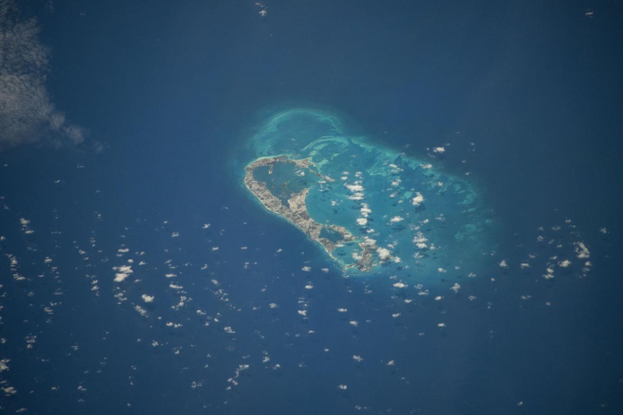
iss071e206529 (June 19, 2024) -- In the North Atlantic Ocean lies Bermuda, an archipelago of more than 180 islands and islets. As the International Space Station orbited 265 miles above, NASA astronaut Matthew Dominick captured this photo.
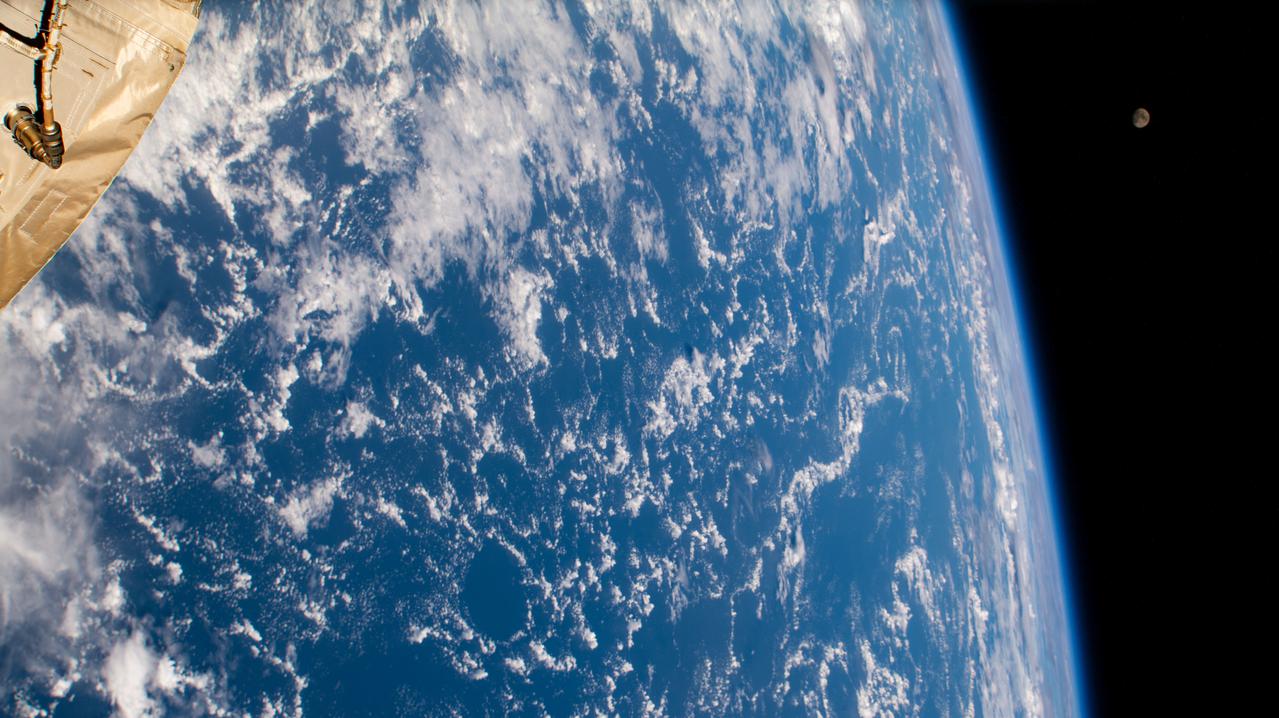
iss060e002083 (June 29, 2019) --- Earth's atmospheric glow, highlighted by the Moon and a starry orbital nighttime background, are pictured as the International Space Station orbited 256 miles above the Pacific Ocean, southeast of the Hawaiian island chain.
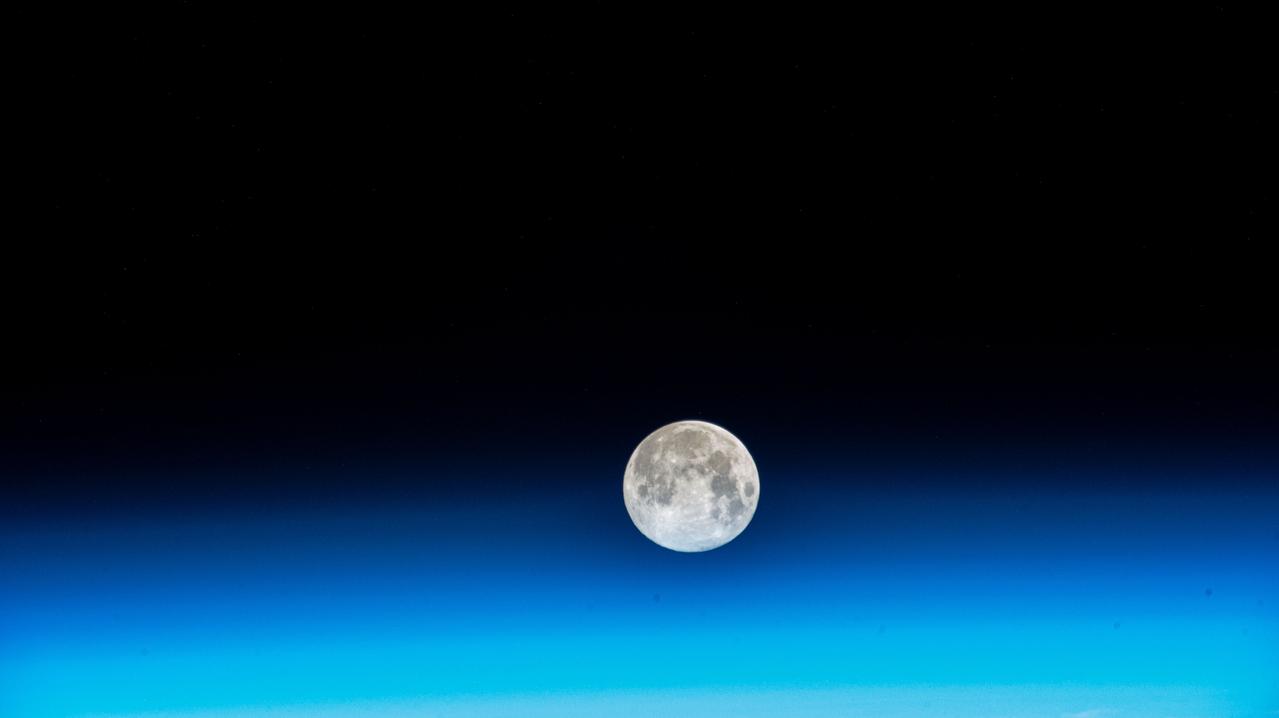
iss071e515452 (Aug. 19, 2024) --- The Full Moon pictured above Earth's horizon as the International Space Station soared 262 miles above the Indian Ocean south of the African island nation of Madagascar.
iss060e007130 (July 12, 2019) --- The Sun's glint beams off the blue waters of the Pacific Ocean as the International Space Station orbited 254 miles above Earth south of the Hawaiian island chain.
iss070e048478 (Dec. 26, 2023) --- The near Full Moon is pictured just above Earth's atmosphere in this photograph from the International Space Station as it orbited 262 miles above the north Pacific Ocean south of Alaska's Aleutian Islands.
iss064e004315 (Nov. 13, 2020) --- Cloudy seas are pictured from the International Space Station as it orbited 260 miles above the Pacific Ocean about 1,100 miles due south of the Hawaiian island chain.
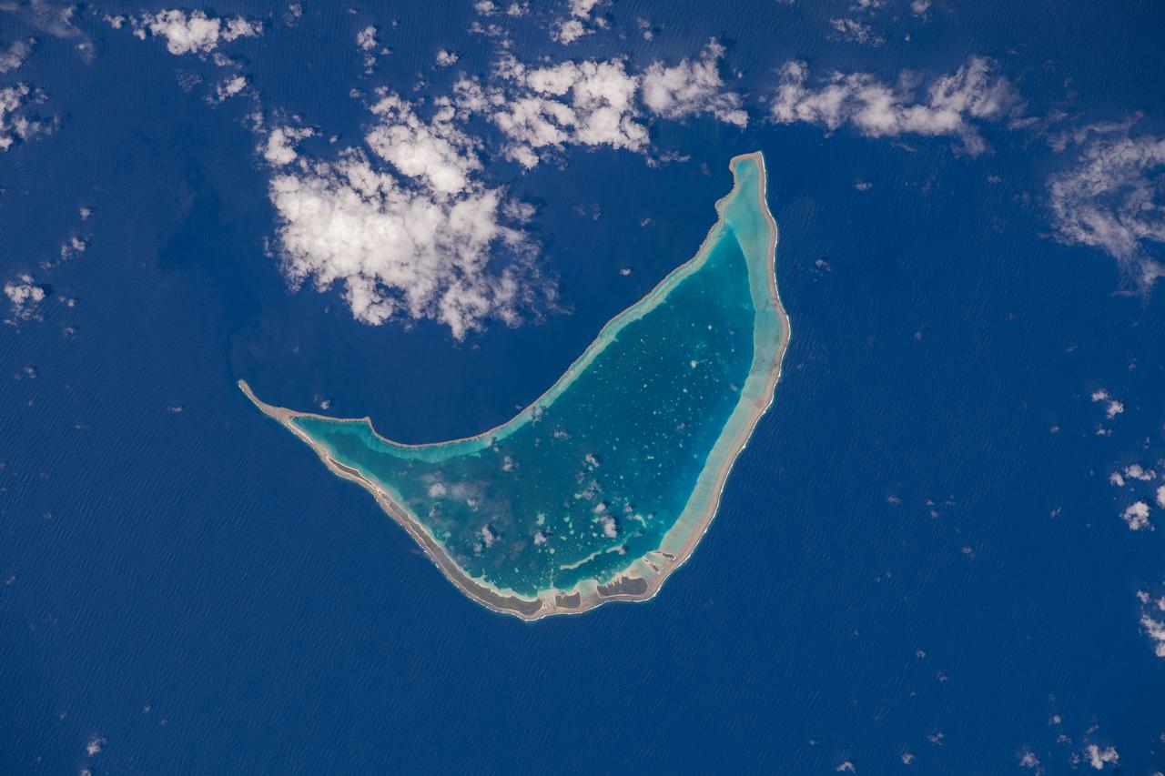
iss072e012016 (Oct. 3, 2024) -- The vibrant turquoise water surrounding the Turks and Caicos Islands contrasts against the deep blue of the Atlantic Ocean in this image taken from the International Space Station as it orbited 256 miles above.
iss065e280824 (Aug. 19, 2021) --- The waxing gibbous Moon (upper right) is pictured from the International Space Station as it orbited 262 miles above the Atlantic Ocean just east of the Lesser Antilles, a group of islands in the Caribbean Sea.
iss061e025964 (Oct. 31, 2019) --- The French Polynesian island of Bora Bora, surrounded by the Bora Main Motu Reef, is pictured as the International Space Station orbited 257 miles above the South Pacific Ocean.
iss072e715777 (Feb. 28, 2025) --- Eleuthera, an island state that is part of the Bahamas archipelago, is pictured in the Atlantic Ocean from the International Space Station as it orbited 262 miles above.

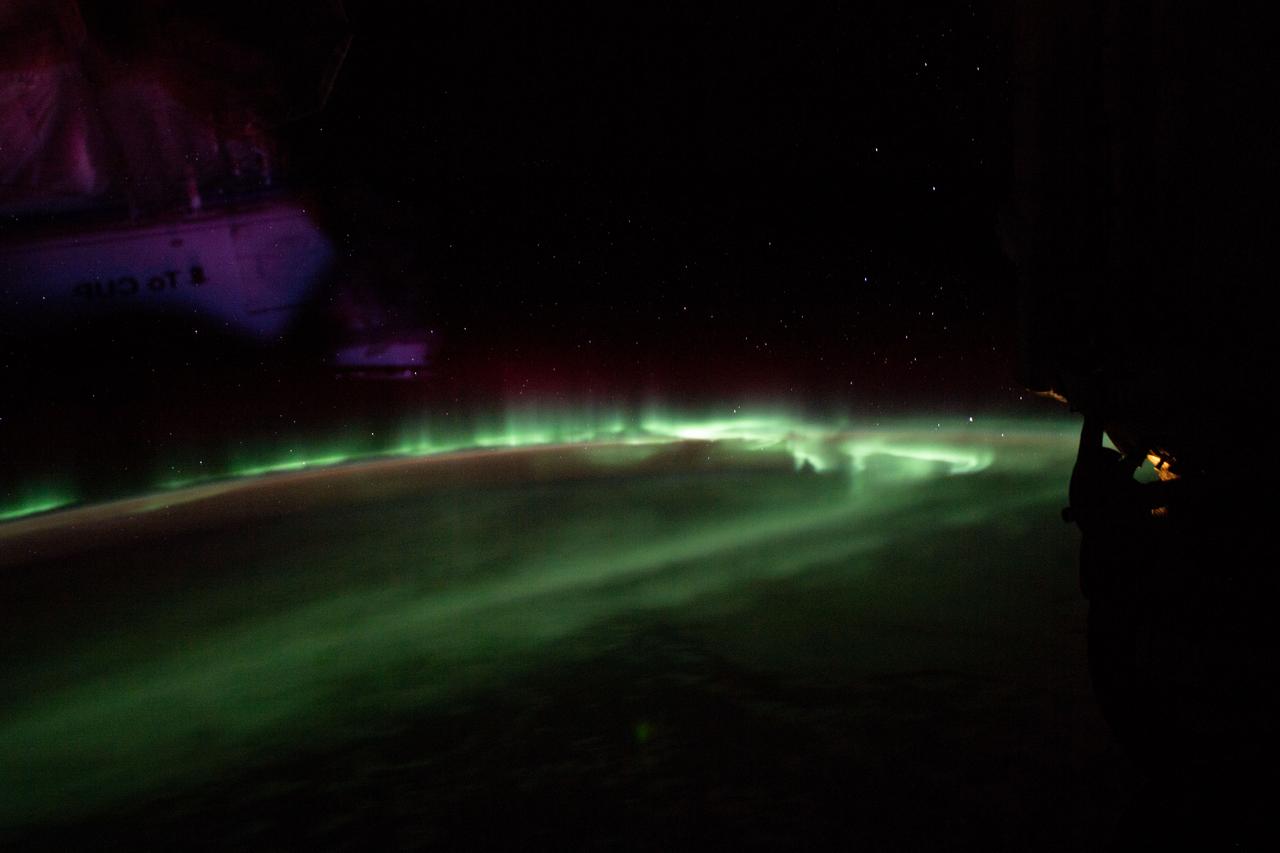
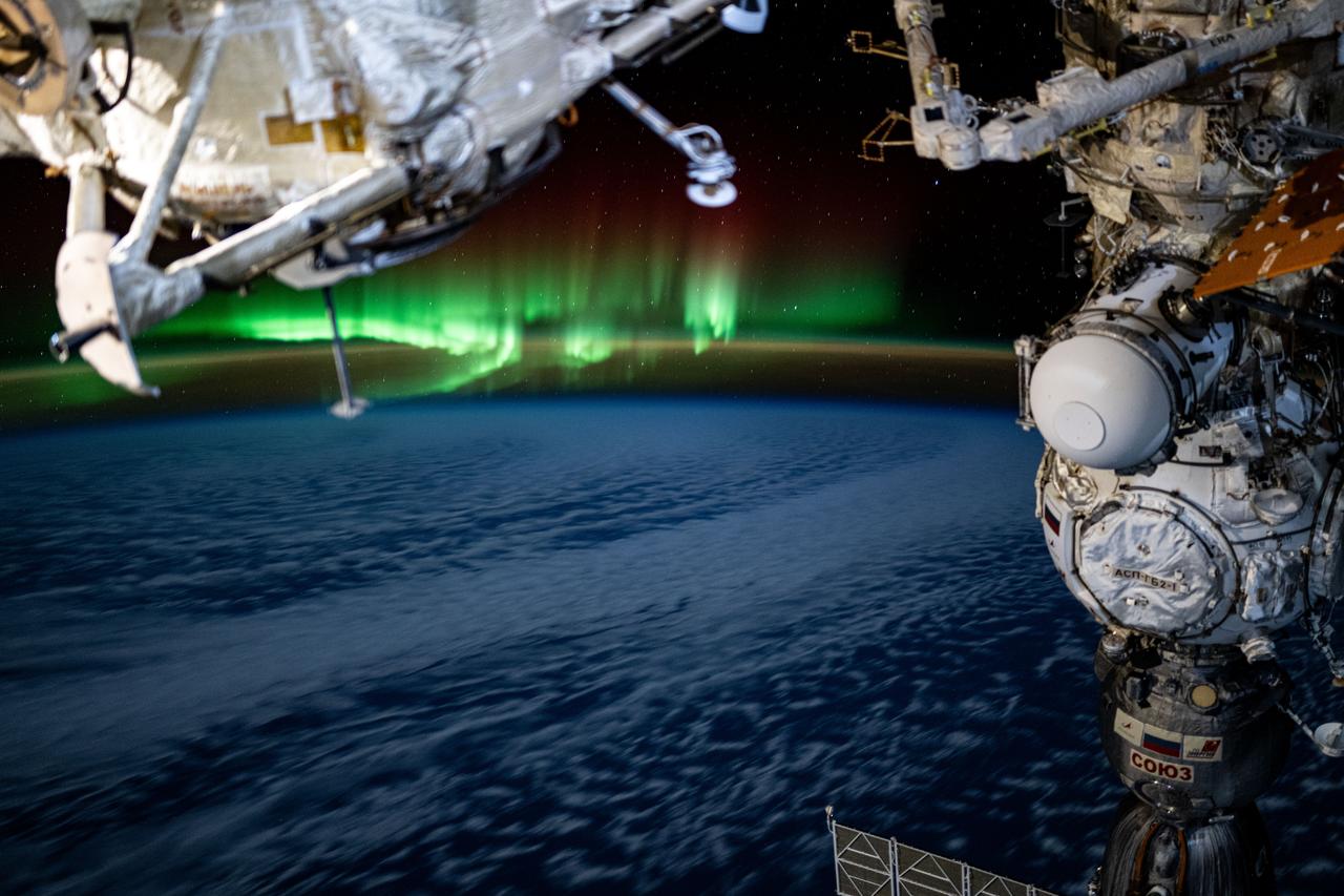
iss071e693961 (Sept. 15, 2024) --- An aurora crowns Earth's horizon in this photograph from the International Space Station as it orbited 265 miles above a cloudy Pacific Ocean southeast of the Kuril Islands.
iss066e008725 (Oct. 22, 2021) --- The airglow blankets the Earth's horizon in this photograph from the International Space Station as it orbited 262 miles above the Pacific Ocean just south of the Hawaiian island chain.
Earth observation taken during a night pass by the Expedition 36 crew. Per Twitter message: Seven Sisters overlooking Reunion & Mauritius Islands in a moonlit Indian Ocean.
iss068e000304 (Sept. 29, 2022) --- Taongi Atoll, in the independent country of the Marshall Islands, is pictured from the International Space Station as it orbited 258 miles above the Pacific Ocean.
iss061e026166 (Oct. 31, 2019) --- The island nation of Cuba is pictured in the rich blue waters between the Caribbean Sea and the Atlantic Ocean as the International Space Station orbited 255 miles above.
iss059e020015 (April 12, 2019) --- The aurora australis, also known as the "southern lights," is pictured as the International Space Station orbited 264 miles above the Indian Ocean south of the Australian island state of Tasmania.
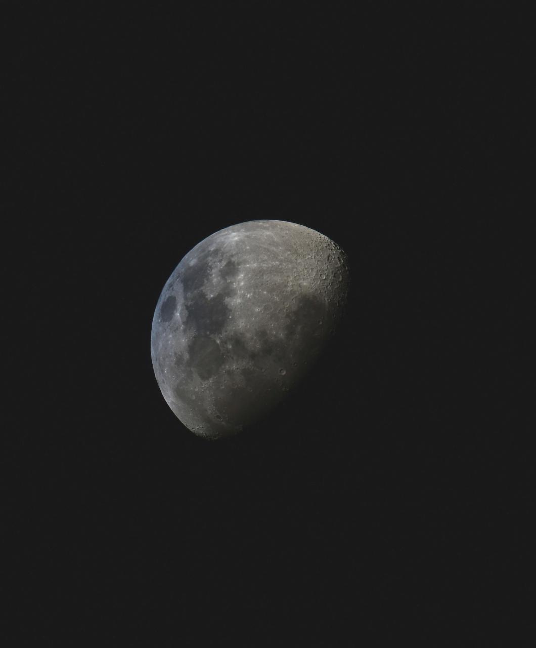
iss064e025547 (Jan. 23, 2021) --- The waxing gibbous Moon is pictured from the International Space Station as it orbited 263 miles above the Pacific Ocean near the island state of Samoa and the U.S. territory of American Samoa. Credit: Roscosmos
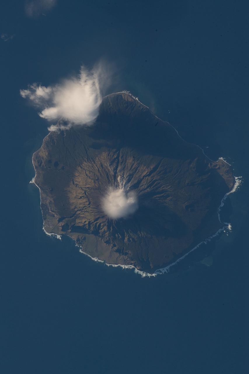
iss056e097317 (July 18, 2018) --- Queen Mary's Peak on the British territorial island of Tristan Da Cunha is pictured as the International Space Station was orbiting nearly 260 miles above the South Atlantic Ocean.
iss066e152100 (Feb. 22, 2022) --- The sun rises above the horizon illuminating the Earth in this photograph from the International Space Station as it orbited 262 above the Pacific Ocean south of Alaska's Aleutian Islands.
iss055e023500 (April 13, 2018) --- The cloud-covered Galapagos Islands and the sun's glint in the waters off the coast of Ecuador are pictured as the International Space Station orbited above the Pacific Ocean.
iss072e188141 (Nov. 15, 2024) --- A bright green aurora borealis streams above Earth's surface as the International Space Station orbited 269 miles above a cloudy North Pacific Ocean south of Alaska's Aleutian Islands.

iss060e002044 (June 29, 2019) --- An atmospheric glow blankets Earth beneath a starry night sky as the International Space Station orbited 271 miles above the Indian Ocean, south of the Australian island state of Tasmania.
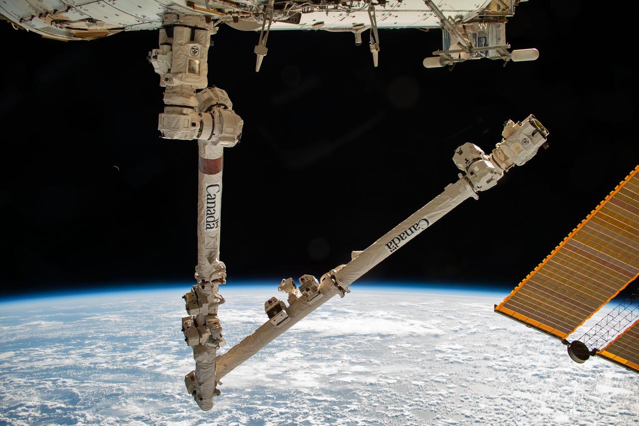
iss070e006089 (Oct. 18, 2023) --- The Canadarm2 robotic arm is pictured extending from the International Space Station while orbiting 260 miles above the Pacific Ocean near the Aleutian Islands.
iss067e221404 (July 31, 2022) --- The sun illuminates Earth's limb as the International Space station soared 271 miles above the Pacific Ocean south of the Australian island state of Tasmania.
iss070e026322 (Nov. 17, 2023) --- The Quirimbas Islands off the northeastern coast of Mozambique in the Indian Ocean are pictured from the International Space Station as it orbited 262 miles above the African nation.
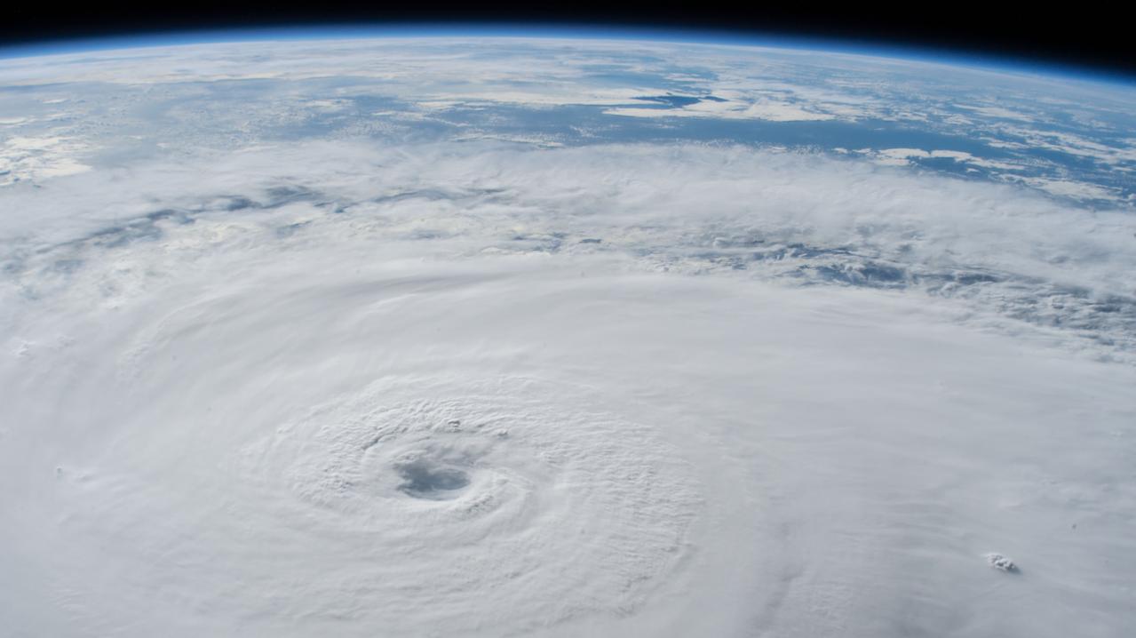
iss056e150297 (Aug. 21, 2018) --- Hurricane Lane, with its well-defined eye, was pictured as a category 4 storm southwest of the Hawaiian Islands as the International Space Station orbited almost 252 miles above the Pacific Ocean.
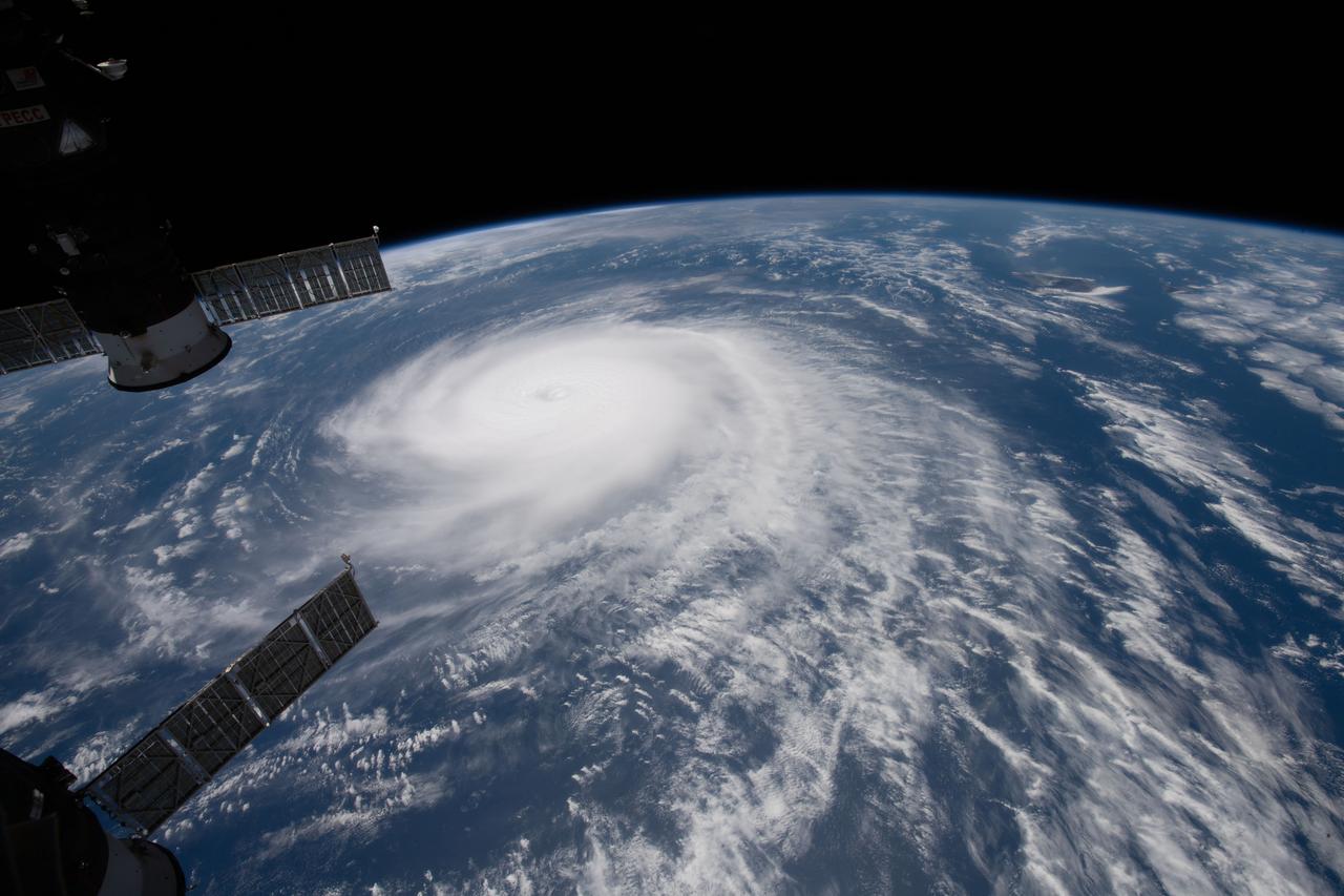
iss056e129968 (Aug. 3, 2018) --- Hurricane Hector was pictured by an Expedition 56 crew member as the International Space Station orbited nearly 250 miles above the Pacific Ocean east of the Hawaiian island chain.
iss071e142810 (May 29, 2024) --- An aurora swirls above the Indian Ocean in this photograph from the International Space Station as it orbited 266 miles above and due south of Australia's island state of Tasmania.
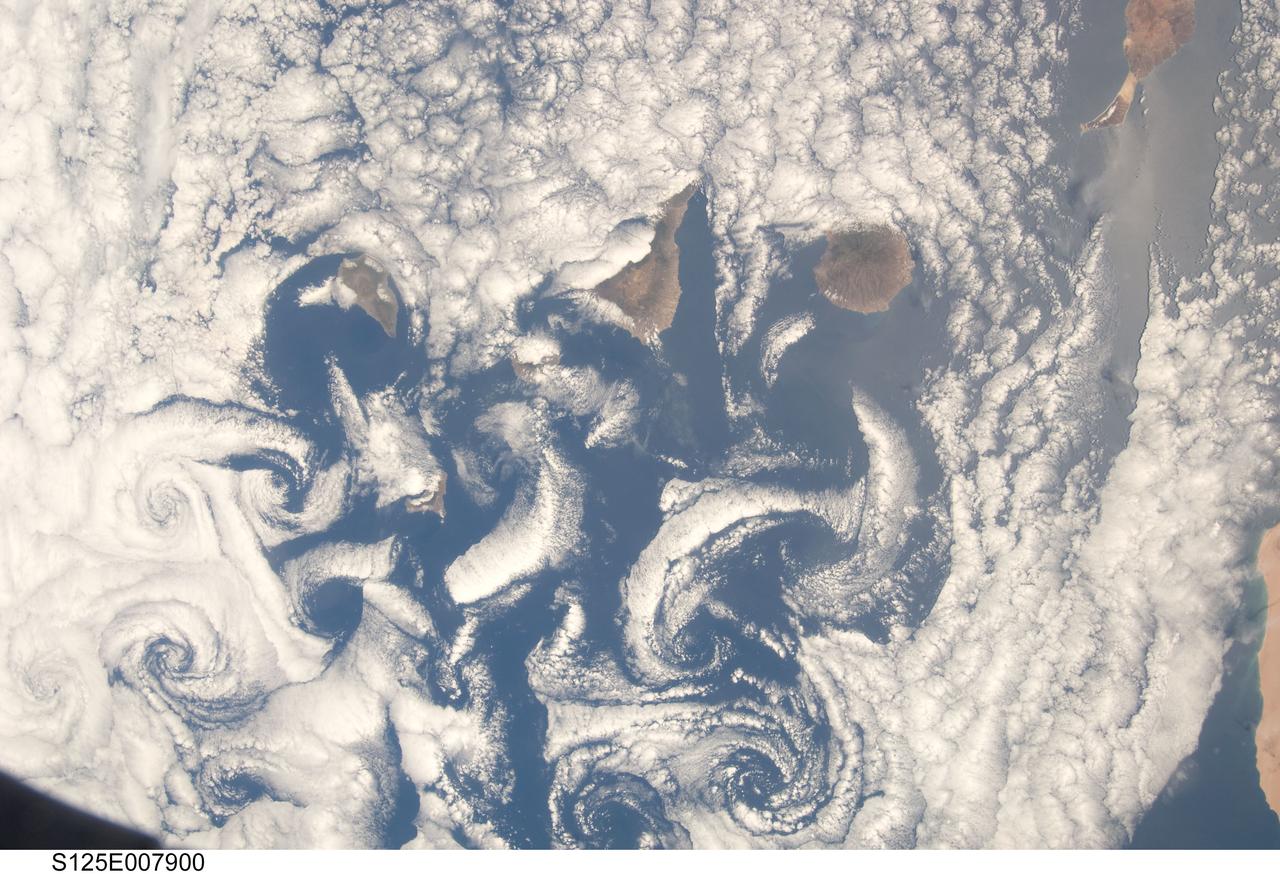
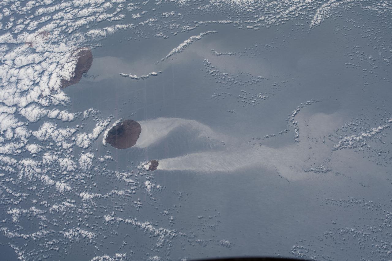
S125-E-007900 (16 May 2009) --- A nadir view of cloud vortices in the area of the Canary Islands in the North Atlantic Ocean was recorded by one of the STS-125 crewmembers on a busy flight day six.