
NASA Aircraft on ramp (Aerial view) Sides: (L) QSRA (R) C-8A AWJSRA - Back to Front: CV-990 (711) C-141 KAO, CV-990 (712) Galileo, T-38, YO-3A, Lear Jet, X-14, U-2, OH-6, CH-47, SH-3G, RSRA, AH-1G, XV-15, UH-1H

NASA Aircraft on ramp (Aerial view) Sides: (L) QSRA (R) C-8A AWJSRA - Back to Front: CV-990 (711) C-141 KAO, CV-990 (712) Galileo, T-38, YO-3A, Lear Jet, X-14, U-2, OH-6, CH-47, SH-3G, RSRA, AH-1G, XV-15, UH-1H

The astronaut mascot holds the 6 collectable postcards designed for the Total Eclipse Fest at the Great Lakes Science Center in Cleveland, OH on April 6, 2024. A total solar eclipse swept across a narrow portion of the North American continent from Mexico’s Pacific coast to the Atlantic coast of Newfoundland, Canada. A partial solar eclipse was visible across the entire North American continent along with parts of Central America and Europe.

NASA’s Advanced Air Mobility National Campaign used this Bell OH-58 helicopter owned by Flight Research Inc. to study urban air mobility vehicle performance, flying qualities, and airspace requirements. The helicopter performed test maneuvers at NASA’s Armstrong Flight Research Center in Edwards, California, during two sessions Nov, 8-10, and Dec. 6, and 8-10.
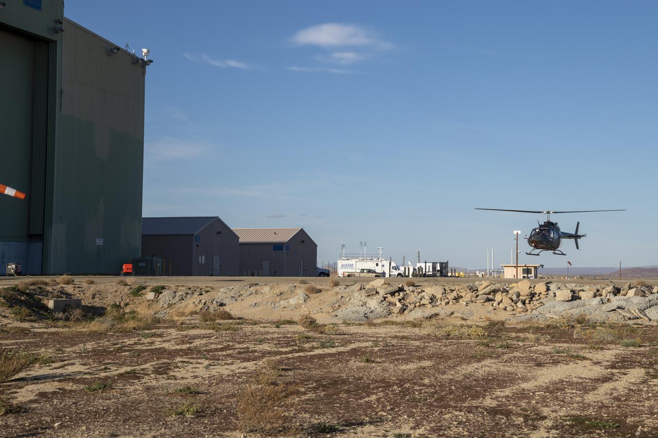
NASA’s Advanced Air Mobility National Campaign flies maneuvers at NASA’s Armstrong Flight Research Center in Edwards, California, Dec. 6, and 8-10. During this testing, the helicopter is used to study controllability characteristics when operating near buildings during heavy wind conditions. The Bell OH-58 Kiowa helicopter provided by Flight Research Inc. was used to study urban air mobility vehicle performance and flying qualities requirements.
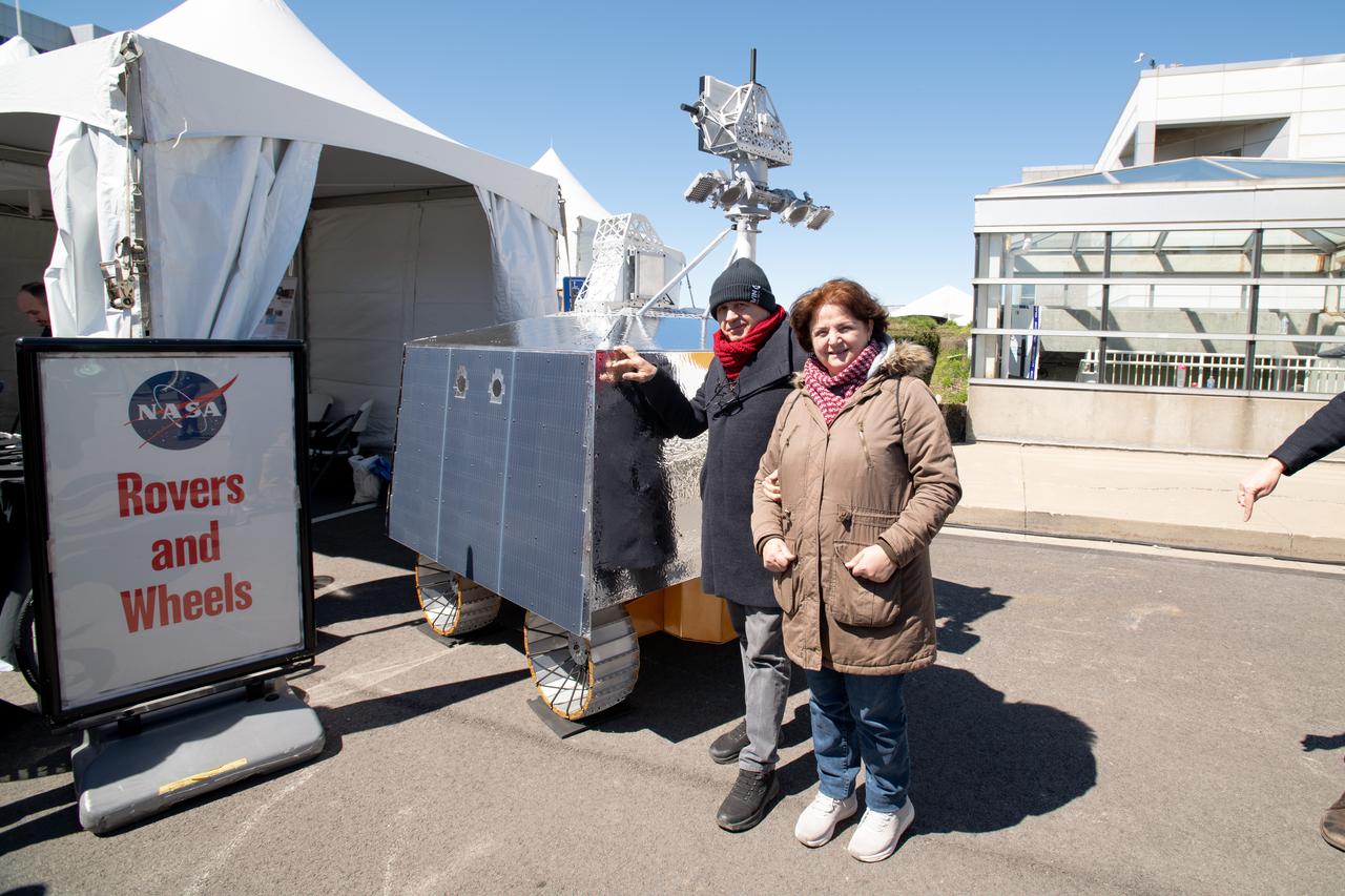
Event Attendees at pose in front of the VIPER model at the Total Eclipse Fest at the Great Lakes Science Center in Cleveland, OH April 6, 2024. A total solar eclipse swept across a narrow portion of the North American continent from Mexico’s Pacific coast to the Atlantic coast of Newfoundland, Canada. A partial solar eclipse was visible across the entire North American continent along with parts of Central America and Europe.

Guests pose for a photo at the Total Solar Eclipse Fest at the Great Lakes Science Center in Cleveland, OH April 6, 2024. A total solar eclipse swept across a narrow portion of the North American continent from Mexico’s Pacific coast to the Atlantic coast of Newfoundland, Canada. A partial solar eclipse was visible across the entire North American continent along with parts of Central America and Europe.
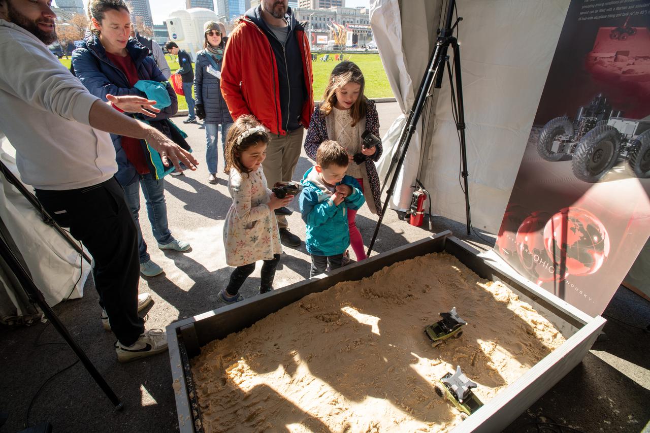
Guests interact with the VIPER exhibit at the Total Solar Eclipse Fest at the Great Lakes Science Center in Cleveland, OH on April 6, 2024. A total solar eclipse swept across a narrow portion of the North American continent from Mexico’s Pacific coast to the Atlantic coast of Newfoundland, Canada. A partial solar eclipse was visible across the entire North American continent along with parts of Central America and Europe. Photo Credit: (NASA/Sara Lowthian-Hanna)

Flight Research Inc.'s Bell OH-58 helicopter performs different test maneuvers at NASA's Armstrong Flight Research Center in Edwards, California, Nov. 8-10, and Dec. 6, and 8-10. NASA's Advanced Air Mobility National Campaign used the helicopter to study urban air mobility vehicle performance and flying qualities requirements.
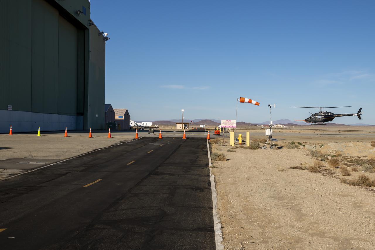
NASA's Advanced Air Mobility National Campaign conducts testing to study controllability characteristics when operating near buildings during heavy wind conditions at NASA's Armstrong Flight Research Center in Edwards, California, Dec. 6 and 8-10. The Bell OH-58 Kiowa helicopter provided by Flight Research Inc. was used to study urban air mobility vehicle performance and flying qualities requirements.
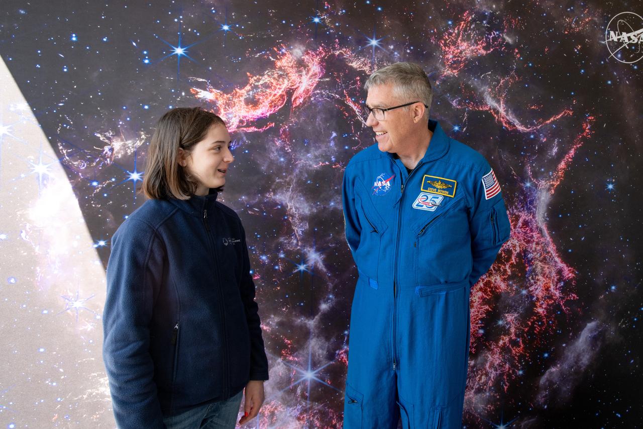
A guest interacts with Astronaut Stephen Bowen during meet and greets at the Total Eclipse Fest at the Great Lakes Science Center in Cleveland, OH on April 6, 2024. A total solar eclipse swept across a narrow portion of the North American continent from Mexico’s Pacific coast to the Atlantic coast of Newfoundland, Canada. A partial solar eclipse was visible across the entire North American continent along with parts of Central America and Europe.
![The combination of morphological and topographic information from stereo images from NASA's Mars Reconnaissance Orbiter, as well as compositional data from near-infrared spectroscopy has been proven to be a powerful tool for understanding the geology of Mars. Beginning with the OMEGA instrument on the European Space Agency's Mars Express orbiter in 2003, the surface of Mars has been examined at near-infrared wavelengths by imaging spectrometers that are capable of detecting specific minerals and mapping their spatial extent. The CRISM (Compact Reconnaissance Imaging Spectrometer for Mars) instrument on our orbiter is a visible/near-infrared imaging spectrometer, and the HiRISE camera works together with it to document the appearance of mineral deposits detected by this orbital prospecting. Mawrth Vallis is one of the regions on Mars that has attracted much attention because of the nature and diversity of the minerals identified by these spectrometers. It is a large, ancient outflow channel on the margin of the Southern highlands and Northern lowlands. Both the OMEGA and CRISM instruments have detected clay minerals here that must have been deposited in a water-rich environment, probably more than 4 billion years ago. For this reason, Mawrth Vallis is one of the two candidate landing sites for the future Mars Express Rover Mission planned by the European Space Agency. This image was targeted on a location where the CRISM instrument detected a specific mineral called alunite, KAl3(SO4)2(OH)6. Alunite is a hydrated aluminum potassium sulfate, a mineral that is notable because it must have been deposited in a wet acidic environment, rich in sulfuric acid. Our image shows that the deposit is bright and colorful, and extensively fractured. The width of the cutout is 1.2 kilometers. The map is projected here at a scale of 50 centimeters (19.7 inches) per pixel. [The original image scale is 60.1 centimeters (23.7 inches) per pixel (with 2 x 2 binning); objects on the order of 180 centimeters (70.9 inches) across are resolved.] North is up. https://photojournal.jpl.nasa.gov/catalog/PIA21936](https://images-assets.nasa.gov/image/PIA21936/PIA21936~medium.jpg)
The combination of morphological and topographic information from stereo images from NASA's Mars Reconnaissance Orbiter, as well as compositional data from near-infrared spectroscopy has been proven to be a powerful tool for understanding the geology of Mars. Beginning with the OMEGA instrument on the European Space Agency's Mars Express orbiter in 2003, the surface of Mars has been examined at near-infrared wavelengths by imaging spectrometers that are capable of detecting specific minerals and mapping their spatial extent. The CRISM (Compact Reconnaissance Imaging Spectrometer for Mars) instrument on our orbiter is a visible/near-infrared imaging spectrometer, and the HiRISE camera works together with it to document the appearance of mineral deposits detected by this orbital prospecting. Mawrth Vallis is one of the regions on Mars that has attracted much attention because of the nature and diversity of the minerals identified by these spectrometers. It is a large, ancient outflow channel on the margin of the Southern highlands and Northern lowlands. Both the OMEGA and CRISM instruments have detected clay minerals here that must have been deposited in a water-rich environment, probably more than 4 billion years ago. For this reason, Mawrth Vallis is one of the two candidate landing sites for the future Mars Express Rover Mission planned by the European Space Agency. This image was targeted on a location where the CRISM instrument detected a specific mineral called alunite, KAl3(SO4)2(OH)6. Alunite is a hydrated aluminum potassium sulfate, a mineral that is notable because it must have been deposited in a wet acidic environment, rich in sulfuric acid. Our image shows that the deposit is bright and colorful, and extensively fractured. The width of the cutout is 1.2 kilometers. The map is projected here at a scale of 50 centimeters (19.7 inches) per pixel. [The original image scale is 60.1 centimeters (23.7 inches) per pixel (with 2 x 2 binning); objects on the order of 180 centimeters (70.9 inches) across are resolved.] North is up. https://photojournal.jpl.nasa.gov/catalog/PIA21936