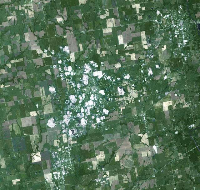
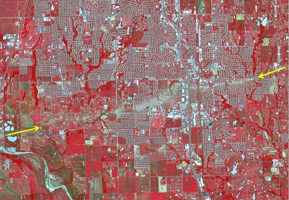
NASA Terra spacecraft acquired this image of Picher, Oklahoma which once boasted 20,000 people in this mining town in northeast Oklahoma. Now, after a 2009 tornado, and a federal cleanup program, the town is a modern-day ghost town.
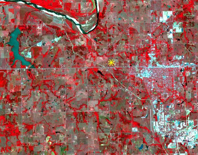
On Sunday, Nov. 6, 2016, at 7:44 p.m. local time, a magnitude 5.0 earthquake struck near the town of Cushing, Oklahoma. Numerous buildings were damaged by the temblor, but only a few minor injuries were reported. Cushing is home to one of the world's largest oil storage terminals; no damage was reported to the petroleum facilities. A star marks the epicenter of the earthquake,which occurred at a depth of 3.1 miles (5 kilometers). The image was acquired April 28, 2011, covers an area of 7 by 9 miles (11.4 by 14.5 kilometers), and is located at 36 degrees north, 96.8 degrees west. http://photojournal.jpl.nasa.gov/catalog/PIA21099
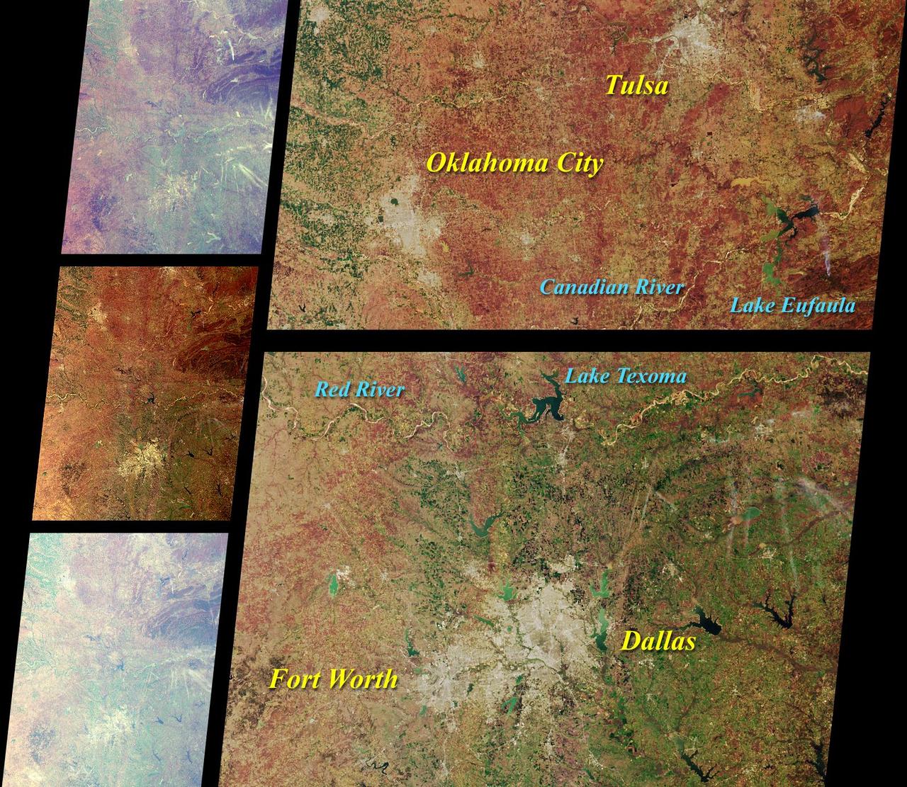
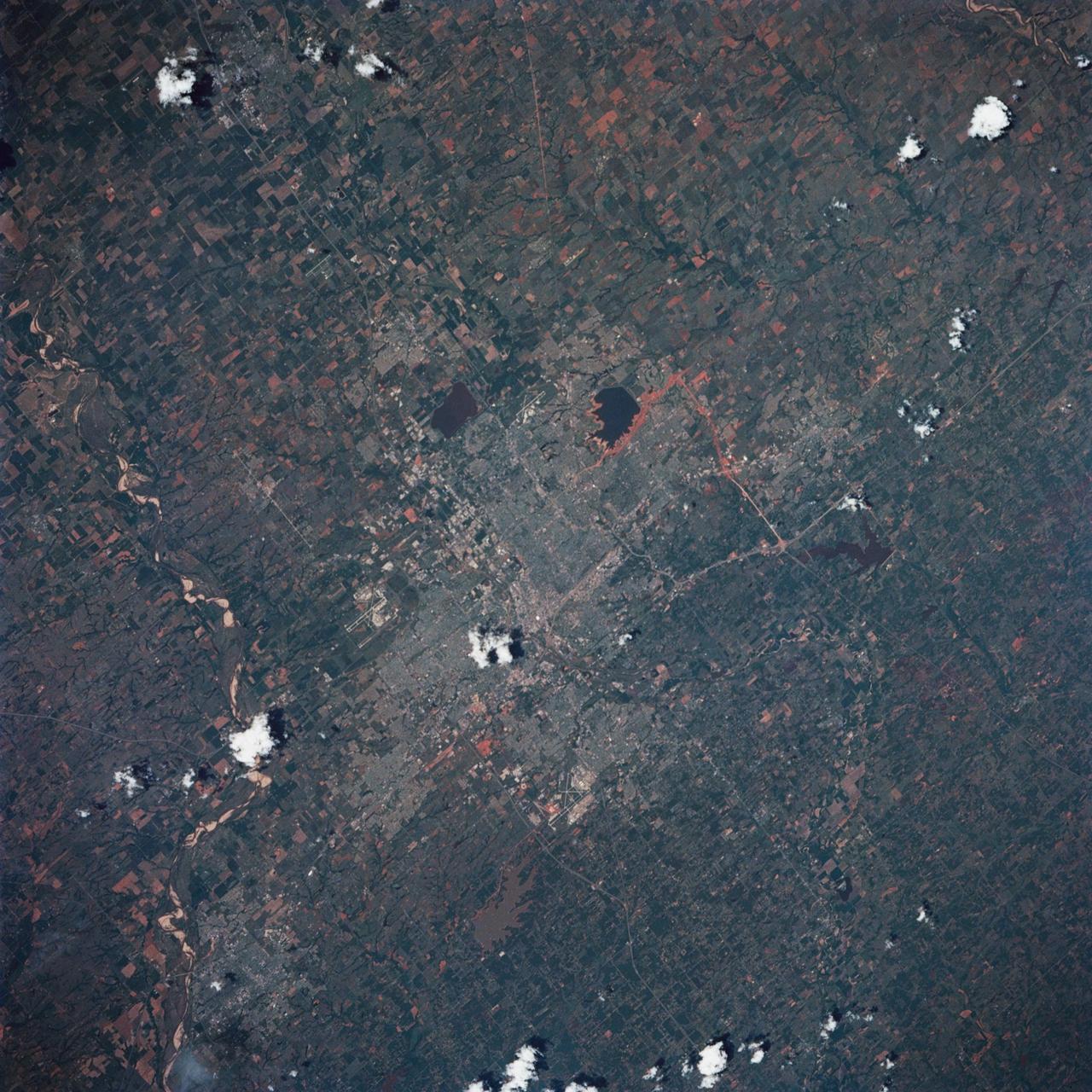
These images from NASA Terra satellite images of Oklahoma and north Texas were acquired on March 12, 2000 during Terra orbit 1243.
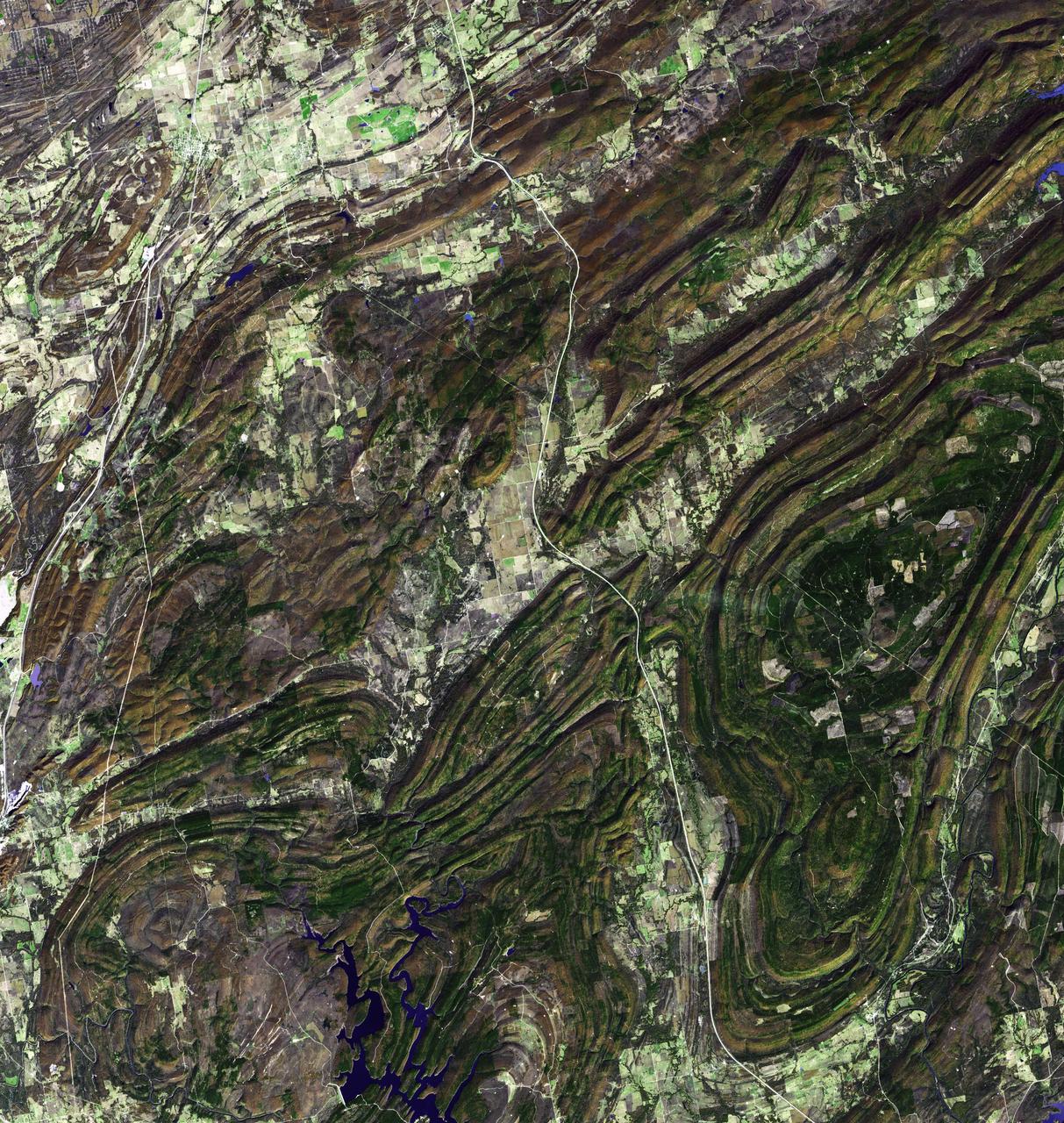
NASA Terra spacecraft captured this image of the Ouachita Mountains in southeast Oklahoma. The Ouachitas are fold mountains, formed about 300 million years ago when the South American Plate drifted northward, colliding with the North American Plate.

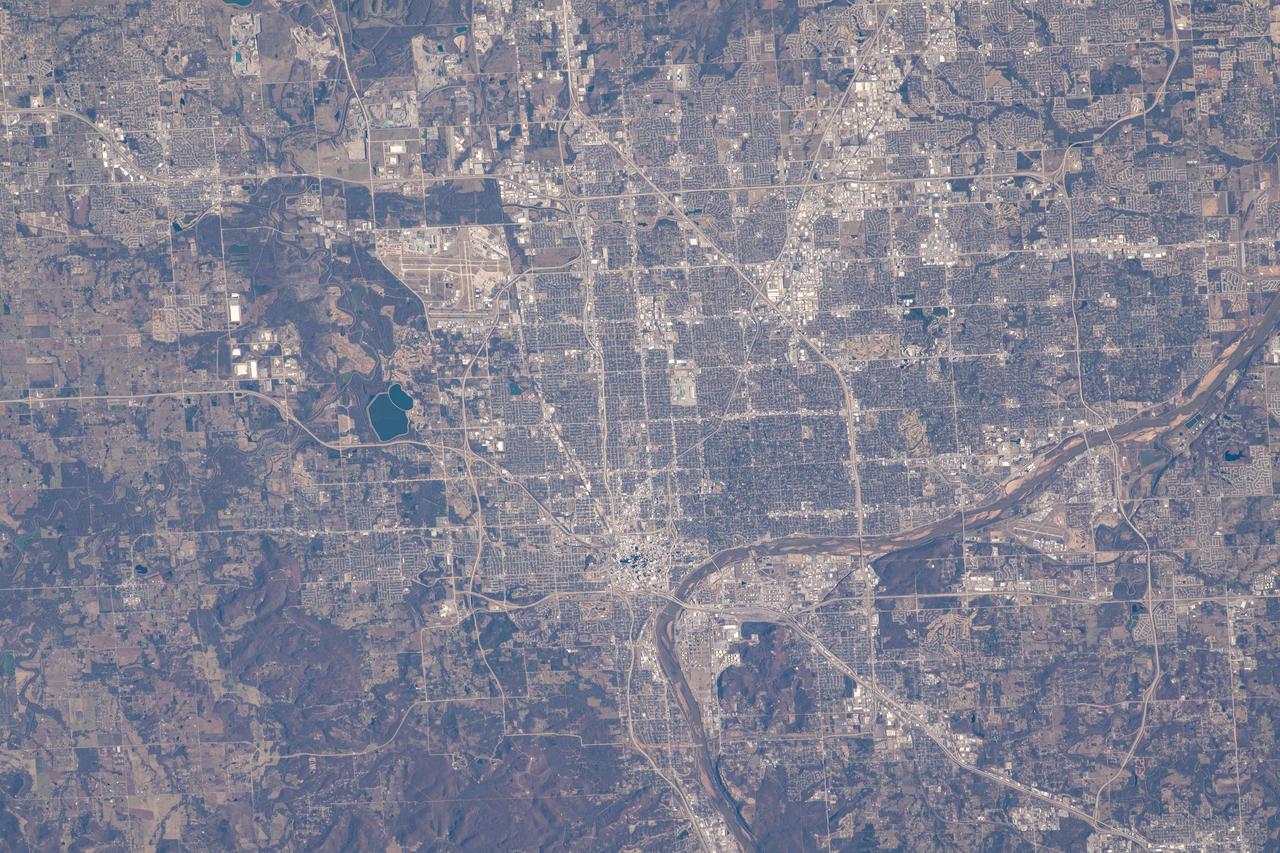
iss073e0120353 (May 19, 2025) --- Oklahoma City, Oklahoma, the Sooner State's capital and largest city with a population of about 713,000, is pictured at approximately 1:33 a.m. local time from the International Space Station as it orbited 260 mles above.
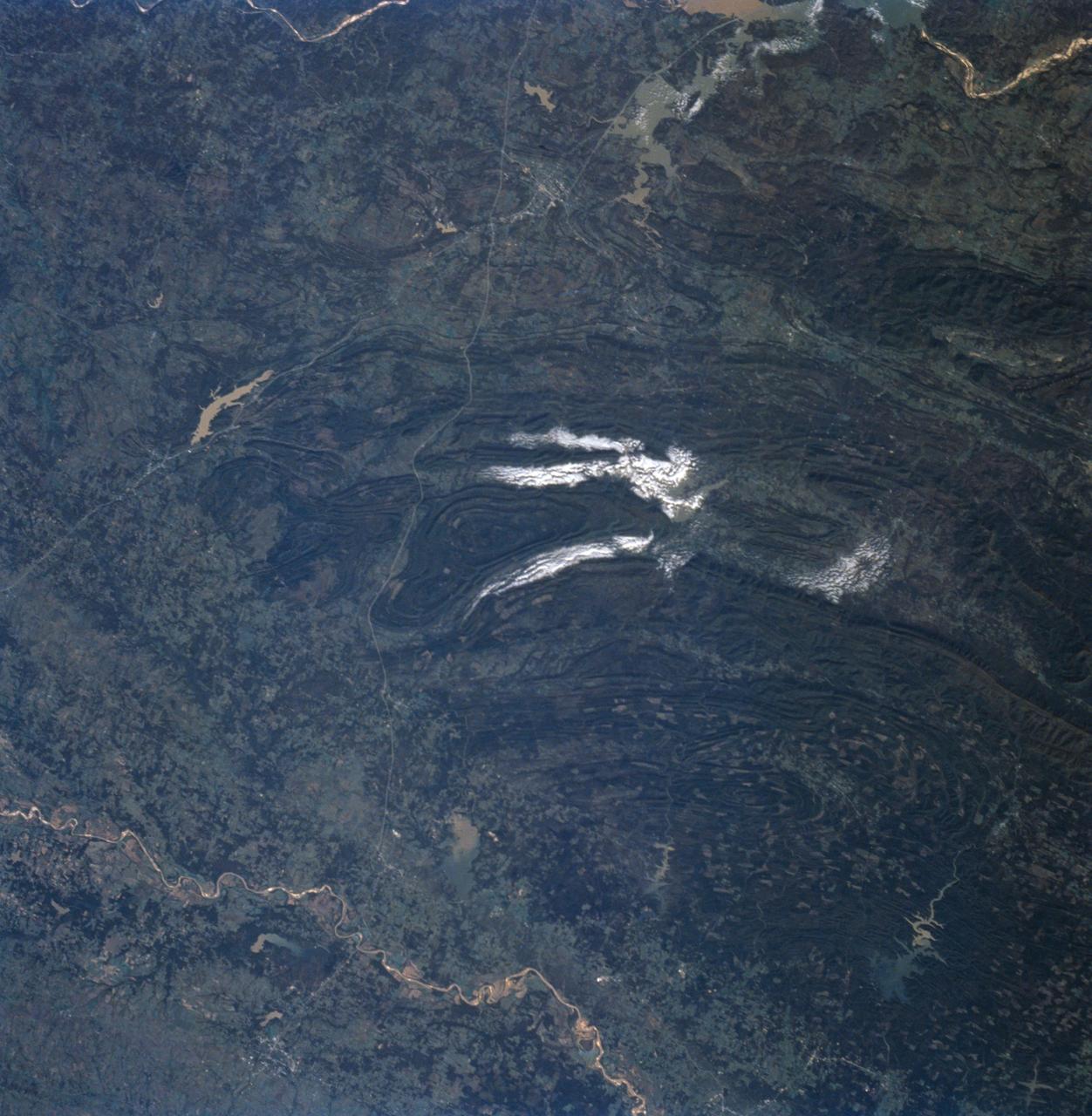
STS058-91-058 (18 Oct-1 Nov 1993) --- In this unusually clear view, the Ouachita Mountains of southeastern Oklahoma are framed on the north by Lake Eufaula on the South Canadian River, and on the south by the Red River. Sandstone, shale and chert (similar to flint) deposited in a sea several thousand feet deep were squeezed up to form the mountains about 250 million years ago. During the ensuing time, erosion of the western end of the Ouachita Mountains has emphasized linear ridges of resistant rock in the plunging anticlines and synclines, causing relief of 800 meters (2,600 feet) or more. Clouds formed by upslope winds border both the north and south sides of one of the most dramatic plunging synclines (in a syncline the rock layers dip toward the center of the structure). Toward the west, densely forested mountains give way to gently rolling, less rocky terrain and a drier climate which is better suited to farming. The mountains centered on Broken Bow, in the lower right corner of the scene, display abundant timber clearcuts that are being regenerated.
The Newcastle-Moore EF-5 tornado ripped through central Oklahoma on May 20, 2013, killing 24 people and leaving behind more than billion in damage. This image was acquired NASA Terra spacecraft on June 2, 2013.
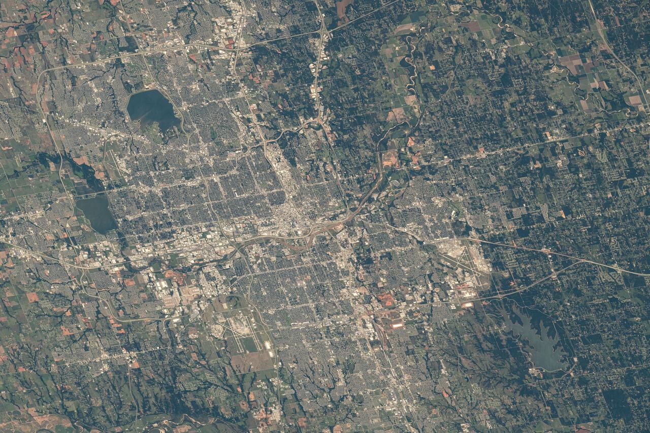
STS039-85-029 (28 April-6 May 1991) --- This 70mm frame is one of the best pictures of the Oklahoma City area from the manned space program, according to NASA photo experts studying STS-39 onboard photography. The central business district is near the center. Several municipalities are visible, along with thousands of acres of farmland. The towns of Norman and Moore and the South Canadian River are in the bottom (south). El Reno and Wiley Post Field off I-40W are just below center in lower left quadrant. Edmond is seen at the top (north). Tinker Field can be seen north of I-40E at right center. Lake Overholser shows recent spring rainfall northwest of the central business district.
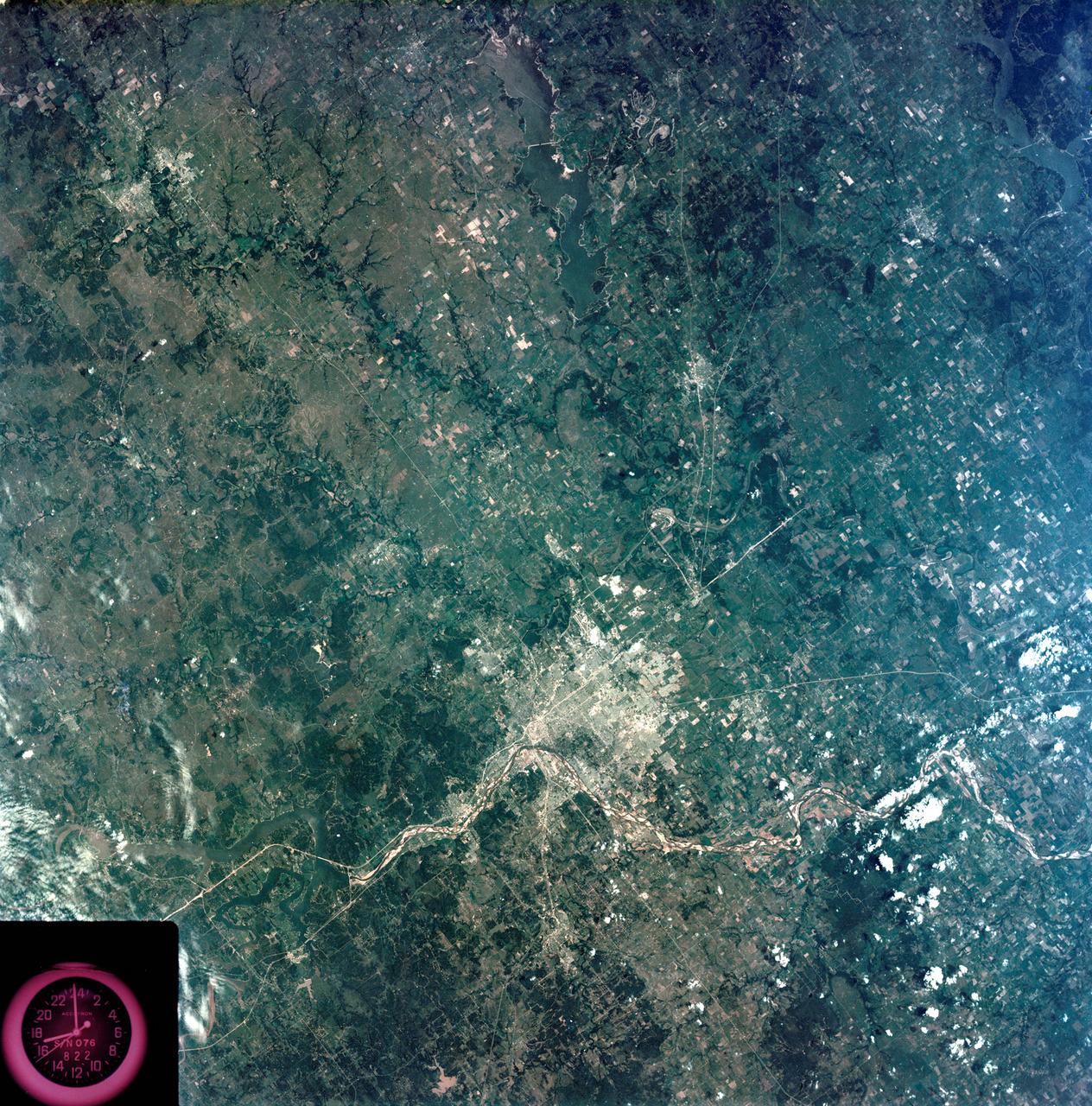
S73-35080 (July-September 1973) --- A vertical view of northeast Oklahoma and the metropolitan Tulsa area is seen in this Skylab 3 Earth Resources Experiments Package S190-B (five-inch Earth terrain camera) photograph taken from the Skylab space station in Earth orbit. THE PICTURE SHOULD BE HELD WITH THE CLOCK ON THE LEFT AND THE LAKE IN THE CORNER ON THE RIGHT. THE LONG STRETCH OF HIGHWAY (U.S. 75) RUNS STRAIGHT NORTH FROM TULSA. Tulsa, a rapidly expanding city in the heart of the mid-continent oil field, has a population of approximately 330,000. The Arkansas River meanders across the southern (lower) portion of the photograph passing through Tulsa as it flows southeastward. Oologah Reservoir, the long body of water, is located northeast of Tulsa. Lake Hudson is the body of water in the right corner of the picture. Keystone Reservoir is to the west and upstream from Tulsa. Westward from Tulsa U.S. 64 makes a 45 degree bend as it turns northwest to cross the Keystone Reservoir. The thin white line over the Oologah Reservoir is a highway bridge. Bartlesville is on U.S. 75 near the north (top) corner of the picture. The Tulsa International Airport is immediately northeast of downtown Tulsa. Several smaller airfields are visible in the surrounding area. The toll roads and other major highways are clearly visible in the picture. Claremore is northeast of Tulsa on U.S. 66 with the Will Rogers Turnpike passing nearby. Sapulpa is southwest of Tulsa on the Turner Turnpike which leads toward Oklahoma City. The detailed information contained in this photograph can be extracted by direct observation and applied to updating land use and cultural maps of Tulsa and to numerous surrounding satellite cities. All EREP photography is available to the public through the Department of Interior?s Earth Resources Observations Systems Data Center, Sioux Falls, South Dakota, 57198. (Alternate number SL3-83-206) Photo credit: NASA
iss064e009722 (Dec. 4, 2020) --- Tulsa, Oklahoma, split by the Arkansas River, was pictured from the International Space Station as it orbited 262 miles above.
iss069e054666 (Aug. 4, 2023) --- Tulsa, Oklahoma, on the Arkansas River is pictured from the International Space Station as it orbited 261 miles above the Sooner State.
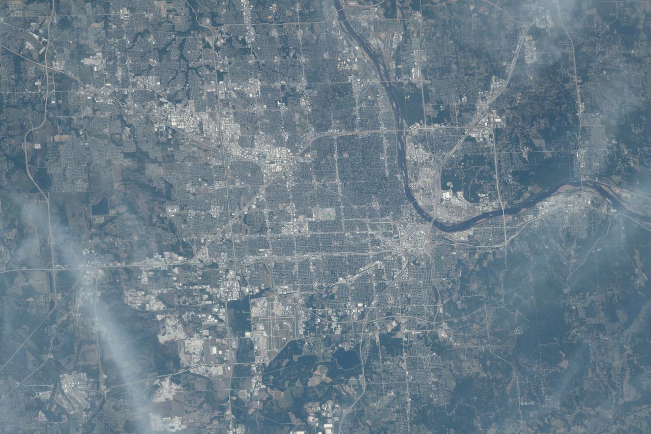
iss071e516947 (Aug. 18, 2024) --- Oklahoma City, the capital of Oklahoma with a population of over 680,000, is pictured from the International Space Station as it orbited 259 miles above. At lower right, near Lake Stanley Draper is Tinker Air Force Base named in honor of Major General Clarence L. Tinker, the first Native American major general.
iss067e123189 (June 10, 2022) --- Agricultural activities along the Arkansas River in the state of Kansas, a leader in wheat, grain sorghum and beef production, are pictured from the International Space Station as it orbited 263 miles above the state of Oklahoma.
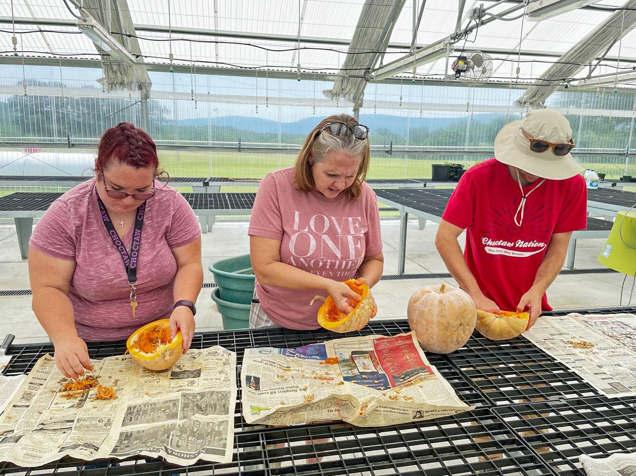
jsc2024e006092 (1/19/2024) --- Three Choctaw Nation of OK citizens remove seeds from a squash for the Choctaw Heirloom Seeds.investigation. Image courtesy of Choctaw Nation of Oklahoma.

S90-45810 (29-31 July 1990) --- Susan J. Helms, one of 23 astronaut candidate who began a year's training and evaluation in July, climbs into a T-38 jet trainer during a survival training school at Vance Air Force Base in Oklahoma.

Dr. Kelvin Droegemeier of Oklahoma appears before the Senate Committee on Commerce, Science, and Transportation as the nominee to be the Director of the Office of Science and Technology Policy on Thursday, Aug. 23, 2018 in the Russell Senate Office Building in Washington. Photo Credit: (NASA/Bill Ingalls)

Dr. Kelvin Droegemeier of Oklahoma appears before the Senate Committee on Commerce, Science, and Transportation as the nominee to be the Director of the Office of Science and Technology Policy on Thursday, Aug. 23, 2018 in the Russell Senate Office Building in Washington. Photo Credit: (NASA/Bill Ingalls)

iss046e005351 (1/5/2016) --- The Expedition 46 crew photographed an Earth observation night pass over the Gulf of Mexico. The view looks toward the northeast and includes Texas and Louisiana gulf coasts, as well as major cities in Texas, Louisiana, Mississippi, Alabama, Oklahoma, Arkansas, Tennessee and more.

S90-45845 (29-31 July 1990) --- Eileen M. Collins, a USAF major and a candidate for a pilot astronaut's position with NASA, listens to a briefing on parachute ejection. The classroom session was part of a three-day survival training course hosted by Vance Air Force Base in Oklahoma. Photo credit: NASA
STS103-501-104 (19-27 December 1999) --- One of the astronauts aboard the Earth-orbiting Space Shuttle Discovery used a handheld large format camera to photograph this scene which stretches from the Gulf of Mexico into Oklahoma. Parts of Louisiana and Arkansas are also visible in the frame. The Red River snakes its way through the East Texas Piney Woods (center). The river meets with the southern edge of the Ouachita folded mountains of southern Oklahoma. The white, linear feature north of the Red River is most likely a jet stream cloud, according to Earth scientists who studied the STS-103 collection at the Johnson Space Center (JSC). Jet contrails can be seen flying over the clouds. Along the Texas Gulf Coast are Galveston Bay and the greater Houston metropolitan area.
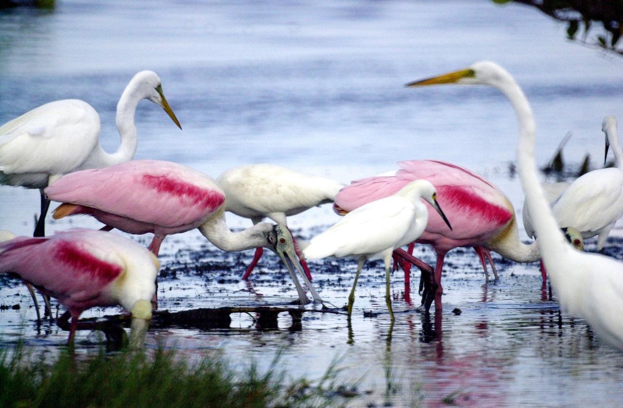
KENNEDY SPACE CENTER, FLA. -- An immature -- therefore white -- Little Blue Heron (center, with black bill) joins Roseate Spoonbills and a pair of Great Egrets in a lake near Kennedy Space Center. The heron ranges along the east coast of the United States, from New York to Texas, inland to Oklahoma. It winters from South Carolina to South America. For habitat the Little Blue Heron prefers freshwater swamps and lagoons in the South, coastal thickets on islands in the North. The species is often observed in large mixed concentrations of herons and egrets

Courtney Miller, a student at Langston University in Oklahoma, participates in a hands-on experience inside a Space Station Processing Facility lab at Kennedy Space Center on Sept. 18, 2019. Miller was part of a tour of the Florida spaceport organized by NASA’s Office of Education and Langston professor Byron Quinn, Ph.D. The Kennedy visit included stops at SwampWorks, the Neil Armstrong Operations and Checkout Building, the Vehicle Assembly Building, the visitor complex and the Center for Space Education.
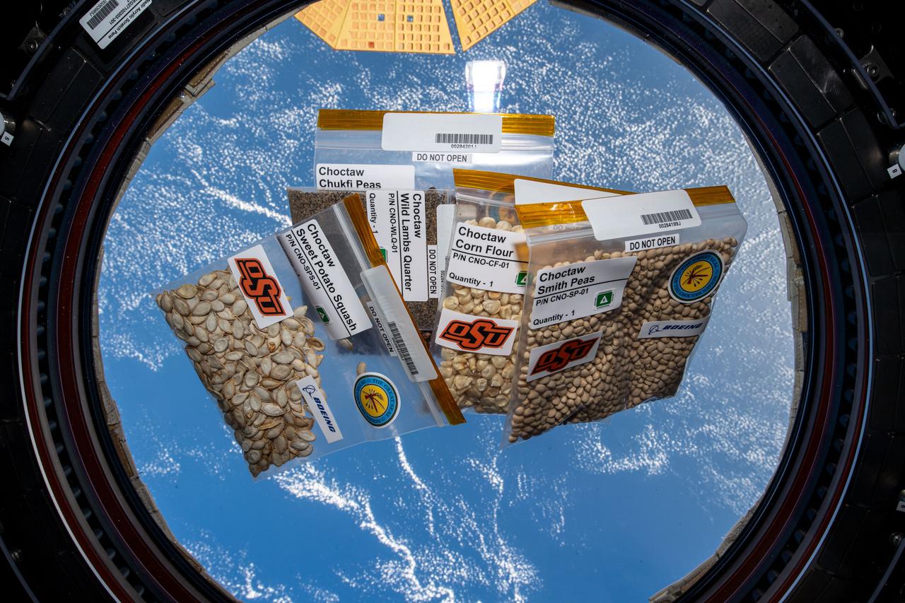
iss070e028324 (Nov. 21, 2023) --- Five varieties of seeds provided by the Choctaw Nation of Oklahoma are pictured inside the cupola as the International Space Station orbited 260 miles above the Atlantic Ocean. The seeds are exposed to microgravity for several months then returned to Earth and planted next to the same seeds left on Earth for comparison. The space botany experiment is promoting STEM (Science, Technology, Engineering, and Math) education among tribal members.
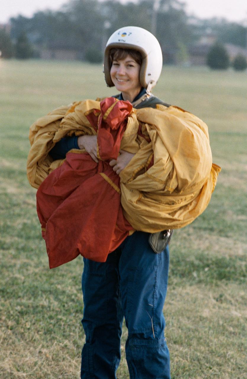
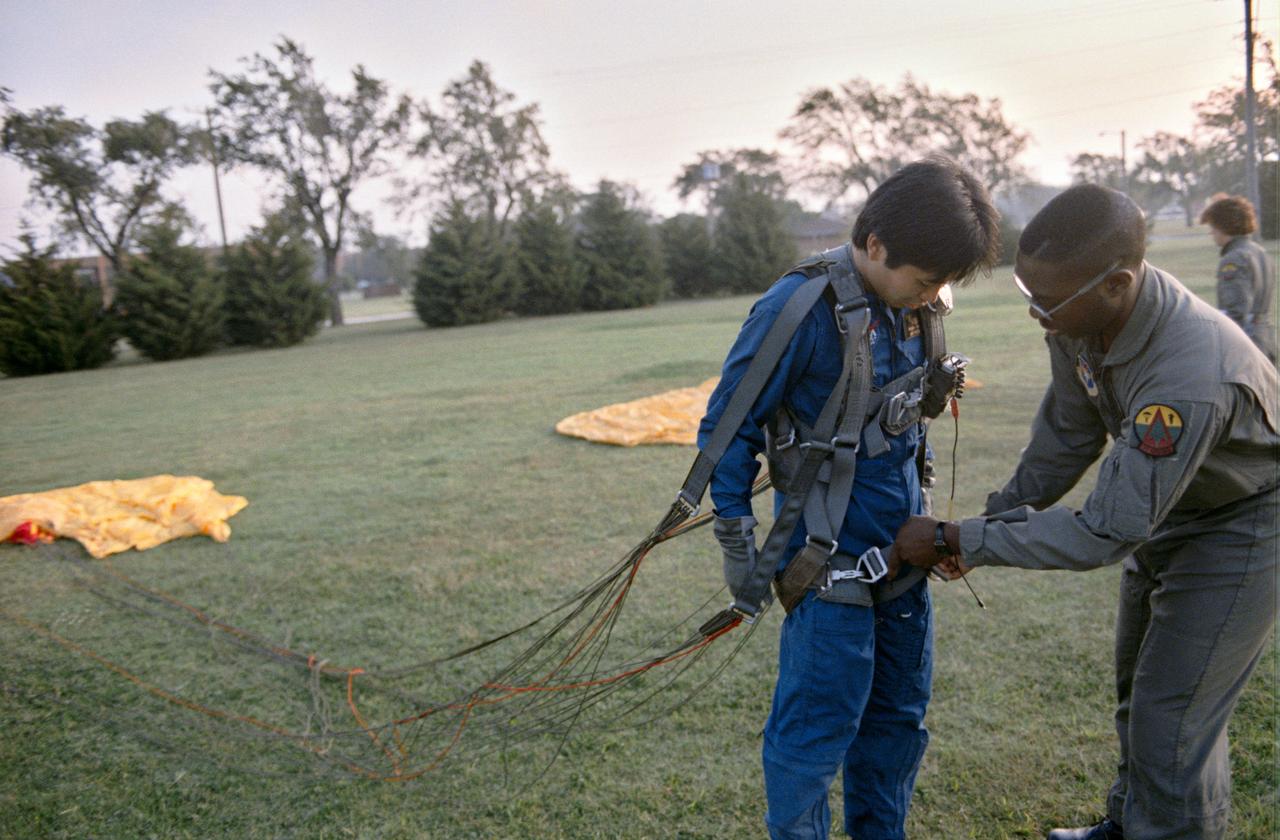
S93-38725 (12-14 Sept. 1992) --- Catherine G. Coleman, a member of the 1992 class of astronaut candidates at the Johnson Space Center (JSC), gathers up a parachute. The chute had just been used in one of many exercises experienced by the trainees at a three-day parachute/survival course hosted by Vance Air Force Base near Enid, Oklahoma. EDITOR?S NOTE: Coleman was later named as mission specialist for the United States Microgravity Laboratory (USML-2) mission, scheduled to fly as STS-73 in 1995.

Kennedy Space Center Veggie Project Manager Trent Smith addresses students from Langston University in Oklahoma inside a Space Station Processing Facility lab at the Florida spaceport on Sept. 18, 2019. The students were part of a tour of Kennedy organized by Langston professor Byron Quinn, Ph.D., and NASA’s Office of Education. The visit included stops at SwampWorks, the Neil Armstrong Operations and Checkout Building, the Vehicle Assembly Building, the visitor complex and the Center for Space Education.

Rep. Frank Lucas, R-Oklahoma, Vice Chairman of the House Committee on Science, Space, and Technology is seen during a hearing on the James Webb Space Telescope, Wednesday, July 25, 2018 at the Rayburn House Office Building in Washington. Witnesses: NASA Administrator Jim Bridenstine and Mr. Tom Young, chairman, JWST Independent Review Board. Photo Credit: (NASA/Bill Ingalls)

Ames Mars Wind Tunnel Facility N-245: NASA is simulating small martian 'dust devils' and wind in a laboraotry to determine how they may affect the landscape and environment of the red planet. Dust Devils on Mars are often a great deal biggger than those on Earth and can at times cover the whole planet. Martian winds & dust devils, big and little, collectively are a great force that is constantly changing the planet's environment. shown here: Silica Sand (Oklahoma 90) particles used in vortex generatory and Mars Wind Tunnel

Robert Lightfoot visited the facility housing the seven-axis milling tool as it performs work on the Spacecraft and Payload Integration adapters for the Space Launch System Program at MSFC. After a short tour, he took a few moment to address the media and answer questions, including how ISERV is examining the damage done by the recent tornado outbreak in Oklahoma, and more information on NASA's asteroid mission.

S95-00359 (12-14 September 1992) --- Astronaut candidate Koichi Wakata gathers his parachute following a simulated chute drop at Vance Air Force Base. Wakata is one of seven international mission specialist candidates who joined 19 United States astronaut candidates for the three-day parachute/survival training school at the Oklahoma Base. EDITORS NOTE: Since this photograph was taken, Wakata has been named as mission specialist for the STS-72 mission.
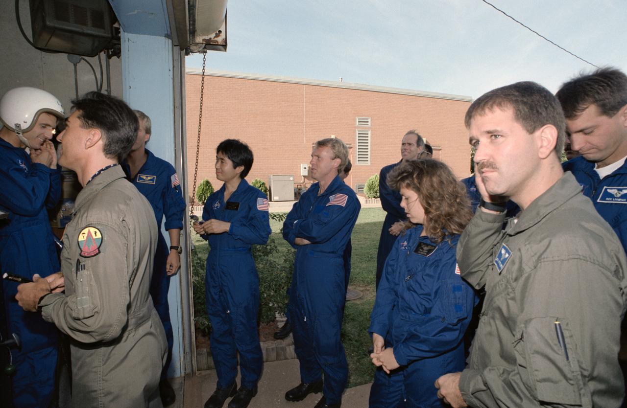
S95-00356 (14 September 1992) --- Several 1992 astronaut candidates wait in line to receive gear for one of several phases of parachute familiarization and survival training at Vance Air Force Base in Oklahoma. Recognizable in the picture are Jerry M. Linenger, Scott E. Parazynski, Koichi Wakata, Andrew S. W. Thomas, Mary Ellen Weber, Joseph R. Tanner, John M. Grunsfeld and Richard M. Linnehan.
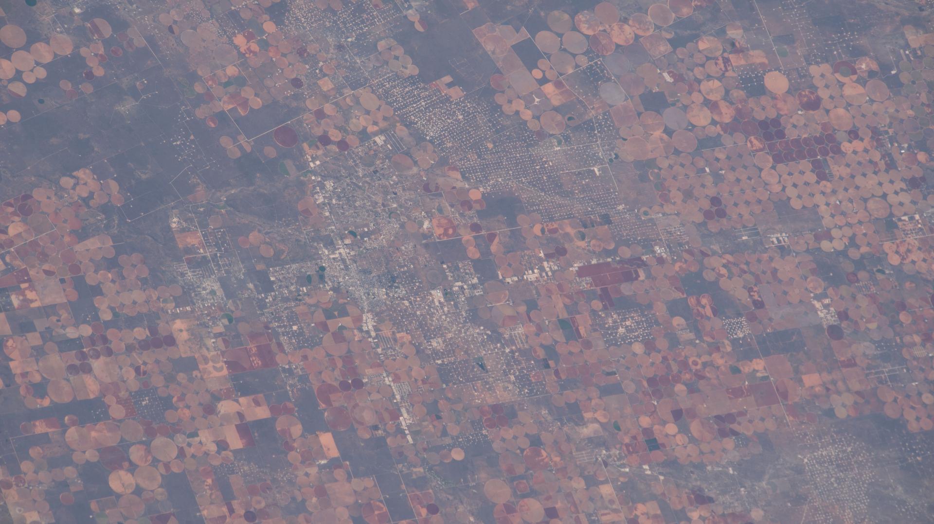
iss074e0603632 (May 16, 2026) --- Industrial-scale farming and oil production exist side-by-side and compete for land and water resources in western Texas. The crop circles are center-pivot irrigation systems used to cultivate cotton, sorghum, wheat, hay, and corn. The grid set against the circular farms is a dense network of well sites, pipelines, and roads that support the petroleum infrastructure. The International Space Station was orbiting 259 miles above the Texas–Oklahoma border at the time of this photograph. Credit: NASA

KENNEDY SPACE CENTER, FLA. -- The Seminole Native American Veterans Color Guard (Seminole Flag, U.S. Flag, and State of Florida Flag) enter the Debus Conference Center in the KSC Visitor Complex during a dinner honoring astronaut John B. Herrington, the first tribally enrolled Native American astronaut to fly on a Shuttle mission. Herrington is a Mission Specialist on STS-113. In addition to the dinner at KSC, several hundred Native Americans from around the country attended a symposium in Orlando commemorating the launch event. The Native Americans, many of them Chickasaw, were here to honor John, who is a Chickasaw from Oklahoma.

ISS025-E-010008 (29 Oct. 2010) --- From 220 miles above Earth, one of the Expedition 25 crew members onboard the International Space Station shot this night time image of the northern Gulf coast. Mobile Bay and the city of Mobile (top left, beneath one of the solar panels of a docked Russian Soyuz spacecraft), New Orleans and Houston are visible as the view ?moves? southeastward. The Interstate Highway 20 cities of Jackson, Shreveport, Dallas and Fort Worth are also visible further inland. The view extends northward (left) to Little Rock and Oklahoma City.

KENNEDY SPACE CENTER, FLA. -- -- The Seminole Native American Veterans Color Guard (Seminole Flag, U.S. Flag, and State of Florida Flag) present colors during a dinner at the Debus Conference Center in the KSC Visitor Complex. The dinner honored John B. Herrington, the first tribally enrolled Native American astronaut to fly on a Shuttle mission. Herrington is a Mission Specialist on STS-113. In addition to the dinner at KSC, several hundred Native Americans from around the country attended a symposium in Orlando commemorating the launch event. The Native Americans, many of them Chickasaw, were here to honor John, who is a Chickasaw from Oklahoma.
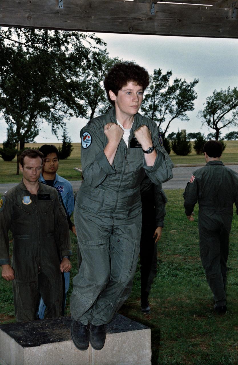
S95-00353 (12-14 September 1992) --- Several 1992 astronaut candidates brush the sand and gravel off one another following one of several phases of parachute familiarization and survival training at Vance Air Force Base in Oklahoma. Recognizable in the picture are Wendy B. Lawrence, Michael E. Lopez-Alegria, Chris A. Hadfield, Winston E. Scott and Koichi Wakata. The trainees had just completed an exercise, which required their jumping off a box into a gravel pit, in order to familiarize them the proper way to meet the ground following an emergency parachute drop.
S95-00352 (12-14 September 1992) --- Astronaut candidate Koichi Wakata gets assistance with his parachute following a simulated chute drop at Vance Air Force Base. Wakata, representing the National Space Development Agency (NASDA) of Japan, is one of seven international mission specialist candidates who joined 19 United States astronaut candidates for the three-day parachute/survival training school at the Oklahoma Base. EDITOR'S NOTE: Since this photograph was taken, Wakata has been named as mission specialist for the STS-72 mission.
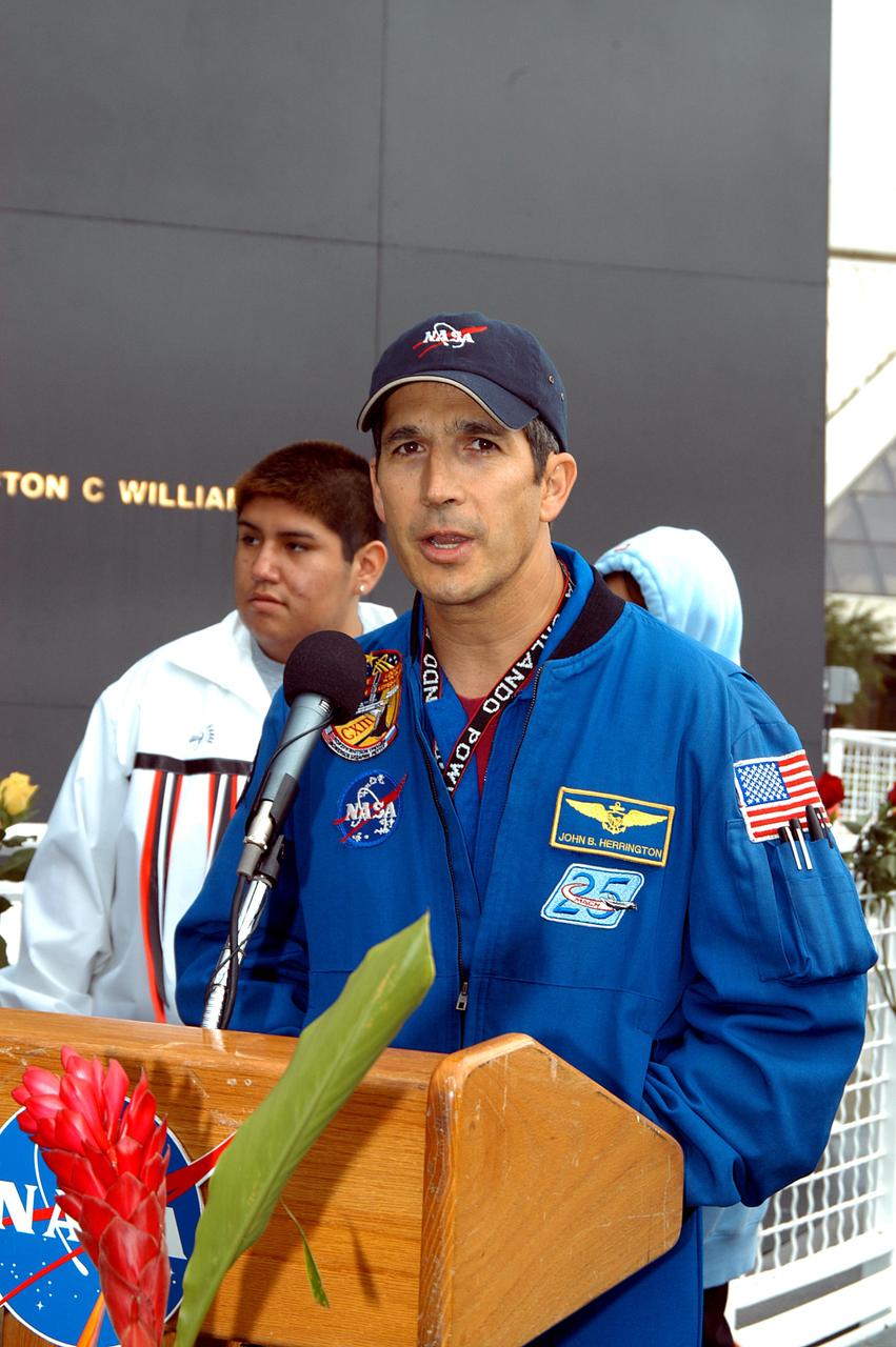
KENNEDY SPACE CENTER, FLA. - Astronaut John Herrington speaks to the visitors at the memorial service held at the Space Memorial Mirror for the crew of Columbia. Herrington, who is a Chickasaw from Oklahoma, introduced the Shoshone-Bannock Junior-Senior High School dancers, from the Native American community at Fort Hall, Idaho, who performed a healing ceremony. Students and staff of the Shoshone-Bannock Nation had an experiment on board Columbia. Feb. 1 is the one-year anniversary of the loss of the crew and orbiter Columbia in a tragic accident as the ship returned to Earth following mission STS-107. The public was invited to the memorial service, held in the KSC Visitor Complex, which included comments by Center Director Jim Kennedy and Executive Director of Florida Space Authority Winston Scott. Scott is a former astronaut who flew on Columbia in 1997.

JSC2004E14160 --- AESP Student Assembly Program, Wilson Elementary School, Lawton, OK November 2003
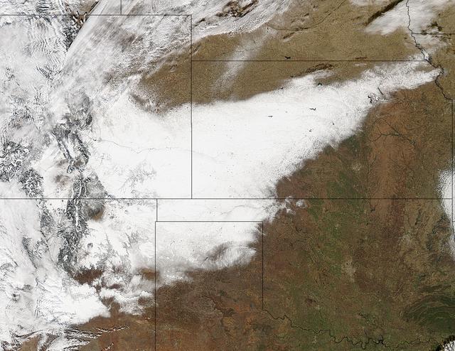
Winter arrived officially on Dec. 22 at 12:35 a.m. EST, but the U.S. Plains states received an early and cool welcome on Dec. 19 from heavy snowfall that was seen by a NASA satellite. NASA's Aqua satellite passed overhead on Dec. 21 at 20:05 UTC (3:05 p.m. EST) and the Moderate Resolution Imaging Spectroradiometer (MODIS) instrument aboard NASA's Aqua satellite captured a visible image of snow blanketing the ground through west and central Kansas, eastern and central Colorado, much of New Mexico, northern Texas and the panhandle of Oklahoma. According to CBS News, blizzard conditions were reported in northern New Mexico, the Texas Panhandle, Oklahoma and northwestern Kansas. The Associated Press reported snow drifts as high as 10 feet in southeast Colorado. Six people lost their lives in traffic accidents from this storm. Heavy snow is expected again today, Dec. 22 in New Mexico and Colorado. Snow is also expected to stretch across the plains into the upper Midwest today, according to the National Weather Service. Portions of many states are expecting some snow today, including the four corners states, north Texas, Kansas, southern Nebraska, western Oklahoma, northern Missouri, Iowa, northern Illinois and southern Wisconsin stretching east into northern New England. The first day of the winter season occurs when the sun is farthest south, either Dec. 21 or 22. The day is also known as the winter solstice. By the second day of winter, NASA's Aqua satellite is going to have a lot more snowfall to observe. Image Credit: NASA Goddard MODIS Rapid Response Team Caption: NASA, Rob Gutro <b><a href="http://www.nasa.gov/audience/formedia/features/MP_Photo_Guidelines.html" rel="nofollow">NASA image use policy.</a></b> <b><a href="http://www.nasa.gov/centers/goddard/home/index.html" rel="nofollow">NASA Goddard Space Flight Center</a></b> enables NASA’s mission through four scientific endeavors: Earth Science, Heliophysics, Solar System Exploration, and Astrophysics. Goddard plays a leading role in NASA’s accomplishments by contributing compelling scientific knowledge to advance the Agency’s mission. <b>Follow us on <a href="http://twitter.com/NASA_GoddardPix" rel="nofollow">Twitter</a></b> <b>Like us on <a href="http://www.facebook.com/pages/Greenbelt-MD/NASA-Goddard/395013845897?ref=tsd" rel="nofollow">Facebook</a></b> <b>Find us on <a href="http://instagrid.me/nasagoddard/?vm=grid" rel="nofollow">Instagram</a></b>
Image acquired December 19, 2011 A strong low pressure area in the southwestern U.S. today is bringing snowfall there as NOAA's GOES-13 satellite captured its associated clouds. Blizzard warnings are already posted for some areas. The image was created on Dec. 19 at 19:10 UTC (2:10 p.m. EST) from the Geostationary Operational Environmental Satellite called GOES-13. GOES-13 is operated by the National Oceanic and Atmospheric Administration. Images and animations are created by NASA's GOES Project, located at NASA's Goddard Space Flight Center, Greenbelt, Md. The low is forecast to move northeast across southeastern New Mexico today and reach southwest the Texas panhandle by early evening. The plains states including portions of Kansas, New Mexico and the Texas and Oklahoma panhandles could all have blizzard warnings later in the day on Dec. 19. Wind gusts to 60mph were recorded in northeastern New Mexico during the afternoon hours today. Kansas City may have a mix of rain, sleet and snow as the front moves past and temperatures fall. At 3 p.m. EST, the National Weather Service forecast indicated that moderate to heavy snow and strong north winds to impact the Texas and Oklahoma panhandles today into Tuesday morning. The low and associated cold front are expected to bring heavy snow to the Oklahoma panhandle and all but the far southeast Texas Panhandle. Behind the cold front, the strong winds will blow snow and lead to poor visibilities and blizzard conditions. The GOES image shows the large bank of clouds along the front stretching from the four corners states east-northeast through the Ohio Valley and into upstate New York. The rounded comma shape of clouds over Texas and stretching into Colorado indicate where the low pressure center is located. Image: NASA/NOAA GOES Project Text: NASA, Rob Gutro <b><a href="http://www.nasa.gov/audience/formedia/features/MP_Photo_Guidelines.html" rel="nofollow">NASA image use policy.</a></b> <b><a href="http://www.nasa.gov/centers/goddard/home/index.html" rel="nofollow">NASA Goddard Space Flight Center</a></b> enables NASA’s mission through four scientific endeavors: Earth Science, Heliophysics, Solar System Exploration, and Astrophysics. Goddard plays a leading role in NASA’s accomplishments by contributing compelling scientific knowledge to advance the Agency’s mission. <b>Follow us on <a href="http://twitter.com/NASA_GoddardPix" rel="nofollow">Twitter</a></b> <b>Like us on <a href="http://www.facebook.com/pages/Greenbelt-MD/NASA-Goddard/395013845897?ref=tsd" rel="nofollow">Facebook</a></b> <b>Find us on <a href="http://instagrid.me/nasagoddard/?vm=grid" rel="nofollow">Instagram</a></b>
S90-45852 (29-31 July 1990) --- Susan J. Helms, one of 23 astronaut candidates who began a year's training and evaluation in July, participates in one of may sessions at a survival training course at Vance Air Force Base. This portion of the course is designed to familiarize the trainee with the "feel" of emergency ejection from a jet aircraft.

S90-45883 (29-31 July 1990) --- Nancy J. Sherlock, one of 23 astronaut candidates who began a year's training and evaluation in July, participates in one of many sessions at a survival training course at Vance Air Force Base. Sherlock is about to take part in parachute drag training. The overall course is designed to familiarize the trainees with procedures to follow in the event of an emergency ejection from a jet aircraft.
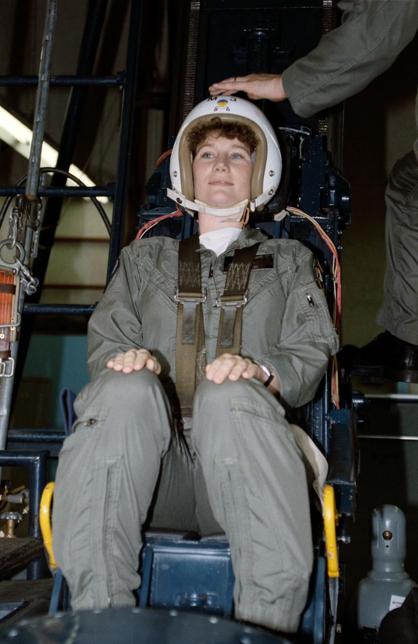
S90-48372 (29-31 July 1990) --- Mission specialist astronaut candidate Susan J. Helms simulates a parachute jump during a survival training course at Vance Air Force Base. She is one of 23 astronaut candidates from the Johnson Space Center who have joined military personnel for the special three-day training course. The course is designed to prepare the trainees for proper survival measures to take in the event of an emergency aboard the T-38 jet trainer aircraft they will frequently use once they become full-fledged astronauts.
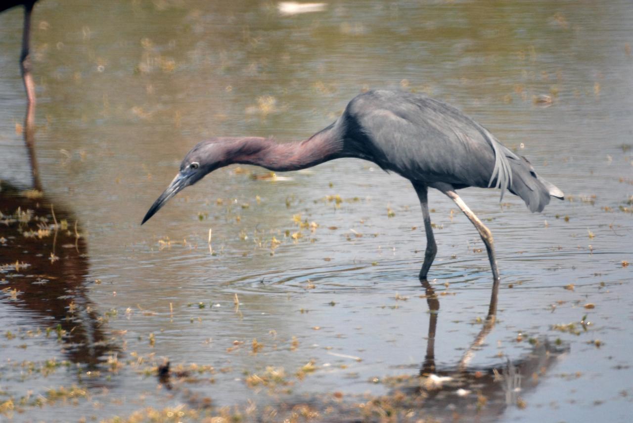
KENNEDY SPACE CENTER, FLA. -- A little blue heron stalks its next meal in a pond near Kennedy Space Center. Identified by their slate blue body and maroon neck, little blue herons range on the east coast from New York to Texas and inland to Oklahoma. They winter as far south as South America. They inhabit freshwater swamps and lagoons in the South; coastal thickets on islands in the North. KSC shares a boundary with the Merritt Island National Wildlife Refuge, which surrounds it. The refuge is a habitat for more than 310 species of birds, 25 mammals, 117 fishes and 65 amphibians and reptiles. In addition, the refuge supports 19 endangered or threatened wildlife species on Federal or State lists, more than any other single refuge in the U.S. Photo credit: NASA/Ken Thornsley
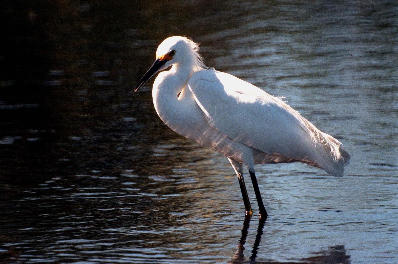
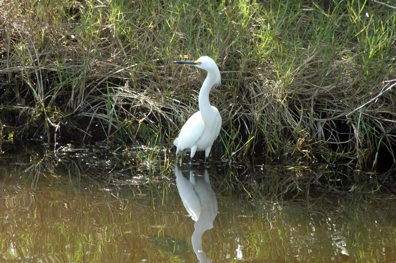
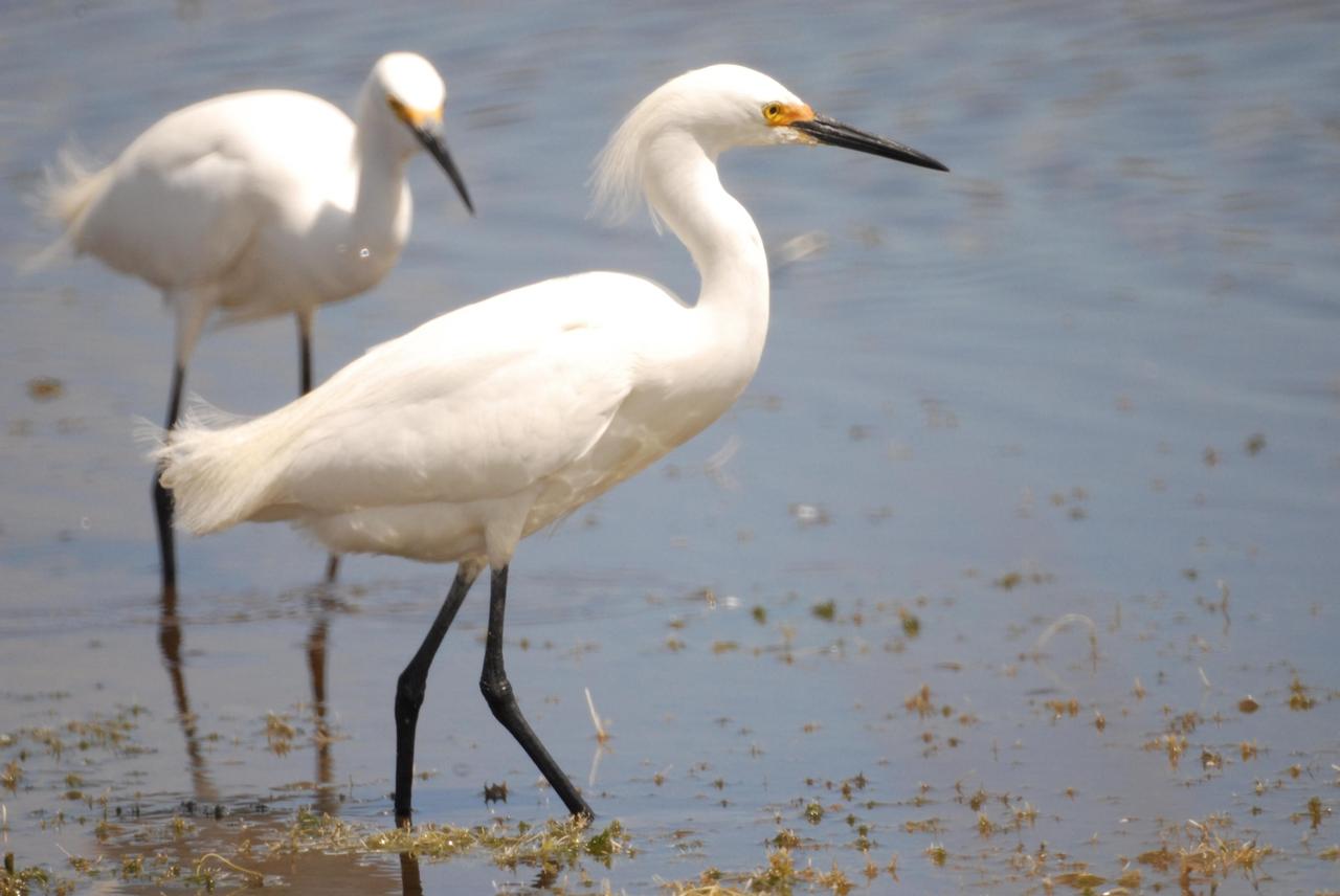
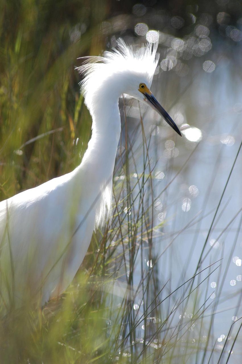
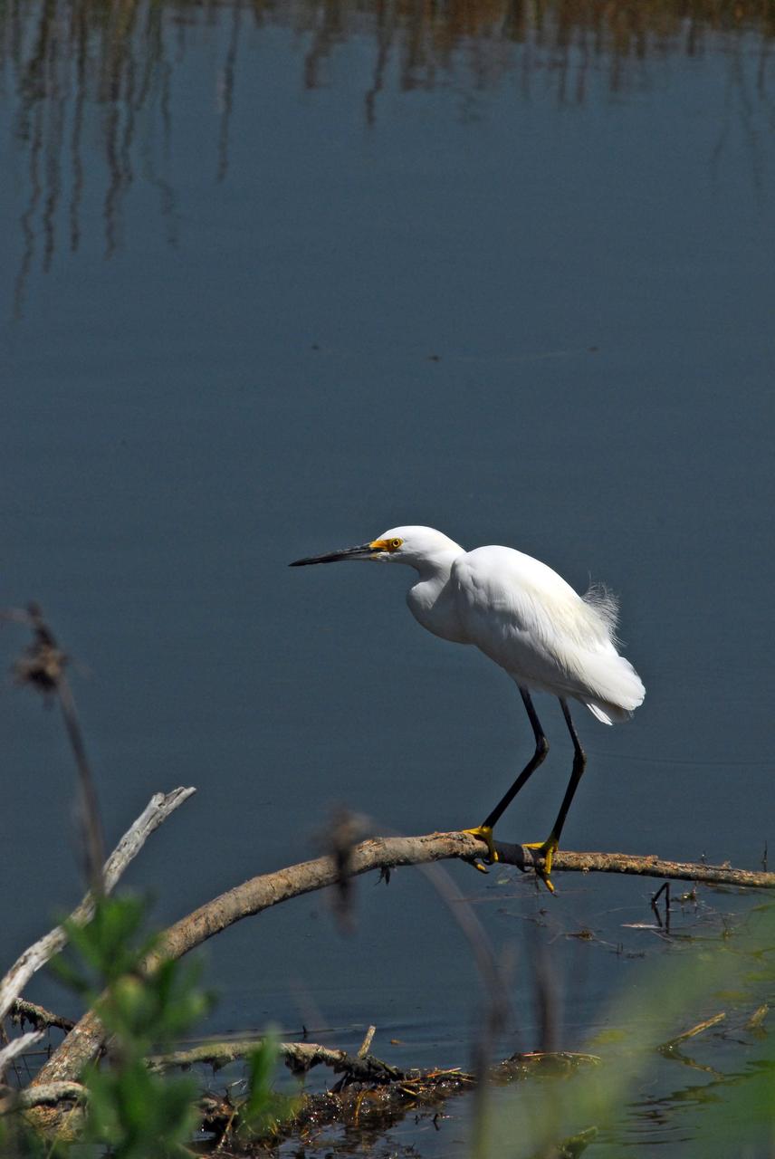
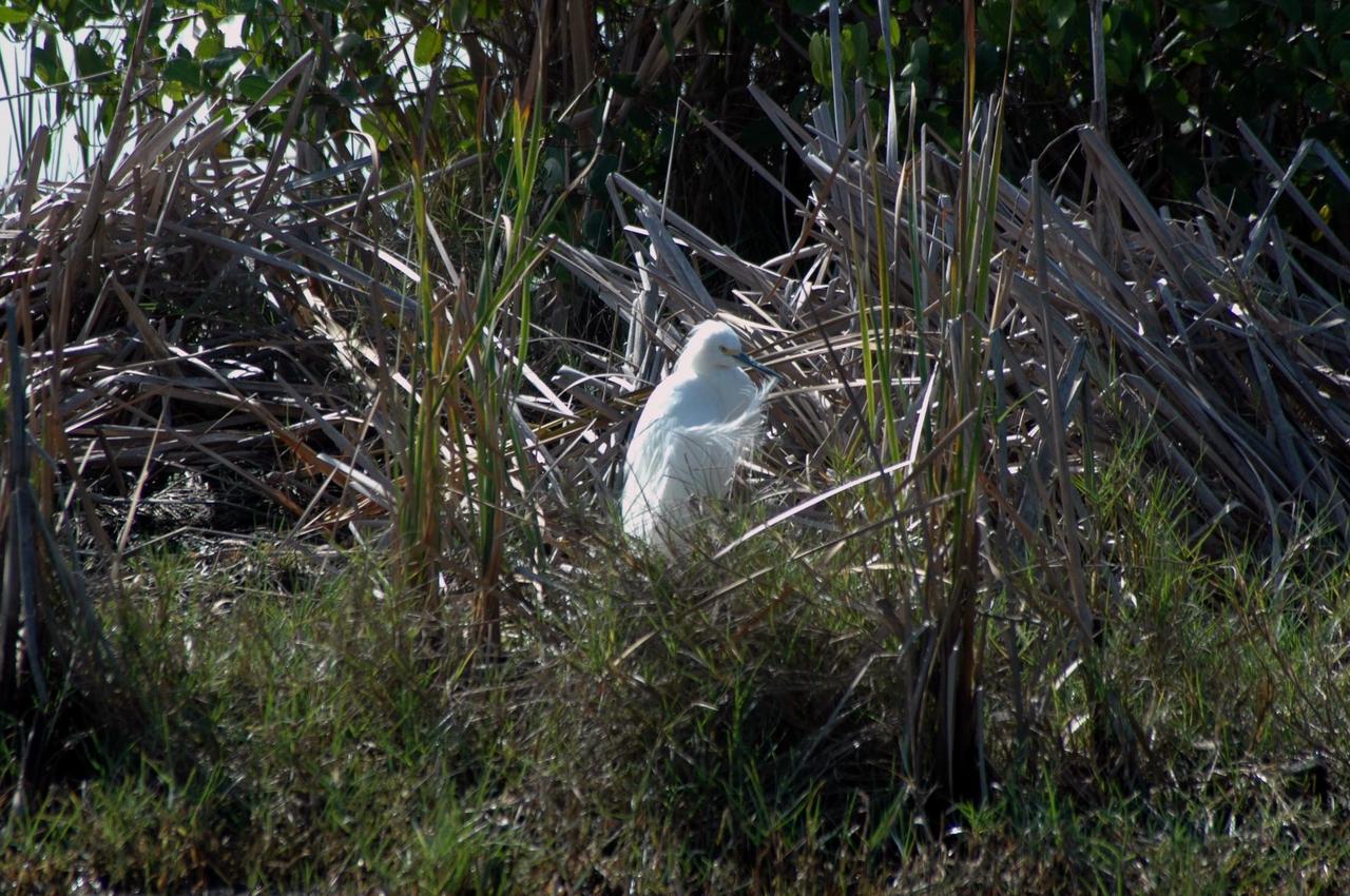
KENNEDY SPACE CENTER, FLA. -- A snowy egret wades the shallow waters of the Merritt Island National Wildlife Refuge, which shares a boundary with Kennedy Space Center. Ranging from northern California, Oklahoma and Maine to southern South America, the snowy egret winters north to California and South Carolina. In the East, they are best known as salt marsh birds. Once an endangered species, their numbers have increased again. The 92,000-acre refuge is a habitat for more than 310 species of birds, 25 mammals, 117 fishes and 65 amphibians and reptiles. The marshes and open water of the refuge also provide wintering areas for 23 species of migratory waterfowl, as well as a year-round home for great blue herons, great egrets, wood storks, cormorants, brown pelicans and other species of marsh and shore birds
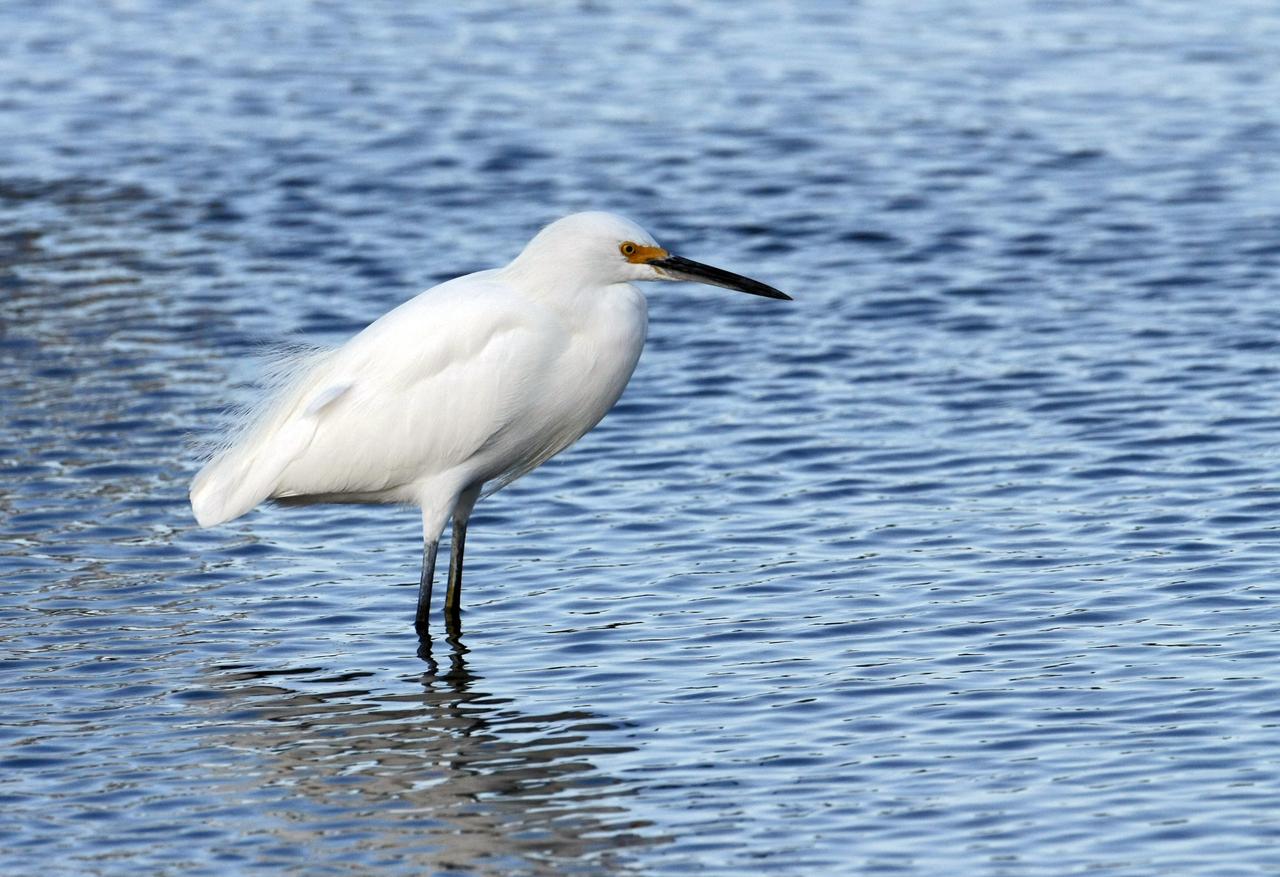
KENNEDY SPACE CENTER, FLA. -- A snowy egret is on the lookout for food in a pond on NASA's Kennedy Space Center. A type of heron, the snowy egret inhabits salt marshes, ponds, rice fields and shallow coastal bays ranging from Maine to southern South America on the east coast. It can also be found in California and Oklahoma to the Gulf of Mexico. KSC shares a boundary with the Merritt Island Wildlife Nature Refuge. The refuge is a habitat for more than 310 species of birds, 25 mammals, 117 fishes and 65 amphibians and reptiles. In addition, the Refuge supports 19 endangered or threatened wildlife species on Federal or State lists, more than any other single refuge in the U.S. Photo credit: NASA/Ken Thornsley
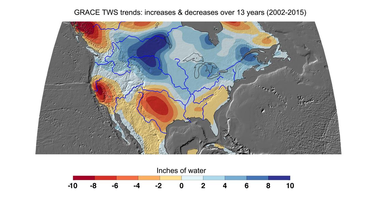
Cumulative total freshwater losses in the United States from 2002 to 2015 (in inches) observed by NASA's Gravity Recovery and Climate Experiment (GRACE) mission. Total water refers to all of the snow, surface water, soil water and groundwater combined. Much of the northern half of the country experienced increasing total water storage during this time period, while total water storage in the southern half decline. Areas where groundwater depletion strongly impacted total water losses include California's Central Valley, and the southern High Plains aquifer beneath the Texas and Oklahoma panhandles. Total water storage in the Upper Missouri River basin increased signficantly and contributed to considerable flooding during the 2002-15 time period. Image updated from Famiglietti and Rodell, 2013. Citation of Record: Famiglietti, J. S., and M. Rodell, Water in the Balance, Science, 340, 1300-1301. http://photojournal.jpl.nasa.gov/catalog/PIA20204
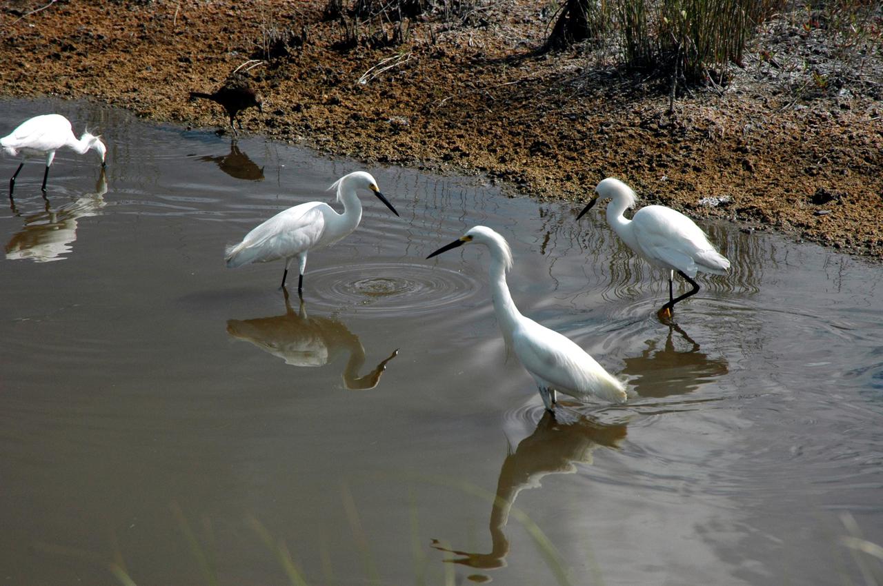
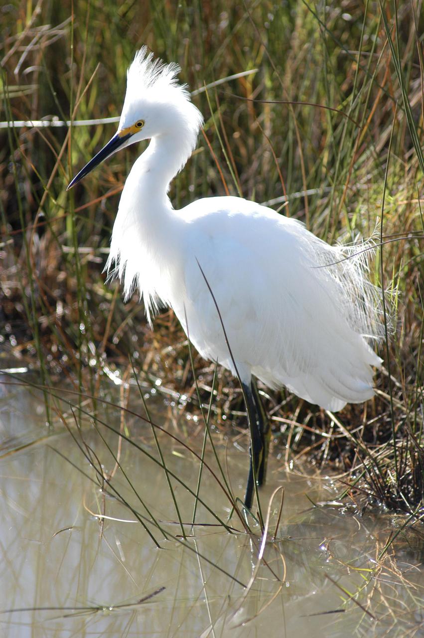
KENNEDY SPACE CENTER, FLA. - Snowy egrets join in a feeding frenzy in a marshy area of the Merritt Island National Wildlife Refuge. Ranging from northern California, Oklahoma and Maine to southern South America, the snowy egret winters north to California and South Carolina. In the East, they are best known as salt marsh birds. Once an endangered species, their numbers have increased. The refuge was established in 1963 on Kennedy Space Center land and water not used by NASA for the space program. The marshes and open water of the refuge provide wintering grounds for 23 species of migratory waterfowl, as well as a year-round home for great blue herons, wood storks, cormorants, brown pelicans and other species of marsh and shore birds.
KENNEDY SPACE CENTER, FLA. -- Snowy egrets wade through a pond for their food. The pond is near Kennedy Space Center. This species inhabits salt marshes, ponds, rice field and shallow coastal bays along the coast from Maine to southern South America. They are also found in northern California, Texas and Oklahoma. KSC shares a boundary with the Merritt Island National Wildlife Refuge, which surrounds it. The refuge is a habitat for more than 310 species of birds, 25 mammals, 117 fishes and 65 amphibians and reptiles. In addition, the refuge supports 19 endangered or threatened wildlife species on Federal or State lists, more than any other single refuge in the U.S. Photo credit: NASA/Ken Thornsley
KENNEDY SPACE CENTER, FLA. — A snowy egret is spotted near NASA Kennedy Space Center. Its habitat is salt marshes, ponds, rice fields and shallow coastal bays, ranging primarily along the eastern coast from Maine to South America, but including areas of northern California and Oklahoma. This and other wildlife abound throughout KSC as it shares a boundary with the Merritt Island National Wildlife Refuge, home to some of the nation’s rarest and most unusual species of wildlife. The wildlife refuge is a habitat for more than 310 species of birds, 25 mammals, 117 fishes and 65 amphibians and reptiles. In addition, the Refuge supports 19 endangered or threatened wildlife species on Federal or State lists, more than any other single refuge in the U.S.

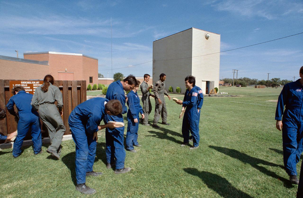
S95-00355 (12-14 September 1992) --- Astronaut candidate Koichi Wakata prepares to jump off a box during a parachute landing demonstration at Vance Air Force Base. This portion of the training is designed to familiarize the trainees with the proper way to hit the ground following a parachute jump. Looking on are astronaut candidates Michael L. Gernhardt (left) and Andrew W. S. Thomas (second left), along with a United States Air Force (USAF) instructor. Wakata, representing Japan's National Space Development Agency (NASDA), is one of seven international mission specialist candidates who joined 19 United States astronaut candidates, including Gernhardt and Thomas, for the three-day parachute/survival training school at the Oklahoma Base. EDITORS NOTE: Since this photograph was taken, Gernhardt, Wakata and Thomas have been named as mission specialists for the STS-69, STS-72 and STS-77 missions, respectively.
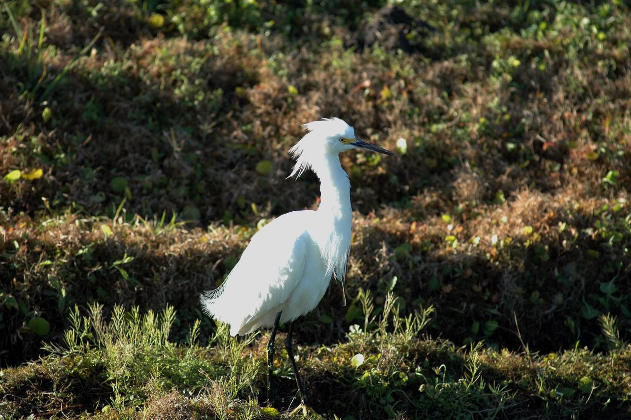
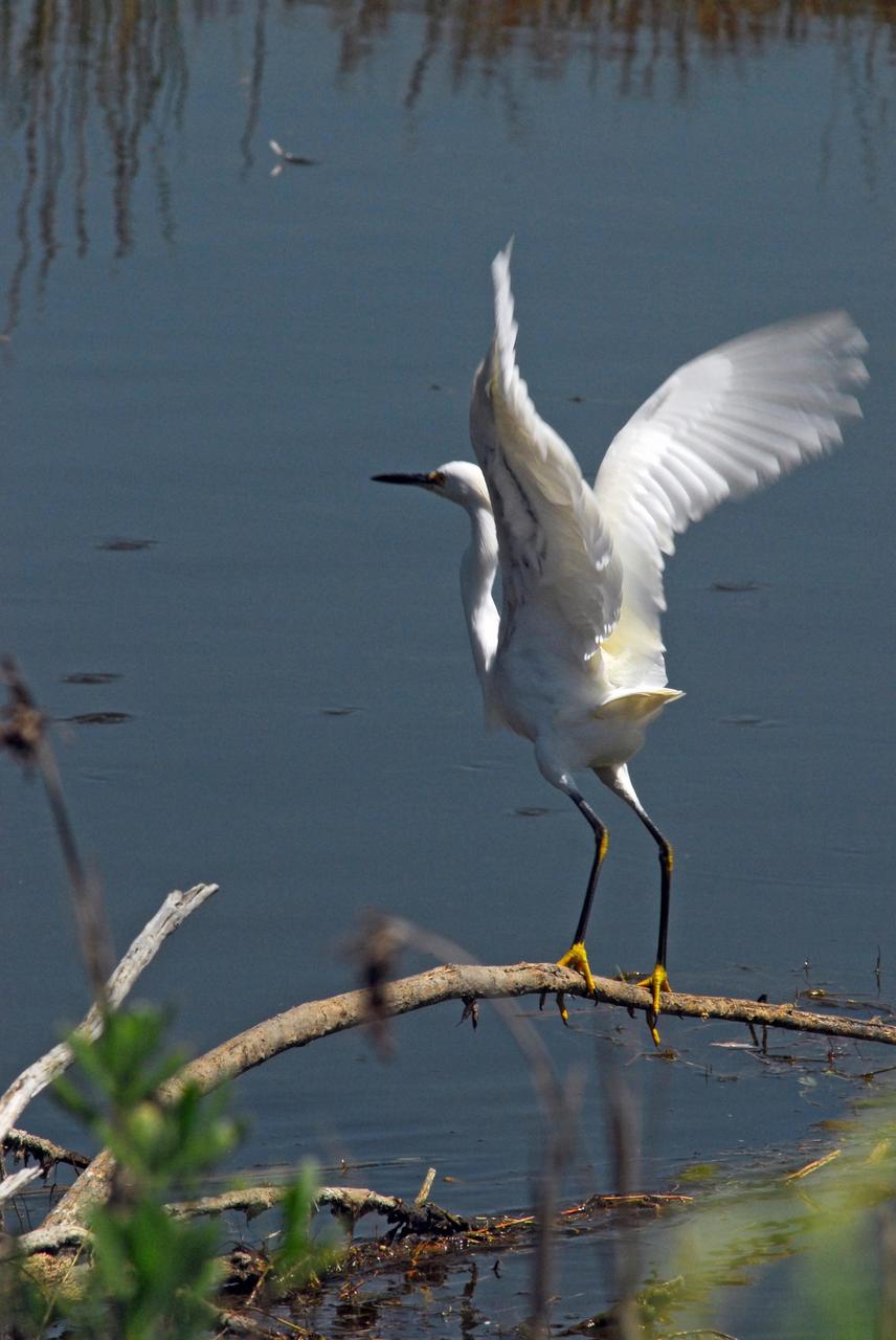
KENNEDY SPACE CENTER, FLA. - At NASA Kennedy Space Center, a snowy egret in breeding plumage stalks the ground. This species is identified by its slender black bill, black legs and yellow feet. It inhabits salt marshes, ponds, rice fields and shallow coastal bays. Its range is northern California, Oklahoma and Maine to southern South America. They winter regularly north to California and South Carolina. The Center shares a boundary with the Merritt Island National Wildlife Refuge, which is a habitat for more than 310 species of birds, 25 mammals, 117 fishes and 65 amphibians and reptiles. In addition, the Refuge supports 19 endangered or threatened wildlife species on Federal or State lists, more than any other single refuge in the U.S. Photo credit: NASA/Jim Grossmann
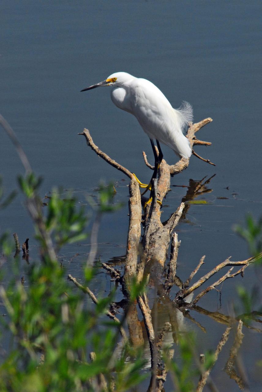
KENNEDY SPACE CENTER, FLA. -- A snowy egret perches on dead limbs in the Indian River near Kennedy Space Center. A type of heron, the snowy egret inhabits salt marshes, ponds, rice fields and shallow coastal bays ranging from Maine to southern South America on the east coast. It can also be found in California and Oklahoma to the Gulf of Mexico. KSC shares a boundary with the Merritt Island Wildlife Nature Refuge. The refuge is a habitat for more than 310 species of birds, 25 mammals, 117 fishes and 65 amphibians and reptiles. In addition, the Refuge supports 19 endangered or threatened wildlife species on Federal or State lists, more than any other single refuge in the U.S. Photo credit: NASA/Dimitri Gerondidakis
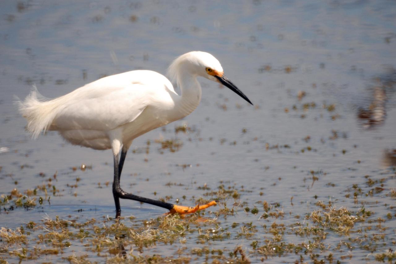
KENNEDY SPACE CENTER, FLA. -- A snowy egret marches through a pond near Kennedy Space Center, looking for food. The snowy egret can be identified by its slender black bill, black legs and yellow feet. This species inhabits salt marshes, ponds, rice field and shallow coastal bays along the coast from Maine to southern South America. They are also found in northern California, Texas and Oklahoma. KSC shares a boundary with the Merritt Island National Wildlife Refuge, which surrounds it. The refuge is a habitat for more than 310 species of birds, 25 mammals, 117 fishes and 65 amphibians and reptiles. In addition, the refuge supports 19 endangered or threatened wildlife species on Federal or State lists, more than any other single refuge in the U.S. Photo credit: NASA/Ken Thornsley
KENNEDY SPACE CENTER, FLA. -- A snowy egret perches on dead limbs in the Indian River near Kennedy Space Center. A type of heron, the snowy egret inhabits salt marshes, ponds, rice fields and shallow coastal bays ranging from Maine to southern South America on the east coast. It can also be found in California and Oklahoma to the Gulf of Mexico. KSC shares a boundary with the Merritt Island Wildlife Nature Refuge. The refuge is a habitat for more than 310 species of birds, 25 mammals, 117 fishes and 65 amphibians and reptiles. In addition, the Refuge supports 19 endangered or threatened wildlife species on Federal or State lists, more than any other single refuge in the U.S. Photo credit: NASA/Dimitri Gerondidakis
KENNEDY SPACE CENTER, FLA. -- A snowy egret prepares for flight from its perch in the Indian River near Kennedy Space Center. A type of heron, the snowy egret inhabits salt marshes, ponds, rice fields and shallow coastal bays ranging from Maine to southern South America on the east coast. It can also be found in California and Oklahoma to the Gulf of Mexico. KSC shares a boundary with the Merritt Island Wildlife Nature Refuge. The refuge is a habitat for more than 310 species of birds, 25 mammals, 117 fishes and 65 amphibians and reptiles. In addition, the Refuge supports 19 endangered or threatened wildlife species on Federal or State lists, more than any other single refuge in the U.S. Photo credit: NASA/Dimitri Gerondidakis
CAPE CANAVERAL, Fla. – A snowy egret stands in the shallow water of a pond in the Merritt island National Wildlife Refuge, which borders NASA's Kennedy Space Center in Florida. A type of heron, the snowy egret inhabits salt marshes, ponds, rice fields and shallow coastal bays ranging from Maine to southern South America on the east coast. It can also be found in California and Oklahoma to the Gulf of Mexico. The center shares a boundary with the refuge that includes salt-water estuaries, brackish marshes, hardwood hammocks and pine flatwoods. The diverse landscape provides habitat for more than 310 species of birds, 25 mammals, 117 fishes and 65 amphibians and reptiles. Photo credit: NASA/Jim Grossmann
KENNEDY SPACE CENTER, FLA. — A contrast in black and white, this snowy egret is spotted near NASA Kennedy Space Center. Its habitat is salt marshes, ponds, rice fields and shallow coastal bays, ranging primarily along the eastern coast from Maine to South America, but including areas of northern California and Oklahoma. This and other wildlife abound throughout KSC as it shares a boundary with the Merritt Island National Wildlife Refuge, home to some of the nation’s rarest and most unusual species of wildlife. The wildlife refuge is a habitat for more than 310 species of birds, 25 mammals, 117 fishes and 65 amphibians and reptiles. In addition, the Refuge supports 19 endangered or threatened wildlife species on Federal or State lists, more than any other single refuge in the U.S.
KENNEDY SPACE CENTER, FLA. -- A snowy egret is spotted in the midst of reeds near a pond on NASA's Kennedy Space Center. A type of heron, the snowy egret inhabits salt marshes, ponds, rice fields and shallow coastal bays ranging from Maine to southern South America on the east coast. It can also be found in California and Oklahoma to the Gulf of Mexico. KSC shares a boundary with the Merritt Island Wildlife Nature Refuge. The refuge is a habitat for more than 310 species of birds, 25 mammals, 117 fishes and 65 amphibians and reptiles. In addition, the Refuge supports 19 endangered or threatened wildlife species on Federal or State lists, more than any other single refuge in the U.S. Photo credit: NASA/Ken Thornsley

S90-45896 (29-31 July 1990) --- Susan J. Helms, one of the 23 astronaut candidates who began a year's training and evaluation program in July, participates in one of themany sessions at a survival training course at Vance Air Force Base. This portion of the course is designed to familiarize the trainee with procedures to follow in preparation for ejection from a jet aircraft.

ISS036-E-009405 (17 June 2013) --- One of the Expedition 36 crew members aboard the International Space Station, some 240 miles above Earth, used a 50mm lens to record this oblique nighttime image of a large part of the nation’s second largest state in area, including the four largest metropolitan areas in population. The extent of the metropolitan areas is easily visible at night due to city and highway lights. The largest metro area, Dallas-Fort Worth, often referred to informally as the Metroplex, is the heavily cloud-covered area at the top center of the photo. Neighboring Oklahoma, on the north side of the Red River, less than 100 miles to the north of the Metroplex, appears to be experiencing thunderstorms. The Houston metropolitan area, including the coastal city of Galveston, is at lower right. To the east near the Texas border with Louisiana, the metropolitan area of Beaumont-Port Arthur appears as a smaller blotch of light, also hugging the coast of the Texas Gulf. Moving inland to the left side of the picture one can delineate the San Antonio metro area. The capital city of Austin can be seen to the northeast of San Antonio. This and hundreds of thousands of other Earth photos taken by astronauts and cosmonauts over the past 50 years are available on http://eol.jsc.nasa.gov
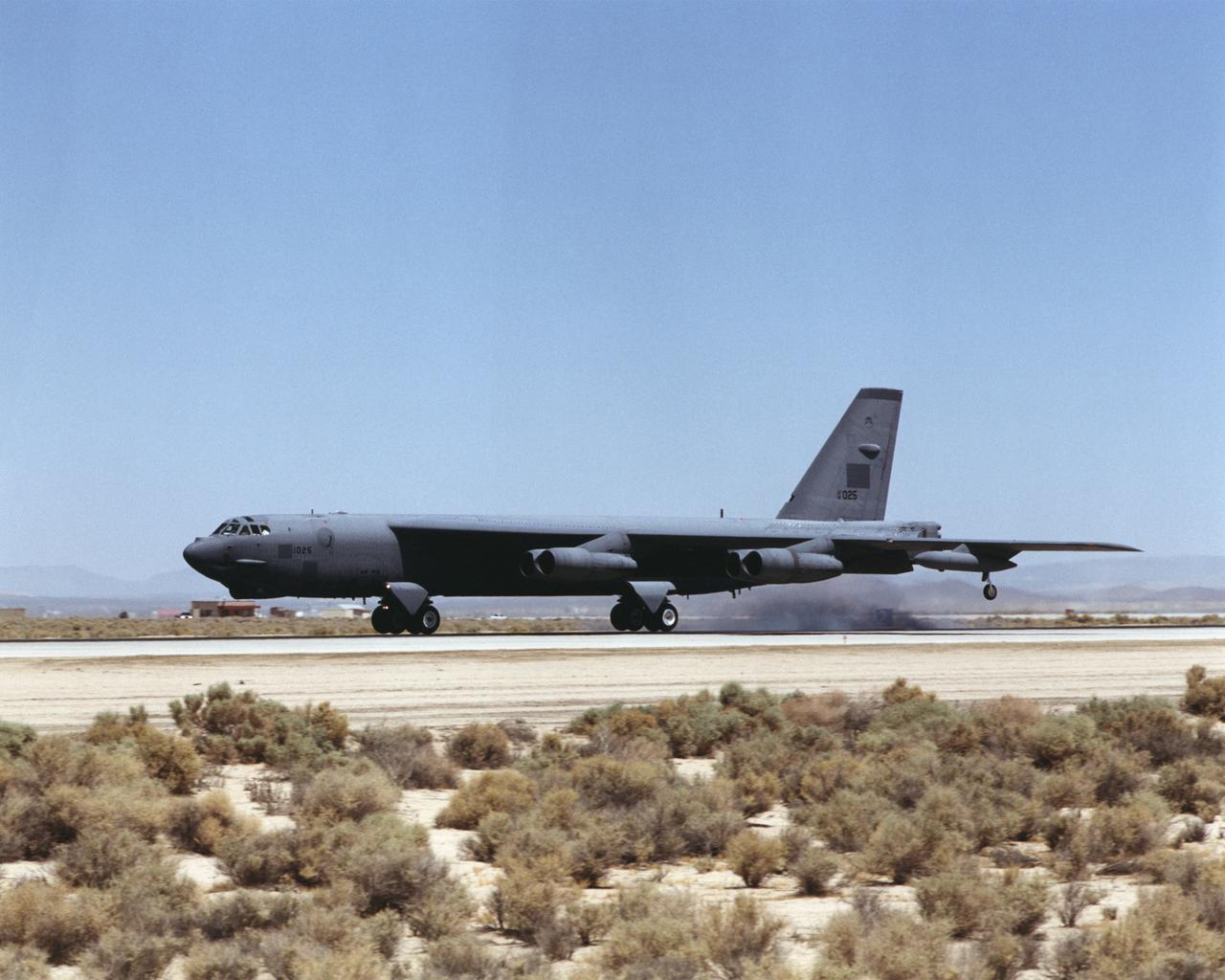
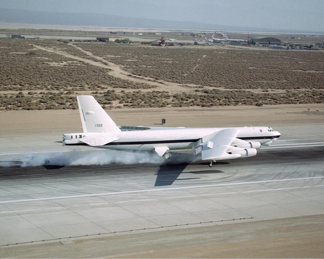
A B-52 "H" model, on loan to NASA Dryden from the U.S. Air Force, touches down at Edwards Air Force Base, California, July 30, 2001.
A B-52H, tail number 61-0025, arrives at NASA's Dryden Flight Research Center after landing July 30, 2001.
A B-52H, on loan to NASA's Dryden Flight Research Center, makes a pass down the runway prior to landing at Edwards Air Force Base, California.
A very anomalous weather pattern is in place over the U.S. for mid-July. Trapped between an upper level ridge centered over the Ohio Valley and the closed upper level low over the Texas/Oklahoma border, atypical hot, muggy air is stifling a broad swath of the eastern U.S. The closed low is expected to drift west toward New Mexico bringing heavy, localized rain to some areas and temperatures running 10-20 degrees below mid-July averages. Across the east, temperatures will warm well into the 90's and stay there through the week. This image was taken by GOES East at 1645Z on July 15, 2013. Image credit: <b><a href="http://goes.gsfc.nasa.gov/" rel="nofollow">Credit: NOAA/NASA GOES Project</a></b> Text credit: NOAA <b><a href="http://www.nasa.gov/audience/formedia/features/MP_Photo_Guidelines.html" rel="nofollow">NASA image use policy.</a></b> <b><a href="http://www.nasa.gov/centers/goddard/home/index.html" rel="nofollow">NASA Goddard Space Flight Center</a></b> enables NASA’s mission through four scientific endeavors: Earth Science, Heliophysics, Solar System Exploration, and Astrophysics. Goddard plays a leading role in NASA’s accomplishments by contributing compelling scientific knowledge to advance the Agency’s mission. <b>Follow us on <a href="http://twitter.com/NASA_GoddardPix" rel="nofollow">Twitter</a></b> <b>Like us on <a href="http://www.facebook.com/pages/Greenbelt-MD/NASA-Goddard/395013845897?ref=tsd" rel="nofollow">Facebook</a></b> <b>Find us on <a href="http://instagram.com/nasagoddard?vm=grid" rel="nofollow">Instagram</a></b>
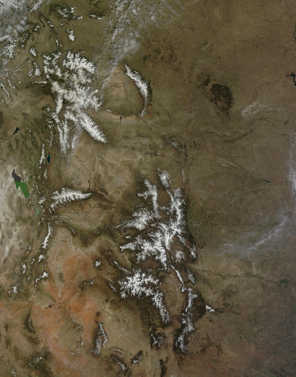
On April 29, 2015 the Moderate Resolution Imaging Spectroradiometer (MODIS) aboard NASA’s Terra satellite captured a true-color image of a typical spring scene in the western United State: snow-crowned Rocky Mountains rising above the faintly greening plains. The Rocky Mountains stretch from British Columbia, Canada to the Rio Grande in New Mexico, a span of roughly 3,000 miles, and contains many of the highest peaks in the continental United States. The tallest, Mount Elbert, rises 14,400 ft. (4,401 m) above sea level, and is located in the San Isabel National Forest, near Leadville, Colorado. This image covers seven Rocky Mountain states. From north to south they are: Montana and Idaho, Wyoming; Utah (with the Great Salt Lake visible) and Colorado; Arizona and New Mexico. To the east, the Great Plain states captured are, from north to south: North Dakota, South Dakota, Nebraska, Kansas, Oklahoma and northwestern Texas. Credit: NASA/GSFC/Jeff Schmaltz/MODIS Land Rapid Response Team <b><a href="http://www.nasa.gov/audience/formedia/features/MP_Photo_Guidelines.html" rel="nofollow">NASA image use policy.</a></b> <b><a href="http://www.nasa.gov/centers/goddard/home/index.html" rel="nofollow">NASA Goddard Space Flight Center</a></b> enables NASA’s mission through four scientific endeavors: Earth Science, Heliophysics, Solar System Exploration, and Astrophysics. Goddard plays a leading role in NASA’s accomplishments by contributing compelling scientific knowledge to advance the Agency’s mission. <b>Follow us on <a href="http://twitter.com/NASAGoddardPix" rel="nofollow">Twitter</a></b> <b>Like us on <a href="http://www.facebook.com/pages/Greenbelt-MD/NASA-Goddard/395013845897?ref=tsd" rel="nofollow">Facebook</a></b> <b>Find us on <a href="http://instagrid.me/nasagoddard/?vm=grid" rel="nofollow">Instagram</a></b>
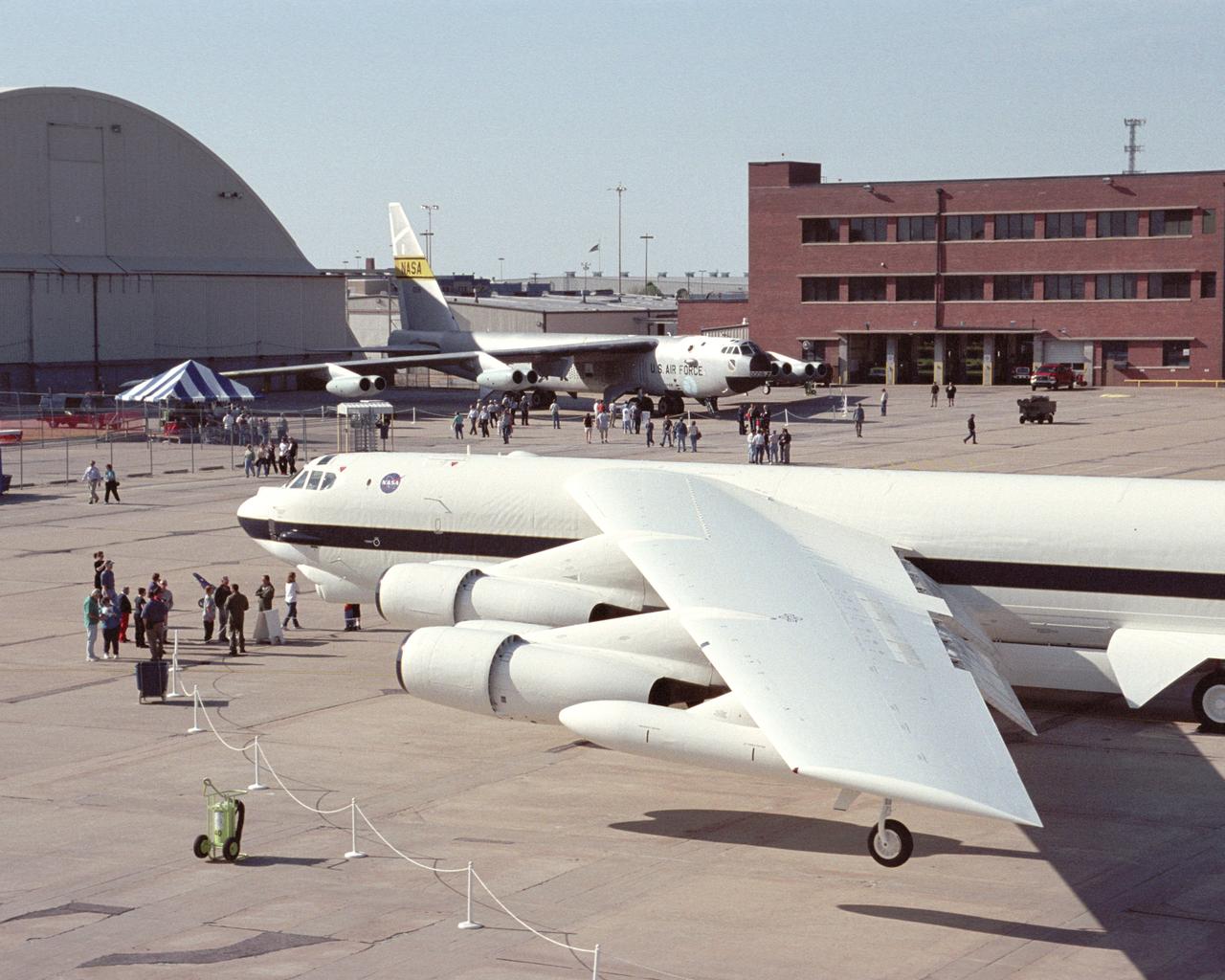
NASA's new white B-52H, shared ramp space with the veteran NASA B-52B mother ship in Wichita, Kansas, April 12, 2002 during the 50th anniversary of the B-52 aircraft.
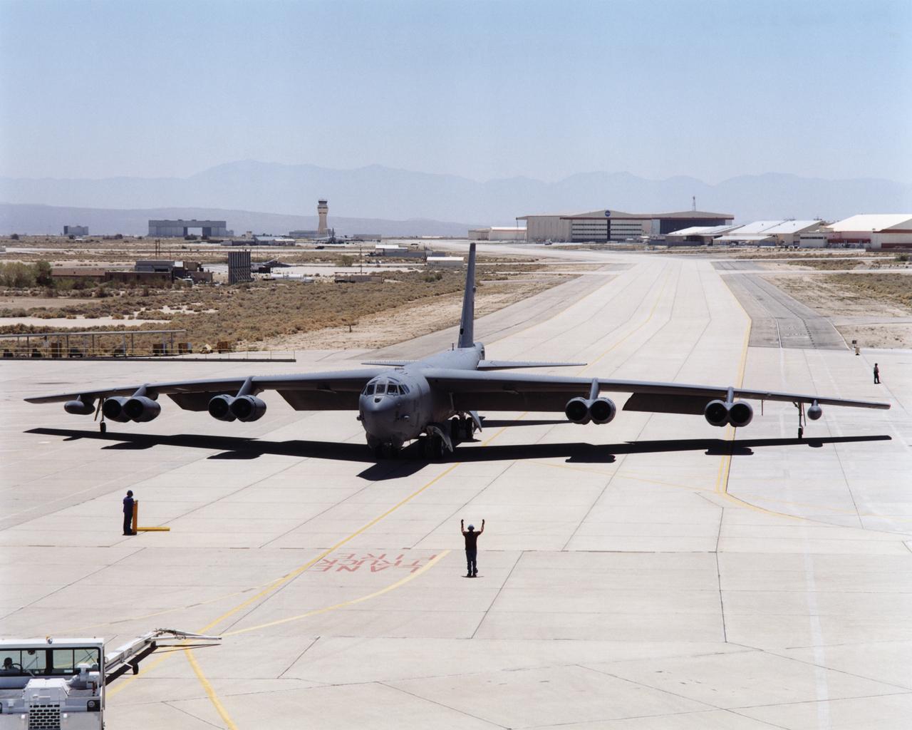
B-52H over Dryden Flight Research Center

NASA's new white B-52H, destined to join a veteran B-52B mother ship at NASA's Dryden Flight Research Center, was exhibited at the Boeing plant in Wichita, Kansas, April 12, 2002 during the 50th anniversary commemoration of the B-52 series of aircraft.
B-52H over Dryden Flight Research Center

NASA's veteran silver B-52B, foreground, joined the new B-52H in NASA markings for a ceremony in Wichita, Kansas, April 12, 2002, marking the 50th anniversary of the B-52 aircraft
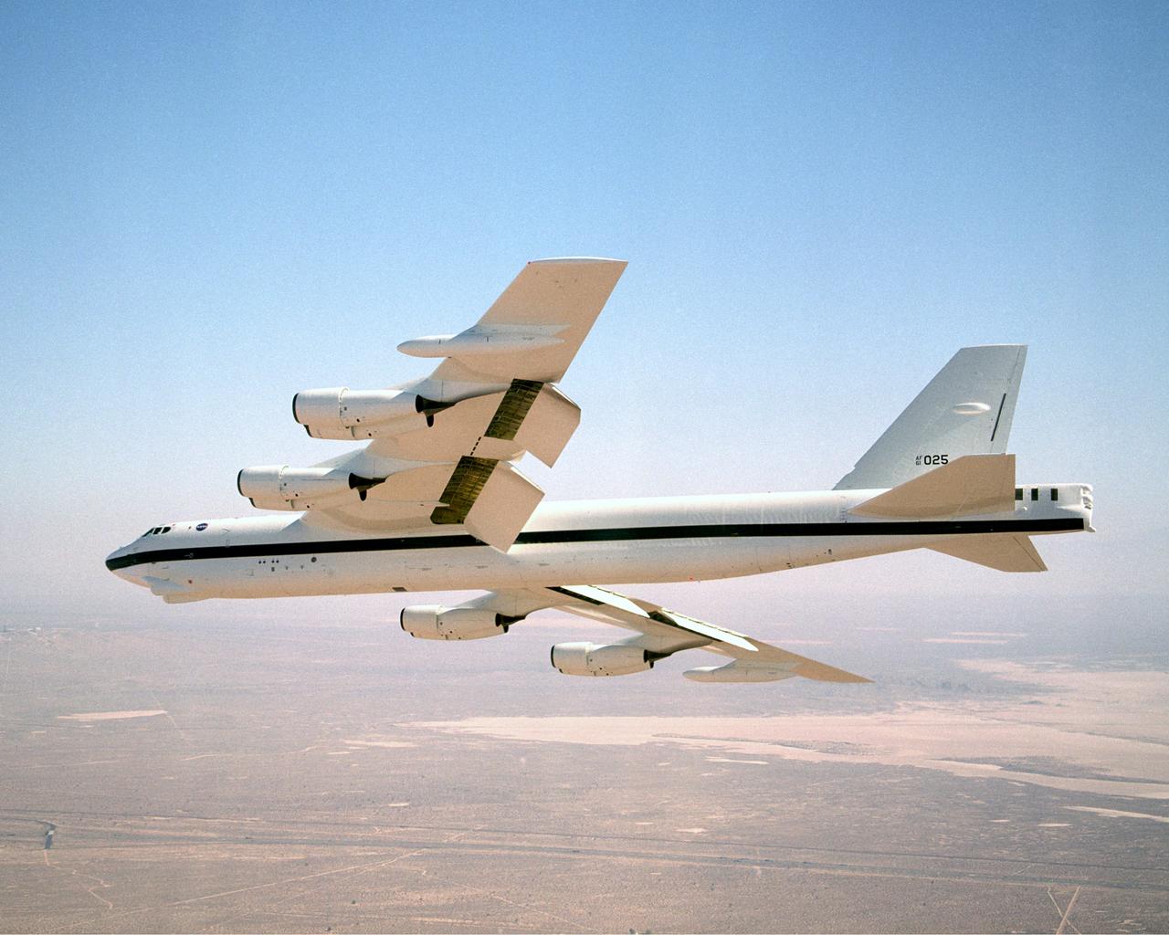
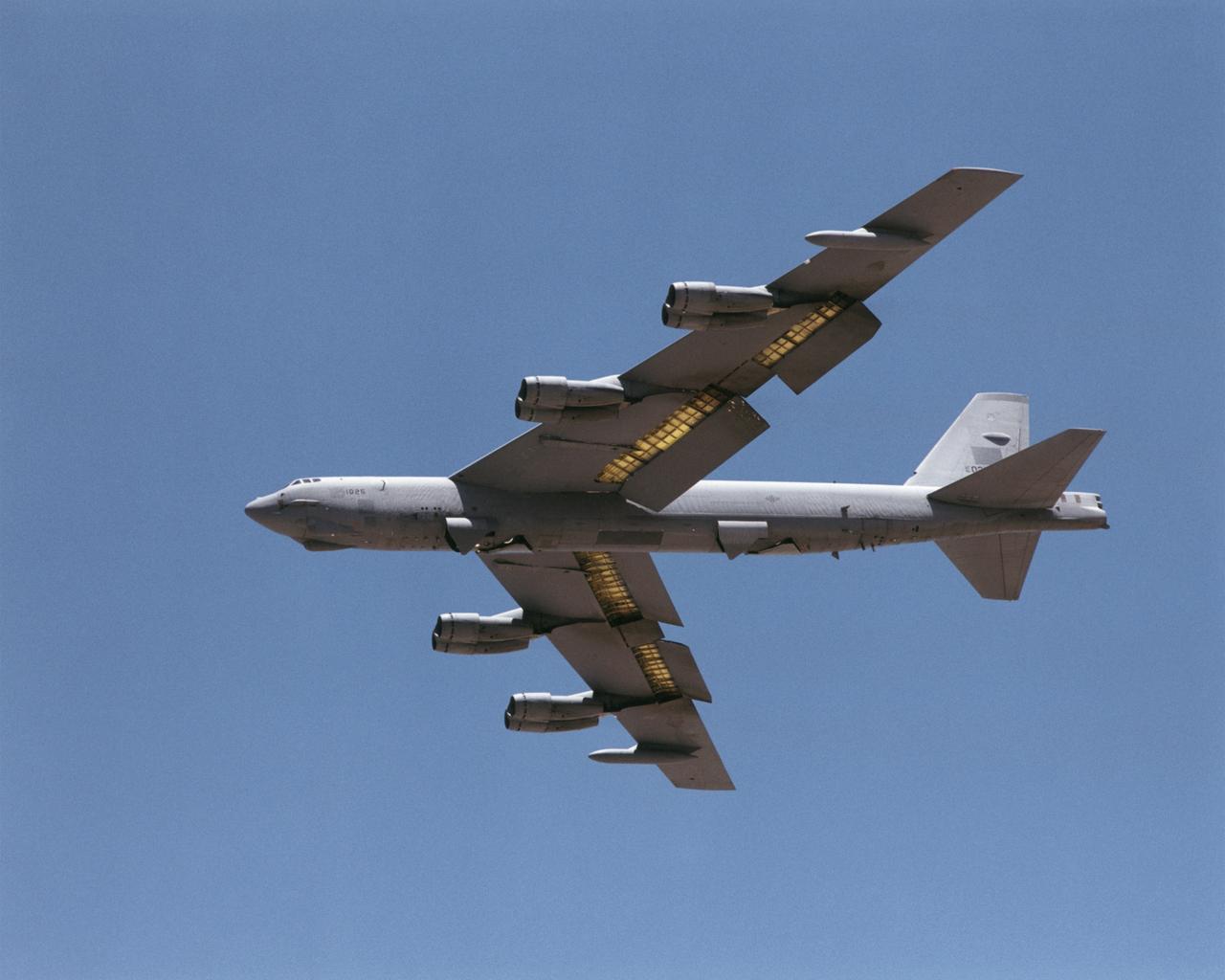
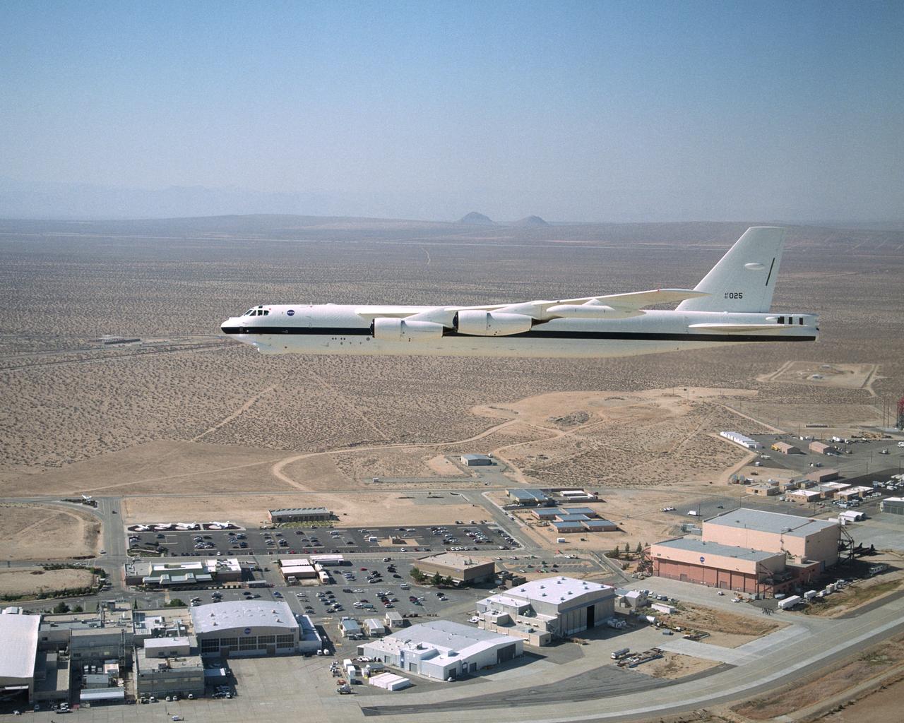
NASA Dryden's B-52H in flight
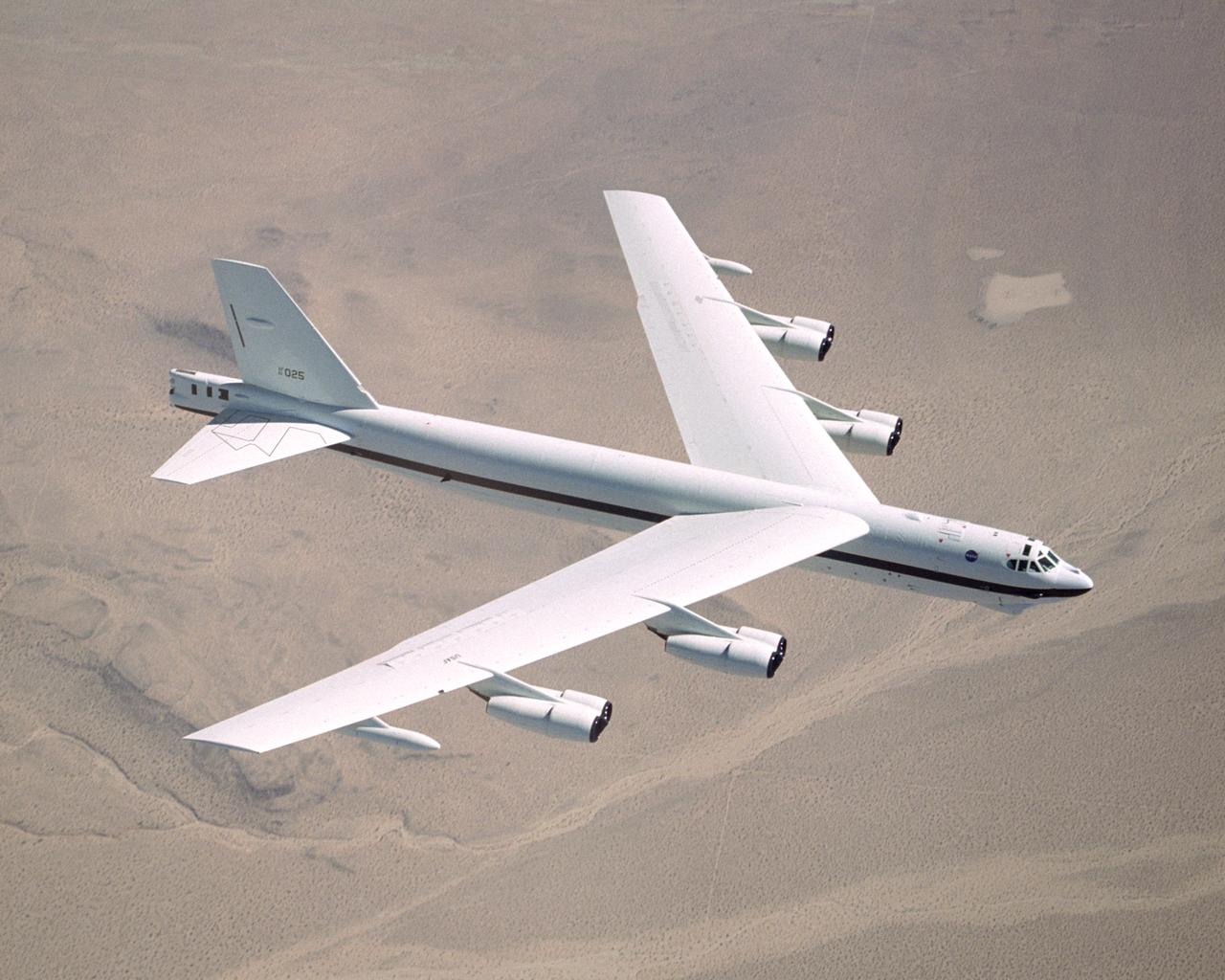
NASA Dryden's B-52H in flight.
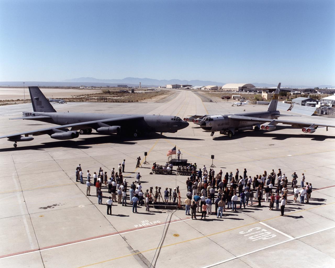
A newly arrived B-52H is seen here alongside NASA Dryden's venerable B-52 "B" model during its arrival ceremony on August 1, 2001.
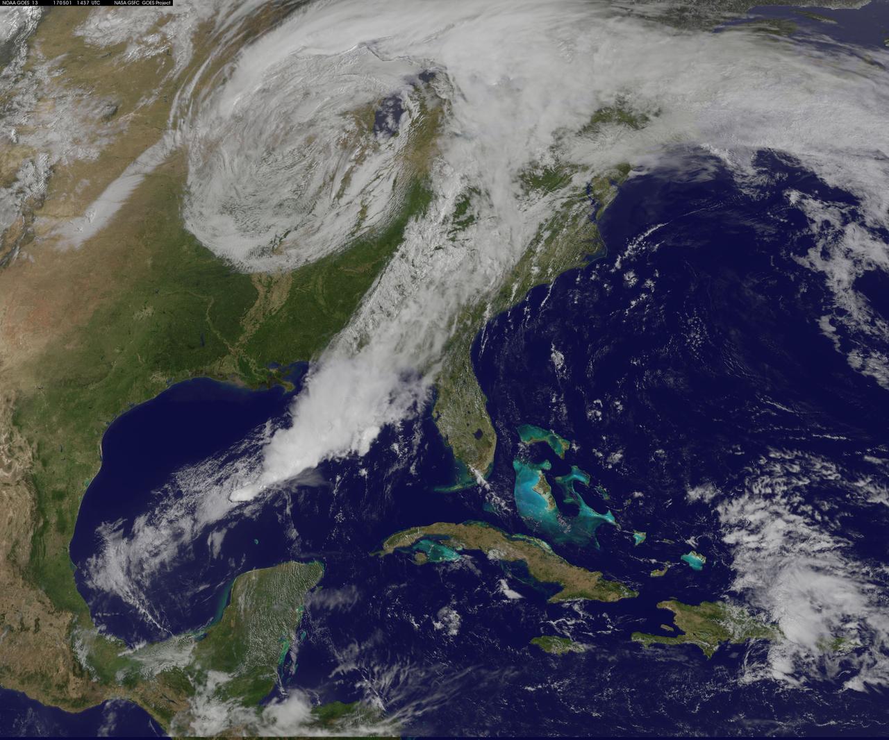
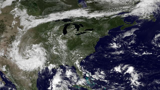
NASA Sees Severe Weather from Central to Eastern US A vigorous weather system has generated severe weather over the mid-section of the U.S. and satellites are providing a look at it as it is moving toward the East Coast. NASA and NOAA satellites have been tracking a storm system that has generated flooding and tornadic thunderstorms in the central U.S. and is expected bring severe weather to the U.S. Mid-Atlantic region. At NASA's Goddard Space Flight Center in Greenbelt, Maryland, data from NOAA's GOES-East satellite were used to create images and an animation of the movement of the powerful storm. On April 30, the Moderate Resolution Imaging Spectroradiometer, or MODIS, instrument aboard NASA's Aqua satellite captured a visible image of the storms moving over eastern Texas and Louisiana. Tornadoes in eastern Texas killed four people. The system generated heavy rainfall and caused additional fatalities and damages in Arkansas, Missouri, Mississippi, Alabama and Tennessee. On Monday, May 1, NOAA's National Weather Service noted, "Major to record flooding continues over portions of the central U.S. Severe thunderstorms are possible from the Mid-Atlantic to the northeastern U.S. "Major to record flooding will continue over portions of eastern Oklahoma, northern Arkansas, Missouri, Illinois and Indiana. Rivers will gradually recede over the next several days. Additional strong to severe thunderstorms will be possible Monday afternoon and evening over portions of the Mid-Atlantic and Northeast U.S. Damaging winds, large hail, and isolated tornadoes will be possible." Image caption: On May 1, 2017, at 10:37 a.m. EDT (1437 UTC) NOAA's GOES-East satellite captured this visible image of the storm system centered over Iowa with an associated cold front that stretches into the Gulf of Mexico. Credits: NASA/NOAA GOES Project <b><a href="http://www.nasa.gov/audience/formedia/features/MP_Photo_Guidelines.html" rel="nofollow">NASA image use policy.</a></b> <b><a href="http://www.nasa.gov/centers/goddard/home/index.html" rel="nofollow">NASA Goddard Space Flight Center</a></b> enables NASA’s mission through four scientific endeavors: Earth Science, Heliophysics, Solar System Exploration, and Astrophysics. Goddard plays a leading role in NASA’s accomplishments by contributing compelling scientific knowledge to advance the Agency’s mission. <b>Follow us on <a href="http://twitter.com/NASAGoddardPix" rel="nofollow">Twitter</a></b> <b>Like us on <a href="http://www.facebook.com/pages/Greenbelt-MD/NASA-Goddard/395013845897?ref=tsd" rel="nofollow">Facebook</a></b> <b>Find us on <a href="http://instagrid.me/nasagoddard/?vm=grid" rel="nofollow">Instagram</a></b>

The Polar Vortex is a whirling and persistent large area of low pressure, found typically over both north and south poles. The northern Polar Vortex is pushing southward over western Wisconsin/eastern Minnesota today, Monday, January 6, 2014 and is bringing frigid temperatures to half of the continental United States. It is expected to move northward back over Canada toward the end of the week. This image was captured by NOAA's GOES-East satellite on January 6, 2014 at 1601 UTC/11:01 a.m. EST. A frontal system that brought rain to the coast is draped from north to south along the U.S. East Coast. Behind the front lies the clearer skies bitter cold air associated with the Polar Vortex. The GOES image also revealed snow on the ground in Minnesota, Wisconsin, Illinois, Indiana, Ohio, Michigan, Iowa and Missouri, stretching into the Great Plains. Cloudiness over Texas is associated with a low pressure system centered over western Oklahoma that is part of the cold front connected to the movement of the Polar Vortex. The GOES image was created at NASA's GOES Project, located at NASA's Goddard Space Flight Center in Greenbelt, Md. Both the northern and southern polar vortices are located in the middle and upper troposphere (lowest level of the atmosphere) and the stratosphere (next level up in the atmosphere). The polar vortex is a winter phenomenon. It develops and strengthens in its respective hemisphere's winter as the sun sets over the polar region and temperatures cool. They weaken in the summer. In the northern hemisphere, they circulate in a counter-clockwise direction, so the vortex sitting over western Wisconsin is sweeping in cold Arctic air around it. The Arctic Polar Vortex peaks in the Northern Hemisphere's wintertime and has already moved southward several times this winter. In the past, it has also moved southward over Europe.On January 21, 1985, the National Oceanic and Atmospheric Administration Daily Weather Map series showed a strong polar vortex centered over Maine. The Polar Vortex also affects ozone. For more information on the Polar Vortex and how it affects ozone, visit NASA's Ozone Watch page: <a href="http://ozonewatch.gsfc.nasa.gov/facts/vortex_NH.html" rel="nofollow">ozonewatch.gsfc.nasa.gov/facts/vortex_NH.html</a> Rob Gutro NASA's Goddard Space Flight Center <b><a href="http://goes.gsfc.nasa.gov/" rel="nofollow">Credit: NOAA/NASA GOES Project</a></b> <b><a href="http://www.nasa.gov/audience/formedia/features/MP_Photo_Guidelines.html" rel="nofollow">NASA image use policy.</a></b> <b><a href="http://www.nasa.gov/centers/goddard/home/index.html" rel="nofollow">NASA Goddard Space Flight Center</a></b> enables NASA’s mission through four scientific endeavors: Earth Science, Heliophysics, Solar System Exploration, and Astrophysics. Goddard plays a leading role in NASA’s accomplishments by contributing compelling scientific knowledge to advance the Agency’s mission. <b>Follow us on <a href="http://twitter.com/NASA_GoddardPix" rel="nofollow">Twitter</a></b> <b>Like us on <a href="http://www.facebook.com/pages/Greenbelt-MD/NASA-Goddard/395013845897?ref=tsd" rel="nofollow">Facebook</a></b> <b>Find us on <a href="http://instagram.com/nasagoddard?vm=grid" rel="nofollow">Instagram</a></b>
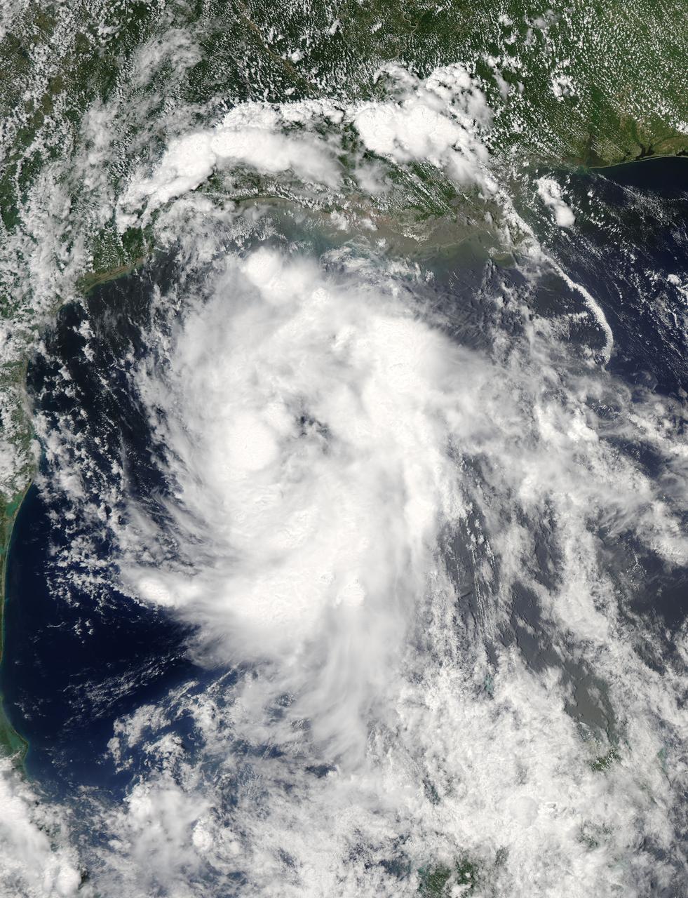
On June 15 at 19:15 UTC (3:15 p.m. EDT) the MODIS instrument aboard NASA's Aqua satellite captured a visible image of Tropical Storm Bill approaching Texas and Louisiana. Powerful thunderstorms circled the center in fragmented bands. At 11 a.m. CDT on June 16, a Tropical Storm Warning was in effect from Baffin Bay to High Island Texas as Bill was making landfall. The National Hurricane Center noted that Bill is expected to produce total rain accumulations of 4 to 8 inches over eastern Texas and eastern Oklahoma and 2 to 4 inches over western Arkansas and southern Missouri, with possible isolated maximum amounts of 12 inches in eastern Texas. In eastern Texas and far western Louisiana today and tonight, isolated tornadoes are also possible, as with any landfalling tropical storm. Tropical storm conditions are expected to continue into the evening in the warning area. Along the coasts, the combination of a storm surge and the tide will cause normally dry areas near the coast to be flooded by rising waters. The water could reach the following heights above ground if the peak surge occurs at the time of high tide. The NHC noted that the Upper Texas coast could experience 2 to 4 feet, and the western Louisiana coast between 1 to 2 feet. At 10 a.m. CDT (1500 UTC), the center of Tropical Storm Bill was located near latitude 28.2 North, longitude 96.4 West. Bill was moving toward the northwest near 10 mph (17 kph) and that general motion is expected to continue today. The latest minimum central pressure reported by an Air Force Reserve Hurricane Hunter aircraft was 997 millibars. Reports from an Air Force Reserve reconnaissance aircraft indicate that maximum sustained winds remain near 60 mph (95 kph) with higher gusts. Unlike Carlos, Bill is not a compact storm. Tropical-storm-force winds extend outward up to 150 miles (240 km) from the center. Between 9 and 10 a.m. CDT, an automated observing station at Port O'Connor also reported a sustained wind of 44 mph (70 kph) and a gust to 53 mph (85 kph). For updated forecasts, watches and warnings, visit the National Hurricane Center webpage at <a href="http://www.nhc.noaa.gov" rel="nofollow">www.nhc.noaa.gov</a>. For local forecasts and advisories, visit: <a href="http://www.weather.gov" rel="nofollow">www.weather.gov</a>. Bill is forecast to continue moving inland and is expected to be a tropical depression by Wednesday, June 17, west of Dallas. The remnants of Bill are forecast to move into the Midwest later in the week. Credit: NASA/GSFC/Jeff Schmaltz/MODIS Land Rapid Response Team <b><a href="http://www.nasa.gov/audience/formedia/features/MP_Photo_Guidelines.html" rel="nofollow">NASA image use policy.</a></b> <b><a href="http://www.nasa.gov/centers/goddard/home/index.html" rel="nofollow">NASA Goddard Space Flight Center</a></b> enables NASA’s mission through four scientific endeavors: Earth Science, Heliophysics, Solar System Exploration, and Astrophysics. Goddard plays a leading role in NASA’s accomplishments by contributing compelling scientific knowledge to advance the Agency’s mission. <b>Follow us on <a href="http://twitter.com/NASAGoddardPix" rel="nofollow">Twitter</a></b> <b>Like us on <a href="http://www.facebook.com/pages/Greenbelt-MD/NASA-Goddard/395013845897?ref=tsd" rel="nofollow">Facebook</a></b> <b>Find us on <a href="http://instagrid.me/nasagoddard/?vm=grid" rel="nofollow">Instagram</a></b>