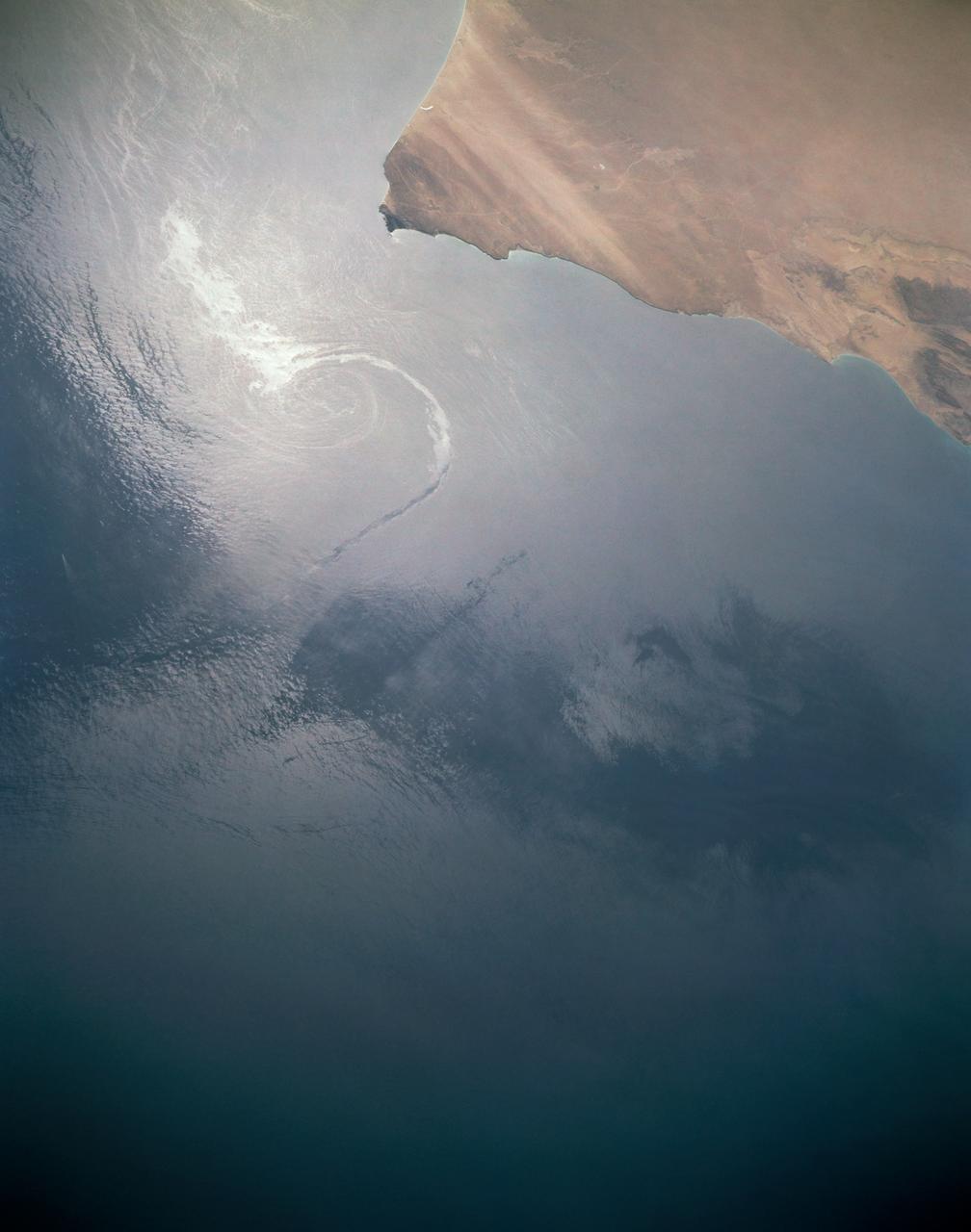
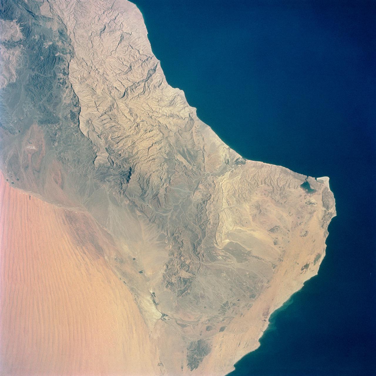
In this sunglint view of the Arabian Seacoast of Oman (19.0N, 59.0E) an oil slick is highlighted on the water's surface by sunglint lighting conditions. Nearly 50 percent of the oil transported worldwide passes through the Gulf of Oman, en route from the Persian Gulf and numerous ship wakes can be seen in this view. The oil slick, rounding the tip of Cape Ras Al Hadd, has formed a counterclockwise bright spiral indicating the local ocean currents.
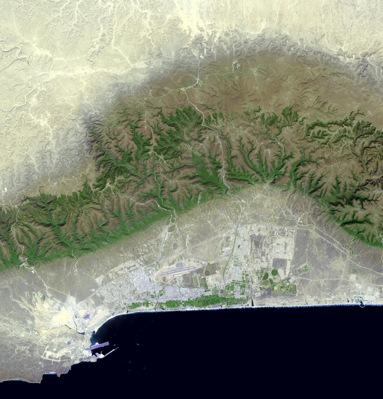
Salalah is the second largest city in the Sultanate of Oman, located in the far southern tip of the country. Salalah reached its peak in the 13th century, thanks to the trade in frankincense and myrrh. From 1932 to 1970, it was the capital of the Sultanate of Muscat and Oman. The Port of Salalah is one of the most vital on the Arabian Peninsula. The image was acquired October 15, 2016, covers an area of 47 by 49 km, and is located at 17.1 north, 54.1 east. https://photojournal.jpl.nasa.gov/catalog/PIA21803
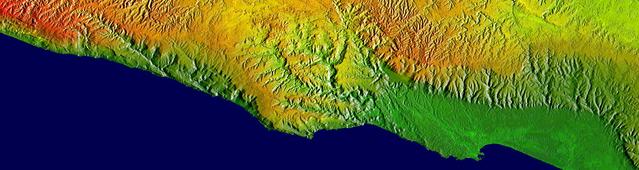
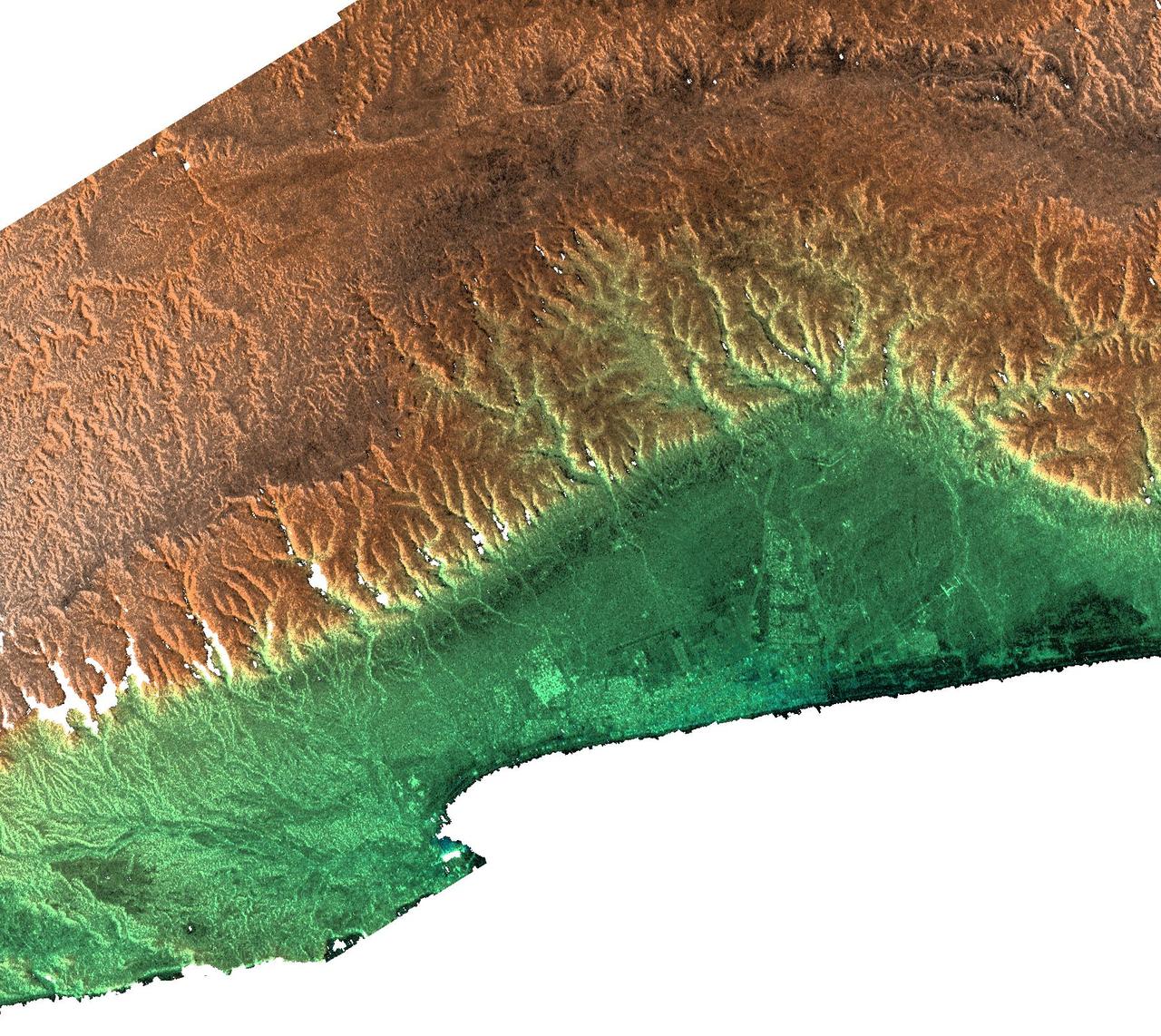
This elevation map shows a part of the southern coast of the Arabian Peninsula including parts of the countries of Oman and Yemen. The narrow coastal plain on the right side of the image includes the city of Salahlah, the second largest city in Oman.
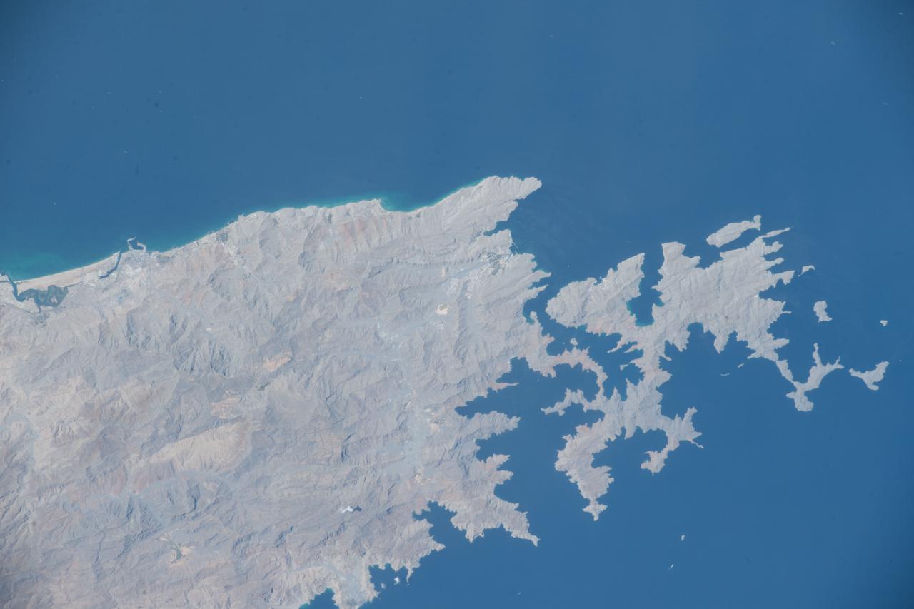
The Musandam Peninsula is part of Oman, separated from the rest of the country by the United Arab Emirates. This image was acquired by NASA Terra satellite on March 27, 2004.
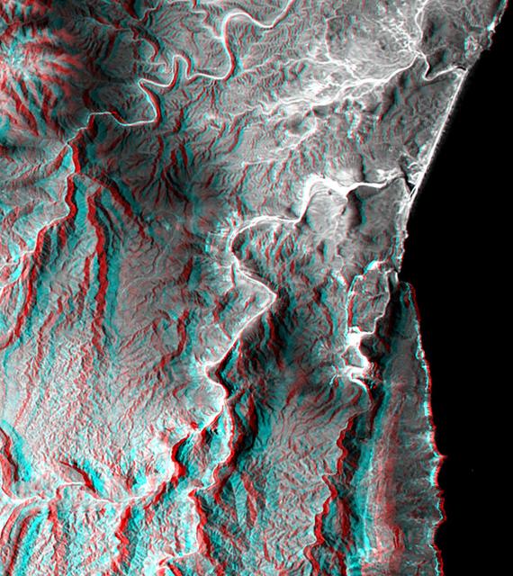
This anaglyph, from NASA Shuttle Radar Topography Mission, is of the coastal area in southernmost Oman; the Arabian Sea is on the right. 3D glasses are necessary to view this image.
This radar image acquired by NASA Shuttle Radar Topography Mission SRTM from data collected on February 15, 2000 includes the city of Salalah, the second largest city in Oman.
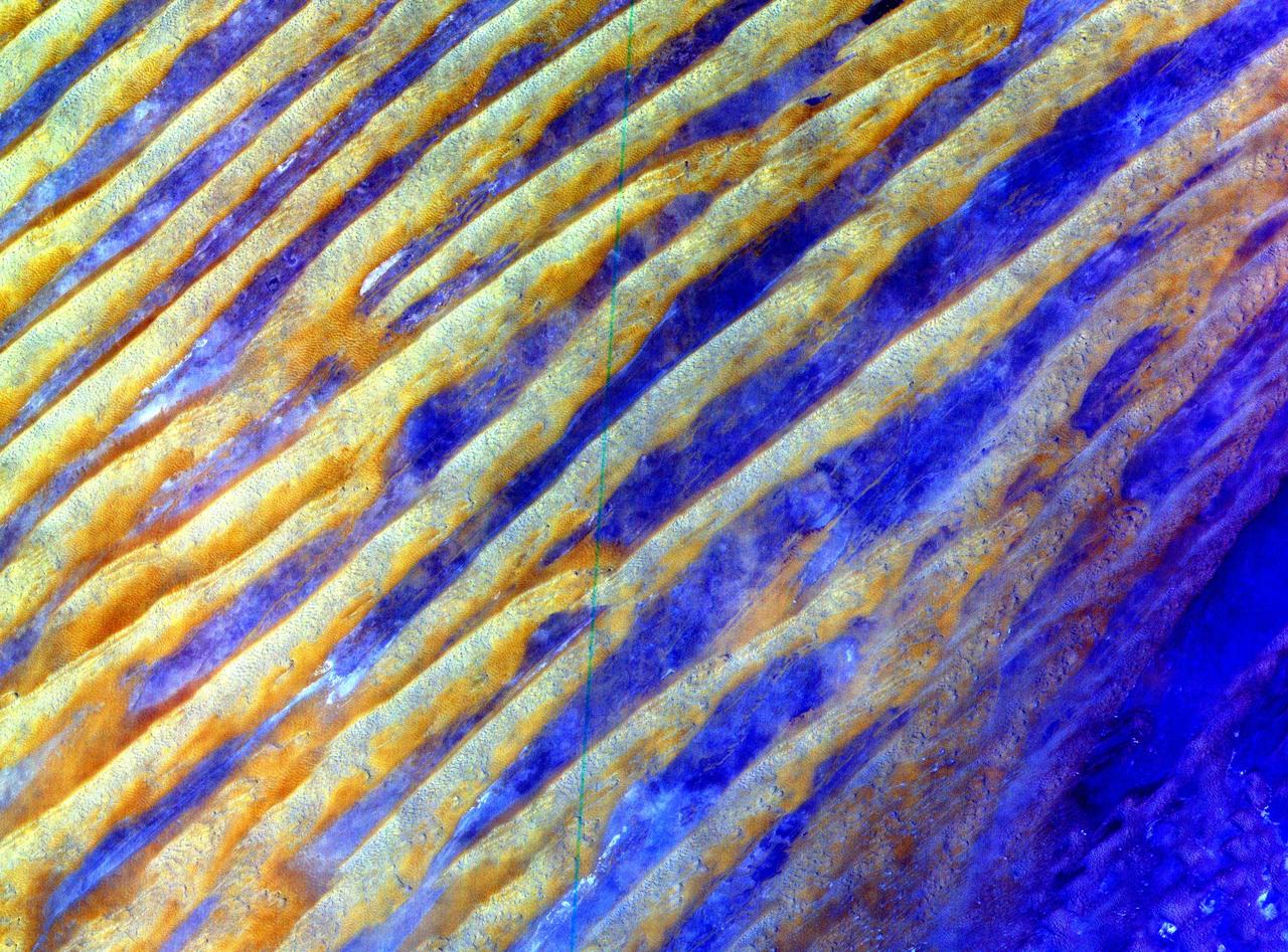
Bright, arc-shaped limestone hills and complex, branching drainage patterns dominate this three-frequency space radar image of a desert area in the north central plain of Oman.
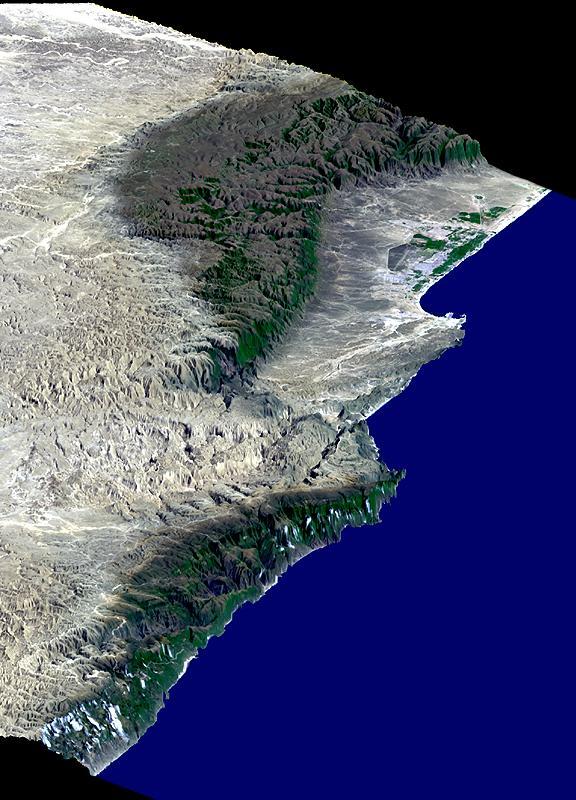
This perspective view includes the city of Salalah, the second largest city in Oman. The city is located on the broad, generally bright coastal plain and includes areas of green irrigated crops.
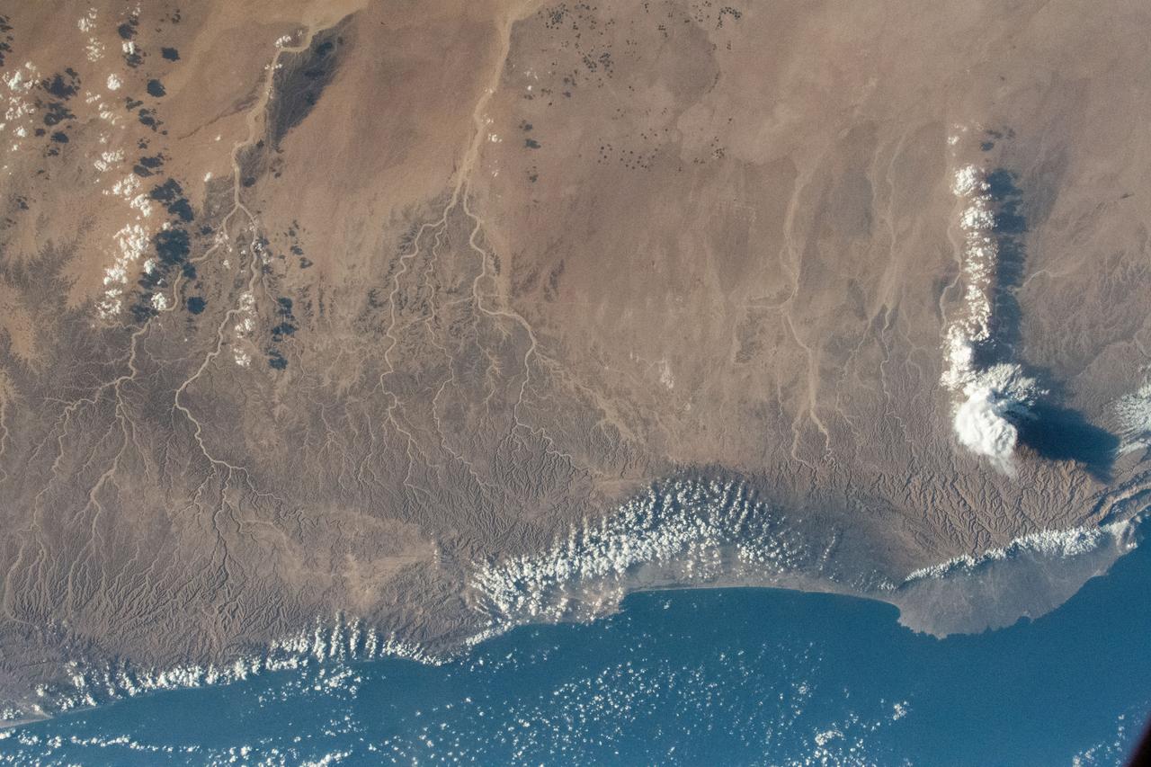
iss069e003275 (April 13, 2023) --- The middle eastern nation of Oman and its Dhofar mountains on the coast of the Arabian Sea were pictured by UAE (United Arab Emirates) astronaut and Expedition 69 Flight Engineer Sultan Alneyadi as the International Space Station orbited 257 miles above.
STS006-44-532 (4-9 April 1983) --- This is one of a series of photographs taken through the “ceiling” windows of the Earth-orbiting space shuttle Challenger by members of the STS-6 crew on its five-day mission in space. Many unused oil tankers lie in the roadstead along the coast of U.A.E. between the ports of Khawn Fakkan and Fujayrah. The sunglint on the Gulf of Oman permits the viewer to see the surface features much clearer. Such surface features as gynes, slicks, wakes, and sea state are clearly seen. Photo credit: NASA
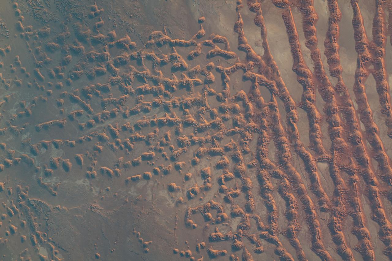
iss069e010867 (May 16, 2023) --- Sand dunes in the desert area along the Saudi Arabia-Oman border were pictured by UAE (United Arab Emirates) astronaut and Expedition 69 Flight Engineer Sultan Alneyadi from the International Space Station as it orbited 256 miles above.
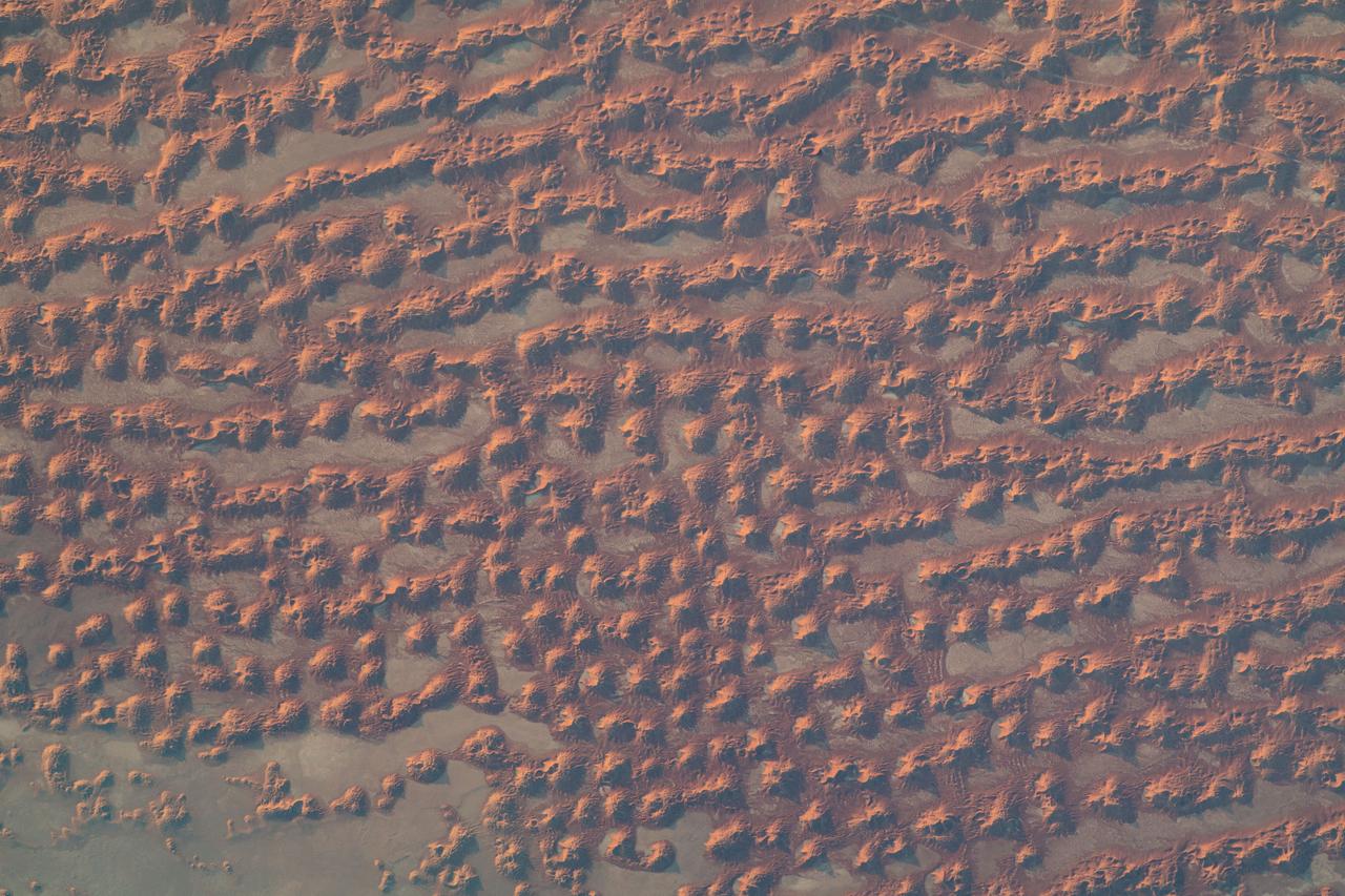
iss069e010869 (May 16, 2023) --- Sand dunes in the desert area along the Saudi Arabia-Oman border were pictured by UAE (United Arab Emirates) astronaut and Expedition 69 Flight Engineer Sultan Alneyadi from the International Space Station as it orbited 256 miles above.
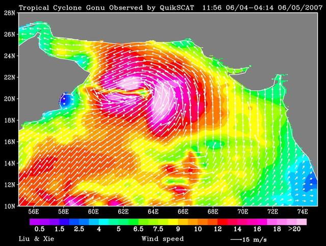
NASA QuikScat observed a rare tropical cyclone in the northern part of the Arabian Sea, threatening the petroleum shipping lanes and the Gulf States e.g. Oman that are unprepared for such an event.
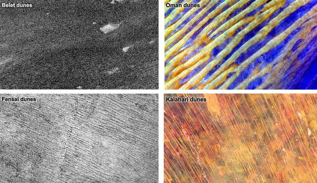
Data from NASA Cassini spacecraft show that the sizes and patterns of dunes on Saturn moon Titan vary as a function of altitude and latitude left. Images of Earth dunes Oman and Kalahari are shown at right as seen by NASA Terra spacecraft.
NASA Terra spacecraft shows the Rub al Khali, one of the largest sand deserts in the world, encompassing most of the southern third of the Arabian Peninsula; it includes parts of Oman, United Arab Emirates, and Yemen.

iss070e002199 (Oct. 4, 2023) --- The Soyuz MS-24 crew ship is featured prominently in this photograph from the International Space Station as it soared into an orbital sunrise 259 miles above the Iran-Pakistan border. The city lights below highlight the United Arab Emirates on the Persian Gulf and Oman on the Gulf of Oman.
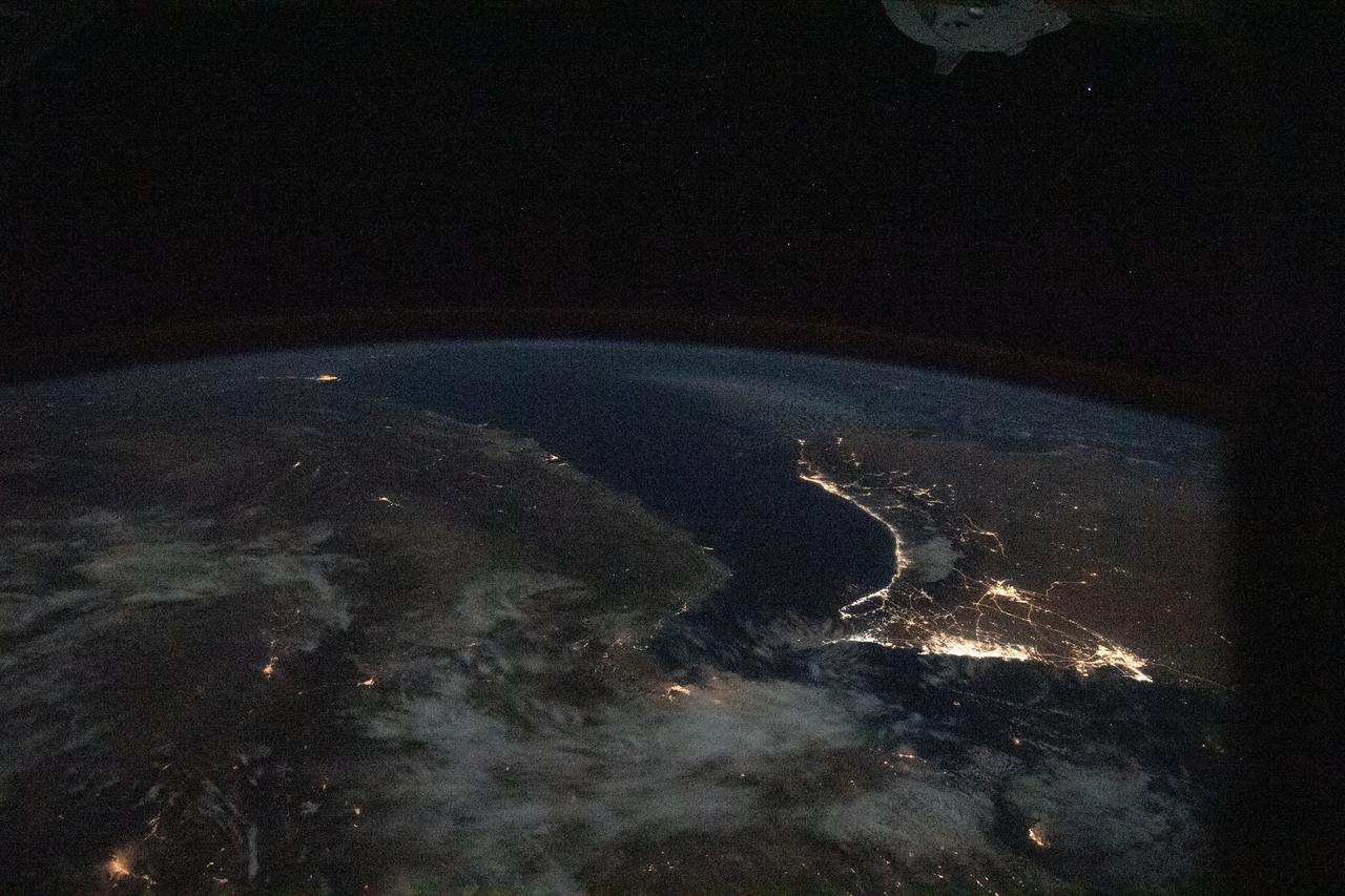
iss067e270600 (Aug. 18, 2022) --- The Strait of Hormuz connects the Gulf of Oman (left) with the Persian Gulf (right). The waterway also separates the Middle Eastern nation of Iran (bottom) from the Arabian Peninsula nations of Oman, United Arab Emirates, and Qatar (top left to right).
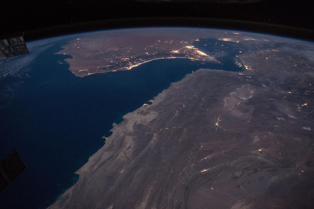
iss064e007913 (Nov. 28, 2020) --- This image from International Space Station as it was flying 261 miles over Iran looks southeast across the Persian Gulf and the Gulf of Oman. The well-lit areas along the coast are cities located in the nations of Oman and the United Arab Emirates.
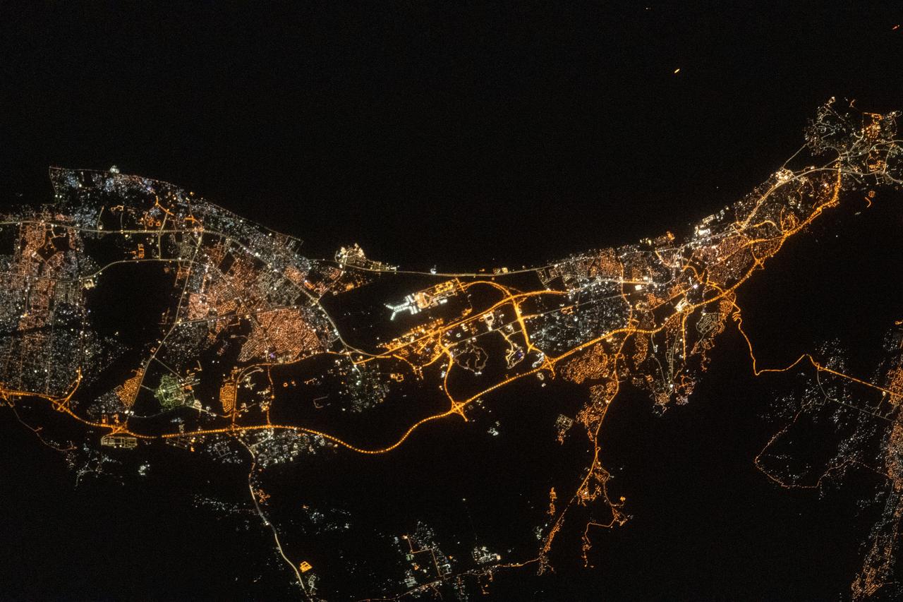
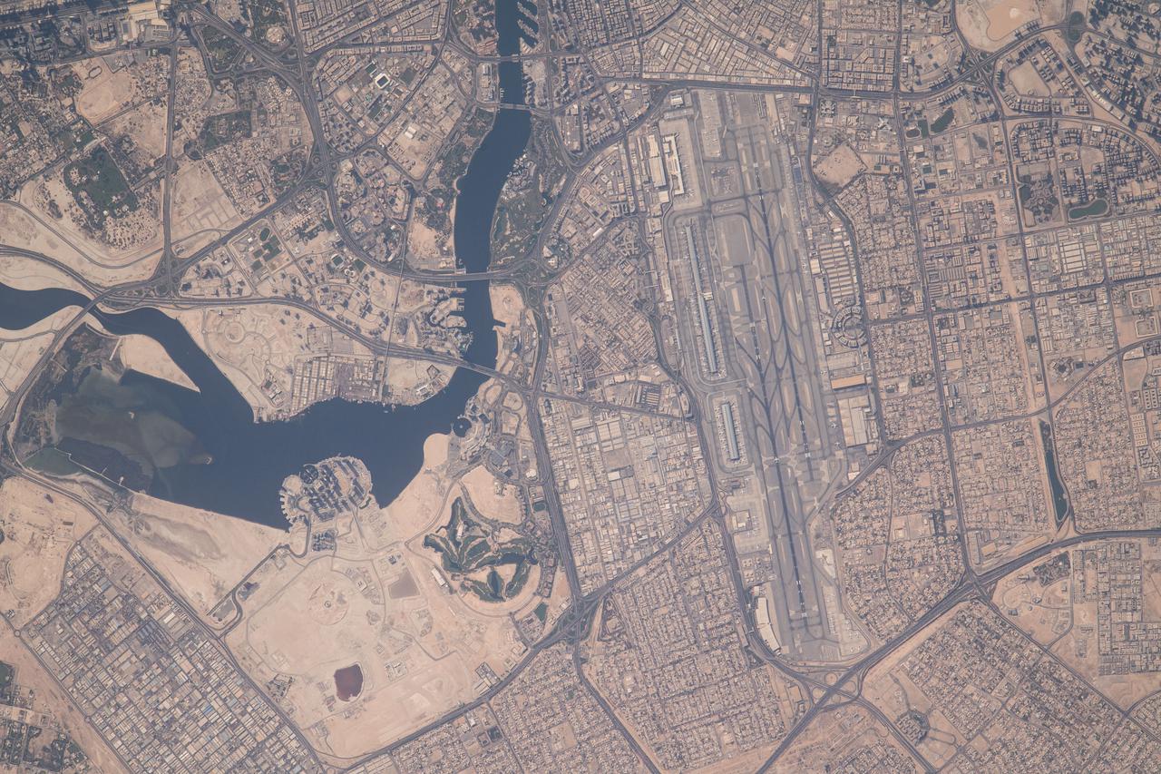
iss069e032988 (July 18, 2023) --- The city light's of the port capital of Muscat, Oman, including the coastal fishing province of Al-Seeb, are pictured from the International Space Station as it orbited 260 miles above the Gulf of Oman. Muscat International Airport is featured prominently in the middle of this photograph.
ISS046e021993 (01/23/2016) --- Earth observation of the coast of Oman taken during a night pass by the Expedition 46 crew aboard the International Space Station. NASA astronaut Tim Kopra tweeted this image out with this message: "Passing over the Gulf of #Oman at night -- city lights of #Muscat #Dubai #AbuDhabi and #Doha in the distance".
S66-63486 (13 Nov. 1966) --- Iran, Trucial Coast, Oman, Zagros Mountains, and Qishm Island (large island at lower right), as seen from the Gemini-12 spacecraft during its 25th revolution of Earth. Gulf of Oman is large body of water at left and the Persian Gulf is body of water at right. View is looking east. Photo credit: NASA

S66-63485 (13 Nov. 1966) --- Iran, Trucial Coast, Oman, Zagros Mountains, and Qishm Island (large island at lower left), as seen from the Gemini-12 spacecraft during its 25th revolution of Earth. Gulf of Oman is at lower left edge and the Persian Gulf is large body of water in upper half of photo. Photo credit: NASA
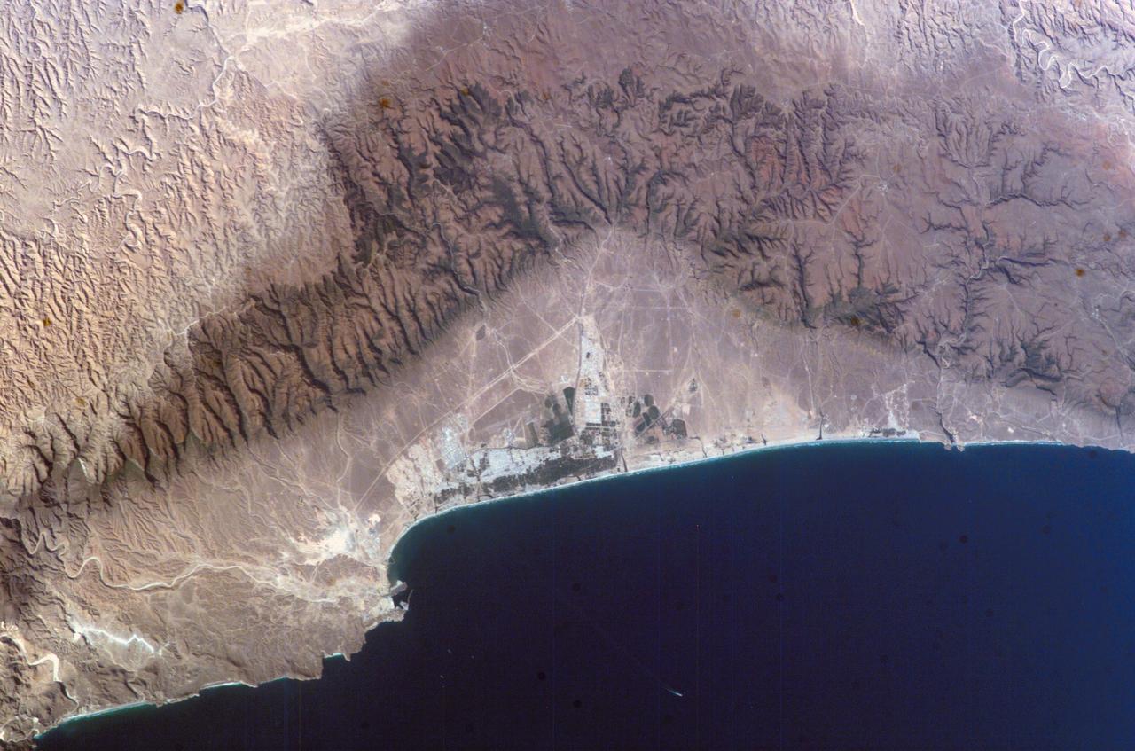
ISS010-E-07210 (16 November 2004) --- Salalah, Sultanate of Oman is featured in this image photographed by an Expedition 10 crewmember on the International Space Station (ISS). The city of Salalah is the capital of the Dhofar region of Oman and is known as the “perfume capital of Arabia”. The city is a popular destination for tourism due to the natural attractions of the al Qara Mountains (Jabal al Qara in Arabic) and abundant stands of frankincense trees lining mountain stream courses. These can be seen as green regions in the Jabal al Qara north of the city (located in the center of this image). The beaches and coastline are also major attractions for scuba diving and bird watching. Modern Oman is also represented by the Port of Salalah, located approximately 15 kilometers to the southwest of the city. The strategic location of this port has made it one of the major entry points to India, the Middle East, and Africa. The rectangular projection into the Arabian Sea visible in this photo is a large shipping container loading/unloading platform.
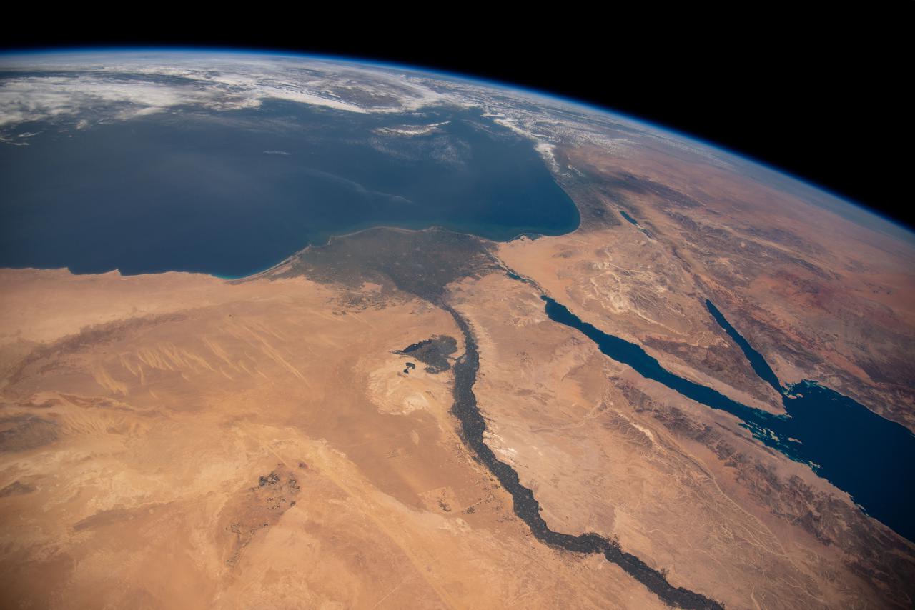
iss064e053173 (April 4, 2021) --- The Nile River, The Red Sea, The Gulf of Oman, The Gulf of Aqaba, and The Mediterranean Sea are pictured in the Middle East from the International Space Station as it orbited 263 miles above Egypt.
iss064e046338 (March 24, 2021) --- The strategically important shipping route of the Strait of Hormuz is pictured separating the nations of the United Arab Emirates and Iran. It also separates the main water bodies of the Persian Gulf and the Gulf of Oman.
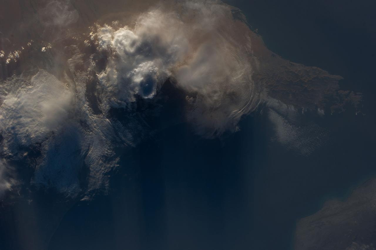
Earth observation taken by an Expedition 36 crew member on board the International Space Station (ISS). Per Twitter message: Evening storms over Oman & United Arab Emirates.
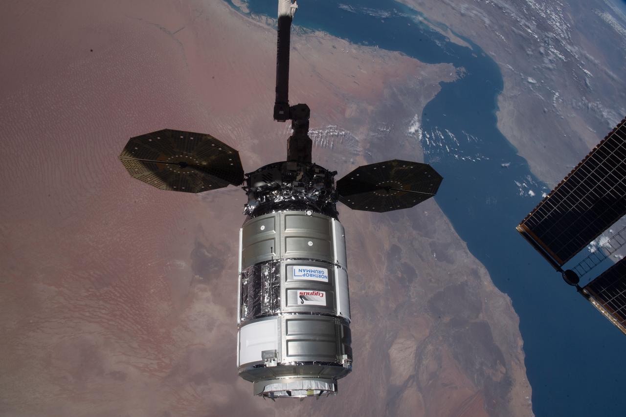
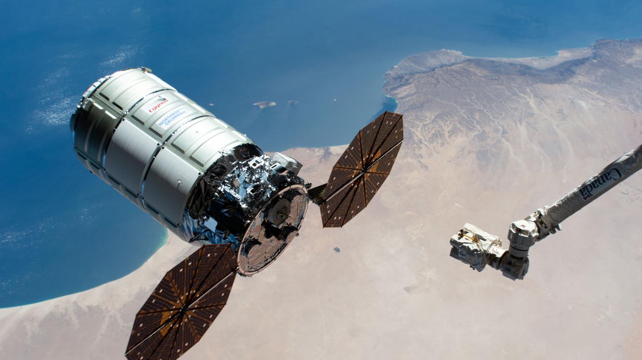
iss064e035964 (Feb. 22, 2021) --- The Cygnus space freighter from Northrop Grumman is pictured moments after its capture with the Canadarm2 robotic arm as the International Space Station was orbiting 262 miles above Oman.
iss065e074314 (May 26, 2021) --- Dubai International Airport and Dubai Creek figure prominently in this photograph from the International Space Station as it orbited 260 miles above the northern tip of Oman.
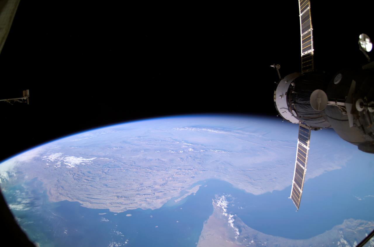
iss063e002679 (April 23, 2020) --- The northern tip of the Middle Eastern nation of Oman is pictured on the Strait of Hormuz. The International Space Station was orbiting above the Persian Gulf when this photograph was taken.
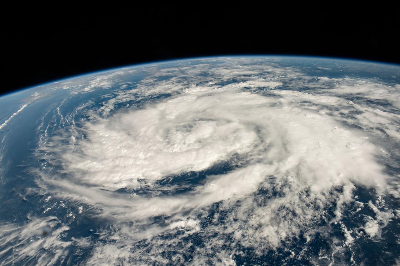
iss070e007626 (Oct. 20, 2023) --- A storm is pictured in the Arabian Sea less than 700 miles off the coast of Oman as the International Space Station orbited 260 miles above.
ISS008-E-12570 (22 January 2004) --- Backdropped by Earth’s horizon and the blackness of space, an unpiloted Progress supply vehicle docked to the International Space Station (ISS) was photographed by one of the Expedition 8 crewmembers. Parts of Iran, the United Arab Emirates, Oman, Strait of Hormuz and the Persian Gulf are also visible.
iss049e007067 (09/19/2016) --- Night views of the Earth from the International Space Station. This image is the southern Persian Gulf at night centered on Dubai and Abu Dhabi; east is at the top of the image with the coast of Iran to upper left and Muscat, Oman upper right.

iss069e056918 (Aug. 14, 2023) --- The Strait of Hormuz (bottom left) connects the Gulf of Oman with the Persian Gulf in this photograph from the International Space Station as it orbited 262 miles above southwestern Iran. In the right foreground, is the Northrop Grumman Cygnus space freighter and one of its cymbal-shaped UltraFlex solar arrays.
iss066e147579 (Feb. 21, 2022) ---Northrop Grumman's Cygnus space freighter is pictured moments away from being captured with the Canadarm2 robotic arm being commanded by NASA astronaut Raja Chari as the International Space Station orbited 257 miles above Oman. This is Northrop Grumman’s 17th contracted resupply mission under the second Commercial Resupply Services contract with NASA.
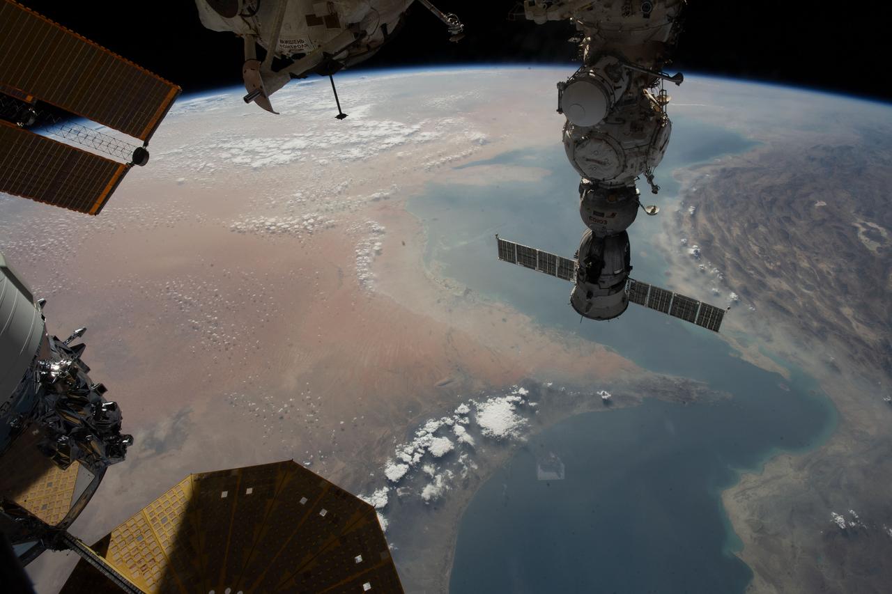
iss069e056939 (Aug. 14, 2023) --- The Strait of Hormuz connects the Gulf of Oman with the Persian Gulf in this photograph from the International Space Station as it orbited 262 miles above. In the right foreground, is the Soyuz MS-23 crew ship docked to the Prichal docking module. At bottom left, is a portion of the Northrop Grumman Cygnus space freighter and one of its cymbal-shaped UltraFlex solar arrays.
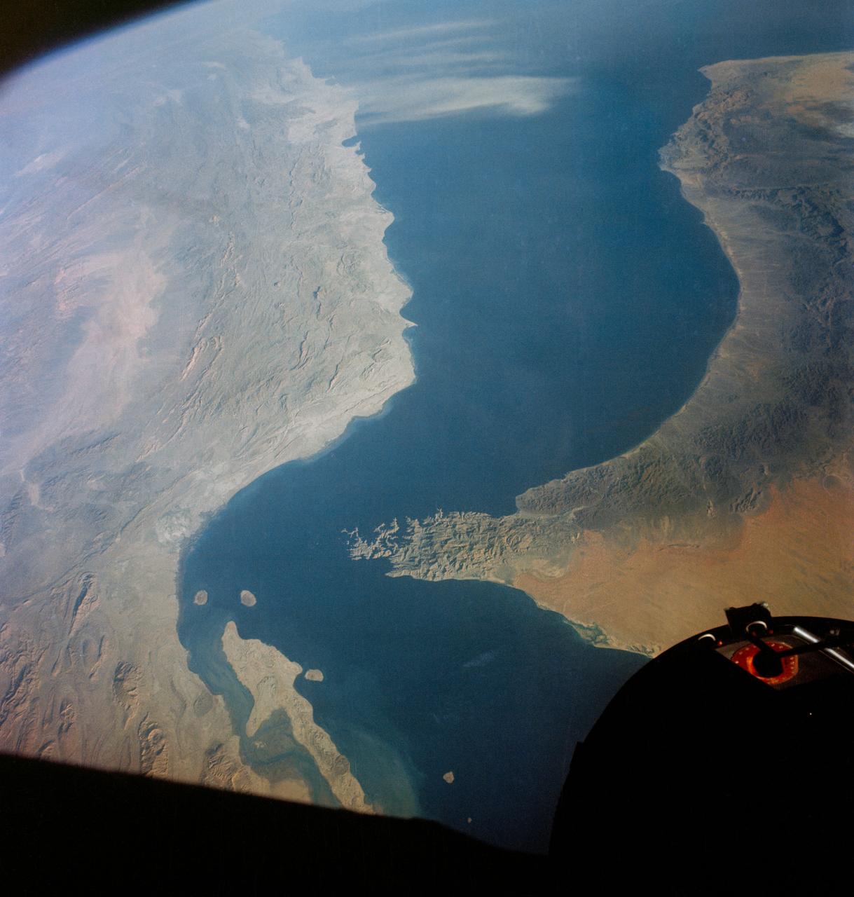
S65-34661 (3-7 June 1965) --- Among the photographs of Earth's terrain taken from the Gemini-4 spacecraft during its orbital mission was this view of the southeastern tip of the Arabian Peninsula with the Gulf of Oman at upper right. Seif dunes (sand) at lower left. This picture was taken with a modified 70mm Hasselblad camera, using Eastman color film, ASA 64 at a setting of 250th of a second at f/11. Dr. Paul Lowman Jr., NASA geologist, was in charge of the Synoptic Terrain Photography.
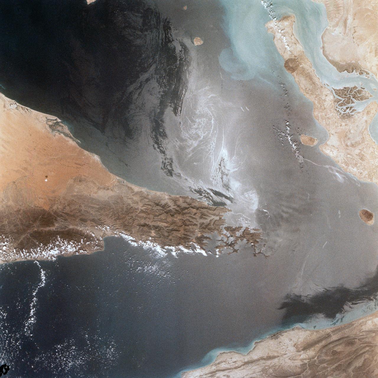
Portions of Oman, The United Arab Emirates and Iran are seen at the Strait of Hormuz (26.0N, 56.0E) in this view. A number of ship wakes can be seen in the area of the strait. Sunglint in the Persian Gulf to the northwest, accentuates the complex currents and oil slicks, seen as dark toned blue streaks on the surface. Qeshm Island, just off the coast of Iran, can be seen on the edge of the photo.
iss073e0982720 (Oct. 25, 2025) --- The Persian Gulf region—from Oman to the United Arab Emirates, with Iran's southwest coast visible across the geographically important waterway—is illuminated beneath a bright yellow-green airglow. This long-exposure photograph, taken at approximately 11:40 p.m. local time from the International Space Station as it orbited 259 miles above northwestern India, also captures the starry expanse of the night sky.
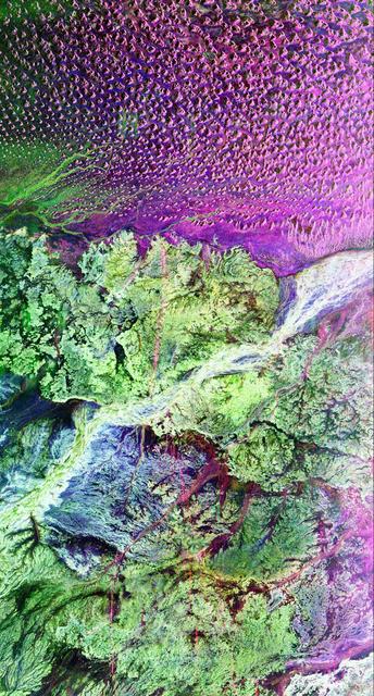
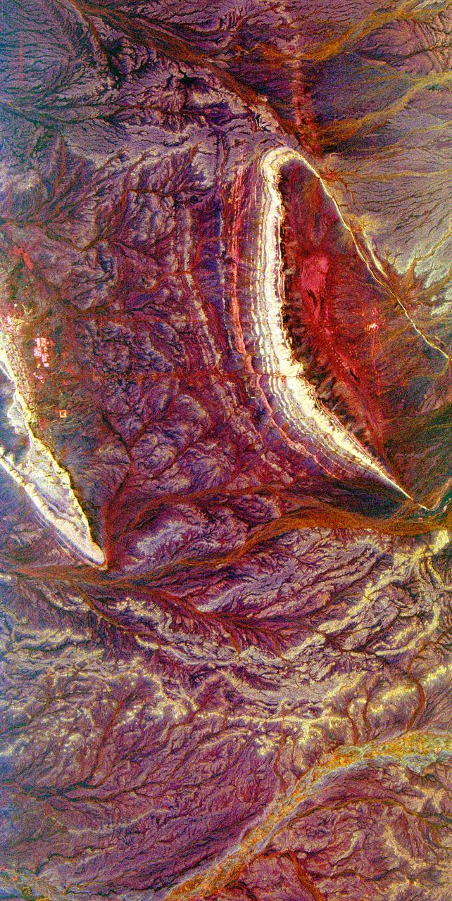
This is a radar image of the region around the site of the lost city of Ubar in southern Oman, on the Arabian Peninsula. The ancient city was discovered in 1992 with the aid of remote sensing data. Archeologists believe Ubar existed from about 2800 B.C. to about 300 A.D. and was a remote desert outpost where caravans were assembled for the transport of frankincense across the desert. This image was acquired on orbit 65 of space shuttle Endeavour on April 13, 1994 by the Spaceborne Imaging Radar C/X-Band Synthetic Aperture Radar (SIR-C/X-SAR). The SIR-C image shown is centered at 18.4 degrees north latitude and 53.6 degrees east longitude. The image covers an area about 50 by 100 kilometers (31 miles by 62 miles). The image is constructed from three of the available SIR-C channels and displays L-band, HH (horizontal transmit and receive) data as red, C-band HH as blue, and L-band HV (horizontal transmit, vertical receive) as green. The prominent magenta colored area is a region of large sand dunes, which are bright reflectors at both L-and C-band. The prominent green areas (L-HV) are rough limestone rocks, which form a rocky desert floor. A major wadi, or dry stream bed, runs across the middle of the image and is shown largely in white due to strong radar scattering in all channels displayed (L and C HH, L-HV). The actual site of the fortress of the lost city of Ubar, currently under excavation, is near the Wadi close to the center of the image. The fortress is too small to be detected in this image. However, tracks leading to the site, and surrounding tracks, appear as prominent, but diffuse, reddish streaks. These tracks have been used in modern times, but field investigations show many of these tracks were in use in ancient times as well. Mapping of these tracks on regional remote sensing images was a key to recognizing the site as Ubar in 1992. This image, and ongoing field investigations, will help shed light on a little known early civilization. http://photojournal.jpl.nasa.gov/catalog/PIA01721
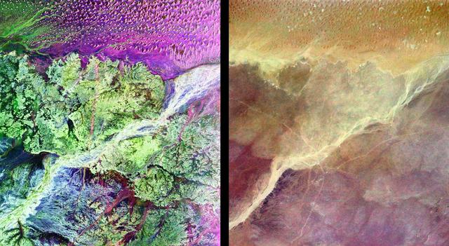
This pair of images from space shows a portion of the southern Empty Quarter of the Arabian Peninsula in the country of Oman. On the left is a radar image of the region around the site of the fabled Lost City of Ubar, discovered in 1992 with the aid of remote sensing data. On the right is an enhanced optical image taken by the shuttle astronauts. Ubar existed from about 2800 BC to about 300 AD. and was a remote desert outpost where caravans were assembled for the transport of frankincense across the desert. The actual site of the fortress of the Lost City of Ubar, currently under excavation, is too small to show in either image. However, tracks leading to the site, and surrounding tracks, show as prominent, but diffuse, reddish streaks in the radar image. Although used in modern times, field investigations show many of these tracks were in use in ancient times as well. Mapping of these tracks on regional remote sensing images provided by the Landsat satellite was a key to recognizing the site as Ubar. The prominent magenta colored area is a region of large sand dunes. The green areas are limestone rocks, which form a rocky desert floor. A major wadi, or dry stream bed, runs across the scene and appears as a white line. The radar images, and ongoing field investigations, will help shed light on an early civilization about which little in known. The radar image was taken by the Spaceborne Imaging Radar C/X-Band Synthetic Aperture Radar (SIR-C/X-SAR) and is centered at 18 degrees North latitude and 53 degrees East longitude. The image covers an area about 50 kilometers by 100 kilometers (31 miles by 62 miles). The colors in the image are assigned to different frequencies and polarizations of the radar as follows: red is L-band, horizontally transmitted, horizontally received; blue is C-band horizontally transmitted, horizontally received; green is L-band horizontally transmitted, vertically received. SIR-C/X-SAR, a joint mission of the German, Italian and the United States space agencies, is part of NASA's Mission to Planet Earth. http://photojournal.jpl.nasa.gov/catalog/PIA01302
This image of Saudi Arabia shows a great sea of linear dunes in part of the Rub' al Khali, or the Empty Quarter. Acquired on June 25, 2000, the image covers an area 37 kilometers (23 miles) wide and 28 kilometers (17 miles) long in three bands of the reflected visible and infrared wavelength region. The dunes are yellow due to the presence of iron oxide minerals. The inter-dune area is made up of clays and silt and appears blue due to its high reflectance in band 1. The Rub' al Khali is the world's largest continuous sand desert. It covers about 650,000 square kilometers (250,966 square miles) and lies mainly in southern Saudi Arabia, though it does extend into the United Arab Emirates, Oman, and Yemen. One of the world's driest areas, it is uninhabited except for the Bedouin nomads who cross it. The first European to travel through the desert was Bertram Thomas in 1930. http://photojournal.jpl.nasa.gov/catalog/PIA02656
AS17-148-22718 (7-19 Dec. 1972) --- This excellent view of Saudi Arabia and the north eastern portion of the African continent was photographed by the Apollo 17 astronauts with a hand-held camera on their trans-lunar coast toward man's last lunar visit. Egypt, Sudan, Ethiopia are some of the African nations are visible. Iran, Iraq, Jordan are not so clearly visible because of cloud cover and their particular location in the picture. India is dimly visible at right of frame. The Red Sea is seen entirely in this one single frame, a rare occurrence in Apollo photography or any photography taken from manned spacecraft. The Gulf of Suez, the Dead Sea, Gulf of Aden, Persian Gulf and Gulf of Oman are also visible. This frame is one of 169 frames on film magazine NN carried aboard Apollo 17, all of which are SO368 (color) film. A 250mm lens on a 70mm Hasselblad camera recorded the image, one of 92 taken during the trans-lunar coast. Note AS17-148-22727 (also magazine NN) for an excellent full Earth picture showing the entire African continent.
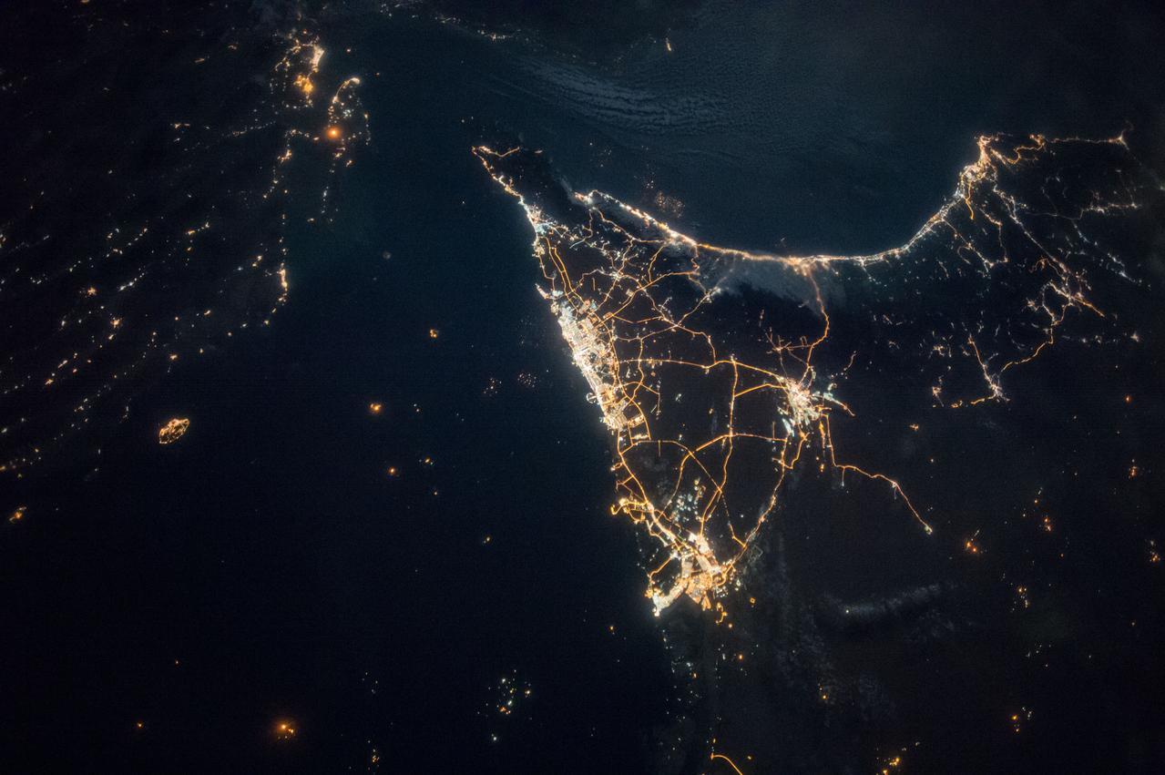
ISS038-E-016335 (11 Dec. 2013) --- A nighttime view of the United Arab Emirates is featured in this image photographed by an Expedition 38 crew member on the International Space Station. Geographers like night images of cities because you see immediately so much about the human landscape--things that are difficult or impossible to see in day images. You see where the cities are located and their shape; the brightest light clusters frequently indicate the city centers. In large field of view images, such as this photograph of the United Arab Emirates (UAE), you can also see cities' position relative to one another and their relative size. Here the largest cluster of lights is the conurbation ("joined cities") of Dubai-Sharjah-Ajman (population 3.25 million), with its smaller neighbor Dubai (population 2.1 million). These cities front onto the Persian Gulf (also known as the Arabian Gulf) where the city lights are cut off abruptly at the coastline. The bright city centers are located at the coast showing that sea trade is important (and has been important) in the growth of these cities. Smaller cities are Al Ain (population 518,000), the fourth largest city in the UAE, and Fujairah (population 152,000). Major highways join the cities in a brightly lit network, and a faint peppering of lights offshore shows the relatively young oil and gas platforms on either side of the Musandam Peninsula (left). Despite being taken at night, the spike of the Musandam Peninsula is easy to imagine at the south end of the Persian Gulf. The biggest cities in the UAE are Abu Dhabi and Dubai. Muscat, the capital city of the neighboring country of Oman, appears top center. By contrast, the almost unpopulated Musandam Peninsula shows very few lights.
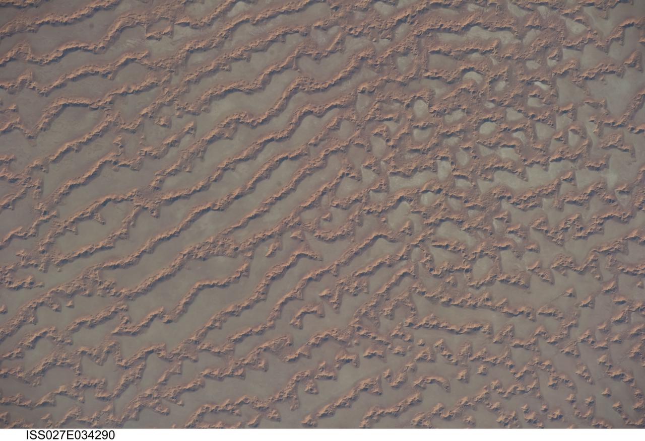
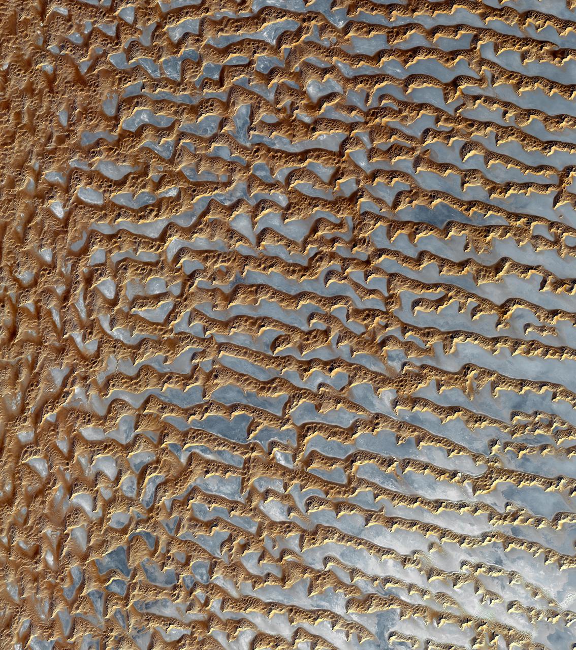
ISS027-E-034290 (16 May 2011) --- Ar Rub al Khali Sand Sea, Arabian Peninsula is featured in this image photographed by an Expedition 27 crew member on the International Space Station. The Ar Rub al Khali, also known as the “Empty Quarter”, is a large region of sand dunes and interdune flats known as a sand sea (or erg). This photograph highlights a part of the Ar Rub al Khali located close to its southeastern margin in the Sultanate of Oman. Reddish-brown, large linear sand dunes alternate with blue-gray interdune salt flats known as sabkhas at left. The major trend of the linear dunes is transverse to northwesterly trade winds that originate in Iraq (known as the Shamal winds). Formation of secondary barchan (crescent-shaped) and star dunes (dune crests in several directions originating from a single point, looking somewhat like a starfish from above) on the linear dunes is supported by southwesterly winds that occur during the monsoon season (Kharif winds). The long linear dunes begin to break up into isolated large star dunes to the northeast and east (right). This is likely a result of both wind pattern interactions and changes in the sand supply to the dunes. The Empty Quarter covers much of the south-central portion of the Arabian Peninsula, and with an area of approximately 660,000 square kilometers it is the largest continuous sand desert on Earth. The Empty Quarter is so called as the dominantly hyperarid climate and difficulty of travel through the dunes has not encouraged permanent settlement within the region. There is geological and archeological evidence to support cooler and wetter past climates in the region together with human settlement. This evidence includes exposed lakebed sediments, scattered stone tools, and the fossils of hippopotamus, water buffalo, and long-horned cattle.