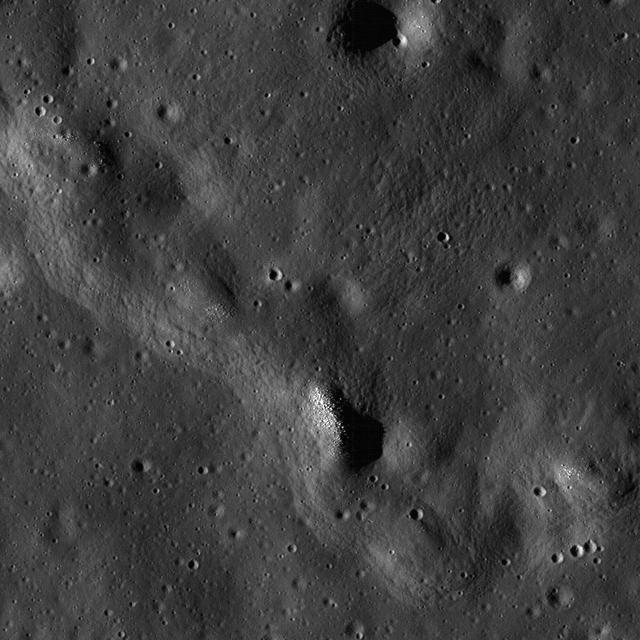
Wrinkle Ridge in Oceanus Procellarum
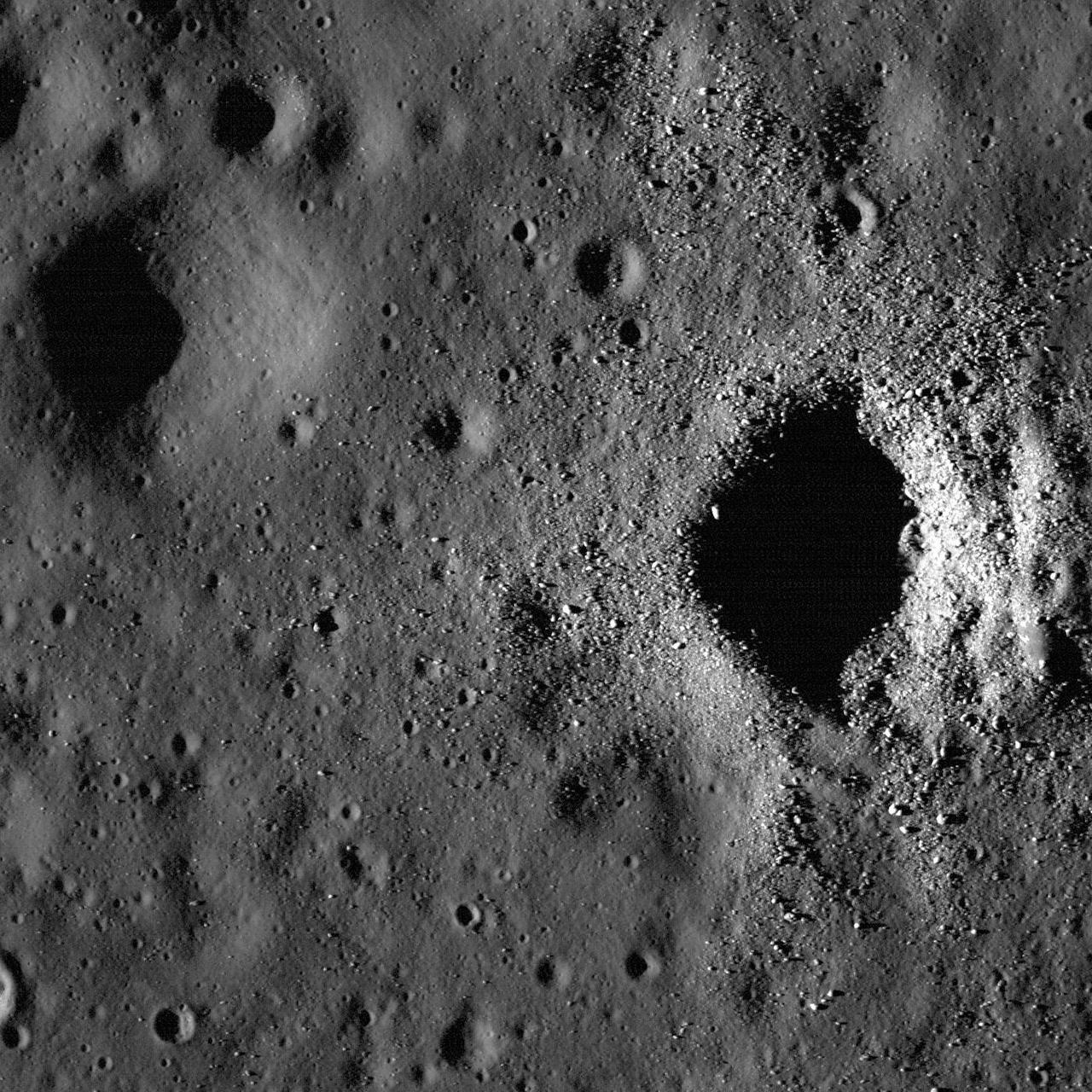
Fresh Crater on Oceanus Procellarum
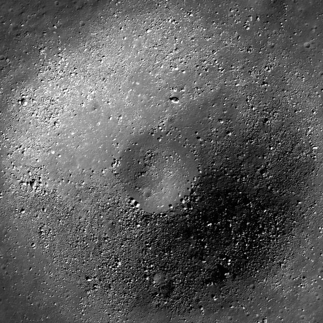
Small Crater in Oceanus Procellarum
art002e012010 (April 6, 2026) - Resembling a “handprint” to the Artemis II crew, this view highlights contrasting dark and light features on the Moon’s surface. From top to bottom, the darker regions include Oceanus Procellarum, Mare Humorum—known as the “Sea of Moisture”—and the crater Byrgius A. Credit: NASA
New view of the Apollo 12 landing site in Oceanus Procellarum imaged from NASA Lunar Reconnaissance Orbiter mapping orbit.
art002e012261 (April 6, 2026) - Multiple lunar landmarks come into view in this image, many of which were highlighted during the Artemis II crew’s observation call. Visible features include Ohm crater, Oceanus Procellarum, Grimaldi crater, Pierazzo crater, the newly proposed Carroll crater, and the expansive Hertzsprung Basin—together illustrating a range of geologic terrains, from dark volcanic plains to heavily cratered highlands and the remnants of ancient impact basins.
Lichtenberg crater is of Eratosthenian age, located in western Oceanus Procellarum. It is named after George C. Lichtenberg, a German professor of experimental physics 16th century.
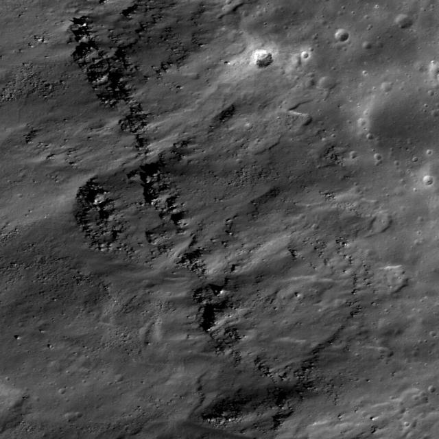
A subset of NAC Image M112162602L showing landslides bottom covering impact melt on the floor top of a fresh Copernican-age crater at the edge of Oceanus Procellarum and west of Balboa crater taken by NASA Lunar Reconnaissance Orbiter.
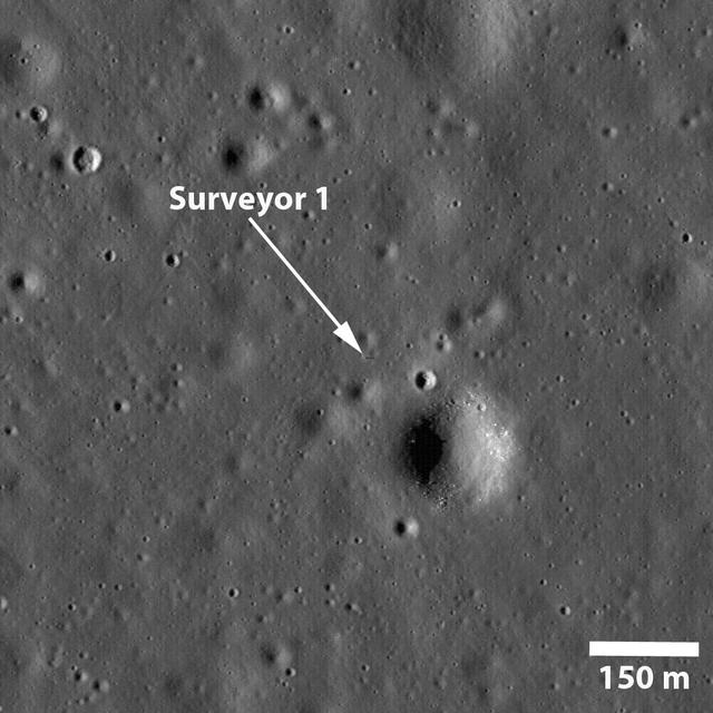
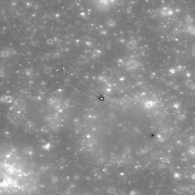
NASA Surveyor 1 spacecraft sitting silently on Oceanus Procellarum, the first US spacecraft to land on another planet on June 2, 1966 in this image taken by NASA Lunar Reconnaissance Orbiter.
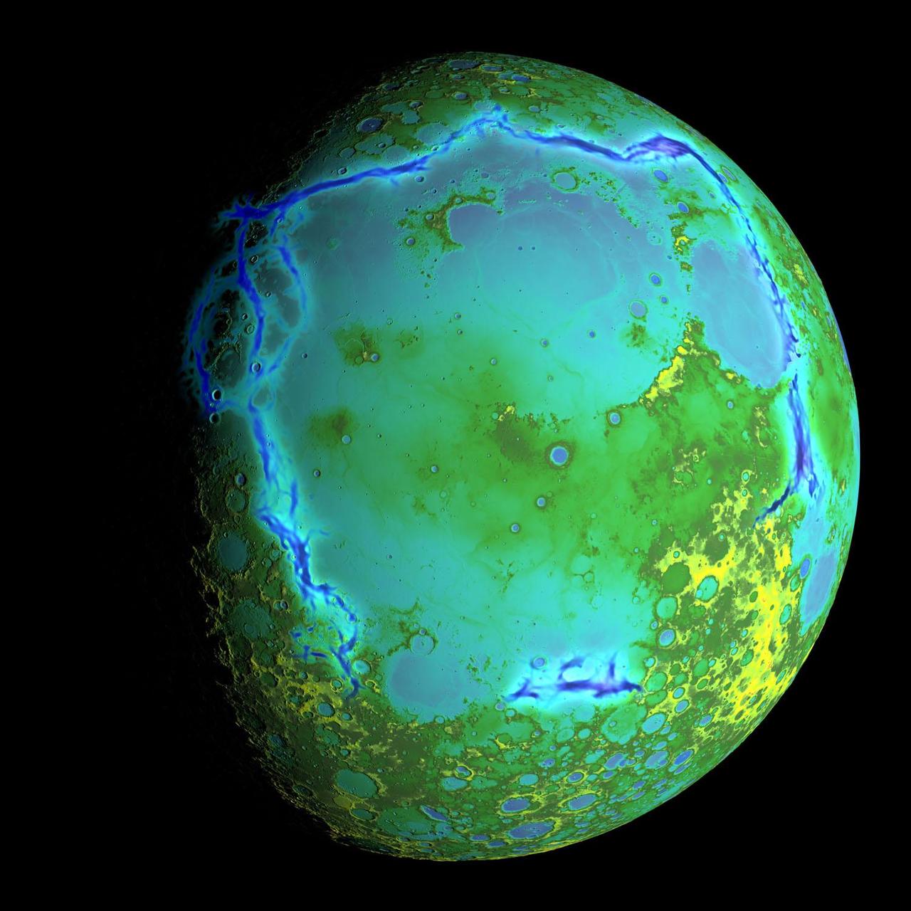
Topography of Earth moon generated from data NASA LRO, with the gravity anomalies bordering the Procellarum region superimposed in blue. The border structures are shown using gravity gradients calculated with data from NASA GRAIL mission.
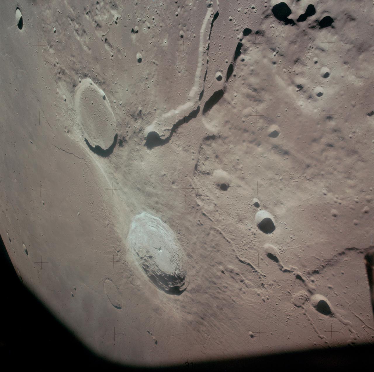
AS15-88-12002 (31 July-2 Aug. 1971) --- An oblique view of a portion of the lunar nearside located near the northeast edge of the Ocean of Storms (Oceanus Procellarum), photographed by astronaut Alfred M. Worden, command module pilot, from the Apollo 15 spacecraft in lunar orbit, showing the bright-appearing crater Aristarchus on the left, the crater Herodotus on the right, and Schroter's Valley at lower right. This view is looking southward. Aristarchus the head of Schroter's Valley, a sinuous rille in the Aristarchus Plateau, is called Cobra Head. The coordinates of the center of Aristarchus crater are 47.5 degrees west longitude and 23.6 degrees north latitude. While Worden remained in the Command and Service Modules (CSM) in lunar orbit, astronauts David R. Scott, commander; and James B. Irwin, lunar module pilot, descended in the Lunar Module (LM) "Falcon" to explore the moon.
Range : 220,000 mi. (left)/350,000 mi. (right) These pictures of the Moon were taken by the Galileo spacecraft. Image on the right shows the dark Oceanus Procellarum in the upper center, with Mare Imbrium above it and the smaller circular Mare Humorum below. The Orientale Basin, with a small mare in its center, is on the lower left near the limb or edge. Between stretches the cratered highland terrain, with scattered bright young craters on highlands and maria alike. The left image shows the globe of the Moon rotated, putting Mare Imbrium on the eastern limb and moving the Orientale Basin almost to the center. The extent of the cratered highlands on tghe far side is very apparent., At lower left, near the limb, is the South-Pole-Aitken basin, similar to Orientale but very much older and some 1,200 miles in diameter. This feature was previously known as a large depression in the southern far side; this image shows its Orientale-like structure and darkness relative to surrounding highlands.
Range : 350,000 miles This image of the western hemisphere of the Moon was taken through a green filter by Galileo at 9:35 am PST. In the center is the Orientale Basin, 600 miles in diameter, formed about 3.8 billion years ago by the impact of an streroid-size body. Orientale's dark center is a small mare. To the right is the lunar near side with the great, dark Oceanus Procellarum above and the small, circular, dark Mare Humorum Below. Maria are broad plains formed mostly over 3 billion years ago as vast bassaltic lava flows. To the left is the lunar far side with fewer maria, but, at lower left, the South-Pole-Aitken basin, about 1200 miles in diameter, which resemble Orientale but is much older and more weathered and battered by cratering. The intervening cratered highlands of both sides, as well as the maria, are dotted with bright, young craters. This image was 'reprojected' so as to center visibility of small features.
Range : 350,000 miles (JPL Ref: P-37329) This image of the western hemisphere of the Moon was taken through a green filter by Galileo at 9:35 am PST. In the center is the Orientale Basin, 600 miles in diameter, formed about 3.8 billion years ago by the impact of an streroid-size body. Orientale's dark center is a small mare. To the right is the lunar near side with the great, dark Oceanus Procellarum above and the small, circular, dark Mare Humorum Below. Maria are broad plains formed mostly over 3 billion years ago as vast bassaltic lava flows. To the left is the lunar far side with fewer maria, but, at lower left, the South-Pole-Aitken basin, about 1200 miles in diameter, which resemble Orientale but is much older and more weathered and battered by cratering. The intervening cratered highlands of both sides, as well as the maria, are dotted with bright, young craters. This image was 'reprojected' so as to center visibility of small features.
S90-55753 (9 Dec. 1990) --- This color image of the Moon was taken by the Galileo spacecraft at 9:25 a.m. (PST) December 9, 1990, at a range of about 350,000 miles. The color composite uses monochrome images taken through violet, red, and near infrared filters. The concentric, circular Orientale Basin, 600 miles across, is near the center; the near side is to the right, the far side to the left. At the upper right is the large, dark Oceanus Procellarum; below it is the smaller Mare Humorum. These, like the small dark Mare Orientale in the center of the basin, formed over 3 billion years ago as basaltic lava flows. At the lower left, among the southern cratered highlands of the far side, is the South-Pole-Aitken Basin, similar to Orientale but twice as great in diameter and much older and more degraded by crating and weathering. The cratered highlights of the near and far sides and the Maria are covered with scattered bright, young ray-craters.

Galileo spacecraft image of the Moon recorded at 9:35 am Pacific Standard Time (PST), 12-09-90, after completing its first Earth Gravity Assist. Western hemisphere of the Moon was taken through a green filter at a range of about 350,000 miles. In the center is Orientale Basin, 600 miles in diameter, formed about 3.8 billion years ago by the impact of an asteroid-size body. Orientale's dark center is a small mare. To the right is the lunar near side with the great, dark Oceanus Procellarum above the small, circular, dark Mare Humorum below. Maria are broad plains formed mostly over 3 billion years ago as vast basaltic lava flows. To the left is the lunar far side with fewer maria, but, at lower left South-Pole-Aitken basin, about 1200 miles in diameter, which resembles Orientale but is much older and more weathered and battered by cratering. The intervening cratered highlands of both sides, as well as the maria, are dotted with bright young craters. This image was "reprojected" so as to center the Orientale Basin, and was filtered to enhance the visibility of small features. The digital image processing was done by DLR, the German Aerospace Research Establishment near Munich, an international collaborator in the Galileo mission. Photo was provided by Jet Propulsion Laboratory (JPL) with alternate number P-37327, 12-19-90.
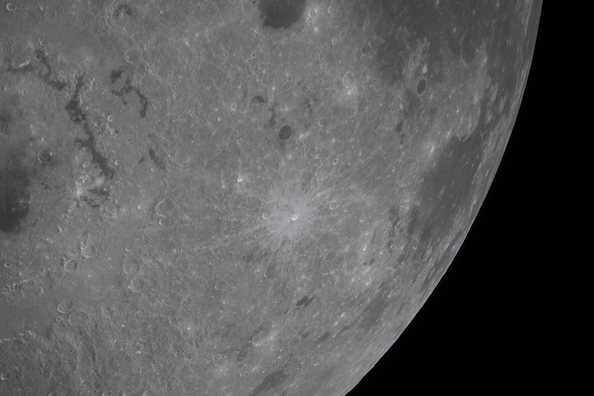
art002e010014 (April 6, 2026) – A bright portion of the Moon is visible in this image. If you look closely, you can see linear, pitted features known as “crater chains” radiating from the Orientale basin, an impact crater with a patch of ancient lava at its center, visible in the bottom center of the image. These crater chains formed about 3.8 billion years ago, when rocks spewed from the collision that formed Orientale landed in lines extending away from the crater. These chains are found near other large craters on the Moon, but we don’t get to see them on Earth because our planet’s crust has been turned over so many times through plate tectonics and largely erased by rain, wind, and ice. In the upper left corner of the Moon disk is a line called the terminator, the boundary between lunar day and night. Here, low-angle sunlight skims the surface, casting dramatic shadows that expose the area’s topography — or the shape of its surface. Glushko crater is the bright spot just to the left of the dark mare, or “sea” of ancient lava flows on the near side of the Moon. It’s identifiable by the bright rays that shoot across the mare, some hundreds of miles away. These rays are made of ejected material after the collision that formed Glushko. Glushko and its rays are brighter than the surrounding area because that younger has experienced less weathering from radiation and impacts. Oceanus Procellarum, the largest lava-filled region on the Moon, spans the horizon. The Aristarchus crater, the bright spot in the sea of lava, creeps toward the right edge of the Moon.