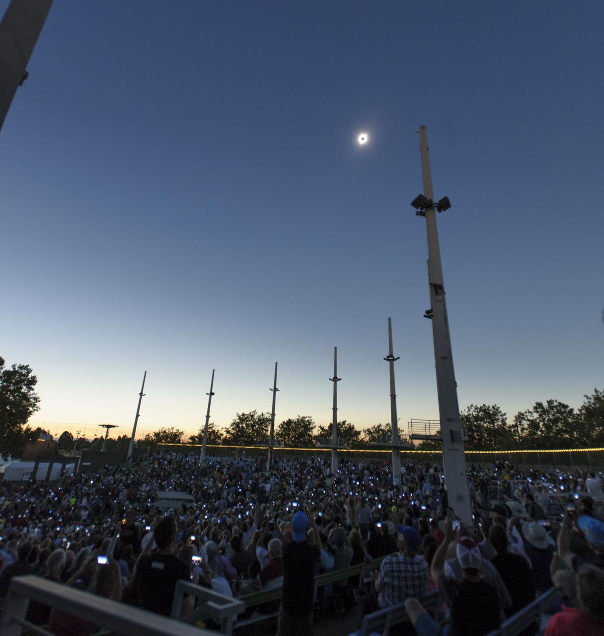
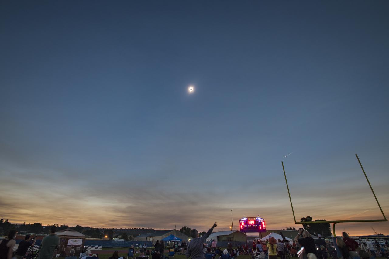
2017 Solar Eclipse totality as seen by the people attending the viewing event at the Oregon State Fairgrounds, Salem, Oregon.

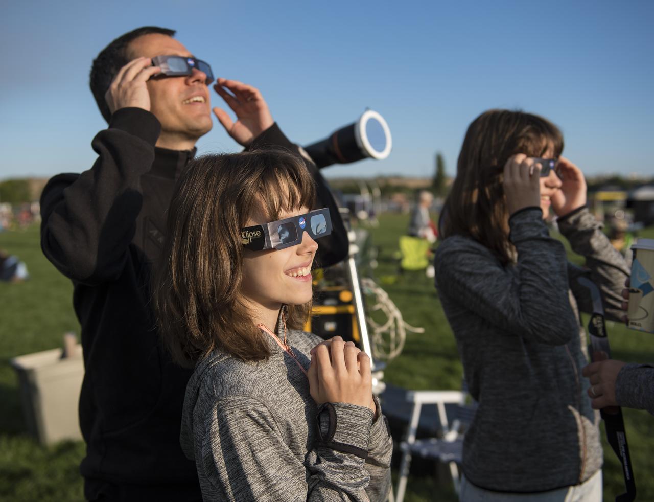
Visitors at the a NASA booth during the 2017 Solar Eclipse viewing event at the Oregon State Farigrounds, Salem, Oregon.

It's time for looking up at the Oregon State Fairgrounds Viewing Event in Salem, Oregon.
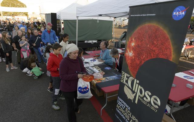
Visitors at the a NASA booth during the 2017 Solar Eclipse viewing event at the Oregon State Farigrounds, Salem, Oregon.
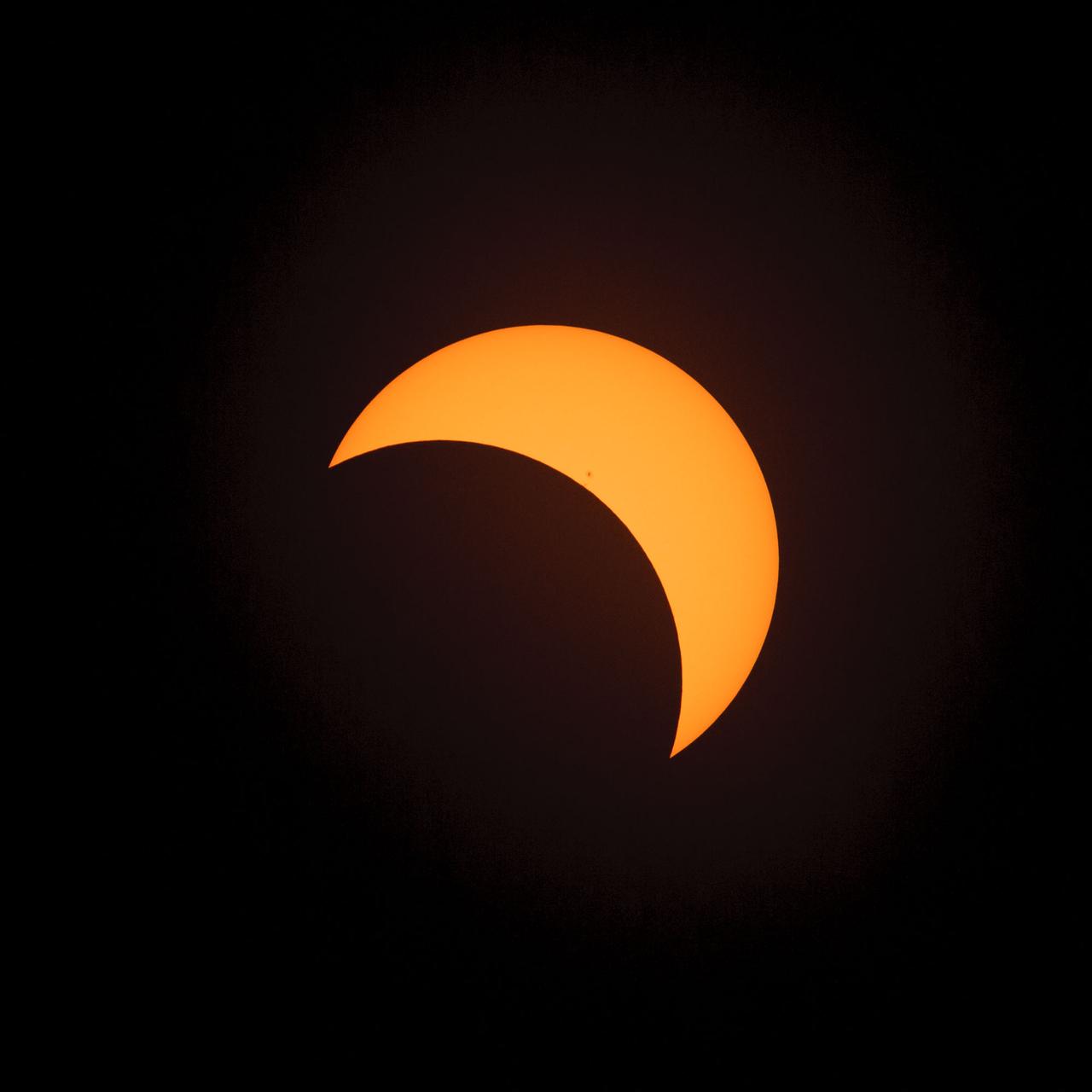
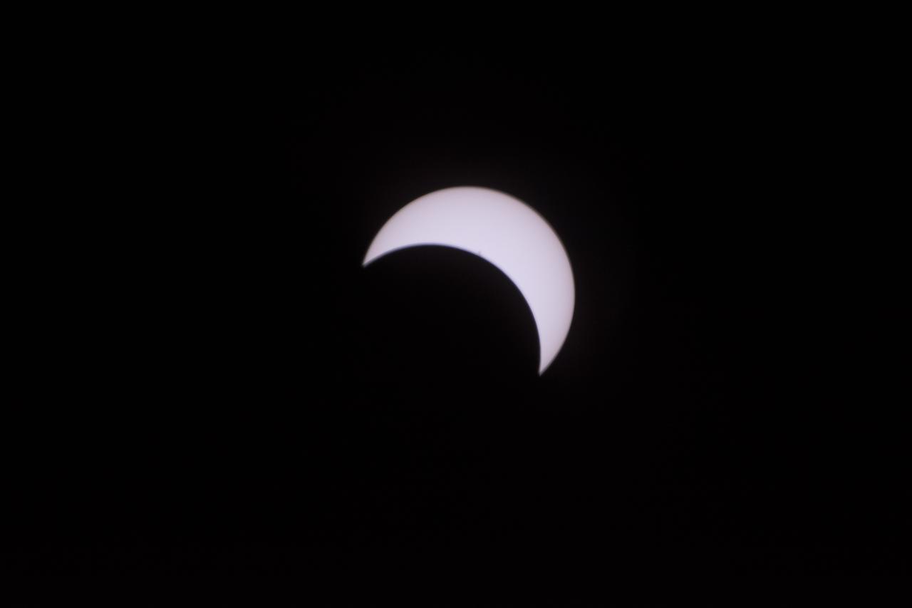
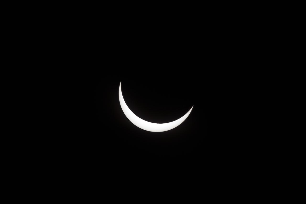
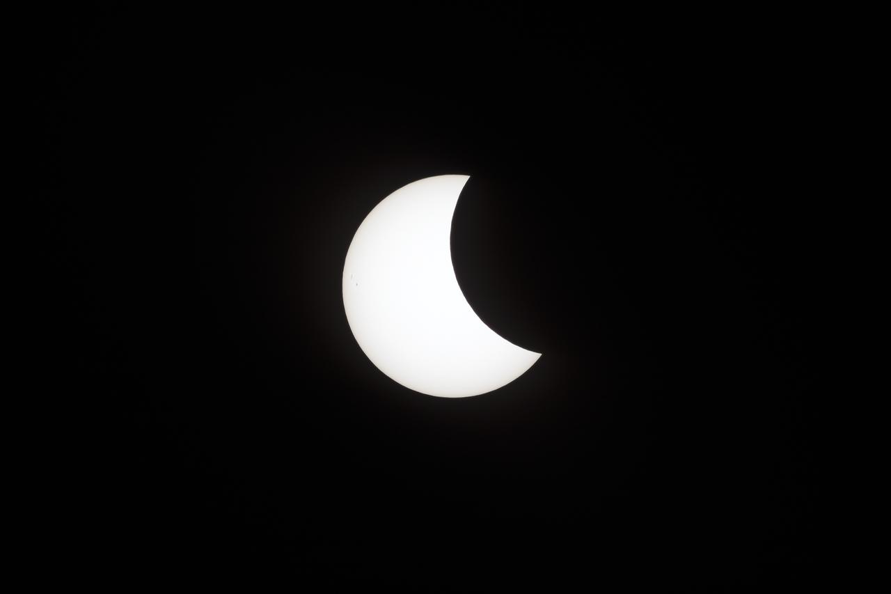
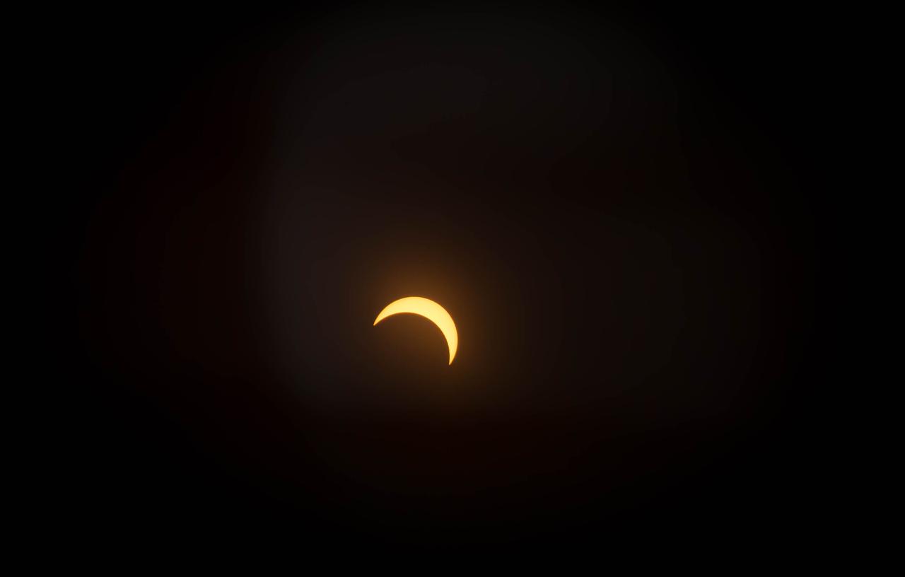
2017 Solar Eclipse first images from Oregon State Fair Grounds, Salem, Oregon. This image taken at 10:17:13 on August 21, 2017 as Oregon has almost reached totality.

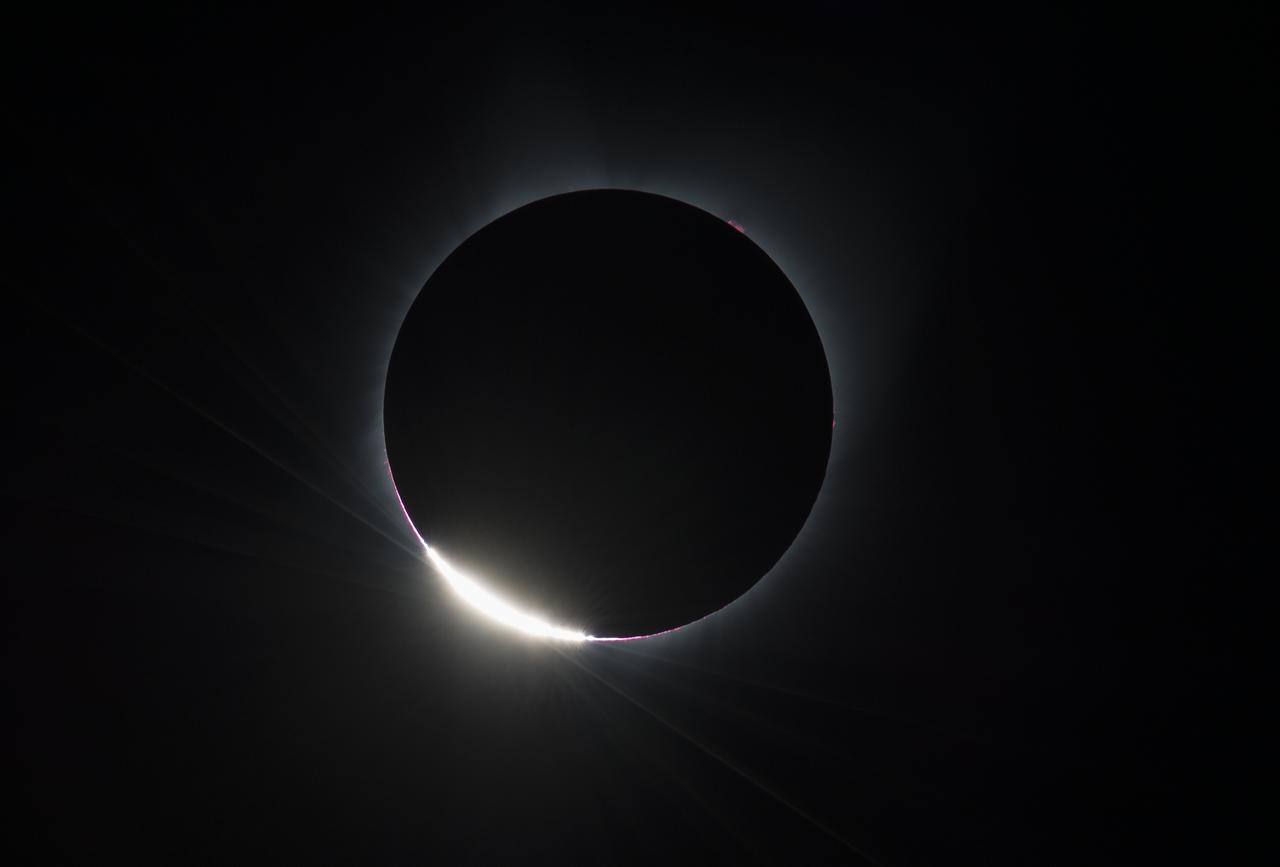
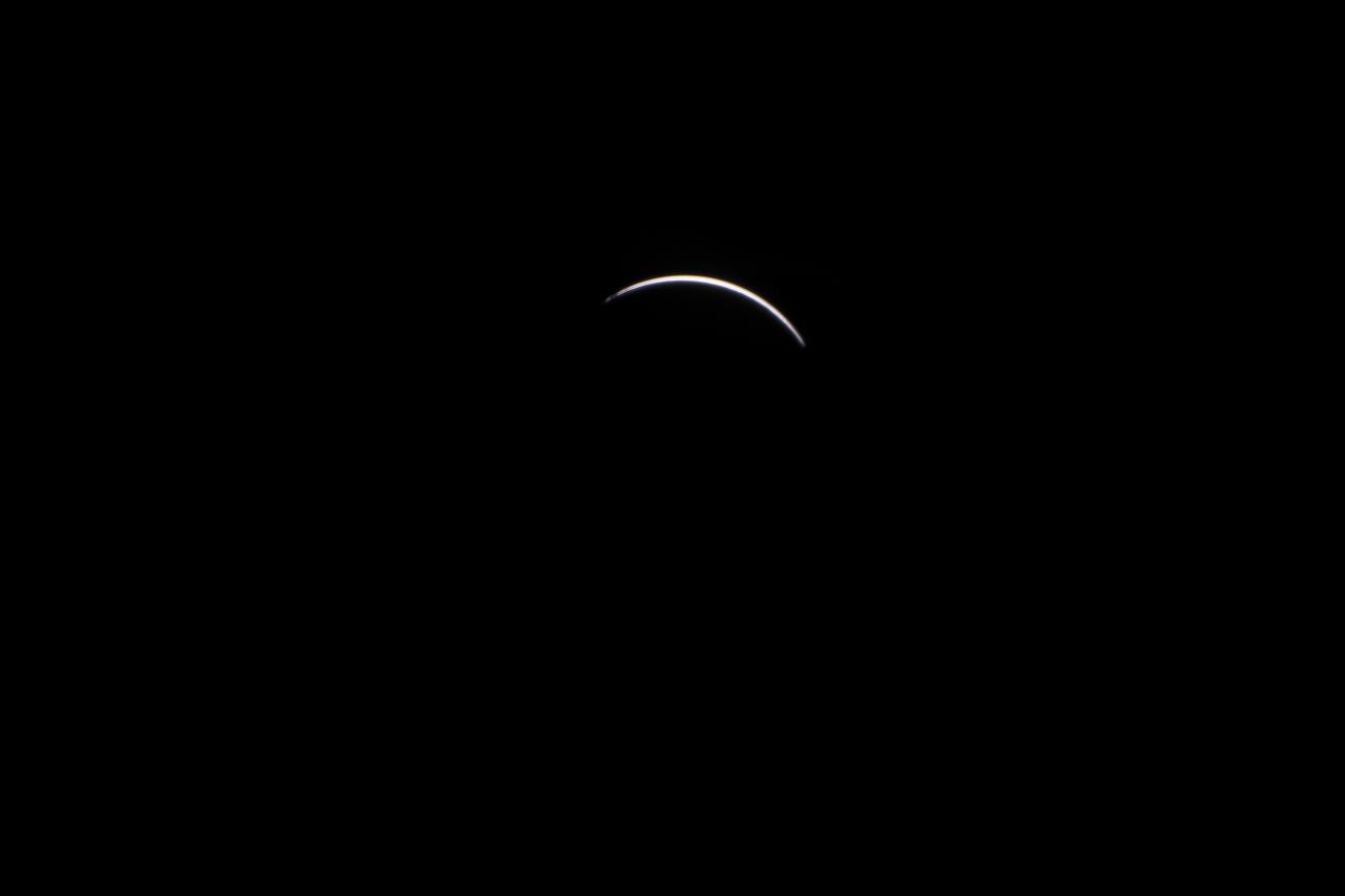
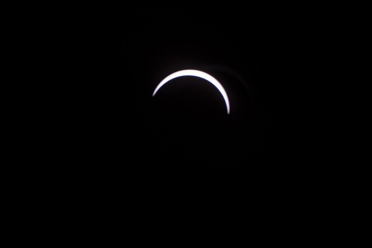
2017 Solar Eclipse first images from Oregon State Fair Grounds, Salem, Oregon. This image taken at 10:19:24 on August 21, 2017 as Oregon begins to see first light 'diamond' following totality.
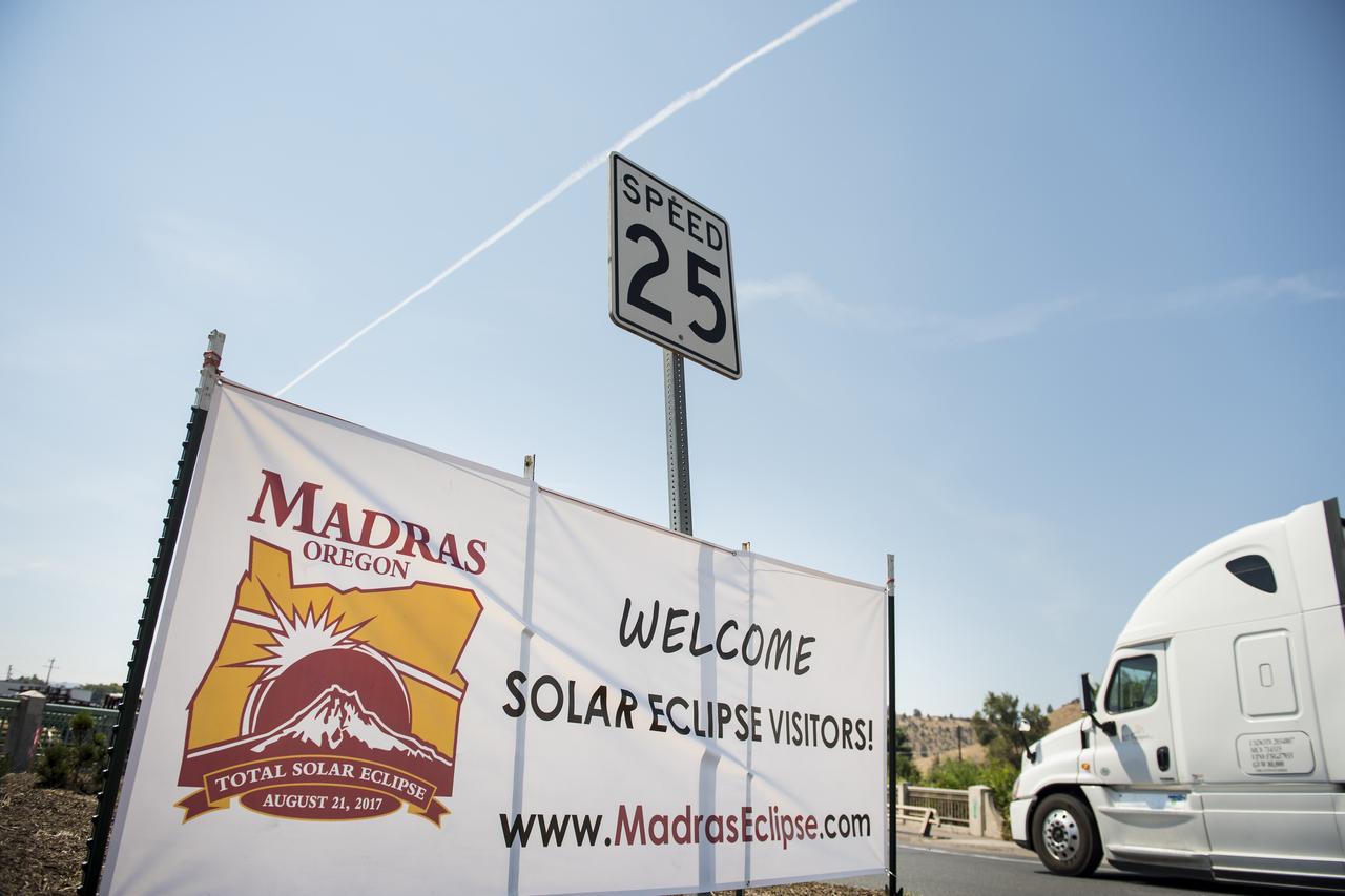
A welcome sign is seen along the roads in Madras, Oregon, where thousands of visitors are expected for the total solar eclipse, Saturday, August 19, 2017. The eclipse will be sweeping across a narrow portion of the contiguous United States from Lincoln Beach, Oregon to Charleston, South Carolina on August 21. A partial solar eclipse will be visible across the entire North American continent along with parts of South America, Africa, and Europe. Photo Credit: (NASA/Aubrey Gemignani)
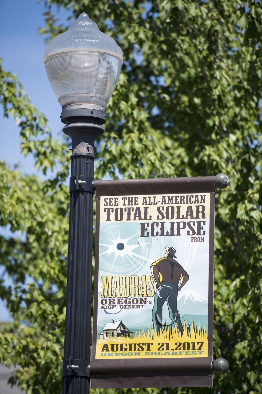
A sign is seen along the roads in Madras, Oregon, where thousands of visitors are expected for the total solar eclipse, Saturday, August 19, 2017. The eclipse will be sweeping across a narrow portion of the contiguous United States from Lincoln Beach, Oregon to Charleston, South Carolina on August 21. A partial solar eclipse will be visible across the entire North American continent along with parts of South America, Africa, and Europe. Photo Credit: (NASA/Aubrey Gemignani)

A sign is seen along the roads in Madras, Oregon, where thousands of visitors are expected for the total solar eclipse, Saturday, August 19, 2017. The eclipse will be sweeping across a narrow portion of the contiguous United States from Lincoln Beach, Oregon to Charleston, South Carolina on August 21. A partial solar eclipse will be visible across the entire North American continent along with parts of South America, Africa, and Europe. Photo Credit: (NASA/Aubrey Gemignani)
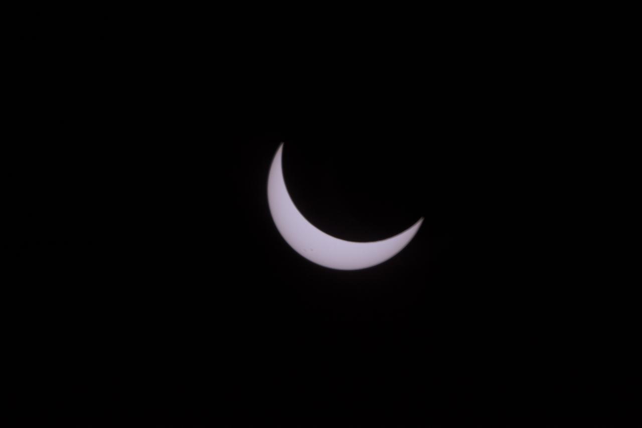
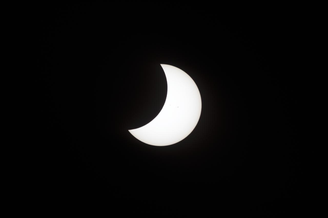
2017 Solar Eclipse first images from Oregon State Fair Grounds, Salem, Oregon. This image was taken at 10:44:10 on August 21, 2017 following totality.

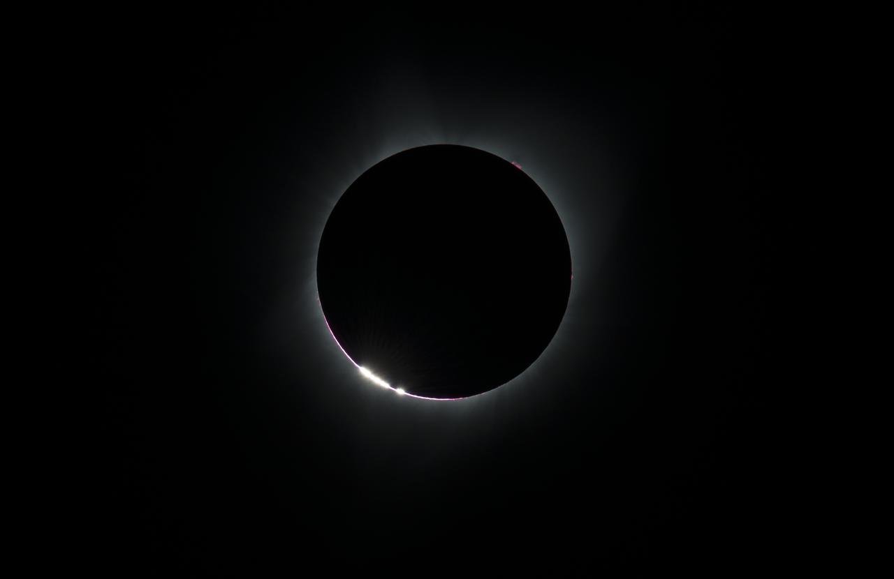
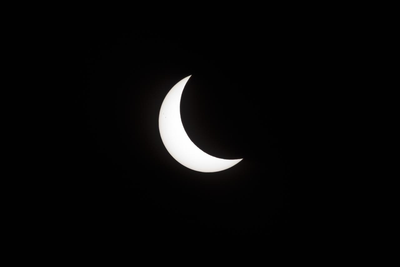
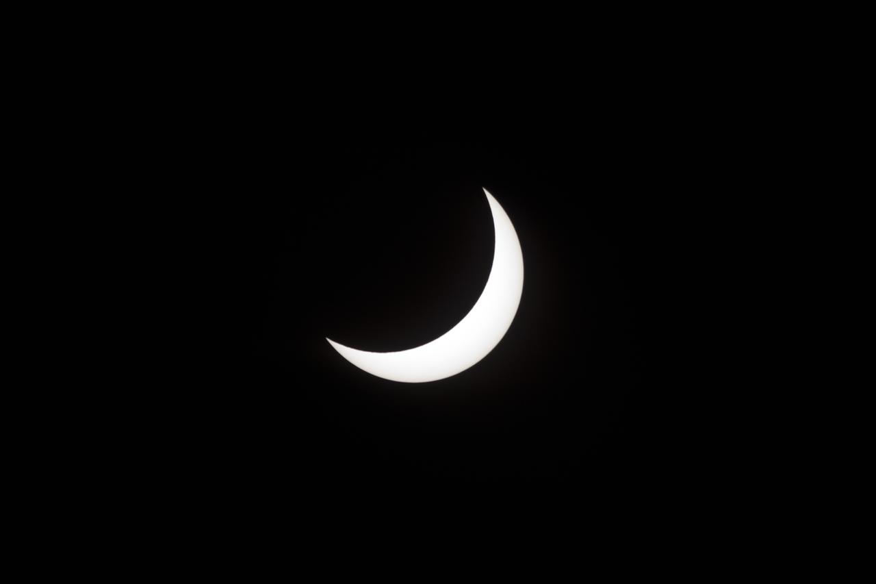
2017 Solar Eclipse first images from Oregon State Fair Grounds, Salem, Oregon. This image taken at 10:18:30 on August 21, 2017 where they have reached totality.

Astronaut Don Pettit gives an overview of the 2017 Solar Eclipse during the viewing event at the Oregon State Fair Grounds, Salem, Oregon

A boy watches the total solar eclipse through protective glasses in Madras, Oregon on Monday, Aug. 21, 2017. A total solar eclipse swept across a narrow portion of the contiguous United States from Lincoln Beach, Oregon to Charleston, South Carolina. A partial solar eclipse was visible across the entire North American continent along with parts of South America, Africa, and Europe. Photo Credit: (NASA/Aubrey Gemignani)
A total solar eclipse is seen on Monday, Aug. 21, 2017 above Madras, Oregon. A total solar eclipse swept across a narrow portion of the contiguous United States from Lincoln Beach, Oregon to Charleston, South Carolina. A partial solar eclipse was visible across the entire North American continent along with parts of South America, Africa, and Europe. Photo Credit: (NASA/Aubrey Gemignani)
The last glimmer of the sun is seen as the moon makes its final move over the sun during the total solar eclipse on Monday, August 21, 2017 above Madras, Oregon. A total solar eclipse swept across a narrow portion of the contiguous United States from Lincoln Beach, Oregon to Charleston, South Carolina. A partial solar eclipse was visible across the entire North American continent along with parts of South America, Africa, and Europe. Photo Credit: (NASA/Aubrey Gemignani)

Some prominences are seen as the moon begins to move off the sun during the total solar eclipse on Monday, August 21, 2017 above Madras, Oregon. A total solar eclipse swept across a narrow portion of the contiguous United States from Lincoln Beach, Oregon to Charleston, South Carolina. A partial solar eclipse was visible across the entire North American continent along with parts of South America, Africa, and Europe. Photo Credit: (NASA/Aubrey Gemignani)

A man drums during the partial phase of the total solar eclipse in Madras, Oregon on Monday, Aug. 21, 2017. A total solar eclipse swept across a narrow portion of the contiguous United States from Lincoln Beach, Oregon to Charleston, South Carolina. A partial solar eclipse was visible across the entire North American continent along with parts of South America, Africa, and Europe. Photo Credit: (NASA/Aubrey Gemignani)

A total solar eclipse is seen on Monday, August 21, 2017 above Madras, Oregon. A total solar eclipse swept across a narrow portion of the contiguous United States from Lincoln Beach, Oregon to Charleston, South Carolina. A partial solar eclipse was visible across the entire North American continent along with parts of South America, Africa, and Europe. Photo Credit: (NASA/Aubrey Gemignani)

The Vasquez family from Eureka and Edgewood, Washington take a photo during the total solar eclipse in Madras, Oregon on Monday, Aug. 21, 2017. A total solar eclipse swept across a narrow portion of the contiguous United States from Lincoln Beach, Oregon to Charleston, South Carolina. A partial solar eclipse was visible across the entire North American continent along with parts of South America, Africa, and Europe. Photo Credit: (NASA/Aubrey Gemignani)

Lili Bornio, right, and her mom, set up to sell eclipse shirts and stickers, that she designed, to raise money for medical school, in Madras, Oregon on Saturday, August 19, 2017. Thousands of visitors are expected in Madras to view the total solar eclipse. The eclipse will be sweeping across a narrow portion of the contiguous United States from Lincoln Beach, Oregon to Charleston, South Carolina on August 21. A partial solar eclipse will be visible across the entire North American continent along with parts of South America, Africa, and Europe. Photo Credit: (NASA/Aubrey Gemignani)

People are seen as they watch a total solar eclipse through protective glasses in Madras, Oregon on Monday, Aug. 21, 2017. A total solar eclipse swept across a narrow portion of the contiguous United States from Lincoln Beach, Oregon to Charleston, South Carolina. A partial solar eclipse was visible across the entire North American continent along with parts of South America, Africa, and Europe. Photo Credit: (NASA/Aubrey Gemignani)

People are seen as they watch a total solar eclipse through protective glasses in Madras, Oregon on Monday, Aug. 21, 2017. A total solar eclipse swept across a narrow portion of the contiguous United States from Lincoln Beach, Oregon to Charleston, South Carolina. A partial solar eclipse was visible across the entire North American continent along with parts of South America, Africa, and Europe. Photo Credit: (NASA/Aubrey Gemignani)

People are seen as they watch a total solar eclipse through protective glasses in Madras, Oregon on Monday, Aug. 21, 2017. A total solar eclipse swept across a narrow portion of the contiguous United States from Lincoln Beach, Oregon to Charleston, South Carolina. A partial solar eclipse was visible across the entire North American continent along with parts of South America, Africa, and Europe. Photo Credit: (NASA/Aubrey Gemignani)

Dave Punaro reflects the shadow of the partial eclipse into a box during the total solar eclipse in Madras, Oregon on Monday, Aug. 21, 2017. A total solar eclipse swept across a narrow portion of the contiguous United States from Lincoln Beach, Oregon to Charleston, South Carolina. A partial solar eclipse was visible across the entire North American continent along with parts of South America, Africa, and Europe. Photo Credit: (NASA/Aubrey Gemignani)

Eirik Olsen, of Seattle, Washington, plays giant Jenga while waiting to watch the total solar eclipse in Madras, Oregon on Saturday, August 19, 2017. The eclipse will be sweeping across a narrow portion of the contiguous United States from Lincoln Beach, Oregon to Charleston, South Carolina on August 21. A partial solar eclipse will be visible across the entire North American continent along with parts of South America, Africa, and Europe. Photo Credit: (NASA/Aubrey Gemignani)
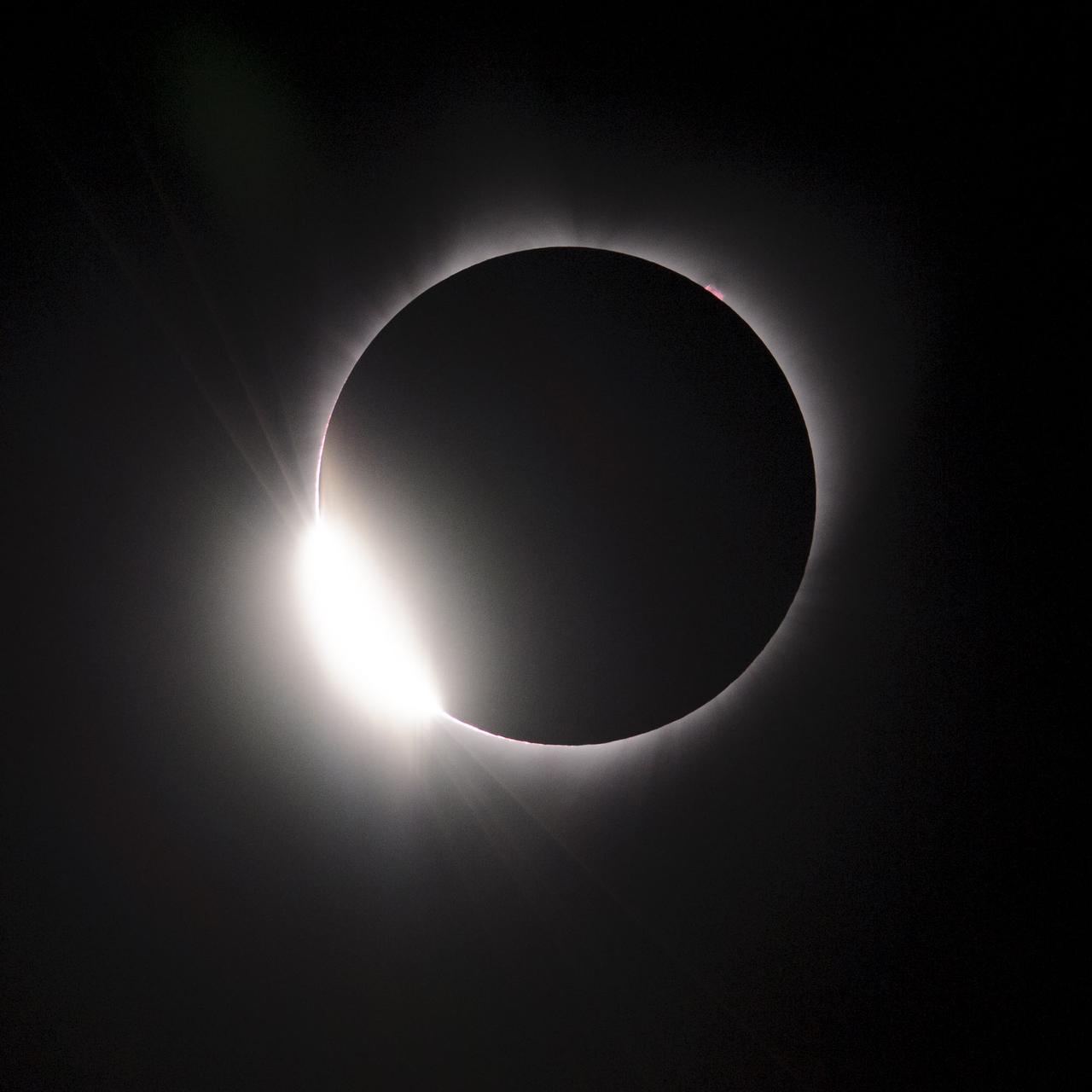
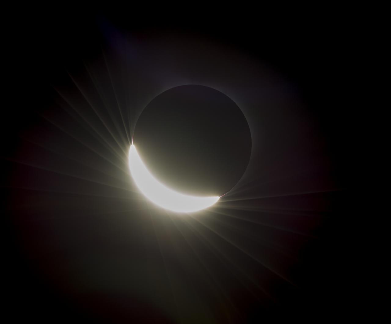
The Baily's Beads effect is seen as the moon makes its final move over the sun during the total solar eclipse on Monday, August 21, 2017 above Madras, Oregon. A total solar eclipse swept across a narrow portion of the contiguous United States from Lincoln Beach, Oregon to Charleston, South Carolina. A partial solar eclipse was visible across the entire North American continent along with parts of South America, Africa, and Europe. Photo Credit: (NASA/Aubrey Gemignani)

Smokey Bear, left, and Judy Reese of the Crooked River National Grassland, right, wave at passersby as crowds arrive to watch the total solar eclipse in Madras, Oregon on Saturday, August 19, 2017. The eclipse will be sweeping across a narrow portion of the contiguous United States from Lincoln Beach, Oregon to Charleston, South Carolina on August 21. A partial solar eclipse will be visible across the entire North American continent along with parts of South America, Africa, and Europe. Photo Credit: (NASA/Aubrey Gemignani)
The Diamond Ring effect is seen as the moon makes its final move over the sun during the total solar eclipse on Monday, August 21, 2017 above Madras, Oregon. A total solar eclipse swept across a narrow portion of the contiguous United States from Lincoln Beach, Oregon to Charleston, South Carolina. A partial solar eclipse was visible across the entire North American continent along with parts of South America, Africa, and Europe. Photo Credit: (NASA/Aubrey Gemignani)
A total solar eclipse is seen on Monday, August 21, 2017 above Madras, Oregon. A total solar eclipse swept across a narrow portion of the contiguous United States from Lincoln Beach, Oregon to Charleston, South Carolina. A partial solar eclipse was visible across the entire North American continent along with parts of South America, Africa, and Europe. Photo Credit: (NASA/Aubrey Gemignani)

Astronaut Don Pettit gives an overview of the 2017 Solar Eclipse viewing event at the Oregon State Farigrounds, Salem, Orgon.
Klaus Koschinsky, left, and his daughters, Claudia, center, and Tanja, right, from Munich, Germany, are seen as they watch a total solar eclipse through protective glasses in Madras, Oregon on Monday, Aug. 21, 2017. A total solar eclipse swept across a narrow portion of the contiguous United States from Lincoln Beach, Oregon to Charleston, South Carolina. A partial solar eclipse was visible across the entire North American continent along with parts of South America, Africa, and Europe. Photo Credit: (NASA/Aubrey Gemignani)

Carol Jensen, a produce purveyor for Black Bear Diner, is seen displaying solar glasses for sale at Black Bear Diner in Madras, Oregon on Saturday, August 19, 2017. She is volunteering her time to help prepare for the crowds arriving to watch the total solar eclipse. The eclipse will be sweeping across a narrow portion of the contiguous United States from Lincoln Beach, Oregon to Charleston, South Carolina on August 21. A partial solar eclipse will be visible across the entire North American continent along with parts of South America, Africa, and Europe. Photo Credit: (NASA/Aubrey Gemignani)
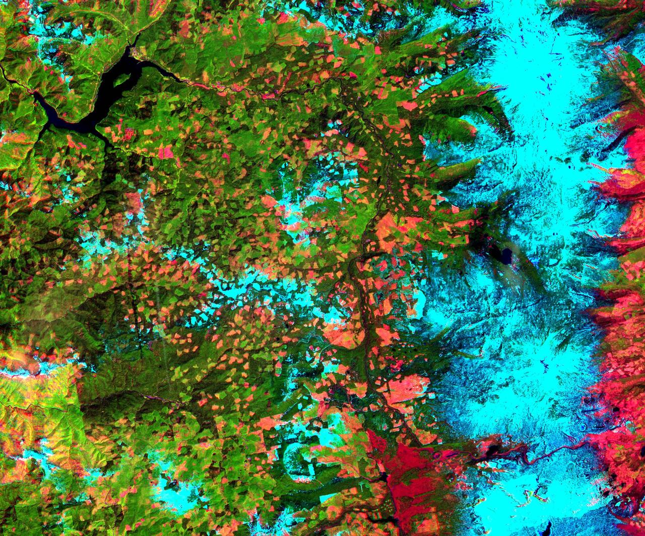
This 39 by 47 km ASTER sub-scene was acquired on May 20, 2000 and shows an area along the west side of the Cascade Range in west central Oregon. Bands 4, 3, and 2 were combined as red, green, and blue. In this composite, snow appears blue, forests are green, and clear-cut areas are orange-pink. The magnitude of logging operations is quite obvious, appearing as a checker board pattern. The image is centered at 44.6 degrees north latitude, 122.2 degrees west longitude. http://photojournal.jpl.nasa.gov/catalog/PIA11165
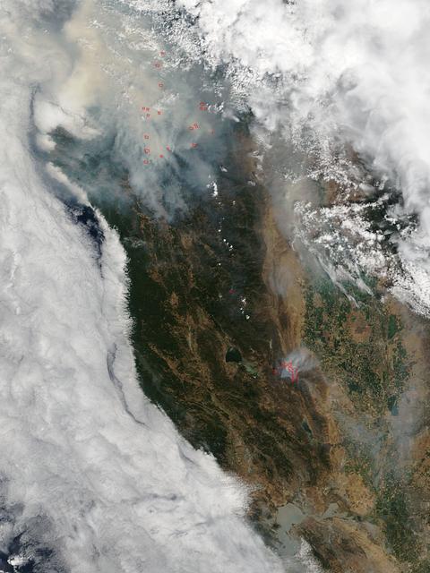
This satellite image shows smoke from several fires in Oregon and California on Aug. 2, 2015. The Moderate Resolution Imaging Spectroradiometer (MODIS) instrument that flies aboard NASA's Aqua satellite captured an image of smoke from these fires Aug. 2 at 21:05 UTC (5:05 p.m. EDT). The multiple red pixels are heat signatures detected by MODIS. The smoke appears to be a light brown color. InciWeb is an interagency all-risk incident information management system that coordinates with federal, state and local agencies to manage wildfires. In Oregon smoke from the Cable Crossing Fire, the Stouts Fire and the Potter Mountain Complex Fire commingle. The Cable Crossing Fire was reported burning on forestlands protected by the Douglas Forest Protective Association (DFPA) at approximately 3:25 p.m. on Tuesday, July 28, 2015, near Oregon Highway 138 East, near Mile Post 23, east of Glide. South of the Cable Crossing Fire is the Stouts Fire also in forestlands of the DFPA. This fire was reported on Thursday, July 30, 2015, burning approximately 11 miles east of Canyonville near the community of Milo. East of the other fires is the Potter Mountain Complex Fire. These fires are located in the Deschutes Forest consists of eight fires. According to Inciweb they were started by dry lightning on Saturday, Aug. 2, at approximately 5:30 p.m. about five miles north of Toketee Lake. In northern California, smoke from the River Complex Fire, the Fork Complex Fire and the Shf July Lightning Fire was visible in the MODIS image. The River Complex currently consists of seven reported and observed fires on the Six Rivers and Shasta Trinity National Forests. Originally identified as 18 fires, some have burned together. Inciweb noted that in the Six Rivers National Forest there are fires in the Trinity Alps Wilderness. Those fires include the Groves Fire and the Elk Fire. In the Shasta-Trinity National Forest the fires include the Happy Fire at 2,256 acres, Daily Fire at 16 acres, the Look Fire at 7 acres, Onion Fire at 136 acres and Smokey Fire at 1 acre. In the same forest, south of the River Complex is the Fork Complex fire. Inciweb reported that the Fork Complex consists of (at current count) over 40 fires, all of which were ignited by lightning between July 29 and 31, 2015. To the southwest of this complex is the Mad River Complex. This is a series of seven lightning fires that started on July 30, 2015 after a lightning storm moved through Northern California. To the east of this and the other fires, burns another near Redding, California, called the Shf July Lightning Fire. This is also under the Shasta-Trinity National Forest management. At 8 p.m. PDT on Aug. 2, Inciweb reported that approximately 15 lightning strikes occurred within 24 hours throughout the Shasta Trinity National Forest and resulted in two new fires. The Caves fire, east of Mt. Shasta, is approximately one-tenth of an acre. The Bluejay fire, east of Shasta Lake, is approximately four acres. Image credit: NASA Goddard's MODIS Rapid Response Team, Jeff Schmaltz <b><a href="http://www.nasa.gov/audience/formedia/features/MP_Photo_Guidelines.html" rel="nofollow">NASA image use policy.</a></b> <b><a href="http://www.nasa.gov/centers/goddard/home/index.html" rel="nofollow">NASA Goddard Space Flight Center</a></b> enables NASA’s mission through four scientific endeavors: Earth Science, Heliophysics, Solar System Exploration, and Astrophysics. Goddard plays a leading role in NASA’s accomplishments by contributing compelling scientific knowledge to advance the Agency’s mission. <b>Follow us on <a href="http://twitter.com/NASAGoddardPix" rel="nofollow">Twitter</a></b> <b>Like us on <a href="http://www.facebook.com/pages/Greenbelt-MD/NASA-Goddard/395013845897?ref=tsd" rel="nofollow">Facebook</a></b> <b>Find us on <a href="http://instagrid.me/nasagoddard/?vm=grid" rel="nofollow">Instagram</a></b>
Oregon, California is shown in this MISR Mystery Quiz #23 captured by NASA Terra spacecraft.
Portland, the largest city in Oregon, is located on the Columbia River at the northern end of the Willamette Valley. On clear days, Mount Hood highlights the Cascade Mountains backdrop to the east.
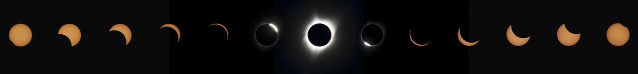
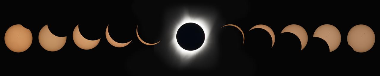
This composite image of thirteen photographs shows the progression of a total solar eclipse at Madras High School in Madras, Oregon on Monday, August 21, 2017. A total solar eclipse swept across a narrow portion of the contiguous United States from Lincoln Beach, Oregon to Charleston, South Carolina. A partial solar eclipse was visible across the entire North American continent along with parts of South America, Africa, and Europe. Photo Credit: (NASA/Aubrey Gemignani)
This composite image shows the progression of a total solar eclipse over Madras, Oregon on Monday, Aug. 21, 2017. A total solar eclipse swept across a narrow portion of the contiguous United States from Lincoln Beach, Oregon to Charleston, South Carolina. A partial solar eclipse was visible across the entire North American continent along with parts of South America, Africa, and Europe. Photo Credit: (NASA/Aubrey Gemignani)
The extent, height, and amount of smoke originating from the B&B Complex Fires in central Oregon are captured in these September 4, 2003 views from NASA Terra spacecraft.
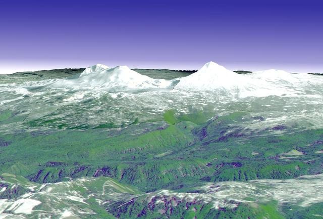
The ground near one of the long-dormant Three Sisters volcanoes in the Cascade Mountains of west-central Oregon has risen approximately 10centimeters in a 10-by-20-km parcel since 1996, meaning that magma or underground lava is slowly flowing into the area, according to a research team from the U.S. Geological Survey. The Three Sisters area -- which contains five volcanoes -- is only about 170 miles from Mount St. Helens, which erupted in 1980. Both are part of the Cascades Range, a line of 27volcanoes stretching from British Columbia in Canada to northern California. This perspective view was created by draping a simulated natural color ASTER image over digital topography from the U.S. Geological Survey National Elevation Dataset. This image was acquired on May 28, 2000 by the Advanced Spaceborne Thermal Emission and Reflection Radiometer (ASTER) on NASA's Terra satellite. With its 14 spectral bands from the visible to the thermal infrared wavelength region, and its high spatial resolution of 15 to 90 meters (about 50 to 300 feet), ASTER will image Earth for the next 6 years to map and monitor the changing surface of our planet. http://photojournal.jpl.nasa.gov/catalog/PIA03492

iss072e009893 (Oct. 1, 2024) --- Portland, Oregon, a city with a population of about 652,000 at the junction of the Willamette and Columbia Rivers, is pictured from the International Space Station as it orbited 259 miles above North America.
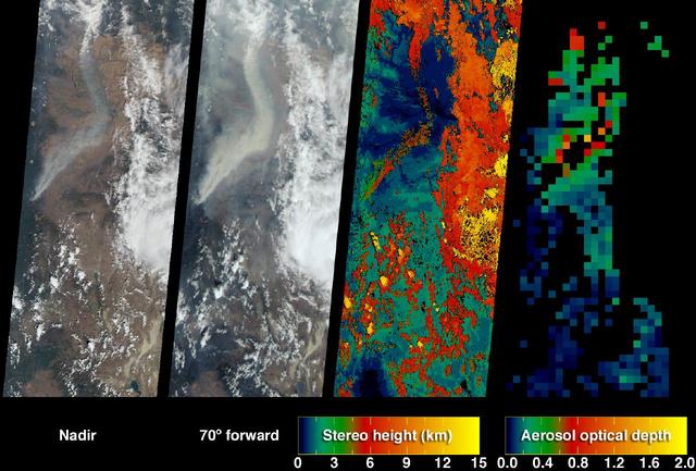
In early August 2017, the Cinder Butte fire burned 9 miles (15 kilometers) outside of the town of Riley, Oregon, and consumed more than 82 square miles (53,000 acres) of forest and brushland. The fire threatened tribal archaeological sites with strong significance to the Burns Paiute and Klamath tribes. Firefighters were able to contain the fire before it could damage the historic sites. On the image, the burned area is gray-brown, and cloud shadows are dark gray-to-black. The image was acquired Aug. 23, 2017, covers an area of 20 by 25 miles (31.5 by 39.9 kilometers), and is located at 43.5 degrees north, 119.9 degrees west. https://photojournal.jpl.nasa.gov/catalog/PIA21879
The Whitewater Fire in the Mount Jefferson Wilderness in Oregon was started by a lightning strike. As of Aug. 18, 2017, more than 117,000 acres and 30 miles (48 kilometers) of the Pacific Crest Trail are closed to the public in an area that had been expected to be popular with people there to view the August 21 solar eclipse. The smoke clouds sit over the burned area, just west-northwest of Mount Jefferson. The image was acquired Aug. 18, 2017, covers an area of 16 by 17 miles (26.1 by 27.2 kilometers), and is located at 44.7 degrees north, 121.8 degrees west. https://photojournal.jpl.nasa.gov/catalog/PIA21877
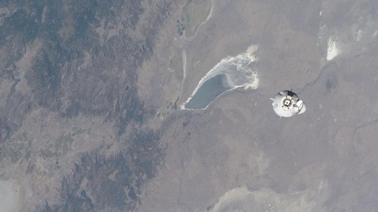
iss072e004107 (Sept. 29, 2024) --- The SpaceX Dragon Freedom spacecraft carrying NASA astronaut Nick Hague and Roscosmos cosmonaut Aleksandr Gorbunov approaches the International Space Station 258 miles above Lake Abert in Oregon.

Bill Moede, Howard Video Productions, of the NASA Ames Video group explains how the filter that will be used on the camera to safely photograph the sun during the eclipse.

The Oregon State University Mars Rover Team, from Corvallis, Oregon, follows their robot on the practice field during the 2014 NASA Centennial Challenges Sample Return Robot Challenge, Tuesday, June 10, 2014, at the Worcester Polytechnic Institute (WPI) in Worcester, Mass. The Oregon State University Mars Rover Team is one of eighteen teams competing for a $1.5 million NASA prize purse. Teams will be required to demonstrate autonomous robots that can locate and collect samples from a wide and varied terrain, operating without human control. The objective of this NASA-WPI Centennial Challenge is to encourage innovations in autonomous navigation and robotics technologies. Innovations stemming from the challenge may improve NASA's capability to explore a variety of destinations in space, as well as enhance the nation's robotic technology for use in industries and applications on Earth. Photo Credit: (NASA/Joel Kowsky)

Robert Lightfoot, acting NASA administrator and Thomas Zurbuchen NASA AA for the science mission directorate view a partial eclipse solar eclipse Monday, August 21, 2017, from onboard a NASA Armstrong Flight Research Center’s Gulfstream III 35,000 feet above the Oregon Coast. A total solar eclipse swept across a narrow portion of the contiguous United States from Lincoln Beach, Oregon to Charleston, South Carolina. Photo Credit: (NASA/Carla Thomas)

Robert Lightfoot, acting NASA administrator and Thomas Zurbuchen NASA AA for the science mission directorate view a partial eclipse solar eclipse Monday, August 21, 2017, from onboard a NASA Armstrong Flight Research Center’s Gulfstream III 35,000 feet above the Oregon Coast. A total solar eclipse swept across a narrow portion of the contiguous United States from Lincoln Beach, Oregon to Charleston, South Carolina. Photo Credit: (NASA/Carla Thomas)

Robert Lightfoot, acting NASA administrator and Thomas Zurbuchen NASA AA for the science mission directorate view a partial eclipse solar eclipse Monday, August 21, 2017, from onboard a NASA Armstrong Flight Research Center’s Gulfstream III 35,000 feet above the Oregon Coast. A total solar eclipse swept across a narrow portion of the contiguous United States from Lincoln Beach, Oregon to Charleston, South Carolina. Photo Credit: (NASA/Carla Thomas)
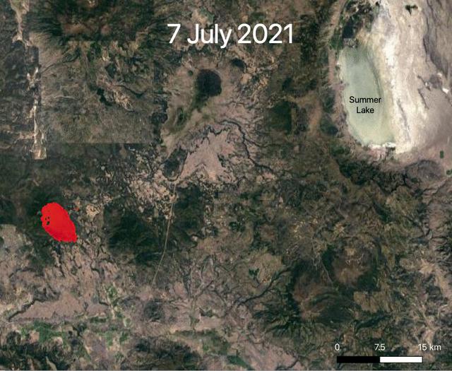
NASA's ECOsystem Spaceborne Thermal Radiometer Experiment on Space Station (ECOSTRESS) is aiding in the fight against fires in the Western U.S. As of July 27, 2021, the Bootleg Fire in southern Oregon had ballooned to more than 410,000 acres, damaging hundreds of buildings and vehicles in its path. ECOSTRESS measures surface temperature from the vantage point of the International Space Station. Researchers of the RADR-Fire team at Pacific Northwest National Laboratory have been experimenting with ECOSTRESS data as part of a new tool now being implemented for first responders like the U.S. Forest Service. In the visualization, ECOSTRESS is tracking the movement of the Bootleg Fire between July 7 and July and identifying its proximity to critical infrastructure — areas in red represent the hottest pixels ECOSTRESS detected. The extreme heat in those areas indicates the fire front, or where resources are most needed. Tasked with detecting plant water use and stress, ECOSTRESS's primary mission is to measure the temperature of plants heating up as they run out of water. But it can also measure and track heat-related phenomena like wildfires, heat waves, and volcanoes. ECOSTRESS observations have a spatial resolution of about 77 by 77 yards (70 by 70 meters), which enables researchers to study surface-temperature conditions down to the size of a football field. Due to the space station's unique orbit, the mission can acquire images of the same regions at different times of the day, as opposed to crossing over each area at the same time of day like satellites in other orbits do. This is advantageous when monitoring plant stress in the same area throughout the day, for example. Movie available at https://photojournal.jpl.nasa.gov/catalog/PIA23695

Oregon Air National Guard and NASA flight crew look out across the desert while awaiting the arrival of the NASA’s newest F-15 aircraft from the Oregon Air National Guard’s 173rd Fighter Wing to NASA’s Armstrong Flight Research Center in Edwards, California, on Monday, Dec. 22, 2025.

The Oregon State University Mars Rover Team follows their robot on the practice field during the 2014 NASA Centennial Challenges Sample Return Robot Challenge, Tuesday, June 10, 2014, at the Worcester Polytechnic Institute (WPI) in Worcester, Mass. The Oregon State University Mars Rover Team is one of eighteen teams competing for a $1.5 million NASA prize purse. Teams will be required to demonstrate autonomous robots that can locate and collect samples from a wide and varied terrain, operating without human control. The objective of this NASA-WPI Centennial Challenge is to encourage innovations in autonomous navigation and robotics technologies. Innovations stemming from the challenge may improve NASA's capability to explore a variety of destinations in space, as well as enhance the nation's robotic technology for use in industries and applications on Earth. Photo Credit: (NASA/Joel Kowsky)

By August, 2024, the four dams blocking the flow of the Klamath River in California and Oregon were removed. After more than 100 years, nearly 640 km of salmon habitat were restored. Two of the dams and their reservoirs, Copco 1 and Copco 2 in northern California, are shown before and after removal. The images were acquired July 18, 2024 and August 15, 2020, cover an area of 16.5 by 22.5 km, and are located at 42.1 degrees north, 122.2 degrees west. https://photojournal.jpl.nasa.gov/catalog/PIA26448

Oregon Air National Guard pilots deliver NASA’s newest F-15 aircraft from the Oregon Air National Guard’s 173rd Fighter Wing at Kingsley Field to NASA’s Armstrong Flight Research Center in Edwards, California, on Monday, Dec. 22, 2025. After completing their final flights with the Air Force, the two aircraft begin their new role supporting NASA’s flight research.

Oregon Air National Guard ground crew guides one of NASA’s newest F-15 aircraft onto the ramp at the agency’s Armstrong Flight Research Center in Edwards, California, on Monday, Dec. 22, 2025. The retired U.S. Air Force F-15s come from the Oregon Air National Guard’s 173rd Fighter Wing and will transition from military service to support NASA’s flight research fleet.

Ignited by lightning strikes during a record-breaking heat wave, the Biscuit Fire became Oregon largest wildfire of the past century. NASA Terra spacecraft acquired these image between mid July and early September 2002.

NASA staff and Oregon Air National Guard’s 173rd Fighter Wing crew pose for a group photo at NASA’s Armstrong Flight Research Center in Edwards, California, on Monday, Dec. 22, 2025. The group stands in front of one of two F-15 aircraft added to the agency’s flight research fleet.

The Oregon State University Mars Rover Team poses for a picture with their robot following their attempt at the level one challenge during the 2014 NASA Centennial Challenges Sample Return Robot Challenge, Wednesday, June 11, 2014, at the Worcester Polytechnic Institute (WPI) in Worcester, Mass. is one of eighteen teams competing for a $1.5 million NASA prize purse. Teams will be required to demonstrate autonomous robots that can locate and collect samples from a wide and varied terrain, operating without human control. The objective of this NASA-WPI Centennial Challenge is to encourage innovations in autonomous navigation and robotics technologies. Innovations stemming from the challenge may improve NASA's capability to explore a variety of destinations in space, as well as enhance the nation's robotic technology for use in industries and applications on Earth. Photo Credit: (NASA/Joel Kowsky)
In southwest Oregon, the Biscuit Fire continues to grow. This image, acquired from the Advanced Spaceborne Thermal Emission and Reflection Radiometer (ASTER) on NASA's Terra satellite on August 14, 2002, shows the pillars of smoke arising from the fires. Active fire areas are in red. More than 6,000 fire personnel are assigned to the Biscuit Fire alone, which was 390,276 acres as of Thursday morning, August 15, and only 26 percent contained. Among the resources threatened are thousands of homes, three nationally designated wild and scenic rivers, and habitat for several categories of plants and animals at risk of extinction. Firefighters currently have no estimate as to when the fire might be contained. http://photojournal.jpl.nasa.gov/catalog/PIA03856
iss063e070752 (Aug. 14, 2020) --- Klamath River, pictured from the International Space Station, runs through Oregon just north of the border with California.
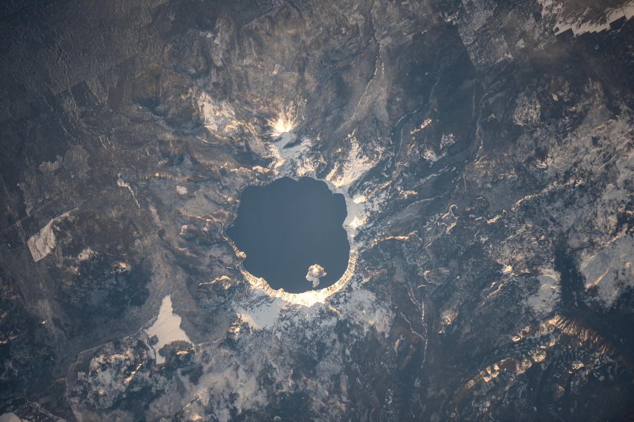
iss062e152575 (March 5, 2020) --- Crater Lake National Park. Oregon, is pictured from the International Space Station as it orbited 264 miles above.

The Moon is seen passing in front of the Sun during a total solar eclipse on Monday, August 21, 2017 from onboard a NASA Gulfstream III aircraft flying 25,000 feet above the Oregon coast. A total solar eclipse swept across a narrow portion of the contiguous United States from Lincoln Beach, Oregon to Charleston, South Carolina. A partial solar eclipse was visible across the entire North American continent along with parts of South America, Africa, and Europe. Photo Credit: (NASA/Carla Thomas)
The Moon is seen passing in front of the Sun during a total solar eclipse on Monday, August 21, 2017 from onboard a NASA Gulfstream III aircraft flying 25,000 feet above the Oregon coast. A total solar eclipse swept across a narrow portion of the contiguous United States from Lincoln Beach, Oregon to Charleston, South Carolina. A partial solar eclipse was visible across the entire North American continent along with parts of South America, Africa, and Europe. Photo Credit: (NASA/Carla Thomas)
The Moon is seen passing in front of the Sun during a total solar eclipse on Monday, August 21, 2017 from onboard a NASA Gulfstream III aircraft flying 25,000 feet above the Oregon coast. A total solar eclipse swept across a narrow portion of the contiguous United States from Lincoln Beach, Oregon to Charleston, South Carolina. A partial solar eclipse was visible across the entire North American continent along with parts of South America, Africa, and Europe. Photo Credit: (NASA/Carla Thomas)

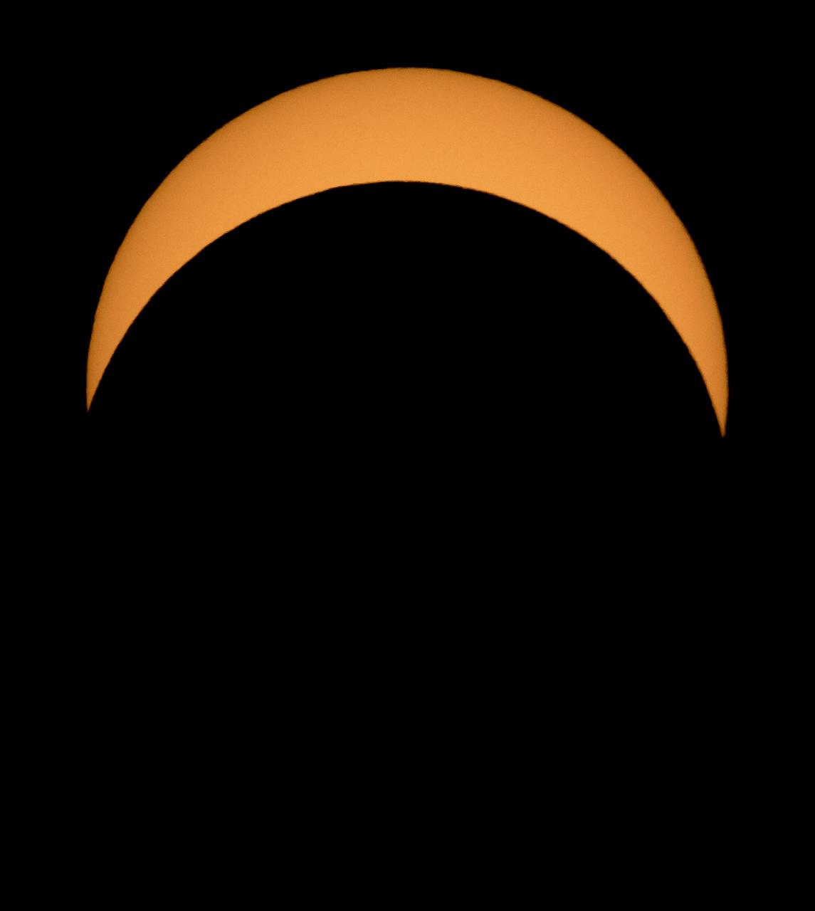
A total solar eclipse is seen on Monday, August 21, 2017 from onboard a NASA Armstrong Flight Research Center’s Gulfstream III 25,000 feet above the Oregon coast. A total solar eclipse swept across a narrow portion of the contiguous United States from Lincoln Beach, Oregon to Charleston, South Carolina. Photo Credit: (NASA/Carla Thomas)
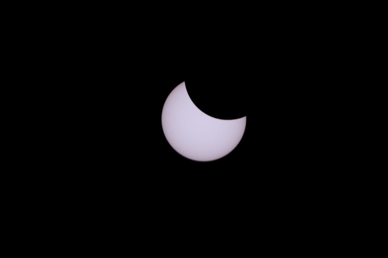
A partial eclipse on Florida's Space Coast, the rare astronomical event was photographed from the top of the Vehicle Assembly Building, as the Moon passed between Earth and the midafternoon Sun. The Moon's shadow moved across the landscape from Oregon to South Carolina. The 70-mile-wide totality path, or "umbral cone" -- where the entire Sun will vanish behind the Moon -- stretched across 14 states, from Oregon to South Carolina.
The Moon is seen passing in front of the Sun during a total solar eclipse on Monday, August 21, 2017 from onboard a NASA Gulfstream III aircraft flying 25,000 feet above the Oregon coast. A total solar eclipse swept across a narrow portion of the contiguous United States from Lincoln Beach, Oregon to Charleston, South Carolina. A partial solar eclipse was visible across the entire North American continent along with parts of South America, Africa, and Europe. Photo Credit: (NASA/Carla Thomas)
The Moon is seen passing in front of the Sun during a total solar eclipse on Monday, August 21, 2017 from onboard a NASA Gulfstream III aircraft flying 25,000 feet above the Oregon coast. A total solar eclipse swept across a narrow portion of the contiguous United States from Lincoln Beach, Oregon to Charleston, South Carolina. A partial solar eclipse was visible across the entire North American continent along with parts of South America, Africa, and Europe. Photo Credit: (NASA/Carla Thomas)
A partial eclipse on Florida's Space Coast, the rare astronomical event was photographed from the top of the Vehicle Assembly Building, as the Moon passed between Earth and the midafternoon Sun. The Moon's shadow moved across the landscape from Oregon to South Carolina. The 70-mile-wide totality path, or "umbral cone" -- where the entire Sun will vanish behind the Moon -- stretched across 14 states, from Oregon to South Carolina.
A partial eclipse on Florida's Space Coast, the rare astronomical event was photographed from the top of the Vehicle Assembly Building, as the Moon passed between Earth and the midafternoon Sun. The Moon's shadow moved across the landscape from Oregon to South Carolina. The 70-mile-wide totality path, or "umbral cone" -- where the entire Sun will vanish behind the Moon -- stretched across 14 states, from Oregon to South Carolina.
The Moon is seen passing in front of the Sun during a total solar eclipse on Monday, August 21, 2017 from onboard a NASA Gulfstream III aircraft flying 25,000 feet above the Oregon coast. A total solar eclipse swept across a narrow portion of the contiguous United States from Lincoln Beach, Oregon to Charleston, South Carolina. A partial solar eclipse was visible across the entire North American continent along with parts of South America, Africa, and Europe. Photo Credit: (NASA/Carla Thomas)

A total solar eclipse is seen on Monday, August 21, 2017 from onboard a NASA Armstrong Flight Research Center’s Gulfstream III 25,000 feet above the Oregon coast. A total solar eclipse swept across a narrow portion of the contiguous United States from Lincoln Beach, Oregon to Charleston, South Carolina. Photo Credit: (NASA/Carla Thomas)
A partial eclipse on Florida's Space Coast, the rare astronomical event was photographed from the top of the Vehicle Assembly Building, as the Moon passed between Earth and the midafternoon Sun. The Moon's shadow moved across the landscape from Oregon to South Carolina. The 70-mile-wide totality path, or "umbral cone" -- where the entire Sun will vanish behind the Moon -- stretched across 14 states, from Oregon to South Carolina.
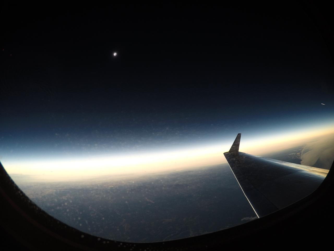
A total solar eclipse is seen on Monday, August 21, 2017 from onboard a NASA Armstrong Flight Research Center’s Gulfstream III 25,000 feet above the Oregon coast. A total solar eclipse swept across a narrow portion of the contiguous United States from Lincoln Beach, Oregon to Charleston, South Carolina. Photo Credit: (NASA/Carla Thomas)

The Moon is seen passing in front of the Sun during a total solar eclipse on Monday, August 21, 2017 from onboard a NASA Gulfstream III aircraft flying 25,000 feet above the Oregon coast. A total solar eclipse swept across a narrow portion of the contiguous United States from Lincoln Beach, Oregon to Charleston, South Carolina. A partial solar eclipse was visible across the entire North American continent along with parts of South America, Africa, and Europe. Photo Credit: (NASA/Carla Thomas)
A partial eclipse on Florida's Space Coast, the rare astronomical event was photographed from the top of the Vehicle Assembly Building, as the Moon passed between Earth and the midafternoon Sun. The Moon's shadow moved across the landscape from Oregon to South Carolina. The 70-mile-wide totality path, or "umbral cone" -- where the entire Sun will vanish behind the Moon -- stretched across 14 states, from Oregon to South Carolina.

The Oregon State University Mars Rover Team's robot is seen during level one competition at the 2014 NASA Centennial Challenges Sample Return Robot Challenge, Wednesday, June 11, 2014, at the Worcester Polytechnic Institute (WPI) in Worcester, Mass. Eighteen teams are competing for a $1.5 million NASA prize purse. Teams will be required to demonstrate autonomous robots that can locate and collect samples from a wide and varied terrain, operating without human control. The objective of this NASA-WPI Centennial Challenge is to encourage innovations in autonomous navigation and robotics technologies. Innovations stemming from the challenge may improve NASA's capability to explore a variety of destinations in space, as well as enhance the nation's robotic technology for use in industries and applications on Earth. Photo Credit: (NASA/Joel Kowsky)

The Oregon State University Mars Rover Team's robot is seen during level one competition at the 2014 NASA Centennial Challenges Sample Return Robot Challenge, Wednesday, June 11, 2014, at the Worcester Polytechnic Institute (WPI) in Worcester, Mass. Eighteen teams are competing for a $1.5 million NASA prize purse. Teams will be required to demonstrate autonomous robots that can locate and collect samples from a wide and varied terrain, operating without human control. The objective of this NASA-WPI Centennial Challenge is to encourage innovations in autonomous navigation and robotics technologies. Innovations stemming from the challenge may improve NASA's capability to explore a variety of destinations in space, as well as enhance the nation's robotic technology for use in industries and applications on Earth. Photo Credit: (NASA/Joel Kowsky)

Members of the Oregon State University Mars Rover Team prepare their robot to attempt the level one competition at the 2014 NASA Centennial Challenges Sample Return Robot Challenge, Wednesday, June 11, 2014, at the Worcester Polytechnic Institute (WPI) in Worcester, Mass. Eighteen teams are competing for a $1.5 million NASA prize purse. Teams will be required to demonstrate autonomous robots that can locate and collect samples from a wide and varied terrain, operating without human control. The objective of this NASA-WPI Centennial Challenge is to encourage innovations in autonomous navigation and robotics technologies. Innovations stemming from the challenge may improve NASA's capability to explore a variety of destinations in space, as well as enhance the nation's robotic technology for use in industries and applications on Earth. Photo Credit: (NASA/Joel Kowsky)
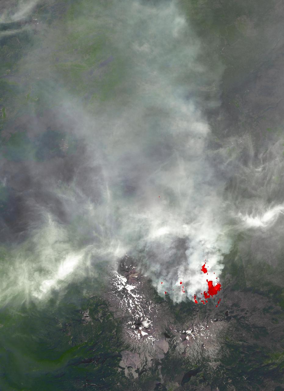
This image, acquired by NASA Terra spacecraft, is of the Pole Creek fire southwest of Sisters, Ore., which had grown to 24,000 acres as of Sept. 20, 2012. No structures have been destroyed, and the fire is mostly confined to the national forest.

iss063e070781 (Aug. 14, 2020) --- The high-saline Lake Abert, surrounded by arid land in Oregon, is pictured from the International Space Station as it orbited above the western United States.

iss071e133389 (May 29, 2024) --- Mud Lake in Harney County, Oregon, one of at least sixteen similarly named lakes throughout the Beaver State, is pictured from the International Space Station as it orbited 263 miles above.
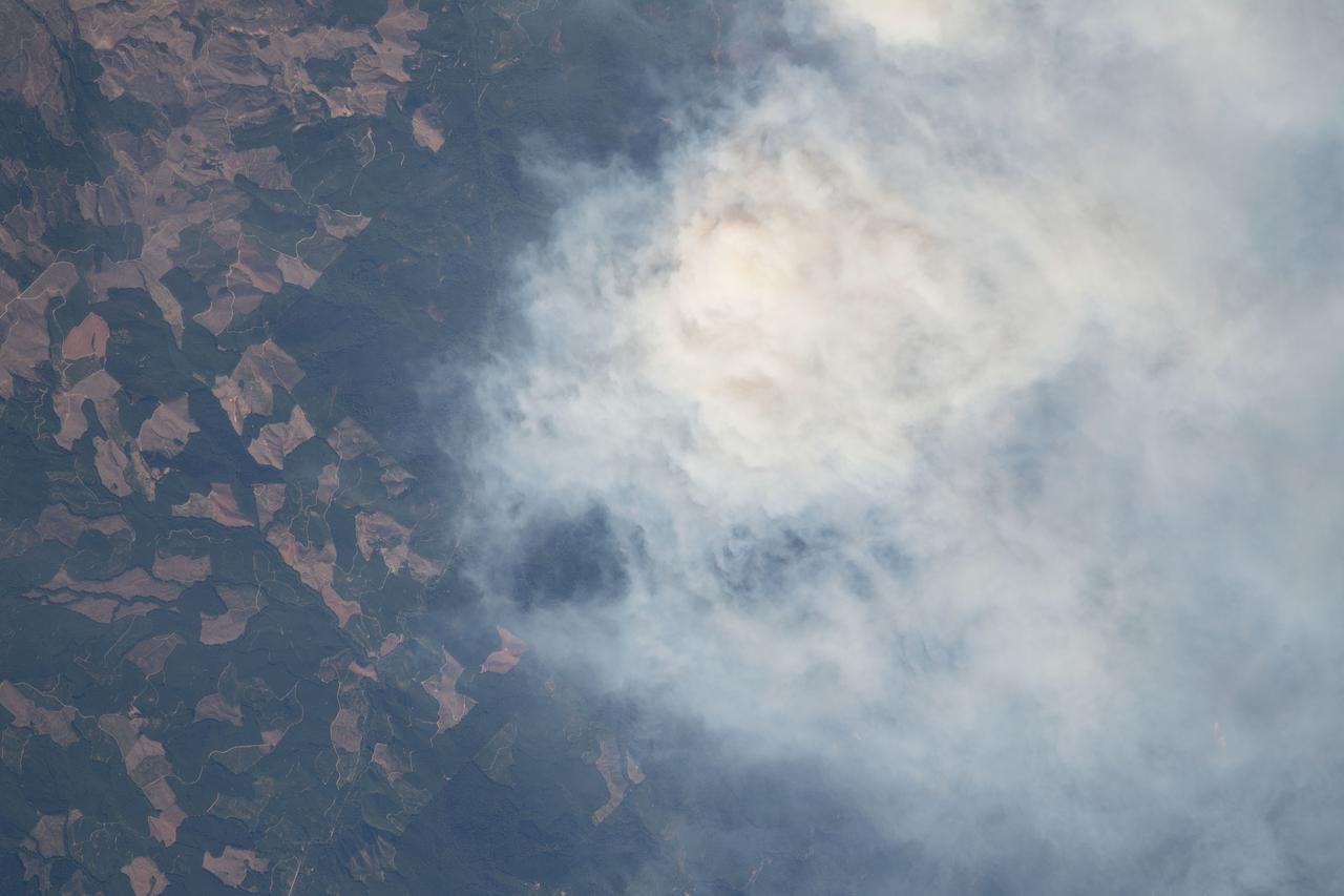
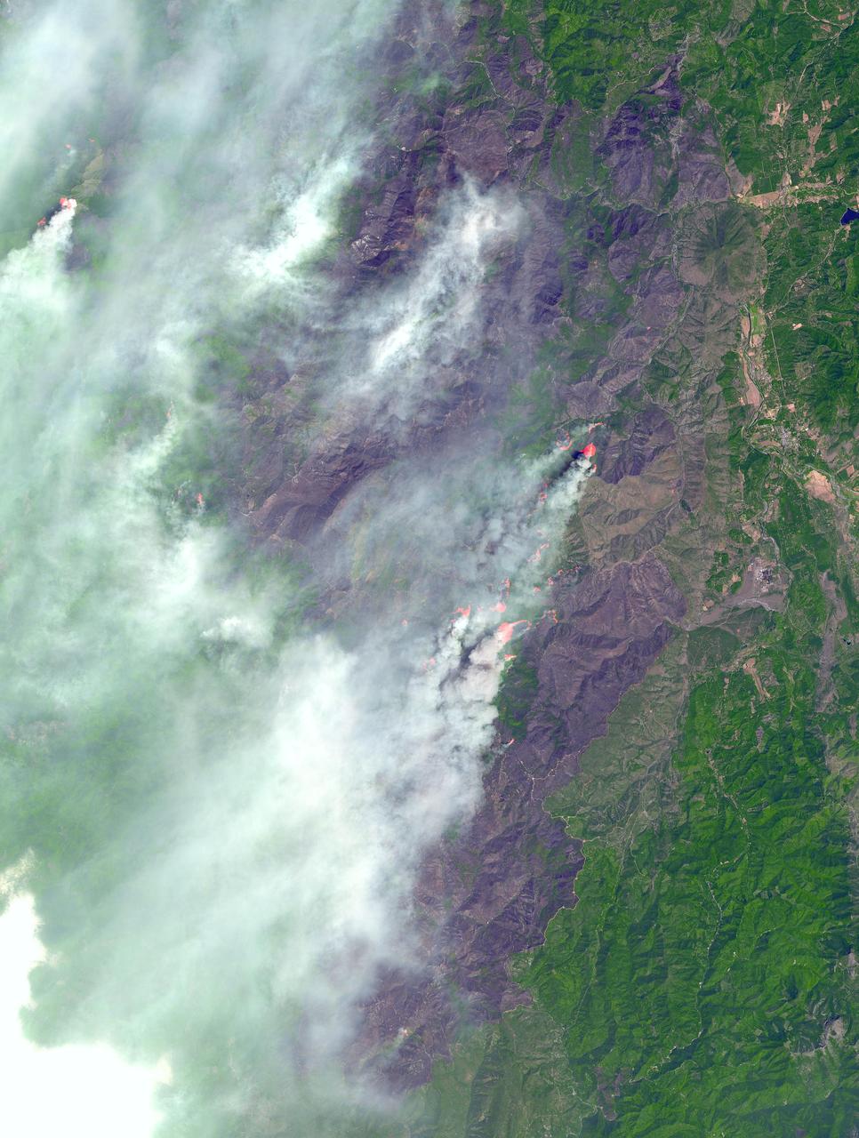
iss069e057022 (Aug. 12, 2023) --- A wildfire near the Willamette National Forest in Oregon is pictured from the International Space Station as it orbited 265 miles above the Beaver State.

iss064e038372 (Feb. 26, 2021) --- A full Moon is pictured above the Earth's horizon as the International Space Station orbited 263 miles above the Washington-Oregon border in northwestern United States.

iss072e005655 (Sept. 29, 2024) --- The SpaceX Dragon Freedom spacecraft carrying NASA astronaut Nick Hague and Roscosmos cosmonaut Aleksandr Gorbunov approaches the International Space Station as it orbited 259 miles above Oregon.

51F-37-014 (29 July-6 Aug 1985) --- This Earth view shows Oregon and Washington including metropolitan Portland at the center. The Columbia River can be seen from Goble (upper left) upstream to Bonneville (upper right). The Willamette River is at the lower photo and seen upstream to east of McMinnville.
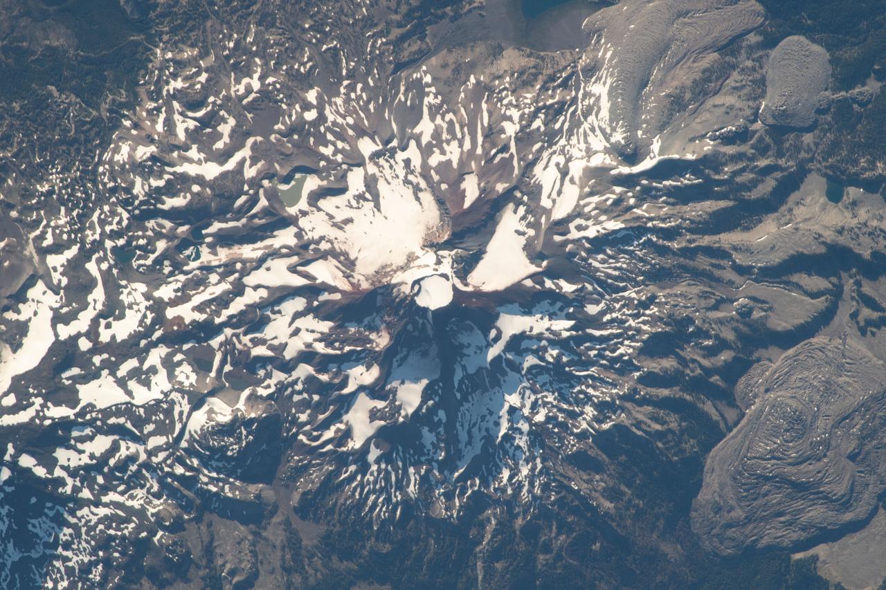
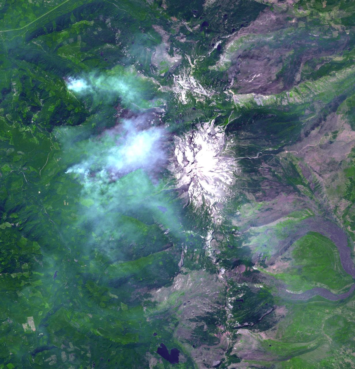
iss056e094579 (July 10, 2018) --- South Sister is the tallest of three volcanic peaks known as the Three Sisters in the northwest American state of Oregon. The International Space Station was orbiting nearly 256 miles above the United States when this photograph was taken by an Expedition 56 crewmember.

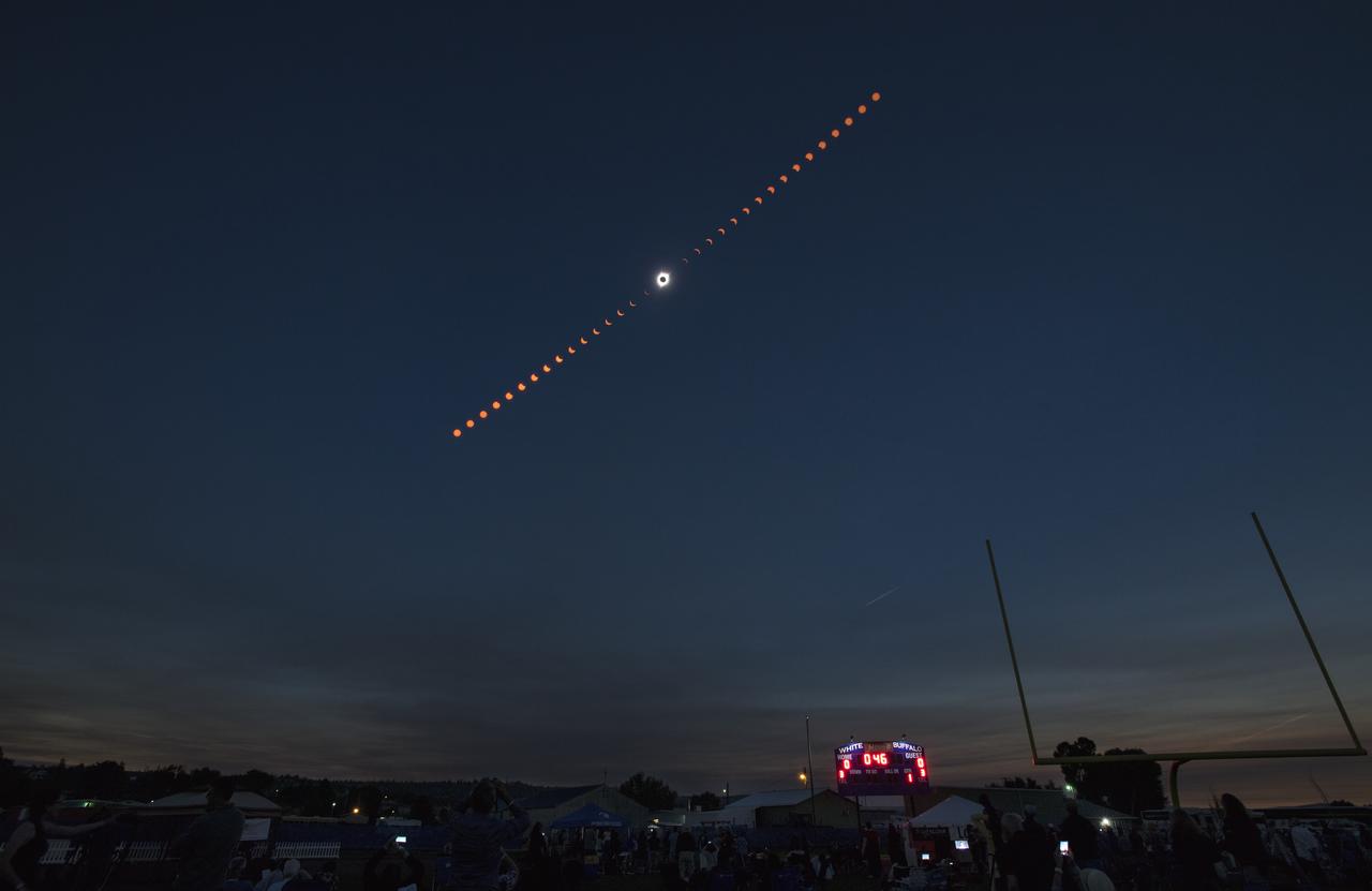
This composite image of nine pictures shows the progression of a partial solar eclipse near Banner, Wyoming on Monday, Aug. 21, 2017. A total solar eclipse swept across a narrow portion of the contiguous United States from Lincoln Beach, Oregon to Charleston, South Carolina. A partial solar eclipse was visible across the entire North American continent along with parts of South America, Africa, and Europe. Photo Credit: (NASA/Joel Kowsky)
View of the partial solar eclipse from NASA's Goddard Space Flight Center in Greenbelt, Md on Monday, August 21, 2017. A total solar eclipse swept across a narrow portion of the contiguous United States from Lincoln Beach, Oregon to Charleston, South Carolina. A partial solar eclipse was visible across the entire North American continent along with parts of South America, Africa, and Europe. Credit: NASA/Goddard/Rebecca Roth

The Moon is seen as it starts passing in front of the Sun during a solar eclipse from Ross Lake, Northern Cascades National Park, Washington on Monday, Aug. 21, 2017. A total solar eclipse swept across a narrow portion of the contiguous United States from Lincoln Beach, Oregon to Charleston, South Carolina. A partial solar eclipse was visible across the entire North American continent along with parts of South America, Africa, and Europe. Photo Credit: (NASA/Bill Ingalls)

NASA employees and contractors use protective glasses to view a partial solar eclipse from NASA Headquarters Tuesday, Aug. 22, 2017 in Washington. A total solar eclipse swept across a narrow portion of the contiguous United States from Lincoln Beach, Oregon to Charleston, South Carolina. A partial solar eclipse was visible across the entire North American continent along with parts of South America, Africa, and Europe. Photo Credit: (NASA/Gwen Pitman)

From the Kennedy Space Center Visitor Complex, guests joined Americans from coast to coast following the solar eclipse. Although a partial eclipse on Florida's Space Coast, young and old alike found many ways to watch the rare astronomical event. As the Moon passed between Earth and the midafternoon Sun, a shadow moved across the landscape. The 70-mile-wide totality path, or "umbral cone" -- where the entire Sun will vanish behind the Moon -- stretched across 14 states, from Oregon to South Carolina.

From the Kennedy Space Center Visitor Complex, guests joined Americans from coast to coast following the solar eclipse. Although a partial eclipse on Florida's Space Coast, young and old alike found many ways to watch the rare astronomical event. As the Moon passed between Earth and the midafternoon Sun, a shadow moved across the landscape. The 70-mile-wide totality path, or "umbral cone" -- where the entire Sun will vanish behind the Moon -- stretched across 14 states, from Oregon to South Carolina.

From the Kennedy Space Center Visitor Complex, guests joined Americans from coast to coast following the solar eclipse. Although a partial eclipse on Florida's Space Coast, young and old alike found many ways to watch the rare astronomical event. As the Moon passed between Earth and the midafternoon Sun, a shadow moved across the landscape. The 70-mile-wide totality path, or "umbral cone" -- where the entire Sun will vanish behind the Moon -- stretched across 14 states, from Oregon to South Carolina.
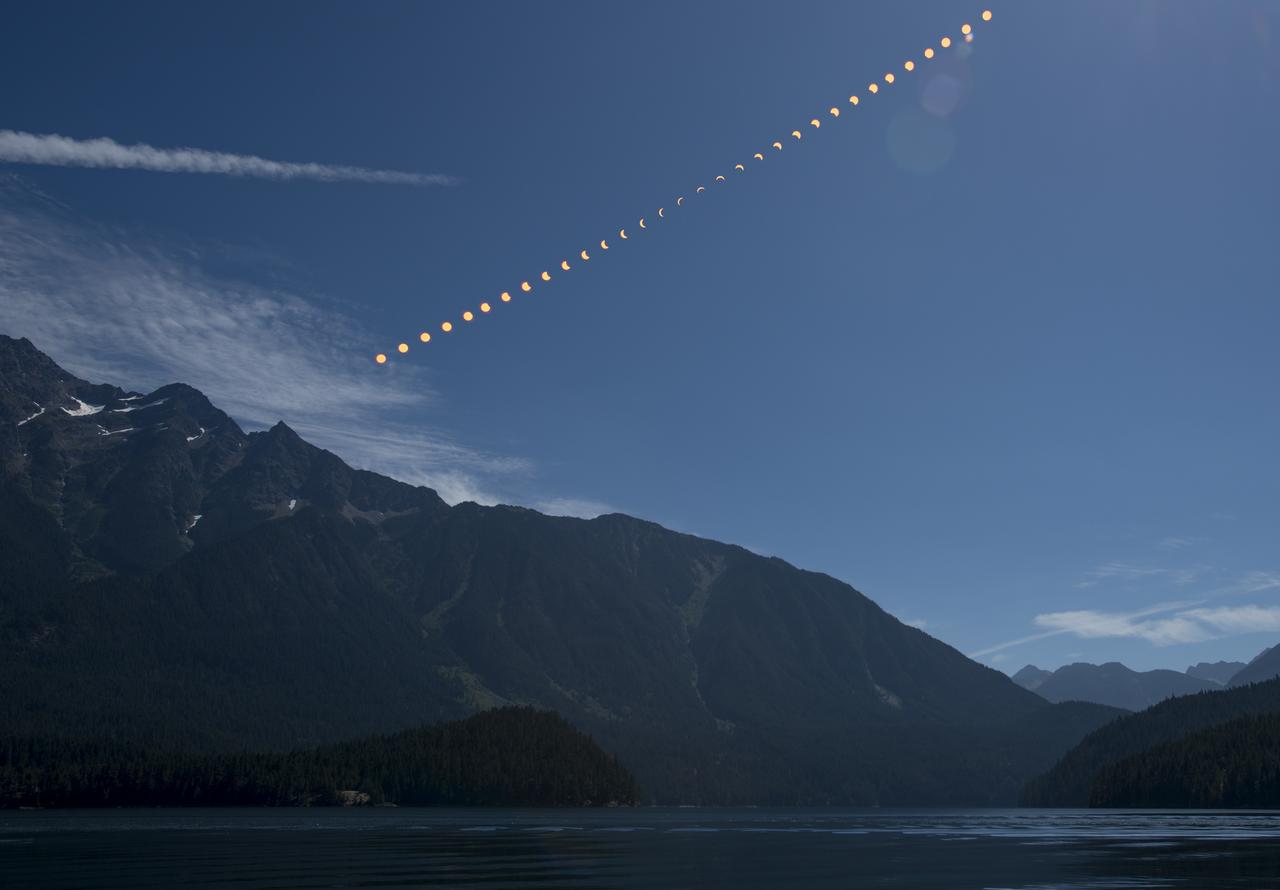
This composite image shows the progression of a partial solar eclipse over Ross Lake, in Northern Cascades National Park, Washington on Monday, Aug. 21, 2017. A total solar eclipse swept across a narrow portion of the contiguous United States from Lincoln Beach, Oregon to Charleston, South Carolina. A partial solar eclipse was visible across the entire North American continent along with parts of South America, Africa, and Europe. Photo Credit: (NASA/Bill Ingalls)
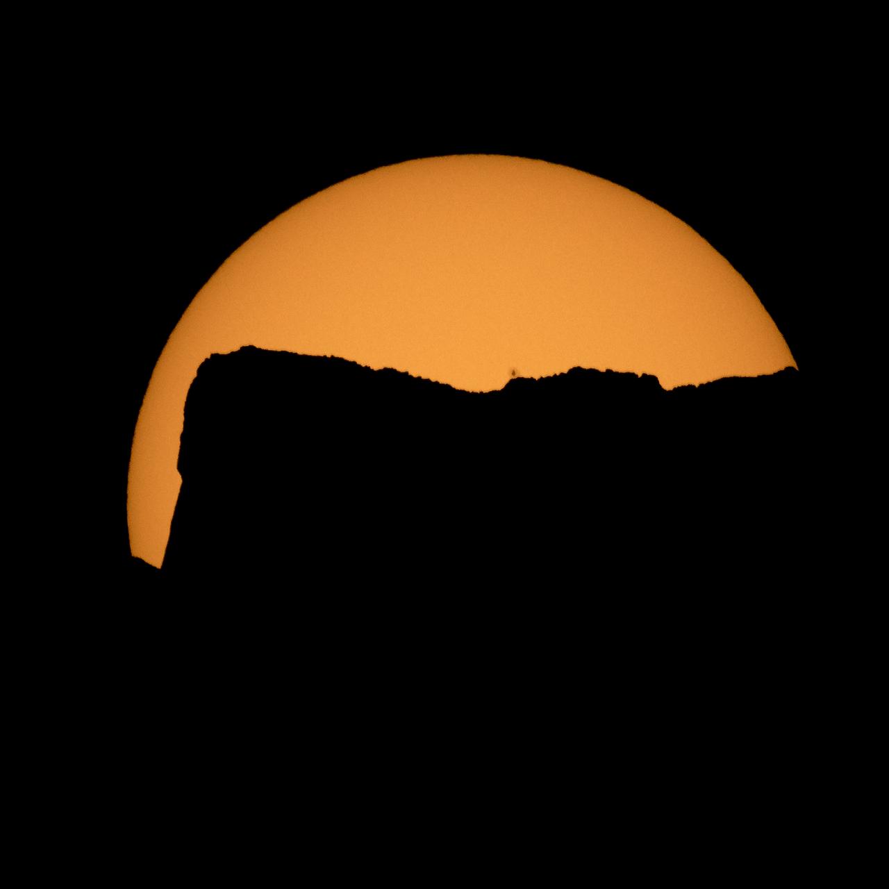
The Sun is seen as it rises behind Jack Mountain head of the solar eclipse, Monday, Aug. 21, 2017, Ross Lake, Northern Cascades National Park, Washington. A total solar eclipse will sweep across a narrow portion of the contiguous United States from Lincoln Beach, Oregon to Charleston, South Carolina. A partial solar eclipse was visible across the entire North American continent along with parts of South America, Africa, and Europe. Photo Credit: (NASA/Bill Ingalls)

From the Kennedy Space Center Visitor Complex, guests joined Americans from coast to coast following the solar eclipse. Although a partial eclipse on Florida's Space Coast, young and old alike found many ways to watch the rare astronomical event. As the Moon passed between Earth and the midafternoon Sun, a shadow moved across the landscape. The 70-mile-wide totality path, or "umbral cone" -- where the entire Sun will vanish behind the Moon -- stretched across 14 states, from Oregon to South Carolina.

51F-37-097 (29 July-6 Aug 1985) --- The snow capped peaks of the Oregon Cascades are clearly seen. From bottom to top we see Mount Hood, Mount Jefferson, and the Three Sisters volcanos. The Columbia River is at the bottom. The Deschutes River system and canyon, the scene of railroad wars nearly a century ago, is at the left side. The Cascades make a very distinct rain shadow between the moist forests to the right and the semiario lands to the east (left) of these great mountains.
The Moon is seen passing in front of the Sun during a solar eclipse from Ross Lake, Northern Cascades National Park, Washington on Monday, Aug. 21, 2017. A total solar eclipse swept across a narrow portion of the contiguous United States from Lincoln Beach, Oregon to Charleston, South Carolina. A partial solar eclipse was visible across the entire North American continent along with parts of South America, Africa, and Europe. Photo Credit: (NASA/Bill Ingalls)
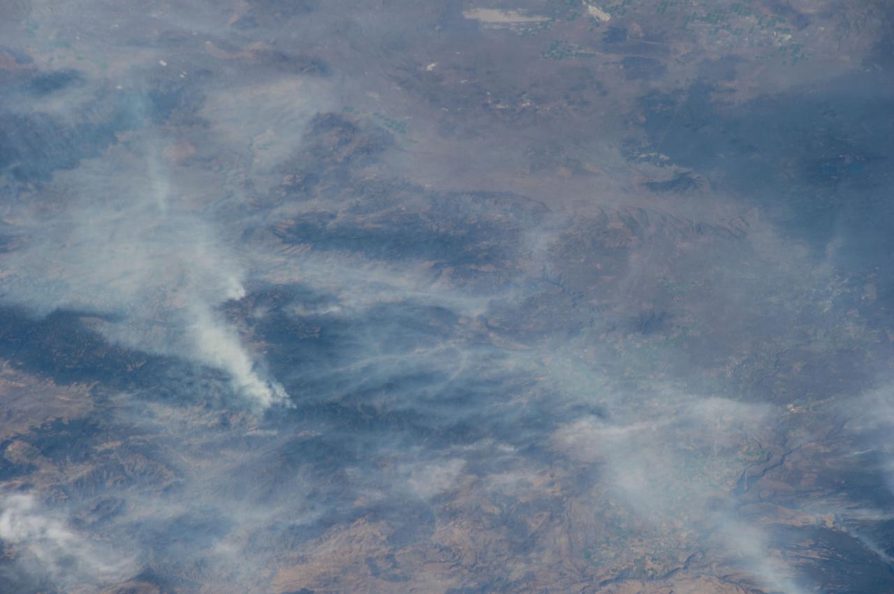
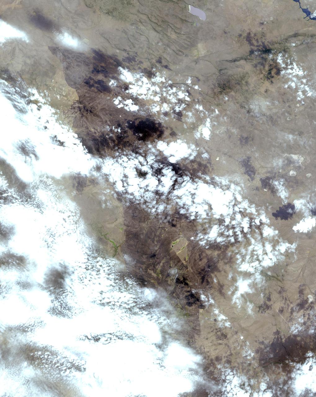
ISS040-E-070424 (19 July 2014) --- One of the Expedition 40 crew members aboard the Earth-orbiting International Space Station recorded this July 19 image of wildfires which are plaguing the Northwest and causing widespread destruction. The orbital outpost was flying 223 nautical miles above Earth at the time of the photo. Lightning has been given as the cause of the Ochoco Complex fires in the Ochoco National Forest in central Oregon. The complex has gotten larger since this photo was taken.