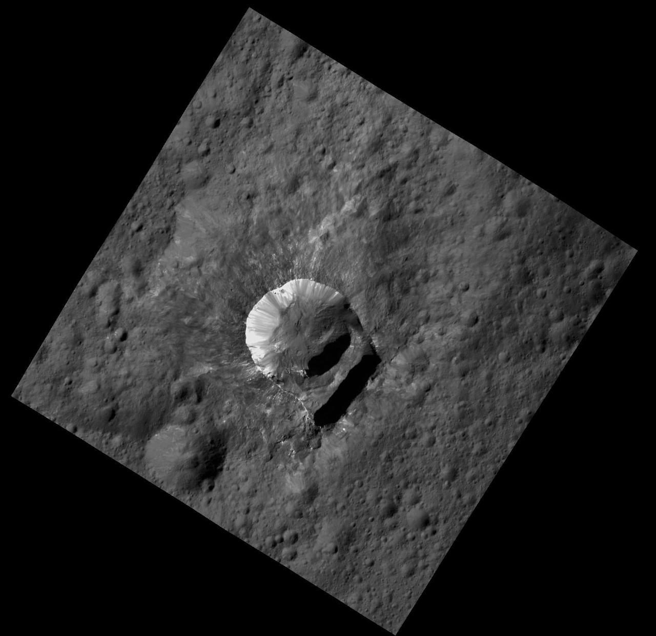
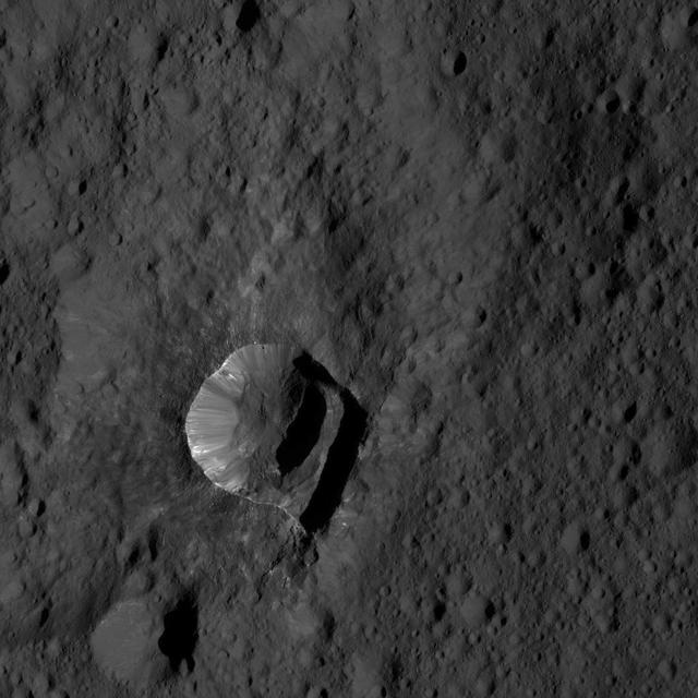
NASA Dawn spacecraft shows Oxo Crater is unique because of the relatively large lump in its crater rim.
The small, bright crater Oxo on Ceres is featured in this image from NASA's Dawn spacecraft. Oxo (6 miles, 10 kilometers in diameter) is located at mid-latitudes on Ceres and likely has water ice. Dawn took this image on Oct. 17, 2016, from its second extended-mission science orbit, at a distance of about 920 miles (1,480 kilometers) above the surface. The image resolution is about 460 feet (140 meters) per pixel. http://photojournal.jpl.nasa.gov/catalog/PIA21221
The 6-mile-wide (10-kilometer-wide) Oxo Crater stands out on the dark landscape of Ceres in this view from NASA's Dawn spacecraft. Oxo is one of several sites at which ice has been identified by Dawn's visible and infrared mapping spectrometer. The crater is located at mid-latitudes (42 degrees North, 0 degrees East), and the presence of ice there is consistent with the recent mapping of hydrogen by Dawn's GRaND instrument (Gamma Ray and Neutron Detector). Ice is likely to be present at shallow depths in this region, waiting to be exposed via small impacts or landslides, as is believed to be the case for Oxo. Ice is not stable for long periods of time on Ceres' surface, thus its exposure at Oxo must be a relatively recent event. Dawn took this image on Oct. 25, 2016, during its second extended-mission science orbit (XMO2), from a distance of about 920 miles (1,480 kilometers) above the surface of Ceres. The image resolution is about 460 feet (140 meters) per pixel. http://photojournal.jpl.nasa.gov/catalog/PIA21250

Ceres' lonely mountain, Ahuna Mons, is seen in this simulated perspective view. The elevation has been exaggerated by a factor of two. The view was made using enhanced-color images from NASA's Dawn mission. Images taken using blue (440 nanometers), green (750 nanometers) and infrared (960 nanometers) spectral filters were combined to create the view. The spacecraft's framing camera took the images from Dawn's low-altitude mapping orbit, from an altitude of 240 miles (385 kilometers) in August 2016. The resolution of the component images is 120 feet (35 meters) per pixel. http://photojournal.jpl.nasa.gov/catalog/PIA20915

This image shows Haulani Crater and its bright ejecta near the limb of Ceres and Oxo Crater near the center of the image. The latter is easily recognizable by its bright wall that is enriched in ice and carbonate. The image is facing south, with Haulani Crater located near Ceres' equator at 5.8 degrees north latitude and 10.8 degrees east longitude and Oxo Crater located at 42.2 degrees north latitude and 359.6 degrees east longitude. The images used in this montage were obtained by NASA's Dawn spacecraft on September 1, 2018 from an altitude of about 2075 miles (3340 kilometers). NASA announced the conclusion of Dawn's mission operations was Oct. 31, 2018, when the spacecraft depleted its hydrazine. Haulani Crater is named after "Hau-lani", the Hawaiian plant goddess. Oxo Crater is named after the God of agriculture in Afro-Brazilian beliefs of Yoruba derivation. https://photojournal.jpl.nasa.gov/catalog/PIA22984
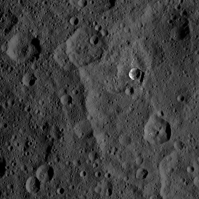
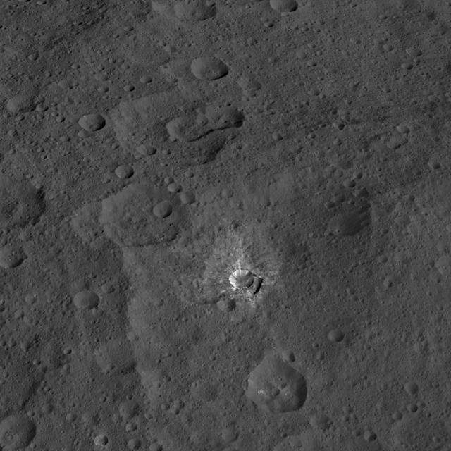
Oxo Crater and its surroundings are featured in this image of Ceres' surface from NASA's Dawn spacecraft. Dawn took this image on Oct. 18, 2016, from its second extended-mission science orbit (XMO2), at a distance of about 920 miles (1,480 kilometers) above the surface. The image resolution is about 460 feet (140 meters) per pixel. http://photojournal.jpl.nasa.gov/catalog/PIA21225
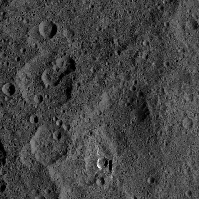
NASA's Dawn spacecraft views Oxo Crater (6 miles, 10 kilometers wide) in this view from Ceres. Dawn took this image on June 4, 2016, from its low-altitude mapping orbit, at a distance of about 240 miles (385 kilometers) above the surface. The image resolution is 120 feet (35 meters) per pixel. http://photojournal.jpl.nasa.gov/catalog/PIA20950
This view from NASA Dawn spacecraft features a crater named Oxo, which is about 6 miles 9 kilometers in diameter. A short, linear slump, where a mass of material has dropped below the surface, is seen to the left of Oxo crater rim. Dawn took this image on Oct. 17, 2015, from an altitude of 915 miles (1,470 kilometers). It has a resolution of 450 feet (140 meters) per pixel. http://photojournal.jpl.nasa.gov/catalog/PIA20136

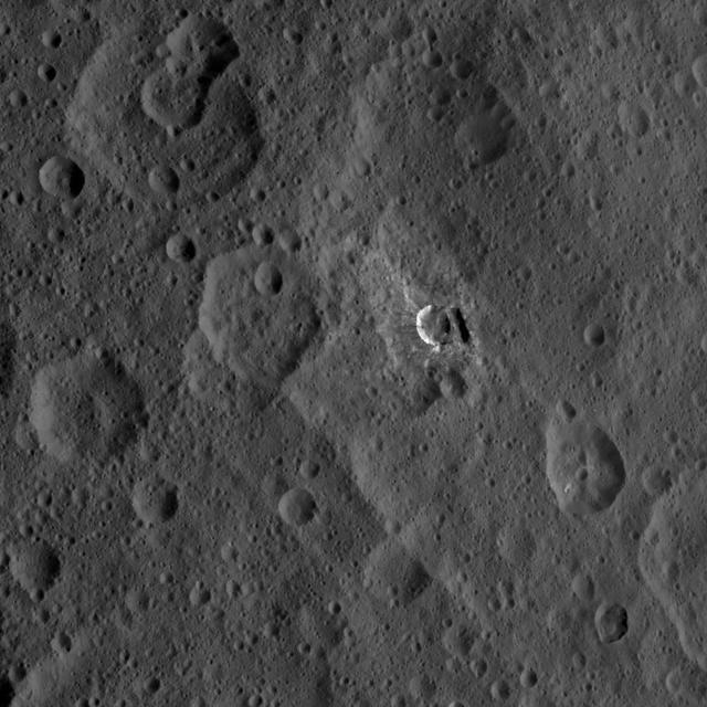
This image taken by NASA's Dawn spacecraft shows Duginavi Crater, a large (96 miles, 155 kilometers in diameter) crater on Ceres. Duginavi's degraded rim barely stands out in this picture, which indicates this feature is very old. There are several factors that alter and eventually erase the shapes of geological features on bodies that do not have an atmosphere. These include gravity, which is responsible for landslides and scarps. The formation of newer craters, and the material that gets ejected in the process, has smoothed over craters such as Duginavi. Duginavi hosts the small Oxo Crater, recognizable by its bright rim and ejecta. Oxo is the first site at which ice was discovered on Ceres. Duginavi is named for an agriculture god of the Kogi people of northern Colombia. Oxo bears the name of the god of agriculture in Afro-Brazilian beliefs of Yoruba derivation. These features can be found on the global map of Ceres. Dawn took this image on October 8, 2015, from its high-altitude mapping orbit, at a distance of about 915 miles (1,470 kilometers) above the surface. It has a resolution of 450 feet (140 meters) per pixel. The center coordinates of this image are 39 degrees north latitude, 8 degrees east longitude. https://photojournal.jpl.nasa.gov/catalog/PIA21912
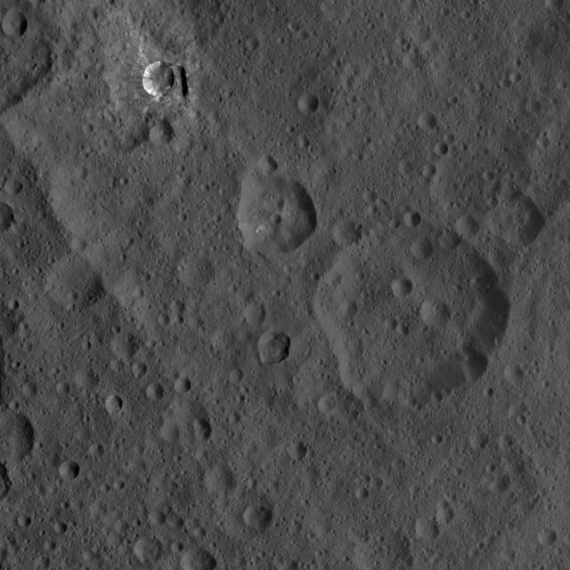
This image of Ceres, taken by NASA's Dawn spacecraft, shows three prominent craters located to the northeast of a terrace (the terrace feature being located at left in this image). The lower two craters, which are larger, have polygonal rims. The steep crater walls, distinct rim and visible ejecta of the upper smaller crater, called Oxo, hint at a fresh impact. Oxo is about 6 miles (9 kilometers) in diameter. Another interesting feature in this view is a short, linear slump, where a mass of material has dropped below the surface, to the east (or right in this view) of Oxo. The image was taken on Oct. 8, 2015, from an altitude of 915 miles (1,470 kilometers), and has a resolution of 450 feet (140 meters) per pixel. The image is located at 42 degrees north latitude, 358 degrees east longitude. http://photojournal.jpl.nasa.gov/catalog/PIA20120
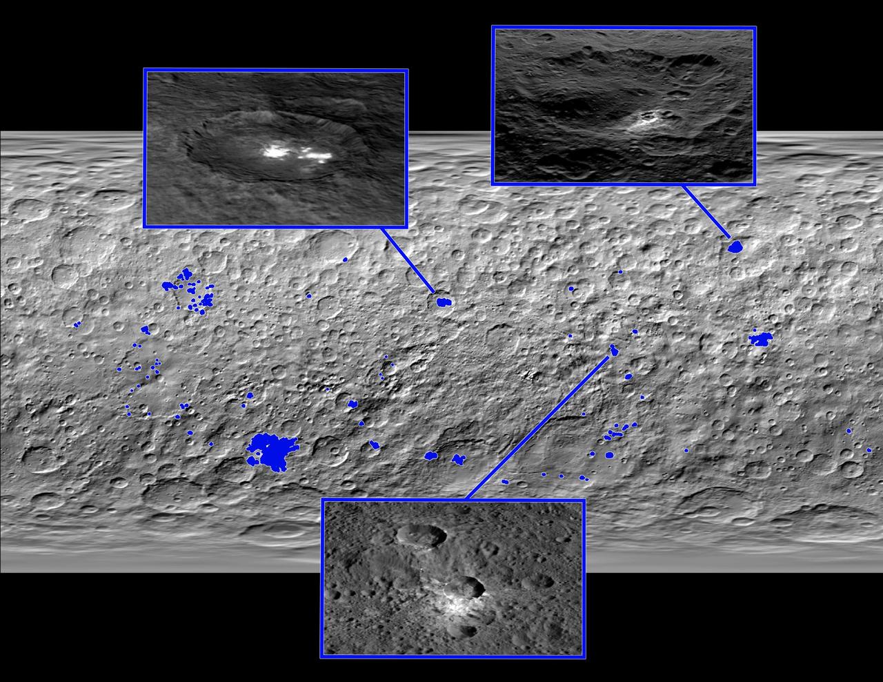
This map of Ceres, made from images taken by NASA's Dawn spacecraft, shows the locations of about 130 bright areas across the dwarf planet's surface, highlighted in blue. Most of these bright areas are associated with craters. Three insets zoom in on a few areas of interest. Occator Crater, containing the brightest area on Ceres, is shown at top left; Oxo Crater, the second-brightest feature on Ceres, is at top right. In a paper published in the Dec. 10, 2015, issue the journal Nature, Dawn mission scientists identify what they believe to be diffuse hazes at both Occator and Oxo. They believe the hazes appear when the sun shines on these craters, possibly from the sublimation of ice. A typical Ceres crater with bright material that does not appear to have remaining ice is shown at bottom. The bright material in this crater and others appears to originate from mineral salts that may have once been mixed with water ice, but dried up over time, scientists wrote in the same paper. http://photojournal.jpl.nasa.gov/catalog/PIA20183

This collage shows some of the most interesting geological sites that NASA's Dawn spacecraft has revealed at dwarf planet Ceres. Images were acquired with the spacecraft's framing camera during various phases of the mission: Survey orbit at a distance of about 2,700 miles (4,400 kilometers); high-altitude mapping orbit (HAMO) at a distance of 915 miles (1,470 kilometers) from Ceres; and low-altitude mapping orbit (LAMO) at an altitude of 240 miles (385 kilometers). In the first row, from left to right: Ceres in shown in false color, roughly centered on Occator Crater, home of the brightest area on Ceres. This picture combines color images obtained by Dawn in its survey orbit. Red corresponds to a wavelength range around 980 nanometers (near infrared), green to a wavelength range around 750 nanometers (red, visible light) and blue to a wavelength range of around 430 nanometers (blue, visible light). This picture illustrates the diversity of terrains on Ceres where the bluish material points to recently emplaced material and the brownish background material is associated with older terrains. Juling Crater (12 miles, 20 kilometers in diameter) as seen in LAMO. Central coordinates are 36 degrees south latitude, 168 degrees east longitude. It is named after the Sakai/Orang Asli (Malaysia) spirit of the crops. This crater displays evidence for the presence of ice -- for example, in the form of a large flow feature seen at the top of the image. Oxo Crater (6 miles, 10 kilometers in diameter) as seen in LAMO. Center coordinates are 42 degrees north latitude, 0 degrees east longitude. It is named after the god of agriculture in Afro-Brazilian beliefs of Yoruba derivation. Oxo hosts the first site at which Dawn detected ice on Ceres, exposed by a landslide. Ahuna Mons is not only a volcano, but also the tallest mountain on Ceres. It is about 2.5 miles (4 kilometers) high and 11 miles (17 kilometers) wide. Center coordinates are 10 degrees south latitude, 316 degrees east longitude. This view combines images obtained in LAMO in blue (430 nanometers), green (750 nanometers) and infrared (980 nanometers) color filters. Ahuna is named after the Sumi tribe (Nagaland, northeastern India) traditional post-harvest thanksgiving festival. Second Row Occator Crater (57 miles, 92 kilometers across) is seen in LAMO images. Center coordinates are 20 degrees north latitude, 239 degrees east longitude. Named after the Roman agricultural deity of the harrowing. This image shows a "Type I" flow feature with a thick "toe" typical of rock glaciers and icy landslides on Earth as viewed in LAMO. The flow feature, found in Ghanan Crater (77 degrees north latitude, 31 degrees east longitude), is one of the most voluminous on Ceres. Enhanced color view of Haulani Crater (21 miles, 34 kilometers in diameter) in color observed in HAMO. Central coordinates: 6 degrees north latitude, 11 degrees east longitude. Named after the Hawaiian plant goddess. Kokopelli Crater (21 miles, 34 kilometers in diameter) seen in LAMO. Central coordinates: 18 degrees north latitude, 125 degrees east longitude. Named after the Pueblo (SW USA) fertility deity, who presides over agriculture. This crater displays a nice arrangement of scarps that likely formed when the crater partly collapsed during its formation. Third Row Central region of Occator Crater, called Cerealia Facula, seen in color. The facula -- or "bright spot" -- is about 9 miles (14 kilometers) in diameter. Center coordinates: 20 N, 240 E. Cerealia refers to the major festival in Ancient Rome that celebrates the grain goddess Ceres (8 days in mid- to late April). The view was produced by combining the highest resolution images of Occator obtained in LAMO (at image scales of 35 meters, or 115 feet, per pixel) with color images obtained in HAMO (at image scales of 135 meters, or about 440 feet, per pixel). The three images used to produce the color were taken using filters centered at 430, 750 and 980 nanometers (the last being slightly beyond the range of human vision, in the near-infrared). North part of Nar Sulcus seen in LAMO. The full feature is about 39 miles (63 km) in length and is located around 42 degrees south latitude, 280 degrees east longitude. Nar is a Azerbaijani festival of pomegranate harvest held in October-November in Goychay city, center of pomegranate cultivation in Azerbaijan. A sulcus is a set of parallel furrows or ridges. Ikapati Crater (31 miles, 50 kilometers in diameter) seen in LAMO. Central coordinates: 34 degrees north latitude, 46 degrees east longitude. Ikapati is named after the Philippine goddess of the cultivated lands. The crater has a smooth floor, probably because heat from the impact that formed Ikapati caused ice in the ground to melt, and then refreeze. This view of Ceres, taken in LAMO, shows an area located at approximately 86 degrees south longitude, 177 degrees east longitude. This part of Ceres, near the south pole, has such long shadows because, from the perspective of this location, the sun is near the horizon. At the time this image was taken, the sun was 4 degrees north of the equator. If you were standing this close to Ceres' south pole, the sun would never get high in the sky during the course of a nine-hour Cerean day. https://photojournal.jpl.nasa.gov/catalog/PIA22090