
BO THAO-URABE, A MEMBER OF PRESIDENT BARACK OBAMA’S COMMISSION ON ASIAN AMERICANS AND PACIFIC ISLANDERS, SPOKE TO TEAM MEMBERS OF NASA’S MARSHALL SPACE FLIGHT CENTER DURING AN ASIAN AMERICANS AND PACIFIC ISLANDERS MONTH CELEBRATION EVENT MAY 31.

BRIAN BAE, EV41, AND JOHN EARL BROWN, U.S. ARMY, CONDUCT KENDO DEMONSTRATION AT ASIAN AMERICANS AND PACIFIC ISLANDERS MONTH CELEBRATION EVENT MAY 31.
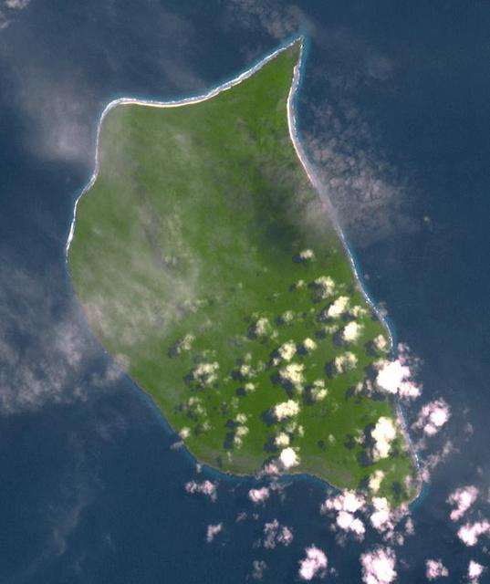
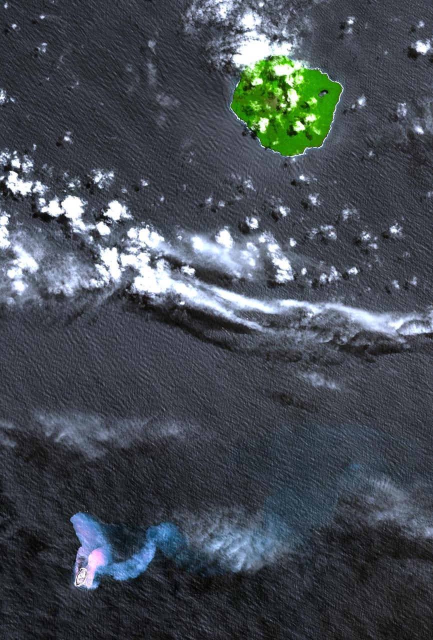
Uninhabited Henderson Island is part of the United Kingdom's Pitcairn Islands group in the South Pacific. According to a study by the University of Tasmania published in the Proceedings of the National Academy of Science, the island has the highest density of plastic waste anywhere in the world, an estimated 38 million pieces of rubbish. The island is near the center of an ocean current, so it collects rubbish from boats and South America. The image was acquired February 7, 2012, covers an area of 10.3 by 12.3 km, and is located at 24.3 degrees south, 128.3 degrees west. https://photojournal.jpl.nasa.gov/catalog/PIA21691
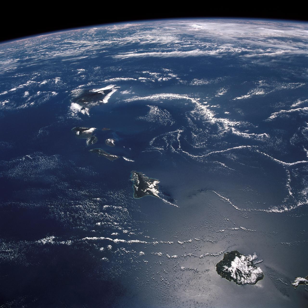
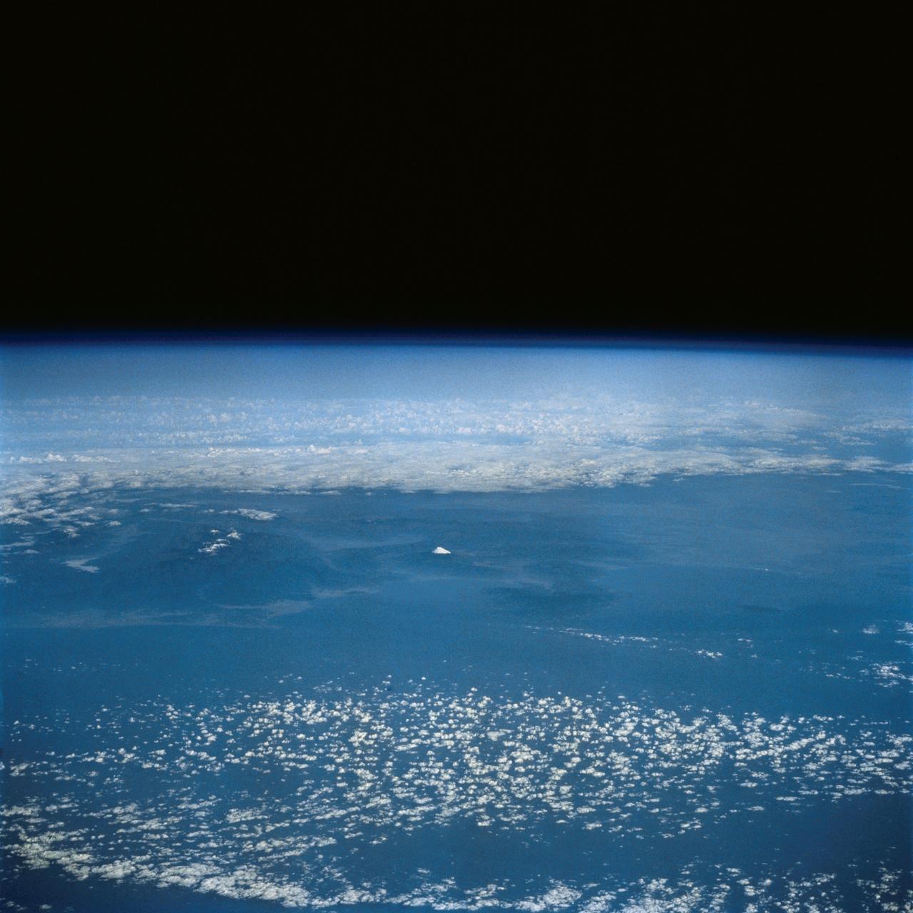
STS026-43-082 (29 Sept. - 3 Oct. 1988) --- This 70mm northerly oriented frame over the Pacific Ocean features the Hawaiian Islands chain. The islands perturb the prevailing northeasterly winds producing extensive cloud wakes in the lee of the islands. Photo experts feel that atmospheric haze in the Hawaii wake is probably a result of the continuing eruptions of Kilauea volcano on the southeast coast. From the lower right corner in a diagonal directed upward to the north are the islands of Nihau, Kauai, Oahu, Molokai, Lanai, Maui, Kahoolawe, and Hawaii. This photo was shown during the post-flight press conference on October 11, 1988 by the STS-26 astronauts, who at one time during the flight wore Hawaiian attire to pay tribute to the working staff of the Hawaii tracking station.
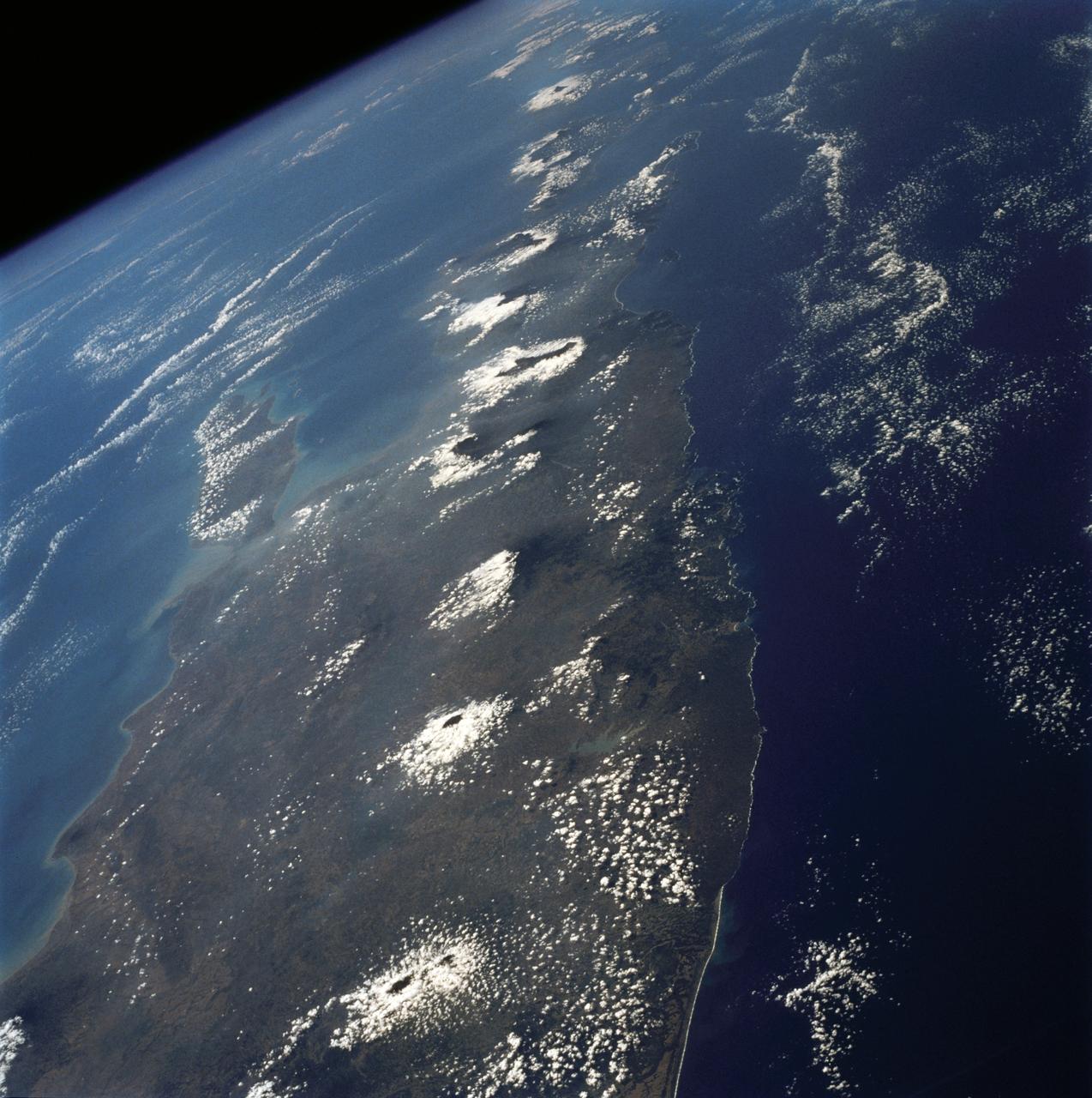
The island of Java (8.0S, 112.0E), perhaps better than any other, illustrates the volcanic origin of Pacific Island groups. Seen in this single view are at least a dozen once active volcano craters. Alignment of the craters even defines the linear fault line of Java as well as the other some 1500 islands of the Indonesian Archipelago. Deep blue water of the Indian Ocean to the south contrasts to the sediment laden waters of the Java Sea to the north.
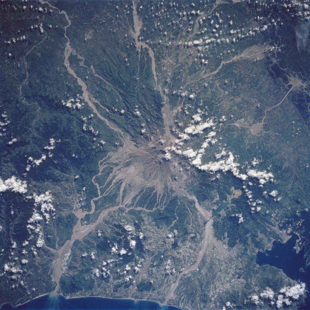
Mt. Pinatubo on the island of Luzon (15.0N, 120.0E) erupted catastrophically in June 1991 after over 600 years of inactivity. In this vertical view, the full extent of the eruption is obvious. Thick layers of ash completely surrounds the crater and the effect of mudflows in this previously heavily forested and agricultural region can be traced as ribbons flowing downhill. Clark AFB, once the crossroads of the SW Pacific can only partially be seen.
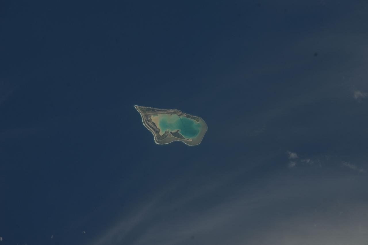
The Sovereign Democratic Republic of the Fiji Islands, commonly known as Fiji, is an independent nation consisting of some 332 islands surrounding the Koro Sea in the South Pacific Ocean. This image shows Viti Levu, the largest island in the group.
AST-19-1555 (24 July 1975) --- A sunglint in the South Western Pacific Ocean, as photographed from the Apollo spacecraft in Earth orbit during the joint U.S.-USSR Apollo-Soyuz Test Project mission. The island is Bougainville of the Solomon Islands group. The horizon of Earth is in the background. The picture was taken at an altitude of 231 kilometers (143 statute miles), with a 70mm Hasselblad camera using medium-speed Ektachrome QX-807 type film.
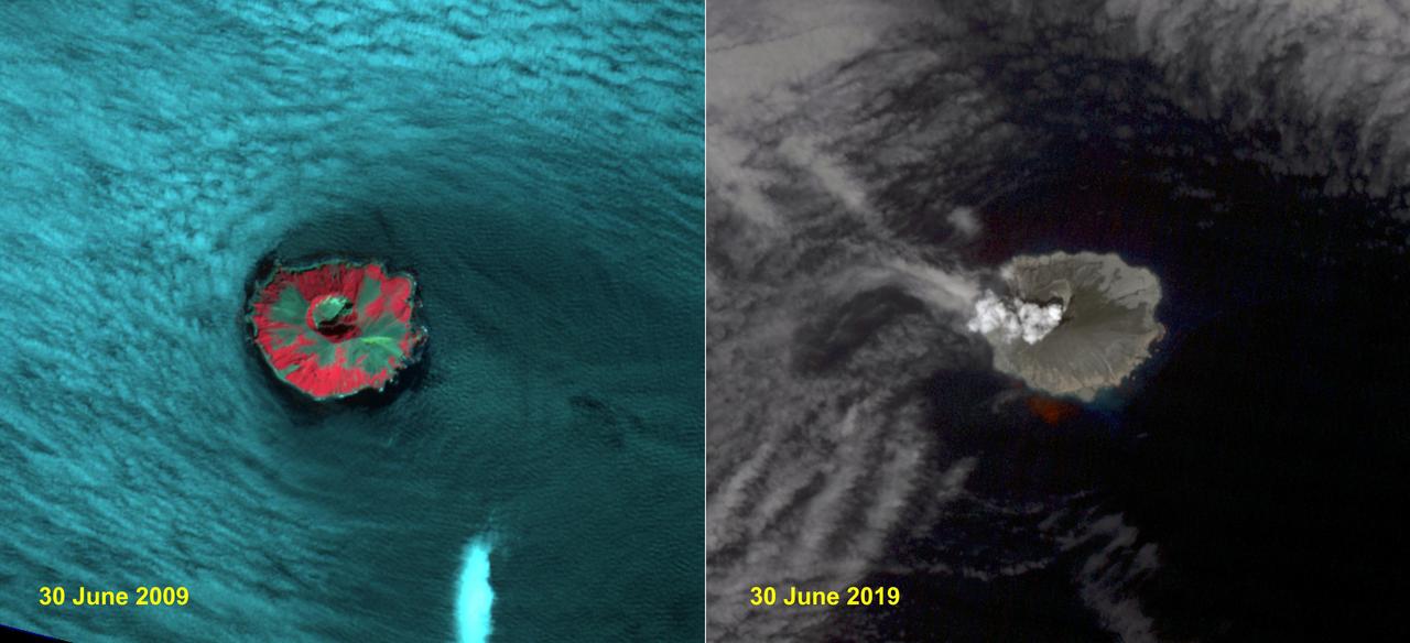
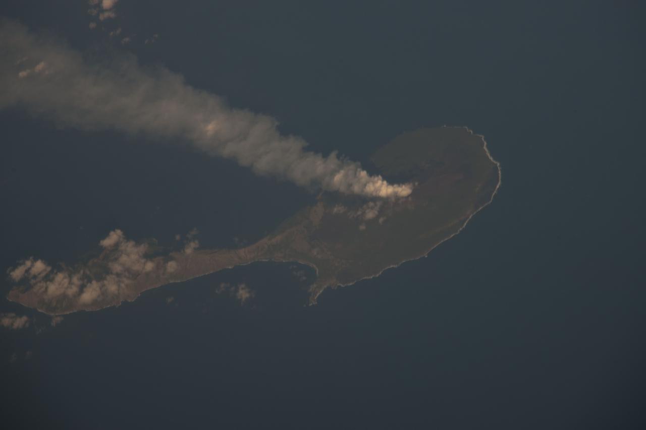
Raikoke volcanic island is near the center of the Kuril Islands in the Sea of Okhotsk in the northwest Pacific Ocean. The island is roughly circular with dimensions of 2.0 by 2.5 kilometers. On June 22, the volcano erupted with a gas and ash plume reaching 17 kilometers. The two ASTER images, acquired exactly 10 years apart on June 30, dramatically depict the changes to the island. In 2009, vegetation (red) covered most of the island. The 2019 image shows an ash and steam plume rising from the caldera. There is no trace of any vegetation, ash deposits having buried everything. The images are located at 48.3 degrees north, 153.2 degrees east. https://photojournal.jpl.nasa.gov/catalog/PIA23326
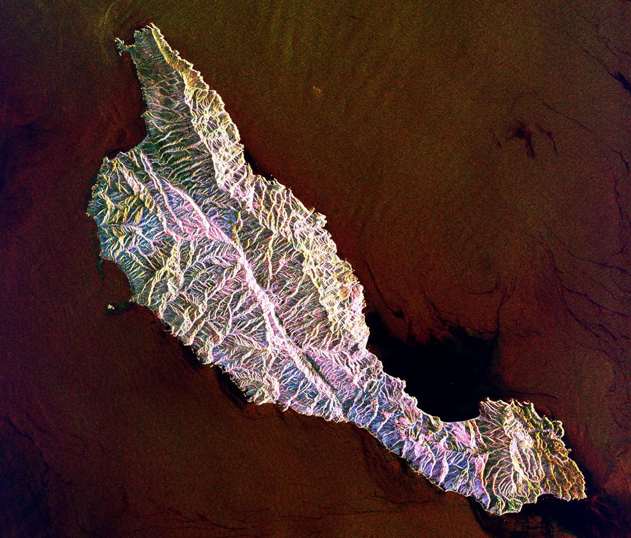
This space radar image shows the rugged topography of Santa Cruz Island, part of the Channel Islands National Park in the Pacific Ocean off the coast of Santa Barbara and Ventura, Calif.
In the South Pacific, south of Late Island along the Tofua volcanic arc in Tonga, a new volcanic island Home Reef is being re-born. This image was acquired October 10, 2006 by NASA Terra spacecraft.
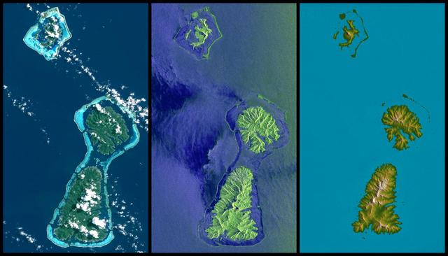
Bora Bora, Tahaa, and Raiatea top to bottom are Polynesian Islands about 220 kilometers 135 miles west-northwest of Tahiti in the South Pacific.
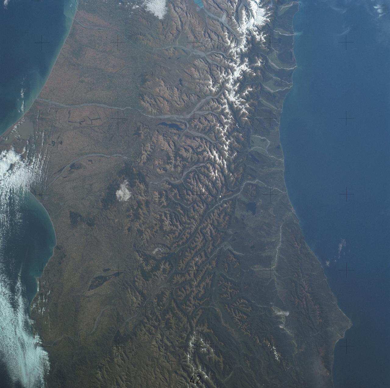
SL4-137-3700 (22 Dec. 1973) --- A near vertical view of a portion of South Island, New Zealand, as see from the Skylab space station in Earth orbit. This picture was taken by one of the Skylab 4 crew members with a handheld 70mm Hasselblad camera using a 100mm lens. The picture should be held with the largest body of water (Tasman Sea) on the left. Cape Foulwind is at the upper left. The City of Christchurch is under clouds at the center right margin. Note the movement of sediment by alongshore currents, especially on the east (right) side of the island. The Alpine Fault, which is part of the circum-Pacific volcanic-tectonic belt, is clearly visible on the left (west) side of the island. The fault line is marked by a scarp, which appears very distinct from orbital altitude. Differences in topography and vegetation on either side of the fault are also sharp. Streams change direction at the fault line, and the change in slope at the fault line is evident in the widening of stream channels. The left side of the fault has moved northeast (upward) relative to the right side; some stream offsets indicate the direction of relative movement, but others are controlled by local topography. The Alpine Fault, which also transects New Zealand's North Island, was photographed and described more than a dozen times by the Skylab 4 crewmen. The circum-Pacific volcanic-tectonic belt is a feature of the Earth's crust which is related to sea floor spreading and continental drift. Though the Alpine Fault is sharply delineated in this photograph, other major crustal features are subtle that their existence was unknown before their observation from orbit. The distance from top to bottom is about 290 kilometers (175 miles). Photo credit: NASA
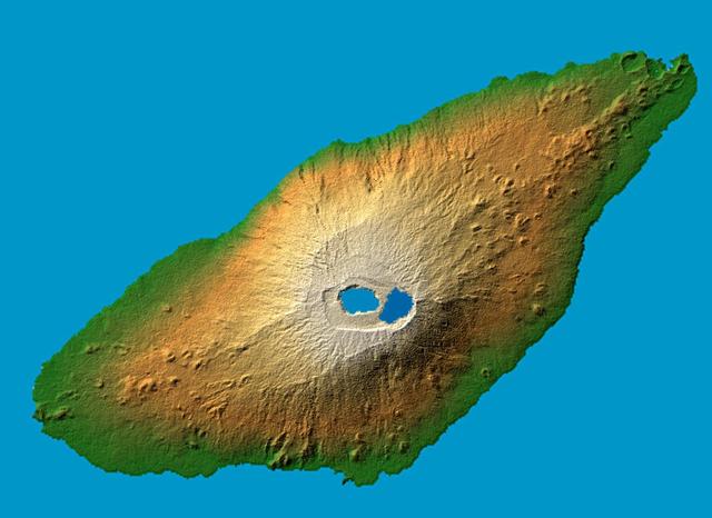
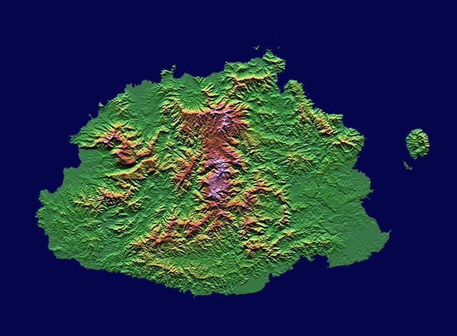
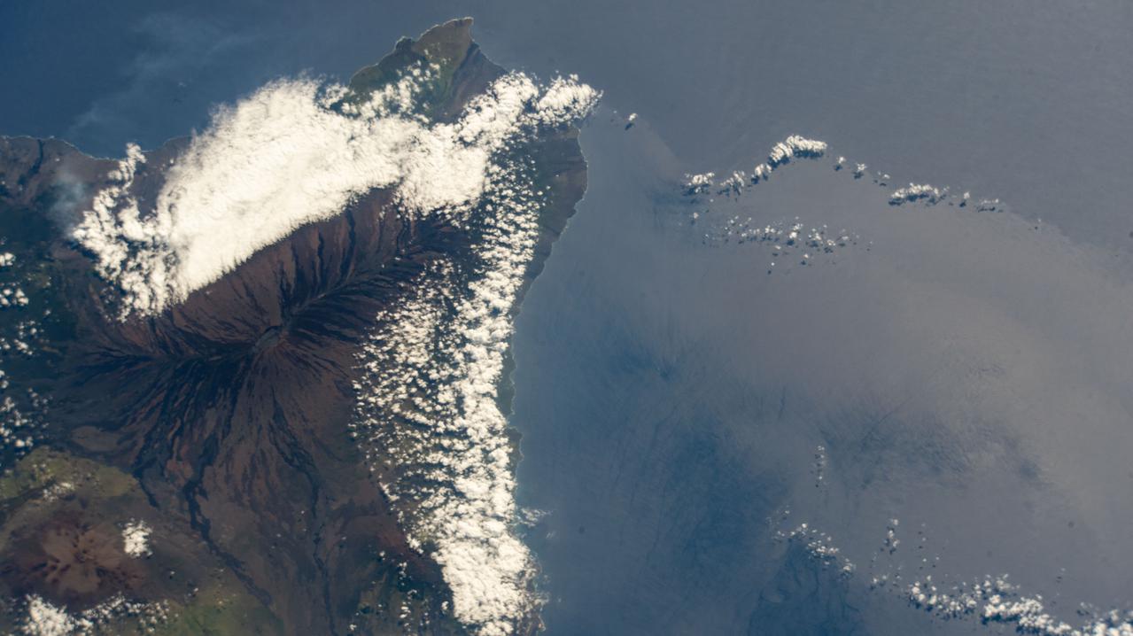
The recently active volcano Mt. Manaro is the dominant feature in this shaded relief image of Ambae Island, part of the Vanuatu archipelago located 1400 miles northeast of Sydney, Australia.
ISS033-E-007873 (27 Sept. 2012) --- Wake Island is featured in this image photographed by an Expedition 33 crew member on the International Space Station. The atoll of Wake Island is located in the central Pacific Ocean approximately 4,000 kilometers to the west-southwest of Hawaii and 2,400 kilometers to the northwest of Guam. In addition to Wake Island, the atoll includes the smaller Peale and Wilkes Island for a total land surface area of 6.5 square kilometers. Like many atolls in the Pacific, the islands and associated reefs formed around a submerged volcano. The lagoon in the center of the islands—characterized by shallow, light blue water in contrast to the surrounding darker, deeper Pacific Ocean waters—marks the approximate location of the summit crater of the volcano.
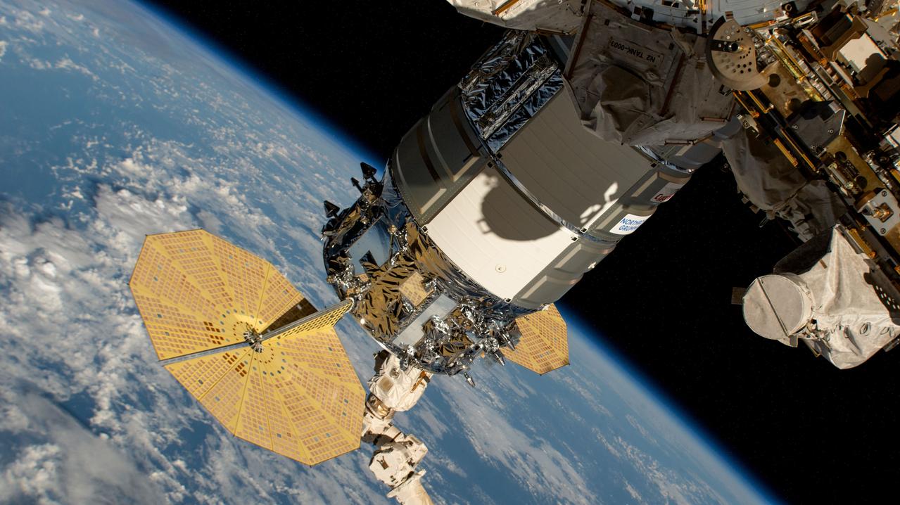
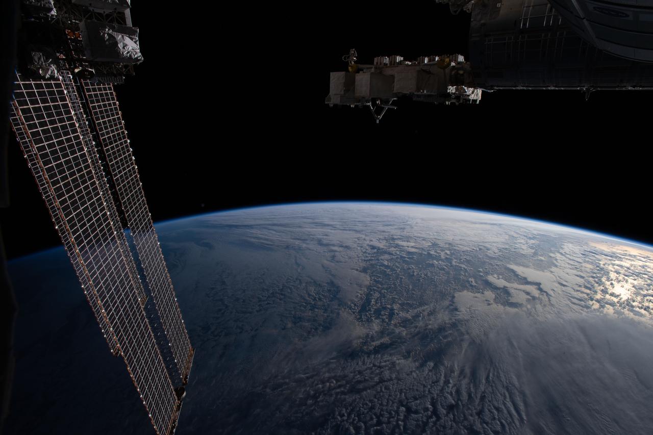
iss071e439629 (Aug. 6, 2024) --- Still in the grips of the Canadarm2 robotic arm, the Northrop Grumman Cygnus space freighter is pictured attached to the Unity module's Earth-facing port. The International Space Station was orbiting 262 miles above a cloudy Pacific Ocean halfway between the U.S. island of Hawaii and the island nation of the Republic of Kiribati at the time of this photograph.
The southern half of the island of Okinawa, Japan (26.5N, 128.0E) can be seen in this nearly cloud free view. Okinawa is part of the Ryuku Islands which extend from Taiwan northeastward to Kyushu, southernmost of the Japanese Home Islands. The large military base at Kadena, with large runways, is visible near the center of the scene. Kadena is one of several emergency landing sites around the world for the space shuttle.
This almost totally cloud free, photo of the island of Timor, Indonesia (9.0S, 125.0E) illustrates the volcanic origin of the over 1500 islands of Indonesia. Close examination of the photo reveals several eroded volcanoes on the Island of Timor and several of the adjacent islands. The linear alignment of the volcanoes, as seen from space, indicates the edges of the tectonic plates of the Earth's crust where volcanic activity is most common.
This distant view of Mt. Fuji, on the main home island of Honshu, Japan (34.0N, 139.0E) was taken from about 450 miles to the south. Evan at that great distance, the majestic and inspiring Mt. Fuji is still plainly visible and easily recognized as a world renowned symbol of Japan. The snow capped extinct volcano lies just a few miles south of Tokyo.
iss068e025397 (Nov. 28, 2022) --- The peak of La Cumbre Volcano on Ecuador's Fernandina Island, part of the Galapagos Islands, is surrounded by clouds in this photograph from the International Space Station as it orbited 261 miles above the Pacific Ocean.
iss063e040531 (July 6, 2020) --- Mauna Loa, the world's largest active volcano, was pictured on the island of Hawaii as the International Space Station orbited above the Pacific Ocean to the northeast of the island chain.
iss069e025331 (June 24, 2023) -- Clouds cover the Island of Hawaii, the youngest and largest of eight islands in the chain, as the International Space Station orbited 258 miles above the Pacific Ocean.

iss053e180184 (Nov. 12, 2017) --- The islands of (from left) Abaiang, Tarawa and Maiana are part of the Gilbert Islands and make up part of the republic of Kiribati in the Pacific Ocean. Kiribati is comprised of a total of 33 coral atolls and isles.
ISS030-E-122047 (6 March 2012) --- Pagan Island, Northern Marianas is featured in this image photographed by an Expedition 30 crew member on the International Space Station. A steam plume flows south from the peak of Pagan Island’s northernmost volcano in this photograph. Pagan is part of the Commonwealth of the Northern Marianas, an island chain of volcanoes that form the margin between the Pacific Ocean (to the east) and the Philippine Sea (to the west). Pagan is made up of two stratovolcanoes separated by an isthmus, and is one of the more volcanically active islands. The last eruption was in 2010, but the island was completely evacuated in 1981 when a large eruption forced the small Micronesian community to flee. According to NASA scientists, the islands themselves mark the tectonic boundary where the old, cold Pacific plate is subducted beneath the younger, less dense Philippine Sea crust at the Marianas Trench. The subduction results in substantial volcanic activity on the upper plate, forming the island arc of the Marianas. Considered to be one of the type examples for an oceanic subduction zone, the Marianas Trench includes the deepest spot in Earth’s oceans (more than 10,000 meters). The foreshortened appearance of the island is due to the viewing angle and distance from the space station, which was located over the Pacific Ocean approximately 480 kilometers to the southeast of Pagan Island when the image was taken.
iss063e105773 (Oct. 8, 2020) --- The Hawaiian island chain was pictured as the International Space Station orbited above the Pacific Ocean.
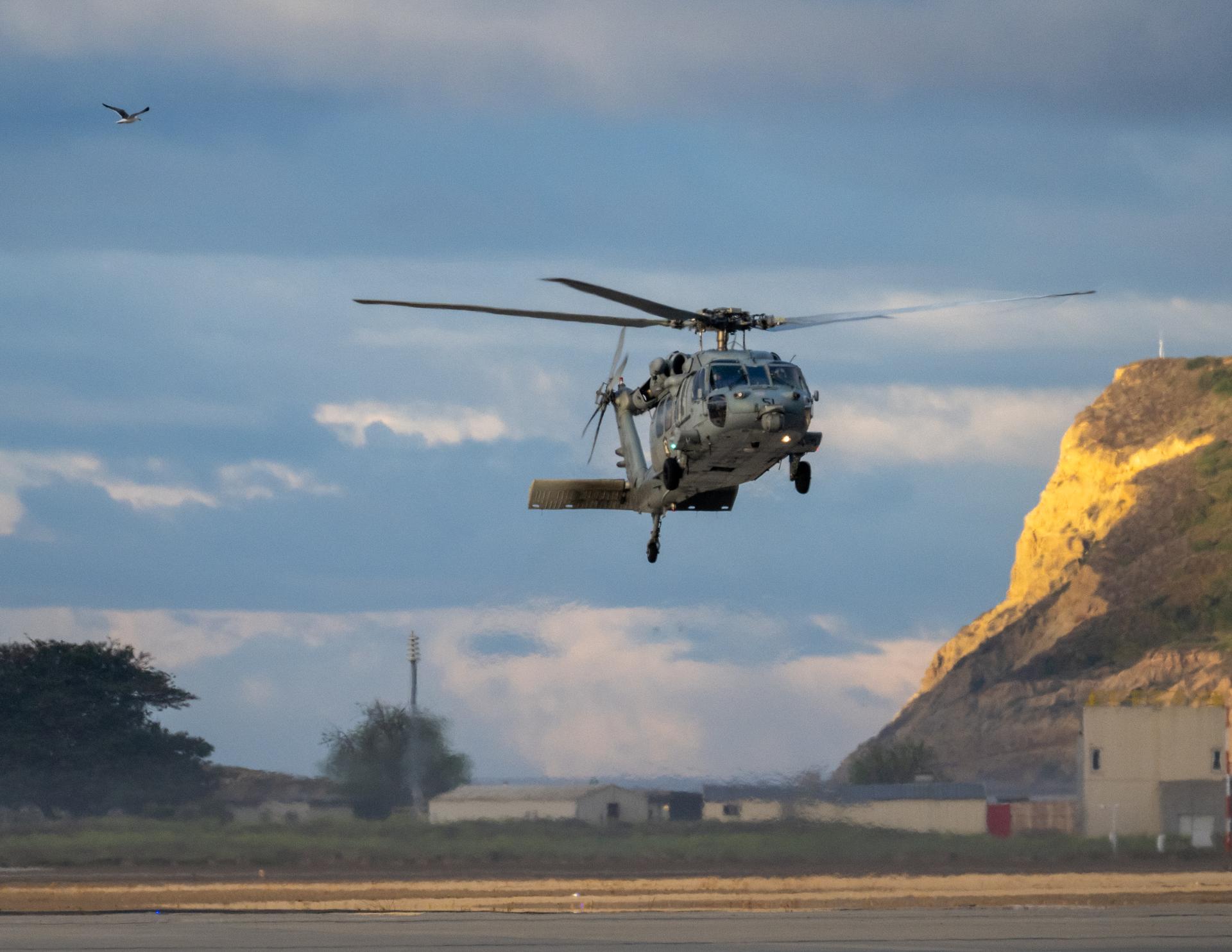
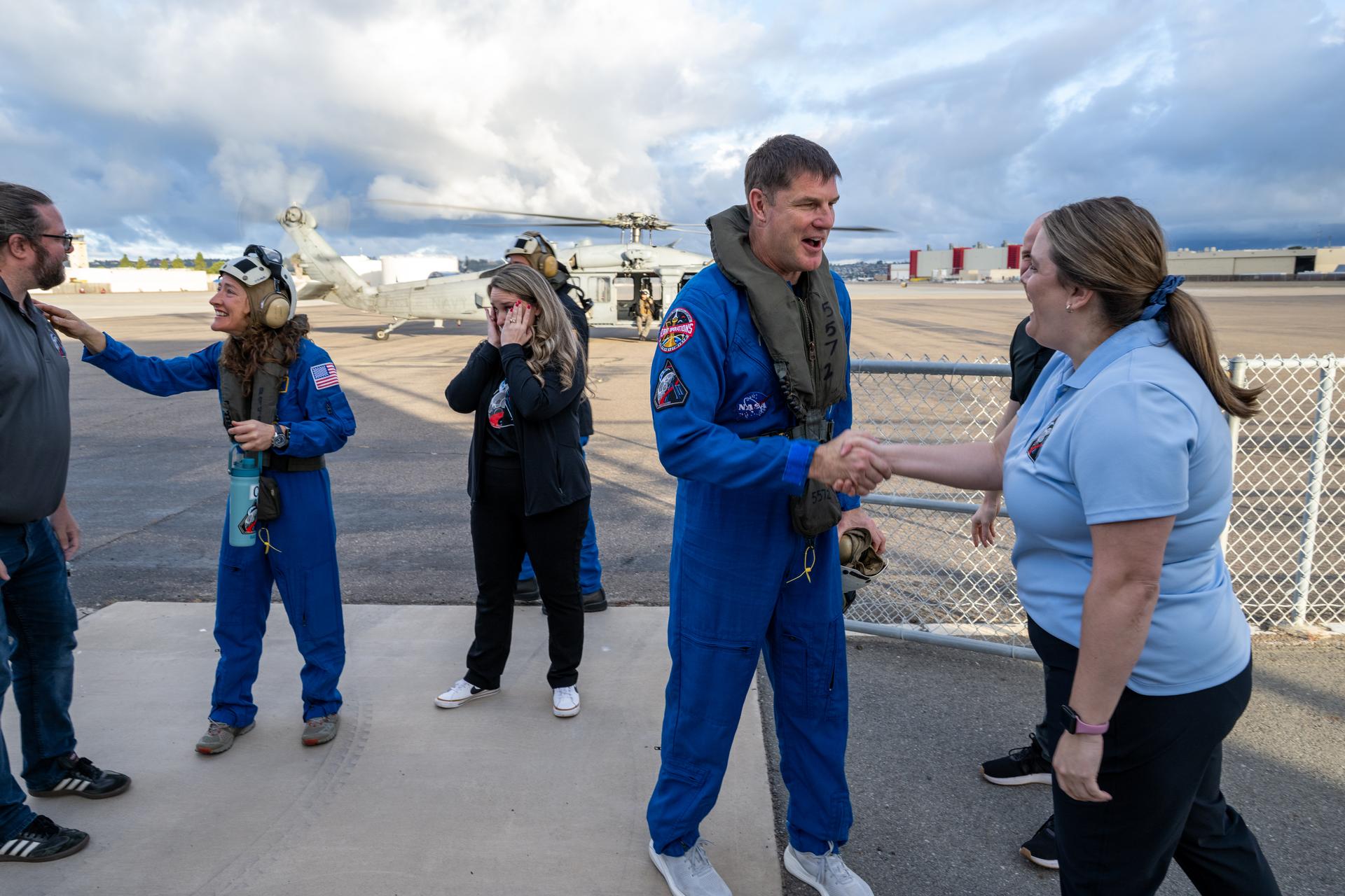
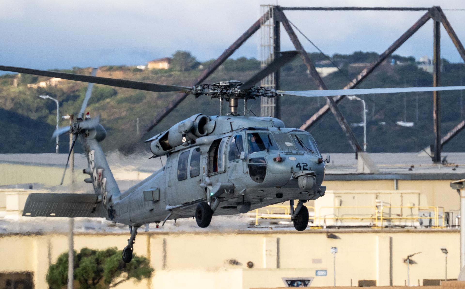
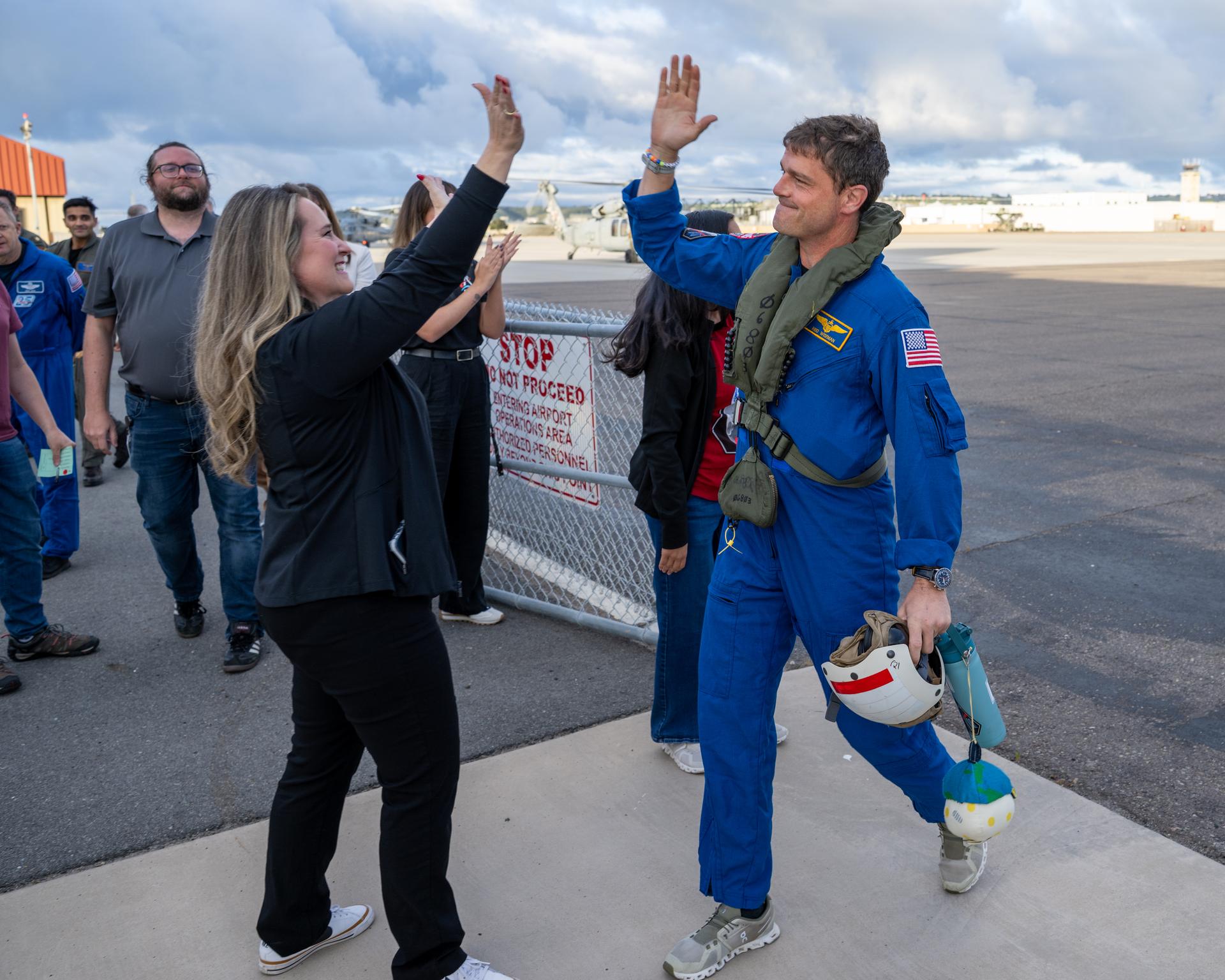
Artemis II NASA astronaut Victor Glover, pilot, is seen after being flown from USS John P. Murtha to Naval Air Station North Island on Navy MH-60 Seahawks from Helicopter Sea Combat Squadron (HSC) 23, Saturday, April 11, 2026, following a splashdown in the Pacific Ocean off the coast of California at 5:07 p.m. PDT (8:07 p.m. EDT) on April 10. NASA’s Artemis II mission took NASA astronauts Reid Wiseman, commander; Victor Glover, pilot; Christina Koch, mission specialist; and CSA (Canadian Space Agency) astronaut Jeremy Hansen, mission specialist on a nearly ten day journey around the Moon and back to Earth. Photo Credit: (NASA/Keegan Barber)
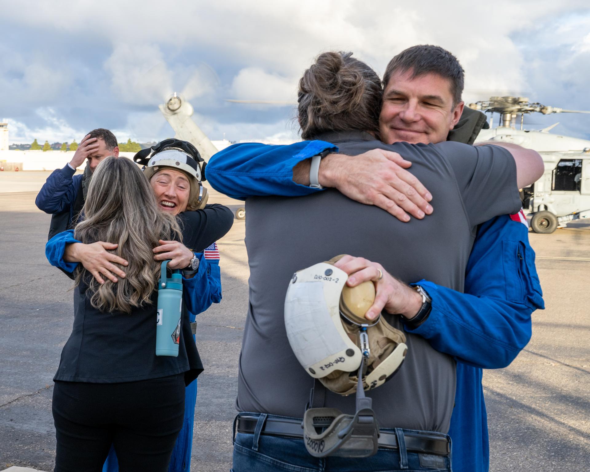
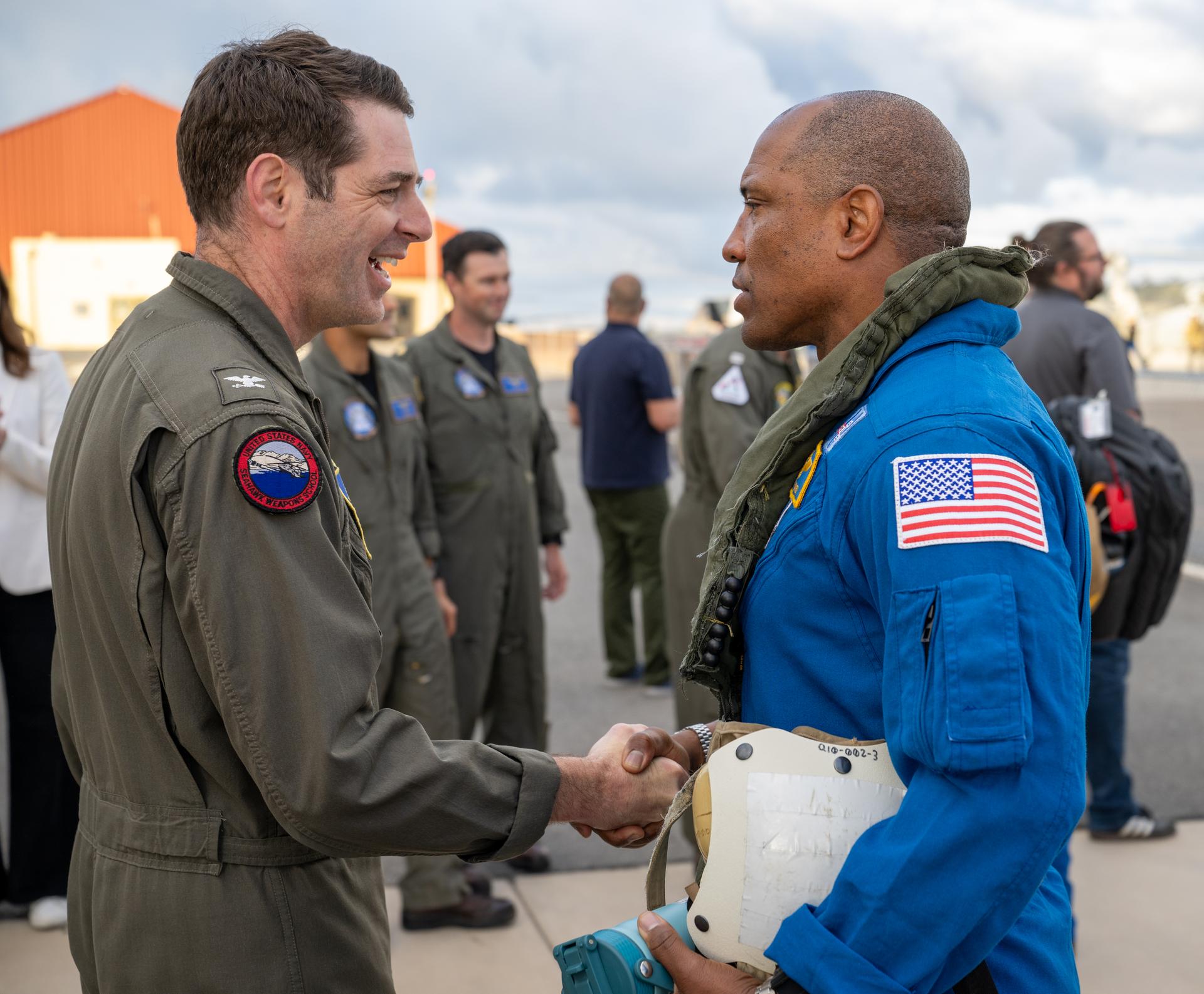
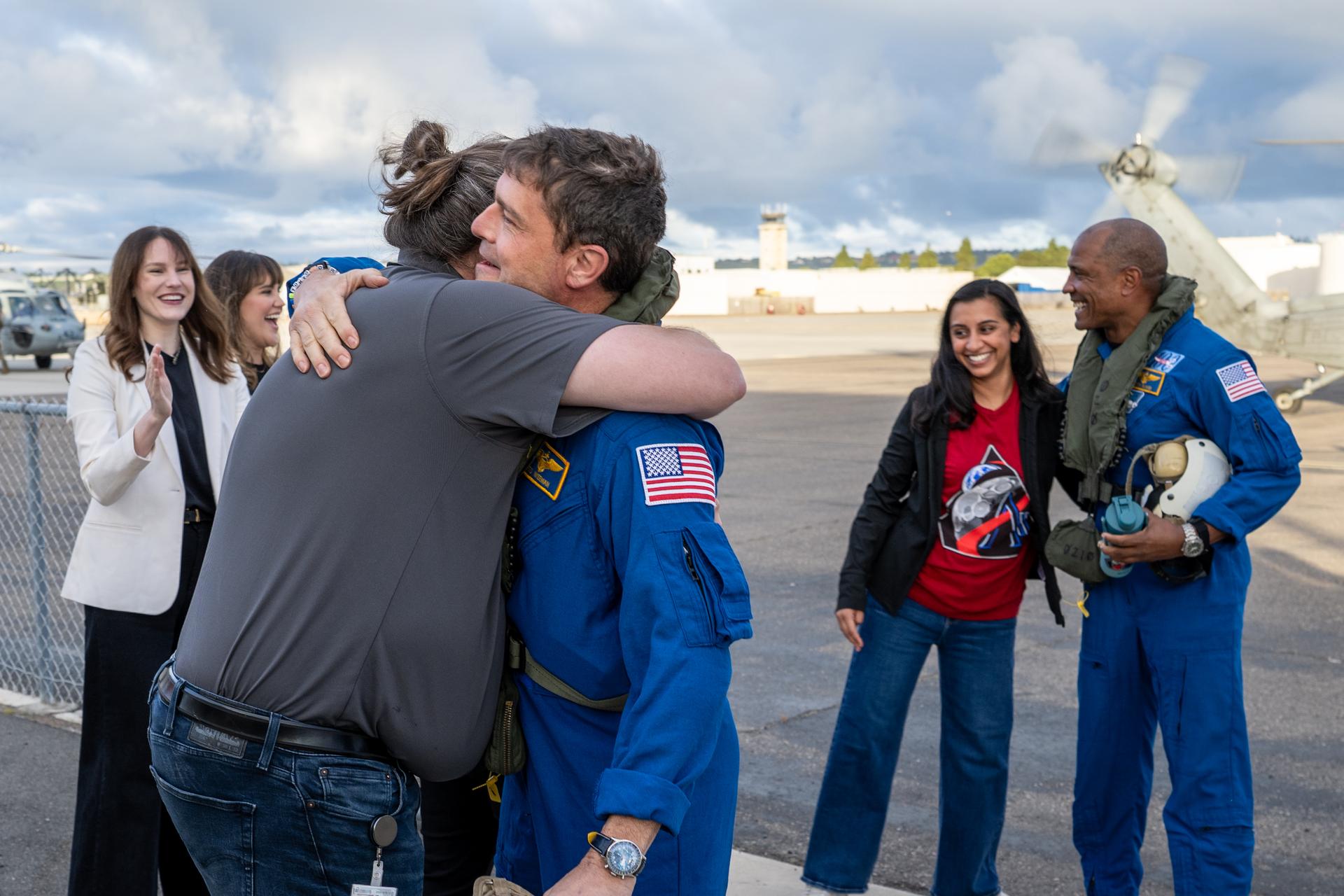
Artemis II NASA astronaut Reid Wiseman, commander, greets Capt. Loren “Wookie” Jacobi of Naval Base San Diego after being flown from USS John P. Murtha to Naval Air Station North Island on Navy MH-60 Seahawks from Helicopter Sea Combat Squadron (HSC) 23, Saturday, April 11, 2026, following a splashdown in the Pacific Ocean off the coast of California at 5:07 p.m. PDT (8:07 p.m. EDT) on April 10. NASA’s Artemis II mission took NASA astronauts Reid Wiseman, commander; Victor Glover, pilot; Christina Koch, mission specialist; and CSA (Canadian Space Agency) astronaut Jeremy Hansen, mission specialist on a nearly ten day journey around the Moon and back to Earth. Photo Credit: (NASA/Keegan Barber)
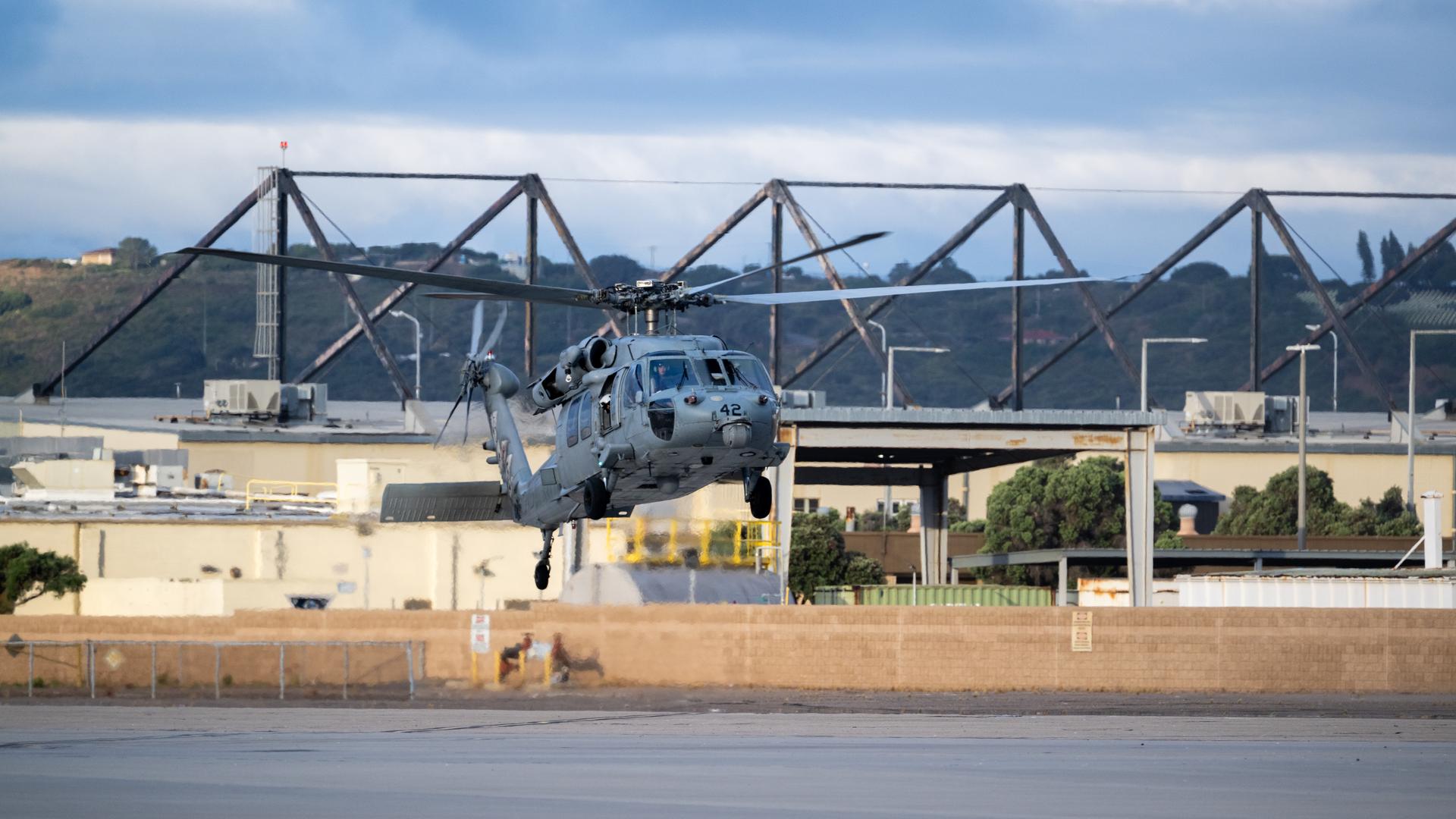
Navy MH-60 Seahawks from Helicopter Sea Combat Squadron (HSC) 23 are seen as they arrive at Naval Air Station North Island, Calif. after flying from USS John P. Murtha with Artemis II NASA astronauts Reid Wiseman, commander; Victor Glover, pilot; Christina Koch, mission specialist; and CSA (Canadian Space Agency) astronaut Jeremy Hansen, mission specialist onboard, Saturday, April 11, 2026, following a splashdown in the Pacific Ocean off the coast of California at 5:07 p.m. PDT (8:07 p.m. EDT) on April 10. NASA’s Artemis II mission took the quartet on a nearly ten day journey around the Moon and back to Earth. Photo Credit: (NASA/Keegan Barber)
Artemis II NASA astronaut Christina Koch, mission specialist, right, joined by Tarah Castleberry, flight surgeon, left, is seen after being flown from USS John P. Murtha to Naval Air Station North Island on Navy MH-60 Seahawks from Helicopter Sea Combat Squadron (HSC) 23, Saturday, April 11, 2026, following a splashdown in the Pacific Ocean off the coast of California at 5:07 p.m. PDT (8:07 p.m. EDT) on April 10. NASA’s Artemis II mission took NASA astronauts Reid Wiseman, commander; Victor Glover, pilot; Christina Koch, mission specialist; and CSA (Canadian Space Agency) astronaut Jeremy Hansen, mission specialist on a nearly ten day journey around the Moon and back to Earth. Photo Credit: (NASA/Keegan Barber)
Navy MH-60 Seahawks from Helicopter Sea Combat Squadron (HSC) 23 are seen as they arrive at Naval Air Station North Island, Calif. after flying from USS John P. Murtha with Artemis II NASA astronauts Reid Wiseman, commander; Victor Glover, pilot; Christina Koch, mission specialist; and CSA (Canadian Space Agency) astronaut Jeremy Hansen, mission specialist onboard, Saturday, April 11, 2026, following a splashdown in the Pacific Ocean off the coast of California at 5:07 p.m. PDT (8:07 p.m. EDT) on April 10. NASA’s Artemis II mission took the quartet on a nearly ten day journey around the Moon and back to Earth. Photo Credit: (NASA/Keegan Barber)
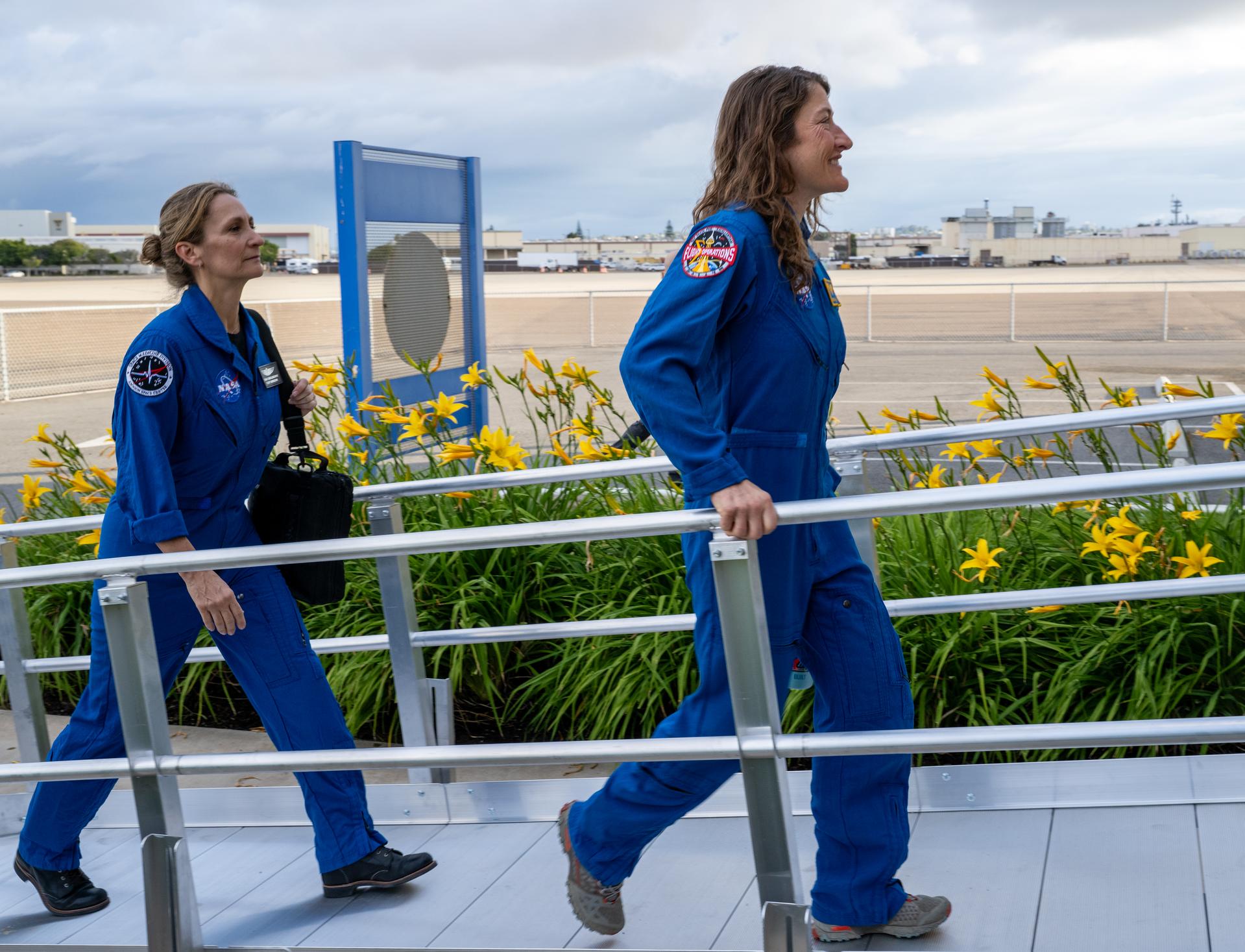
Artemis II NASA astronaut Christina Koch, mission specialist, and CSA (Canadian Space Agency) astronaut Jeremy Hansen, greet NASA team members after being flown from USS John P. Murtha to Naval Air Station North Island on Navy MH-60 Seahawks from Helicopter Sea Combat Squadron (HSC) 23, Saturday, April 11, 2026, following a splashdown in the Pacific Ocean off the coast of California at 5:07 p.m. PDT (8:07 p.m. EDT) on April 10. NASA’s Artemis II mission took NASA astronauts Reid Wiseman, commander; Victor Glover, pilot; Christina Koch, mission specialist; and CSA (Canadian Space Agency) astronaut Jeremy Hansen, mission specialist on a nearly ten day journey around the Moon and back to Earth. Photo Credit: (NASA/Keegan Barber)
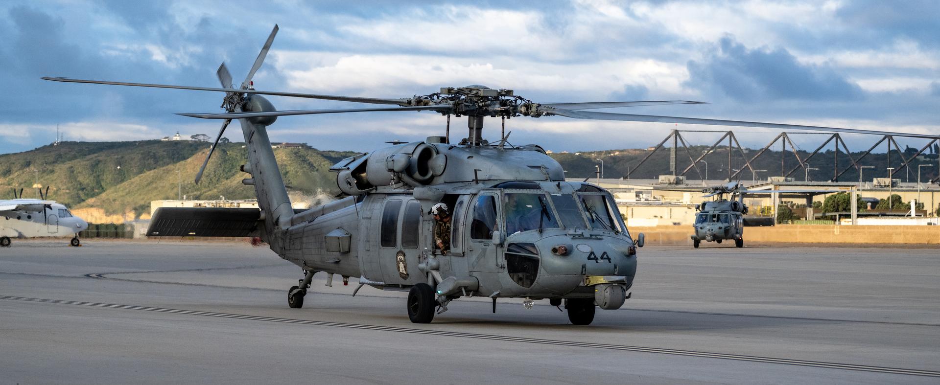
Navy MH-60 Seahawks from Helicopter Sea Combat Squadron (HSC) 23 are seen as they arrive at Naval Air Station North Island, Calif. after flying from USS John P. Murtha with Artemis II NASA astronauts Reid Wiseman, commander; Victor Glover, pilot; Christina Koch, mission specialist; and CSA (Canadian Space Agency) astronaut Jeremy Hansen, mission specialist onboard, Saturday, April 11, 2026, following a splashdown in the Pacific Ocean off the coast of California at 5:07 p.m. PDT (8:07 p.m. EDT) on April 10. NASA’s Artemis II mission took the quartet on a nearly ten day journey around the Moon and back to Earth. Photo Credit: (NASA/Keegan Barber)
Artemis II NASA astronaut Christina Koch, mission specialist, and CSA (Canadian Space Agency) astronaut Jeremy Hansen, greet NASA team members after being flown from USS John P. Murtha to Naval Air Station North Island on Navy MH-60 Seahawks from Helicopter Sea Combat Squadron (HSC) 23, Saturday, April 11, 2026, following a splashdown in the Pacific Ocean off the coast of California at 5:07 p.m. PDT (8:07 p.m. EDT) on April 10. NASA’s Artemis II mission took NASA astronauts Reid Wiseman, commander; Victor Glover, pilot; Christina Koch, mission specialist; and CSA (Canadian Space Agency) astronaut Jeremy Hansen, mission specialist on a nearly ten day journey around the Moon and back to Earth. Photo Credit: (NASA/Keegan Barber)
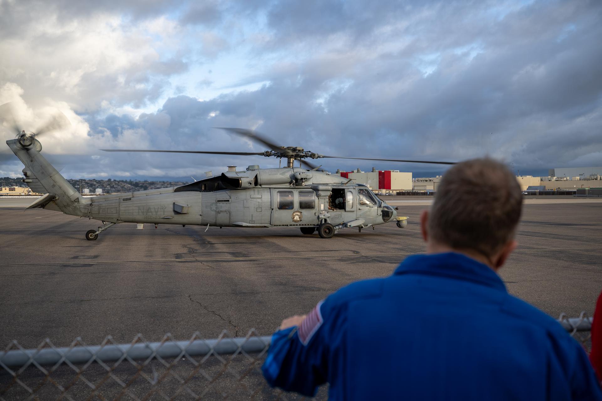
Navy MH-60 Seahawks from Helicopter Sea Combat Squadron (HSC) 23 are seen as they arrive at Naval Air Station North Island, Calif. after flying from USS John P. Murtha with Artemis II NASA astronauts Reid Wiseman, commander; Victor Glover, pilot; Christina Koch, mission specialist; and CSA (Canadian Space Agency) astronaut Jeremy Hansen, mission specialist onboard, Saturday, April 11, 2026, following a splashdown in the Pacific Ocean off the coast of California at 5:07 p.m. PDT (8:07 p.m. EDT) on April 10. NASA’s Artemis II mission took the quartet on a nearly ten day journey around the Moon and back to Earth. Photo Credit: (NASA/Keegan Barber)
Artemis II NASA astronaut Victor Glover, pilot, greets Capt. Loren “Wookie” Jacobi of Naval Base San Diego after being flown from USS John P. Murtha to Naval Air Station North Island on Navy MH-60 Seahawks from Helicopter Sea Combat Squadron (HSC) 23, Saturday, April 11, 2026, following a splashdown in the Pacific Ocean off the coast of California at 5:07 p.m. PDT (8:07 p.m. EDT) on April 10. NASA’s Artemis II mission took NASA astronauts Reid Wiseman, commander; Victor Glover, pilot; Christina Koch, mission specialist; and CSA (Canadian Space Agency) astronaut Jeremy Hansen, mission specialist on a nearly ten day journey around the Moon and back to Earth. Photo Credit: (NASA/Keegan Barber)

Artemis II NASA astronaut Victor Glover, pilot, is seen after being flown from USS John P. Murtha to Naval Air Station North Island on Navy MH-60 Seahawks from Helicopter Sea Combat Squadron (HSC) 23, Saturday, April 11, 2026, following a splashdown in the Pacific Ocean off the coast of California at 5:07 p.m. PDT (8:07 p.m. EDT) on April 10. NASA’s Artemis II mission took NASA astronauts Reid Wiseman, commander; Victor Glover, pilot; Christina Koch, mission specialist; and CSA (Canadian Space Agency) astronaut Jeremy Hansen, mission specialist on a nearly ten day journey around the Moon and back to Earth. Photo Credit: (NASA/Keegan Barber)
Artemis II NASA astronaut Reid Wiseman, commander, and Victor Glover, pilot, greet NASA team members after being flown from USS John P. Murtha to Naval Air Station North Island on Navy MH-60 Seahawks from Helicopter Sea Combat Squadron (HSC) 23, Saturday, April 11, 2026, following a splashdown in the Pacific Ocean off the coast of California at 5:07 p.m. PDT (8:07 p.m. EDT) on April 10. NASA’s Artemis II mission took NASA astronauts Reid Wiseman, commander; Victor Glover, pilot; Christina Koch, mission specialist; and CSA (Canadian Space Agency) astronaut Jeremy Hansen, mission specialist on a nearly ten day journey around the Moon and back to Earth. Photo Credit: (NASA/Keegan Barber)
Navy MH-60 Seahawks from Helicopter Sea Combat Squadron (HSC) 23 are seen as they arrive at Naval Air Station North Island, Calif. after flying from USS John P. Murtha with Artemis II NASA astronauts Reid Wiseman, commander; Victor Glover, pilot; Christina Koch, mission specialist; and CSA (Canadian Space Agency) astronaut Jeremy Hansen, mission specialist onboard, Saturday, April 11, 2026, following a splashdown in the Pacific Ocean off the coast of California at 5:07 p.m. PDT (8:07 p.m. EDT) on April 10. NASA’s Artemis II mission took the quartet on a nearly ten day journey around the Moon and back to Earth. Photo Credit: (NASA/Keegan Barber)

Artemis II NASA astronaut Reid Wiseman, commander, and Victor Glover, pilot, are seen after being flown from USS John P. Murtha to Naval Air Station North Island on Navy MH-60 Seahawks from Helicopter Sea Combat Squadron (HSC) 23, Saturday, April 11, 2026, following a splashdown in the Pacific Ocean off the coast of California at 5:07 p.m. PDT (8:07 p.m. EDT) on April 10. NASA’s Artemis II mission took NASA astronauts Reid Wiseman, commander; Victor Glover, pilot; Christina Koch, mission specialist; and CSA (Canadian Space Agency) astronaut Jeremy Hansen, mission specialist on a nearly ten day journey around the Moon and back to Earth. Photo Credit: (NASA/Keegan Barber)
Artemis II NASA astronaut Reid Wiseman, commander, greets NASA team members after being flown from USS John P. Murtha to Naval Air Station North Island on Navy MH-60 Seahawks from Helicopter Sea Combat Squadron (HSC) 23, Saturday, April 11, 2026, following a splashdown in the Pacific Ocean off the coast of California at 5:07 p.m. PDT (8:07 p.m. EDT) on April 10. NASA’s Artemis II mission took NASA astronauts Reid Wiseman, commander; Victor Glover, pilot; Christina Koch, mission specialist; and CSA (Canadian Space Agency) astronaut Jeremy Hansen, mission specialist on a nearly ten day journey around the Moon and back to Earth. Photo Credit: (NASA/Keegan Barber)

NASA Administrator Jared Isaacman disembarks a Navy MH-60 Seahawk from Helicopter Sea Combat Squadron (HSC) 23 after Artemis II NASA astronauts Reid Wiseman, commander; Victor Glover, pilot; Christina Koch, mission specialist; and CSA (Canadian Space Agency) astronaut Jeremy Hansen, mission specialist were flown from USS John P. Murtha to Naval Air Station North Island, Saturday, April 11, 2026, following a splashdown in the Pacific Ocean off the coast of California at 5:07 p.m. PDT (8:07 p.m. EDT) on April 10. NASA’s Artemis II mission took the quartet on a nearly ten day journey around the Moon and back to Earth. Photo Credit: (NASA/Keegan Barber)
iss065e001029 (April 19, 2021) --- The coast of Kitami on Japan's island of Hokkaido is pictured from the International Space Station as it orbited 265 miles above the North Pacific.
iss064e002941 (Nov. 1, 2020) --- The Earth's limb, or horizon, is pictured as the International Space Station orbited above the north Pacific near Alaska's Aleutian Islands.
iss068e006998 (Oct. 2, 2022) --- Tokyo, Japan, on the coast of the Pacific Ocean, is pictured from the International Space Station as it orbited 260 miles above the island nation.
iss055e005323 (March 25, 2018) --- The International Space Station was orbiting above the Tasman Sea when an Expedition 55 crew member took this picture of New Zealand's North Island where the city of Auckland is located. The sun's glint over the South Pacific Ocean and the Tasman Sea clearly outlines the island nation.
iss066e137869 (Feb. 8, 2022) --- Hawaii's big island and its two major volcanoes Mauna Kea and Mauna Loa are pictured from the International Space Station as it orbited 258 miles above the Pacific Ocean south of the Hawaiian island chain
S103-E-5361 (24 December 1999) --- This vertical view from the Space Shuttle Discovery shows two small islands of the Marianas Islands (Saipan and Tinian) in Micronesia in the Pacific Ocean. The STS-103 crew recorded this electronic still image at 28:05:53 GMT, December 24, 1999.
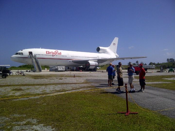
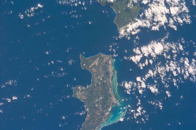
KWAJALEIN ATOLL, Marshall Islands - Orbital Science Corp.'s L-1011 aircraft "Stargazer" stands near the runway on Kwajalein Atoll with the company's Pegasus rocket slung underneath. The Pegasus was used to launch NASA's NuSTAR spacecraft mission on June 13, 2012, from the Pacific island chain. Photo credit: NASA

iss056e129864 (Aug. 7, 2018) --- Hurricane Hector was pictured by an Expedition 56 crew member as the International Space Station orbited 250 miles above the Pacific Ocean almost due south of the big island of Hawaii which anchors the Hawaiian island chain.
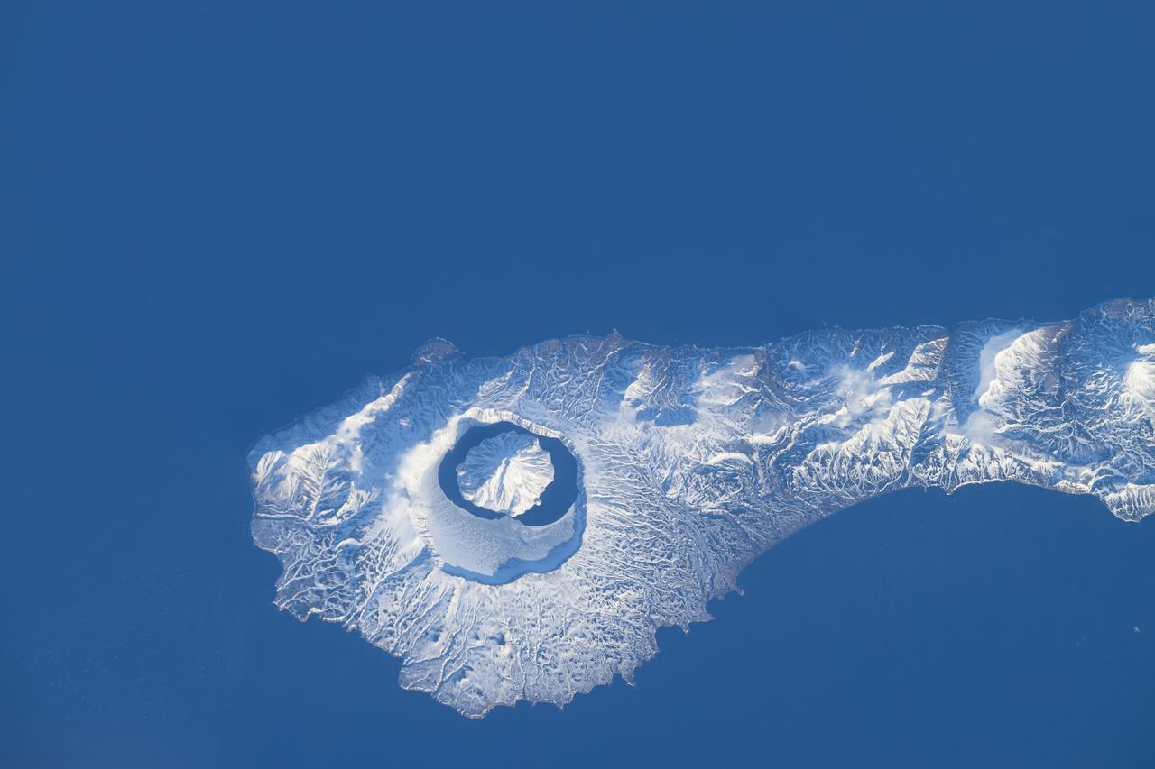
iss071e046424 (April 29, 2024) --- The snow-covered Onekotan Island, part of Russia's Kuril Islands, is home to the Tao-Rusyr Caldera stratovolcano in this photograph. Inside the caldera is the Krenitsyna Volcano peak surrounded by the partially ice-covered Kol'tsevoe Lake. The International Space Station was orbiting 259 miles above the Pacific Ocean at the time of this photograph.
iss068e025399 (Nov. 28, 2022) --- From top, the peaks of Wolf Volcano and Darwin Volcano on Ecuador's Isabel Island, part of the Galapagos Islands, are surrounded by clouds in this photograph from the International Space Station as it orbited 261 miles above the Pacific Ocean.
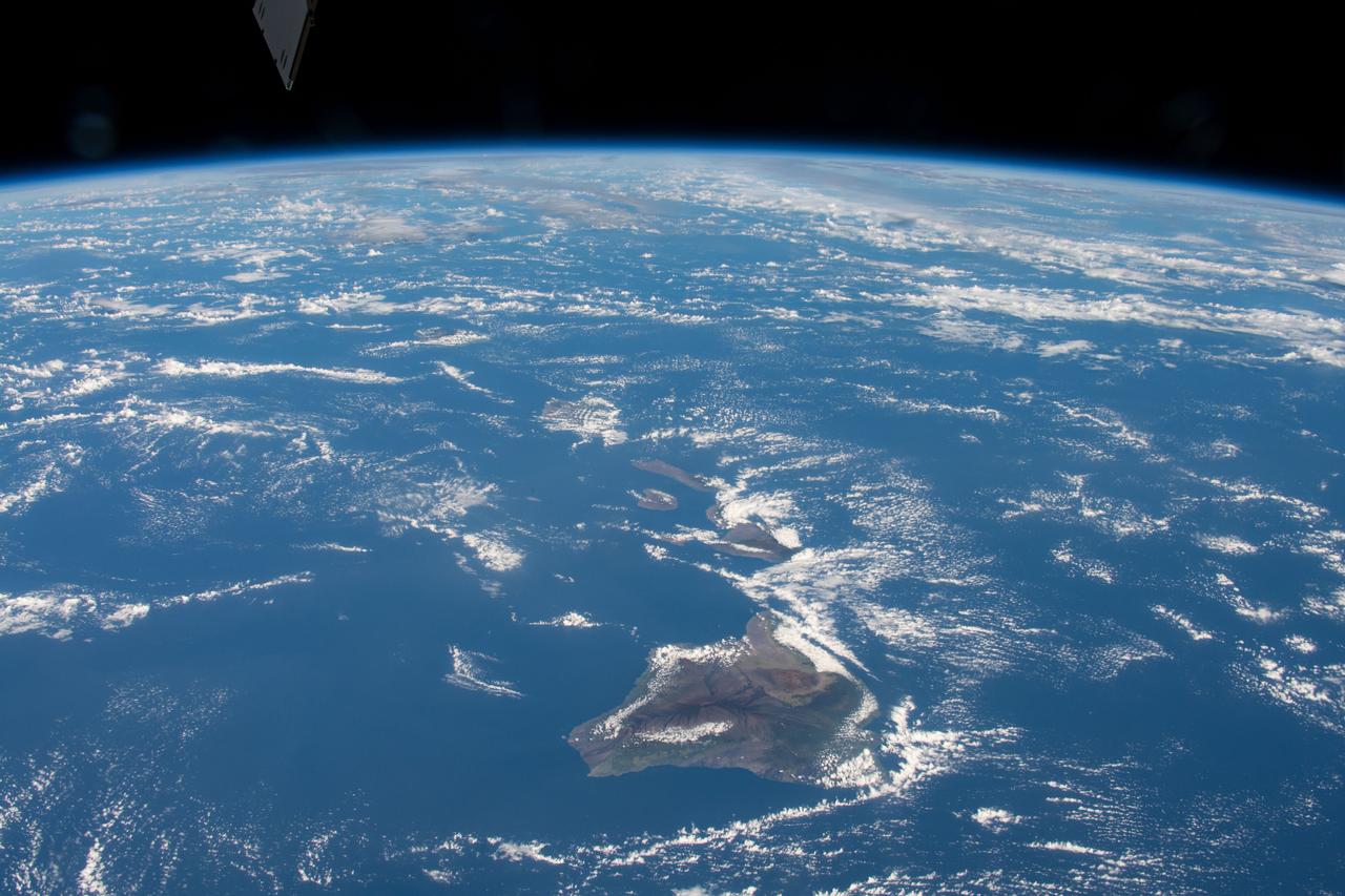
The entire Hawaiian Island Archipelago (21.5N, 158.0W) is seen in this single view. The islands are a favorite international resort and tourist attraction drawing visitors from all over the world to enjoy the tropical climate, year round beaches and lush island flora. Being volcanic in origin, the islands' offer a rugged landscape and on the big island of Hawaii, there is still an occasional volcanic eruption of lava flows and steam vents.
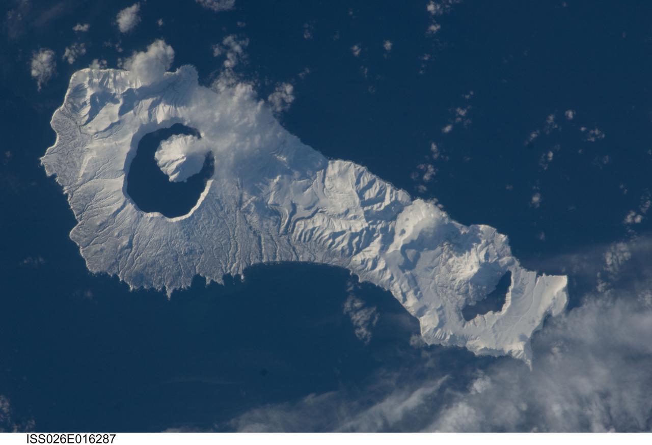
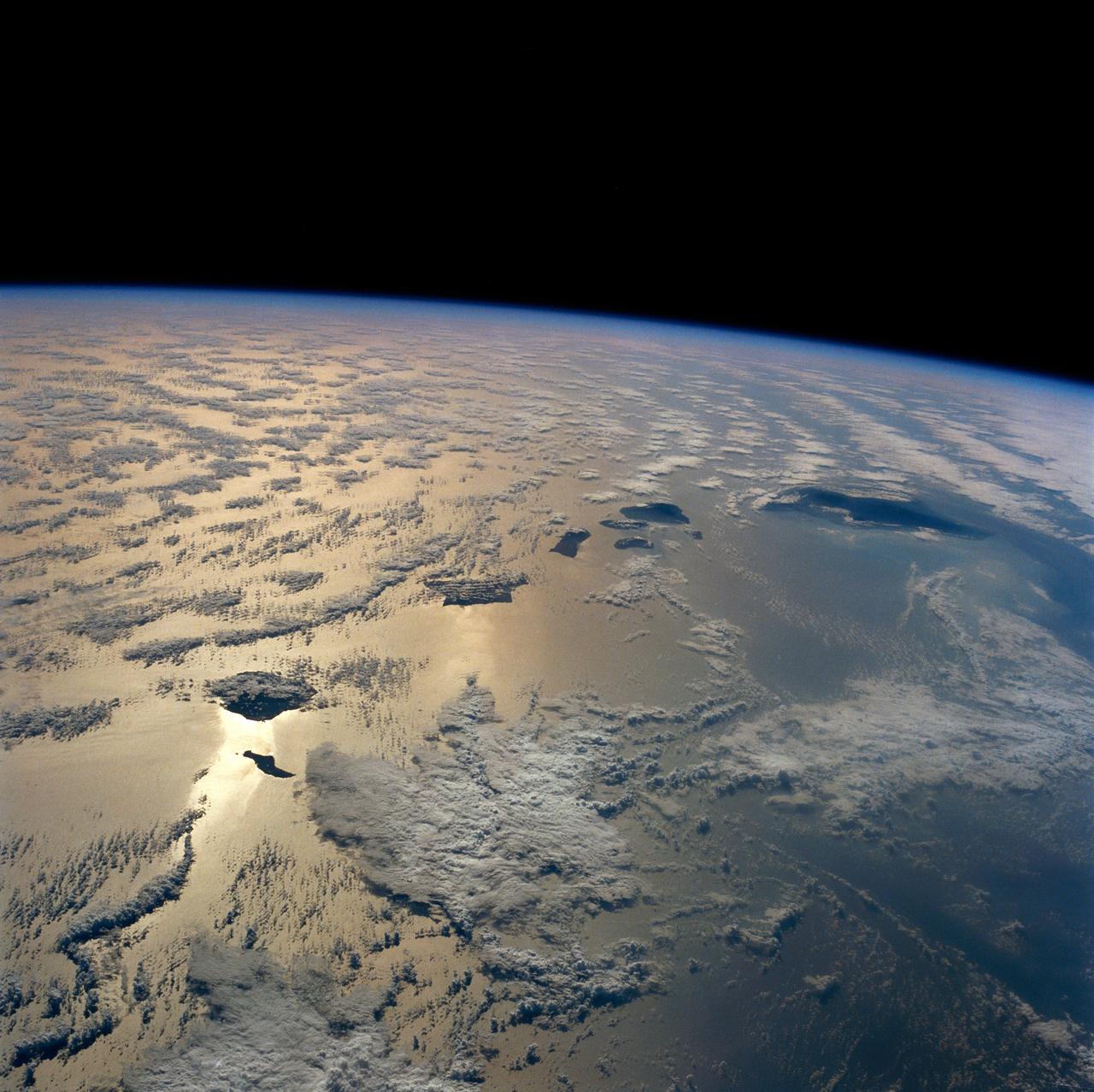
ISS026-E-016287 (9 Jan. 2011) --- Onekotan Island, part of the Russian Federation in the western Pacific Ocean, is featured in this image photographed by an Expedition 26 crew member on the International Space Station. Snow cover highlights calderas and volcanic cones that form the northern and southern ends of the island. Calderas are depressions formed when a volcano empties its magma chamber in an explosive eruption, followed by collapse of the overlaying material into the newly evacuated space. The northern end of the island is dominated by the Nemo Peak volcano that began forming within an older caldera approximately 9,500 years ago, according to scientists. The last recorded eruptive activity at Nemo Peak occurred in the early 18th century. The southern end of the island is formed by the 7.5 kilometer wide Tao-Rusyr Caldera. The caldera is filled by Kal’tsevoe Lake and Krenitzyn Peak, a volcano that has only erupted once in recorded history during 1952. Extending between northeastern Japan and the Kamchatka Peninsula of Russia, the Kuril Islands are an island arc located along the Pacific “Ring of Fire”. Island arcs form along an active boundary between two tectonic plates where one plate is being driven beneath the other (subduction). Magma generated by the subduction process feeds volcanoes—which eventually form volcanic islands—over the subduction boundary.
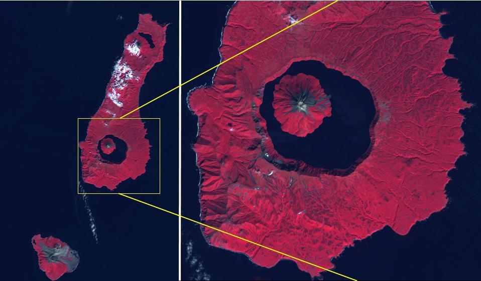
The Kuril Islands are a volcanic archipelago, stretching 1300 km from Hokkaido, Japan to Kamchatka, Russia. They are part of the Pacific Ring of Fire, the result of subduction of the Pacific Plate under the Okhotsk Plate along the Kuril Trench. At the southern end of Onekotan Island is the Tao-Rusyr Caldera stratovolcano, with its 7500 year old caldera lake. The most recent eruption was in 1952. The smaller Kharimkotan Island to the southwest last erupted in 1933. Collapse of this volcano created a horseshoe-shaped crater, and caused a tsunami that killed two people on a near-by island. The image was acquired June 4, 2012; the enlargement covers an area of 17 by 18.5 km, and is located at 49.3 degrees north, 154.7 degrees east. https://photojournal.jpl.nasa.gov/catalog/PIA24020
iss072e188141 (Nov. 15, 2024) --- A bright green aurora borealis streams above Earth's surface as the International Space Station orbited 269 miles above a cloudy North Pacific Ocean south of Alaska's Aleutian Islands.
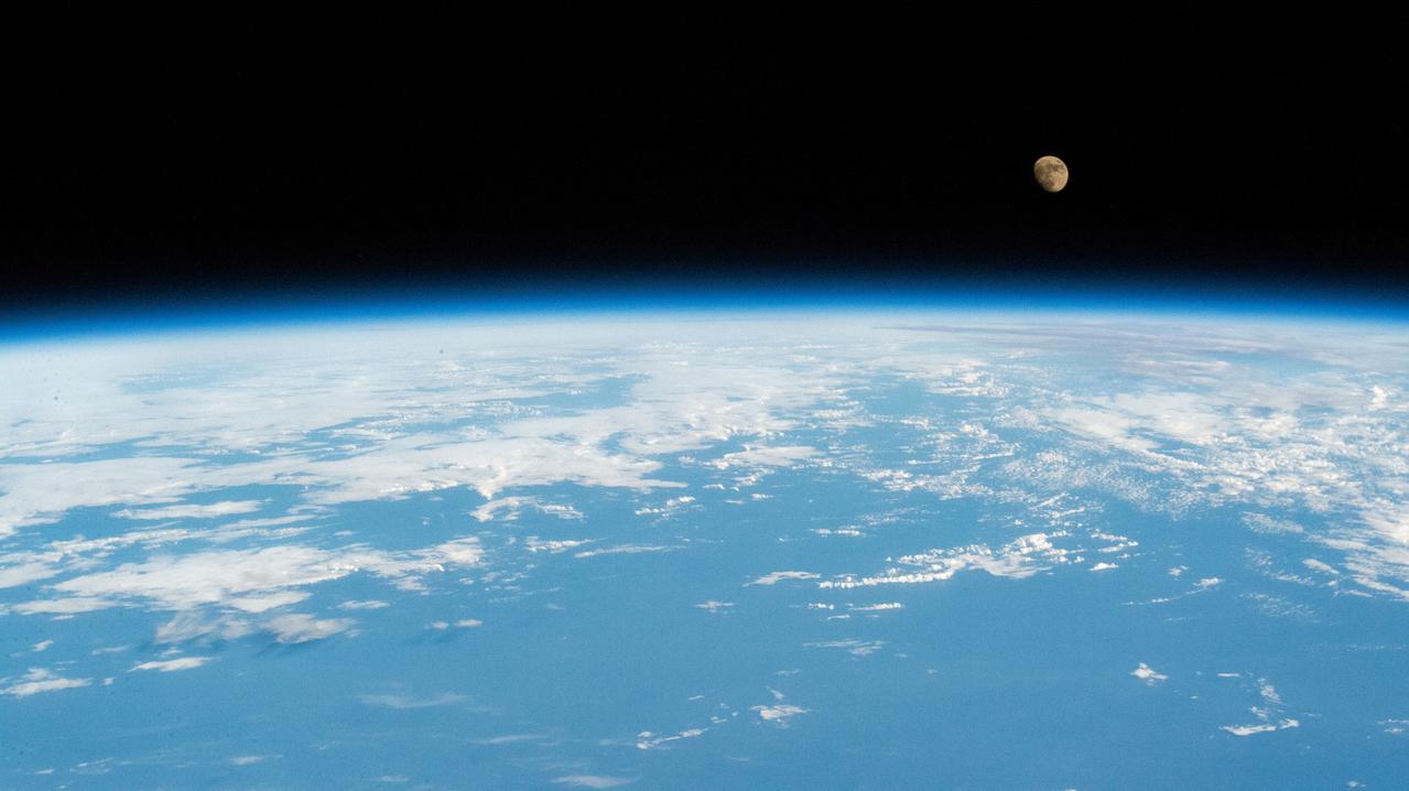
iss059e021191 (April 11, 2019) --- The moon is photographed in its waxing gibbous phase as the International Space Station orbited 256 miles above the North Pacific Ocean south of Alaska's Aleutian Islands.
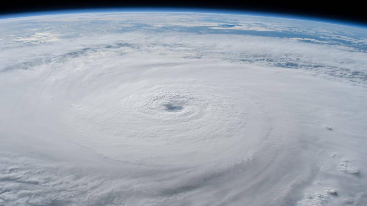
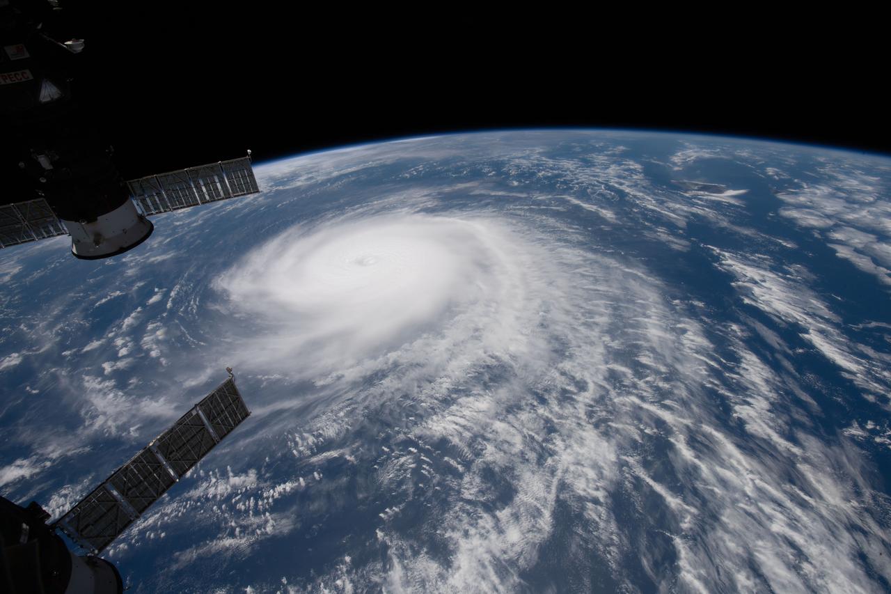
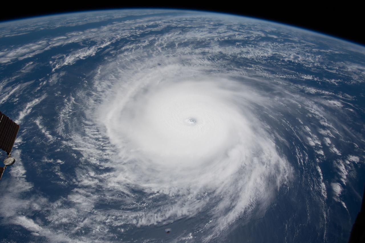
iss056e150299 (Aug. 21, 2018) --- Hurricane Lane, with its well-defined eye, was pictured as a category 4 storm southwest of the Hawaiian Islands as the International Space Station orbited almost 252 miles above the Pacific Ocean.
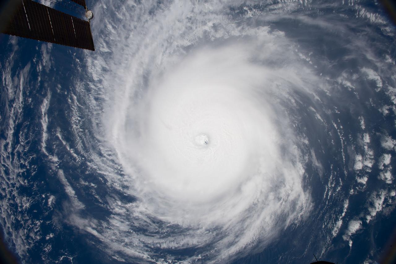
iss056e129954 (Aug. 7, 2018) --- Hurricane Hector was pictured by an Expedition 56 crew member as the International Space Station orbited nearly 250 miles directly above the storm in the Pacific Ocean just southeast of the Hawaiian island chain.
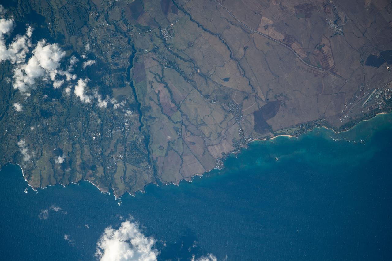
iss060e058583 (Sept. 8, 2019) --- The north coast of Maui on the Hawaiian island chain, including the city of Kahului and its airport, is pictured as the International Space Station orbited 261 miles above the Pacific Ocean.
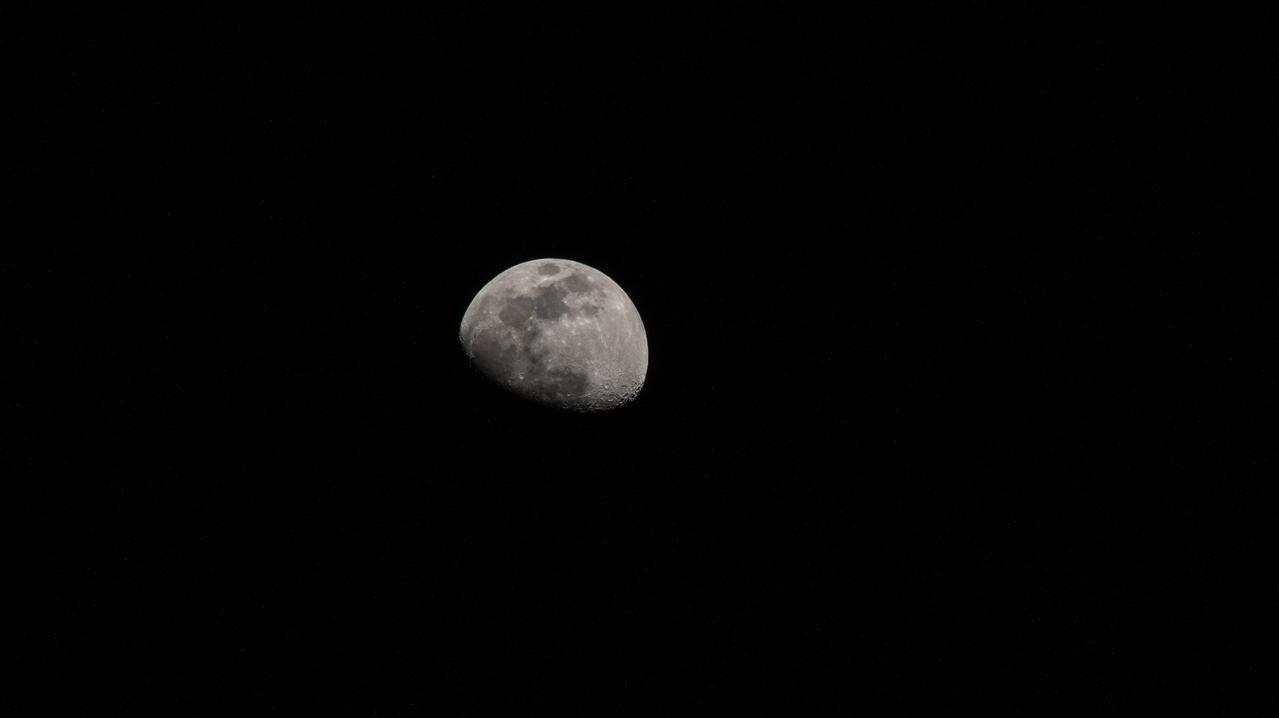
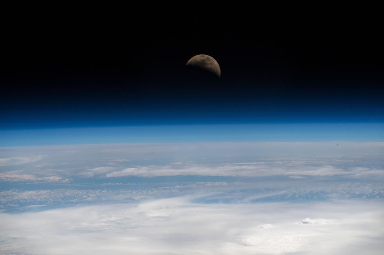
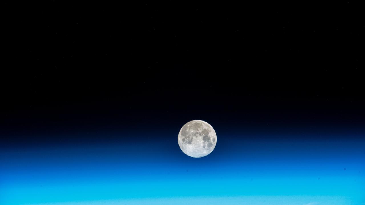
iss064e025547 (Jan. 23, 2021) --- The waxing gibbous Moon is pictured from the International Space Station as it orbited 263 miles above the Pacific Ocean near the island state of Samoa and the U.S. territory of American Samoa. Credit: Roscosmos
iss056e150306 (Aug. 21, 2018) --- Hurricane Lane, with its distinct eye, was pictured as a category 4 storm as the International Space Station orbited 251 miles above the Pacific Ocean east of the Hawaiian Islands.
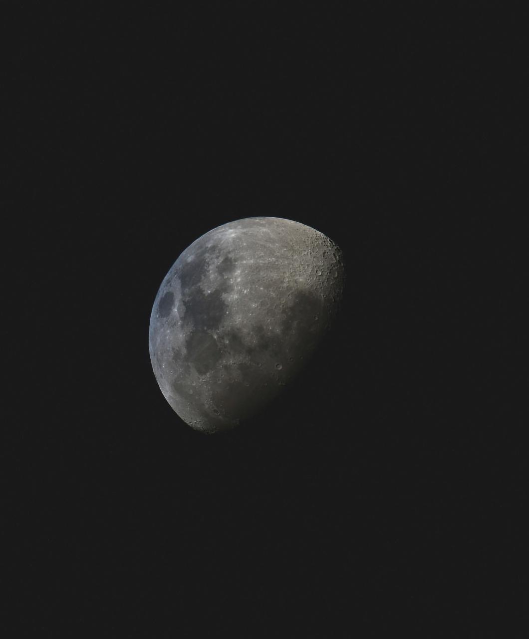
iss059e019955 (April 11, 2019) --- The moon is photographed in its first quarter phase just above the Earth's limb as the International Space Station orbited 255 miles above the Pacific Ocean south of the Hawaiian island chain.
iss056e129968 (Aug. 3, 2018) --- Hurricane Hector was pictured by an Expedition 56 crew member as the International Space Station orbited nearly 250 miles above the Pacific Ocean east of the Hawaiian island chain.
iss067e315980 (Sept. 4, 2022) --- The Niuoku Islet, part of the island nation of Tuvalu, is pictured from the International Space Station as it orbited 259 miles above the southern Pacific Ocean.
iss072e145206 (Nov. 5, 2024) --- The SpaceX Dragon cargo spacecraft is pictured approaching the International Space Station as both spacecraft were orbiting 255 miles above a cloudy Pacific Ocean southwest of Ecuador's Galápagos Islands.
iss066e152100 (Feb. 22, 2022) --- The sun rises above the horizon illuminating the Earth in this photograph from the International Space Station as it orbited 262 above the Pacific Ocean south of Alaska's Aleutian Islands.
iss067e249774 (Aug. 9, 2022) --- The waxing gibbous Moon is pictured from the International Space Station as it orbited 260 miles above the Pacific Ocean south of Alaska's Aleutian Islands.
iss056e126638 (Aug. 7, 2018) --- Hurricane Hector was pictured by an Expedition 56 crew member as the International Space Station orbited nearly 250 miles above the Pacific Ocean just south of the Hawaiian island chain.
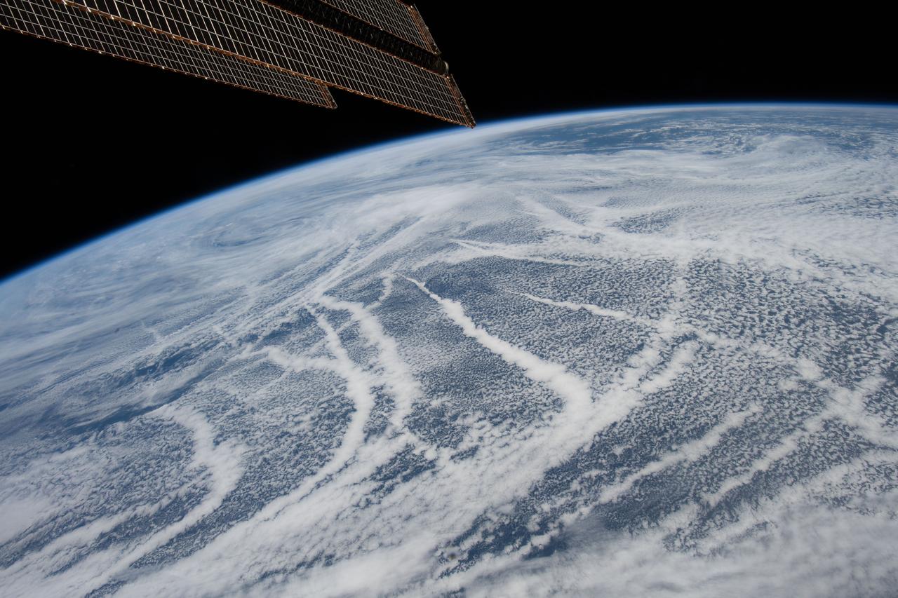
iss059e036736 (April 28, 2019) --- The International Space Station was orbiting 257 miles above the North Pacific Ocean when an Expedition 59 crewmember photographed these cloud patterns south of the Aleutian Islands.
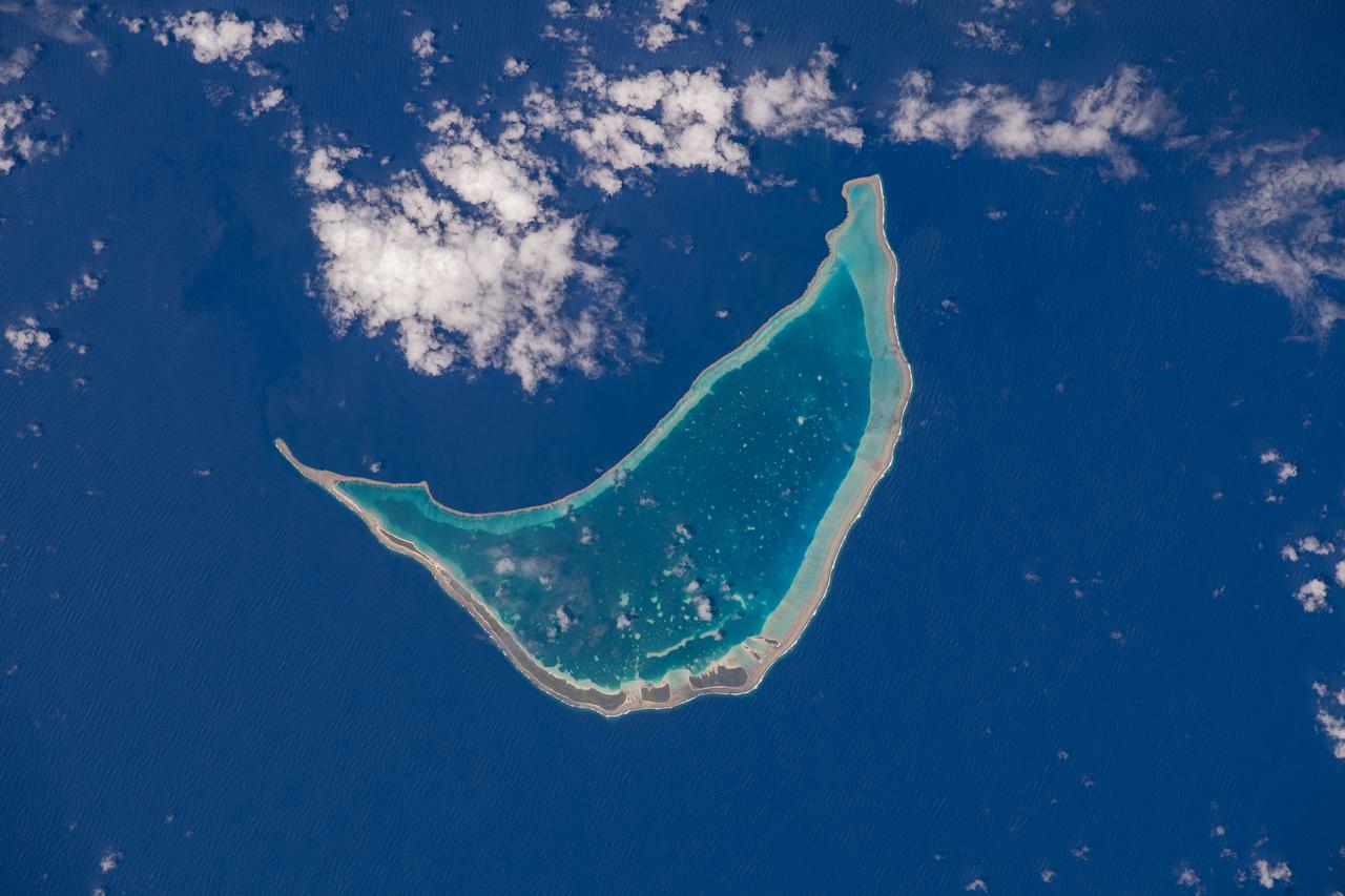
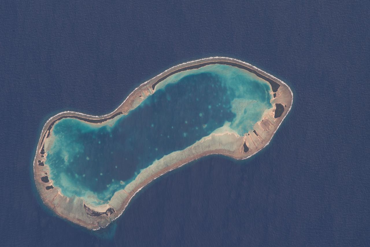
iss068e000304 (Sept. 29, 2022) --- Taongi Atoll, in the independent country of the Marshall Islands, is pictured from the International Space Station as it orbited 258 miles above the Pacific Ocean.
iss064e016369 (Dec. 25, 2020) --- Mauna Loa, the world's largest active volcano, on the island of Hawaii is pictured from the International Space Station as it orbited 260 miles above the Pacific Ocean

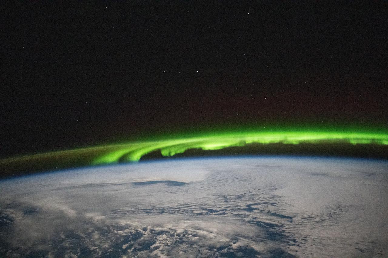
iss071e693961 (Sept. 15, 2024) --- An aurora crowns Earth's horizon in this photograph from the International Space Station as it orbited 265 miles above a cloudy Pacific Ocean southeast of the Kuril Islands.
iss066e008725 (Oct. 22, 2021) --- The airglow blankets the Earth's horizon in this photograph from the International Space Station as it orbited 262 miles above the Pacific Ocean just south of the Hawaiian island chain.
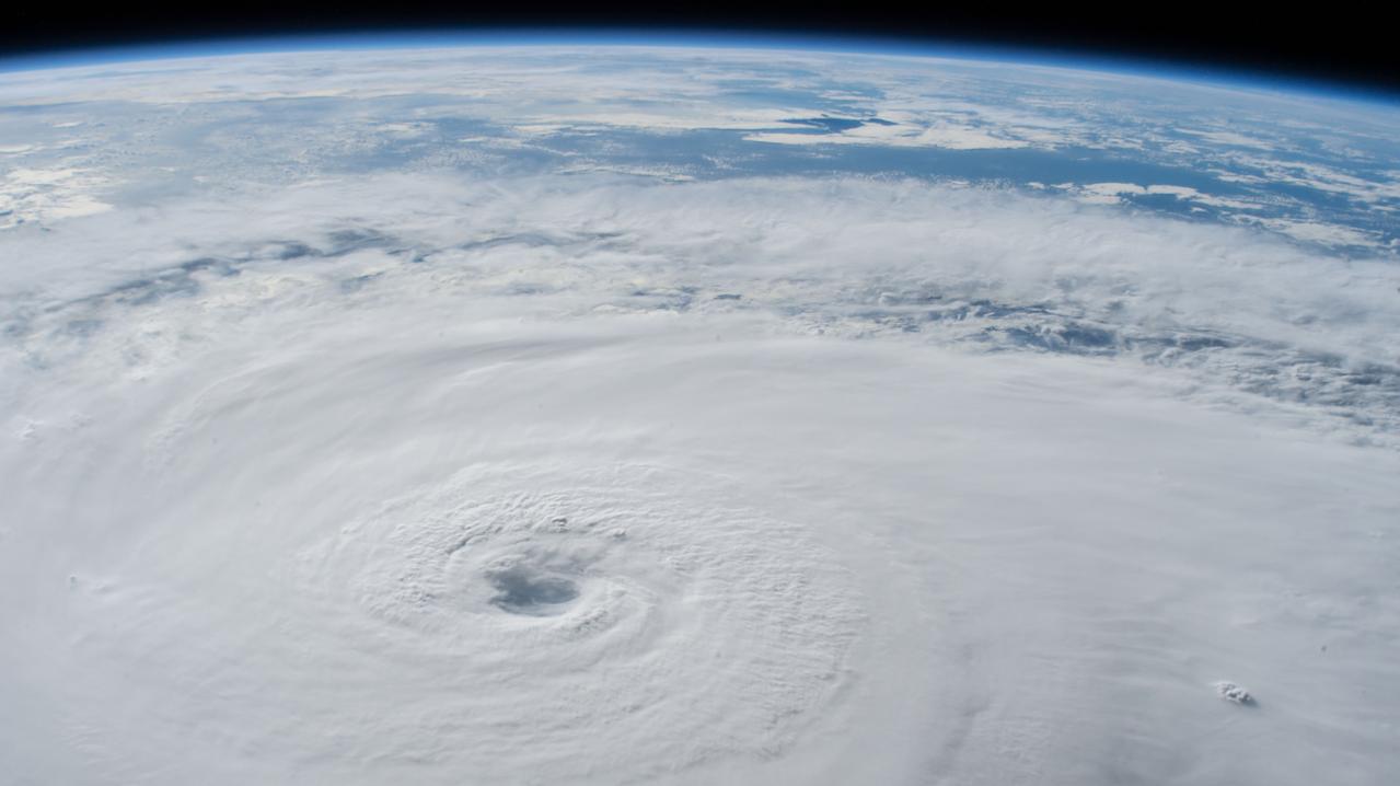
iss056e150297 (Aug. 21, 2018) --- Hurricane Lane, with its well-defined eye, was pictured as a category 4 storm southwest of the Hawaiian Islands as the International Space Station orbited almost 252 miles above the Pacific Ocean.
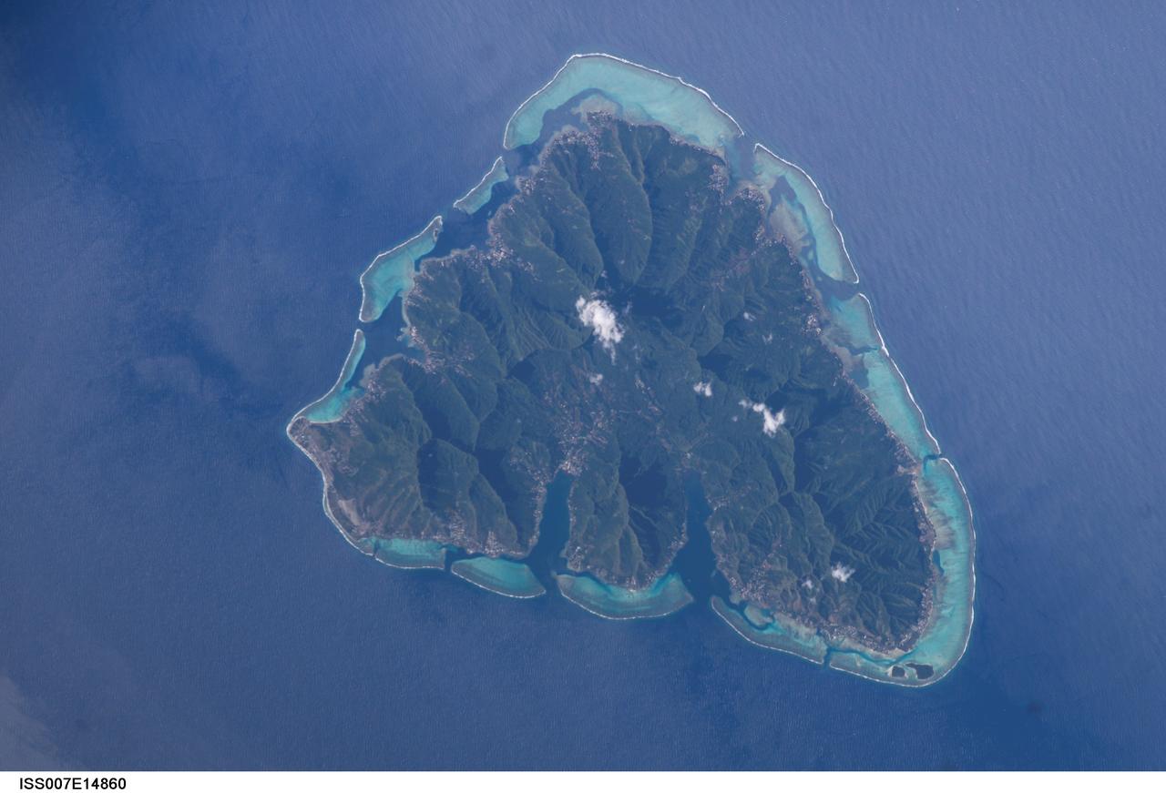
ISS007-E-14860 (13 September 2003) --- The tropical island of Moorea in the South Pacific is featured in this image taken by an Expedition 7 crewmember onboard the International Space Station (ISS).

iss065e073777 (May 26, 2021) --- Japan's northernmost main island of Hokkaido is pictured from the International Space Station as it orbited east 262 miles above the Pacific Ocean.

iss069e086332 (Aug. 31, 2023) --- The Moon's image is refracted due to Earth's atmosphere in this photograph from the International Space Station as it orbited 262 miles above the Pacific Ocean south of Alaska's Aleutian islands.
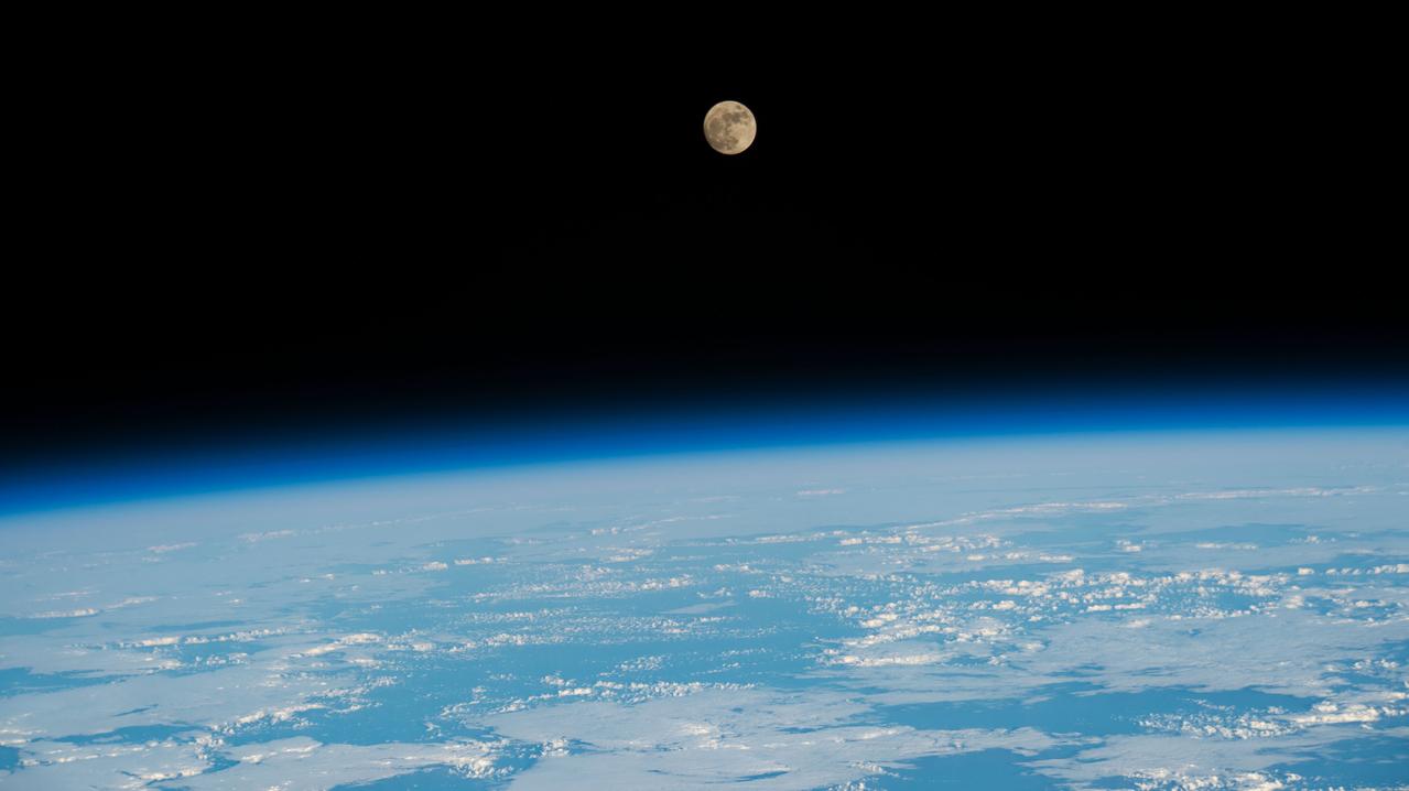
iss067e249811 (Aug. 10, 2022) --- The waxing gibbous Moon is pictured from the International Space Station as it orbited 258 miles above the Pacific Ocean north of the Hawaiian island chain.
iss055e023500 (April 13, 2018) --- The cloud-covered Galapagos Islands and the sun's glint in the waters off the coast of Ecuador are pictured as the International Space Station orbited above the Pacific Ocean.
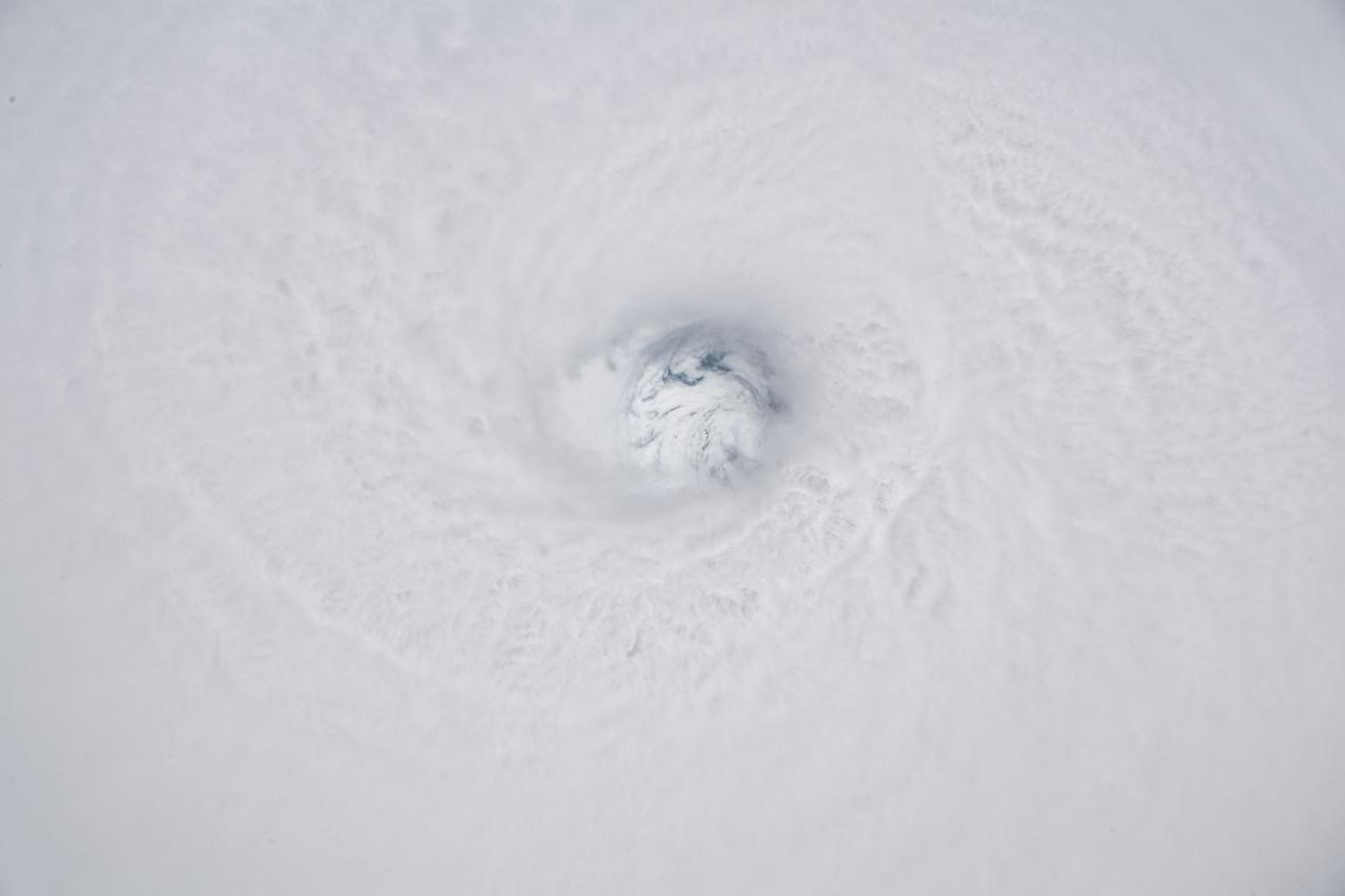
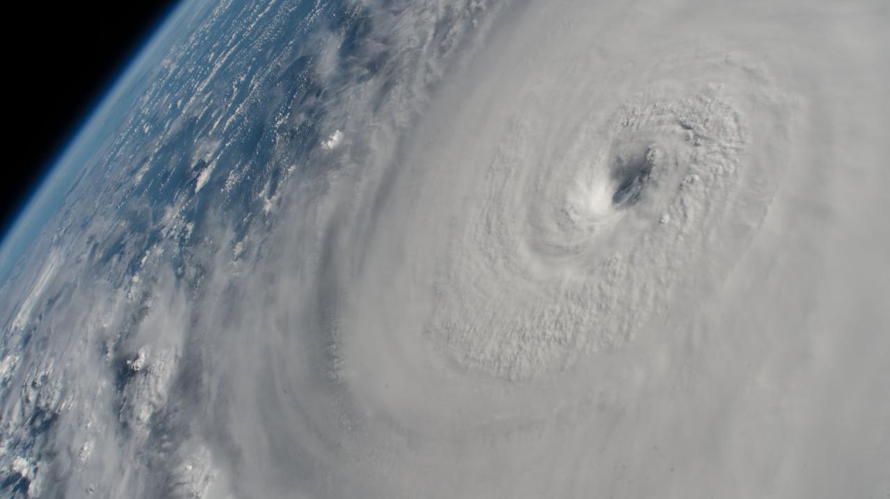
iss056e129868 (Aug. 7, 2018) --- The fully-formed eye of Hurricane Hector is clearly visible from the International Space Station as the orbital complex flew 250 miles above the Pacific Ocean southeast of the Hawaiian island chain.
iss064e004315 (Nov. 13, 2020) --- Cloudy seas are pictured from the International Space Station as it orbited 260 miles above the Pacific Ocean about 1,100 miles due south of the Hawaiian island chain.
iss061e025964 (Oct. 31, 2019) --- The French Polynesian island of Bora Bora, surrounded by the Bora Main Motu Reef, is pictured as the International Space Station orbited 257 miles above the South Pacific Ocean.
iss066e152101 (Feb. 22, 2022) --- The Earth is illuminated shortly after an orbital sunrise in this photograph from the International Space Station as it orbited 262 above the Pacific Ocean south of Alaska's Aleutian Islands.
iss067e221404 (July 31, 2022) --- The sun illuminates Earth's limb as the International Space station soared 271 miles above the Pacific Ocean south of the Australian island state of Tasmania.
iss070e015686 (Nov. 2, 2023) --- The sun's glint beams across the Pacific Ocean in this photograph from the International Space Station as it orbited 259 miles above the Hawaiian island chain.
iss060e002083 (June 29, 2019) --- Earth's atmospheric glow, highlighted by the Moon and a starry orbital nighttime background, are pictured as the International Space Station orbited 256 miles above the Pacific Ocean, southeast of the Hawaiian island chain.
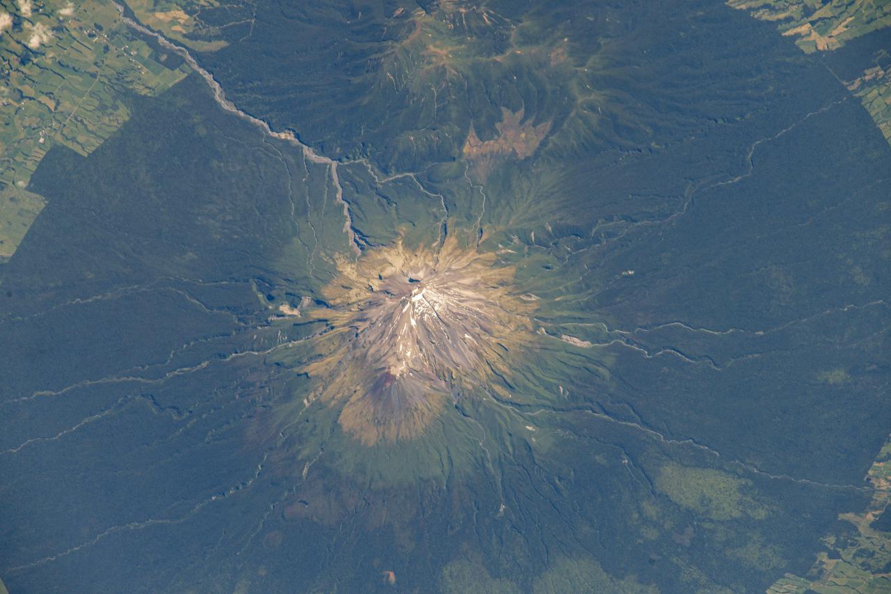
iss064e026424 (Jan. 25, 2021) --- Mount Taranaki on the island nation of New Zealand is pictured from the International Space Station as it orbited 268 miles above the South Pacific. Credit: Roscosmos
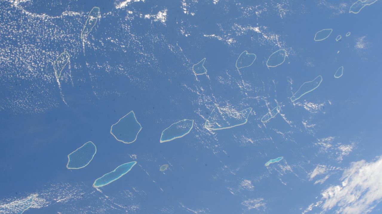
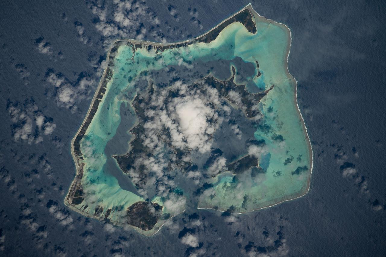
iss071e207656 (June 22, 2024) --- The Palliser Islands, atolls that are part of Fench Polynesia's Tuamotu Archipelago in the Pacific Ocean, are pictured from the International Space Station as it orbited 266 miles above.
iss060e007130 (July 12, 2019) --- The Sun's glint beams off the blue waters of the Pacific Ocean as the International Space Station orbited 254 miles above Earth south of the Hawaiian island chain.
iss067e362267 (Sept. 15, 2022) --- An orbital sunrise begins to illuminate the cloud tops in this photograph from the International Space Station as it orbited 258 miles above the Pacific Ocean south of the Hawaiian island chain.
iss070e048478 (Dec. 26, 2023) --- The near Full Moon is pictured just above Earth's atmosphere in this photograph from the International Space Station as it orbited 262 miles above the north Pacific Ocean south of Alaska's Aleutian Islands.
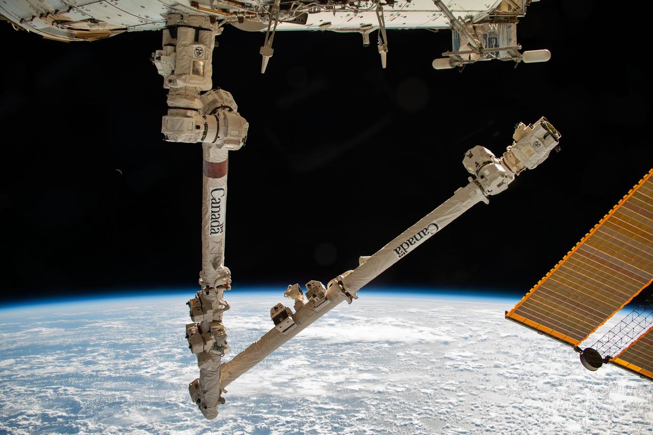
iss070e006089 (Oct. 18, 2023) --- The Canadarm2 robotic arm is pictured extending from the International Space Station while orbiting 260 miles above the Pacific Ocean near the Aleutian Islands.
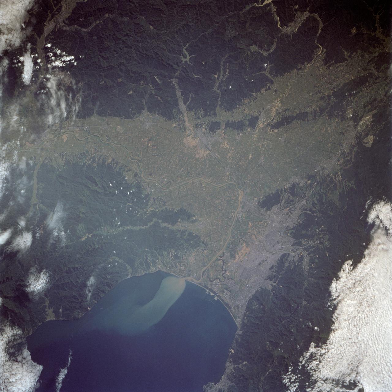
The city of Sapporo on the northernmost of the Japanese Home Island of Hokkaido (43.5N, 141.5E), host to the 1986 Winter Olympic Games is situated along the margin of a large valley which extends across the island from the Sea of Japan to the Pacific Ocean. The Valley is largely cultivated (the lighter green of the cultivated land distinguishes it from the gray urban development of Sapporo), but much of the island remains heavily forested.
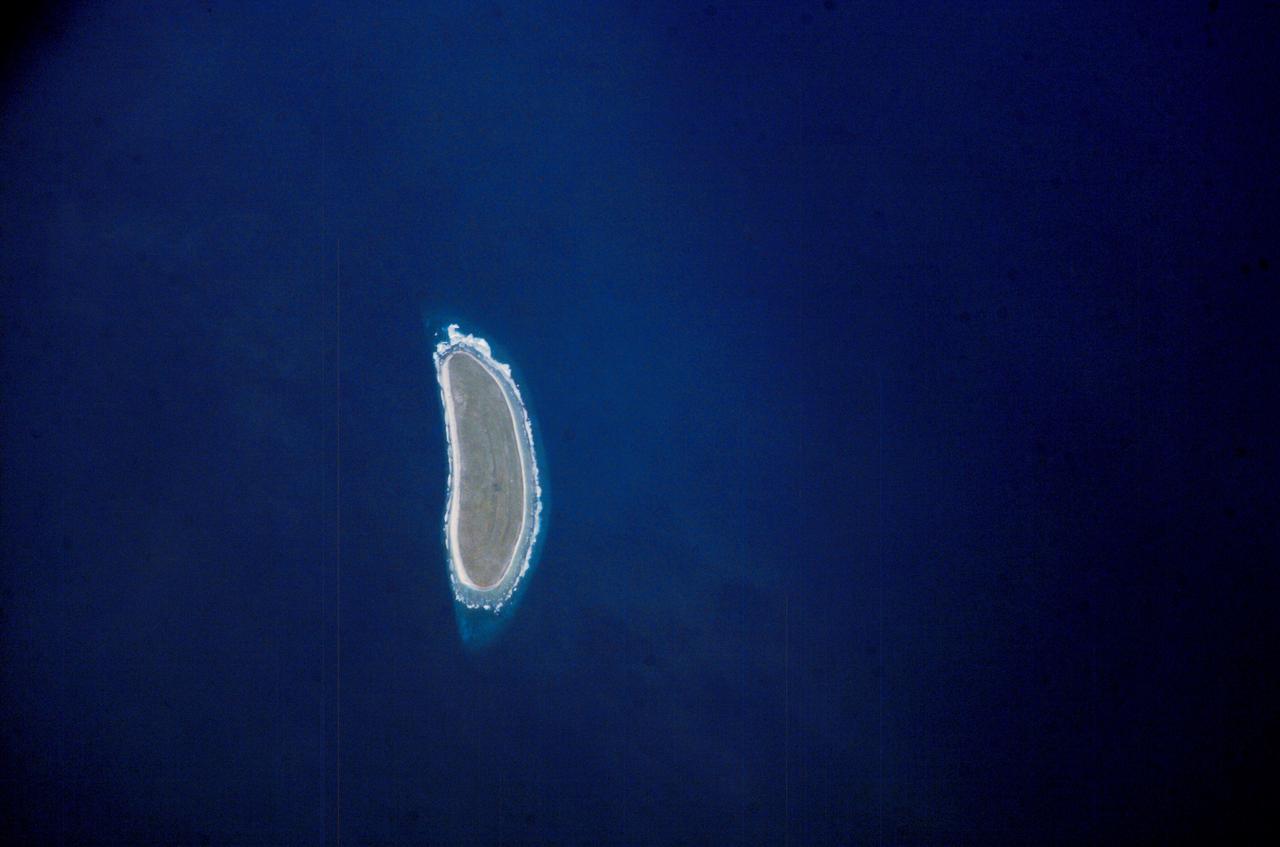
ISS010-E-09287 (3 December 2004) --- Howland Island, Oceania is featured in this digital image photographed by an Expedition 10 crewmember on the International Space Station (ISS). Howland Island is a United States possession located in the north Pacific between Australia and the Hawaiian Islands. Prior to 1890, organic nitrate (guano) was mined from the island by both the United States and the British. This tiny island is currently part of the US National Wildlife Refuge system, and provides nesting areas and forage for a variety of birds and marine wildlife. The island is composed of coral fragments and is surrounded by an active fringing reef. White breakers encircling the island indicate the position of the reef. Astronauts aboard the Space Station photograph numerous reefs around the world as part of a global mapping and monitoring program. High-resolution images such as this one are used to update geographic maps of reefs and islands, assess the health of reef ecosystems, and calculate bathymetry of the surrounding ocean bottom.
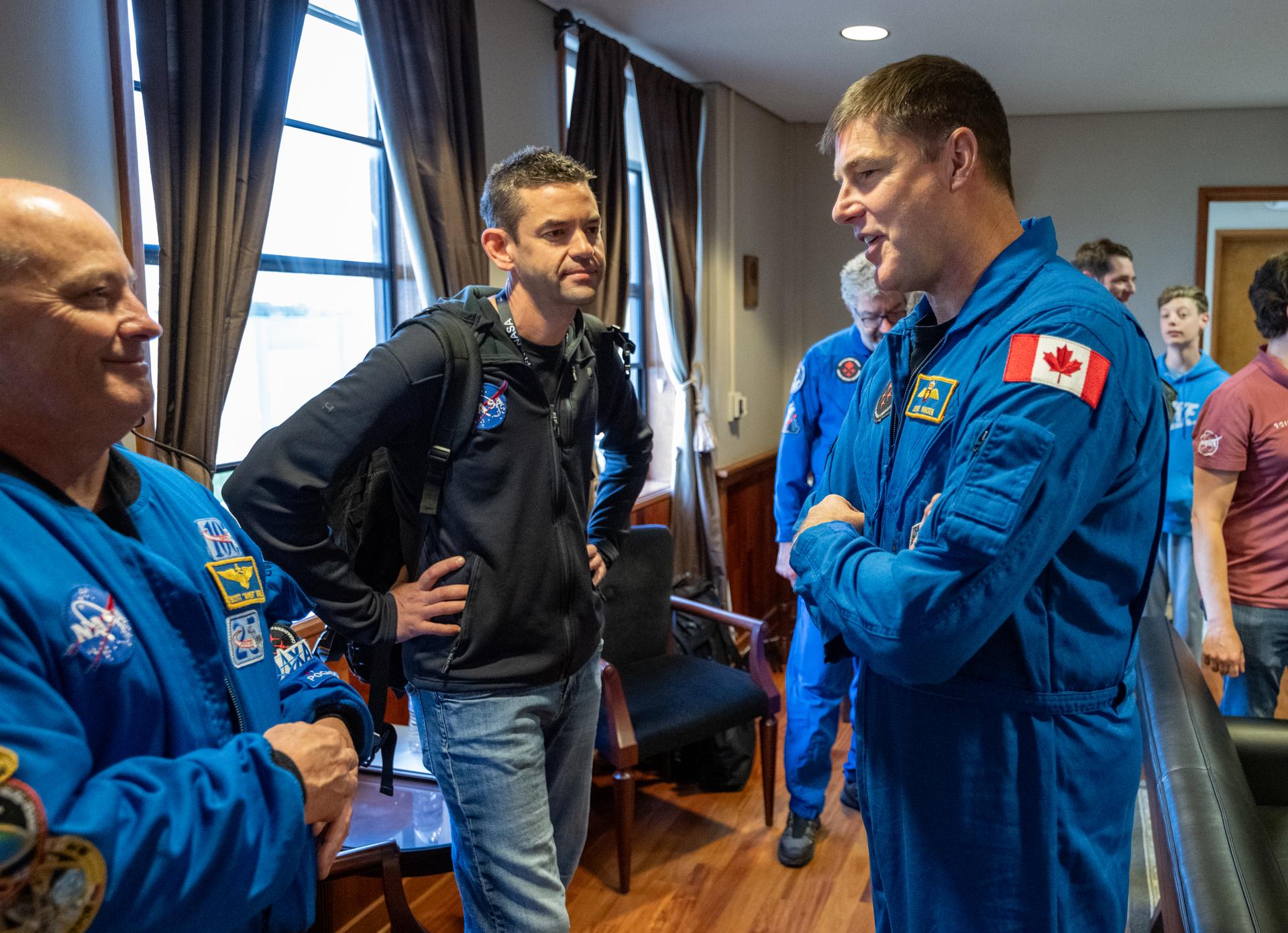
From left to right, Chief of the Astronaut Office Scott Tingle, NASA Administrator Jared Isaacman, and CSA (Canadian Space Agency) astronaut Jeremy Hansen are seen at Naval Air Station North Island, Saturday, April 11, 2026, following a splashdown in the Pacific Ocean off the coast of California at 5:07 p.m. PDT (8:07 p.m. EDT) on April 10. NASA’s Artemis II mission took NASA astronauts Reid Wiseman, commander; Victor Glover, pilot; Christina Koch, mission specialist; and CSA (Canadian Space Agency) astronaut Jeremy Hansen, mission specialist on a nearly ten day journey around the Moon and back to Earth. Photo Credit: (NASA/Keegan Barber)
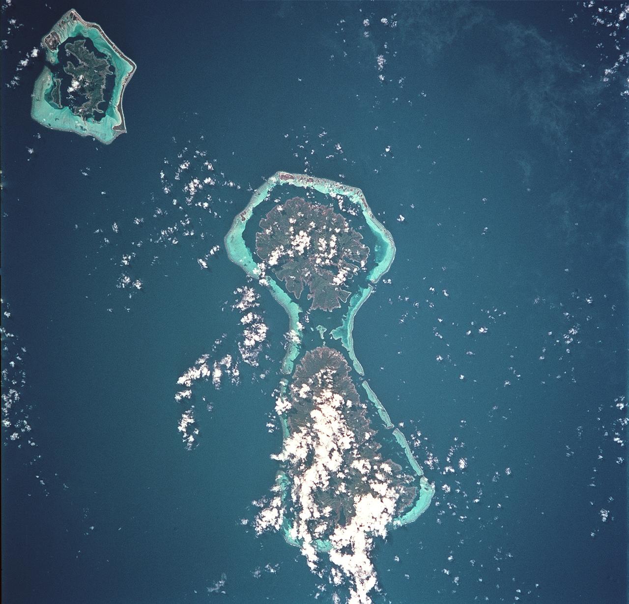
STS093-717-066 (23-27 July 1999) --- The STS-93 astronauts aboard the Space Shuttle Columbia took this picture featuring the Society Islands. Delicate coral reefs ring the islands of Bora Bora (top), Tahaa (center) and Raiatea (bottom). The Society Islands, which also include the island of Tahiti, are one of many archipelagoes that constitute French Polynesia in the central South Pacific. When the photo was taken, the shuttle was flying over a point located at 16.2 degrees south latitude and 151.8 degrees west longitude. Data back information on the 70mm listed the time and date as 23:36:16 GMT, July 25, 1999 (Orbit 45).
This view of the Malay Peninsula shows the city state of Singapore, Malaysia (1.5N, 104.0E) with all its urban, industrial and commercial land use areas. Singapore is located at the south tip of the Malay peninsula separated by the Johor Strait. The prosporous island state, once Asia's major trade center, is now highly industrialized despite its small size and its ideal location has made this island a hub of trade, shipping and service industries.
STS026-038-056 (29 Sept. - 3 Oct. 1988) --- Tambora Caldera, Sumbawa Island, Indonesia as photographed with a 70mm handheld Hasselblad camera. Tambora is a 6-kilometer-wide and 650-meter-deep Caldera formed in 1815 as a result of a huge volcanic eruption. Gases from the eruption were ejected high into Earth's atmosphere and transported around the globe. The atmospheric gases trapped part of the incoming sunglint, resulting in extremely cold weather. In New England, snow fell in June, and freezes occurred throughout the summer of 1816, which became known as "the year without a summer." This photo was shown by the STS-26 astronaut crew during its Oct. 11, l988 post-flight press conference.
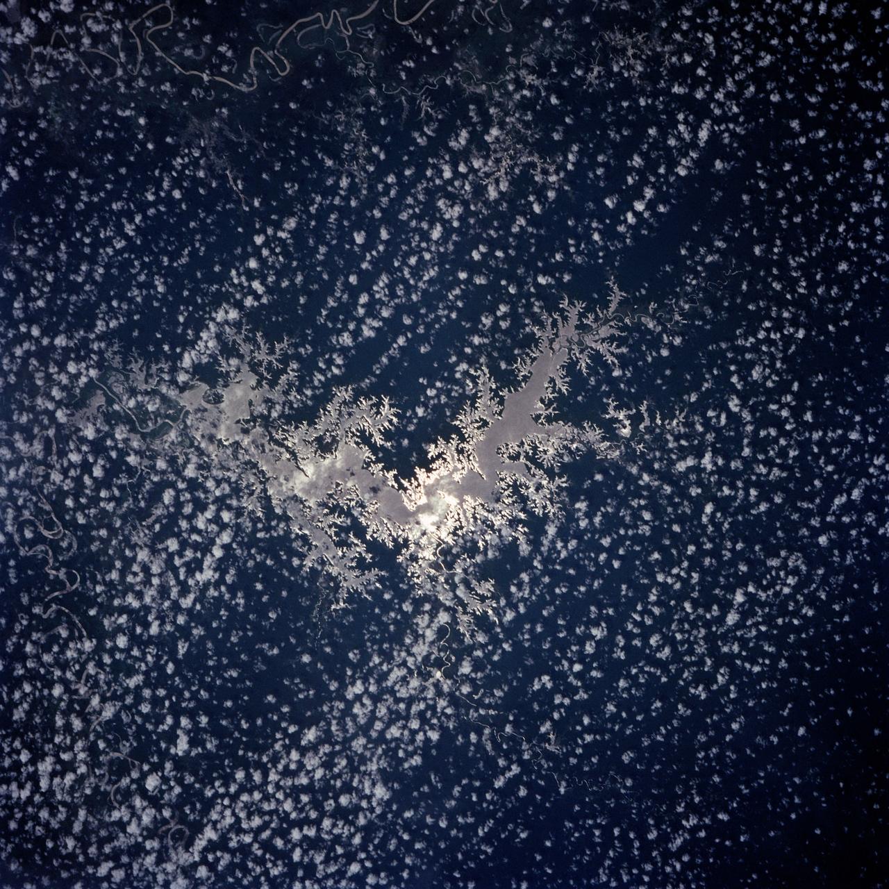
Lake Murray, a manmade reservoir, lies between the Fly and Strickland River Basins, Papua, New Guinea (7.0S, 141.5E). The region, photographed in sunglint, shows the water level in the reservoir and the full extent of the drainage basins of both river systems as the rivers meander through wide alluvial floodplains. Some forest clearing can be seen in places throughout the region, but most of the area remains in closed canopy forest.
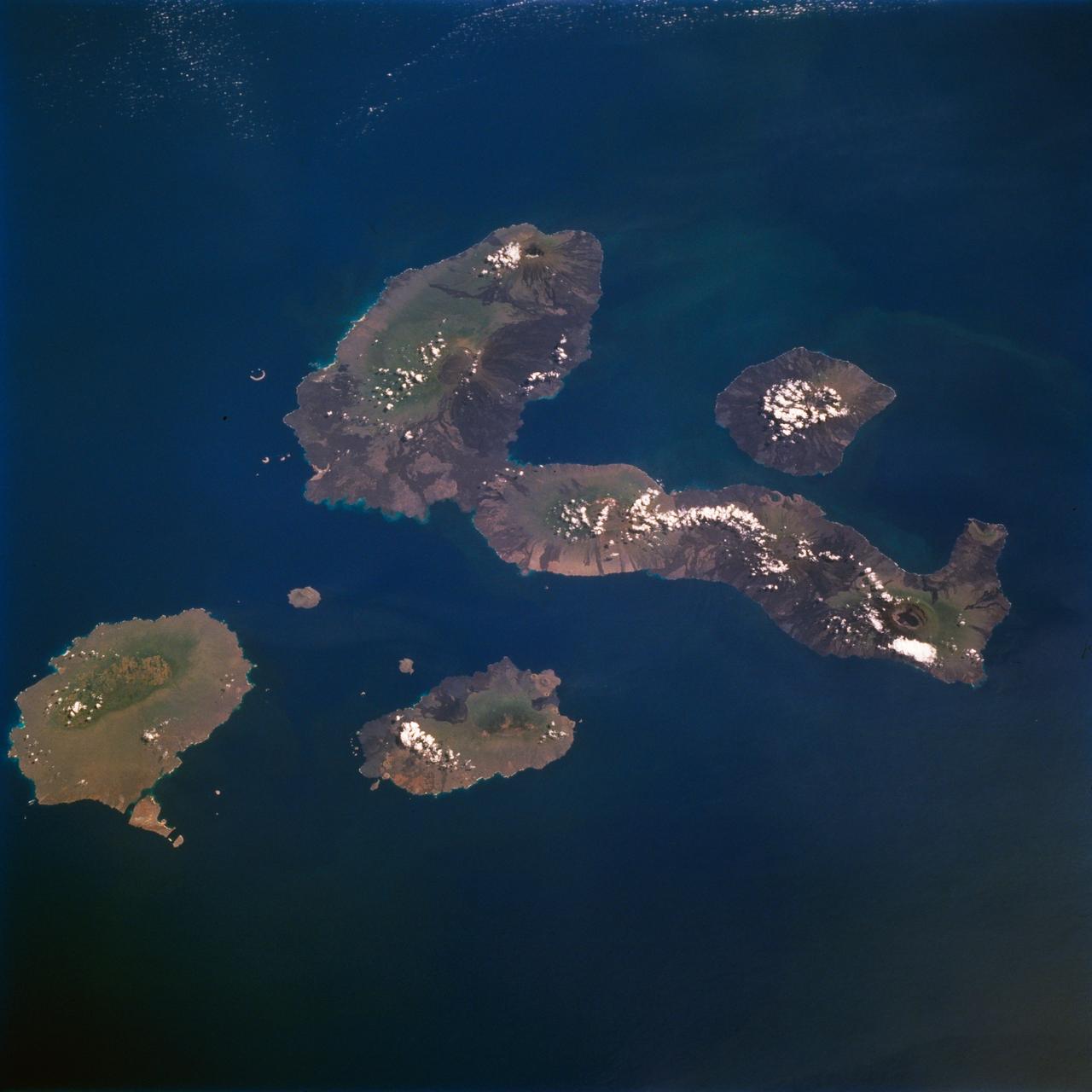
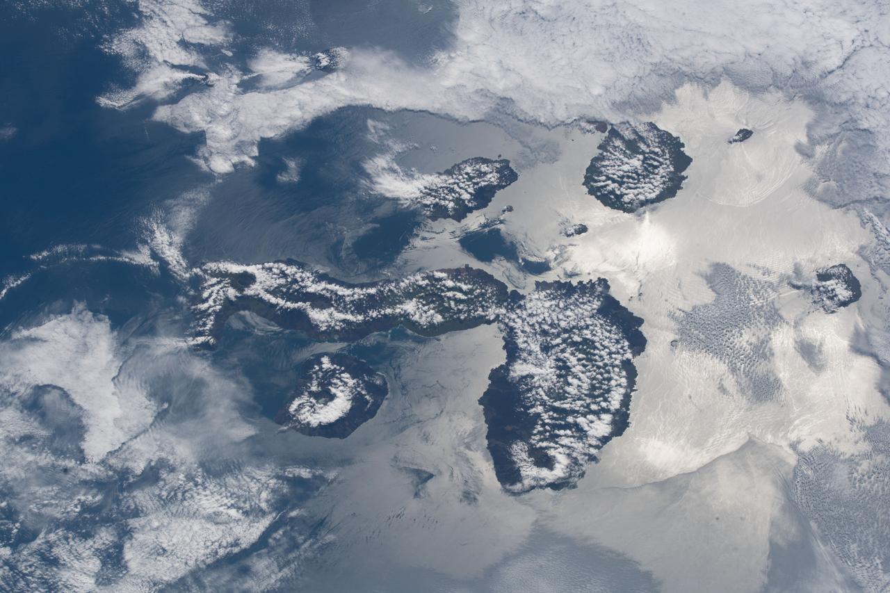
STS077-711-012 (19-29 May 1996) --- One of several volcanic-laden photo targets for the crew members was the grouping of the Galapagos Islands -composites of flat-topped volcanoes produced by a hot spot in the eastern Pacific. Dark lava flows drape the flanks of each volcano. This view centers on Isabella, the sea horse-shaped island. The most active volcano is the island of Fernandina, which sits just west (up) from the sea horse?s middle area. Fernandina erupted late last year, and Shuttle photography has documented the changes produced by eruptions over the past 10 years. Because the Galapagos Islands sit on the equator and near the junction of current systems in the eastern Pacific Ocean, and the volcano provides a sharp topographic barrier to the currents, many interesting oceanic phenomena occur and have been recorded in this region. Lighter colored water occurs just west of Isabella and Fernandina. The origin of the color difference is unknown, but could possibly be plankton blooms related to upwelling around the islands.