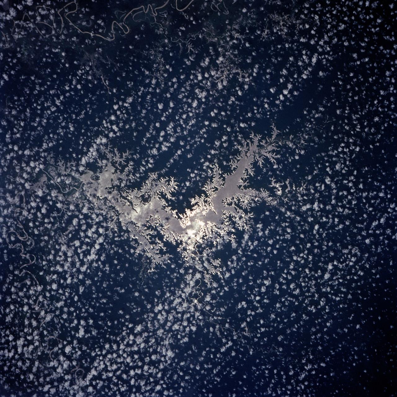
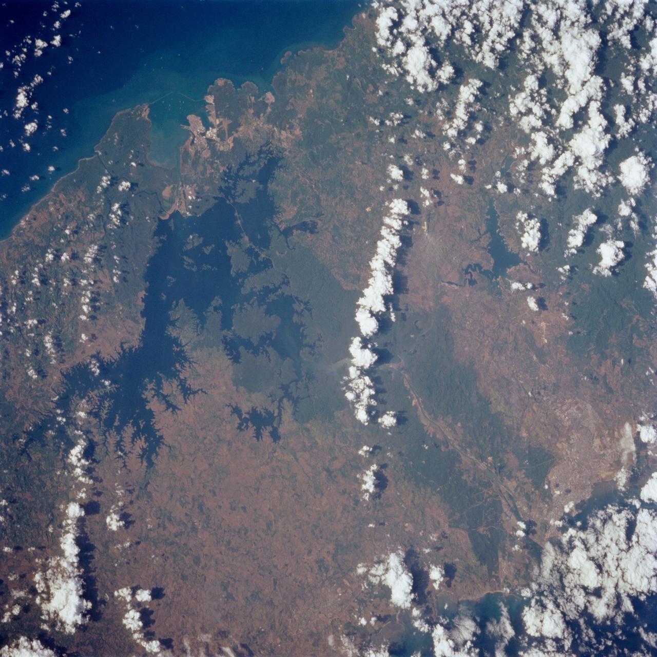
Lake Murray, a manmade reservoir, lies between the Fly and Strickland River Basins, Papua, New Guinea (7.0S, 141.5E). The region, photographed in sunglint, shows the water level in the reservoir and the full extent of the drainage basins of both river systems as the rivers meander through wide alluvial floodplains. Some forest clearing can be seen in places throughout the region, but most of the area remains in closed canopy forest.
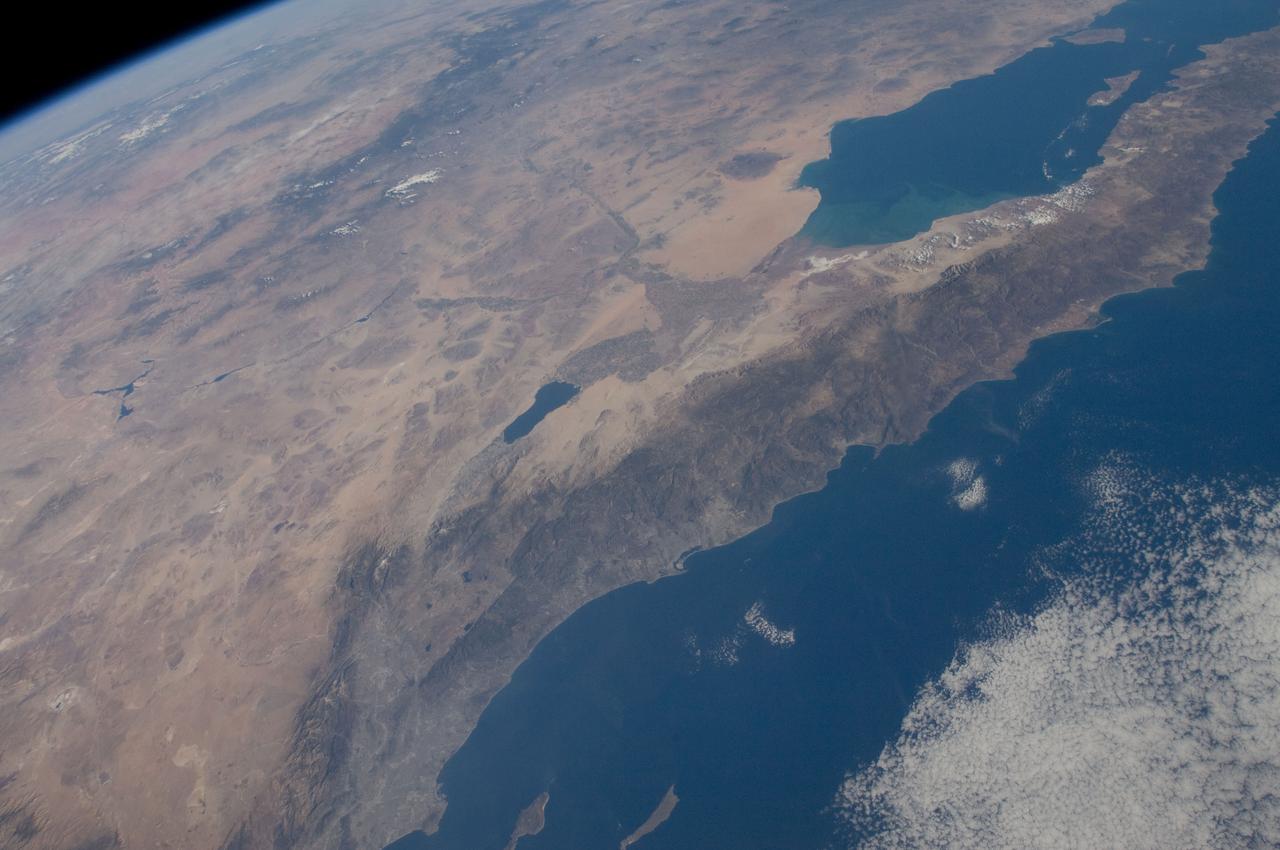
ISS029-E-042846 (16 Nov. 2011) --- Parts of the U.S. and Mexico are seen in this image photographed by one of the Expedition 29 crew members from the International Space Station as it flew above the Pacific Ocean on Nov. 16, 2011. The Salton Sea is in the center of the frame, with the Gulf of Cortez, Mexico's Baja California and the Colorado River in the upper right quadrant. The Los Angeles Basin and Santa Catalina and San Clemente islands are at the bottom center edge of the image. Lake Mead and the Las Vegas area of Nevada even made it into the frame in the upper left quadrant.
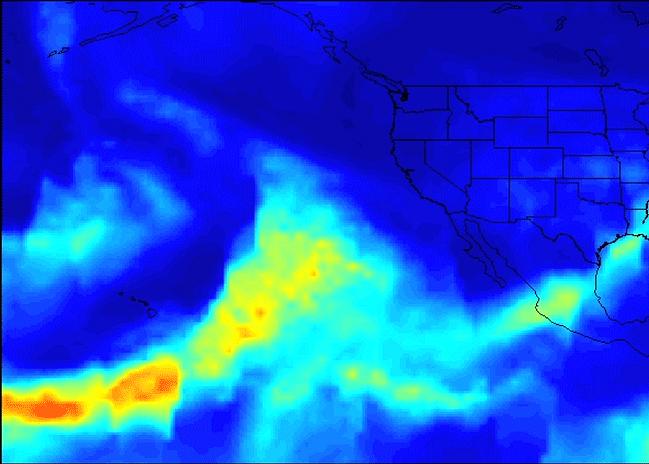
A series of atmospheric rivers that brought drought-relieving rains, heavy snowfall and flooding to California this week is highlighted in a new movie created with satellite data from the Atmospheric Infrared Sounder (AIRS) instrument on NASA's Aqua satellite. The images of atmospheric water vapor were collected by AIRS between January 7 and 11. They show the amount of moisture present in the atmosphere and its movement across the Pacific Ocean to the United States, where much of it fell as rain or snow. In early January 2017, the Western U.S. experienced rain and flooding from a series of storms flowing to America on multiple streams of moist air, each individually known as an atmospheric river. Atmospheric rivers are typically 250 to 375 miles (400 to 600 kilometers) wide. The term "Pineapple Express" refers to atmospheric rivers that originate near or just east of the Hawaiian Islands and terminate along the West Coast of North America. Other atmospheric rivers originate in the tropical Western Pacific Ocean and take on a more west-to-east orientation near the U.S. West Coast. Several distinct plumes of moisture are apparent in the AIRS imagery. The first of three atmospheric river events occurred on January 7 and 8. This was a classic Pineapple Express, featuring an uninterrupted supply of heavy moisture drawn up from the deep tropics. This was the wettest storm of the series, producing very heavy rainfall, more than 1 foot (0.3 meter), in parts of Central and Northern California, with relatively smaller amounts of snow at the highest elevations of the Sierra Nevada. The second blob of heavy moisture, from January 8 to 10 to the west of California, likely originated thousands of miles to the west, in the tropical Western Pacific. This atmospheric river did not maintain its tropical connection. However, it still produced prodigious rainfall totals in Northern California and much more snow than the first event, since the storm had a more northern and colder trajectory. A third storm, the coldest of the three events, moved through California on January 11 and 12, producing significant rainfall, as well as snow at higher elevations. The movie ends with another atmospheric river attempting to form on January 11 and 12 to the west of Hawaii, transporting moisture into the storm track. Movies are availalbe at http://photojournal.jpl.nasa.gov/catalog/PIA21209
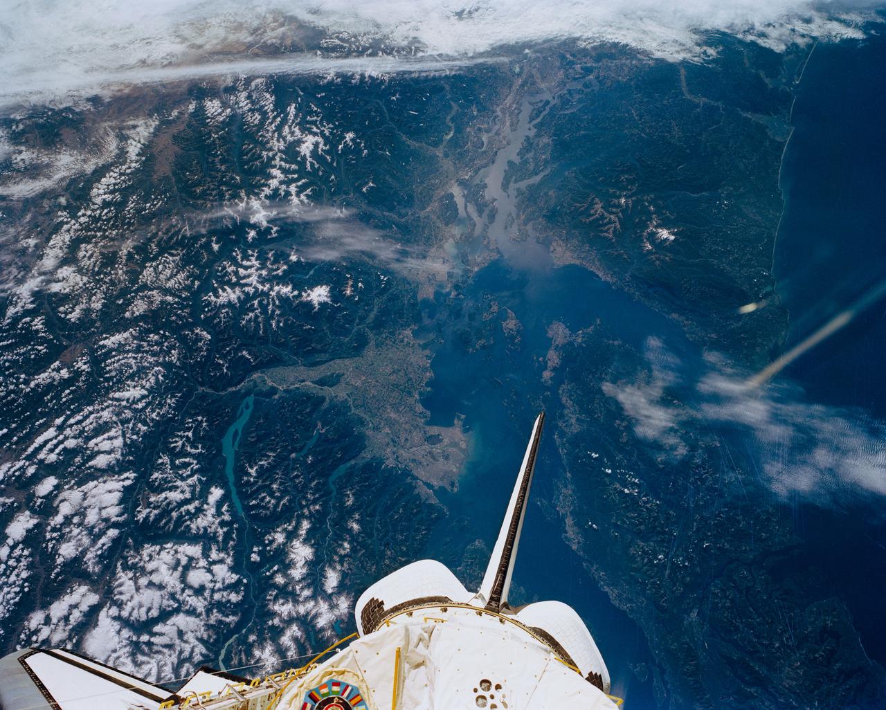
STS047-151-488 (12 - 20 Sept 1992) --- In this large format camera image, the forested Cascade Range appears along the left side; the Pacific Ocean, on the right. The frame was photographed as the Space Shuttle Endeavour flew north to south over Vancouver and Seattle. Many peaks in the Cascades reach altitudes greater than 9,000 feet and remain snowcapped even in mid-summer. The Strait of Juan de Fuca separates the Olympic Peninsula (top right) from Vancouver Island (bottom right). Snowcapped Mt. Olympus (7,965 feet) is one of the wettest places in the continental United States, with rainfall in excess of 120 inches per year. The port cities of Seattle and Tacoma occupy the heavily indented coastline of Puget Sound (top center). They appear as light-colored areas on the left side of the Sound. The angular street pattern of Tacoma is visible at the top of the picture. The international boundary between Canada and the United States of America runs across the middle of the view. The city of Victoria (center) is the light patch on the tip of Vancouver Island. Canada's Fraser River Delta provides flat topography on which the cities of Vancouver, Burnaby, and New Westminster were built. These cities appear as the light-colored area just left of center. The Fraser River can be seen snaking its way out of the mountains at the apex of the delta. Numerous ski resorts dot the slopes of the mountains (bottom left) that rise immediately to the north of Vancouver. In the same area the blue water of Harrison and other, smaller lakes fills some of the valleys that were excavated by glaciers in the "recent" geological past, according to NASA scientists studying the photography. A Linhof camera was used to expose the frame.
STS062-85-095 (4-18 March 1994) --- Gatun Lake and the forested Panama Canal Zone can be seen in this north northwest-looking low oblique photograph obtained in March 1994. The shipping chanel of the canal is 82.4 kilometers (51.2 miles) long, though the canal zone is only 65 kilometers (40 miles) long. The width of the canal zones extends generally 8 kilometers (5 miles) on either side of the shipping channel, except near Madden Lake. The canal connects the Atlantic Ocean (coastal city of Colon) with the Pacific Ocean near Panama City in a line that takes a northwest to southeast course because of the configuration of the isthmus. The canal zigzags across the isthmus to take advantage of the geographic features of the area such as the Chagres River. The controlled water supply for the canal is provided by the three artificial lakes: Gatun near the Atlantic terminus, Miraflores near the Pacific terminus and Madden about halfway across the isthmus. Gatun is the largest of the three lakes covering an area of 429 square kilometers (165 square miles). In the midst of this lake is Barro Colorado Island, a world-famous wild game perserve. Madden Lake was built as a large supplemental reservoir to keep water levels up in the canal during the dry season. All three lakes are vital sources of water for maintaining the ship channel over the continental divide (Gaillard Cut) and for regulating the flow of water that enables hugh vessels to be lifted and lowered in massive locks.