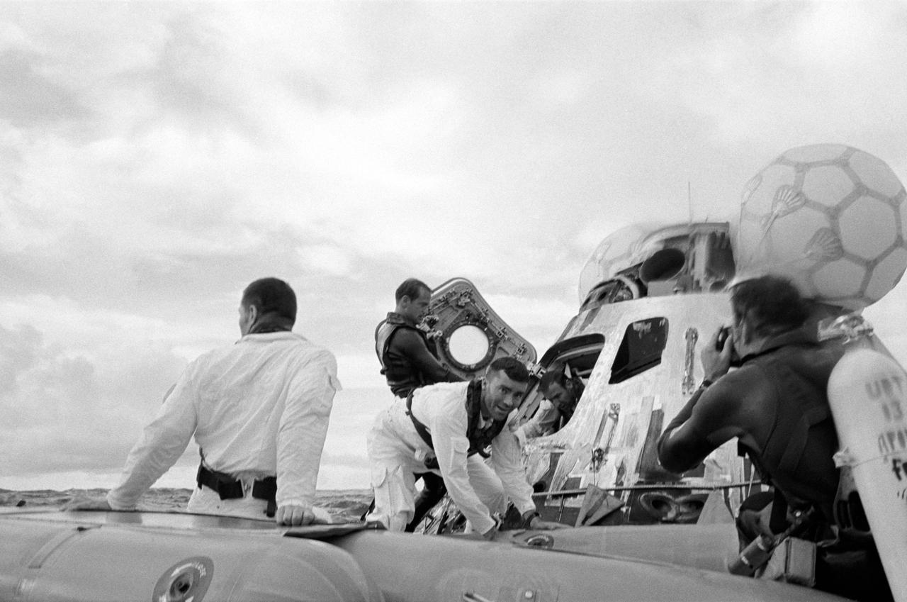
S70-35610 (17 April 1970) --- A water level view of the Apollo 13 recovery operations in the South Pacific Ocean. The three astronauts as seen egressing their spacecraft. John L. Swigert Jr. (back to camera), command module pilot, is already in the life raft. Fred W. Haise Jr., lunar module pilot, facing camera, is stepping into the life raft. James A. Lovell Jr., commander, is leaving the spacecraft in the background. A United States Navy underwater demolition team assists with the recovery operations. The three crewmembers were picked up by helicopter and flown to the prime recovery ship, USS Iwo Jima. The Apollo 13 Command Module (CM) splashed down at 12:07:44 p.m. (CST), April 17, 1970, to conclude safely a perilous space flight. Though the Apollo lunar landing mission was canceled, a disastrous loss of three astronauts was averted.
ISS033-E-007873 (27 Sept. 2012) --- Wake Island is featured in this image photographed by an Expedition 33 crew member on the International Space Station. The atoll of Wake Island is located in the central Pacific Ocean approximately 4,000 kilometers to the west-southwest of Hawaii and 2,400 kilometers to the northwest of Guam. In addition to Wake Island, the atoll includes the smaller Peale and Wilkes Island for a total land surface area of 6.5 square kilometers. Like many atolls in the Pacific, the islands and associated reefs formed around a submerged volcano. The lagoon in the center of the islands—characterized by shallow, light blue water in contrast to the surrounding darker, deeper Pacific Ocean waters—marks the approximate location of the summit crater of the volcano.

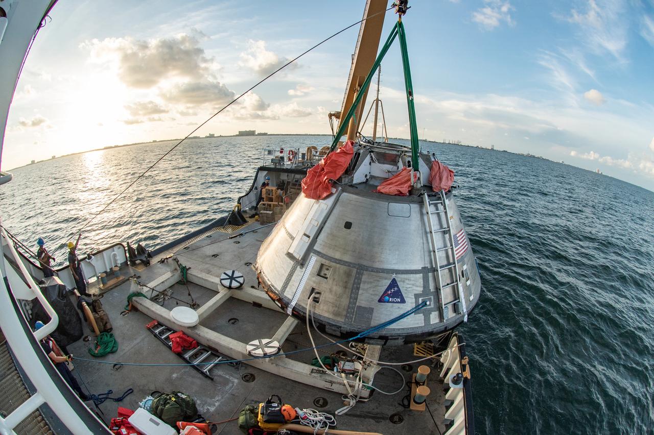
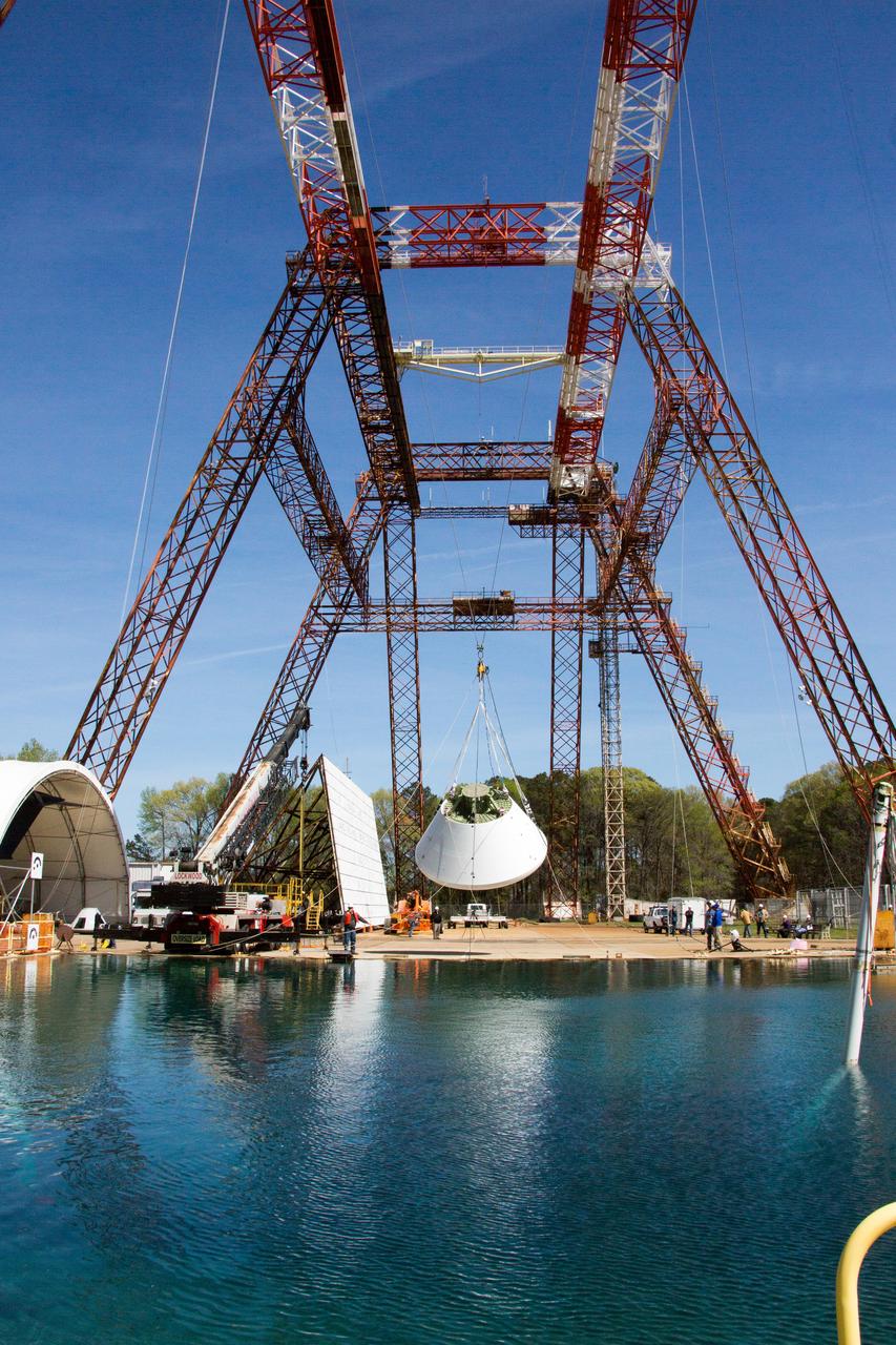
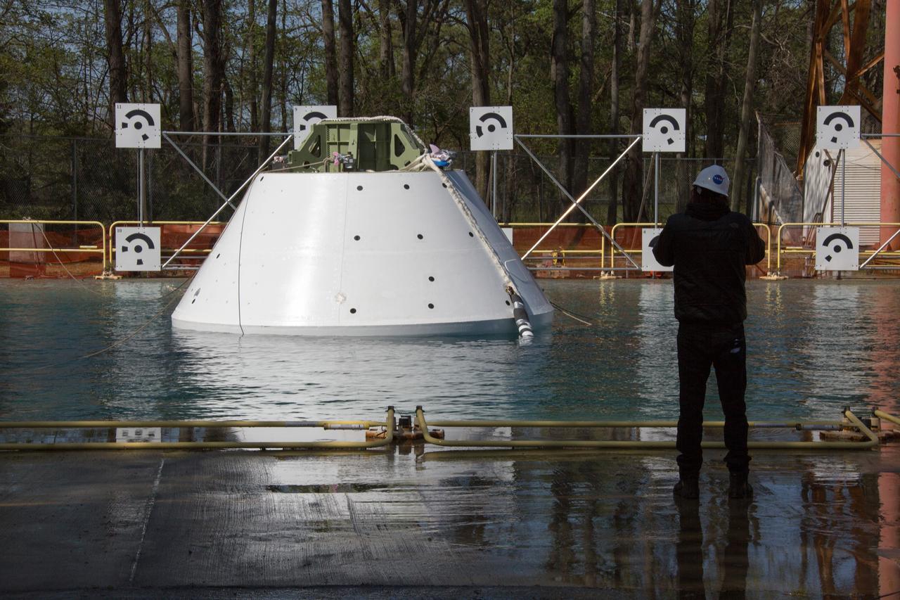
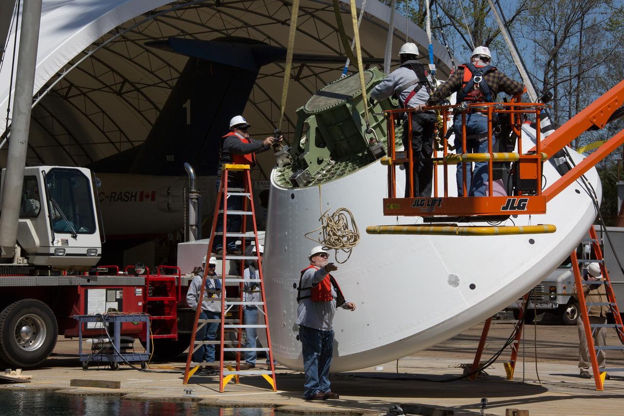
Engineers at NASA’s Langley Research Center in Hampton, Virginia, install test dummies into the seats of an Orion test article on Feb. 26, 2016. The capsule, coupled with the heat shield from the spacecraft’s first flight, will be used for water-impact testing to simulate what astronauts will experience when landing in the Pacific Ocean during a real mission.
Engineers at NASA’s Langley Research Center in Hampton, Virginia, install test dummies into the seats of an Orion test article on Feb. 26, 2016. The capsule, coupled with the heat shield from the spacecraft’s first flight, will be used for water-impact testing to simulate what astronauts will experience when landing in the Pacific Ocean during a real mission.

Engineers at NASA’s Langley Research Center in Hampton, Virginia, install test dummies into the seats of an Orion test article on Feb. 26, 2016. The capsule, coupled with the heat shield from the spacecraft’s first flight, will be used for water-impact testing to simulate what astronauts will experience when landing in the Pacific Ocean during a real mission.

Engineers at NASA’s Langley Research Center in Hampton, Virginia, install test dummies into the seats of an Orion test article on Feb. 26, 2016. The capsule, coupled with the heat shield from the spacecraft’s first flight, will be used for water-impact testing to simulate what astronauts will experience when landing in the Pacific Ocean during a real mission.
iss069e054648 (August 4, 2023) -- Amanu, a ring-shaped island—or an atoll—is roughly 560 miles (900 kilometers) from Tahiti. Only 10 miles (~15 kilometers) of its land is above water, creating a lagoon in its center. The International Space Station soared 261 miles above the Pacific Ocean as this image was taken.
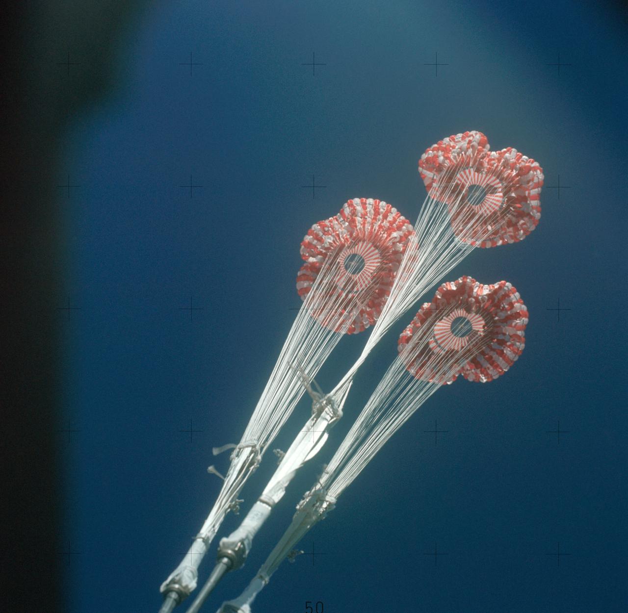
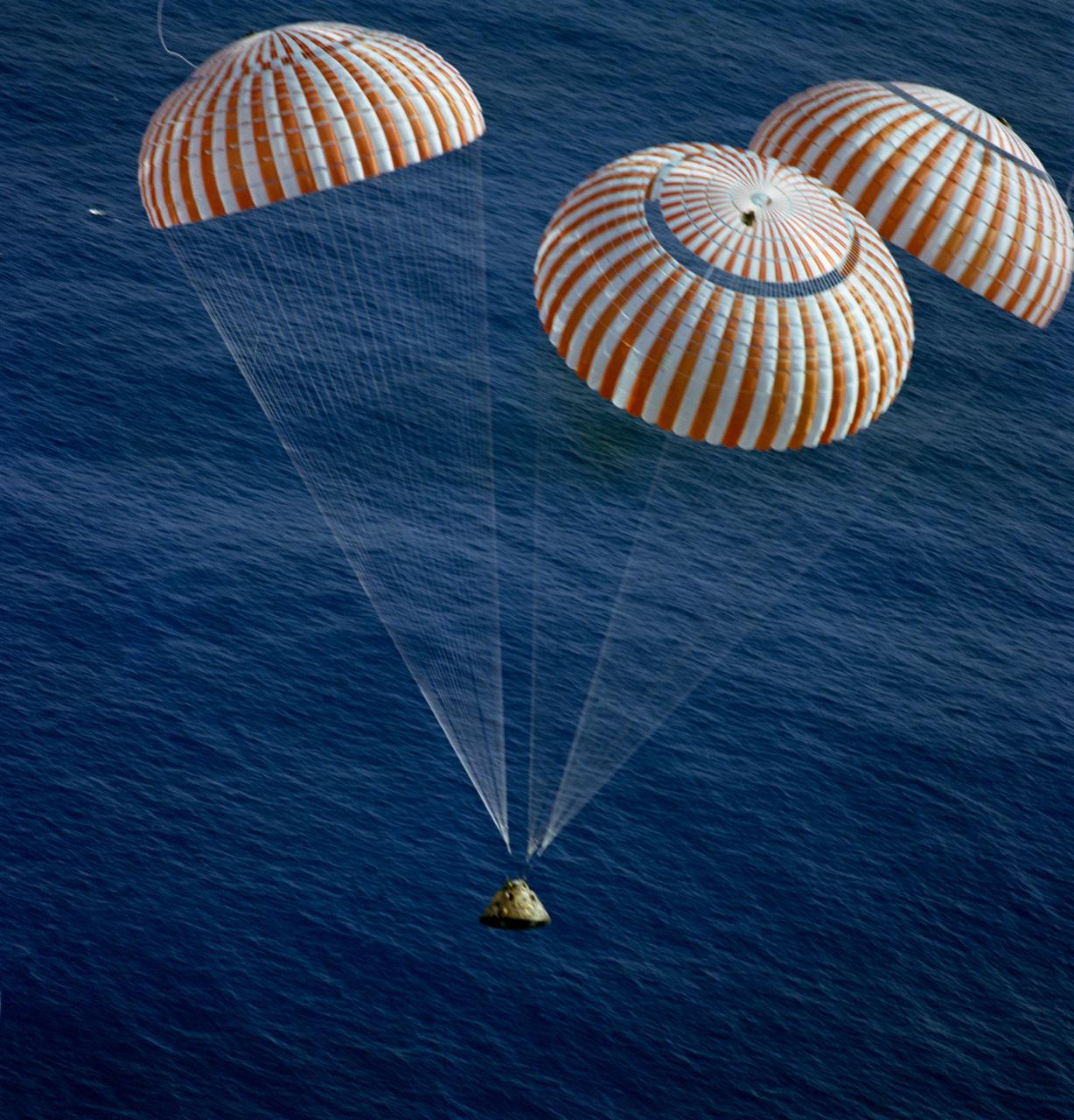
SL3-114-1760 (25 Sept. 1973) --? An excellent view of the three main ring sail parachutes of the Skylab 3 command module as they unfurl during descent to a successful splashdown in the Pacific Ocean. This picture was taken by a hand-held 70mm Hasselblad camera, looking up through a window of the command module. These parachutes open at approximately 10,000 feet altitude. Aboard the CM were astronauts Alan L. Bean, Owen K. Garriott and Jack R. Lousma, who had just completed a 59-day visit to the Skylab space station in Earth orbit. Photo credit: NASA
S70-35638 (17 April 1970) --- A perilous space mission comes to a smooth ending with the safe splashdown of the Apollo 13 Command Module (CM) in the South Pacific, only four miles from the prime recovery ship. The spacecraft with astronauts James A. Lovell Jr., John L. Swigert Jr., and Fred W. Haise Jr. aboard, splashed down at 12:07:44 p.m. (CST) April 17, 1970, to conclude safely the problem-plagued flight. The crewmen were transported by helicopter from the immediate recovery area to the USS Iwo Jima, prime recovery vessel.
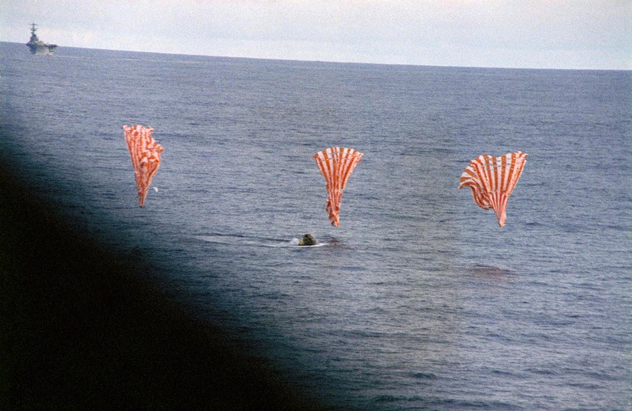
S70-35644 (17 April 1970) --- The Apollo 13 Command Module (CM) splashes down and its three main parachutes collapse, as the week-long problem-plagued Apollo 13 mission comes to a premature, but safe end. The spacecraft, with astronauts James A. Lovell Jr., commander; John L. Swigert Jr., command module pilot; and Fred W. Haise Jr., lunar module pilot, aboard splashed down at 12:07:44 p.m. (CST) April 17, 1970, in the South Pacific Ocean, only about four miles from the USS Iwo Jima, prime recovery ship.
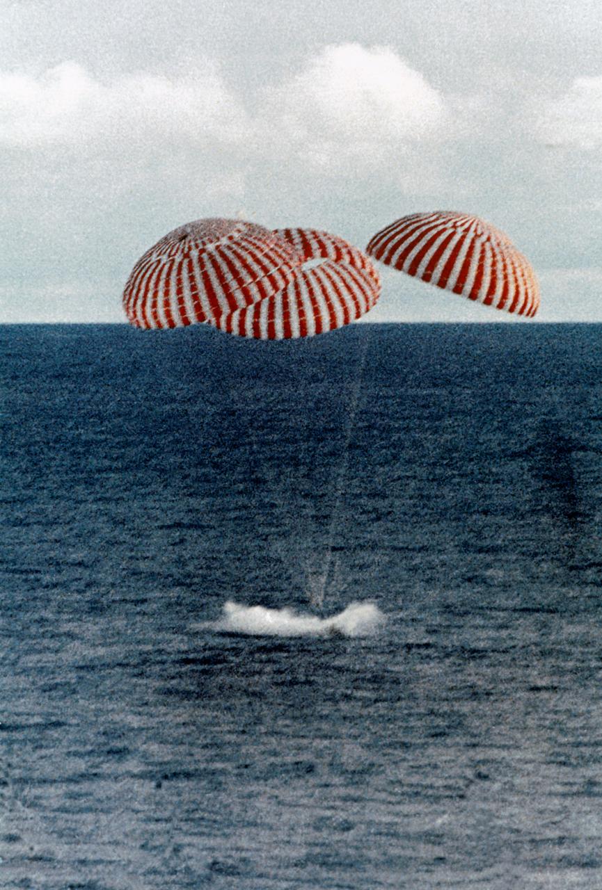
S75-29719 (24 July 1975) --- The ASTP Apollo Command Module, with astronauts Thomas P. Stafford, Vance D. Brand and Donald K. Slayton aboard, nears a touchdown in the Central Pacific Ocean to conclude the historic joint U.S.-USSR Apollo-Soyuz Test Project docking mission in Earth orbit. The spacecraft splashed down in the Hawaiian Islands area at 4:18 p.m. (CDT), July 24, 1975.
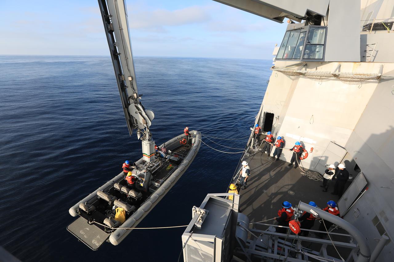
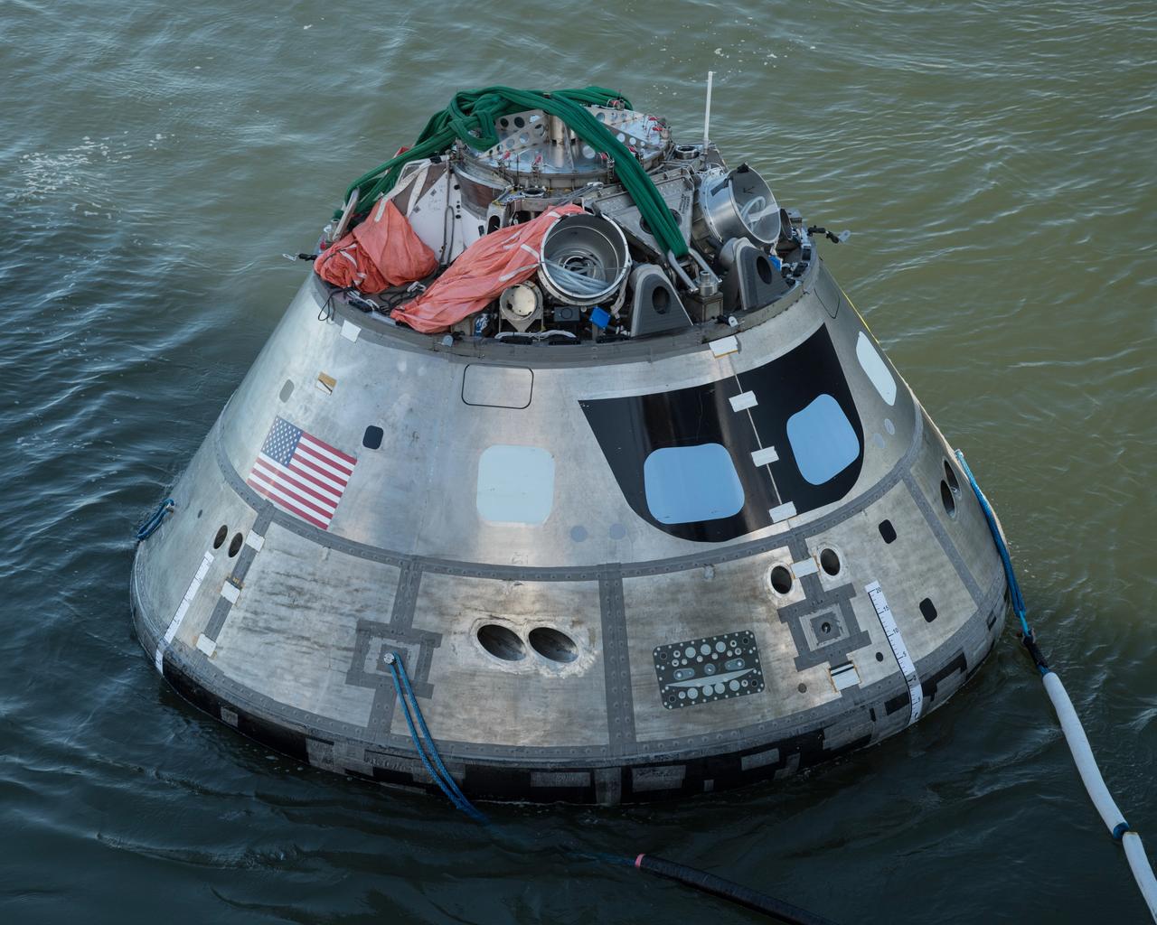
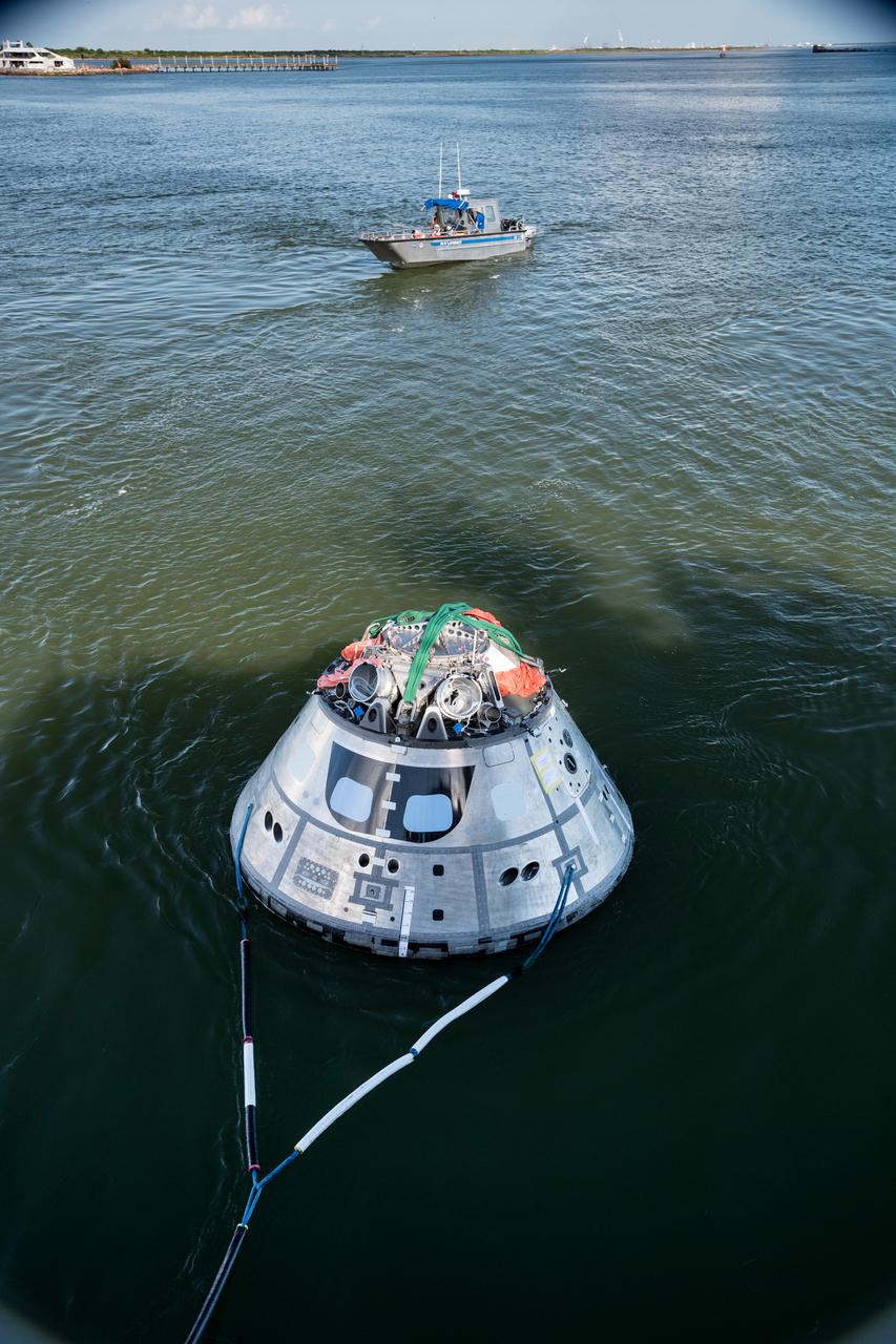
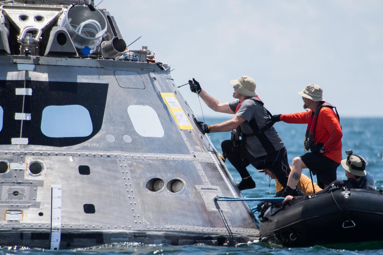
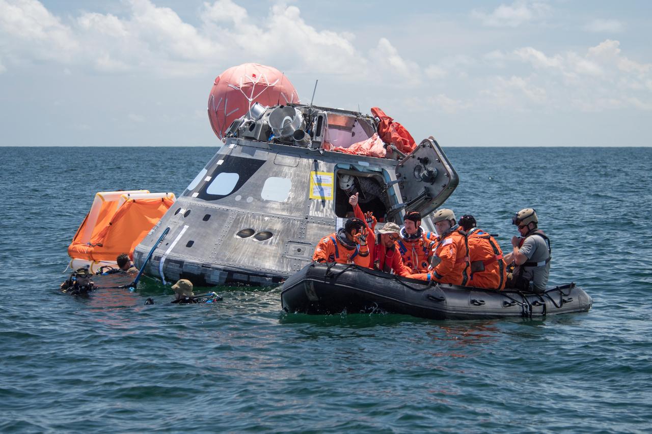
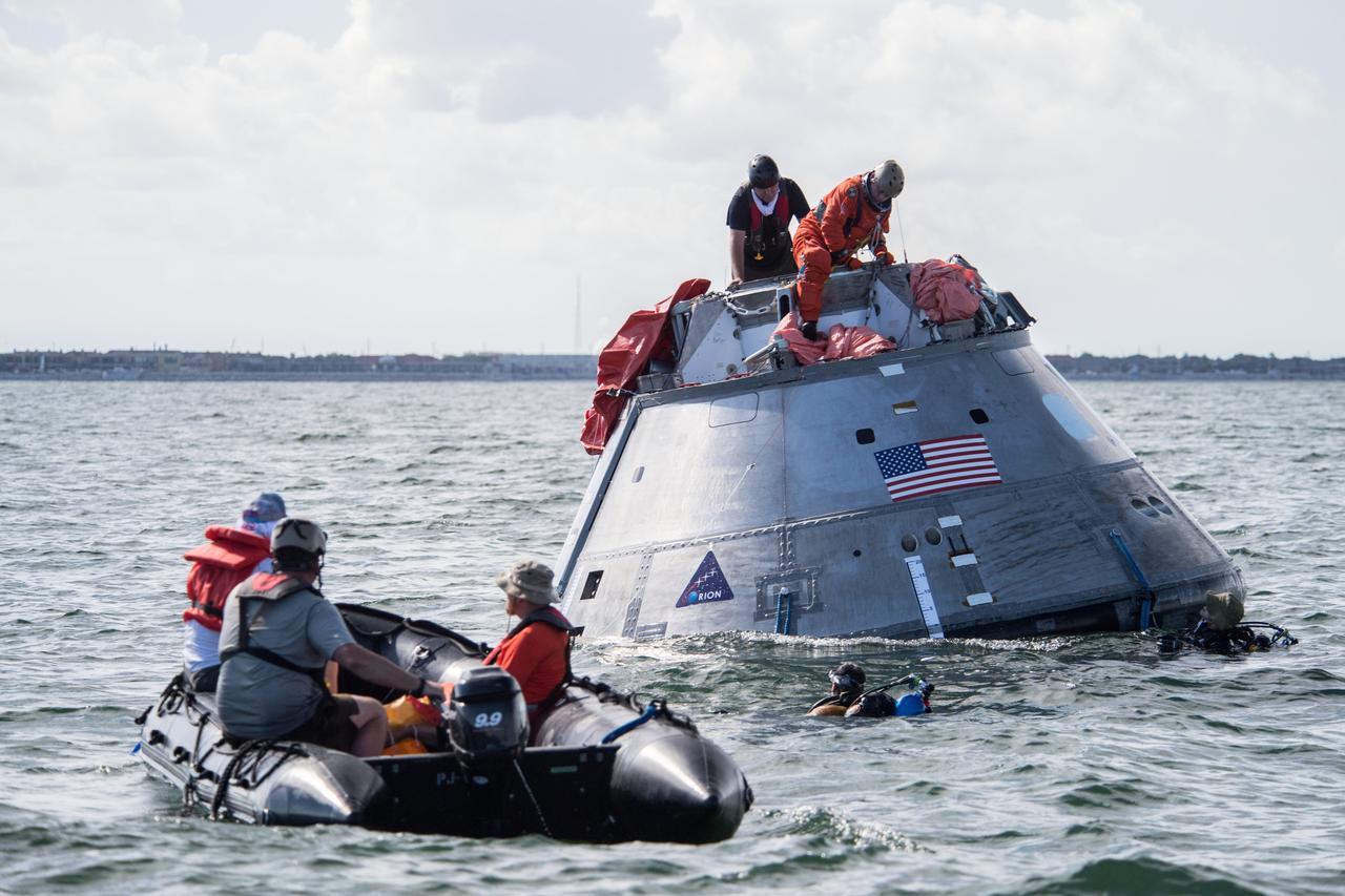
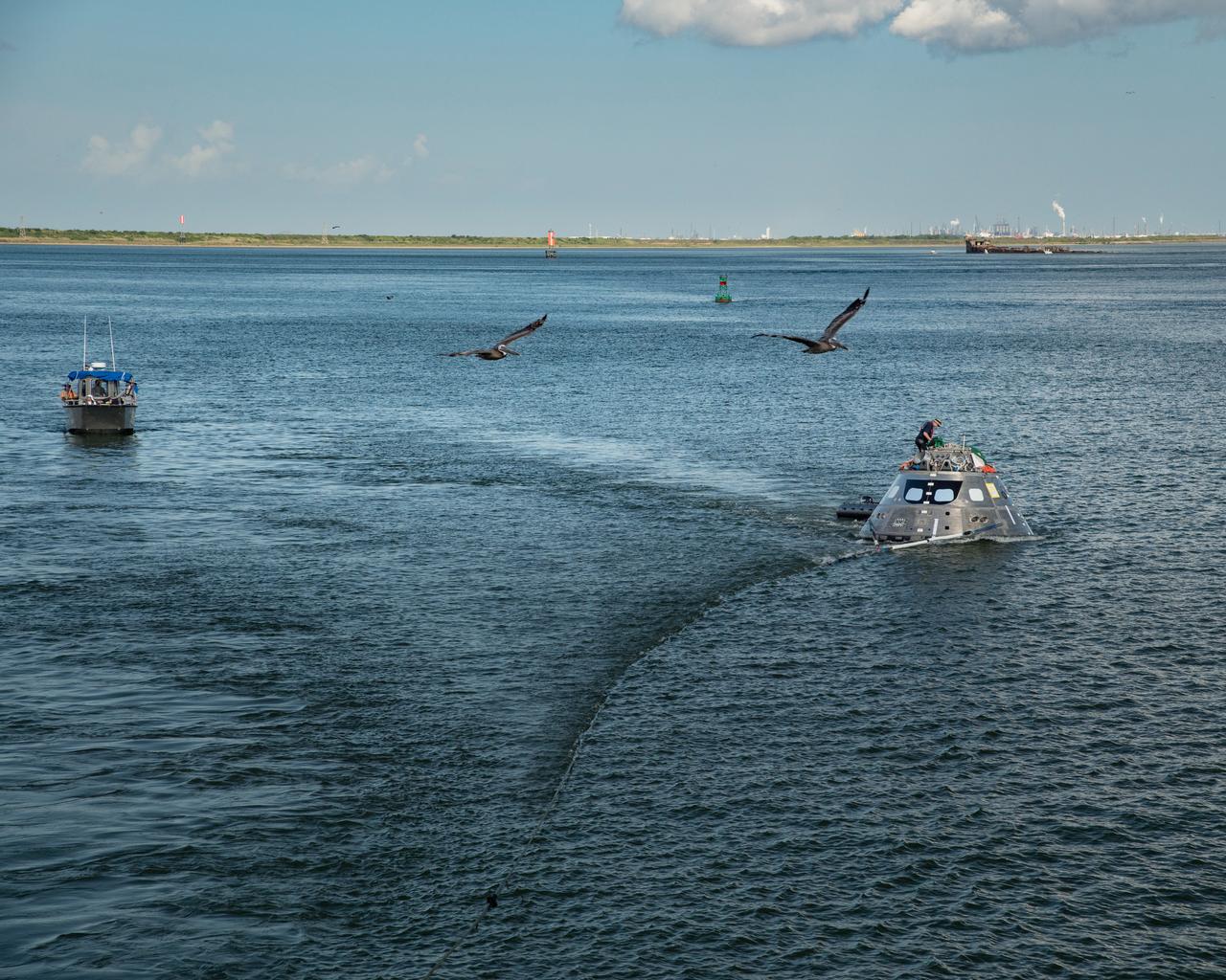
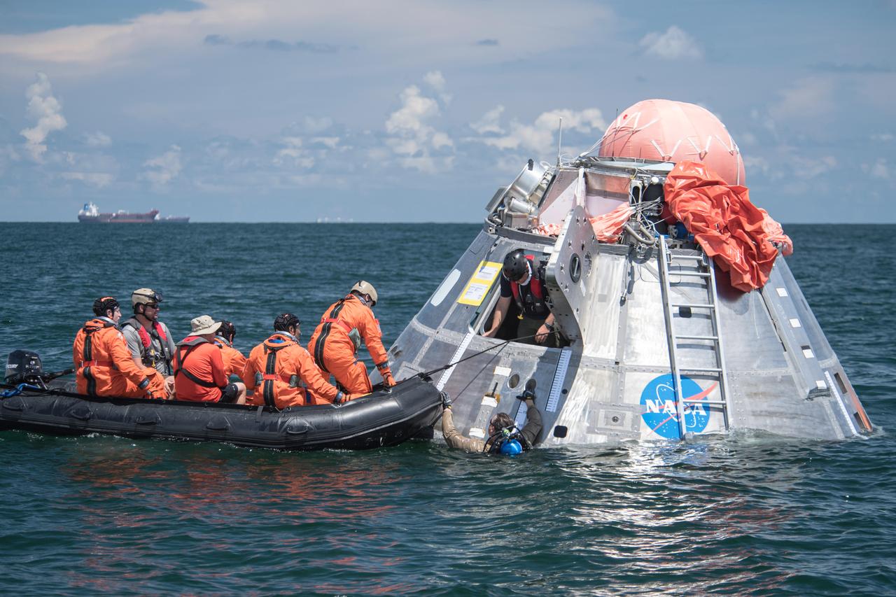
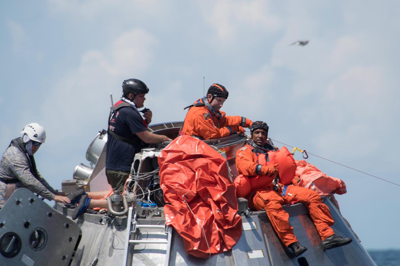
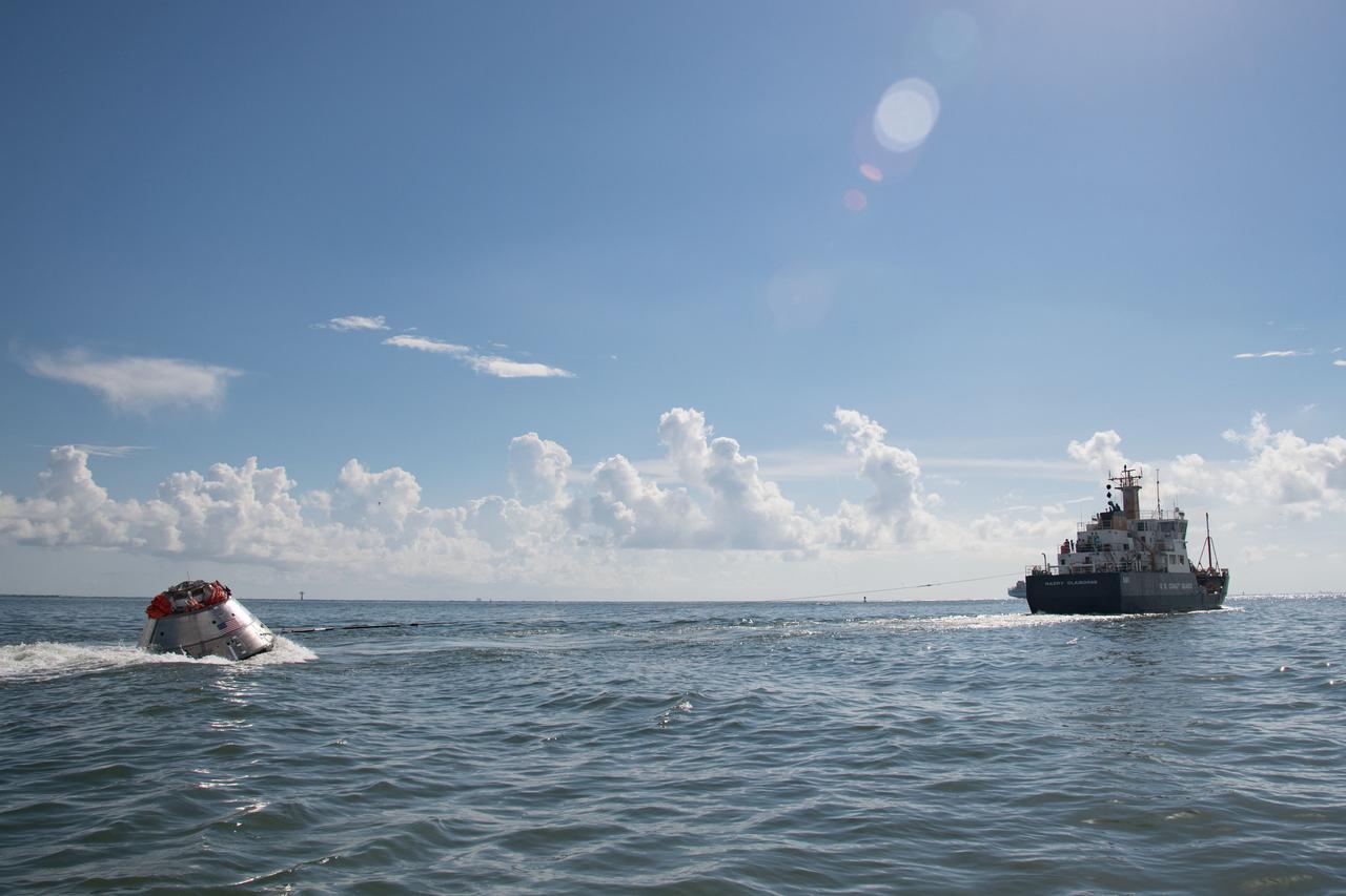
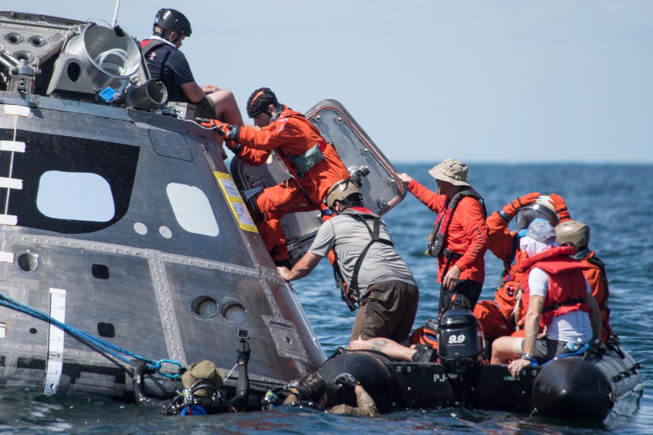
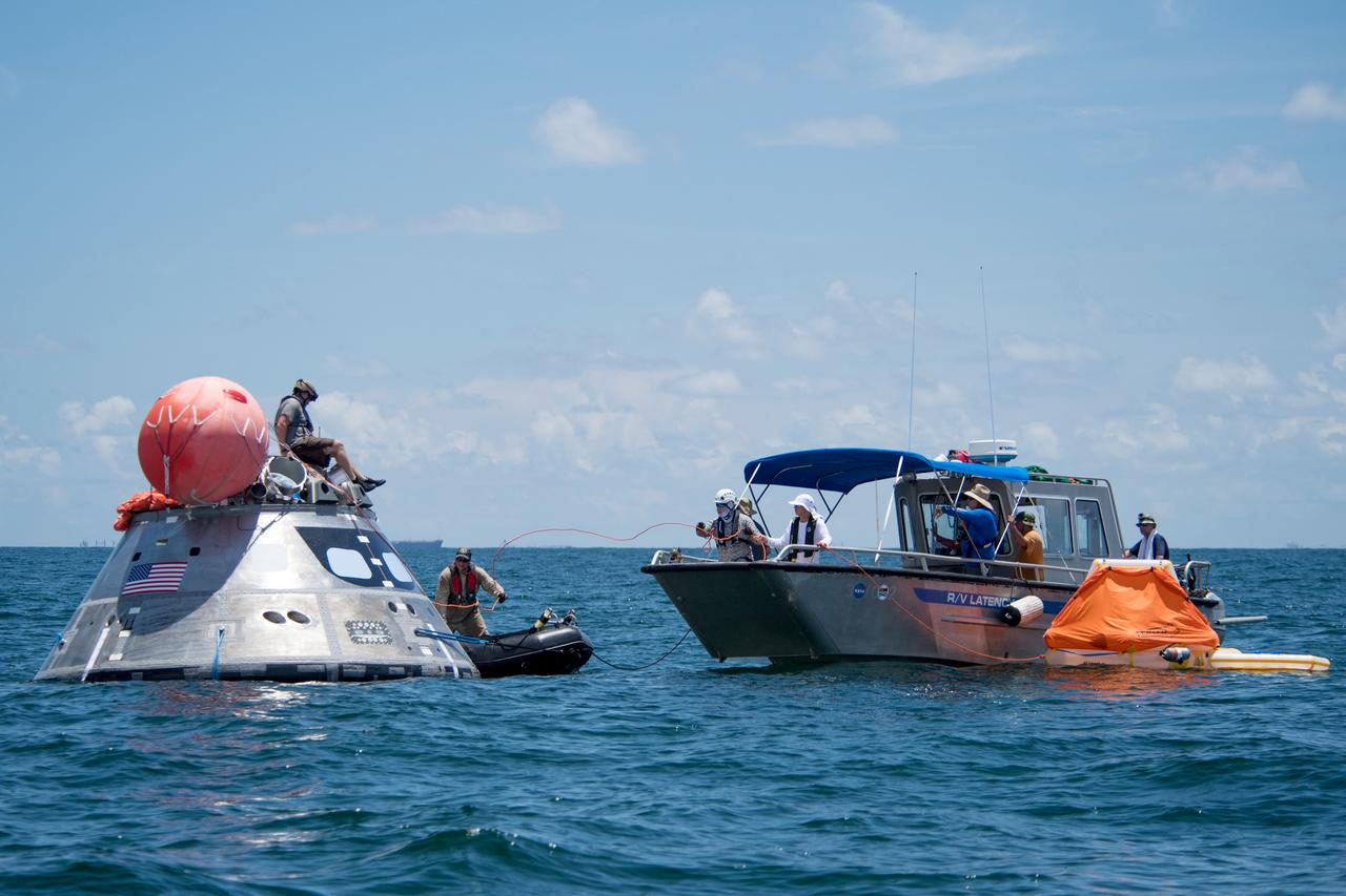
Small boats used by U.S. Navy divers are lowered into the water in preparation for the dive teams to race out to a test version of the Orion capsule during Underway Recovery Test-7 (URT-7), on Oct. 31, 2018, aboard the USS John P. Murtha in the Pacific Ocean. The Exploration Ground Systems (EGS) Landing and Recovery team and the U.S. Navy are using the mock Orion, several rigid hull inflatable boats and support equipment to verify and validate processes, procedures, hardware and personnel during recovery of Orion in open waters. URT-7 is one in a series of tests to verify and validate procedures and hardware that will be used to recover the Orion spacecraft after it splashes down in the Pacific Ocean following deep space exploration missions. Orion will have emergency abort capability, sustain the crew during space travel and provide safe re-entry from deep space return velocities.
SL4-137-3608 (14 Dec. 1973) --- A view of cold water eddies in the Falkland Current off the South Atlantic coast of southern Argentina as seen from the Skylab space station in Earth orbit. This picture was taken by one of the Skylab 4 crewmen using a hand-held 70mm Hasselblad camera. This land area (left corner) extends south along the coast from Puerto Deseado (center left border) for about 50 miles. Within the ocean, several light blue areas are visible and represent the occurrence of plankton with the Falkland Current. Over the ocean, the cold water eddies are identified by the circular cloud-free areas within the cloud street pattern and bordered by cumulus cloud buildup (white). The cloud streets indicate the wind is from the southwest and do not form over eddies because energy form the atmosphere is absorbed by the cold ocean water. On the downwind side of the eddies, cumulus clouds tend to form as the cold moist air flows over the warmer water. Similar cloud and eddy features have been observed by the Skylab 4 crewmen in the Yucatan Current off Yucatan Peninsula and in some parts of the South Pacific. Studies are underway by Dr. George Maul, NOAA, and Dr. Robert Stevenson, ONR, to determine the significance of the cold water eddies to ocean dynamics. Photo credit: NASA
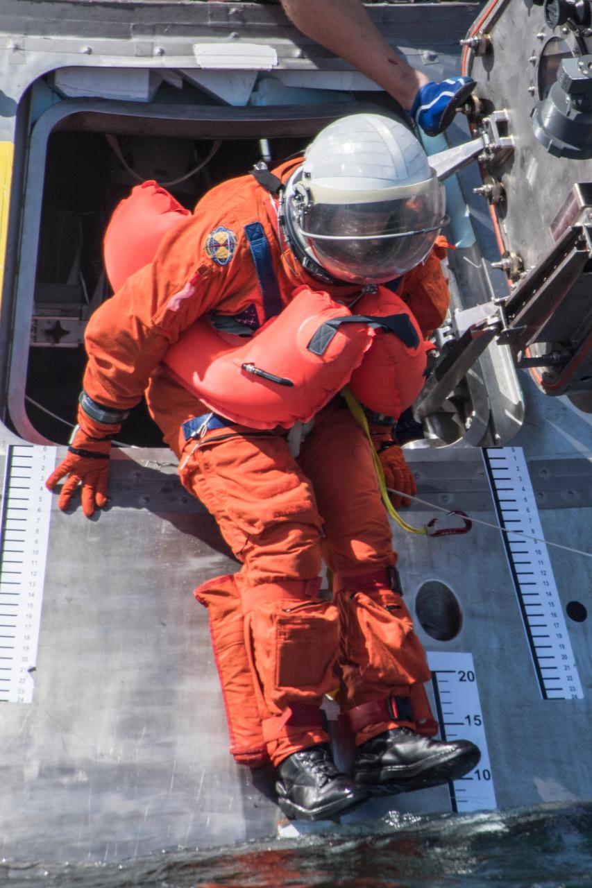
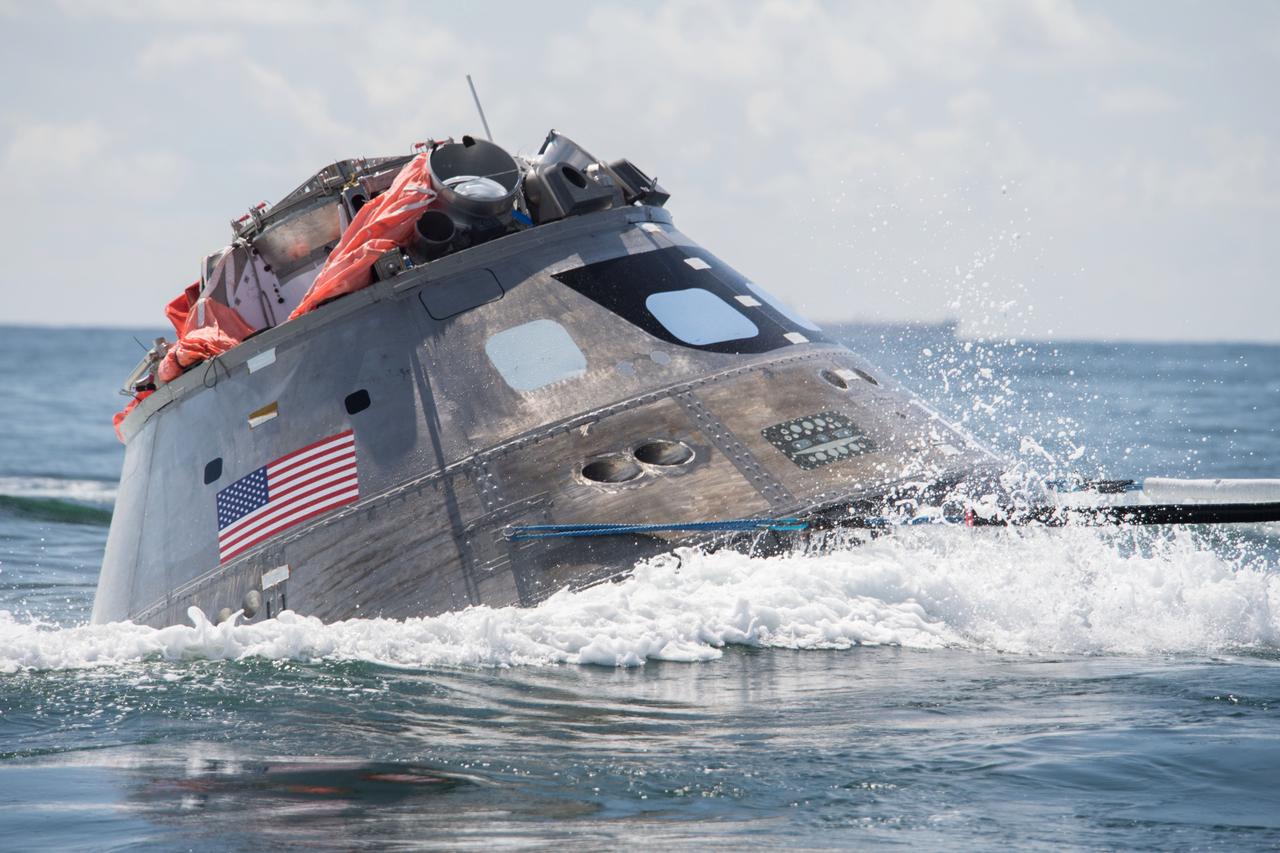
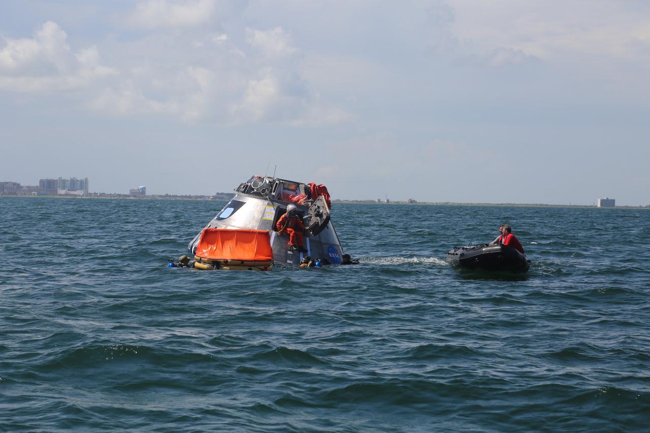
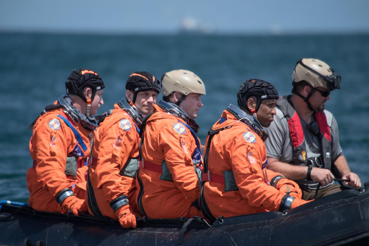
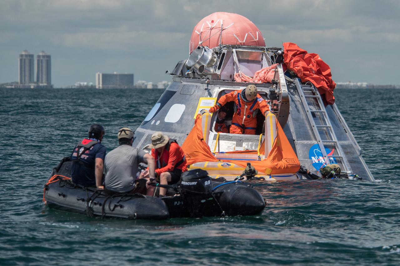
When astronauts return to Earth from destinations beyond the Moon in NASA’s Orion spacecraft and splashdown in the Pacific Ocean, they’ll still need to safely get out of the spacecraft and back on dry land. Using the waters off the coast of Galveston, Texas, a NASA and Department of Defense team test Orion exit procedures in a variety of scenarios on July 11, 2017. Part of Batch images transfer from Flickr.
When astronauts return to Earth from destinations beyond the Moon in NASA’s Orion spacecraft and splashdown in the Pacific Ocean, they’ll still need to safely get out of the spacecraft and back on dry land. Using the waters off the coast of Galveston, Texas, a NASA and Department of Defense team test Orion exit procedures in a variety of scenarios on July 11, 2017. Part of Batch images transfer from Flickr.
When astronauts return to Earth from destinations beyond the Moon in NASA’s Orion spacecraft and splashdown in the Pacific Ocean, they’ll still need to safely get out of the spacecraft and back on dry land. Using the waters off the coast of Galveston, Texas, a NASA and Department of Defense team test Orion exit procedures in a variety of scenarios on July 11, 2017. Part of Batch images transfer from Flickr.
When astronauts return to Earth from destinations beyond the Moon in NASA’s Orion spacecraft and splashdown in the Pacific Ocean, they’ll still need to safely get out of the spacecraft and back on dry land. Using the waters off the coast of Galveston, Texas, a NASA and Department of Defense team test Orion exit procedures in a variety of scenarios on July 11, 2017. Part of Batch images transfer from Flickr.
When astronauts return to Earth from destinations beyond the Moon in NASA’s Orion spacecraft and splashdown in the Pacific Ocean, they’ll still need to safely get out of the spacecraft and back on dry land. Using the waters off the coast of Galveston, Texas, a NASA and Department of Defense team test Orion exit procedures in a variety of scenarios on July 11, 2017. Part of Batch images transfer from Flickr.
When astronauts return to Earth from destinations beyond the Moon in NASA’s Orion spacecraft and splashdown in the Pacific Ocean, they’ll still need to safely get out of the spacecraft and back on dry land. Using the waters off the coast of Galveston, Texas, a NASA and Department of Defense team test Orion exit procedures in a variety of scenarios on July 11, 2017. Part of Batch images transfer from Flickr.
When astronauts return to Earth from destinations beyond the Moon in NASA’s Orion spacecraft and splashdown in the Pacific Ocean, they’ll still need to safely get out of the spacecraft and back on dry land. Using the waters off the coast of Galveston, Texas, a NASA and Department of Defense team test Orion exit procedures in a variety of scenarios on July 11, 2017. Part of Batch images transfer from Flickr.
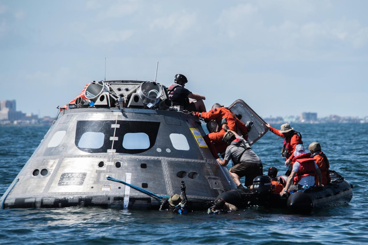
When astronauts return to Earth from destinations beyond the Moon in NASA’s Orion spacecraft and splashdown in the Pacific Ocean, they’ll still need to safely get out of the spacecraft and back on dry land. Using the waters off the coast of Galveston, Texas, a NASA and Department of Defense team test Orion exit procedures in a variety of scenarios on July 11, 2017. Part of Batch images transfer from Flickr.
When astronauts return to Earth from destinations beyond the Moon in NASA’s Orion spacecraft and splashdown in the Pacific Ocean, they’ll still need to safely get out of the spacecraft and back on dry land. Using the waters off the coast of Galveston, Texas, a NASA and Department of Defense team test Orion exit procedures in a variety of scenarios on July 11, 2017. Part of Batch images transfer from Flickr.
When astronauts return to Earth from destinations beyond the Moon in NASA’s Orion spacecraft and splashdown in the Pacific Ocean, they’ll still need to safely get out of the spacecraft and back on dry land. Using the waters off the coast of Galveston, Texas, a NASA and Department of Defense team test Orion exit procedures in a variety of scenarios on July 11, 2017. Part of Batch images transfer from Flickr.
When astronauts return to Earth from destinations beyond the Moon in NASA’s Orion spacecraft and splashdown in the Pacific Ocean, they’ll still need to safely get out of the spacecraft and back on dry land. Using the waters off the coast of Galveston, Texas, a NASA and Department of Defense team test Orion exit procedures in a variety of scenarios on July 11, 2017. Part of Batch images transfer from Flickr.
When astronauts return to Earth from destinations beyond the Moon in NASA’s Orion spacecraft and splashdown in the Pacific Ocean, they’ll still need to safely get out of the spacecraft and back on dry land. Using the waters off the coast of Galveston, Texas, a NASA and Department of Defense team test Orion exit procedures in a variety of scenarios on July 11, 2017. Part of Batch images transfer from Flickr.
When astronauts return to Earth from destinations beyond the Moon in NASA’s Orion spacecraft and splashdown in the Pacific Ocean, they’ll still need to safely get out of the spacecraft and back on dry land. Using the waters off the coast of Galveston, Texas, a NASA and Department of Defense team test Orion exit procedures in a variety of scenarios on July 11, 2017. Part of Batch images transfer from Flickr.
When astronauts return to Earth from destinations beyond the Moon in NASA’s Orion spacecraft and splashdown in the Pacific Ocean, they’ll still need to safely get out of the spacecraft and back on dry land. Using the waters off the coast of Galveston, Texas, a NASA and Department of Defense team test Orion exit procedures in a variety of scenarios on July 11, 2017. Part of Batch images transfer from Flickr.
When astronauts return to Earth from destinations beyond the Moon in NASA’s Orion spacecraft and splashdown in the Pacific Ocean, they’ll still need to safely get out of the spacecraft and back on dry land. Using the waters off the coast of Galveston, Texas, a NASA and Department of Defense team test Orion exit procedures in a variety of scenarios on July 11, 2017. Part of Batch images transfer from Flickr.
When astronauts return to Earth from destinations beyond the Moon in NASA’s Orion spacecraft and splashdown in the Pacific Ocean, they’ll still need to safely get out of the spacecraft and back on dry land. Using the waters off the coast of Galveston, Texas, a NASA and Department of Defense team test Orion exit procedures in a variety of scenarios on July 11, 2017. Part of Batch images transfer from Flickr.
When astronauts return to Earth from destinations beyond the Moon in NASA’s Orion spacecraft and splashdown in the Pacific Ocean, they’ll still need to safely get out of the spacecraft and back on dry land. Using the waters off the coast of Galveston, Texas, a NASA and Department of Defense team test Orion exit procedures in a variety of scenarios on July 11, 2017. Part of Batch images transfer from Flickr.
When astronauts return to Earth from destinations beyond the Moon in NASA’s Orion spacecraft and splashdown in the Pacific Ocean, they’ll still need to safely get out of the spacecraft and back on dry land. Using the waters off the coast of Galveston, Texas, a NASA and Department of Defense team test Orion exit procedures in a variety of scenarios on July 11, 2017. Part of Batch images transfer from Flickr.
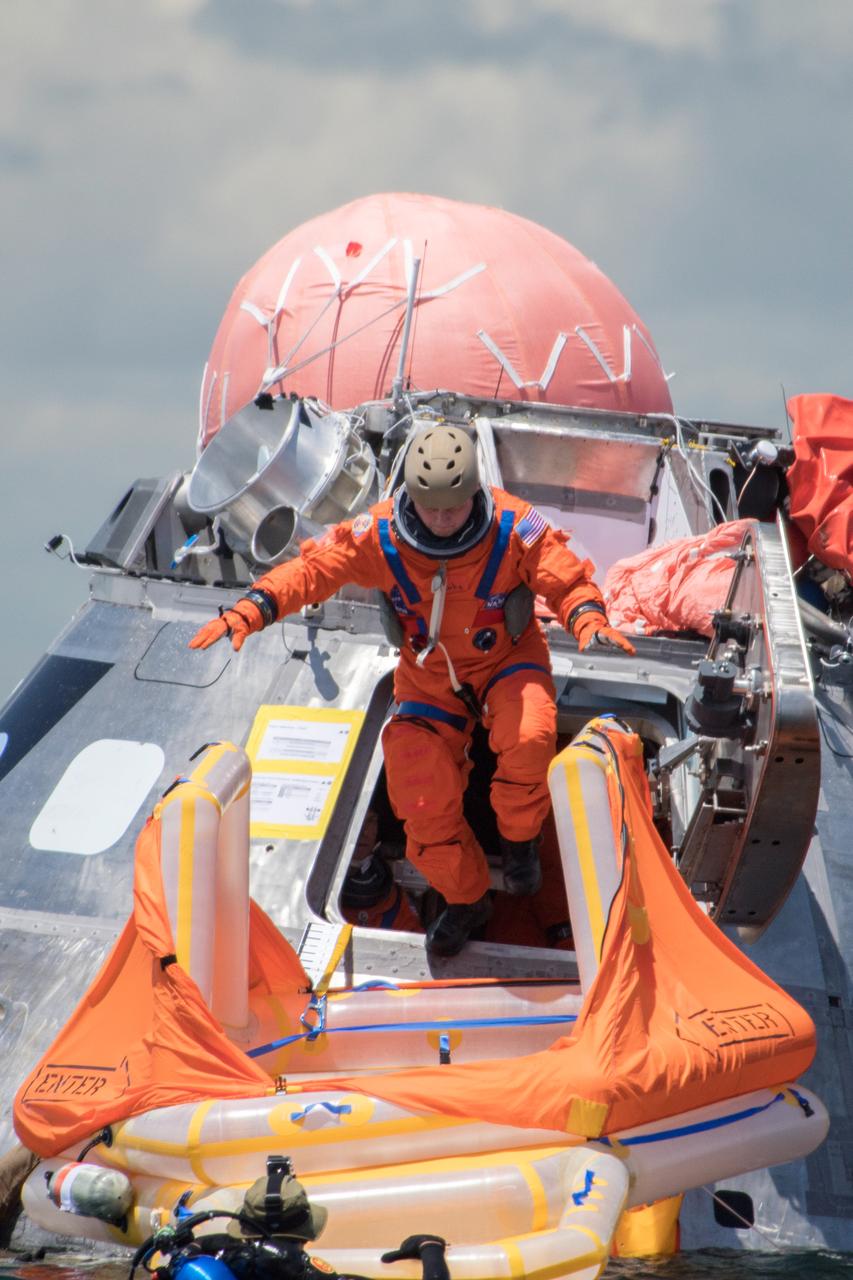
When astronauts return to Earth from destinations beyond the Moon in NASA’s Orion spacecraft and splashdown in the Pacific Ocean, they’ll still need to safely get out of the spacecraft and back on dry land. Using the waters off the coast of Galveston, Texas, a NASA and Department of Defense team test Orion exit procedures in a variety of scenarios on July 11, 2017. Part of Batch images transfer from Flickr.
When astronauts return to Earth from destinations beyond the Moon in NASA’s Orion spacecraft and splashdown in the Pacific Ocean, they’ll still need to safely get out of the spacecraft and back on dry land. Using the waters off the coast of Galveston, Texas, a NASA and Department of Defense team test Orion exit procedures in a variety of scenarios on July 11, 2017. Part of Batch images transfer from Flickr.
When astronauts return to Earth from destinations beyond the Moon in NASA’s Orion spacecraft and splashdown in the Pacific Ocean, they’ll still need to safely get out of the spacecraft and back on dry land. Using the waters off the coast of Galveston, Texas, a NASA and Department of Defense team test Orion exit procedures in a variety of scenarios on July 11, 2017. Part of Batch images transfer from Flickr.
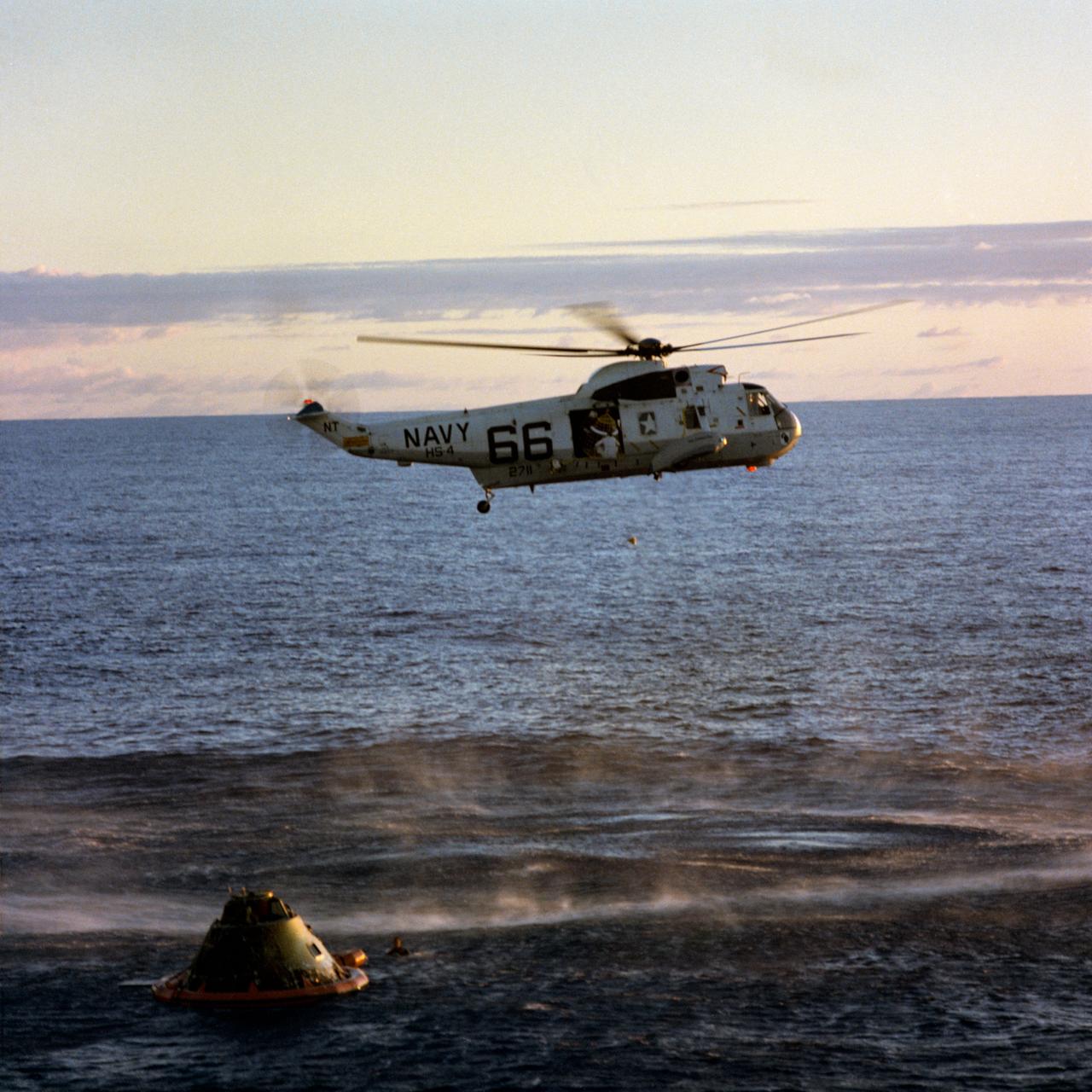
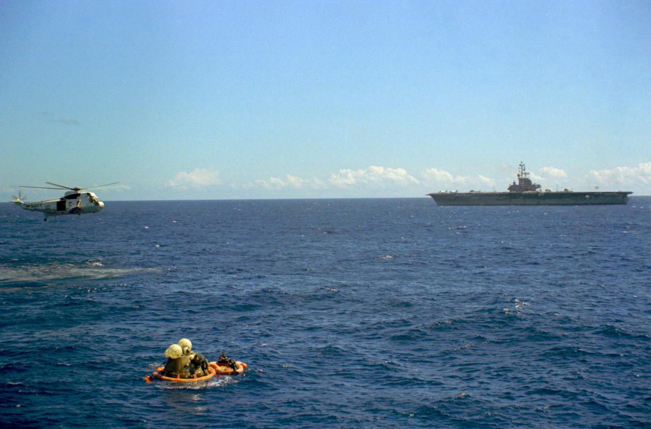
S69-20621 (26 May 1969) --- A member of the Apollo 10 crew is hoisted into a helicopter from the prime recovery ship, USS Princeton, during recovery operations in the South Pacific. Astronauts Thomas P. Stafford, commander; John W. Young, command module pilot; and Eugene A. Cernan, lunar module pilot, were picked up and flown to the deck of the USS Princeton where a red-carpet welcome awaited them. The spacecraft was later retrieved from the water and put aboard the recovery ship. The Apollo 10 splashdown occurred at 11:53 a.m. (CDT), May 26, 1969, about 400 miles east of American Samoa, and about four miles from the recovery ship, to conclude a successful eight-day lunar orbit mission. U.S. Navy underwater demolition team swimmers assisted in the recovery operations.
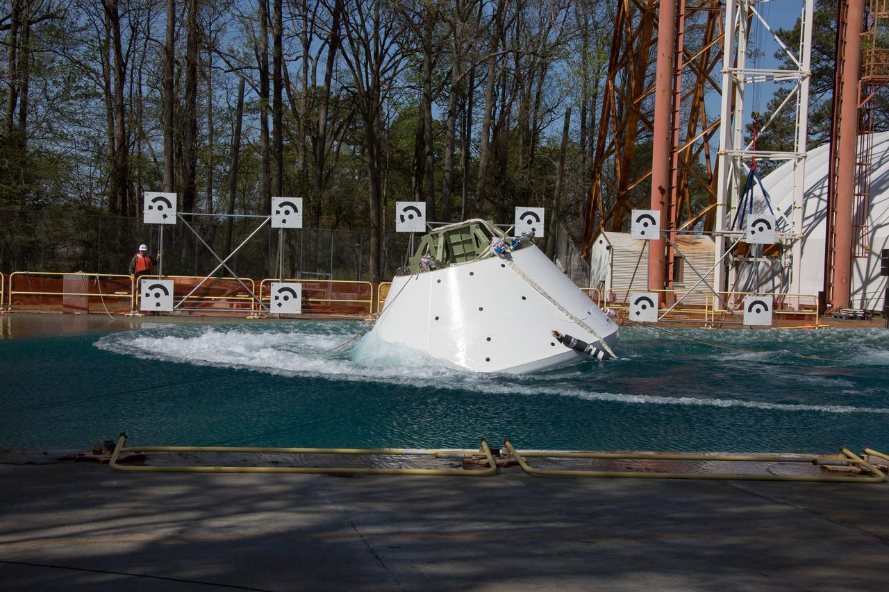
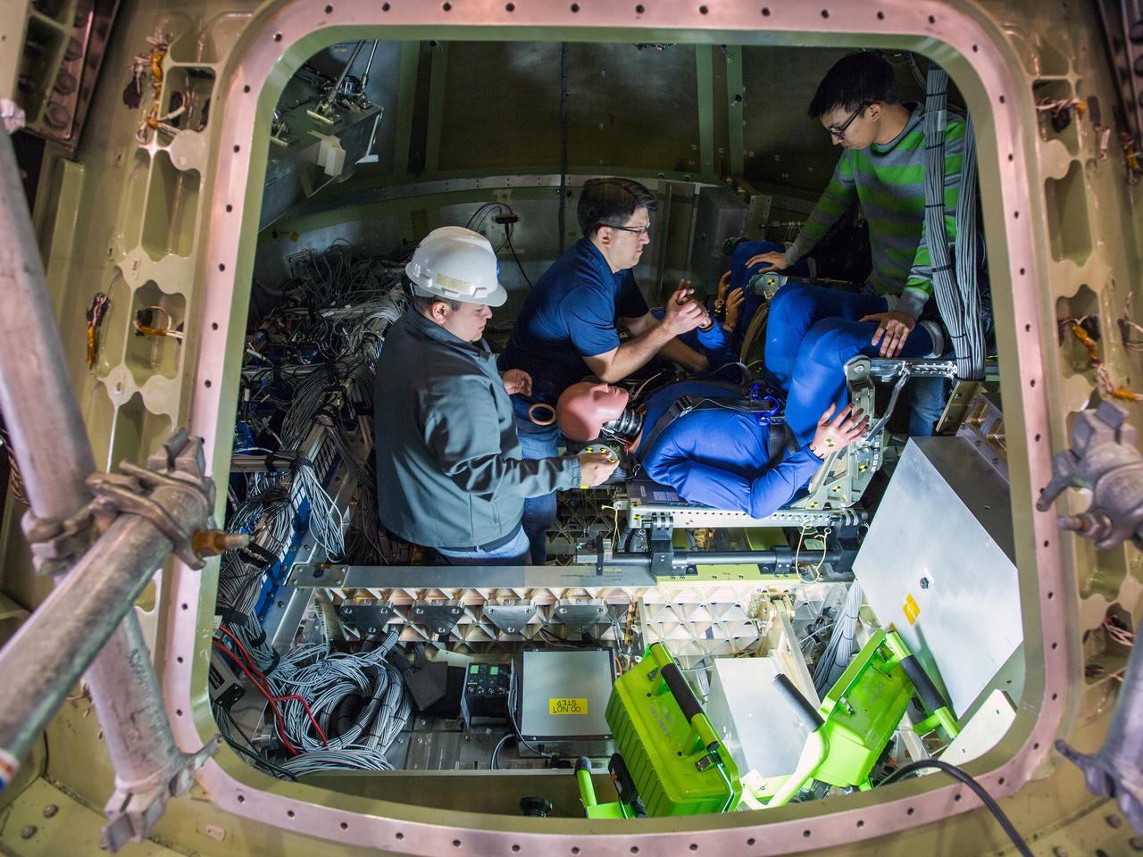
On April 6, 2016, engineers at NASA’s Langley Research Center in Hampton, Virginia, kicked off a series of nine drop tests of a representative Orion crew capsule with crash test dummies inside to understand what the spacecraft and astronauts may experience when landing in the Pacific Ocean after deep-space missions. The high-fidelity capsule, coupled with the heat shield from Orion's first flight in space, was hoisted approximately 16 feet above the water and vertically dropped into Langley’s 20-foot-deep Hydro Impact Basin. The crash test dummies were instrumented to provide data and secured inside the capsule to help provide information engineers need to ensure astronauts will be protected from injury during splashdown. Each test in the series simulates different scenarios for Orion’s parachute-assisted landings, wind conditions, velocities and wave heights the spacecraft may experience when touching down in the ocean.
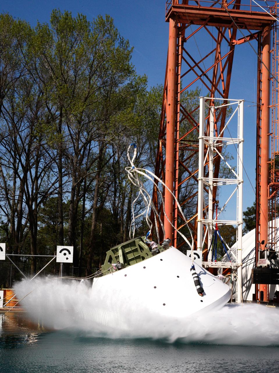
On April 6, 2016, engineers at NASA’s Langley Research Center in Hampton, Virginia, kicked off a series of nine drop tests of a representative Orion crew capsule with crash test dummies inside to understand what the spacecraft and astronauts may experience when landing in the Pacific Ocean after deep-space missions. The high-fidelity capsule, coupled with the heat shield from Orion's first flight in space, was hoisted approximately 16 feet above the water and vertically dropped into Langley’s 20-foot-deep Hydro Impact Basin. The crash test dummies were instrumented to provide data and secured inside the capsule to help provide information engineers need to ensure astronauts will be protected from injury during splashdown. Each test in the series simulates different scenarios for Orion’s parachute-assisted landings, wind conditions, velocities and wave heights the spacecraft may experience when touching down in the ocean.

On April 6, 2016, engineers at NASA’s Langley Research Center in Hampton, Virginia, kicked off a series of nine drop tests of a representative Orion crew capsule with crash test dummies inside to understand what the spacecraft and astronauts may experience when landing in the Pacific Ocean after deep-space missions. The high-fidelity capsule, coupled with the heat shield from Orion's first flight in space, was hoisted approximately 16 feet above the water and vertically dropped into Langley’s 20-foot-deep Hydro Impact Basin. The crash test dummies were instrumented to provide data and secured inside the capsule to help provide information engineers need to ensure astronauts will be protected from injury during splashdown. Each test in the series simulates different scenarios for Orion’s parachute-assisted landings, wind conditions, velocities and wave heights the spacecraft may experience when touching down in the ocean.
On April 6, 2016, engineers at NASA’s Langley Research Center in Hampton, Virginia, kicked off a series of nine drop tests of a representative Orion crew capsule with crash test dummies inside to understand what the spacecraft and astronauts may experience when landing in the Pacific Ocean after deep-space missions. The high-fidelity capsule, coupled with the heat shield from Orion's first flight in space, was hoisted approximately 16 feet above the water and vertically dropped into Langley’s 20-foot-deep Hydro Impact Basin. The crash test dummies were instrumented to provide data and secured inside the capsule to help provide information engineers need to ensure astronauts will be protected from injury during splashdown. Each test in the series simulates different scenarios for Orion’s parachute-assisted landings, wind conditions, velocities and wave heights the spacecraft may experience when touching down in the ocean.
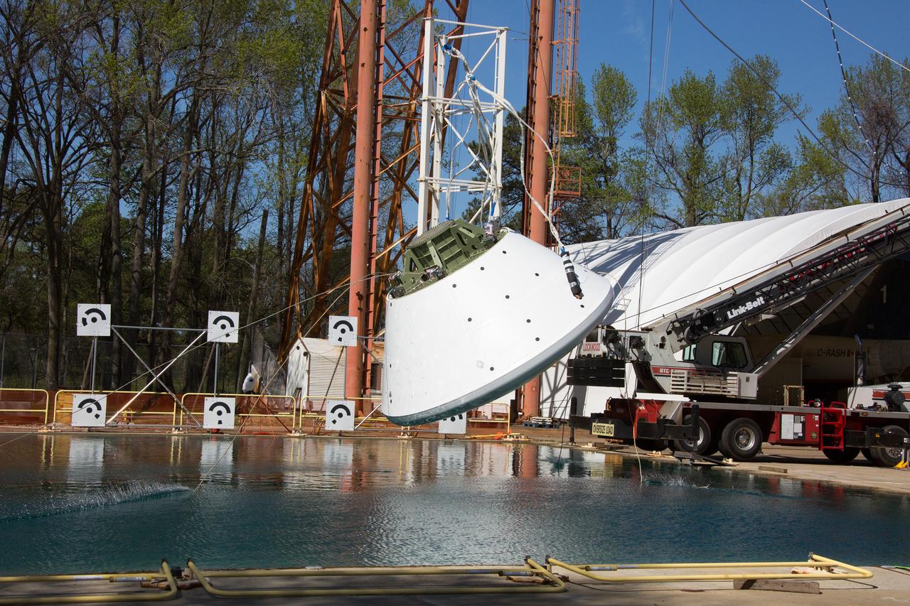
On April 6, 2016, engineers at NASA’s Langley Research Center in Hampton, Virginia, kicked off a series of nine drop tests of a representative Orion crew capsule with crash test dummies inside to understand what the spacecraft and astronauts may experience when landing in the Pacific Ocean after deep-space missions. The high-fidelity capsule, coupled with the heat shield from Orion's first flight in space, was hoisted approximately 16 feet above the water and vertically dropped into Langley’s 20-foot-deep Hydro Impact Basin. The crash test dummies were instrumented to provide data and secured inside the capsule to help provide information engineers need to ensure astronauts will be protected from injury during splashdown. Each test in the series simulates different scenarios for Orion’s parachute-assisted landings, wind conditions, velocities and wave heights the spacecraft may experience when touching down in the ocean.
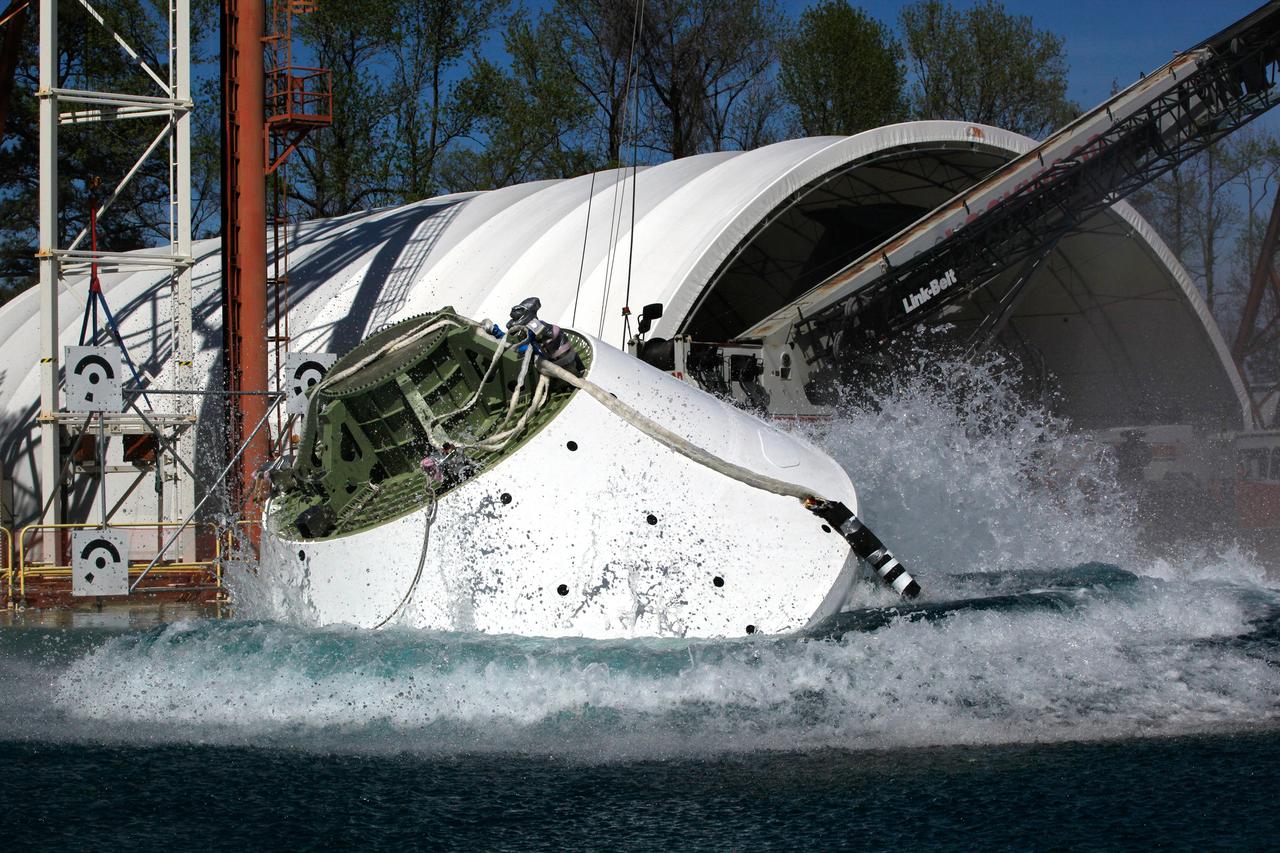
On April 6, 2016, engineers at NASA’s Langley Research Center in Hampton, Virginia, kicked off a series of nine drop tests of a representative Orion crew capsule with crash test dummies inside to understand what the spacecraft and astronauts may experience when landing in the Pacific Ocean after deep-space missions. The high-fidelity capsule, coupled with the heat shield from Orion's first flight in space, was hoisted approximately 16 feet above the water and vertically dropped into Langley’s 20-foot-deep Hydro Impact Basin. The crash test dummies were instrumented to provide data and secured inside the capsule to help provide information engineers need to ensure astronauts will be protected from injury during splashdown. Each test in the series simulates different scenarios for Orion’s parachute-assisted landings, wind conditions, velocities and wave heights the spacecraft may experience when touching down in the ocean.
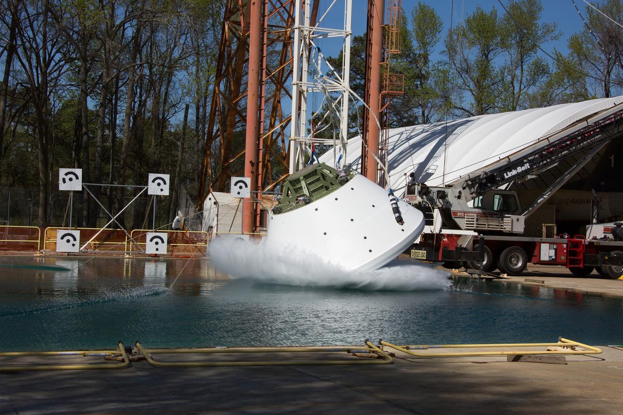
On April 6, 2016, engineers at NASA’s Langley Research Center in Hampton, Virginia, kicked off a series of nine drop tests of a representative Orion crew capsule with crash test dummies inside to understand what the spacecraft and astronauts may experience when landing in the Pacific Ocean after deep-space missions. The high-fidelity capsule, coupled with the heat shield from Orion's first flight in space, was hoisted approximately 16 feet above the water and vertically dropped into Langley’s 20-foot-deep Hydro Impact Basin. The crash test dummies were instrumented to provide data and secured inside the capsule to help provide information engineers need to ensure astronauts will be protected from injury during splashdown. Each test in the series simulates different scenarios for Orion’s parachute-assisted landings, wind conditions, velocities and wave heights the spacecraft may experience when touching down in the ocean.
On April 6, 2016, engineers at NASA’s Langley Research Center in Hampton, Virginia, kicked off a series of nine drop tests of a representative Orion crew capsule with crash test dummies inside to understand what the spacecraft and astronauts may experience when landing in the Pacific Ocean after deep-space missions. The high-fidelity capsule, coupled with the heat shield from Orion's first flight in space, was hoisted approximately 16 feet above the water and vertically dropped into Langley’s 20-foot-deep Hydro Impact Basin. The crash test dummies were instrumented to provide data and secured inside the capsule to help provide information engineers need to ensure astronauts will be protected from injury during splashdown. Each test in the series simulates different scenarios for Orion’s parachute-assisted landings, wind conditions, velocities and wave heights the spacecraft may experience when touching down in the ocean.
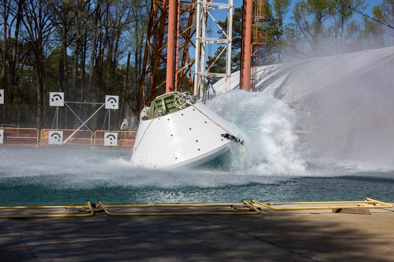
On April 6, 2016, engineers at NASA’s Langley Research Center in Hampton, Virginia, kicked off a series of nine drop tests of a representative Orion crew capsule with crash test dummies inside to understand what the spacecraft and astronauts may experience when landing in the Pacific Ocean after deep-space missions. The high-fidelity capsule, coupled with the heat shield from Orion's first flight in space, was hoisted approximately 16 feet above the water and vertically dropped into Langley’s 20-foot-deep Hydro Impact Basin. The crash test dummies were instrumented to provide data and secured inside the capsule to help provide information engineers need to ensure astronauts will be protected from injury during splashdown. Each test in the series simulates different scenarios for Orion’s parachute-assisted landings, wind conditions, velocities and wave heights the spacecraft may experience when touching down in the ocean.
On April 6, 2016, engineers at NASA’s Langley Research Center in Hampton, Virginia, kicked off a series of nine drop tests of a representative Orion crew capsule with crash test dummies inside to understand what the spacecraft and astronauts may experience when landing in the Pacific Ocean after deep-space missions. The high-fidelity capsule, coupled with the heat shield from Orion's first flight in space, was hoisted approximately 16 feet above the water and vertically dropped into Langley’s 20-foot-deep Hydro Impact Basin. The crash test dummies were instrumented to provide data and secured inside the capsule to help provide information engineers need to ensure astronauts will be protected from injury during splashdown. Each test in the series simulates different scenarios for Orion’s parachute-assisted landings, wind conditions, velocities and wave heights the spacecraft may experience when touching down in the ocean.
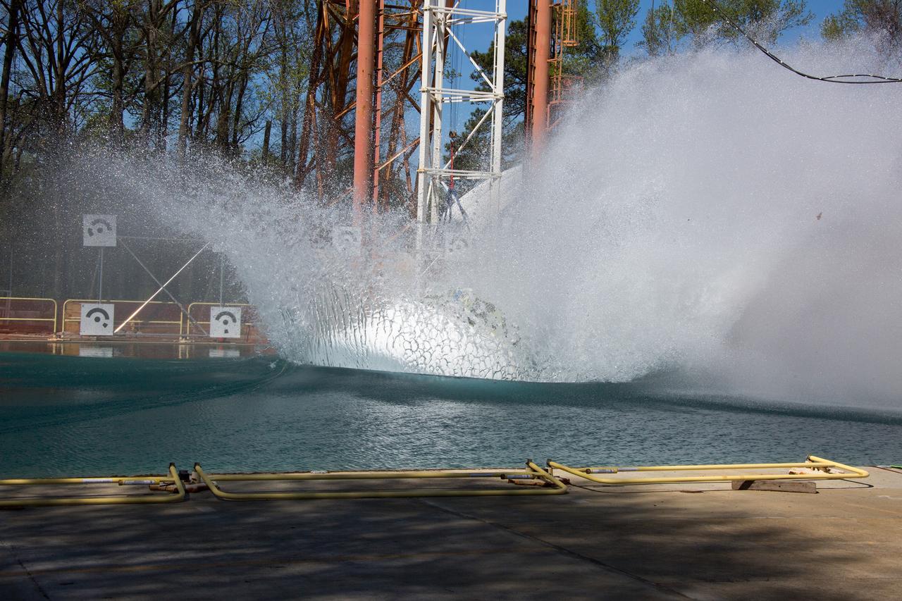
On April 6, 2016, engineers at NASA’s Langley Research Center in Hampton, Virginia, kicked off a series of nine drop tests of a representative Orion crew capsule with crash test dummies inside to understand what the spacecraft and astronauts may experience when landing in the Pacific Ocean after deep-space missions. The high-fidelity capsule, coupled with the heat shield from Orion's first flight in space, was hoisted approximately 16 feet above the water and vertically dropped into Langley’s 20-foot-deep Hydro Impact Basin. The crash test dummies were instrumented to provide data and secured inside the capsule to help provide information engineers need to ensure astronauts will be protected from injury during splashdown. Each test in the series simulates different scenarios for Orion’s parachute-assisted landings, wind conditions, velocities and wave heights the spacecraft may experience when touching down in the ocean.
S66-38070 (5 June 1966) --- Northwestern Mexico as seen from the Gemini-9A spacecraft during its 32nd revolution of Earth. The large penisula is Baja California. The body of water at lower right is the Pacific Ocean. The land mass at upper left is the State of Sonora. The Gulf of California separates Sonora from the peninsula. The nose of the spacecraft is at left; and at right is the open hatch of the spacecraft. Astronaut Eugene A. Cernan, pilot, took this picture with his modified 70mm Hasselblad EVA camera, using Eastman Kodak, Ektachrome, MS (S.O. 217) color film. Photo credit: NASA
ISS006-E-51456 (2003) --- Marias Islands, Mexico is featured in this image photographed by an Expedition Six crewmember on the International Space Station. The view shows the land-sea interactions along a section of Mexico's west coast just south of Mazatlan and the Isla Marias archipelago. The islands are a manifestation of intersecting plate boundaries -- the East Pacific Rise spreading center that traces south from the Gulf of California, and the subduction zone that consumes the Cocos plate beneath southern Mexico. These islands are biologically important: they comprise the Islas Marias Biosphere Reserve and contain endemic species of raccoons and rabbits, and important habitat for birds and marine life. Between the islands and the mainland, swirling surface currents are highlighted by the sun glint reflecting off the ocean surface. Along the Mexican coast, water flows out from a coastal lagoon, and near shore currents carry sediment (light colored water) along the beach front.
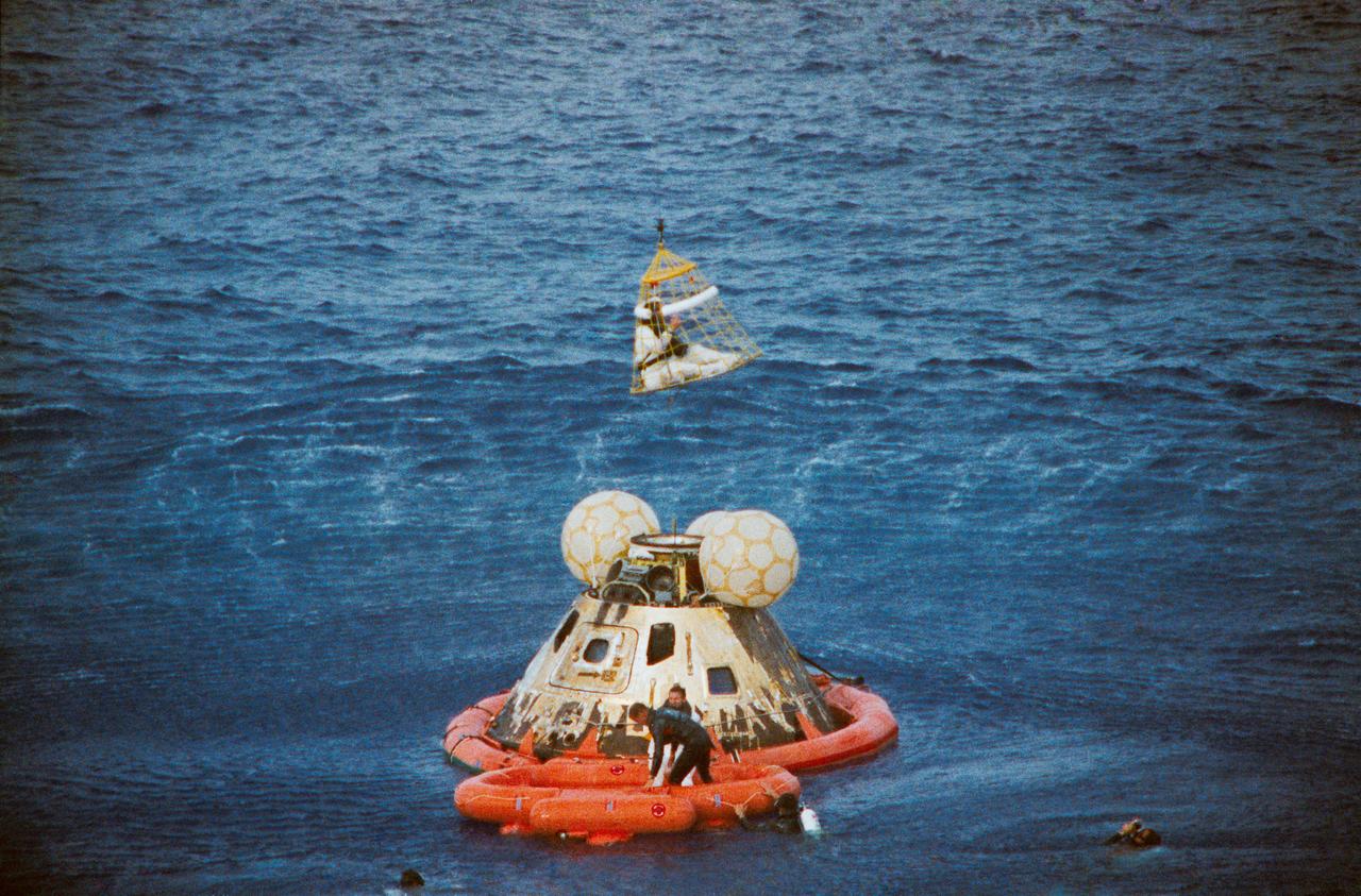
S70-35651 (17 April 1970) --- Astronaut John L. Swigert Jr., command module pilot, is lifted aboard a helicopter in a "Billy Pugh" net while astronaut James A. Lovell Jr., commander, awaits his turn. Astronaut Fred W. Haise Jr., lunar module pilot, is already aboard the helicopter. In the life raft with Lovell, and in the water are several U.S. Navy underwater demolition team swimmers, who assisted in the recovery operations. The crew was taken to the USS Iwo Jima, prime recovery ship, several minutes after the Apollo 13 spacecraft splashed down at 12:07:44 p.m. (CST), April 17, 1970.
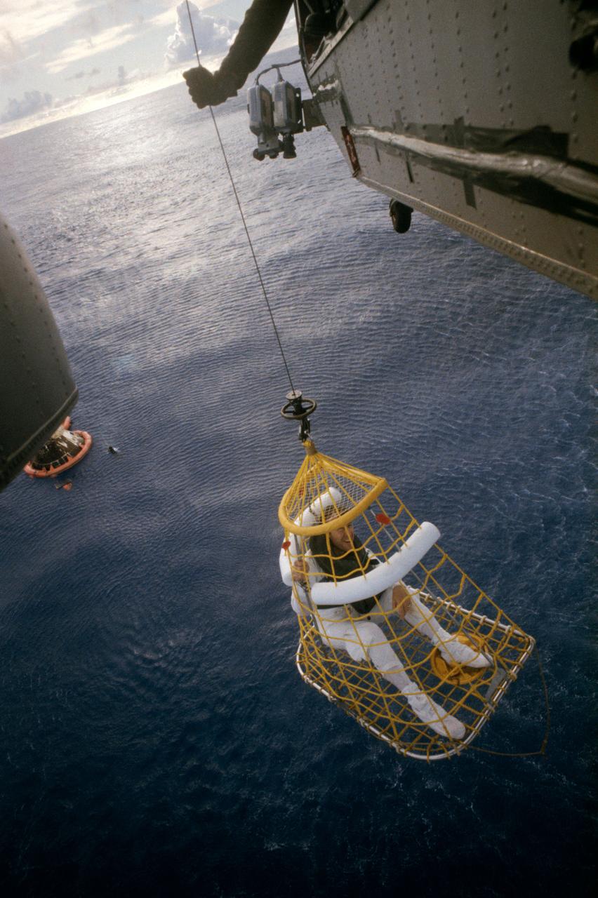
S70-35625 (17 April 1970) --- Astronaut Fred W. Haise Jr., lunar module pilot, is hoisted in a "Billy Pugh" net into a Navy helicopter, while United States Navy underwater demolition team swimmers assist in the recovery operations of the Apollo 13 crewmembers. Astronauts John L. Swigert Jr., command module pilot, and James A. Lovell Jr., commander, are waiting to get hoisted into the helicopter. The helicopter is taking the astronauts to the prime recovery ship, the USS Iwo Jima. Apollo 13 splashed down at 12:07:44 p.m. (CST), April 17, 1970.
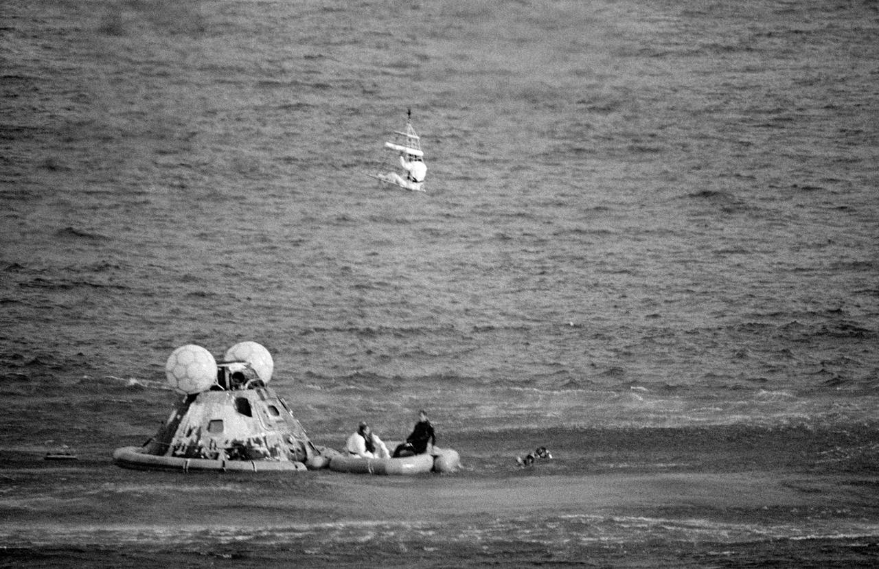
S70-35645 (17 April 1970) --- Astronaut James A. Lovell Jr., commander, is hoisted aboard a helicopter from the USS Iwo Jima, prime recovery vessel for the mission. Lovell was the last of the three Apollo 13 crewmembers to egress the Command Module (CM) and the last to be lifted aboard the helicopter. He was preceded by astronauts John L. Swigert Jr., command module pilot; and Fred W. Haise Jr., lunar module pilot. The CM and a U.S. Navy underwater demolition team swimmer can be seen in the ocean background. Apollo 13 splashed down at 12:07:44 p.m. (CST), April 17, 1970.
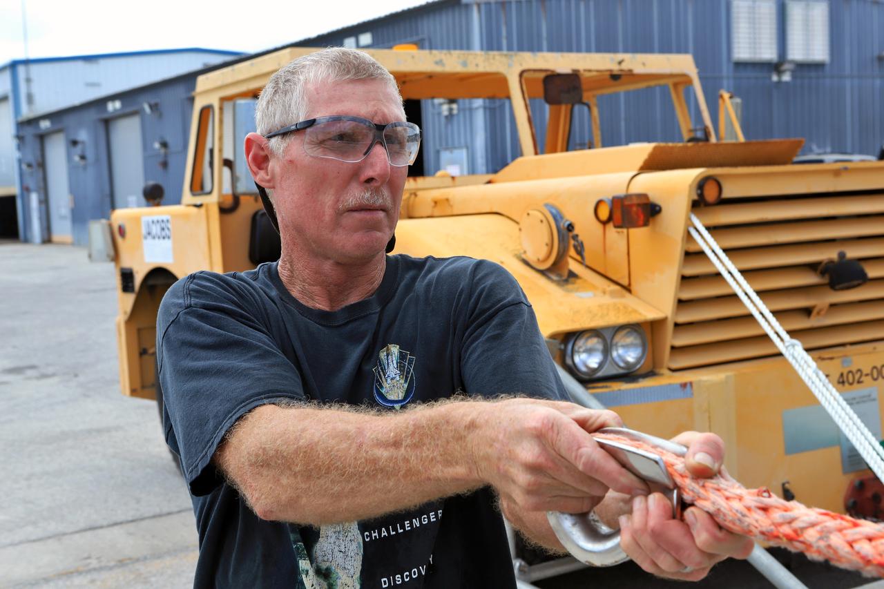
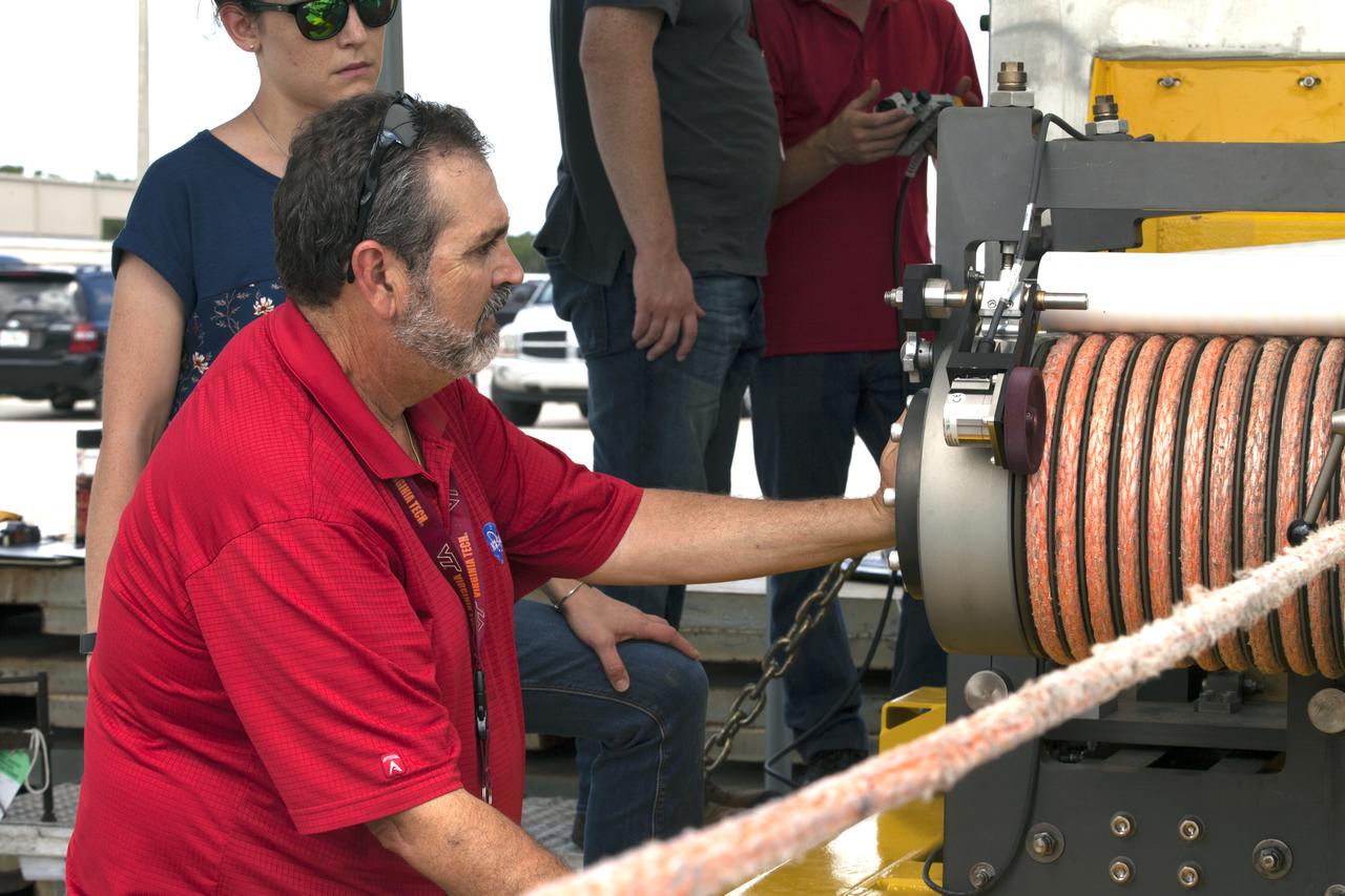
Orion Landing and Recovery team member John Stirling, with Jacobs, practices using a winch to prepare for Underway Recovery Test 7 ( URT-7) on Sept. 5, 2018, in the heavy equipment yard at NASA's Kennedy Space Center in Florida. During URT-7, the recovery team, including Exploration Ground Systems and the U.S. Navy, will practice recovering a test version of the Orion crew module in the Pacific Ocean, off the coast of California, and guiding it into the well deck of a ship. Over several days, the team will demonstrate and evaluate new recovery processes, procedures, hardware and personnel in open waters. Orion is the exploration spacecraft designed to carry astronauts to deep space destinations, including the Moon and on to Mars. Orion will have emergency abort capability, sustain the crew during space travel and provide safe re-entry from deep space return velocities.
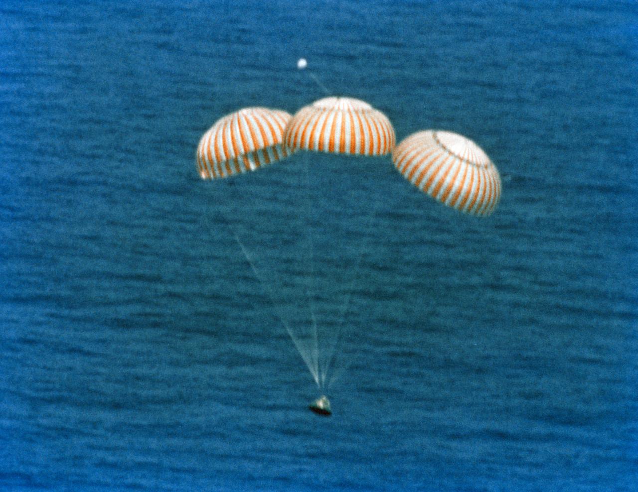
S72-55834 (19 Dec. 1972) --- The Apollo 17 Command Module (CM), with astronauts Eugene A. Cernan, Ronald E. Evans and Harrison H. Schmitt aboard, nears splashdown in the South Pacific Ocean to successfully concludes the final lunar landing mission in NASA's Apollo program. This overhead view was taken from a recovery aircraft seconds before the spacecraft hit the water. The splashdown occurred at 304:31:59 ground elapsed time, 1:24:59 p.m. (CST) Dec. 19, 1972, at coordinates of 166 degrees 8 minutes west longitude and 27 degrees 53 minutes south latitude, about 350 nautical miles southeast of the Samoan Islands. The splashdown was only .8 miles from the target point. Later, the three crewmen were picked up by a helicopter from the prime recovery ship, USS Ticonderoga.
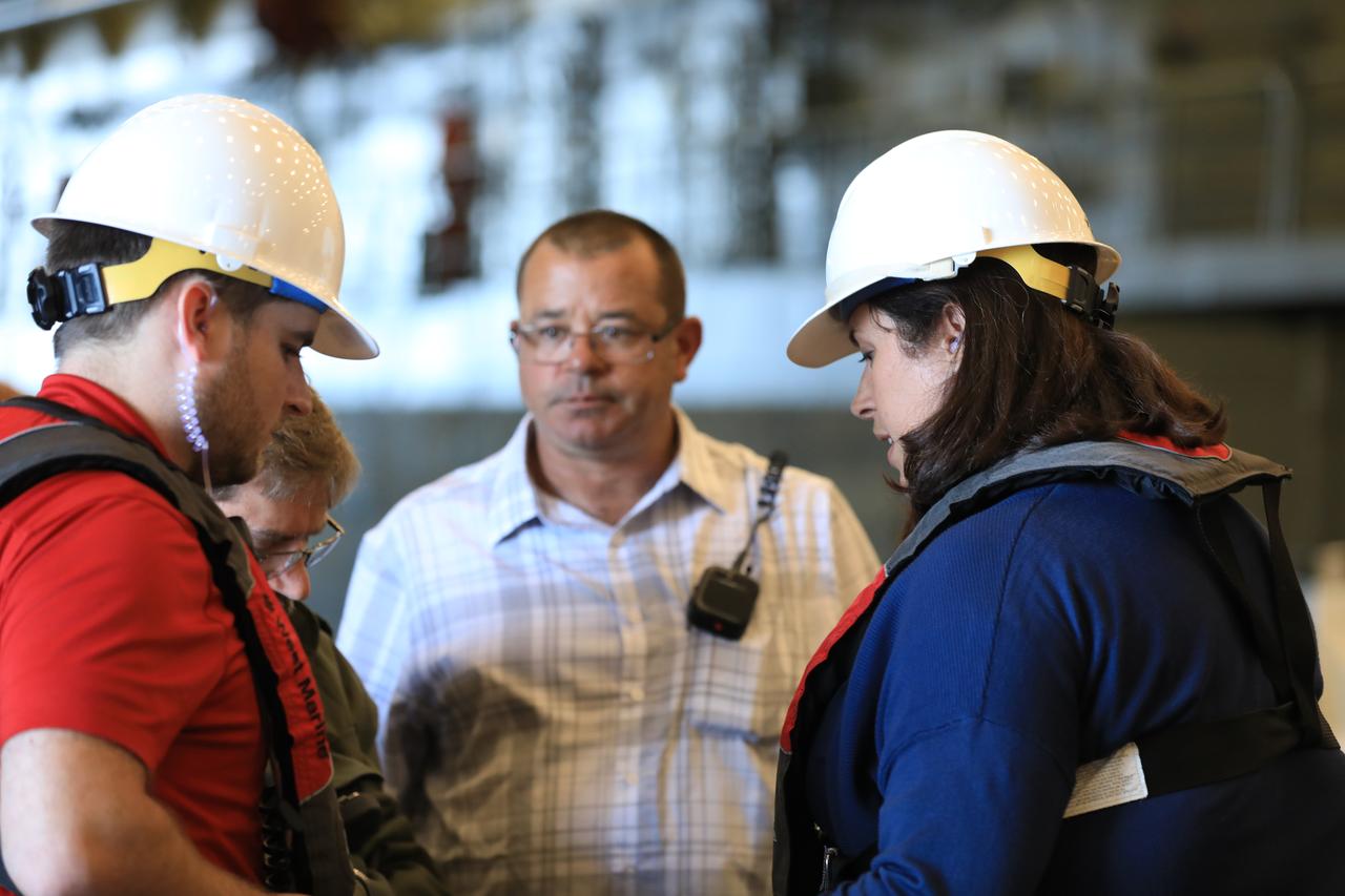
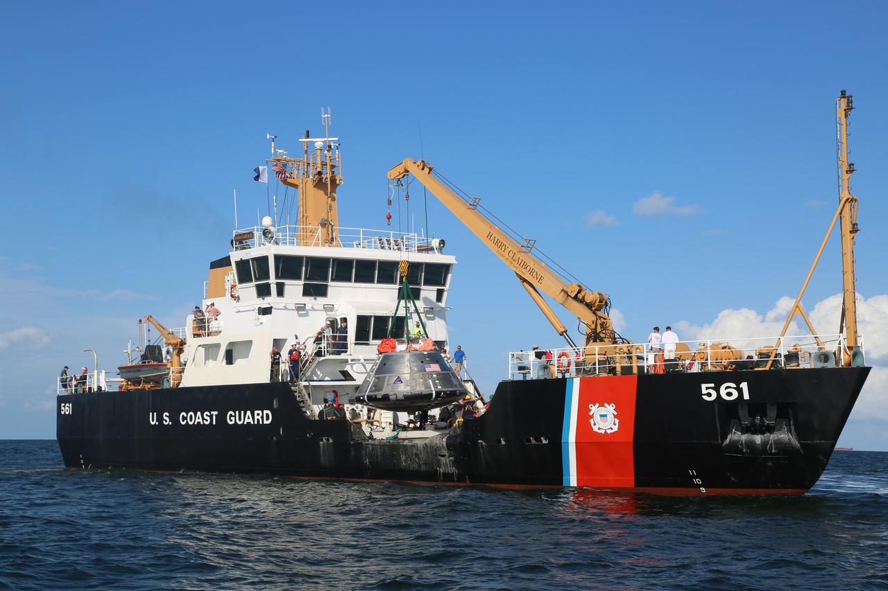
Inside a U.S. Navy ship, Exploration Ground Systems (EGS) Landing and Recovery Director Melissa Jones, at right, briefs her team on Oct. 30, 2018, before they begin Underway Recovery Test-7 (URT-7). EGS and the U.S. Navy will use a test version of the Orion crew module, several rigid hull inflatable boats and support equipment to verify and validate processes, procedures, hardware and personnel during recovery of Orion in open waters. URT-7 is one in a series of tests to verify and validate procedures and hardware that will be used to recover the Orion spacecraft after it splashes down in the Pacific Ocean following deep space exploration missions. Orion will have emergency abort capability, sustain the crew during space travel and provide safe re-entry from deep space return velocities.
Orion Landing and Recovery team members with Jacobs practice using a winch to prepare for Underway Recovery Test 7 (URT-7) on Sept. 5, 2018, in the heavy equipment yard at NASA's Kennedy Space Center in Florida. In front is Pete Ruett. Behind him is Amy Hein. Both are handling and access engineers. During URT-7, the recovery team, including Exploration Ground Systems and the U.S. Navy, will practice recovering a test version of the Orion crew module in the Pacific Ocean, off the coast of California, and guiding it into the well deck of a ship. Over several days, the team will demonstrate and evaluate new recovery processes, procedures, hardware and personnel in open waters. Orion is the exploration spacecraft designed to carry astronauts to deep space destinations, including the Moon and on to Mars. Orion will have emergency abort capability, sustain the crew during space travel and provide safe re-entry from deep space return velocities.
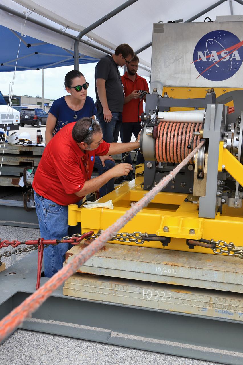
Orion Landing and Recovery team members with Jacobs, practice using a winch to prepare for Underway Recovery Test 7 (URT-7) on Sept. 5, 2018, in the heavy equipment yard at NASA's Kennedy Space Center in Florida. From left, are handling and access engineers Pete Ruett, Amy Hein, Peter Thorn and Eric Hernandez. During URT-7, the recovery team, including Exploration Ground Systems and the U.S. Navy, will practice recovering a test version of the Orion crew module in the Pacific Ocean, off the coast of California, and guiding it into the well deck of a ship. Over several days, the team will demonstrate and evaluate new recovery processes, procedures, hardware and personnel in open waters. Orion is the exploration spacecraft designed to carry astronauts to deep space destinations, including the Moon and on to Mars. Orion will have emergency abort capability, sustain the crew during space travel and provide safe re-entry from deep space return velocities.
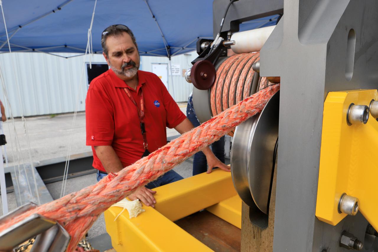
Orion Landing and Recovery team member Pete Ruett, with Jacobs, practices using a winch to prepare for Underway Recovery Test 7 (URT-7) on Sept. 5, 2018, in the heavy equipment yard at NASA's Kennedy Space Center in Florida. Ruett is a handling and access engineer. During URT-7, the recovery team, including Exploration Ground Systems and the U.S. Navy, will practice recovering a test version of the Orion crew module in the Pacific Ocean, off the coast of California, and guiding it into the well deck of a ship. Over several days, the team will demonstrate and evaluate new recovery processes, procedures, hardware and personnel in open waters. Orion is the exploration spacecraft designed to carry astronauts to deep space destinations, including the Moon and on to Mars. Orion will have emergency abort capability, sustain the crew during space travel and provide safe re-entry from deep space return velocities.
S72-36602 (27 April 1972) --- The Apollo 16 Command Module bobbles photographed in the waters of the central Pacific Ocean during recovery operations. The prime recovery ship, USS Ticonderoga, is in the background. A recovery helicopter hovers overhead. The Apollo 16 crew, astronauts John W. Young, Thomas K. Mattingly II, and Charles M. Duke Jr., were picked up by helicopter and flown to the deck of the ship. The splashdown occurred at 290:37:06 ground elapsed time, 1:45:06 p.m. (CST), Thursday, April 27, 1972, at coordinates of 00:45.2 degrees south latitude and 156:11.4 degrees west longitude, a point approximately 215 miles southeast of Christmas Island. A team of Earth Landing System swimmers assisted with the recovery operations.
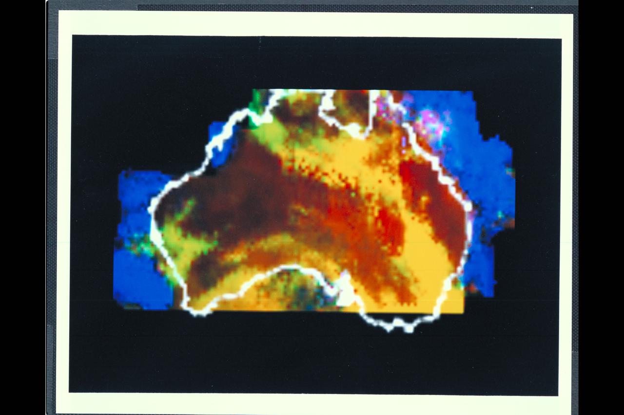
Range : 50,000 miles This multispectral map of Australia, and surrounding seas was obtained by the Galileo spacecraft's Near Infrared Mapping Spectrometer shortly after closest approach. The image shows various ocean, land and atmospheric cloud features as they appear in three of the 408 infrared colors or wavelengths sensed by the instrument. The wavelength of 0.873 micron, represented as blue in the photo, shows regions of enhanced liquid water absorption, i.e. the Pacific and Indian oceans. The 0.984-micron band, represented as red, shows areas of enhanced ground reflection as on the Australian continent. This wavelength is also s ensitive to the reflectivity of relatively thick clouds. The 0.939-micron wavelength, shown as green, is a strong water-vapor-absorbing band, and is used to accentuate clouds lying above the strongly absorbing lower atmosphere. When mixed with the red indicator of cloud reflection, the green produces a yellowish hue; this indicates thick clouds. The distinctive purplish color off the northeast coast marks the unusually shallow waters of the Great Barrier Reef and the Coral Sea. Here the blue denoting water absorption combines with the red denoting reflection from coral and surface marine organisms to produce thiss unusual color. The Near Infrared Mapping Spectrometer (NIMS) on the Galileo spacecraft is a combines mapping (imaging) and spectral instrument. It can sense 408 contiguous wavelengths from 0.7 micron (deep red) to 5.2 microns, and can construct a map or image by mechanical scanning. It can spectroscopically analyze atmospheres and surfaces and construct thermal and chemical maps.
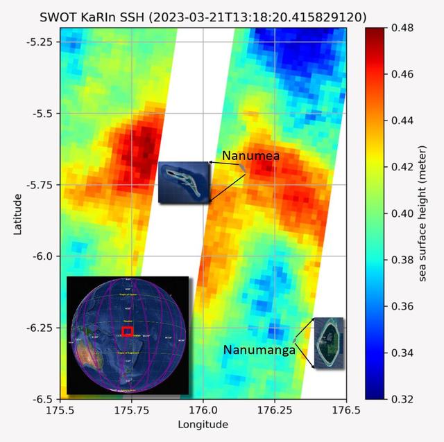
The recently launched Surface Water and Ocean Topography (SWOT) mission collected data on sea levels around two of the inhabited islands of Tuvalu, a nation in the South Pacific Ocean that has been threatened with sea level rise that substantially exceeds the global average. The image shows two areas of red that indicate higher than normal sea levels around two of Tuvalu's inhabited islands, Nanumanga and Nanumea. The higher sea levels were likely caused by internal tides or circular currents called eddies. The SWOT data illuminates for the first time these small ocean features that, when they occur on top of rising sea levels, can lead to episodic flooding along coastlines. The Tuvalu data was collected March 21, 2023. Rising seas are a direct consequence of climate change. On a global scale, the combination of warming ocean waters and ice melt from glaciers and ice sheets is leading to sea level rise that is occurring at an ever-increasing rate. The current rate of rise is more than 0.15 inches (4 millimeters) per year, an increase from 0.08 inches (2 millimeters) per year in 1993. This seemingly small increase holds great significance for coastal communities that have seen more than a century of persistent sea level rise. The gap between the average high tide and flooding conditions has narrowed, and coastal impacts driven by sea level rise have increased in frequency and severity in recent years. This is particularly true for low-lying island nations like Tuvalu, located about 620 miles (1,000 kilometers) north of Fiji. Sea level rise does not occur at the same rate everywhere across the globe, and can be exacerbated by natural ocean fluctuations that occur over time periods from years to decades. For Tuvalu, the amount of sea level rise has been substantially higher than the global average over the past three decades. The amount of rise, when coupled with Tuvalu's low land elevations, places the country increasingly under threat. In the near term, sea level rise will combine with naturally occurring ocean variability and storms to exacerbate events like coastal flooding. Monitoring and understanding sea level change is critical for Tuvalu and other low-lying island nations. Launched on Dec. 16, 2022, from Vandenberg Space Force Base in central California, SWOT collected the Tuvalu sea level data during a period of commissioning, calibration, and validation. Engineers are checking out the performance of the satellite's systems and science instruments before the planned start of science operations in summer 2023. https://photojournal.jpl.nasa.gov/catalog/PIA25777

Melissa Jones, Landing and Recovery director with NASA's Ground Systems Development and Operations Program (GSDO) speaks to the recovery team during wrap up of Underway Recovery Test 5 aboard the USS San Diego. GSDO and the U.S. Navy practiced recovery techniques using the well deck of the ship and a test version of the Orion crew module in the Pacific Ocean off the coast of California to prepare for recovery of Orion on its return from deep space missions. The testing allowed the team to demonstrate and evaluate recovery processes, procedures, hardware and personnel in open waters. Orion is the exploration spacecraft designed to carry astronauts to destinations not yet explored by humans, including an asteroid and NASA's Journey to Mars. It will have emergency abort capability, sustain the crew during space travel and provide safe re-entry from deep space return velocities. Orion is scheduled to launch on NASA's Space Launch System in late 2018. For more information, visit http://www.nasa.gov/orion.

The Orion Underway Recovery Test 5 (URT-5) team celebrate a successful test during a gathering hosted by the Ground Systems Development and Operations Program and the Engineering Directorate at NASA's Kennedy Space Center in Florida. At far left is Melissa Jones, Orion Landing and Recovery director. During URT-5 in October, the team practiced recovering a test version of the Orion crew module in the Pacific Ocean, off the coast of California, and guiding it into the well deck of the USS San Diego. Over several days, the team demonstrated and evaluated new recovery processes, procedures, hardware and personnel in open waters. Orion is the exploration spacecraft designed to carry astronauts to destinations not yet explored by humans, including an asteroid and NASA's Journey to Mars. It will have emergency abort capability, sustain the crew during space travel and provide safe re-entry from deep space return velocities. Orion is scheduled to launch on NASA's Space Launch System in late 2018. For more information, visit http://www.nasa.gov/orion.
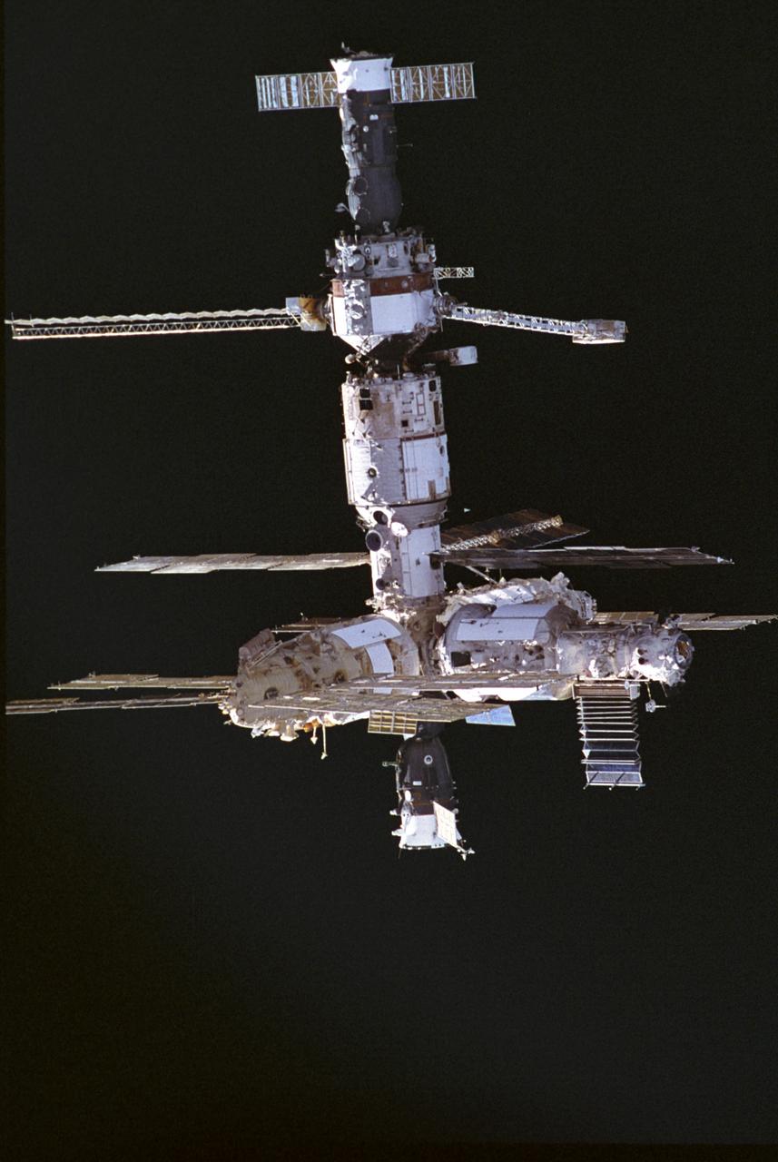
This image of the Russian Mir Space Station was photographed by a crewmember of the STS-74 mission when the Orbiter Atlantis was approaching the Mir Space Station. STS-74 was the second Space Shuttle/Mir docking mission. The Docking Module was delivered and installed, making it possible for the Space Shuttle to dock easily with Mir. The Orbiter Atlantis delivered water, supplies, and equipment, including two new solar arrays to upgrade the Mir, and returned to Earth with experiment samples, equipment for repair and analysis, and products manufactured on the Station. Mir was constructed in orbit by cornecting different modules, seperately launched from 1986 to 1996, providing a large and livable scientific laboratory in space. The 100-ton Mir was as big as six school buses and commonly housed three crewmembers. Mir was continuously occupied, except for two short periods, and hosted international scientists and American astronauts until August 1999. The journey of the 15-year-old Russian Mir Space Station ended March 23, 2001, as Mir re-entered the Earth's atmosphere and fell into the south Pacific ocean . STS-74 was launched on November 12, 1995, and landed at the Kennedy Space Center on November 20, 1995.
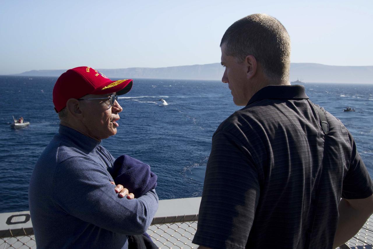
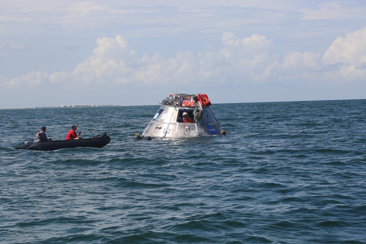
SAN DIEGO, Calif. – NASA Administrator Charlie Bolden, at left, talks to Jeremy Graeber, NASA Recovery director for Exploration Flight Test-1 Landing and Recovery Operations, on the deck of the USS Anchorage during Orion Underway Recovery Test 3. The Orion boilerplate test vehicle is in the Pacific Ocean with U.S. Navy divers nearby in Zodiac boats and rigid hull inflatable boats during recovery operations. NASA, Lockheed Martin and U.S. Navy personnel are conducting the test to prepare for recovery of the Orion crew module on its return from a deep space mission. The test will allow the teams to demonstrate and evaluate the recovery processes, procedures, hardware and personnel in open waters. The Ground Systems Development and Operations Program is conducting the underway recovery tests. Orion is the exploration spacecraft designed to carry astronauts to destinations not yet explored by humans, including an asteroid and Mars. It will have emergency abort capability, sustain the crew during space travel and provide safe re-entry from deep space return velocities. The first unpiloted test flight of Orion is scheduled to launch in 2014 atop a United Launch Alliance Delta IV Heavy rocket and in 2018 on NASA’s Space Launch System rocket. For more information, visit http://www.nasa.gov/orion. Photo credit: NASA/Cory Huston
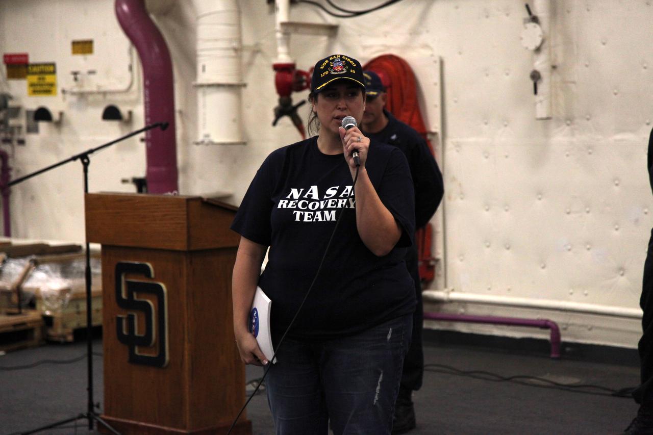
Melissa Jones, Landing and Recovery director with NASA's Ground Systems Development and Operations Program (GSDO) speaks to the recovery team during wrap up of Underway Recovery Test 5 aboard the USS San Diego. GSDO and the U.S. Navy practiced recovery techniques using the well deck of the ship and a test version of the Orion crew module in the Pacific Ocean off the coast of California to prepare for recovery of Orion on its return from deep space missions. The testing allowed the team to demonstrate and evaluate recovery processes, procedures, hardware and personnel in open waters. Orion is the exploration spacecraft designed to carry astronauts to destinations not yet explored by humans, including an asteroid and NASA's Journey to Mars. It will have emergency abort capability, sustain the crew during space travel and provide safe re-entry from deep space return velocities. Orion is scheduled to launch on NASA's Space Launch System in late 2018. For more information, visit http://www.nasa.gov/orion.
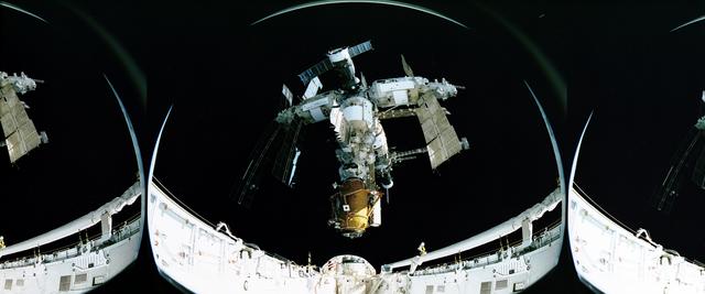
This fish-eye view of the Russian Mir Space Station was photographed by a crewmember of the STS-74 mission after the separation. The image shows the installed Docking Module at bottom. The Docking Module was delivered and installed, making it possible for the Space Shuttle to dock easily with Mir. The Orbiter Atlantis delivered water, supplies, and equipment, including two new solar arrays to upgrade the Mir; and returned to Earth with experiment samples, equipment for repair and analysis, and products manufactured on the Station. Mir was constructed in orbit by cornecting different modules, each launched separately from 1986 to 1996, providing a large and livable scientific laboratory in space. The 100-ton Mir was as big as six school buses and commonly housed three crewmembers. Mir was continuously occupied, except for two short periods, and hosted international scientists and American astronauts until August 1999. The journey of the 15-year-old Russian Mir Space Station ended March 23, 2001, as Mir re-entered the Earth's atmosphere and fell into the south Pacific ocean. STS-74 was the second Space Shuttle/Mir docking mission launched on November 12, 1995, and landed at the Kennedy Space Center on November 20, 1995.
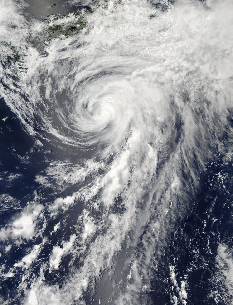
On Tuesday, June 11, 2013 Tropical Storm Yagi spun in the North Pacific Ocean just south of Japan. The Moderate Resolution Imaging Spectroradiometer (MODIS) aboard NASA’s Aqua satellite captured this beautiful true-color image of the storm on that same date at 4:10 UTC (1:10 p.m. Japan local time). The image shows a clear apostrophe-shaped cyclone, with a closed eye and somewhat elliptical shape. The clouds associated with the northern fringes of the storm draped over southeastern coastal Japan, and a long “tail” (or band) of thunderstorms fed into the center from the south. Multispectral imagery also showed tight bands of thunderstorms wrapping into the center of the storm, although the building of thunderstorms was weakening around the center. Near the same time as the image was captured, the Joint Typhoon Warning Center announced that vertical wind shear was starting to take a toll on Yagi. Northwesterly wind shear had caused the system to tilt slightly with the upper-level center displaced about 20 nautical miles east of the low-level center. Tropical Storm Yagi developed from Tropical Depression 03W in the Western North Pacific Ocean on June 6, and intensified the weekend of June 8-9, when it reached Tropical Storm status and was given the name Yagi. Also known as Dante, the storm reached the maximum wind speeds on June 10 and 11, after which it began to weaken as it moved into cooler waters. On June 14, Yagi’s remnants passed about 200 miles south of Tokyo, and brought soaking rains to the coastline of Japan’s Honshu Island. Credit: NASA/GSFC/Jeff Schmaltz/MODIS Land Rapid Response Team <b><a href="http://www.nasa.gov/audience/formedia/features/MP_Photo_Guidelines.html" rel="nofollow">NASA image use policy.</a></b> <b><a href="http://www.nasa.gov/centers/goddard/home/index.html" rel="nofollow">NASA Goddard Space Flight Center</a></b> enables NASA’s mission through four scientific endeavors: Earth Science, Heliophysics, Solar System Exploration, and Astrophysics. Goddard plays a leading role in NASA’s accomplishments by contributing compelling scientific knowledge to advance the Agency’s mission. <b>Follow us on <a href="http://twitter.com/NASA_GoddardPix" rel="nofollow">Twitter</a></b> <b>Like us on <a href="http://www.facebook.com/pages/Greenbelt-MD/NASA-Goddard/395013845897?ref=tsd" rel="nofollow">Facebook</a></b> <b>Find us on <a href="http://instagram.com/nasagoddard?vm=grid" rel="nofollow">Instagram</a></b>
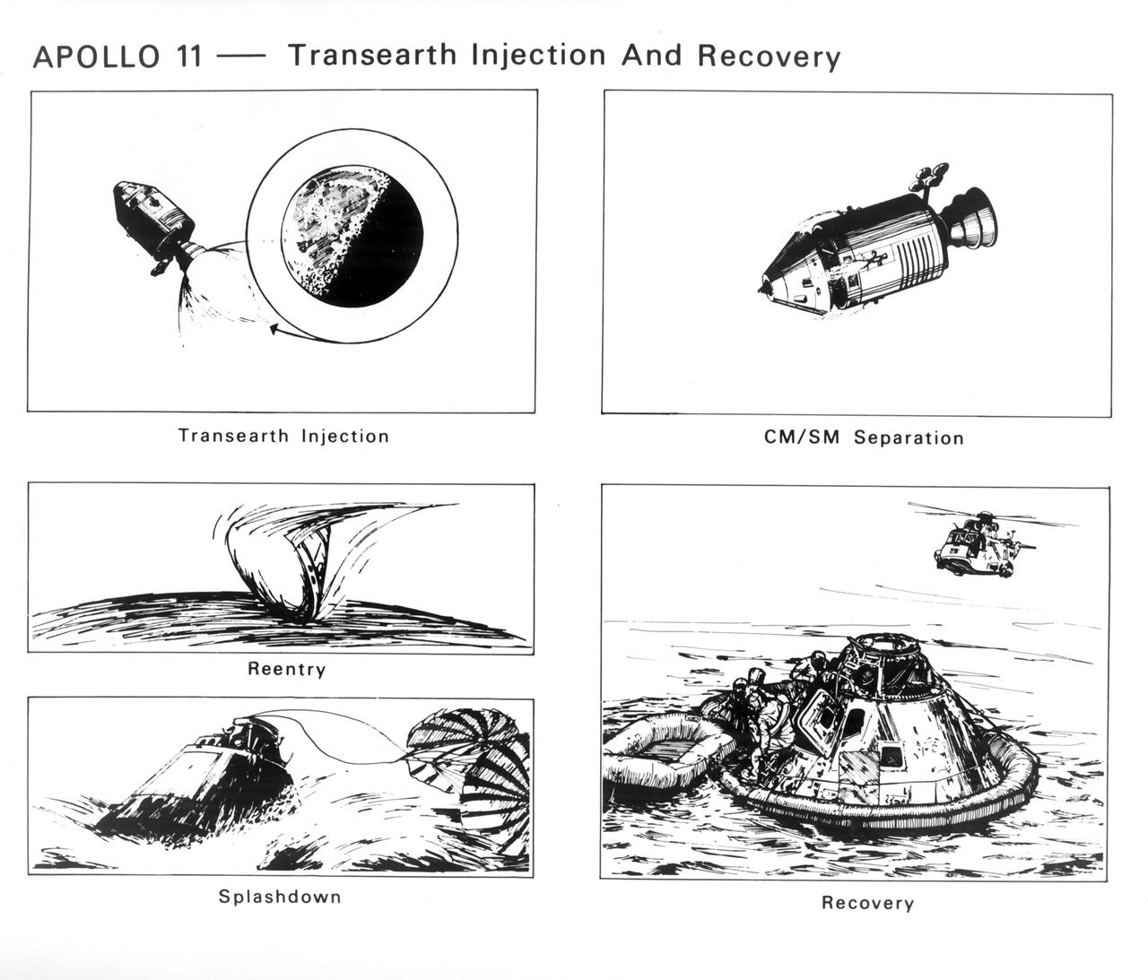
The Apollo 11 mission launched from the Kennedy Space Center (KSC) in Florida via the Marshall Space Flight Center (MSFC) developed Saturn V launch vehicle on July 16, 1969 and safely returned to Earth on July 24, 1969. Aboard the space craft were astronauts Neil A. Armstrong, commander; Michael Collins, Command Module (CM) pilot; and Edwin E. (Buzz) Aldrin Jr., Lunar Module (LM) pilot. With the success of Apollo 11, the national objective to land men on the Moon and return them safely to Earth had been accomplished. These sketches illustrate the steps taken by the astronauts to return to Earth. The service propulsion system engine was fired to increase space craft speed enough to escape Lunar orbit on a trajectory for Earth. Any necessary midcourse corrections were made enroute. Near the point of reentry into Earth’s atmosphere, the CM separated from the service module and turned 180 degrees so the heat shield faced forward on the line of flight. Friction of the atmosphere heated the shield to a white hot temperature, as a meteor, which slowed the craft as it reached lower altitudes. At about three miles altitude, drogue parachutes opened to stabilize the craft. Moments later the main parachutes opened to lower the CM to the waters of the Pacific Ocean. Helicopters and recovery crews from the U.S. S. Hornet aircraft carrier were standing by to pick up the astronauts.

inal Caption Released with Image: The colored regions of this map show the extent of digital elevation data recently released by the Shuttle Radar Topography Mission (SRTM). This release includes data for most of Europe and Asia plus numerous islands in the Indian and Pacific Oceans. SRTM flew on board the Space Shuttle Endeavour in February 2000 and used an interferometric radar system to map the topography of Earth's landmass between latitudes 56 degrees south and 60 degrees north. The data were processed into geographic "tiles," each of which represents one by one degree of latitude and longitude. A degree of latitude measures 111 kilometers (69 miles) north-south, and a degree of longitude measures 111 kilometers or less east-west, decreasing away from the equator. The data are being released to the public on a continent-by-continent basis. This Eurasia segment includes 5,940 tiles, more than a third of the total data set. Previous releases covered North America and South America. Forthcoming releases will include Africa-Arabia and Australia plus an "Islands" release for those islands not included in the continental releases. Together these data releases constitute the world's first high-resolution, near-global elevation model. The resolution of the publicly released data is three arcseconds (1/1,200 of a degree of latitude and longitude), which is about 90 meters (295 feet). European coverage in the current data release stretches eastward from the British Isles and the Iberian Peninsula in the west, across the Alps and Carpathian Mountains, as well as the Northern European Plain, to the Ural and Caucasus Mountains bordering Asia. The Asian coverage includes a great diversity of landforms, including the Tibetan Plateau, Tarin Basin, Mongolian Plateau, and the mountains surrounding Lake Baikal, the world's deepest lake. Mt. Everest in the Himalayas, at 8,848 meters (29,029 feet) is the world's highest mountain. From India's Deccan Plateau, to Southeast Asia, coastal China, and Korea, various landforms place constraints upon land use planning for a great population. Volcanoes in the East Indies, the Philippines, Japan, and the Kamchatka Peninsula form the western part of the "Ring of Fire" around the Pacific Ocean. Many of these regions were previously very poorly mapped due to persistent cloud cover or the inaccessibility of the terrain. Digital elevation data, such as provided by SRTM, are particularly in high demand by scientists studying earthquakes, volcanism, and erosion patterns for use in mapping and modeling hazards to human habitation. But the shape of Earth's surface affects nearly every natural process and human endeavor that occurs there, so elevation data are used in a wide range of applications. In this index map color-coding is directly related to topographic height, with green at the lower elevations, rising through yellow and tan, to white at the highest elevations. The large, very dark green feature in western Asia is the Caspian Sea, which is below sea level. Blue areas on the map represent water within the mapped tiles, each of which includes shorelines or islands. http://photojournal.jpl.nasa.gov/catalog/PIA03398

It’s usually the big, sprawling storms that attract the attention of meteorologists, but occasionally tiny storms can make news as well. The most recent example is a suspected mini-typhoon that drifted across the western Pacific Ocean in mid-July 2013. The storm system emerged on July 16 and dissipated by July 19 without making landfall or causing any significant damage. The Moderate Resolution Imaging Spectroradiometer (MODIS) on NASA’s Terra satellite captured this true-color image of the storm on July 17, 2013. It had the spiral shape of a tropical cyclone, but the cloud field was less than 100 kilometers (60 miles) across. For comparison, Super Typhoon Jelawat, the most intense storm of the 2012 season, had a cloud field that stretched nearly 1,000 kilometers (600 miles). Jelawat’s eye alone—with a diameter of 64 kilometers (40 miles)—was two-thirds the size of the entire July 2013 storm. Despite their small size, mini-cyclones are driven by the same forces that drive larger storms. Both small and large cyclonic storms are simply organized convection feeding off warm water in areas with low wind shear. According to the Joint Typhoon Warning Center, the low-pressure areas for these mini-typhoons must span less than two degrees of latitude (about 140 miles) and have sustained winds of 65 knots (74 miles per hour). The 2013 storm in the Pacific certainly meets the first criteria, but it is unlikely that the storm achieved typhoon-force winds. It’s also unlikely that the system had a “warm core,” which all true tropical cyclones have. While this storm did not cause damage, other mini storms certainly have. In 1974, the miniature cyclone Tracy hit Darwin, Australia, killing 71 people and destroying more than 70 percent of the city’s buildings. According to the National Hurricane Center, tropical cyclone Marco unseated Tracy as the smallest tropical cyclone on record in 2008. Marco had gale force winds that extended just 19 kilometers (12 miles). Typhoon Tip, with gale force winds extending 1,000 kilometers (675 miles) is the largest tropical cyclone on record. Credit: NASA/GSFC/Jeff Schmaltz/MODIS Land Rapid Response Team <b><a href="http://www.nasa.gov/audience/formedia/features/MP_Photo_Guidelines.html" rel="nofollow">NASA image use policy.</a></b> <b><a href="http://www.nasa.gov/centers/goddard/home/index.html" rel="nofollow">NASA Goddard Space Flight Center</a></b> enables NASA’s mission through four scientific endeavors: Earth Science, Heliophysics, Solar System Exploration, and Astrophysics. Goddard plays a leading role in NASA’s accomplishments by contributing compelling scientific knowledge to advance the Agency’s mission. <b>Follow us on <a href="http://twitter.com/NASA_GoddardPix" rel="nofollow">Twitter</a></b> <b>Like us on <a href="http://www.facebook.com/pages/Greenbelt-MD/NASA-Goddard/395013845897?ref=tsd" rel="nofollow">Facebook</a></b> <b>Find us on <a href="http://instagrid.me/nasagoddard/?vm=grid" rel="nofollow">Instagram</a></b>