
NASA image acquired August 4, 2010 Though many areas in northwest Pakistan were bracing for heavy rain and additional flash flooding on August 4, 2010, the city of Kheshgi, in northwest Pakistan, had clear skies. This image, taken by the Advanced Spaceborne Thermal Emission and Reflection Radiometer (ASTER) on NASA’s Terra satellite reveals a city awash in flood water. Thick with mud, the Kabul River is pale green in this false color image. Clearer water is dark blue. The river flows through its usual channel, but in places, water seeps over the channel and across the landscape. The buildings and roads of Kheshgi are silver. Spots of turquoise blue—shallow, muddy water or water-logged ground—covers several sections of the city. On the south side of the Kabul River, water flows down the hills, washing over neighborhoods. The bare ground in the hills is brown and tan. Plant-covered land, red in this image, is divided into long, narrow rectangles, pointing to agriculture. Geometric shapes under the water near the river are probably submerged fields of crops. Thousands of acres of crops had been lost in floods throughout Pakistan, said the United Nations. Kheshgi is in the Nowshera district in the Khyber Pakhutnkhwa province. As of August 2, Khyber Pakhutnkhwa was the hardest hit province in Pakistan, said the United Nations, and Nowshera was the most impacted district in the province. Nowshera reported 500,000 people displaced with 161 dead, said the Government of Khuber Pakhtunkhwa. The floods affected communities throughout Pakistan. More than 1,100 people had died, 15,000 homes were damaged or destroyed, and at least one million people were in need of emergency assistance throughout Pakistan, said the United Nations on August 2. The floods occurred as unusually heavy monsoon rains fell over Pakistan. NASA image courtesy NASA/GSFC/MITI/ERSDAC/JAROS, and U.S./Japan ASTER Science Team. Caption by Holli Riebeek. Instrument: Terra - ASTER Credit: <b><a href="#//earthobservatory.nasa.gov/" rel="nofollow"> NASA’s Earth Observatory</a></b> To learn more about this image go here: <a href="http://earthobservatory.nasa.gov/NaturalHazards/view.php?id=45050" rel="nofollow">earthobservatory.nasa.gov/NaturalHazards/view.php?id=45050</a> Or here: <a href="http://earthobservatory.nasa.gov/NaturalHazards/view.php?id=45343" rel="nofollow">earthobservatory.nasa.gov/NaturalHazards/view.php?id=45343</a> <b><a href="http://www.nasa.gov/centers/goddard/home/index.html" rel="nofollow">NASA Goddard Space Flight Center</a></b> is home to the nation's largest organization of combined scientists, engineers and technologists that build spacecraft, instruments and new technology to study the Earth, the sun, our solar system, and the universe. <b>Follow us on <a href="http://twitter.com/NASA_GoddardPix" rel="nofollow">Twitter</a></b> <b>Join us on <a href="http://www.facebook.com/pages/Greenbelt-MD/NASA-Goddard/395013845897?ref=tsd" rel="nofollow">Facebook</a></b>
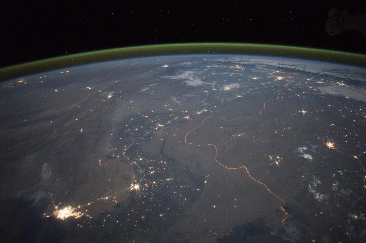
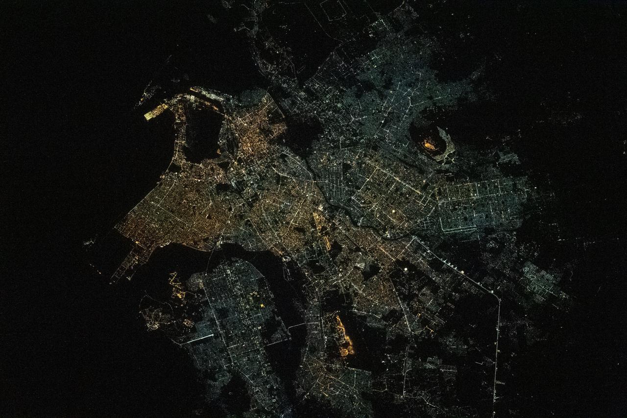
An astronaut aboard the International Space Station took this nighttime panorama while looking north across Pakistan’s Indus River valley. The port city of Karachi is the bright cluster of lights facing the Arabian Sea, which appears completely black. City lights and the dark color of dense agriculture closely track with the great curves of the Indus valley. For scale, the distance from Karachi to the foothills of the Himalaya Mountains is 1,160 kilometers (720 miles). This photograph shows one of the few places on Earth where an international boundary can be seen at night. The winding border between Pakistan and India is lit by security lights that have a distinct orange tone. Astronaut photograph ISS045-E-27869 was acquired on September 23, 2015, with a Nikon D4 digital camera using a 28 millimeter lens, and is provided by the ISS Crew Earth Observations Facility and the Earth Science and Remote Sensing Unit, Johnson Space Center. via NASA Earth Observatory Read more: <a href="http://earthobservatory.nasa.gov/IOTD/view.php?id=86725&eocn=home&eoci=iotd_title" rel="nofollow">earthobservatory.nasa.gov/IOTD/view.php?id=86725&eocn...</a>
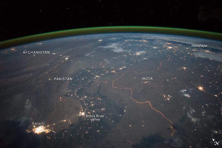
An astronaut aboard the International Space Station took this nighttime panorama while looking north across Pakistan’s Indus River valley. The port city of Karachi is the bright cluster of lights facing the Arabian Sea, which appears completely black. City lights and the dark color of dense agriculture closely track with the great curves of the Indus valley. For scale, the distance from Karachi to the foothills of the Himalaya Mountains is 1,160 kilometers (720 miles). This photograph shows one of the few places on Earth where an international boundary can be seen at night. The winding border between Pakistan and India is lit by security lights that have a distinct orange tone. Astronaut photograph ISS045-E-27869 was acquired on September 23, 2015, with a Nikon D4 digital camera using a 28 millimeter lens, and is provided by the ISS Crew Earth Observations Facility and the Earth Science and Remote Sensing Unit, Johnson Space Center. via NASA Earth Observatory Read more: <a href="http://earthobservatory.nasa.gov/IOTD/view.php?id=86725&eocn=home&eoci=iotd_title" rel="nofollow">earthobservatory.nasa.gov/IOTD/view.php?id=86725&eocn...</a>

On September 24, 2013, a major strike-slip earthquake rattled western Pakistan, killing at least 350 people and leaving more than 100,000 homeless. The 7.7 magnitude quake struck the Baluchistan province of northwestern Pakistan. Amidst the destruction, a new island was created offshore in the Paddi Zirr (West Bay) near Gwadar, Pakistan. On September 26, 2013, the Advanced Land Imager (ALI) on NASA’s Earth Observing-1 (EO-1) satellite captured the top image of that new island, which sits roughly one kilometer (0.6 miles) offshore. Likely a “mud volcano,” the island rose from the seafloor near Gwadar on September 24, shortly after the earthquake struck about 380 kilometers (230 miles) inland. The lower image, acquired by the Operational Land Imager on the Landsat 8 satellite, shows the same area on April 17, 2013. In the satellite images, lighter shades of green and tan in the water reveal shallow seafloor or suspended sediment. The water depth around the new island is roughly 15 to 20 meters (50 to 65 feet), according to marine geologist Asif Inam of Pakistan’s National Institute of Oceanography. “The floor in that area is generally flat, but the gradient in this area changes quite abruptly,” Inam said. The top image from ALI is also clear enough to show the parallel ripples of waves marching toward the shore. Read more: <a href="https://earthobservatory.nasa.gov/IOTD/view.php?id=82146" rel="nofollow">earthobservatory.nasa.gov/IOTD/view.php?id=82146</a> NASA Earth Observatory image by Jesse Allen and Robert Simmon, using EO-1 ALI data from the NASA EO-1 team. <b><a href="http://www.nasa.gov/audience/formedia/features/MP_Photo_Guidelines.html" rel="nofollow">NASA image use policy.</a></b> <b><a href="http://www.nasa.gov/centers/goddard/home/index.html" rel="nofollow">NASA Goddard Space Flight Center</a></b> enables NASA’s mission through four scientific endeavors: Earth Science, Heliophysics, Solar System Exploration, and Astrophysics. Goddard plays a leading role in NASA’s accomplishments by contributing compelling scientific knowledge to advance the Agency’s mission. <b>Follow us on <a href="http://twitter.com/NASAGoddardPix" rel="nofollow">Twitter</a></b> <b>Like us on <a href="http://www.facebook.com/pages/Greenbelt-MD/NASA-Goddard/395013845897?ref=tsd" rel="nofollow">Facebook</a></b> <b>Find us on <a href="http://instagrid.me/nasagoddard/?vm=grid" rel="nofollow">Instagram</a></b>
On Sept. 3, 2010, when NASA Terra spacecraft captured this image strip over the Indus River in Pakistan, severe flooding was still causing a major humanitarian crisis in Pakistan. The city of Hyderabad is near the middle of the image.
NASA Terra spacecraft captured this cloud-free image over the city of Sukkur, Pakistan, on Aug. 18, 2010. Sukkur, located in southeastern Pakistan Sindh Province, is visible as the grey, urbanized area in the lower left center of the image.

This image, acquired by NASA Terra spacecraft, shows the epicenter of a magnitude 7.7 earthquake which struck south-central Pakistan on Sept. 24, 2013, in Pakistan Makran fold belt.
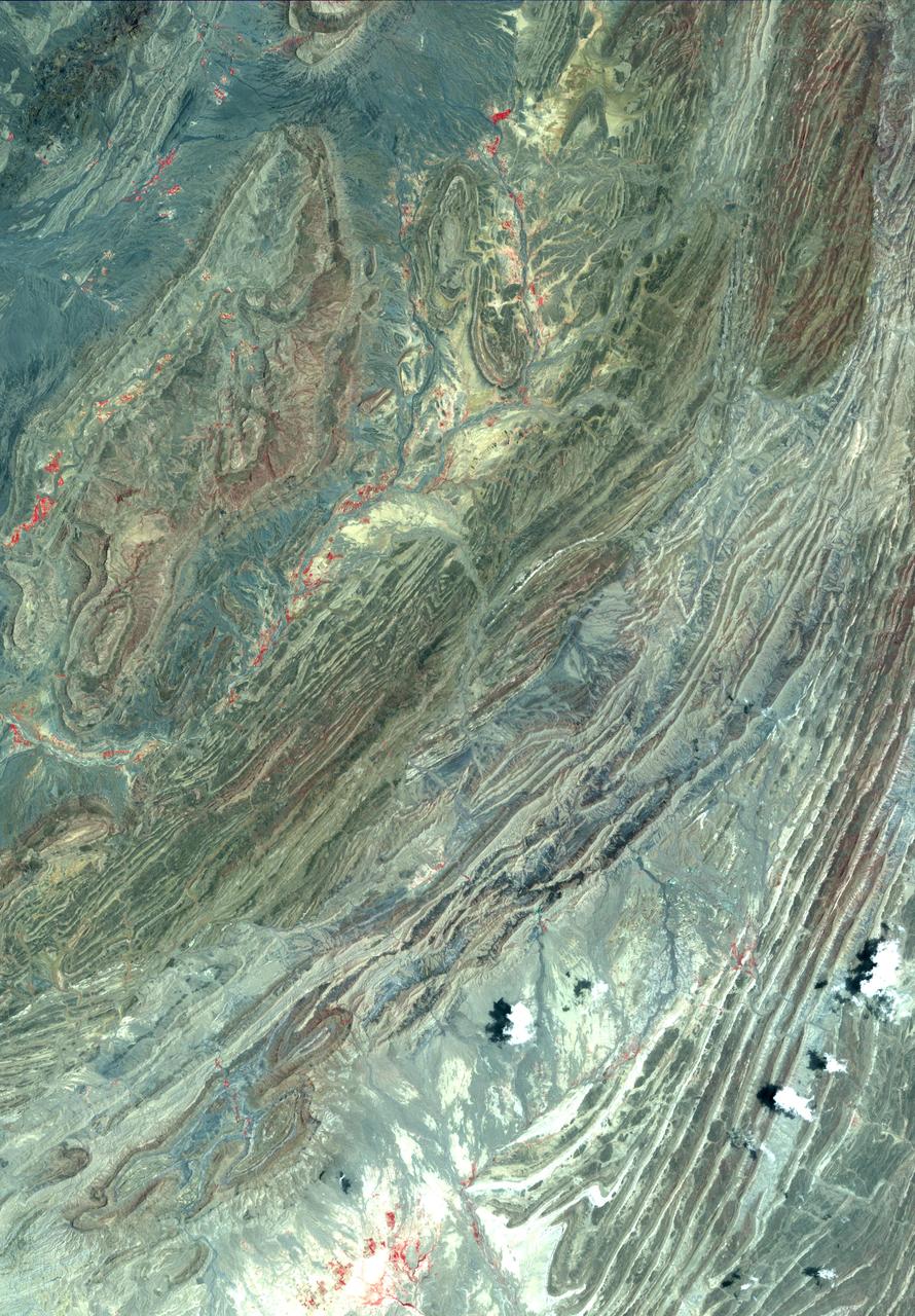
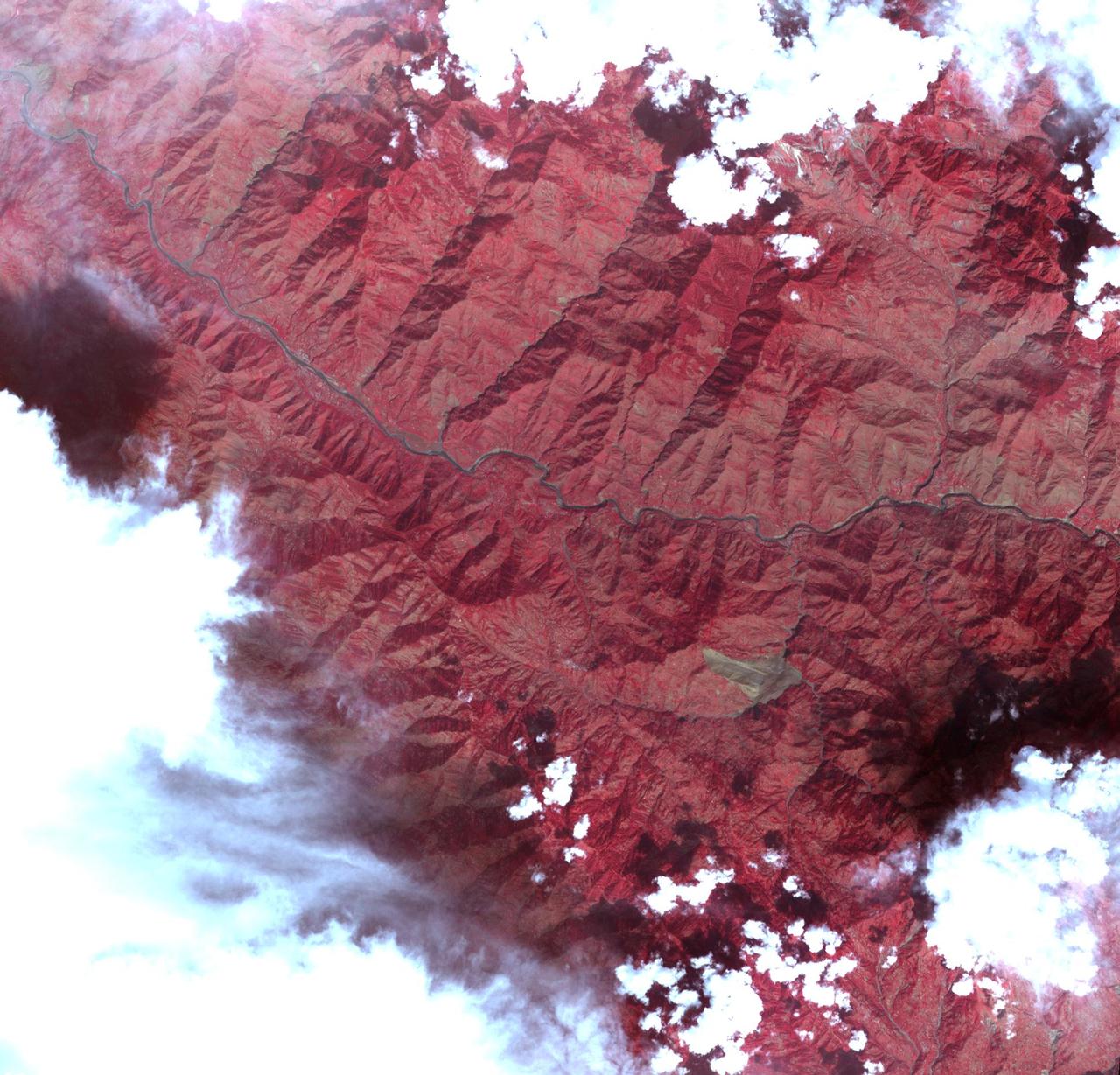
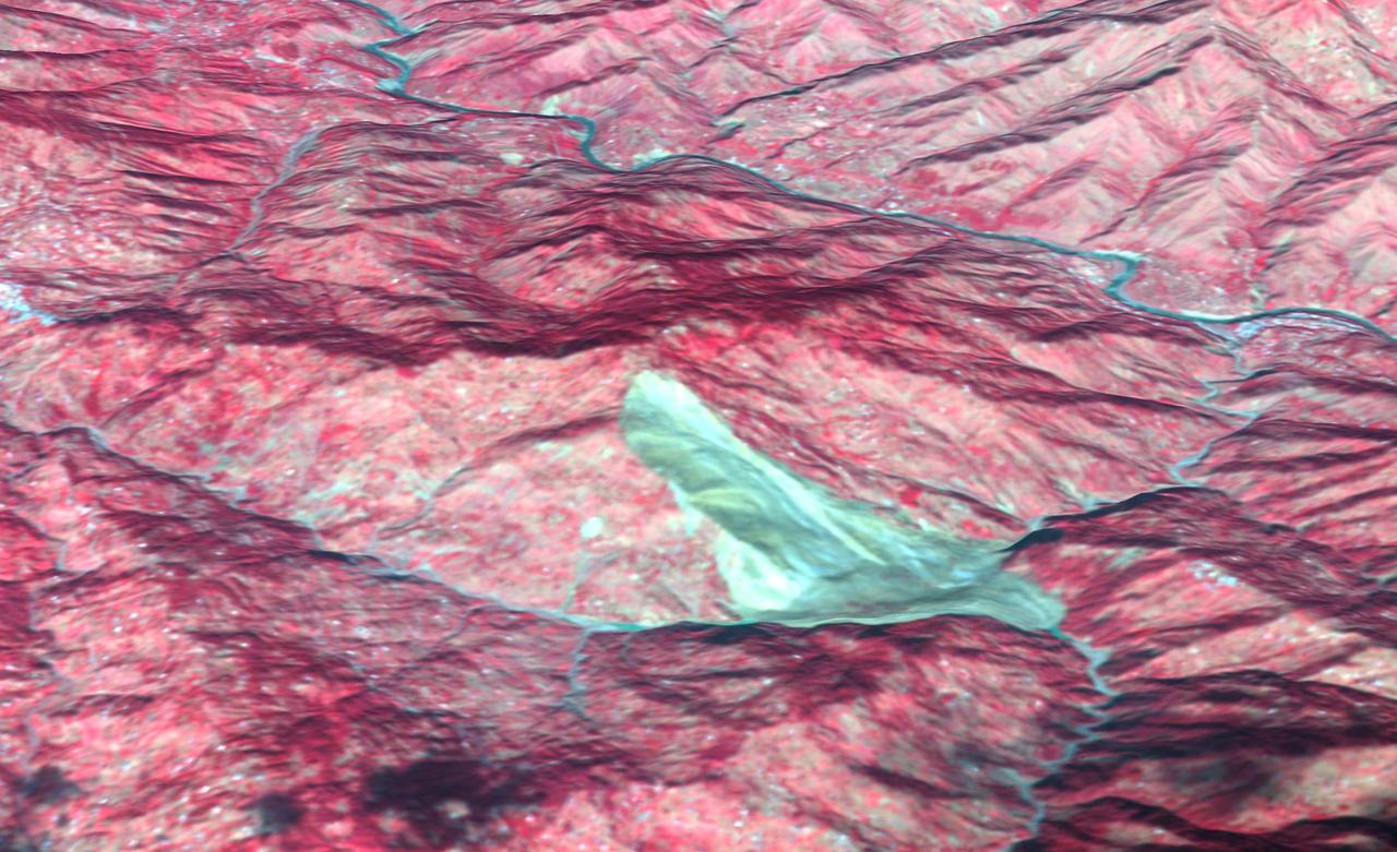
This image acquired by NASA Terra spacecraft shows the Sulaiman fold-thrust belt in northwestern Pakistan, a linear or arcuate belt in which compression has produced a combination of thrust faults and folds.
The ASTER instrument onboard NASA Terra spacecraft imaged the Khyber Pass, a mountain pass that links Afghanistan and Pakistan. Throughout its history it has been an important trade route between Central Asia and South Asia.
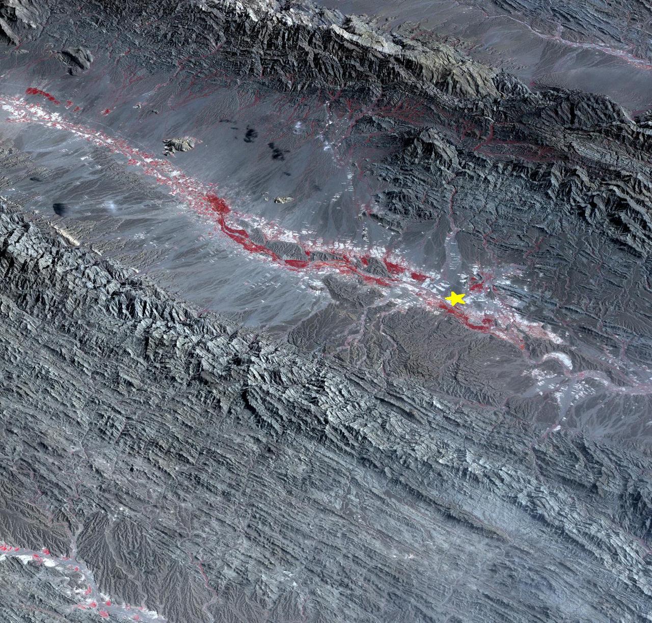
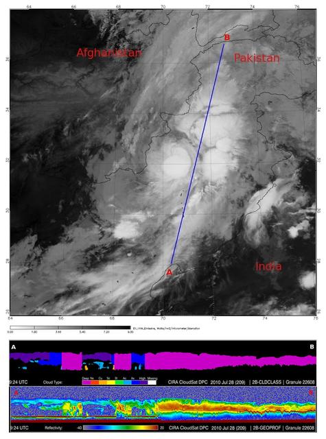
On September 24 at 11:29 GMT, a magnitude 7.7 earthquake struck in south-central Pakistan at a relatively shallow depth of 20 kilometers. The earthquake occurred as the result of oblique strike-slip motion, consistent with rupture within the Eurasian tectonic plate. Tremors were felt as far away as New Delhi as well as Karachi in Pakistan. Even though the immediate area to the epicenter is sparsely populated, the majority of houses are of mud brick construction and damage is expected to be extensive. The perspective view, looking to the east, shows the location of the epicenter in Pakistan's Makran fold belt. The image is centered near 27 degrees north latitude, 65.5 degrees east longitude, and was acquired December 13, 2012. With its 14 spectral bands from the visible to the thermal infrared wavelength region and its high spatial resolution of 15 to 90 meters (about 50 to 300 feet), ASTER images Earth to map and monitor the changing surface of our planet. ASTER is one of five Earth-observing instruments launched Dec. 18, 1999, on Terra. The instrument was built by Japan's Ministry of Economy, Trade and Industry. A joint U.S./Japan science team is responsible for validation and calibration of the instrument and data products. The broad spectral coverage and high spectral resolution of ASTER provides scientists in numerous disciplines with critical information for surface mapping and monitoring of dynamic conditions and temporal change. Example applications are: monitoring glacial advances and retreats; monitoring potentially active volcanoes; identifying crop stress; determining cloud morphology and physical properties; wetlands evaluation; thermal pollution monitoring; coral reef degradation; surface temperature mapping of soils and geology; and measuring surface heat balance. The U.S. science team is located at NASA's Jet Propulsion Laboratory, Pasadena, Calif. The Terra mission is part of NASA's Science Mission Directorate, Washington, D.C. More information about ASTER is available at <a href="http://asterweb.jpl.nasa.gov/" rel="nofollow">asterweb.jpl.nasa.gov/</a>. Image Credit: NASA/GSFC/METI/ERSDAC/JAROS, and U.S./Japan ASTER Science Team Image Addition Date: 2013-09-24 <b><a href="http://www.nasa.gov/audience/formedia/features/MP_Photo_Guidelines.html" rel="nofollow">NASA image use policy.</a></b> <b><a href="http://www.nasa.gov/centers/goddard/home/index.html" rel="nofollow">NASA Goddard Space Flight Center</a></b> enables NASA’s mission through four scientific endeavors: Earth Science, Heliophysics, Solar System Exploration, and Astrophysics. Goddard plays a leading role in NASA’s accomplishments by contributing compelling scientific knowledge to advance the Agency’s mission. <b>Follow us on <a href="http://twitter.com/NASA_GoddardPix" rel="nofollow">Twitter</a></b> <b>Like us on <a href="http://www.facebook.com/pages/Greenbelt-MD/NASA-Goddard/395013845897?ref=tsd" rel="nofollow">Facebook</a></b> <b>Find us on <a href="http://instagram.com/nasagoddard?vm=grid" rel="nofollow">Instagram</a></b>
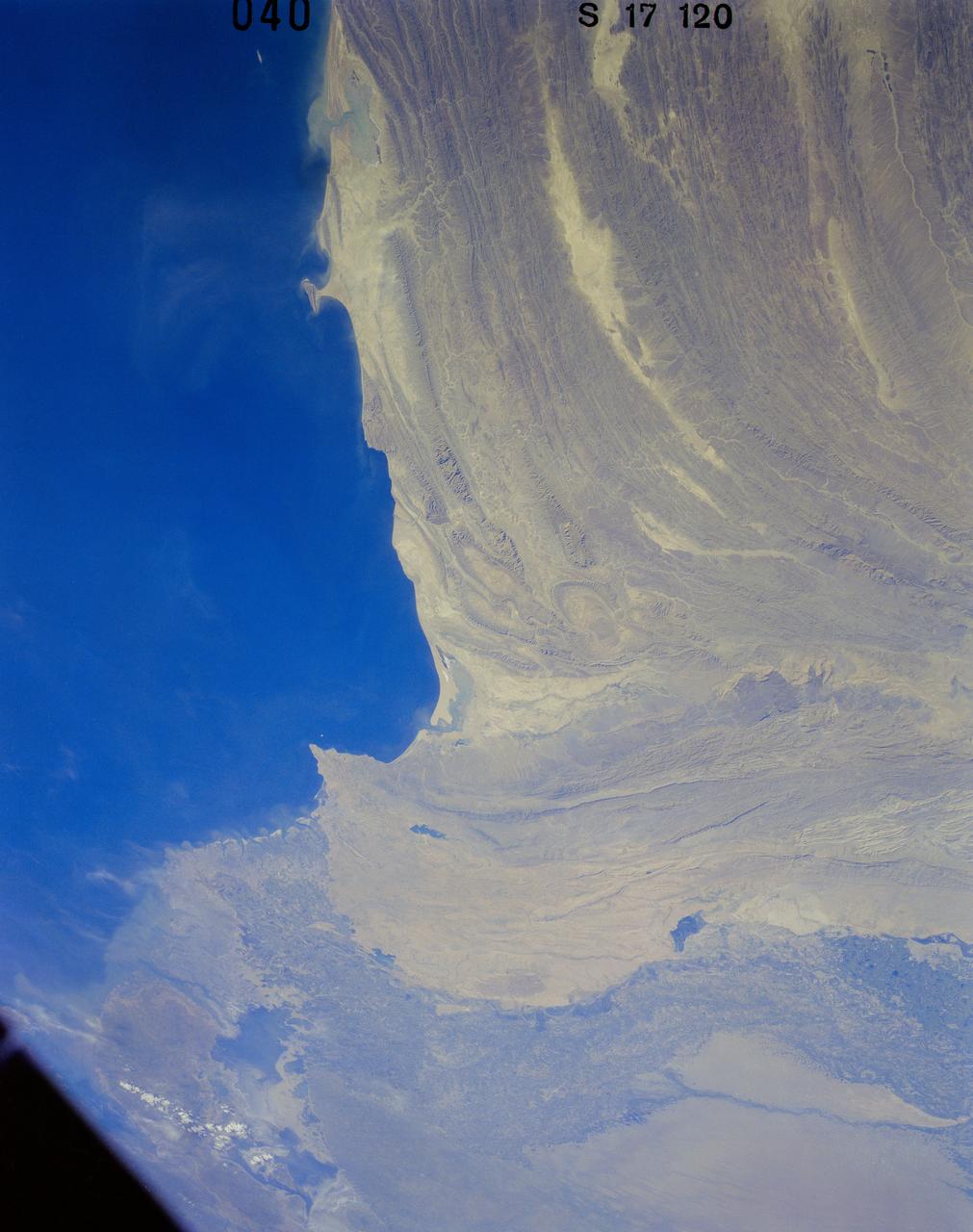
41G-120-040 (5-13 Oct. 1984) --- Pakistan, featuring the city of Karachi, the Makran mountain range, the mouth of the Indus River and the North Arabian Sea were photographed with a medium format camera aboard the space shuttle Challenger during the 41-G mission. Photo credit: NASA
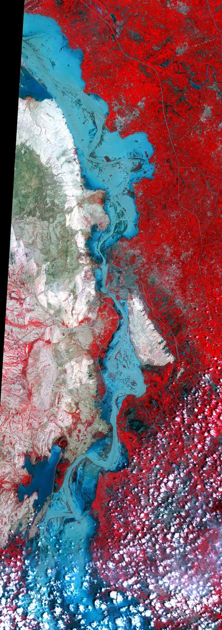
On Sept. 3, 2010, NASA Terra spacecraft captured this image strip over the Indus River, Pakistan, where severe flooding caused a major humanitarian crisis.
AS07-07-1832 (15 Oct. 1968) --- Toba, Kakar, Fort Sandeman, Sulaiman Range area in (West) Pakistan, as seen from the Apollo 7 spacecraft during its 84th revolution of Earth. Note geological features such as folded mountain structures, anticlines and synclines. Photographed from an altitude of 108 nautical miles, at ground elapsed time of 132 hours and 30 minutes.
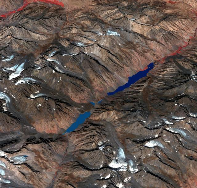
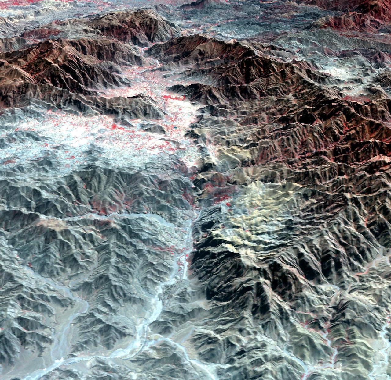
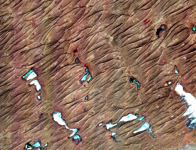
In the Hindu Kush Mtns. in northern Pakistan, landslides from the steep, glaciated terrain are common. When the landslides block rivers, they form temporary lakes or cause small lakes to grow larger. If the landslide dams fail catastrophically, an instantaneous flood surges down the narrow valley, endangering downstream villages. A good example is Lake Shuwarang Chhat, that is upstream of villages of Barsat, Tery, Bahach, and Hundarap. The perspective view data were acquired September23, 2019, and are located at 36 degrees north, 72.6 degrees east. https://photojournal.jpl.nasa.gov/catalog/PIA25355
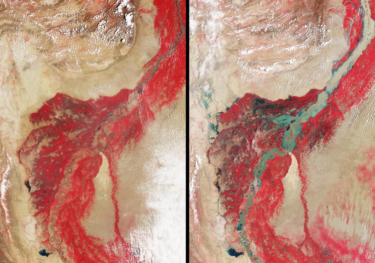
In late July 2010, flooding caused by heavy monsoon rains began in several regions of Pakistan, including the Khyber Pakhtunkhwa, Sindh, Punjab and parts of Baluchistan. This image was acquired by NASA Terra spacecraft on August 11, 2010.
In late July 2010, flooding caused by heavy monsoon rains began in several regions of Pakistan. This image from NASA Aqua spacecraft reveals the bright white cloud tops from the cluster of thunderstorms.
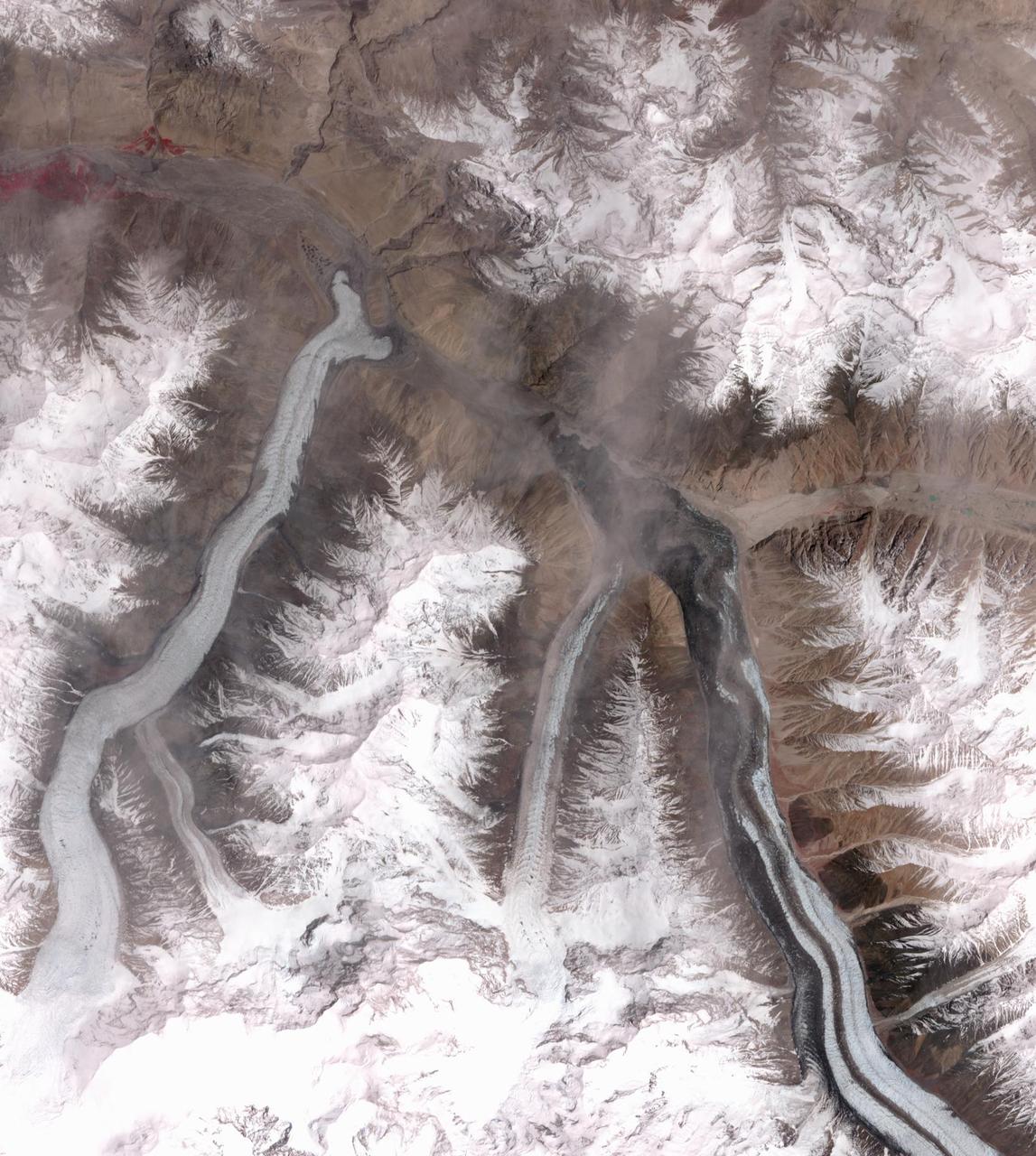
In October 2016, the Khurdopin Glacier in Pakistan began a rapid surge after 20 years of little movement. By March, 2017, a large lake had formed in the Shimshal River, where the glacier had formed a dam. Fortunately, the river carved an outlet through the glacier before the lake could empty catastrophically. In this pair of ASTER images, acquired August 20, 2015 and May 21, 2017, the advance of the Khurdopin Glacier (dark gray and white "river" in lower right quarter of image) is obvious by comparing the before and after images. The images cover an area of 25 by 27.8 km, and are located at 36.3 degrees north, 75.5 degrees east. https://photojournal.jpl.nasa.gov/catalog/PIA22304
iss069e009939 (May 10, 2023) --- The city lights of Lahore, Pakistan's second largest city, were pictured by UAE (United Arab Emirates) astronaut and Expedition 69 Flight Engineer Sultan Alneyadi from the International Space Station as it orbited 259 miles above.
In late July 2010, flooding caused by heavy monsoon rains began in several regions of Pakistan. These images taken by NASA Aqua spacecraft show were taken before and after the flooding.

This image from NASA Aqua spacecraft shows how surface emissivity -- how efficiently Earth surface radiates heat -- changed in several regions of Pakistan over a 32-day period between July 11 pre-flood and August 12 post-flood.
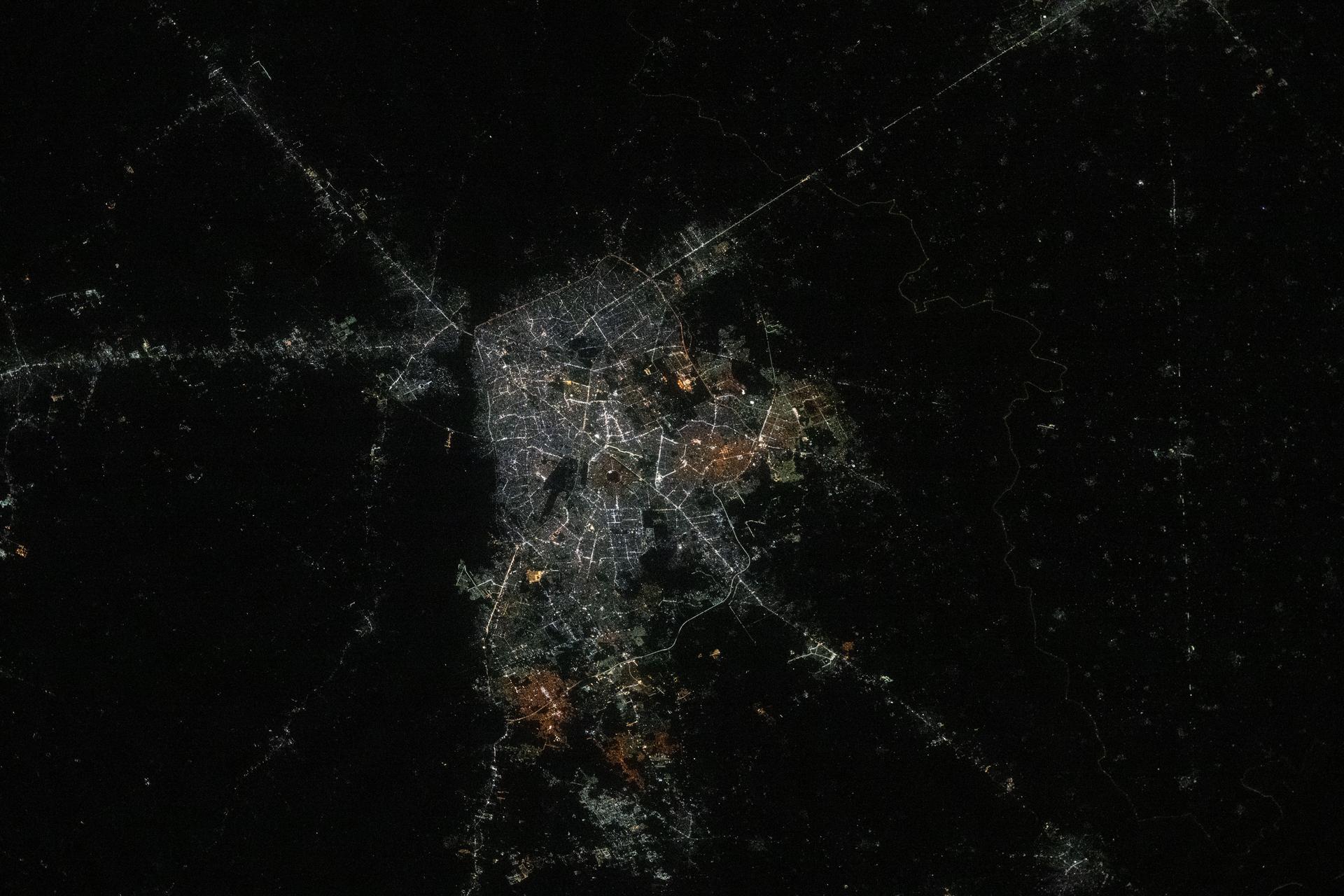
iss073e0763605 (Sept. 21, 2025) --- Lahore, Pakistan, home to approximately 14.8 million people and the country’s second-most populous metropolitan area after Karachi, is pictured from the International Space Station as it orbited 261 miles above Earth at approximately 10:23 p.m. local time.
NASA Terra spacecraft captured this image of the city of Jhudo, Pakistan, and surrounding countryside on Sept. 24, 2011. Torrential monsoon rains in south Asia have displaced hundreds of thousands of residents in India, Pakistan and Thailand.
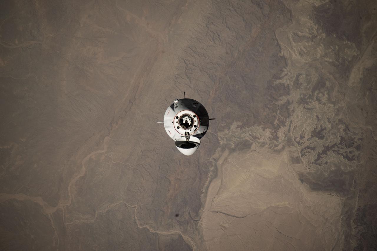
iss073e0424700 (Aug. 2, 2025) --- The SpaceX Dragon spacecraft carrying four members of NASA's SpaceX Crew-11 mission is pictured approaching the International Space Station 259 miles above central Pakistan.
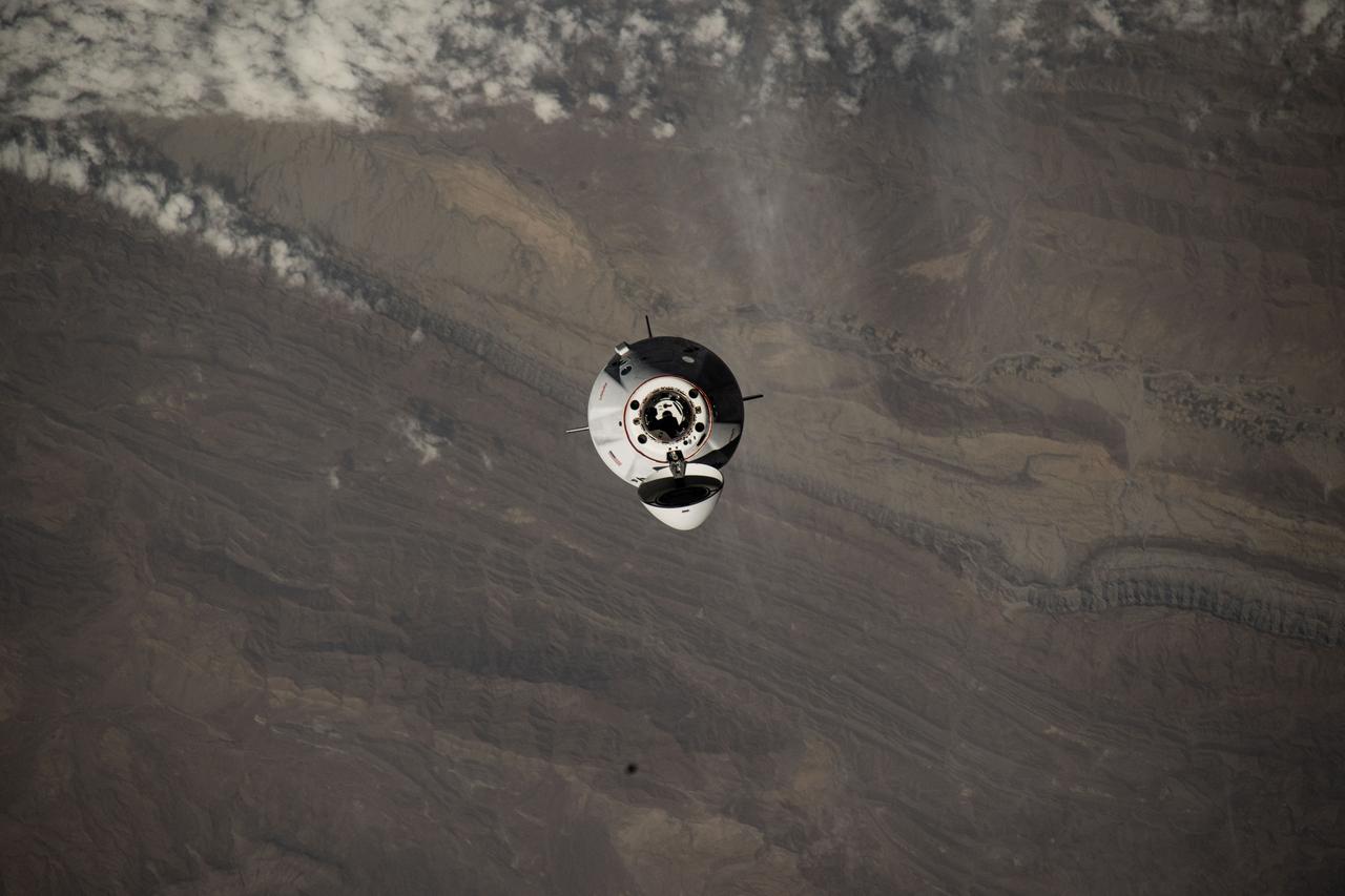
iss073e0424684 (Aug. 2, 2025) --- The SpaceX Dragon spacecraft carrying four members of NASA's SpaceX Crew-11 mission is pictured approaching the International Space Station 260 miles above southern Pakistan.

S63-06443 (15-16 May 1963) --- A northwest-looking view across Pakistan, eastern Iran and Afghanistan as photographed from the Mercury-Atlas 9 (MA-9) capsule by astronaut L. Gordon Cooper Jr., during his 22-orbit MA-9 spaceflight. Photo credit: NASA

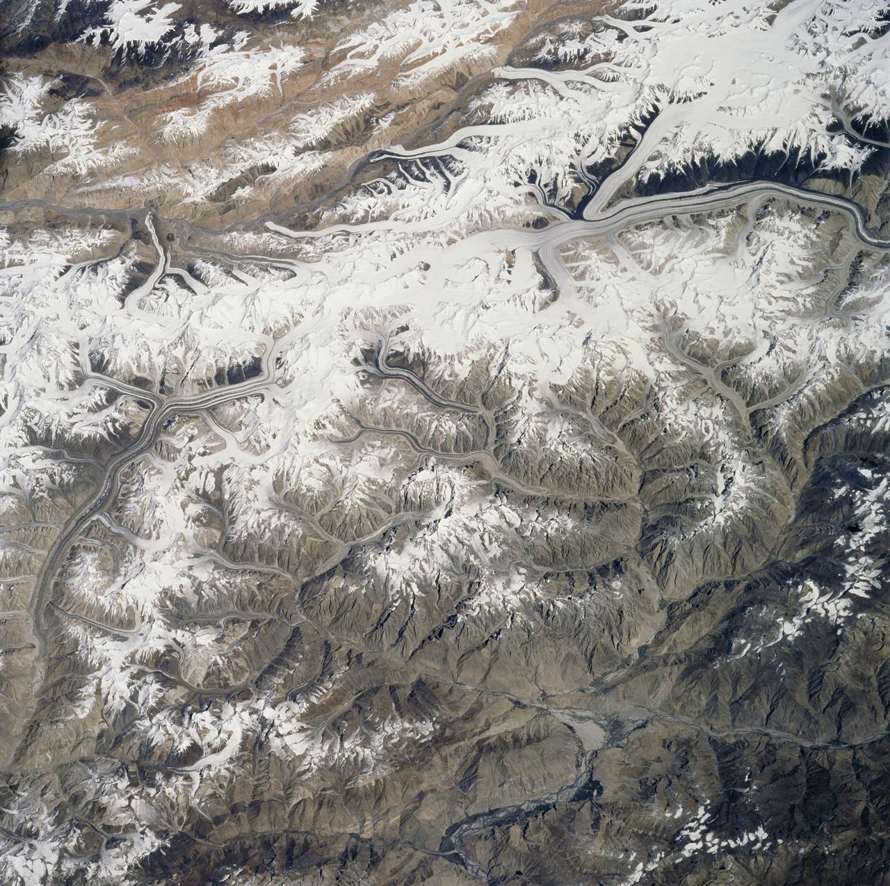
STS058-78-021 (18 Oct-1 Nov 1993) --- A clear three-dimensional view of the Karakorum Range. This northwestern extension of the Himalaya contains glaciated peaks having elevations of 7,000 to 8,000 meters.
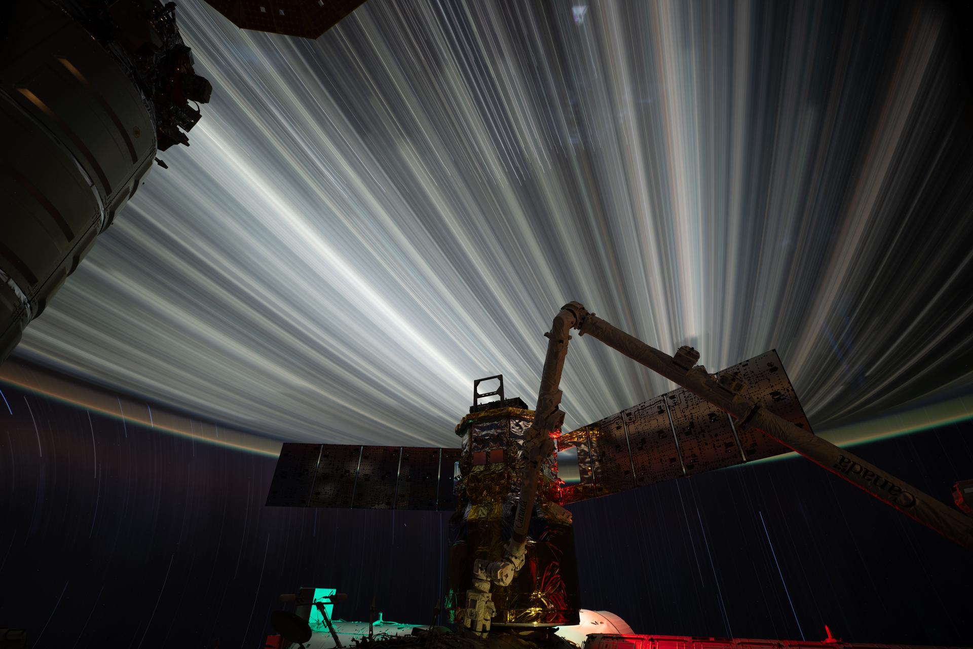
iss074e0319679 (Feb. 19, 2026) --- Star trails and city lights streak by in this long-duration photograph taken from the International Space Station as it orbited 261 miles above the India-Pakistan border at approximately 2:35 a.m. local time. In the foreground is JAXA’s (Japan Aerospace Exploration Agency) HTV-X1 cargo craft, berthed to the Harmony module’s Earth-facing port, with the Canadarm2 robotic arm perched on a portable data grapple fixture in front. Credit: NASA/Chris Williams
This image acquired by NASA Terra spacecraft on Oct. 11, 2005, depicts a 30-kilometer 19-mile wide region southeast of the epicenter of the magnitude 7.6 Pakistan earthquake, between Muzaffarabad and Uri in the Pir Punjal range of Kashmir.
This 3D image was acquired by NASA Terra spacecraft on October 11, 2005 with digital topography from the Shuttle Radar Topography Mission. It depicts a large landslide which occurred in Kashmir, Pakistan.
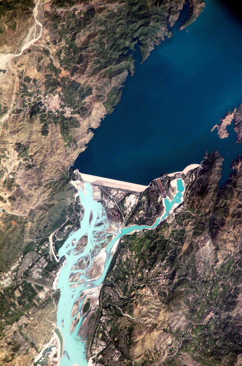
ISS005-E-12804 (6 September 2002) --- Tarbela Dam, Pakistan is featured in this image photographed by an Expedition 5 crewmember on the International Space Station (ISS). The Indus River basin extends from the Himalaya mountain ranges forming the northeastern boundary of Pakistan, to the alluvial plains of Sindh near the Arabian Sea coastline. Tarbela Dam is part of the Indus Basin Project that resulted from a water treaty signed in 1960 between India and Pakistan. This treaty guaranteed Pakistan water supplies independent of upstream control by India. Designed primarily for water storage rather than power generation, the dam was completed in 1977. Turquoise waters of the Indus River (to the south of the dam) reflect the high proportion of silt and clay suspended in waters released by the spillways (chutes on either of side of the main dam). With a volume of 142,000,000 cubic meters, the Tarbela Dam is the largest earth and rockfill dam in the world and stands 147 meters above the Indus riverbed. Its reservoir occupies an area of 37 square kilometers. While the dam has fulfilled its purpose in storing water for agricultural use in Pakistan, there have been environmental consequences to the Indus river delta, according to NASA scientists who are studying the Space Station photography. Reduction of seasonal flooding and reduced water flows to the delta have resulted in decrease of mangrove stands and abundance of some fish species.
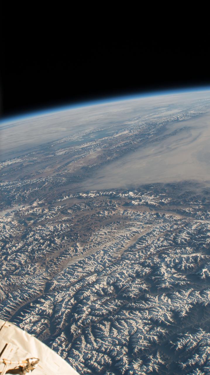
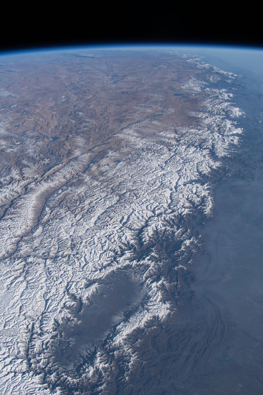
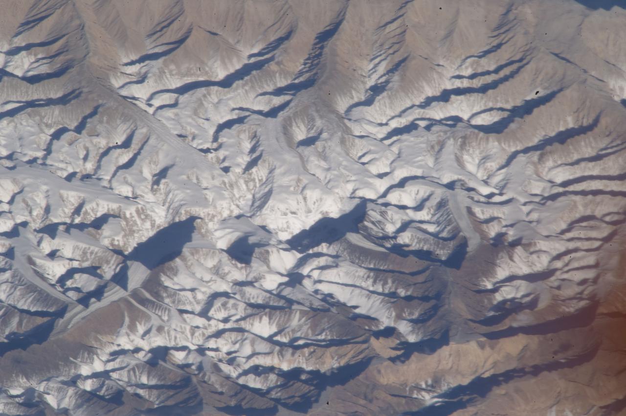
iss057e055415 (Oct. 22, 2018) --- The International Space Station was orbiting 253 miles above northern Pakistan when this photograph was taken of a portion of the Himalayan mountain range.
Earth observation taken during a day pass by the Expedition 40 crew aboard the International Space Station. File identifies it as: Straits of Hormuz through Pakistan into India.
iss070e091714 (Feb. 10, 2024) --- The Kashmir Valley (bottom) and the Himalayas are pictured from the International Space Station as it orbited 261 miles above the Afghanistan-Pakistan border.
ISS008-E-08767 (12 December 2003) --- This view featuring K-2 Mountain in Pakistan, the world’s second highest peak, was photographed by an Expedition 8 crewmember on the International Space Station (ISS).

iss065e385549 (Sept. 15, 2021) --- The International Space Station was orbiting 263 miles above Afghanistan when this photograph was taken of the city lights of Pakistan and India and the well-lit border separating both countries.
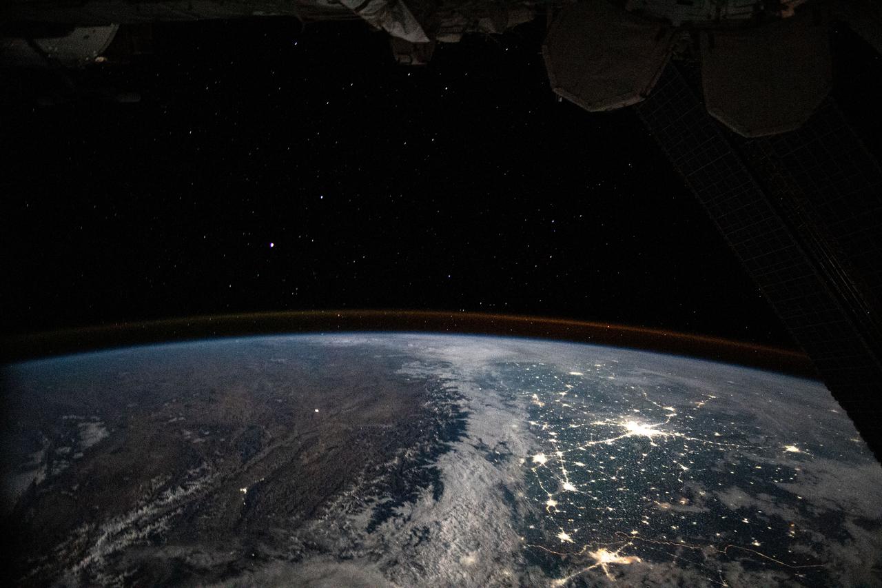
iss063e081399 (Aug. 31, 2020) --- The International Space Station was orbiting above Afghanistan during an orbital night period when an Expedition 63 crew member photographed the well-lit, highly populated areas of Pakistan and northern India.
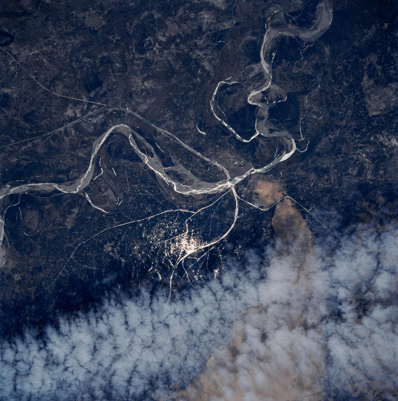
ISS036-E-036730 (14 Aug. 2013) --- One of the Expedition 36 crew members aboard the International Space Station photographed this image of the Indus Valley in Pakistan with its huge August floods brilliantly visible in sunglint.

iss062e103887 (March 20, 2020) --- The city lights of western India and Pakistan spread across the subcontinent like a glittering web as the International Space Station orbited 261 miles above.
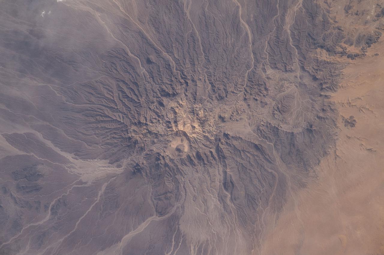
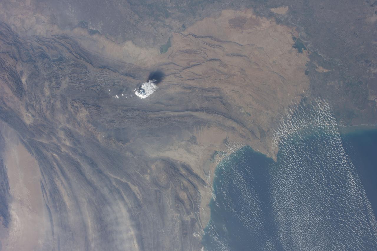
iss071e092895 (May 20, 2024) --- Mud Volcano in Pakistan's western district of Chagai is pictured from the International Space Station as it orbited 258 miles above central Asia.
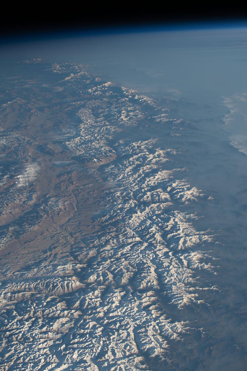
iss064e031247 (Feb. 11, 2021) --- The Himalayas separating China from India and Nepal are pictured from the International Space Station as it orbited 263 miles above northern Pakistan.

iss070e002199 (Oct. 4, 2023) --- The Soyuz MS-24 crew ship is featured prominently in this photograph from the International Space Station as it soared into an orbital sunrise 259 miles above the Iran-Pakistan border. The city lights below highlight the United Arab Emirates on the Persian Gulf and Oman on the Gulf of Oman.
iss064e021873 (Jan. 9, 2021) --- The International Space Station was flying 261 miles above the Arabian Sea just off the coast of Karachi, the largest city in Pakistan with a population of about 16.1 million, when this photograph was taken during a night pass.
iss066e092052 (Dec. 17, 2021) --- The Pakistan-India border ends on the coast of the Arabian Gulf with the Keti Bender South Wildlife Sanctuary on the Pakistani side and the Kutch Peninsula on the Indian side. This photograph was taken from the International Space Station at an altitude of 263 miles above northwest India.
51F-40-017 (29 July-6 Aug 1985) --- The great peaks and massive system of glaciers of the Karakoram Range of northern Pakistan are seen in this unique photo. The area is just of the west of Mount Godwin-Austen with peaks up to 26,000 feet. The Hispar Glacier is at the lower right.
ISS036-E-036732 (14 Aug. 2013) --- One of the Expedition 36 crew members aboard the International Space Station photographed this image of the Indus Valley in Pakistan with its huge August floods brilliantly visible in sunglint. A solar array panel belonging to a docked Russian vehicle is at upper left foreground.
This ASTER sub-scene covers an area of 12 x 15 km in NW India in the Thar Desert. The sand dunes of the Thar Desert constantly shift and take on new shapes. Located in northwestern India and eastern Pakistan, the desert is bounded on the south by a salt marsh known as the Rann of Kutch, and on the west by the Indus River plain. About 800 kilometers long and about 490 kilometers wide, the desert's terrain is mainly rolling sandhills with scattered growths of shrub and rock outcroppings. Only about 12 to 25 centimeters of rain fall on the desert each year, and temperatures rise as high as 52 degrees Celsius. Much of the population is pastoral, raising sheep for their wool. The image is located at 24.4 degrees north latitude and 69.3 degrees east longitude. http://photojournal.jpl.nasa.gov/catalog/PIA11094

ISS028-E-029679 (21 Aug. 2011) --- A night time view of India-Pakistan borderlands is featured in this image photographed by an Expedition 28 crew member on the International Space Station. Clusters of yellow lights on the Indo-Gangetic Plain of northern India and northern Pakistan reveal numerous cities both large and small in this photograph. Of the hundreds of clusters, the largest are the metropolitan areas associated with the capital cities of Islamabad, Pakistan in the foreground and New Delhi, India at the top?for scale these metropolitan areas are approximately 700 kilometers apart. The lines of major highways connecting the larger cities also stand out. More subtle but still visible at night are the general outlines of the towering and partly cloud-covered Himalayan ranges immediately to the north (left). A striking feature of this photograph is the line of lights, with a distinctly more orange hue, snaking across the central part of the image. It appears to be more continuous and brighter than most highways in the view. This is the fenced and floodlit border zone between the countries of India and Pakistan. The fence is designed to discourage smuggling and arms trafficking between the two countries. A similar fenced zone separates India?s eastern border from Bangladesh (not visible). This image was taken with a 16-mm lens, which provides the wide field of view, as the space station was tracking towards the southeast across the subcontinent of India. The station crew took the image as part of a continuous series of frames, each frame taken with a one-second exposure time to maximize light collection ? unfortunately, this also causes blurring of some ground features. The distinct, bright zone above the horizon (visible at top) is produced by airglow, a phenomena caused by excitation of atoms and molecules high in the atmosphere (above 80 kilometers, or 50 miles altitude) by ultraviolet radiation from the sun. Part of the ISS Permanent Multipurpose Module, or PMM, and a solar panel array are visible at right.
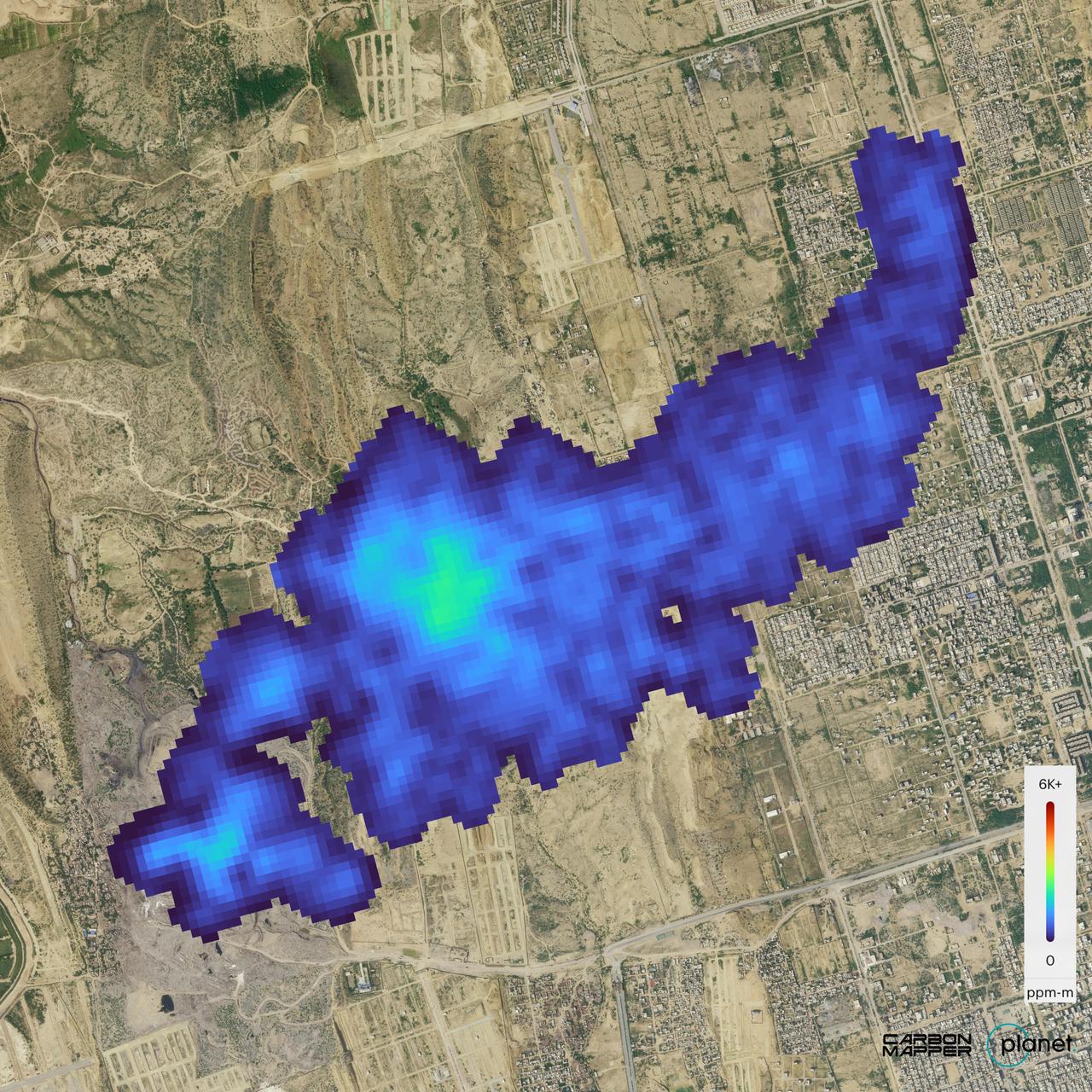
The Carbon Mapper Coalition's Tanager-1 satellite on Sept. 19, 2024, captured data over Karachi, Pakistan, showing the location and concentration of a methane plume measuring about 2½ miles (4 kilometers) long, emanating from a landfill. Enabled by the nonprofit Carbon Mapper and built by Planet Labs PBC, Tanager-1 uses an imaging spectrometer designed by NASA's Jet Propulsion Laboratory in Southern California. Carbon Mapper's preliminary estimate of the source emissions rate is about 2,600 pounds (1,200 kilograms) of methane released per hour. Launched from Vandenberg Space Force Base in California on Aug. 16, 2024, Tanager-1 is part of a broader effort by the nonprofit Carbon Mapper to identify and measure greenhouse gas point-source emissions on a global scale. Both Planet and JPL are members of the philanthropically funded Carbon Mapper Coalition. https://photojournal.jpl.nasa.gov/catalog/PIA26416
ISS033-E-019708 (9 Nov. 2012) --- One of the Expedition 33 crew members aboard the International Space Station exposed this high oblique image of Saser Muztagh, in the Karakoram Range of the Kashmir region of India centered 34.9 degrees north latitude and 77.8 degrees east longitude. The view is in mid-afternoon light looking northeastward from a nadir point in north central Pakistan about 100 miles west of Lahore.

41G-120-009 (5-13 Oct 1984) --- A large format camera's frame from the STS41-G/space shuttle Challenger mission provides a southwestern view of the Greater Himalayas bordering the Karakoram Range, whose great peaks are near the lower left edge of the frame. India is in the upper left; Pakistan, at lower right; and China is in the lower left foreground. The valley of the Indus River is in the right bottom corner. Photo credit: NASA
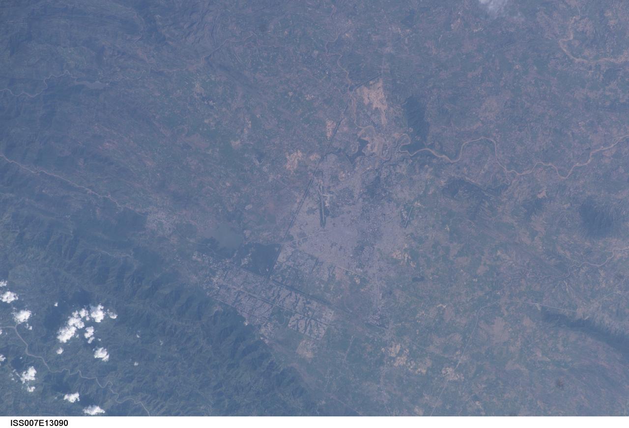
ISS007-E-13090 (21 August 2003) --- This view featuring Islamabad and Rawalpindi was taken by an Expedition 7 crewmember onboard the International Space Station (ISS). These two capital cities in Pakistan lie next to each another, but display land use patterns that are entirely different. Islamabad has a rectangular street pattern nestled against the Margala Hills. The larger Rawalpindi lies to the south on the Soan River.
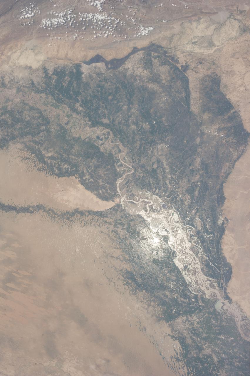
STS083-747-052 (4-8 April 1997) --- Sunglint on the Indus River, Sukkar, and Rohri, Pakistan. Sukkar city (27.42 north 68.52 east), Sindh province, southeastern Pakistan lies on the west bank of the Indus River, connected with Rohri on the opposite bank by a cantilever bridge. Midstream between the two cities is the strategic island fortress of Bukkur. The old town contains many historic tombs and mosques, including the Mir Ma'sum Shah Minaret (c. AD 1607). An industrial and trade center, it has biscuit, cigarette, oil, lime, and cement factories, and cotton, silk, thread, and flour mills; boat building is also significant. The surrounding region is a vast alluvial plain broken only occasionally by low limestone hills. A portion of the Thar Desert is reaching from the south to Rohri. The Sukkur Barrage, highlighted by the sunglint, was completed in 1932. Nearly 1 mile (1.6 kilometers) long it crosses the Indus River 3 miles (4.8 kilometers) below Sukkur Gorge and feeds irrigation canals. The canals originating from it serve a cultivable area of about five million acres of land producing both food and cash crops, such as wheat, cotton, rice, oilseed, and fruit cultivation.
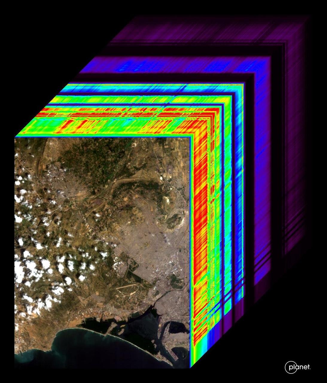
An imaging spectrometer designed by NASA's Jet Propulsion Laboratory captured its first data over Karachi, Pakistan, on Sept. 19, 2024. The instrument is aboard the Carbon Mapper Coalition's Tanager-1 satellite, which was built by Planet Labs PBC. An imaging spectrometer can measure hundreds of wavelengths of light that are reflected by Earth's surface. Different compounds in the planet's atmosphere and on the ground absorb different wavelengths of light, leaving spectral "fingerprints" that researchers can identify. The imaging spectrometer aboard Tanager-1 will enable the satellite to measure methane and carbon dioxide point-source emissions, down to the level of individual facilities and equipment, on a global scale. The image at the front of the cube shows a mix of information on land cover and water in the city and surrounding area, including exposed soil (brown), vegetation (green), and clouds. The rainbow colors extending through the main part of the cube are the wavelengths of light from corresponding spots in the front image. Tanager-1, which launched on Aug. 16, 2024, was developed as part of a philanthropically funded public-private coalition led by the nonprofit Carbon Mapper. Planet Labs and JPL are both members of the Carbon Mapper Coalition. https://photojournal.jpl.nasa.gov/catalog/PIA26412
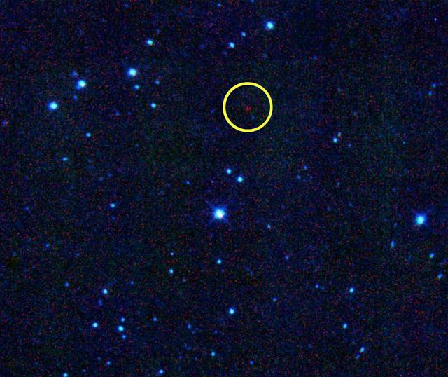
An asteroid discovered by NASA NEOWISE spacecraft has been given the formal designation 316201 Malala, in honor of Malala Yousafzai of Pakistan, who received the Nobel Peace Prize in 2014. The asteroid previous appellation was 2010 ML48. The International Astronomical Union (IAU) renamed the asteroid as the request of Amy Mainzer of NASA's Jet Propulsion Laboratory, Pasadena, California. Mainzer is the principal investigator of NASA's NEOWISE space telescope. The IAU is the sole worldwide organization recognized by astronomers everywhere to designate names for astronomical bodies. So far, Mainzer and the NEOWISE team have focused on pioneers in civil rights, science and the arts for the astronomical honor. Among the strong women of history who have already had NEOWISE-discovered asteroids named for them are civil rights activist Rosa Parks, conservationist Wangari Maathai, abolitionists Sojourner Truth and Harriet Tubman, and singer Aretha Franklin. Asteroid Malala is in the main belt between Mars and Jupiter and orbits the sun every five-and-a-half years. It is about two-and-a-half miles (four kilometers) in diameter, and its surface is very dark, the color of printer toner. http://photojournal.jpl.nasa.gov/catalog/PIA19362
STS106-705-009 (8-20 September 2000) --- One of the STS-106 crew members on board the Space Shuttle Atlantis used a handheld 70mm camera to photograph this image of Qogir Feng (8,611 meters), which appears at the far upper left in this view of the northwestern Karakoram Range. Also called K2 or Mt. Godwin Austen, the mountain is the second highest peak in the world. The Tarim sedimentary basin borders the range on the north and the Lesser Himalayas on the south. Melt waters from vast glaciers, such as those south and east of K2, feed agriculture in the valleys (dark green) and contribute significantly to the regional fresh-water supply. The Karakoram Range lies along the southern edge of the Eurasian tectonic plate and is made up of ancient sedimentary rocks (more than 390 million years old, according to geologists studying the shuttle imagery). Those strata were folded and thrust-faulted, and granite masses were intruded, say the geologists, when the Indo-Pakistan plate collided with Eurasia, beginning more than 100 million years ago.
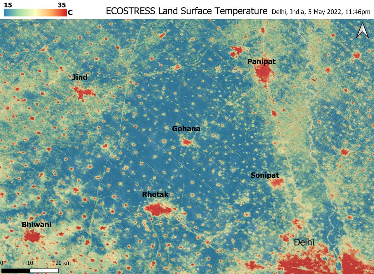
A relentless heat wave has blanketed India and Pakistan since mid-March 2022, causing dozens of deaths, fires, increased air pollution, and reduced crop yields. NASA's Ecosystem Spaceborne Thermal Radiometer Experiment on Space Station instrument (ECOSTRESS) has been measuring these temperatures from space, at the highest spatial resolution of any satellite instrument. This image, taken shortly before local midnight on May 5, shows urban areas and agricultural lands northwest of Delhi that are home to about 28 million people. The image covers about 4,800 square miles (12,350 square kilometers). Cities are usually markedly warmer than the surrounding countryside due to human activities and the materials used in the built environment. The image clearly delineates these urban "heat islands." Nighttime temperatures in Delhi and several smaller villages were above 95 degrees Fahrenheit (35 degrees Celsius), peaking at about 102 degrees F (39 degrees C), while the rural fields nearby had cooled to around 60 degrees F (15 degrees C). This data suggests that city dwellers are experiencing considerably higher temperatures than the average temperatures reported for their regions. ECOSTRESS measures the temperature of the ground itself, which is very similar to air temperature at night (though the ground may be warmer than the air in daylight hours). The instrument launched to the space station in 2018. Its primary mission is to identify plants' thresholds for water use and water stress, giving insight into their ability to adapt to a warming climate. However, ECOSTRESS also records other heat-related phenomena like this heat wave. Its high-resolution images, with a pixel size of about 225 feet (70 meters) by 125 feet (38 meters), are a powerful tool for understanding aspects of the weather event that might be overlooked by traditional observation networks. https://photojournal.jpl.nasa.gov/catalog/PIA24987