Pattern Upon Pattern
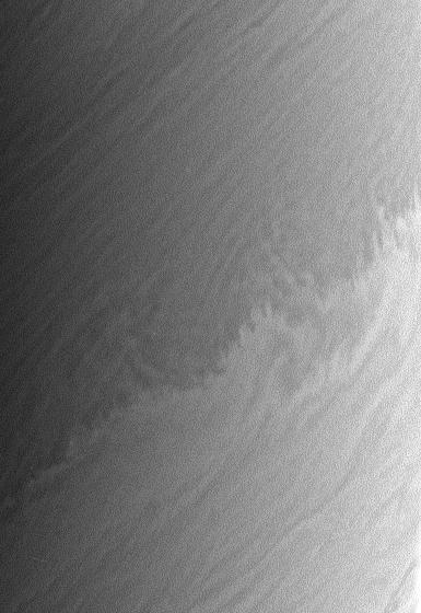
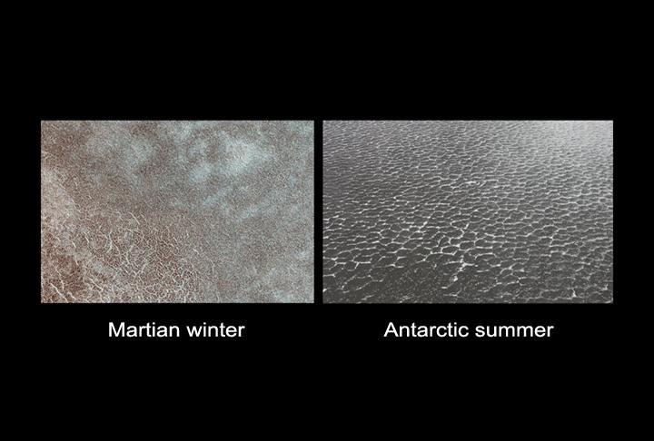
Defrosting Patterns
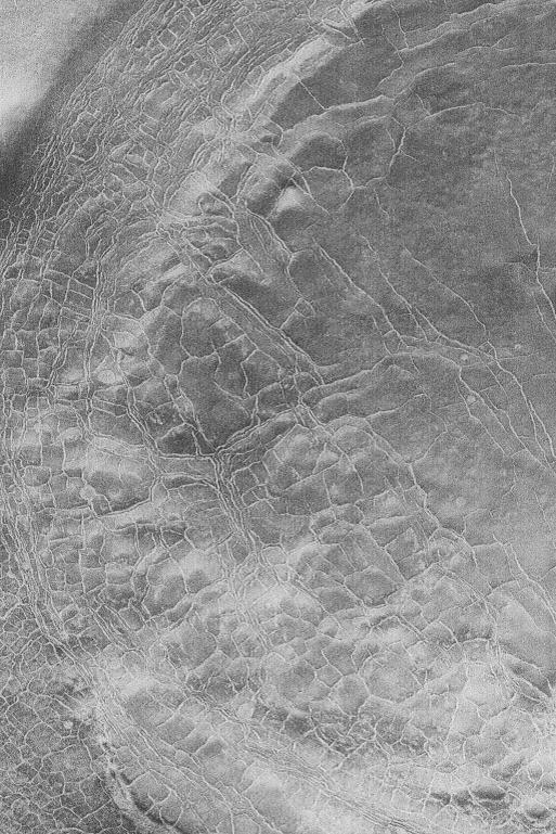
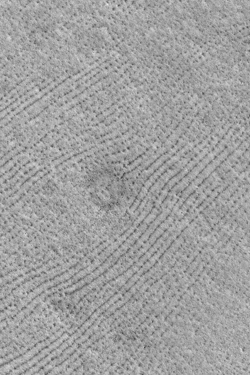
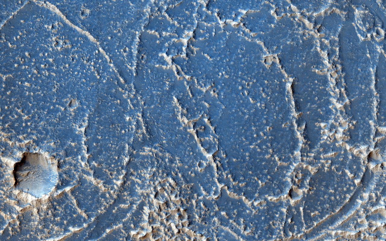
Polygon Patterns
Ground Patterns
Defrosting Patterns
Polar Polygon Patterns
Patterned Ground of the Martian Antarctic
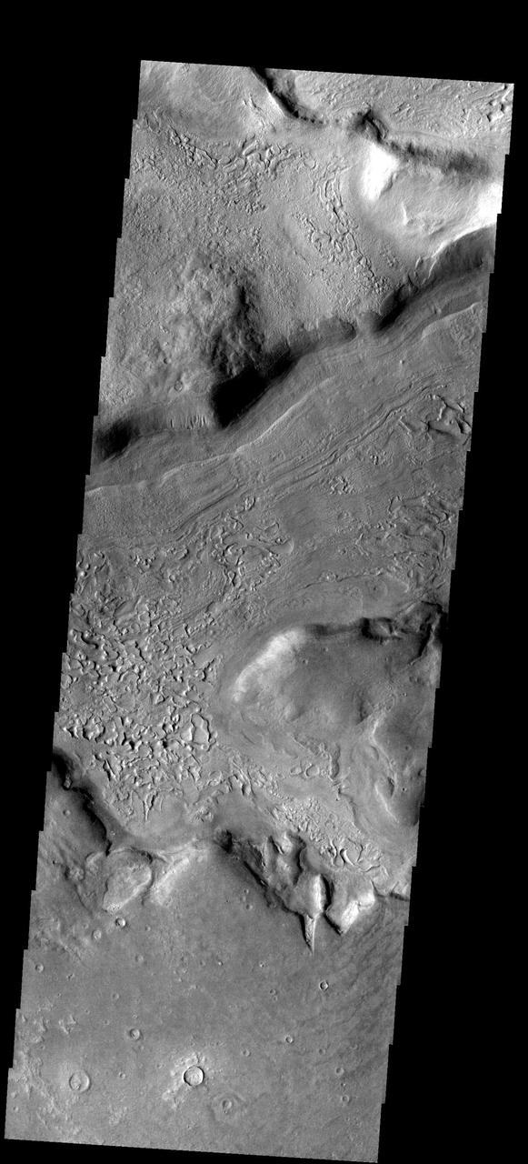
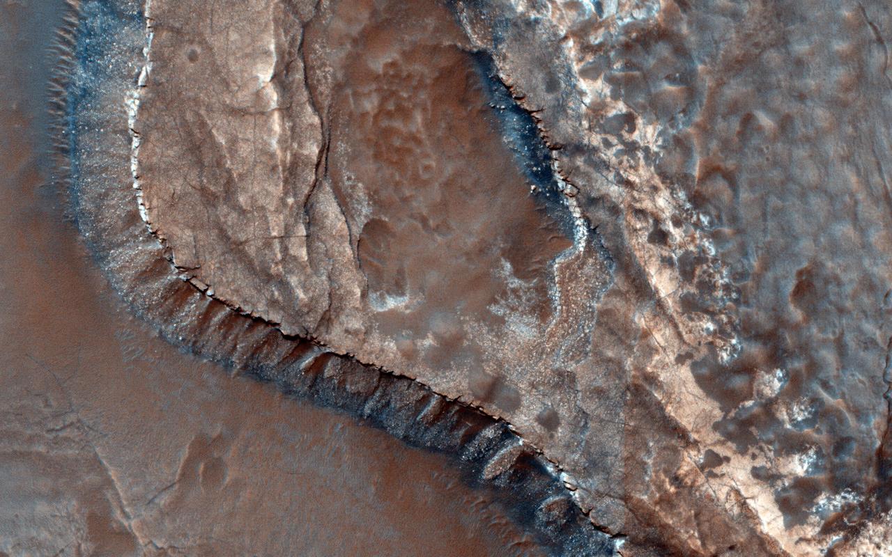
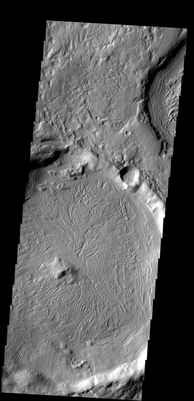
Regolith Patterns in Mendel-Rydberg
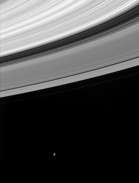
Saturn Ring Patterns
Icy, Patterned Ground on Mars
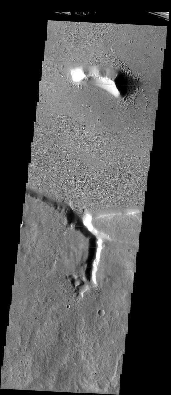
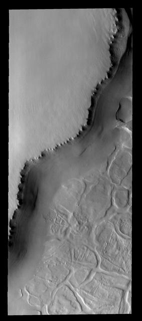
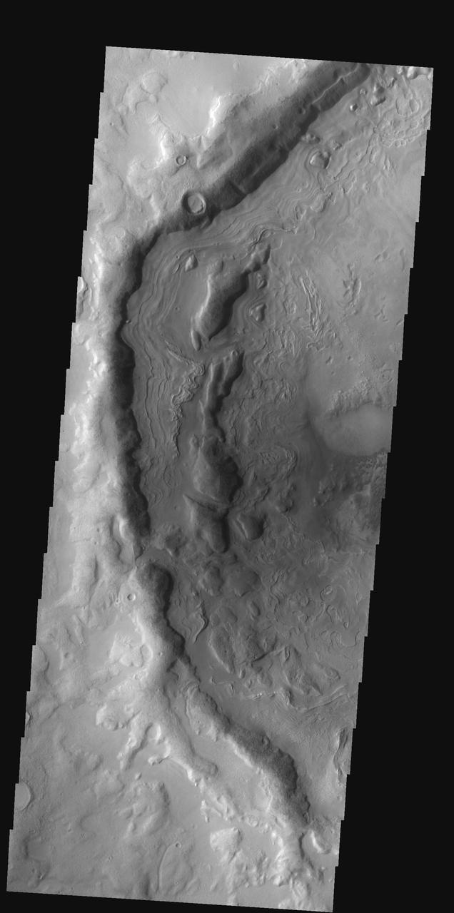
Exhumed Ridge Pattern
Northern Plains Patterns
South Polar Patterns
North Polar Dune Patterns
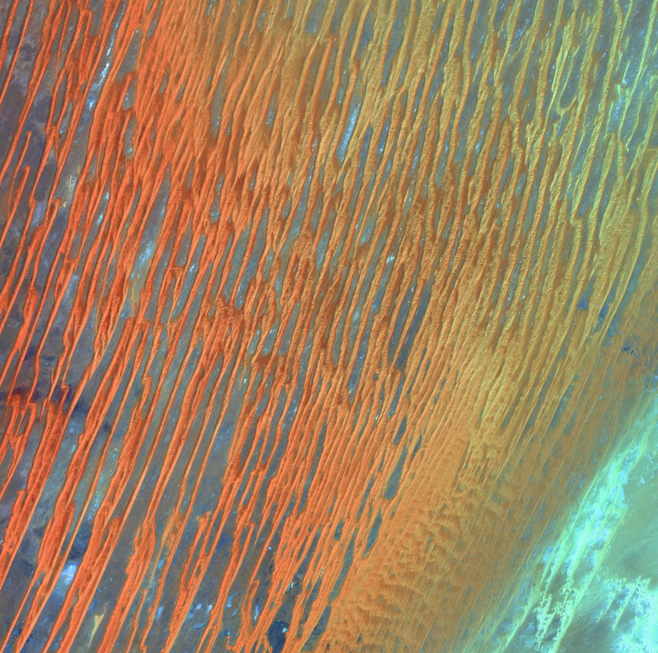
Desert Patterns - April 13th, 2003 Description: Seen through the "eyes" of a satellite sensor, ribbons of Saharan sand dunes seem to glow in sunset colors. These patterned stripes are part of Erg Chech, a desolate sand sea in southwestern Algeria, Africa, where the prevailing winds create an endlessly shifting collage of large, linear sand dunes. The term "erg" is derived from an Arabic word for a field of sand dunes. Credit: USGS/NASA/Landsat 7 To learn more about the Landsat satellite go to: <a href="http://landsat.gsfc.nasa.gov/" rel="nofollow">landsat.gsfc.nasa.gov/</a> <b><a href="http://www.nasa.gov/centers/goddard/home/index.html" rel="nofollow">NASA Goddard Space Flight Center</a></b> enables NASA’s mission through four scientific endeavors: Earth Science, Heliophysics, Solar System Exploration, and Astrophysics. Goddard plays a leading role in NASA’s accomplishments by contributing compelling scientific knowledge to advance the Agency’s mission. <b>Follow us on <a href="http://twitter.com/NASA_GoddardPix" rel="nofollow">Twitter</a></b> <b>Join us on <a href="http://www.facebook.com/pages/Greenbelt-MD/NASA-Goddard/395013845897?ref=tsd" rel="nofollow">Facebook</a></b>
Delicate Patterns in Giordano Bruno Ejecta

Southern Hemisphere Polygonal Patterned Ground
Mapping Titan Global Wind Patterns
Polygon Patterned Ground on Mars and on Earth
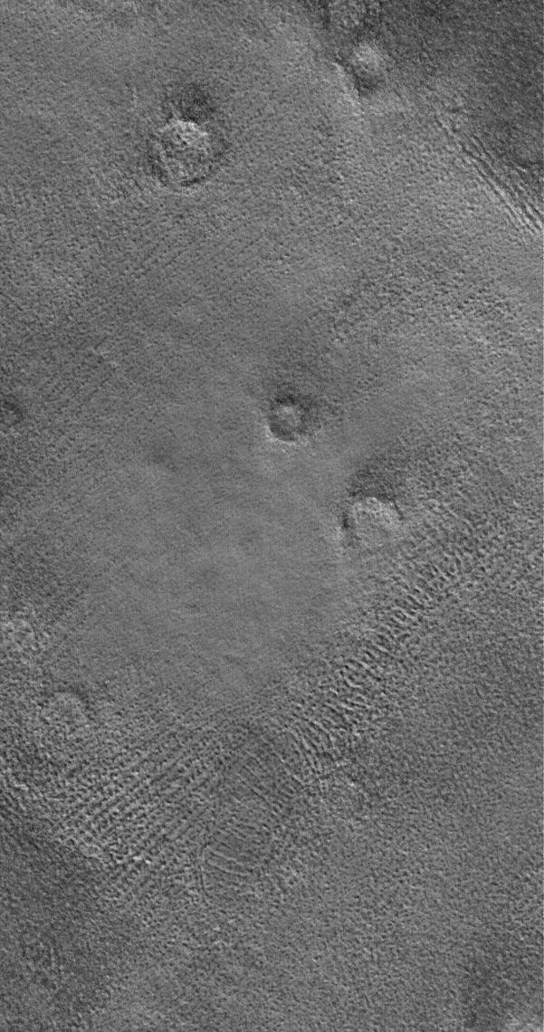
This MOC image shows the patterned ground of the cold, martian northern plains. The circular features are the sites of buried impact craters
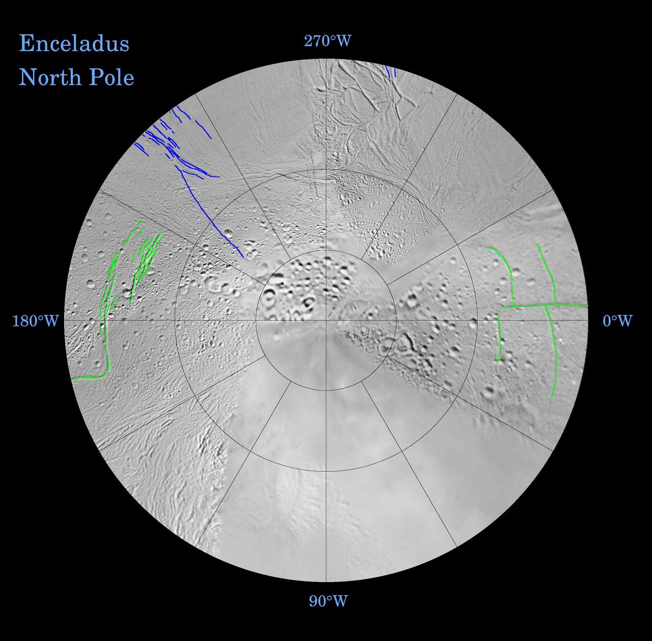
Enceladus: Global Patterns of Fracture Northern Polar Projection
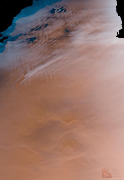
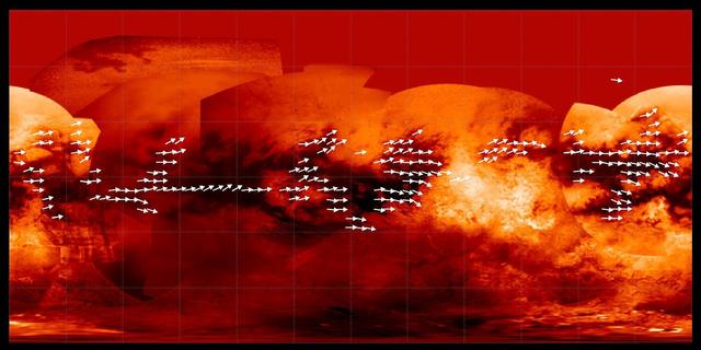
Detailed Cloud Patterns in Martian Northern Hemisphere
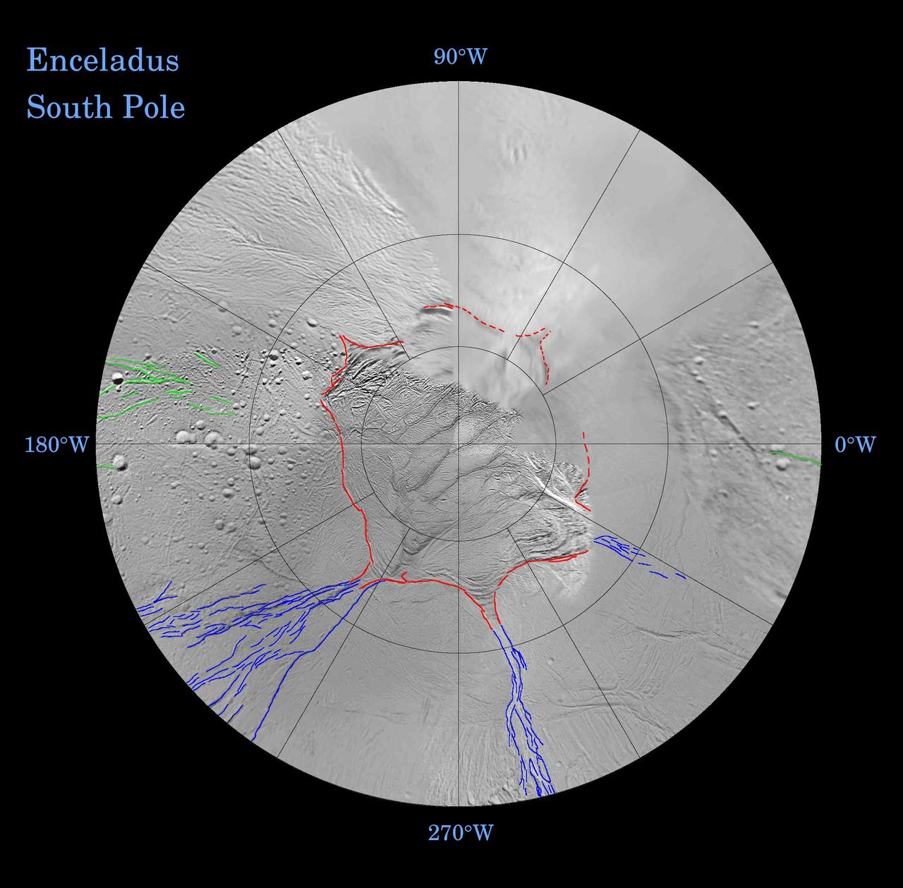
Enceladus: Global Patterns of Fracture Southern Polar Projection
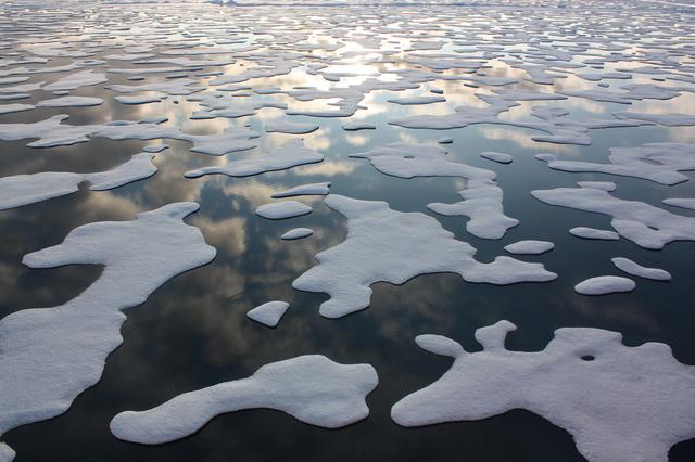
On July 20, the U.S. Coast Guard Cutter Healy steamed south in the Arctic Ocean toward the edge of the sea ice. The ICESCAPE mission, or "Impacts of Climate on Ecosystems and Chemistry of the Arctic Pacific Environment," is NASA's two-year shipborne investigation to study how changing conditions in the Arctic affect the ocean's chemistry and ecosystems. The bulk of the research takes place in the Beaufort and Chukchi seas in summer 2010 and 2011. Credit: NASA/Kathryn Hansen For updates on the five-week ICESCAPE voyage, visit the mission blog at: go.usa.gov/WwU <b><a href="http://www.nasa.gov/audience/formedia/features/MP_Photo_Guidelines.html" rel="nofollow">NASA image use policy.</a></b> <b><a href="http://www.nasa.gov/centers/goddard/home/index.html" rel="nofollow">NASA Goddard Space Flight Center</a></b> enables NASA’s mission through four scientific endeavors: Earth Science, Heliophysics, Solar System Exploration, and Astrophysics. Goddard plays a leading role in NASA’s accomplishments by contributing compelling scientific knowledge to advance the Agency’s mission. <b>Follow us on <a href="http://twitter.com/NASA_GoddardPix" rel="nofollow">Twitter</a></b> <b>Like us on <a href="http://www.facebook.com/pages/Greenbelt-MD/NASA-Goddard/395013845897?ref=tsd" rel="nofollow">Facebook</a></b> <b>Find us on <a href="http://instagrid.me/nasagoddard/?vm=grid" rel="nofollow">Instagram</a></b>
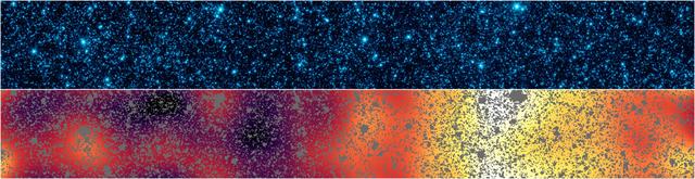
Astronomers have uncovered patterns of light that appear to be from the first stars and galaxies that formed in the universe. The light patterns were hidden within a strip of sky observed by NASA Spitzer Space Telescope.
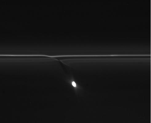
In this image from NASA Cassini spacecraft, the gravitational pull of Saturn moon Prometheus creates patterns in Saturn F ring.
AST-14-890 (18 July 1975) --- An oblique view of unique drainage patterns in southwestern Africa in the Rio Cuando area of Angola and South-West Africa, as photographed from the Apollo spacecraft in Earth orbit during the joint U.S.-USSR Apollo-Soyuz Test Project mission. The picture was taken at an altitude of 223 kilometers (138 statute miles) with a 70mm Hasselblad camera using high-definition Ektachrome aerial SO-242 type film.

AF-2, Major Ryan "Gunner" Reinhardt, Pattern Work & Taxi, 28 November 2012
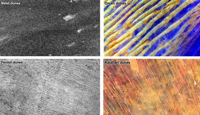
Data from NASA Cassini spacecraft show that the sizes and patterns of dunes on Saturn moon Titan vary as a function of altitude and latitude left. Images of Earth dunes Oman and Kalahari are shown at right as seen by NASA Terra spacecraft.

This graph compares a typical daily pattern of changing atmospheric pressure blue with the pattern during a regional dust storm hundreds of miles away red. The data are by the Rover Environmental Monitoring Station REMS on NASA Curiosity rover.
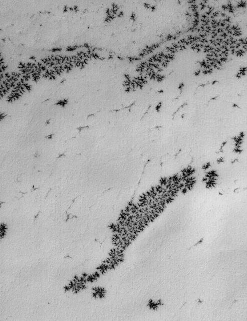
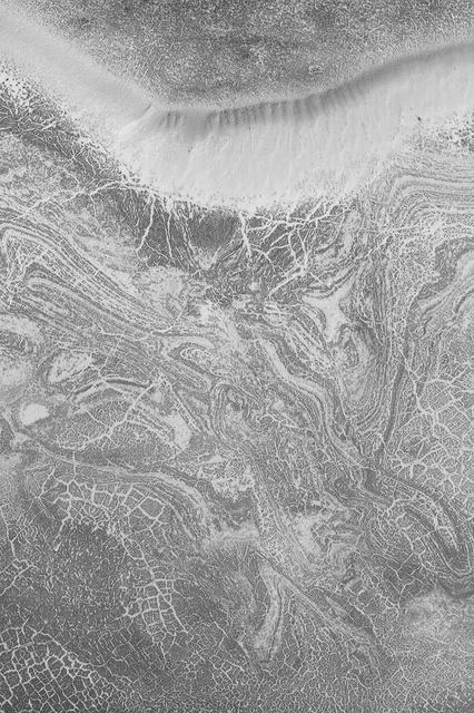
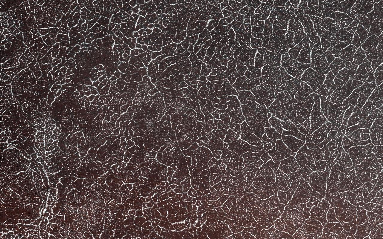
A delicate pattern, like that of a spider web, appears on top of the Mars residual polar cap, after the seasonal carbon-dioxide ice slab has disappeared
This image of a crater floor at high southern latitude reveals many boulders ranging from 1 to 10 meters in diameter. The boulders are not distributed randomly or uniformly but are often arranged in linear or circular patterns. Some of these patterns resemble the polygons often seen at high latitudes on Mars, which form from seasonal expansion and contraction of ground ice. Over many years, these processes might move boulders, concentrating then around the margins of polygons. If so, then the earlier polygons are no longer apparent at this location, but the boulder patterns persist. https://photojournal.jpl.nasa.gov/catalog/PIA25793
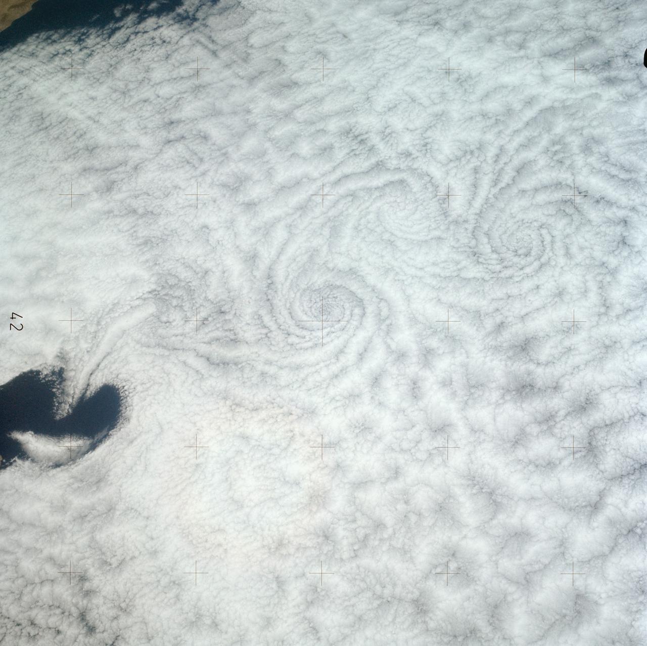
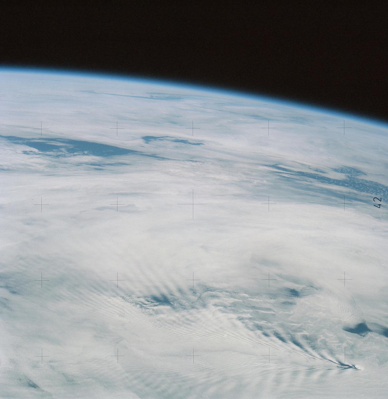
SL3-121-2371 (July-September 1973) --- A pattern of downstream eddies in the stratocumulus clouds over the Pacific Ocean west of Baja California, as photographed by the crewmen of the second Skylab manned mission (Skylab 3) from the space station cluster in Earth orbit. The clouds, produced by the cold California current running to the south and southwest, are prevented from rising by warm air above them. Photo credit: NASA
Wind Patterns in Jupiter Equatorial Region Time set 1
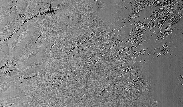
This image was taken by the Long Range Reconnaissance Imager (LORRI) on NASA's New Horizons spacecraft shortly before closest approach to Pluto on July 14, 2015; it resolves details as small as 270 yards (250 meters). The scene shown is about 130 miles (210 kilometers) across. The sun illuminates the scene from the left, and north is to the upper left. Credits: NASA/JHUAPL/SwRI It seems that the more we see of Pluto, the more fascinating it gets. With its prominent heart-shaped feature, icy mountains, and “snakeskin” terrain, Pluto has already surprised New Horizons scientists with the variety and complexity of its surface features. Now this latest image, from the heart of Pluto’s heart feature, show the plains’ enigmatic cellular pattern (at left) as well as unusual clusters of small pits and troughs (from lower left to upper right). Scientists believe that this area, informally known as Sputnik Planum, is composed of volatile ices such as solid nitrogen. They theorize that the pits and troughs – typically hundreds of meters across and tens of meters deep – are possibly formed by sublimation or evaporation of these ices. However, the reasons for the striking shapes and alignments of these features are a mystery. Adding to the intrigue is that even at this resolution, no impact craters are seen, testifying to the extreme geologic youth of Sputnik Planum. “Pluto is weird, in a good way,” said Hal Weaver, New Horizons project scientist with Johns Hopkins Applied Physics Laboratory in Laurel, Maryland. “The pits, and the way they’re aligned, provide clues about the ice flow and the exchange of volatiles between the surface and atmosphere, and the science team is working hard to understand what physical processes are at play here.” <b><a href="http://www.nasa.gov/audience/formedia/features/MP_Photo_Guidelines.html" rel="nofollow">NASA image use policy.</a></b> <b><a href="http://www.nasa.gov/centers/goddard/home/index.html" rel="nofollow">NASA Goddard Space Flight Center</a></b> enables NASA’s mission through four scientific endeavors: Earth Science, Heliophysics, Solar System Exploration, and Astrophysics. Goddard plays a leading role in NASA’s accomplishments by contributing compelling scientific knowledge to advance the Agency’s mission. <b>Follow us on <a href="http://twitter.com/NASAGoddardPix" rel="nofollow">Twitter</a></b> <b>Like us on <a href="http://www.facebook.com/pages/Greenbelt-MD/NASA-Goddard/395013845897?ref=tsd" rel="nofollow">Facebook</a></b> <b>Find us on <a href="http://instagrid.me/nasagoddard/?vm=grid" rel="nofollow">Instagram</a></b>

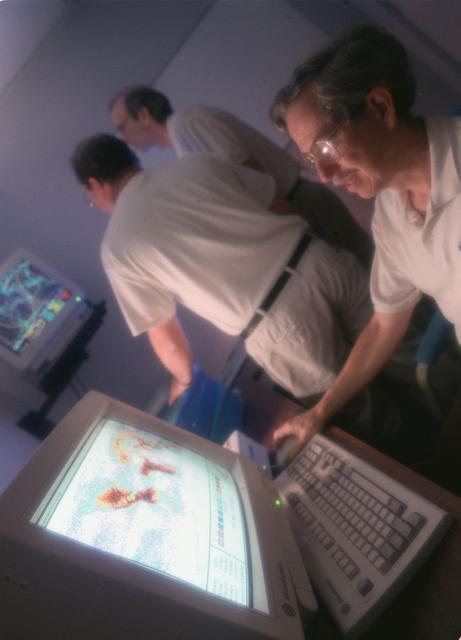
Dr. Donald Frazier works with a laser imaging system designed by Dr. Hossin Abdeldayem for pattern recognition applications. Photo credit: NASA/Marshall Space Flight Center (MSFC)
This image shows bright and dark patterns with curving boundaries, a good example of Mars art. What caused this appearance? This region of Echus Chasma has been flooded by lava flows that produced rough and smooth surfaces. The rough areas then trap bright dust, creating the contrasts in brightness. http://photojournal.jpl.nasa.gov/catalog/PIA20209
Marshall researchers conduct extensive analysis of weather patterns by using remote sensing on lightning and thunderstorms from outer space for the Mission to Planet Earth program.

A dance-step pattern is visible in the wheel tracks near the left edge of this scene recorded by NASA Mars Exploration Rover Opportunity on Mars on April 1, 2011.
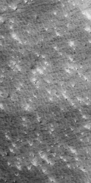
It's spring in the Northern Hemisphere of Mars (when this image was taken), and this area was recently completely covered by the seasonal frost cap. Here, we see polygonal patterns that are highlighted by carbon dioxide frost that has not entirely sublimed away. These organized patterns are likely caused by differences in the soil (regolith) characteristics such as grain size, density, even grain-shape and orientation in the underlying landforms and geologic materials. Variations in these characteristics strongly influence the strength of the ice-rich permafrost. This gives a preferred orientation to the stress field that produces the polygonal patterns. In this case, there appears to have been a meander in a fluvial channel in which sediments that differ from the native soil were deposited. The physical properties of these sediments probably change near the channel banks where flow rate drops off. Additionally, a high ice content might have resulted from a sediment-rich slurry flow that froze in place. Higher ice content will produce a weaker stress field and larger polygons, more so than just changes in grain size or orientation. https://photojournal.jpl.nasa.gov/catalog/PIA23581
SL4-137-3632 (February 1974) --- A photograph taken from the Skylab space station in Earth orbit illustrating an atmospheric wave pattern by the affect of a small mountainous island on wind currents. Various patterns can be seen downwind of small islands. Often a Von Karmon vortex can be seen which appears as a spiral pattern. Multiple vortices have been photographed on previous missions. This photograph illustrates a "bow wave" pattern which extends for hundreds of miles downwind from the island. The island itself is often clear when a wave pattern is formed downstream. This particular pattern is very symmetrical. These wave patterns are most common in the South Pacific. This picture was taken by a Skylab 4 crewmen using a hand-held 70mm Hasselblad camera. Photo credit: NASA
This image from NASA's Curiosity Mars rover reveals details of a bedrock discoloration pattern at a site between "Marias Pass" and "Bridger Basin." The discoloration is not associated with individual layers. It crosses layers and shows clear horizontal boundaries to the darker toned bedrock. This suggests it is related to alteration by fluids that flowed through fractures and permeated into the bedrock. The image was taken by the right-eye (telephoto) camera of the rover's Mast Camera instrument on Sept. 2, 2015, during the mission's 1,092nd Martian day, or sol. http://photojournal.jpl.nasa.gov/catalog/PIA20269
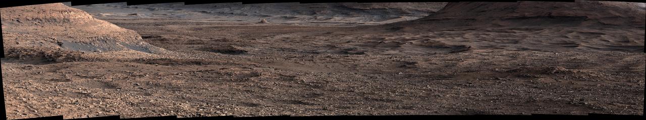
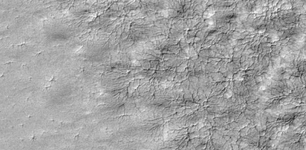
NASA's Curiosity Mars rover viewed this expanse while looking out across a region filled with low ridges known as boxwork patterns. The panorama is stitched together from 23 individual images the rover's Mast Camera, or Mastcam, captured on May 22, 2025 (the 4,536th day, or sol, of the mission). The color in these images has been adjusted to match the lighting conditions as the human eye would see them on Earth. When viewed from space, the boxwork patterns look a bit like spiderwebs. They have fascinated scientists since before Curiosity's 2012 landing on the Red Planet and are believed to have formed from groundwater trickling through rock cracks billions of years ago. Minerals left behind by the water hardened like cement within the rock; after eons of sandblasting by wind, the rock was carved away, revealing networks of resistant ridges within. Curiosity's images provide the first up-close views of the boxwork region, which is located in the foothills of Mount Sharp, a 3-mile-tall (5-kilometer-tall) mountain the rover has been ascending since 2014. Video available at https://photojournal.jpl.nasa.gov/catalog/PIA26560
A dance-step pattern is visible in the wheel tracks near the left edge of this scene recorded by NASA Mars Exploration Rover Opportunity on Mars on April 1, 2011. 3D glasses are necessary to view this image.
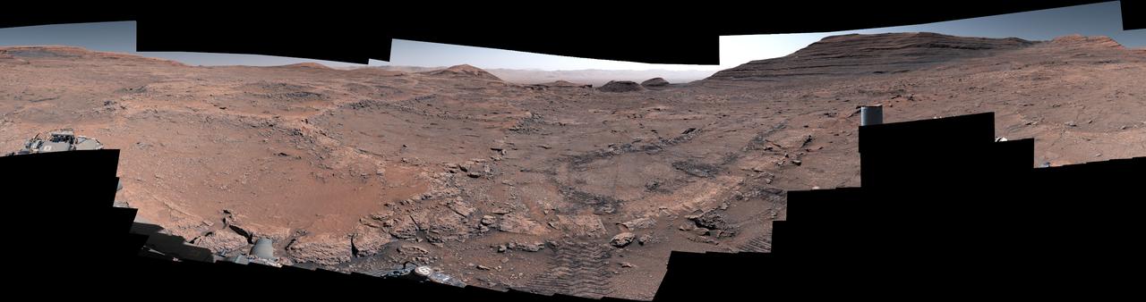
NASA's Curiosity Mars rover captured this 360-degree view after arriving at a region crisscrossed by hardened low ridges called boxwork patterns. The panorama is stitched together from 291 individual images the rover's Mast Camera, or Mastcam, captured between May 15 and May 18, 2025 (the 4,451st Martian day, or sol, of the mission and the 4,454th sol). The color in these images has been adjusted to match the lighting conditions as the human eye would see them on Earth. When viewed from space, the boxwork patterns look a bit like spiderwebs. They have fascinated scientists since before Curiosity's 2012 landing on the Red Planet and are believed to have formed from groundwater trickling through rock cracks billions of years ago. Minerals left behind by the water hardened like cement within the rock; after eons of sandblasting by wind, the rock was carved away, revealing networks of resistant ridges within. Curiosity's tracks can be seen in the middle of the image. In the distance to the right is a butte nicknamed "Texoli." Far in the distance at the top center of the image is the rim of Gale Crater. Since 2014, Curiosity has been exploring the foothills of Mount Sharp, a 3-mile-tall (5-kilometer-tall) mountain within the crater. https://photojournal.jpl.nasa.gov/catalog/PIA26559
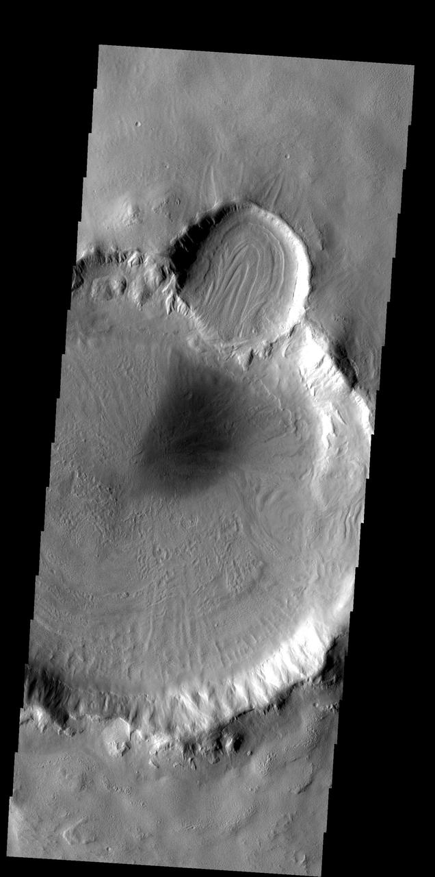
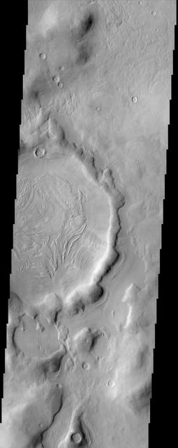
The floor of Reull Vallis is filled with patterned material. The patterns indicate a volitile such as ice played a part in creating the interesting surface
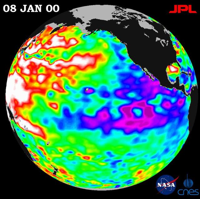
A giant horseshoe pattern of higher than normal sea-surface heights developing over the last year is beginning to dominate the entire western Pacific and Asiatic oceans.
STS054-80-024 (13-19 Jan 1993) --- As the Shuttle was passing southeast over the coast of India, approaching the Bay of Bengal, Endeavour's crew took this picture of the Godavari River Delta. The sun glint pattern was centered directly over the delta and highlighted well the intricate drainage pattern. Offshore, water features associated with current boundaries and river plumes are readily visible. The line of clouds along the coast south of the delta suggest that surface winds are blowing onshore from the Bay of Bengal. As the air passes over the warmer coastal water and land, it is warmed and begins to rise. The moisture in the air condenses, forming a line of low-level clouds.
Textured rows on the ground in this portion of "Perseverance Valley" are under investigation by NASA's Mars Exploration Rover Opportunity, which used its Navigation Camera (Navcam) to take the component images of this downhill-looking scene. The rover took this image on Jan. 4, 2018, during the 4,958th Martian day, or sol, of its work on Mars, looking downhill from a position about one-third of the way down the valley. Perseverance Valley descends the inboard slope of the western rim of Endeavour Crater. A view on the same sol with the rover's front Hazard Avoidance Camera includes ground even closer to the rover at this site. Opportunity was still working close by as it reached the mission's Sol 5,000 (Feb. 16, 2018). In the portion of the valley seen here, soil and gravel have been shaped into a striped pattern in the foreground and partially bury outcrops visible in the midfield. The long dimensions of the stripes are approximately aligned with the downhill direction. The striped pattern resembles a type of feature on Earth (such as on Hawaii's Mauna Kea) that is caused by repeated cycles of freezing and thawing, though other possible origins are also under consideration for the pattern in Perseverance Valley. The view is spans from north on the left to east-southeast on the right. For scale, the foreground rock clump in the lower right is about 11 inches (28 centimeters) in width. https://photojournal.jpl.nasa.gov/catalog/PIA22217
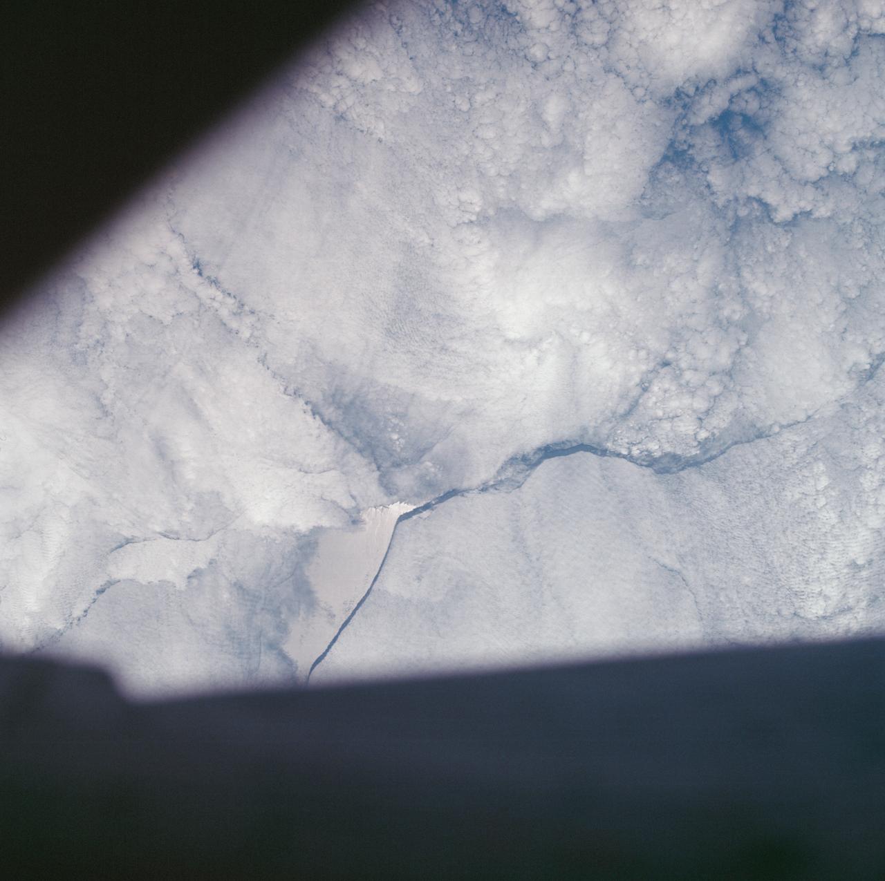
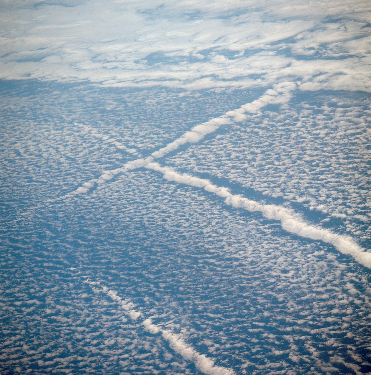
AS07-05-1644 (13 Oct. 1968) --- Remarkable cloud patterns as seen from the Apollo 7 spacecraft during its 34th revolution of Earth. Note break in two adjacent decks of strato-cumulus cloud formations. Sea can be seen through holes in clouds.
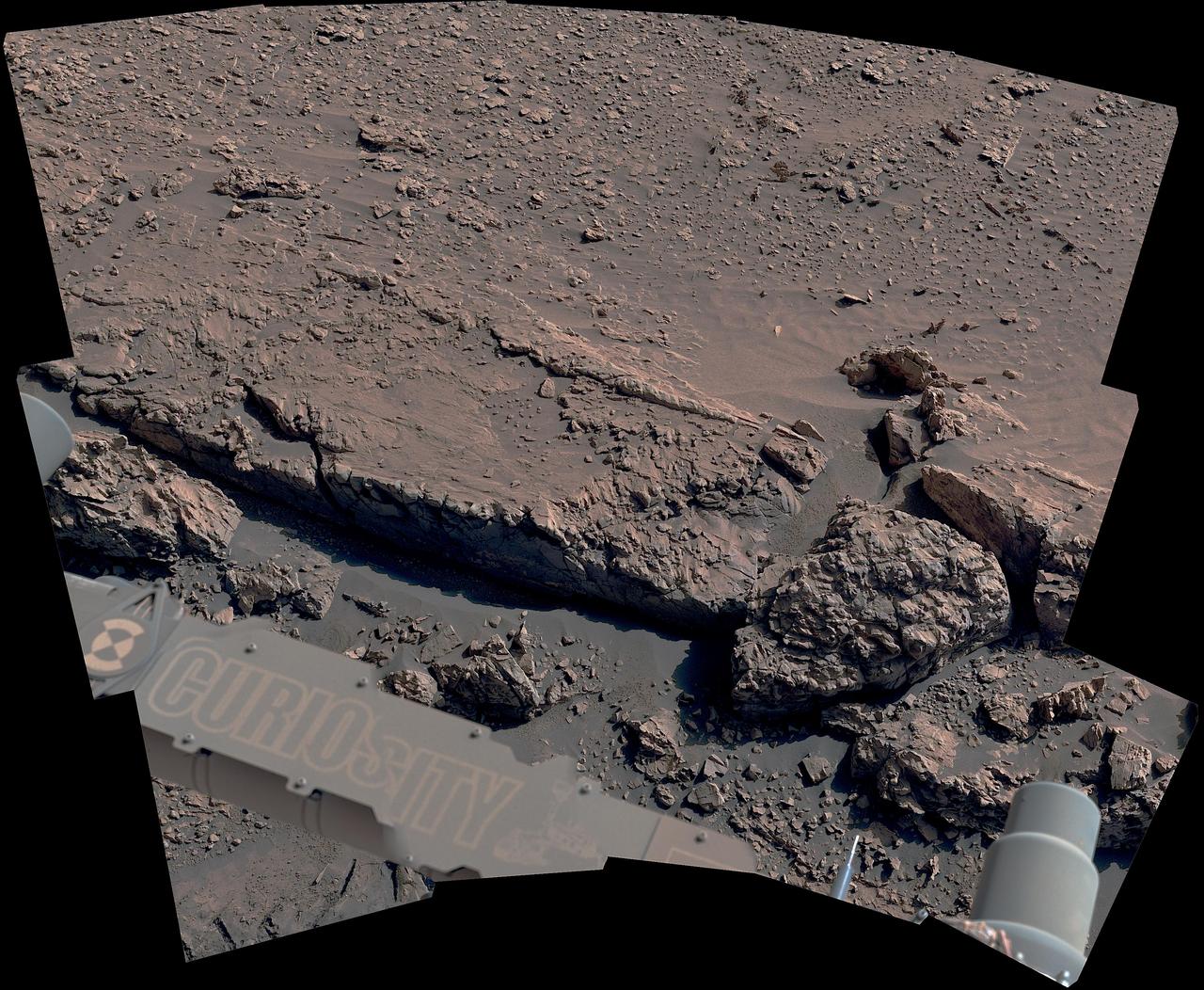
The curblike ridge in this view is part of a series of crisscrossing features that form what's called a boxwork pattern. NASA's Curiosity Mars rover captured the image with its Mast Camera, or Mastcam, on May 16, 2025, the 4,541st Martian day, or sol, of the mission. This panorama was stitched together from 15 individual images. The color in these images has been adjusted to match the lighting conditions as the human eye would see them on Earth. When viewed from space, the boxwork patterns look a bit like spiderwebs. They have fascinated scientists since before Curiosity's 2012 landing on the Red Planet and are believed to have formed from groundwater trickling through rock cracks billions of years ago. Minerals left behind by the water hardened like cement within the rock; after eons of sandblasting by wind, the rock was carved away, revealing networks of resistant ridges within. https://photojournal.jpl.nasa.gov/catalog/PIA26558
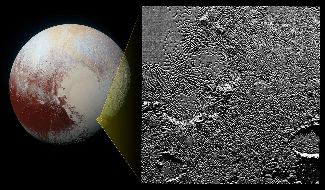
On July 14, 2015, the telescopic camera on NASA's New Horizons spacecraft took the highest resolution images ever obtained of the intricate pattern of "pits" across a section of Pluto's prominent heart-shaped region, informally named Tombaugh Regio. Mission scientists believe these mysterious indentations may form through a combination of ice fracturing and evaporation. The scarcity of overlying impact craters in this area also leads scientists to conclude that these pits -- typically hundreds of yards across and tens of yards deep -- formed relatively recently. Their alignment provides clues about the ice flow and the exchange of nitrogen and other volatile materials between the surface and the atmosphere. The image is part of a sequence taken by New Horizons' Long Range Reconnaissance Imager (LORRI) as the spacecraft passed within 9,550 miles (15,400 kilometers) of Pluto's surface, just 13 minutes before the time of closest approach. The small box on the global view shows the section of the region imaged in the southeast corner of the giant ice sheet informally named Sputnik Planum. The magnified view is 50-by-50 miles (80-by-80 kilometers) across. The large ring-like structure near the bottom right of the magnified view -- and the smaller one near the bottom left -- may be remnant craters. The upper-left quadrant of the image shows the border between the relatively smooth Sputnik Planum ice sheet and the pitted area, with a series of hills forming slightly inside this unusual "shoreline." http://photojournal.jpl.nasa.gov/catalog/PIA20212

JANUARY 8, 2013: Astronomers using NASA's Hubble and Spitzer space telescopes have probed the stormy atmosphere of a brown dwarf named 2MASSJ22282889-431026, creating the most detailed "weather map" yet for this class of cool, star-like orbs. The forecast shows wind-driven, planet-sized clouds enshrouding these strange worlds. Brown dwarfs form out of condensing gas, as stars do, but lack the mass to fuse atoms and produce energy. Instead, these objects, which some call failed stars, are more similar to gas planets with their complex, varied atmospheres. The new research is a stepping stone toward a better understanding not only brown dwarfs, but also of the atmospheres of planets beyond our solar system. Hubble and Spitzer simultaneously watched the brown dwarf as its light varied in time, brightening and dimming about every 90 minutes as the body rotated. Astronomers found the timing of this change in brightness depended on whether they looked using different wavelengths of infrared light. The variations are the result of different layers or patches of material swirling around in the brown dwarf in windy storms as large as Earth itself. Spitzer and Hubble see different atmospheric layers because certain infrared wavelengths are blocked by vapors of water and methane high up, while other infrared wavelengths emerge from much deeper layers. Daniel Apai, the principal investigator of the research from the University of Arizona, Tucson, presented the results at the American Astronomical Society meeting on January 8 in Long Beach, Calif. A study describing the results, led by Esther Buenzli, also of the University of Arizona, is published in the Astrophysical Journal Letters. For more information about this study, visit <a href="http://www.nasa.gov/spitzer" rel="nofollow">www.nasa.gov/spitzer</a> . <b><a href="http://www.nasa.gov/audience/formedia/features/MP_Photo_Guidelines.html" rel="nofollow">NASA image use policy.</a></b> <b><a href="http://www.nasa.gov/centers/goddard/home/index.html" rel="nofollow">NASA Goddard Space Flight Center</a></b> enables NASA’s mission through four scientific endeavors: Earth Science, Heliophysics, Solar System Exploration, and Astrophysics. Goddard plays a leading role in NASA’s accomplishments by contributing compelling scientific knowledge to advance the Agency’s mission. <b>Follow us on <a href="http://twitter.com/NASA_GoddardPix" rel="nofollow">Twitter</a></b> <b>Like us on <a href="http://www.facebook.com/pages/Greenbelt-MD/NASA-Goddard/395013845897?ref=tsd" rel="nofollow">Facebook</a></b> <b>Find us on <a href="http://instagram.com/nasagoddard?vm=grid" rel="nofollow">Instagram</a></b>
AST-01-042 (16 July 1975) --- An oblique view of unique cloud patterns over the Pacific Ocean caused by aircraft contrail shadows altering cumulus clouds and forming straight line clouds, as photographed from the Apollo spacecraft in Earth orbit during the joint U.S.-USSR Apollo-Soyuz Test Project mission. This area is southwest of Los Angeles, California. This photograph was taken at an altitude of 177 kilometers (110 statute miles) with a 70mm Hasselblad camera using medium-speed Ektachrome QX-807 type film.
This image from NASA Mars Reconnaissance Orbiter shows the southwestern floor of a 50-kilometer diameter unnamed crater, about 100 kilometers northeast of Hellas Basin. The crater's rim is breached on both the north and south by a valley system that previously flowed across the crater floor, leaving behind an interesting array of channel patterns and deposits as it transported water and sediments into and out of the crater. In this image, we see a portion of the channel system along the southwestern crater floor near where the valley breaches the southern rim. The darker-toned surface has a pattern similar to the texture of a basketball, and blankets the region both in the channel belt and in the basin below the cliffs. Superposed on this patterned surface are clusters of larger, circular mounds that may be related to the thawing and freezing of ice-rich sediment, which is unusual at this relatively low latitude. Extensional cracks and clusters of pits make this topography more complicated. The southern part of this image reveals a prominent irregular scarp with light-toned layered deposits exposed along the margin beneath this textured surface. The light-toned layers look like an ancient mosaic in some areas as they are irregularly fractured and brecciated. Individual blocks and large boulders of this material are visible at full-resolution near the scarp, just about to fall and already lying on the debris slopes below the scarp. Some are brighter than the others: these may be dust-free, indicating that they have detached from the cliff more recently. http://photojournal.jpl.nasa.gov/catalog/PIA19850
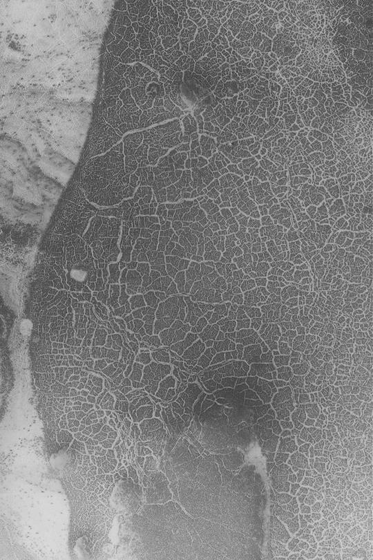
The unusual surface pattern exists at the margin of the north polar layered deposit
The patterns on the floor of these craters indicates that a volitile, such as ice, likely was present in the floor material
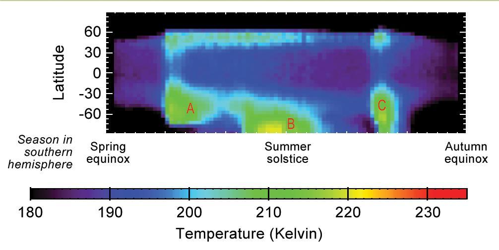
This graphic shows Martian atmospheric temperature data related to seasonal patterns in occurrence of large regional dust storms. The data shown here were collected by the Mars Climate Sounder instrument on NASA's Mars Reconnaissance Orbiter over the course of one-half of a Martian year, during 2012 and 2013. The color coding indicates daytime temperatures of a layer of the atmosphere centered about 16 miles (25 kilometers) above ground level, corresponding to the color-key bar at the bottom of the graphic. Three regional dust storms indicated by increased temperatures are labeled A, B and C. A similar sequence of three large regional dust storms has been seen in atmosphere-temperature data from five other Martian years. The vertical axis is latitude on Mars, from the north pole at the top to south pole at the bottom. Each graphed data point is an average for all Martian longitudes around the planet. The horizontal axis is the time of year, spanning from the beginning of Mars' southern-hemisphere spring (on the left) to the end of southern-hemisphere summer. This is the half of the year when large Martian dust storms are most active. http://photojournal.jpl.nasa.gov/catalog/PIA20746
The bizarre patterns on the floor of this crater in Nilosyrtis Mensae imaged by NASA Mars Odyssey defy an easy explanation. It is possible that some form of periglacial process combined with the vaporization of ground ice to form these patterns.
The full-circle panorama in approximately true color taken by NASA Phoenix Mars Lander shows the polygonal patterning of ground at the landing area, similar to patterns in permafrost areas on Earth.

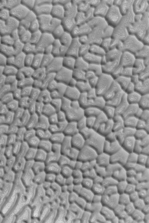
This close-up image from NASA's Mars Reconnaissance Orbiter gives the impression of looking like bacterial cells and their internal structures which travel and split in the process of life. These features are fractal in nature: the same image is preserved through different scales, with the pattern repeating eternally. The reality is, we are looking at one of Mars' polar regions; the South Polar residual cap to be precise, and, as with many things in Martian planetary science, there is a precise reasoning behind the name. With the coming and going of the seasons, this is an area on Mars where ice remains even after the peak of summer arrives. The texture is very alien, bearing more of a resemblance to the universe of the very small, rather than the universe far, far away. But if this is a polar cap, then why does it not look like the polar caps on Earth? Indeed, there is no equivalent terrain observed here on Earth. The so-called "Swiss cheese terrain, referencing the numerous holes of the region, is a product of seasonal exchange between the surface and the Martian atmosphere. With a predominantly carbon dioxide content at 98 percent, the colder temperatures condense the gas out of the atmosphere to produce dry ice. The prevalence of water is more concentrated in the north, leaving the South polar region more carbon dioxide rich, and it's this difference in composition that generates the unusual texture of the Swiss cheese terrain. The Red Planet is one of the chief candidates in the search for life elsewhere in the Solar System; however, a quick glance at this image virtually gives the impression we have already found it. NB: The cutout image has been rotated so that north is approximately up. https://photojournal.jpl.nasa.gov/catalog/PIA21880

This image from NASA's Mars Reconnaissance Orbiter (MRO) shows two new craters, both with the same distinctive pattern of relatively blue (less red) ejecta surrounded by a dark blast zone (where dust has been removed or disturbed), and with arcing patterns extending northwest and northeast. This pattern indicates an oblique impact angle with the bolide coming from the north. MRO has discovered over 700 new impact sites on Mars. Often, a bolide breaks apart in the atmosphere and makes a tight cluster of new craters. https://photojournal.jpl.nasa.gov/catalog/PIA22453
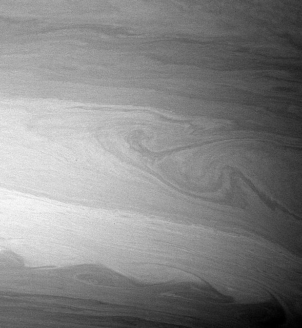
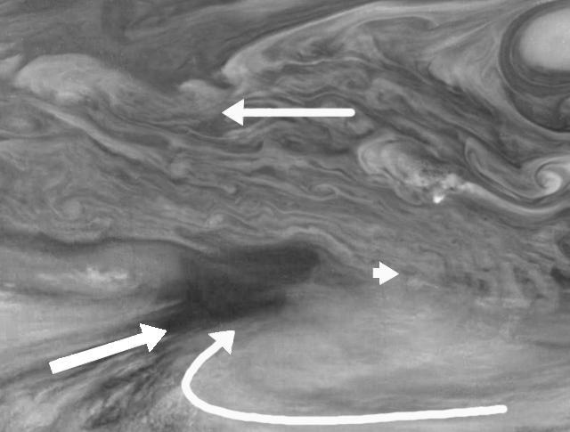
During its time in orbit, Cassini has spotted many beautiful cat's eye-shaped patterns like the ones visible here. These patterns occur in places where the winds and the atmospheric density at one latitude are different from those at another latitude. The opposing east-west flowing cloud bands are the dominant patterns seen here and elsewhere in Saturn's atmosphere. Contrast in the image was enhanced to aid the visibility of atmospheric features. The image was taken with the Cassini spacecraft wide-angle camera on Aug. 20, 2005. http://photojournal.jpl.nasa.gov/catalog/PIA07600
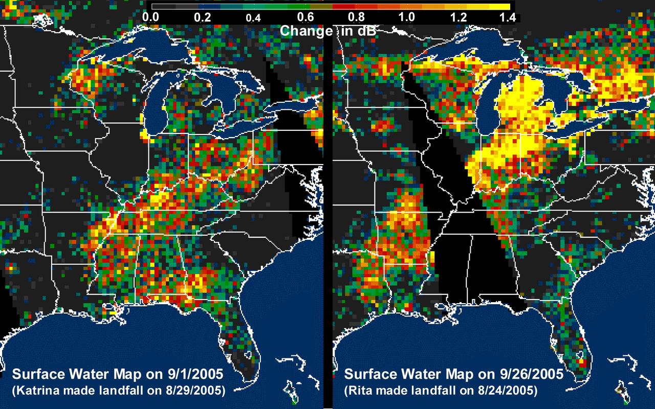
The above images, derived from NASA QuikScat satellite data, show the extensive pattern of rain water deposited by Hurricanes Katrina and Rita on land surfaces over several states in the southern and eastern United States. These results demonstrate the capability of satellite scatterometers to monitor changes in surface water on land. The color scale depicts increases in radar backscatter (in decibels) between the current measurement and the mean of measurements obtained during the previous two weeks. The backscatter can be calibrated to measure increases in surface soil moisture resulting from rainfall. The yellow color corresponds to an increase of approximately 10 percent or more in surface soil moisture according to the calibration site of Lonoke, Ark. The two hurricanes deposited excessive rainfall over extensive regions of the Mississippi River basin. Basins the size of the Mississippi can take up to several weeks before such excess rainfall significantly increases the amount of river discharge in large rivers such as the Mississippi. With hurricane season not over until November 30, the potential exists for significant flooding, particularly if new rain water is deposited by new hurricanes when river discharge peaks up as a result of previous rainfalls. River discharge should be closely monitored to account for this factor in evaluating potential flood conditions in the event of further hurricanes. http://photojournal.jpl.nasa.gov/catalog/PIA03029
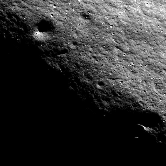
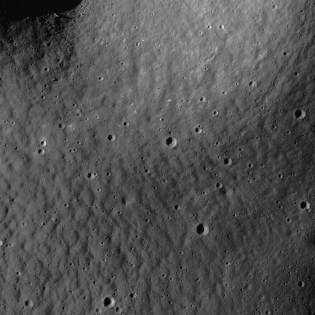
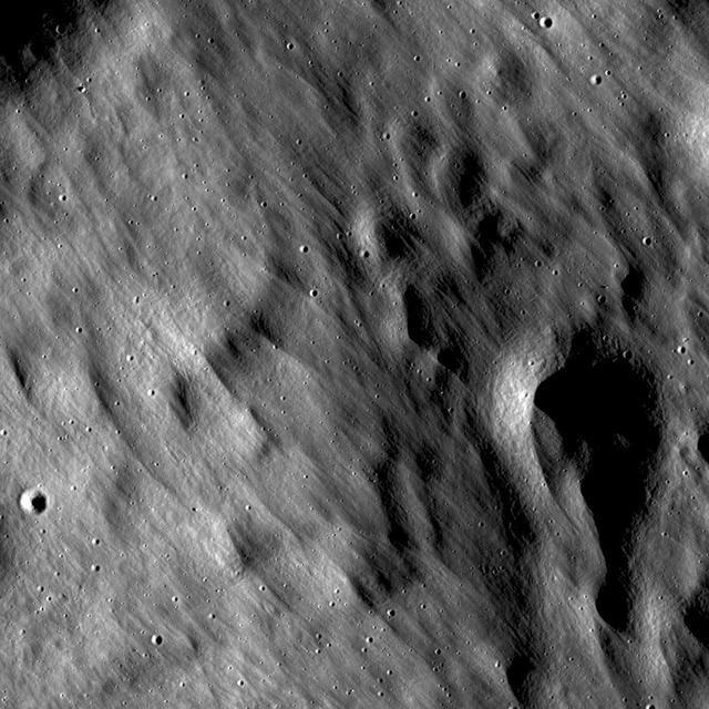
The lunar highlands exhibit rhythmic patterns thought to result from slow, downslope creep of the loose regolith soil. These subtle patterns are most easily seen when the Sun is low to the horizon in this image taken by NASA Lunar Reconnaissance Orbit
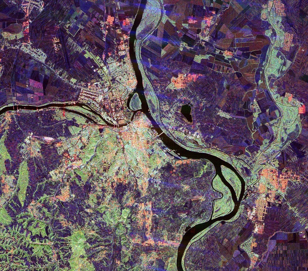
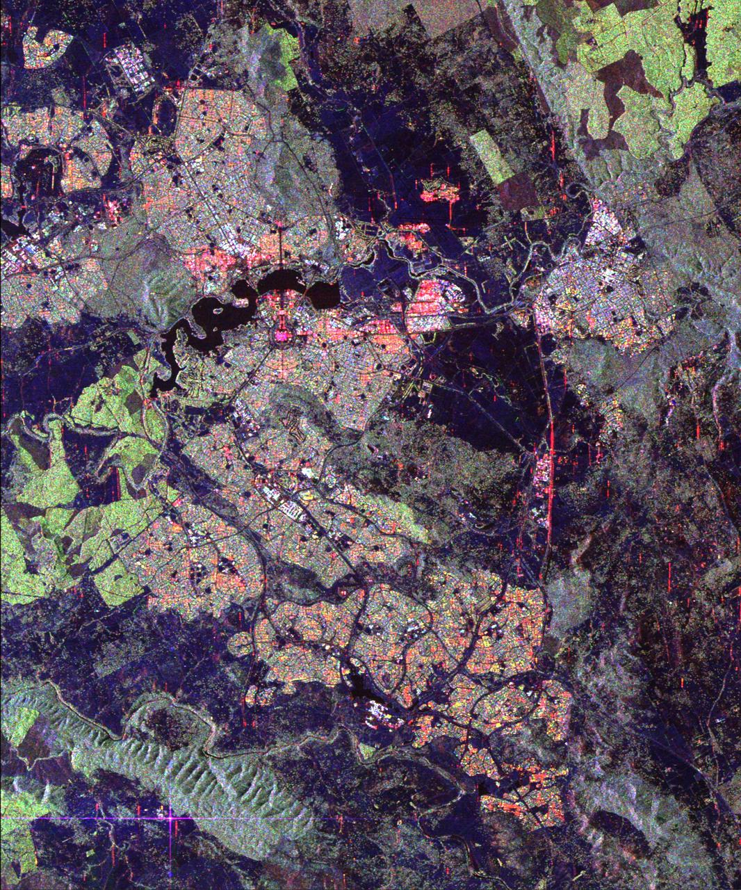
This spaceborne radar image of Belgrade, Serbia, illustrates the variety of land use patterns that can be observed with a multiple wavelength radar system.
The odd pattern on the floor of this channel suggests that a volitile such as ice played a part in its formation
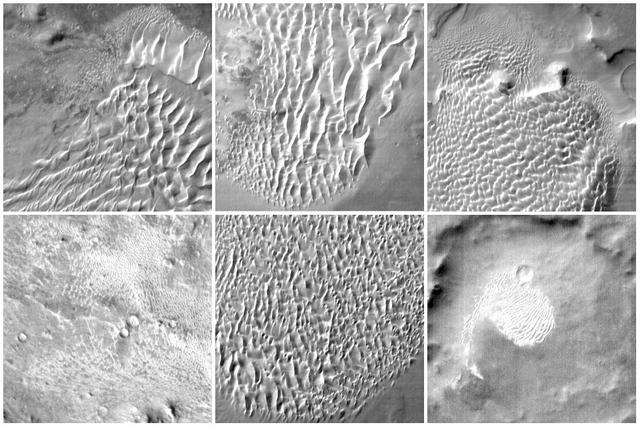
This collage of six images taken by NASA Mars Odyssey spacecraft, shows examples of the daytime temperature patterns of Martian dunes.
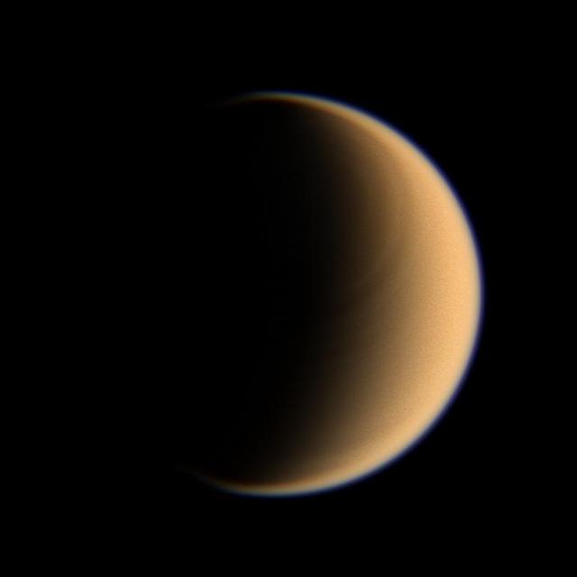
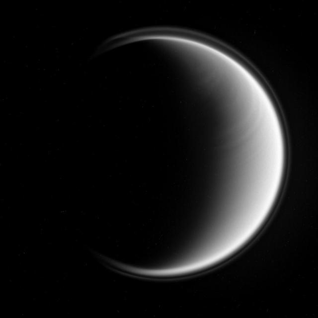
Looking toward high northern latitudes on Titan, the Cassini spacecraft spies a banded pattern encircling the pole

Completion of the thermal blanket patterns for the Aquarius bipod after routing the flight harness from the SAC-D service platform.
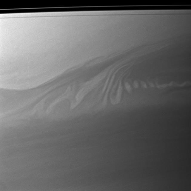
Clouds in Saturn atmosphere create an intricate pattern reminiscent of whipped cream swirling in coffee in this image captured by NASA Cassini spacecraft.
The texture/pattern on the floor of this unnamed crater in Terra Sabaea indicates that volitiles make up a portion of the material filling the crater
The Lake Palanskoye in northern Kamchatka was formed when a large landslide disrupted the drainage pattern, forming a natural dam.
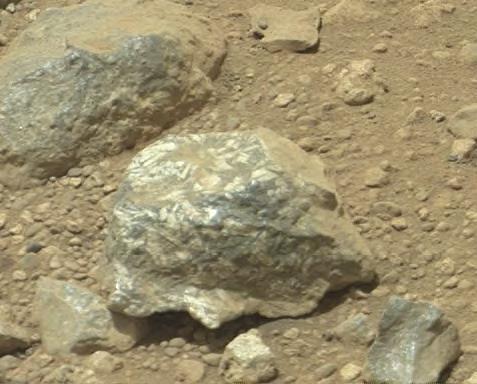
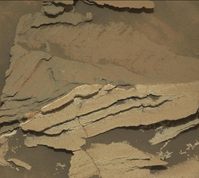
The Mast Camera Mastcam on NASA Mars rover Curiosity showed researchers interesting color and patterns in this unnamed rock.
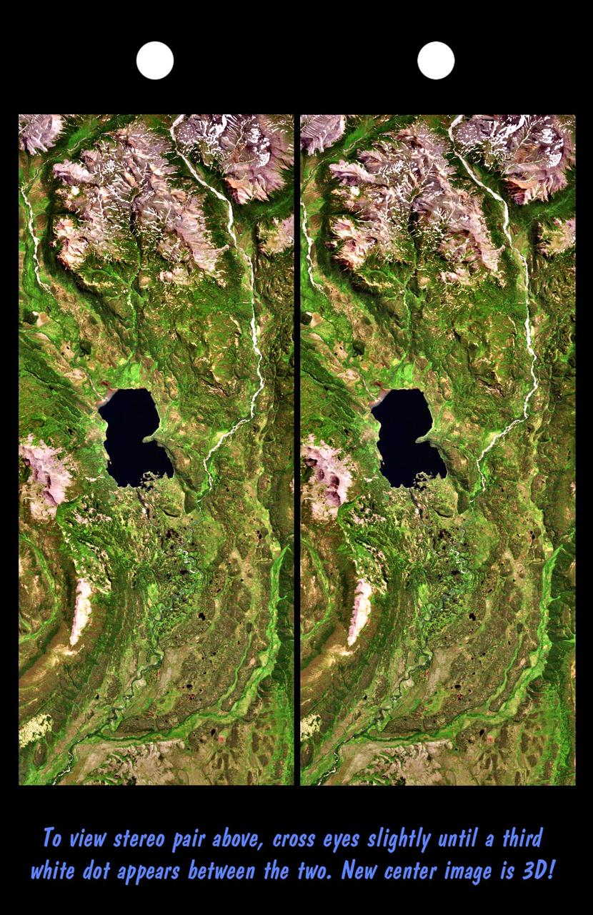
River drainage patterns provide clues to the rock types and erosional processes involved in landscape evolution.
As it passed over Antarctica on December 16, 2004, NASA Terra satellite captured this image showing a wavy pattern in a field of white.
Titan bears a distinct east-west banded pattern in this Cassini spacecraft image taken in the ultraviolet
This MOC image shows a bowl-shaped crater on the martian northern plains with a mysterious radiant pattern of zones with and without boulders and rocks
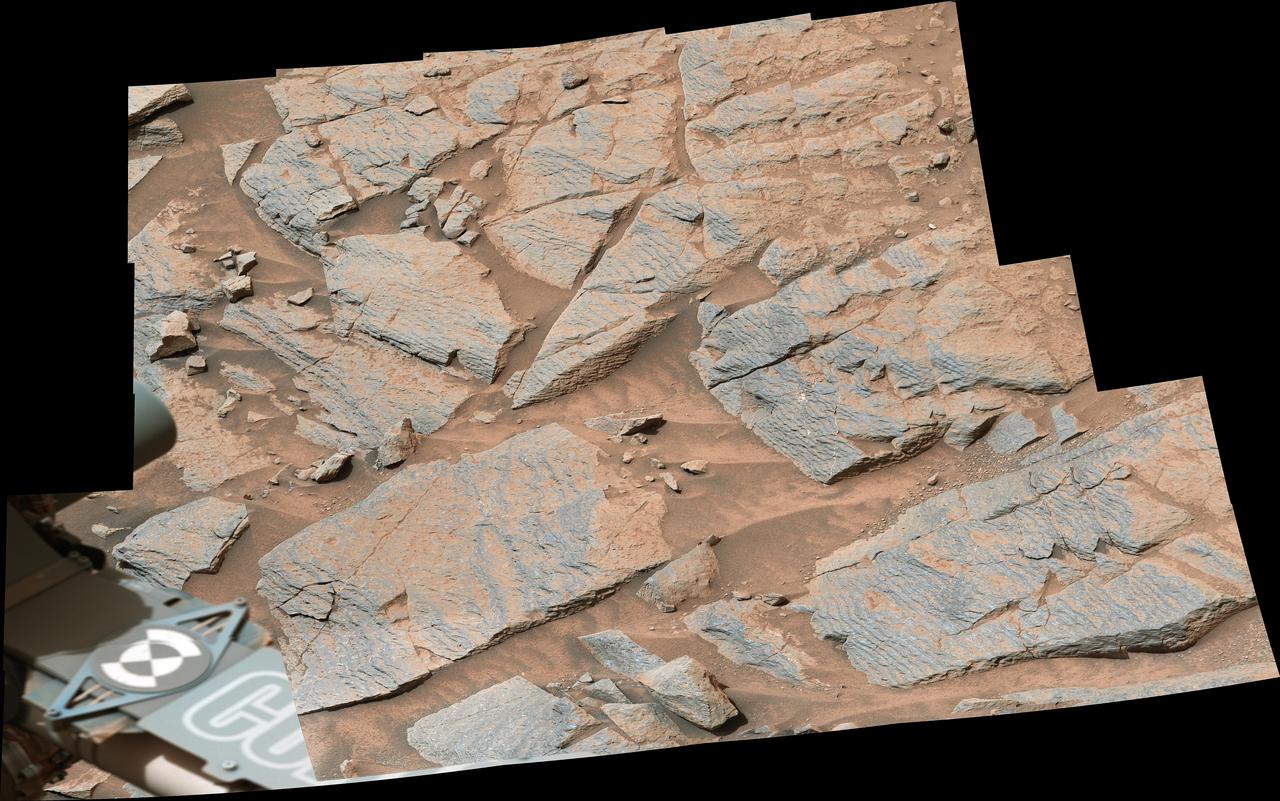
NASA's Curiosity Mars rover captured this image of rhythmic rock layers with a repetitive pattern in their spacing and thickness. The pattern might have been caused by weather or climate cycles occurring while the sediment layers were being deposited, such as dust storms happening at regular intervals in the ancient past. This mosaic is made up of 17 individual images captured in the "Marker Band" area by Curiosity's Mastcam on Nov. 7, 2022, the 3,646th Martian day, or sol, of the mission. The mosaic was captured by Mastcam's 34-millimeter-focal-length camera. https://photojournal.jpl.nasa.gov/catalog/PIA25734
NASA MARCI acquires a global view of the red planet and its weather patterns every day. This image was taken on Nov. 3, 2008 by the Mars Reconnaissance Orbiter.
This Mars Global Surveyor MGS Mars Orbiter Camera MOC image shows a complex pattern of intersecting and overlapping troughs in the Olympica Fossae region of northern Tharsis
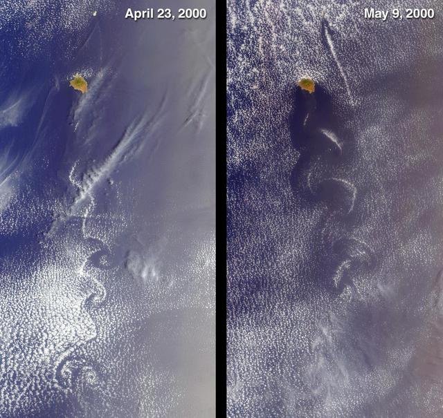
Socorro, Mexico was captured by NASA Terra satellite in 2000 showing cloud swirls, like delicate lace, forming patterns known as von Karman vortex streets.
This image from NASA 2001 Mars Odyssey spacecraft shows a region of the south pole where the surface has developed linear markings, a pattern not unlike a thumbprint.
This image captured by NASA Mars Reconnaissance Orbiter from the Gordii Dorsum region of Mars shows a large area covered with polygonal ridges in an almost geometric pattern.
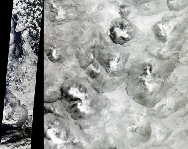
NASA Terra satellite shows the shape and size of cellular patterns within marine stratocumulus cloud layers can change dramatically with the prevailing meteorological conditions.
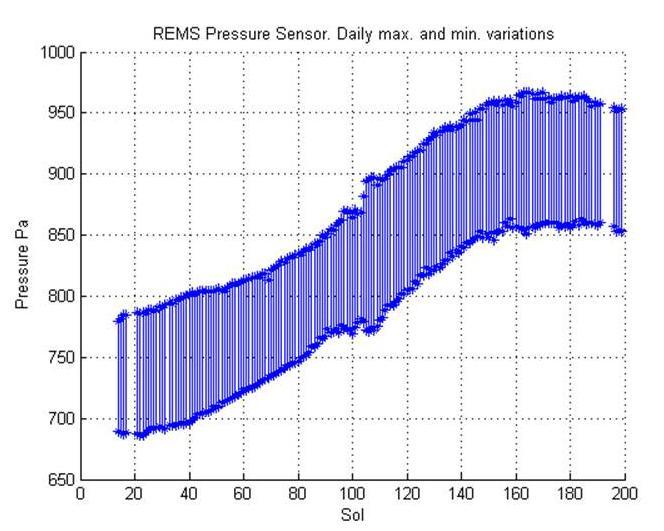
This graph shows about one-fourth of a Martian year pattern atmospheric pressure at the surface of Mars, as measured by the Rover Environmental Monitoring Station on NASA Curiosity rover.
Basalt cliffs along the northwest edge of the Meseta de Somuncura plateau near Sierra Colorada, Argentina show an unusual and striking pattern of erosion.

In this artist impression, a pair of stars peeks out from a tilted disk twirling around them, allowing astronomers to monitor their blinking pattern.
The ejecta pattern around this northern plains crater is termed butterfly for its similarity to butterfly wings, as shown in this image captured by NASA 2001 Mars Odyssey spacecraft.
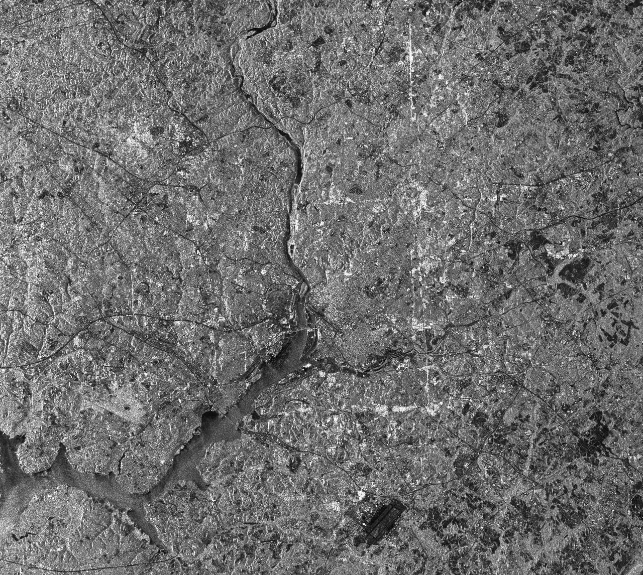
This radar image of the Washington, D.C. area demonstrates the capability of imaging radar as a useful tool for urban planners and managers to map and monitor land use patterns.
Australia capital city, Canberra, is shown in the center of this spaceborne radar image. Images like this can help urban planners assess land use patterns.
This old crater in Terra Sabaea has patterned floor material that is indicative of having a volitile component. At high latitudes the volitile is most likely ice
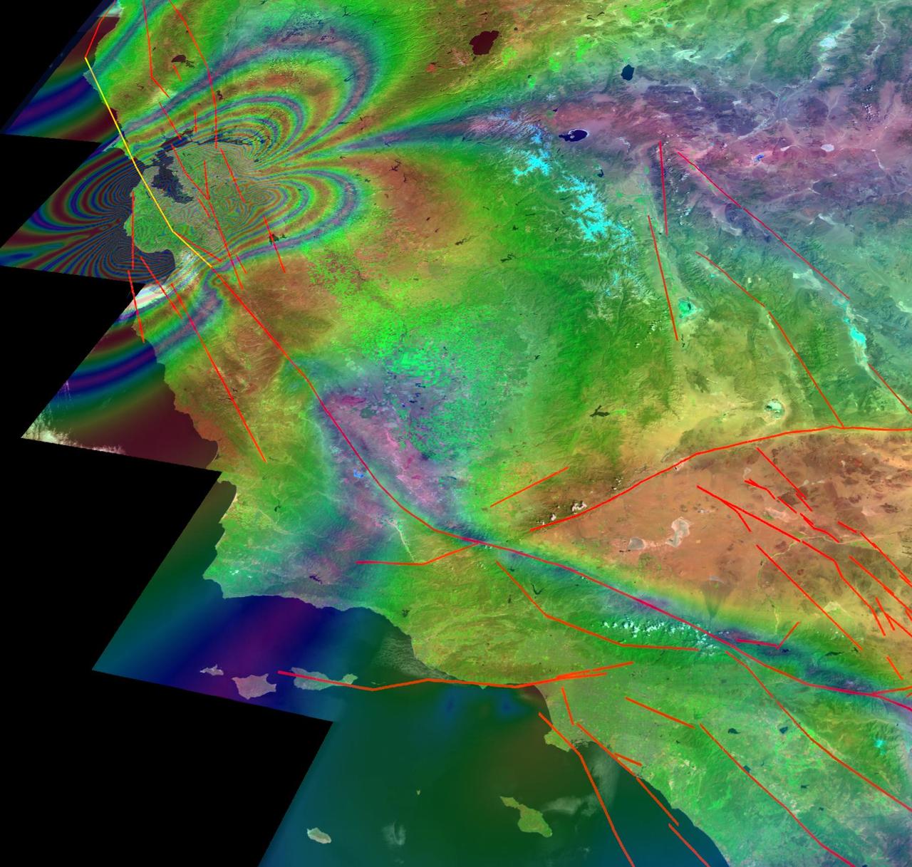
This illustration depicts synthetic aperature radar patterns of seismic deformations associated with a model earthquake on the San Francisco section of the San Andreas Fault depicted in yellow.
This image was obtained by NASA's Dawn spacecraft on July 5, 2018 from an altitude of about 33 miles (54 kilometers). The center of this picture is located at about 20.3 degrees north latitude and 240.6 degrees east longitude. https://photojournal.jpl.nasa.gov/catalog/PIA22630
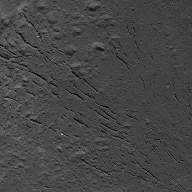
This image was obtained by NASA's Dawn spacecraft on July 25, 2018 from an altitude of about 87 miles (140 kilometers). The center of this picture is located at about 16.4 degrees north latitude and 238.9 degrees east longitude. https://photojournal.jpl.nasa.gov/catalog/PIA22760
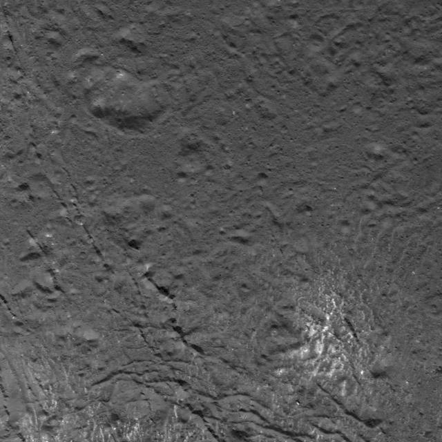
This image was obtained by NASA's Dawn spacecraft on July 16, 2018 from an altitude of about 58 miles (93 kilometers). The center of this picture is located at about 18.5 degrees north latitude and 240.9 degrees east longitude. https://photojournal.jpl.nasa.gov/catalog/PIA22757
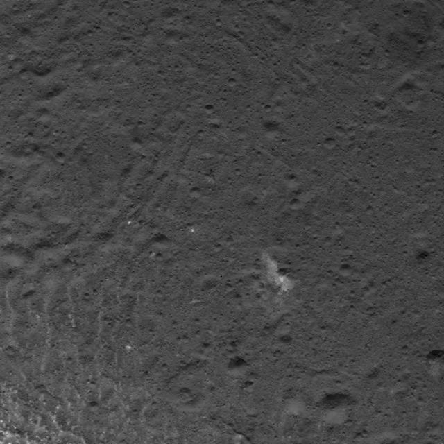
This image was obtained by NASA's Dawn spacecraft on July 5, 2018 from an altitude of about 32 miles (52 kilometers). The center of this picture is located at about 19.3 degrees north latitude and 240.7 degrees east longitude. https://photojournal.jpl.nasa.gov/catalog/PIA22631
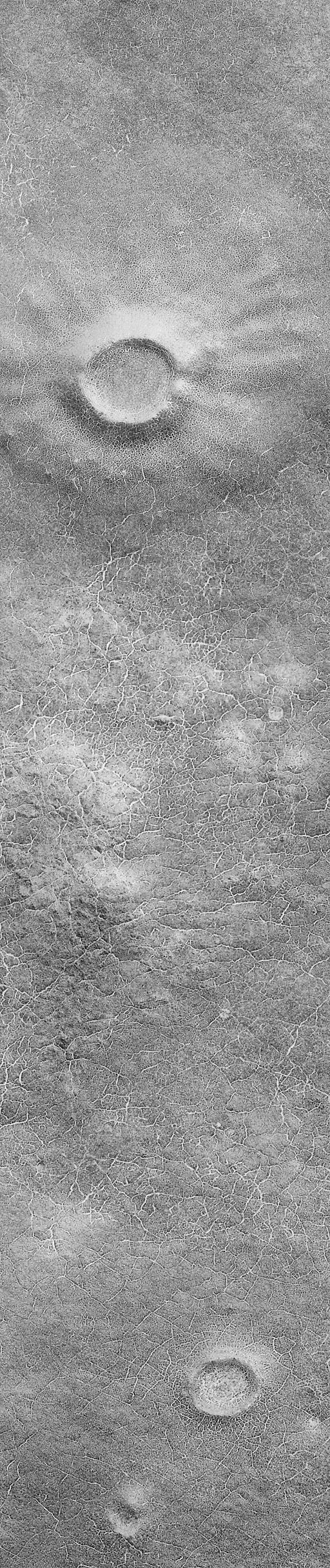
The north polar residual ice cap, which is cut by spiral-patterned troughs, is located at the top in this view from NASA's Viking Orbiter 1. http://photojournal.jpl.nasa.gov/catalog/PIA00192
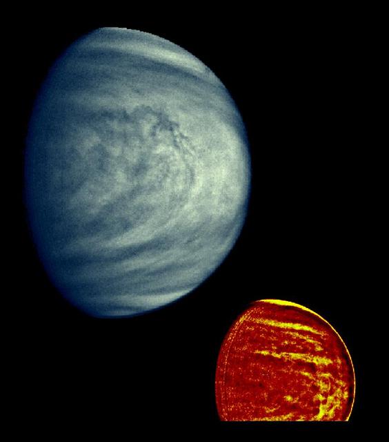
These two images of Venus from NASA Galileo spacecraft show the global structure of cloud patterns at two different depths in the upper cloud layers. http://photojournal.jpl.nasa.gov/catalog/PIA00073
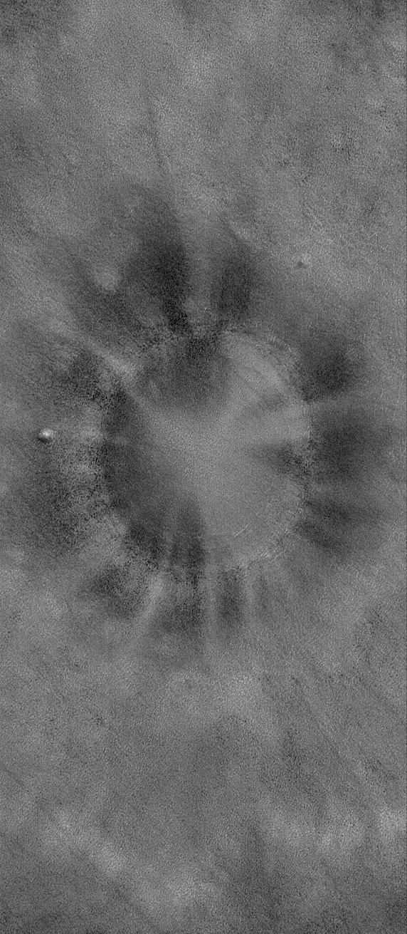
This Magellan image, which is 50 kilometers (31 miles) in width and 80 kilometers (50 miles) in length, is centered at 11.9 degrees latitude, 352 degrees longitude in the eastern Navka Region of Venus. The crater, which is approximately 8 kilometers (5 miles) in diameter, displays a butterfly symmetry pattern. The ejecta pattern most likely results from an oblique impact, where the impactor came from the south and ejected material to the north. http://photojournal.jpl.nasa.gov/catalog/PIA00474