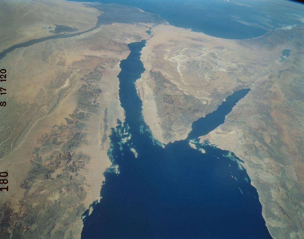
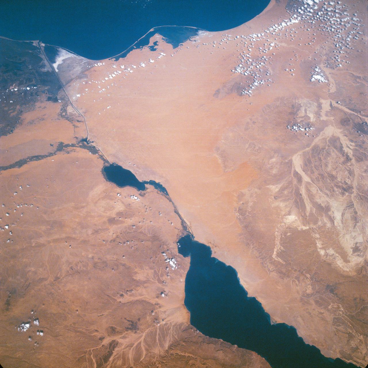
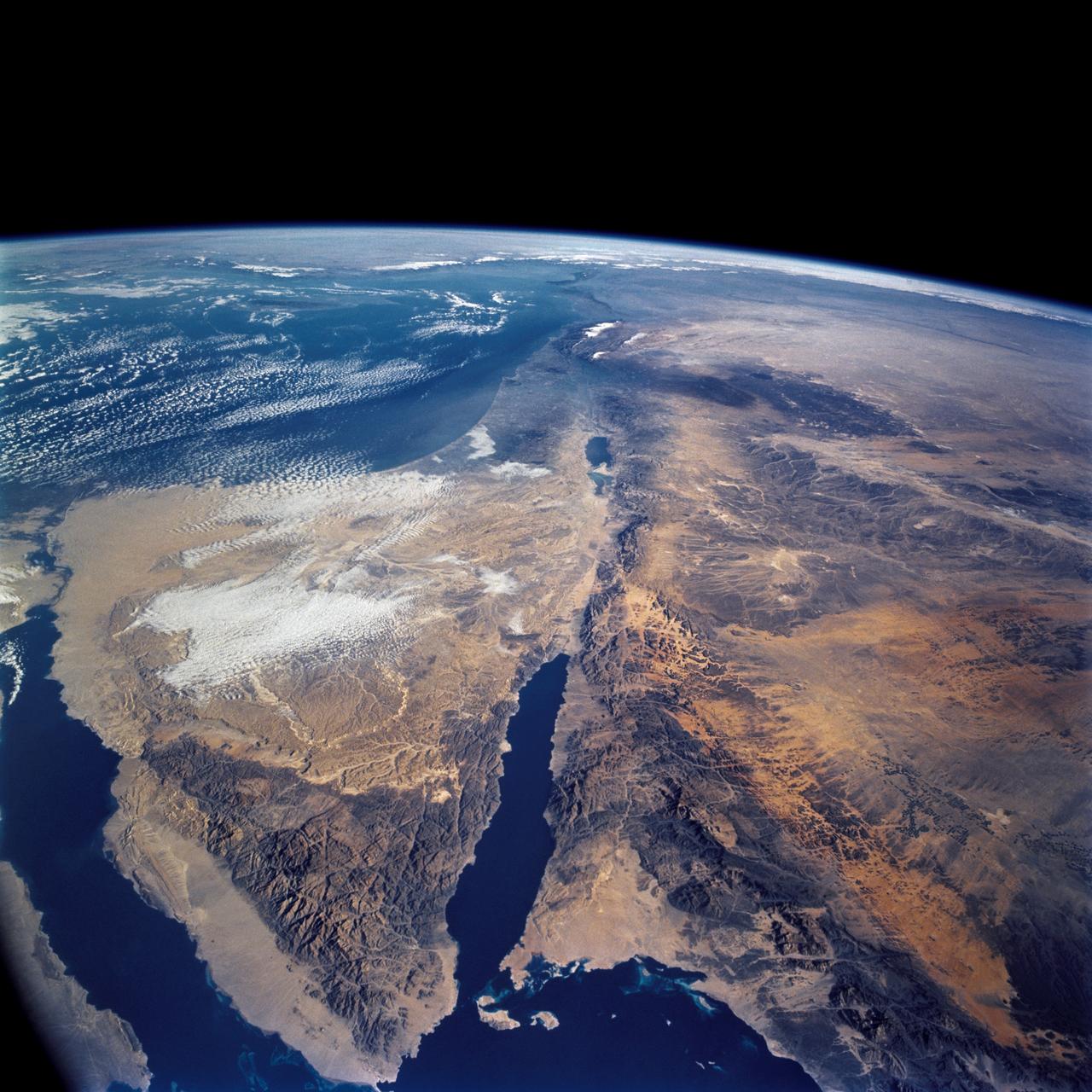
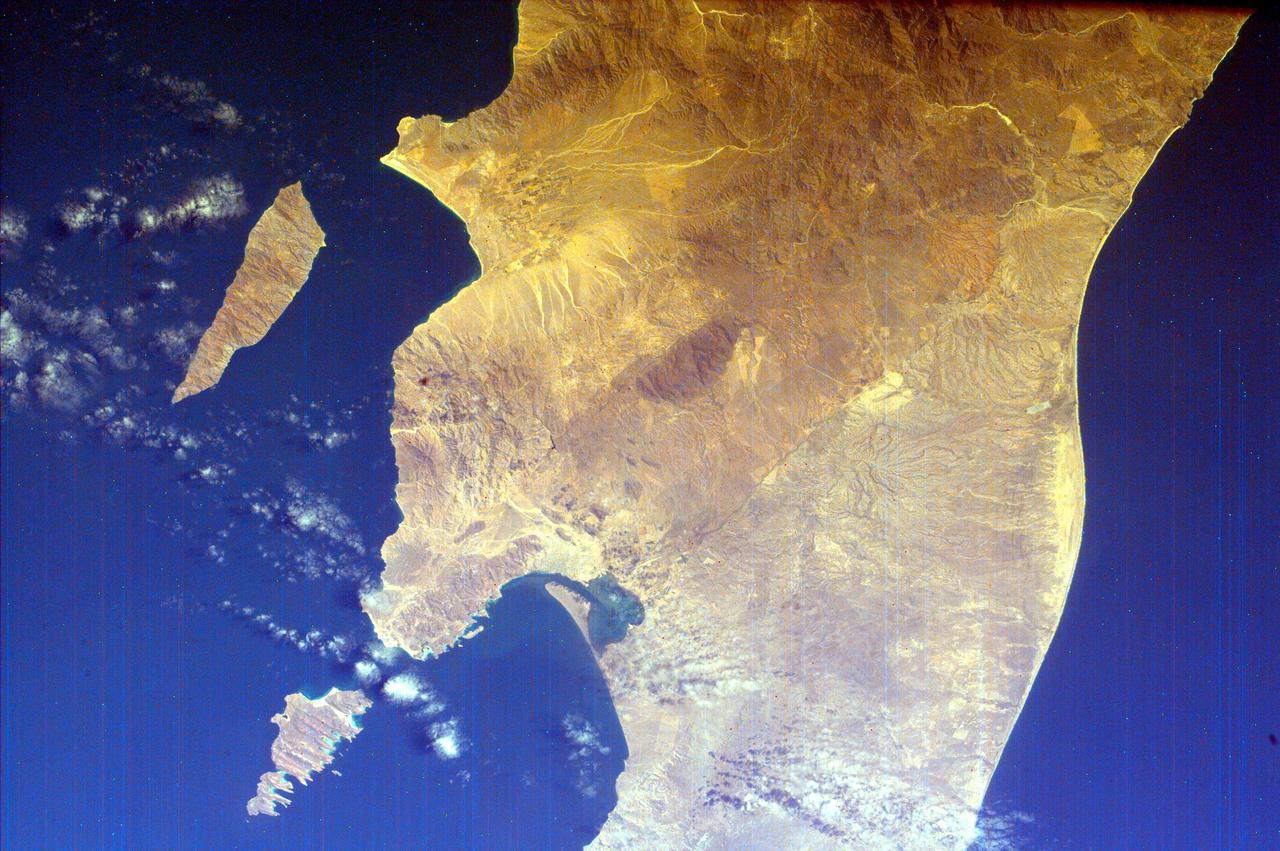
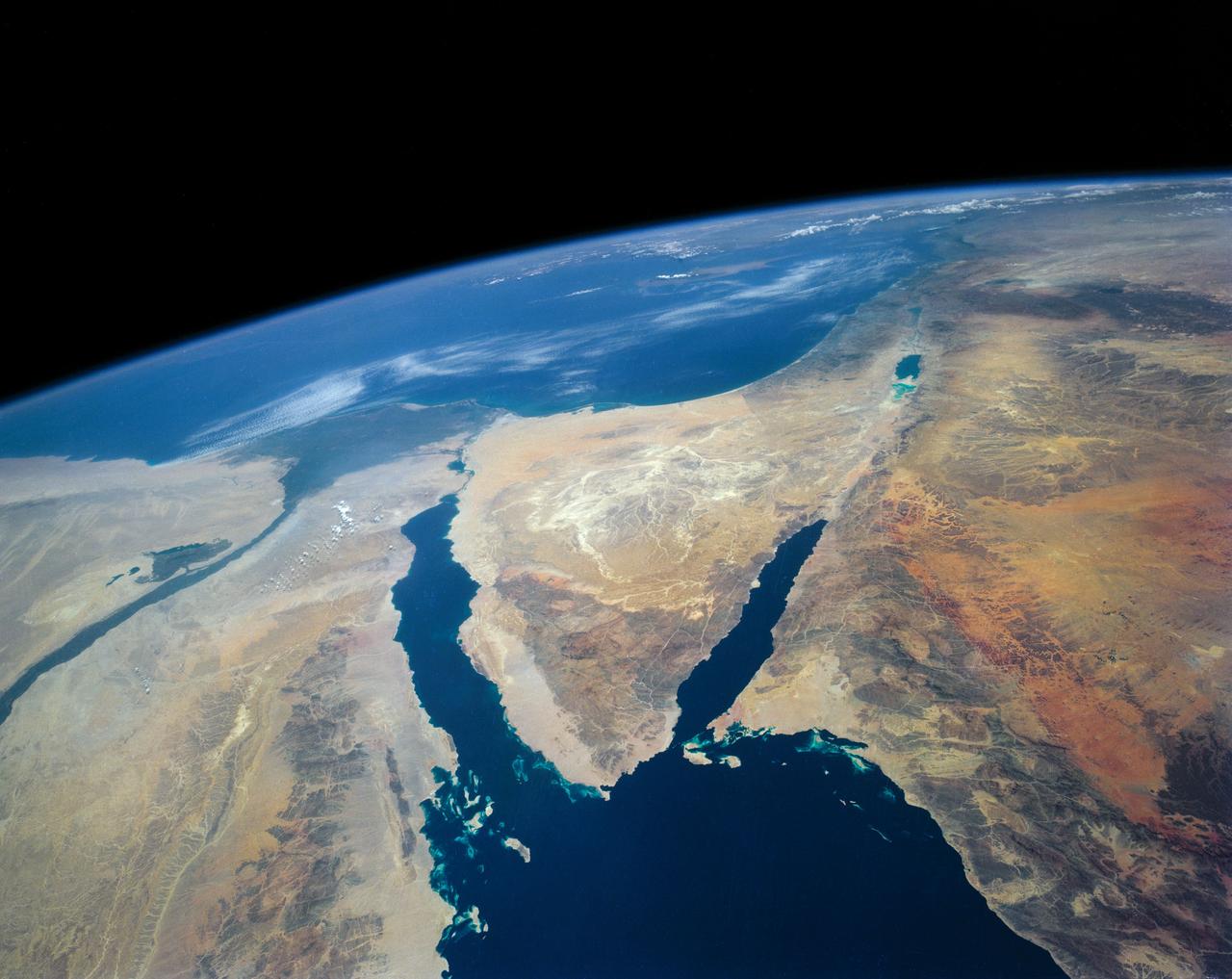
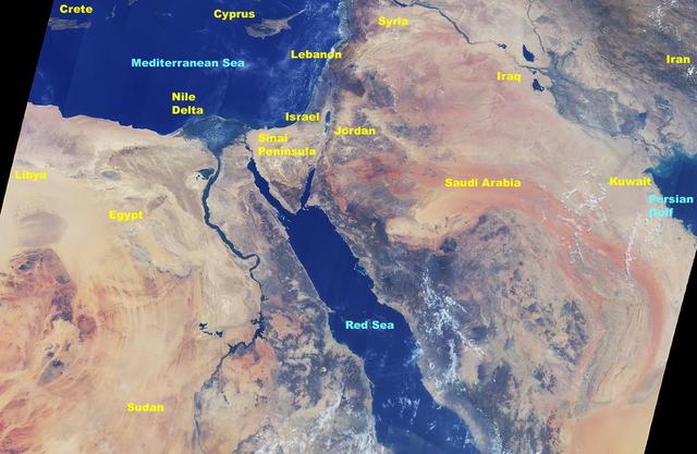
An excellent panoramic view of the entire Sinai Peninsula (29.0N, 34.0E) and the nearby Nile River Delta and eastern Mediterranean coastal region. The Suez Canal, at the top of the scene just to the right of the Delta, connects the Mediterranean Sea with the Gulf of Suez on the west side of the Sinai Peninsula and the Gulf of Aqaba is on the west where they both flow into the Red Sea. At upper right, is the Dead Sea, Jordan River and Lake Tiberius.
SL2-05-389 (22 June 1973) --- This scene displays the southeastern part of Michigan's Lower Peninsula and adjacent Ontario, Canada (43.0N, 84.0W). Detroit can be recognized by its radial pattern of development and sediment plumes in the rivers from the massive industrial activity. The area pockmarked by lakes northwest of Detroit essentially outlines the limits of the Defiance Moraine caused by the stagnation and melting of Ice Age glaciers. Photo credit: NASA
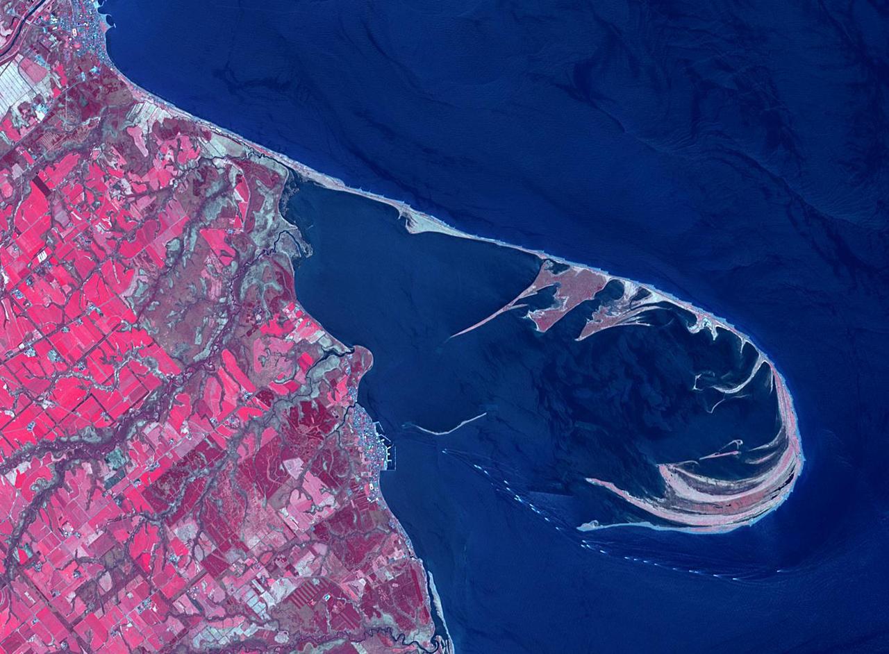
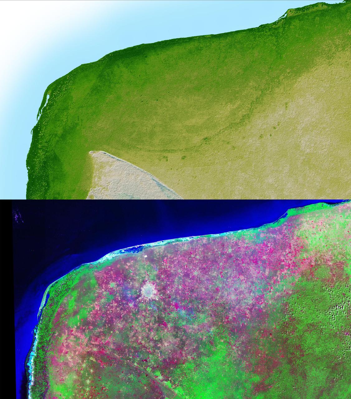
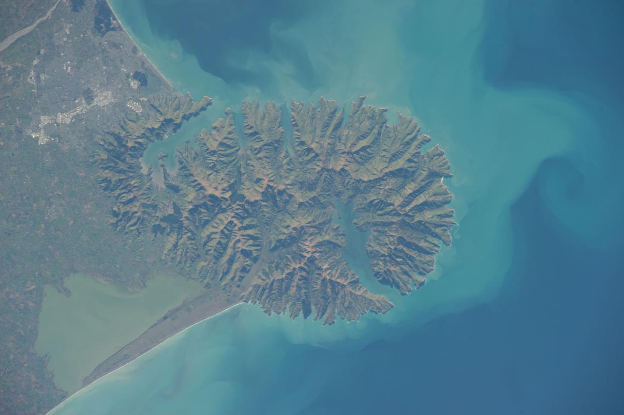
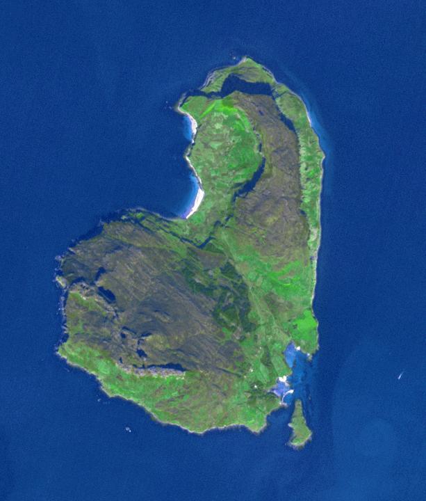
The Notsuke Peninsula is on the east coast of Hokkaido, Japan. Its name is derived from the Ainu word for jawbone. The curved peninsula is the longest sandspit in the country (26 km), formed by the deposition of sand carried by offshore currents. A 15 km road stretches from the base of the peninsula to a nature center and is known as the "Flower Road". The image was acquired May 14, 2019, covers an area of 15.9 by 21.7 km, and is located at 43.6 degrees north, 145.3 degrees east. https://photojournal.jpl.nasa.gov/catalog/PIA25858
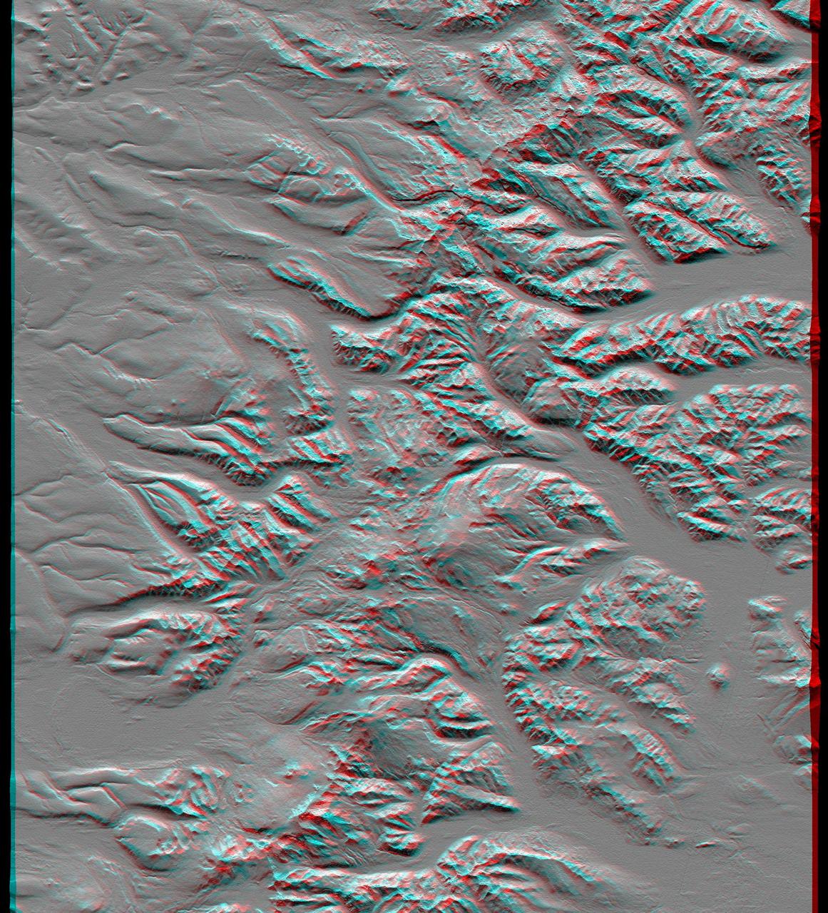
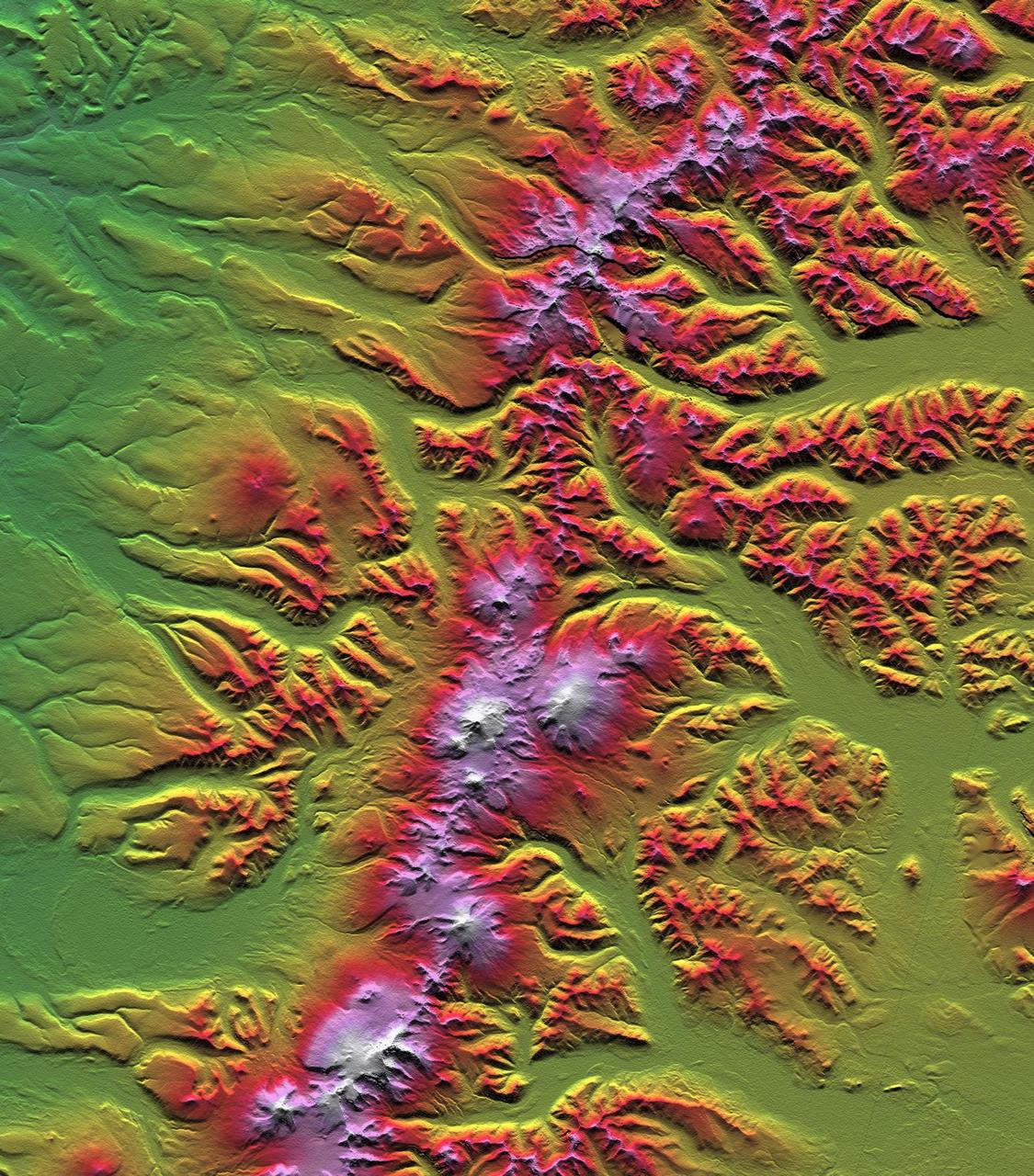
This anaglyph, from NASA Shuttle Radar Topography Mission, shows the Kamchatka Peninsula in eastern Russia. Sredinnyy Khrebet, the mountain range that makes up the spine of the peninsula. 3D glasses are necessary to view this image.

The Banks Peninsula, New Zealand was created by volcanic activity in the Miocene epoch about 10 million years ago. This image is from NASA Terra spacecraft.
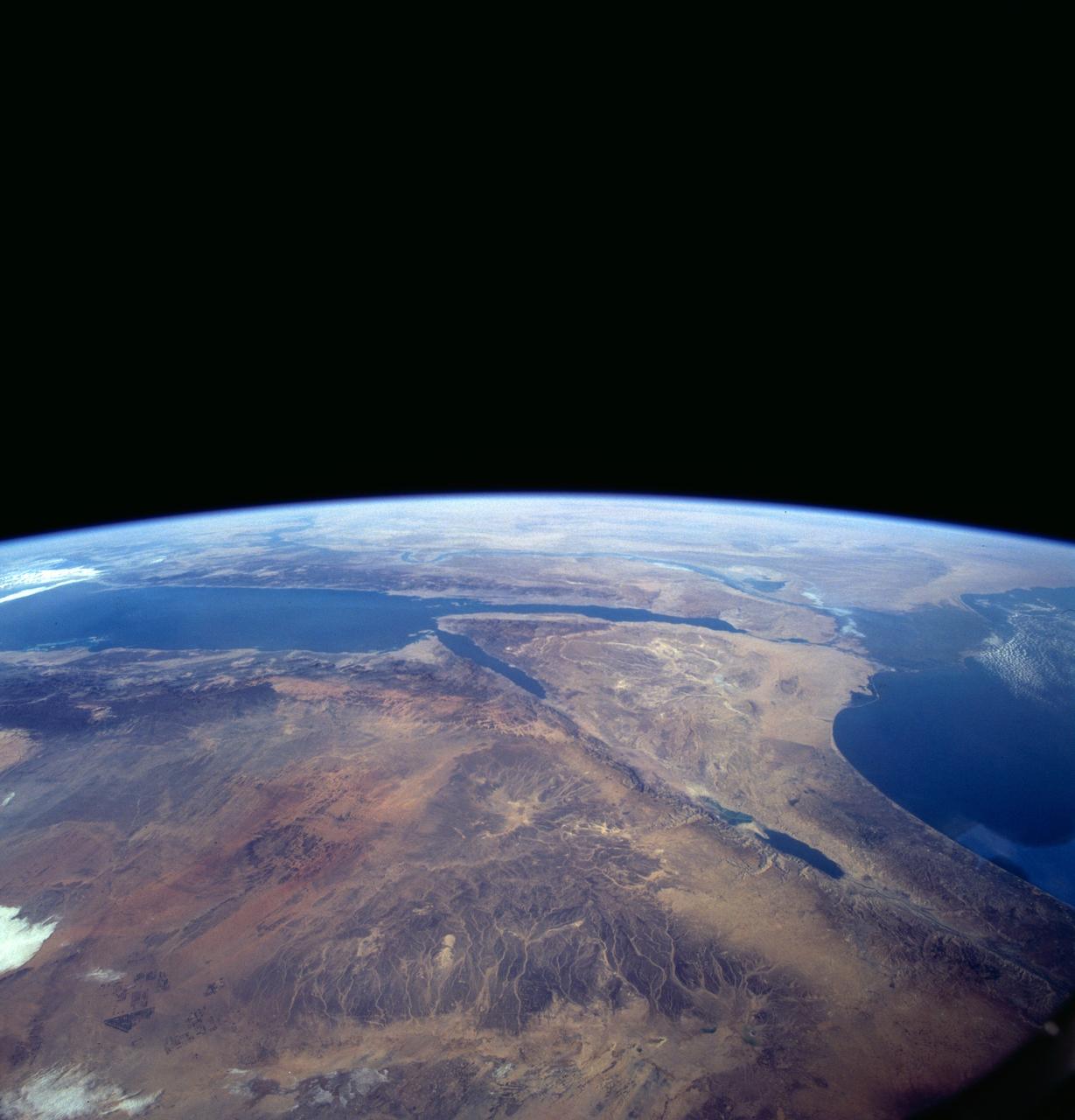
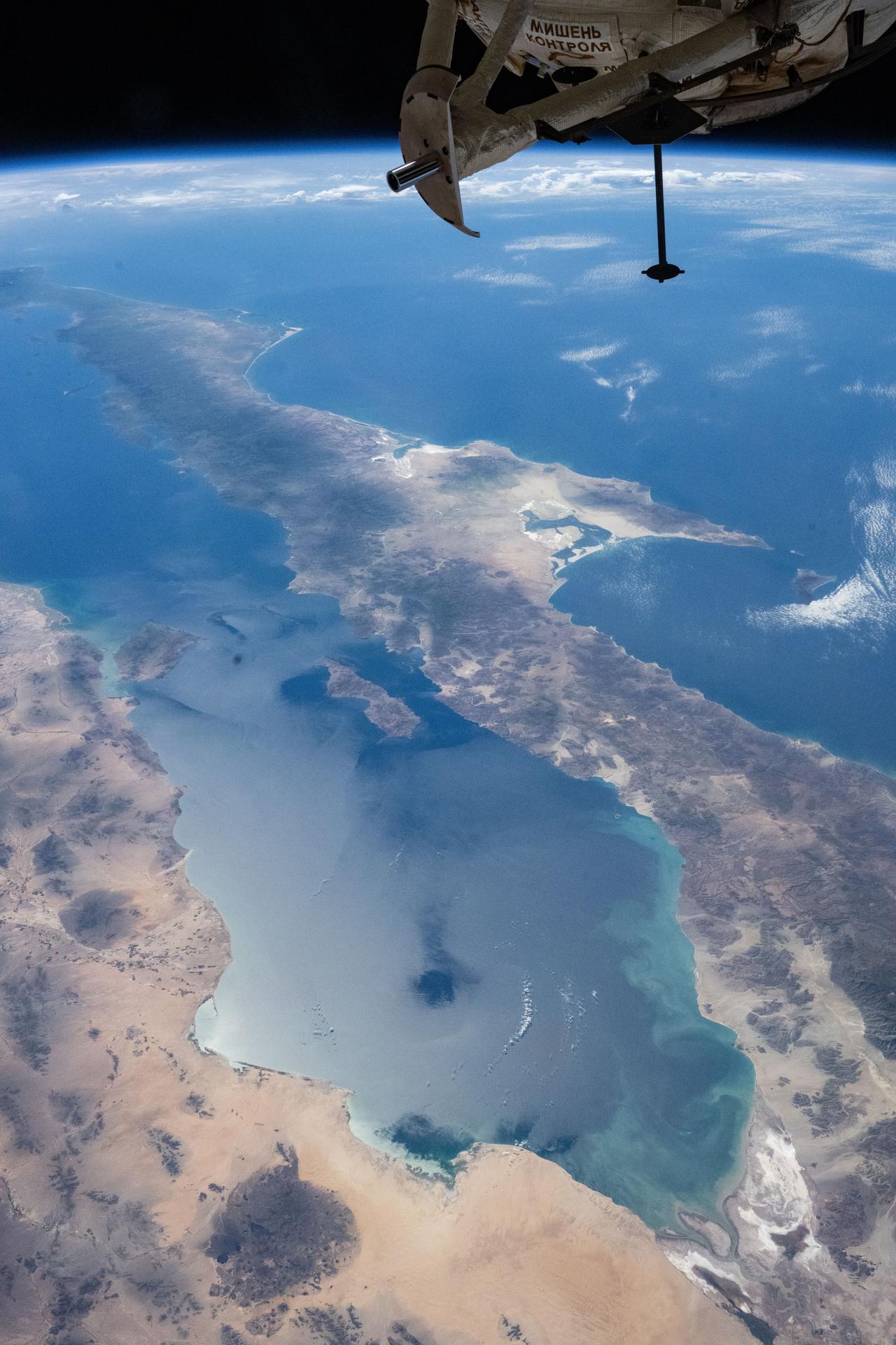
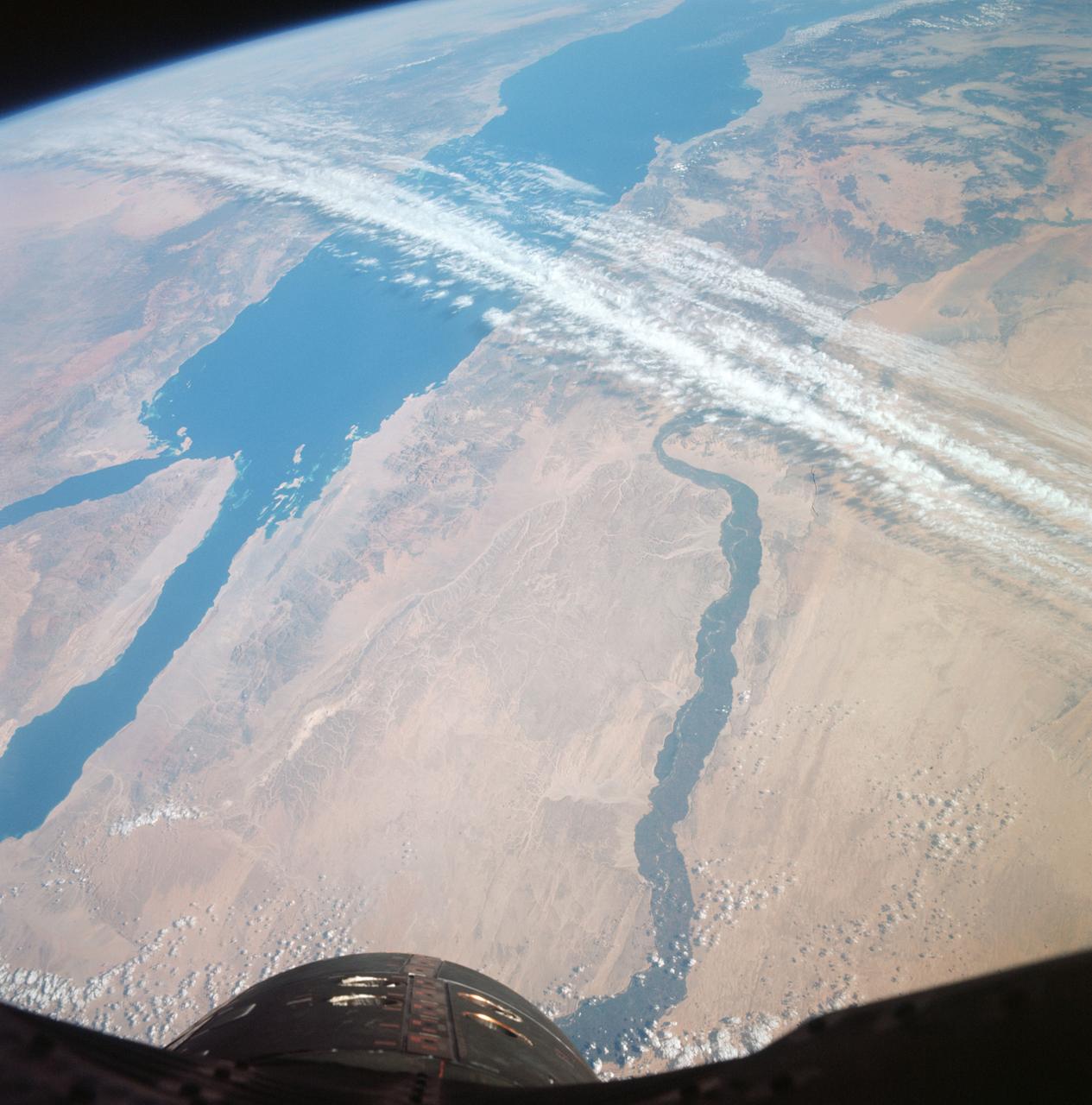
A high oblique view of the Middle East centered at approximately 28.0 degrees north and 34.0 degrees east. Portions of the countries of Egypt, Israel, Jordan and Saudi Arabia are visible. The Dead Sea Rift Valley continuing into the Gulf of Aqaba marks the boundary between Israel and Jordan. The vegetation change in the Sinai Peninsula is the border between the Gaza Strip and Egypt. In Egypt, the Suez Canal connects the Gulf of Suez with the Mediterranean Sea and forms the western boundary of the Sinai Peninsula. The green ribbon of the Nile River is in marked contrast to this arid region. Even the Jordan River does not support large scale agriculture.
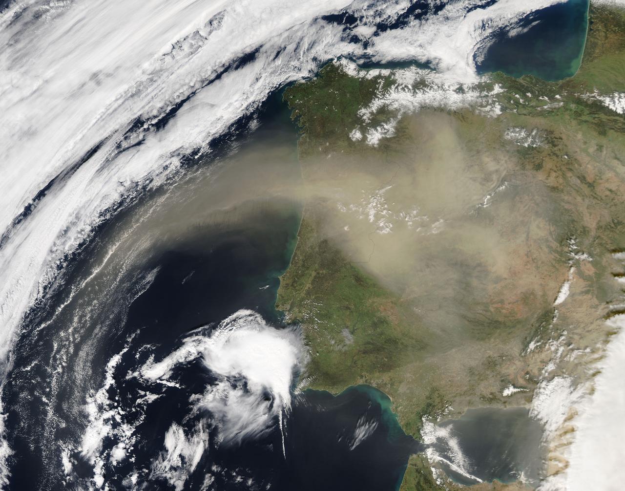
On Feb. 21, 2016 at 14:00 UTC, the Moderate Resolution Imaging Spectroradiometer (MODIS) aboard NASA’s Aqua satellite captured a true color image of Saharan dust over the Iberian Peninsula. Credit: NASA/Goddard/Jeff Schmaltz/MODIS Land Rapid Response Team <b><a href="http://www.nasa.gov/audience/formedia/features/MP_Photo_Guidelines.html" rel="nofollow">NASA image use policy.</a></b> <b><a href="http://www.nasa.gov/centers/goddard/home/index.html" rel="nofollow">NASA Goddard Space Flight Center</a></b> enables NASA’s mission through four scientific endeavors: Earth Science, Heliophysics, Solar System Exploration, and Astrophysics. Goddard plays a leading role in NASA’s accomplishments by contributing compelling scientific knowledge to advance the Agency’s mission. <b>Follow us on <a href="http://twitter.com/NASAGoddardPix" rel="nofollow">Twitter</a></b> <b>Like us on <a href="http://www.facebook.com/pages/Greenbelt-MD/NASA-Goddard/395013845897?ref=tsd" rel="nofollow">Facebook</a></b> <b>Find us on <a href="http://instagrid.me/nasagoddard/?vm=grid" rel="nofollow">Instagram</a></b>
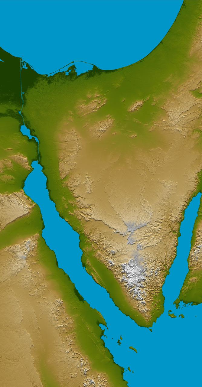
The Sinai Peninsula, located between Africa and Asia, is a result of those two continents pulling apart from each other.
A devastating mudslide in the world-renowned Geyser Valley on the Kamchatka Peninsula virtually obliterated the natural wonder, forcing the emergency evacuation of visitors and national park personnel. This image was acquired by NASA Terra spacecraft.
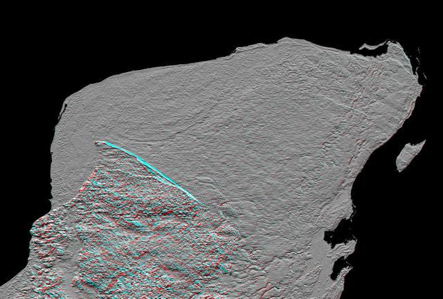
This anaglyph of Mexico Yucatan Peninsula was generated from NASA Shuttle Radar Topography Mission data, and shows a subtle but distinctive indication of the Chicxulub impact crater. 3D glasses are necessary to view this image.
This topographic map acquired by NASA Shuttle Radar Topography Mission SRTM from data collected on February 12, 2000 shows the western side of the volcanically active Kamchatka Peninsula, Russia.
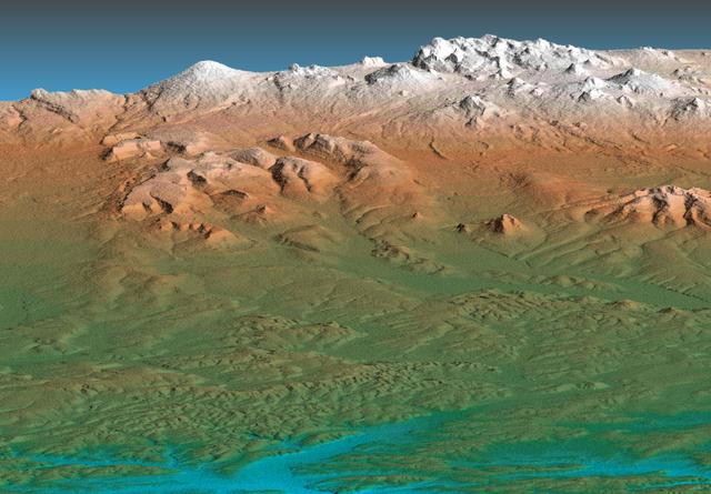
This perspective view acquired by NASA Shuttle Radar Topography Mission SRTM from data collected on February 12, 2000 shows the western side of the volcanically active Kamchatka Peninsula, Russia.

iss072e518202 (Jan. 23, 2025) --- This long-duration photograph highlights the city lights of Mexico's Yucatan peninsula, Earth's atmospheric glow, and star trails above taken from the International Space Station as it orbited 258 miles above.

This image of northeast Africa and the Arabian Peninsula was taken from an altitude of about 500,000 kilometers 300,000 miles by NASA’s Galileo spacecraft on December 9, 1992, as it left Earth en route to Jupiter. http://photojournal.jpl.nasa.gov/catalog/PIA00127

iss071e009021 (April 15, 2024) -- The Zapata Peninsula on the southern coast of Cuba is pictured from the International Space Station as it orbited nearly 260 miles above. Both a Biosphere Reserve and National Park, it's home to diverse ecosystems, including coral reefs in the cove of the Caribbean Sea.
Kamchatka Peninsula, Russia is shown in this MISR Mystery Quiz #15 captured by NASA Terra spacecraft.
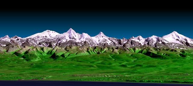
This perspective view shows the western side of the volcanically active Kamchatka Peninsula in eastern Russia. The image was generated using the first data collected during NASA Shuttle Radar Topography Mission SRTM.
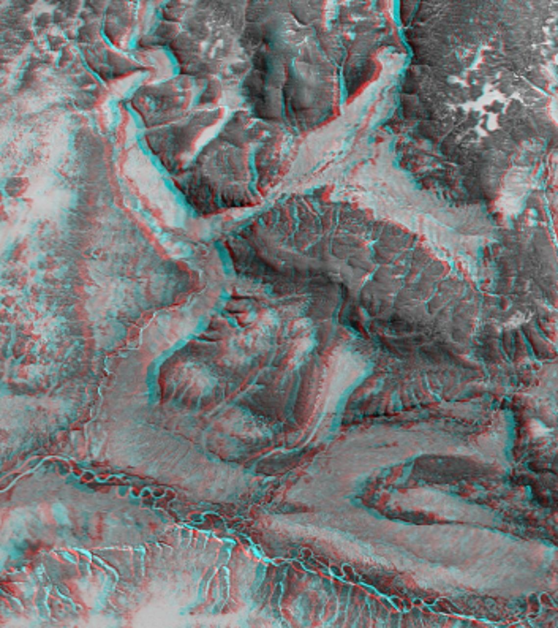
This 3-D anaglyph shows an area on the western side of the volcanically active Kamchatka Peninsula, Russia as seen by the instrument onboard NASA Shuttle Radar Topography Mission. 3D glasses are necessary to view this image.
Russia Kamchatka Peninsula, lying between the Sea of Okhotsk to the west and the Bering Sea and Pacific Ocean to the east, is one of the most active volcanic regions along the Pacific Ring of Fire.
This shaded relief topographic acquired by NASA Shuttle Radar Topography Mission SRTM image from data collected on February 12, 2000 shows the western side of the volcanically active Kamchatka Peninsula, Russia.
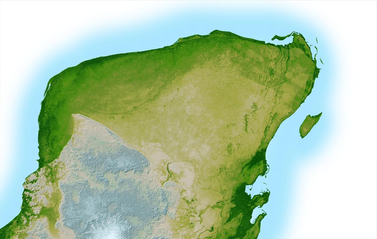
This shaded relief image of Mexico Yucatan Peninsula show a subtle, but unmistakable, indication of the Chicxulub impact crater. Most scientists now agree that this impact was the cause of the Cretatious-Tertiary Extinction.
Suez Canal, Gulf of Suez, Sinai Peninsula, United Arab Republic (Egypt), Mediterranean Sea, as seen from the Apollo 7 spacecraft during its 13th revolution of the earth. Photographed from an altitude of 126 nautical miles, at ground elapsed time of 19 hours and 42 minutes.
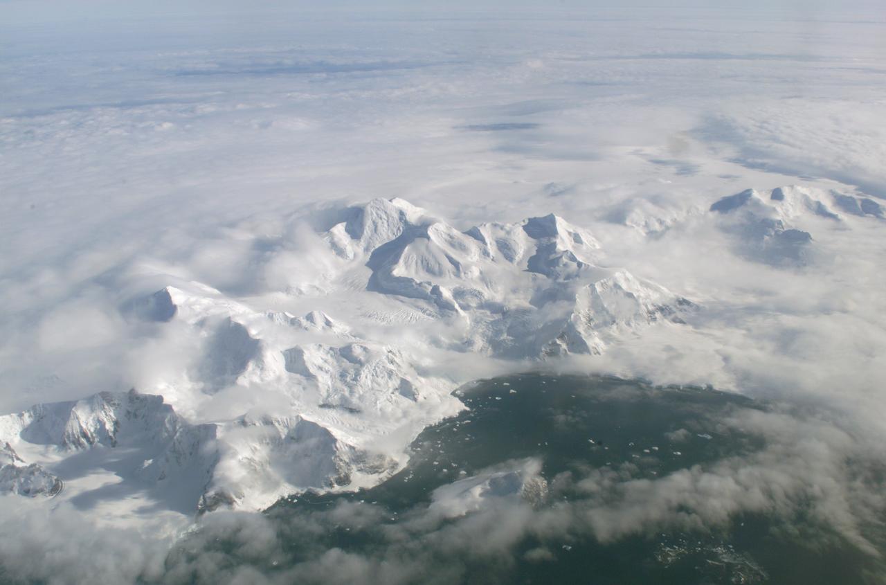
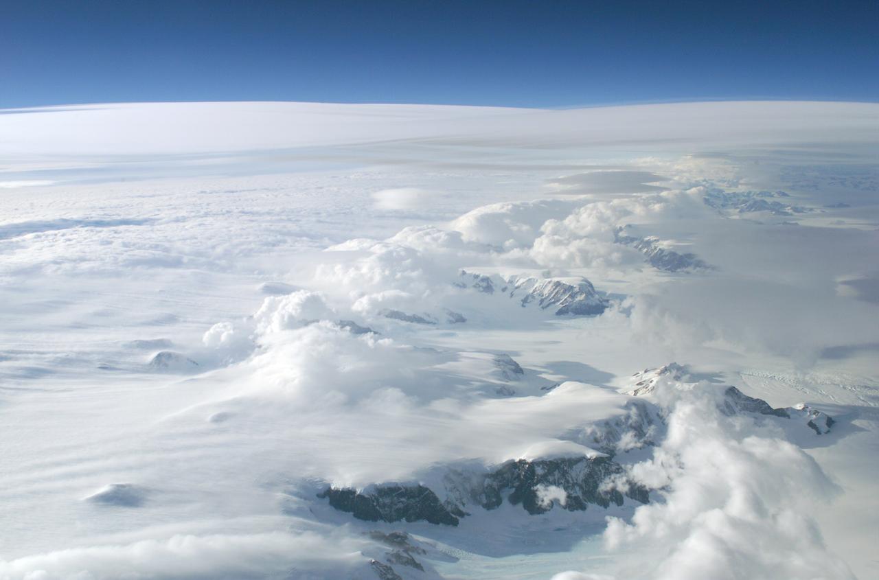
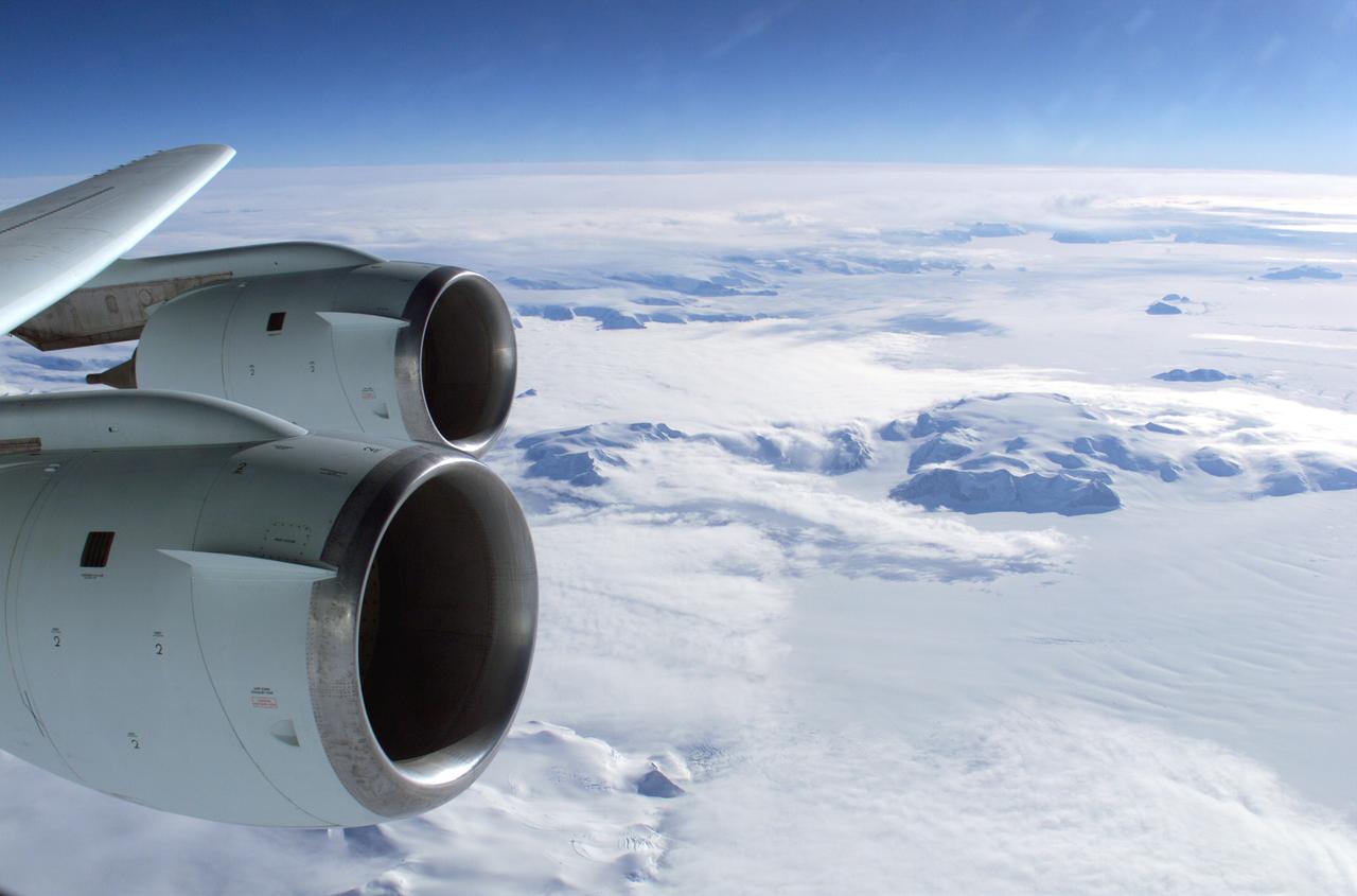
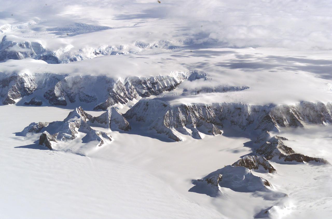
An AirSAR 2004 view from the DC-8 as it approaches the Larsen Ice Shelf, which is part of the Antarctic Peninsula. AirSAR 2004 is a three-week expedition in Central and South America by an international team of scientists that is using an all-weather imaging tool, called the Airborne Synthetic Aperture Radar (AirSAR), located onboard NASA's DC-8 airborne laboratory. Scientists from many parts of the world are combining ground research with NASA's AirSAR technology to improve and expand on the quality of research they are able to conduct. These photos are from the DC-8 aircraft while flying an AirSAR mission over Antarctica. The Antarctic Peninsula is more similar to Alaska and Patagonia than to the rest of the Antarctic continent. It is drained by fast glaciers, receives abundant precipitation, and melts significantly in the summer months. In recent decades, the Peninsula has experienced significant atmospheric warming (about 2 degrees C since 1950), which has triggered a vast and spectacular retreat of its floating ice shelves, glacier reduction, a decrease in permanent snow cover and a lengthening of the melt season. As a result, the contribution to sea level from this region could be rapid and substantial. With an area of 120,000 km, or ten times the Patagonia ice fields, the Peninsula could contribute as much as 0.4mm/yr sea level rise, which would be the largest single contribution to sea level from anywhere in the world. This region is being studied by NASA using a DC-8 equipped with the Airborne Synthetic Aperture Radar developed by scientists from NASA’s Jet Propulsion Laboratory. AirSAR will provide a baseline model and unprecedented mapping of the region. This data will make it possible to determine whether the warming trend is slowing, continuing or accelerating. AirSAR will also provide reliable information on ice shelf thickness to measure the contribution of the glaciers to sea level.
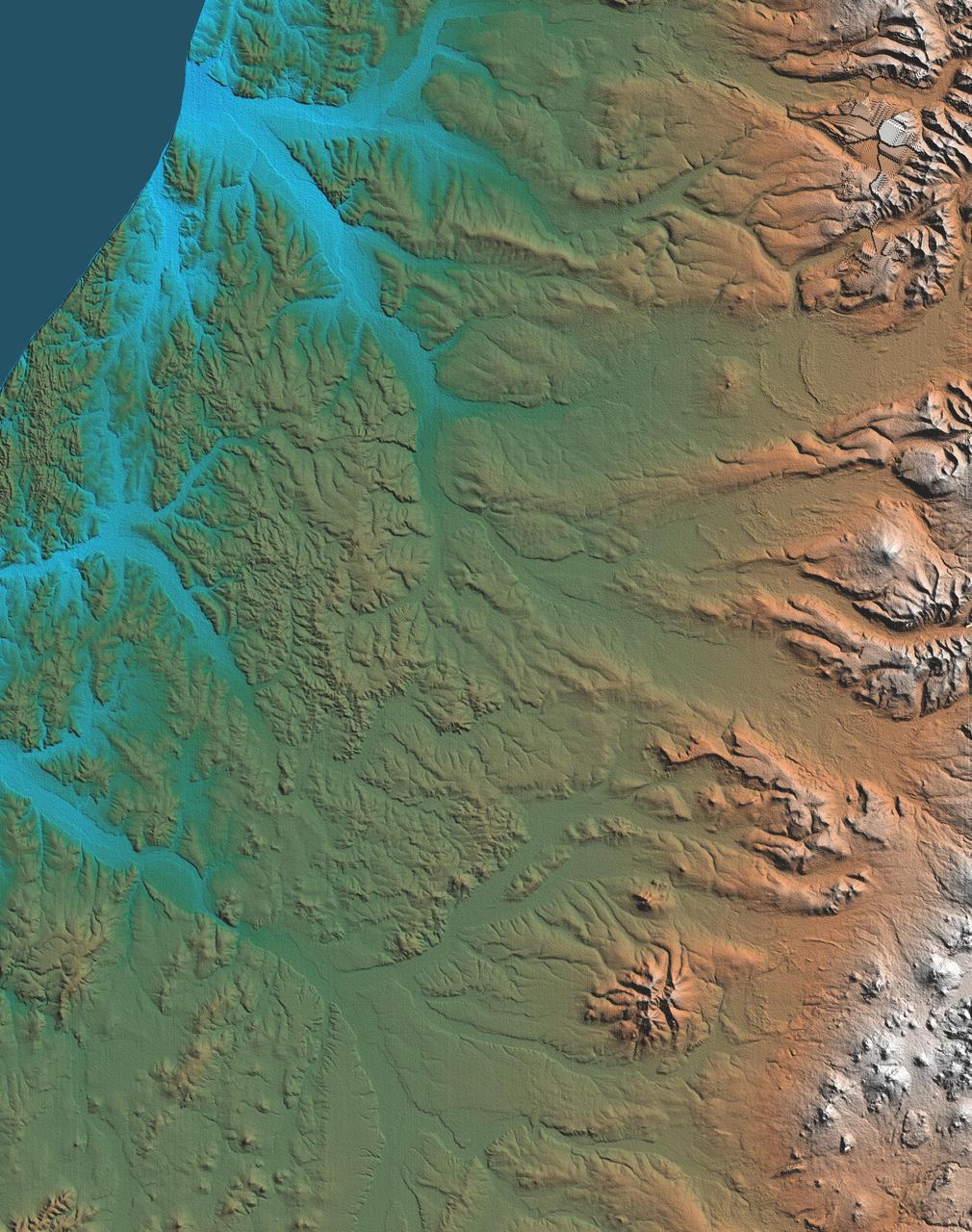
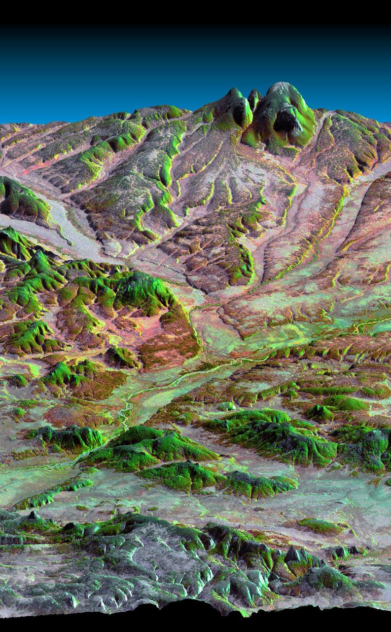
The Kamchatka Peninsula in eastern Russia is shown in this scene created from a preliminary elevation model derived from the first data collected during NASA Shuttle Radar Topography Mission SRTM on February 12, 2000.
The top picture is a shaded relief image of the northwest corner of Mexico Yucatan Peninsula generated from NASA Shuttle Radar Topography Mission SRTM data, and shows a subtle, but unmistakable, indication of the Chicxulub impact crater.
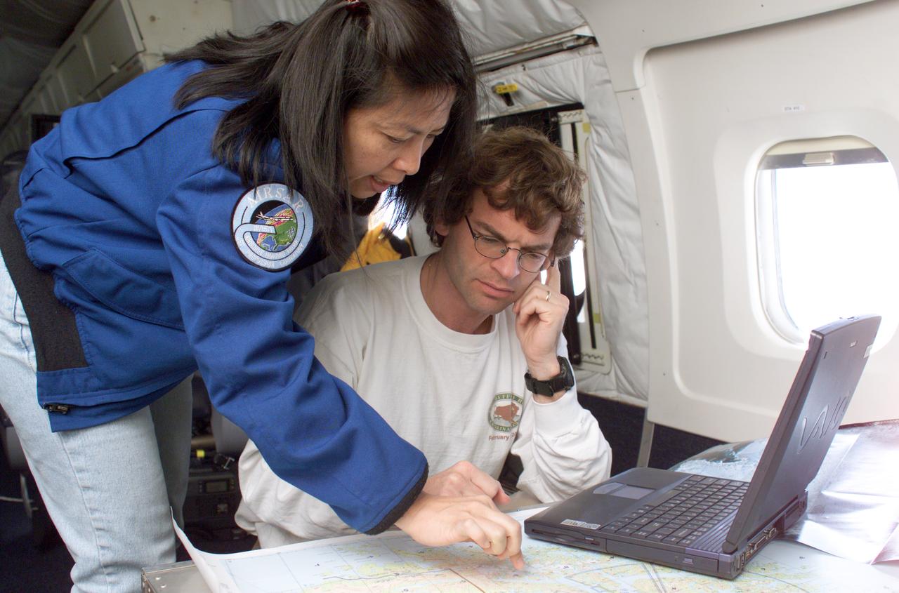
NASA JPL scientists Yunling Lou and Dr. Eric Rignot work on line selection while flying AirSAR missions over the Antarctic Peninsula. AirSAR 2004 is a three-week expedition in Central and South America by an international team of scientists that is using an all-weather imaging tool, called the Airborne Synthetic Aperture Radar (AirSAR), located onboard NASA's DC-8 airborne laboratory. Scientists from many parts of the world are combining ground research with NASA's AirSAR technology to improve and expand on the quality of research they are able to conduct. These photos are from the DC-8 aircraft while flying an AirSAR mission over Antarctica. The Antarctic Peninsula is more similar to Alaska and Patagonia than to the rest of the Antarctic continent. It is drained by fast glaciers, receives abundant precipitation, and melts significantly in the summer months. In recent decades, the Peninsula has experienced significant atmospheric warming (about 2 degrees C since 1950), which has triggered a vast and spectacular retreat of its floating ice shelves, glacier reduction, a decrease in permanent snow cover and a lengthening of the melt season. As a result, the contribution to sea level from this region could be rapid and substantial. With an area of 120,000 km, or ten times the Patagonia ice fields, the Peninsula could contribute as much as 0.4mm/yr sea level rise, which would be the largest single contribution to sea level from anywhere in the world. This region is being studied by NASA using a DC-8 equipped with the Airborne Synthetic Aperture Radar developed by scientists from NASA’s Jet Propulsion Laboratory. AirSAR will provide a baseline model and unprecedented mapping of the region. This data will make it possible to determine whether the warming trend is slowing, continuing or accelerating. AirSAR will also provide reliable information on ice shelf thickness to measure the contribution of the glaciers to sea level.
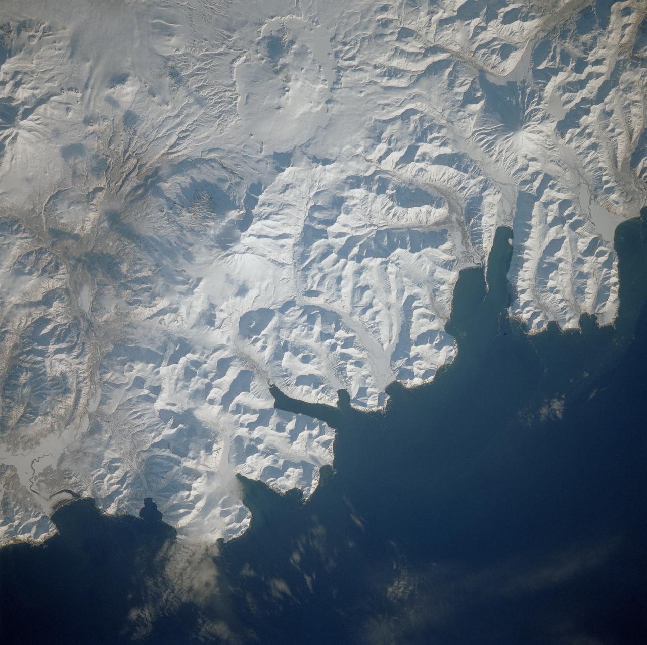
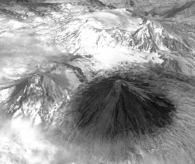
STS039-77-010 (28 April 1991) --- The Kamchatka Peninsula, USSR. This oblique view of the eastern margin of the Kamchatka Peninsula shows pack-ice along the coast, which is drifting along with local currents and delineates the circulation patterns. Also visible are the Kamchatka River (left of center), and the volcanic complex with the active volcano Klyuchevskaya (Kloo-chevs'-ska-ya), 15,584 feet in elevation. The last reported eruption of the volcano was on April 8, but an ash and steam plume extending to the south can be seen in this photograph, taken almost three weeks later (April 28). On April 29, the crew observed and photographed the volcano again, and it was no longer visibly active. However, the flanks of the mountain are dirty from the ash fall. Just north of the Kamchatka River (to the left, just off frame) is Shiveluch, a volcano which was active in early April. There are more than 100 volcanic edifices recognized on Kamchatka, with 15 classified as active.
iss072e891004 (March 22, 2025) --- The Florida peninsula and the eastern coast of the United States, including the Bahamas in the Atlantic Ocean, are pictured at 1:37 a.m. local time from the International Space Station as it orbited 260 miles above.
iss073e0379768 (July 20, 2025) --- Colombia's La Guajira Peninsula on the Caribbean Sea, with its desert region and beautiful coastline, is pictured from the International Space Station as it orbited 258 miles above.

NASA DC-8 Mission Manager Walter Klein and Chilean Air Force Advisor Captain Saez review maps of the Antarctic Peninsula during an AirSAR 2004 mission. AirSAR 2004 is a three-week expedition in Central and South America by an international team of scientists that is using an all-weather imaging tool, called the Airborne Synthetic Aperture Radar (AirSAR), located onboard NASA's DC-8 airborne laboratory. Scientists from many parts of the world are combining ground research with NASA's AirSAR technology to improve and expand on the quality of research they are able to conduct. These photos are from the DC-8 aircraft while flying an AirSAR mission over Antarctica. The Antarctic Peninsula is more similar to Alaska and Patagonia than to the rest of the Antarctic continent. It is drained by fast glaciers, receives abundant precipitation, and melts significantly in the summer months. In recent decades, the Peninsula has experienced significant atmospheric warming (about 2 degrees C since 1950), which has triggered a vast and spectacular retreat of its floating ice shelves, glacier reduction, a decrease in permanent snow cover and a lengthening of the melt season. As a result, the contribution to sea level from this region could be rapid and substantial. With an area of 120,000 km, or ten times the Patagonia ice fields, the Peninsula could contribute as much as 0.4mm/yr sea level rise, which would be the largest single contribution to sea level from anywhere in the world. This region is being studied by NASA using a DC-8 equipped with the Airborne Synthetic Aperture Radar developed by scientists from NASA’s Jet Propulsion Laboratory. AirSAR will provide a baseline model and unprecedented mapping of the region. This data will make it possible to determine whether the warming trend is slowing, continuing or accelerating. AirSAR will also provide reliable information on ice shelf thickness to measure the contribution of the glaciers to sea level.
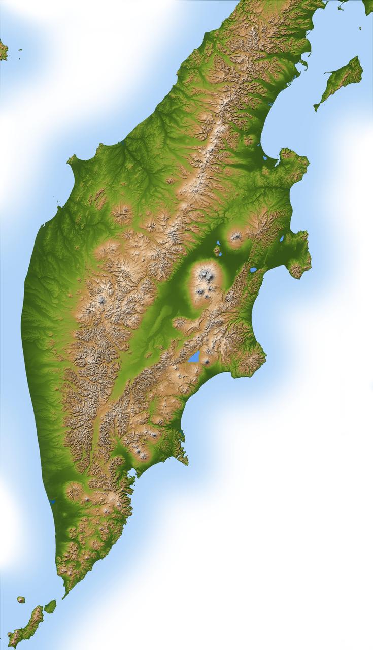
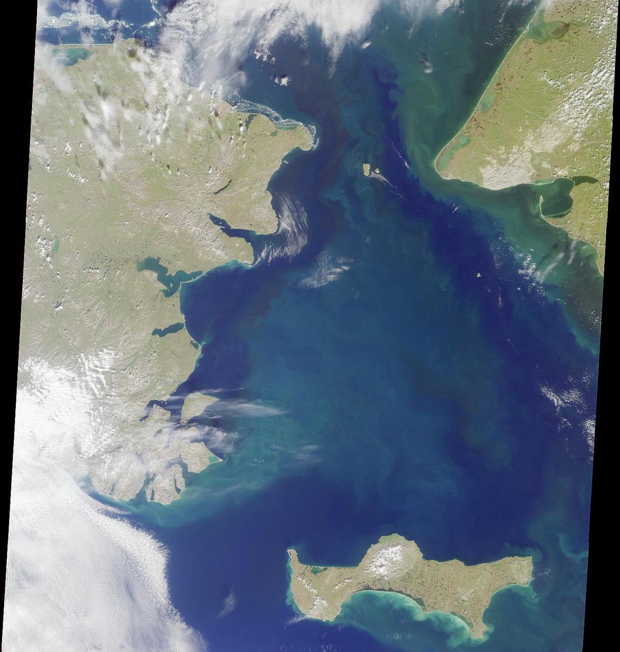
The Iveragh Peninsula, one of the four peninsulas in southwestern Ireland, is shown in this spaceborne radar image. The lakes of Killarney National Park are the green patches on the left side of the image.
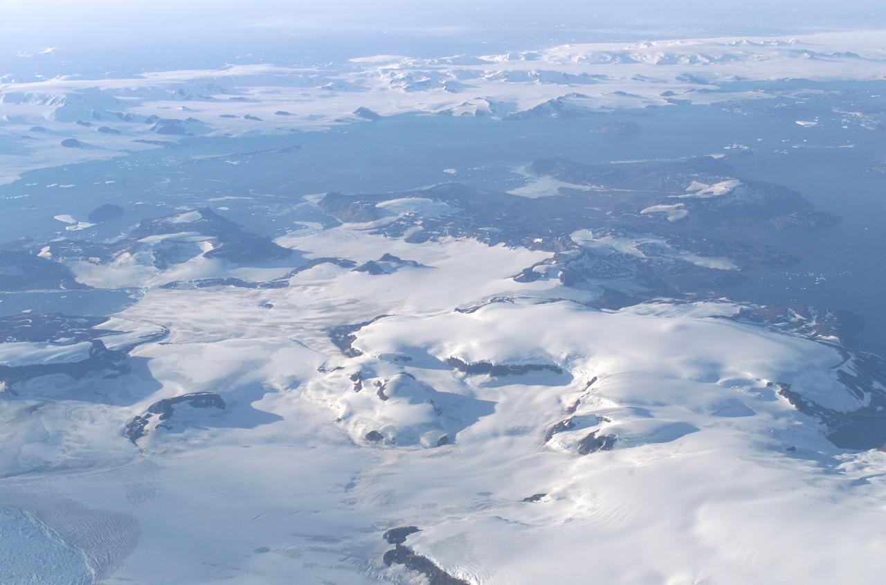
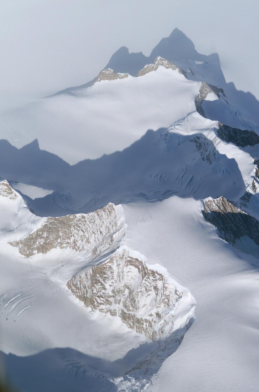
James Ross Island captured by NASA photographer James Ross(no relation), from NASA's DC-8 aircraft during an AirSAR 2004 mission over the Antarctic Peninsula. James Ross Island, named for 19th century British polar explorer Sir James Clark Ross, is located at the northern tip of the Antarctic Peninsula. The island is about 1500 m high and 40-60 km wide. In recent decades, the area has experienced significant atmospheric warming (about 2 degrees C since 1950), which has triggered a vast and spectacular retreat of its floating ice shelves, glacier reduction, a decrease in permanent snow cover and a lengthening of the melt season. AirSAR 2004 is a three-week expedition in Central and South America by an international team of scientists that is using an all-weather imaging tool, called the Airborne Synthetic Aperture Radar (AirSAR), located onboard NASA's DC-8 airborne laboratory. Scientists from many parts of the world are combining ground research with NASA's AirSAR technology to improve and expand on the quality of research they are able to conduct. These photos are from the DC-8 aircraft while flying an AirSAR mission over Antarctica. The Antarctic Peninsula is more similar to Alaska and Patagonia than to the rest of the Antarctic continent. It is drained by fast glaciers, receives abundant precipitation, and melts significantly in the summer months. This region is being studied by NASA using a DC-8 equipped with the Airborne Synthetic Aperture Radar developed by scientists from NASA’s Jet Propulsion Laboratory. AirSAR will provide a baseline model and unprecedented mapping of the region. This data will make it possible to determine whether the warming trend is slowing, continuing or accelerating. AirSAR will also provide reliable information on ice shelf thickness to measure the contribution of the glaciers to sea level.
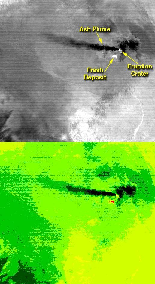
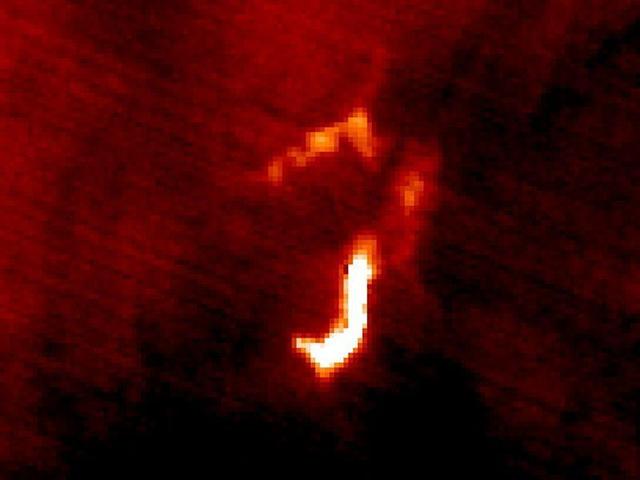
On the night of June 4, 2001, the Advanced Spaceborne Thermal Emission and Reflection Radiometer (ASTER) captured this thermal image of the erupting Shiveluch volcano. Located on Russia's Kamchatka Peninsula, Shiveluch rises to an altitude of 2,447 meters (8,028 feet). The active lava dome complex is seen as a bright (hot) area on the summit of the volcano. To the southwest, a second hot area is either a debris avalanche or hot ash deposit. Trailing to the west is a 25-kilometer (15-mile) ash plume, seen as a cold "cloud" streaming from the summit. At least 60 large eruptions have occurred here during the last 10,000 years; the largest historical eruptions were in 1854 and 1964. Because Kamchatka is located along the major aircraft routes between North America/Europe and Asia, this area is constantly monitored for potential ash hazards to aircraft. The area is part of the "Ring of Fire," a string of volcanoes that encircles the Pacific Ocean. The lower image is the same as the upper, except it has been color-coded: red is hot, light greens to dark green are progressively colder, and gray/black are the coldest areas. The image is located at 56.7 degrees north latitude, 161.3 degrees east longitude. http://photojournal.jpl.nasa.gov/catalog/PIA03514
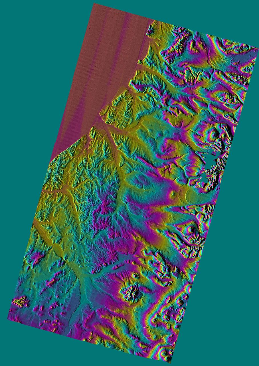
This three-dimensional perspective view, looking up the Tigil River, acquired by NASA Shuttle Radar Topography Mission SRTM from data collected on February 16, 2000, shows the western side of the volcanically active Kamchatka Peninsula, Russia.
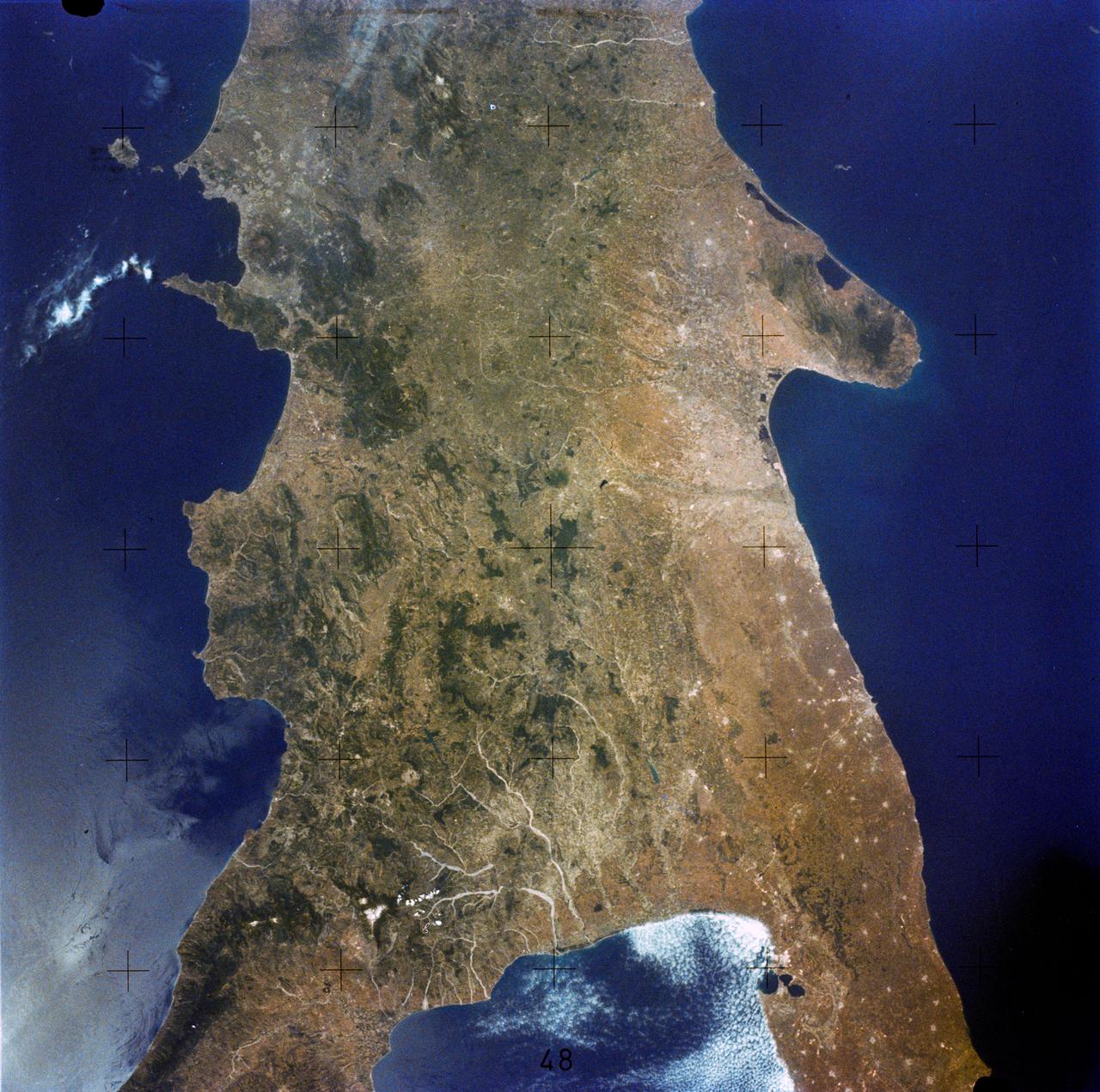
SL2-05-359 (22 June 1973) --- This rare cloud free view of southern Italy (41.0N, 16.0E) shows almost all of the famous `boot' configuration of the peninsula up to just north of Naples and Mount Vesuvius. The land mass of this historic peninsula contrasts sharply with the sparkling blue waters of the Mediterranean Sea. Photo credit: NASA
STS109-708-024 (1-12 March 2002) --- The astronauts on board the Space Shuttle Columbia took this 70mm picture featuring the Sinai Peninsula and the Dead Sea Rift. The left side of the view is dominated by the great triangle of the Sinai peninsula, which is partly obscured by an unusual cloud mass on this day. The famous Monastery of St. Catherine lies in the very remote, rugged mountains in the southern third of the peninsula (foreground). The Gulf of Aqaba is a finger of the Red Sea bottom center, pointing north to the Dead Sea, the small body of water near the center of the view. According to NASA scientists studying the STS-109 photo collection, the gulf and the Dead Sea are northerly extensions of the same geological rift that resulted in the opening of the Red Sea . The Gulf of Suez appears in the lower left corner. Northwest Saudi Arabia occupies the lower right side of the view, Jordan and Syria the right and top right, and the Eastern Mediterranean Sea the top left. Thin white lines of cloud have formed along the coastal mountains of southern Turkey and stretch across the top of the view near the Earth's limb.
S66-54893 (14 Sept. 1966) --- Near East area as seen from the orbiting Gemini-11 spacecraft during its 26th revolution of Earth. The United Arab Republic (Egypt) is in foreground. Triangular-shaped area is the Sinai Peninsula. Saudi Arabia is at upper right. The Mediterranean Sea is at upper left. The Gulf of Suez separates Egypt from the Sinai Peninsula. The Red Sea is at bottom right. The Gulf of Aqaba is the body of water in right center of photograph separating the Sinai Peninsula and the Arabian Peninsula. The Dead Sea, Sea of Galilee, Jordan and Israel are in top center of picture. Iraq is at top right edge of photograph. Taken with a J. A. Maurer 70mm camera, using Eastman Kodak, Ektachrome, MS (S.O. 368) color film. Photo credit: NASA
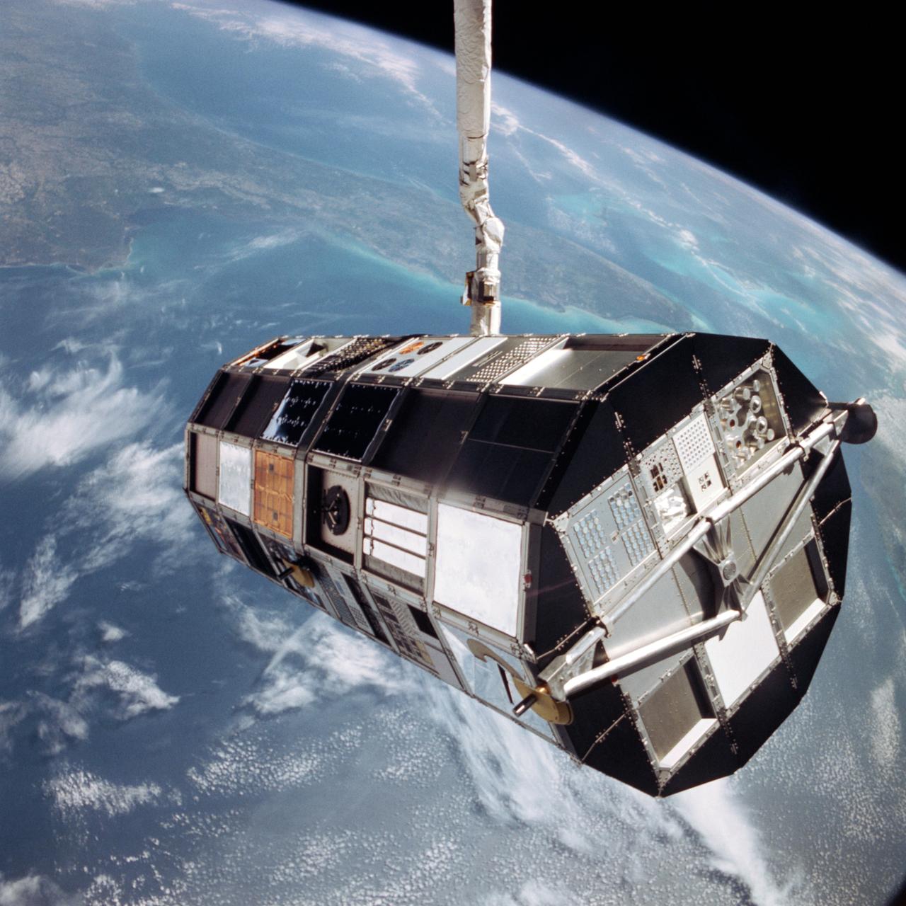
41C-36-1618 (7 April 1984) --- The Remote Manipulator System (RMS) arm suspends the giant Long Duration Exposure Facility (LDEF) high above the Gulf of Mexico prior to releasing it into space. Carried into Earth orbit with the STS-41C crew by the Space Shuttle Challenger, LDEF will remain in space until retrieved by a future Shuttle mission, in nine or ten months. Florida and the Bahama Banks are visible near the Earth's horizon in the 70mm frame.
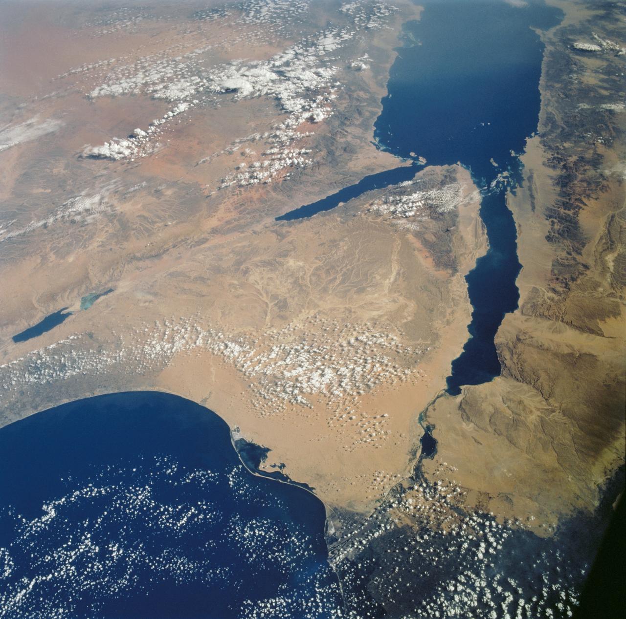
STS112-702-002 (7-18 October 2002) --- Egypt's triangular Sinai Peninsula lies in the center of this view, photographed from the Space Shuttle Atlantis, with the dark greens of the Nile delta lower right. In this southwesterly view, the Red Sea, with its characteristic parallel coastlines, stretches toward the top. At the bottom of the image, the Suez Canal appears as an irregular line joining the Red Sea to the Mediterranean Sea (lower left). The Dead Sea in central Israel, with its light blue salt ponds at the south end, appears on the left margin.

iss073e0983131 (Sept. 21, 2025) --- A partly cloudy Korean Peninsula, surrounded by the sun's glint reflecting off the Sea of Japan and the Yellow Sea, is pictured from the International Space Station as it orbited 259 miles above Earth off the coast of western Japan.

iss073e0824130 (Sept. 14, 2025) --- The Korean Peninsula—highlighted by Seoul, South Korea (bottom left)—and Northeast China—illuminated by the Beijing Municipality (top left)—are pictured from the International Space Station as it orbited 262 miles above Asia at approximately 12:42 a.m. local time.
iss074e0454554 (April 10, 2026) --- The snow‑covered Kronotsky, a major stratovolcano on the Kamchatka Peninsula in Russia, is pictured from the International Space Station as it orbited 267 miles above the Pacific Ocean. Kronotsky is known for its picturesque, near‑perfect symmetry, comparable to Japan’s Mount Fuji. Credit: NASA/Chris Williams
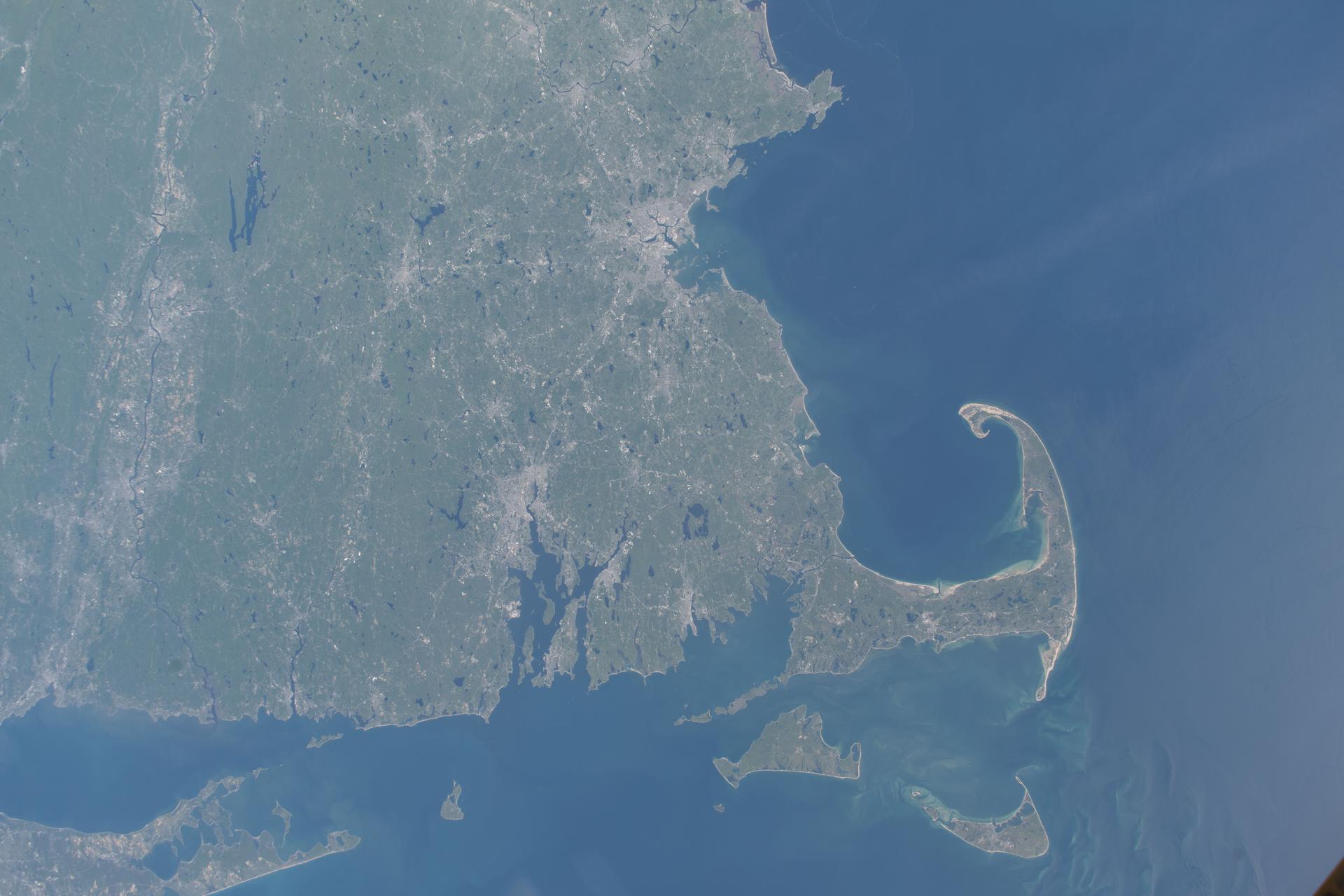
iss074e0671775 (June 4, 2026) --- Massachusetts’ Cape Cod peninsula and the southern New England coastline extending from Rhode Island to Connecticut are featured prominently in this photograph from the International Space Station as it orbited 261 miles above the Atlantic Ocean. Credit: NASA/Chris Williams
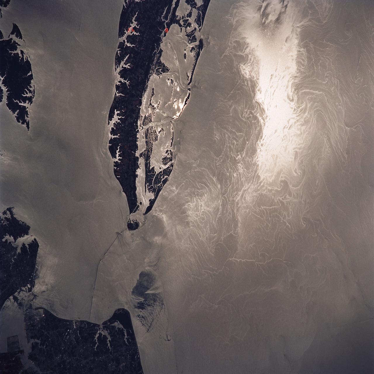
STS040-614-047 (5-14 June 1991) --- This image is of the Norfolk, Virginia -- Southern Delmarva Peninsula Southern Chesapeake Bay Area as seen in sunlight. The exposure is adjusted to emphasize the water patterns present. The outgoing tide generates considerable turbulence as it passes through the mouth of the bay. This is displayed by differences in reflective properties of the water surface due to differences in slope and turbidity. Ship wakes and the wakes of subsurface structures are seen clearly. The bridge tunnel system linking Norfolk with the peninsula and its effect on the system is quite apparent. Sunglint images over land areas were also acquired which emphasize land-water boundaries as demonstrated here in the small Delmarva inlets as a tool for wetland mapping, and river, lake and even pond description. During the first few days of the STS-40 mission the Eastern Seaboard of the United States was free of clouds and haze providing excellent photography of many of the major cities and the countryside of that area as well as the Gulf Stream.
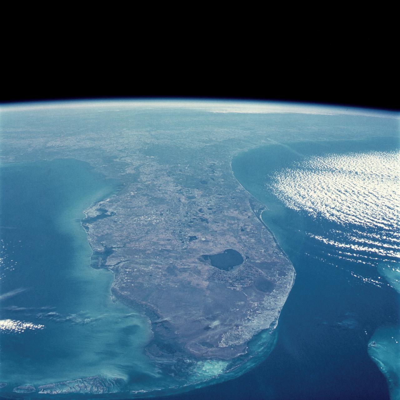
STS058-107-046 (18 Oct-1 Nov 1993) --- Clouds streak across central Florida in this striking photograph which includes the Florida Peninsula, Andros Island of the northern Bahamas and Cuba (lower left). The light blue, shallow bank of the Bahamas contrast with the deeper blue waters of the Florida strait. The city of Miami is obscured by clouds, but one can see the Florida Keys stretching off to the left. Much of the rest of the southeast coast is barely visible under haze.
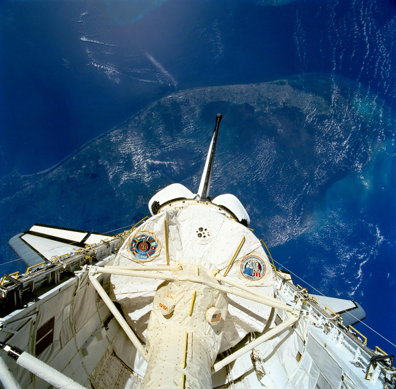
STS050-81-027 (25 June-9 July 1992) --- The first United States Microgravity Laboratory 1 (USML-1) module is pictured in the payload bay of the Earth-orbiting Space Shuttle Columbia in this scene over the southern two-thirds of the Florida peninsula. The Kennedy Space Center (KSC), where the mission began, can be seen just above Columbia's starboard wing. (Hold photo with number at left.)
STS059-81-095 (9-20 April 1994) --- View southwestward across the Kamchatka Peninsula. The cluster of volcanoes in the middle distance are active, including Klutchevskaya whose summit reaches 15,580 feet. Changes in volcanic deposits, snow, and ice are being studied by Russian and American SRL investigators. Seasonal changes in sea ice are also of interest, for example, in Kamchatskiy Bay (upper left). Hasselblad camera, 40mm lens.
STS039-81-00OU (28 April-6 May 1991) --- Flying at an inclination of 57 degrees to Earth's Equator, the Space Shuttle Discovery was able to record photography of a number of seldom observed areas on the planet, such as the USSR. This view was taken in the far north Pacific Ocean and shows part of the Kamchatka Peninsula. One of Discovery's seven crewmembers aimed a 70mm handheld camera through aft flight deck overhead windows to record the image.
iss073e0865795 (Oct. 1, 2025) --- The Gulf of California, also known as the Sea of Cortez, separates mainland Mexico from the Baja California Peninsula in this photograph from the International Space Station as it orbited 261 miles above California. Geologically, it is Earth’s youngest sea, formed around 5 million years ago due to tectonic activity. In 2005, the Gulf was designated a UNESCO World Heritage Site in recognition of its unique oceanographic processes and extraordinary biodiversity.
STS039-81-00OW (28 April-6 May 1991) --- This scene shows a small area of the north Pacific coast of the USSR's Kamchatka peninsula. Flying at an inclination of 57 degrees to Earth's Equator, the Space Shuttle Discovery was able to record photography of a number of seldom observed areas on the planet, such as the USSR. One of Discovery's seven crewmembers aimed a 70mm handheld camera through aft flight deck overhead windows to record the image.
This montage is a natural-color view of the Caribbean Sea east of the Yucatan Peninsula as seen by NASA Terra satellite.

The city of Nome lies on the southern Seward Peninsula coast of Alaska, on the Bering Sea, as shown in this image from NASA Terra spacecraft.
The Larsen Ice Shelf in Antarctica viewed from NASA's DC-8 aircraft during the AirSAR 2004 campaign. AirSAR 2004 is a three-week expedition in Central and South America by an international team of scientists that is using an all-weather imaging tool, called the Airborne Synthetic Aperture Radar (AirSAR), located onboard NASA's DC-8 airborne laboratory. Scientists from many parts of the world are combining ground research with NASA's AirSAR technology to improve and expand on the quality of research they are able to conduct. These photos are from the DC-8 aircraft while flying an AirSAR mission over Antarctica. The Antarctic Peninsula is more similar to Alaska and Patagonia than to the rest of the Antarctic continent. It is drained by fast glaciers, receives abundant precipitation, and melts significantly in the summer months. In recent decades, the Peninsula has experienced significant atmospheric warming (about 2 degrees C since 1950), which has triggered a vast and spectacular retreat of its floating ice shelves, glacier reduction, a decrease in permanent snow cover and a lengthening of the melt season. As a result, the contribution to sea level from this region could be rapid and substantial. With an area of 120,000 km, or ten times the Patagonia ice fields, the Peninsula could contribute as much as 0.4mm/yr sea level rise, which would be the largest single contribution to sea level from anywhere in the world. This region is being studied by NASA using a DC-8 equipped with the Airborne Synthetic Aperture Radar developed by scientists from NASA’s Jet Propulsion Laboratory. AirSAR will provide a baseline model and unprecedented mapping of the region. This data will make it possible to determine whether the warming trend is slowing, continuing or accelerating. AirSAR will also provide reliable information on ice shelf thickness to measure the contribution of the glaciers to sea level.

The Larsen Ice Shelf in Antarctica viewed from NASA's DC-8 aircraft during the AirSAR 2004 campaign. AirSAR 2004 is a three-week expedition in Central and South America by an international team of scientists that is using an all-weather imaging tool, called the Airborne Synthetic Aperture Radar (AirSAR), located onboard NASA's DC-8 airborne laboratory. Scientists from many parts of the world are combining ground research with NASA's AirSAR technology to improve and expand on the quality of research they are able to conduct. These photos are from the DC-8 aircraft while flying an AirSAR mission over Antarctica. The Antarctic Peninsula is more similar to Alaska and Patagonia than to the rest of the Antarctic continent. It is drained by fast glaciers, receives abundant precipitation, and melts significantly in the summer months. In recent decades, the Peninsula has experienced significant atmospheric warming (about 2 degrees C since 1950), which has triggered a vast and spectacular retreat of its floating ice shelves, glacier reduction, a decrease in permanent snow cover and a lengthening of the melt season. As a result, the contribution to sea level from this region could be rapid and substantial. With an area of 120,000 km, or ten times the Patagonia ice fields, the Peninsula could contribute as much as 0.4mm/yr sea level rise, which would be the largest single contribution to sea level from anywhere in the world. This region is being studied by NASA using a DC-8 equipped with an Airborne Synthetic Aperture Radar (AirSAR) developed by scientists from NASA’s Jet Propulsion Laboratory. AirSAR will provide a baseline model and unprecedented mapping of the region. This data will make it possible to determine whether the warming trend is slowing, continuing or accelerating. AirSAR will also provide reliable information on ice shelf thickness to measure the contribution of the glaciers to sea level.
The Larsen Ice Shelf in Antarctica viewed from NASA's DC-8 aircraft during the AirSAR 2004 campaign. AirSAR 2004 is a three-week expedition in Central and South America by an international team of scientists that is using an all-weather imaging tool, called the Airborne Synthetic Aperture Radar (AirSAR), located onboard NASA's DC-8 airborne laboratory. Scientists from many parts of the world are combining ground research with NASA's AirSAR technology to improve and expand on the quality of research they are able to conduct. These photos are from the DC-8 aircraft while flying an AirSAR mission over Antarctica. The Antarctic Peninsula is more similar to Alaska and Patagonia than to the rest of the Antarctic continent. It is drained by fast glaciers, receives abundant precipitation, and melts significantly in the summer months. In recent decades, the Peninsula has experienced significant atmospheric warming (about 2 degrees C since 1950), which has triggered a vast and spectacular retreat of its floating ice shelves, glacier reduction, a decrease in permanent snow cover and a lengthening of the melt season. As a result, the contribution to sea level from this region could be rapid and substantial. With an area of 120,000 km, or ten times the Patagonia ice fields, the Peninsula could contribute as much as 0.4mm/yr sea level rise, which would be the largest single contribution to sea level from anywhere in the world. This region is being studied by NASA using a DC-8 equipped with the Airborne Synthetic Aperture Radar developed by scientists from NASA’s Jet Propulsion Laboratory. AirSAR will provide a baseline model and unprecedented mapping of the region. This data will make it possible to determine whether the warming trend is slowing, continuing or accelerating. AirSAR will also provide reliable information on ice shelf thickness to measure the contribution of the glaciers to sea level.

The Larsen Ice Shelf in Antarctica viewed from NASA's DC-8 aircraft during the AirSAR 2004 campaign. AirSAR 2004 is a three-week expedition in Central and South America by an international team of scientists that is using an all-weather imaging tool, called the Airborne Synthetic Aperture Radar (AirSAR), located onboard NASA's DC-8 airborne laboratory. Scientists from many parts of the world are combining ground research with NASA's AirSAR technology to improve and expand on the quality of research they are able to conduct. These photos are from the DC-8 aircraft while flying an AirSAR mission over Antarctica. The Antarctic Peninsula is more similar to Alaska and Patagonia than to the rest of the Antarctic continent. It is drained by fast glaciers, receives abundant precipitation, and melts significantly in the summer months. In recent decades, the Peninsula has experienced significant atmospheric warming (about 2 degrees C since 1950), which has triggered a vast and spectacular retreat of its floating ice shelves, glacier reduction, a decrease in permanent snow cover and a lengthening of the melt season. As a result, the contribution to sea level from this region could be rapid and substantial. With an area of 120,000 km, or ten times the Patagonia ice fields, the Peninsula could contribute as much as 0.4mm/yr sea level rise, which would be the largest single contribution to sea level from anywhere in the world. This region is being studied by NASA using a DC-8 equipped with the Airborne Synthetic Aperture Radar developed by scientists from NASA’s Jet Propulsion Laboratory. AirSAR will provide a baseline model and unprecedented mapping of the region. This data will make it possible to determine whether the warming trend is slowing, continuing or accelerating. AirSAR will also provide reliable information on ice shelf thickness to measure the contribution of the glaciers to sea level.
The Larsen Ice Shelf in Antarctica viewed from NASA's DC-8 aircraft during the AirSAR 2004 campaign. AirSAR 2004 is a three-week expedition in Central and South America by an international team of scientists that is using an all-weather imaging tool, called the Airborne Synthetic Aperture Radar (AirSAR), located onboard NASA's DC-8 airborne laboratory. Scientists from many parts of the world are combining ground research with NASA's AirSAR technology to improve and expand on the quality of research they are able to conduct. These photos are from the DC-8 aircraft while flying an AirSAR mission over Antarctica. The Antarctic Peninsula is more similar to Alaska and Patagonia than to the rest of the Antarctic continent. It is drained by fast glaciers, receives abundant precipitation, and melts significantly in the summer months. In recent decades, the Peninsula has experienced significant atmospheric warming (about 2 degrees C since 1950), which has triggered a vast and spectacular retreat of its floating ice shelves, glacier reduction, a decrease in permanent snow cover and a lengthening of the melt season. As a result, the contribution to sea level from this region could be rapid and substantial. With an area of 120,000 km, or ten times the Patagonia ice fields, the Peninsula could contribute as much as 0.4mm/yr sea level rise, which would be the largest single contribution to sea level from anywhere in the world. This region is being studied by NASA using a DC-8 equipped with the Airborne Synthetic Aperture Radar developed by scientists from NASA’s Jet Propulsion Laboratory. AirSAR will provide a baseline model and unprecedented mapping of the region. This data will make it possible to determine whether the warming trend is slowing, continuing or accelerating. AirSAR will also provide reliable information on ice shelf thickness to measure the contribution of the glaciers to sea level.
The Larsen Ice Shelf in Antarctica viewed from NASA's DC-8 aircraft during the AirSAR 2004 campaign. AirSAR 2004 is a three-week expedition in Central and South America by an international team of scientists that is using an all-weather imaging tool, called the Airborne Synthetic Aperture Radar (AirSAR), located onboard NASA's DC-8 airborne laboratory. Scientists from many parts of the world are combining ground research with NASA's AirSAR technology to improve and expand on the quality of research they are able to conduct. These photos are from the DC-8 aircraft while flying an AirSAR mission over Antarctica. The Antarctic Peninsula is more similar to Alaska and Patagonia than to the rest of the Antarctic continent. It is drained by fast glaciers, receives abundant precipitation, and melts significantly in the summer months. In recent decades, the Peninsula has experienced significant atmospheric warming (about 2 degrees C since 1950), which has triggered a vast and spectacular retreat of its floating ice shelves, glacier reduction, a decrease in permanent snow cover and a lengthening of the melt season. As a result, the contribution to sea level from this region could be rapid and substantial. With an area of 120,000 km, or ten times the Patagonia ice fields, the Peninsula could contribute as much as 0.4mm/yr sea level rise, which would be the largest single contribution to sea level from anywhere in the world. This region is being studied by NASA using a DC-8 equipped with the Airborne Synthetic Aperture Radar developed by scientists from NASA’s Jet Propulsion Laboratory. AirSAR will provide a baseline model and unprecedented mapping of the region. This data will make it possible to determine whether the warming trend is slowing, continuing or accelerating. AirSAR will also provide reliable information on ice shelf thickness to measure the contribution of the glaciers to sea level.
The Larsen Ice Shelf in Antarctica viewed from NASA's DC-8 aircraft during the AirSAR 2004 campaign. AirSAR 2004 is a three-week expedition in Central and South America by an international team of scientists that is using an all-weather imaging tool, called the Airborne Synthetic Aperture Radar (AirSAR), located onboard NASA's DC-8 airborne laboratory. Scientists from many parts of the world are combining ground research with NASA's AirSAR technology to improve and expand on the quality of research they are able to conduct. These photos are from the DC-8 aircraft while flying an AirSAR mission over Antarctica. The Antarctic Peninsula is more similar to Alaska and Patagonia than to the rest of the Antarctic continent. It is drained by fast glaciers, receives abundant precipitation, and melts significantly in the summer months. In recent decades, the Peninsula has experienced significant atmospheric warming (about 2 degrees C since 1950), which has triggered a vast and spectacular retreat of its floating ice shelves, glacier reduction, a decrease in permanent snow cover and a lengthening of the melt season. As a result, the contribution to sea level from this region could be rapid and substantial. With an area of 120,000 km, or ten times the Patagonia ice fields, the Peninsula could contribute as much as 0.4mm/yr sea level rise, which would be the largest single contribution to sea level from anywhere in the world. This region is being studied by NASA using a DC-8 equipped with the Airborne Synthetic Aperture Radar developed by scientists from NASA’s Jet Propulsion Laboratory. AirSAR will provide a baseline model and unprecedented mapping of the region. This data will make it possible to determine whether the warming trend is slowing, continuing or accelerating. AirSAR will also provide reliable information on ice shelf thickness to measure the contribution of the glaciers to sea level.
The Larsen Ice Shelf in Antarctica viewed from NASA's DC-8 aircraft during the AirSAR 2004 campaign. AirSAR 2004 is a three-week expedition in Central and South America by an international team of scientists that is using an all-weather imaging tool, called the Airborne Synthetic Aperture Radar (AirSAR), located onboard NASA's DC-8 airborne laboratory. Scientists from many parts of the world are combining ground research with NASA's AirSAR technology to improve and expand on the quality of research they are able to conduct. These photos are from the DC-8 aircraft while flying an AirSAR mission over Antarctica. The Antarctic Peninsula is more similar to Alaska and Patagonia than to the rest of the Antarctic continent. It is drained by fast glaciers, receives abundant precipitation, and melts significantly in the summer months. In recent decades, the Peninsula has experienced significant atmospheric warming (about 2 degrees C since 1950), which has triggered a vast and spectacular retreat of its floating ice shelves, glacier reduction, a decrease in permanent snow cover and a lengthening of the melt season. As a result, the contribution to sea level from this region could be rapid and substantial. With an area of 120,000 km, or ten times the Patagonia ice fields, the Peninsula could contribute as much as 0.4mm/yr sea level rise, which would be the largest single contribution to sea level from anywhere in the world. This region is being studied by NASA using a DC-8 equipped with the Airborne Synthetic Aperture Radar developed by scientists from NASA’s Jet Propulsion Laboratory. AirSAR will provide a baseline model and unprecedented mapping of the region. This data will make it possible to determine whether the warming trend is slowing, continuing or accelerating. AirSAR will also provide reliable information on ice shelf thickness to measure the contribution of the glaciers to sea level.
This is an image of the southern portion of the Baja California Peninsula taken by NASA EarthKAM on February 12, 2000. The Pacific Ocean lies to the west and the Gulf of California to the east.
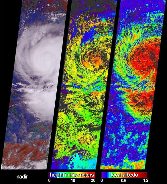
These views of Hurricane Isidore were acquired by NASA Terra satellite on September 20, 2002 as it flooded western Cuba and swept westward to Mexico Yucatan Peninsula.
The Musandam Peninsula is part of Oman, separated from the rest of the country by the United Arab Emirates. This image was acquired by NASA Terra satellite on March 27, 2004.
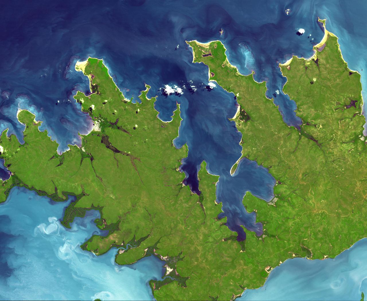
At the northern tip of Northern Territory, Australia, the Garig Gunak Barlu National Park spans the entire Cobourg Peninsula. Nearly the whole peninsula is Aboriginal land, and the park is managed as a sanctuary under the direction of traditional Aboriginal landowners. The first wetlands to be declared "Wetlands of International Importance" by the Ramsar Convention on Wetlands International Treaty are located in this park. The image was acquired April 12, 2016, covers an area of 48.2 by 58.6 km, and is located at 11.3 degrees south, 132.2 degrees east. https://photojournal.jpl.nasa.gov/catalog/PIA24732
Shiveluch volcano on Russia’s Kamchatka Peninsula. This is a false-color satellite image, acquired by the Advanced Spaceborne Thermal Emission and Reflection Radiometer (ASTER) on March 10, 2010. To download a full high res version of this image and to learn more go to: <a href="http://earthobservatory.nasa.gov/NaturalHazards/view.php?id=43103" rel="nofollow">earthobservatory.nasa.gov/NaturalHazards/view.php?id=43103</a> Credit: NASA Earth Observatory image by Jesse Allen and Robert Simmon, based on data from the NASA/GSFC/METI/ERSDAC/JAROS, and U.S./Japan ASTER Science Team. Instrument: Terra - ASTER For more information about the Goddard Space Flight Center go here: <a href="http://www.nasa.gov/centers/goddard/home/index.html" rel="nofollow">www.nasa.gov/centers/goddard/home/index.html</a>
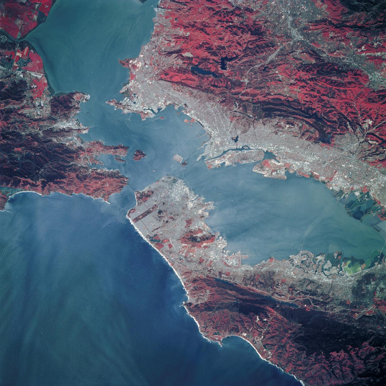
STS039-89-053 (28 April-6 May 1991) --- A 70mm, infrared frame of the city of San Francisco, taken on a clear day. The gray areas represent urban regions, and the red areas are vegetated. Within the city of San Francisco, parks like Golden Gate park and the Presidio at the base of the Golden Gate Bridge easily stand out from the well-developed parts of the city. Major thoroughfares and bridges (Golden Gate and Bay Bridges) are seen as are other landmarks such as Candlestick Park and Alcatraz. The trace of the San Andreas faults show as a straight valley running northerly along the San Francisco peninsula. Good detail is visible in the turbid waters of San Francisco Bay.
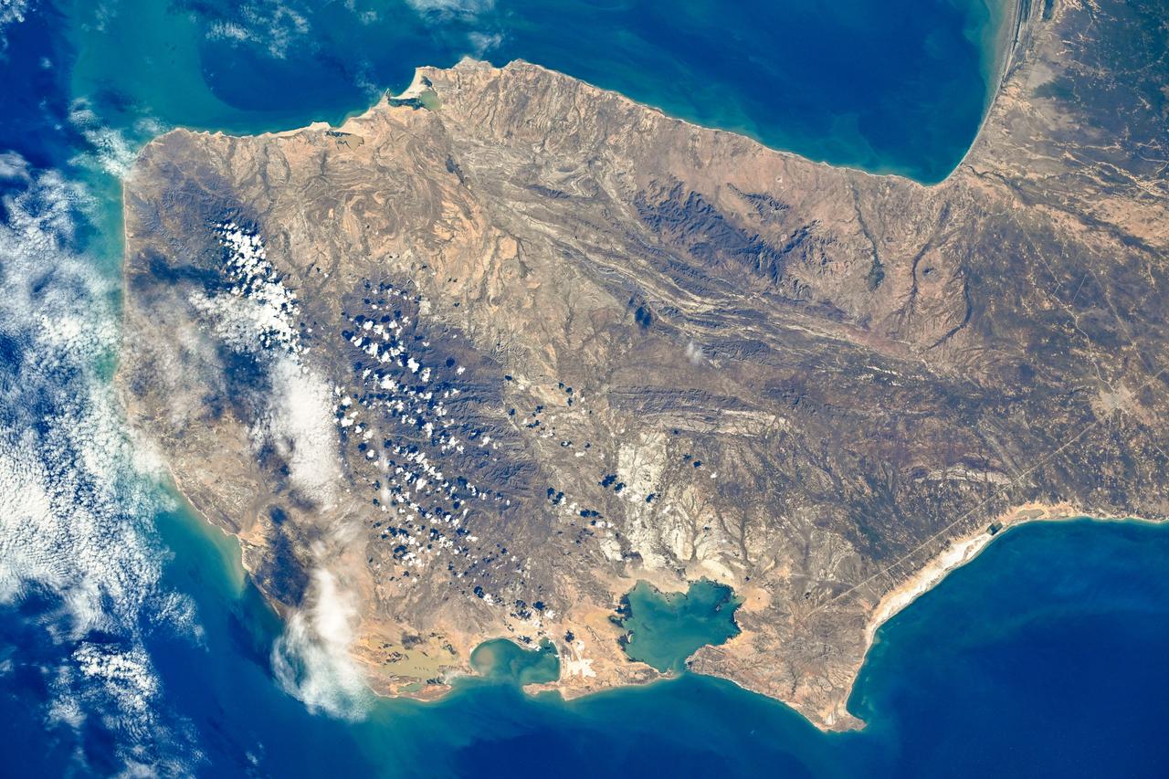
STS040-152-180 (5-24 June 1991) --- The Sinai Peninsula dominates this north-looking, oblique view. According to NASA photo experts studying the STS 40 imagery, the Red Sea in the foreground is clear of river sediment because of the prevailing dry climate of the Middle East. The great rift of the Gulf of Aqaba extends northward to Turkey (top right) through the Dead Sea. The international boundary between Israel and Egypt, reflecting different rural landscapes, stands out clearly. The Nile River runs through the frame. NASA photo experts believe the haze over the Mediterranean to be wind-borne dust. The photo was taken with an Aero-Linhof large format camera.
The earliest trace of alphabetic writing was found at Serabit el-Khadim in the Sinai Peninsula, Egypt at a temple to the Goddess Hathor. Since 2800 BCE, turquoise was mined here, mainly by the ancient Egyptians. Four thousand year old inscriptions are in the Proto-Sinaitic script, the ancestor to the Greek alphabet, and our modern alphabets. (Smithsonian magazine, January-February 2021) The image was acquired November 7, 2015, covers an area of 23.3 by 28.2 km, and is located at 29 degrees north, 33.4 degrees east. https://photojournal.jpl.nasa.gov/catalog/PIA24386
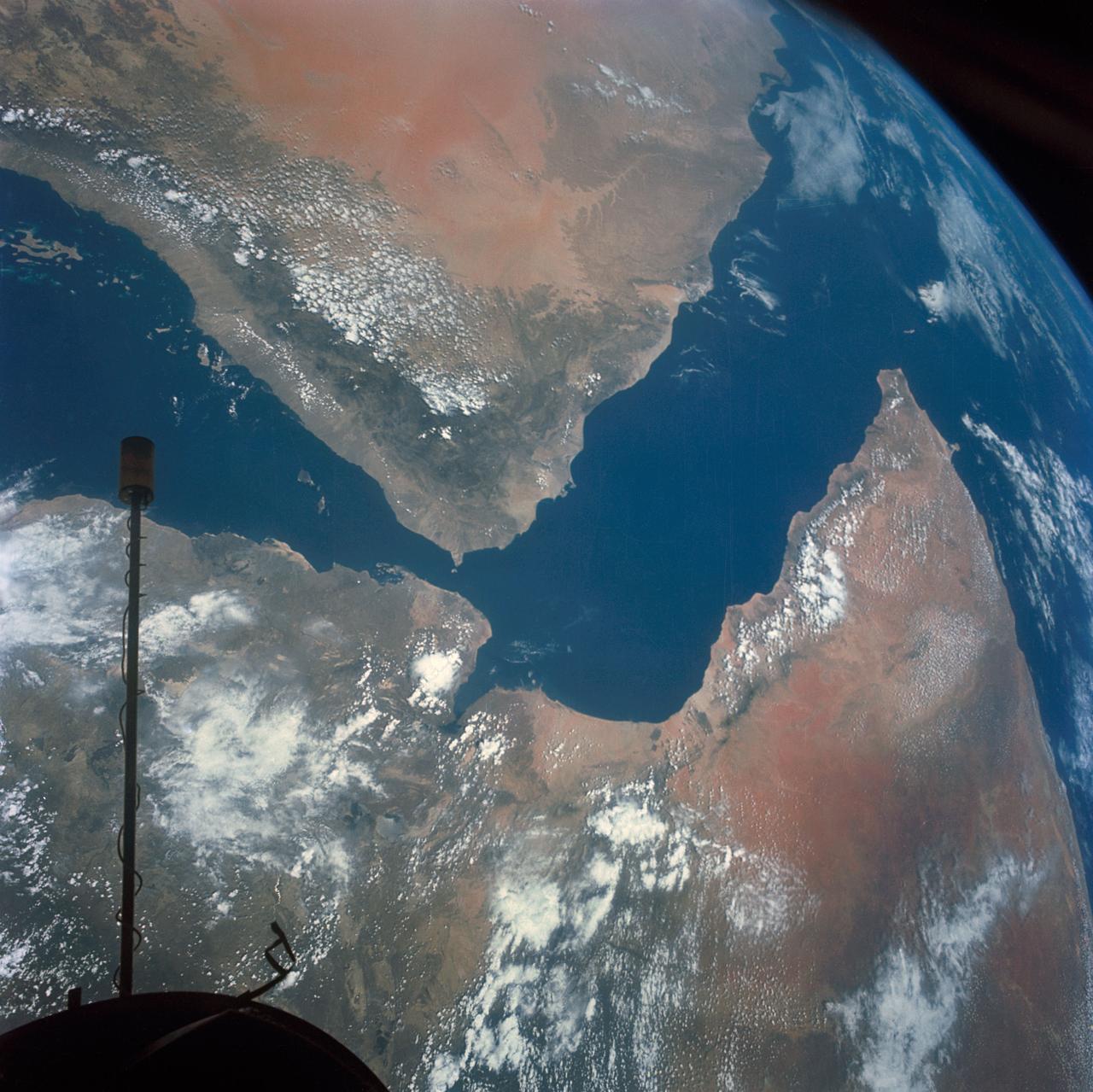
S66-54536 (14 Sept. 1966) --- Arabian Peninsula (on left) and northeast Africa (on right) as seen from the orbiting Gemini-11 spacecraft at an altitude of 340 nautical miles during its 27th revolution of Earth, looking southeast. Saudi Arabia, South Arabia, Yemen, and Aden Protectorate are at left. At bottom right is Ethiopia. French Somaliland is in center on right shore. Somali is at upper right. Body of water at bottom is Red Sea. Gulf of Aden is in center; and at top left is Indian Ocean. Taken with a modified 70mm Hasselblad camera, using Eastman Kodak, Ektachrome, MS (S.O. 368) color film. Photo credit: NASA
This elevation map shows a part of the southern coast of the Arabian Peninsula including parts of the countries of Oman and Yemen. The narrow coastal plain on the right side of the image includes the city of Salahlah, the second largest city in Oman.
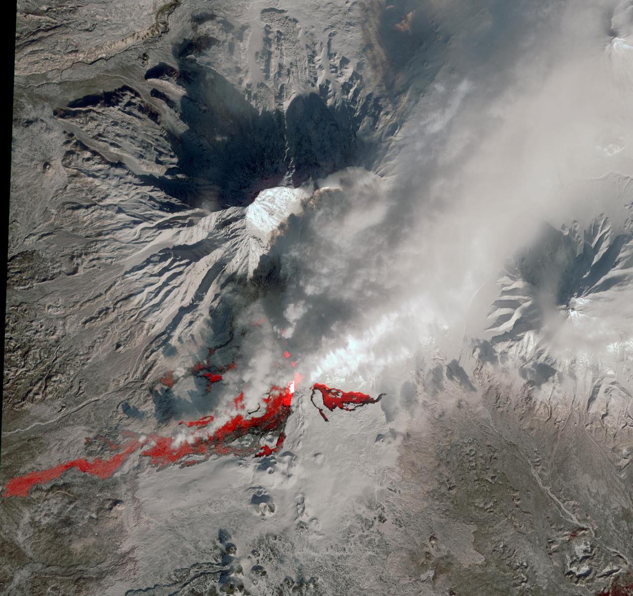
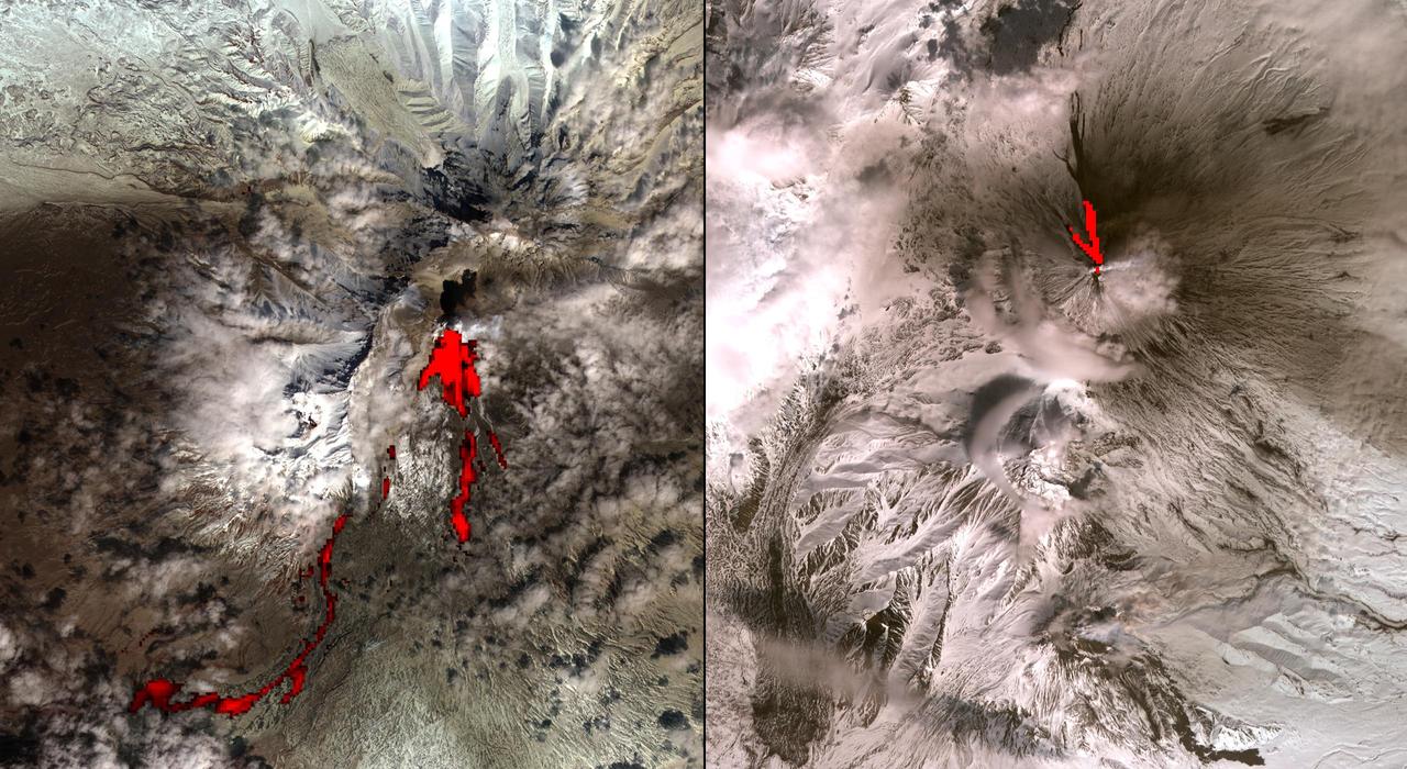
NASA Terra spacecraft reveals the still-active lava flows in the snowy winter landscape of Plosky Tolbachik volcano, which erupted for the first time in 35 years on Nov. 27, 2012, in Russia far eastern Kamchatka Peninsula.
These images acquired on October 11, 2001 by NASA Terra satellite portray an occluded extratropical cyclone situated in the Southern Ocean, about 650 kilometers south of the Eyre Peninsula, South Australia.
This image from NASA Terra spacecraft shows Petropavlovsk-Kamchatsky P-K, which is the administrative, cultural, scientific and economic center of Kamchatka Krai, Russia on the Kamchatka Peninsula.
This image shows JPL Multi-angle Imaging SpectroRadiometer instrument onboard NASA Terra satellite on Sunday, Nov. 8, 2009 as it passed over Hurricane Ida while situated between western Cuba and the Yucatan Peninsula.
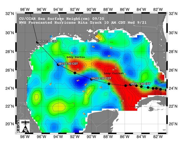
This sea surface height map of the Gulf of Mexico, with the Florida peninsula on the right and the Texas-Mexico Gulf Coast on the left, is based on altimeter data from four satellites including NASA’s Topex/Poseidon and Jason.
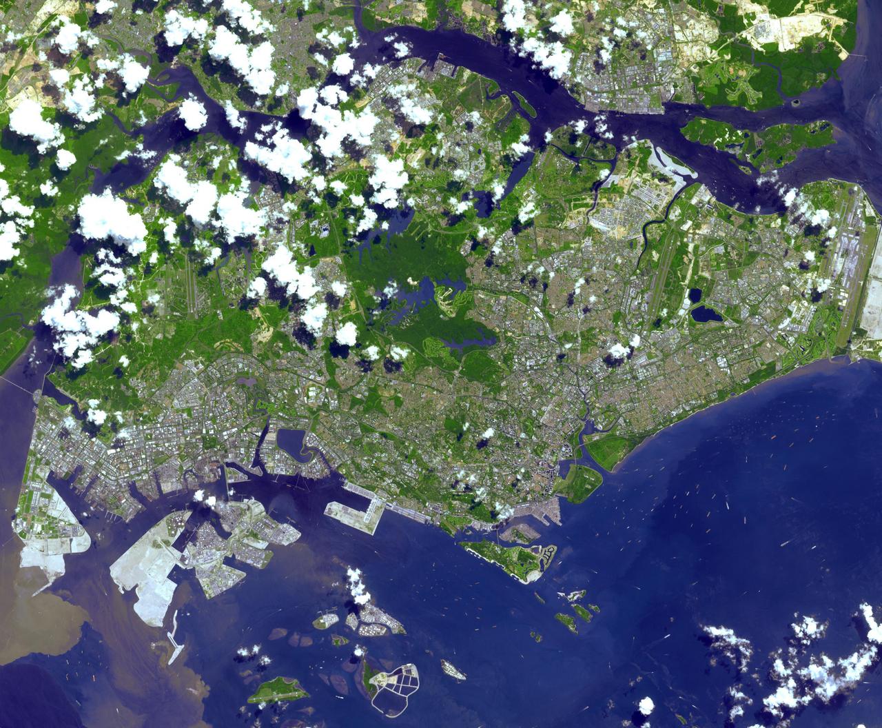
This image from NASA Terra spacecraft is of the Republic of Singapore, a city-state off the southern tip of the Malay Peninsula. An island country made up of 63 islands, the country is largely urbanized with very little rain forest left.
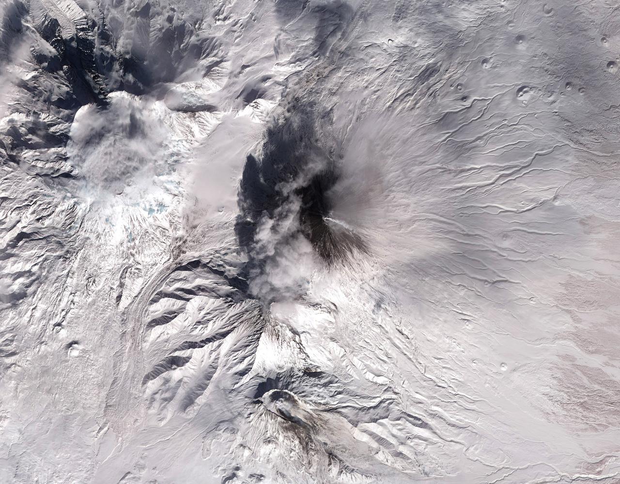
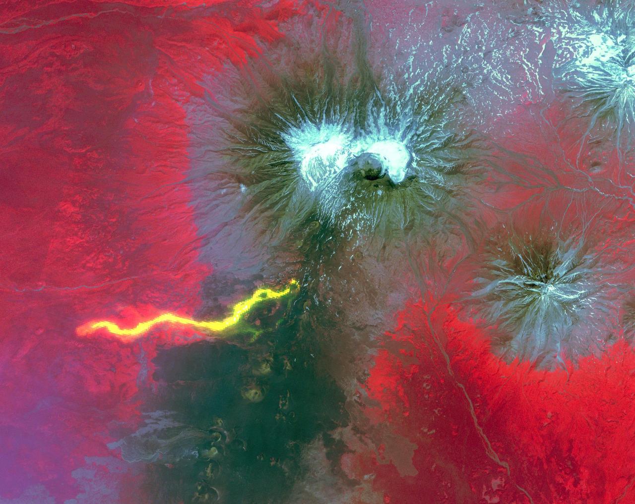
This image acquired by NASA Terra spacecraft on March 6, 2009, shows early March eruptions of Karymsky volcano on Russia Kamchatka Peninsula left the usually white snow a gray ashy color.
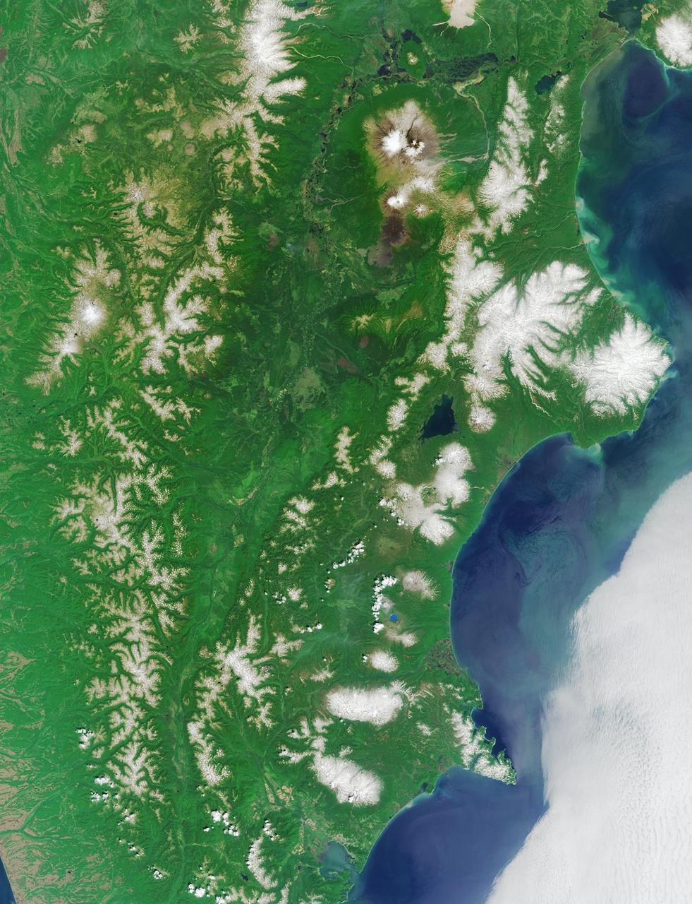
One of the most volcanically active regions of the world is the Kamchatka Peninsula in eastern Siberia, Russia. It is not uncommon for several volcanoes to be erupting at the same time. NASA Terra satellite acquired this image on April 26, 2007
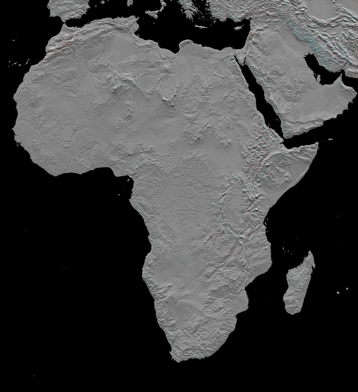
This stereoscopic shaded relief image from NASA Shuttle Radar Topography Mission shows Africa topography. Also shown are Madagascar, the Arabian Peninsula, and other adjacent regions. 3D glasses are necessary to view this image.
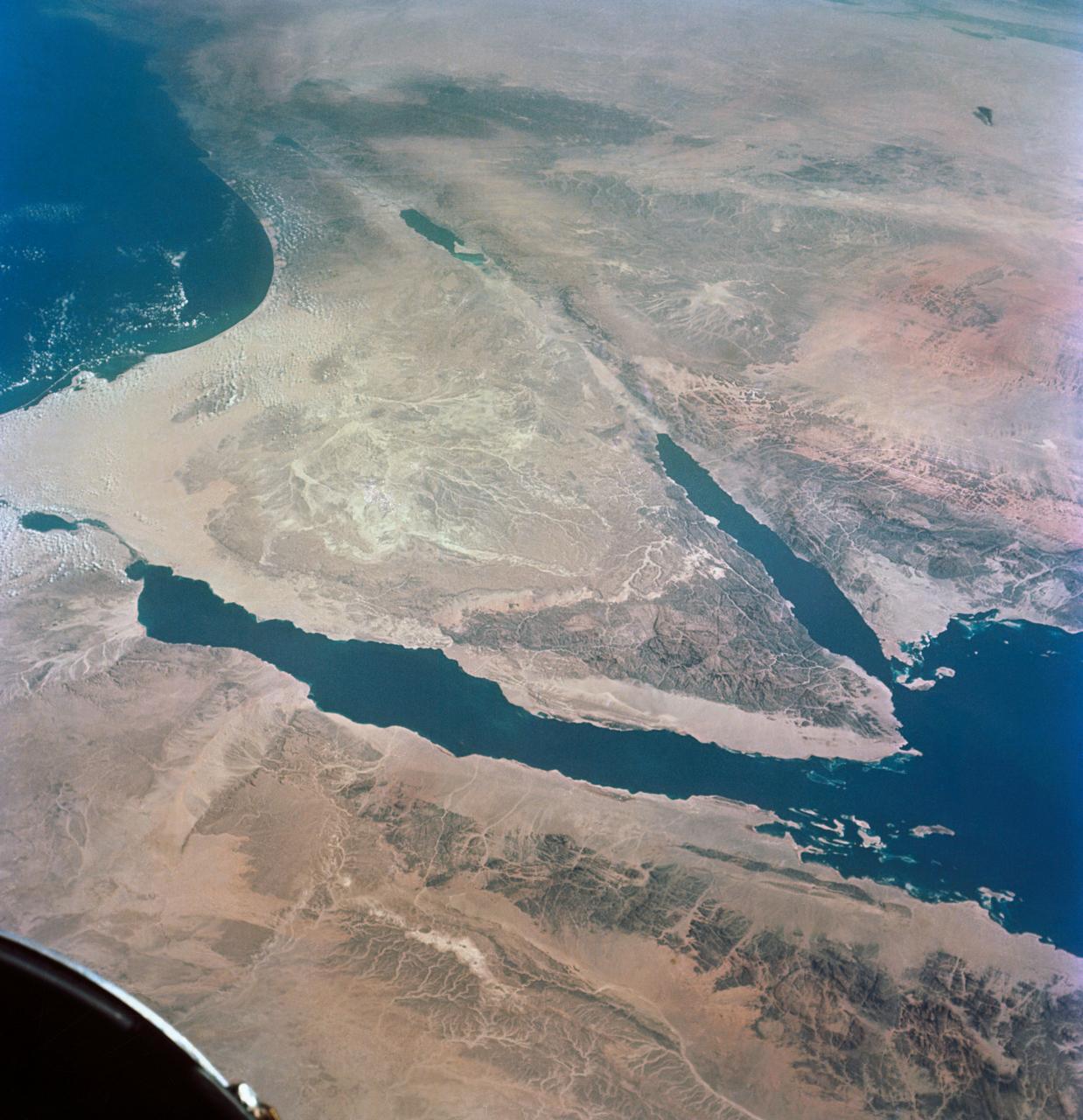
This image from NASA Terra satellite in August, 2000, shows the northern tip of the Red Sea, the Gulf of Suez and the Gulf of Aqaba frame the sandy deserts and spectacular mountains of the Sinai Peninsula.
NASA Terra spacecraft views central South Dakota, where the Missouri River forms a meander bend, creating Lake Sharpe. Eventually, the Missouri River will cut through the skinny peninsula, creating a shorter path.
This nighttime thermal infrared image from NASA Terra spacecraft shows Shiveluch volcano, one of the largest and most active volcanoes in Russia Kamchatka Peninsula; the bright, hot summit lava dome is evident in the center of the image.
This image from NASA Terra satellite, acquired on August 18, 2000 during Terra orbit 3562, show the Bering Strait, with Seward Peninsula of Alaska to the east, and Chukotskiy Poluostrov of Siberia to the west.
Plosky Tolbachik volcano, in Russia far eastern Kamchatka peninsula, erupted on Nov. 27, 2012 for the first time in 35 years, sending clouds of ash almost 10,000 feet into the sky. This image was acquired by NASA Terra spacecraft.
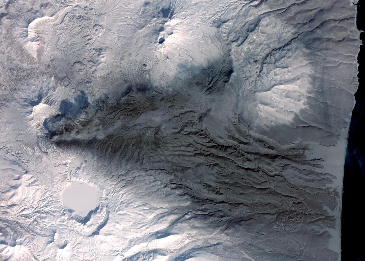
Winter still grips the volcanoes on Russia Kamchatka peninsula. NASA Terra spacecraft acquired this image showing the mantle of white, disturbed by dark ash entirely covering Sheveluch volcano from recent eruptions.
NASA Terra spacecraft acquired this image on June 2, 2012 of Sheveluch, one of the most active volcanoes on the Kamchatka peninsula, with frequent explosive events that can disrupt air traffic over the northern Pacific.
NASA Terra spacecraft shows the Rub al Khali, one of the largest sand deserts in the world, encompassing most of the southern third of the Arabian Peninsula; it includes parts of Oman, United Arab Emirates, and Yemen.
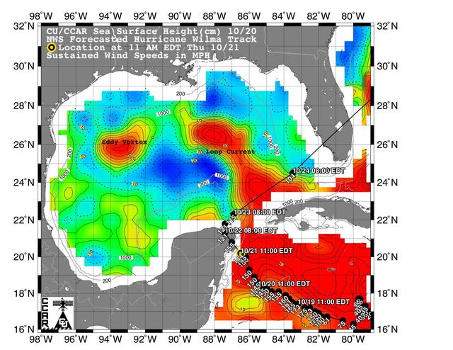
This sea surface height map of the Gulf of Mexico and the northwestern Caribbean Sea, with the Florida peninsula on the upper right, is based on altimeter data from three satellites including NASA Jason-1.
51C-44-026 (24-27 January 1985) --- This oblique view of the Florida peninsula was photographed from the Earth-orbiting Space Shuttle Discovery during the DOD-devoted mission. Many popular features of the state can be delineated in the scene. Kennedy Space Center (KSC), from which this and all Space Shuttle missions are launched, is on the jutting Cape Canaveral, visible on the east Atlantic Coast. The spacecraft was flying at an altitude of 190 nautical miles. A handheld Hasselblad camera, with 70mm Kodak natural color Ektachrome ASA 64 film, was used to expose the frame. Crew members for the flight were astronauts Thomas K. Mattingly, Loren J. Shriver, Ellison S. Onizuka, James F. Buchli, and Gary E. Payton of the United States Air Force.
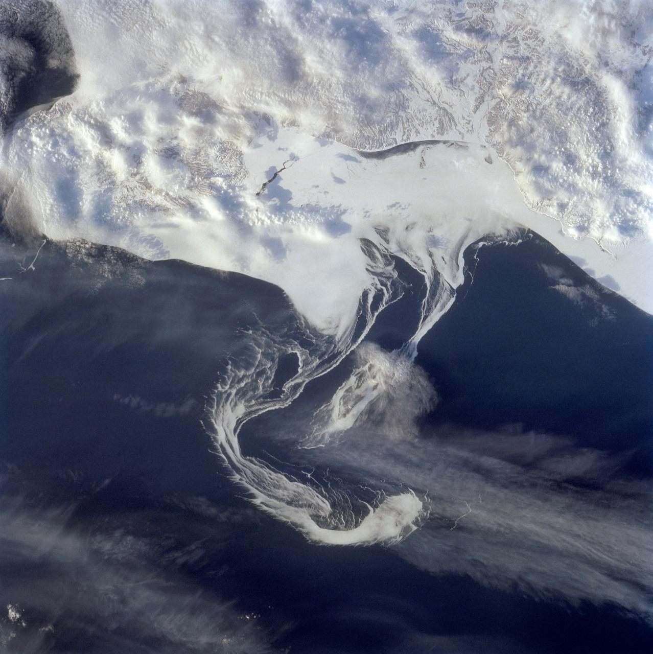
STS060-73-038 (3-11 Feb 1994) --- Pack ice is documented in this photograph along the coast of the Kamchatka Peninsula of Russia in Zaliv Ozernoj. Newly formed ice continually breaks away from the land and takes the form imposed by coastal currents. Detailed photographs of the ice provide information to scientists in both Russia and the united States about the location and fluctuation of ice edges, and how this new sea ice interacts with ocean and littoral currents. This information results in better ice warnings to shipping traffic and provides data points for long-range climate change research for both the Mission-To-Planet Earth and the Russian Priroda ("Nature") monitoring and assessment programs that are respectively coordinated by NASA and the Russian Academy of Sciences. This photography of ice development in the North Pacific, North Atlantic, the Southern Ocean, the Baltic and North Seas, and the Great Lakes is of great interest to the international scientific community. NASA scientists feel high-resolution analog and digital photography from the Space Shuttle and future craft can be a particularly important component in satisfying their data needs on both an operational and a long-term research basis.
S66-63533 (14 Nov. 1966) --- United Arab Republic (Egypt) area as seen from the Gemini-12 spacecraft during its 39th revolution of Earth, looking southeast. Nile River is in center of picture. At bottom center is the Sinai Peninsula. Arabian Peninsula is at lower left. Large body of water is Red Sea. Gulf of Aqaba is on east side of Sinai Peninsula. Gulf of Suez separates Sinai from Egyptian mainland. Photo credit: NASA
ISS040-E-006165 (31 May 2014 ) --- One of the Expedition 40 crew members aboard the International Space Station photographed this nadir image of the volcanic-born Banks Peninsula, on the east coast of the South Island of New Zealand on May 31, 2014. Banks Peninsula covers an area of approximately 1,150 square kilometers.
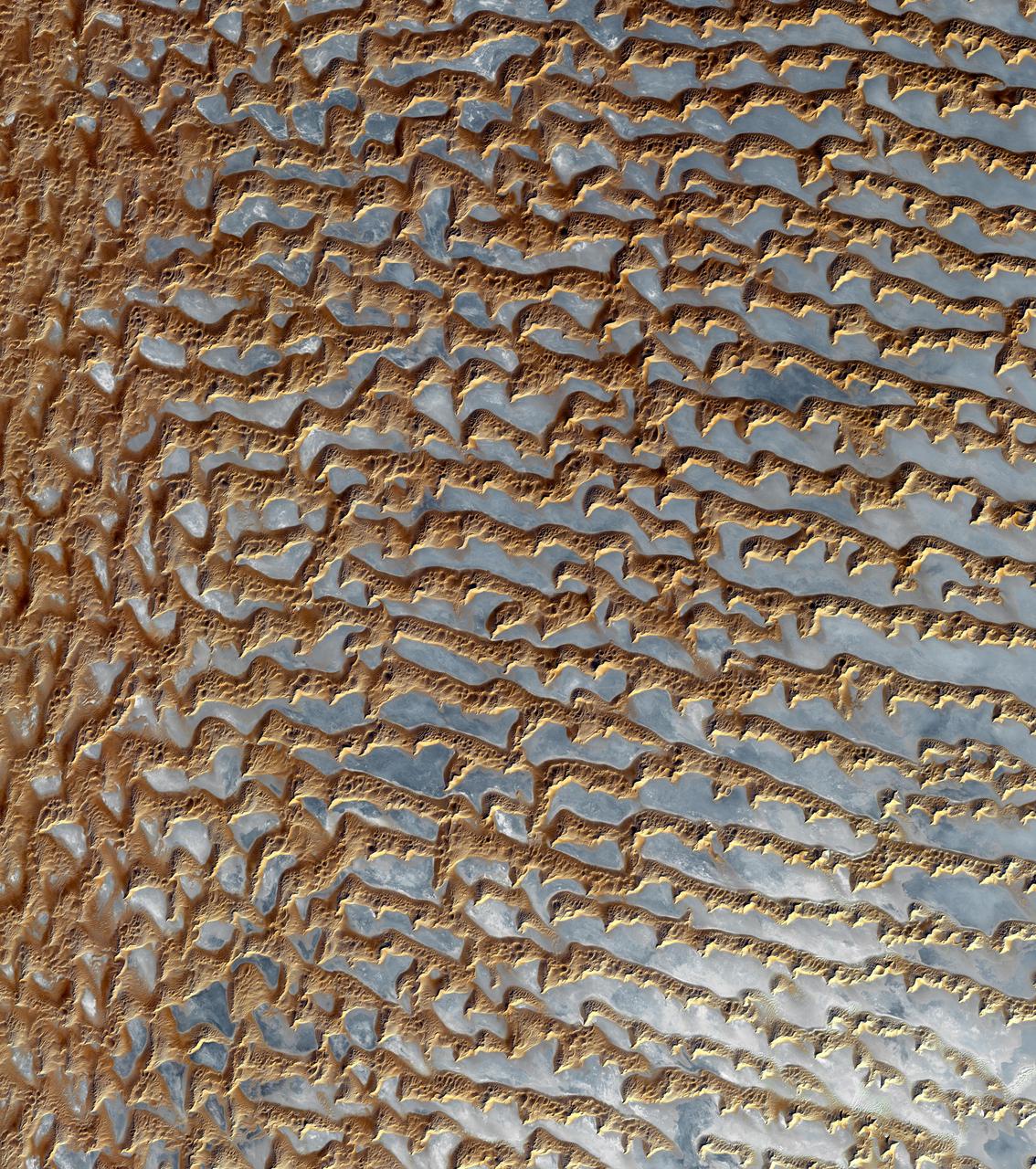
GMT326_08_15_Barry Wilmore_Israel Saudi Peninsula Sand Dunes_131 (Image was released by astronaut on Instagram.)
GMT326_08_15_Barry Wilmore_Israel Saudi Peninsula Sand Dunes_131 (Image was released by astronaut on Instagram.)
The March 16 volcanic eruption in Iceland's Reykjanes Peninsula was the fourth in many months. On March 22, ASTER's thermal infrared scanner detected the hot lava flow, through a thick cloud cover. The image matched the most recent official map, released March 20. The image covers an area of 7.5 by 10 km, and is located at 63.9 degrees north, 22.3 degrees west. https://photojournal.jpl.nasa.gov/catalog/PIA26288
Located in the Gulf of California, Smith Island sits just off the eastern shore of Mexico's Baja Peninsula. The 7 kilometers long island is dominated by Volcan Coronado on the northern end. The uninhabited island is a refuge for a rich marine assemblage, including sea lion colonies. The image was acquired September 23, 2023, covers an area of 8.2 by 9.5 km, and is located at 29.1 degrees north, 113.5 degrees west. https://photojournal.jpl.nasa.gov/catalog/PIA26284

This color image of the Earth was obtained by NASA Galileo spacecraft in Dec. 1990, when the spacecraft was about 1.5 million miles from the Earth. Africa stretches from the center to the top of the picture with the Arabian Peninsula off to its right. http://photojournal.jpl.nasa.gov/catalog/PIA00076
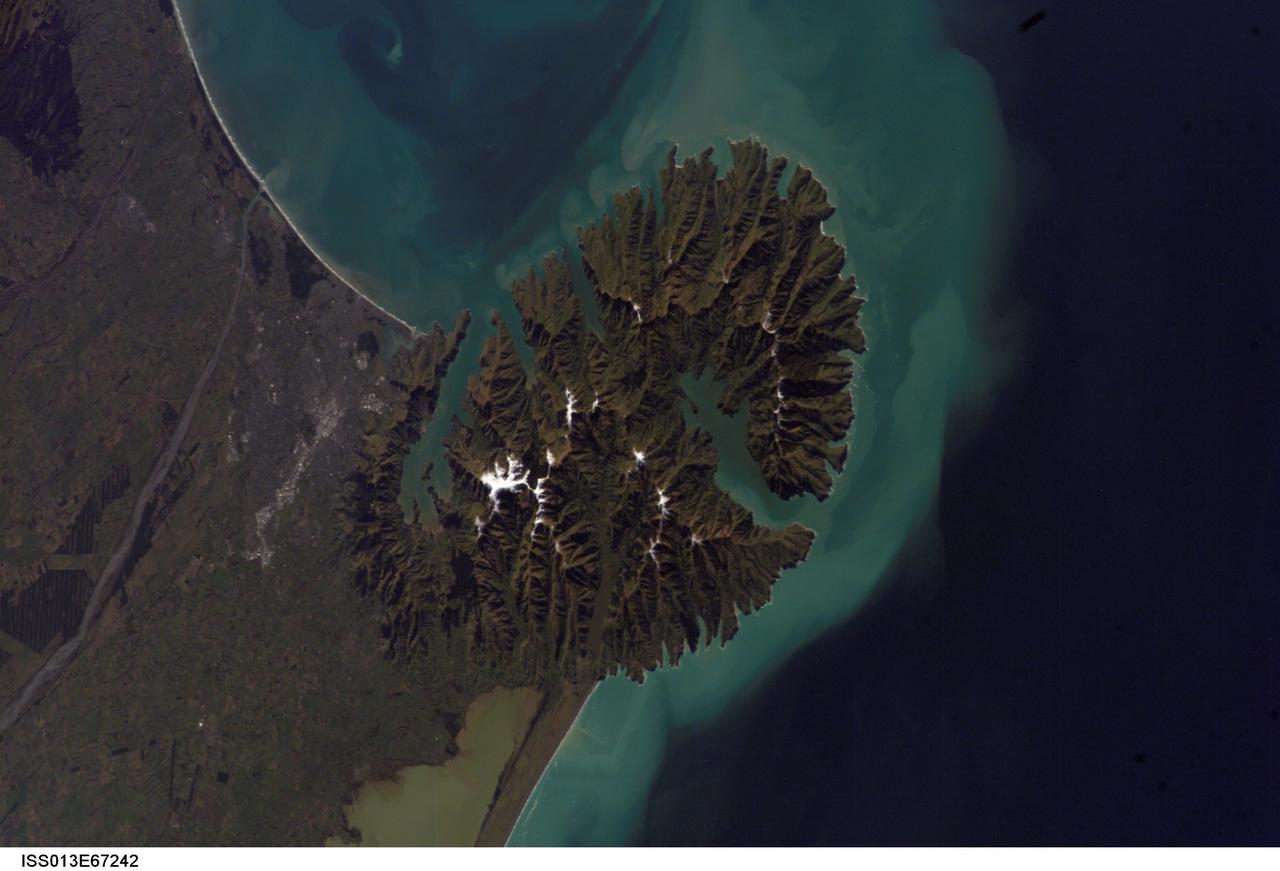
ISS013-E-67242 (15 Aug. 2006) --- Christchurch, New Zealand is featured in this image photographed by an Expedition 13 crewmember on the International Space Station. Snow highlights the peaks of the Banks Peninsula to the southeast of the city. The Peninsula has a radically different landscape compared to the adjoining flat Canterbury Plains on which Christchurch is situated. This is a result of the geology of the Banks Peninsula -- it is formed from the overlapping cones of the extinct Lyttelton and Akaroa volcanoes. Subsequent erosion of the cones formed the heavily dissected terrain visible in the image, and sea level rise led to the creation of several harbors around the Peninsula. Erosion continues unabated today, as evidenced by the apron of greenish blue sediment-laden waters surrounding the Banks Peninsula. Other features of interest in the image include the braided Waimakariri River to the north-northwest of the city, and the greenish brown waters of Lake Ellesmere. The coloration of the water is due both to its shallow depth (1.4 meters average) and its high concentrations of nitrogen and phosphorus - conditions which lead to a high abundance of green algae.
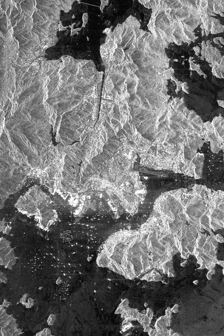
This is an X-SAR image spanning an area of approximately 20 kilometers by 40 kilometers (12 miles by 25 miles) of the island of Hong Kong, the Kowloon Peninsula and the new territories in southern China, taken by the imaging radar on board the space shuttle Endeavour on October 4, 1994. North is toward the top left corner of the image. The Kaitak Airport runway on Kowloon Peninsula (center right of image) was built on reclaimed land and extends almost 3 kilometers (nearly 2 miles) into Victoria Harbor. To the south of the harbor lies the island of Hong Kong. The bright areas around the harbor are the major residential and business districts. Housing more than six million residents, Hong Kong is the most densely populated area in the world. The large number of objects visible in the harbor and surrounding waters are a variety of sea-going vessels, anchored in one of the busiest seaports in the Far East. http://photojournal.jpl.nasa.gov/catalog/PIA01750
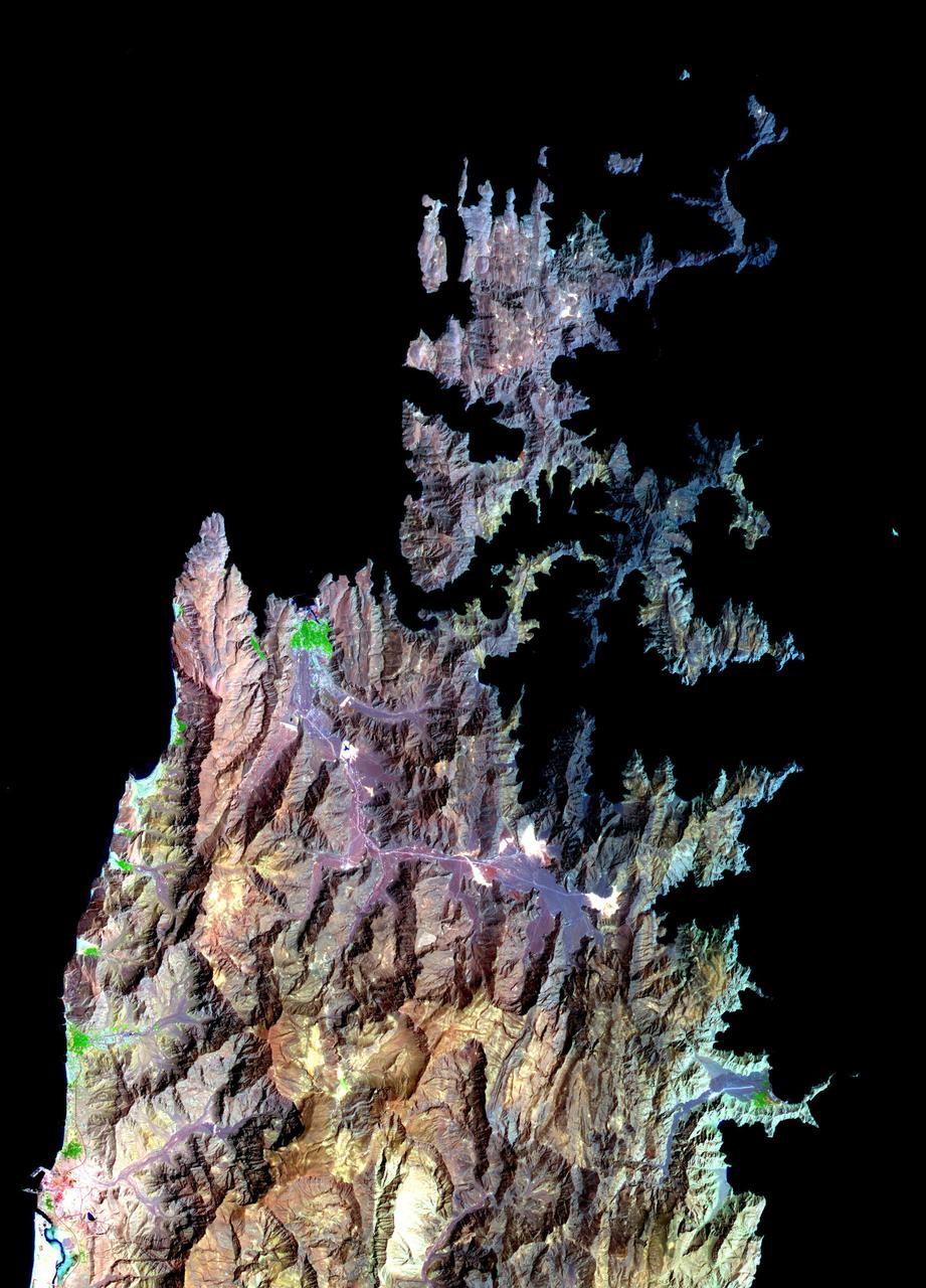
The island of Eigg is one of the small isles in the Scottish Inner Hebrides, south of the Skye peninsula. The main settlement of the 31 km2 island is Cleadale. In 2008, Eigg began a project to become completely energy self-sufficient. Using a combination of wind, water and solar, the population of about 90 now has 24-hour power. The image was acquired 18 September 2015, covers an area of 9.2 by 10.8 km, and is located at 57 degrees north, 6.2 degrees west. https://photojournal.jpl.nasa.gov/catalog/PIA22164