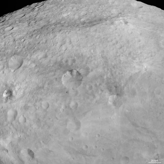
1.5 Meter Per Pixel View of Boulders in Ganges Chasma

In this Space Shuttle STS-102 mission image, the Payload Equipment Restraint System H-Strap is shown at the left side of the U.S. Laboratory hatch and behind Astronaut James D. Weatherbee, mission specialist. PERS is an integrated modular system of components designed to assist the crew of the International Space Station (ISS) in restraining and carrying necessary payload equipment and tools in a microgravity environment. The Operations Development Group, Flight Projects Directorate at the Marshall Space Flight Center (MSFC), while providing operation support to the ISS Materials Science Research Facility (MSRF), recognized the need for an on-orbit restraint system to facilitate control of lose objects, payloads, and tools. The PERS is the offspring of that need and it helps the ISS crew manage tools and rack components that would otherwise float away in the near-zero gravity environment aboard the Space Station. The system combines Kevlar straps, mesh pockets, Velcro and a variety of cornecting devices into a portable, adjustable system. The system includes the Single Strap, the H-Strap, the Belly Pack, the Laptop Restraint Belt, and the Tool Page Case. The Single Strap and the H-Strap were flown on this mission. The PERS concept was developed by industrial design students at Auburn University and the MSFC Flight Projects Directorate.
NASA's SMAP radiometer instrument measured Hurricane Matthew's wind speeds at 4:52 a.m. PDT (7:52 a.m. EDT) at up to 132 miles per hour (59 meters per second). SMAP has excellent sensitivity to extreme winds, far beyond that of typical scatterometer instruments now in orbit. http://photojournal.jpl.nasa.gov/catalog/PIA21096
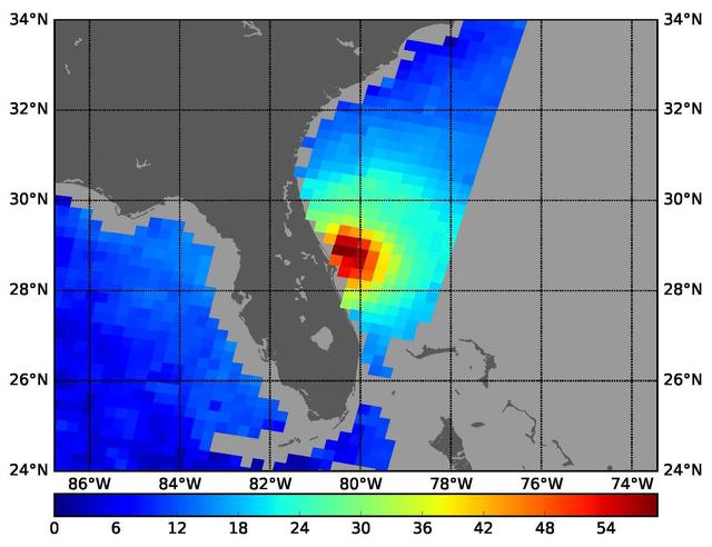
Tropical Storm Katrina is shown here as observed by NASA QuikScatsatellite on August 25, 2005, at 08:37 UTC 4:37 a.m. in Florida. At this time, the storm had 80 kilometers per hour 50 miles per hour; 43 knots sustained winds.
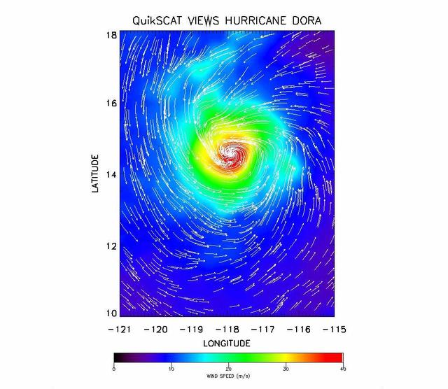
The SeaWinds instrument onboard NASA new QuikScat ocean-viewing satellite captured this image of Hurricane Dora in the eastern tropical Pacific Ocean on August 10, as it was blowing at speeds of nearly 40 meters per second 90 miles per hour.
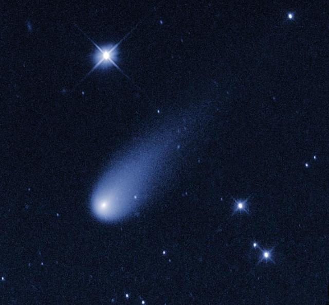
Superficially resembling a skyrocket, Comet ISON is hurtling toward the Sun at a whopping 48,000 miles per hour in this still from a Hubble animation.
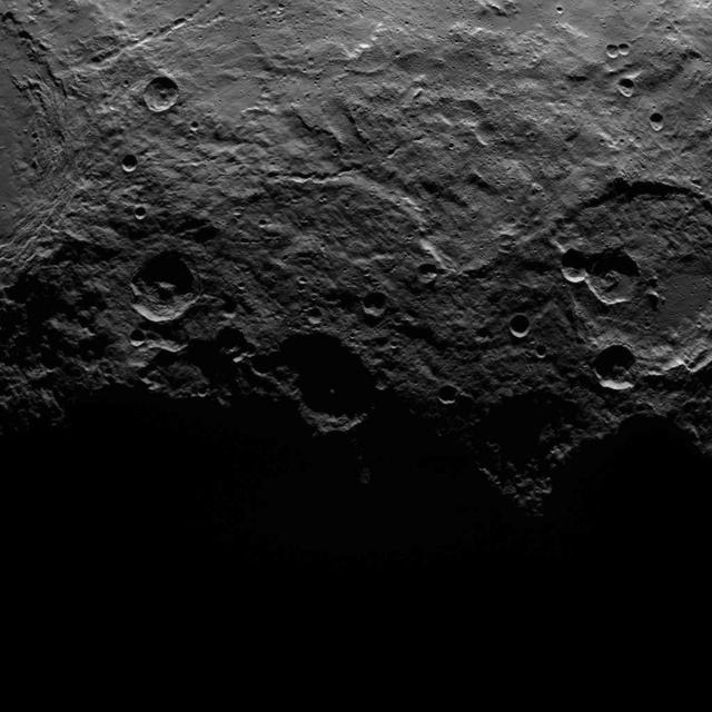
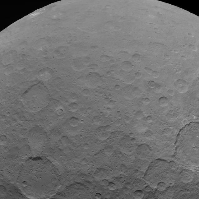
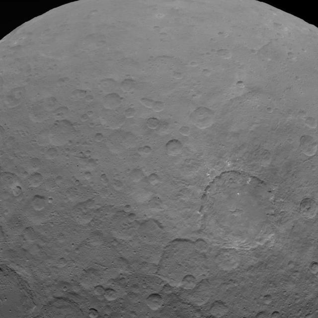
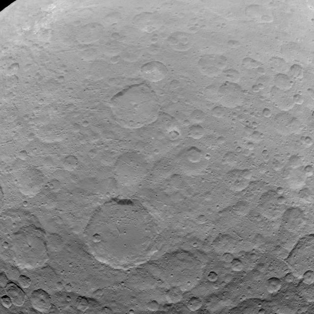
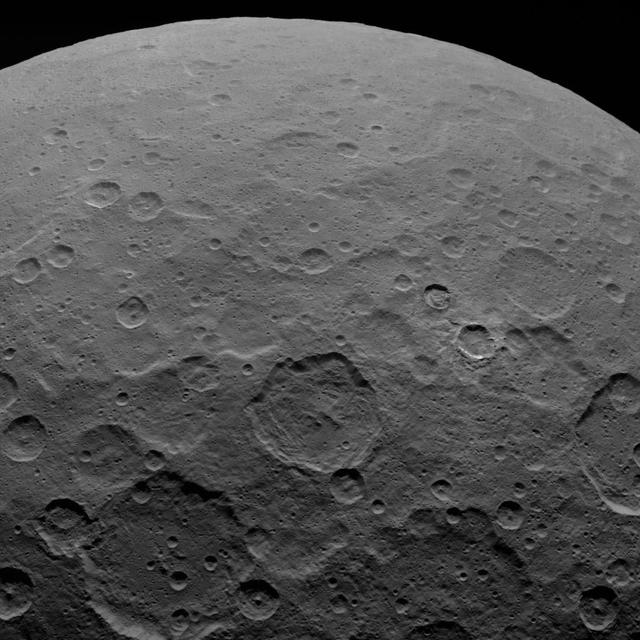
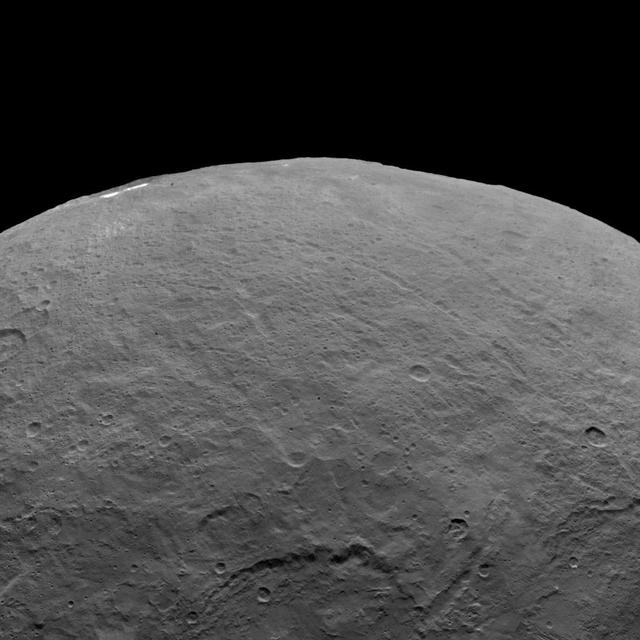
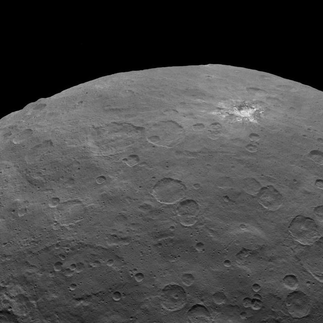
This image, taken by NASA's Dawn spacecraft, shows a portion of the southern hemisphere of dwarf planet Ceres from an altitude of 2,700 miles (4,400 kilometers). The image, with a resolution of 1,400 feet (410 meters) per pixel, was taken on June 25, 2015. The image was obtained on June 25, 2015 from an altitude of 2,700 miles (4,400 kilometers) above Ceres and has a resolution of 1,400 feet (410 meters) per pixel. http://photojournal.jpl.nasa.gov/catalog/PIA19616

Millions of excited people in the U.S. traveled many miles see a total eclipse, and what a show it was. The SDO spacecraft was not so fortunate: its orbit only allowed it to observe a partial eclipse that at its peak covered only about 14 per cent of the sun (Aug. 21, 2017). Most of the people in the U.S. (weather permitting) observed at least 60 per cent coverage of the sun by the Moon. The good news for SDO is that it gets to see partial and solar eclipses several times a year. So, it all kind of balances out, in a way. An animation is available at https://photojournal.jpl.nasa.gov/catalog/PIA21929
NASA Evolutionary Xenon Thruster - Commercial, NEXT-C
NASA Dawn spacecraft obtained this image with its framing camera on Aug. 20, 2011. This image was taken through the camera clear filter. The image has a resolution of about 260 meters per pixel.
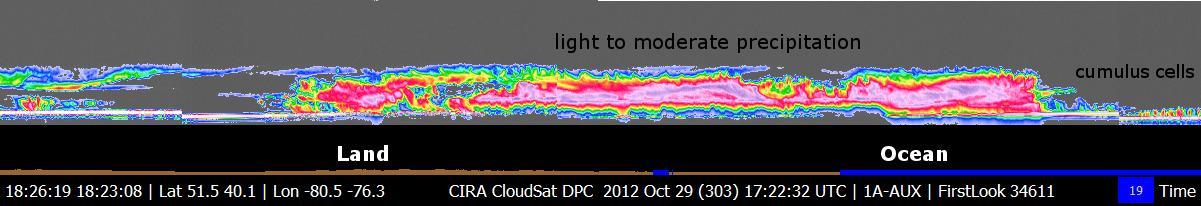
NASA CloudSat spacecraft overpassed Hurricane Sandy on Oct. 29, 2012 just as Sandy was approaching the Atlantic coastline. Sandy contained estimated maximum sustained winds of 90 miles per hour 78 knots.
NASA Dawn spacecraft obtained this image of a young and old crater at the night and day boundary on asteroid Vesta. The image has a resolution of about 260 meters per pixel.
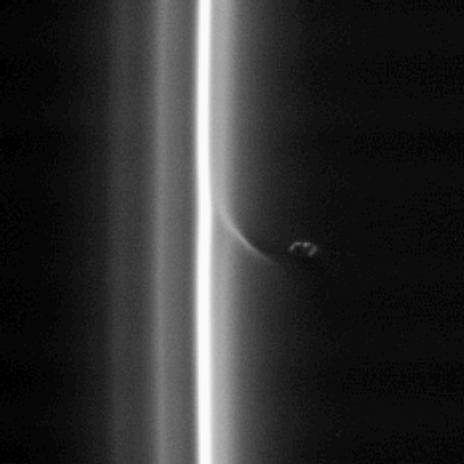
This view shows Prometheus with a streamer it has created in the inner edge of the F ring. Prometheus comes close to the inner edge of the ring once per orbit, perturbing the ring particles there
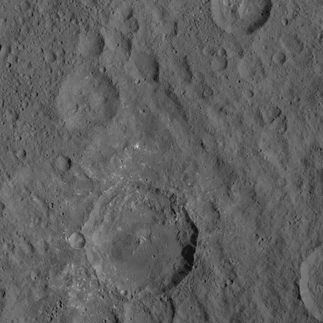
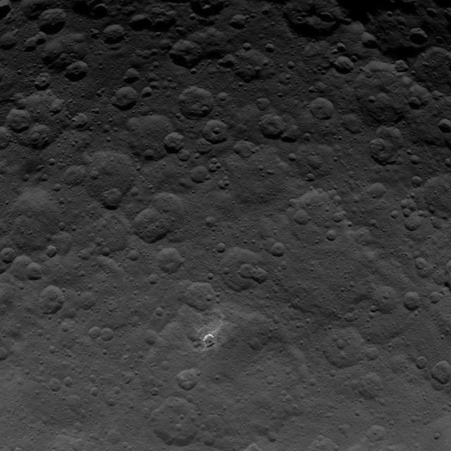
This image of Ceres is part of a sequence taken by NASA Dawn spacecraft on May 22, 2015, from a distance of 3,200 miles 5,100 kilometers with a resolution of 1,600 feet 480 meters per pixel. http://photojournal.jpl.nasa.gov/catalog/PIA19567
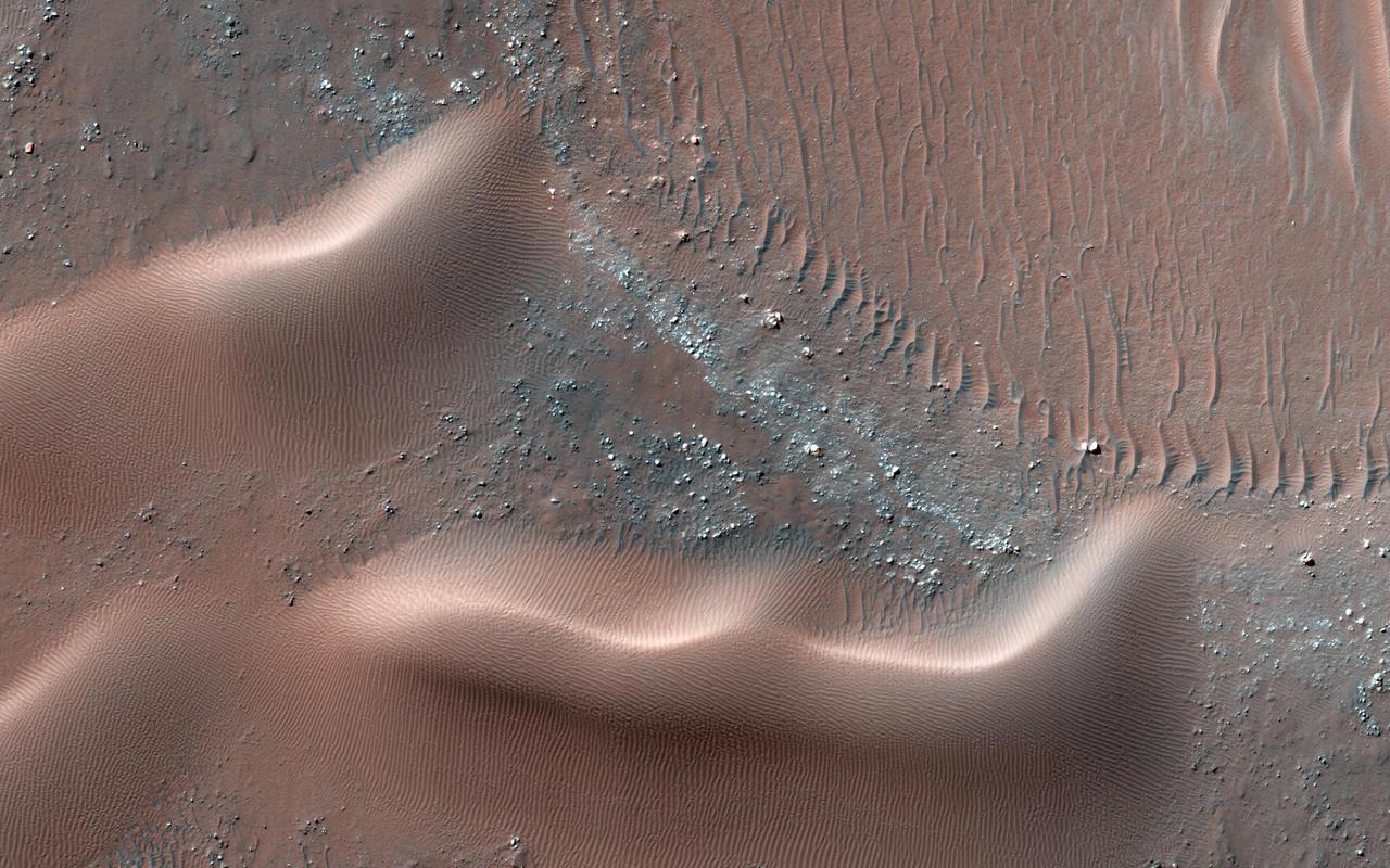
This observation from NASA Mars Reconnaissance Orbiter is of one many that highlights new discoveries; one of these is that many sand dunes and ripples are moving, some at rates of several meters per year.
This image of Ceres is part of a sequence taken by NASA Dawn spacecraft on May 22, 2015, from a distance of 3,200 miles 5,100 kilometers with a resolution of 1,600 feet 480 meters per pixel. http://photojournal.jpl.nasa.gov/catalog/PIA19564
This image of Ceres is part of a sequence taken by NASA Dawn spacecraft on May 22, 2015, from a distance of 3,200 miles 5,100 kilometers with a resolution of 1,600 feet 480 meters per pixel. http://photojournal.jpl.nasa.gov/catalog/PIA19566
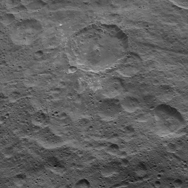
This image, taken by NASA Dawn spacecraft, shows the surface of dwarf planet Ceres from an altitude of 915 miles 1,470 kilometers. The image, with a resolution of 450 feet 140 meters per pixel, was taken on August 26, 2015.
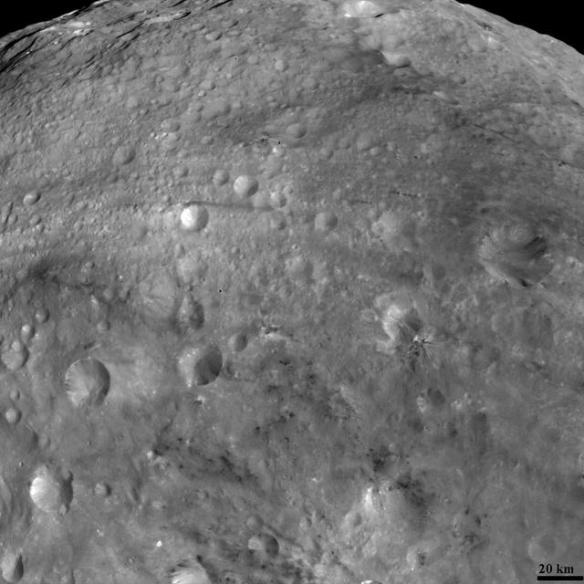
This view of the topography of asteroid Vesta surface is composed of several images obtained with the clear filter in the framing camera on NASA Dawn spacecraft on August 6, 2011. The image has a resolution of about 260 meters per pixel.
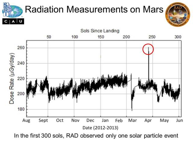
Micrograys are unit of measurement for absorbed radiation dose. The vertical axis is in micrograys per day. The RAD instrument on NASA Curiosity Mars rover monitors the natural radiation environment at the surface of Mars.

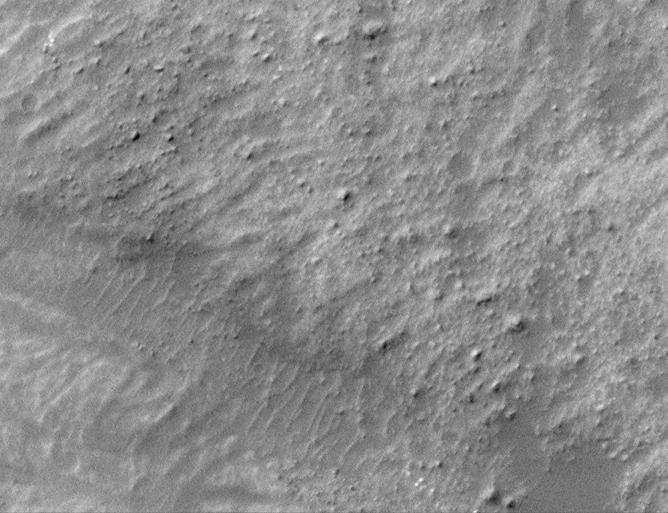
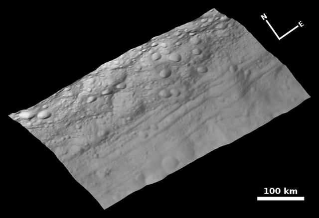
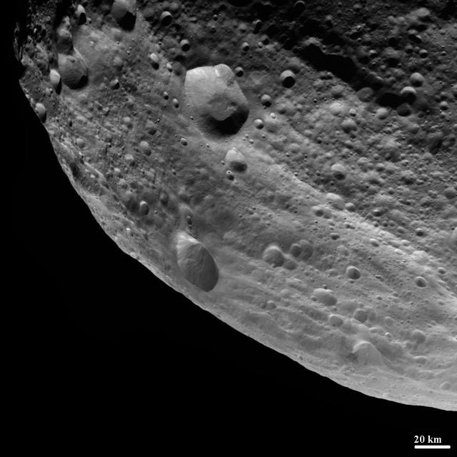
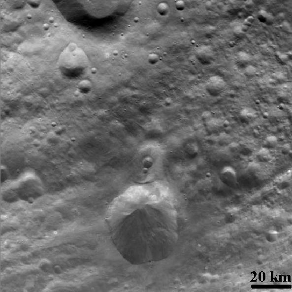
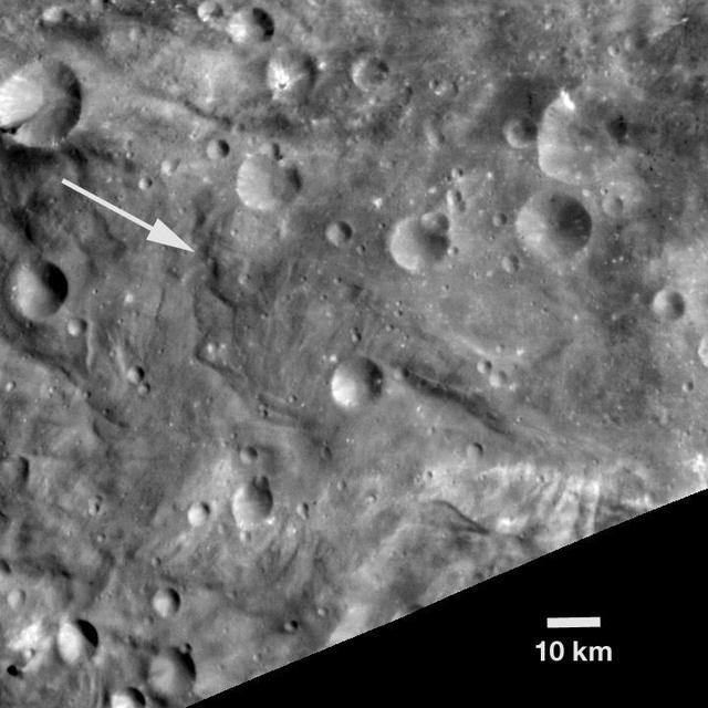
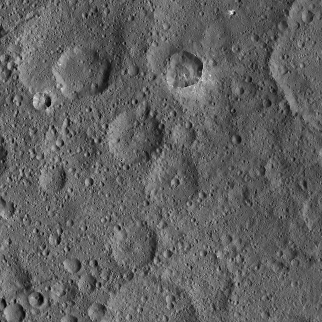
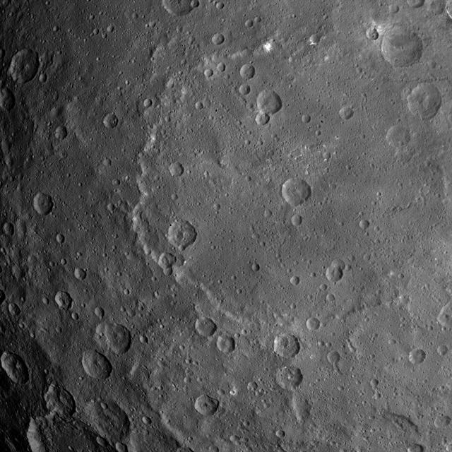
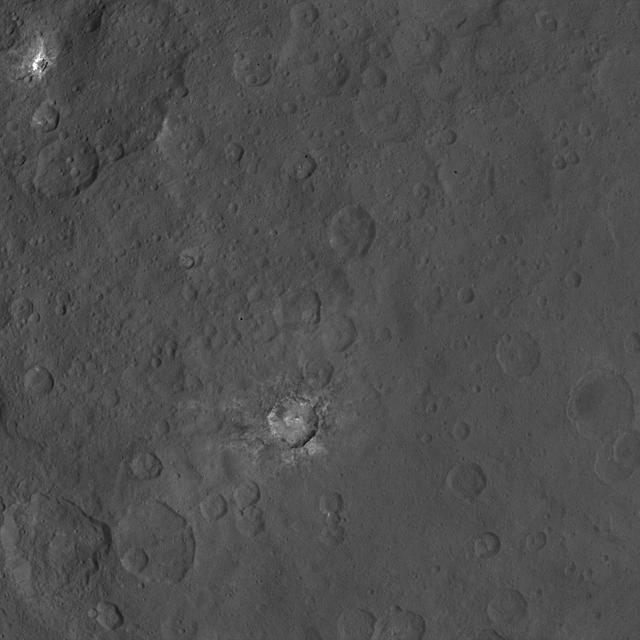
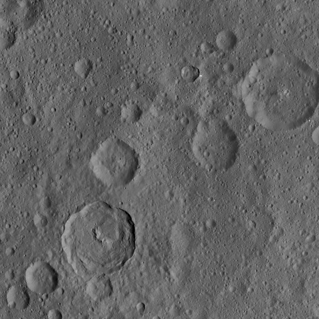
This MOC image shows a 1.5 meters ~5 feet per pixel view of a crater in the Terra Cimmeria region of Mars. Several gullies extend from near the top of the crater rim, downslope toward the floor of the crater
NASA Dawn spacecraft obtained this image with its framing camera on Aug. 20, 2011. This image was taken through the camera clear filter. The image has a resolution of about 260 meters per pixel.
NASA Dawn spacecraft obtained this image with its framing camera on August 6, 2011. Old and heavily cratered terrain is shown on Vesta. The framing camera has a resolution about 280 yards 260 meters per pixel.
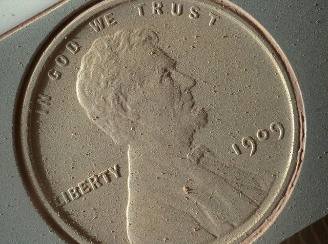
This image of a U.S. penny on a calibration target was taken by the Mars Hand Lens Imager MAHLI aboard NASA Curiosity rover in Gale Crater on Mars. At 14 micrometers per pixel, this is the highest-resolution image that MAHLI can acquire.
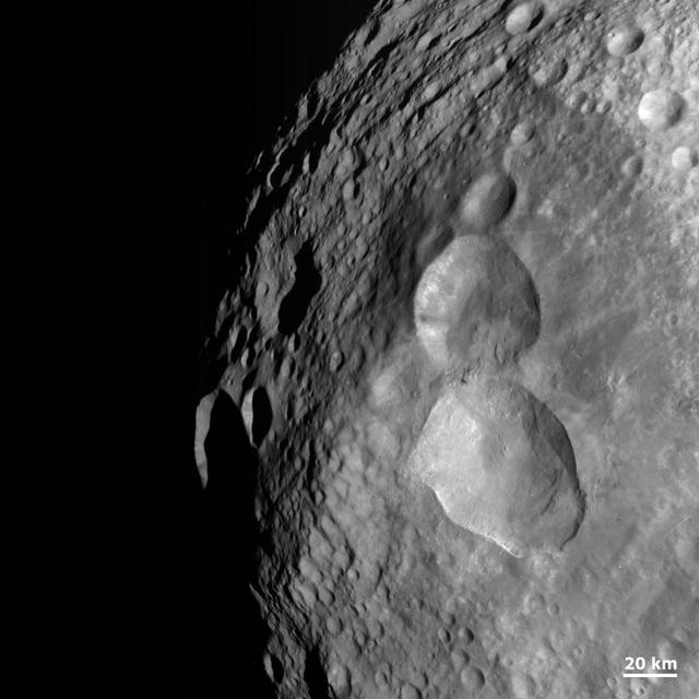
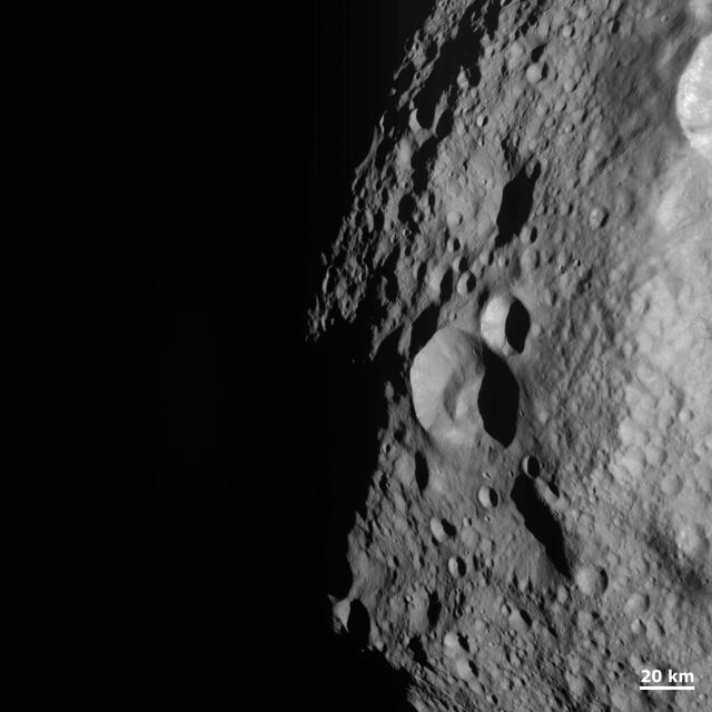
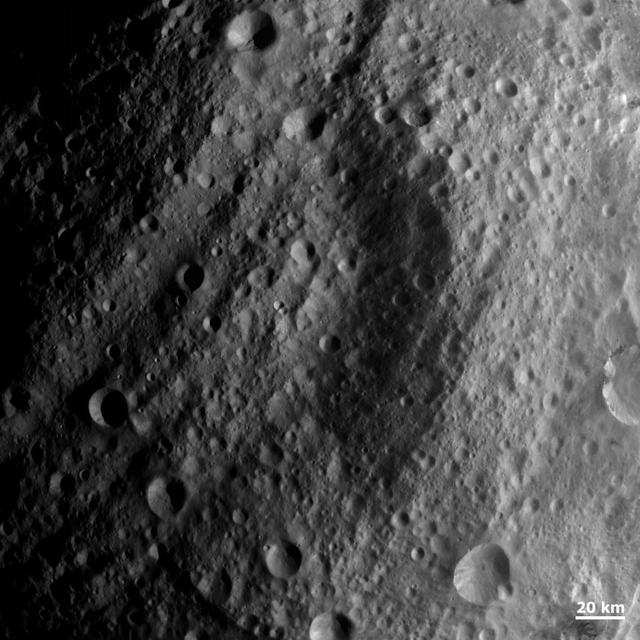
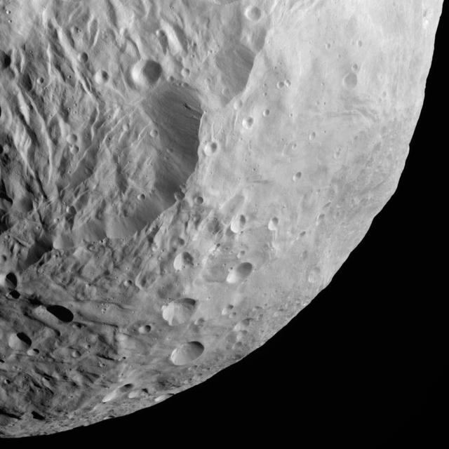
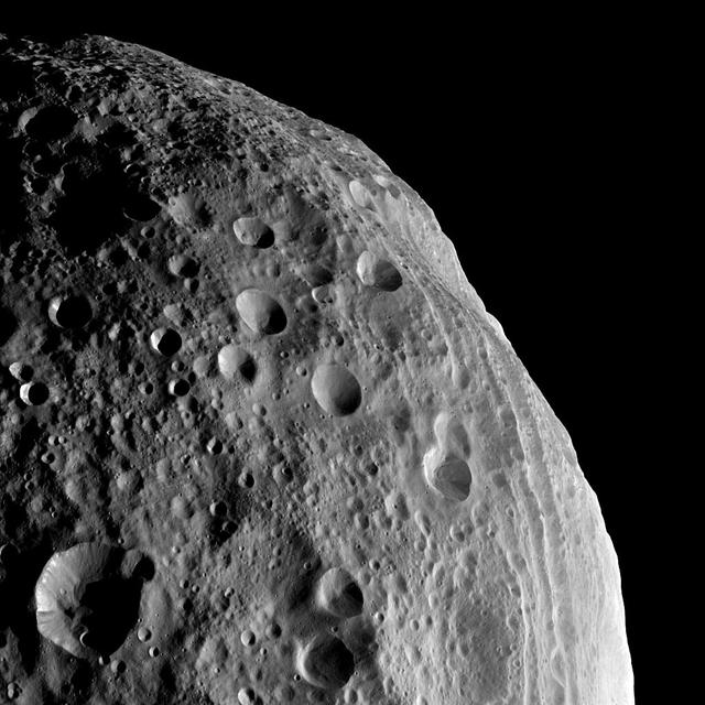
NASA Dawn spacecraft obtained this image of asteroid Vesta south polar region with its framing camera on August 12, 2011. The image has a resolution of about 260 meters per pixel.
This image of Ceres is part of a sequence taken by NASA Dawn spacecraft on May 23, 2015, from a distance of 3,169 miles 5,100 kilometers. Resolution in the image is about 1,565 feet 477 meters per pixel.
NASA Dawn spacecraft obtained this image of asteroid Vesta with its framing camera on Aug. 26, 2011. This image was taken through the camera clear filter. The image has a resolution of about 260 meters per pixel.
NASA Dawn spacecraft obtained this image of a dark band on asteroid Vesta with its framing camera on August 19, 2011. The image has a resolution of about 260 meters per pixel.
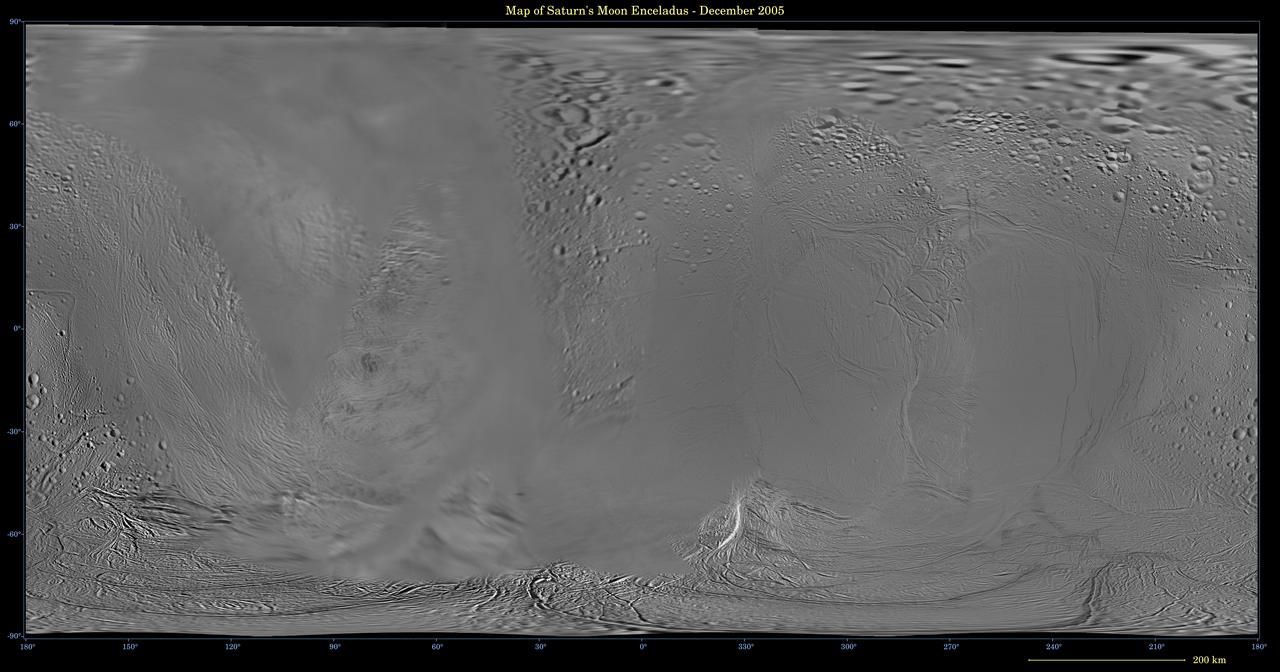
This global digital map of Saturn moon Enceladus was created using data taken during Cassini and Voyager spacecraft flybys. The map is an equidistant projection and has a scale of 110 meters 361 feet per pixel
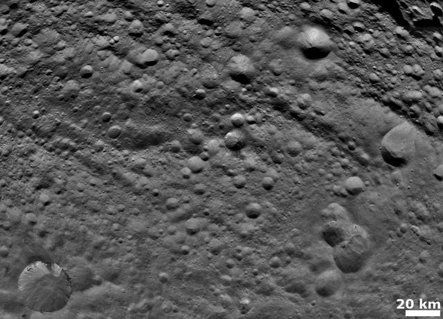
NASA Dawn spacecraft obtained this image of various craters on asteroid Vesta with its framing camera on August 19, 2011. The image has a resolution of about 260 meters per pixel.
NASA Dawn spacecraft obtained this image of dark material on hilltops on asteroid Vesta with its framing camera on August 18, 2011. The image has a resolution of about 260 meters per pixel.
NASA Dawn spacecraft obtained this image of dark patches and stripes on crater walls on asteroid Vesta with its framing camera on August 18, 2011. The image has a resolution of about 260 meters per pixel.

NASA Dawn spacecraft obtained this image of craters with bright features on asteroid Vesta with its framing camera on August 18, 2011. The image has a resolution of about 260 meters per pixel.
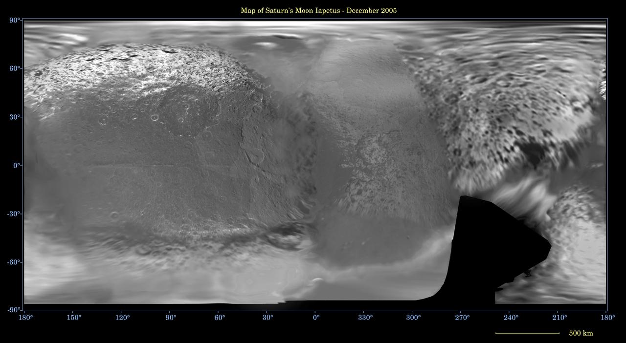
This global digital map of Saturn moon Iapetus was created using data taken during Cassini and Voyager spacecraft flybys. The map is an equidistant projection and has a scale of 641 meters 2,103 feet per pixel
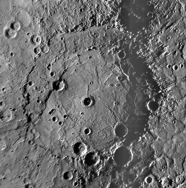
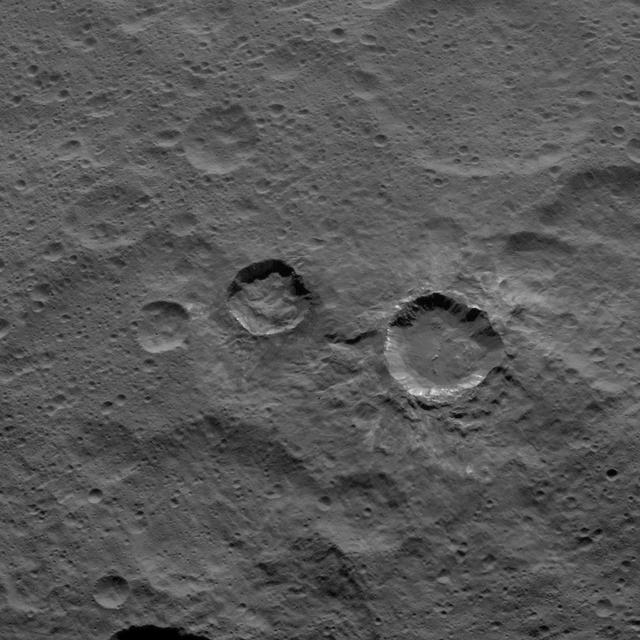
This NAC mosaic of the newly discovered Rembrandt impact basin was presented last week during a NASA media teleconference. The number per area and size distribution of impact craters superposed on Rembrandt rim indicates that it is one of the younges
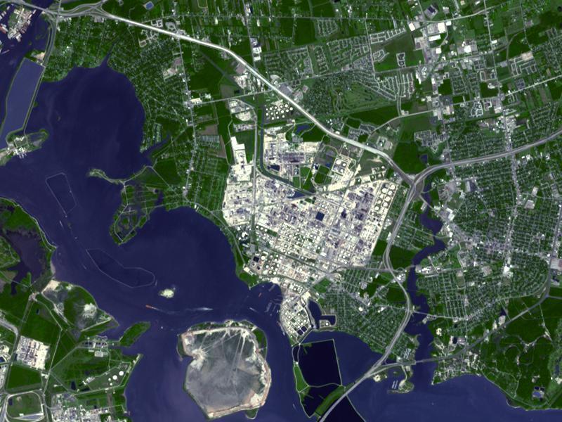
Acquired by NASA Terra spacecraft, this image shows ExxonMobil Baytown refinery in Texas. With a refining capacity of over 560,000 barrels per day, it is the largest refinery in the United States.
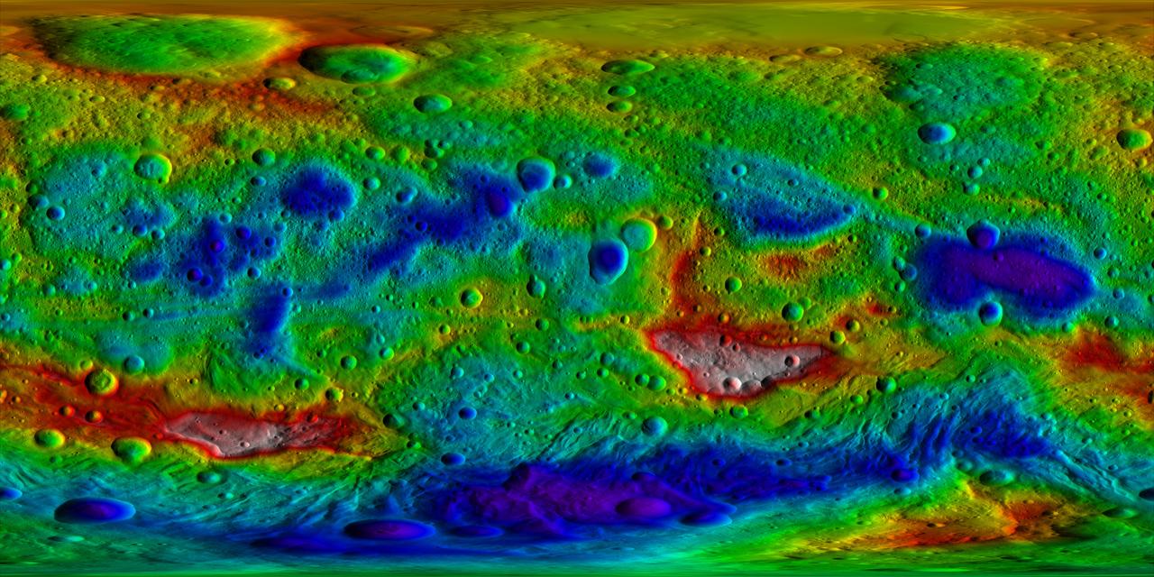
This color-coded topography map from NASA Dawn mission shows the giant asteroid Vesta in an equirectangular projection at 32 pixels per degree, relative to an ellipsoid of 177 miles by 177 miles by 142 miles.
NASA Dawn spacecraft obtained this image of the surface of asteroid Vesta with its framing camera on August 11, 2011. It was taken through the camera clear filter. The image has a resolution of about 260 meters per pixel.
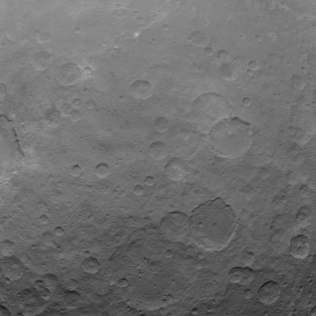
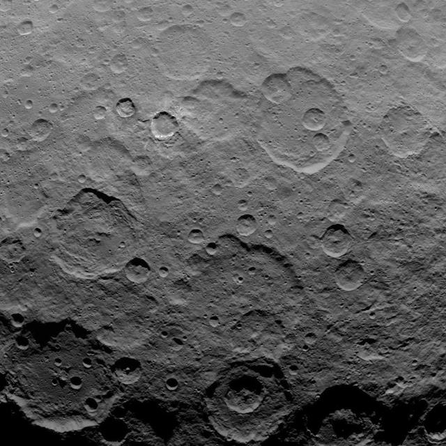
NASA Dawn spacecraft captured this view of mid-latitudes on Ceres on Oct. 18, 2015, from an altitude of 915 miles 1,470 kilometers. The image has a resolution of 450 feet 140 meters per pixel.
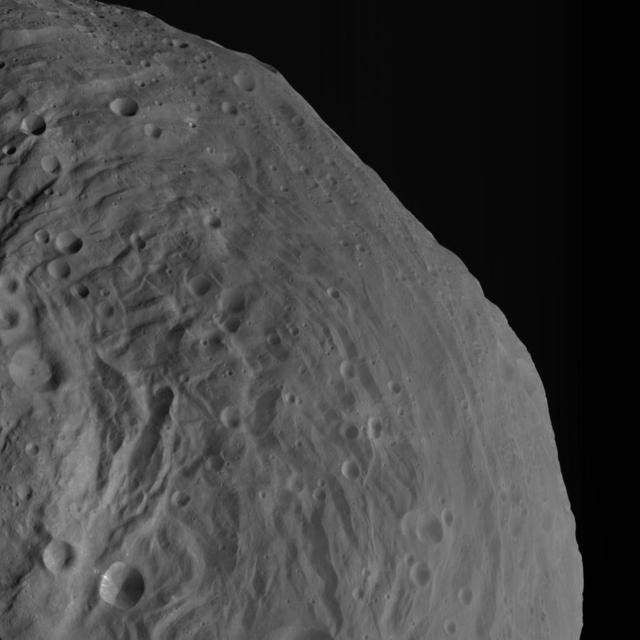
NASA Dawn spacecraft obtained this image of terrestrial mountains on asteroid Vesta with its framing camera on Aug. 26, 2011. The image has a resolution of about 260 meters per pixel.
NASA Dawn spacecraft obtained this image of the surface of asteroid Vesta with its framing camera on August 11, 2011. It was taken through the camera clear filter. The image has a resolution of about 260 meters per pixel.
This image of Ceres is part of a sequence taken by NASA Dawn spacecraft on May 22, 2015, from a distance of 3,200 miles 5,100 kilometers with a resolution of 1,600 feet 480 meters per pixel. http://photojournal.jpl.nasa.gov/catalog/PIA19565
This frame from an animation shows the motion of ice in Antarctica as measured by satellite data from various space agencies. The colors represent the speed of the ice flows in meters per year.
NASA Dawn spacecraft obtained this image of asteroid Vesta with its framing camera on August 11, 2011. The image has a resolution of about 260 meters per pixel.
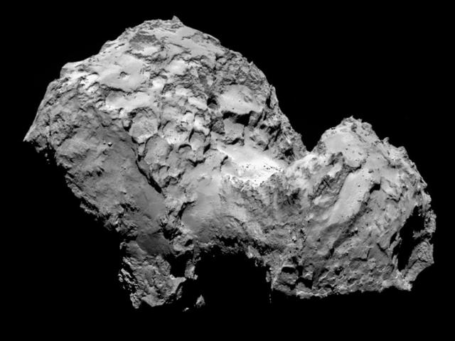
Comet 67P/Churyumov-Gerasimenko by ESA Rosetta OSIRIS narrow-angle camera on August 3, 2014, from a distance of 177 miles 285 kilometers. The image resolution is 17 feet 5.3 meters per pixel.
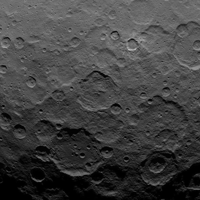
NASA Dawn spacecraft captured this scene, showing southern mid-latitudes on Ceres, on Oct. 18, 2015, from an altitude of 915 miles 1,470 kilometers. It has a resolution of 450 feet 140 meters per pixel.
This image of Ceres is part of a sequence taken by NASA Dawn spacecraft on May 22, 2015, from a distance of 3,200 miles 5,100 kilometers with a resolution of 1,600 feet 480 meters per pixel. http://photojournal.jpl.nasa.gov/catalog/PIA19563
This image, taken by NASA Dawn spacecraft, shows the surface of dwarf planet Ceres from an altitude of 915 miles 1,470 kilometers. The image, with a resolution of 450 feet 140 meters per pixel, was taken on August 27, 2015.
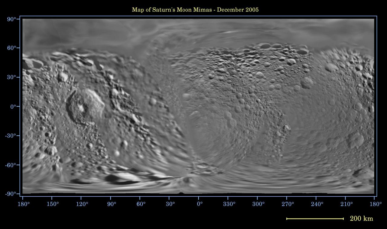
This global digital map of Saturn moon Mimas was created using data taken during Cassini and Voyager spacecraft flybys. The map is an equidistant projection and has a scale of 434 meters 1,424 feet per pixel
NASA Dawn spacecraft obtained this image of the surface of asteroid Vesta with its framing camera on August 11, 2011. It was taken through the camera clear filter. The image has a resolution of about 260 meters per pixel.
NASA Dawn spacecraft obtained this image of the giant asteroid Vesta with its framing camera on Aug. 14 2011. This image was taken through the camera clear filter. The image has a resolution of about 260 meters per pixel.
NASA Dawn spacecraft obtained this image of asteroid Vesta with its framing camera on Aug. 26, 2011 at a distance of 1,700 miles 2,740 kilometers. The image has a resolution of about 260 meters per pixel.
NASA Dawn spacecraft obtained this image of an unusual hill on asteroid Vesta with its framing camera on August 18, 2011. The image has a resolution of about 260 meters per pixel.
NASA Dawn spacecraft obtained this image with its framing camera on Aug. 23, 2011. This image was taken through the camera clear filter. The image has a resolution of about 260 meters per pixel.

This global digital map of Saturn moon Tethys was created using data taken during Cassini and Voyager spacecraft flybys. The map is an equidistant projection and has a scale of 293 meters 961 feet per pixel

NASA Dawn spacecraft obtained these side-by-side views of a dark hill of the surface of asteroid Vesta with its framing camera on August 19, 2011. The images have a resolution of about 260 meters per pixel.
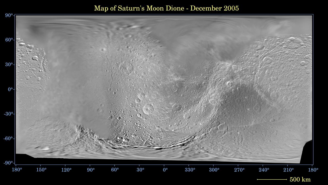
This global digital map of Saturn moon Dione was created using data taken during Cassini and Voyager spacecraft flybys. The map is an equidistant projection and has a scale of 977 meters 3,205 feet per pixel
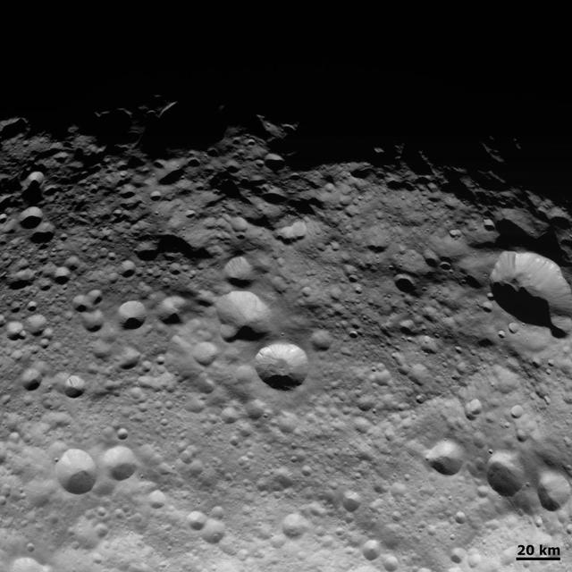
NASA Dawn spacecraft obtained this image of craters and grooves in the south polar region on asteroid Vesta with its framing camera on Sept. 3, 2011. The image has a resolution of about 220 meters per pixel.
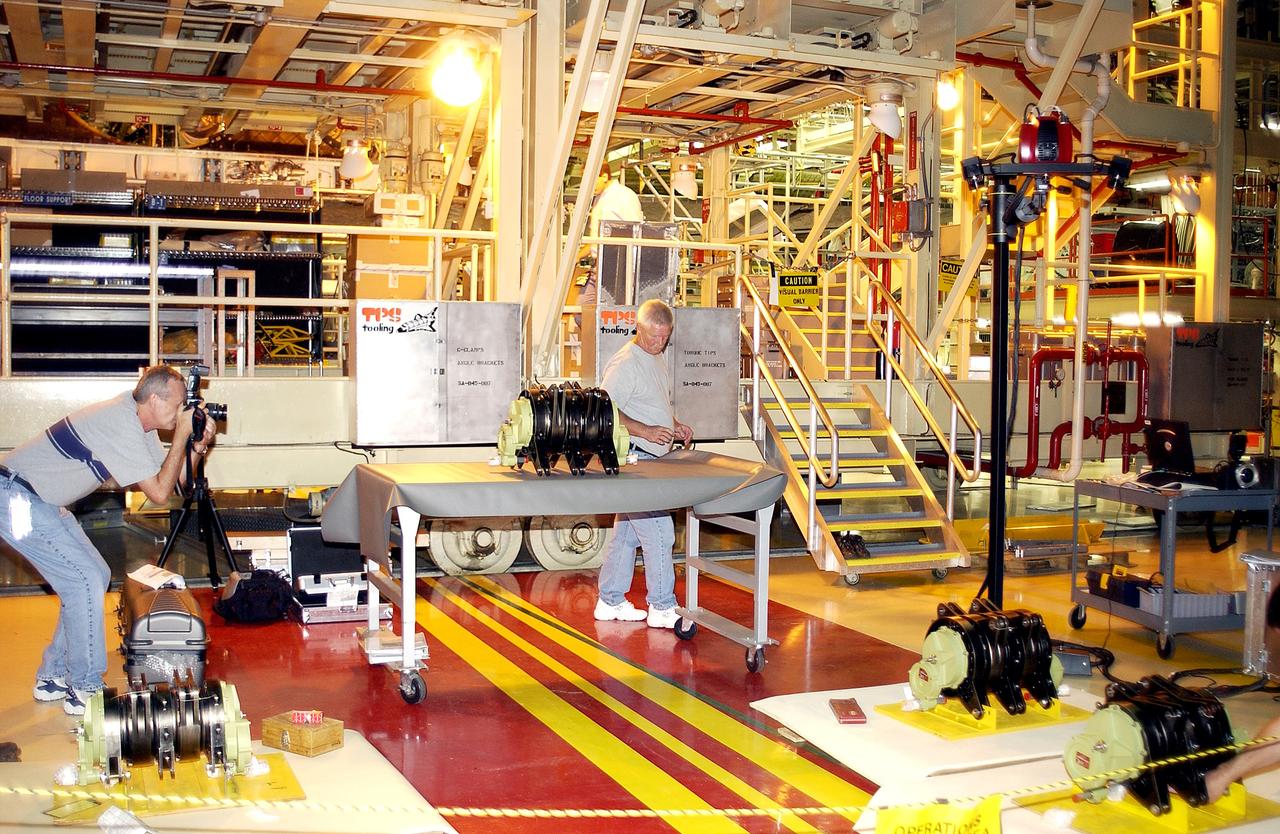
KENNEDY SPACE CENTER, FLA. - In the Orbiter Processing Facility, an actuator is set up on a table for a 3D digital scan. There are two actuators per engine on the Shuttle, one for pitch motion and one for yaw motion. The Space Shuttle Main Engine hydraulic servoactuators are used to gimbal the main engine.
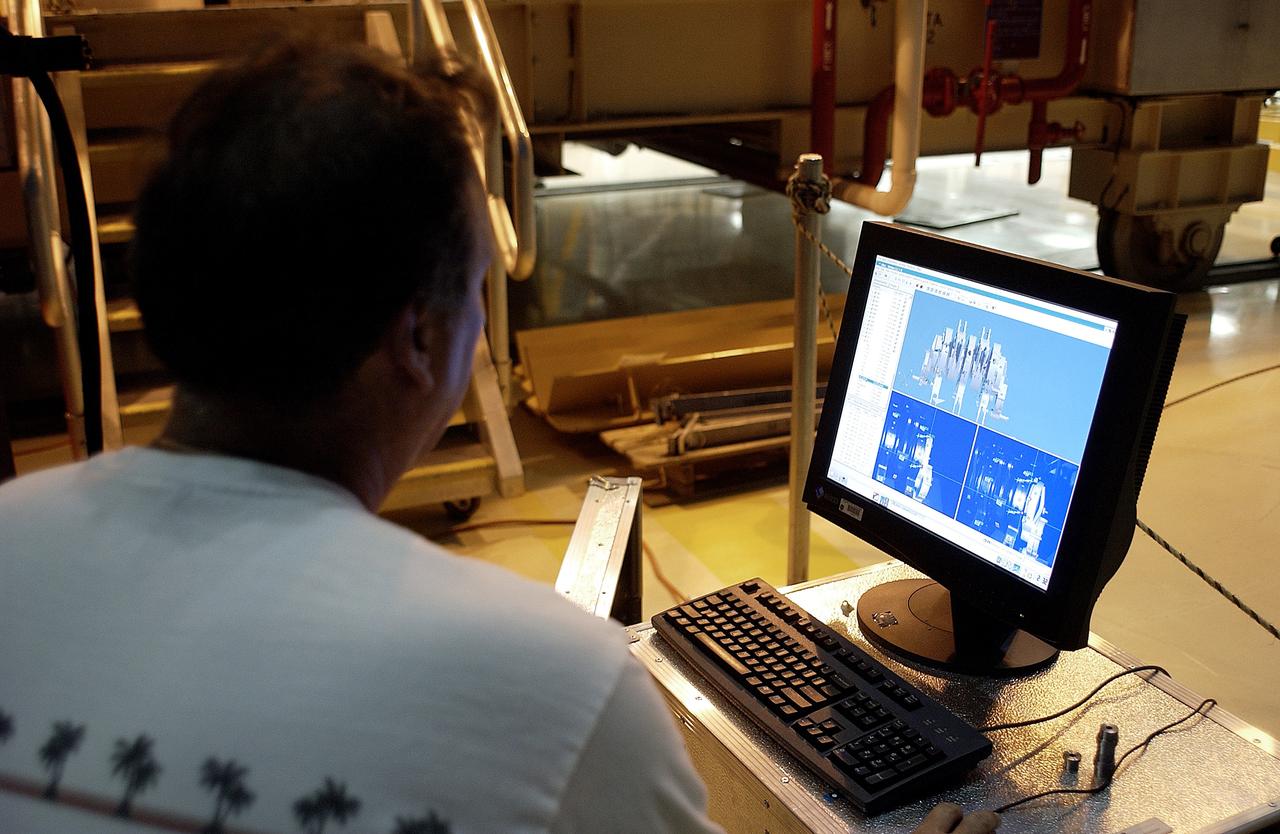
KENNEDY SPACE CENTER, FLA. - In the Orbiter Processing Facility, Boeing worker Alden Pitard looks at a 3D digital scan of an actuator. There are two actuators per engine on the Shuttle, one for pitch motion and one for yaw motion. The Space Shuttle Main Engine hydraulic servoactuators are used to gimbal the main engine.
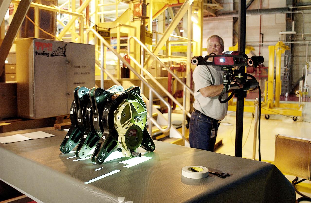
KENNEDY SPACE CENTER, FLA. - In the Orbiter Processing Facility, Dan Clark, with KSC Boeing, operates the camera for a 3D digital scan of the actuator on the table. There are two actuators per engine on the Shuttle, one for pitch motion and one for yaw motion. The Space Shuttle Main Engine hydraulic servoactuators are used to gimbal the main engine.
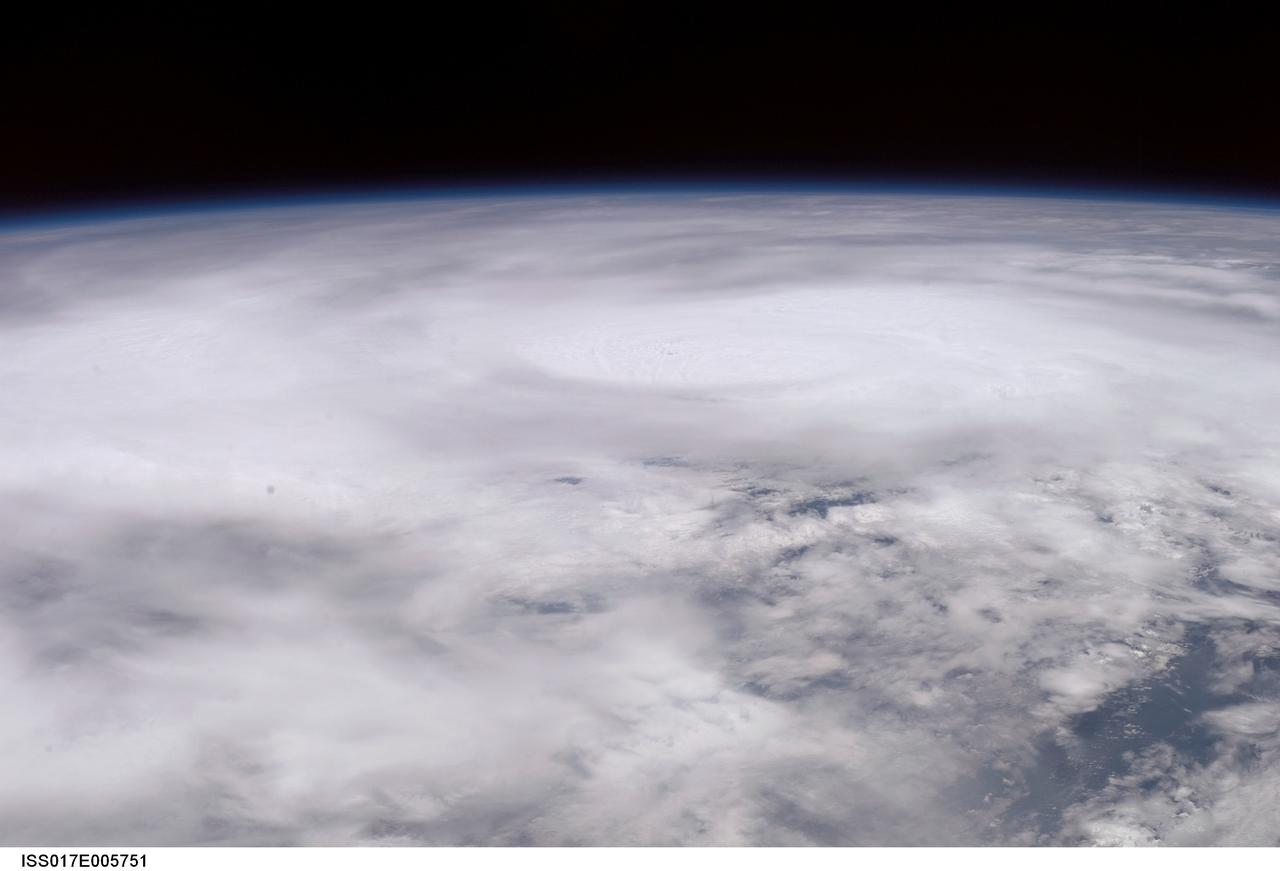
ISS017-E-005751 (30 April 2008) --- When this image was photographed by one of the crew members aboard the International Space Station, Tropical Cyclone Nargis was centered near a point located at 15.3 degrees north latitude and 88.2 degrees north longitude and moving northeast at 065 degrees at 8.1 miles per hour. The center was approximately 7 degrees southwest of Burma with sustained winds of 74.9 miles per hour, gusting to 92.2 miles per hour, forecast to strengthen. Maximum significant wave height was 27 feet.
ISS017-E-015751 (10 Sept. 2008) --- This picture of Hurricane Ike from earlier today was downlinked by the crew of the International Space Station, flying 220 statute miles above Earth. The center of the hurricane was near 23.8 degrees north latitude and 85.3 degrees west longitude, moving 300 degrees at 7 nautical miles per hour. The sustained winds were 80 nautical miles per hour with gusts to 100 nautical miles per hour and forecast to intensify.
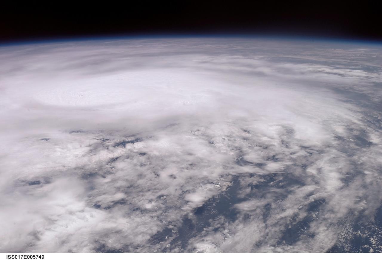
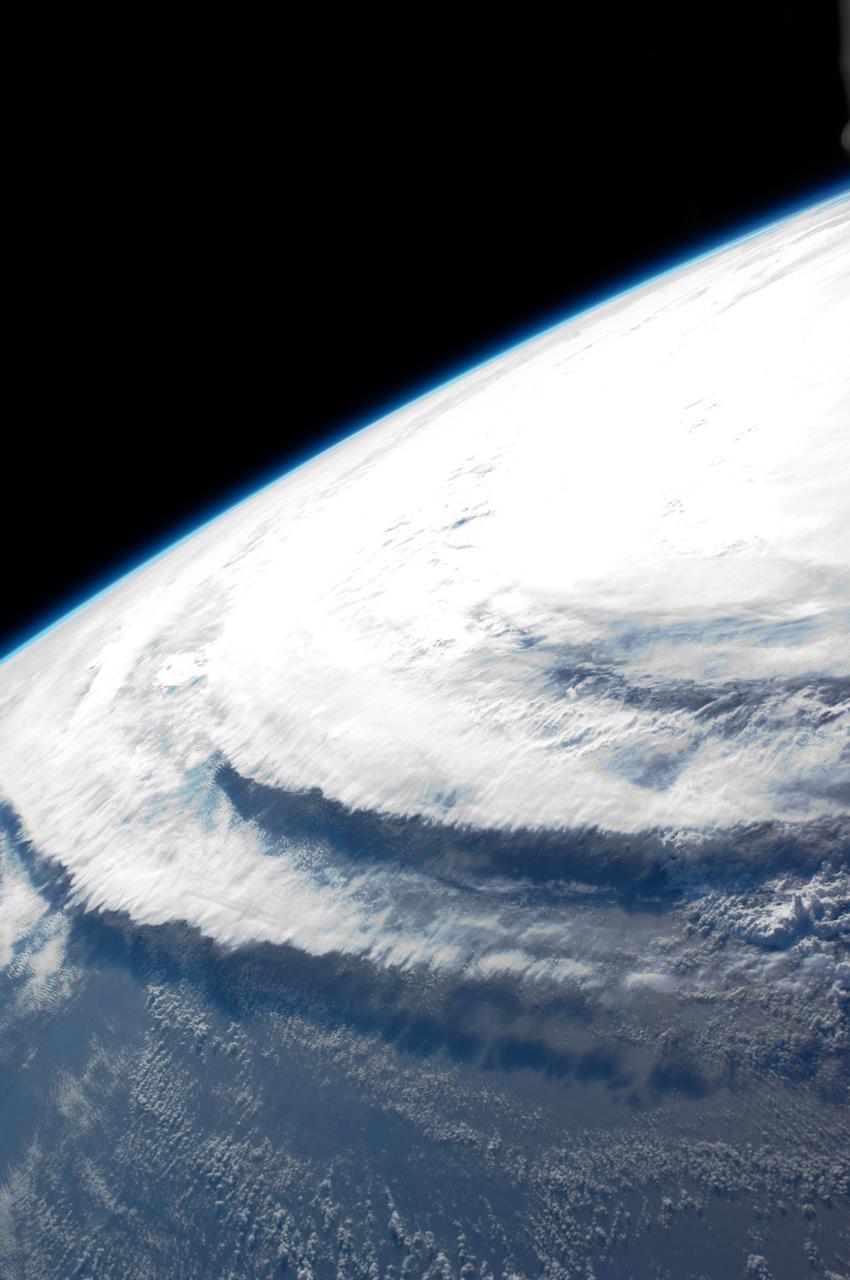
ISS017-E-005749 (30 April 2008) --- When this image was photographed by one of the crew members aboard the International Space Station, Tropical Cyclone Nargis was centered near a point located at 15.3 degrees north latitude and 88.2 degrees north longitude and moving northeast at 065 degrees at 8.1 miles per hour. The center was approximately 7 degrees southwest of Burma with sustained winds of 74.9 miles per hour, gusting to 92.2 miles per hour, forecast to strengthen. Maximum significant wave height was 27 feet.
This image, taken by NASA Dawn spacecraft, shows dwarf planet Ceres from an altitude of 2,700 miles 4,400 kilometers. The image, with a resolution of 1,400 feet 410 meters per pixel, was taken on June 7, 2015. http://photojournal.jpl.nasa.gov/catalog/PIA19580

This image, taken by NASA's Dawn spacecraft, shows the surface of dwarf planet Ceres from an altitude of 915 miles (1,470 kilometers). The image, with a resolution of 450 feet (140 meters) per pixel, was taken on August 27, 2015. http://photojournal.jpl.nasa.gov/catalog/PIA19900
This image, taken by NASA Dawn spacecraft on June 24, 2015, shows dwarf planet Ceres from an altitude of 2,700 miles 4,400 kilometers with a resolution of 1,400 feet 410 meters per pixel. http://photojournal.jpl.nasa.gov/catalog/PIA19613
This image, taken by NASA's Dawn spacecraft, shows the surface of dwarf planet Ceres from an altitude of 915 miles (1,470 kilometers). The image, with a resolution of 450 feet (140 meters) per pixel, was taken on August 24, 2015. http://photojournal.jpl.nasa.gov/catalog/PIA19892
This image, taken by NASA's Dawn spacecraft, shows dwarf planet Ceres from an altitude of 2,700 miles (4,400 kilometers). The image, with a resolution of 1,400 feet (410 meters) per pixel, was taken on June 24, 2015. http://photojournal.jpl.nasa.gov/catalog/PIA19595
This image, taken by NASA Dawn spacecraft, shows dwarf planet Ceres from an altitude of 2,700 miles 4,400 kilometers. The image, with a resolution of 1,400 feet 410 meters per pixel, was taken on June 6, 2015. http://photojournal.jpl.nasa.gov/catalog/PIA19576
This image, taken by NASA's Dawn spacecraft, shows the surface of dwarf planet Ceres from an altitude of 915 miles (1,470 kilometers). The image, with a resolution of 450 feet (140 meters) per pixel, was taken on August 26, 2015. http://photojournal.jpl.nasa.gov/catalog/PIA19897
This image, taken by NASA's Dawn spacecraft, shows dwarf planet Ceres from an altitude of 2,700 miles (4,400 kilometers). The image, with a resolution of 1,400 feet (410 meters) per pixel, was taken on June 25, 2015. http://photojournal.jpl.nasa.gov/catalog/PIA19596
This image, taken by NASA Dawn spacecraft, shows dwarf planet Ceres from an altitude of 2,700 miles 4,400 kilometers. The image, with a resolution of 1,400 feet 410 meters per pixel, was taken on June 6, 2015. http://photojournal.jpl.nasa.gov/catalog/PIA19572
This image, taken by NASA's Dawn spacecraft, shows the surface of dwarf planet Ceres from an altitude of 915 miles (1,470 kilometers). The image, with a resolution of 450 feet (140 meters) per pixel, was taken on August 25, 2015. http://photojournal.jpl.nasa.gov/catalog/PIA19895
This image, taken by NASA Dawn spacecraft, shows dwarf planet Ceres from an altitude of 2,700 miles 4,400 kilometers. The image, with a resolution of 1,400 feet 410 meters per pixel, was taken on June 9, 2015. http://photojournal.jpl.nasa.gov/catalog/PIA19575
This image, taken by NASA's Dawn spacecraft, shows the surface of dwarf planet Ceres from an altitude of 915 miles (1,470 kilometers). The image, with a resolution of 450 feet (140 meters) per pixel, was taken on August 26, 2015. http://photojournal.jpl.nasa.gov/catalog/PIA19896
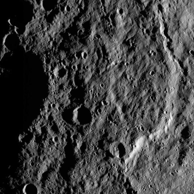
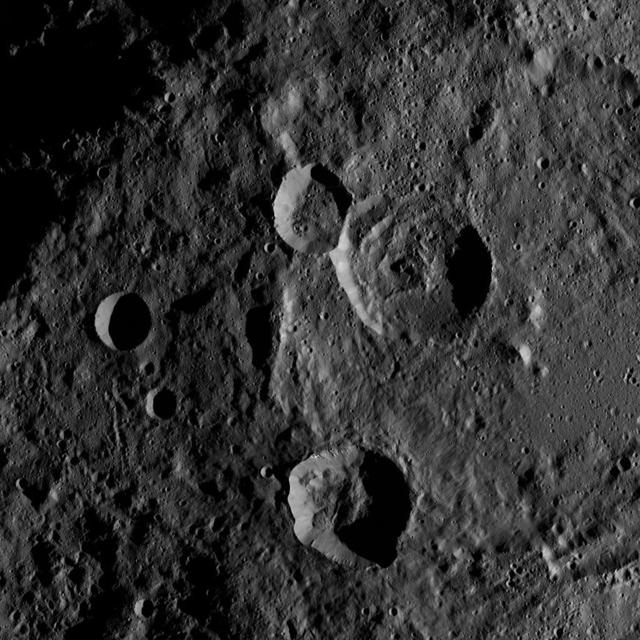
This image, taken by NASA Dawn spacecraft, shows a portion of Ceres at mid-latitudes from an altitude of 915 miles 1,470 kilometers. The image, with a resolution of 450 feet 140 meters per pixel, was taken on August 21, 2015. http://photojournal.jpl.nasa.gov/catalog/PIA19885
This image, taken on June 25, 2015 by NASA Dawn spacecraft, shows a portion of the southern hemisphere of dwarf planet Ceres from an altitude of 2,700 miles 4,400 kilometers, with a resolution of 1,400 feet 410 meters per pixel. http://photojournal.jpl.nasa.gov/catalog/PIA19603
This image, taken by NASA Dawn spacecraft, shows dwarf planet Ceres from an altitude of 2,700 miles 4,400 kilometers. The image, with a resolution of 1,400 feet 410 meters per pixel, was taken on June 6, 2015. http://photojournal.jpl.nasa.gov/catalog/PIA19573
This image, taken by NASA's Dawn spacecraft, shows dwarf planet Ceres from an altitude of 2,700 miles (4,400 kilometers). The image, with a resolution of 1,400 feet (410 meters) per pixel, was taken on June 9, 2015. The bright feature in the upper-left is also seen in PIA19581. http://photojournal.jpl.nasa.gov/catalog/PIA19582

This image, taken by NASA's Dawn spacecraft, shows the surface of dwarf planet Ceres from an altitude of 915 miles (1,470 kilometers). The image, with a resolution of 450 feet (140 meters) per pixel, was taken on August 27, 2015. http://photojournal.jpl.nasa.gov/catalog/PIA19899
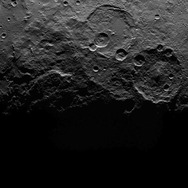
This image, taken by NASA's Dawn spacecraft, shows a portion of the southern hemisphere of dwarf planet Ceres from an altitude of 2,700 miles (4,400 kilometers). The image, with a resolution of 1,400 feet (410 meters) per pixel, was taken on June 22, 2015. http://photojournal.jpl.nasa.gov/catalog/PIA19588
This image, taken by NASA's Dawn spacecraft, shows dwarf planet Ceres from an altitude of 2,700 miles (4,400 kilometers). The image, with a resolution of 1,400 feet (410 meters) per pixel, was taken on June 24, 2015. http://photojournal.jpl.nasa.gov/catalog/PIA19594
This image, taken by NASA's Dawn spacecraft, shows a portion of the southern hemisphere of dwarf planet Ceres from an altitude of 2,700 miles (4,400 kilometers). The image, with a resolution of 1,400 feet (410 meters) per pixel, was taken on June 16, 2015. http://photojournal.jpl.nasa.gov/catalog/PIA19585

This image, taken by NASA's Dawn spacecraft, shows dwarf planet Ceres from an altitude of 2,700 miles (4,400 kilometers). The image, with a resolution of 1,400 feet (410 meters) per pixel, was taken on June 24, 2015. http://photojournal.jpl.nasa.gov/catalog/PIA19599
This image, taken by NASA's Dawn spacecraft, shows the surface of dwarf planet Ceres from an altitude of 915 miles (1,470 kilometers). The image, with a resolution of 450 feet (140 meters) per pixel, was taken on August 24, 2015. http://photojournal.jpl.nasa.gov/catalog/PIA19893
This image, taken by NASA Dawn spacecraft, shows dwarf planet Ceres from an altitude of 2,700 miles 4,400 kilometers. The image, with a resolution of 1,400 feet 410 meters per pixel, was taken on June 25, 2015. http://photojournal.jpl.nasa.gov/catalog/PIA19601

This image, taken on June 25, 2015 by NASA Dawn spacecraft, shows a portion of the southern hemisphere of dwarf planet Ceres from an altitude of 2,700 miles 4,400 kilometers, with a resolution of 1,400 feet 410 meters per pixel. http://photojournal.jpl.nasa.gov/catalog/PIA19602
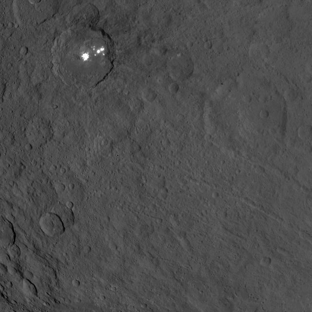
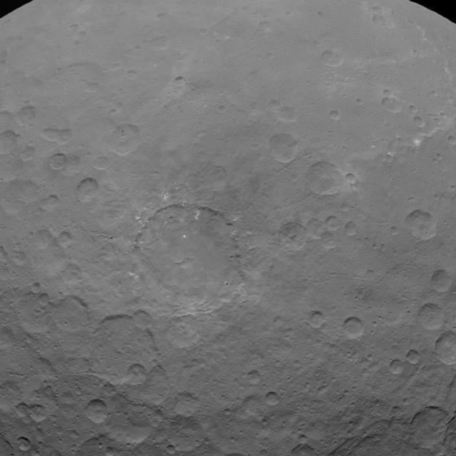
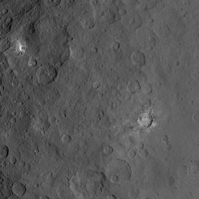
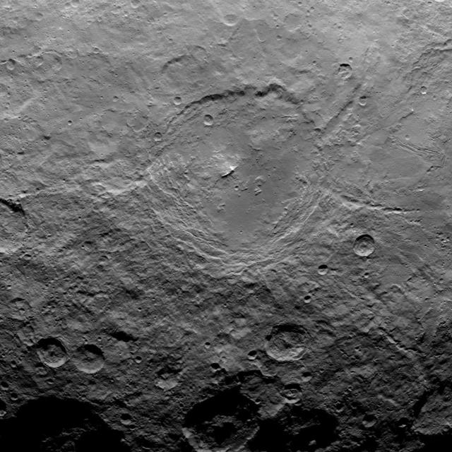
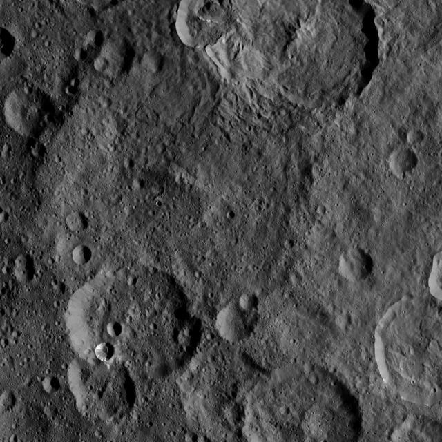
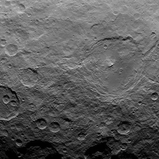
This image, taken by NASA's Dawn spacecraft, shows the bright spots of Occator crater on Ceres from an altitude of 2,700 miles (4,400 kilometers). The image, with a resolution of 1,400 feet (410 meters) per pixel, was taken on June 25, 2015. http://photojournal.jpl.nasa.gov/catalog/PIA19630

This image, taken by NASA's Dawn spacecraft, shows dwarf planet Ceres from an altitude of 2,700 miles (4,400 kilometers). The image, with a resolution of 1,400 feet (410 meters) per pixel, was taken on June 18, 2015. http://photojournal.jpl.nasa.gov/catalog/PIA19590
This image, taken by NASA's Dawn spacecraft, shows the surface of dwarf planet Ceres from an altitude of 915 miles (1,470 kilometers). The image, with a resolution of 450 feet (140 meters) per pixel, was taken on August 24, 2015. http://photojournal.jpl.nasa.gov/catalog/PIA19894
This image, taken by NASA's Dawn spacecraft, shows a portion of the northern hemisphere of dwarf planet Ceres from an altitude of 2,700 miles (4,400 kilometers). The image, with a resolution of 1,400 feet (410 meters) per pixel, was taken on June 21, 2015. http://photojournal.jpl.nasa.gov/catalog/PIA19592
This image, taken by NASA Dawn spacecraft, shows dwarf planet Ceres from an altitude of 2,700 miles 4,400 kilometers. The image, with a resolution of 1,400 feet 410 meters per pixel, was taken on June 10, 2015. http://photojournal.jpl.nasa.gov/catalog/PIA19583

This image, taken by NASA Dawn spacecraft, shows dwarf planet Ceres from an altitude of 2,700 miles 4,400 kilometers. The image, with a resolution of 1,400 feet 410 meters per pixel, was taken on June 25, 2015. http://photojournal.jpl.nasa.gov/catalog/PIA19600
This image, taken by NASA's Dawn spacecraft, shows dwarf planet Ceres from an altitude of 2,700 miles (4,400 kilometers). The image, with a resolution of 1,400 feet (410 meters) per pixel, was taken on June 22, 2015. http://photojournal.jpl.nasa.gov/catalog/PIA19591
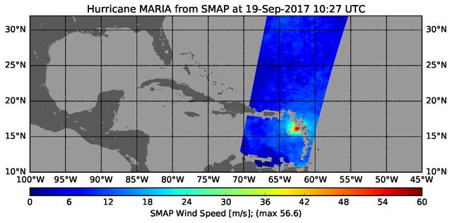
The radiometer instrument on NASA's Soil Moisture Active Passive (SMAP) spacecraft captured this image of Hurricane Maria at 6:27 a.m. EDT on Sept. 19, 2017 (10:27 UTC), showing an estimated maximum surface wind speed of 126.6 miles per hour (56.6 meters per second). While Maria was already a Category 5 hurricane at the time of this observation, it is an extremely tightly organized hurricane and SMAP cannot fully resolve its highest winds due to the 25-mile (40-kilometer) resolution of SMAP. https://photojournal.jpl.nasa.gov/catalog/PIA21960
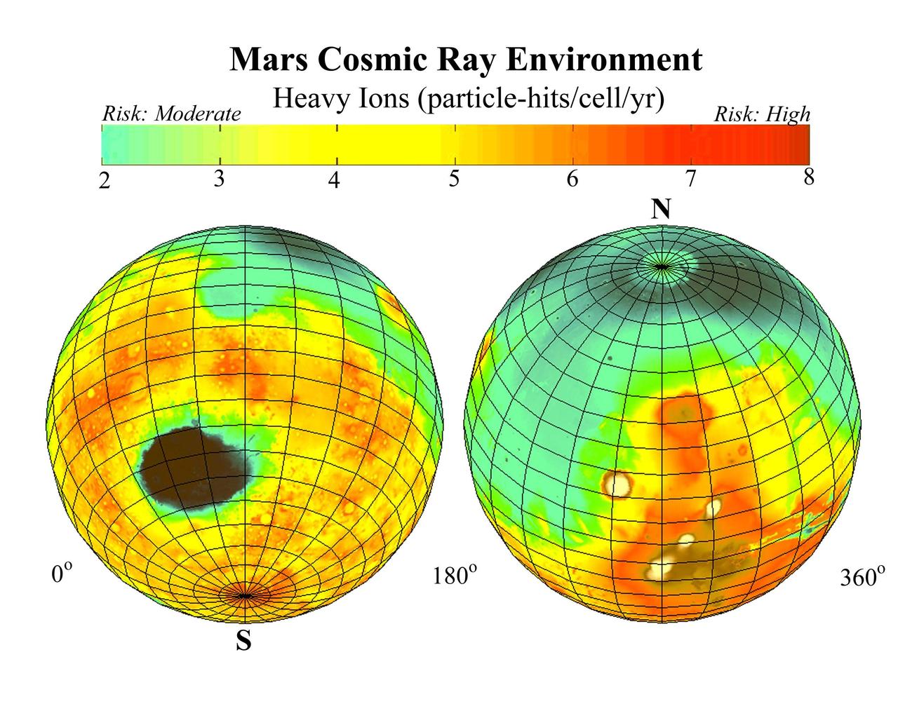
This global map of Mars, based on data from NASA Mars Odyssey, shows estimates for amounts of high-energy-particle cosmic radiation reaching the surface, a serious health concern for any future human exploration of the planet.
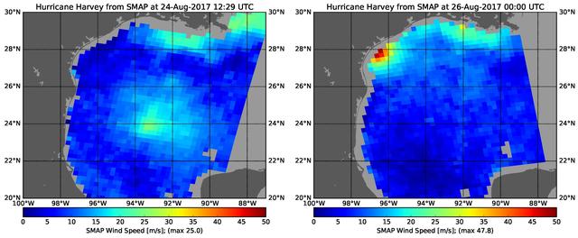
The rapid intensification of Hurricane Harvey is seen in this pair of images of ocean surface wind speeds as observed by the radiometer instrument aboard NASA's Soil Moisture Active Passive (SMAP) satellite at 7:29 a.m. CDT Aug. 24th, 2017 (left) and at 7 p.m. CDT Aug. 26th (right). Color indicates wind speed, with red being highest and blue lowest. The images show Harvey's maximum wind speeds increased from approximately 56 miles per hour (25 meters per second) to about 107 miles per hour (47.8 meters per second) in the 36 hours just before landfall. The higher wind speeds estimated near the mouth of the Mississippi River are erroneous and are due to errors in the ancillary sea-surface-salinity data product used by SMAP to estimate extreme wind speeds. https://photojournal.jpl.nasa.gov/catalog/PIA21884
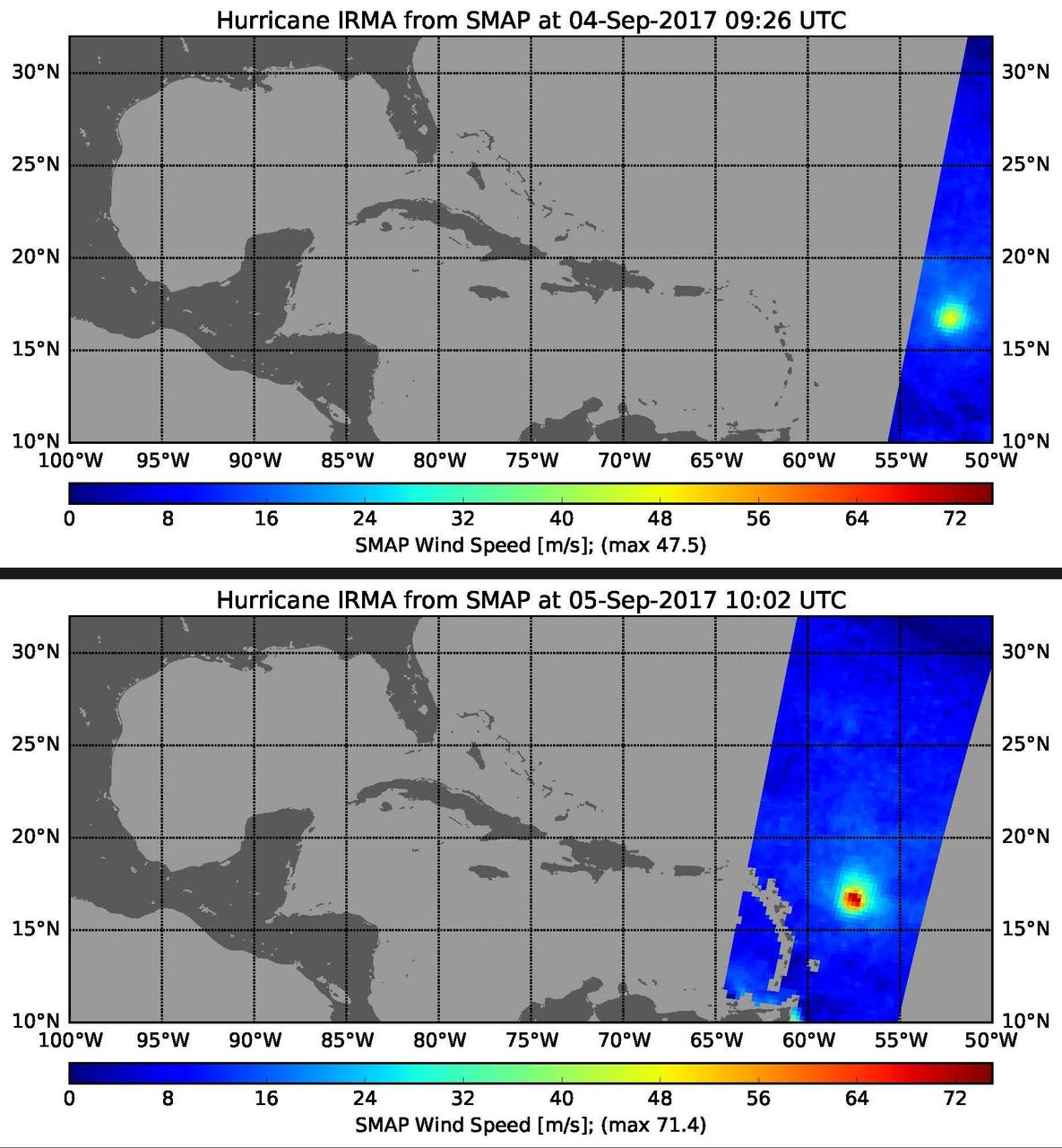
This pair of images shows ocean surface wind speeds for Hurricane Irma as observed at 5:26 a.m. EDT on Sept. 4, 2017 (top) and 24.5 hours later at 6:02 a.m. EDT on September 5th (bottom) by the radiometer instrument on NASA's Soil Moisture Active Passive (SMAP) satellite. Color indicates wind speed, with red being highest and blue lowest. Irma intensified from a Category 2 hurricane on Sept. 4 with observed wind speed of 106 miles per hour (47.5 meters per second) to a Category 5 hurricane on Sept. 5 with a maximum observed wind speed of 160 miles per hour (71.4 meters per second). https://photojournal.jpl.nasa.gov/catalog/PIA21939
ISS028-E-034004 (27 Aug. 2011) --- Some five and a half hours after Hurricane Irene?s initial landfall at Cape Hatteras, NC, one of the Expedition 28 crew members aboard the International Space Station photographed this image, one of a series following the hurricane?s destructive path along the east coast. At this time, the Hurricane was at 35.5 degrees north latitude and 76.3 degrees west longitude over Cape Hatteras, moving 15 degrees at 13 miles per hour. Winds were at 81 miles per hour, gusting to 98 miles per hour.