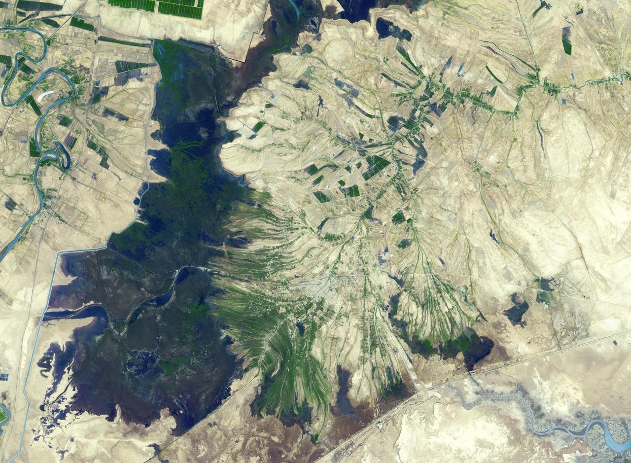
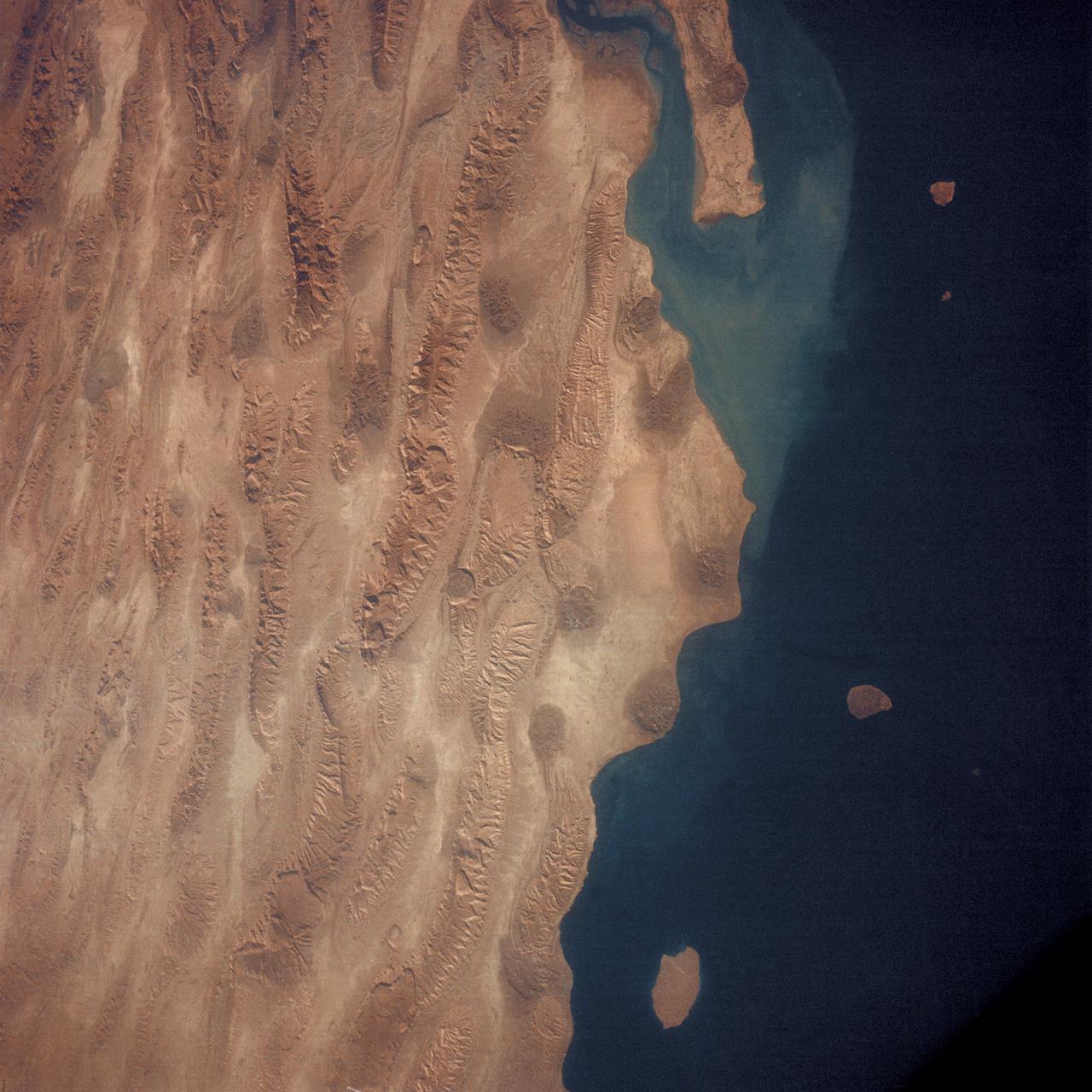
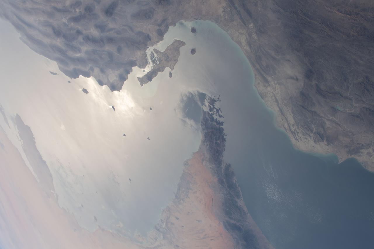
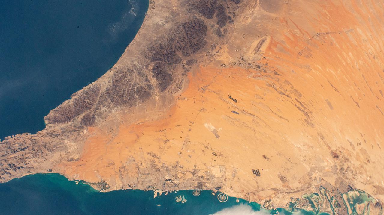
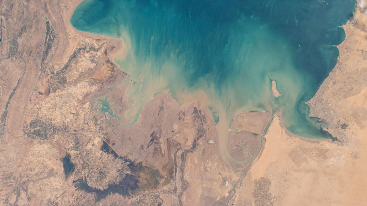
The town of Shadegan, Iran is northeast of where the Tigris and Euphrates Rivers enter the Persian Gulf. It sits near a wetland and upon land that was once part of an inland river delta. The long, linear orchards follow the topography created by the delta. The image was acquired September 3, 2012, covers an area of 40.6 by 55.3 km, and is located at 30.6 degrees north, 48.6 degrees east. http://photojournal.jpl.nasa.gov/catalog/PIA21170
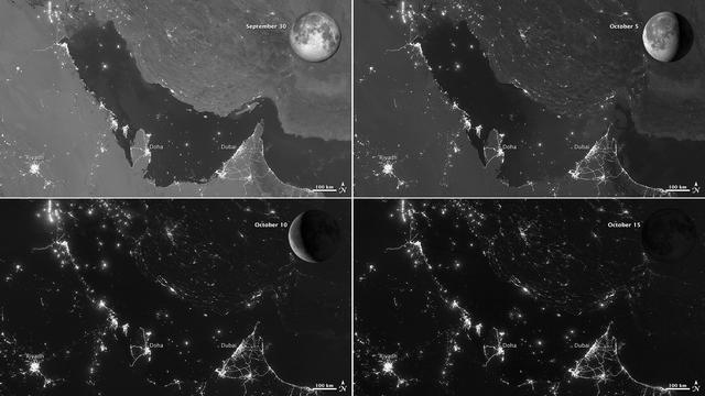
NASA images acquired October 15, 2012 The Visible Infrared Imaging Radiometer Suite (VIIRS) on the Suomi NPP satellite captured these nighttime views of the Persian Gulf region on September 30, October 5, October 10, and October 15, 2012. The images are from the VIIRS “day-night band,” which detects light in a range of wavelengths from green to near-infrared and uses filtering techniques to observe signals such as gas flares, auroras, wildfires, city lights, and reflected moonlight. Each image includes an inset of the Moon in four different phases. September 30 shows the Persian Gulf by the light of the full Moon; October 15 shows the effects of a new Moon. As the amount of moonlight decreases, some land surface features become harder to detect, but the lights from cities and ships become more obvious. Urbanization is most apparent along the northeastern coast of Saudi Arabia, in Qatar, and in the United Arab Emirates (UAE). In Qatar and UAE, major highways can even be discerned by nighttime lights. In eighteenth-century England, a small group of entrepreneurs, inventors and free thinkers—James Watt and Charles Darwin’s grandfathers among them—started a club. They named it the Lunar Society, and the “lunaticks” scheduled their dinner meetings on evenings of the full Moon. The timing wasn’t based on any kind of superstition, it was based on practicality. In the days before electricity, seeing one’s way home after dark was far easier by the light of a full Moon. In the early twenty-first century, electricity has banished the need for such careful scheduling, but the light of the full Moon still makes a difference. NASA Earth Observatory image by Jesse Allen and Robert Simmon, using VIIRS day-night band data from the Suomi National Polar-orbiting Partnership. Suomi NPP is the result of a partnership between NASA, the National Oceanic and Atmospheric Administration, and the Department of Defense. Caption by Michon Scott. Instrument: Suomi NPP - VIIRS Credit: <b><a href="http://www.earthobservatory.nasa.gov/" rel="nofollow"> NASA Earth Observatory</a></b> <b>Click here to view all of the <a href="http://earthobservatory.nasa.gov/Features/NightLights/" rel="nofollow"> Earth at Night 2012 images </a></b> <b>Click here to <a href="http://earthobservatory.nasa.gov/NaturalHazards/view.php?id=79834" rel="nofollow"> read more </a> about this image </b> <b><a href="http://www.nasa.gov/audience/formedia/features/MP_Photo_Guidelines.html" rel="nofollow">NASA image use policy.</a></b> <b><a href="http://www.nasa.gov/centers/goddard/home/index.html" rel="nofollow">NASA Goddard Space Flight Center</a></b> enables NASA’s mission through four scientific endeavors: Earth Science, Heliophysics, Solar System Exploration, and Astrophysics. Goddard plays a leading role in NASA’s accomplishments by contributing compelling scientific knowledge to advance the Agency’s mission. <b>Follow us on <a href="http://twitter.com/NASA_GoddardPix" rel="nofollow">Twitter</a></b> <b>Like us on <a href="http://www.facebook.com/pages/Greenbelt-MD/NASA-Goddard/395013845897?ref=tsd" rel="nofollow">Facebook</a></b> <b>Find us on <a href="http://instagram.com/nasagoddard?vm=grid" rel="nofollow">Instagram</a></b>

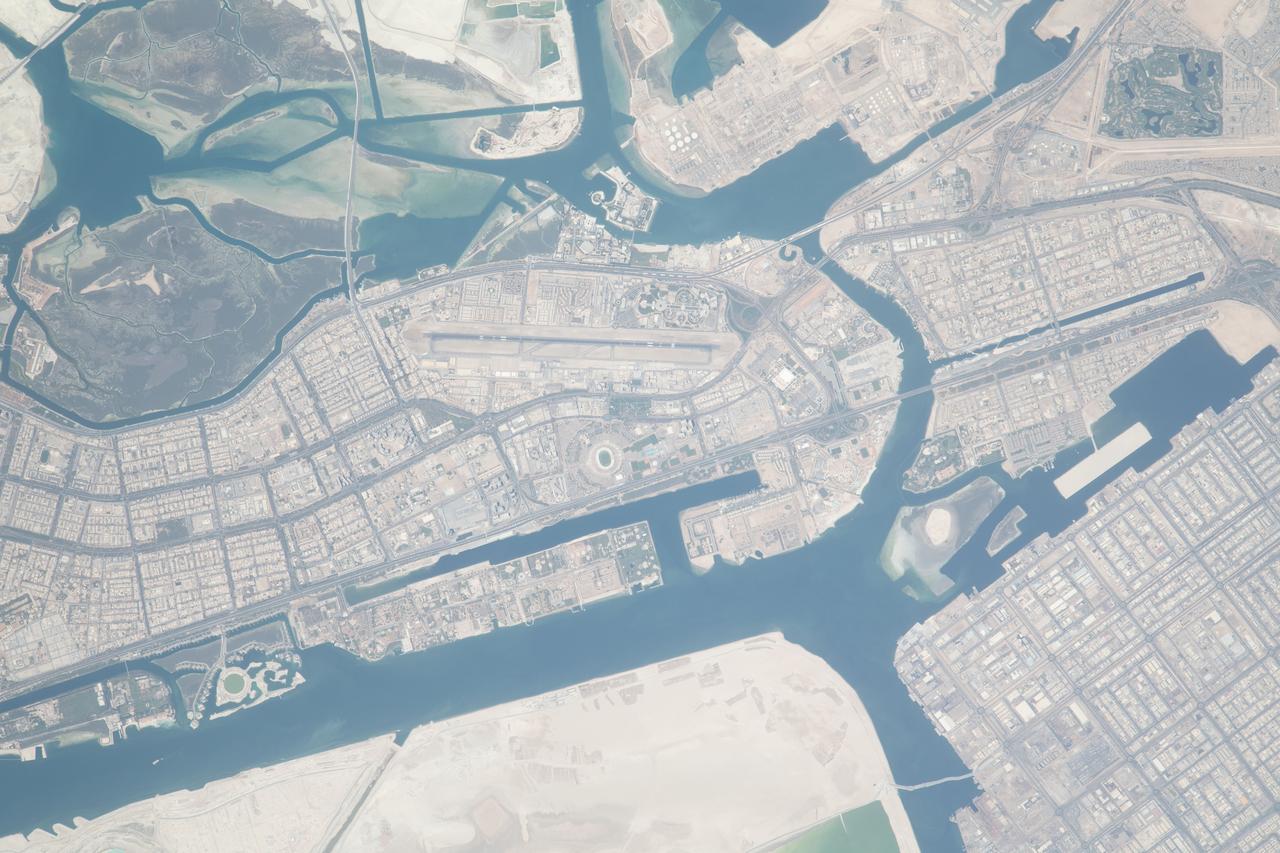
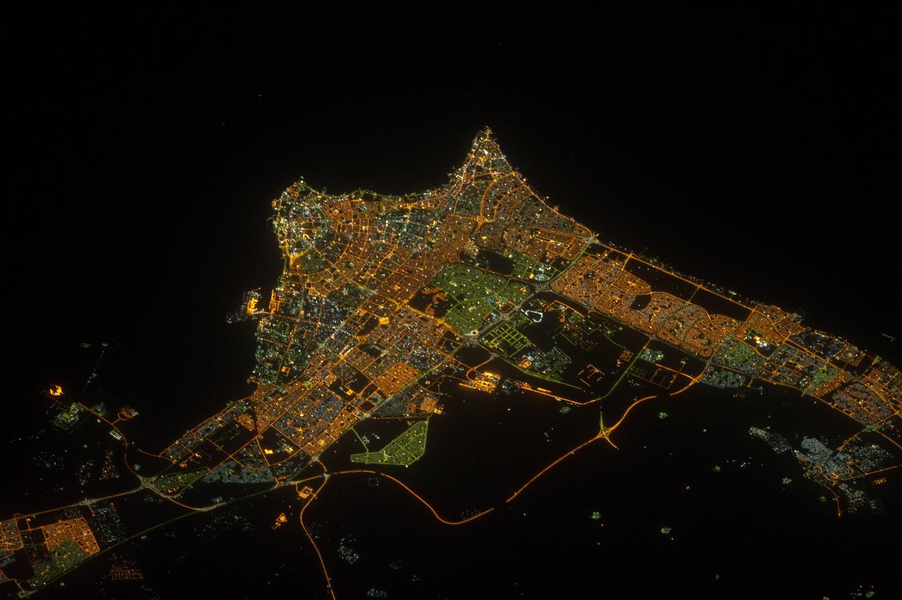
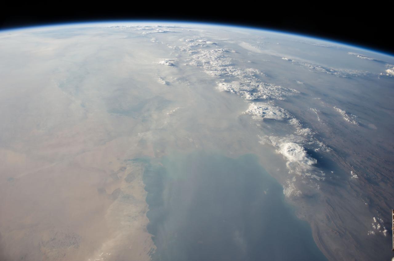
Abu Dhabi, the capital of the United Arab Emirates on the Persian Gulf coast, is pictured from the International Space Station as it soared 257 miles above the Middle East.
STS-35 Earth observation taken aboard Columbia, Orbiter Vehicle (OV) 102, is of the Persian Gulf area. Major cities and oilfields of the countries of Saudi Arabia (foreground), Iraq (top left), Iran (top center and top right), Kuwait, Bahrain, Qatar, and a portion of the United Arab Emirates are visible in this scene. The cities are the large whitish areas of city lights. Flares characteristic of the Mid-East oil field practices are visible both onshore and offshore throughout the scene. Major cities identifiable are in Iraq - Baghdad, Basra, and Faw; in Qatar - Ab Dawhah; in Kuwait - Kuwait City; in Saudi Arabia - Riyadh, Al Jubayl, Dharan, Al Huf, Ad Dilam and Al Hariq; and Bahrain and its associated causeway to the mainland.

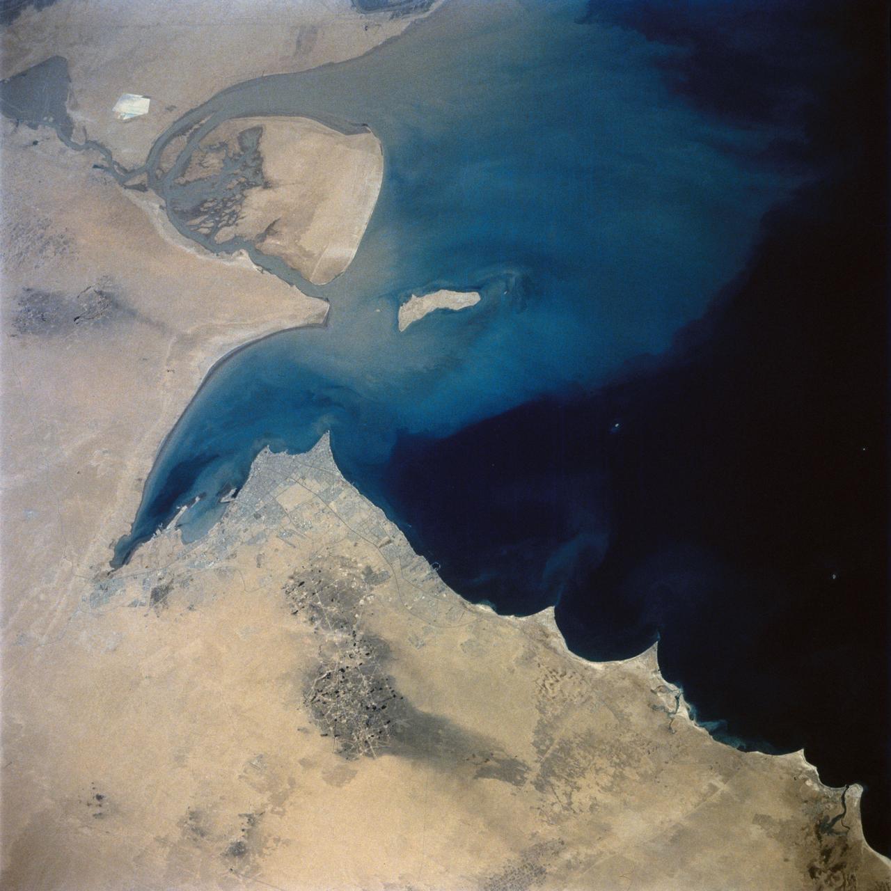
This image from NASA EarthKAM is of the northern end of the Persian Gulf and the broad delta complex of the Tigris, Euphrates, Shatt al Arab, and Karun rivers has captured the arid-looking wetlands of northeast Kuwait Bubiyan Island,
iss072e518049 (Jan. 21, 2025) --- A series of islands on the Persian Gulf coast of the United Arab Emirates near its capital of Abu Dhabi are pictured from the International Space Station as it orbited 259 miles above.
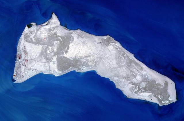
AS7-05-1615 (12 Oct. 1968) --- Persian Gulf coastal area of Iran, Qeshm Island, as seen from the Apollo 7 spacecraft during its 24th revolution of Earth. Photographed from an altitude of approximately 130 nautical miles, at ground elapsed time of 37 hours and 23 minutes.
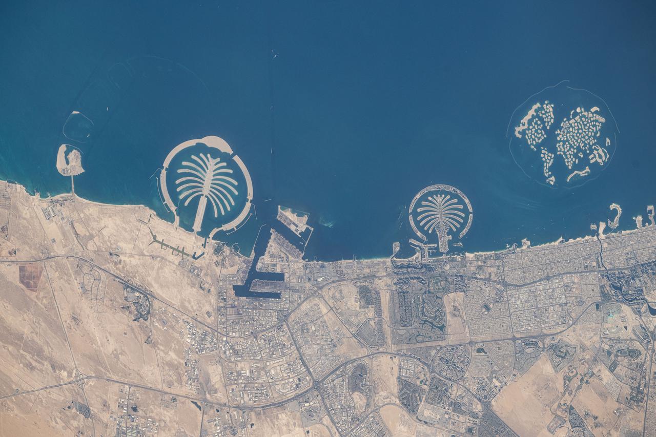
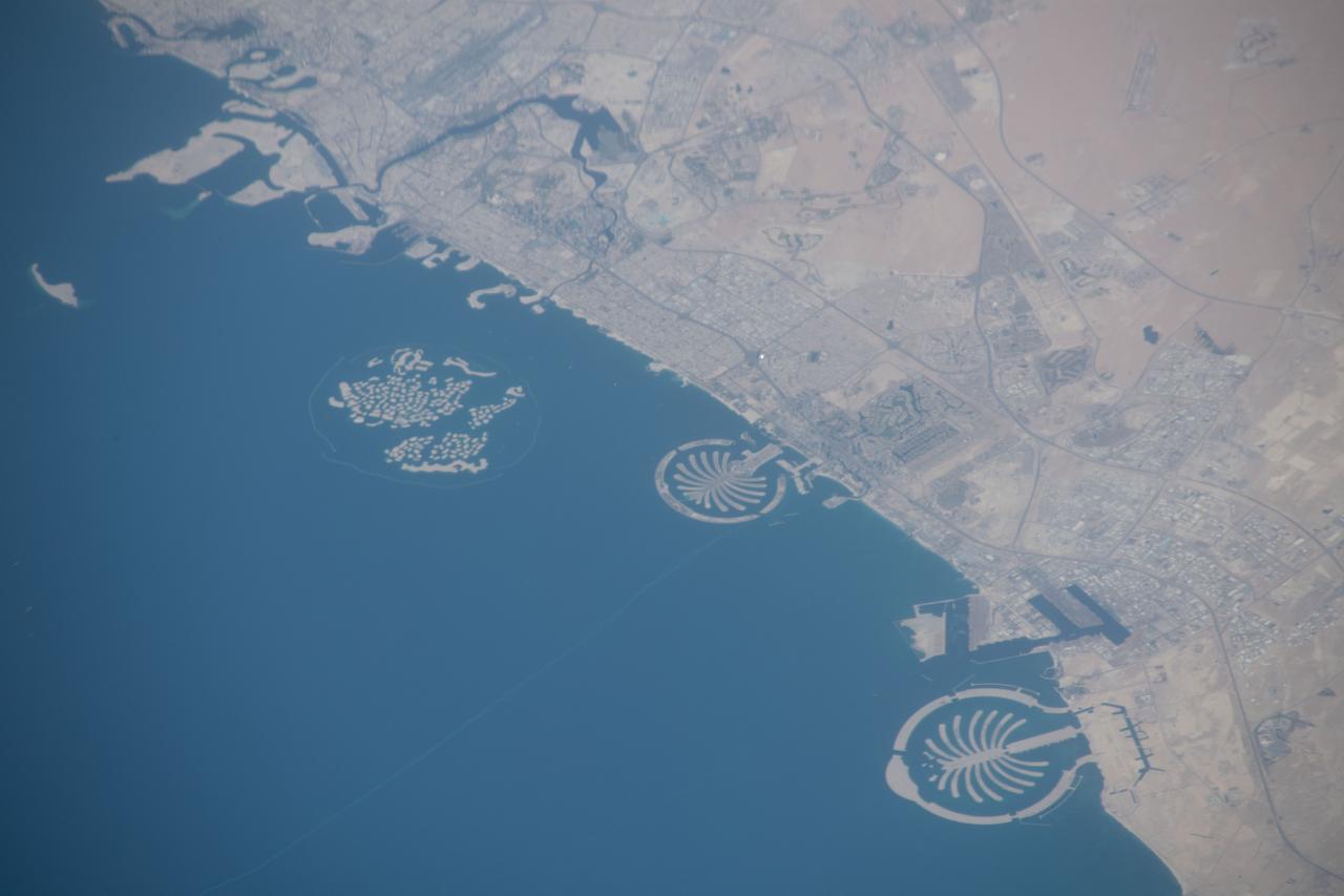
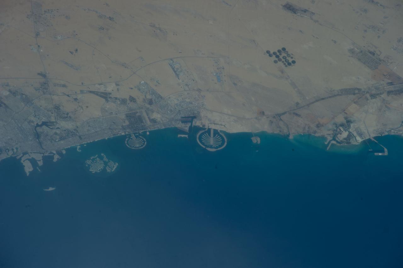
iss073e0247372 (June 10, 2025) --- Artificial islands built on the Persian Gulf coast of Dubai, United Arab Emirates, are pictured from the International Space Station as it orbited 258 miles above the Arabian Sea. Featured promoniently from left, are the man-made archipelagos of Palm Jebel Ali, Palm Jumierah, and The World islands.
This image acquired by NASA Terra spacecraft is of the Kingdom of Bahrain, a small island country near the western shore of the Persian Gulf.
iss073e0134584 (May 22, 2025) --- Dubai, the United Arab Emirates' largest city with a population af 3.94 million on the Persian Gulf coast, is pictured at approximately 11:44 p.m. local time from the International Space Station as it orbited 259 miles above the Arabian Peninsula. Featured prominently at left center, is the artifical island of Palm Jumeirah.
iss073e0982720 (Oct. 25, 2025) --- The Persian Gulf region—from Oman to the United Arab Emirates, with Iran's southwest coast visible across the geographically important waterway—is illuminated beneath a bright yellow-green airglow. This long-exposure photograph, taken at approximately 11:40 p.m. local time from the International Space Station as it orbited 259 miles above northwestern India, also captures the starry expanse of the night sky.
NASA Terra spacecraft captured Kuwait Failaka Island, located 50 km southeast of the spot where the Tigris and Euphrates Rivers empty into the Persian Gulf.
STS039-71-088 (28 April-6 May 1991) --- A handheld 70mm frame of the southern Persian Gulf area. The island in the middle of the frame is Al Jirab, 30 miles west of Abu Dhabi in the United Arab Emirates. On the mainland beaches opposite the island, a thick and continuous black fringe of oil can be seen as a line. Photo experts studying the STS 39 photography have not yet ascertained the source of the oil. They disclosed that if the oil does in fact stem from damaged Kuwaiti offshore oil fields, the slick has been blown southward at least 460 miles. The city of Tarif is visible in the affected area. Lighter brown slicks can be seen offshore. A causeway joins Al Jirab to the mainland and a dredged ship channel with its associated islands can be seen west of the causeway.
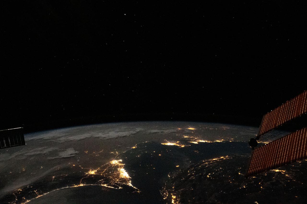
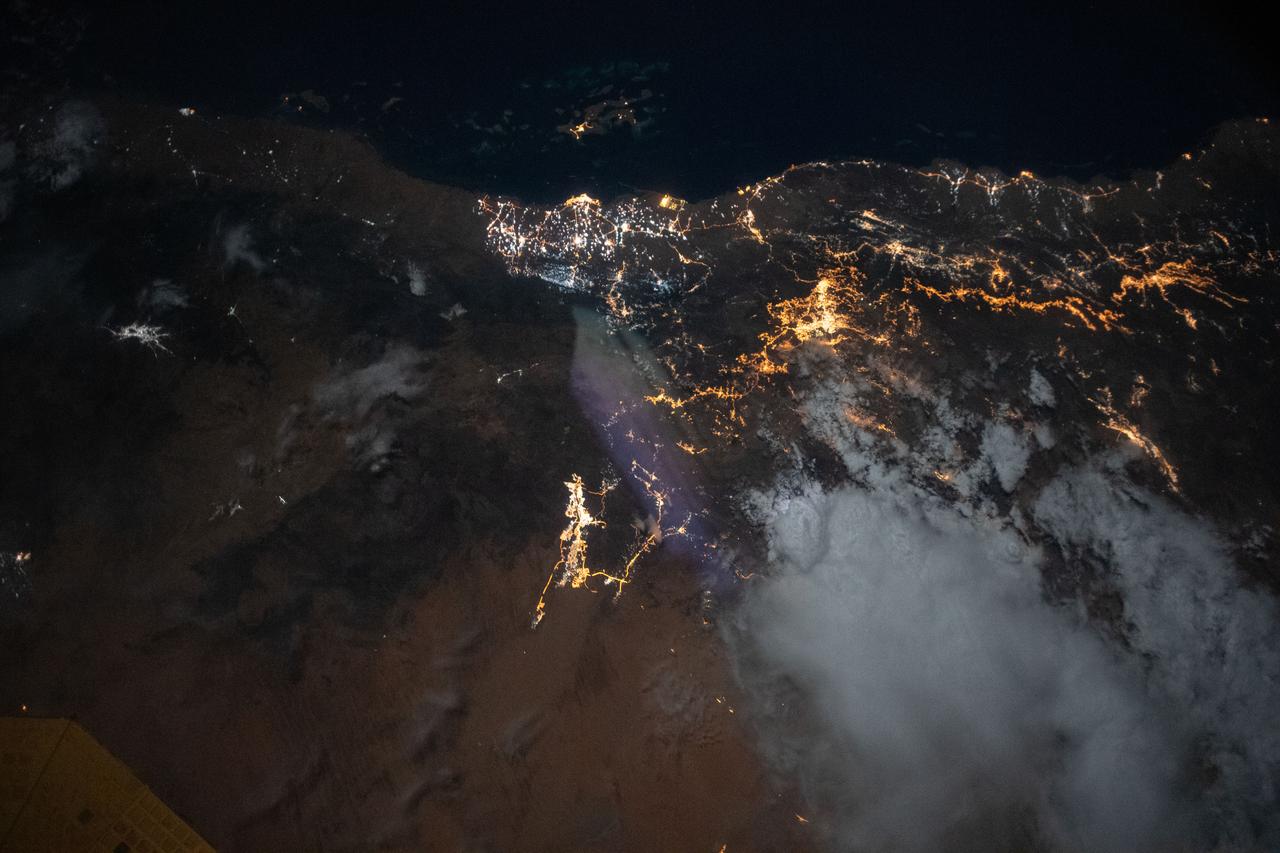
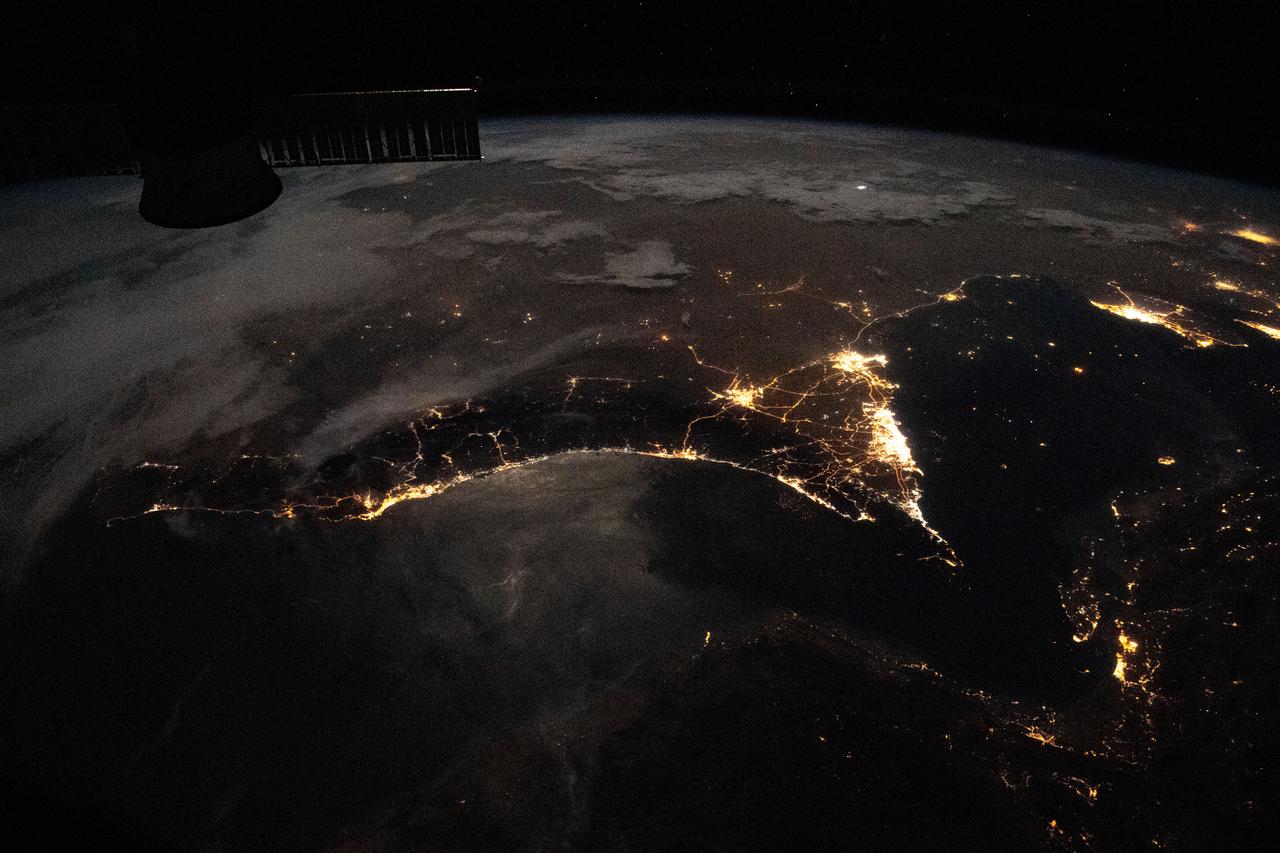
GMT359_16_57_Terry Virts_israel persian gulf night wide_123

iss067e169952 (July 1, 2022) --- The Arvand Roud (center) is a river that separates the southern borders of Iraq and Iran on the Persian Gulf coast. At right, is the Bahmanshir River in Iran that drains into the Persian Gulf. The International Space Station was orbiting 262 miles above Saudi Arabia near the island nation of Bahrain at the time this photograph was taken.

iss072e519889 (Jan. 23, 2025) --- The city lights of Kuwait City, the capital of Kuwait with a population of about 3 million on the Persian Gulf coast, are pictured at approximately 9:49 p.m. local time from the International Space Station as it orbited 258 miles above.
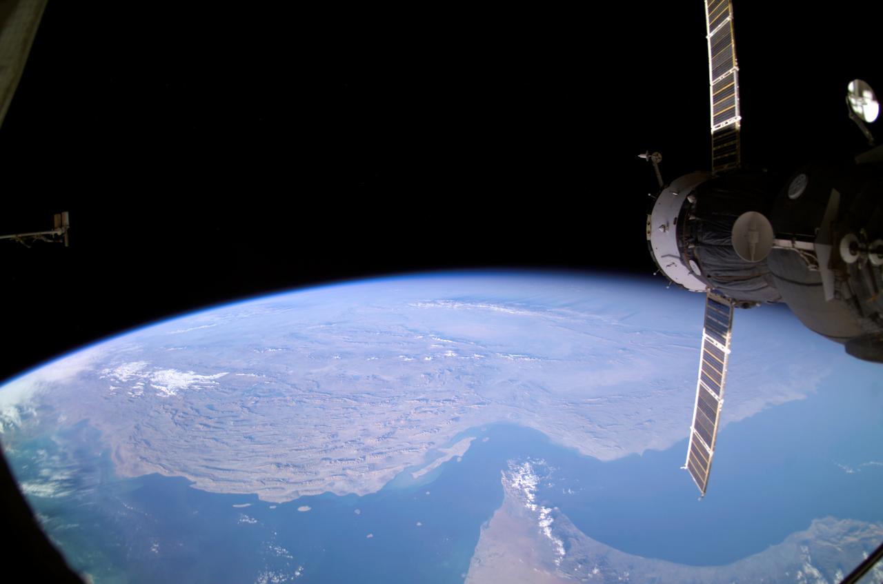
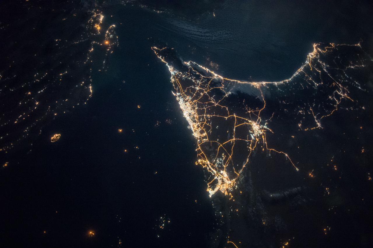
iss064e046338 (March 24, 2021) --- The strategically important shipping route of the Strait of Hormuz is pictured separating the nations of the United Arab Emirates and Iran. It also separates the main water bodies of the Persian Gulf and the Gulf of Oman.
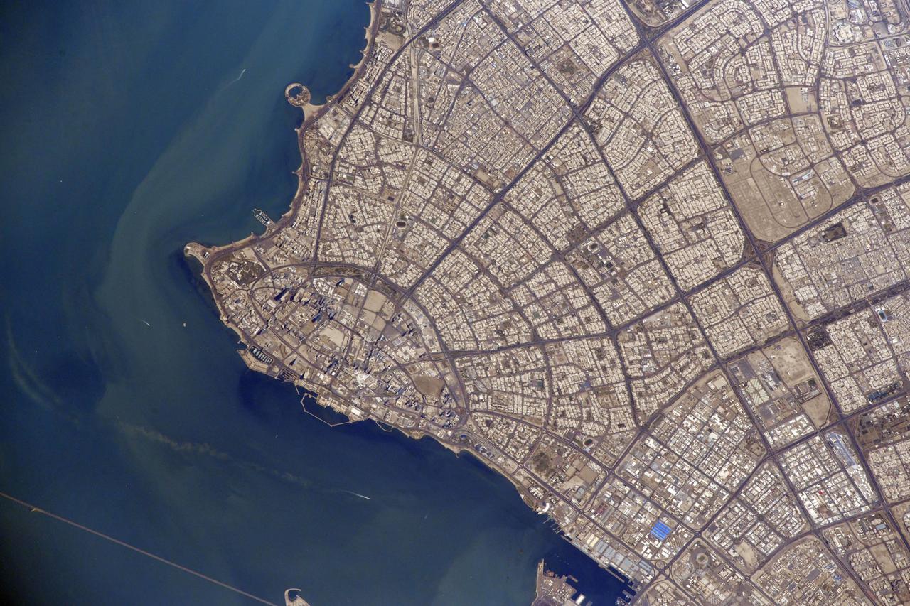
iss063e006714 (May 5, 2020) --- The well lit Persian Gulf coast of Saudi Arabia is pictured from the International Space Station during an orbital night pass.

Earth observation taken during a day pass by the Expedition 43 crew aboard the International Space Station (ISS). Folder lists this as Persian Gulf.
iss068e026585 (Dec. 4, 2022) --- The city lights of Doha, Qatar, are pictured on the coast of the Persian Gulf as the International Space Station orbited 258 miles above.
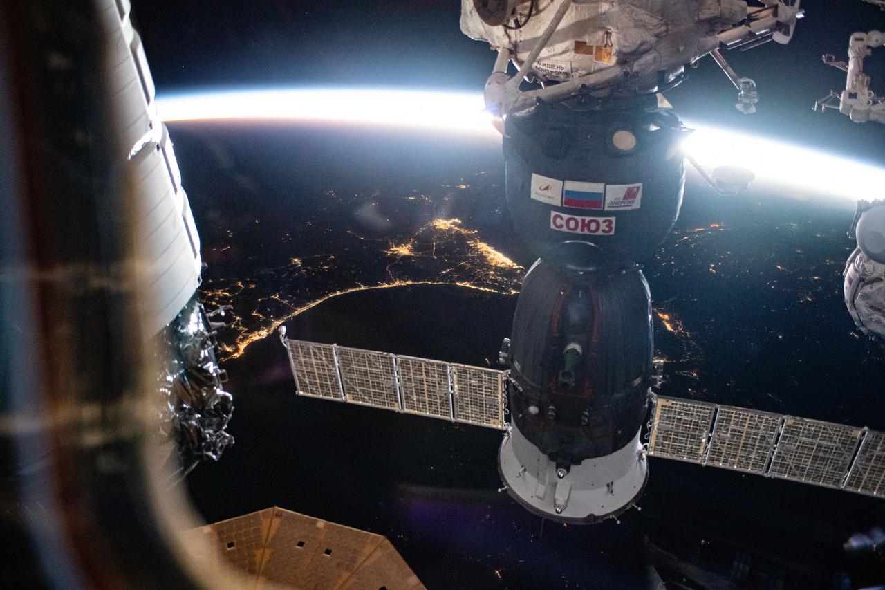
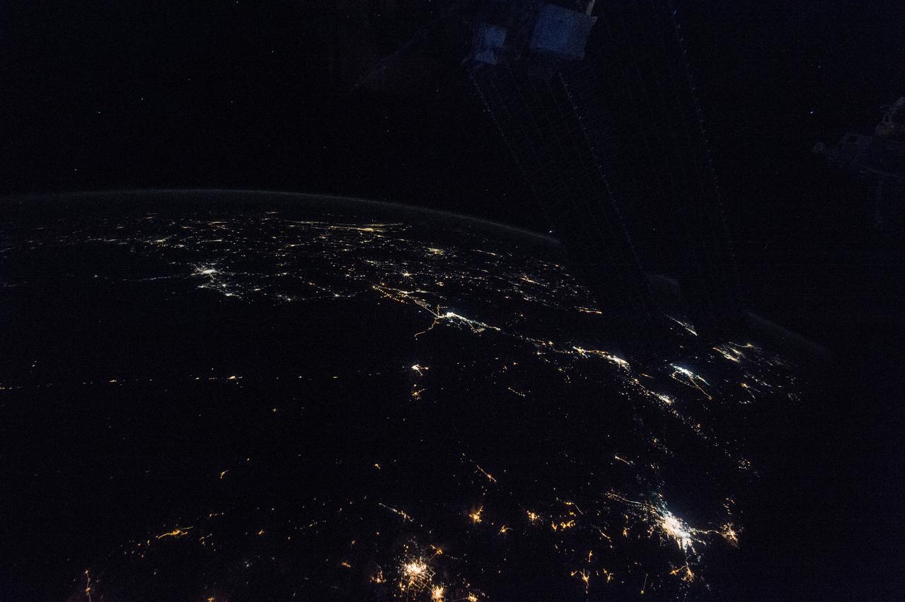
iss070e002199 (Oct. 4, 2023) --- The Soyuz MS-24 crew ship is featured prominently in this photograph from the International Space Station as it soared into an orbital sunrise 259 miles above the Iran-Pakistan border. The city lights below highlight the United Arab Emirates on the Persian Gulf and Oman on the Gulf of Oman.
iss067e270600 (Aug. 18, 2022) --- The Strait of Hormuz connects the Gulf of Oman (left) with the Persian Gulf (right). The waterway also separates the Middle Eastern nation of Iran (bottom) from the Arabian Peninsula nations of Oman, United Arab Emirates, and Qatar (top left to right).
iss064e007913 (Nov. 28, 2020) --- This image from International Space Station as it was flying 261 miles over Iran looks southeast across the Persian Gulf and the Gulf of Oman. The well-lit areas along the coast are cities located in the nations of Oman and the United Arab Emirates.

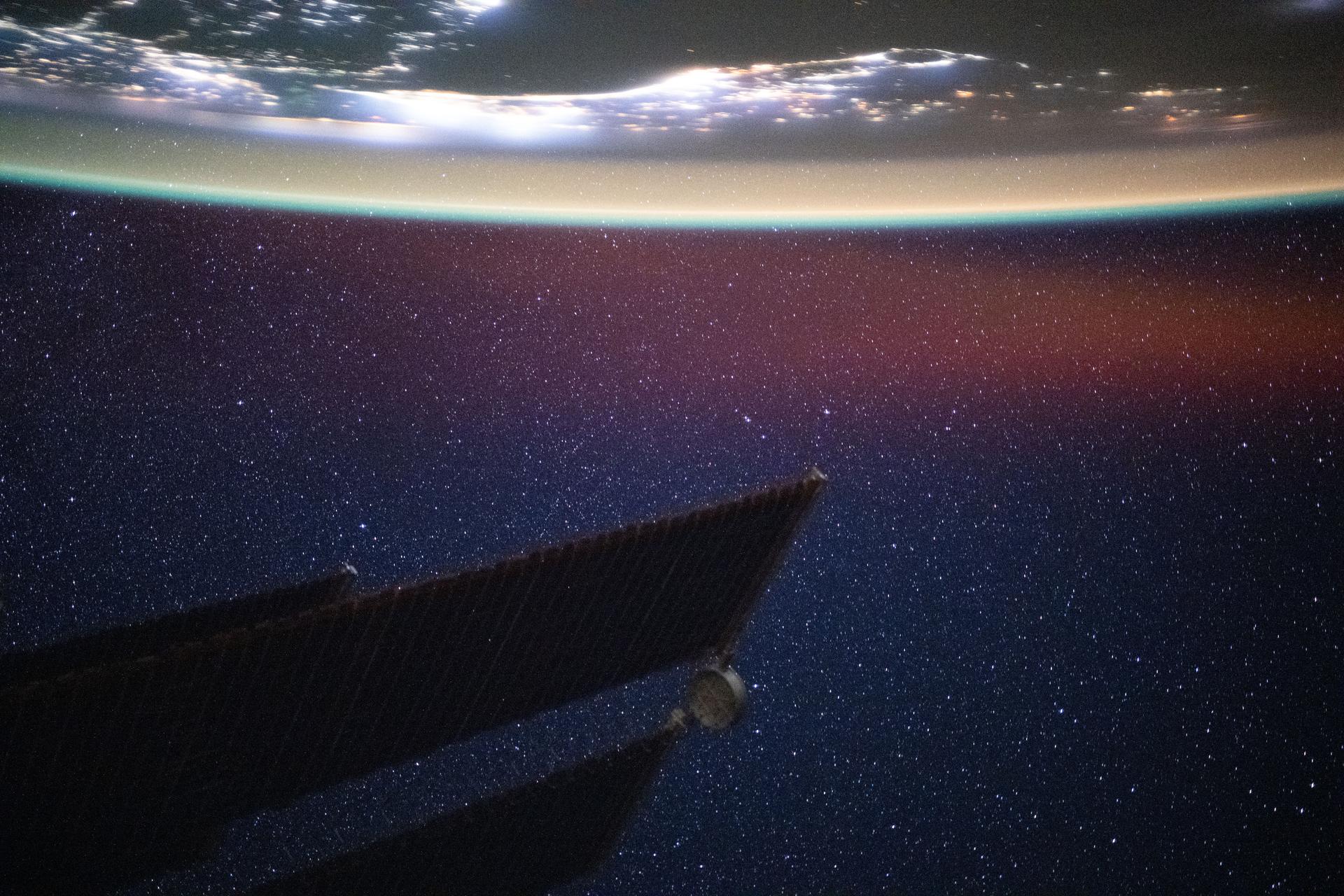
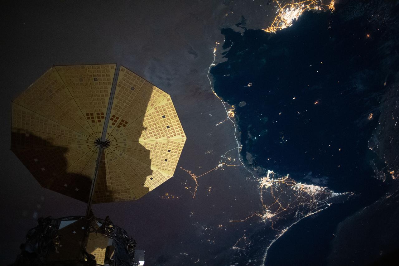
iss069e056918 (Aug. 14, 2023) --- The Strait of Hormuz (bottom left) connects the Gulf of Oman with the Persian Gulf in this photograph from the International Space Station as it orbited 262 miles above southwestern Iran. In the right foreground, is the Northrop Grumman Cygnus space freighter and one of its cymbal-shaped UltraFlex solar arrays.
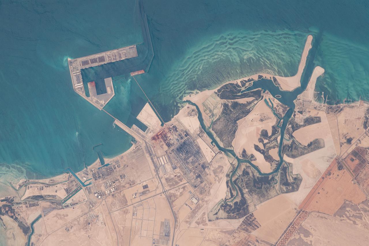
iss065e000773 (April 19, 2021) --- A manufacturing site on the Persian Gulf coast of the United Arab Emirates near Abu Dhabi is pictured from the International Space Station as it orbited 262 miles above.
iss068e024291 (Nov. 24, 2022) --- Qatar, the island Kingdom of Bahrain, and the eastern coast of Saudi Arabia on the Persian Gulf are pictured from the International Space Station as it orbited 258 miles above the Arabian Peninsula.
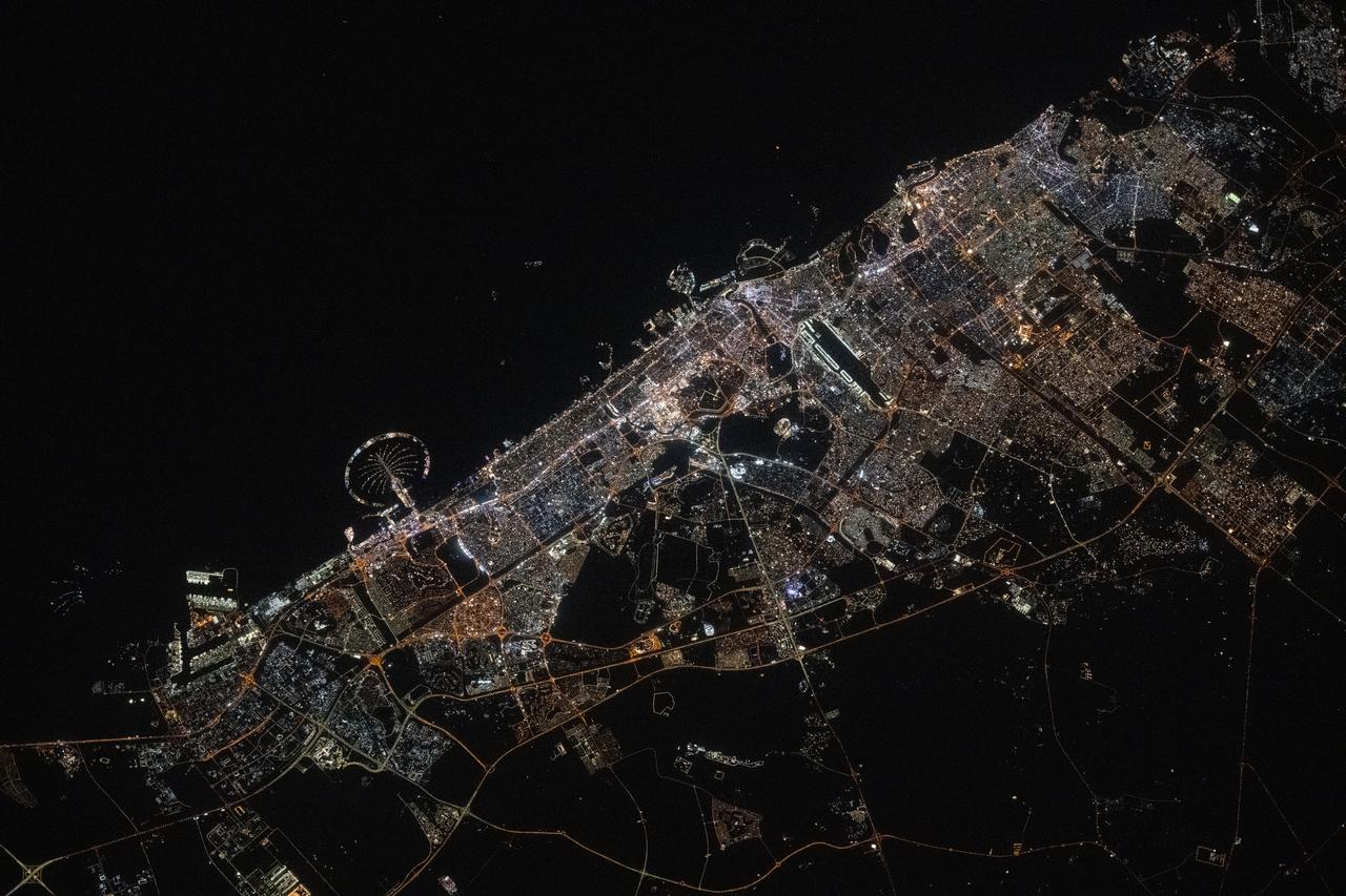
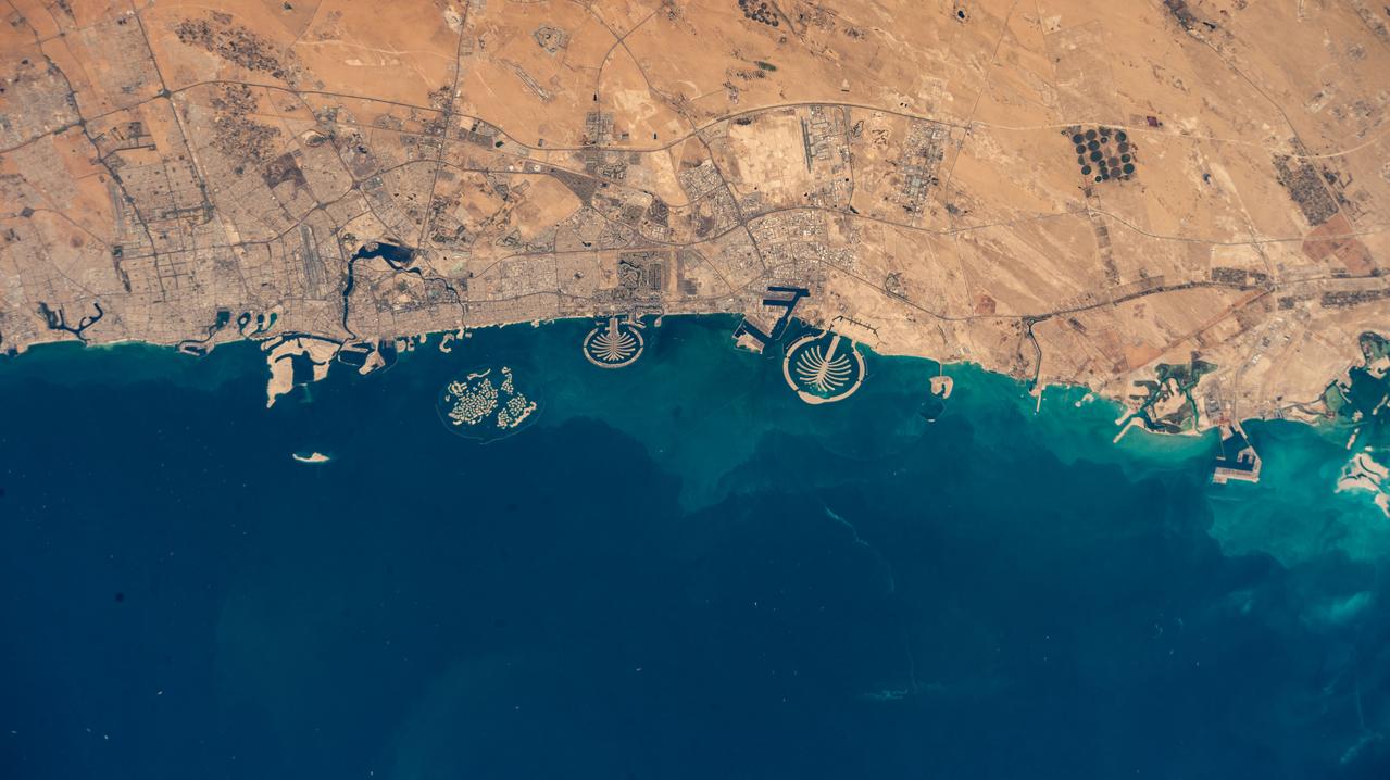
iss064e029032 (Feb. 4, 2021) --- The desert city of Dubai, on the Persian Gulf coast of the United Arab Emirates, is pictured from the International Space Station as it orbited 261 miles above.
iss067e284429 (Aug. 20, 2022) --- Kuwait City, on the south shore of Kuwait Bay on the Persian Gulf, is pictured from the International Space Station as it orbited 257 miles above western Iran.
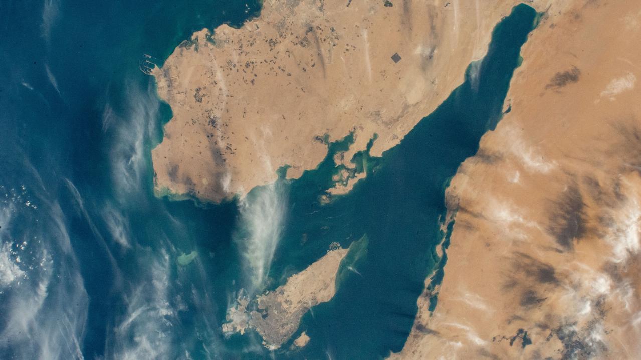
iss063e002679 (April 23, 2020) --- The northern tip of the Middle Eastern nation of Oman is pictured on the Strait of Hormuz. The International Space Station was orbiting above the Persian Gulf when this photograph was taken.
iss063e081362 (Aug. 31, 2020) --- The well-lit Middle Eastern cities along the Persian Gulf coast of the Arabian Peninsula to the north of Iran were photographed from the International Space Station during an orbital night pass.

iss065e000674 (April 19, 2021) --- The north coast of the island nation of Bahrain in the Persian Gulf is pictured from the International Space Station as it orbited 262 miles above western Iran.
iss069e071346 (Aug. 21, 2023) --- Abu Dhabi, the capital of the United Arab Emirates, is pictured from the International Space Station as it orbited 262 miles above the Persian Gulf.

iss064e039347 (Feb. 26, 2021) --- Petal 2 Beach, on the southern tip of the island nation of Bahrain, is pictured from the International Space Station as it orbited 261 miles above the Persian Gulf. Credit: Roscosmos
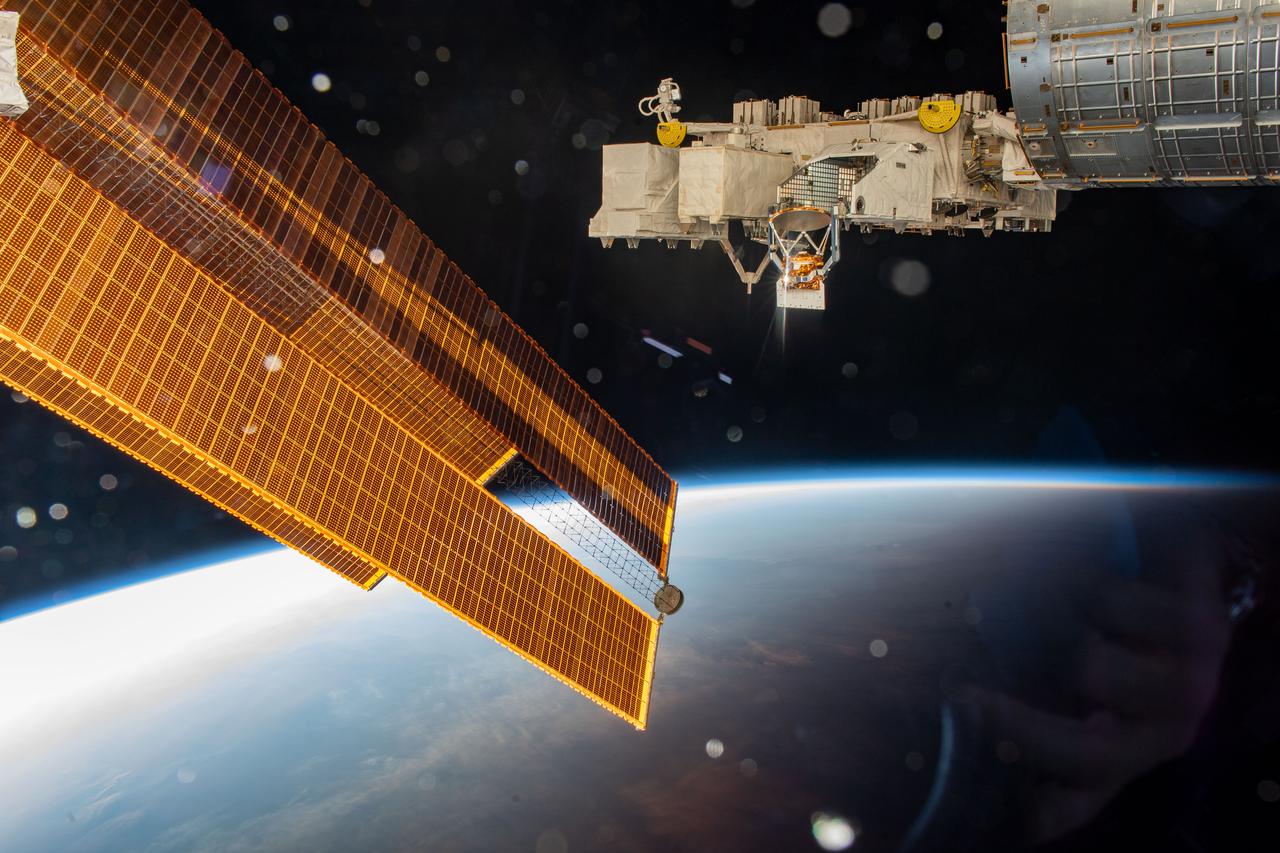
iss067e187085 (July 14, 2022) --- A pair of the International Space Station's main solar arrays (left) and the Kibo laboratory module's Exposed Facility (right) are pictured as the orbiting lab flew 258 miles above the Persian Gulf.

iss068e026591 (Dec. 4, 2022) --- The city lights of Dubai, United Arab Emirates, on the coast of the Persian Gulf are pictured from the International Space Station as it orbited 258 miles above.
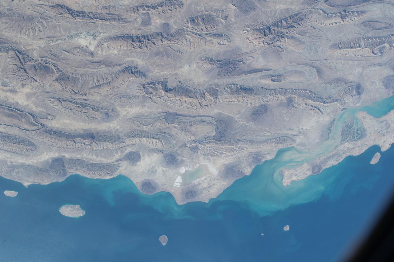
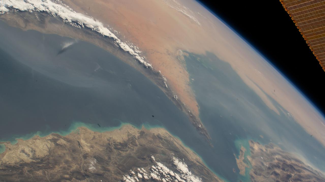
iss066e126129 (Jan. 26, 2022) --- The semi-desert, southern coast of Iran on the Persian Gulf is pictured from the International Space Station as it orbited 258 miles above the Middle Eastern nation.
iss064e039346 (Feb. 26, 2021) --- Kuwait City, population 4.1 million, on the south shore of Kuwait Bay is pictured from the International Space Station as it orbited 261 miles above the Persian Gulf. Credit: Roscosmos
iss063e081369 (Aug. 31, 2020) --- Photographed from the International Space Station at night, the well-lit United Arab Emirates (lower center) is situated at the northeast end of the Arabian Peninsula, with Qatar and Bahrain to the north on the coast of the Persian Gulf.
iss064e029028 (Feb. 2, 2021) --- The northern coast of the Persian Gulf, pictured from the International Space Station at an altitude of 262 miles, leads to the Middle Eastern nations of Kuwait, Iraq and Iran.
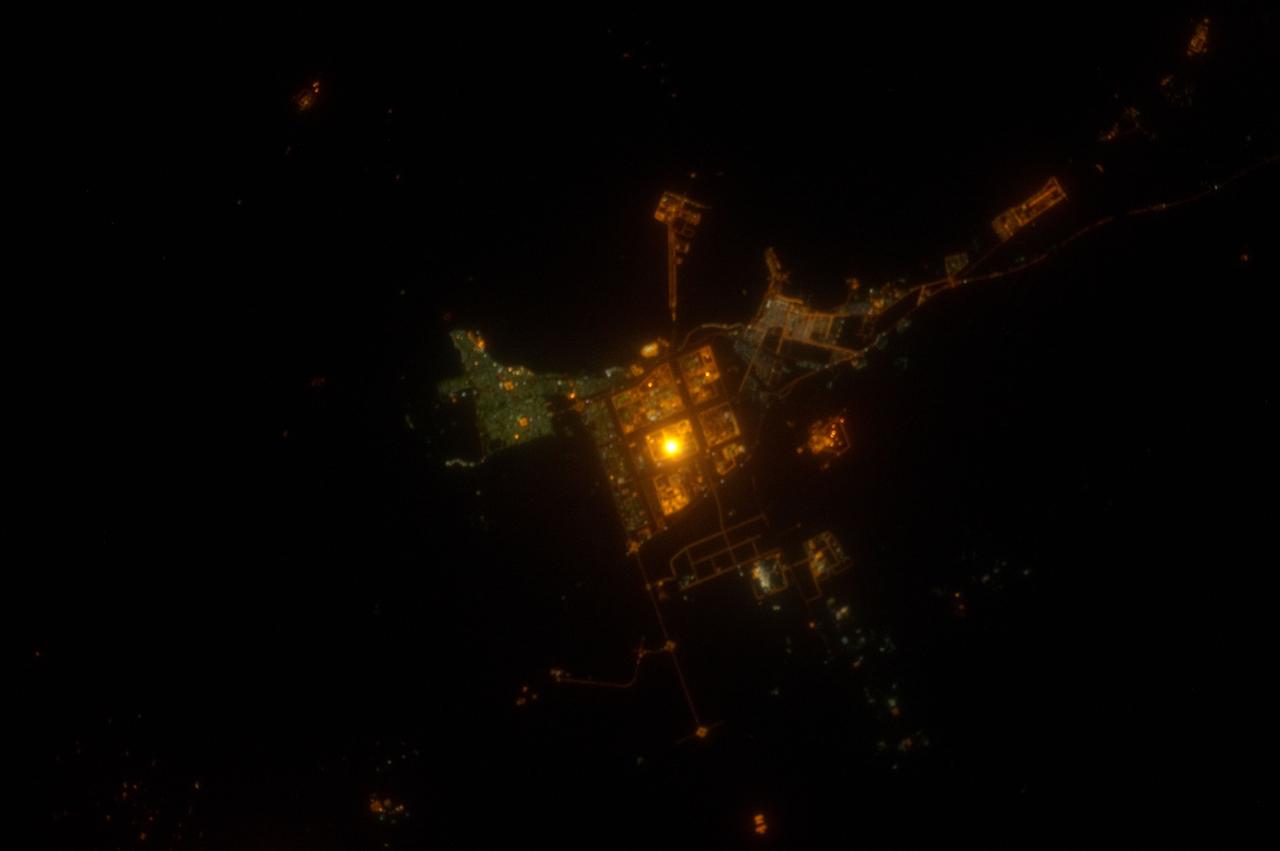
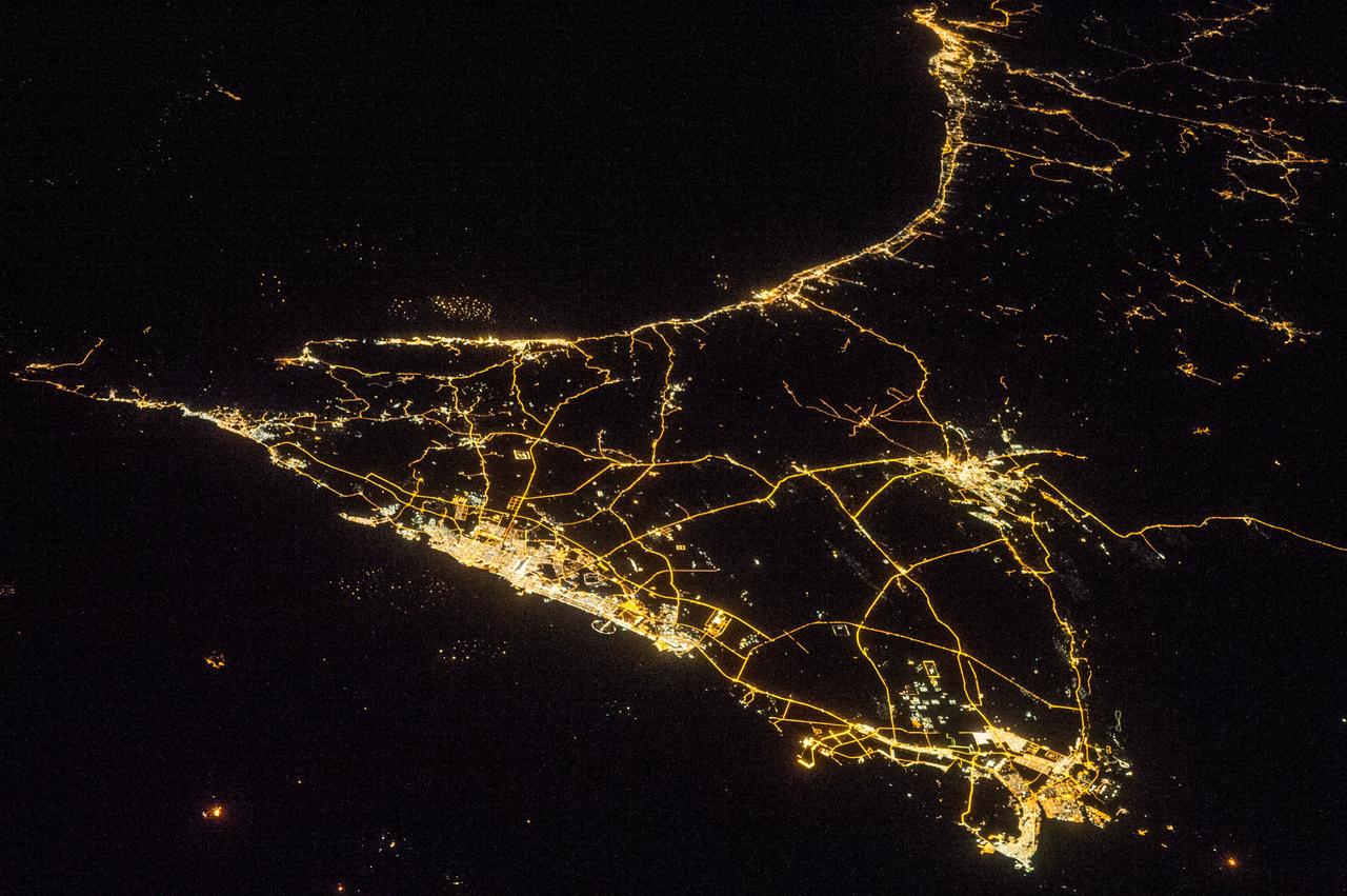
ISS031-E-143143 (19 June 2012) --- Al Jubayl, Saudi Arabia at night is featured in this image photographed by an Expedition 31 crew member on the International Space Station. The city of Al Jubayl (or Jubail) is located on the Saudi Arabian coastline of the Persian Gulf. The city has a history extending back more than 7,000 years, but since 1975 it has been associated with the heavy industries of petrochemical refining and production, fertilizer production and steel works. At night, these industrial areas form a brightly lit region (center) to the south of the residential and commercial center of Al Jubayl (characterized by green-gray lighting). An artificial peninsula extending into the Persian Gulf to the northeast hosts supertanker docks and petroleum storage facilities. The Persian Gulf to the north and northeast is devoid of lights; likewise, the open desert to the south-southeast provides a stark contrast to the well-lit urban and industrial areas. A bright circle of light located within the heavy industrial area (center) cannot be resolved in this photograph, but is likely a concentration of lights associated with ongoing processing or construction activities. The approximate scale of the feature ? hundreds of meters in diameter ? is consistent with multiple stationary light sources, particularly if the light from those sources is accentuated due to the camera?s low light settings.
iss072e574768 (Jan. 29, 2025) --- Dubai, United Arab Emirates, and its distinct artificial islands of Palm Jebel Ali, Palm Jumeirah, and The World Islands, on the coast of the Persian Gulf, are pictured from the International Space Station as it orbited 259 miles above.
iss072e447461 (Jan. 2, 2025) --- The well-lit island city and capital of United Arab Emirates, Abu Dhabi on the Persian Gulf with a population of about 1.57 million people, is pictured at approximately 10:03 p.m. local time from the International Space Station as it orbited 256 miles above.
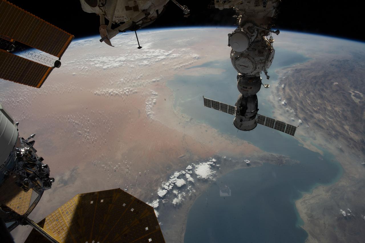
ISS030-E-035698 (30 Dec. 2011) --- This almost vertical scene of the Persian Gulf was photographed by one of the Expedition 30 crew members aboard the International Space Station on Dec. 30, 2011. A Russian spacecraft, docked to the orbital outpost, is seen at left edge of frame.
ISS008-E-12570 (22 January 2004) --- Backdropped by Earth’s horizon and the blackness of space, an unpiloted Progress supply vehicle docked to the International Space Station (ISS) was photographed by one of the Expedition 8 crewmembers. Parts of Iran, the United Arab Emirates, Oman, Strait of Hormuz and the Persian Gulf are also visible.
STS027-152-007 (2-6 Dec. 1988) --- Crew members for the STS-27 mission aboard the Earth-orbiting space shuttle Atlantis took this photo of part of the Persian Gulf, with a hand-held, large format camera. Photo credit: NASA
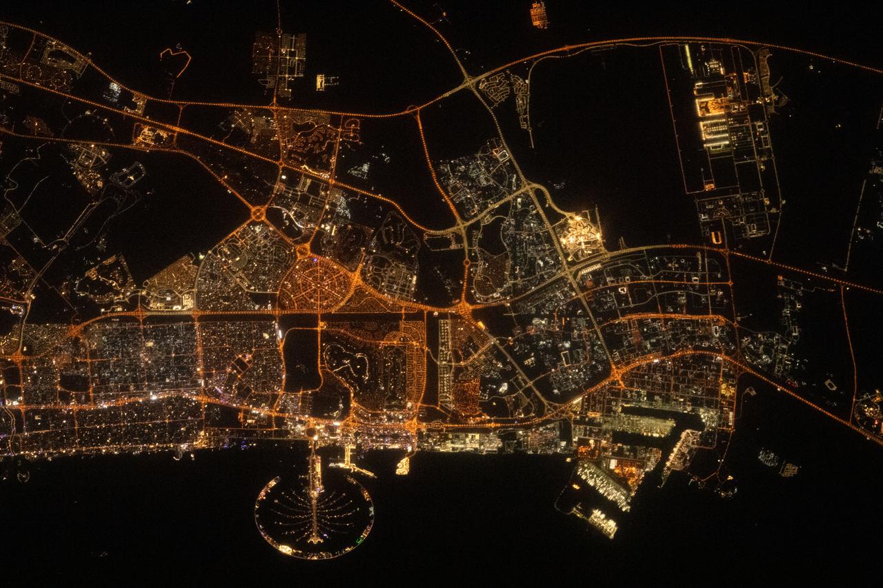
iss069e084252 (Aug. 26, 2023) --- Palm Jumeirah, the palm tree-shaped artificial island, is a highlight in the United Arab Emirates' city of Abu Dhabi in this nighttime photograph from the International Space Station as it orbited 258 miles above the Persian Gulf.
iss049e007067 (09/19/2016) --- Night views of the Earth from the International Space Station. This image is the southern Persian Gulf at night centered on Dubai and Abu Dhabi; east is at the top of the image with the coast of Iran to upper left and Muscat, Oman upper right.
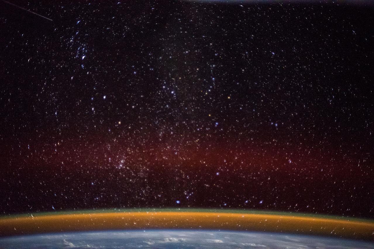
ISS042E037846 (12/13/2015) --- European Space Agency (ESA) Astronaut Samantha Cristoforetti on the International Space Station took this Earth observation picture of England, the Baltic area, and the Persian Gulf with a golden aurora on Dec. 15, 2014. Samantha is a flight engineer with Expedition 42.
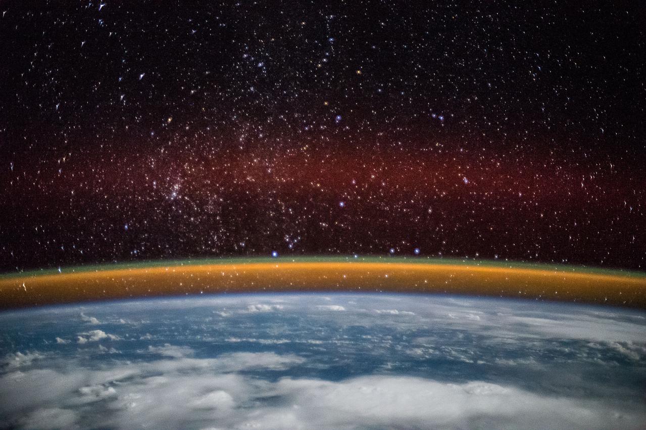
ISS042E037847 (12/15/2014) ---ESA (European Space Agency) astronaut Samantha Cristoforetti captured this image while on the International Space Station. It shows cloud cover over England, Baltic Sea and the Persian Gulf. It also displays a golden aurora with a splash of red through the stars during the night of Dec. 15, 2014.
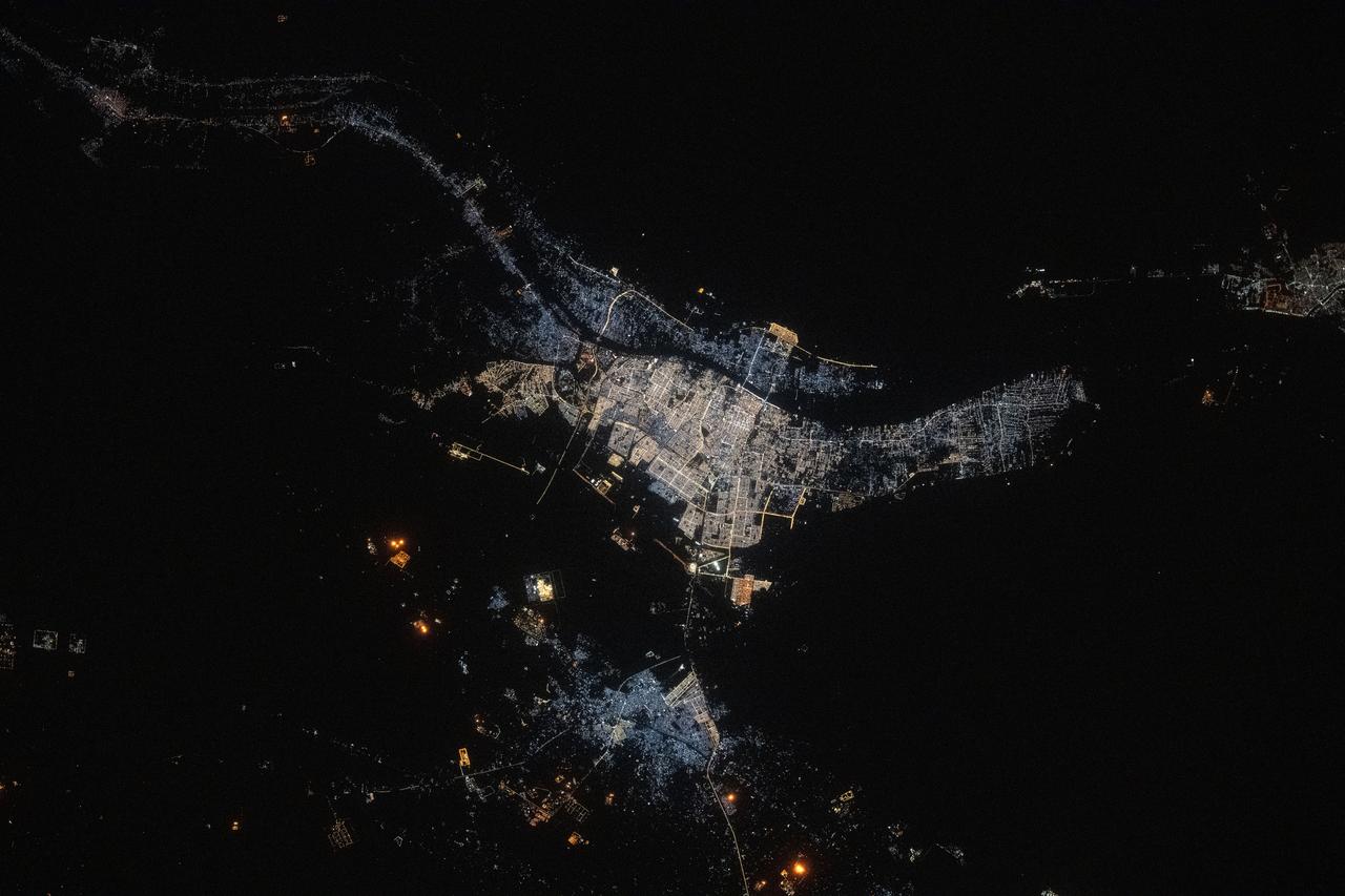
iss073e0134545 (May 22, 2025) --- The port city of Basrah, Iraq, with a population of about 1.49 million near the Persian Gulf and split by the Shatt Al Arab river, is pictured at approximately 10:42 p.m. local time from the International Space Station as it orbited 260 miles above the Middle East.
iss073e0134562 (May 22, 2025) --- The port city of Dammam, Saudi Arabia, with a population of about 1.38 million on the Persian Gulf coast, is pictured at approximately 10:43 p.m. local time from the International Space Station as it orbited 259 miles above the Middle East.
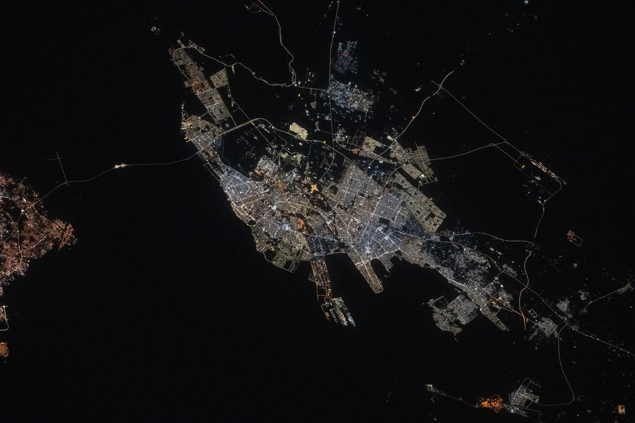
iss073e0134580 (May 22, 2025) --- Abu Dhabi, the capital and second most populous city in the United Arab Emirates with a population of about 1.57 million on the Persian Gulf, is pictured at approximately 10:44 p.m. local time from the International Space Station as it orbited 259 miles above the Middle East.
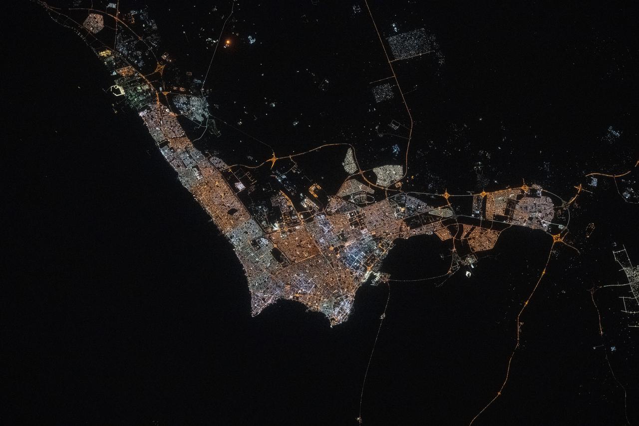
iss073e0134550 (May 22, 2025) --- Kuwait City, with a population of about 3.5 million and where the majority of Kuwait's citizens reside on the Persian Gulf coast, is pictured at approximately 10:42 p.m. local time from the International Space Station as it orbited 259 miles above the Middle East.
iss063e006708 (May 5, 2020) --- The city lights of Jazan (top center) and its suburbs on the Persian Gulf coast of Saudi Arabia are easily visible from the International Space Station during an orbital night pass. Just off the coast of Jazan is the Farason Island Marine Sanctuary.
iss063e081357 (Aug. 31, 2020) --- Photographed from the International Space Station at night, the well-lit United Arab Emirates (center right) is situated at the northeast end of the Arabian Peninsula in the southern Persian Gulf, with Qatar and Bahrain (far right) to the north.
ISS008-E-16355 (15 February 2004) --- A massive sandstorm over the Persian Gulf state of Qatar blows southward toward southeastern Saudi Arabia and the United Arab Emirates in this image photographed by an Expedition 8 crewmember onboard the International Space Station (ISS).
iss073e0003324 (April 30, 2025) --- (From top to bottom) The United Arab Emirates' two most populous cities of Dubai and Abu Dhabi with a combined population of nearly 5.8 million, along with the artificial Palm Islands and the World Islands, on the coast of the Persian Gulf are pictured from the International Space Station as it orbited 260 miles above.
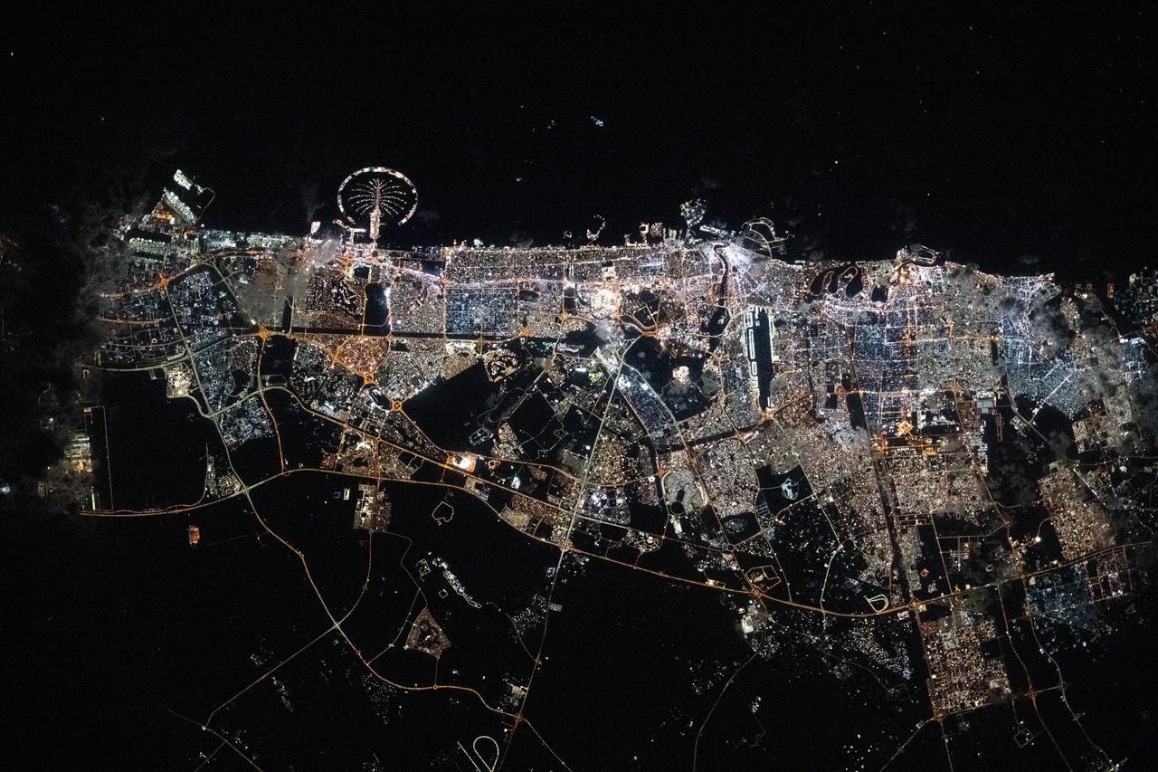
iss072e447465 (Jan. 2, 2025) --- United Arab Emirates' most populous and well-lit city of Dubai, with its famous artificial island Palm Jumeirah, is pictured at approximately 10:03 p.m. local time from the International Space Station as it orbited 256 miles above the Persian Gulf.
iss069e056939 (Aug. 14, 2023) --- The Strait of Hormuz connects the Gulf of Oman with the Persian Gulf in this photograph from the International Space Station as it orbited 262 miles above. In the right foreground, is the Soyuz MS-23 crew ship docked to the Prichal docking module. At bottom left, is a portion of the Northrop Grumman Cygnus space freighter and one of its cymbal-shaped UltraFlex solar arrays.

STS080-733-021 (19 Nov.-7 Dec. 1996) --- The crewmembers of the Earth-orbiting space shuttle Columbia took this view that shows Kuwait City (mid-center right and along the coastal area), most of Kuwait, portions of Saudi Arabia, and Iraq. Faylakah Awhah Island is seen in the Persian Gulf to the bottom right. Most of the darkened areas represent the residual from oil well fires during the Gulf War of the early 1990?s.
S66-63486 (13 Nov. 1966) --- Iran, Trucial Coast, Oman, Zagros Mountains, and Qishm Island (large island at lower right), as seen from the Gemini-12 spacecraft during its 25th revolution of Earth. Gulf of Oman is large body of water at left and the Persian Gulf is body of water at right. View is looking east. Photo credit: NASA

S66-63485 (13 Nov. 1966) --- Iran, Trucial Coast, Oman, Zagros Mountains, and Qishm Island (large island at lower left), as seen from the Gemini-12 spacecraft during its 25th revolution of Earth. Gulf of Oman is at lower left edge and the Persian Gulf is large body of water in upper half of photo. Photo credit: NASA
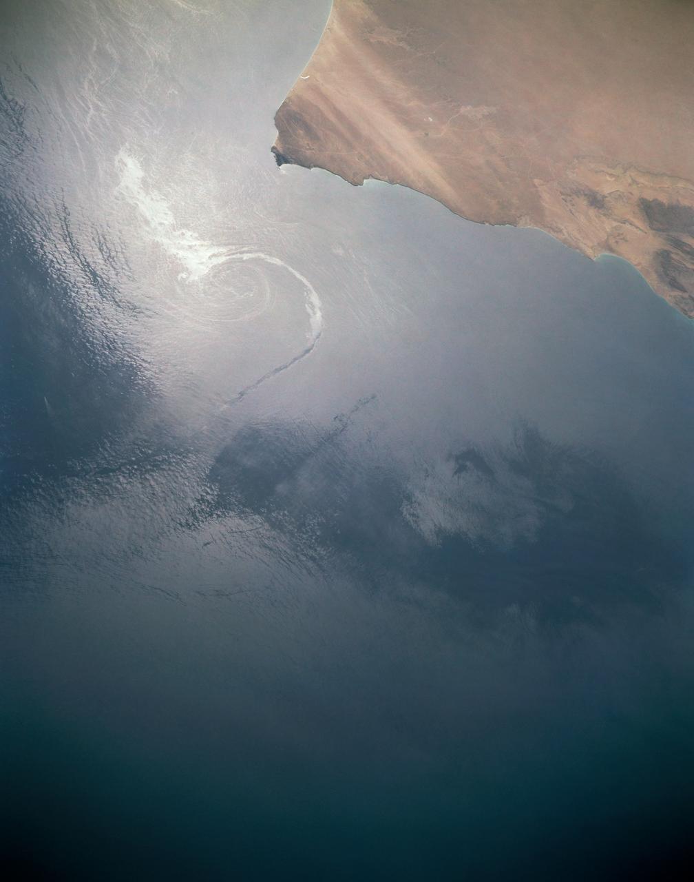
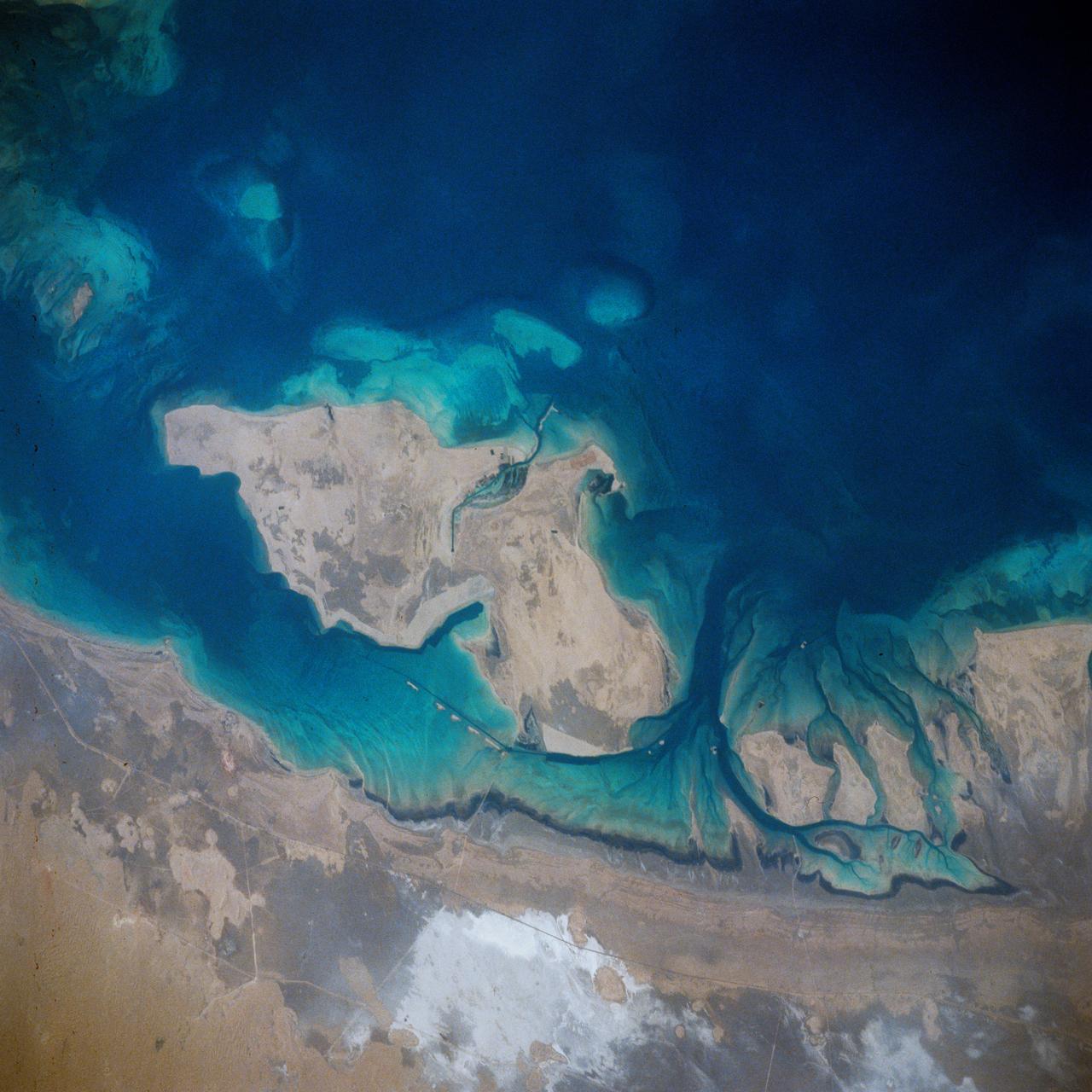
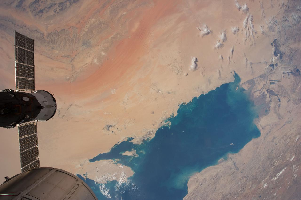
In this sunglint view of the Arabian Seacoast of Oman (19.0N, 59.0E) an oil slick is highlighted on the water's surface by sunglint lighting conditions. Nearly 50 percent of the oil transported worldwide passes through the Gulf of Oman, en route from the Persian Gulf and numerous ship wakes can be seen in this view. The oil slick, rounding the tip of Cape Ras Al Hadd, has formed a counterclockwise bright spiral indicating the local ocean currents.
iss072e519924 (Jan. 23, 2025) --- The city lights of Doha, Qatar, the Middle Eastern nation's capital with a population of about 1.2 million, are pictured at approximately 9:51 p.m. local time from the International Space Station as it orbited 258 miles above. Some prominent landmarks include the Shahaniyah Camel Race Track (top right), Hamad International Airport, and the artificial Pearl Island (both at center and on the Persian Gulf Coast).
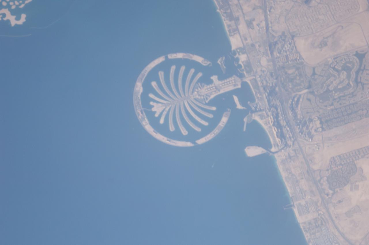
ISS040-E-125332 (4 Sept. 2014) --- Palm Jumeirah, protruding off the Persian Gulf Coast of Dubai in the United Arab Emirates, is featured in this 800mm photograph, taken by one of the Expedition 40 crew members aboard the International Space Station. The municipality of Dubai is the largest city of the Persian Gulf emirate of the same name, and has built a global reputation for large-scale developments and architectural works. Among the most visible of these developments ? particularly from the perspective of crew members onboard the space station ? are three man-made archipelagos. The two Palm Islands (Palm Jumeirah and Palm Jebel Ali, which is not in this frame) appear as stylized palm trees when viewed from above. The World Islands evoke a rough map of the world from an air- or space-borne perspective. A very small part of the World Islands is seen in upper left corner.
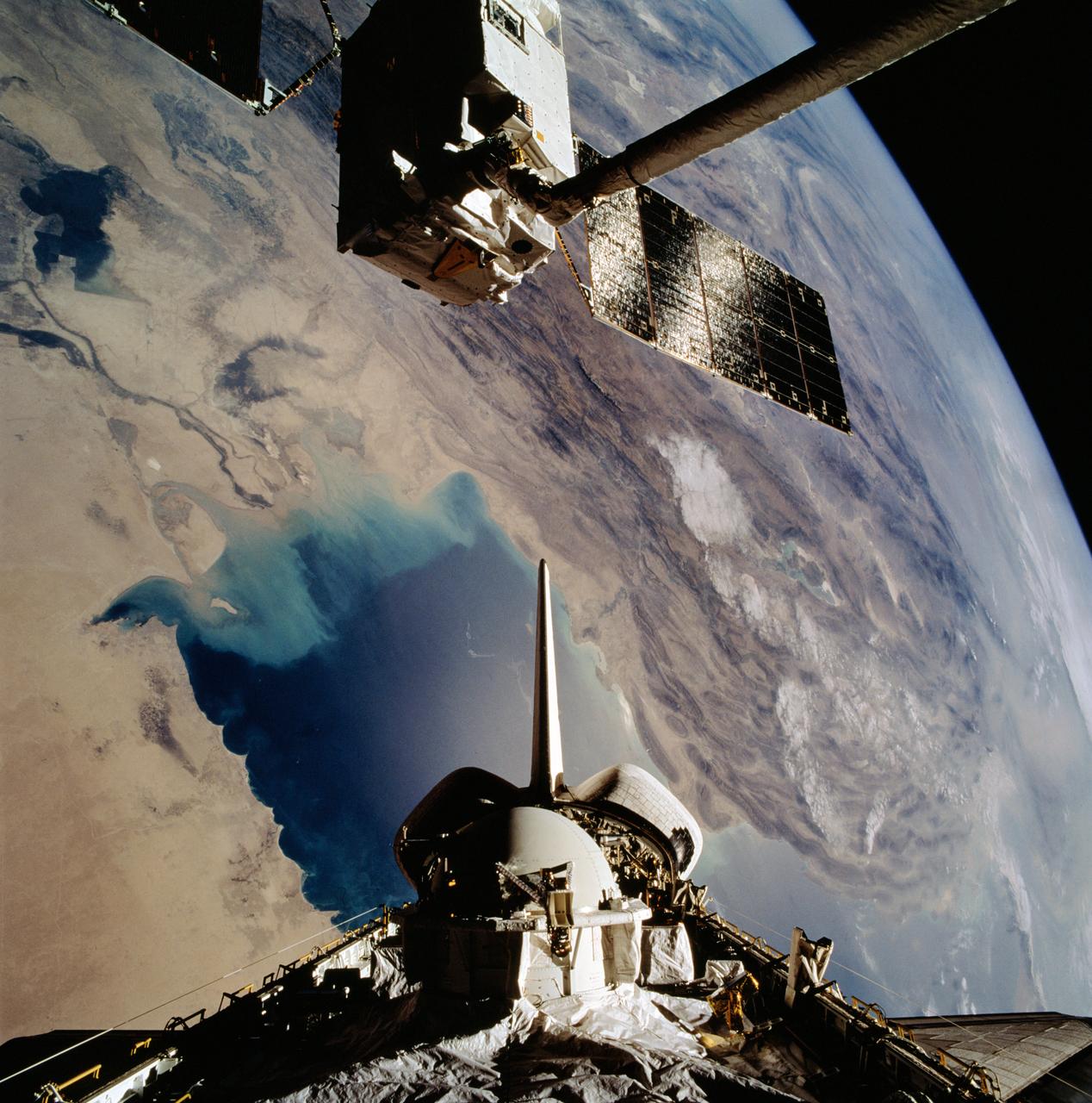
STS046-102-021 (1 Aug 1992) --- The European Space Agency's (ESA) EURECA satellite remains in the grasp of the Space Shuttle Atlantis' Remote Manipulator System (RMS) as the Space Shuttle passes over the Persian Gulf. Most of the theater of the recent war is visible in the frame. Parts of Kuwait, Iraq, Iran and Saudi Arabia can be delineated. The Tethered Satellite System (TSS) remains stowed in the aft cargo bay of Atlantis.
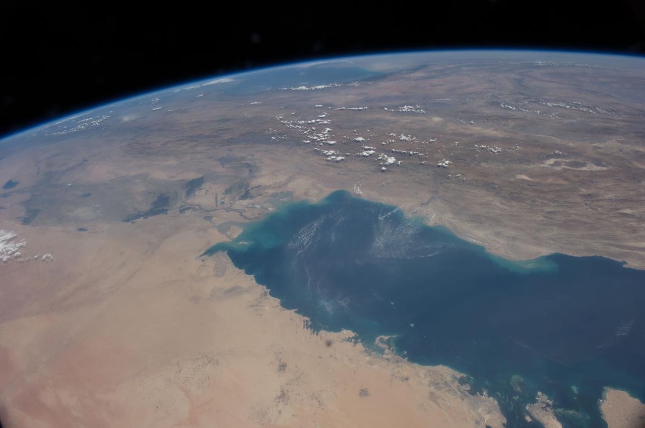
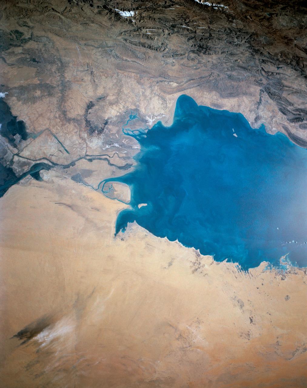
ISS040-E-106243 (25 Aug. 2014) --- This panorama view, photographed by an Expedition 40 crew member on the International Space Station, shows the tropical blue waters of the Persian Gulf. Strong north winds often blow in summer, churning up dust from the entire length of the desert surfaces of the Tigris and Euphrates valleys (top left). Dust partly obscures the hundreds of kilometers of Iraq?s light-green agricultural lands along these rivers (left). The Caspian Sea cuts the horizon.
This view of the northern Persian Gulf shows Kuwait City and the Tigris and Euphrates River Deltas (29.5N, 48.5E). The oil laden sands and oil lakes of the Kuwait Oil Fields to the north and south of the city are clearly visible as dark patches surrounded by oil free desert sands. Comparison with earlier photos indicate that the oil laden sands are slowly being covered with clean sand carried by strong NW winds called Shmals.
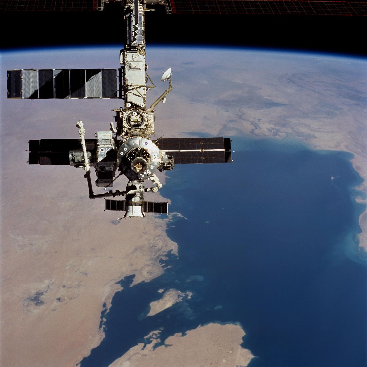
STS104-723-014 (21 July 2001) --- Backdropped over a wide scene of topography in the Middle East, the International Space Station (ISS) passes over the Persian Gulf. The photograph was taken with a 70mm handheld camera during a fly-around inspection by the Space Shuttle Atlantis not long after the two spacecraft separated. Prominent on the starboard side of the outpost is the newly-installed Quest airlock.
STS027-152-004 (2-6 Dec. 1988) --- Crew members for the STS-27 mission aboard the Earth-orbiting space shuttle Atlantis took this photo of the south Persian Gulf. with a hand-held, large format camera. The mouths of both the Tigris and Euphrates Rivers can be seen, as can nearly all the country of Kuwait. Photo credit: NASA
iss067e169965 (July 1, 2022) --- The Khawr az-Zubayr Waterway (at bottom) separates the Middle Eastern nations of Kuwait and Iraq on the Persian Gulf coast. At top left, is the desert town of Abdali, Kuwait. At right, is the fertile, agricultural town of Abu Al-Khaseeb, Iraq. The International Space Station was orbiting 262 miles above Saudi Arabia near the island nation of Bahrain at the time this photograph was taken.
iss059e078929 (May 29, 2019) --- The artificial islands off the coast of Dubai in the United Arab Emirates are known as (from left) The World Islands, Palm Jumeirah and Palm Jebel Ali. The International Space Station was orbiting 255 miles above Saudi Arabia about to cross the Persian Gulf when this photograph was taken by an Expedition 59 crewmember.
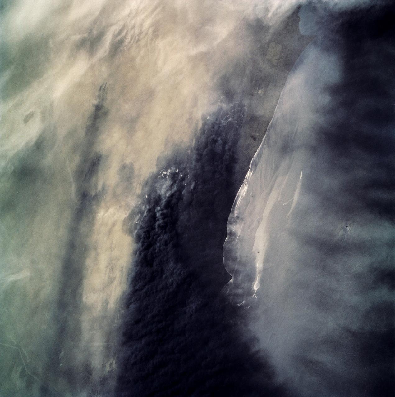
ISS008-E-18935 (24 March 2004) --- This photo of a large black smoke plume from an oil fire was taken by an Expedition 8 crewmember on the International Space Station as the Station orbited northeastward across Saudi Arabia. According to a front-page story in the New York Times, an oil pipeline near the channel of Shatt al Arab in southeastern Iraq on the Persian Gulf ruptured the day before. The resulting oil spill ignited and its smoke can here be seen to extend over 100 miles northwestward into southern Iraq.
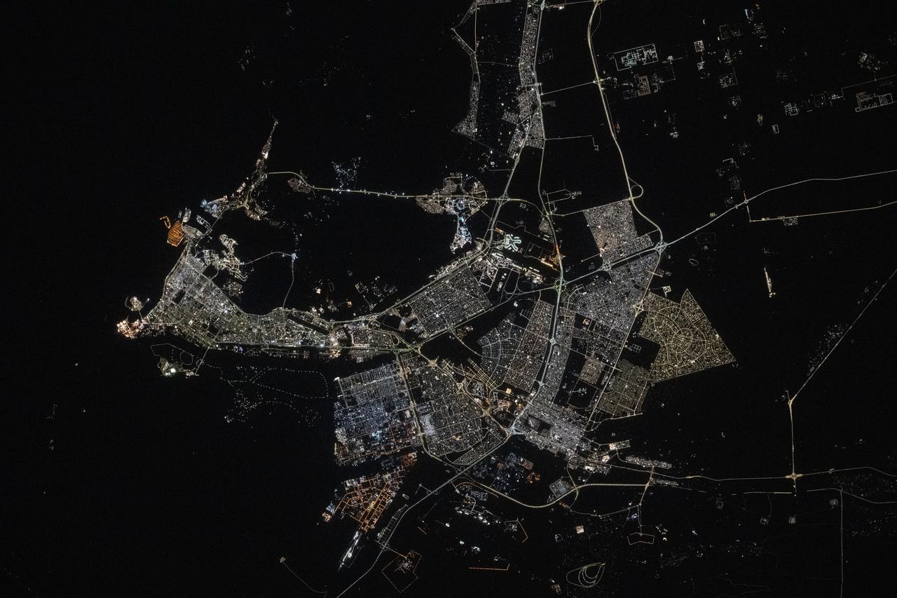
iss073e0134569 (May 22, 2025) --- Doha, the capital and largest city of Qatar with a population of about 1.9 million, is pictured at approximatelt 10:44 p.m. local time from the International Space Station as it orbited 259 miles above the Persian Gulf. Landmarks include Hamad International Airport (center left) and the artificial Pearl Island (lower center).
iss063e006718 (May 5, 2020) --- This nighttime image from the International Space Station shows the Persian Gulf city of Doha, Qatar (top right) and the United Arab Emirates cities (bottom right) of Abu Dhabi, Dubai and Ali Ain. In the foreground, is one of the cymbal-shaped UltraFLex solar arrays that powers the Cygnus space freighter from Northrop Grumman.
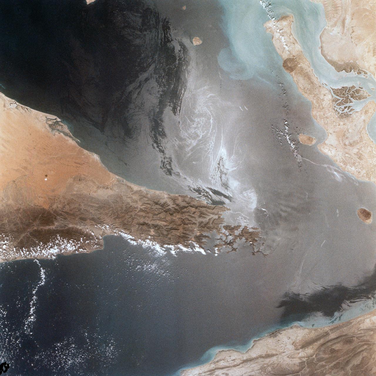
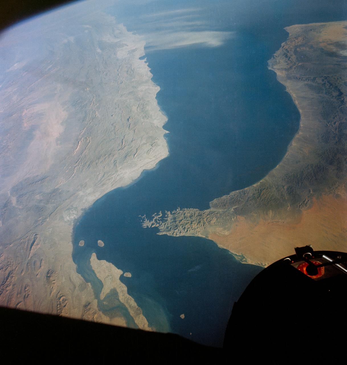
Portions of Oman, The United Arab Emirates and Iran are seen at the Strait of Hormuz (26.0N, 56.0E) in this view. A number of ship wakes can be seen in the area of the strait. Sunglint in the Persian Gulf to the northwest, accentuates the complex currents and oil slicks, seen as dark toned blue streaks on the surface. Qeshm Island, just off the coast of Iran, can be seen on the edge of the photo.
STS039-87-012 (28 April-6 May 1991) --- A handheld 70mm camera onboard the Space Shuttle Discovery exposed this infrared frame showing oil fires near the Kuwait coast as well as south-bound oil slicks in the Gulf. Pools of oil on the land are recognized as white objects near the burning wells.
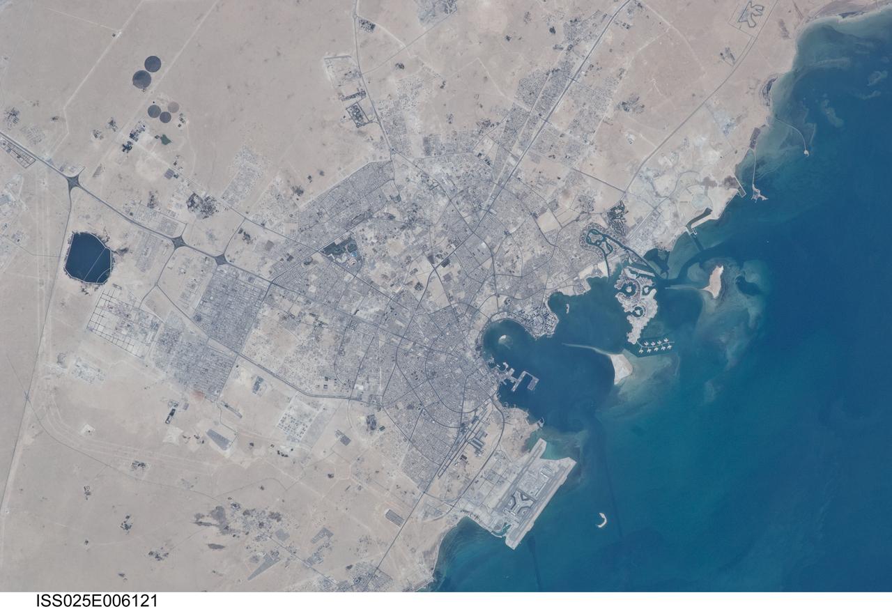
ISS025-E-006121 (5 Oct. 2010) --- Doha City, Doha Bay, State of Qatar and the Persian Gulf are featured in this image photographed by an Expedition 25 crew member on the International Space Station. The old and new zones of Doha, the capital city of the Persian Gulf state of Qatar, are visible in this photograph. The old city comprises the ancient bazaar, or Souq, near the dhow harbor (a dhow is a traditional Arab sailing vessel) which is still used today. Subsequent developments have taken place progressively further from the ancient center, with successive ring roads concentrically arranged around it. Modern port facilities can be seen immediately to the east of the Souq. The diplomatic quarter is reached via the Corniche promenade north of the old city. Yet further away an extensive marina complex known as West Bay Lagoon, with boating access to the Persian Gulf, stands out. Qatar’s new artificial island, known as the Pearl-Qatar, is under construction with 32 kilometers of new coastline, just offshore of West Bay Lagoon. This vast development is intended mainly as a residential zone with themes based on Arabic, Mediterranean and European cultures. The Pearl-Qatar complex is named for the fact that the new island is being built on one of Qatar’s major historical pearl diving sites. A string of small islands built along the outer margin of the complex is intended to recall the pearl-diving culture of the nation’s past.
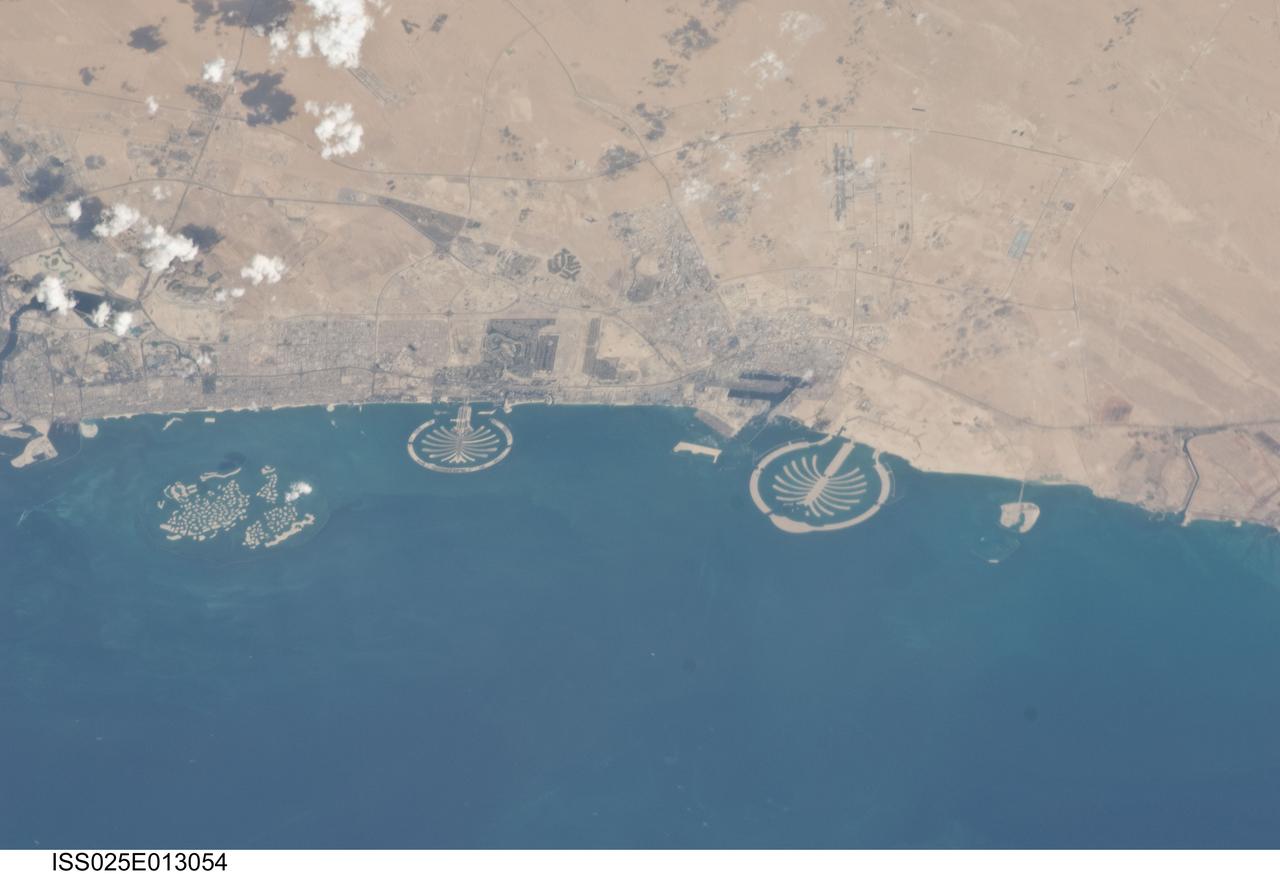
ISS025-E-013054 (7 Nov. 2010) --- Man-made archipelagos near Dubai, United Arab Emirates, are featured in this image photographed by an Expedition 25 crew member on the International Space Station, flying at 220 miles above Earth. The municipality of Dubai is the largest city of the Persian Gulf emirate of the same name, and has built a global reputation for large-scale developments and architectural works. Among the most visible of these developments -- particularly from the perspective of astronauts onboard the ISS -- are three man-made archipelagos. The two Palm Islands -- Palm Jumeirah to the left of center, and Palm Jebel Ali, just to the right of center, appear as stylized palm trees when viewed from above. The World Islands (near left edge) evoke a rough map of the world from an air- or space-borne perspective. The Palm Jumeirah project began in 2001 and required more than 50 million cubic meters of dredged sand to raise the islands above the Persian Gulf sea level. Construction of the Palm Jumeirah islands was completed in 2006; they are now being developed for residential and commercial housing and infrastructure. Creation of the World Islands was begun in 2003 and completed in 2008, using 320 million cubic meters of sand and 37 million tons of rock for the surrounding 27 kilometer-long protective breakwater.
ISS039-E-011515 (13 April 2014) --- Man-made archipelagos near Dubai, United Arab Emirates, are featured in this image photographed by an Expedition 39 crew member on the International Space Station, flying at 220 miles above Earth. The municipality of Dubai is the largest city of the Persian Gulf emirate of the same name, and has built a global reputation for large-scale developments and architectural works. Among the most visible of these developments -- particularly from the perspective of astronauts onboard the ISS -- are three man-made archipelagos. The two Palm Islands -- Palm Jumeirah to the left of center, and Palm Jebel Ali, just to the right of center, appear as stylized palm trees when viewed from above. The World Islands (near left edge) evoke a rough map of the world from an air- or space-borne perspective. The Palm Jumeirah project began in 2001 and required more than 50 million cubic meters of dredged sand to raise the islands above the Persian Gulf sea level. Construction of the Palm Jumeirah islands was completed in 2006; they are now being developed for residential and commercial housing and infrastructure. Creation of the World Islands was begun in 2003 and completed in 2008, using 320 million cubic meters of sand and 37 million tons of rock for the surrounding 27 kilometer-long protective breakwater.
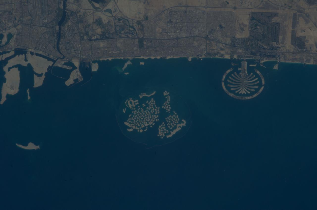
ISS037-E-011470 (14 Oct. 2013) --- Man-made archipelagos near Dubai, United Arab Emirates, are featured in this image photographed by an Expedition 37 crew member on the International Space Station, flying at approximately 220 miles above Earth. The municipality of Dubai is the largest city of the Persian Gulf emirate of the same name, and has built a global reputation for large-scale developments and architectural works. Among the most visible of these developments -- particularly from the perspective of astronauts onboard the space station -- are three man-made archipelagos. The two Palm Islands -- Palm Jumeirah (right) and Palm Jebel Ali (out of frame further to the right) -- appear as stylized palm trees when viewed from above. The World Islands (center frame) evoke a rough map of the world from an air- or space-borne perspective. The Palm Jumeirah project began in 2001 and required more than 50 million cubic meters of dredged sand to raise the islands above the Persian Gulf sea level. Construction of the Palm Jumeirah islands was completed in 2006; for several years now they have been developed for residential and commercial housing and infrastructure. Creation of the World Islands was begun in 2003 and completed in 2008, using 320 million cubic meters of sand and 37 million tons of rock for the surrounding 27 kilometer-long protective breakwater.
ISS032-E-017635 (9 Aug. 2012) --- A nighttime view of Kuwait City is featured in this image photographed by an Expedition 32 crew member on the International Space Station. Seen at night Kuwait City, the capital of the small Persian Gulf state of Kuwait, contrasts dramatically with the dark surface of the Persian Gulf (top) and the very sparsely populated desert area (bottom). Night views also show at a glance some aspects of urban geography that are difficult to perceive in daylight images. Here the focus of radial traffic arteries and ?ring roads? guide the eye to the financial center of the city?on the cape extending into Kuwait Bay north of the First Ring Road. The numbering of the ring roads shows the progressive southward development of the city, towards the Seventh Ring Road which still lies outside the built-up area at lower right. The striking differences in color of city lighting also provide information on the urban geography. Areas with lighting of a green tinge are, in each case, newer residential districts. The town of Al Ahmadi (lower right), known for its verdant vegetation, was built in 1946 when oil was struck and stands out with its characteristic blue night lights. Kuwait International Airport, like most major airports around the globe, is particularly bright due to the high concentration of lights.
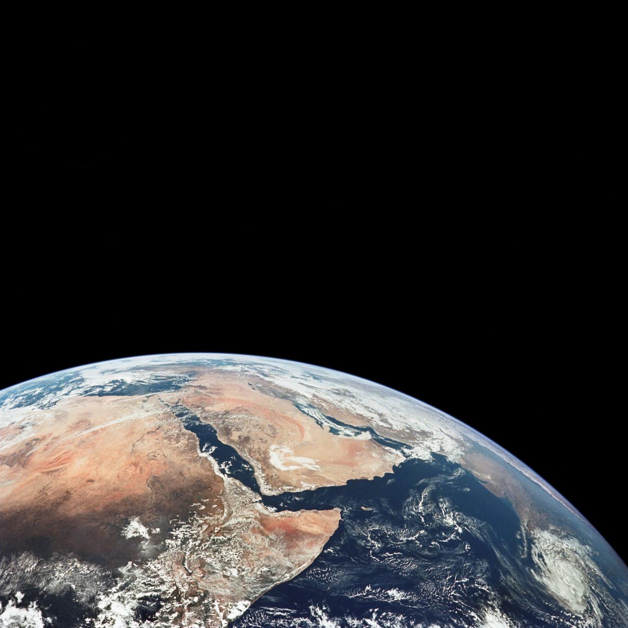
AS17-148-22718 (7-19 Dec. 1972) --- This excellent view of Saudi Arabia and the north eastern portion of the African continent was photographed by the Apollo 17 astronauts with a hand-held camera on their trans-lunar coast toward man's last lunar visit. Egypt, Sudan, Ethiopia are some of the African nations are visible. Iran, Iraq, Jordan are not so clearly visible because of cloud cover and their particular location in the picture. India is dimly visible at right of frame. The Red Sea is seen entirely in this one single frame, a rare occurrence in Apollo photography or any photography taken from manned spacecraft. The Gulf of Suez, the Dead Sea, Gulf of Aden, Persian Gulf and Gulf of Oman are also visible. This frame is one of 169 frames on film magazine NN carried aboard Apollo 17, all of which are SO368 (color) film. A 250mm lens on a 70mm Hasselblad camera recorded the image, one of 92 taken during the trans-lunar coast. Note AS17-148-22727 (also magazine NN) for an excellent full Earth picture showing the entire African continent.
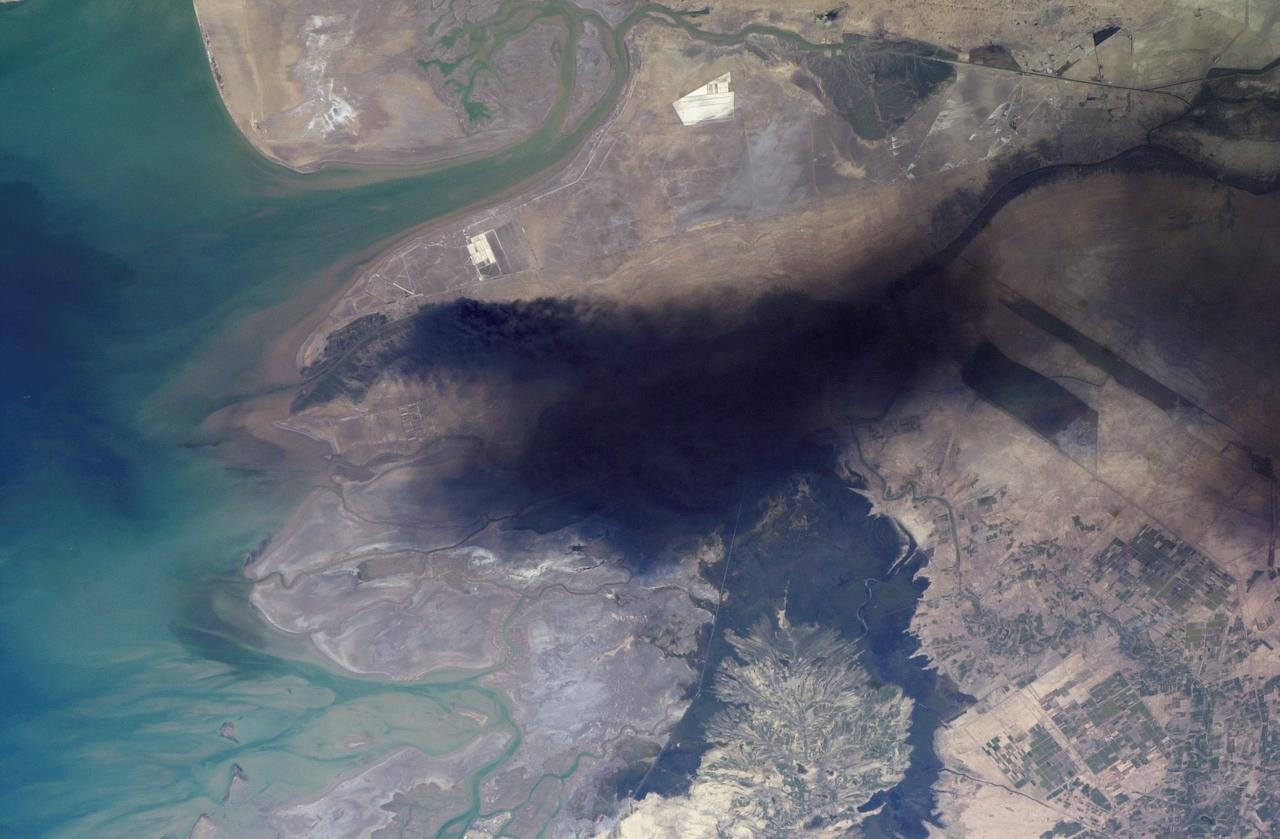
ISS008-E-18938 (24 March 2004) --- This photo of a large black smoke plume over southeastern Iraq was taken by an Expedition 8 crewmember on the International Space Station. The oil that is burning spilled from a ruptured pipeline on March 23, 2004. This photo was taken the next afternoon and shows details of land use near the fire. The delta of the Shatt al Arab has numerous channels, estuaries, and tidal flats. Near the top of the photo (southwest) are two large white salt evaporator operations while to the lower right are wetlands and irrigated agricultural fields. Iraq’s only oil terminal on the Persian Gulf is near the left edge of the plume.
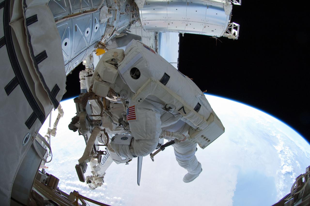
ISS028-E-016121 (12 July 2011) --- NASA astronaut Ron Garan, Expedition 28 flight engineer, uses a tether to secure his position during the July 12 spacewalk he performed outside the docked International Space Station and space shuttle Atlantis with station crewmate Mike Fossum (out of frame). The Persian Gulf can be seen on the Earth below. With support from crewmates inside the station and shuttle, NASA astronauts Garan and Fossum joined forces to complete some needed chores during the six and half hour spacewalk.
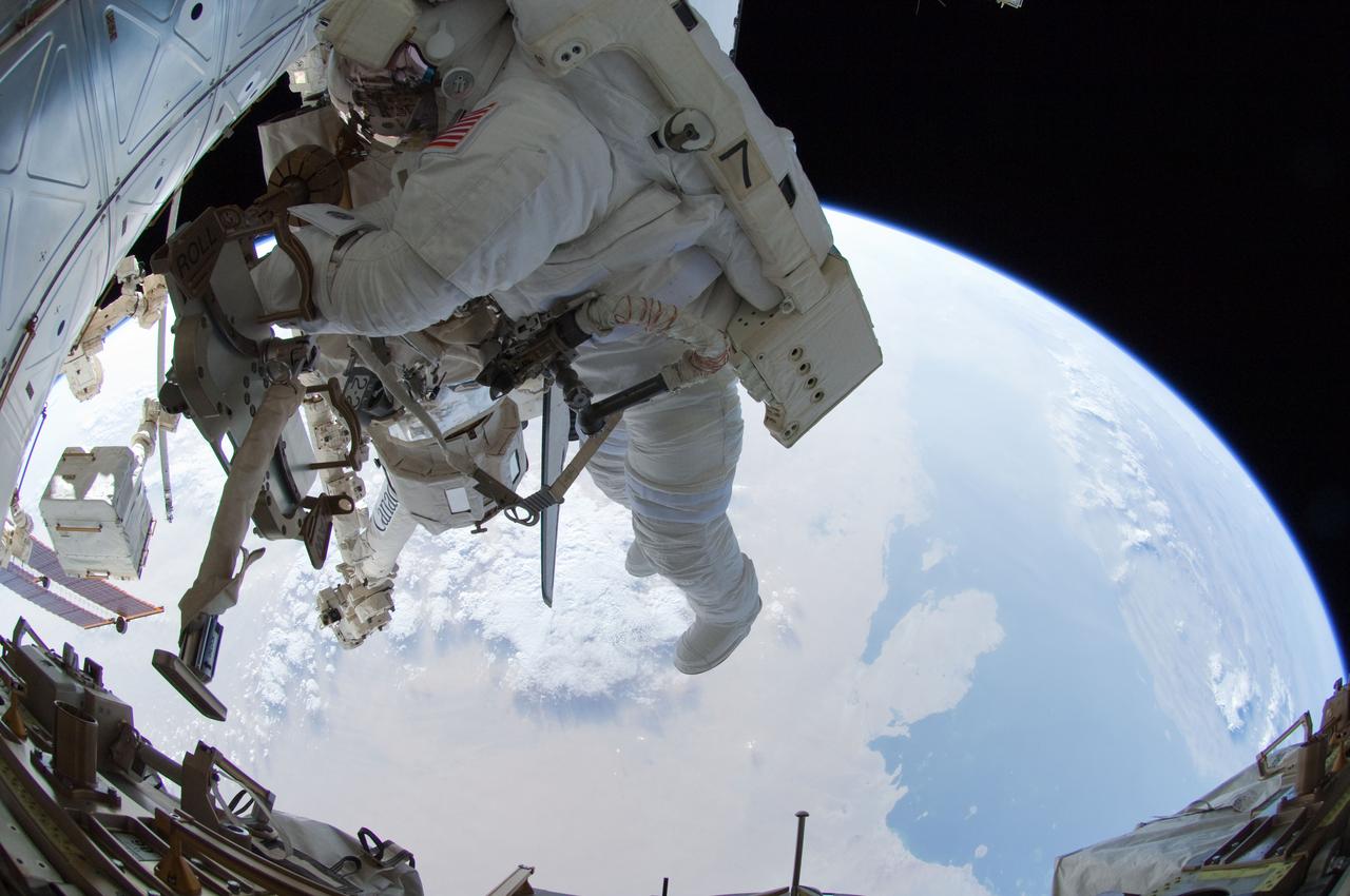
ISS028-E-016122 (12 July 2011) --- NASA astronaut Ron Garan, Expedition 28 flight engineer, uses a tether to secure his position during the July 12 spacewalk he performed outside the docked International Space Station and space shuttle Atlantis with station crewmate Mike Fossum (out of frame). The Persian Gulf can be seen on the Earth below. With support from crewmates inside the station and shuttle, NASA astronauts Garan and Fossum joined forces to complete some needed chores during the six and half hour spacewalk.
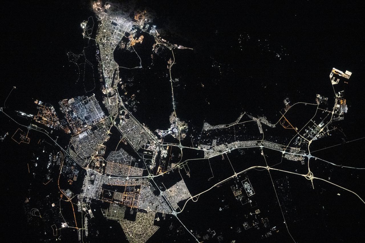
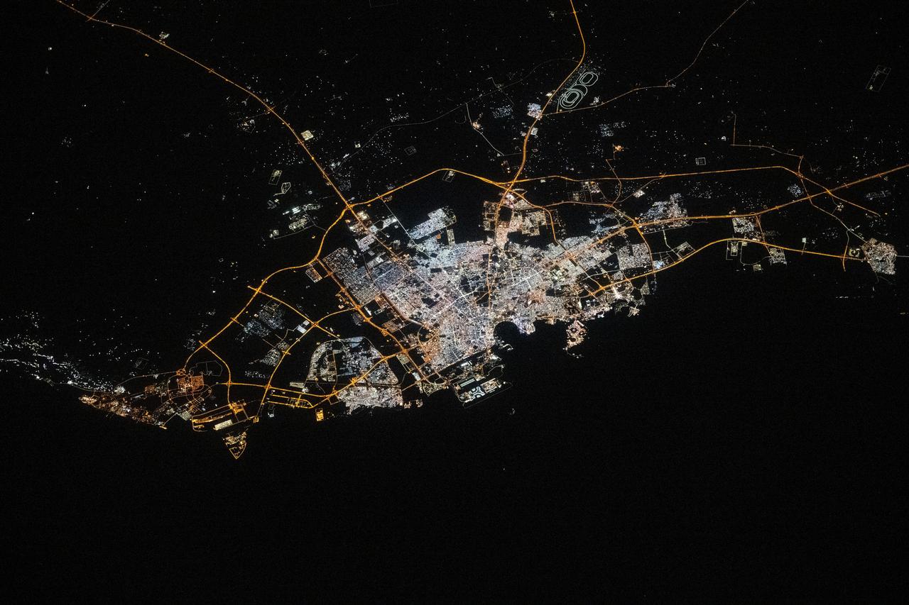
ISS038-E-016335 (11 Dec. 2013) --- A nighttime view of the United Arab Emirates is featured in this image photographed by an Expedition 38 crew member on the International Space Station. Geographers like night images of cities because you see immediately so much about the human landscape--things that are difficult or impossible to see in day images. You see where the cities are located and their shape; the brightest light clusters frequently indicate the city centers. In large field of view images, such as this photograph of the United Arab Emirates (UAE), you can also see cities' position relative to one another and their relative size. Here the largest cluster of lights is the conurbation ("joined cities") of Dubai-Sharjah-Ajman (population 3.25 million), with its smaller neighbor Dubai (population 2.1 million). These cities front onto the Persian Gulf (also known as the Arabian Gulf) where the city lights are cut off abruptly at the coastline. The bright city centers are located at the coast showing that sea trade is important (and has been important) in the growth of these cities. Smaller cities are Al Ain (population 518,000), the fourth largest city in the UAE, and Fujairah (population 152,000). Major highways join the cities in a brightly lit network, and a faint peppering of lights offshore shows the relatively young oil and gas platforms on either side of the Musandam Peninsula (left). Despite being taken at night, the spike of the Musandam Peninsula is easy to imagine at the south end of the Persian Gulf. The biggest cities in the UAE are Abu Dhabi and Dubai. Muscat, the capital city of the neighboring country of Oman, appears top center. By contrast, the almost unpopulated Musandam Peninsula shows very few lights.
ISS040-E-113700 (31 Aug. 2014) --- This panorama view, photographed by an Expedition 40 crew member on the International Space Station, shows tan-colored dust of a major dust storm obscuring the Persian Gulf and the its northern shoreline. Strong north winds often blow in summer, churning up dust from the entire length of the desert surfaces of the Tigris and Euphrates valleys (top left). Dust partly obscures the hundreds of kilometers of Iraq’s light-green agricultural lands along these rivers (left). A line of thunderstorms is being set off by the Zagros Mountains of Iran (right), with the setting sun casting long shadows from the thunderheads. Space station crews see sixteen sunrises and sunsets every day from low Earth orbit. Here the crew captured dusk in a darkening Iranian landscape (right).

ISS030-E-099324 (22 Feb. 2012) --- City lights of Dubai, United Arab Emirates are featured in this image photographed by an Expedition 30 crew member on the International Space Station. The City of Dubai?the largest metropolitan area within the emirate of Dubai?is a favorite subject of astronaut photography largely due to the unique island developments situated directly offshore in the Persian Gulf. These artificial archipelagos have been built such that their full design is only visible from the vantage point of an airplane ? or an orbiting spacecraft such as the International Space Station. The city presents an eye-catching appearance at night that vividly displays the urban development pattern. In this detailed nighttime image?taken with a long focal length lens and digital camera optimized for fast response and high light sensitivity?several interesting patterns can be observed. The highways and major streets are sharply defined by yellow-orange lighting, while the commercial and residential areas are resolved into a speckle pattern of individual white, blue, and yellow-orange lights. Several large and brilliantly lit areas are large hotel and mall complexes, including the Burj Khalifa Tower; at 828 meters (2,717 feet) height it is the world?s tallest building. The brilliant lighting of the city contrasts sharply with both the dark Persian Gulf to the northwest, and largely undeveloped and unlit areas to the southeast. Likewise, the clusters of lighting in the Palm Jumeira complex at bottom right correspond to the relatively small part of the archipelago that has been developed. Isolated areas of blurred city lights are due to patchy clouds.
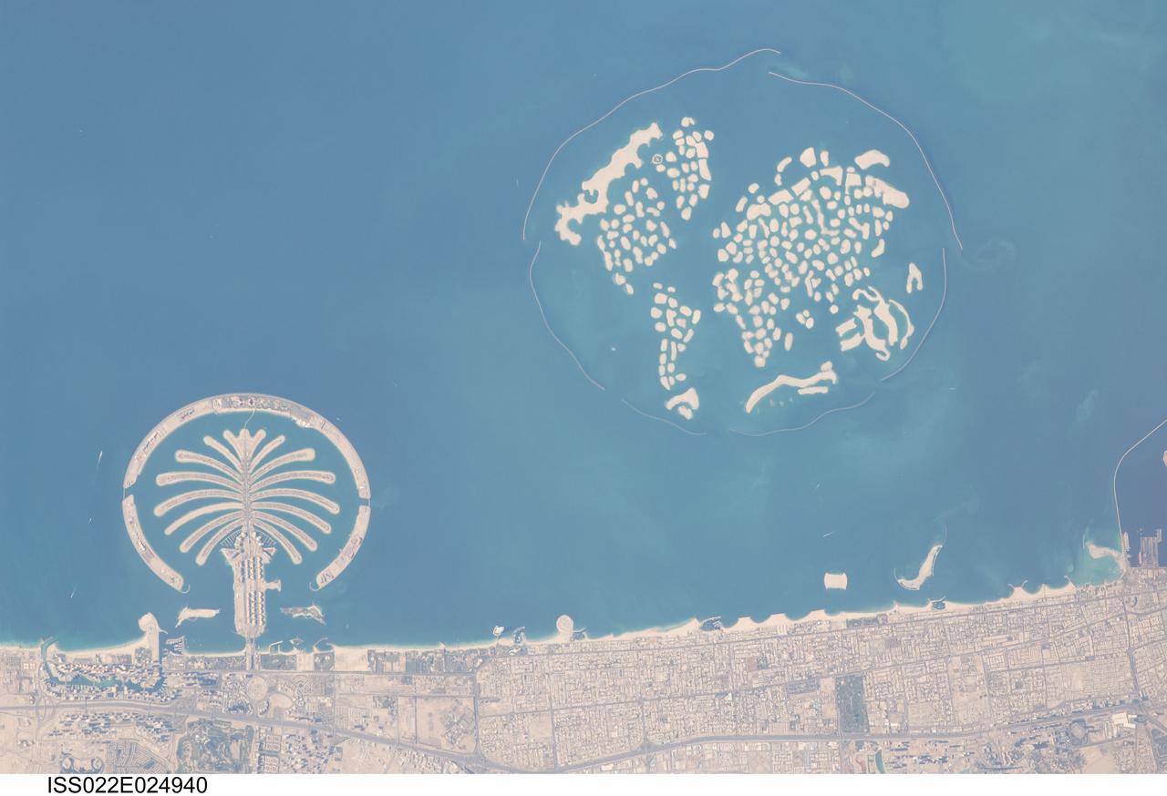
ISS022-E-024940 (13 Jan. 2010) --- Man-made archipelagos near Dubai, United Arab Emirates are featured in this image photographed by an Expedition 22 crew member on the International Space Station. The municipality of Dubai is the largest city of the Persian Gulf emirate of the same name, and has built a global reputation for large-scale developments and architectural works. Among the most visible of these developments ? particularly from the perspective of astronauts onboard the ISS ? are three man-made archipelagos. The two Palm Islands (Palm Jumeirah and Palm Jebel Ali) appear as stylized palm trees when viewed from above. The World Islands evoke a rough map of the world from an air- or space-borne perspective. Palm Jumeirah and the World Islands are highlighted in this view. Palm Jumeirah (lower left) was begun in 2001 and required more than 50 million cubic meters of dredged sand to raise the islands above the Persian Gulf sea level. Construction of the Palm Jumeirah islands was completed in 2006; they are now being developed for residential and commercial housing and infrastructure. Creation of the 300 World Islands (upper right) was begun in 2003 and completed in 2008, using 320 million cubic meters of sand and 37 million tons of rock for the surrounding 27 kilometer-long protective breakwater. Also visible at the lower edge of the image is another notable built structure ? the Burj Tower (white rectangle at lower right and inset image). The Burj Tower ? or Burj Khalifa ? stands 800 meters high, and is currently the world?s tallest structure. The photograph captures enough detail to make out the tapering outline of the building as well as its dark needle-like shadow pointing towards the northeast.
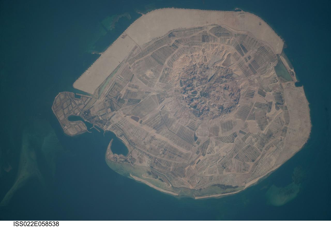
ISS022-E-058538 (31 Jan. 2010) --- Sir Bani Yas Island is featured in this image photographed by an Expedition 22 crew member on the International Space Station. Sir Bani Yas Island is located in the Persian Gulf near the western coastline of the United Arab Emirates (UAE). The approximately 14-kilometers x nine-kilometers island is the surface expression of a salt dome, and is one of several such islands in the Persian Gulf. During past periods of alternating wet and dry climate, sometimes involving areas with high rates of evaporation in enclosed basins, thick layers of salt minerals (such as halite ? common table salt, or gypsum ? a major component of wallboard) were deposited. These layers were subsequently buried by sediments; with enough overlaying material and depth of burial, the salt layers can begin to flow. Salt has lower density than the surrounding rock and it tends to flow upwards, pushing up the overlaying layers of rock to form a salt dome. While many salt domes retain a cap of the youngest rock layers at the surface, in some cases the underlaying salt extrudes onto the surface. This photograph illustrates the varying character of surfaces on the island. The central mountains of Jebel Wahid (center) mark the location of the Sir Bani Yas salt dome. The dome has breached the surface but exposed salt - primarily gypsum - is removed by erosion, leaving a rugged, insoluble cap formed from fragments of the overlaying sedimentary and volcanic rocks. Sand and silt derived from the Jebel Wahid area and surrounding gravel cover forms beaches along the outer edge of the island.
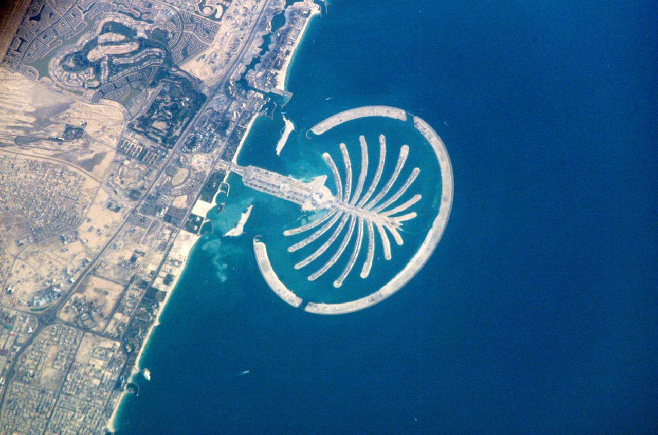
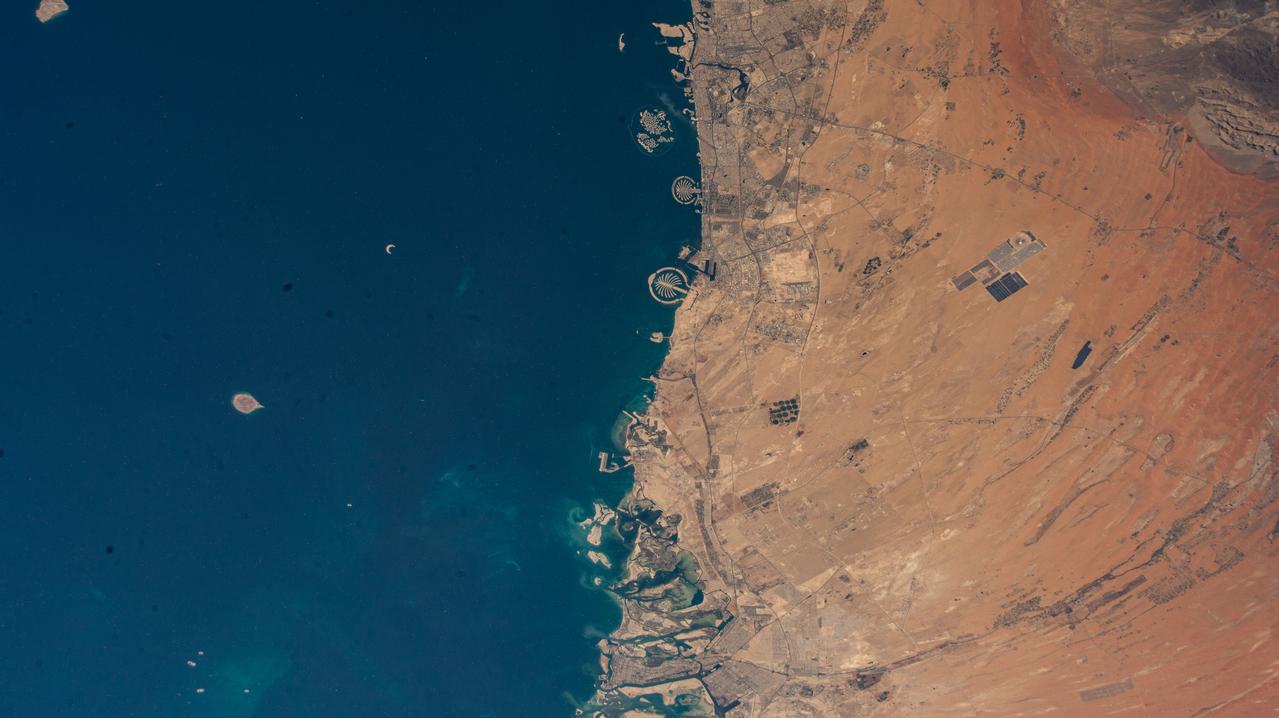
ISS010-E-22273 (1 April 2005) --- Palm Island Resort, Dubai, United Arab Emirates is featured in this image photographed by an Expedition 10 crewmember on the International Space Station. Palm Island is a resort under construction on reclaimed land silhouetted against the dark waters of Dubai’s Persian Gulf coast. Advertised as "being visible from the Moon," this man-made palm-shaped structure displays 17 huge fronds framed by a 12-kilometer protective barrier. When completed, the resort will sport 2000 villas, 40 luxury hotels, shopping centers, cinemas, and other facilities. An earlier handheld image from 2003 shows the outline of the palm nearing completion (link to http://spaceflight.nasa.gov/gallery/images/station/crew-6/html/iss006e35516.html). Two years later, the palm appears in all its glory to passing space travelers. It has so far required over 50 million cubic meters of sand to raise it above the sea surface. Palm Island is the last of three major developments designed to transform the Dubai coastline into a major coastal metropolitan area and destination. When completed, the resort is expected to support a population of approximately 500,000 people.
ISS032-E-023718 (11 Aug. 2012) --- The city of Dubai, United Arab Emirates, is featured in this night view photographed by an Expedition 32 crew member on the International Space Station. The city of Dubai is the largest metropolitan area in the emirate of Dubai, one of the member states of the United Arab Emirates. Dubai is located along the southern Persian Gulf on the Arabian Peninsula, and its signature city is known for high profile architectural and development projects. Among the most notable is the Palm Island Resort, a manmade peninsula and surrounding islands built from over 50 million cubic meters of sand. Two other island projects (out of frame), one similar to the Palm Island Resort and another crafted to look like a map of the world, are also visible in other space station imagery along the Dubai coastline. Orange sodium vapor lights trace out the major highways and surface street grid in and around the metropolitan area, while grey-white mercury vapor lamps fill in the commercial and residential areas. The lighted islands and peninsula of the Palm Island Resort are clearly visible along the coastline. An interesting spiral pattern of lights on the southeastern fringe of the urban area is a camel racetrack. Night time images like this are useful to climate modelers, urban planners, and geographers as they allow for simple definition of urban (densely lit) and rural (sparsely lit) areas.
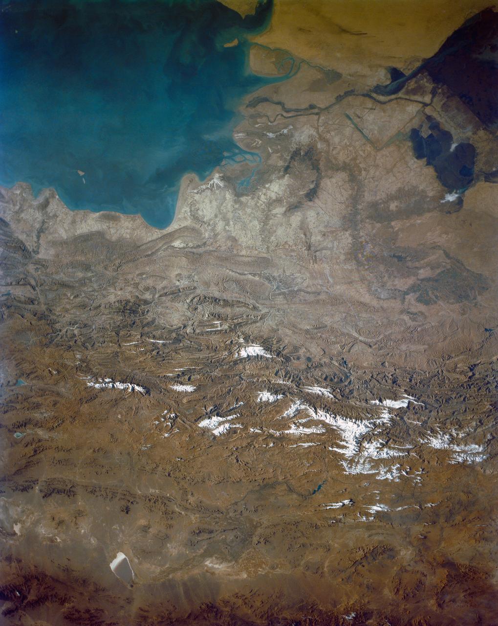
ISS012-E-18779 (28 Feb. 2006) --- Winter in the Dasht-e-Lut Desert, eastern Iran is featured in this image photographed by an Expedition 12 crew member on the International Space Station. The image takes advantage of the low angle of illumination to reveal linear geological structures of the Iranian mountain range bordering the western edge of the basin known as Dasht-e-Lut. The range rises 1818 meters (6000 feet) above sea level and lies 750 kilometers (466 miles) north of the Persian Gulf. The convoluted appearance results from erosion of folded and faulted rocks – softer rocks erode away quickly, leaving more resistant rock to form linear ridges perpendicular to the direction of compression. While not a major oil producing region like the Zagros Fold Belt to the southwest, the mountains of east-central Iran contain economically important deposits of copper and other metals. Little vegetation is visible from space in the arid interior basin of the Dasht-e-Lut. Iran is climatically part of the Afro-Asian belt of deserts that stretch from the Cape Verde islands off West Africa all the way to Mongolia near Beijing. The patchy, elongated, light-colored feature in the foreground (parallel to the mountain range) is the northernmost of the Dasht dry lakes that stretch southward 300 kilometers (186 miles). High country is the source of precipitation-derived water in all near-tropical deserts. Agricultural fields (small dark patches in the image) that depend on this precipitation are located down slope near the margin of the dry, salty soils of the lake.
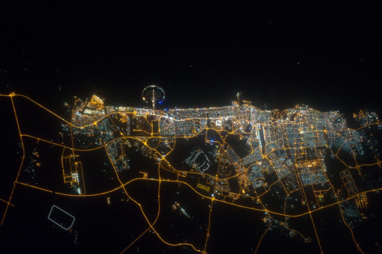
ISS020-E-039932 (11 Sept. 2009) --- City of Dubai, United Arab Emirates is featured in this night view photographed by an Expedition 20 crew member on the International Space Station. The city of Dubai is the largest metropolitan area in the emirate of Dubai, one of the member states of the United Arab Emirates. Dubai is located along the southern Persian Gulf on the Arabian Peninsula, and its signature city is known for high profile architectural and development projects. Among the most notable is the Palm Island Resort, a manmade peninsula and surrounding islands built from over 50 million cubic meters of sand. Two other island projects, one similar to the Palm Island Resort and another crafted to look like a map of the world, are also underway along the Dubai coastline. This night time photograph of the city of Dubai was taken at approximately 2:00 a.m. local time. Orange sodium vapor lights trace out the major highways and surface street grid in and around the metropolitan area, while grey-white mercury vapor lamps fill in the commercial and residential areas. The lighted islands and peninsula of the Palm Island Resort are clearly visible along the coastline. An interesting spiral pattern of lights on the southeastern fringe of the urban area is a camel racetrack. Night time images like these are useful to climate modelers, urban planners, and geographers as they allow for simple definition of urban (densely lit) and rural (sparely lit) areas.
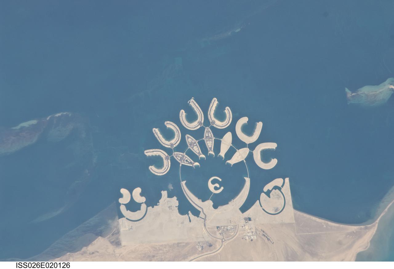
ISS026-E-020126 (23 Jan. 2011) --- Durrat Al Bahrain, Bahrain, is featured in this image photographed by an Expedition 26 crew member on the International Space Station. Set at the southern end of Bahrain Island, at the furthest point from the cities of the kingdom, is a new complex of 14 artificial islands designed for residential living and tourism with luxury hotels and shopping malls. Aimed at a cosmopolitan clientele, the Durrat Al Bahrain includes 21 square kilometers of new surface area—for more than 1,000 residences—that has been designed as The Islands (six “atolls” leading off five fish-shaped “petals”), The Crescent, Hotel Island in the center of the complex, and Durrat Marina in the north. The spectacular outline of this development, and others such as the Palm Jumeirah and World Islands developments in the Persian Gulf, are best appreciated from above. Views from jet liners at high altitude—and orbital platforms such as the International Space Station—are the only ways to fully appreciate these sights. This detailed photograph shows that construction on the southern two atolls and petals has yet to begin. Artificial beaches have been created on the inner shorelines of the Crescent and petals, with smaller beaches on the inner ends of the atolls and Hotel Island. The angular outline of the golf course, where many more residences are planned to line the fairways, can be seen between The Crescent and the marina. What may be a second marina at the south end of the complex mirrors the one on the north, appears to be part of the complex, but it does not figure in some earlier plans for the Durrat Al Bahrain.