
Ambassador of Peru to the United States Alfredo Ferrero Diez Canseco delivers remarks during an Artemis Accords signing ceremony, Thursday, May 30, 2024, at the Mary W. Jackson NASA Headquarters building in Washington. Peru is the 41st country to sign the Artemis Accords, which establish a practical set of principles to guide space exploration cooperation among nations participating in NASA’s Artemis program. Photo Credit: (NASA/Keegan Barber)

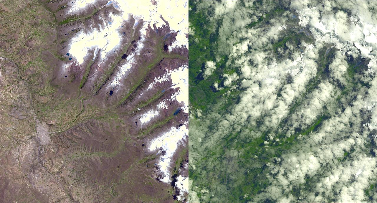
Ambassador of Peru to the United States Alfredo Ferrero Diez Canseco delivers remarks during an Artemis Accords signing ceremony, Thursday, May 30, 2024, at the Mary W. Jackson NASA Headquarters building in Washington. Peru is the 41st country to sign the Artemis Accords, which establish a practical set of principles to guide space exploration cooperation among nations participating in NASA’s Artemis program. Photo Credit: (NASA/Keegan Barber)
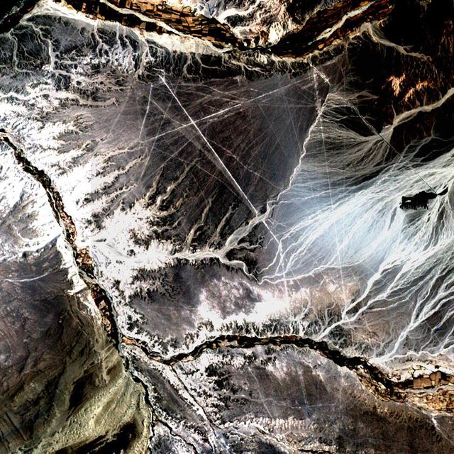
Acquisition Date: November 10, 2002 In the desert of southwest Peru, between the Andes Mountains and the Peruvian coast, lies a plateau with huge geometric patterns and spirals, animal figures including a monkey, a spider, and an 'owl man,' and thousands of perfectly straight lines. The last of these was drawn about a thousand years ago. Known as the Nazca lines, the drawings have mystified scientists since they were first discovered in the 1920s. Pictured here is all that can be seen of these lines by Landsat 7's 15 meter pan band, which has been used to sharpen the 30 meter Bands 3, 2, and 1. Credit: NASA/GSFC/Landsat/USGS To learn more about Landsat and to see the orginal high res file go to: <a href="http://landsat.usgs.gov/gallery_view.php?category=greenflag&thesort=mainTitle" rel="nofollow">landsat.usgs.gov/gallery_view.php?category=greenflag&...</a>
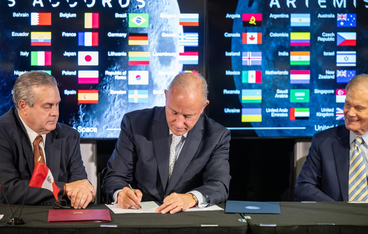
Peruvian Foreign Minister Javier González-Olaechea signs the Artemis Accords as NASA Administrator Bill Nelson, right, and Ambassador of Peru to the United States Alfredo Ferrero Diez Canseco, left, look on, Thursday, May 30, 2024, at the Mary W. Jackson NASA Headquarters building in Washington. Peru is the 41st country to sign the Artemis Accords, which establish a practical set of principles to guide space exploration cooperation among nations participating in NASA’s Artemis program. Photo Credit: (NASA/Keegan Barber)

Peruvian Foreign Minister Javier González-Olaechea signs the Artemis Accords as NASA Administrator Bill Nelson, right, and Ambassador of Peru to the United States Alfredo Ferrero Diez Canseco, left, look on, Thursday, May 30, 2024, at the Mary W. Jackson NASA Headquarters building in Washington. Peru is the 41st country to sign the Artemis Accords, which establish a practical set of principles to guide space exploration cooperation among nations participating in NASA’s Artemis program. Photo Credit: (NASA/Keegan Barber)

From left to right, Ambassador of Peru to the United States Alfredo Ferrero Diez Canseco, Peruvian Foreign Minister Javier González-Olaechea, NASA Administrator Bill Nelson, and United States Department of State Acting Assistant Secretary in the Bureau of Oceans and International Environmental and Scientific Affairs Jennifer R. Littlejohn, pose for a photo during an Artemis Accords signing ceremony, Thursday, May 30, 2024, at the Mary W. Jackson NASA Headquarters building in Washington. Peru is the 41st country to sign the Artemis Accords, which establish a practical set of principles to guide space exploration cooperation among nations participating in NASA’s Artemis program. Photo Credit: (NASA/Keegan Barber)

Peruvian Foreign Minister Javier González-Olaechea signs the Artemis Accords, Thursday, May 30, 2024, at the Mary W. Jackson NASA Headquarters building in Washington. Peru is the 41st country to sign the Artemis Accords, which establish a practical set of principles to guide space exploration cooperation among nations participating in NASA’s Artemis program. Photo Credit: (NASA/Keegan Barber)

NASA Administrator Bill Nelson delivers remarks during an Artemis Accords signing ceremony, Thursday, May 30, 2024, at the Mary W. Jackson NASA Headquarters building in Washington. Peru is the 41st country to sign the Artemis Accords, which establish a practical set of principles to guide space exploration cooperation among nations participating in NASA’s Artemis program. Photo Credit: (NASA/Keegan Barber)

United States Department of State Acting Assistant Secretary in the Bureau of Oceans and International Environmental and Scientific Affairs Jennifer R. Littlejohn delivers remarks during an Artemis Accords signing ceremony, Thursday, May 30, 2024, at the Mary W. Jackson NASA Headquarters building in Washington. Peru is the 41st country to sign the Artemis Accords, which establish a practical set of principles to guide space exploration cooperation among nations participating in NASA’s Artemis program. Photo Credit: (NASA/Keegan Barber)

United States Department of State Acting Assistant Secretary in the Bureau of Oceans and International Environmental and Scientific Affairs Jennifer R. Littlejohn delivers remarks during an Artemis Accords signing ceremony, Thursday, May 30, 2024, at the Mary W. Jackson NASA Headquarters building in Washington. Peru is the 41st country to sign the Artemis Accords, which establish a practical set of principles to guide space exploration cooperation among nations participating in NASA’s Artemis program. Photo Credit: (NASA/Keegan Barber)

Peruvian Foreign Minister Javier González-Olaechea delivers remarks during an Artemis Accords signing ceremony, Thursday, May 30, 2024, at the Mary W. Jackson NASA Headquarters building in Washington. Peru is the 41st country to sign the Artemis Accords, which establish a practical set of principles to guide space exploration cooperation among nations participating in NASA’s Artemis program. Photo Credit: (NASA/Keegan Barber)

Peruvian Foreign Minister Javier González-Olaechea signs the Artemis Accords, Thursday, May 30, 2024, at the Mary W. Jackson NASA Headquarters building in Washington. Peru is the 41st country to sign the Artemis Accords, which establish a practical set of principles to guide space exploration cooperation among nations participating in NASA’s Artemis program. Photo Credit: (NASA/Keegan Barber)

NASA Administrator Bill Nelson delivers remarks during an Artemis Accords signing ceremony, Thursday, May 30, 2024, at the Mary W. Jackson NASA Headquarters building in Washington. Peru is the 41st country to sign the Artemis Accords, which establish a practical set of principles to guide space exploration cooperation among nations participating in NASA’s Artemis program. Photo Credit: (NASA/Keegan Barber)

Peruvian Foreign Minister Javier González-Olaechea delivers remarks during an Artemis Accords signing ceremony, Thursday, May 30, 2024, at the Mary W. Jackson NASA Headquarters building in Washington. Peru is the 41st country to sign the Artemis Accords, which establish a practical set of principles to guide space exploration cooperation among nations participating in NASA’s Artemis program. Photo Credit: (NASA/Keegan Barber)
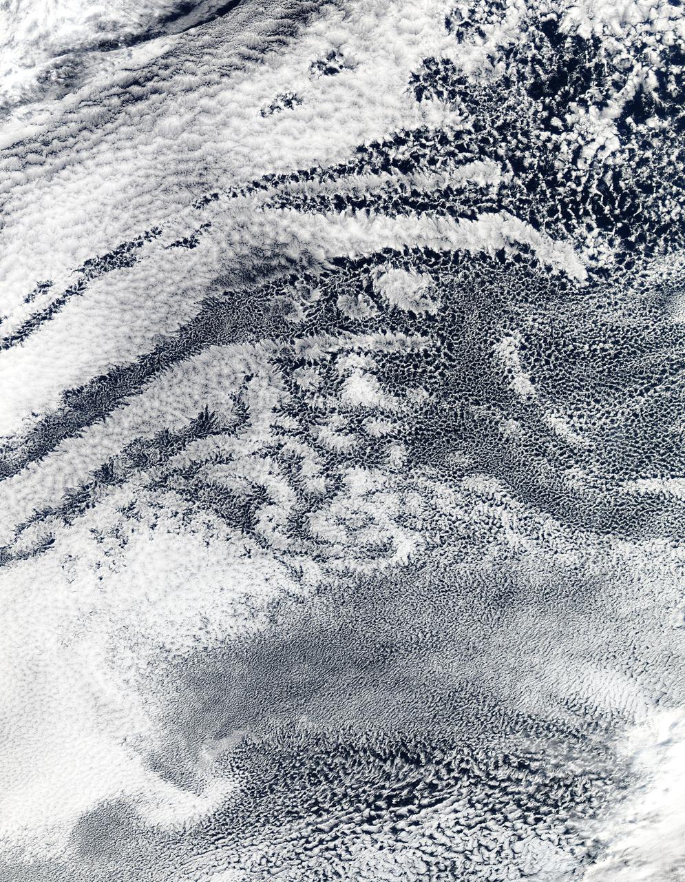
2010/107 - 04/17 at 21 :05 UTC. Open-cell and closed-cell clouds off Peru, Pacific Ocean Resembling a frosted window on a cold winter's day, this lacy pattern of marine clouds was captured off the coast of Peru in the Pacific Ocean by the MODIS on the Aqua satellite on April 19, 2010. The image reveals both open- and closed-cell cumulus cloud patterns. These cells, or parcels of air, often occur in roughly hexagonal arrays in a layer of fluid (the atmosphere often behaves like a fluid) that begins to "boil," or convect, due to heating at the base or cooling at the top of the layer. In "closed" cells warm air is rising in the center, and sinking around the edges, so clouds appear in cell centers, but evaporate around cell edges. This produces cloud formations like those that dominate the lower left. The reverse flow can also occur: air can sink in the center of the cell and rise at the edge. This process is called "open cell" convection, and clouds form at cell edges around open centers, which creates a lacy, hollow-looking pattern like the clouds in the upper right. Closed and open cell convection represent two stable atmospheric configurations — two sides of the convection coin. But what determines which path the "boiling" atmosphere will take? Apparently the process is highly chaotic, and there appears to be no way to predict whether convection will result in open or closed cells. Indeed, the atmosphere may sometimes flip between one mode and another in no predictable pattern. Satellite: Aqua NASA/GSFC/Jeff Schmaltz/MODIS Land Rapid Response Team To learn more about MODIS go to: <a href="http://rapidfire.sci.gsfc.nasa.gov/gallery/?latest" rel="nofollow">rapidfire.sci.gsfc.nasa.gov/gallery/?latest</a> <b><a href="http://www.nasa.gov/centers/goddard/home/index.html" rel="nofollow">NASA Goddard Space Flight Center</a></b> is home to the nation's largest organization of combined scientists, engineers and technologists that build spacecraft, instruments and new technology to study the Earth, the sun, our solar system, and the universe.
S66-54834 (14 Sept. 1966) --- Peru, Bolivia, Chile, Lake Titicaca and La Paz, as seen from the Gemini-11 spacecraft during its 34th revolution of Earth. Photo credit: NASA

iss071e403651 (July 21, 2024) --- The 57.7-foot-long Canadarm2 robotic arm extends from the International Space Station's Harmony module as the orbital outpost soared 261 miles above the coast of Peru. Partially obscured in the top background, is the Boeing Starliner spacecraft docked to Harmony's forward port.
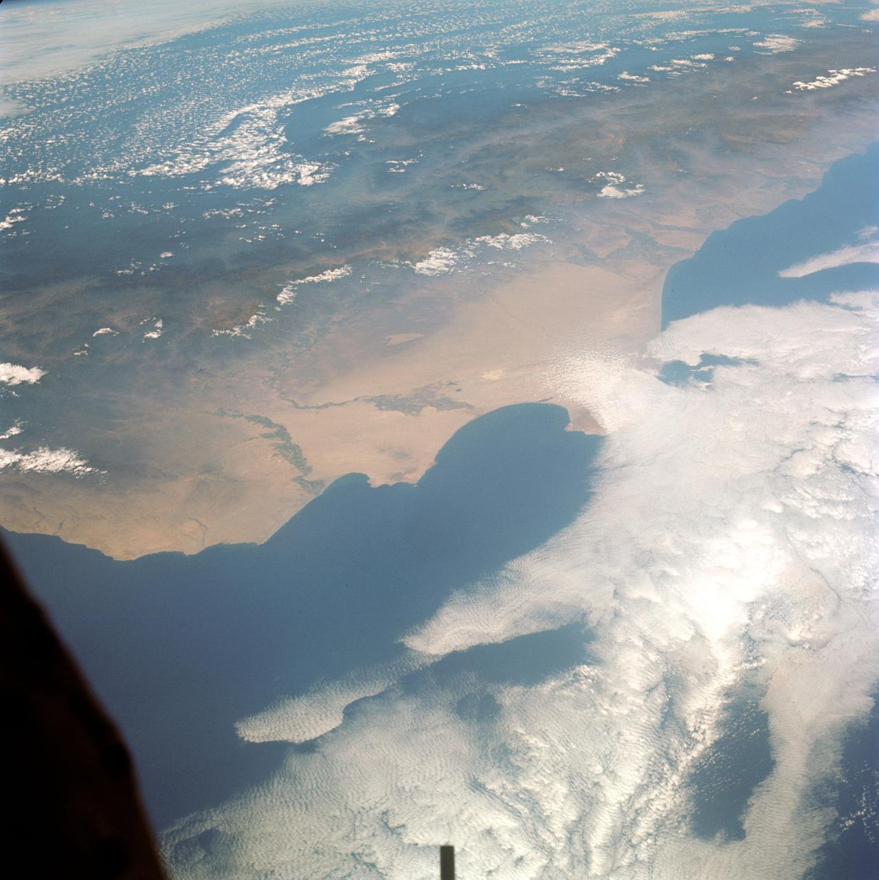
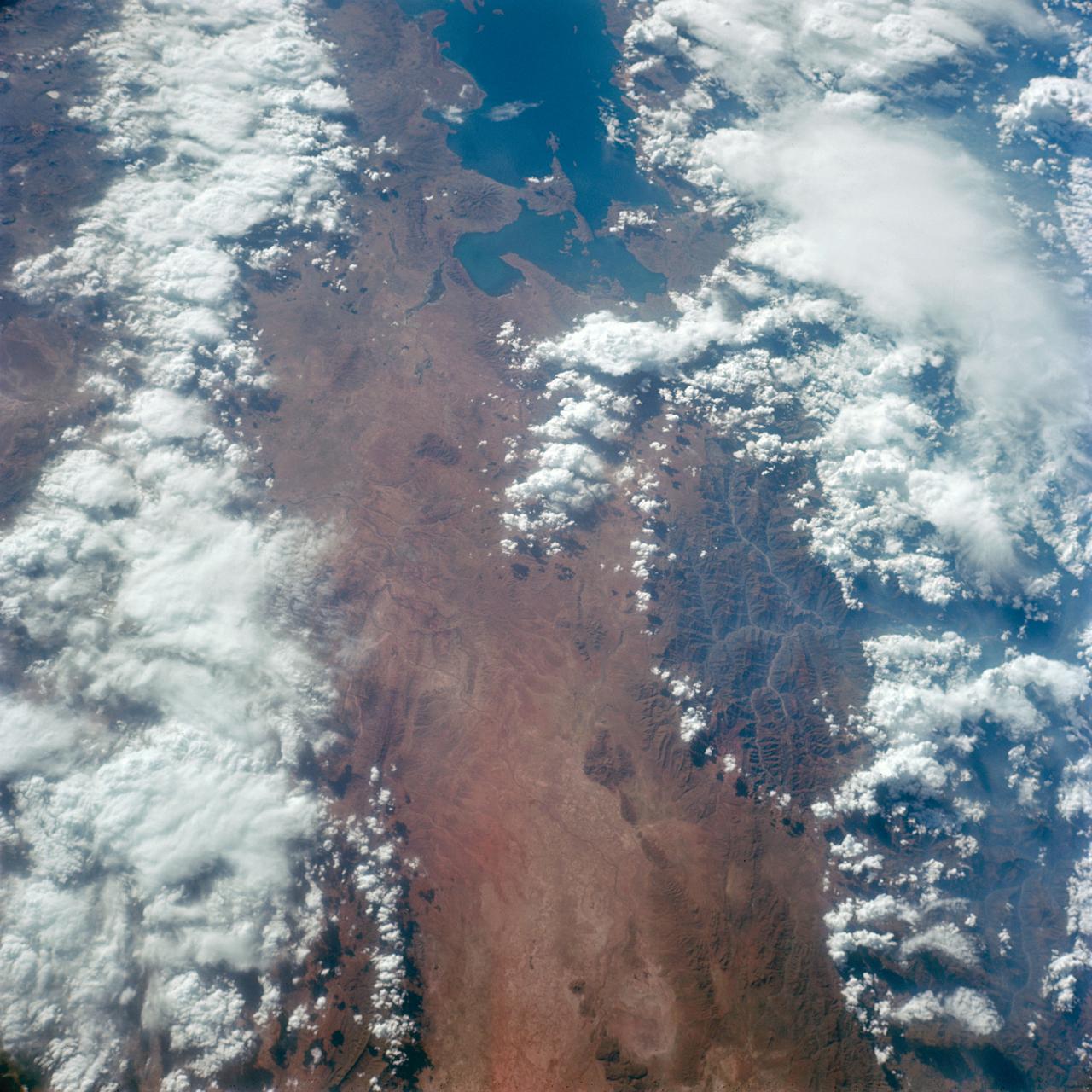
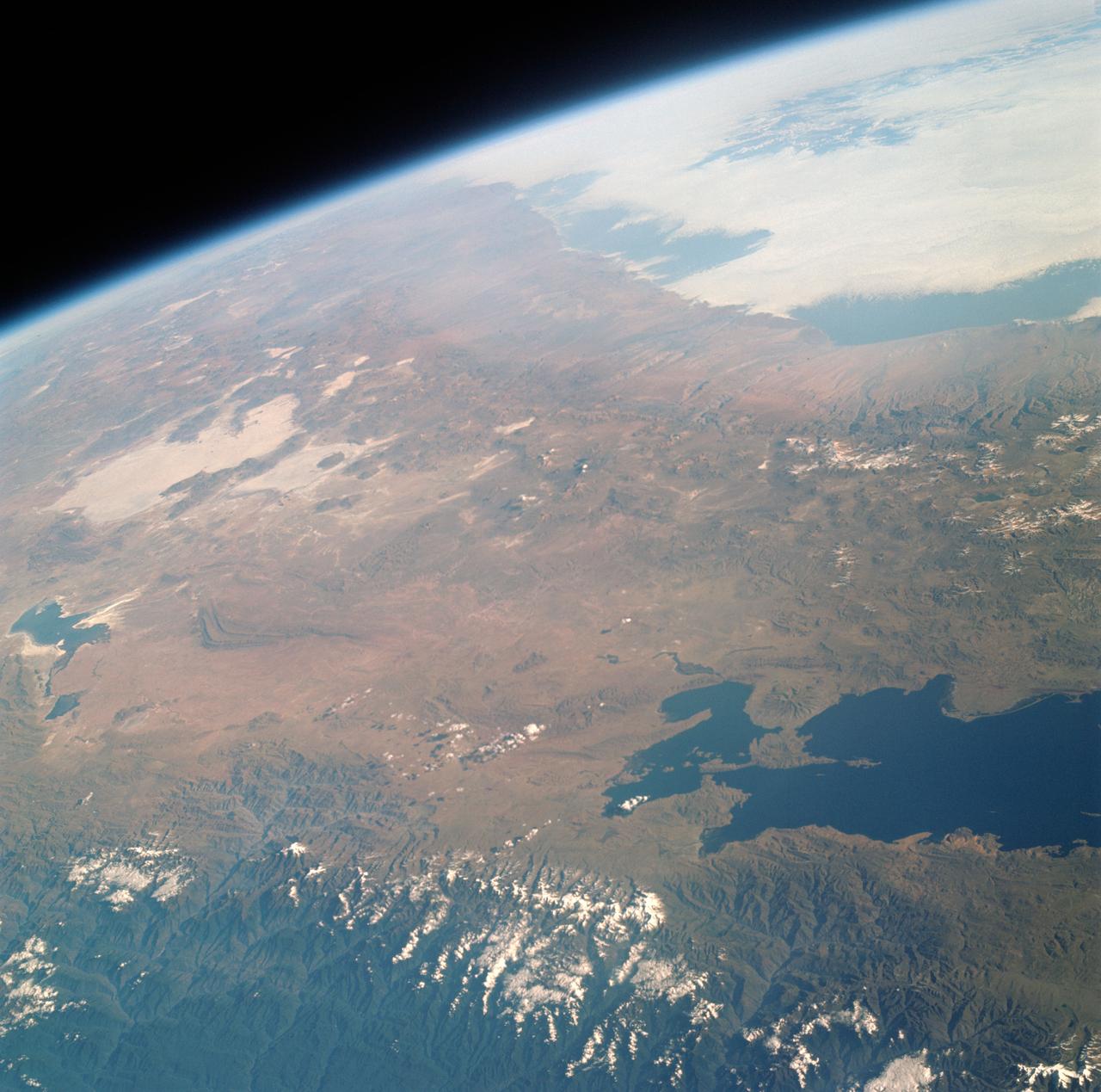
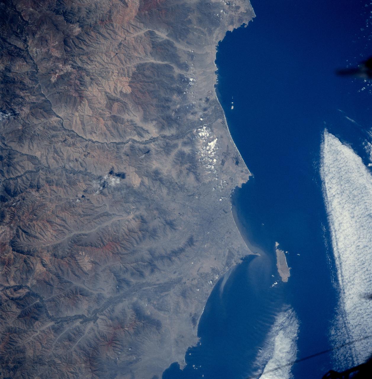
S66-38290 (5 June 1966) --- The north coastal area of Peru looking southeast across the Andes Mountains as seen from the National Aeronautics and Space Administration's Gemini-9A spacecraft. The body of water is the Pacific Ocean. The image was taken with a modified 70mm Hasselblad camera, using Eastman Kodak, Ektachrome MS (S.O. 217) color film. Photo credit: NASA
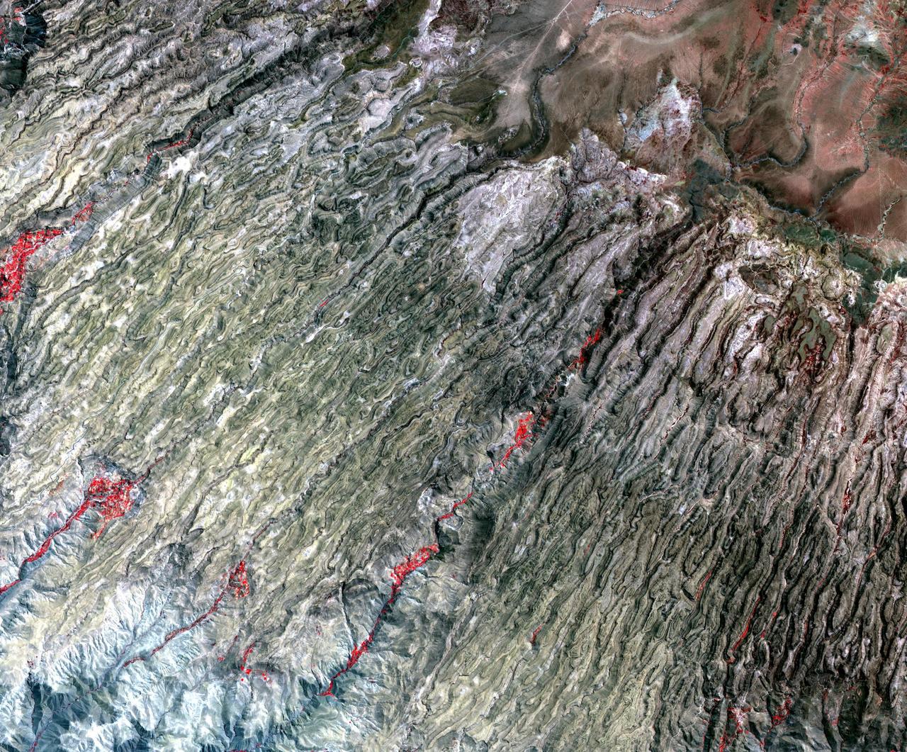
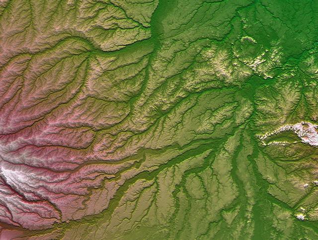
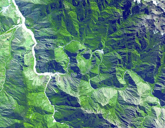
Along the western flank of the Andes, 400 km SE of Lima Peru, erosion has carved the mountain slopes into long, narrow serpentine ridges. NASA Terra satellite captured this image on September 28, 2004.
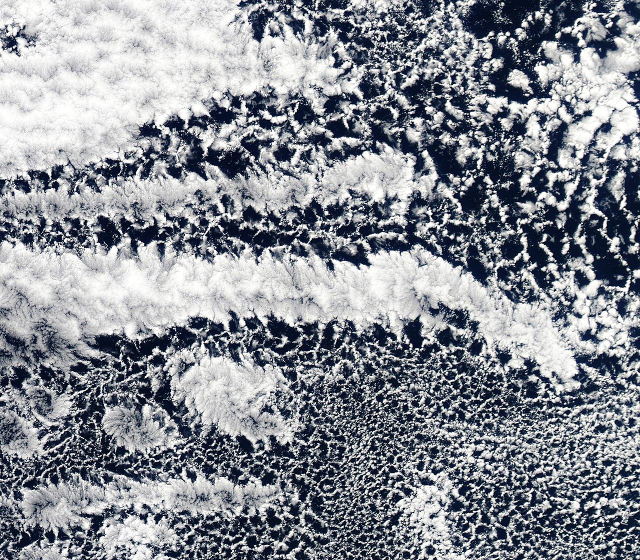
2010/107 - 04/17 at 21 :05 UTC. Open-cell and closed-cell clouds off Peru, Pacific Ocean. To view the full fame of this image to go: <a href="http://www.flickr.com/photos/gsfc/4557497219/">www.flickr.com/photos/gsfc/4557497219/</a> Resembling a frosted window on a cold winter's day, this lacy pattern of marine clouds was captured off the coast of Peru in the Pacific Ocean by the MODIS on the Aqua satellite on April 19, 2010. The image reveals both open- and closed-cell cumulus cloud patterns. These cells, or parcels of air, often occur in roughly hexagonal arrays in a layer of fluid (the atmosphere often behaves like a fluid) that begins to "boil," or convect, due to heating at the base or cooling at the top of the layer. In "closed" cells warm air is rising in the center, and sinking around the edges, so clouds appear in cell centers, but evaporate around cell edges. This produces cloud formations like those that dominate the lower left. The reverse flow can also occur: air can sink in the center of the cell and rise at the edge. This process is called "open cell" convection, and clouds form at cell edges around open centers, which creates a lacy, hollow-looking pattern like the clouds in the upper right. Closed and open cell convection represent two stable atmospheric configurations — two sides of the convection coin. But what determines which path the "boiling" atmosphere will take? Apparently the process is highly chaotic, and there appears to be no way to predict whether convection will result in open or closed cells. Indeed, the atmosphere may sometimes flip between one mode and another in no predictable pattern. Satellite: Aqua NASA/GSFC/Jeff Schmaltz/MODIS Land Rapid Response Team To learn more about MODIS go to: <a href="http://rapidfire.sci.gsfc.nasa.gov/gallery/?latest" rel="nofollow">rapidfire.sci.gsfc.nasa.gov/gallery/?latest</a> <b><a href="http://www.nasa.gov/centers/goddard/home/index.html" rel="nofollow">NASA Goddard Space Flight Center</a></b> is home to the nation's largest organization of combined scientists, engineers and technologists that build spacecraft, instruments and new technology to study the Earth, the sun, our solar system, and the universe.
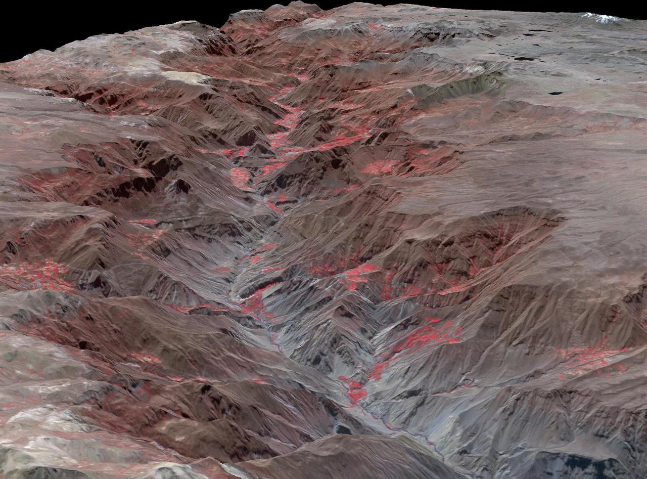
Cotahuasi Canyon, near the city of Arequipa, Peru, is one of the deepest canyons in the world. It reaches a maximum depth of 3,350 m, twice as deep as the Grand Canyon. Volcanic peaks nearby reach altitudes of over 6,000 meters. The perspective view is draped over an ASTER DEM, and projected with no vertical exaggeration. The image was acquired August 30, 2019, and is located at 15.3 degrees south, 73 degrees west. https://photojournal.jpl.nasa.gov/catalog/PIA24943
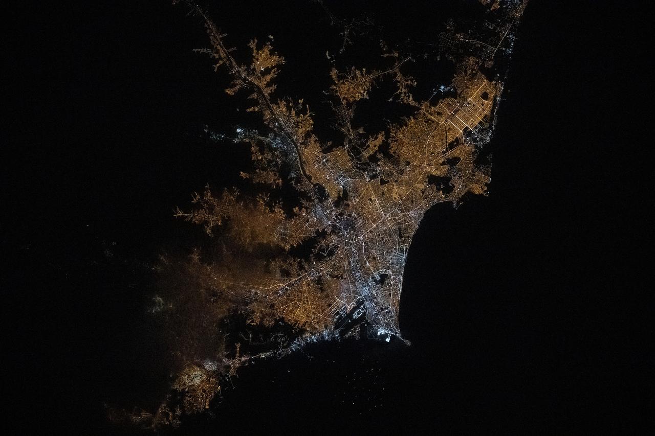
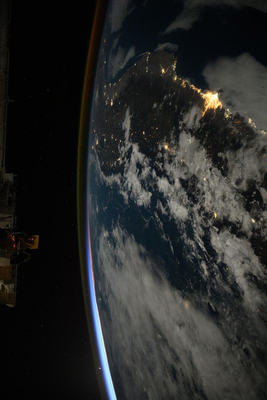
iss072e519089 (Jan. 21, 2025) --- The city lights of Lima, Peru, the South American nation's capital and most populous city with approximately 10.1 million residents on the Pacific coast, are pictured from the International Space Station at approximately 1:43 a.m. local time as it orbited 261 miles above.
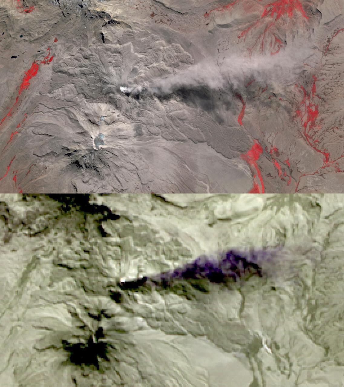
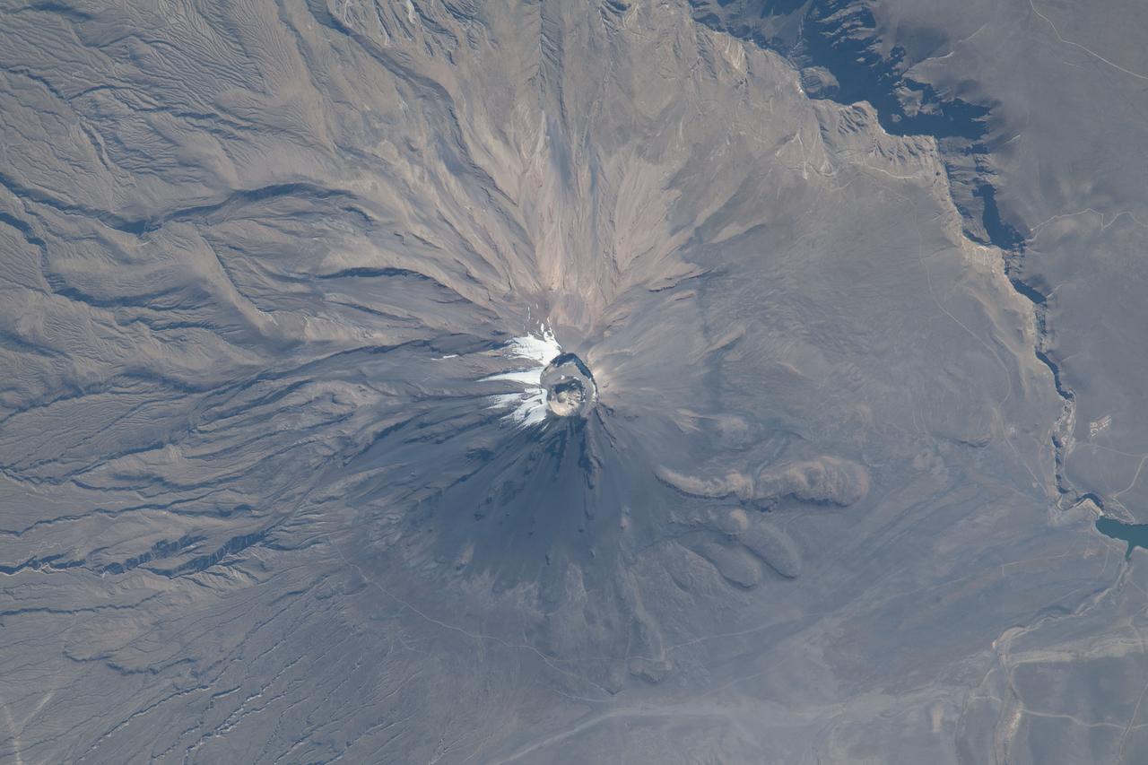
In this image of Peru's Sabancaya stratovolcano, acquired May 13, 2020, the years-long eruption continues. In the top image, Sabancaya has a bright white cloud in its caldera. The greyish cloud to the east is an ash plume. The Ampato volcano, with its prominent summit caldera, is to the south. The red areas are vegetation. The lower thermal infrared composite image shows the plume in purple, indicating that it is dominantly composed of ash and water vapor. A bright hotspot can be seen in the summit caldera of Sabancaya. The images cover an area of 13.5 by 24 kilometers, and are located at 15.8 degrees south, 71.9 degrees west. https://photojournal.jpl.nasa.gov/catalog/PIA24866
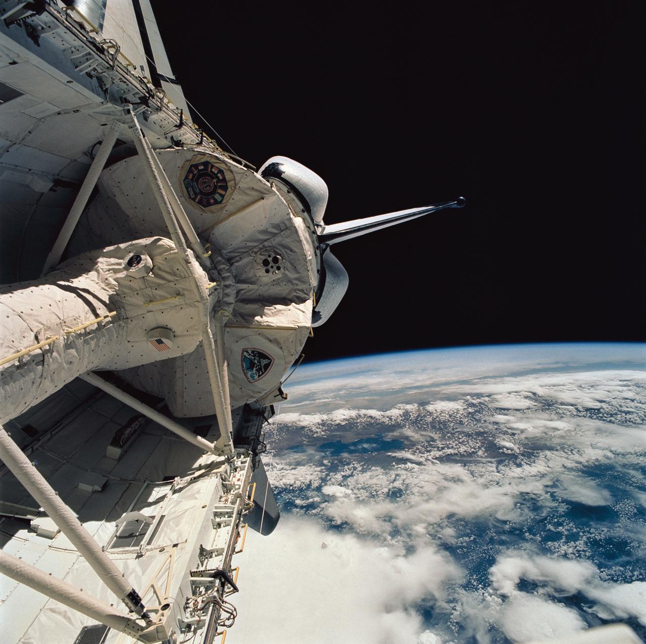
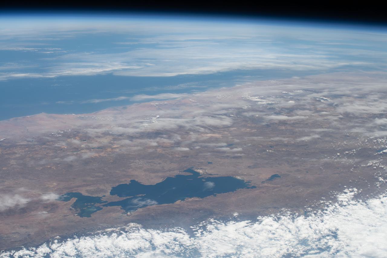
STS058-76-041 (18 Oct-1 Nov 1993) --- Backdropped against the Peru-Bolivia border and part of the Amazon basin, the Spacelab Life Sciences (SLS-2) laboratory module was captured with a 70mm camera, by one of the seven crew members inside the Space Shuttle Columbia's cabin. Part of the tunnel-like passageway is visible in the foreground. Six NASA astronauts and a veterinarian from the private sector spent two weeks devoted to medical research in Earth-orbit. Lake Titicaca, the largest high-altitude lake in the world lies in the Altiplano of Bolivia and Peru. Space Shuttle photography has been used to document fluctuations of several meters of the level of Lake Titicaca during the past decade, as well as to document the eutrophication of the north end of the lake, which is primarily due to increased population in the Peruvian shoreline areas. This view shows the effect of abnormally heavy precipitation of the region for the third successive year. Meteorologists feel this precipitation increase, which may portend another increase of the lake level, is due to the third successive El Nino - Southern Oscillation phenomenon in the 1993 - 94 southern hemisphere summertime. This global phenomenon is now resulting in major weather disturbances in Indonesia, California, Texas and elsewhere.
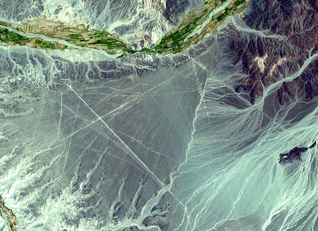
The Nasca Lines are located in the Pampa region of Peru, the desolate plain of the Peruvian coast 400 km south of Lima. The Lines were first spotted when commercial airlines began flying across the Peruvian desert in the 1920's. Passengers reported seeing 'primitive landing strips' on the ground below. The Lines were made by removing the iron-oxide coated pebbles which cover the surface of the desert. When the gravel is removed, they contrast with the light color underneath. In this way the lines were drawn as furrows of a lighter color. On the pampa, south of the Nasca Lines, archaeologists have now uncovered the lost city of the line-builders, Cahuachi. It was built nearly two thousand years ago and was mysteriously abandoned 500 years later. This ASTER sub-image covers an area of 14 x 18 km, was acquired on December 22, 2000, and is located at 14.7 degrees south latitude and 75.1 degrees west longitude. http://photojournal.jpl.nasa.gov/catalog/PIA11097
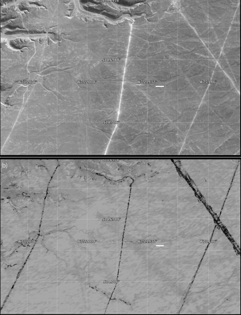
A protected area within the Nasca World Heritage Site in Peru that has experienced apparent disturbance between two different observations by NASA Uninhabited Aerial Vehicle Synthetic Aperture Radar UAVSAR.
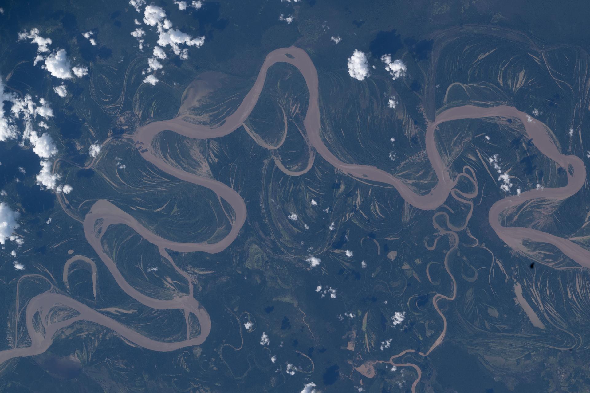
iss074e0492148 (April 15, 2026) --- The Ucayali River in central Peru—home to a wide array of wildlife including dolphins, manatees, reptiles, and birds—is a major tributary and main headstream of the Amazon River. The International Space Station was orbiting 264 miles above the lowland Amazon rainforest when this photograph was taken. Credit: NASA/Jessica Meir
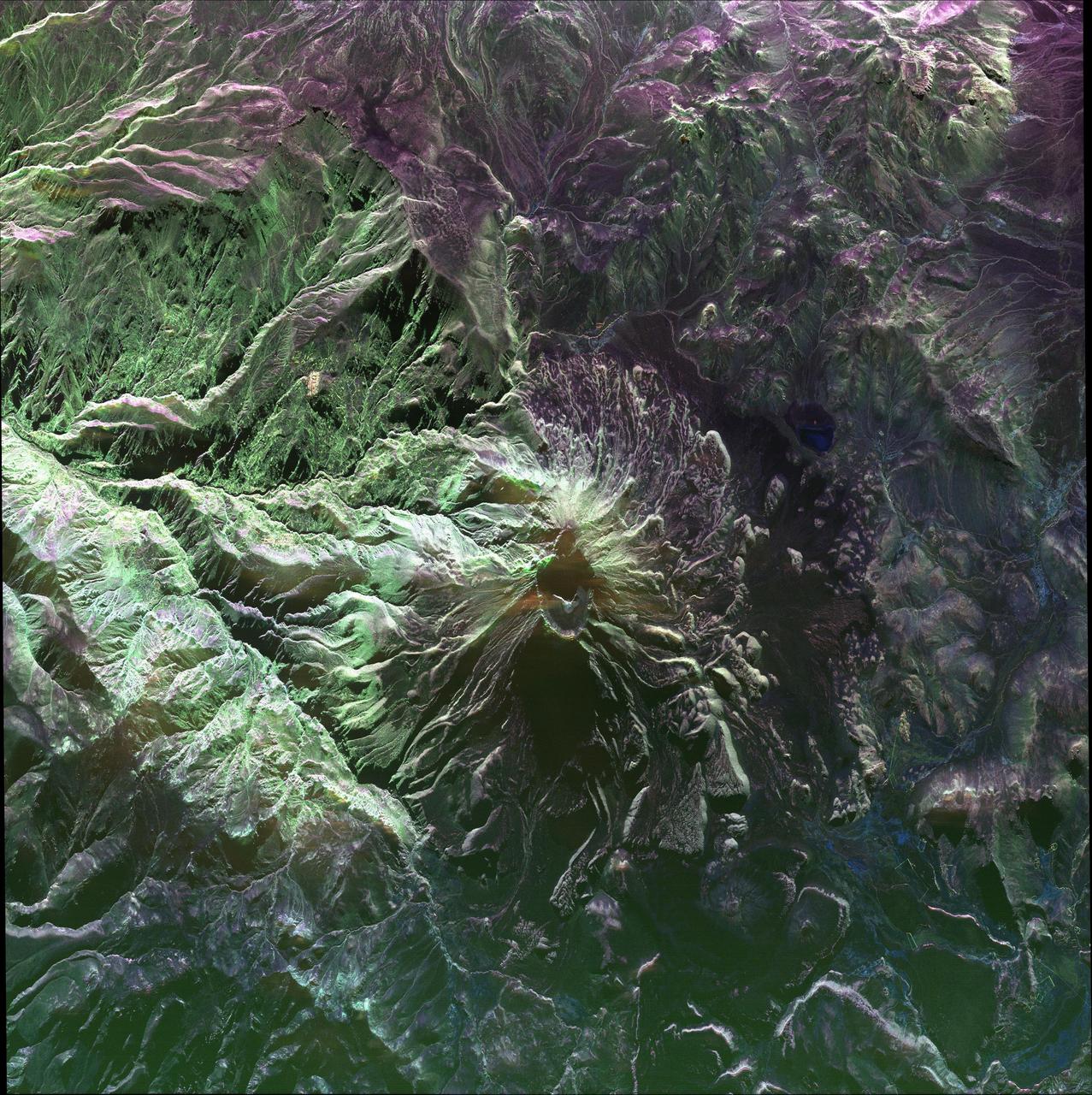
This false-color image of Peru Ubinas volcano was acquired on April 14, 2014, by NASA UAVSAR. Located about 100 miles 160 kilometers from the city of Arequipa, Ubinas is Peru most active volcano.
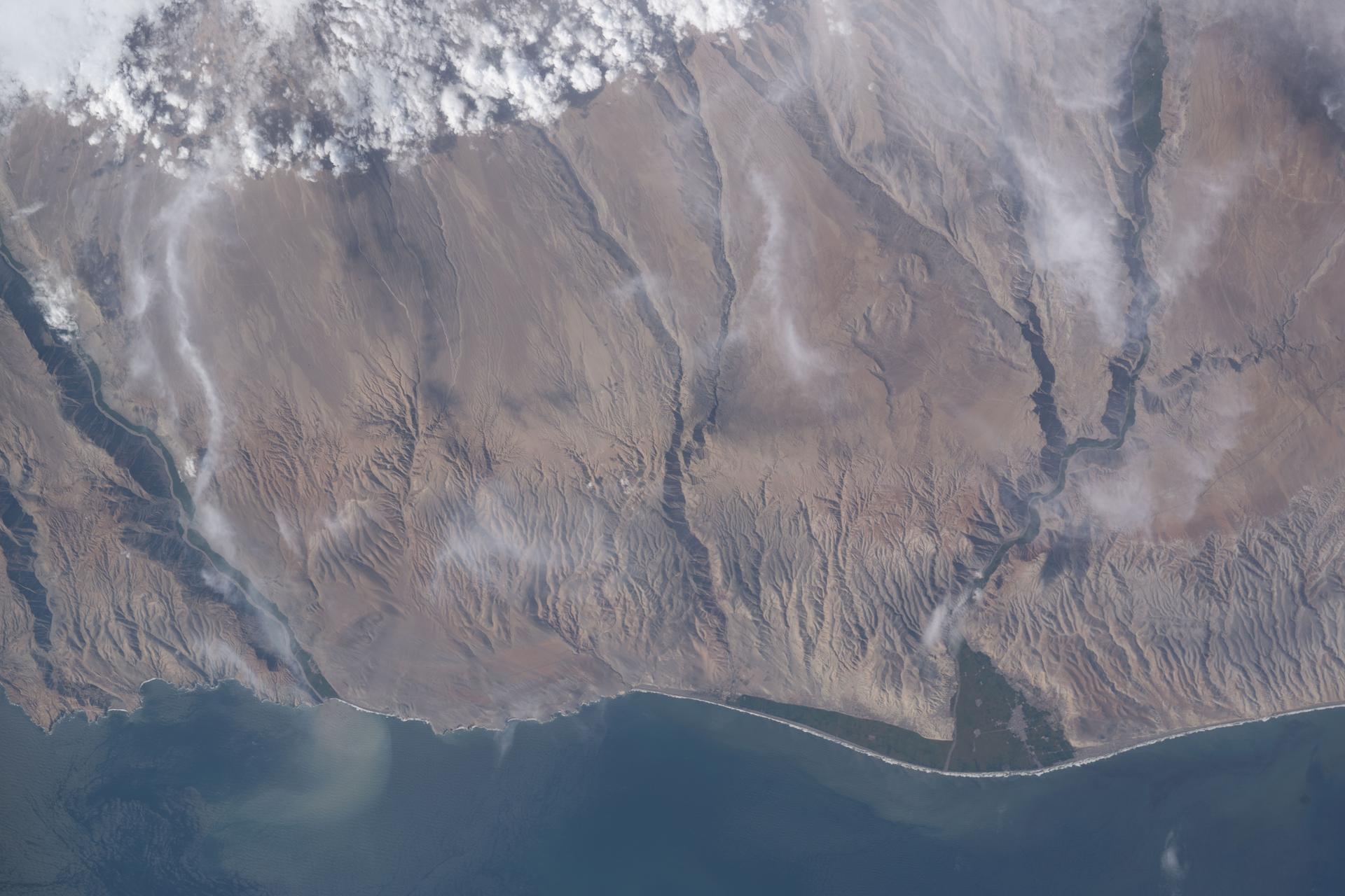
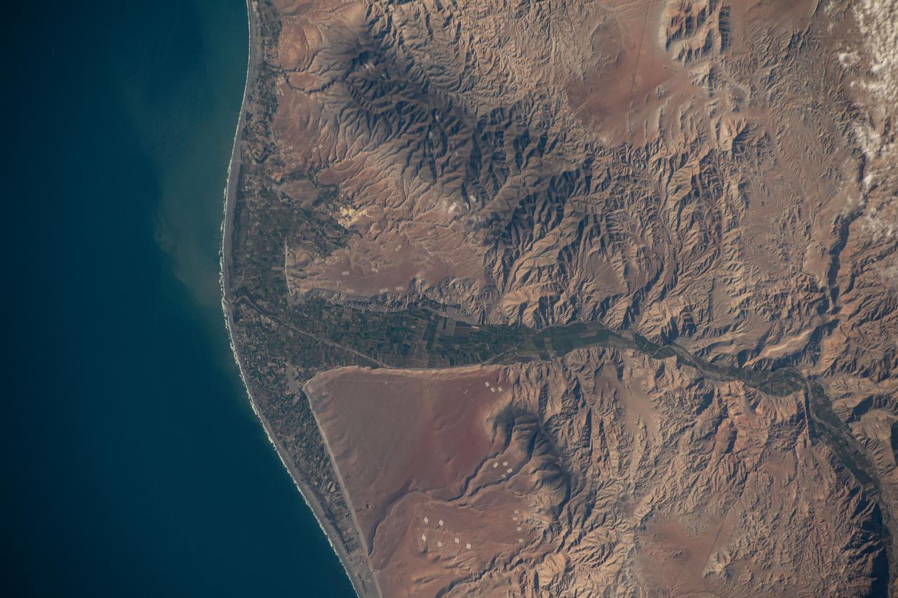
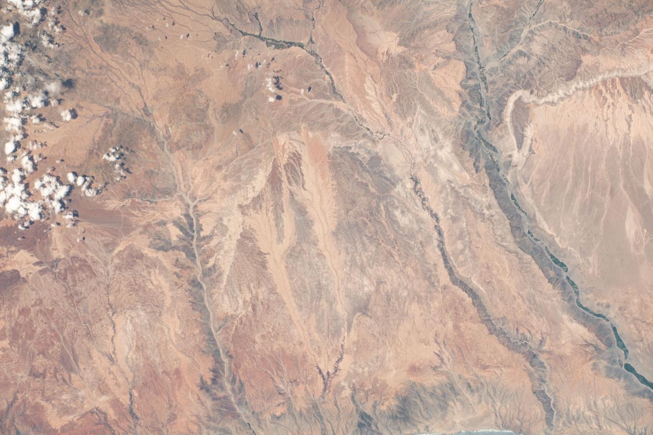
iss074e0315662 (Feb. 13, 2026) --- A portion of the Atacama Desert along Peru’s southern Pacific coast, featuring barren plains, rocky cliffs, vast sand dunes, and fertile river valleys, is pictured from the International Space Station as it orbited 265 miles above the South American nation. Credit: NASA/Chris Williams
iss073e0089435 (May 16, 2025) --- The International Space Station was soaring 261 miles above the Pacific coast of South America into an orbital sunrise at approximately 4:09 a.m. local time when this photograph was taken. Lima (upper right), Peru's capital and largest city with a population of 10.1 million, represents the brightest lights on the Peruvian coast.
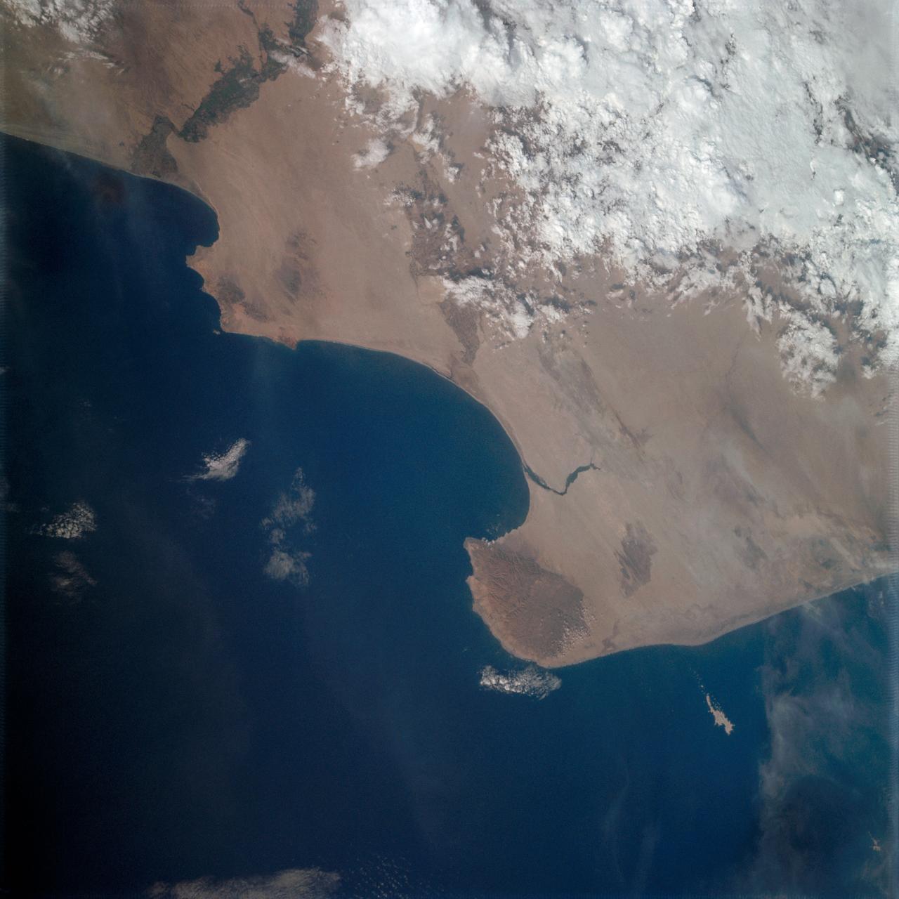
Vertical Earth Observation taken by the Apollo 9 crew. View is of Peru and South America including Aguja Point and Piura. Film magazine was E,film type was SO-368 Ektachrome with 0.460 - 0.710 micrometers film / filter transmittance response and haze filter,80mm lens. Latitude was 5.35 S by Longitude 81.05 W, Overlap was 0%, Altitude miles were 125 and cloud cover was 20%.
S66-38313 (5 June 1966) --- Areas of Peru (upper right), Chile (top center) and Bolivia as seen from the Gemini-9 spacecraft during its 35th revolution of Earth. The large body of water at lower right is Lake Titicaca. The smaller lake at left edge is Lake Poopo. Salar de Uyuni is the large light-colored area at upper left. At the bottom of the picture is the snow-capped Cordillera Real range of the Andes Mountains. The Pacific coastline of Peru and Chile is at upper right. The range running parallel with the coastline is the Cordillera Occidental. The image was taken with a modified 70mm Hasselblad camera, using Eastman Kodak, Ektachrome MS (S.O. 217) color film. Photo credit: NASA
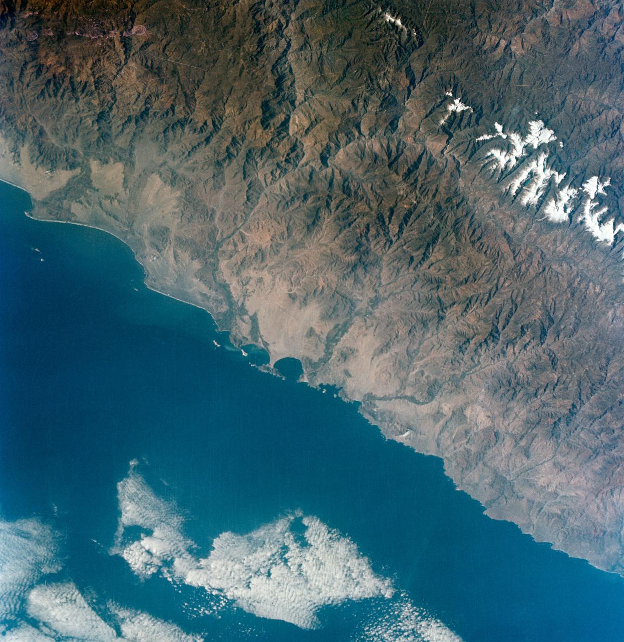
S66-38298 (5 June 1966) --- The central coastal area of Peru as seen from the Gemini-9A spacecraft during its 35th revolution of Earth. The body of water is the Pacific Ocean. The mountains are in the Cordillera Blanca range of the Andes. The 22,205-feet Huascaran is the highest peak in the area. The image was taken with a modified 70mm Hasselblad camera, using Eastman Kodak, Ektachrome MS (S.O. 217) color film Photo credit: NASA
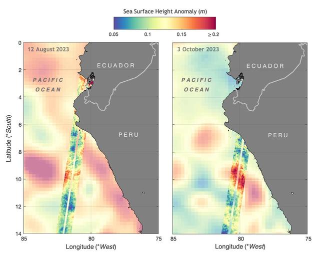
The illustration above shows sea levels off the coasts of Peru and Ecuador on Aug. 12, 2023, and Oct. 3, 2023. The Surface Water and Ocean Topography (SWOT) satellite collected the ocean data during its operational phase, which began in late July. The red and orange colors represent sea levels that are higher than average (units are in meters), while green and blue indicate sea levels that are lower than average. The SWOT data shows some of the development of an El Niño along the west coast of the Americas. The SWOT science team made the measurements using the spacecraft's Ka-band Radar Interferometer (KaRIn) instrument. With two antennas spread 33 feet (10 meters) apart on a boom, KaRIn produces a pair of data swaths (tracks visible in the animation) as it circles the globe, bouncing radar pulses off the water's surface to collect surface-height measurements. Launched on Dec. 16, 2022, from Vandenberg Space Force Base in central California, SWOT is now in its operations phase, measuring the height of nearly all water on Earth's surface. The satellite will provide one of the most detailed, comprehensive views yet of the planet's oceans and fresh water lakes and rivers, collecting data that will be used for research and other purposes. https://photojournal.jpl.nasa.gov/catalog/PIA26181
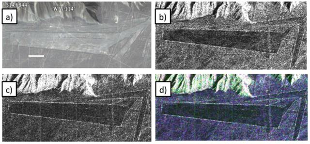
Different visualizations of an area with geometric geoglyphs at the Nasca World Heritage Site in Peru as seen by NASA Uninhabited Aerial Vehicle Synthetic Aperture Radar UAVSAR.
On March 17, 2013, NASA Uninhabited Aerial Vehicle Synthetic Aperture Radar UAVSAR acquired synthetic aperture radar data over the Napo River in Ecuador and Peru.
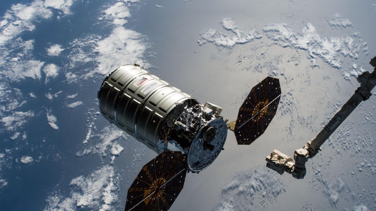
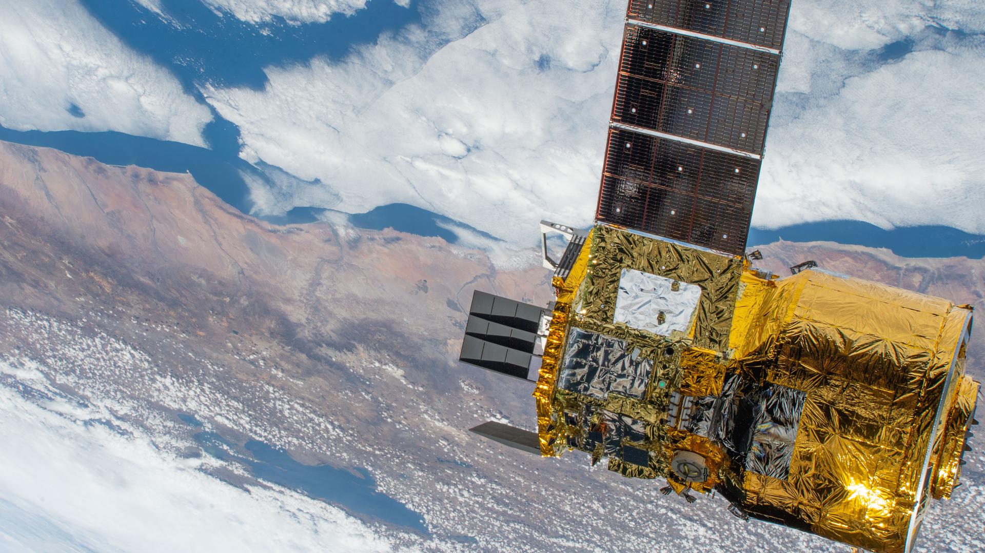
iss058e011814 (Feb. 8, 2019) --- The Cygnus cargo craft from Northrop Grumman is released from the grips of the Canadarm2 robotic arm as the International Space Station was orbiting over the Pacific Ocean off the coast of Peru.
Pando Province, Bolivia, and adjacent parts of Brazil and Peru are seen in this visualization of NASA Shuttle Radar Topography Mission SRTM elevation data covering part of the Amazon Basin.
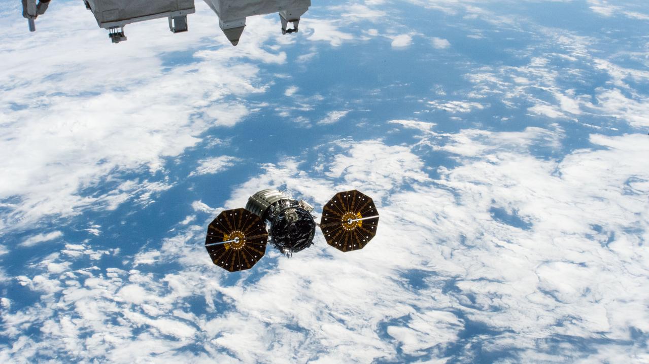
iss058e011816 (Feb. 8, 2019) --- The Cygnus cargo craft from Northrop Grumman begins its departure from the International Space Station as both spacecraft were orbiting 252 miles over the Pacific Ocean off the coast of Peru.
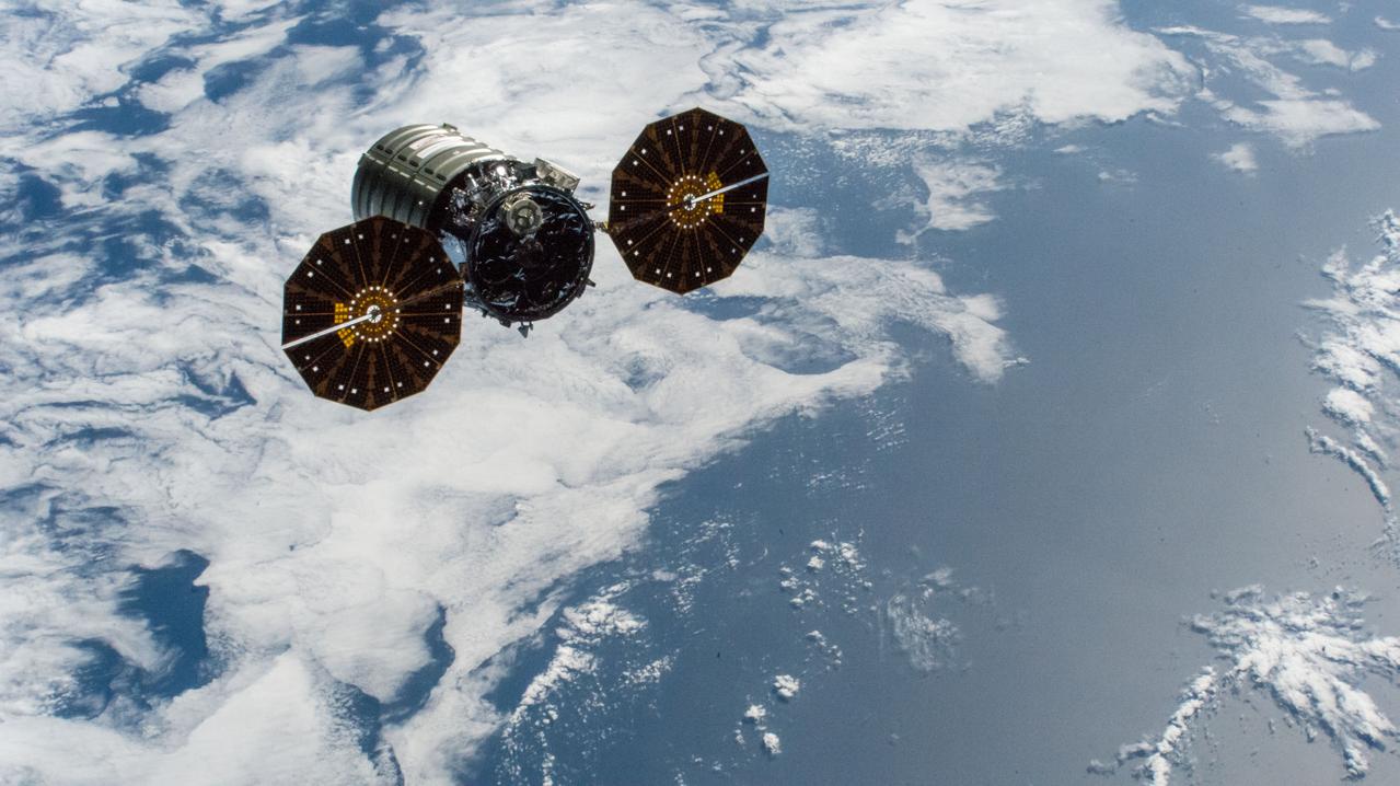
iss058e011815 (Feb. 8, 2019) --- The Cygnus cargo craft from Northrop Grumman begins its departure from the International Space Station as both spacecraft were orbiting 252 miles over the Pacific Ocean off the coast of Peru.
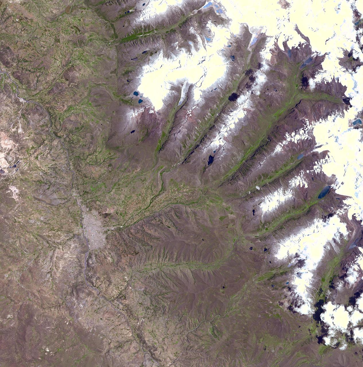
A chunk of glacier was threatening to fall into an Andean lake and cause major flooding in a Peruvian city of 60,000. A fissure has appeared in the glacier that feeds the Lake Palcacocha near the city of Huaraz, 270 km north of Lima. If the piece breaks off, ensuing floods would take 15 minutes to reach the city. In 1941, the lake overflowed and caused massive destruction, killing 7,000 people. The city can be seen in the left-center part of the image. Lake Palcacocha is in the upper right corner of the image at the head of a valley, below the snow and glacier cap. The ASTER instrument is being tasked to obtain current images of the glacier to help monitor the situation. This image was acquired on November 5, 2001 by the Advanced Spaceborne Thermal Emission and Reflection Radiometer (ASTER) on NASA's Terra satellite. With its 14 spectral bands from the visible to the thermal infrared wavelength region, and its high spatial resolution of 15 to 90 meters (about 50 to 300 feet), ASTER images Earth to map and monitor the changing surface of our planet. http://photojournal.jpl.nasa.gov/catalog/PIA03898
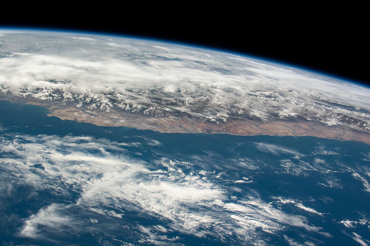
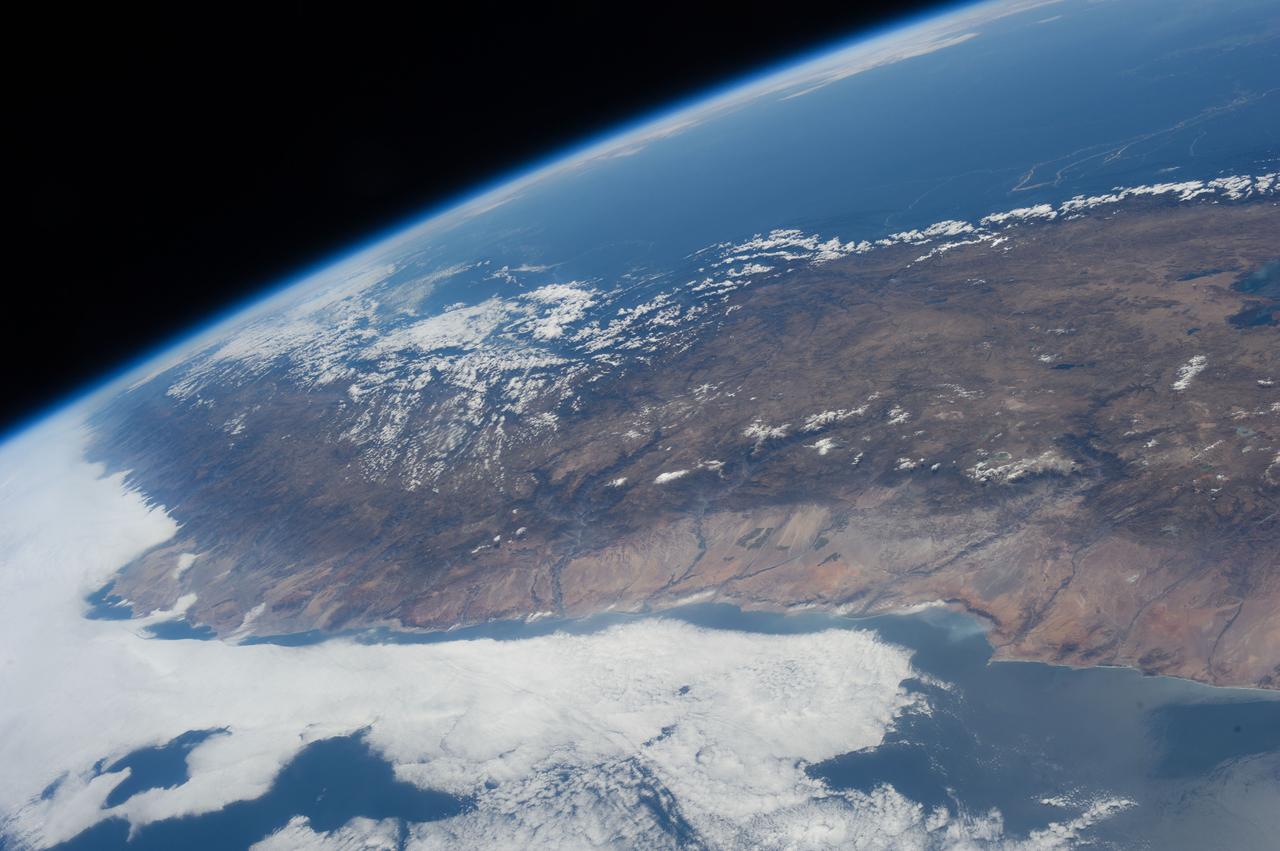
iss070e064082 (Jan. 11, 2024) --- The southern coast of Peru on the Pacific Ocean is pctured from the International Space Station as it orbited 260 miles above.
iss064e026455 (Jan. 26, 2021) --- The coast of Peru in South America is pictured from the International Space Station as it orbited 263 miles above the Pacific Ocean.
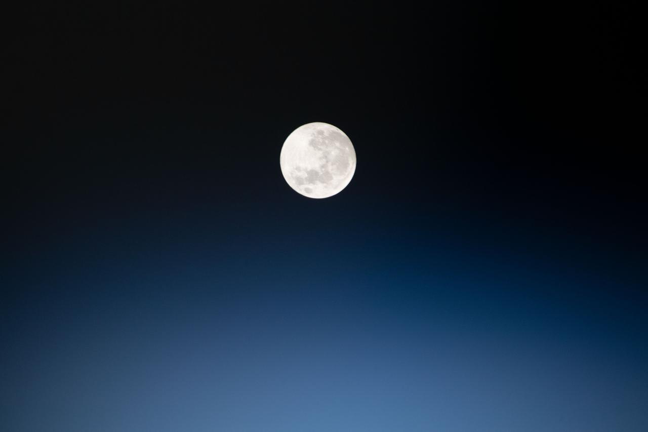
iss060e008815 (July 16, 2019) --- The full moon is pictured as the International Space Station orbited 257 miles above Peru in South America.
Earth Observation taken during a day pass by the Expedition 40 crew aboard the International Space Station (ISS). Folder lists this as: Peru.

iss064e026467 (Jan. 26, 2021) --- The coast of Peru in South America is pictured from the International Space Station as it orbited 263 miles above the Pacific Ocean.
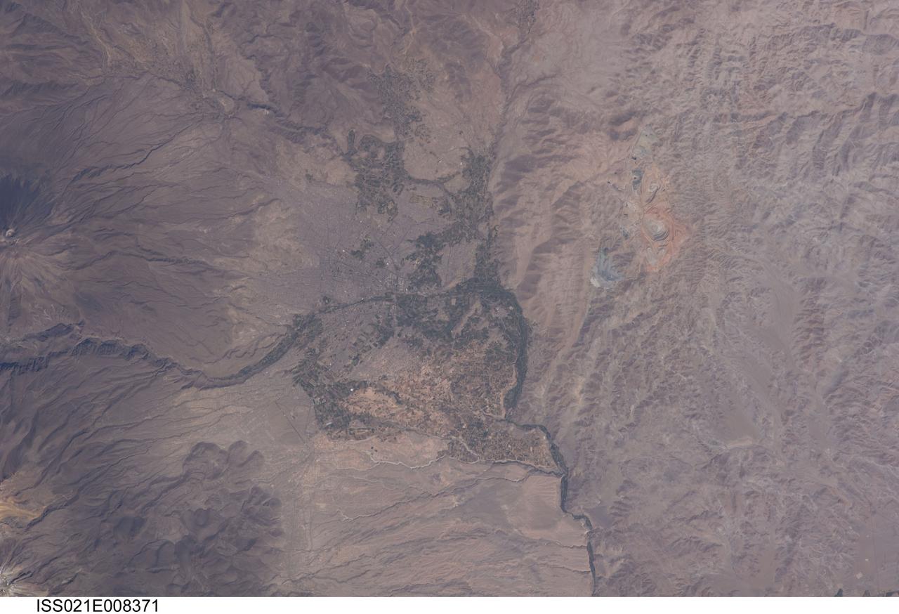
ISS021-E-008371 (16 Oct. 2009) --- The city of Arequipa, Peru is featured in this image photographed by an Expedition 21 crew member on the International Space Station. Several Latin American cities have grown up on the flanks of active volcanoes. The city center of Arequipa, Peru lies only 17 kilometers away from the summit of El Misti volcano (partially out of frame at left); the gray urban area is bordered by green agricultural fields. With almost one million residents in 2009, it is the second city of Peru in terms of population. Much of the building stone for Arequipa, known locally as sillar, is quarried from nearby pyroclastic flow deposits that are white in color. Arequipa is known as ?the White City? because of the prevalence of this building material. The Chili River extends northeastwards from the city center, and flows through a canyon (left) between El Misti volcano and Nevado Chachani to the north.
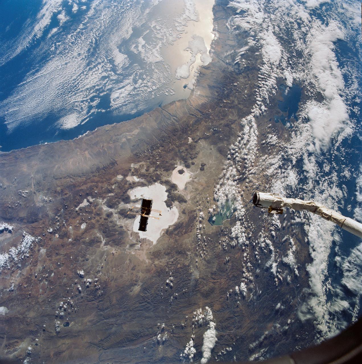
Hubble Space Telescope (HST), with its solar array (SA) wings and high gain antennae (HGA) fully extended,is released from Discovery's, Orbiter Vehicle (OV) 103's, remote manipulator system (RMS) end effector and is set free into Earth orbit by the STS-31 crew. HST drifts away from the end effector over the Andes Mountains.Parts of Bolivia, Peru, Chile, and Argentina are visible. The view covers a huge area of the western half of South America stretching from 14 degrees south latitude to 23 degrees, about 1,000 kilometers.
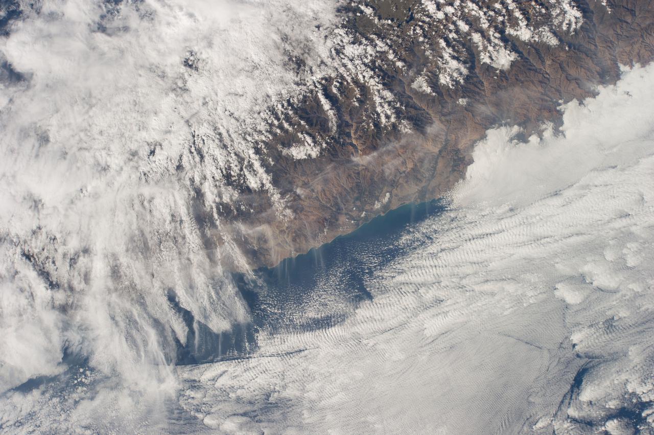
iss070e003364 (Oct. 13, 2023) --- An orbital sunrise casts elongated cloud shadows in this photograph from the International Space Station as it orbited 260 miles above the Peru-Ecuador border in South America.

iss067e220400 (July 31, 2022) --- A partly cloudy Pacific Ocean is pictured from the International Space Station as it orbited 259 miles above off the coast of Peru in South America.
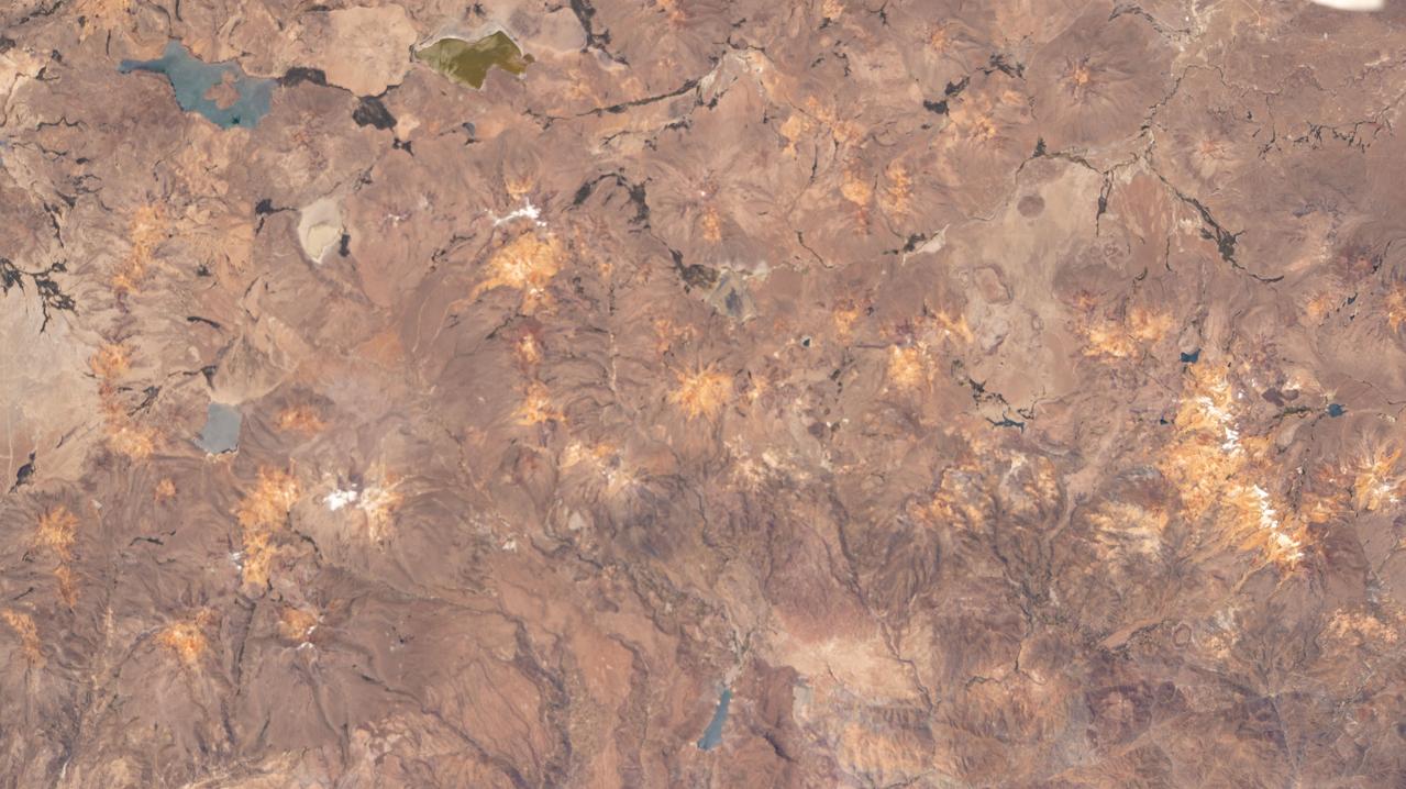
iss064e002484 (Oct. 29, 2020) --- Looking like daubs of ochre paint on an artist's canvas, a portion of the Andes Mountain range, with the Lagunas Ajuachaya and Loriscota (top left), in southern Peru is pictured from the International Space Station.
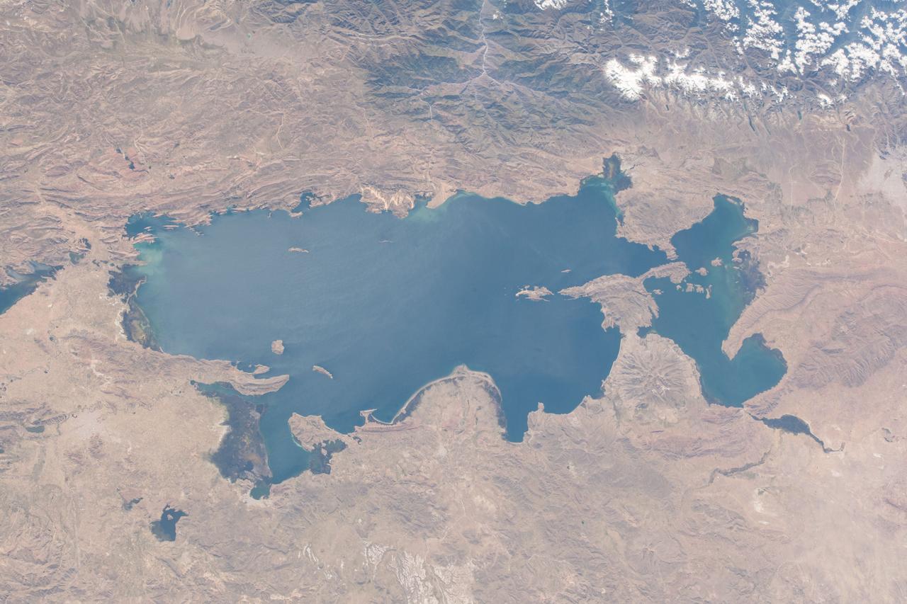
iss055e071030 (May 14, 2018) --- Lake Titicaca is bisected by the South American countries of Peru and Bolivia with the Andes Mountain range skirting up against its northwestern edge.
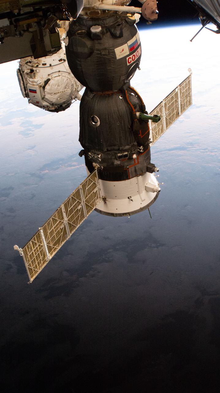
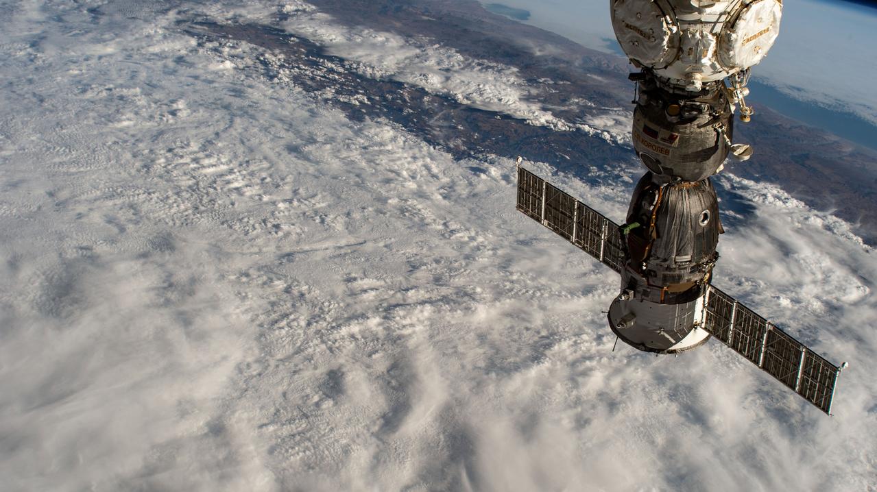
iss066e109862 (Jan. 9, 2022) --- The Soyuz MS-19 crew ship and the Prichal docking module (background) are pictured as the International Space Station orbited 260 miles above the Pacific Ocean off the coast of Peru.
Earth observation taken during day pass by an Expedition 36 crew member on board the International Space Station (ISS). Per Twitter message: Southwest coast of Peru.
iss064e026005 (Jan. 26, 2021) --- The subtropical desert climate of the southern coast of Peru is pictured from the International Space Station as it orbited 263 miles above the South American nation.
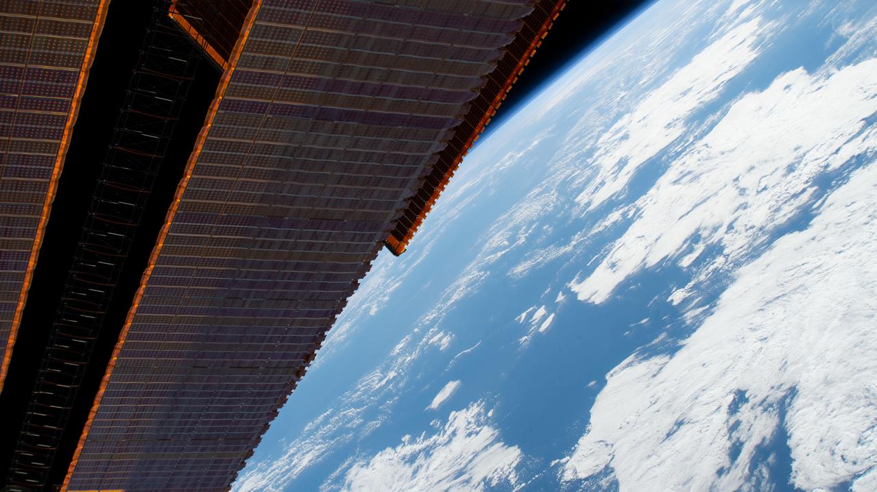
iss060e013819 (July 21, 2019) --- A portion of the International Space Station's main solar arrays drape the foreground as the orbiting lab flew 261 miles above the Pacific Ocean west of Peru.
iss067e169915 (July 1, 2022) --- Lake Titicaca, a freshwater lake in the Andes on the border between Bolivia and Peru, is pictured from the International Space Station as it orbited 262 miles above the western portion of the South American continent.
iss067e362299 (Sept. 15, 2022) --- The Soyuz MS-21 crew ship is pictured attached to the Prichal docking module as the International Space Station orbited 260 miles above a cloudy Peru on the South American continent.
iss068e022209 (Nov. 13, 2022) --- Clouds gather near the peaks of the Andes Mountain range in Peru in this photograph from the International Space Station as it orbited 262 miles above the South American nation's Pacific coast.
iss070e015250 (Oct. 29, 2023) --- Lake Titicaca, a freshwater lake nestled in between Peru and Bolivia in the Andes Mountains, is pictured from the International Space Station as it orbited 261 miles above the South American continent.
The ruins of Machu Picchu, rediscovered in 1911 by Hiram Bingham, are one of the most beautiful and enigmatic ancient sites in the world. While the Inca people utilized the Andean mountain top (2800 m elevation), erecting massive stone structures from the early 1400's, legends and myths indicate that Machu Picchu (meaning "Old Peak" in the Quechua language) was revered as a sacred place from a far earlier time. The Inca turned the site into a small (12 square kilometers) but extraordinary city. Invisible from the Urubamba River valley below and completely self-contained, surrounded by agricultural terraces sufficient to feed the population, and watered by natural springs, Machu Picchu seems to have been utilized by the Inca as a secret ceremonial city. The Spaniards never found Machu Picchu, even though they suspected its existence. The mountain top sanctuary fell into disuse and was abandoned some forty years after the Spanish took Cuzco in 1533. Supply lines linking the many Inca social centers were disrupted and the great empire came to an end. This image was acquired on June 25, 2001 by the Advanced Spaceborne Thermal Emission and Reflection Radiometer (ASTER) on NASA's Terra satellite. With its 14 spectral bands from the visible to the thermal infrared wavelength region, and its high spatial resolution of 15 to 90 meters (about 50 to 300 feet), ASTER will image Earth for the next 6 years to map and monitor the changing surface of our planet. http://photojournal.jpl.nasa.gov/catalog/PIA03853
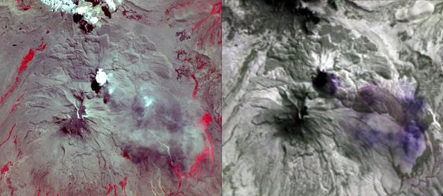
NASA's Advanced Spaceborne Thermal Emission and Reflection Radiometer (ASTER) acquired this image of Peru's Sabancaya stratovolcano on April 10, 2019. Sabancaya has been erupting regularly for several months, sending ash plumes high into the air. At the time this image was taken, the plume reached an altitude of 9100 meters (9950 yards) and was moving southeastward. In the left image, Sabancaya is under the bright round white cloud. The greyish clouds to the southeast are ash plumes. The Ampato volcano, with its prominent summit caldera, is to the south. The red areas are vegetation. The right thermal image shows the plume in purple, indicating that it is dominantly composed of sulfur dioxide gas. A bright hotspot can be seen directly north of the black (cold) cloud over Sabancaya. The image covers an area of 19.5 by 17.2 kilometers (12 miles by 11 miles), and is located at 15.8 degrees south, 71.9 degrees west. https://photojournal.jpl.nasa.gov/catalog/PIA23143
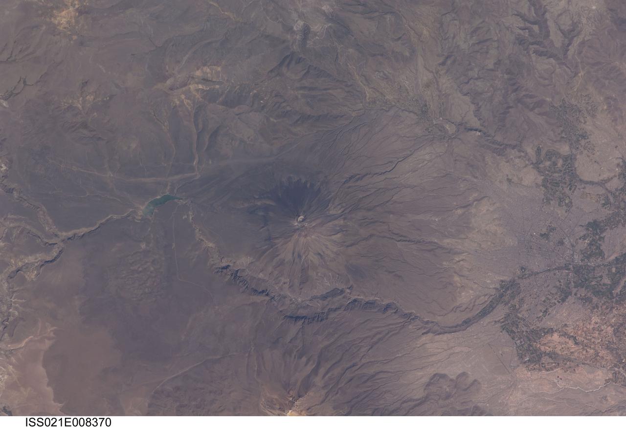
ISS021-E-008370 (16 Oct. 2009) --- El Misti volcano in Peru is featured in this image photographed by an Expedition 21 crew member on the International Space Station. The symmetric conical shape of El Misti is typical of a stratovolcano ? a type of volcano characterized by interlayered lavas and products of explosive eruptions, such as ash and pyroclastic flow deposits. Stratovolcanoes are usually located on the continental crust above a subducting tectonic plate. Magma feeding the stratovolcanoes of the Andes Mountains ? including 5,822 meter-high El Misti ? is associated with ongoing subduction of the Nazca Plate beneath the South American Plate. El Misti?s most recent -- and relatively minor -- eruption occurred in 1985. The city center of Arequipa, Peru lies only 17 kilometers away from the summit of El Misti; the gray urban area is bordered by green agricultural fields (right). With almost one million residents in 2009, it is the second city of Peru in terms of population. Much of the building stone for Arequipa, known locally as sillar, is quarried from nearby pyroclastic flow deposits that are white in color. Arequipa is known as ?the White City? because of the prevalence of this building material. The Chili River extends northeastwards from the city center, and flows through a canyon (left) between El Misti volcano and Nevado Chachani to the north.

iss063e053023 (July 22, 2020) --- Lake Titicaca, pictured from the International Space Station as it orbited off the Pacific coast of South America, is located between the nations of Peru and Bolivia in the Andes Mountains and is one of the highest navigable lakes in the world.
iss069e033636 (July 19, 2023) -- El Misti Volcano, which towers 5,822 meters (19,100 feet) high, is characterized by alternating layers of lava and debris from explosive eruptions. The International Space Station orbited 262 miles above Peru as this photo was captured.

iss068e029146 (Dec. 11, 2022) --- Expedition 68 Flight Engineer Koichi Wakata of the Japan Aerospace Exploration Agency (JAXA) peers at the Earth below from inside the cupola as the International Space Station orbited 261 miles above the Pacific Ocean off the coast of Peru.
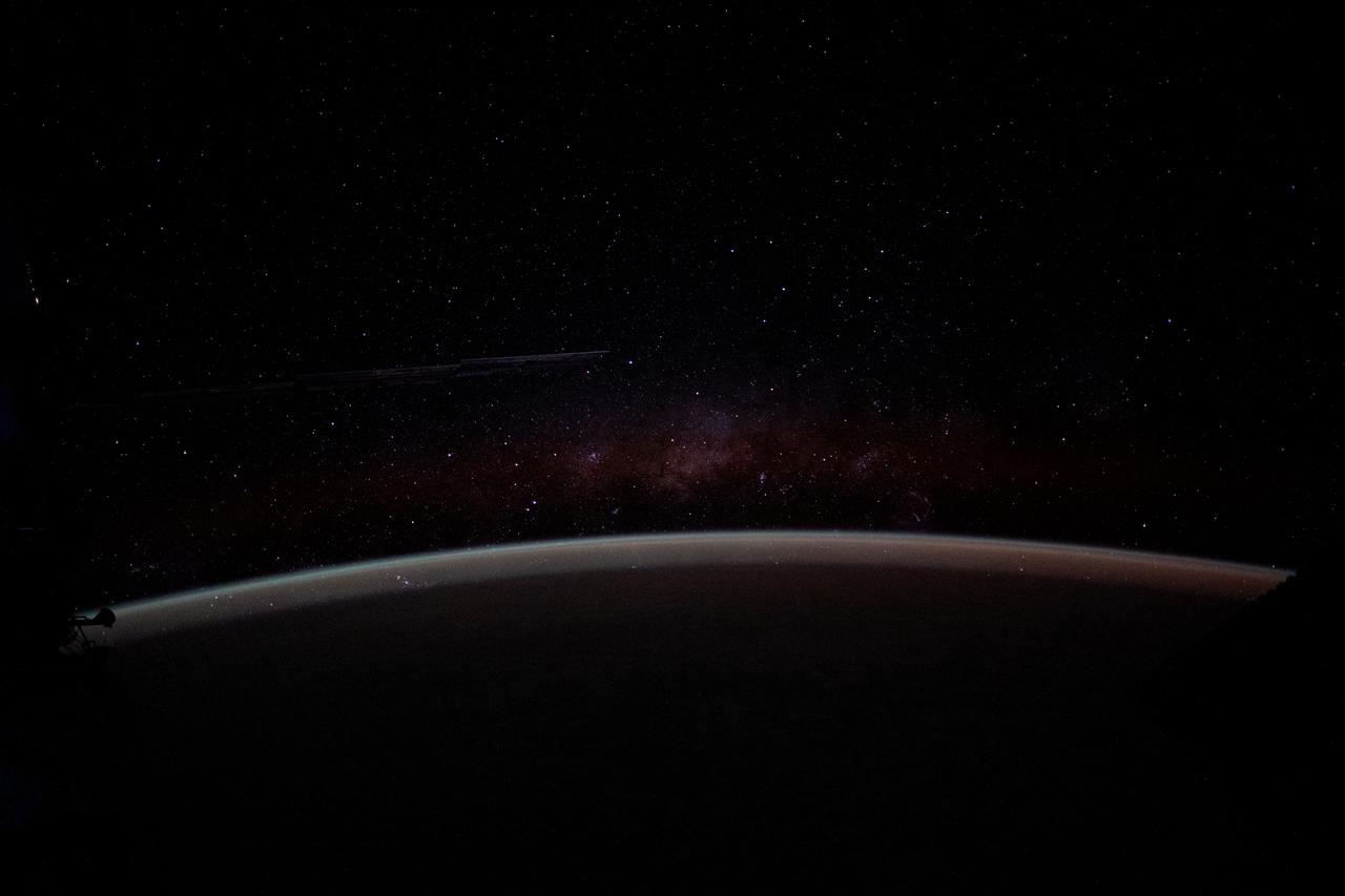
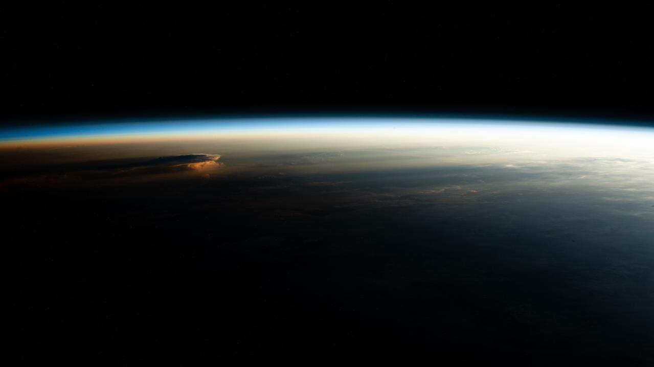
iss071e587371 (Aug. 13, 2024) --- The Earth's airglow blankets the atmosphere with a wispy Milky Way in the background above the horizon in this long-duration photograph taken with a camera programmed for high sensitivity aboard the International Space Station as it orbited 262 miles above the Pacific Ocean off the coast of Peru.

iss068e017849 (Oct. 22, 2022) --- NASA astronaut and Expedition 68 Flight Engineer Josh Cassada is pictured inside the cupola, the International Space Station's "window to the world," as the orbiting lab flew 264 miles above the Pacific Ocean off the coast of Peru. Credit: NASA/Nicole Mann

iss068e006170 (Oct. 1, 2022) --- ESA (European Space Agency) astronaut and Expedition 68 Flight Engineer Samantha Cristoforetti looks at the Earth below through the cupola, the International Space Station's "window to the world," while orbiting 260 miles above the Pacific Ocean off the coast of Peru.
iss073e0988449 (Oct. 29, 2025) --- The new HTV-X1 cargo spacecraft from JAXA (Japan Aerospace Exploration Agency), carrying about 12,800 pounds of science, supplies, and hardware for the Expedition 73 crew, slowly approaches the International Space Station 264 miles above the Pacific coast of southern Peru.
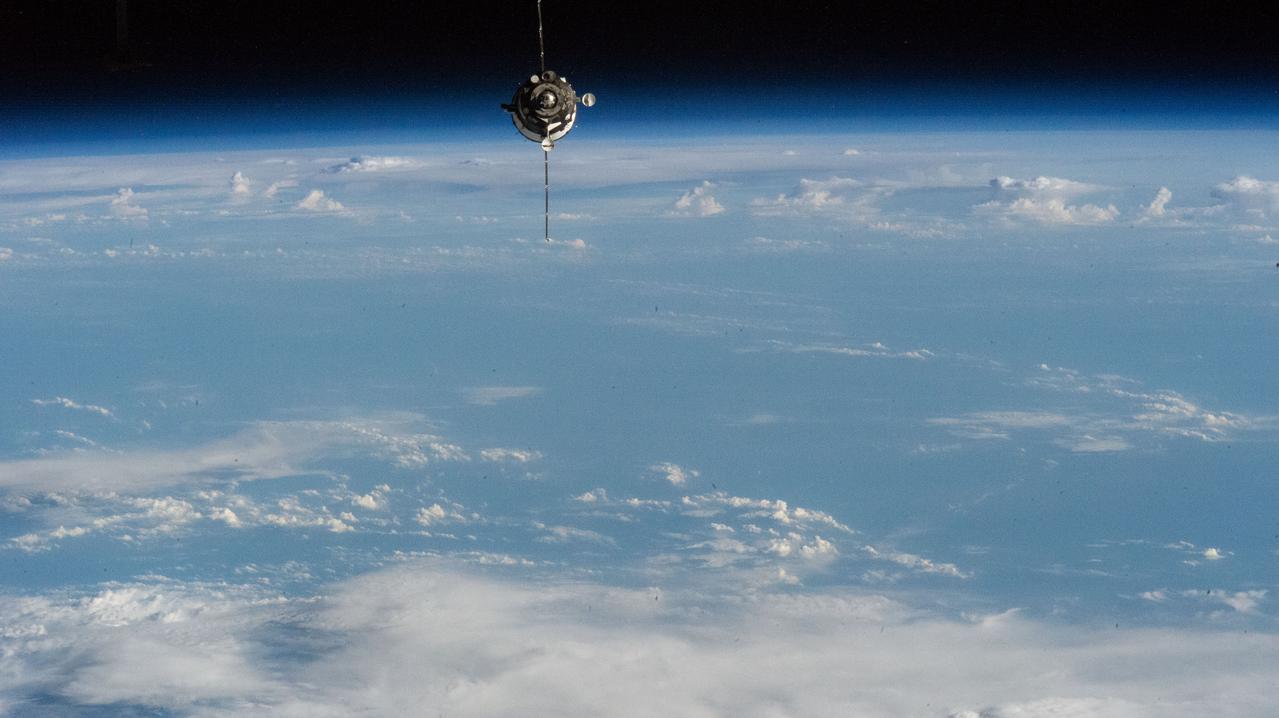
iss062e140338 (March 9, 2020) --- The Expedition 63 crew, with NASA astronaut Chris Cassidy and Roscosmos cosmonauts Anatoly Ivanishin and Ivan Vagner, approaches the International Space Station inside the Soyuz MS-16 crew ship. Both spacecraft were orbiting above the Pacific Ocean off the coast of Peru.

STS109-E-5887 (9 March 2002) --- This view of a good portion of the country of Chile was recorded with a digital still camera by one of the STS-109 astronauts aboard the Space Shuttle Columbia. Chile's Pacific Coast is featured and the country's borders with three other nations--Bolivia, Peru and Argentina--almost or just barely made it into the frame in three different directions. Punta Angamos and Punta Tetas are readily visible on the anvil shaped peninsular feature, near the city of Antofagasta.

iss073e0511718 (Aug. 20, 2025) --- NASA astronaut and Expedition 73 Flight Engineer Zena Cardman speaks on a ham radio with the NixderStelar youth organization from Lima, Peru. The youngsters asked about using artificial intelligence on the International Space Station, how research in space benefits humans on Earth, and how living in weightlessness affects their bodies. Astronauts frequently speak to students, professionals, and government officials using the ham radio aboard the orbital outpost's Destiny laboratory module.
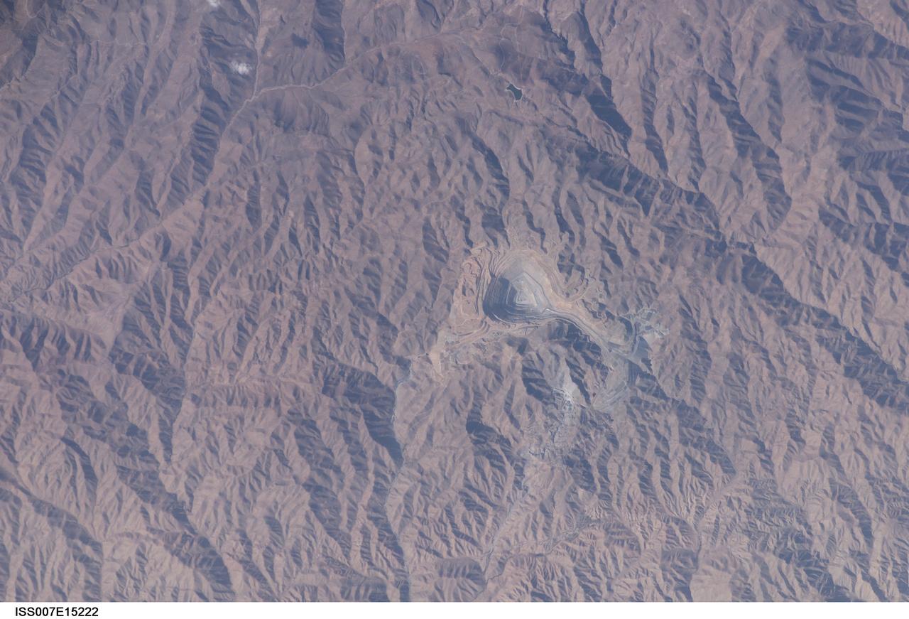
ISS007-E-15222 (22 September 2003) --- This view in southern Peru, photographed by an Expedition 7 crewmember onboard the International Space Station (ISS), features the Toquepala copper mine, a steep sided and stepped open-pit mine. Mid-afternoon sunlight of the arid slopes of the central Andes Mountains provides an accent to the mine contours. At the surface the open pit is 6.5 kilometers across and it descends more than 3000 meters into the earth. A dark line on the wall of the pit is the main access road to the bottom.
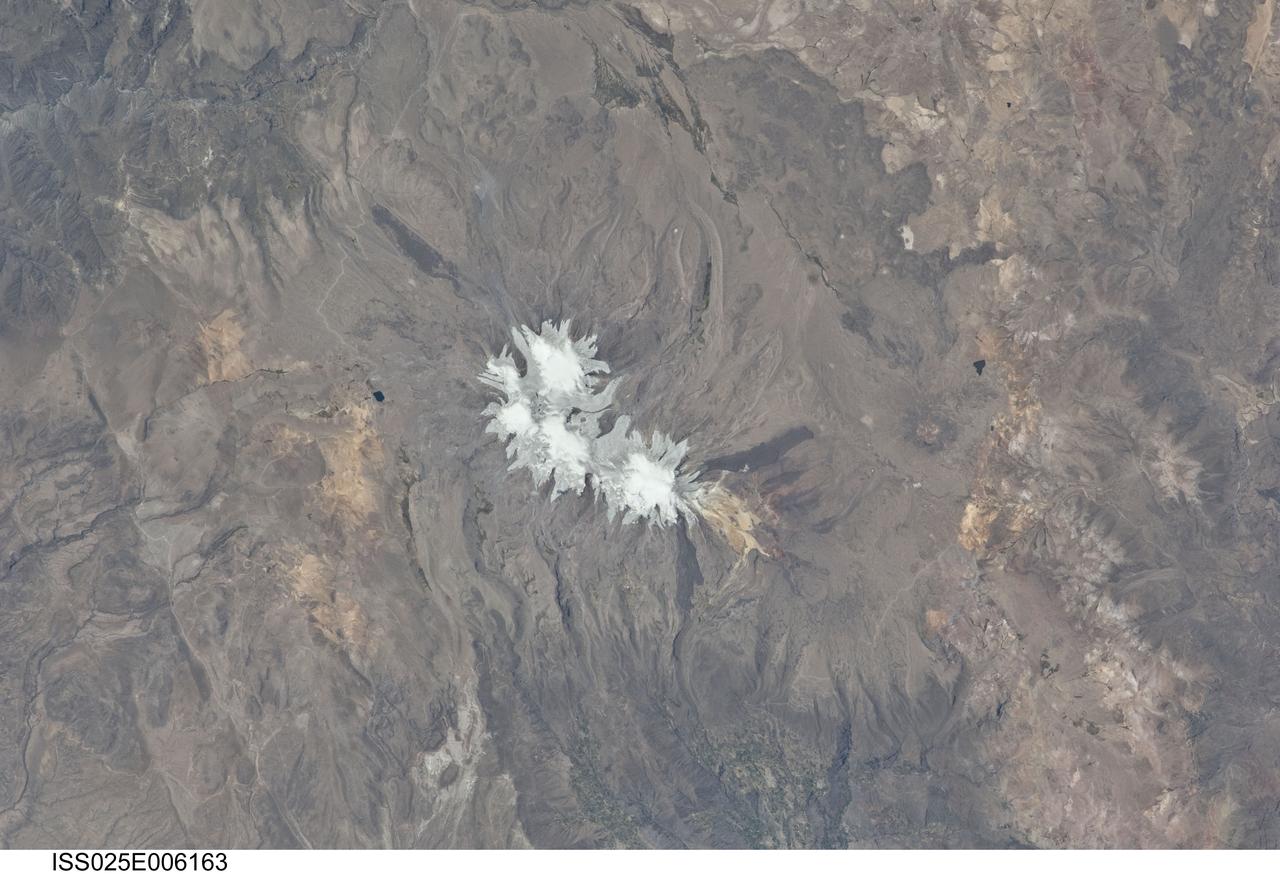
ISS025-E-006163 (6 Oct. 2010) --- Nevado Coropuna, Peru is featured in this image photographed by an Expedition 25 crew member on the International Space Station. Nevado (“snowy” or “snowy peak” in Spanish) Coropuna is the highest volcanic peak in Peru – the summit elevation is 6,377 meters above sea level. Rather than being a single stratovolcano, Coropuna is a volcanic complex of numerous summit cones. The complex covers an area of 240 square kilometers within the Ampato mountain range (Cordillera Ampato) in southeast-central Peru. While the exact date of the volcano’s last eruption is not known, lava flows (black, at center and upper left) along the northern, southern, and western flanks of the complex are thought to have been emplaced during the early Holocene Epoch – the current geologic time period which began approximately 12,000 years ago, according to scientists. Coropuna also hosts several summit glaciers and icefields (white to gray, center) that contrast sharply with the dark rock outcrops and surface deposits at lower elevations. Glacial deposits and lateral moraines on the flanks of Coropuna indicate that glaciers once extended to much lower elevations than are observed today. Scientists believe that careful mapping and surface exposure age-dating of these glacial deposits and landforms provides data on the timing of ice advances and retreats in the tropics near the end of the Pleistocene Epoch (extending from approximately 2.5 million to approximately 12,000 years ago). In turn, this information can be compared with other paleoclimate records to obtain a better understanding of how Earth’s global climate has changed over geologic time.
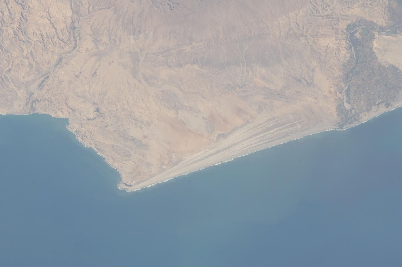
ISS032-E-016579 (11 Aug. 2012) --- A strandplain on coastal Peru is featured in this image photographed by an Expedition 32 crew member on the International Space Station. The scale and orientation of landscape features that are difficult to see on the ground often become readily visible from orbit. Numerous subparallel lines (center) along the arid, northern coast of Peru (about five degrees south of the Equator) are close-packed beach ridges, known collectively as a strandplain (for scale, the strandplain is 30 kilometers long). Each ridge shows the position of a prior shoreline. The Chira River delta appears at right, with dark green agricultural fields occupying the delta of the river. A smaller river reaches the sea, without forming a delta, at extreme left. The prominent cape at lower left is Punta Balcones, a region with many oil wells. Strandplains are built by successive additions of beach sand usually from some nearby source. Currents on this coast of South America come from the south, suggesting to scientists that the Chira River delta (right) is the source of the sand. The newest beach is being formed today by the waves?which appear as the thin ragged white line along the strandplain?supplied by the north-flowing current. The regularity of the spacing of the beaches suggests that some episodic influx of sediment controls beach formation. This influx may be determined by floods coming down the Chira River, possibly controlled by the heavy rains of El Nino events which occur irregularly every few years. Two other sets of faint parallel lines can be seen on higher ground inland (between arrows, center and top right), the upper set stretching all the way from the Chira river floodplain. Seen in many places along the coast of Peru, scientists believe these may also be strandplains (i.e. formed at sea level) generated when the land surface was at a lower altitude; both also may have been produced by sand from the Chira River. The land surface is known to be rising along this coast with the rise of the Andes Mts. (outside the top of the image), explaining why the upper shorelines now lie 120 meters above sea level.
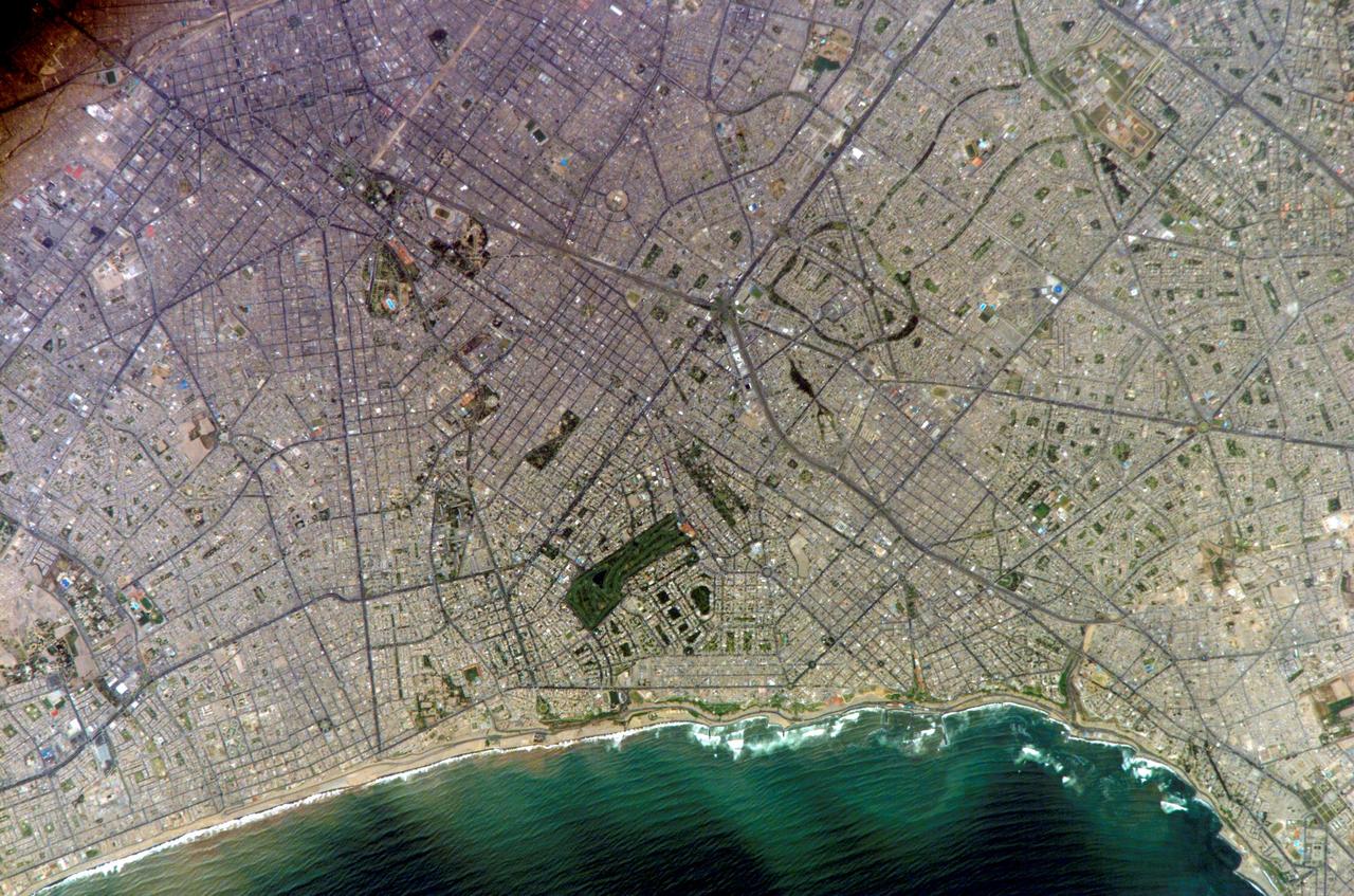
ISS010-E-20111 (15 March 2005) --- Lima, Peru is featured in this image photographed by an Expedition 10 crewmember on the International Space Station (ISS). Located on the broad alluvial fan of the Rimac River, Lima is the capital of Peru and the only mega city (7.7 million inhabitants in 2002) located on the western coastline of South America. The city was established by Francisco Pizarro in 1535 and became an important colonial port linking silver mines of the Altiplano of the high Andes to the east with the burgeoning Spanish empire. During the mid-20th century a significant relocation of people from rural mountain communities into the Lima metropolitan area led to its growth into a mega city. Problems now facing the metropolitan region include development of adequate water resources, control of pollution, and the potential effects of natural hazards such as earthquakes and landslides. This photograph depicts the wealthier San Isidro and Mira Flores quarters of Lima. This part of the metropolitan area is characterized by numerous vegetated parks, golf courses (such as the Lima Golf Course—approximately 1 kilometer long), and greenbelts interspersed with residential and commercial areas. The higher proportion of dark asphalt in the street grid of the residential and commercial areas lends a purple coloration to the left portion of the image (downtown Lima is to the north). Regions with fewer built materials and vegetation are light tan. Wave patterns are visible approaching beaches, popular tourist destinations, in the lower half of the image.
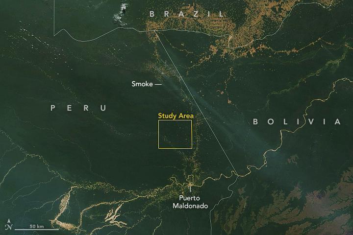
This satellite image, taken by NASA's Earth-observing Terra satellite on Aug. 18, 2019, shows the ECOSTRESS study area in the Amazon Basin and smoke from active fires in the rainforest. ECOSTRESS also captured an image of the Amazon rainforest, PIA23432, revealing water-stressed and non-stressed forest in the area. The water-stressed areas of the forest look as green and healthy as these cooler areas, making them invisible except to a radiometer that can measure thermal infrared energy from the surface. https://photojournal.jpl.nasa.gov/catalog/PIA23546
STS084-727-053 (15-24 May 1997) --- This view of Lima, Peru is among a very few photographed by astronauts who have orbited Earth since the early 1960's. Francisco Pizarro founded the city of Lima in 1535. Lima is located 13 kilometers (8 miles) inland from the Peruvian coast and is surrounded by coastal desert and the Andes mountains. Suburbs of Lima extend in all directions except to the east, where the Andes prohibits growth. The three rivers, Chillion to the northeast of Lima, the Rimac which runs through the northern part of the city, and the Mala to the southeast, all drain the central Andes. The island off the coast is San Lorenzo.
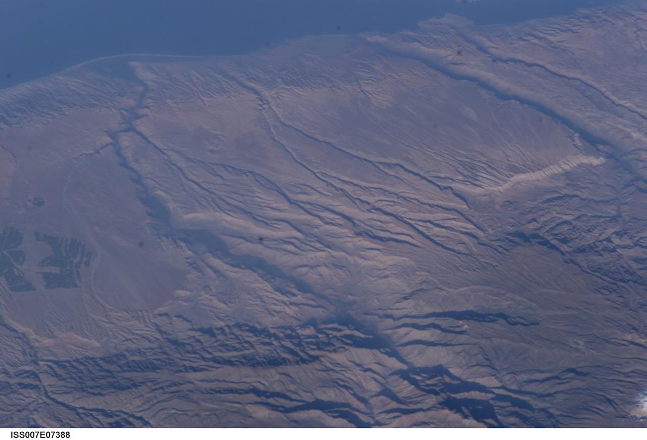
ISS007-E-07388 (14 June 2003) --- Some of the deepest canyons in the world cut west to the Pacific from the high crest of the Andes Mountains in Peru. This view taken by an Expedition 7 crewmember onboard the International Space Station (ISS) provides a birds-eye view down the canyons of the Rio Camana (center left) and the Rio Ocona (upper right). The low early morning sun highlights the extreme topography created by rapidly uplifting mountains and powerful water erosion by water dropping nearly 10,000 feet in this view. At the edge of the image are the snowy flanks of Nevado Coropuna, the highest mountain in the Cordillera Occidental (6613 meters). The coastal city of Camana is visible in the upper left.
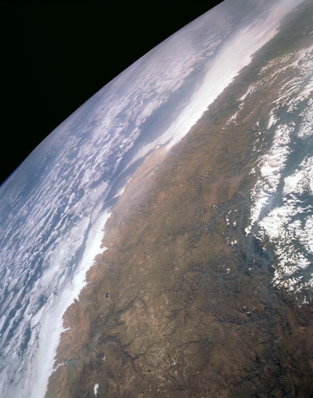
STS043-151-159 (2-11 August 1991) --- This photograph looks westward over the high plateau of the southern Peruvian Andes west and north of Lake Titicaca (not in field of view). Lima, Peru lies under the clouds just north of the clear coastal area. Because the high Andes have been uplifted 10,000 to 13,000 feet during the past 20 million years, the rivers which cut down to the Pacific Ocean have gorges almost that deep, such as the Rio Ocona at the bottom of the photograph. The eastern slopes of the Andes are heavily forested, forming the headwaters of the Amazon system. Smoke from burning in the Amazon basin fills river valleys on the right side of the photograph. A Linhof camera was used to take this view.

ISS026-E-029958 (26 Feb. 2011) --- This partial view of the starboard wing of the space shuttle Discovery was provided by an Expedition 26 crew member during a survey of the approaching STS-133 vehicle prior to docking with the International Space Station. As part of the survey and part of every mission's activities, Discovery performed a back-flip for the rendezvous pitch maneuver (RPM). The image was photographed with a digital still camera, using a 400mm lens at a distance of about 600 feet (180 meters). Although at first glance, it appears there is some sort of wire or cord hanging from the shuttle, the curly object is actually 220 miles below and appears to be a portion of the Alto Purus River in southeastern Peru near the village of San Pedro in Ucayali province.
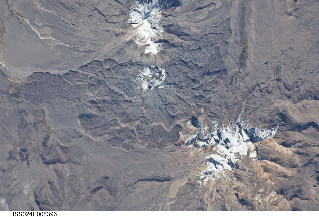
ISS024-E-008396 (15 July 2010) --- Sabancaya volcano in Peru is featured in this image photographed by an Expedition 24 crew member on the International Space Station. The 5,967-meter-high Sabancaya stratovolcano (or Nevado Sabancaya) is located in southern Peru approximately 70 kilometers to the northwest of the city of Arequipa. The name Sabancaya means ?tongue of fire? in the Quechua Indian language. Sabancaya is part of a volcanic complex that includes two other nearby (and older) volcanoes, neither of which has been active historically; in this detailed photograph, Nevado Ampato is visible to the south (top center) and the lower flanks of Nevado Hualca Hualca are visible to the north (bottom right). The snowy peaks of the three volcanoes provide a stark contrast to the surrounding desert of the Puna Plateau. Sabancaya?s first historical record of an eruption dates to 1750. The most recent eruptive activity at the volcano occurred in July 2003 and deposited ash on the volcano?s summit and northeastern flank. Volcanism at Sabancaya is fueled by magma generated at the subduction zone between the Nazca and South American tectonic plates. Magma can erupt to the surface and form lava flows through the volcano?s summit (frequently forming a crater) but can also erupt from lava domes and flank vents along the volcano?s sides. Lava has issued from all of these points at Sabancaya, forming numerous gray to dark brown lobate flows that extend in all directions except southwards (center).
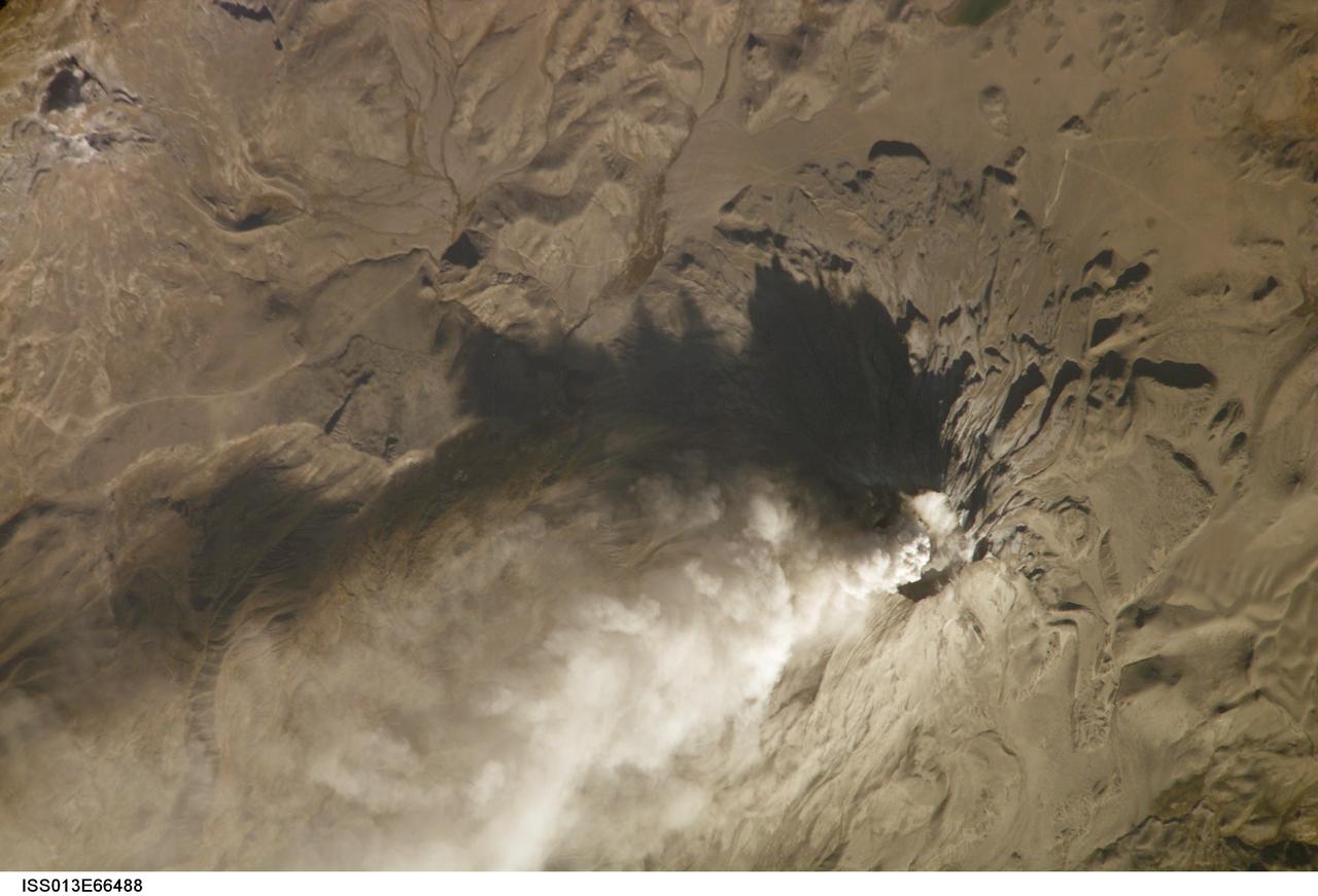
ISS013-E-66488 (14 Aug. 2006) --- Ash cloud from Ubinas Volcano, Peru is featured in this image photographed by an Expedition 13 crewmember on the International Space Station (ISS). Subduction of the Nazca tectonic plate along the western coast of South America forms the high Peruvian Andes, and also produces magma feeding a chain of historically active volcanoes along the western front of the mountains. The most active of these volcanoes in Peru is Ubinas. A typical steep-sided stratovolcano comprised primarily of layers of silica-rich lava flows, it has a summit elevation of 5,672 meters. The volcanic cone appears distinctively truncated or flat-topped in profile -- the result of a relatively small eruption that evacuated a magma reservoir near the summit. Following removal of the magma, the summit material collapsed downwards to form the current 1.4 kilometer-wide summit caldera. This oblique image (looking at an angle from the ISS) captures an ash cloud first observed on satellite imagery at 11:00 GMT on Aug. 14, 2006; this image was acquired one hour and 45 minutes later. The ash cloud resulted in the issuing of an aviation hazard warning by the Buenos Aires Volcanic Ash Advisory Center. Modern activity at Ubinas is characterized by these minor to moderate explosive eruptions of ash and larger pumice - a volcanic rock characterized by low density and high proportion of gas bubbles formed as the explosively-erupted parent lava cools during its transit through the air. These materials blanket the volcanic cone and surrounding area, giving this image an overall gray appearance. Shadowing of the western flank of Ubinas throws several lava flows into sharp relief, and highlights the steep slopes at the flow fronts -- a common characteristic of silica-rich, thick, and slow-moving lavas. NASA researchers note that the most recent major eruption of Ubinas occurred in 1969, however the historical record of activity extends back to the 16th century.
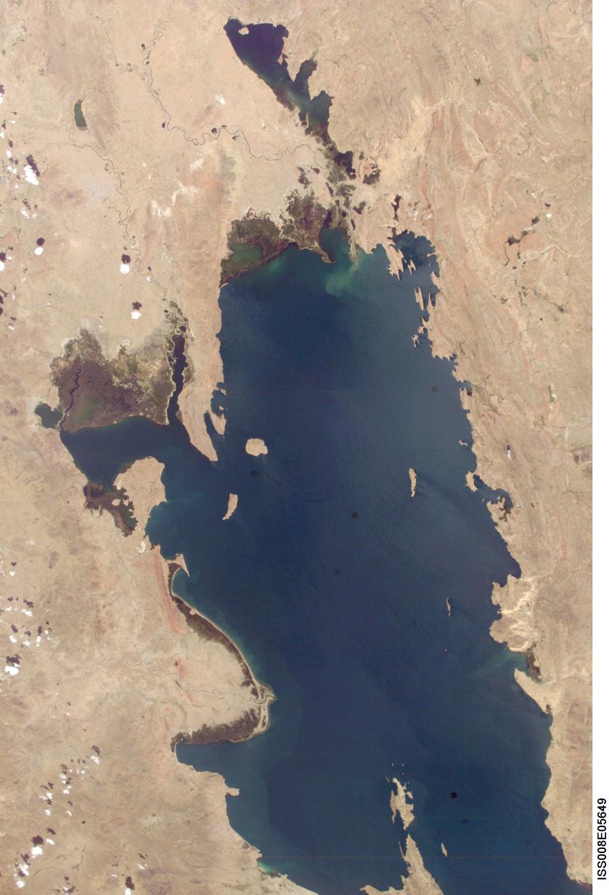
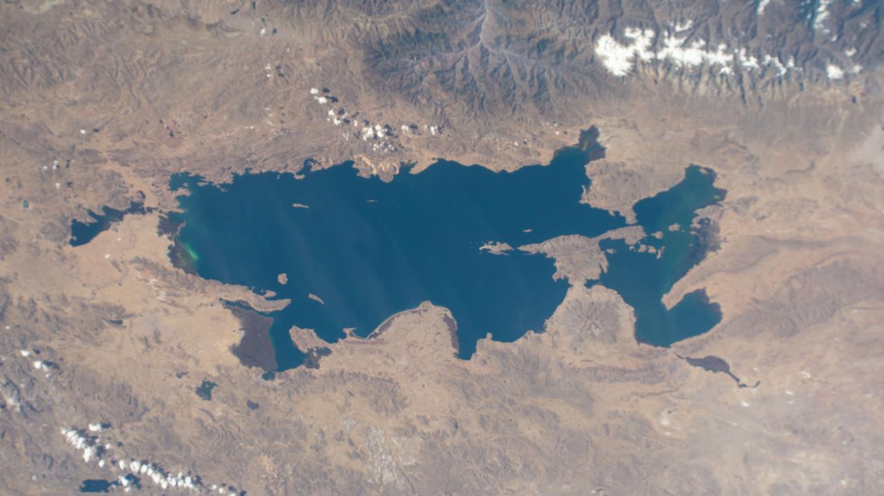
ISS008-E-05649 (8 November 2003) --- Lake Titicaca was featured in this image taken by one of the Expedition 8 crewmembers onboard the International Space Station (ISS). Lake Titicaca, at an elevation of 12,507 feet in the Andean Altiplano, is the highest large lake in the world. More than 120 miles long and 50 miles wide, it was the center of Incan civilization, and today straddles the boundary between Peru and Bolivia. Scientists have studied indicators of the water level changes over time to tease out information about precipitation shifts in the high Andes and the South American tropics. Following are some observations by NASA scientists who are studying this imagery: Because the lake occupies the low point of the Altiplano, much of the water of the high plateau eventually trickles into the lake. And because it is surrounded by mountains, very little of Lake Titicaca’s water drains out -- the Rio Desguadero is the only major outflow river. So, like a bathtub with no drain, this large and deep lake (with depths of several hundred feet) has become the collecting basin for thousands of years of sediment. These sediments and their fossils contain clues about past climate conditions. The restricted outflow of the lake creates conditions where even shorter, interannual climate cycles (like El Niño /Southern Oscillation) impact Lake Titicaca’s water levels. Recent lake level variations have been several meters, with low levels occurring during regional droughts of El Niños. Right now, the region is relatively wet. In this image, the dark greens of the wetlands along the shallower margins of the lake contrast strongly with the surrounding desert. But the even large cities like Puno, Peru (100,000 people) are difficult to discern from the surrounding countryside.
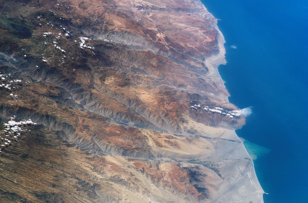
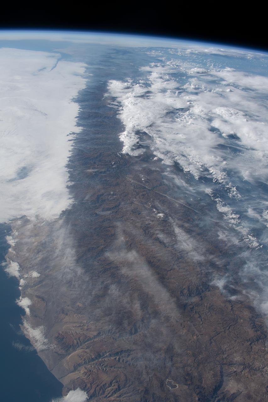
ISS006-E-38306 (14 March 2003) --- The Arid Coast of Peru is featured in this digital image photographed by an Expedition 6 crewmember on the International Space Station (ISS). This oblique, south-looking view shows the dramatic canyons of Peru’s southern coast (15.5 – 17 degrees S). According to NASA scientists studying ISS imagery, these are relatively young features carved by rivers mainly over the past 8 million years following the last major upheaval of the Andes Mountains. The canyons are some of the steepest and deepest on Earth—lake Laguna Parincocha (top left corner) lies on the Andean plateau about 3,250 meters above sea level, only 80 kilometers from the coast. A sheet of volcanic rock (known as an ignimbrite deposit) emplaced during an explosive eruptive event is scored with a dense pattern of parallel dry streams in the lower left corner of the image. Volcanic source regions for the ignimbrite lie outside the left margin of the view. The Yauca and Acarí rivers feed small tan-colored sediment plumes into the sea (lower right). Dark green agricultural fields cluster along the lower courses of the rivers. Strong southerly winds have generated sand dunes and dark wind streaks along the coast, whose alignments re-curve inland into the lower river valleys (lower right). The coast and canyons are commonly hazy due to oceanic air and blowing dust. Yellow lines parallel with the coast and near the small peninsula, according to scientists, are raised shorelines probably caused by tectonic uplift of the coastline.
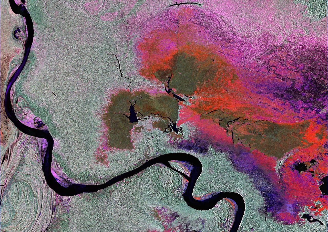
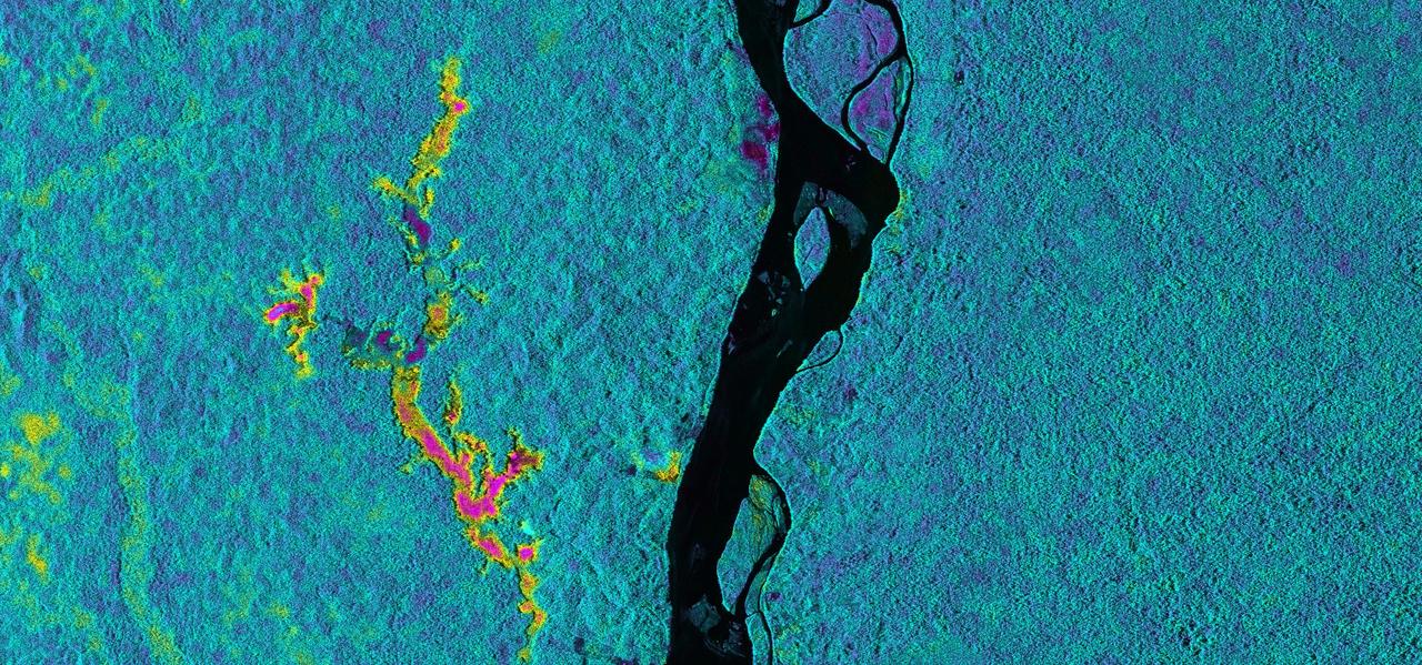
To show the kind of imagery that data from the NISAR (NASA-ISRO Synthetic Aperture Radar) satellite mission will be used to produce, researchers pointed to a 2013 image of flooding extent in the Pacaya-Samaria National Reserve that used data from the Uninhabited Aerial Vehicle Synthetic Aperture Radar (UAVSAR), an airborne system. In the image of this flood-prone area of the Amazonian jungle in Peru, black indicates open water, grayish-green is tropical forest, dark green is low-lying or floating vegetation, and red and pink are two different types of flooded vegetation. NISAR will offer detailed insights into the flooding patterns of the planet's wetland ecosystems, which will help researchers understand how these areas are being affected by climate change and human activity and the role they play in the global carbon cycle. NISAR is a joint mission of the U.S. and Indian space agencies. When in orbit, its sophisticated L- and S-band radar systems will scan nearly all of Earth's land and ice surfaces twice every 12 days with exquisite precision. Scheduled to launch in early 2024, NISAR is an equal collaboration between NASA and the Indian Space Research Organisation and marks the first time the two agencies have cooperated on hardware development for an Earth-observing mission. NASA's Jet Propulsion Laboratory, which is managed for the agency by Caltech in Pasadena, leads the U.S. component of the project and is providing the mission's L-band SAR. NASA is also providing the radar reflector antenna, the deployable boom, a high-rate communication subsystem for science data, GPS receivers, a solid-state recorder, and payload data subsystem. ISRO's U R Rao Satellite Centre in Bengaluru, which is leading the ISRO component of the mission, is providing the spacecraft bus, the S-band SAR electronics, the launch vehicle, and associated launch services and satellite mission operations. https://photojournal.jpl.nasa.gov/catalog/PIA26112
An Earth-monitoring instrument aboard NASA's Terra satellite is keeping a close eye on a potential glacial disaster in the making in Peru's spectacular, snow-capped Cordillera Blanca (White Mountains), the highest range of the Peruvian Andes. Data from NASA's Advanced Spaceborne Thermal Emission and Reflection Radiometer (Aster) is assisting Peruvian government officials and geologists in monitoring a glacier that feeds Lake Palcacocha, located high above the city of Huaraz, 270 kilometers (168 miles) north of Lima. An ominous crack has developed in the glacier. Should the large glacier chunk break off and fall into the lake, the ensuing flood could hurtle down the Cojup Valley into the Rio Santa Valley below, reaching Huaraz, population 60,000, in less than 15 minutes. "Glacial natural hazards like the one in Huaraz are an increasing threat to people in many parts of the world," said Dr. Michael Abrams, associate Aster team leader at NASA's Jet Propulsion Laboratory, Pasadena, Calif. "Remote sensing instruments like Aster can serve a vital role in mountain hazard management and disaster mapping by providing rapid access to data, even in regions not easily accessible by humans. Aster's unique vantage point from space gives scientists another tool with which to see early signs of potential glacial flood-burst events and to monitor changes in glacial behavior over time. In Huaraz, Peruvian authorities and scientists will incorporate Aster data along with data from ground-based monitoring techniques to better assess current conditions and take steps necessary to reduce risks to human lives and property." Comparison images of the area are available at: http://asterweb.jpl.nasa.gov . Huaraz can be seen in the images' left-center, with Lake Palcacocha in the images' upper right corners at the head of a valley, below the snow and glacier cap. The left image was acquired on November 5, 2001; the right on April 8, 2003. Glacial flood-bursts, known by Peruvians as "aluviones," occur periodically when water is released abruptly from a previously ice-dammed lake alongside, within, or above a glacier. The release can be caused by various triggering events. These flood-bursts typically arrive with little or no warning, carrying liquid mud, large rock boulders and blocks of ice. The Rio Santa Valley is no stranger to such disasters. Since 1702, floods caused by glaciological conditions have repeatedly caused death and destruction in the region. One particularly devastating event in 1941 destroyed approximately one-third of Huaraz, killing an estimated 5,000 to 7,000 people. Since then, the Peruvian government has emphasized control of the water level in Lake Palcacocha and other lakes in the region that pose similar threats. The efforts appear to have worked; since 1972, no destructive floods resulting from the breakout of glacial lakes have occurred. Nevertheless, officials are still monitoring the current situation closely. http://photojournal.jpl.nasa.gov/catalog/PIA03899
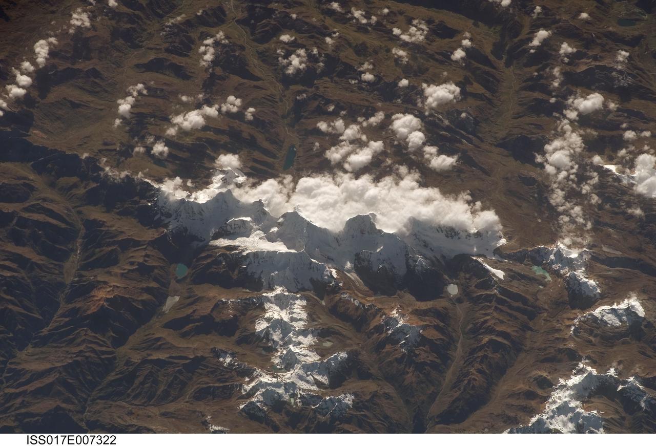
ISS017-E-007322 (17 May 2008) --- Cordillera Huayhuash in the Peruvian Andes is featured in this image photographed by an Expedition 17 crewmember on the International Space Station. This view was taken looking east as the station was flying approximately 100 kilometers off the Peruvian coast and shows Cordillera Huayhuash (pronounced Why-wash). Here clouds are banked up on the east side, snow covers all higher slopes and mountain peaks, and glaciers occupy lower slopes. This prominent but short mountain range (25 kilometers in length) boasts twenty peaks of remarkable steepness and ridge sharpness. Although only 100 kilometers from the coastline, six of the peaks reach above 6,000 meters (more than 19,500 feet), the highest of which is Nevado Yerupaja, Peru's second highest peak, variously estimated as 6,617 and 6,635 meters high. Generally considered the most spectacular peak in South America, Yerupaja is so steep that it has seldom been climbed. The best climbing approach is from the southwest, the face seen in this view. Yerupaja is locally known as El Carnicero (The Butcher) because of its blade-like ridges, features typical of mountains that have been heavily eroded by glacial ice. Other features created by the erosive effect of flowing ice are small glacial lakes, which often vary in color due to different amounts of fine mud being fed into them by meltwater from under the glaciers. According to scientists, during the ice ages the glaciers advanced many kilometers outward from the cordillera, occupying all the surrounding valley floors (all of which lie above 3,000 meters) producing the characteristic U-shaped valleys.

“My mother always instilled and made me appreciate the value of hard work and education. That was my pillar. We are a large family. I have family in Peru, still. I have family members in Europe, in Mexico, and across the U.S. They all face challenges every day, and that motivates me to keep moving forward. The military was no exception. It’s a challenging career. I’ve participated in war environments and peacekeeping operations. When I retired from the military, I took the uniform off one day and put on civilian clothes the next day and went on to work for the Department of Defense. I progressed in my public service career and went on to National Oceanic and Atmospheric Administration. Then, I finally came to NASA. I have always admired NASA. I remember since 1968, hearing about all the missions and projects and accomplishments. The reputation that NASA has! I researched how logistics work for NASA’s missions. That’s why I prepared myself. The military provided me a strong logistics background. I got a Master degree in Public Administration because my goal was to end up working for NASA. And I did so, on my second attempt. I started working for NASA’s Logistics Management Division, and served as Deputy Director. Working at NASA is something very special. I find myself surrounded by a group of professional individuals, working in a complete camaraderie environment. Yes, it has been a challenge, to get to work for NASA. But it’s worth it, every single day.” NASA Program Executive Manager for the Office of Insfrastructure, Miguel Angel Rodriguez Maco, poses for a portrait outside NASA Headquarters in Washington DC, Wednesday, Sept. 2, 2020. Photo Credit: (NASA/Aubrey Gemignani)
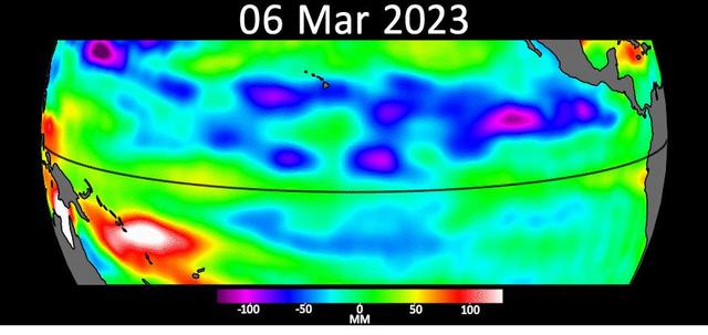
Sea level data from the U.S.-European satellite Sentinel-6 Michael Freilich shows early signs of a developing El Niño along the equatorial Pacific Ocean. The measurements show Kelvin waves, low waves that can be tens of miles (hundreds of kilometers) wide, moving from west to east at the equator towards the west coast of Ecuador. When they form at the equator, Kelvin waves can move warm water – associated with higher sea levels – from the western Pacific to the eastern Pacific. El Niño is a periodic climate phenomenon that can affect weather patterns around the world. The condition can bring cooler, wetter conditions to the U.S. Southwest and drought to countries in the western Pacific such as Indonesia and Australia. El Niño is characterized by higher sea levels and warmer-than-average ocean temperatures along the western coasts of North and South America. Water expands as it warms, so sea levels tend to be higher in places with warmer water. The climate phenomenon is also associated with a weakening of the trade winds. The Sentinel-6 Michael Freilich satellite data shown here covers a seven-week period between the beginning of March and the end of April 2023. By April 24, Figure A, Kelvin waves had piled up warmer water and higher sea levels (shown in red and white) off the coasts of Peru, Ecuador, and Columbia. A series of Kelvin waves starting in spring is a well-known precursor to an El Niño. The waves seen during March and April 2023 are similar to the ones that preceded the 1997-1998 El Niño, one of the most powerful in recorded history. Satellites like Sentinel-6 Michael Freilich can detect Kelvin waves with an instrument called an altimeter that uses radar signals to measure the height of the ocean's surface. Warmer areas show up as higher sea levels. The satellite, named after former NASA Earth Science Division Director Michael Freilich, is one of two that compose the Copernicus Sentinel-6/Jason-CS (Continuity of Service) mission. Animation available at https://photojournal.jpl.nasa.gov/catalog/PIA25776
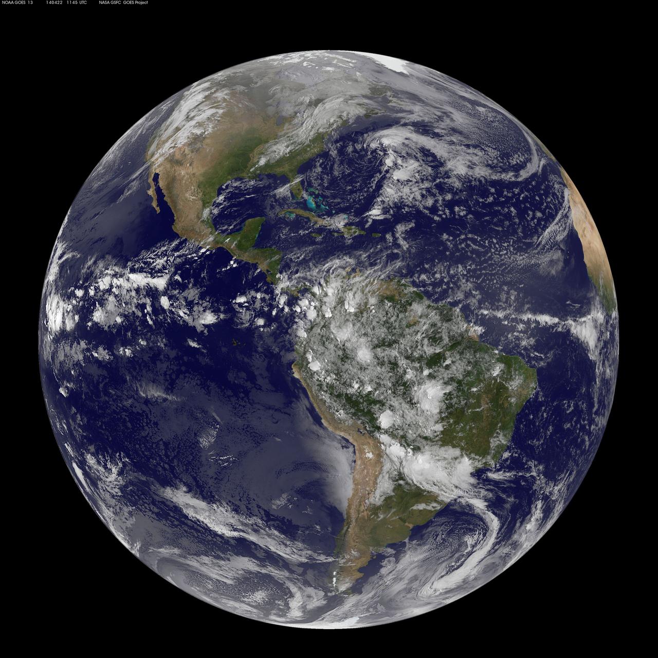
Today, April 22, 2014 is Earth Day, and what better way to celebrate than taking a look at our home planet from space. NOAA's GOES-East satellite captured this stunning view of the Americas on Earth Day, April 22, 2014 at 11:45 UTC/7:45 a.m. EDT. The data from GOES-East was made into an image by the NASA/NOAA GOES Project at NASA's Goddard Space Flight Center in Greenbelt, Md. In North America, clouds associated with a cold front stretch from Montreal, Canada, south through the Tennessee Valley, and southwest to southern Texas bringing rain east of the front today. A low pressure area in the Pacific Northwest is expected to bring rainfall in Oregon, Washington, Idaho, stretching into the upper Midwest, according to NOAA's National Weather Service. That low is also expected to bring precipitation north into the provinces of British Columbia and Alberta, Canada. Another Pacific low is moving over southern Nevada and the National Weather Service expects rain from that system to fall in central California, Nevada, and northern Utah. Near the equator, GOES imagery shows a line of pop up thunderstorms. Those thunderstorms are associated with the Intertropical Convergence Zone (ITCZ). The ITCZ encircles the Earth near the equator. In South America, convective (rapidly rising air that condenses and forms clouds) thunderstorms pepper Colombia, Venezuela, Ecuador, Peru, Bolivia, Paraguay and northwestern and southeastern Brazil. GOES satellites provide the kind of continuous monitoring necessary for intensive data analysis. Geostationary describes an orbit in which a satellite is always in the same position with respect to the rotating Earth. This allows GOES to hover continuously over one position on Earth's surface, appearing stationary. As a result, GOES provide a constant vigil for the atmospheric "triggers" for severe weather conditions such as tornadoes, flash floods, hail storms and hurricanes. For more information about GOES satellites, visit: <a href="http://www.goes.noaa.gov/" rel="nofollow">www.goes.noaa.gov/</a> or <a href="http://goes.gsfc.nasa.gov/" rel="nofollow">goes.gsfc.nasa.gov/</a> Rob Gutro NASA's Goddard Space Flight Center <b><a href="http://www.nasa.gov/audience/formedia/features/MP_Photo_Guidelines.html" rel="nofollow">NASA image use policy.</a></b> <b><a href="http://www.nasa.gov/centers/goddard/home/index.html" rel="nofollow">NASA Goddard Space Flight Center</a></b> enables NASA’s mission through four scientific endeavors: Earth Science, Heliophysics, Solar System Exploration, and Astrophysics. Goddard plays a leading role in NASA’s accomplishments by contributing compelling scientific knowledge to advance the Agency’s mission. <b>Follow us on <a href="http://twitter.com/NASAGoddardPix" rel="nofollow">Twitter</a></b> <b>Like us on <a href="http://www.facebook.com/pages/Greenbelt-MD/NASA-Goddard/395013845897?ref=tsd" rel="nofollow">Facebook</a></b> <b>Find us on <a href="http://instagram.com/nasagoddard?vm=grid" rel="nofollow">Instagram</a></b>