
41D-32-14 (30 Aug 1984) --- A rainbow-like sunrise over the Philippine Sea greeted the six crew members aboard the Earth-orbiting Space Shuttle Discovery on its first day in space. A 70mm camera was used to record the scene at 3:08:14 p.m. (CDT), August 30, 1984, during Discovery's sixth orbit of a six-day mission. The spacecraft was above a position on Earth centered at 21.1 degrees north and 12.9 degrees east (about 250 miles north - northeast of the Philippine Islands). The scene was shown as one of the Post-Flight Press Conference (PFPC) visuals by the crew on September 12, 1984.

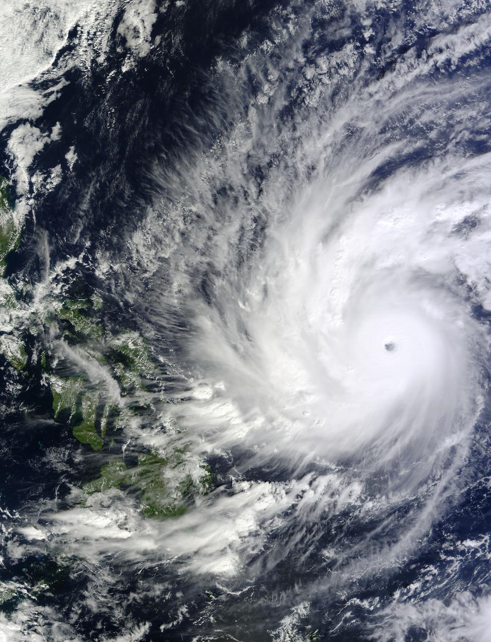
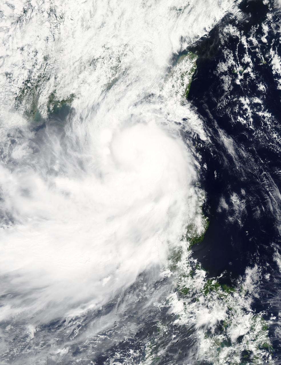
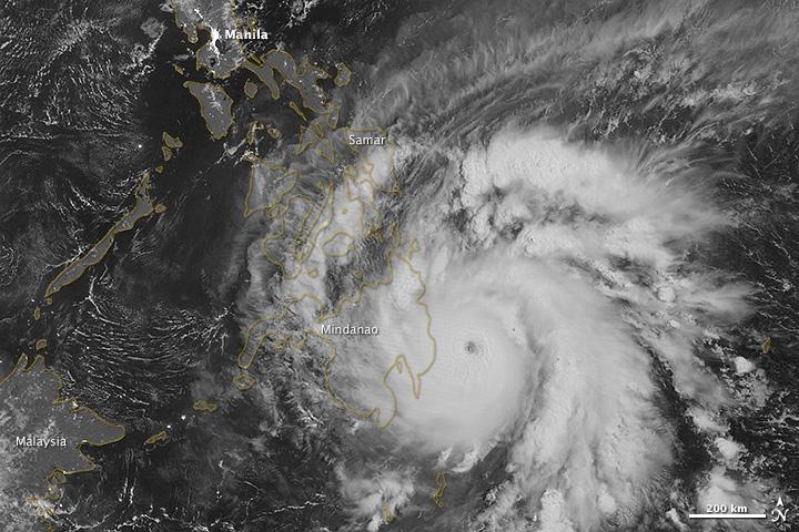
With maximum sustained wind speeds of 140 mph, Super Typhoon Utor made landfall in the Philippines on August 11, 2013 around 18:00z. The storm crossed over the island of Luzon and into the South China Sea. The Joint Typhoon Warning Center predicts Utor will head for the Chinese mainland and make landfall again around 12:00z on the 14th about 200 miles southwest of Hong Kong. This colorized infrared image from the Suomi NPP satellite shows the storm on August 11th at 4:30z. NASA/NOAA <b><a href="http://www.nasa.gov/audience/formedia/features/MP_Photo_Guidelines.html" rel="nofollow">NASA image use policy.</a></b> <b><a href="http://www.nasa.gov/centers/goddard/home/index.html" rel="nofollow">NASA Goddard Space Flight Center</a></b> enables NASA’s mission through four scientific endeavors: Earth Science, Heliophysics, Solar System Exploration, and Astrophysics. Goddard plays a leading role in NASA’s accomplishments by contributing compelling scientific knowledge to advance the Agency’s mission. <b>Follow us on <a href="http://twitter.com/NASA_GoddardPix" rel="nofollow">Twitter</a></b> <b>Like us on <a href="http://www.facebook.com/pages/Greenbelt-MD/NASA-Goddard/395013845897?ref=tsd" rel="nofollow">Facebook</a></b> <b>Find us on <a href="http://instagram.com/nasagoddard?vm=grid" rel="nofollow">Instagram</a></b>
On Dec. 4 at 02:10 UTC, the MODIS instrument aboard NASA's Terra satellite took this visible image of Super Typhoon Hagupit approaching the Philippines. Image Credit: NASA Goddard's MODIS Rapid Response Team Read more: <a href="http://1.usa.gov/12q3ssK" rel="nofollow">1.usa.gov/12q3ssK</a> <b><a href="http://www.nasa.gov/audience/formedia/features/MP_Photo_Guidelines.html" rel="nofollow">NASA image use policy.</a></b> <b><a href="http://www.nasa.gov/centers/goddard/home/index.html" rel="nofollow">NASA Goddard Space Flight Center</a></b> enables NASA’s mission through four scientific endeavors: Earth Science, Heliophysics, Solar System Exploration, and Astrophysics. Goddard plays a leading role in NASA’s accomplishments by contributing compelling scientific knowledge to advance the Agency’s mission. <b>Follow us on <a href="http://twitter.com/NASAGoddardPix" rel="nofollow">Twitter</a></b> <b>Like us on <a href="http://www.facebook.com/pages/Greenbelt-MD/NASA-Goddard/395013845897?ref=tsd" rel="nofollow">Facebook</a></b> <b>Find us on <a href="http://instagram.com/nasagoddard?vm=grid" rel="nofollow">Instagram</a></b>
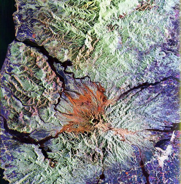
This is a false color L-band and C-band image of the area around Mount Pinatubo in the Philippines, centered at about 15 degrees north latitude, 120.5 degrees east longitude.
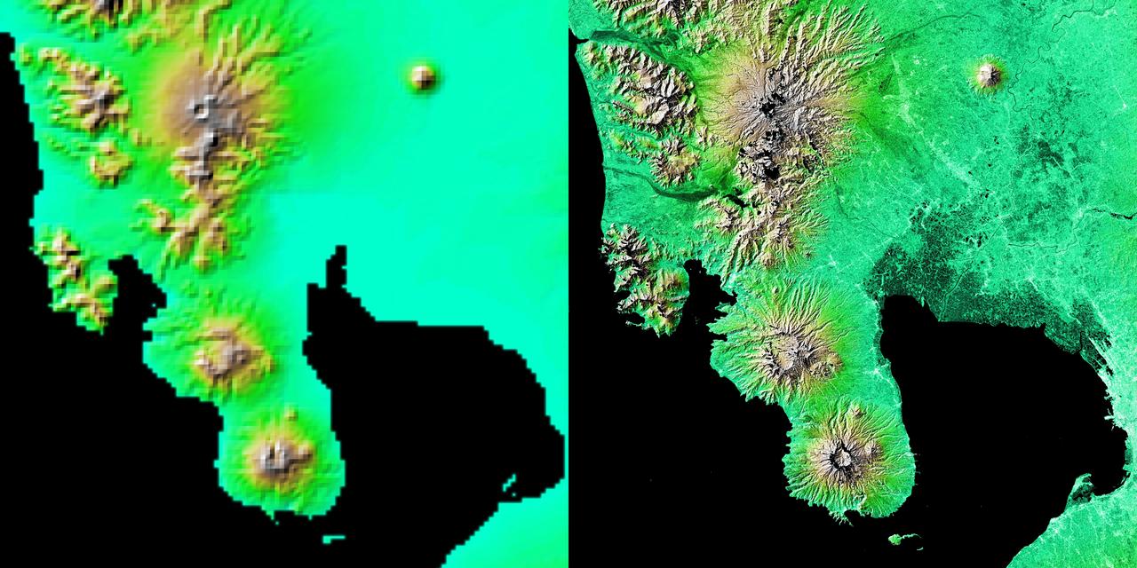
These two images show exactly the same area, Manila Bay and nearby volcanoes on Luzon Island in the Philippines. The image on the left was created using the best global topographic data set previously available, the U.S. Geological Survey GTOPO30.
Taal Volcano in the Philippines is about 50 km south of Manila (top of image). It is the second most active volcano in the country, with 38 recorded historic eruptions. The caldera is filled by Taal Lake; Volcano Island is the active cone in the middle of the lake (bottom of image). Eruptions have occurred every year since 2019, with ash and sulfur dioxide vog at times reaching Manila. (Credit: Wikipedia) The image was acquired October 8, 2024, covers an area of 33 by 92.2 km, and is located at 14 degrees north, 121 degrees east. https://photojournal.jpl.nasa.gov/catalog/PIA26506
NASA's Aqua satellite captured a picture of Tropical Storm Linfa in the South China Sea on July 7 when it was between southern Taiwan and the northern Philippines. Aqua passed over Linfa on July 7 at 05:25 UTC (1:25 a.m. EDT) and the Moderate Resolution Imaging Spectroradiometer or MODIS instrument captured a visible image of the storm. Bands of thunderstorms wrapping into the center of circulation from the south, draped over western Luzon. The MODIS image showed the tight concentration of thunderstorms around Linfa's center were located over the South China Sea. Fragmented bands of thunderstorms north of the center were brushing over Southern Taiwan while clouds from another band of fragmented thunderstorms stretched northwest through the Taiwan Strait. On July 7 at 1500 UTC (11 a.m. EDT), Tropical Storm Linfa's maximum sustained winds had increased to 50 knots (57.5 mph/92.6 kph), up from 45 knots (51.7 mph/83.3 kph) six hours before. Linfa strengthened in the warm waters of the South China Sea now that its center has moved away from the northern Philippines and was no longer over land. Linfa was centered near 21.0 North latitude and 118.8 East longitude, about 277 nautical miles (319 miles/513.3 km) east-southeast of Hong Kong, China. Linfa has tracked northward at 3 knots (3.5 mph/5.5 kph). China's National Meteorological Centre has (CNMC) issued a yellow category warning of typhoon at 6:00 a.m. July 7, Beijing Time. CNMC noted that Linfa is the tenth typhoon this year and at that time it was centered about 430 km (267.2 miles) southeast of border between Fujian and Guangdong For updated warnings and watches from the China Meteorological Service, visit: <a href="http://www.cma.gov.cn/en/WeatherWarnings/" rel="nofollow">www.cma.gov.cn/en/WeatherWarnings/</a>. Linfa is moving north between Luzon and Taiwan. The Joint Typhoon Warning Center expects Linfa to strengthen to 60 knots (69 mph/111 kph) by mid-day on July 9, before weakening and then making landfall in mainland China. Credit: NASA/GSFC/Jeff Schmaltz/MODIS Land Rapid Response Team <b><a href="http://www.nasa.gov/audience/formedia/features/MP_Photo_Guidelines.html" rel="nofollow">NASA image use policy.</a></b> <b><a href="http://www.nasa.gov/centers/goddard/home/index.html" rel="nofollow">NASA Goddard Space Flight Center</a></b> enables NASA’s mission through four scientific endeavors: Earth Science, Heliophysics, Solar System Exploration, and Astrophysics. Goddard plays a leading role in NASA’s accomplishments by contributing compelling scientific knowledge to advance the Agency’s mission. <b>Follow us on <a href="http://twitter.com/NASAGoddardPix" rel="nofollow">Twitter</a></b> <b>Like us on <a href="http://www.facebook.com/pages/Greenbelt-MD/NASA-Goddard/395013845897?ref=tsd" rel="nofollow">Facebook</a></b> <b>Find us on <a href="http://instagrid.me/nasagoddard/?vm=grid" rel="nofollow">Instagram</a></b>

On Sept. 21, Typhoon Usagi was moving between the northern Philippines and Taiwan when NASA's Aqua satellite passed overhead. NASA's AIRS instrument that flies aboard the Aqua satellite captured this near-infrared image on Sept. 21 at 505 UTC/1:05 a.m. EDT as Usagi. The near-infrared image is similar to how the clouds of the typhoon would appear in the daylight. Image Credit: NASA JPL, Ed Olsen Caption: NASA Goddard, Rob Gutro <b><a href="http://www.nasa.gov/audience/formedia/features/MP_Photo_Guidelines.html" rel="nofollow">NASA image use policy.</a></b> <b><a href="http://www.nasa.gov/centers/goddard/home/index.html" rel="nofollow">NASA Goddard Space Flight Center</a></b> enables NASA’s mission through four scientific endeavors: Earth Science, Heliophysics, Solar System Exploration, and Astrophysics. Goddard plays a leading role in NASA’s accomplishments by contributing compelling scientific knowledge to advance the Agency’s mission. <b>Follow us on <a href="http://twitter.com/NASA_GoddardPix" rel="nofollow">Twitter</a></b> <b>Like us on <a href="http://www.facebook.com/pages/Greenbelt-MD/NASA-Goddard/395013845897?ref=tsd" rel="nofollow">Facebook</a></b> <b>Find us on <a href="http://instagram.com/nasagoddard?vm=grid" rel="nofollow">Instagram</a></b>
On Nov. 9 at 05:55 UTC/12:55 a.m. EDT, Typhoon Haiyan was in the middle of the South China Sea, headed toward Vietnam. Credit: NASA Goddard MODIS Rapid Response Team <b><a href="http://www.nasa.gov/audience/formedia/features/MP_Photo_Guidelines.html" rel="nofollow">NASA image use policy.</a></b> <b><a href="http://www.nasa.gov/centers/goddard/home/index.html" rel="nofollow">NASA Goddard Space Flight Center</a></b> enables NASA’s mission through four scientific endeavors: Earth Science, Heliophysics, Solar System Exploration, and Astrophysics. Goddard plays a leading role in NASA’s accomplishments by contributing compelling scientific knowledge to advance the Agency’s mission. <b>Follow us on <a href="http://twitter.com/NASA_GoddardPix" rel="nofollow">Twitter</a></b> <b>Like us on <a href="http://www.facebook.com/pages/Greenbelt-MD/NASA-Goddard/395013845897?ref=tsd" rel="nofollow">Facebook</a></b> <b>Find us on <a href="http://instagrid.me/nasagoddard/?vm=grid" rel="nofollow">Instagram</a></b>
STS068-232-083 (30 September-11 October 1994) --- This is a view of Mount Pinatubo, Philippine Islands, orient with the coast to the top. View westward across central Luzon and Mount Pinatubo. Manilla Bay is in partial sunglint along the left edge of the frame. The extensive flows of volcanic ash (lahars) extending from the mountain are readily seen despite partial cloud cover. The ash is mobilized with every rain in this typhoon-ridden region, flowing down valleys, filling drainage channels, and covering fields and towns. The STS-68 crew obtained excellent photographs of the region, for comparison to the radar data also obtained on the mission. Photographs in sunglint have proven particularly helpful because they show the exact outlines of surface water, which provides a datum point for the radar returns.

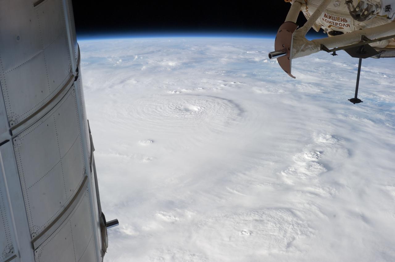
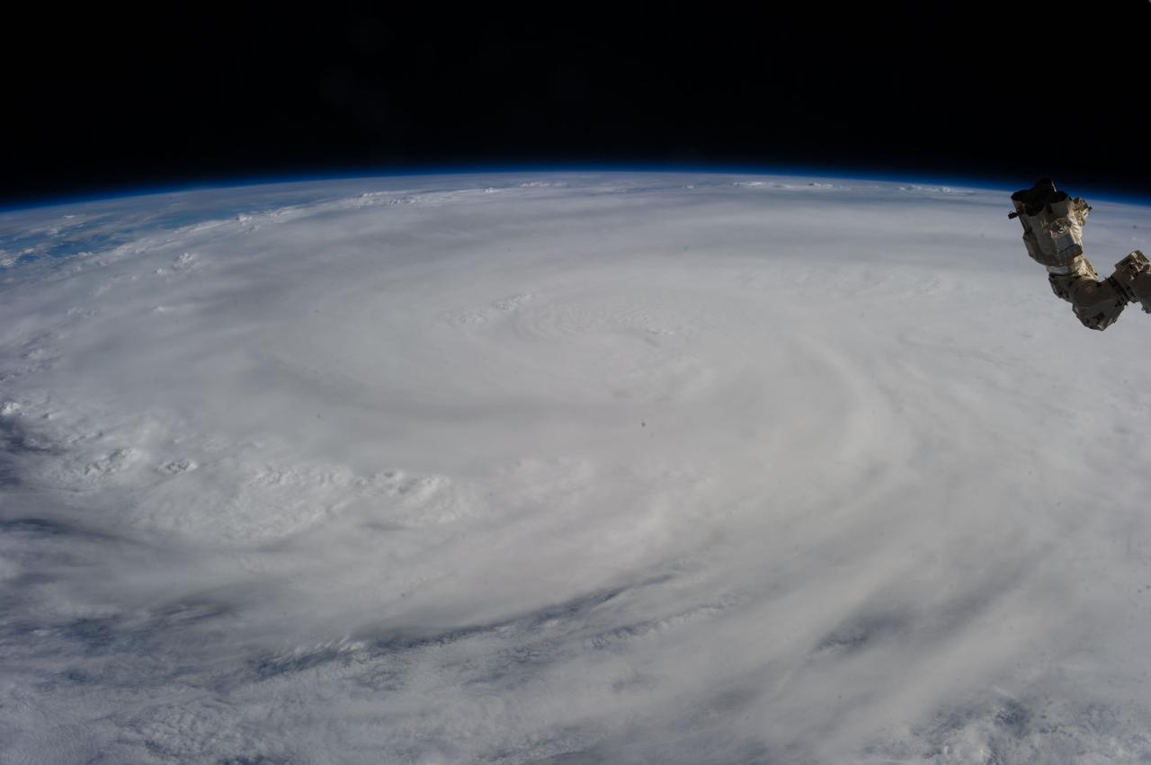
iss073e0764760 (Sept. 22, 2025) --- Typhoon Ragasa with its well-defined eye is pictured southeast of Taiwan in the Philippine Sea from the International Space Station as it orbited 257 miles above. Silhouetted in the foreground, is the Soyuz MS-27 spacecraft docked to the Prichal module.
Mt. Pinatubo on the island of Luzon (15.0N, 120.0E) erupted catastrophically in June 1991 after over 600 years of inactivity. In this vertical view, the full extent of the eruption is obvious. Thick layers of ash completely surrounds the crater and the effect of mudflows in this previously heavily forested and agricultural region can be traced as ribbons flowing downhill. Clark AFB, once the crossroads of the SW Pacific can only partially be seen.
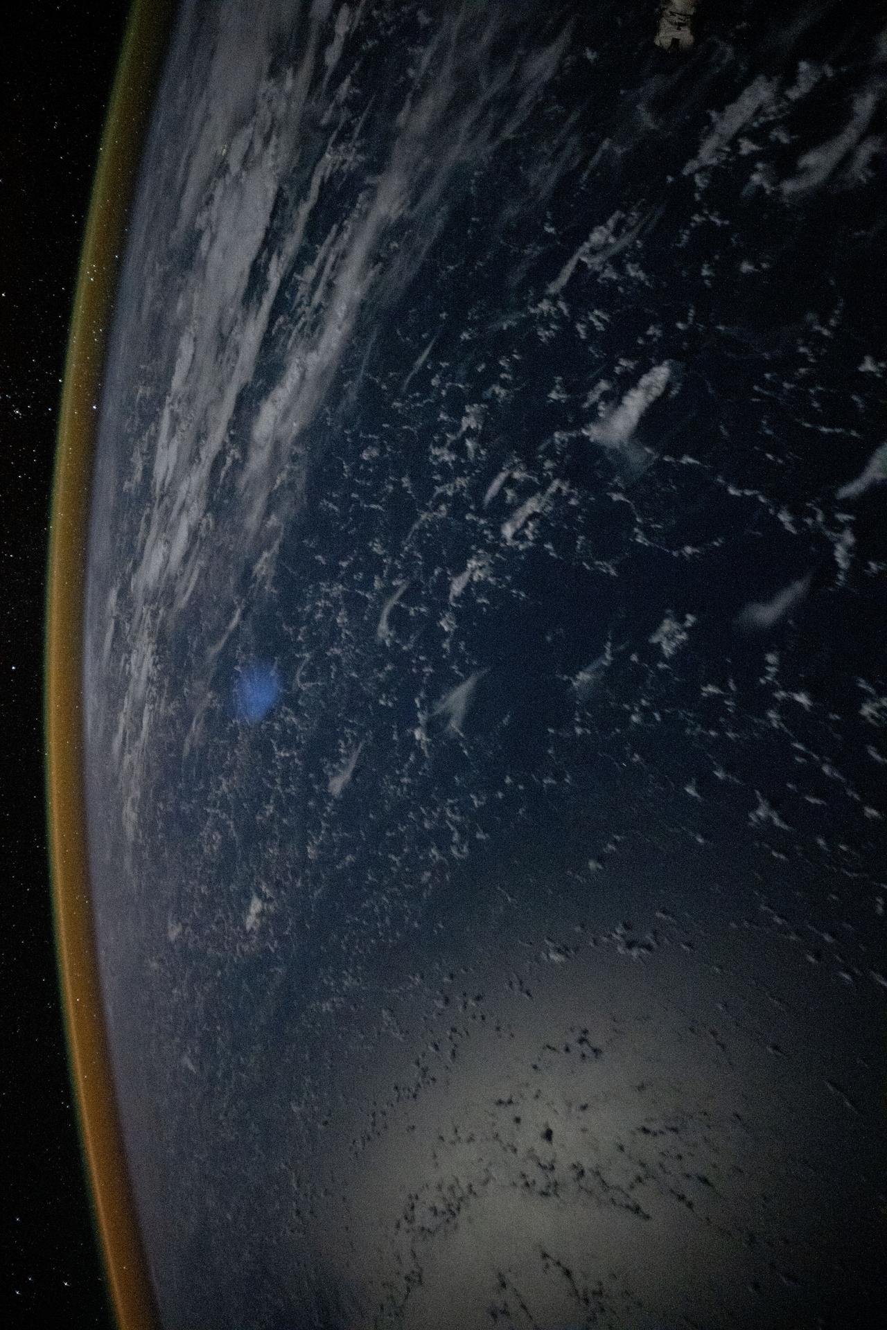
iss073e0824860 (Sept. 14, 2025) --- A red-yellow airglow blankets Earth's horizon above the tranquil, moonlit Philippine Sea in this photograph taken from the International Space Station at approximately 1:49 a.m. local time while orbiting 261 miles above Earth. This type of airglow is caused by chemical reactions in the upper atmosphere, often involving oxygen and hydroxyl molecules, and is typically visible in long-exposure imagery taken from orbit.

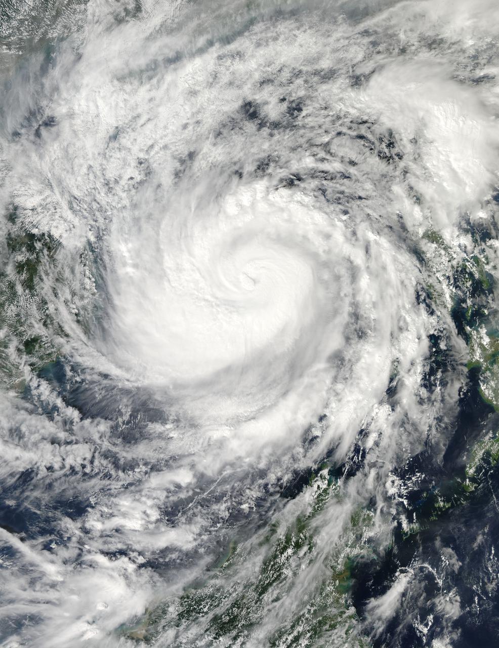
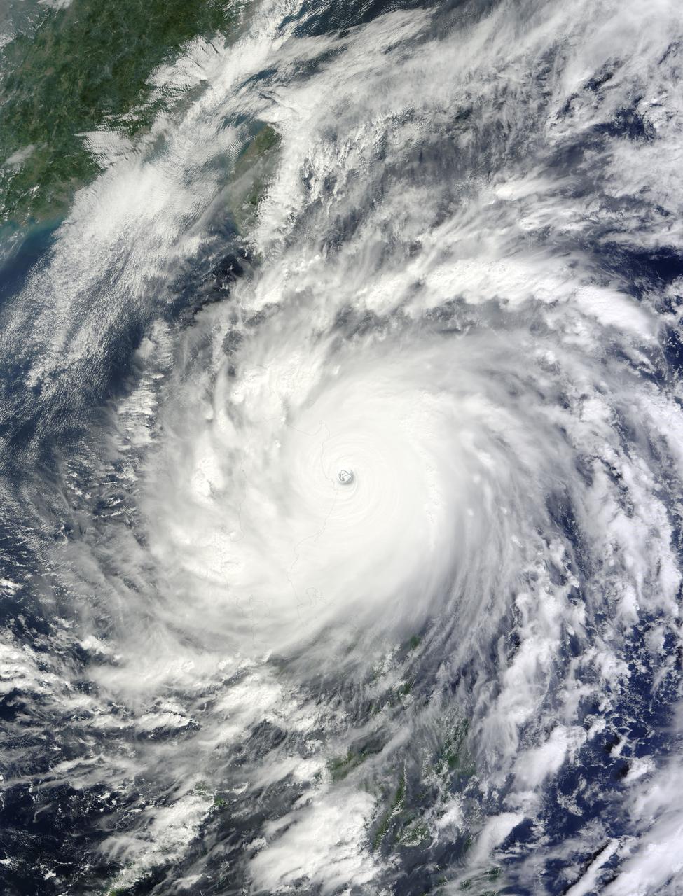
This image, is of Super Typhoon Haiyan, one of the most powerful storms ever recorded on Earth, which struck the Philippines Nov. 8, 2013.
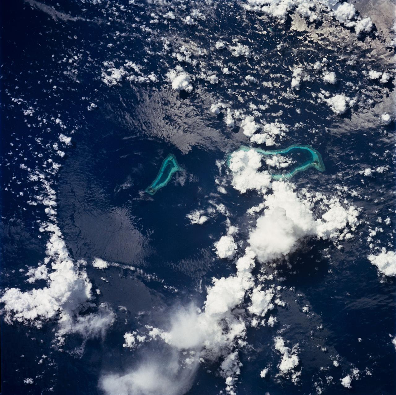
STS049-71-042 (8 May 1992) --- This photograph, taken from the Earth-orbiting Space Shuttle Endeavour, shows a collapsed thunderstorm in the southwestern Pacific Ocean. The clouds were pushed from this circular area of the ocean's surface by relatively cool air that spread downward and outward from a dying thunderstorm. Around the edges of the downdrafted air, new, though smaller, storms are developing. The photo was taken on May 8, 1992, between Borneo and the Philippine island of Mindoro. Two coral atolls can be seen near the center of the photograph. The crew members used a handheld Hasselblad camera, 250-mm lens, color film to expose the image.

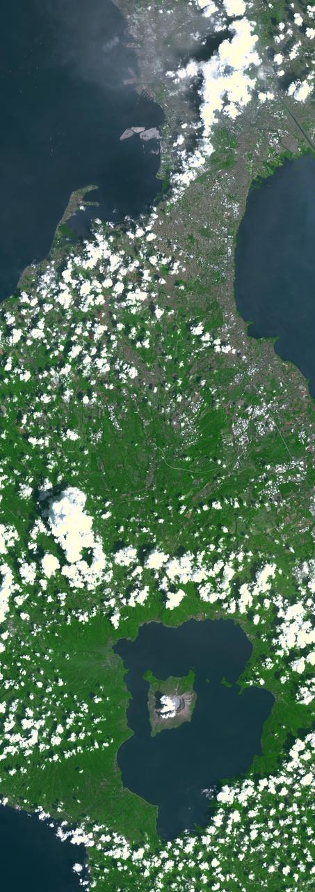
This is an image of Taal volcano, near Manila on the island of Luzon in the Philippines. The black area in the center is Taal Lake, which nearly fills the 30-kilometer-diameter (18-mile) caldera. The caldera rim consists of deeply eroded hills and cliffs. The large island in Taal Lake, which itself contains a crater lake, is known as Volcano Island. The bright yellow patch on the southwest side of the island marks the site of an explosion crater that formed during a deadly eruption of Taal in 1965. The image was acquired by the Spaceborne Imaging Radar-C/X-band Synthetic Aperture Radar (SIR-C/X-SAR) aboard the space shuttle Endeavour on its 78th orbit on October 5, 1994. The image shows an area approximately 56 kilometers by 112 kilometers (34 miles by 68 miles) that is centered at 14.0 degrees north latitude and 121.0 degrees east longitude. North is toward the upper right of the image. The colors in this image were obtained using the following radar channels: red represents the L-band (horizontally transmitted and received); green represents the L-band (horizontally transmitted and vertically received); blue represents the C-band (horizontally transmitted and vertically received). Since 1572, Taal has erupted at least 34 times. Since early 1991, the volcano has been restless, with swarms of earthquakes, new steaming areas, ground fracturing, and increases in water temperature of the lake. Volcanologists and other local authorities are carefully monitoring Taal to understand if the current activity may foretell an eruption. Taal is one of 15 "Decade Volcanoes" that have been identified by the volcanology community as presenting large potential hazards to population centers. The bright area in the upper right of the image is the densely populated city of Manila, only 50 kilometers (30 miles) north of the central crater. http://photojournal.jpl.nasa.gov/catalog/PIA01768

iss066e013510 (Oct. 27, 2021) --- A typhoon is pictured from the International Space Station as it orbited 260 miles above the Philippine Sea in between Guam and the Philippines.
NASA image captured Oct. 18, 2010 at 02:35 UTC Typhoon Megi (15W) over the Philippines. The Moderate Resolution Imaging Spectroradiometer (MODIS) on NASA’s Terra satellite at 10:35 a.m. Philippine Time (02:35 UTC) on October 18, 2010. Megi was bearing down on Palanan Bay as a “super typhoon” with category 5 strength on the Saffir Simpson scale. Image Credit: NASA Goddard MODIS Rapid Response Team To learn more go to: <a href="http://www.nasa.gov/mission_pages/hurricanes/archives/2010/h2010_Megi.html" rel="nofollow">www.nasa.gov/mission_pages/hurricanes/archives/2010/h2010...</a> <b><a href="http://www.nasa.gov/centers/goddard/home/index.html" rel="nofollow">NASA Goddard Space Flight Center</a></b> enables NASA’s mission through four scientific endeavors: Earth Science, Heliophysics, Solar System Exploration, and Astrophysics. Goddard plays a leading role in NASA’s accomplishments by contributing compelling scientific knowledge to advance the Agency’s mission. <b>Follow us on <a href="http://twitter.com/NASA_GoddardPix" rel="nofollow">Twitter</a></b> <b>Join us on <a href="http://www.facebook.com/pages/Greenbelt-MD/NASA-Goddard/395013845897?ref=tsd" rel="nofollow">Facebook</a></b>
STS059-L14-170 (9-20 April 1994) --- Orient with the sea at the left. Then Subic Bay is at the lower left corner, and Clark Air Force Base (abandoned after the eruption) is to the lower right of the volcano. A turquoise lake occupies the caldera just below the center of the photograph. Mount Pinatubo erupted in June, 1991 after several hundred years of quiescence. Eruptive activity has nearly ceased, but every torrential rain in this monsoonal climate causes renewed mud flows of a viscous slurry composed of volcanic ash and pumice. Shuttle crews have been photographing the mountain at every opportunity, to add documentation to unmanned-satellite, aerial, and ground-based observations of changes. SRL scientists will use the excellent radar imagery obtained during STS-59 to help discriminate among different kinds of volcanic material, and to extend their observations to other volcanoes around the world using future, perhaps unmanned, radar satellites. Linhof photograph.

iss063e076166 (Aug. 19, 2020) --- Sunrise casts long shadows over a cloudy Philippine Sea as the International Space Station orbited off the coast of the Philippines northeast of Manila.
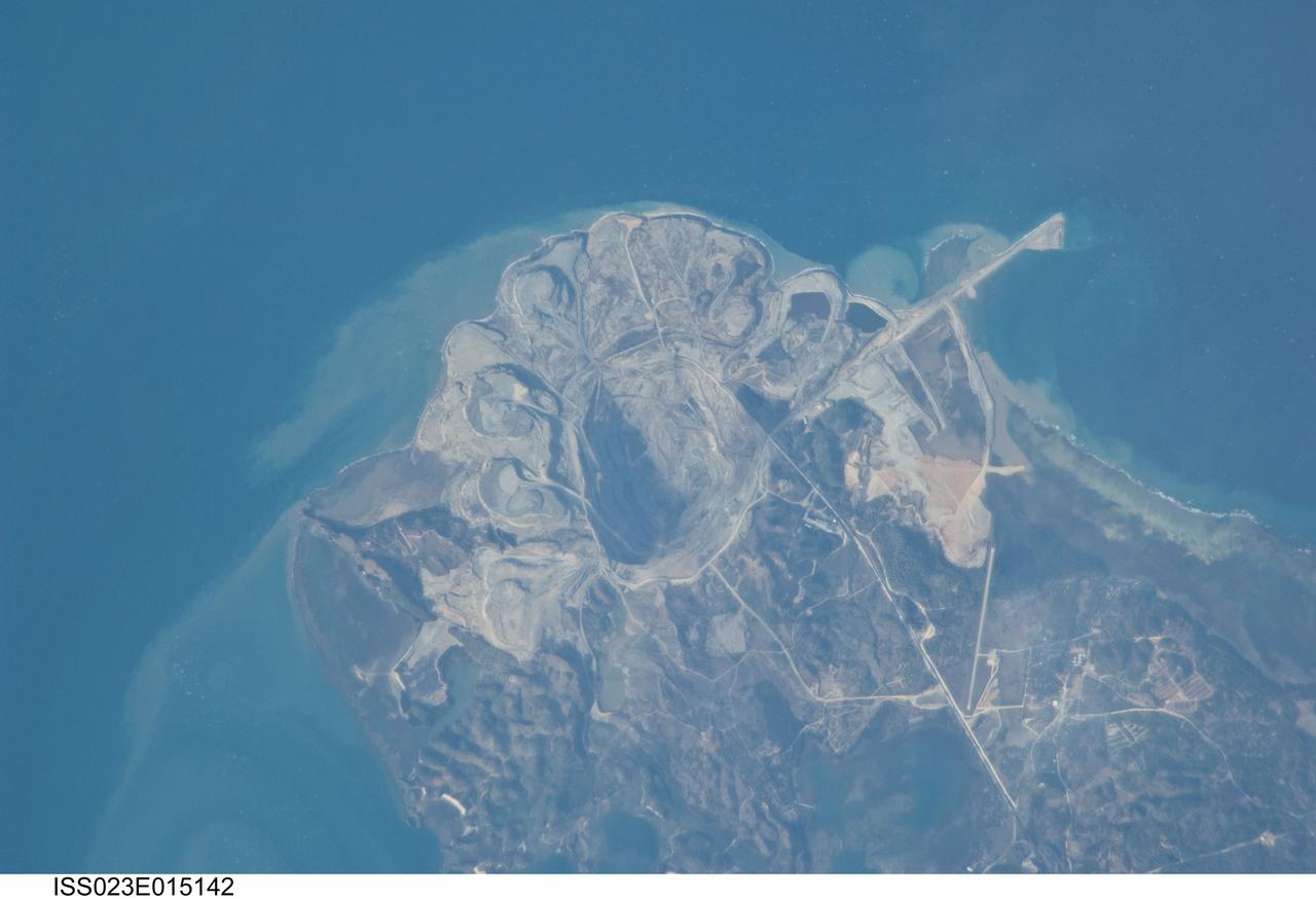
090 asia philippines 254
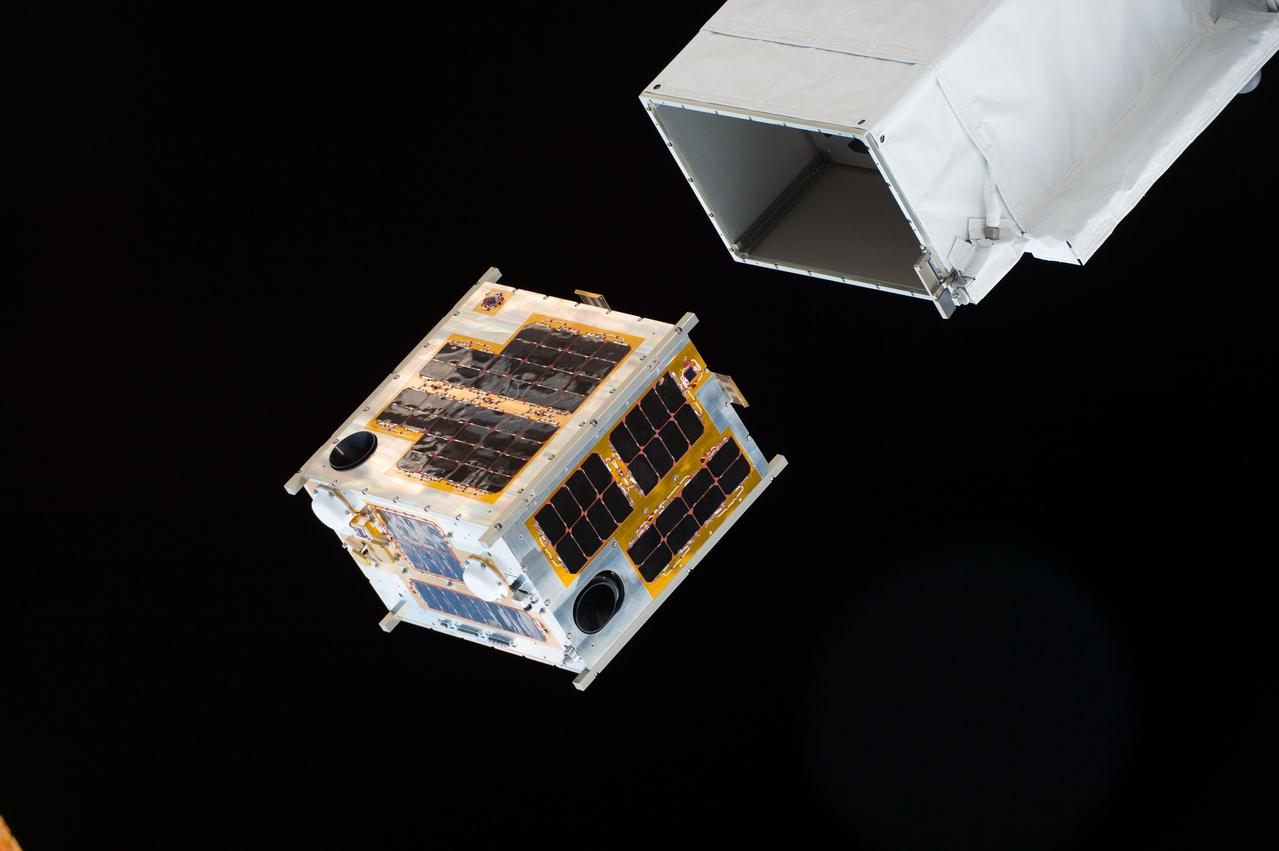
ISS047e083577 (04/27/2016) --- The DIWATA-1 satellite is deployed from outside of the Japanese Kibo module. Intended to observe earth and monitor climate changes, this was the first microsatellite owned by the Philippine government that involved Filipino engineers in the development. It was a joint project between Philippine and Japanese universities.
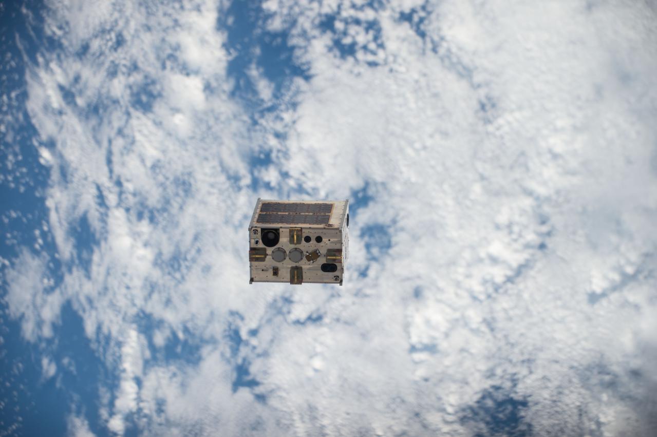
ISS047e083589(04/27/2016) --- The DIWATA-1 satellite is deployed from outside of the Japanese Kibo module. Intended to observe earth and monitor climate changes, this was the first microsatellite owned by the Philippine government that involved Filipino engineers in the development. It was a joint project between Philippine and Japanese universities.
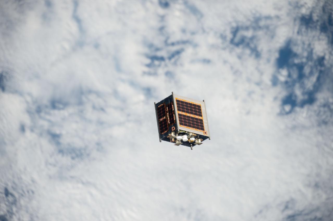
ISS047e083623(04/27/2016) --- The DIWATA-1 satellite is deployed from outside of the Japanese Kibo module. Intended to observe earth and monitor climate changes, this was the first microsatellite owned by the Philippine government that involved Filipino engineers in the development. It was a joint project between Philippine and Japanese universities.
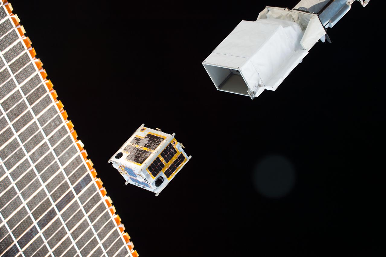
ISS047e083584 (04/27/2016) --- The DIWATA-1 satellite is deployed from outside of the Japanese Kibo modul. Intended to observe earth and monitor climate changes, this was the first microsatellite owned by the Philippine government that involved Filipino engineers in the development. It was a joint project between Philippine and Japanese universities.
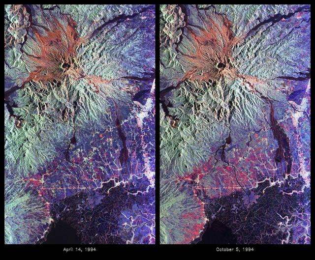
These are color composite radar images showing the area around Mount Pinatubo in the Philippines. The images were acquired by the Spaceborne Imaging Radar-C and X-band Synthetic Aperture Radar (SIR-C/X-SAR) aboard the space shuttle Endeavour on April 14, 1994 (left image) and October 5,1994 (right image). The images are centered at about 15 degrees north latitude and 120.5 degrees east longitude. Both images were obtained with the same viewing geometry. The color composites were made by displaying the L-band (horizontally transmitted and received) in red; the L-band (horizontally transmitted and vertically received) in green; and the C-band (horizontally transmitted and vertically received) in blue. The area shown is approximately 40 kilometers by 65 kilometers (25 miles by 40 miles). The main volcanic crater on Mount Pinatubo produced by the June 1991 eruptions and the steep slopes on the upper flanks of the volcano are easily seen in these images. Red on the high slopes shows the distribution of the ash deposited during the 1991 eruption, which appears red because of the low cross-polarized radar returns at C and L bands. The dark drainages radiating away from the summit are the smooth mudflows, which even three years after the eruptions continue to flood the river valleys after heavy rain. Comparing the two images shows that significant changes have occurred in the intervening five months along the Pasig-Potrero rivers (the dark area in the lower right of the images). Mudflows, called "lahars," that occurred during the 1994 monsoon season filled the river valleys, allowing the lahars to spread over the surrounding countryside. Three weeks before the second image was obtained, devastating lahars more than doubled the area affected in the Pasig-Potrero rivers, which is clearly visible as the increase in dark area on the lower right of the images. Migration of deposition to the east (right) has affected many communities. Newly affected areas included the community of Bacolor, Pampanga, where thousands of homes were buried in meters of hot mud and rock as 80,000 people fled the lahar-stricken area. Scientists are closely monitoring the westward migration ( toward the left in this image) of the lahars as the Pasig-Potrero rivers seek to join with the Porac River, an area that has not seen laharic activity since the eruption. This could be devastating because the Pasig-Potrero rivers might be permanently redirected to lower elevations along the Porac River where communities are located. Ground saturation with water during the rainy season reveals inactive channels that were dry in the April image. A small lake has turned into a pond in the lower reaches of the Potrero River because the channels are full of lahar deposits and the surface runoff has no where to flow. Changes in the degree of erosion in ash and pumice deposits from the 1991 eruption can also be seen in the channels that deliver the mudflow material to the Pasig-Potrero rivers. The 1991 Mount Pinatubo eruption is well known for its near-global effects on the atmosphere and short-term climate due to the large amount of sulfur dioxide that was injected into the upper atmosphere. Locally, however, the effects will most likely continue to impact surrounding areas for as long as the next 10 to 15 years. Mudflows, quite certainly, will continue to pose severe hazards to adjacent areas. Radar observations like those obtained by SIR-C/X-SAR will play a key role in monitoring these changes because of the radar's ability to see in daylight or darkness and even in the worst weather conditions. Radar imaging will be particularly useful, for example, during the monsoon season, when the lahars form. Frequent imaging of these lahar fields will allow scientists to better predict when they are likely to begin flowing again and which communities might be at risk. http://photojournal.jpl.nasa.gov/catalog/PIA01743
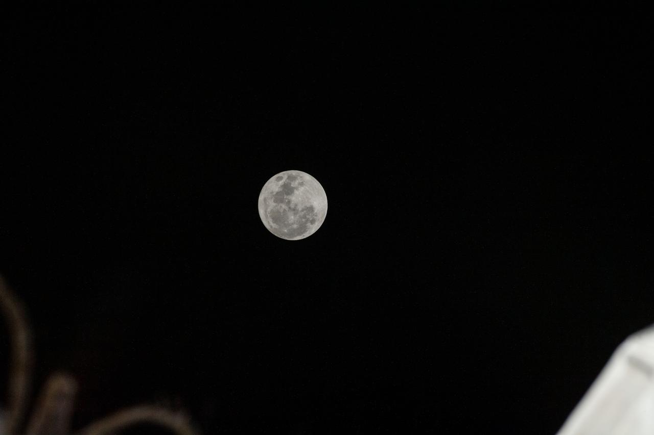
iss067e187059 (July 13, 2022) --- The Full Moon is pictured from the International Space Station as it orbited 261 milies above the Philippine Sea.
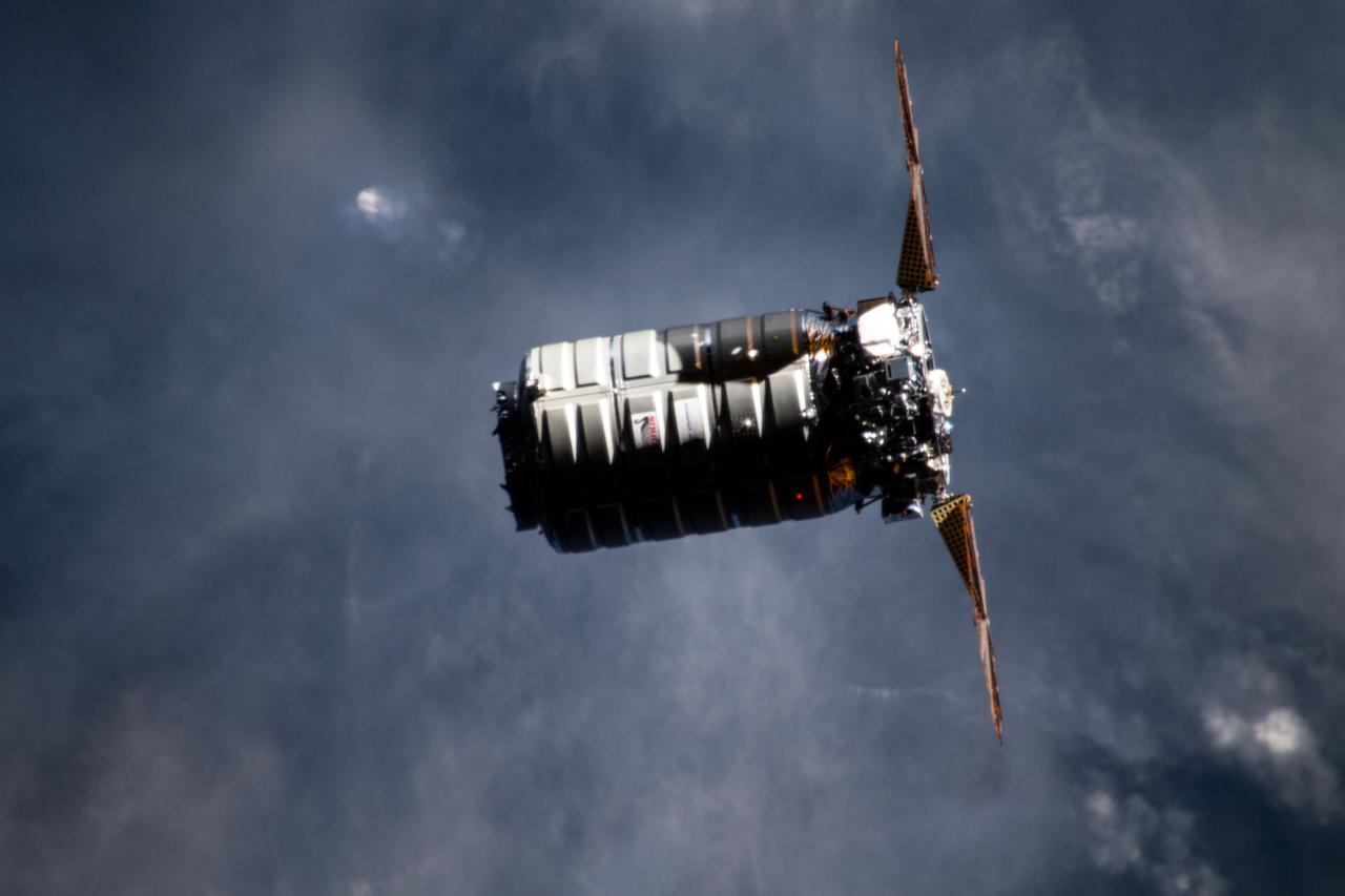
iss059e025388 (April 19, 2019) --- Northrop Grumman's Cygnus space freighter approaches the International Space Station 254 miles above the Philippines.

On Nov. 8, 2013, NASA Terra spacecraft acquired this image of Super Typhoon Haiyan as it tore across the central Philippines, leaving a trail of destruction in its path. Among the worst-hit areas is eastern Leyte island and the city of Tacloban.
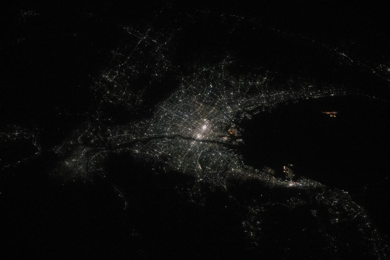
iss072e519516 (Jan. 22, 2025) --- The city lights of Osaka, Japan, the island nation's third most populous city split by the Yodo River, are pictured at approximately 10:25 p.m. local time from the International Space Station as it orbited 258 miles above the Philippine Sea.
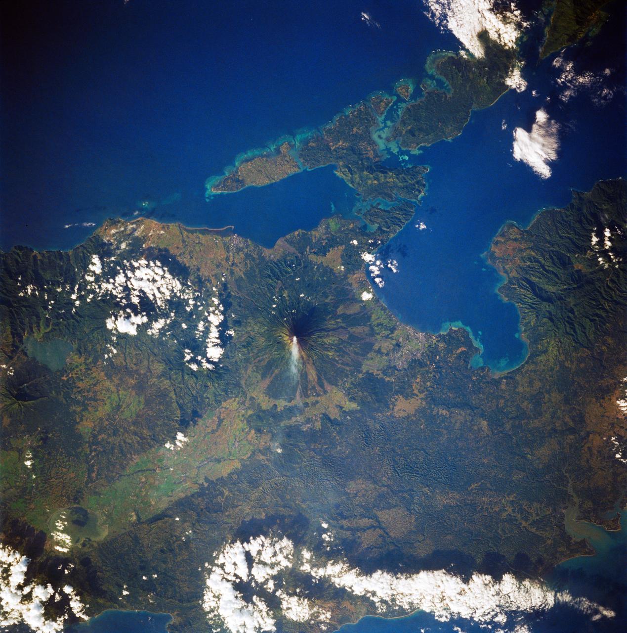
STS083-747-088 (4-8 April 1997)--- Mayon Volcano with a Plume, Luzon, the Philippines Mayon has the classic conical shape of a strato volcano. It is the most active volcano in the Philippines and continues to be active as demonstrated by the plume in the photo. Since 1616, Mayon has erupted 47 times. The most recent major eruption, in 1993, began unexpectedly with an explosion. The initial eruption lasted only 30 minutes but it generated pyroclastic flows that killed 68 people and prompted the evacuation of 60,000 others.

jsc2021e042552 (10/29/2020) --- Maya-3 and Maya-4 Flight Model Assembly inside the Clean Booth at the University Laboratory for Small Satellites and Space Engineering Systems (ULyS3Es), University of the Philippines-Diliman . The BIRDS-2S project consists of the Maya-3 and Maya-4 CubeSats, the first Philippine university-built cube satellites developed by eight graduate students under the Space science education and Technology Proliferation through University Partnerships (STeP-UP) Project. Image Credit: Batch-1 STeP-UP Scholars

iss061e097961 (Dec. 26, 2019) --- The shadow of the Moon is cast over portions of Malaysia and the Philippines during today's solar eclipse. The International Space Station was orbiting 259 miles above the South China Sea at the time this photograph was taken.
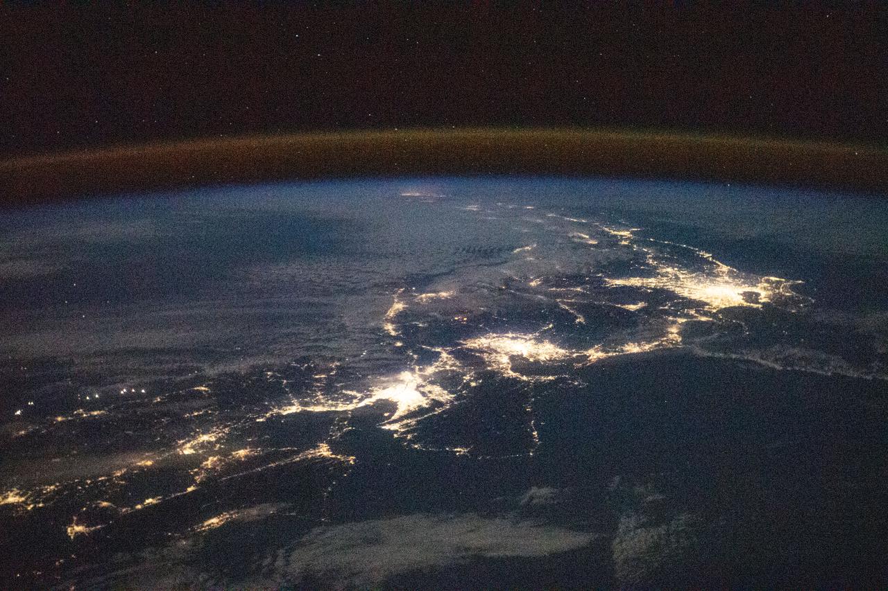
iss064e037541 (Feb. 24, 2021) --- The city lights of Japan, blanketed by the air glow above Earth's horizon, are pictured from International Space Station as it orbited 260 miles above the Philippine Sea south of the island nation .
iss061e093009 (Dec. 18, 2019) --- The International Space Station orbits 267 miles above the Earth as the Sun's glint beams over the Philippine Sea highlighting the clouds and their shadows during an orbital sunrise.
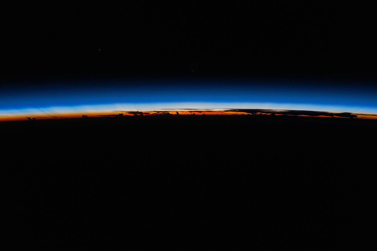
iss071e310017 (July 6, 2024) -- The last rays of an orbital sunset shine a striking orange against Earth's blue glow as the International Space Station orbited 255 miles above The Philippines.

iss061e097976 (Dec. 26, 2019) --- The shadow of the Moon is cast over portions of Malaysia and the Philippines during today's solar eclipse. The International Space Station was orbiting 260 miles above the South China Sea at the time this photograph was taken.
iss063e052774 (July 13, 2020) --- Sunrise casts long shadows from the clouds across the Philippine Sea as the International Space Station orbited about 200 miles east of Taiwan.

iss071e489468 (Aug. 17, 2024) --- The Progress 89 cargo craft approaches the International Space Station above Earth's horizon in this photograph from the orbital outpost as it soared 257 miles above the Philippine Sea.
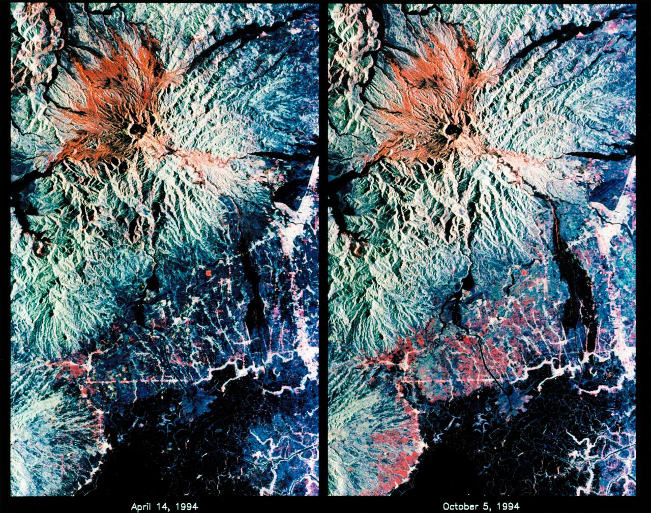
STS068-S-053 (7 October 1994) --- These are color composite radar images showing the area around Mount Pinatubo in the Philippines. The images were acquired by the Spaceborne Imaging Radar-C/X-Band Synthetic Aperture Radar (SIR-C/X-SAR) aboard the Space Shuttle Endeavour on April 14, 1994 (left image) and October 5, 1994 (right image). The images are centered at about 15 degrees north latitude and 120.5 degrees east longitude. Both images were obtained with the same viewing geometry. The color composites were made by displaying the L-Band (horizontally transmitted and received) in red; the L-Band (horizontally transmitted and vertically received) in green; and the C-Band (horizontally transmitted and vertically received) in blue. The area shown is approximately 40 by 65 kilometers (25 by 40 miles). The main volcanic crater on Mount Pinatubo produced by the June 1991 eruptions and the steep slopes on the upper flanks of the volcano are easily seen in these images. Red on the high slopes shows the distribution of the ash deposited during the 1991 eruption, which appears red because of the low cross-polarized radar returns at C and L Bands. The dark drainage's radiating away from the summit are smooth mud flows, which even three years after the eruption continue to flood the river valleys after heavy rain. Comparing the two images shows that significant changes have occurred in the intervening five months along the Pasig-Potero rivers (the dark area in the lower right of the images). Mud flows, called "lahars", that occurred during the 1994 monsoon season filled the river valleys, allowing the lahars to spread over the surrounding countryside. Three weeks before the second image was obtained, devastating lahars more than doubled the area affected in the Pasig-Potero rivers, which is clearly visible as the increase in dark area on the lower right of the images. Migration of deposition to the east (right) has affected many communities. Newly affected areas included the community of Bacolor, Pampanga, where thousands of homes were buried in meters of hot mud and rock as 80,000 people fled the lahar-stricken area. The 1991 Mount Pinatubo eruption is well known for its near-global effects on the atmosphere and short-term climate due to the large amount of sulfur dioxide that was injected into the upper atmosphere. Locally, however, the effects will most likely continue to impact surrounding areas for as long as the next 10 to 15 years. Mud flows, quite certainly, will continue to pose severe hazards to adjacent areas. Radar observations like those obtained by SIR-C/X-SAR will play a key role in monitoring these changes because of the radar's ability to see daylight or darkness and even in the worst weather conditions. Radar imaging will be particularly useful during the monsoon season, when the lahars form. Frequent imaging of these lahar fields will allow scientists to better predict when they are likely to begin flowing again and which communities might be at risk. Spaceborne Imaging Radar-C/X-Band Synthetic Aperture Radar (SIR-C/X-SAR) is part of NASA's Mission to Planet Earth. (P-44729)

iss068e071325 (March 5, 2021) --- UAE (United Arab Emirates) astronaut and Expedition 68 Flight Engineer Sultan Alneyadi is pictured inside the seven-window cupola, the International Space Station's "window to the world." The orbiting lab was flying 260 milers above the Philippine Sea at the time of this photograph.
STS073-E-5313 (3 Nov. 1995) --- Typhoon Angela packed winds of 115 knots when this shot was taken with an Electronic Still Camera (ESC) from the Earth-orbiting space shuttle Columbia. It subsequently increased to speeds of 155 nautical miles, making it a super typhoon, heading due west toward Luzon in the Philippines.

STS106-704-063 (9 September 2000) --- Typhoon Saomai swirls in the Pacific Ocean east of Taiwan and the Philippines. The typhoon was captured on film with a 70mm handheld camera by the STS-106 crew members aboard the Space Shuttle Atlantis on September. 9

iss073e0657546 (Sept. 8, 2025) --- The 57.7-foot-long Canadarm2 robotic arm extends from a grapple fixture on the International Space Station as it soared into an orbital sunrise 260 miles above the Philippine Sea at approximately 4:04 a.m. local time.
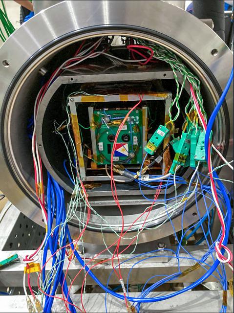
jsc2021e042551 (8/31/2021) --- Maya-3 and Maya-4 (Maya-3 in front) inside the Small Thermal Vacuum Chamber at the Center for Nanosatellite Testing, Kyushu Institute of Technology. The BIRDS-2S project consists of the Maya-3 and Maya-4 CubeSats, the first Philippine university-built cube satellites developed by eight graduate students under the Space science education and Technology Proliferation through University Partnerships (STeP-UP) Project.

iss061e100234 (Dec. 26, 2019) --- The shadow of the Moon is cast over portions of Malaysia and the Philippines during today's solar eclipse. The International Space Station was orbiting 259 miles above the South China Sea at the time this photograph was taken. In the foreground is the SpaceX Dragon resupply ship and part of the ESA (European Space Agency) Columbus laboratory module.

ISS043E183985 (05/08/2015) --- Typhoon Noul from a camera aboard the International Space Station taken by the Expedition 43 crew led by Commander Terry Virts, NASA astronaut. Noul originated in the tropical Western Pacific, brushing the island of Yap before strengthening rapidly and clipping the northern Philippines as a super typhoon, winding up on the Pacific coast of Japan reduced to a tropical storm.

STS79-E-5099 (20 September 1996) --- The crew members have been able to spot two typhoons - the larger Violet, north of the Philippines, and a lesser one called Willie, near Vietnam - and a tropical depression from Earth-orbit, during Flight Day 5. They aimed the Electronic Still Camera (ESC) at this storm, believed to be Violet, during the early hours of September 20, 1996.
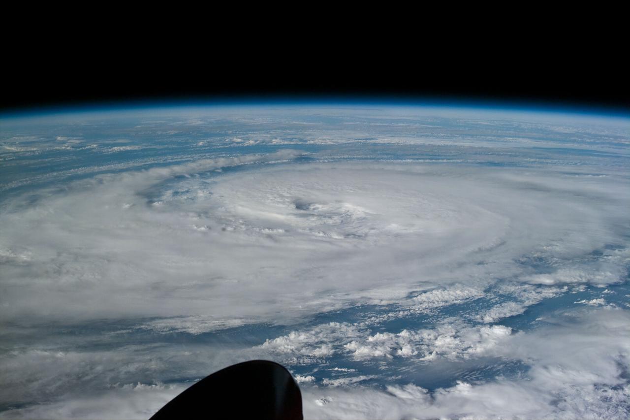
ISS034-E-005437 (2 Dec. 2012) --- One of the Expedition 34 crew members aboard the International Space Station captured this still image of Super Typhoon Bopha on Dec. 2, 2012. The storm was bearing down on the Philippines with winds of 135 miles per hour. Meteorologists are predicting that the storm will make landfall on Mindanao in the early morning of Dec. 4 local time, as either a category 4 or 5.

iss067e006352 (April 9, 2022) --- The SpaceX Dragon Endeavour crew ship (white dot at lower center) carrying four Axiom Mission 1 astronauts approaches the International Space Station during an orbital sunset less than a day after launching from NASA's Kennedy Space Center in Florida. Both spacecraft were orbiting 261 miles above the Philippine Sea near the U.S. island territory of Guam.
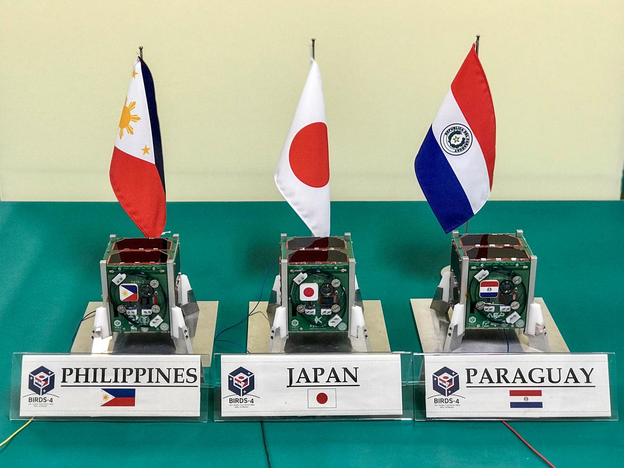
jsc2020e049619 (2/4/2020) --- A preflight view of the three BIRDS-4 Flight units inside clean room of Kyushu Insitute of Technology. The Joint Global Multi Nation Birds or BIRDS-4 Project is a constellation of three 1U CubeSats developed by Japan, Philippines and Paraguay, with Paraguay launching their first satellite. The mission of the BIRDS-4 satellites is to test commercial off-the-shelf components, as well as new technologies in space. Image Credit: Mark Angelo Purio

ISS043E078143 (03/31/2015) --- Astronauts on board the International Space Station captured this image on Mar. 31, 2015 of the category 5 super Typhoon Maysak which is headed toward the Philippines. The Tropical Rainfall Measuring Mission (TRMM) and Global Precipitation Measurement (GPM) satellites, both co-managed by NASA and the Japan Aerospace Exploration Agency, captured rainfall and cloud data that revealed heavy rainfall and high thunderstorms in the strengthening storm.

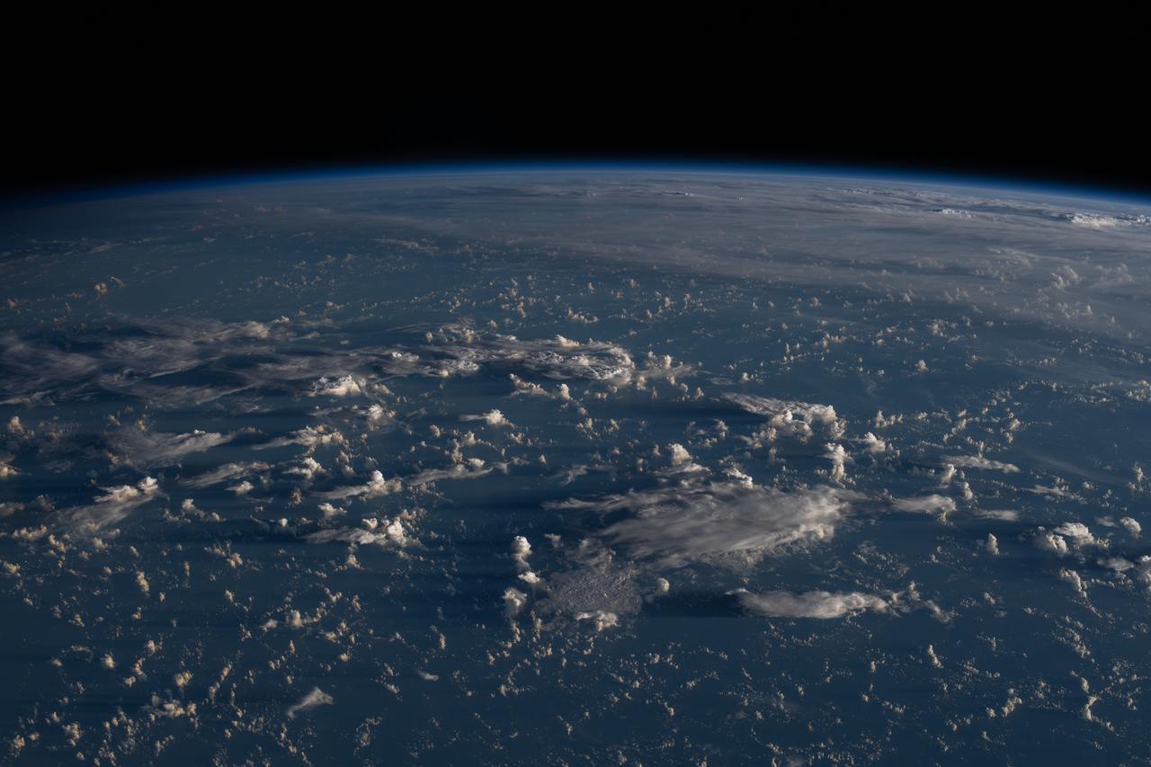
ISS040-E-087412 (30 July 2014) --- An area of sun glint near the horizon caught the eye of one of the Expedition 40 crew members as the International Space Station was flying roughly 225 nautical miles above a point in the Pacific Ocean a few hundred miles southeast of the Philippines on July 30, 2014. The view is looking northwestward.

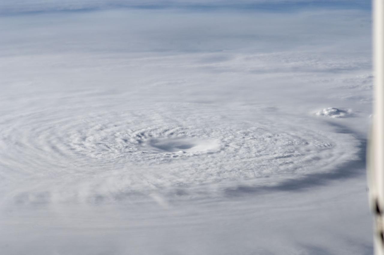
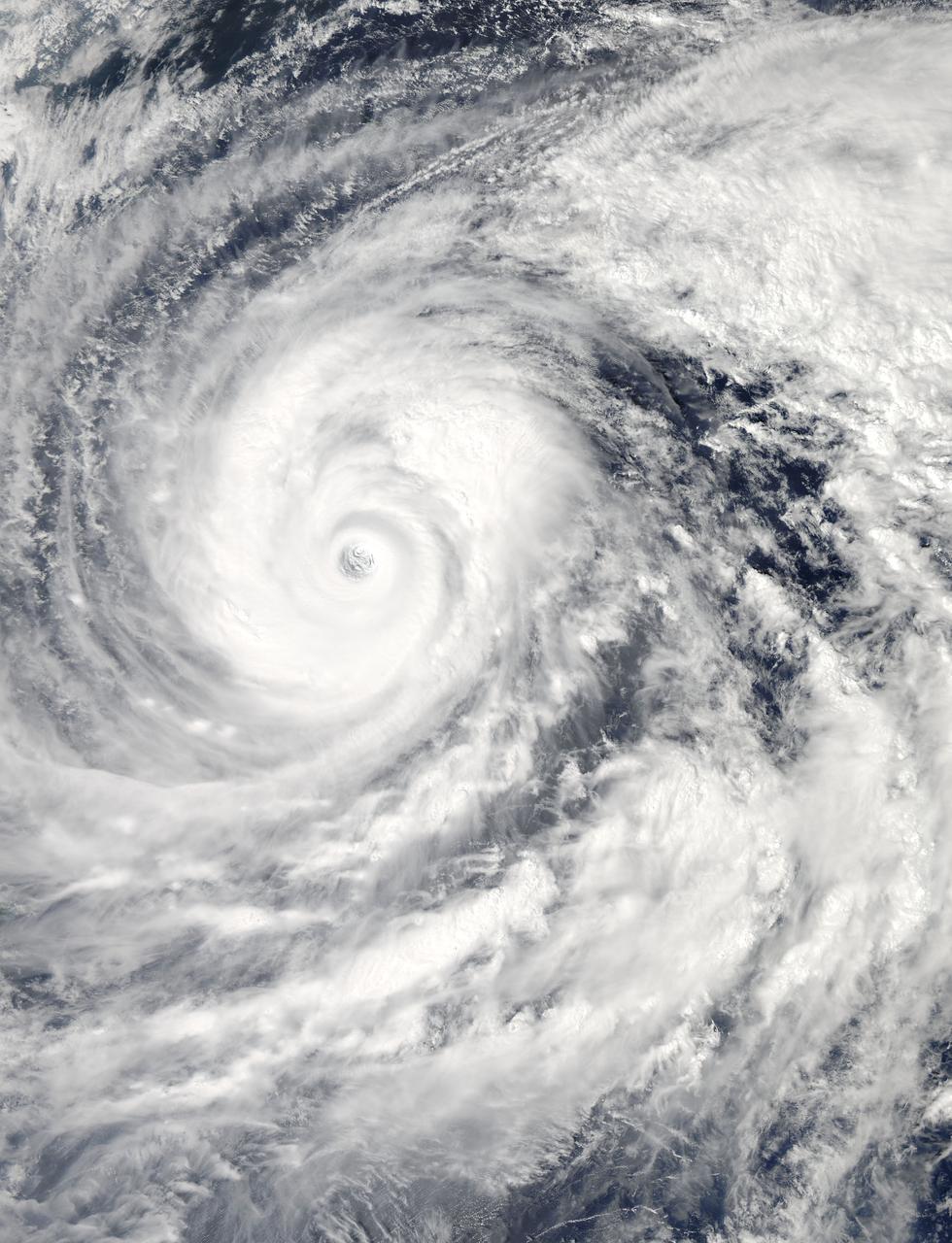
Supertyphoon Yuri began development approximately 1000 miles east of the Philippine Islands. At the time this photo was taken, Yuri was about 1000 nautical miles in diameter and had estimated maximum sustained wind speeds of 145 mph, gusting to 170 mph. This oblique view shows the well formed eye of Yuri and the raised segment of clouds at the cusp of the eye indicating very high wind speeds within the vortex.
ISS034-E-005476 (2 Dec. 2012) --- One of the Expedition 34 crew members aboard the International Space Station captured this still image of Super Typhoon Bopha on Dec. 2, 2012. The storm was bearing down on the Philippines with winds of 135 miles per hour. Meteorologists are predicting that the storm will make landfall on Mindanao in the early morning of Dec. 4 local time, as either a category 4 or 5. Parts of the orbital outpost are seen in the picture -- the Permanent Multipurpose Module on the left, and Mini-Research Module 1 (MRM1) on the right.
ISS037-E-028930 (9 Nov. 2013) --- When one of the Expedition 37 crew members aboard the International Space Station took this photograph on Nov. 9, 2013, Typhoon Haiyan had already made landfall and was rapidly weakening over the west-central Philippines, with winds estimated at 110 miles per hour and estimated position near 15.0 degrees north latitude and 112.3 degrees east longitude.
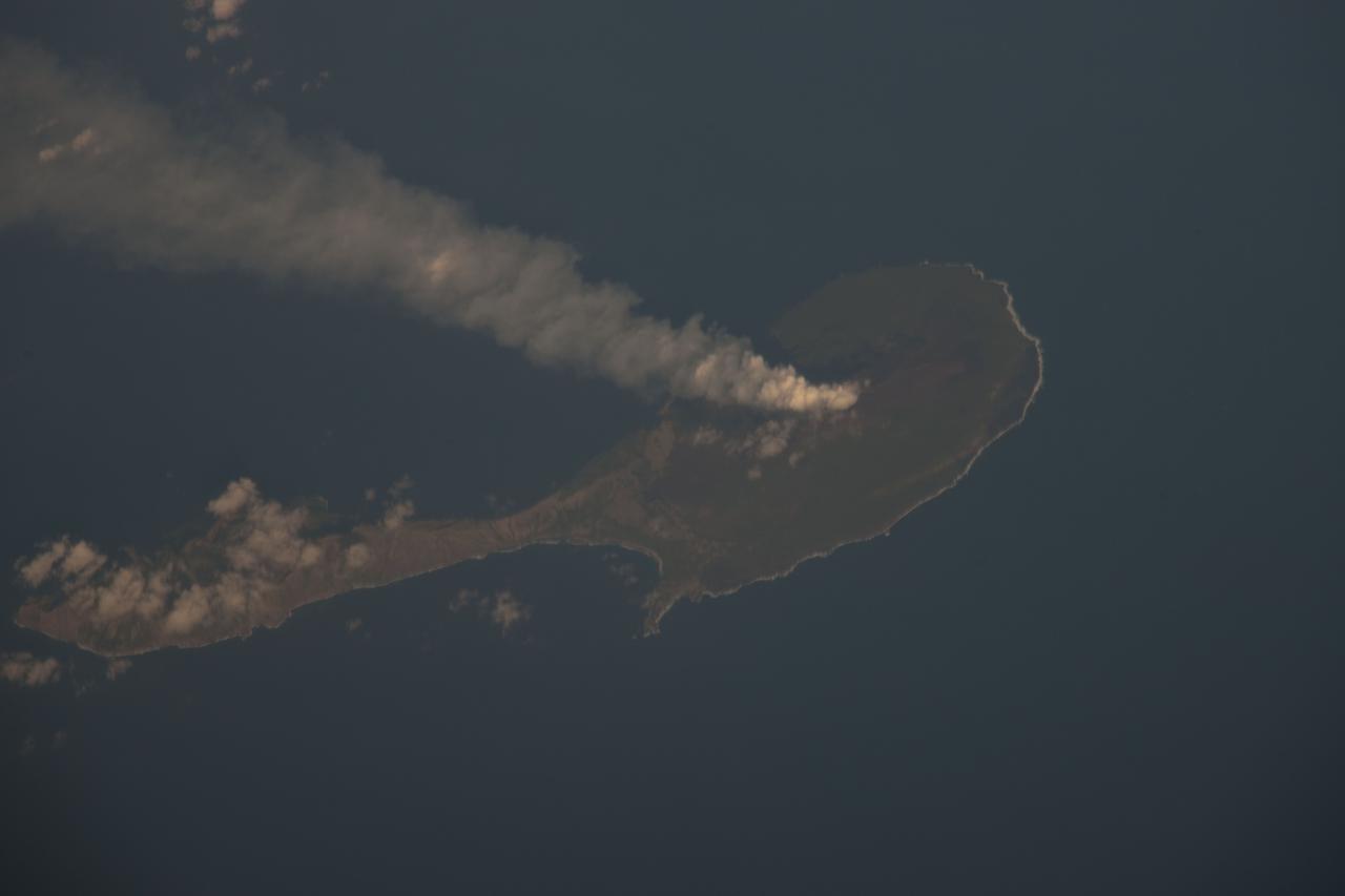
ISS030-E-122047 (6 March 2012) --- Pagan Island, Northern Marianas is featured in this image photographed by an Expedition 30 crew member on the International Space Station. A steam plume flows south from the peak of Pagan Island’s northernmost volcano in this photograph. Pagan is part of the Commonwealth of the Northern Marianas, an island chain of volcanoes that form the margin between the Pacific Ocean (to the east) and the Philippine Sea (to the west). Pagan is made up of two stratovolcanoes separated by an isthmus, and is one of the more volcanically active islands. The last eruption was in 2010, but the island was completely evacuated in 1981 when a large eruption forced the small Micronesian community to flee. According to NASA scientists, the islands themselves mark the tectonic boundary where the old, cold Pacific plate is subducted beneath the younger, less dense Philippine Sea crust at the Marianas Trench. The subduction results in substantial volcanic activity on the upper plate, forming the island arc of the Marianas. Considered to be one of the type examples for an oceanic subduction zone, the Marianas Trench includes the deepest spot in Earth’s oceans (more than 10,000 meters). The foreshortened appearance of the island is due to the viewing angle and distance from the space station, which was located over the Pacific Ocean approximately 480 kilometers to the southeast of Pagan Island when the image was taken.
NASA image acquired December 3, 2012 As predicted, Typhoon Bopha made landfall on the Philippine island of Mindanao overnight December 3–4, 2012. Known in the Philippines as Pablo, the storm was blamed for 43 deaths and 25 injuries as of December 4, according to the Philippine Daily Inquirer. (To view the high res or to read more go to: <a href="http://1.usa.gov/XnYhVG" rel="nofollow">1.usa.gov/XnYhVG</a>) The Visible Infrared Imaging Radiometer Suite (VIIRS) on the Suomi NPP satellite acquired this image around 1:12 a.m. local time on December 4 (17:12 UTC on December 3). This image is from the VIIRS “day-night band,” which detects light in a range of wavelengths from green to near-infrared and uses filtering techniques to observe signals such as gas flares, auroras, wildfires, city lights, and reflected moonlight. Bopha remained a powerful typhoon as it made landfall on Mindanao, retaining a distinct eye and spiral shape as storm clouds stretched over the eastern part of the island. Unisys Weather reported that Bopha carried super-typhoon strength at the time it was coming ashore. William Straka, associate researcher at the Cooperative Institute for Meteorological Satellite Studies at the University of Wisconsin–Madison, estimated that the storm spanned at least 1,677 kilometers (1,042 miles). Bopha lost some strength after making landfall. On December 4 (late in the evening in the Philippines), the U.S. Navy’s Joint Typhoon Warning Center (JTWC) reported that the storm had maximum sustained winds of 95 knots (175 kilometers per hour) and gusts up to 115 knots (215 kilometers per hour)—still a fierce storm, but weakened since the previous day. The JTWC projected storm track showed Bopha continuing its movement toward the west-northwest, passing over the southern Philippines toward the South China Sea. NASA Earth Observatory image by Jesse Allen, using VIIRS day-night band data from the Suomi National Polar-orbiting Partnership. Suomi NPP is the result of a partnership between NASA, the National Oceanic and Atmospheric Administration, and the Department of Defense. Caption by Michon Scott. Instrument: Suomi NPP - VIIRS Credit: <b><a href="http://www.earthobservatory.nasa.gov/" rel="nofollow"> NASA Earth Observatory</a></b> <b><a href="http://www.nasa.gov/audience/formedia/features/MP_Photo_Guidelines.html" rel="nofollow">NASA image use policy.</a></b> <b><a href="http://www.nasa.gov/centers/goddard/home/index.html" rel="nofollow">NASA Goddard Space Flight Center</a></b> enables NASA’s mission through four scientific endeavors: Earth Science, Heliophysics, Solar System Exploration, and Astrophysics. Goddard plays a leading role in NASA’s accomplishments by contributing compelling scientific knowledge to advance the Agency’s mission. <b>Follow us on <a href="http://twitter.com/NASA_GoddardPix" rel="nofollow">Twitter</a></b> <b>Like us on <a href="http://www.facebook.com/pages/Greenbelt-MD/NASA-Goddard/395013845897?ref=tsd" rel="nofollow">Facebook</a></b> <b>Find us on <a href="http://instagrid.me/nasagoddard/?vm=grid" rel="nofollow">Instagram</a></b>

ISS043E078169 (03/31/2015) --- This close up of the huge Typhoon Maysak "eye" of the category 5 (hurricane status on the Saffir-Simpson Wind Scale) was captured by astronauts on board the International Space Station Mar. 31, 2015. The massive Typhoon is headed toward the Philippines and expected to land on the upcoming Easter weekend. The Tropical Rainfall Measuring Mission (TRMM) and Global Precipitation Measurement (GPM) satellites, both co-managed by NASA and the Japan Aerospace Exploration Agency, captured rainfall and cloud data that revealed very heavy rainfall and high thunderstorms in the still strengthening storm.
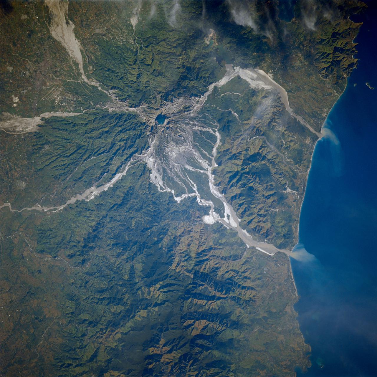
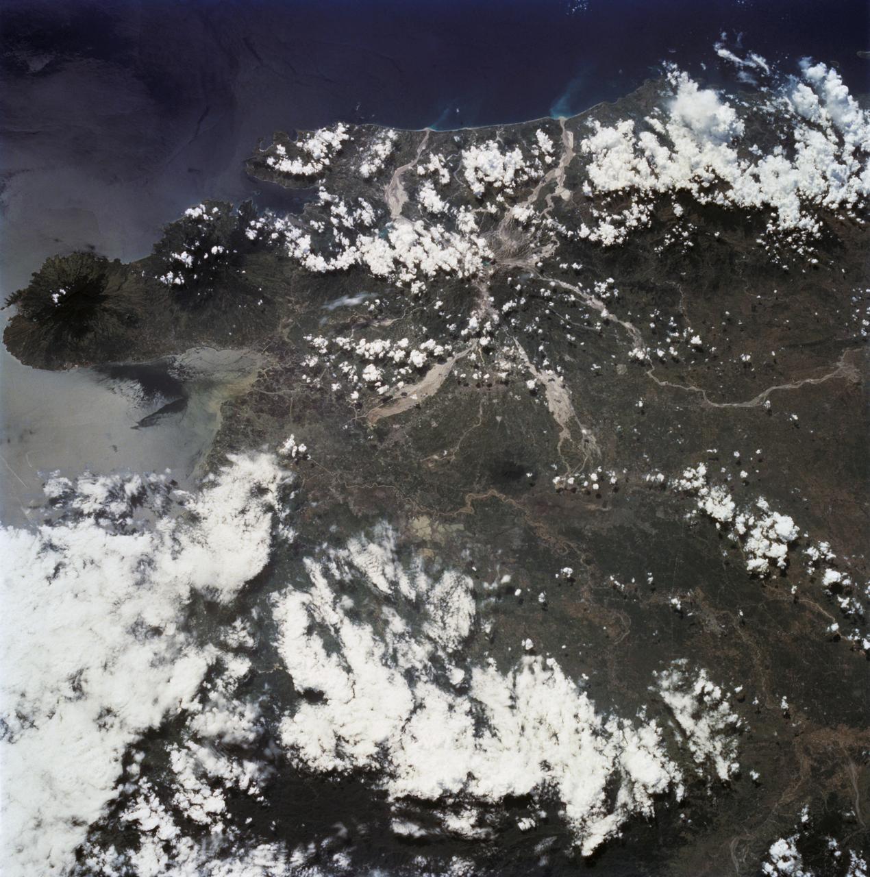
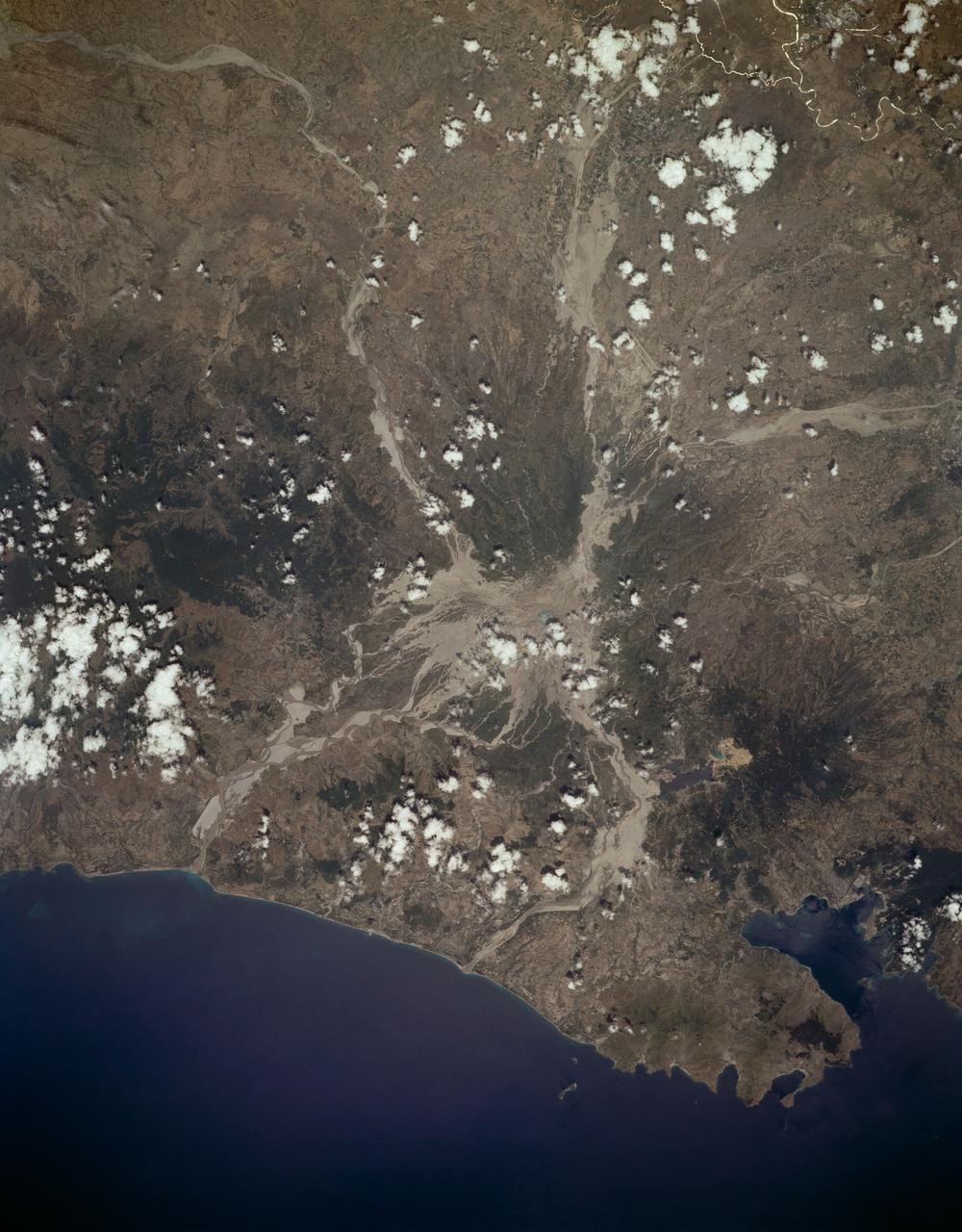
STS080-706-044 (19 Nov.-7 Dec. 1996) --- This view shows Mount Pinatubo, an active volcano in the Zambales Mountains range of western Luzon, the main island of the Philippines. Mud flows radiate out from the active volcano, which has erupted in recent years, coming down the mountain. After the eruption a lot of the vegetation was removed, causing the mountain to erode at a more rapid pace than an older mountain that has its vegetation in place. In two cases the flows reach the South China Sea, and flow down three valleys to the east. The now abandoned Clark Air Force Base is to the upper left corner. Pinatubo is about 80 miles northwest of Manila.

Ikapati Crater on Ceres is seen at top right in this image from NASA's Dawn spacecraft. Ikapati has a complex of central peaks and roughly parallel fractures on its floor. The crater, named for a Philippine goddess of cultivated lands, measures 31 miles (50 kilometers) in diameter. Dawn took this image on Oct. 24, 2016, during its second extended-mission science orbit (XMO2), from a distance of about 920 miles (1,480 kilometers) above the surface of Ceres. The image resolution is about 460 feet (140 meters) per pixel. http://photojournal.jpl.nasa.gov/catalog/PIA21249

jsc2021e042550 (8/31/2020) --- The developers of Maya-3 and Maya-4 (top row, from left to right) Renzo Wee, Christy Raterta, Lorilyn Daquioag, Derick Canceran, (bottom row, from left to right) Judiel Reyes, Gladys Bajaro, Marielle Magbanua-Gregorio, Bryan Custodio. The BIRDS-2S project consists of the Maya-3 and Maya-4 CubeSats, the first Philippine university-built cube satellites developed by eight graduate students under the Space science education and Technology Proliferation through University Partnerships (STeP-UP) Project.

STS047-54-018 (12-20 Sept. 1992) --- The colors in this photograph provide insight into the relative density of the atmosphere. The crew members had many opportunities to witness sunrises and sunsets, considering they orbit the Earth every 90 minutes, but few, they said, compared to this scene. It captures the silhouette of several mature thunderstorms with their cirrus anvil tops spreading out against the tropopause (the top of the lowest layer of Earth's atmosphere) at sunset. The lowest layer (troposphere) is the densest and refracts light at the red end of the visible spectrum (7,400 Angstroms), while the blues (4,000 Angstroms) are separated in the least dense portion of the atmosphere (middle and upper atmosphere, or stratosphere and mesosphere). Several layers of blue can be seen. NASA scientists studying the photos believe this stratification to be caused by the scattering of light by particulate trapped in the stratosphere and mesosphere particulate that generally originate from volcanic eruptions, such as those of Mt. Pinatubo in the Philippines and, most recently, Mt. Spurr in Alaska.

STS047-54-016 (12 - 20 Sept 1992) --- The colors in this photograph provide insight into the relative density of the atmosphere. The crew members had many opportunities to witness sunrises and sunsets, considering they orbit the Earth every 90 minutes, but few, they said, compared to this scene. It captures the silhouette of several mature thunderstorms with their cirrus anvil tops spreading out against the tropopause (the top of the lowest layer of Earth's atmosphere) at sunset. The lowest layer (troposphere) is the densest and refracts light at the red end of the visible spectrum (7,400 Angstroms), while the blues (4,000 Angstroms) are separated in the least dense portion of the atmosphere (middle and upper atmosphere, or stratosphere and mesosphere). Several layers of blue can be seen. NASA scientists studying the photos believe this stratification to be caused by the scattering of light by particulate trapped in the stratosphere and mesosphere particulate that generally originate from volcanic eruptions, such as those of Mt. Pinatubo in the Philippines and, most recently, Mt. Spurr in Alaska.
The MODIS instrument aboard NASA's Aqua satellite captured this visible image of Super Typhoon Vongfong on Oct. 9 at 04:25 UTC (12:25 a.m. EDT as it moved north through the Philippine Sea. Credit: NASA Goddard MODIS Rapid Response Team --- Vongfong weakened to a Category 4 typhoon on the Saffir-Simpson scale on Thursday, October 9, with maximum sustained winds near 130 knots (149.6 mph/240.8 kph), down from a Category 5 typhoon on Oct. 8. Forecasters at the Joint Typhoon Warning Center predict slow weakening over the next several days. Vongfong was centered near 20.6 north and 129.5 east, about 384 nautical miles south-southeast of Kadena Air Base, Okinawa, Japan. It is moving to the north-northwest at 7 knots (8 mph/12.9 kph) and generating 44 foot (13.4 meter) high seas. For warnings and watches, visit the Japan Meteorological Agency website at: <a href="http://www.jma.go.jp/en/typh/" rel="nofollow">www.jma.go.jp/en/typh/</a>. Vongfong is forecast to continue moving north through the Philippine Sea and is expected to pass just to the east of Kadena Air Base, then track over Amami Oshima before making landfall in Kyushu and moving over the other three big islands of Japan. Residents of all of these islands should prepare for typhoon conditions beginning on October 10. Read more: <a href="http://1.usa.gov/1s0CCQy" rel="nofollow">1.usa.gov/1s0CCQy</a> <b><a href="http://www.nasa.gov/audience/formedia/features/MP_Photo_Guidelines.html" rel="nofollow">NASA image use policy.</a></b> <b><a href="http://www.nasa.gov/centers/goddard/home/index.html" rel="nofollow">NASA Goddard Space Flight Center</a></b> enables NASA’s mission through four scientific endeavors: Earth Science, Heliophysics, Solar System Exploration, and Astrophysics. Goddard plays a leading role in NASA’s accomplishments by contributing compelling scientific knowledge to advance the Agency’s mission. <b>Follow us on <a href="http://twitter.com/NASAGoddardPix" rel="nofollow">Twitter</a></b> <b>Like us on <a href="http://www.facebook.com/pages/Greenbelt-MD/NASA-Goddard/395013845897?ref=tsd" rel="nofollow">Facebook</a></b> <b>Find us on <a href="http://instagram.com/nasagoddard?vm=grid" rel="nofollow">Instagram</a></b>

On Saturday, Sept. 21, TRMM captured rainfall data on Typhoon Usagi as it passed between the northern Philippines and southern Taiwan. TRMM found rain falling at a rate of over 134 mm/hr (~5.2 inches) in USAGI's eye wall. Credit: SSAI/NASA, Hal Pierce <b><a href="http://www.nasa.gov/audience/formedia/features/MP_Photo_Guidelines.html" rel="nofollow">NASA image use policy.</a></b> <b><a href="http://www.nasa.gov/centers/goddard/home/index.html" rel="nofollow">NASA Goddard Space Flight Center</a></b> enables NASA’s mission through four scientific endeavors: Earth Science, Heliophysics, Solar System Exploration, and Astrophysics. Goddard plays a leading role in NASA’s accomplishments by contributing compelling scientific knowledge to advance the Agency’s mission. <b>Follow us on <a href="http://twitter.com/NASA_GoddardPix" rel="nofollow">Twitter</a></b> <b>Like us on <a href="http://www.facebook.com/pages/Greenbelt-MD/NASA-Goddard/395013845897?ref=tsd" rel="nofollow">Facebook</a></b> <b>Find us on <a href="http://instagram.com/nasagoddard?vm=grid" rel="nofollow">Instagram</a></b>

STS003-10-567 (22-30 March 1982) --- Manila Bay, the city of Manila, Clark Air Force Base and other features can be delineated in this nearly vertical view of Luzon in the Philippines, as photographed with a handheld camera from the Earth-orbiting space shuttle Columbia on NASA's STS-3 mission. Hold picture with largest cloud mass at bottom so that north will be at top right corner. A number of volcanoes can be seen in the picture: Mariveles (left center), Natib (just north of Mariveles), Pinatubo (upper right) and Arayet (east-southeast of Pinatubo). Manila is in the south portion of the picture (lower left corner). The island of Corregidor is clearly visible at the mouth of the bay. Clark Air Force Base can be seen between Mt. Pinatubo and Mt. Arayet. Subic Naval Base is just northwest of Mt. Natib on the coast of the South China Sea. Photo credit: NASA EDITOR'S NOTE: Since this photograph was taken, an important update. June 20, 1991, a small eruption in April northwest of the summit at the geothermal area was followed on June 11, 1991, by a larger one, which climaxed June 15 and 16, 1991, into an event of historic proportions. Until the 1991 eruptions, the volcano had not erupted for 635 years.

Super typhoon Mangkhut slammed into the northern Philippines on September 15 with wind speeds equivalent to a category 5 hurricane. South of where the eye made landfall, the storm's effects could be seen clearly five days later. The ASTER image of Dagupan and the Lingayen Gulf shows flooded and water-saturated areas in dark blue. Sediment-laden waters from swollen rivers enter the ocean and appear as blue-green plumes. The image was acquired September 22, 2018, covers an area of 51.4 by 61.2 kilometers, and is located at 16.2 degrees north, 120.3 degrees east. With its 14 spectral bands from the visible to the thermal infrared wavelength region and its high spatial resolution of about 50 to 300 feet (15 to 90 meters), ASTER images Earth to map and monitor the changing surface of our planet. ASTER is one of five Earth-observing instruments launched Dec. 18, 1999, on Terra. The instrument was built by Japan's Ministry of Economy, Trade and Industry. A joint U.S./Japan science team is responsible for validation and calibration of the instrument and data products. The broad spectral coverage and high spectral resolution of ASTER provides scientists in numerous disciplines with critical information for surface mapping and monitoring of dynamic conditions and temporal change. Example applications are monitoring glacial advances and retreats; monitoring potentially active volcanoes; identifying crop stress; determining cloud morphology and physical properties; wetlands evaluation; thermal pollution monitoring; coral reef degradation; surface temperature mapping of soils and geology; and measuring surface heat balance. https://photojournal.jpl.nasa.gov/catalog/PIA22705
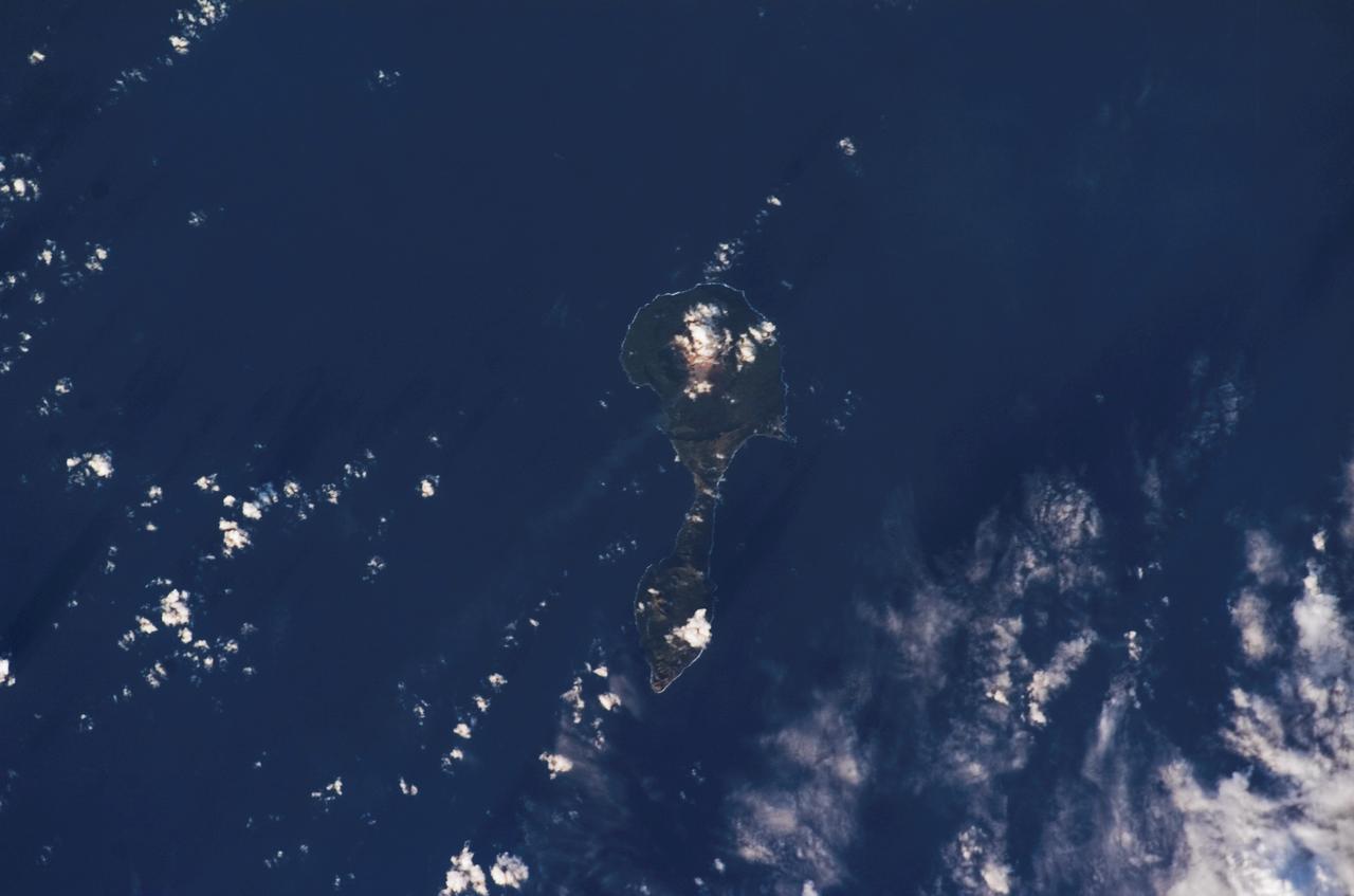
ISS014-E-11872 (11 Jan. 2007) --- Pagan Island, Northern Mariana Islands, is featured in this image photographed by an Expedition 14 crewmember on the International Space Station. According to scientists, the Mariana Islands are part a volcanic island arc -- surface volcanoes formed from magma generation as one tectonic plate is overridden (or subducted) beneath another. In the case of the Mariana Islands, the Pacific Plate is being subducted beneath the Philippine Plate along the famously deep Mariana Trench (more than 11 kilometers below sea level). Pagan Island (right) is comprised of two stratovolcanoes (tall, typically cone-shaped structures formed by layers of dense crystallized lava and less-dense ash and pumice) connected by a narrow isthmus of land. Mount Pagan, the larger of the two volcanoes, forms the northeastern portion of the island and has been the most active historically. The most recent major eruption took place in 1981, but since then numerous steam- and ash-producing events have been observed at the volcano -- the latest reported one occurring between Dec. 5-8, 2006. This image records volcanic activity on Jan. 11, 2007 that produced a thin plume (most probably steam, say NASA scientists, possibly with minor ash content) that extended westwards away from Mount Pagan. The island is sparsely populated, and monitored for volcanic activity by the United States Geological Survey and the Commonwealth of the Mariana Islands.
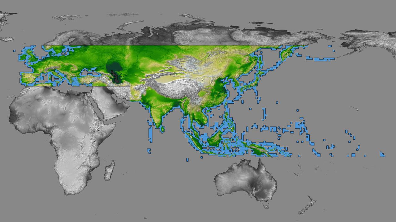
inal Caption Released with Image: The colored regions of this map show the extent of digital elevation data recently released by the Shuttle Radar Topography Mission (SRTM). This release includes data for most of Europe and Asia plus numerous islands in the Indian and Pacific Oceans. SRTM flew on board the Space Shuttle Endeavour in February 2000 and used an interferometric radar system to map the topography of Earth's landmass between latitudes 56 degrees south and 60 degrees north. The data were processed into geographic "tiles," each of which represents one by one degree of latitude and longitude. A degree of latitude measures 111 kilometers (69 miles) north-south, and a degree of longitude measures 111 kilometers or less east-west, decreasing away from the equator. The data are being released to the public on a continent-by-continent basis. This Eurasia segment includes 5,940 tiles, more than a third of the total data set. Previous releases covered North America and South America. Forthcoming releases will include Africa-Arabia and Australia plus an "Islands" release for those islands not included in the continental releases. Together these data releases constitute the world's first high-resolution, near-global elevation model. The resolution of the publicly released data is three arcseconds (1/1,200 of a degree of latitude and longitude), which is about 90 meters (295 feet). European coverage in the current data release stretches eastward from the British Isles and the Iberian Peninsula in the west, across the Alps and Carpathian Mountains, as well as the Northern European Plain, to the Ural and Caucasus Mountains bordering Asia. The Asian coverage includes a great diversity of landforms, including the Tibetan Plateau, Tarin Basin, Mongolian Plateau, and the mountains surrounding Lake Baikal, the world's deepest lake. Mt. Everest in the Himalayas, at 8,848 meters (29,029 feet) is the world's highest mountain. From India's Deccan Plateau, to Southeast Asia, coastal China, and Korea, various landforms place constraints upon land use planning for a great population. Volcanoes in the East Indies, the Philippines, Japan, and the Kamchatka Peninsula form the western part of the "Ring of Fire" around the Pacific Ocean. Many of these regions were previously very poorly mapped due to persistent cloud cover or the inaccessibility of the terrain. Digital elevation data, such as provided by SRTM, are particularly in high demand by scientists studying earthquakes, volcanism, and erosion patterns for use in mapping and modeling hazards to human habitation. But the shape of Earth's surface affects nearly every natural process and human endeavor that occurs there, so elevation data are used in a wide range of applications. In this index map color-coding is directly related to topographic height, with green at the lower elevations, rising through yellow and tan, to white at the highest elevations. The large, very dark green feature in western Asia is the Caspian Sea, which is below sea level. Blue areas on the map represent water within the mapped tiles, each of which includes shorelines or islands. http://photojournal.jpl.nasa.gov/catalog/PIA03398
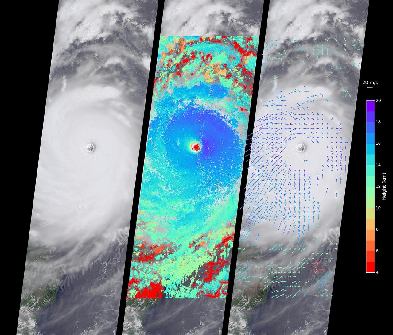
Typhoon Nepartak, the first large typhoon in the northwest Pacific this season, is currently taking aim at the east coast of Taiwan. Over the past few days, Nepartak has rapidly gained strength, growing from a tropical storm to the equivalent of a Category 5 hurricane with sustained wind speeds of more than 160 miles (258 kilometers) per hour. Taiwan's Central Weather Bureau has issued a torrential rain warning, bracing for likely flooding as 5 to 15 inches (13 to 38 centimeters) of rain are expected to fall over Taiwan during the storm's passage. Waves of up to 40 feet (12 meters) are predicted on the coast as the typhoon approaches, and air and train travel have been severely impacted. The typhoon is currently moving at about 10 miles per hour (16 kilometers) to the west-northwest, and is predicted to pass over Taiwan within the next day and then hit the coast of mainland China. Central and eastern China are poorly situated to absorb the rainfall from Nepartak after suffering the effects of severe monsoon flooding, which has killed at least 140 people in the past week. The Multi-angle Imaging SpectroRadiometer (MISR) instrument aboard NASA's Terra satellite captured this view of Typhoon Nepartak on July 7, 2016, at 10:30 a.m. local time (2:30 a.m. UTC). On the left is an image from the nadir (vertical pointing) camera, which shows the central portion of Nepartak and the storm's eye. The image is about 235 miles (378 kilometers) across. The island of Manila in the Philippines, about 250 miles (400 kilometers) south of Taiwan, is visible to the southwest of the eye. The image shows that Nepartak's center is extremely compact, rather than broken up into spiral bands as is more typical of typhoons. This means that the storm may retain more of its strength as it passes over land. MISR uses nine cameras to capture images of the typhoon from different angles. This provides a stereographic view, which can be used to determine the height of the storm's cloud tops. These heights are plotted in the middle panel, superimposed on the image. This shows that the cloud tops are relatively low, about 2.5 miles (4 kilometers), in the eye, but much higher, up to 12.5 miles (20 kilometers), just outside it. By tracking the motion of clouds as they are viewed by each of the nine cameras over about seven minutes, it is possible to also derive how fast the clouds are moving due to wind. These wind vectors are superimposed on the image in the right panel. The length of each arrow shows the wind speed at that location (compare to the 45 miles per hour or 20 meters per second arrow in the legend), and the color shows the height at which the wind is being computed. The motion of the low-level winds (red and yellow arrows) is counterclockwise, while the motion of the high winds (blue and purple arrows) is mostly clockwise. This is because hurricanes draw in warm, moist air at low altitudes, which then flows upward around the eye, releases its moisture as rain, and moves outward at high altitudes. As is typical of these types of storm systems, the inflowing low winds and the outflowing high winds spin in different directions. http://photojournal.jpl.nasa.gov/catalog/PIA20719

This collage shows some of the most interesting geological sites that NASA's Dawn spacecraft has revealed at dwarf planet Ceres. Images were acquired with the spacecraft's framing camera during various phases of the mission: Survey orbit at a distance of about 2,700 miles (4,400 kilometers); high-altitude mapping orbit (HAMO) at a distance of 915 miles (1,470 kilometers) from Ceres; and low-altitude mapping orbit (LAMO) at an altitude of 240 miles (385 kilometers). In the first row, from left to right: Ceres in shown in false color, roughly centered on Occator Crater, home of the brightest area on Ceres. This picture combines color images obtained by Dawn in its survey orbit. Red corresponds to a wavelength range around 980 nanometers (near infrared), green to a wavelength range around 750 nanometers (red, visible light) and blue to a wavelength range of around 430 nanometers (blue, visible light). This picture illustrates the diversity of terrains on Ceres where the bluish material points to recently emplaced material and the brownish background material is associated with older terrains. Juling Crater (12 miles, 20 kilometers in diameter) as seen in LAMO. Central coordinates are 36 degrees south latitude, 168 degrees east longitude. It is named after the Sakai/Orang Asli (Malaysia) spirit of the crops. This crater displays evidence for the presence of ice -- for example, in the form of a large flow feature seen at the top of the image. Oxo Crater (6 miles, 10 kilometers in diameter) as seen in LAMO. Center coordinates are 42 degrees north latitude, 0 degrees east longitude. It is named after the god of agriculture in Afro-Brazilian beliefs of Yoruba derivation. Oxo hosts the first site at which Dawn detected ice on Ceres, exposed by a landslide. Ahuna Mons is not only a volcano, but also the tallest mountain on Ceres. It is about 2.5 miles (4 kilometers) high and 11 miles (17 kilometers) wide. Center coordinates are 10 degrees south latitude, 316 degrees east longitude. This view combines images obtained in LAMO in blue (430 nanometers), green (750 nanometers) and infrared (980 nanometers) color filters. Ahuna is named after the Sumi tribe (Nagaland, northeastern India) traditional post-harvest thanksgiving festival. Second Row Occator Crater (57 miles, 92 kilometers across) is seen in LAMO images. Center coordinates are 20 degrees north latitude, 239 degrees east longitude. Named after the Roman agricultural deity of the harrowing. This image shows a "Type I" flow feature with a thick "toe" typical of rock glaciers and icy landslides on Earth as viewed in LAMO. The flow feature, found in Ghanan Crater (77 degrees north latitude, 31 degrees east longitude), is one of the most voluminous on Ceres. Enhanced color view of Haulani Crater (21 miles, 34 kilometers in diameter) in color observed in HAMO. Central coordinates: 6 degrees north latitude, 11 degrees east longitude. Named after the Hawaiian plant goddess. Kokopelli Crater (21 miles, 34 kilometers in diameter) seen in LAMO. Central coordinates: 18 degrees north latitude, 125 degrees east longitude. Named after the Pueblo (SW USA) fertility deity, who presides over agriculture. This crater displays a nice arrangement of scarps that likely formed when the crater partly collapsed during its formation. Third Row Central region of Occator Crater, called Cerealia Facula, seen in color. The facula -- or "bright spot" -- is about 9 miles (14 kilometers) in diameter. Center coordinates: 20 N, 240 E. Cerealia refers to the major festival in Ancient Rome that celebrates the grain goddess Ceres (8 days in mid- to late April). The view was produced by combining the highest resolution images of Occator obtained in LAMO (at image scales of 35 meters, or 115 feet, per pixel) with color images obtained in HAMO (at image scales of 135 meters, or about 440 feet, per pixel). The three images used to produce the color were taken using filters centered at 430, 750 and 980 nanometers (the last being slightly beyond the range of human vision, in the near-infrared). North part of Nar Sulcus seen in LAMO. The full feature is about 39 miles (63 km) in length and is located around 42 degrees south latitude, 280 degrees east longitude. Nar is a Azerbaijani festival of pomegranate harvest held in October-November in Goychay city, center of pomegranate cultivation in Azerbaijan. A sulcus is a set of parallel furrows or ridges. Ikapati Crater (31 miles, 50 kilometers in diameter) seen in LAMO. Central coordinates: 34 degrees north latitude, 46 degrees east longitude. Ikapati is named after the Philippine goddess of the cultivated lands. The crater has a smooth floor, probably because heat from the impact that formed Ikapati caused ice in the ground to melt, and then refreeze. This view of Ceres, taken in LAMO, shows an area located at approximately 86 degrees south longitude, 177 degrees east longitude. This part of Ceres, near the south pole, has such long shadows because, from the perspective of this location, the sun is near the horizon. At the time this image was taken, the sun was 4 degrees north of the equator. If you were standing this close to Ceres' south pole, the sun would never get high in the sky during the course of a nine-hour Cerean day. https://photojournal.jpl.nasa.gov/catalog/PIA22090